cardiff local development plan 2006-2026 appendices … · cardiff local development plan 2006-2026...
TRANSCRIPT

1
Cardiff Local Development Plan 2006-2026 Appendices Contents Appendix 1: List of Key and Detailed Policies
Appendix 2: National and Regional Policy Framework
Appendix 3: The Cardiff Context and Key Issues the Plan must
Address
Appendix 4: Supplementary Planning Guidance (SPG)
Appendix 5: Sites over 10 Dwellings with Planning Permission for
Residential (March 2014)
Appendix 6: Heritage Assets Areas of Protection
Appendix 7: Designated Sites
Appendix 8: District and Local Centres
Appendix 9: Monitoring Indicators
Appendix 10: Summary of LDP process including Technical terms
Glossary
Appendix 11: Tests of Soundness Self-Assessment
Appendix 12: List of Supporting Documents
Appendix 13: List of the Evidence Base
Appendix 14: Bibliography

2
Appendix 1:- List of Key and Detailed Policies KEY POLICIES KP1: LEVEL OF GROWTH KP2: STRATEGIC SITES KP2 (A): CARDIFF CENTRAL ENTERPRISE ZONE AND REGIONAL
TRANSPORT HUB KP2 (B): FORMER GAS WORKS, FERRY ROAD KP2 (C): NORTH WEST CARDIFF KP2 (D & E): NORTH OF JUNCTION 33 ON M4 AND SOUTH OF
CREIGIAU KP2 (F): NORTH EAST CARDIFF (WEST OF PONTPRENNAU) KP2 (G): EAST OF PONTPRENNAU LINK ROAD KP2 (H): SOUTH OF ST MELLONS BUSINESS PARK KP3 (A): GREEN WEDGE KP3 (B): SETTLEMENT BOUNDARIES KP4: MASTERPLANNING APPROACH KP5: GOOD QUALITY AND SUSTAINABLE DESIGN KP6: NEW INFRASTRUCTURE KP7: PLANNING OBLIGATIONS KP8: SUSTAINABLE TRANSPORT KP9: RESPONDING TO EVIDENCED ECONOMIC NEEDS KP10: CENTRAL AND BAY BUSINESS AREAS KP11: CRUSHED ROCK AGGREGATES AND OTHER MINERALS KP12: WASTE KP13: RESPONDING TO EVIDENCED SOCIAL NEEDS KP14: HEALTHY LIVING

3
KP15: CLIMATE CHANGE KP16: GREEN INFRASTRUCTURE KP17: BUILT HERITAGE KP18: NATURAL RESOURCES DETAILED POLICIES HOUSING H1: NON-STRATEGIC HOUSING SITES H2: CONVERSION TO RESIDENTIAL USE H3: AFFORDABLE HOUSING H4: CHANGE OF USE OF RESIDENTIAL LAND OR
PROPERTIES H5: SUB-DIVISION OR CONVERSION OF RESIDENTIAL
PROPERTIES H6: CHANGE OF USE OR REDEVELOPMENT TO
RESIDENTIAL USE H7: SITES FOR GYPSY AND TRAVELLER CARAVANS ECONOMY EC1: EXISTING EMPLOYMENT LAND EC2: PROVISION OF COMPLEMENTARY FACILITIES FOR
EMPLOYEES IN BUSINESS, INDUSTRIAL AND WAREHOUSING DEVELOPMENTS
EC3: ALTERNATIVE USE OF EMPLOYMENT LAND AND
PREMISES EC4: PROTECTING OFFICES IN THE CENTRAL AND BAY
BUSINESS AREAS EC5: HOTEL DEVELOPMENT EC6: NON-STRATEGIC EMPLOYMENT SITE

4
EC7: EMPLOYMENT PROPOSALS ON LAND NOT IDENTIFIED FOR EMPLOYMENT USE
ENVIRONMENT Countryside Protection EN1: COUNTRYSIDE PROTECTION EN2: CONVERSION, EXTENSION AND REPLACEMENT
BUILDINGS IN THE COUNTRYSIDE The Natural Environment EN3: LANDSCAPE PROTECTION EN4: RIVER CORRIDORS EN5: DESIGNATED SITES EN6: ECOLOGICAL NETWORKS AND FEATURES OF
IMPORTANCE FOR BIODIVERSITY EN7: PRIORITY HABITATS AND SPECIES EN8: TREES, WOODLANDS AND HEDGEROWS The Historic Environment EN9: CONSERVATION OF THE HISTORIC ENVIRONMENT Natural Resources EN10: WATER SENSITIVE DESIGN EN11: PROTECTION OF WATER RESOURCES Renewable Energy EN12: RENEWABLE ENERGY AND LOW CARBON
TECHNOLOGIES Pollution EN13: AIR, NOISE, LIGHT POLLUTION AND LAND
CONTAMIINATION

5
Flood Risk EN14: FLOOD RISK TRANSPORT T1: WALKING AND CYCLING T2: STRATEGIC RAPID TRANSIT & BUS CORRIDORS T3: TRANSPORT INTERCHANGES T4: CENTRAL TRANSPORT HUB T5: MANAGING TRANSPORT IMPACTS T6: IMPACT ON TRANSPORT NETWORKS AND SERVICES T7: STRATEGIC TRANSPORTATION INFRASTRUCTURE T8: STRATEGIC RECREATIONAL ROUTES T9: CARDIFF CITY REGION ‘METRO’ NETWORK RETAIL R1: RETAIL HIERARCHY R2: DEVELOPMENT IN THE CENTRAL SHOPPING AREA R3: PROTECTED SHOPPING FRONTAGES R4: DISTRICT CENTRES R5: LOCAL CENTRES R6: RETAIL DEVELOPMENT (OUT OF CENTRE) R7: RETAIL PROVISION WITHIN STRATEGIC SITES R8: FOOD AND DRINK USES COMMUNITY C1: COMMUNITY FACILITIES C2: PROTECTION OF EXISTING COMMUNITY FACILITIES

6
C3: COMMUNITY SAFETY/CREATING SAFE
ENVIRONMENTS C4: PROTECTION OF OPEN SPACE C5: PROVISION FOR OPEN SPACE, OUTDOOR
RECREATION, CHILDREN’S PLAY AND SPORT C6: HEALTH C7: PLANNING FOR SCHOOLS MINERALS M1: MINERAL LIMESTONE RESERVES AND RESOURCES M2: PREFERRED ORDER OF MINERAL RESOURCE RELEASE M3: QUARRY CLOSURES AND EXTENSION LIMITS M4: MINERALS BUFFER ZONES M5: RESTORATION AND AFTER - USE OF MINERAL
WORKINGS M6: SAND WHARF PROTECTION AREAS M7: SAFEGUARDING OF SAND AND GRAVEL, COAL AND
LIMESTONE RESOURCES M8: AREAS WHERE COAL WORKING WILL NOT BE
ACCEPTABLE WASTE W1: SITES FOR WASTE MANAGEMENT FACILITIES W2: PROVISION FOR WASTE MANAGEMENT FACILITIES IN
DEVELOPMENT

7
Appendix 2: National and Regional Policy Framework Introduction 2.1 Cardiff’s LDP must take into account relevant policies and guidance relating to Wales, the city-region and other approved policies relating to the local area.
LDP legislation and guidance 2.2 Every local planning authority in Wales must prepare a LDP for its area. This is known as a ‘plan-led’ system and together with other relevant plans, strategies and policies, provides the framework for planning in Cardiff. The main relevant legislation and guidance relating to LDPs is as follows: • Planning and Compulsory Purchase Act 2004- Requires the Council to prepare a LDP and, in doing so, to have regard to its Community Strategy and national policy including the Wales Spatial Plan (WSP); • The Town and Country Planning (Local Development Plan) (Wales) Regulations 2005- Outlines the details of how the LDP system will be operated. This includes the need for LDPs to have regard to the Waste Strategy for Wales, Regional Waste Plans, Regional Transport Plan and Local Housing Strategies; and • Additional guidance on the preparation of LDPs has been prepared by the Welsh Government and includes: - Local Development Plans Wales (2005) - Local Development Plan Manual (2006) - Planning Your Community: A Guide to Local Development Plans (2006) - Guide to the examination of Local Development Plans (2006) National policy framework 2.3 The Welsh Government's national land use policies are set out in Planning Policy Wales (Edition 5, November 2012) and Mineral Planning Policy Wales (2001). These are supplemented by Technical Advice Notes and Circulars. Planning Policy Wales sets out how the land use planning system can help achieve the Welsh Government's goals of: • Sustainable Development - meeting the needs of the present without compromising the ability of future generations to meet their own needs; • Building a dynamic and advanced economy - supporting economic regeneration, creating wealth and good quality jobs; • Tackling social disadvantage - developing an inclusive society where everyone has the chance to fulfil their potential; and • Equal Opportunities - promoting a culture in which diversity is valued and equality of opportunity is a reality.

8
2.4 Chapter 2 of PPW sets out further information on Development Plan coverage. 2.5 People Places Futures: The Wales Spatial Plan (2008 update) provides a strategic framework to guide future development and policy interventions across Wales, beyond the scope of formal land use planning control. The Spatial Plan places Cardiff at the centre of the South East - 'Capital Network' - area of Wales, for which its vision is of, '' An innovative skilled area offering a high quality of life – international yet distinctively Welsh. It will compete internationally by increasing its global visibility through stronger links between the Valleys and the coast and with the UK and Europe, helping to spread prosperity within the area and benefiting other parts of Wales''. 2.6 The Spatial Plan acknowledges that it is important for Wales as a whole that Cardiff becomes significant internationally and that, to achieve this, the city needs to be the focal point of a coherent and successful urban network in south east Wales. Integrated transport is identified as being crucial to the area effectively functioning in this way; and achieving this in ways which reduce reliance on private cars, through improved public transport links. 2.7 Of particular relevance, the Spatial Plan also identifies:
• The City Coastal Area will function as a networked city-region, on a scale to realise its international potential, its national role and to reduce inequalities;
• The success of the City Coastal Area relies on Cardiff developing its capital functions, together with strong and distinctive roles of other towns and cities;
• The overall priority is to make better use of the area’s existing transport infrastructure to deliver more sustainable access to jobs and services;
• The pressure to provide more housing and employment should be managed so as to fit in compatibly with conservation of the landscape, environment and community strength of this area; and
• Substantial growth of housing in the coastal zone should also be compatible with the health of housing markets in the Heads of the Valleys and Connections Corridor.
2.8 The Environment Strategy for Wales (2006) outlines the Welsh Government’s long-term strategy for the environment of Wales, setting out the strategic direction for the next 20 years. The purpose of the Strategy is to provide a framework within which to achieve an environment that is clean, healthy, biologically diverse and valued by the people of Wales. Welsh Government wishes to see the environment

9
thriving and contributing to the economic and social well-being and health of all of the people of Wales. 2.9 One Wales, One Planet (2009) sets out the Welsh Government’s vision of a sustainable Wales and the priority it attaches to sustainable development. This builds on the Welsh Government’s legal duty to deliver sustainable development and requires all organisations in Wales to actively commit to sustainable development. 2.10 Economic Renewal: A New Direction (2010) is the Welsh Government’s Strategic Framework for economic development. It sets out a vision for making Wales ‘one of the best places in the world to live and to work’. The strategy outlines the Welsh Government’s following priorities, which are; investing in high quality sustainable infrastructure; making Wales a more attractive place to do business; broadening and deepening the skills base; encouraging innovation and targeting support for business. 2.11 One Wales: Connecting the nation – The Wales Transport Strategy (2008) is the Welsh Government’s strategy for transport. It sets out how the Welsh Government intends to achieve certain social, economic and environmental outcomes. Five key areas are identified for progress:
• Reducing greenhouse gas emissions and other environmental impacts; • Improving public transport and better integration between modes; • Improving links and access between key settlements and sites across Wales and strategically important all-Wales links; • Enhancing international connectivity; and • Increasing safety and security.
2.12 The National Transport Plan (2010) sets out in detail how the Welsh Government proposes to deliver the Wales Transport Strategy One Wales: Connecting the Nation over the next 5 years. The National Transport Plan builds on previous plans, adding and integrating public and community transport, walking and cycling so that investments help to deliver One Wales. The National Transport Plan sits alongside the Regional Transport Plans in delivering the Wales Transport Strategy to ensure consistency of service provision across the transport network. Together the national and regional plans seek to strengthen local service delivery and improve access to essential services such as health and education. Regional Policy Context 2.13 A Regional Transport Plan (RTP) (2010) has been prepared by the regional transport consortium, the South East Wales Transport Alliance (Sewta), which is made up of 10 local authorities including Cardiff

10
and other transport stakeholders. The Sewta RTP was approved by the Welsh Government in January 2010. Under the provisions of the Transport (Wales) Act 2006, the RTP replaces the Local Transport Plans formerly produced by each local authority in Wales. Welsh Government guidance requires the RTP to support the delivery of the strategic objectives of the WSP and the Wales Transport Strategy. The RTP is a material consideration in the formulation of LDPs and decisions on land use where there is a transport dimension. 2.14 The Sewta RTP sets out a vision of, “A modern, accessible, integrated and sustainable transport system for south east Wales which increases opportunity, promotes prosperity for all and protects the environment; where walking, cycling, public transport and sustainable freight provide real travel alternatives”. To deliver this vision the RTP identifies a range of strategic objectives, policies, and actions, together with a five year rolling programme of schemes to develop and improve the transport network. 2.15 Managing demand for private car travel, making better use of the existing transport network and encouraging use of sustainable and active transport modes are key themes of the RTP which will provide the strategic framework for regional and local level transport improvements across the region. 2.16 The RTP recognises the critical relationship between land use and transport provision and how each affects the other. In tune with Welsh Government RTP guidance, it advocates a process of information sharing, joined-up thinking and integration to establish a consistency between the RTP and LDPs across the south east Wales region. These interactions need to embrace both LDP and Development Management elements of land use planning. 2.17 The South East Wales Regional Waste Plan, First Review (RWP) (2008) provides a land use framework to facilitate the development of an integrated network of facilities to treat and dispose of waste in south east Wales in a way that has regard for the Waste Strategy for Wales, satisfies modern environmental standards and meets targets set by European and national legislation. The document was subject to a 1st Review, the contents of which have been approved by the constituent authorities of south east Wales including Cardiff in July 2008.The Review sets out a Regional Waste Strategy indicating the preferred mix of waste management/resource recovery technologies and capacities for managing the forecast arisings of all controlled waste streams and a spatial element that guides the location of new facilities. In identifying suitable locations for new waste facilities, the LDP waste policies will assist in the development of an integrated network of facilities to treat and dispose of waste in ways that will satisfy modern environmental standards. A grouping of the authorities (Caerphilly, Cardiff,

11
Monmouthshire, Newport and the Vale of Glamorgan) has been formed through Prosiect Gwyrdd to tackle the issue. 2.18 The Regional Technical Statement (1st Review) (RTS) (2014) has been prepared in response to Minerals Technical Advice Note 1: Aggregates (MTAN1), issued by Welsh Government in March 2004. This has a primary objective of seeking to ensure a sustainably managed supply of aggregates that are essential for construction, by striking the best balance between environmental, economic and social costs. To achieve that objective, the RTS has been prepared by consultants on behalf the South Wales and North Wales Regional Aggregates Working Party (RAWP) to provide a strategic basis for aggregates supply for LDPs in the south Wales region until 2036. As appropriate, local planning authorities will then be expected to include allocations for aggregates provision in their area as part of the LDP process. The RTS was endorsed by Welsh Government and the constituent authorities including Cardiff in August 2014. 1.19 The main recommendations arising out of the RTS for Cardiff’s LDP to effectively address are:
Confirmation that the current aggregate reserves with planning permission are sufficient to meet the 10 year landbank requirements of MTAN1;
The need to safeguard the marine dredging wharves within Cardiff Docks; and
The need to safeguard for potential use by future generations the one potential sand and gravel resource block within Cardiff.

12
Appendix 3: The Cardiff context and key issues the plan must address Introduction 3.1 It is important that the Plan is informed by relevant information relating to Cardiff. Extensive work has been undertaken to develop a comprehensive and robust evidence base. This section summarises some of the key issues which have been identified following analysis of the information collected. Further detailed information and technical data is contained in the supporting documents which accompany this document. The Cardiff Context 3.2 The county covers some 143 square kilometres, and is the largest urban area in Wales. Approximately 53% of the county is urban with the remaining 47% formed by countryside and strategic river valleys which embraces a diverse pattern of landscapes and wide range of resources. 3.3 Cardiff is the key driver of the city-region economy in south east Wales which has a total population of 1.4 million. It is also the capital city of Wales and seat of National Government which further enhance Cardiff’s nationally important role. This role is reinforced through its excellent range of retail, cultural, further education and sporting facilities. 3.4 LDPs within south east Wales local planning authorities (LPAs) have progressed at different timescales with four of the 10 LPAs having adopted LDPs, but with the majority still under preparation. The current situation is summarised in Table 1, below. Table 1: South east Wales local authority LDP progress and overall levels of growth (as at Deposit).
Local Authority
Stage of Preparation Plan Period
Overall level of growth (dwellings proposed)
Blaenau Gwent Adopted 2006-21 3,500 Bridgend Deposit 2006-21 9,000 Caerphilly Adopted 2006-21 8,625 Merthyr Tydfil Adopted 2006-21 3,800 Monmouth Deposit 2011-21 4,000 Newport Deposit 2011-26 8,750 Rhondda Cynon Taff Adopted 2006-21 14,385
Torfaen Deposit 2006-21 5,000 Vale of Glamorgan Deposit 2011-26 9,950

13
3.5 In order to assist the LDP in meeting the tests of soundness relating to cross boundary issues and compatibility with LDPs prepared by neighbouring authorities, a Working Group was set up in November 2011, made up of the 10 south east Wales LPAs and other participating organisations in the South East Wales Strategic Planning Group (SEWSPG). The South East Wales Economic Forum (SEWEF) and the South East Wales Transport Authority (Sewta) were also invited to participate. The purpose of the working group was to discuss the cross-boundary implications of the emerging issues involved in the preparation of the LDP. Key Social Trends and Issues 3.6 Cardiff is the most populated local authority in Wales, with 345,400 people living in the county in 2011 (Office of National Statistics 2012) - over 11% of the total population of Wales. Some 1.4 million people live within a 45 minute drive time of the city. Cardiff’s population has increased steadily over the past 20 years (by about 2,400 people per year) but much more rapidly since 2001 (about 3,500 per year). Welsh Government projections indicate that the number of households in Cardiff will significantly increase by 37% between 2008 and 2026 from 136,741 to 187,302 households. According to the Welsh Government projections, this is driven partly by in-migration (particularly net international migration), partly by natural population increase (births less deaths), and partly by a decline in average household size with over three quarters of the growth being for 1 and 2 person households. 3.7 In recent years a high proportion of new housing has been built on brownfield land. This has contributed to the development of many apartments and the relative under-provision of family housing. On average around 1,476 new dwellings have been built each year for the last 10 years. 14% of those were affordable (213 p.a.). 68% (1,001) p.a. were flats or apartments. Much of this development has been within the city centre and bay area and has helped to revitalise these areas and provide high quality opportunities for urban living. This is demonstrated by the fact that 94% of housing completions in the last 10 years have been on brownfield land compared to 6% on Greenfield sites. 3.8 The affordability of housing - particularly family housing – remains an issue that will continue to need to be addressed. At present (April 2013) there are 9,710 on the combined housing waiting list; 545 families are in temporary accommodation. These facts help indicate the scale of the affordable housing requirement. The Cardiff Local Housing Market Assessment update (LHMA July 2013) indicates that, based on the Welsh Government formula, 3,989 affordable dwellings are required in Cardiff for each of the next 5 years to deal with need. The social and economic importance of providing a range and choice of homes, particularly affordable housing is fully recognised in the Welsh Government White

14
Paper Homes for Wales, “A White Paper for Better Lives and Communities” (May 2012). 3.9 There are two Gypsy and Traveller sites in Cardiff (Rover Way and Shirenewton) providing a total of 80 pitches. The population in these sites is growing and there is a demand for new sites. The Council has a legal duty to meet the need for Gypsy and Traveller sites in the Local Development Plan (Welsh Government Circular 30/2007). The latest study in 2013 found a need up to 2026 for an additional 108 pitches plus 10 transit pitches. 3.10 Compared with Wales and the UK, Cardiff has a higher percentage of population in age groups 15-39 years but a lower percentage in age groups from 40 upwards. The impact of the student population is particularly significant. According to latest data for 2010-11, the growing student resident population of 37,400 comprised around 10.8% of the city's total population (Higher Education Statistical Authority 2012 and National Statistics). 3.11 The health of Cardiff’s population is not significantly different from the Welsh average. However, this headline conceals large variations in health status between richer and poorer areas. There is a north-south divide across Cardiff with a difference in life expectancy of nearly 12 years between the poorest and most affluent wards (Cardiff What Matters Headline Needs Assessment 20101). Health inequality – the avoidable difference between the least and most advantaged populations - is thus evident in parts of the population. Opportunities for health are less in disadvantaged areas and health outcomes such as cardiovascular mortality are poorer. 3.12 In Cardiff, the greatest causes of death in people aged less than 75 years are cancer, circulatory disease and respiratory disease. Many chronic conditions are preventable by ensuring the environment is health enhancing and through the adoption of healthy lifestyles. However, over half of Cardiff’s adults are clinically overweight or obese, just a quarter (25%) of adults meet recommended physical activity guidelines of undertaking at least 30 minutes of moderate intensity physical activity on five or more days per week (the lowest across Welsh local authorities) and 35% of adults eat the recommended 5 or more portions of fruit and vegetables each day (Welsh Health Survey 20112). 3.13 The built and natural environment together with lifestyle behaviours contribute to improving health. Walking and cycling, access to well-maintained open spaces for physical activity and food growing plus easy access to health care facilities by active travel impact on the health of the population. Achieving and maintaining a healthy weight, protecting
1 http://www.cardiffproudcapital.co.uk/content.asp?nav=2,260&parent_directory_id=2&id=612&d1p1=1 2 http://gov.wales/docs/statistics/2012/120919healthsurvey2011en.pdf

15
mental health and reducing stress levels are supported by this approach. Cardiff has a wealth of open spaces and walking and cycling rates to work/school and for leisure are increasing; there is the opportunity to protect and enhance these assets for health improvement. 3.14 The 2011 census statistics indicate that 16.2% of the population of Cardiff have one or more skills in the Welsh Language (ability to read, write or/and understand Welsh) and 11.1% of the County’s population are able to speak Welsh. This compares with a national average of 19.0%. However there are substantial variations between the proportion of Welsh speakers in different communities in Wales, varying from below 8% to above 65%. 3.15 The Welsh Language Board approved Cardiff Council’s revised Welsh Language Scheme 2009 to 2012 in July 2009. The Council has adopted the principle that in the conduct of public business and administration of justice in Wales, it will treat the English and Welsh languages on a basis of equality. This scheme sets out how the Council will give effect to that principle when providing services to the public in Cardiff. 3.16 Community safety is one of the top issues raised in successive Ask Cardiff Surveys. Between 2010 and 2011, Cardiff had the second highest recorded crime rate in Wales and 50 per cent higher than the average for Wales. These include violence against the person, burglary, vehicle and other theft and criminal damage. However, Cardiff’s total recorded crime rate has fallen over the past eight years (with some fluctuations) and is now less than two-thirds of the figure of eight years ago. There was a 12% reduction in total crime between 2009/2010 and 2010/2011 (Home Office Statistics). 3.17 While Cardiff is generally a prosperous city offering a high quality of life for residents; deprivation (in terms of housing, physical environment, employment income, educational achievements, health) still remains an important issue that needs to be addressed. Of the 10% most deprived LSOAs (Lower Layer Super Output Area) in Wales, 15.8% are in Cardiff (Welsh Index of Multiple Deprivation 2011). Parts of Ely, Butetown and Splott are the most deprived areas of Cardiff. 3.18 9.5% of the total population of Cardiff live in the 10% most health deprived LSOAs (Lower Super Output Areas) in Wales (i.e. those ranked 1-190). However, this proportion varies greatly across the neighbourhood areas. Cardiff South West (23.2%) has the highest proportion of its residents living in these most deprived areas, followed by City & Cardiff South (19.0%) and Cardiff South East (14.6%). In contrast, Cardiff West (0.0%) has no areas of this kind, while just 1.5% of Cardiff North’s population reside within these LSOAs. For Cardiff East the figure is 8.0%. 3.19 When looking at those living within the 20% most health deprived LSOAs in Wales (i.e. those ranked 1-380), it can be seen that 21.7% of

16
Cardiff’s total population live within these areas. The disparities across the city’s neighbourhood areas also become more apparent. More than two-fifths (43.9%) of Cardiff South West’s population live in these LSOAs, while Cardiff East (38.2%), Cardiff South East (29.9%) and City & Cardiff South (24.0%) also have proportions above the Cardiff average. In contrast, just 5.5% of Cardiff North’s and 7.3% of Cardiff West’s residents live in the 20% most health deprived areas. 3.20 Ethnic minorities comprise 15.5% of Cardiff's population broadly similar to the average for England and Wales (14.0%) but higher than the Wales average (4.4%) with a higher concentration of ethnic groups in Grangetown, Butetown, Riverside Adamsdown and Plasnewydd than elsewhere (ONS 2011). 3.21 In terms of education, training and skill base the proportion of Cardiff’s working age population lacking any qualifications has hovered at around 13% for the past five years. However, Cardiff performs particularly well with regards to high-level skills with 39.8% of 16 to 64 year olds having NVQ level 4 or equivalent, putting Cardiff significantly above the Wales (29.3%) and UK (32.7%) averages (Annual Population Survey, 2011). In addition, 39% of Cardiff’s workforce is educated to NVQ level 4 or above compared with Wales (29%) and UK (33%) (Annual Population Survey January 2011) a reflection of the four universities located within the city. However, as with other areas in the UK, it is important to recognise the link between low educational achievement and deprivation. Key Economic Trends and Issues 3.22 The economy of Cardiff is generally strong and buoyant, reflecting its position as Capital of Wales, seat of Welsh Government and the regional centre and economic driver for the wider south east Wales economy, accounting for 32% of total employment in south east Wales. Commuting patterns into Cardiff demonstrate the city’s importance to the regional economy and the Wales Spatial Plan and Economic Renewal Programme acknowledge that maintaining Cardiff’s performance is vital for the economic well-being of the region and Wales as a whole. 3.23 Cardiff’s employment workforce totals 188,977 (Employee Jobs Business Register and Employment Survey 2012, ONS) approximately 40% are daily in-commuters – 88% are employed in the service sector, 6% in construction and 6% in manufacturing. Gross Value Added (GVA) is an economic measure of the value of goods and services produced in an area. In 2009 Cardiff and the Vale of Glamorgan generated £9,615 million – 22% of Welsh GVA. GVA per head in Cardiff and the Vale stood at £20,864 in 2009 – higher than both the Welsh and UK averages (ONS 2011). Unemployment in Cardiff was 4.5% in March 2013 (10,617) (Claimant Count ONS). Between 2001 and 2009 employment in Cardiff expanded by 16% compared to an overall growth of 4% in the wider

17
south east Wales region (Source DTZ Validation of Cardiff Labour Market and Employment Scenarios, June 2011). The economic recession over the last few years has contributed to the net loss of approximately 4,733 jobs in Cardiff between 2008 and 2010 (Source ONS Business Register and Employment Survey). 3.24 A key challenge for the LDP is planning for the economy and meeting the need for future jobs within the city and the wider south east Wales region through striking a balance between the supply and demand for employment land and continuing to provide a diverse range of job opportunities. Likely future growth sectors in Cardiff over the plan period include specialist sectors relating to ICT, energy and environment, advanced materials and manufacturing, creative industries, life sciences and financial and professional services. It is essential that the location, amount and nature of employment land allocated and protected ensures Cardiff fulfils its economic potential and also the success of the south east Wales region. This includes, for example, the designation in 2012 of a Cardiff Central Enterprise Zone providing a much needed boost to the supply of Grade A office stock for the city. 3.25 Employment land take up data for the period July 2001-July 2010 can be summarised as follows. Average take up for offices (B1a) was 28,200 square metres per annum. Average land take up was 8.1 hectares per annum for industrial and warehousing (B1b/c, B2 and B8) (Cardiff Employment Land Study Demand Assessment, DTZ, June 2011). Industrial supply currently comprises 69.7 hectares. Office supply currently comprises 426,971 square metres (Cardiff Employment Land Study Gap Analysis, Hardisty Jones Associates, April 2012). 3.26 Total industrial stock in Cardiff is approximately 19.2 million square feet of which 43% is warehousing stock, with the remainder providing more traditional industrial accommodation. However, the quality of stock has become a major issue, with only 6.1% being less than five years old. Many of the buildings within the current stock are reaching functional obsolescence and there is very little new floorspace to satisfy the emerging knowledge and technology services, which are driving demand for high specification industrial buildings, rather than the older, larger premises. Existing general industry and warehousing land is largely concentrated to the east of the city, within or in close proximity to the southern arc of deprivation which geographically contains some of the most deprived wards in Wales. Key strategic locations include Ocean Park, Splott, Capital Business Park and Wentloog Corporate Park. The Penarth Road/Leckwith area also continues to perform an important employment function, with good linkages to the south and west of the city. As a distribution location, Cardiff’s location towards the western end of the UKs major transport axis means it struggles to compete against locations further to the east (Newport, Chepstow, Bristol) for major transport and distribution functions.

18
3.27 In terms of office supply the city centre and Bay Business Area remain the principle locations. These are also the most accessible in the city, in terms of public transport and for those commuting into the city. Out of centre growth has focused at Green Meadow Spring, Coryton, Cardiff Gate, Pontprennau, and St Mellons Business Park. Lack of grade A office space has been addressed to a degree with the development of Callaghan Square, Fusion Point and Caspian Point. However, of the 1.5 million square feet of office space available in Cardiff only 7% is grade A (DTZ Supply Audit, 2011). 3.28 Cardiff city centre is the main shopping centre for south east Wales and over the last 3 years (2009 to 2011) has been ranked the 6th top retail centre in the UK (Experian rankings). District and Local Centres provide important local facilities to the local community. However, they are particularly vulnerable to out of centre competition and changing shopping habits. As a consequence the range and quality of retail provision is under pressure in many centres. There has been a 4% reduction in terms of net retail floorspace between 2005 and 2008. 3.29 The regeneration of Cardiff Bay represents a major success story with major redevelopment and infrastructure projects being undertaken over the past two decades. Whilst significant progress has been made a number of sites remain to be implemented including the completion of developments at the International Sports Village and the media/creative industries cluster, residential development and associated uses at Roath Basin (Porth Teigr). 3.30 Cardiff’s leisure and tourism sector generates significant economic and cultural benefits for the city through the staging of major international events at world class venues such as the Millennium Stadium and Wales Millennium Centre. Cardiff’s diverse leisure and tourism offer also embraces a proud heritage, boasting a number of castles, two national museums, two cathedrals, Roman remains and acres of parks and gardens. In 2010 the city attracted a total of 18.3 million visitors (STEAM, 2010), a 25% growth since 2009. Cardiff came in at 11 in Visit Britain’s rankings for overseas visits to towns and cities in 2012. The Welsh capital had 301,000 visits, and was just ahead of Leeds (299,000) and behind Brighton (345,000). Key Transportation Trends and issues 3.31 Traffic on Cardiff’s roads grew on average by 9% between 2002 and 2012 (Cardiff Annual Traffic Flow Surveys, calculated using 5yr Rolling Averages). Around 56% of employed Cardiff residents travel to work by car; with 17% walking; 10% travelling by bus; 10% by cycle; 6% by rail; and the remaining 1% by other means. This compares with travel by non-car means for other journey purposes as follows: Shopping 53%; Education 59%; and Leisure 57% (Ask Cardiff Survey 2012). A large proportion of car journeys are relatively short: 25% of trips being

19
no longer than 2km and 58% no longer than 5km (Census 2001 excluding working from home). Overall vehicle occupancy has increased from 1.37 per private car in 2008 to 1.41 in 2011 (Cardiff Annual Traffic Flow Surveys). 3.32 Cardiff has consistently experienced the highest levels of daily inbound commuters of any other local authority in Wales. As of 2011, this equates to nearly 77,900 people travelling into Cardiff each day by all modes, and representing around 37% of the city’s total workforce. The largest numbers commute from the adjoining areas of The Vale of Glamorgan (20,500), Rhondda Cynon Taff (18,800) and Caerphilly (9,700). A total of 27,900 Cardiff residents commute outside of the authority on a daily basis, giving a net inflow of around 50,000 commuters (Annual Population Survey, 2011). 3.33 In terms of transport interchanges Cardiff benefits from having a co-located central rail and bus station within the heart of the city and within 2 hours rail travel time from London. Central rail station is used by approximately 5.75 million people each year (Source: Office of Rail Regulation, 2011-12 Station Usage Report) and significant improvements are planned for both the bus station and rail station. Its sustainable location within the heart of the city enables it to perform an important role for the south east Wales region in providing easy access to jobs and services. 3.34 Travel on rail services into Cardiff has increased considerably, with passenger numbers at Cardiff stations having increased by 82% between 2001 and 2011. Cardiff Central and Cardiff Queen Street Station alone have experienced an increase in patronage during this period of 100% and 53%, respectively. (Cardiff Annual Patronage Surveys, calculated using 5yr Rolling Averages). Significant enhancements to rail services are planned during the plan period with electrification of the main line from Cardiff to London approved for completion in 2017. Proposals for also electrifying the Valley line network and main line to Swansea are currently being considered by UK and Welsh Governments. In addition, work on enhancing the capacity between Central and Queen Street stations, including additional platforms for both, has been approved for completion in 2014. 3.35 With respect to other modes, cycle usage within the city centre has seen an increase of 10% between 2001 and 2011, while overall bus patronage numbers across the city have decreased from 2001 to 2011 (Cardiff Annual Patronage Surveys, calculated from 5yr rolling averages). Use of the Cardiff East Park and Ride site after opening in October 2009 has increased from approximately 69,500 in 2009/10 to 84,700 in 2012/13 (22% growth) and rail based park and ride in Cardiff remains over-subscribed.

20
3.36 Cardiff International Airport plays an important role in international connectivity for both Cardiff and the wider region and consideration needs to be given to improving the role and links to the airport. 3.37 The port facilities within Cardiff docks are important in terms of international freight movement for both Cardiff and the wider region and it is important that these facilities are maintained and improved where necessary. Associated British Ports (ABP) and its tenants at South Wales directly and indirectly support over £1.7 billion of gross output in Wales. There are therefore opportunities to develop the role of the port, particularly concerning its potential to generate new industry, services and accelerate economic growth. Key Environmental Trends and Issues 3.38 Cardiff is located on the coastal plain of the Severn Estuary. The southern rim of the south Wales coalfields in Caerphilly and Rhondda Cynon Taff provide a strong imposing backdrop to the north of the city, dramatically broken by the River Taff at Tongwynlais. The Rivers Ely and Rhymney also converge on the city from the west and east, respectively. To the south west the Leckwith Escarpment in the Vale of Glamorgan provides another strong backdrop. By contrast, the flat land to the south east, adjacent to the Severn Estuary and Newport forms part of the Gwent Levels. This undeveloped coastline contrasts with the developed coastline further west which includes Cardiff Bay and the barrage and associated fresh water lake. This setting has influenced the city’s development to date with its distinctive urban form and will continue to do so in the future. 3.39 Landscape studies undertaken in 1997 and 2007 have recognised the particular value of five areas of countryside: St Fagans Lowlands and the Ely Valley; the Garth Hill Uplands and the Pentyrch Ridges and Valleys; the Fforest Fawr and Caerphilly Ridge; the Wentloog Levels; and Flat Holm. In addition Cardiff’s three river valleys of the Taff, Ely, and Rhymney (including Nant Fawr) play an important strategic role as wildlife and recreation corridors linking the urban area with the countryside. 3.40 Cardiff has a strong and rich built heritage and many designations have been made to identify interests of historic conservation importance in Cardiff which need to be protected and include:
• 28 Scheduled Ancient Monuments and 4 archaeologically sensitive areas;
• Almost 1000 Listed Buildings; • 27 Conservation Areas;

21
• 19 Historic Parks, Gardens and Landscapes including part of the Gwent Levels which are included in the Register of Landscapes of Outstanding Historic Interest in Wales; and
• Local buildings of merit.
3.41 The city has a particularly rich Victorian and Edwardian legacy that is reflected in the city centre, its inner suburbs and in the civic centre and religious building. Churches and chapels, schools and public houses remain prominent and often create focal points on streets and junctions. As Cardiff continues to grow, high quality design will be required which takes this local distinctiveness into consideration. 3.42 Open spaces are important as they improve people's mental and physical health, encourage physical activity, are attractive, support biodiversity, act as a carbon sink, and can help to adapt to climate change. Cardiff has over 400 hectares of recreational open space, 2000 hectares of amenity open space and 200 hectares of education open space. Cardiff has a good coverage of Accessible Natural Greenspace, with over two thirds of the population living within a 400m distance of access to green space. Cardiff has more green space per person than any of the other UK core cities; a situation to be protected and promoted. 3.43 Cardiff has a diverse and widespread collection of species and sites of Local, UK and European biodiversity importance which need to be protected. Including:
• 4 sites designated for their international importance – the Severn Estuary Special Protection Area (SPA), Severn Estuary Special Area of Conservation (SAC) and Ramsar sites, and Cardiff Beech Woods Special Area of Conservation (SAC);
• 17 Sites of Special Scientific Interest (SSSIs); • 6 Local Nature Reserves (LNRs); • 177 Sites of Importance for Nature Conservation (SINCs) and 4
more pending designation (subject to approval by Cardiff Biodiversity Partnership);
• European protected species occurring in Cardiff include the Great Crested Newt, otter, dormouse as well as several species of bat; and
• A number of the Cardiff priority habitats and species have been identified by UKBAP, Section 42 and Local Priority.
3.44 Good quality agricultural land is known to exist within the rural area of Cardiff. The best and most versatile agricultural land is a finite resource. Areas within the city known to contain some good (Grade 1, 2 and 3a) quality agricultural land include agricultural land in the west, north and north east of the city.

22
3.45 Flooding poses a particular threat to Cardiff because of its coastal location, low-lying areas and rivers, and it is inevitable that climate change will increase flood risk in the city. The Environment Agency advises planning authorities on flooding issues and also gives advice in the form of River Catchment Management Plans. It has identified areas of Cardiff – mainly in the south of the county (Wentloog Levels, Pengam Area) and the river valleys (the Taff, Ely and Rhymney) – which are at high risk of flooding (either with or without defences) or which have a history of flooding. In order to build on this baseline information the Council has undertaken a Strategic Flood Consequence Assessment which assessed fluvial and tidal influences on flood risk within the city for both the present day and in the next 75 and 100 years taking account of climate change and in particular predicted sea level rise. In terms of present day flood risk the findings of this work reinforce the Environment Agency data. However for future flood risk in 75 and 100 years the findings show significantly increased flood risk in the Pengam Green area and Wentloog Levels area south of Rumney and Trowbridge due to the impact of climate change and in particular predicted sea level rise. The need for the plan to respond to these findings is clearly a major issue. 3.46 In order to combat climate change a key issue for the plan to address is reducing greenhouse gas emissions which are the key cause of global warming. Cardiff’s per capita average CO2 emissions were estimated at 6.8 tonnes in 2009. The majority of these emissions resulted from industry (45%), domestic sources (30%) and road transport (25%) (Department for Energy and Climate Change). The Welsh Government target is to reduce CO2 emissions by 80% by 2050. 3.47 The Council is currently undertaking a Renewable Energy Assessment and initial findings show that current production of renewable energy in Cardiff is low. The European Union target is to source 15% energy from renewable sources by 2020. (European Directive 2009/28/EC). 3.48 In 2011/12 municipal waste arisings in Cardiff totalled 169,216 tonnes. Over the last 10 years the recycling and composting rate of household waste in Cardiff has risen from 4% to 55% meaning the Council is on target to reach the Welsh Government target of 58% by 2016, 64% by 2020 and 70% by 2025. For municipal waste that cannot be recycled or composted the Council is currently working with other authorities in the region through Prosiect Gwyrdd to secure a long term solution to turn waste into energy. In February 2013 Viridor was announced as Preferred Bidder to deliver an environmentally sustainable waste management solution for the Partnership. Viridor’s solution, is based on an energy from waste facility located at Trident Park. 3.49 Cardiff has significant, good quality mineral reserves (mainly carboniferous limestone) which are an important source of aggregates for

23
the region. A supply of aggregates should be maintained, so mineral reserves need to be safeguarded against inappropriate development. Currently Cardiff has approximately 41 million tonnes of limestone reserves which represent a supply of 69 years, well beyond the plan period. There is also a potential sand and gravel resource adjacent to the Rhymney River in the north east of the county, and potential coal resources in the north west of the county, which are unlikely to be required within the Plan period but which need to be safeguarded for potential future use. 3.50 As a result of past activities including industry, mining, quarrying, dockland and waste disposal there is a range of undeveloped potentially contaminated land within the city. However the majority of these undeveloped sites are either protected as areas of open space or for nature conservation purposes or are required for operational purposes such as quarrying activity or port related activities. 3.51 In common with other towns and cities in the UK, the predominant local source of emissions which affects air quality is road traffic and the pollutant of concern is nitrogen dioxide. Cardiff currently has three AQMAs including St Mary Street, Ely Bridge and Stephenson Court (on Newport Road near Cardiff Royal Infirmary). 3.52 Water quality in the rivers Taff, Ely and Rhymney is improving, but falls below the requirements of the Water Framework Directive. In total the status of watercourses (percent of river lengths achieving good ecological status) in Cardiff using data collected under the Water Framework Directive is 1.8 km Good, 33.7 km Moderate, 7.6 km Poor and 4.2 km Bad. The groundwater around Taff Gorge / Creigiau area is vulnerable. 3.53 In order to meet the needs of new development proposed in the plan new water supply infrastructure will be required but dialogue with Welsh Water has demonstrated a commitment to address this issue.

24
Appendix 4: – Supplementary Planning Guidance (SPG) The Table below provides a list of SPG to support the Plan with a timetable for preparation. This list will be kept under review in light of changing priorities for preparation and the need for additional SPG. The requirement for preparation/review of SPG is linked to the Monitoring Framework.
Supplementary Planning
Guidance
Current Status /Proposed Action
Relevant Plan
Policy
Indicative Date for
Production
Design and
Parking Guidance
(incorporating Access,
Circulation and Parking
Requirements SPG and
sustainable design guidance)
Current adopted SPG to the Local Plan To be revised to link to adopted LDP updated and extended. New planning obligations SPG to pick up S106 issues from Transportation SPG
T5 Within 6 months of adoption
Affordable
Housing
Current adopted SPG to the Local Plan To be revised to link to adopted LDP New planning obligations SPG to pick up S106 issues
H3 Within 6 months of adoption
Open Space Current adopted SPG to the Local Plan To be revised to link to adopted LDP New planning obligations SPG to pick up S106 issues
C4, C5 Within 6 months of adoption
Houses in
Multiple Occupation
New SPG H5 Within 6 months of adoption
Planning Obligations
Incorporating Developer
Contributions for
New SPG KP7 Within 12 months of adoption

25
Transport
facilities and relevant sections
from the following SPGs:
• Affordable
Housing
• Access,
Circulation and
Parking
Requirements
• Open Space
• Schools
• Public Art
• PROW
• Community
Facilities
• Trees and
Development
• Waste
Collection and
Storage
Facilities
• Biodiversity
Locating Waste Management
Facilities
Current adopted SPG to the Local Plan To be revised to link to adopted LDP
W1 Within 12 months of adoption
Central Shopping
Area Protected Frontages
New SPG R3 Within 12 months of adoption
Flooding New SPG EN14 Within 12 months of adoption
Natural Heritage
Network
New SPG KP16, EN3 - 8
Within 12 months of adoption
Design Guidance
and Standards for Flat
Conversions
New SPG H5 Within 12 months of adoption

26
Infill Sites
Design Guidance
Current adopted SPG to the Local Plan To be revised to link to adopted LDP
KP5 Within 18 months of adoption
Tall Buildings Guidance
Current adopted SPG to the Local Plan To be revised to link to adopted LDP
KP5 Within 18 months of adoption
Householder Design Guidance
Current adopted SPG to the Local Plan To be revised to link to adopted LDP
KP5 Within 18 months of adoption
Shop Fronts and Signs Guidance
Current adopted SPG to the Local Plan To be revised to link to adopted LDP
KP5 Within 18 months of adoption
Public Art
Guidance
Current adopted SPG to the Local Plan To be revised to link to adopted LDP New planning obligations SPG to pick up S106 issues
KP5 Within 18 months of adoption
Public Rights of Way and
Development
Current adopted SPG to the Local Plan. To be revised and updated to link to adopted LDP New planning obligations SPG to pick up S106 issues
T1 Within 18 months of adoption
Protection of Employment
Land and Premises for
Business, Industry and
Warehousing
Current adopted SPG to the Local Plan. To be revised and updated to link to adopted LDP
EC1,EC3 Within 18 months of adoption
Food Drink and
Leisure Uses
Current adopted SPGs to the Local Plan.
R7

27
To be merged together and revised and updated to link to adopted LDP
Within 18 months of adoption
Premises for Eating, Drinking
& Entertainment in Cardiff City
Centre
Trees and Development
Current adopted SPG to the Local Plan To be revised and updated to link to adopted LDP New planning obligations SPG to pick up S106 issues
EN8 Within 18 months of adoption
Community Facilities and
Residential
Development
Current adopted SPG to the Local Plan To be revised and updated to link to adopted LDP New planning obligations SPG to pick up S106 issues
C1 Within 18 months of adoption
Childcare
Facilities
Current adopted SPG to the Local Plan To be revised and updated to link to adopted LDP
EC2 Within 18 months of adoption
Waste Collection and Storage
Facilities
Current adopted SPG to the Local Plan To be revised and updated to link to adopted LDP New planning obligations SPG to pick up S106 issues
W2 Within 18 months of adoption
Biodiversity Current adopted SPG to the Local To be revised and updated to link to adopted LDP New planning obligations SPG to pick up S106 issues
EN5,EN6, EN7
Within 18 months of adoption
Archaeologically Sensitive Areas
Current adopted SPG to the Local Plan To be revised and updated to link to adopted LDP
KP17, EN9
Within 18 months of adoption

28
Health New SPG to be prepared C6 Within 18
months of adoption
Gypsy and
Traveller Sites
New SPG to be prepared H7 Within 18 months of adoption

29
Appendix 5: Sites Over 10 Dwellings with Planning Permission for Residential (March 2014)

SITE REF SITE LOCATIONELECTORAL
DIVISIONTENURE
APPLICATION NUMBER
PERMISSION TYPE
DATE GRANTED
BROWNFIELD GREENFIELD
NOT STARTED (PLOTS)
NOT STARTED
(AREA ha)
IN PROGRE
SS (Plots)
IN PROGRESS (AREA ha)
COMPLETED (PLOTS)
COMPLETED AREA (ha)
TOTAL (PLOTS)
TOTAL (AREA ha)
Completed Plots 2013-
14
Completed Area 2013-14
AD160 Former Eastern Hotel, 54 Metal Street Adamsdown Private 13/00013 Outline Legal Agreement Brown 14 0.00 0 0.00 0 0.00 14 0.10 0 0.00
AD174 Former Tredegar House, 57-58 Clifton Street Adamsdown Private 08/01716 Full Legal Agreement Brown 12 0.00 0 0.00 0 0.00 12 0.04 0 0.00
AD186 St James' Church, Newport Road Adamsdown Private 08/01608 Full 01/11/2011 Brown 12 0.00 0 0.00 0 0.00 12 0.18 0 0.00
AD188 86-89 Adam Street Adamsdown Private 07/02883 Outline 17/10/2008 Brown 0 0.00 16 0.00 0 0.00 16 0.05 0 0.00
AD212 Bronte Hostel, 158-164 Newport Road Adamsdown HA 10/02302 Full 31/10/2011 Brown 38 0.00 0 0.00 0 0.00 38 0.18 0 0.00
AD213 Former Rumpoles, Moira Terrace Adamsdown HA 13/00536 Full 04/10/2013 Brown 49 0.00 0 0.00 0 0.00 49 0.04 0 0.00
BU107i Land West of Dumballs Road Butetown Private 07/01637 Outline 16/05/2011 Brown 1,656 0.00 0 0.00 0 0.00 1,656 10.64 0 0.00
BU107ii Land West of Dumballs Road Butetown HA 07/01637 Outline 16/05/2011 Brown 414 0.00 0 0.00 0 0.00 414 2.66 0 0.00
BU109 15-17 Harrowby Street Butetown Private 08/00082 Outline Legal Agreement Brown 20 0.00 0 0.00 0 0.00 20 0.07 0 0.00
BU118 Sterling Works, Clarence Road Butetown HA 11/01168 Outline 18/03/2013 Brown 0 0.00 19 0.00 0 0.00 19 0.04 0 0.00
BU123A Brandon Tool Hire, 151 Bute Street Butetown Private 13/00143 Outline Legal Agreement Brown 28 0.00 0 0.00 0 0.00 28 0.10 0 0.00
BU123B Brandon Tool Hire, 151 Bute Street Butetown HA 13/00143 Outline Legal Agreement Brown 11 0.00 0 0.00 0 0.00 11 0.10 0 0.00
BU32A Land at Roath Basin (WDA) Butetown Private 08/01736 Outline 15/01/2010 Brown 758 0.00 0 0.00 0 0.00 758 4.32 0 0.00
BU32B Land at Roath Basin (WDA) Butetown HA 08/01736 Outline 15/01/2010 Brown 252 0.00 0 0.00 0 0.00 252 1.44 0 0.00
BU86AFormer Post Office and adjoining car park, Bute Street
Butetown Private 03/01531 Full Legal Agreement Brown 75 0.00 0 0.00 0 0.00 75 0.12 0 0.00
BU86Ai Corys Building, Bute Street Butetown Private 06/02527 Full Legal Agreement Brown 24 0.00 0 0.00 0 0.00 24 0.03 0 0.00
BU86BFormer Post Office and adjoining car park, Bute Street
Butetown HA 03/01531 Full Legal Agreement Brown 11 0.00 0 0.00 0 0.00 11 0.12 0 0.00
BU95Cadogan House & adj Land, West Bute St & James St
Butetown Private 05/00127 Full 09/11/2005 Brown 0 0.00 23 0.00 0 0.00 23 0.03 0 0.00
BU97A 130-132 Bute Street ,"Dixie" Butetown Private 07/02550 Full Legal Agreement Brown 43 0.00 0 0.00 0 0.00 43 0.04 0 0.00
BU98 Hannah Street Church, Hannah Street Butetown HA 13/01239 Full Legal Agreement Brown 14 0.05 0 0.00 0 0.00 14 0.05 0 0.00
BU99 Coal Exchange, Mount Stuart Square Butetown Private 12/00015 Full Legal Agreement Brown 116 0.00 0 0.00 0 0.00 116 0.43 0 0.00
CN137AFormer Arjo Wiggins Paper Mill Site, Paper Mill Road
Canton Private 12/01663 Outline Legal Agreement Brown 535 0.00 0 0.00 0 0.00 535 13.72 0 0.00
CN137BFormer Arjo Wiggins Paper Mill Site, Paper Mill Road
Canton HA 12/01663 Outline Legal Agreement Brown 191 0.00 0 0.00 0 0.00 191 5.88 0 0.00
CN145 635 Cowbridge Road East Canton Private 07/02384 Outline Legal Agreement Brown 24 0.00 0 0.00 0 0.00 24 0.10 0 0.00
CN155 The Maltings, Cowbridge Road East Canton HA 11/02190 Full 30/11/2012 Brown 0 0.00 26 0.00 0 0.00 26 0.15 0 0.00
CN164 Canton Police Station, Cowbridge Road East Canton HA 13/02071 Full Legal Agreement Brown 17 0.06 0 0.00 0 0.00 17 0.06 0 0.00
CS138Junction of Lucas Street, Fanny Street & Gwyneth Street
Cathays Private 10/00710 Full 26/07/2011 Brown 0 0.00 10 0.00 0 0.00 10 0.18 0 0.00
CS139 CCC Offices Wood Street Cathays Private 08/01741 Full Legal Agreement Brown 220 0.00 0 0.00 0 0.00 220 0.30 0 0.00
CS174i Land at Thomson House, Park Street Cathays Private 10/00431 Outline 30/12/2010 Brown 211 0.00 0 0.00 0 0.00 211 0.22 0 0.00
CS174iiLand at Thomson House, Park Street (Affordable Housing)
Cathays HA 10/00431 Outline 30/12/2010 Brown 20 0.00 0 0.00 0 0.00 20 0.06 0 0.00
CS176 41 Charles Street Cathays Private 05/00003 Full 08/03/2006 Brown 0 0.00 11 0.00 0 0.00 11 0.04 0 0.00
CS178 Texaco Service Station, 188-198 Cathays Terrace Cathays Private 06/02351 Full 24/06/2008 Brown 0 0.00 14 0.00 0 0.00 14 0.10 0 0.00
CS181 St Martin's Parish Hall Site, Alexander Street Cathays Private 07/00891 Full 11/02/2008 Brown 0 0.00 16 0.00 0 0.00 16 0.06 0 0.00
CS191i Marcol Court, Churchill Way Cathays Private 07/03013 Outline Legal Agreement Brown 103 0.00 0 0.00 0 0.00 103 0.34 0 0.00
CS191ii Marcol Court, Churchill Way Cathays HA 07/03013 Outline Legal Agreement Brown 44 0.00 0 0.00 0 0.00 44 0.14 0 0.00
CU52 Land at Heol Trelai Caerau HA 13/00859 Full 18/10/2013 Brown 0 0.00 40 0.00 0 0.00 40 0.60 0 0.00
CU77i r/o Western Leisure Centre Careau Private 11/00672 Outline 10/02/2012 Brown 57 0.00 0 0.00 0 0.00 57 1.60 0 0.00
CU77ii r/o Western Leisure Centre Careau HA 11/00672 Outline 10/02/2012 Brown 25 0.00 0 0.00 0 0.00 25 0.50 0 0.00
EL55 70 Mill Road Ely Private 12/01130 Full 24/04/2013 Brown 0 0.00 11 0.00 0 0.00 11 0.06 0 0.00
EL84A Land off Clos y Cwarra Ely Private 13/00444 Outline Legal Agreement Green 30 0.44 0 0.00 0 0.00 30 0.44 0 0.00
EL84B Land off Clos Y Cwarra Ely HA 13/00444 Outline Legal Agreement Green 20 0.20 0 0.00 0 0.00 20 0.20 0 0.00
FA52A Land between 53-81 Gorse Place Fairwater HA 12/02186 Full 07/08/2013 Green 16 0.00 0 0.00 0 0.00 16 0.19 0 0.00
FA87 52 Beechley Drive Fairwater Private 13/02545 Full 11/03/2014 Brown 10 0.00 0 0.00 0 0.00 10 0.07 0 0.00
FA89 60-72 Beechley Drive Fairwater HA 12/01386 Full 25/01/2012 Brown 13 0.00 0 0.00 0 0.00 13 0.36 0 0.00
GA52A Briardene North Road Gabalfa Private 09/00161 Outline 15/09/2011 Brown 33 0.00 0 0.00 0 0.00 33 0.28 0 0.00
GA52B Briardene North Road Gabalfa HA 09/00161 Outline 15/09/2011 Brown 15 0.00 0 0.00 0 0.00 15 0.12 0 0.00
GA55 Land at Talybont Gate, Bevan Place Gabalfa Private 11/01414 Full 24/05/2012 Brown 0 0.00 22 0.00 0 0.00 22 0.25 0 0.00
GR108i Cambrian Marina, Ely Harbour, Ferry Road Grangetown Private 13/00310 Outline Legal Agreement Brown 125 0.00 0 0.00 0 0.00 125 0.32 0 0.00
GR138i Cardiff Bus Depot, Sloper Road Grangetown Private 07/02973 Outline Legal Agreement Brown 183 0.00 0 0.00 0 0.00 183 2.18 0 0.00
GR138ii Cardiff Bus Depot, Sloper Road Grangetown HA 07/02973 Outline Legal Agreement Brown 79 0.00 0 0.00 0 0.00 79 0.94 0 0.00

SITE REF SITE LOCATIONELECTORAL
DIVISIONTENURE
APPLICATION NUMBER
PERMISSION TYPE
DATE GRANTED
BROWNFIELD GREENFIELD
NOT STARTED (PLOTS)
NOT STARTED
(AREA ha)
IN PROGRE
SS (Plots)
IN PROGRESS (AREA ha)
COMPLETED (PLOTS)
COMPLETED AREA (ha)
TOTAL (PLOTS)
TOTAL (AREA ha)
Completed Plots 2013-
14
Completed Area 2013-14
GR156A Land at Wholesale Fruit Centre, Bessemer Road Grangetown Private 10/01432 Full Legal Agreement Brown 215 0.00 0 0.00 0 0.00 215 6.00 0 0.00
GR156B Land at Wholesale Fruit Centre, Bessemer Road Grangetown HA 10/01432 Full Legal Agreement Brown 35 0.00 0 0.00 0 0.00 35 1.00 0 0.00
GR158 Bay Pointe (ISV) Grangetown Private 12/00937 Full 05/04/2013 Brown 524 0.00 33 0.00 4 0.00 561 5.60 4 0.04
GR159 Car Park/Pool (ISV) Grangetown Private 12/00934 Full 05/04/2013 Brown 79 0.00 0 0.00 0 0.00 79 0.99 0 0.00
GR160A Morrisons (ISV) Grangetown Private 12/00935 Full 05/04/2013 Brown 29 0.00 0 0.00 0 0.00 29 0.15 0 0.00
GR160B Morrisons Affordable ISV) Grangetown HA 12/00935 Full 05/04/2013 Brown 34 0.00 0 0.00 0 0.00 34 0.30 0 0.00
GR161A Watkiss Way (ISV) Grangetown Private 13/00829 RM 18/07/2013 Brown 35 0.00 0 0.00 0 0.00 35 0.42 0 0.00
GR161B Watkiss Way Affordable (ISV) Grangetown HA 13/00829 RM 18/07/2013 Brown 66 0.00 0 0.00 0 0.00 66 0.65 0 0.00
GR166 ISV Ice Rink Site Grangetown Private 12/01861 Outline 17/06/2013 Brown 213 0.00 0 0.00 0 0.00 213 0.20 0 0.00
GR65A Prospect Place, off Ferry Road (Bellway) Grangetown Private 10/00811 Full 28/06/2010 Brown 0 0.00 240 0.00 493 0.00 733 4.60 0 0.00
GR65BProspect Place, off Ferry Road (Affordable Housing)
Grangetown HA 06/00613 Full 27/10/2006 Brown 0 0.00 6 0.00 83 0.00 89 0.17 0 0.00
HE75 Thornbury House, Thornbury Close Heath Private 11/00238 Outline Legal Agreement Brown 10 0.00 0 0.00 0 0.00 10 0.10 0 0.00
LD125 18 High Street Llandaff Private 09/01810 Full 13/05/2010 Brown 11 0.00 0 0.00 0 0.00 11 0.08 0 0.00
LD129 The Retreat, Pwllmelin Road Llandaff Private 10/00846 Full 08/06/2011 Brown 20 0.00 0 0.00 0 0.00 20 0.20 0 0.00
LN52 Old Vaughan's Laundry Site Llandaff North Private 13/00273 RM 02/05/2013 Brown 10 0.00 9 0.00 4 0.00 23 0.54 4 0.09
LN52i Old Vaughan's Laundry Site Llandaff North HA 13/00273 RM 02/05/2013 Brown 5 0.00 0 0.00 0 0.00 5 0.38 0 0.00
LR30 735 Newport Road Llanrumney Private 08/01905 Outline 01/04/2011 Brown 13 0.00 0 0.00 0 0.00 13 0.12 0 0.00
LR36ACardiff Council Housing Depot, Mount Pleasant Lane
Llanrumney Private 12/00579 Outline 13/07/2012 Brown 15 0.00 0 0.00 0 0.00 15 0.32 0 0.00
LS185 Land at Chiltern Close Llanishen Private 13/01923 Outline Legal Agreement Brown 70 0.00 0 0.00 0 0.00 70 0.50 0 0.00
LV06 Land south of Lisvane Road Lisvane Private 11/01300 Full 27/03/2013 Green 40 0.00 0 0.00 0 0.00 40 2.04 0 0.00
LV128A Land off Cefn Mably Road Lisvane Private 13/00649 Full 27/02/2014 Green 41 1.80 0 0.00 0 0.00 41 1.80 0 0.00
LV128B Land off Cefn Mably Road Lisvane HA 13/00649 Full 27/02/2014 Green 10 0.00 0 0.00 0 0.00 10 1.00 0 0.00
LV76 Balmoral Close Lisvane Private 11/01301 Full 27/03/2013 Green 24 0.00 0 0.00 0 0.00 24 2.02 0 0.00
NP58 Land at Church RoadPontprennau/ Old St. M
Private 04/03065 Outline 19/10/2011 Brown 45 0.00 0 0.00 0 0.00 45 1.34 0 0.00
PL109 Former Warehouse, Elm Street Plasnewydd Private 13/00867 Full 11/06/2013 Brown 0 0.00 10 0.00 0 0.00 10 0.11 0 0.00
PL178 122-130 Albany Road Plasnewydd Private 08/02018 Full Legal Agreement Brown 12 0.00 0 0.00 0 0.00 12 0.02 0 0.00
PL179A 217-223 Newport Road Plasnewydd Private 08/01551 Full 21/09/2011 Brown 47 0.00 0 0.00 0 0.00 47 0.22 0 0.00
PL179B 217-223 Newport Road Plasnewydd HA 08/01551 Full 21/09/2011 Brown 6 0.00 0 0.00 0 0.00 6 0.02 0 0.00
PL186 57a Richards Place Plasnewydd Private 09/02063 Outline Legal Agreement Brown 11 0.00 0 0.00 0 0.00 11 0.03 0 0.00
PL205 Gibbons Yard, Richmond Road Plasnewydd Private 10/01936 Full 26/08/2011 Brown 39 0.00 10 0.00 0 0.00 49 0.31 0 0.00
PL214 21-27 City Road Plasnewydd Private 12/01260 Outline Legal Agreement Brown 26 0.00 0 0.00 0 0.00 26 0.10 0 0.00
PW22A Maelfa Centre, Llanedeyrn Drive Pentwyn Private 11/01082 Outline 16/09/2011 Brown 83 0.00 0 0.00 0 0.00 83 0.95 0 0.00
PW22B Maelfa Centre, Llanedeyrn Drive Pentwyn HA 11/01082 Outline 16/09/2011 Brown 21 0.00 0 0.00 0 0.00 21 0.40 0 0.00
RO109 22 Ty Gwyn Road Penylan Private 08/00581 Full 01/04/2011 Brown 10 0.00 0 0.00 0 0.00 10 0.12 0 0.00
RO120A Ty Gwyn School Penylan Private 12/00438 RM 12/07/2012 Brown 0 0.00 12 0.00 7 0.00 19 1.00 7 0.37
RO120B Ty Gwyn School Penylan HA 12/00438 RM 12/07/2012 Brown 0 0.00 0 0.00 4 0.00 4 0.44 4 0.44
RO69 Land at White Lodge, Ty Gwyn Ave. Penylan Private 10/00675 Full 23/09/2010 Brown 2 0.00 0 0.00 9 0.00 11 1.40 0 0.00
RO99A Land to West of Equinox (Colchester Ave) Penylan Private 12/01240 Full 16/09/2013 Brown 14 0.00 0 0.00 0 0.00 14 0.20 0 0.00
RU71 599 Newport Road Rumney Private 04/00374 Outline Legal Agreement Brown 24 0.25 0 0.00 0 0.00 24 0.25 0 0.00
RV171 Wellington House, Wellington Street Riverside Private 08/00809 Full 16/09/2009 Brown 44 0.00 0 0.00 0 0.00 44 0.22 0 0.00
RV174 St Winefrides Nursing Home, 24 Romily Crescent Riverside Private 10/01326 Full 19/05/2011 Brown 76 0.00 0 0.00 0 0.00 76 1.03 0 0.00
RV183 3 - 5 Brook Street Riverside Private 10/00179 Full 03/07/2013 Brown 0 0.00 10 0.00 0 0.00 10 0.03 0 0.00
RV184 Pontcanna Pine, 200 King's Road Riverside Private 10/00232 Full 09/05/2011 Brown 0 0.00 14 0.00 0 0.00 14 0.07 0 0.00
RV199 4 Cathedral Road Riverside Private 13/01217 Full Legal Agreement Brown 14 0.00 0 0.00 0 0.00 14 0.01 0 0.00
RV200 Land to the West of Albert Street Riverside HA 13/01734 Full 20/02/2014 Brown 0 0.05 10 0.00 0 0.00 10 0.05 0 0.00
RV203 Riverside House, 31 Cathedral Road Riverside Private 13/00918 Full Legal Agreement Brown 20 0.09 0 0.00 0 0.00 20 0.09 0 0.00
SF39A Michaelston RoadCriegiau/St Fagans
Private 12/01810 RM 11/03/2013 Green 67 0.00 0 0.00 0 0.00 67 2.00 0 0.00
SF39B Michaelston RoadCriegiau/St Fagans
HA 12/01810 RM 11/03/2013 Green 16 0.00 0 0.00 0 0.00 16 1.00 0 0.00
SF40A Land North & West of Great House FarmCriegiau/St Fagans
Private 13/00435 Outline 27/02/2014 Green 15 0.00 0 0.00 0 0.00 15 0.60 0 0.00

SITE REF SITE LOCATIONELECTORAL
DIVISIONTENURE
APPLICATION NUMBER
PERMISSION TYPE
DATE GRANTED
BROWNFIELD GREENFIELD
NOT STARTED (PLOTS)
NOT STARTED
(AREA ha)
IN PROGRE
SS (Plots)
IN PROGRESS (AREA ha)
COMPLETED (PLOTS)
COMPLETED AREA (ha)
TOTAL (PLOTS)
TOTAL (AREA ha)
Completed Plots 2013-
14
Completed Area 2013-14
SF40B Land North & West of Great House FarmCriegiau/St Fagans
HA 13/00435 Outline 27/02/2014 Green 4 0.00 0 0.00 0 0.00 4 0.20 0 0.00
SM65A Land adj to Blooms Garden CentrePontprennau/ Old St. M
Private 13/01172 Outline Legal Agreement Green 46 1.60 0 0.00 0 0.00 46 1.60 0 0.00
SM65B Land adj to Blooms Garden CentrePontprennau/ Old St. M
HA 13/01172 Outline Legal Agreement Green 20 1.20 0 0.00 0 0.00 20 1.20 0 0.00
SP120 The Grosvenor Hotel, South Park Road Splott Private 11/02004 Full 12/04/2013 Brown 0 0.00 12 0.00 12 0.00 24 0.06 12 0.03
SP132 Land to South Side, Moorland Road Splott HA 13/01313 Full Legal Agreement Brown 15 0.00 0 0.00 0 0.00 15 0.13 0 0.00
SP133 Land at Sanquhar Street Splott HA 13/02674 Full Legal Agreement Brown 26 0.00 0 0.00 0 0.00 26 0.27 0 0.00
SP84 The Bayside, East Tyndall Street Splott Private 07/00333 Full Legal Agreement Brown 32 0.00 0 0.00 0 0.00 32 0.13 0 0.00
SP99A Splott Market, Lewis Road Splott Private 06/02474 RM 14/12/2006 Brown 0 0.00 15 0.00 77 0.00 92 0.45 0 0.00
TR133ALand between Crickhowell Road and Willowbrook Drive
Trowbridge Private 10/01246 Outline 08/09/2010 Green 115 0.00 0 0.00 0 0.00 115 1.10 0 0.00
TR133BLand between Crickhowell Road and Willowbrook Drive
Trowbridge HA 10/01246 Outline 08/09/2010 Green 50 0.00 0 0.00 0 0.00 50 0.02 0 0.00
TR140A Land off Crumlin Drive Trowbridge HA 08/01173 Full 04/03/2009 Brown 10 0.00 0 0.00 0 0.00 10 0.33 0 0.00
TR151 The Hendre Pub, 157 Hendre Road Trowbridge Private 13/01186 Full Legal Agreement Brown 15 0.18 0 0.00 0 0.00 15 0.18 0 0.00
TR85A Part area 11, St Mellons (CCHA) Trowbridge HA 09/00796 Outline 21/01/2011 Green 56 0.00 0 0.00 0 0.00 56 1.43 0 0.00
TR87DiPart of Area 9, Land south of the Beacon Centre, Harrison Drive
Trowbridge HA 08/02456 RM Legal Agreement Brown 15 0.00 0 0.00 0 0.00 15 0.30 0 0.00
WH71A Whitchurch HospitalWhit/Tongwynlais
Private 10/02301 Outline 09/01/2014 Brown 248 0.00 0 0.00 0 0.00 248 6.70 0 0.00
WH71B Whitchurch HospitalWhit/Tongwynlais
HA 10/02301 Outline 09/01/2014 Brown 82 0.00 0 0.00 0 0.00 82 2.21 0 0.00
TOTALS 8,343 5.92 589 0.00 693 0.00 9,625 108 31 0.97

33
Appendix 6: Heritage Assets Areas of Protection Policy EN9 (i): Cadw Scheduled Ancient Monuments in Cardiff
Proposals Map Reference
Monument Name
1 Cae-yr-Arfau Burial Chamber 2 Caer Castell Camp 3 Caerau Camp 4 Cardiff Castle and Roman Fort 5 Castell Coch 6 Castell Morgraig 7 Castle Field Camp E Of Craig-Llywn
8 Cooking Mound East of Taff Terrace
9 Cross in Llandaff Cathedral
10 Dominican Friary 11 Ely Roman Villa 12 Ely Tidal Harbour Coal Staithe Number One
13 Five Round Barrows on Garth Hill 14 Flat Holm Coastal and Anti-aircraft Defences 15 Leckwith Bridge
16 Llandaff Cathedral Bell Tower 17 Llwynda-Ddu Camp 18 Melingriffith Water Pump
19 Morganstown Castle Mound 20 Old Bishop's Palace, Llandaff 21 Pen y lan Roman Site
22 Queen Alexandra Dock Harbour Defence Gun Emplacement
23 Relict Seawall on Rumney Great Wharf
24 St Mellons Churchyard Cross 25 The Wreck of the "Louisa" 26 Three Palmerstonian Gun Batteries, Flat Holm 27 Twmpath, Rhiwbina 28 Wenallt Camp, Rhiwbina

34
Policy EN9 (ii): Listed Buildings
Refer to the online mapping portal http://ishare.cardiff.gov.uk/

35
Policy EN9 (iii): Conservation Areas in Cardiff
Proposals Map Reference
Name (designation date(s))
1 Cardiff Road Conservation Area (July 1975) 2 Cathays Park Conservation Area (June 1978) 3 Cathedral Road Conservation Area (April 1972;
amended June 2007) 4 Charles Street Conservation Area (October 1988) 5 Church Road, Whitchurch (August 2006) 6 Churchill Way Conservation Area (December 1991) 7 Conway Road Conservation Area (June 2007) 8 Gwaelod-y-Garth Conservation Area (Sept 1970;
amended Oct 2007) 9 Insole Court Conservation Area (May 1992) 10 Llandaff Conservation Area (March 1968) 11 Melingriffith Conservation Area (Aug 1975; amended
Oct 2007) 12 Mount Stuart Square Conservation Area (July 1980;
amended June 2009) 13 Oakfield Street Conservation Area (February 1992) 14 Old St. Mellons Conservation Area (July 2007) 15 Pentyrch (Craig-y-Parc) Conservation Area (July 1991;
amended Oct 2007) 16 Pentyrch (St. Catwg's) Conservation Area (Mar 1973;
amended Oct 2007) 17 Pierhead Conservation Area (June 1984; amended June
2009) 18 Queen Street Conservation Area (May 1992) 19 Rhiwbina Garden Village Conservation Area (February
1977) 20 Roath Mill Gardens Conservation Area (January 1988) 21 Roath Park Conservation Area (January 1973) 22 Roath Park Lake and Gardens Conservation Area
(November 1976) 23 St. Fagans Conservation Area (July 2007) 24 St. Mary Street Conservation Area (July 1975) 25 Tredegarville Conservation Area (March 1981 amended
Dec 2008) 26 Windsor Place Conservation Area (August 1975) 27 Wordsworth Avenue Conservation Area (February 1974)
Policy EN9 (iv): Archaeologically Sensitive Areas in Cardiff
Proposals Map Reference
Area
1 Llandaff 2 St Fagans/Michaelstone-super-Ely

36
3 The City Centre 4 The Wentloog Levels

37
Policy EN9 (v): Cadw / ICOMOS UK Registered Historic Parks and Gardens in Cardiff
Proposals Map Reference
Site Name
1 Cardiff Castle and Bute Park
2 Cathays Cemetery
3 Cathays Park
4 Cefn Mably
5 Coryton House
6 Craig y Parc
7 Fairwood House, Cardiff
8 Grange Gardens
9 Insole Court
10 Parc Cefn Onn
11 Pontcanna Fields and Llandaff Fields
12 Roath Park
13 Rookwood Hospital
14 Sophia Gardens
15 St. Fagan's Castle
16 Thompson's Park (Sir David's Field)
17 Victoria Park
18 Waterloo and Roath Mill Gardens
19 Whitchurch Hospital
Policy EN9 (v): Cadw/NRW Registered Landscapes of Historic Interest in Cardiff
1 Gwent Levels (part City of Cardiff, part Newport CC) - Landscape of Outstanding Historic Interest
http://www.ggat.org.uk

38
Policy EN9 (vi): Locally Listed Buildings of Merit and other features of interest
Locally Listed Buildings: Please refer to the online mapping portal http://ishare.cardiff.gov.uk/
Historic Environment Record (HER): The Glamorgan-Gwent Archaeological Trust's Historic Environment Record (HER) is the official register of archaeological sites in Southeast Wales. http://www.ggat.org.uk

39
Appendix 7: Designated Sites
Proposals Map Reference
Sites of Special Scientific Interest (SSSI)
1 Caeau Blaen-Bielly
2 Castell Coch woodlands and road section
3 Coead Y Bedw
4 Cwm Cydfin, Leckwith
5 Ely Vally
6 Fforestganol a Chwm Nofydd
7 Flat Holm
8 Garth Wood
9 Glamorgan Canal / Long Wood
10 Gwent Levels - Rumney and Peterstone
11 Lisvane Reservoir
12 Llanishen and Lisvane reservoir embankments
13 Penylan Quarry
14 Rhymney River Section
15 Rumney Quarry
16 Severn Estuary
17 Ton Mawr and Taffs Well quarries
18 Ty Du Moor
Proposals Map Reference
SPA and Ramsar
1 Severn Estuary
Proposals Map Reference
Special Area of Conservation (SAC)
1 Cardiff Beech Woods
2 Severn Estuary
40
Proposals Map Reference
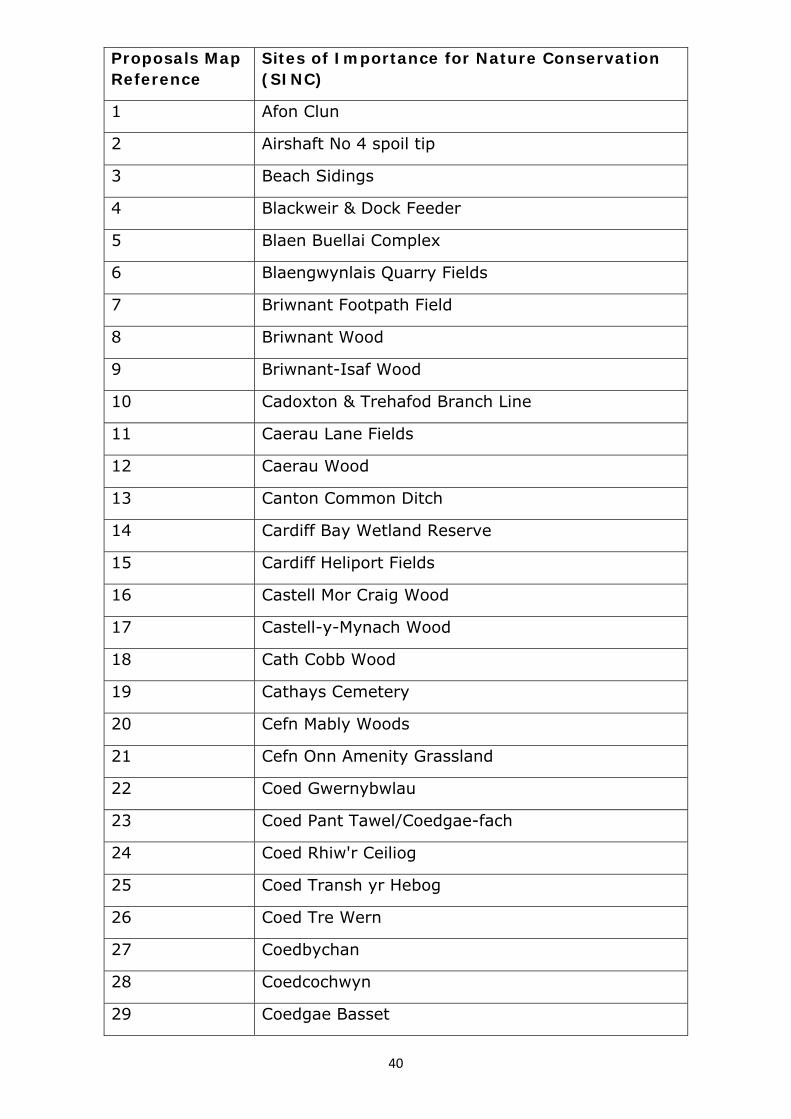
Sites of Importance for Nature Conservation (SINC)
1 Afon Clun
2 Airshaft No 4 spoil tip
3 Beach Sidings
4 Blackweir & Dock Feeder
5 Blaen Buellai Complex
6 Blaengwynlais Quarry Fields
7 Briwnant Footpath Field
8 Briwnant Wood
9 Briwnant-Isaf Wood
10 Cadoxton & Trehafod Branch Line
11 Caerau Lane Fields
12 Caerau Wood
13 Canton Common Ditch
14 Cardiff Bay Wetland Reserve
15 Cardiff Heliport Fields
16 Castell Mor Craig Wood
17 Castell-y-Mynach Wood
18 Cath Cobb Wood
19 Cathays Cemetery
20 Cefn Mably Woods
21 Cefn Onn Amenity Grassland
22 Coed Gwernybwlau
23 Coed Pant Tawel/Coedgae-fach
24 Coed Rhiw'r Ceiliog
25 Coed Transh yr Hebog
26 Coed Tre Wern
27 Coedbychan
28 Coedcochwyn
29 Coedgae Basset

41
30 Coedgae Fawr
31 Coedifanbychan/Coedtirhwnt
32 Coed-ty-Llwyd
33 Coed-y-Briwnant
34 Coed-y-Caeau
35 Coed-y-Creigiau
36 Coed-y-Cwar
37 Coed-y-Felin
38 Coed-y-Glyn
39 Coed-y-Goetre
40 Coed-y-Gof
41 Coed-y-Graig
42 Coed-y-Llan
43 Coed-y-Trenches
44 Coetgaepengam
45 Coetgae-sych
46 Cogan Spur
47 Coryton Heronry Wood
48 Coryton Interchange
49 Craig Llanishen
50 Craigbriwnant field
51 Craig-Llwyn Road Wood
52 Craig-y-Parc
53 Craig-y-Sianel
54 Creigiau Railway Fields
55 Cwm Farm Pond & Streamside Copse
56 Cwm Nofydd Grassland
57 Cwmffynnonau Field
58 Cwmrhyddgoed
59 Discovery Wood
60 Druidstone Road

42
61 Ely Northwest
62 Fairwater Park
63 Fforest-fach/Graig-goch
64 Fforest-fawr
65 Ffynnon-Dwym Wood
66 Fishpond Wood
67 Former Llantrisant No.1 Branch Line
68 Former Penrhos Branch Line
69 Former St. Fagans Branch line
70 Foxfield
71 Gabalfa Woods
72 Glan Ely Wood
73 Goitre-Fawr Ponds
74 Grangemore Park
75 Greenmeadow Wood
76 Groes Faen Fen Meadow
77 Groes Faen Wood
78 Gwern-y-Bendy
79 Gwern-y-Cegyrn
80 Hailey Park
81 Heath Wood & Pond
82 Hendre Lake
83 Hendre Lake West
84 Hendre Road
85 Henstaff Rhos Pasture
86 Lamby North
87 Lamby Salt Marsh
88 Lamby Way
89 Leckwith Pond & Marsh
90 Leckwith Woods Viaduct
91 Lisvane Reservoir Wood

43
92 Lisvane Station Wood
93 Llanedeyrn Woodlands Complex
94 Llanishen Brook (north)
95 Llanishen Brook (south)
96 Llanishen Reservoir
97 Llanishen Reservoir Grassland and Scrub
98 Llwyn-crwnganol Wood
99 Llwyn-y-Pia Marsh
100 Llys-y-coed
101 Lower Rookery Wood
102 M4 Junction 33 Spoil Tip
103 Maerdy Woods
104 Maes Mawr Wood
105 Malthouse Wood
106 Marshfield
107 Melingriffith & Melingriffith Feeder
108 Michaelston Marsh & Woods
109 Mynydd Woods
110 Nant Coslech
111 Nant Cwmllwydrew
112 Nant Dowlais
113 Nant Fawr (north section)
114 Nant Fawr Community Woodlands
115 Nant Fawr Meadows
116 Nant Glandulais
117 Nant Henstaff
118 Nant Mwlan Wood
119 Nant Nofydd
120 Nant Rhydlafer
121 Nant Transh yr Hebog
122 Nant Ty-draw

44
123 Nant Ty-draw Fach
124 Nant-y-Briwnant
125 Nant-y-Briwnant Complex
126 Nant-y-Cesair
127 Nant-y-Draenog
128 Nant-y-Felin
129 Nant-y-Fforest
130 Nant-y-Glaswg
131 Nant-y-Plac Complex
132 Ocean Park South
133 Pant Mawr Cemetery
134 Pant y Gored Wet Woodland
135 Parc Cefn Onn
136 Pencoed Wood
137 Pengam Moors
138 Pentrebane Cottages Ponds
139 Pentyrch Drove Track
140 Plymouth Great Wood
141 Pontprennau Wood
142 Radyr Community Woodlands
143 Radyr Cricket Ground and Fields
144 Rhyd-y-Pennau Complex
145 Rhymney Grassland East
146 Rhymney River Valley Complex
147 River Ely
148 River Rhymney
149 River Taff
150 Riverside Wood
151 Roath Brook
152 Roath Park Lake
153 Roath Park Wild Gardens

45
154 Rumney Great Wharf
155 Scott Wood
156 Slanney Woods & Garn
157 Springmeadow
158 Springmeadow Wood
159 St Fagan's
160 St Julians Forge Fields
161 Swan Mear Wood
162 Sweldon Wood
163 The Garth
164 Thornhill Primary School Pond
165 Tidal Sidings
166 Tongwynlais Oldfield Rd
167 Tre Wern Field, Pentyrch
168 Twmpath Fields
169 Twynau Gwynion Field
170 Ty Llwyd Meadows
171 Tydu Marsh
172 Tyla Farm Wood
173 Tyn-y-Coed Complex
174 Waterhall Plantation & Pond
175 Wenallt Farm Fields
176 Wenallt Road Field, Rhiwbina
177 Wenallt Road North Fields
178 Wentloog Industrial Park
179 Wern Fawr South
180 Whitchurch Golf Course Pond
181 Whitchurch Green Fields

46
Proposals Map Reference
Local Nature Reserve (LNR)
1 Cardiff Bay Wetlands and Hamadryad Park
2 Cwm Nofydd and Fforest Ganol
3 Flat Holm
4 Glamorganshire Canal
5 Hermit Wood
6 Howardian

47
Appendix 8: District and Local Centres
Policy R4 refers to District Centres as defined on the Proposals Map: The District Centres detailed on the following plans are:
(1) Albany Road/Wellfield Road (2) City Road (3) Clifton Street (4) Cowbridge Road East (5) Crwys Road/Woodville Road (6) Bute Street/James St (7) Merthyr Road, Whitchurch (8) Penarth Road/Clare Road (9) St Mellons (10) Thornhill (11) Whitchurch Road
Policy R5 refers to Local Centres as defined on the Proposals Map: The Local Centres detailed on the following plans are:
(1) Birchgrove (2) Bute Street (Loudoun Square) (3) Cathedral Road (4) Countisbury Avenue (5) Caerau Lane (6) Fairwater Green (7) Gabalfa Avenue (8) Grand Avenue (9) High Street, Llandaff (10) Maelfa, Llanedeyrn (11) Newport Road, Rumney (12) Rhiwbina Village (13) Salisbury Road (14) Splott Road (15) Station Road, Llanishen (16) Station Road, Llandaff North (17) Station Road, Radyr (18) Tudor Street (19) Willowbrook Drive (20) Wilson Road

5
26
14
45
41
36
Sub Sta
49
El
25
2
14
13
37
38
16
27
28
15
54
3
2
21
Bank
14
Shelter
200
216
31
36
57
75
211
199
211a
The Gaiety
205
She
lter
14.3m
8
227
3
6
7
242
39
48
43
42
54
195
166
164a
164b
229
166a
199
Gara
ge
43
14.6m
14.0m
68
154
164
51
70
11
El
1
167
181
Sub Sta
Garage
5
1
Rear of 138
Rear of 144
6
27
39
2
29
2
17
38
29
1891
32
120
2
16.5m
197
193
201
16
5
168
Surgery
250
41
49
28
14.9m
28a
Moy
House
Gara
ge
Royal
9
George
TCB1
Sta
Sub
16
El
8to 12
14
139
151
167
151
Garage 15
5
160
Hous
e
14.3m
170
172174
Coac
h
The Gate
wPar
kLibe
ral C
lub
1
PW
201
232
224
203
10
El Sub
Sta
11
116
100
Rave
nsco
urt
1to
15
106
135
121
MP
1.7
523
15
3
42
69
7573
77
6563
7276
69
66
62
59
63
14.9m
LB
64a
26
69b
2
15
1
14
61 to 67
59
Primary School
Albany
64
61
62
14.0m59
49
49
50
37
1
2
51 to 57
13.7m
47
TCB
43
39
27
38
38
35
47
50
Surg
ery
24
13.7m
32
22
34
33
14.6m
41
37
Tennis Courts
27
12
26
19
32
18
21
43
40
30
31
29
16
4a
2
11
4
1
32
20
Sunday
School
4
10
11
66a
1
2
2
158
144to
14
150
25
15
24
13
1
26
12
1
2a
2
1a
169 PH
42
18
17
2
4
23 to 27
12
31
20
St Martin's Church
7
Vica
rage
14
26
11 to 17
19
21
1
2
1a
2a
212
214
202
14.3m
TCB to19
6
175
2
167a
Sub Sta
Surgery
176
180 17
8179
El
194
9a
29
15
1a
14.3m
14.0m
26
2
1
53
63
58
65
14.9m
57
45
14
4
225
203 to 207
7
14.6m
(PH)
Hotel
LB
30
16
14.6m
Park
217
234
Conservative
Club
209
215
Nursery
PLA
SN
EW
YD
DR
OA
D
DIA
NA
ST
RE
ET
DO
NA
LD
ST
RE
ET
KEPPOCH STREET
PLA
SN
EW
YD
DS
QU
AR
E
GLENROY STREET
ALF
RE
DS
TR
EE
T
KINCRAIGSTREET
ARRAN STREET
MOY ROAD
CIT
YR
OA
D
STRATHNAIRN STREET
AR
AB
ELLA
ST
RE
ET
ALBANY ROAD
INV
ER
NE
SS
PLA
CE
RTH
CO
TESTR
EET
VIOLET ROW
MA
CK
INT
OS
HP
LA
CE
FITZROY STREET
RIC
HM
ON
DR
OA
D
Centre:Albany Road / Wellfield Road
Designation:
District CentreMap 1 of 2
© Crown copyright and database rights 2013 Ordnance Survey 100023376
�
N

1
11
71
61 C
hurch
4
11.6m
112
61
Def
8
14
11 51
20
to
31
3
24
11.3m
14.6m
41
2
37
14.3m
50
14.3m
153
51
61
4
40
149
CR
ED
Bdy
41a
2a
15
29
21
1
14
2
7246
3
26
15
38
56
Penyla
n
14
4
1
Court
10.7m6
60
32
1
Kirkland
62
Court
United
Reform
ed
37
Wellfield
1
29Court
44
40
12.8m
Bank
1
Posts
LB
11.6m
TCB
76
75
13.7m
74
Claude Hotel
111
72
10.7m
10
121
138a
10.4m
26
14
132
167
157
138
132a130
11
63
12.8m
84
87
75
2
99
12.2m
108
118
96
1
120
145
128
132
11.3m
Garage
120
El
123
Posts
111
11.9m
Sub Sta
112
110
86
98
13.1m
100
75a
13
1b
12
11
133
13
1b
19
131
110
63
51
129c
129
Cinema
112
135
131a
12.8m163
146
163
134
147
122
164
12.2m
Warehouse
Globe
158
102
The
TCB
Centre
150
166
153
138
150
121
131
12.5m
141
88
123
76
135
64
1
13
23
Bank
13.1m
Bank
12.5m
94
92
PH
12.8m
52
114
109
129
126
117
111
124
136
101
El
Sta
80
107
SubWarehouse
99
68
101
13.1m
2
102
87
95
1a
97
1
93
112
100
85
73
105
39
13.4m
13
26
14
38
25
46
81
75
78
90
852
5250
13.4m
54
83
30
16
22
14
2
Victoria Ct
39
49
27
5
34
6
83
32
5
11
1
12
41
19
2
9
1
1
29
1
25
13
42
311
21
22
12
35
70
41
68
58
163
85
23
96
82
30
73
14.3m
2
14
35
23
3864
15
5426
3
42
69
75
48
73
8179
77
61
65
63
72
88
76
69
66
62
64a
41
69b
WELLFIELD
PLACE
PEN-Y
-LAN
RO
AD
CLA
UD
ER
OA
D
CO
TTR
ELL
RO
AD
ALBANY ROAD
CLAUDEPLACE
WE
LLF
IELD
RO
AD
MARLB
ORO
UG
HROAD
GLENROY STREET
KEPPOCH STREET
STRATHNAIRN STREET
BA
LAC
LAV
AR
OA
D
BA
NG
OR
ST
RE
ET
AN
GU
SS
TR
EE
T
WE
LLFIE
LD
RO
AD
ESSICH
STREET
TULLOC
HSTR
EET
AN
GU
SS
TR
EE
T
BAN
GO
RSTR
EET
BANGORLANE
BAN
GO
RCO
URT
LOCH
ABER
STREET
ALF
RE
DS
TR
EE
T
Centre:Albany Road / Wellfield Road
Designation:
District CentreMap 2 of 2
© Crown copyright and database rights 2013 Ordnance Survey 100023376
�
N

1a
5
Shelter
1a
25
2
14
13
37
38
2
21
Bank
Shelter
200
216
211
199
211a
The Gaiety
205
She
lter
14.3m
8
227
3
6
7
242
195
166
164a
164b
229
166a
199
Gara
ge
14.0m
154
164
1
167
Ric
hm
ond
Apart
ments
Rear of 138
Rear of 144
56
70
58
1891
32
120
16.5m
197
193
201
16
5
168
Surgery
250
Royal
9
George
TCB1
139
151
108
98to100
to110
167
151
Garage
155
160
Hous
e
14.3m
170
172174
Coac
h
The Gate
32
44
33
13.7m
New
Park
Libe
ral C
lub
134to
142
Russell
Court
1 to 11
64
Hall
21
52
85
1
109
College
Baptist
97
76
14.0m
1
45
PW
Depot
90
13.7m
60
125
201
232
224
203
10
El Sub
Sta
23
20
11
Church
73
TCB
75
69
13.1m79
86
83
7880
85
116
13.7m
88
100
Rave
nsco
urt
1to
15
106
37
Sunday
8
School
39
135
121
El
Sub
Sta
Richmond
Square
2
37a
Chy
81
78
13
Bowling Greens
14.6m
Mackintosh Sports Club
90to
94
96
17
14
39
30
65
63
72
88
76
69
66
62
59
63
14.9m
LB
64a
64
61
62
14.0m59
49
49
50
37
38
35
47
50
Surg
ery
2422
FS
33
14.6m
41
37
Tennis Courts
38
91to
99
102
to106
101
103
Gara
ge
118
116
118
13.1m
1
114
116
2
112
27
12
26
19
32
18
128
1b
LB
132
1
13.4m
2
26
5
Garage
113
111
117
115
126
120
21
43
40
30
31
29
16
4a2a
2
11
4
1
32
20
Sunday
School
2
Garage
119
Hall
Garage
127
119a
Warehouse
123
125
121
121a
4
10
11
6
6a
1
2
139
2
Gar
age
Pota
to
Pro
cess
ing
Plant
158
144to
148
150
73
12.8m
PH
4
5
50
14
24
1
9
25
15
24
13
1
26
12
1
2a
2
1a
169 PH
18
4
12
20
St Martin's Church
7
Vica
rage
14
26
11 to 17
19
21
1
2
1a
2a
212
214
202
14.3m
TCB to19
6
175
2
167a
Sub Sta
Surgery
176
180 17
8179
El
194
9a
14.3m
14.0m2
14
4
225
203 to 2077
(PH)
Hotel
LB
16
14.6m
Park
217
234
Conservative
Club
209
215
PEARSONSTREET
PLA
SN
EW
YD
DR
OA
D
KEPPOCH STREET
PLA
SN
EW
YD
DS
QU
AR
E
GLENROY STREET
KINCRAIGSTREET
TAVISTOCK
STREET
CITY
ROAD
RU
SSELL
STREE
T
ARRAN STREET
BEDFO
RDSTREE
T
CIT
YR
OA
D
STRATHNAIRN STREET
ALBANY ROA
RIC
HM
ON
DR
OAD
NO
RTH
COTE
LANE
NO
RTH
CO
TESTR
EET
ER ROAD
RIC
HM
ON
DR
OA
D
Centre:City Road
Designation:
District CentreMap 1 of 2
© Crown copyright and database rights 2013 Ordnance Survey 100023376
�
N

1a
6
25
108
98to100
to110
Shelter
Shelter
1
28
Shelter
35 to43
EDBdy
CR
9
10.7m
11.0m
47
Longcross Court
45
El Sub Sta
40
38
31
35
11.3m
College
31
33
44
11.6m
30
43
6
rinity
Court
47
45 11.6m
2
Hafren
FS
47
28
Cardiff Tertiary College
/ Coleg Glan
22
53
12.2m
23
West
Gro
ve
1to13
Cou
rt
31
CourtRichmond
5
1
18 to20
45
41
54
55
52
1
12.2m
53
4
12.5m
1a1
Hall
50
19
Sub Sta
El
9
7
10
8
6
48a
48c48b
6
63to
57
13
1917
16
11.9m
1
14
10
15
6
Court
Cow
per
5
3
4
2
1
Kings College
St James' Church
1
3
15
5
4
1
Walk
1
7
13
She
lley
Shelley Gardens
7
14
8
Centre
Playground
Community
2to
12
Offices
16
Governm
ent
Garage
26
18
2220
11.9
m
8
12
9
Garage
58to
ShakespeareCourt
34
17
40
36
38
15
TC
B
44
11.6m
42
46
48
Club
7
27
Place
22
Dylan
20
23
25
32
33
3134 24
28
2930
1
26
7
Askam
Court
34
1
42
35
1 to 3
13
12.8m
28
1
22
Posts
3024
18
20
14
26
32
167
22
15
47
14
44
36
Garage
12
90to
94
96
88
52
86
12.5m
84
1
LB
General Buildings
11
to13
19
Club
29
1to
27
Pascall
Court
50
54
11.6m
52
31
11.6m
64
PH
66
1
TCB
47
to61
St Peter's Court
El Sub Sta
PH
78
76
72
80
67
74
69
70
82
71
Club
73
1
16
4
1
3
75
El Sub Sta
81
79
77
85
83
87
124
2
12.2m
1
YMCA
8
5
1
St Peter'sRC
Church
Presb
y
Hall
Tk
5
12.2m
1to4
26
to
PenfordCourt
18
13
8
25
9
112
6 10
11
22
1
5
312
714
8
4
13
12
18
Richmond Court
21
19
1716
23
20
1524
37
49
16
29
30
3427
36
25
33
35
26
31
42
37
46
38
28
4445
40
32
41
48
4
91to
99TCB
89
102
to106
101
103
Gara
ge
118
116
118
13.1m
1
114
116
2
112
Garage
Garage
113
111
117
115
120
2
Garage
119
Hall
Garage
40
73
12.8m
PH
4
5
50
61
14
1
9
Tredega
rv il le
11
29
Baptist C
hurch
42
45
El Sub StaLB
COWPER
PLACE
CLIVE
VERE STREET
OX
FO
RD
STR
EE
T
HA
RD
YP
LA
CE
PLACE
CA
STLE
LA
NE
BE
DFO
RD
PLA
CE
BYR
ON
STREET
CIT
YR
OA
D
MILT
ON
STR
EET
ST PETER'SSTREET
SHAKESPEARE
STREET
TALWO
RTH
STREE
T
PEARSONSTREET
PENLLINE
STREET
BE
DFO
RD
STR
EE
T
TAVISTOCK
STREET
THEPARADE
WE
ST
GR
OV
E
THEW
ALK
OXFORDLANE
NEWPORT ROAD
EA
ST
GR
OV
E
CIT
YR
OA
D
THEPARADE
EAST
GR
OV
ELA
NE
STPETER'S
STREET
Centre:City Road
Designation:
District CentreMap 2 of 2
© Crown copyright and database rights 2013 Ordnance Survey 100023376
�
N

64
66
1to6
1to
6
1to6
1
Clifton
House
Shelter14
5
25
26
93
63
1
58
56
59
57
36
49
24
4637
25
50105
2
14
103
1
46
13
11.3m
102
1310
1
96to
99
2
14
51
87
1614
Shelter
PH
11.3m
17
12
7
100
15
1
29
1
21
36
16
101
Community Centre
Gas Governor
St Germ
ansM
ews
Phoenix
45
40
50
43
24
11.3m
33to
35
1
12
1
36
13
6to10
Centre
113
Community
112
15
104
El Sub Sta
41
40
1
7
420
21
24
16
Bank
118
30
32
31
t029
11.6m
27
11
8
1
12
St Germ
ansCourt
5
1
126
127
122
128
125
11
123
23
2213
53
59
1
19
6
16
20
132
133
139
136
11.6m
137
138
10
1
17
6
Sikh
Tem
ple77
69
26
85
11.6m 27a27b
16
19
11
PO
10
67
51
19
57
55
Vicarage
School
Adamsdown
Primary
Cross
5
St German's
Church
47
3
12.2m
52
1
1
27
2
13
26
2
14
Hall
1
14
12
11
4
42
36
7
1to5
Trinity
66
11.9m
62
26
15
60
23
56
1to10
11.3m
54
22
57
Clifton Court
71
73
5
25
Coach
37
29
38
2
The
House
60
Mews
65
64
Garage
16
11.6m
El Sub Sta
47
54 5
0
49
57
52
51
55 53
57
56
58
41
49
58
32
37
46
44
47
2527
33
31
Hodge Centre
35
48
37
23
Sir Julian
1
21
11.9m
15
33
29
36
31B31C
31A
24
31D
27
15
14
Club
22to32
34
Conserv
ative
Millennium Court
11.6m
10
11.9m
13b
5
9 to 11
1 to 8
8
3
2
11
13a
18
116a
116
Surgery
10
142
14
11
141
2
TCB
11.9m
1
5
147
11
2
11.9m
19
PH2
67
94
5
3 4
8
Upp
erC
lifton
Stre
et
155
11.6m
104Sur
ger
y
15
16
10
12
14b
14
7
PoliceStation
143
11.9m
1
13
to24A
sh
wo
od
Court
1to
12
8
67
64
St Peter's RC Primary School
Library
12.5m
Shelter
147
8
2
11.9m
1
3
12.2m
149a
PH
TCB
5
Stone
3
The Elms
Church
Trinity
1
Centre
Methodist11.9m
to30
25
1to
12
13to
24
31to
36
Nor
woo
dCou
rt
145
46
27
24
63
23
27
FOUR ELMS ROAD
CLIF
TO
NS
TR
EE
T
BROADWAY
SAPPHIRE STREET
CYRIL
CRESCEN
T
EMERALDSTREET
ZIN
CSTREET
TINSTREET
IRON STREET
TOPAZSTREET
RUBYSTREET
CLIF
TO
NSTR
EE
T
DIAM
ONDSTREET
SILVERSTREET
PIE
RC
EFIE
LD
PLA
CE
COPPERSTREET
GOLD STREET
SUN STREET
LEADSTREET
STARSTREET
ME
TA
LS
TR
EE
T
SY
ST
EM
STR
EE
T
OR
BIT
STR
EE
T
SY
ST
EM
STR
EE
T
OR
BIT
STR
EET
Centre:Clifton Street
Designation:
District CentreMap 1 of 1
© Crown copyright and database rights 2013 Ordnance Survey 100023376
�
N

2
1
14
26
64
59
1
24
13
12
24
27
47
8.2m
46
2
56
48
1
38
2
13
15
28
1
14
27
30
28
14
13
14
28
39
40
40
39
27
28
40
33
A
A B
B
8.5m
17
35
19
49
51
84
72
49A
47
69
57
Depot
62
50
Gara
ge
The Lansdowne
1 to 14
71
84
62
74
4la
40
41
100
106
29
28
8.2m
101
8.2m
196
5
40
31
19
Tank
CANTON
Church
Chapter ArtsCentre
Shelter
Club
Police
Station
299
305
8.5m
a
196
196
15
29
8.5m
12
10
2
20
Bresbyteraidd
2
16
Cymru)
2
1
2
1to
8
75
Cw
rt -y-
the Elderly
Court
Home for
Carmarthen
Alexandra
Court6
8
Carm
arth
en
317
202204 to 208
198
307to315
(Eglwys
Car Park
3
Salem
11
2
21
Ty Canna
40
Chapter Arts Centre
Car Park
50
Court
1
41
68
54
4
41a
9.1m
(PH)
The Insole
12
8.5m
327
220218
210
327ab
22
Car Park
9.8m
Car Park11
1
44
23
13
32
44
31
32
21
41
40
5
1
Church
School
Uniting
Sunday
8
10
234
234
Canton
8.5m
PO
a
El
51
Sub
Sta
16
2
331
TCB
236
236238 b
236
a
339
Farch
nad
752
14
1b
1
3
1a
36
26
1
22
9
54
61
46
62
2 2a
63
5to
670
22
80
School House
SchoolGymraeg
Treganna
9.1m
36
46
39
91
9
11
5to
8
a
3
20
101
MP
240
2
238
48
18
54
40
41
28
43
De
pot
7
8
5
61 to 4
910
Cardigan
Court
40
50
19
60
17
31
5to
20
30
5
Cwrt Treganna
4
3c
3a
1
4 2
1
17
9 4
1
16
2
70
14
1
6668
9
11
Shelter363
351
349
23
38
26
35
1
12
55c
55b
43
55a
Radnor Court
4
3
2
1
50
1c
1
90
80
1a
31d
1b
2c
2a
2
16
15
Sub
Sta
El
Ham
ilton
Court
31
10.4m43
28
40
12
10.4m
11
21
14
1
100
42b
375
2
379
373
1
PH
377
MARKET
DE
NT
ON
RO
AD
ALE
XA
ND
RA
RO
AD
ETON PLACE
CUMBERLAND STREET
WESTMORELAND STREET
TH
EO
BA
LD
RO
AD
HANOVER STREET
CARMARTHEN STREET
GLA
MO
RG
AN
ST
RE
ET
GLA
MO
RG
AN
ST
RE
ET
HARVEY STREET
MA
RK
ET
RO
AD
TH
EO
BA
LD
RO
AD
ME
WS
BRUNSWICK STREET
ST
CA
NN
AC
LO
SE
ANGLESEY STREET
CARDIGAN STREET
PE
N-Y
-PE
EL
RO
AD
RA
DN
OR
RO
AD
COWBRIDGE ROAD EAST
BE
DA
RO
AD
BE
DA
RO
AD
NO
RT
HU
MB
ER
LA
ND
ST
RE
ET
Centre:Cowbridge Road East
Designation:
District CentreMap 1 of 3
© Crown copyright and database rights 2013 Ordnance Survey 100023376
�
N

15
LB
52
201
Dorothy Le
Pi c
ton
Wal k
1
9
47
13
12
51
14
211
15
12
11
17
GrahamWalk
14
2
16
6
1
Murray Walk
Alb
ert
Walk
1
TC
Bs
48
7.0m
7.0m
229217219
17
8488
8690
80
82
25
13
1
to239
Shelter
241243
TCB
PH
Bank
237
Car Park
El
10
28
Colb
ourn
eW
alk
11
Sub7.0m
Community Hall
Playground
Sta
1
6
249
7.0mBank
6.7m
19
12a
12
253
ED
Bdy
25
18
38
CR
Post
22
14
20
46
12
St John's
PH
Garage
Court
1 to 9
9 2
11
1
2
7.3m
1to
3
St Johns Mews
1
5
13
1
26
14
1
82 7.0m
1
2
2
11
1
7.6m
2
21
31
12
7
10
25
2
1
13
8
St John's Church
The Old Coach House
11
21
38
LB
14
26
1
19
24
8.2m
10
213
Car Park
215
2
116
126
78
51
7.9m 90
St M
ary'sRC
Scho
ol
61
132
1a
128
House
Seve
rnC
ourt
1to
10
7.9m
4
Amberly
1to
5
7.9m
27
28
16
7.9m
76
75
52
64
25
40
35
41
29a-29c
29
Sunday
Church
School
Calvary
134136
Baptist
1 to 5
41a
El Sub Sta
43
1
Severn Square
Junior
School
138
Severn Road
to
Madras
Taleemul Quaran
53
65
53
51a
54
59
51
Severn Road
39
42
49
Mosque
1a
152
Infants
Chy
146
158
251
PH
20
11
2
19
2a
Nursery
10
160
Tank
259
Posts
Post
164
162
30
25
21
295
2
3
6
30
4
1
31
269
Car Park
174
Posts
170
176172
PC
7
9
11
1210
13
16
8
66
13
1614
64
15
271275
7.3m
Bank
4
186
(PH)The Canton
8
2
TC
B
2798.2
m
27
17
32
8.2
m
20
42
9
CR
ED
Bdy
3
Bank
Hotel
Corporation
1
190(PH)
5
194
Library
El Sub Sta
Chy
8.2m
291
1a
TCBS
Free
18
Centre
10
(PH)
Butchers Arms
41
51
Adult 3
1
Educatio
n
68
2
196
2
5
24
293
2a
40
24
8.5m
2
54
50
56 1
Olive Court
19
Tank
CANTON
Church
Chapter ArtsCentre
Shelter
Club
Police
Station
299
1
11314353
61
SE
VE
RN
RO
AD
WYN
DHA
MC
RESC
EN
T
PIC
TO
NP
LA
CE
WELLINGTON STREET
ALB
ER
TS
TR
EE
T
DELT
AST
COWBRIDGE ROADEAST
ORCHARD PLACE
GR
AY
STR
EE
T
PHILIPSTREET
GLYNNE STREET
SPRINGFIELD PLACE
CH
UR
CH
RO
AD
EARLE PLACE
MAJOR ROAD
WE
LB
YR
OA
D
ANSTEE
CO
UR
T
GR
AY
LA
NE
GRAY STREET
LIB
RA
RY
ST
RE
ET
LLA
ND
AF
FR
OA
D
MARKET PLACE
WELBY LANE
CRESCENT
STCRESCENT
PE
NL
LY
NR
OA
D
ST
DE
NT
ON
RO
AD
JOHN'S
JOHN'S
TON PLACE
Centre:Cowbridge Road East
Designation:
District CentreMap 2 of 3
© Crown copyright and database rights 2013 Ordnance Survey 100023376
�
N

2
9
Adult P
Posts7.3m
23
14
34
36
26
32
33
30
7.0m
43
1to8
Mews
Wellington
107to111
32
El Sub
28
30
2
25
1
25
24
11
37
7.6m
36
25
49
12
24
37
48
61
7.9m
60
51
8.2m
36
34
Posts
72
87
82
73
7.6m
48
Priory
61
3 1
7.3m
546
Hospital
1 to 18
StDavidsMansions
21
19
29
24
23
20
27
22
26
61 5963
42
47
132
36
32
31 35
33
54
34
7
4
Wellington
Court
48 to 50
1
67
68
70
71
7269
42
41
40
37 39
38
23 56
98Car Park
10
144
1
28
TCB
1918
9
14
5
25
60
3
2
66
129to133
52
18
48
13
5149
HealthCentre
54
53
5250
Riverside
41
37
50
46
32
54
Edinb
urghC
ourt27
El Sub Sta
45
36
23
43
10
2
45 47
46
1
44
Surgery
Court
68
1
4
St David's
PH
Club
Kings Mews 1to
5
7270
2
King's
(PH)
Castle
147149
27
25
25b
42
Gerrard
Court
1
2
1to7
Port
House
St Mary
38 t o
36
34
RC Church
of the Angels
29
7.6m
26
24
89
6to
10
7.0m
15
14
7a
7
22
24
13
64
Hall
8.2m
54
50
7.0m
30
Cant on
Court
51
33
34
1
163
80
157
2
76
6.7m
10
1
8
2
29
15
16
30
44
43
57
26
165167169
43
23
69 to 77
27
28
45
52
Canton
Court
15
59
2
6
2
1
51
P
1
16
69
181
191
201 PH
HomeDorothy Lewis
22
60 to 68
Pi c
ton
Wal k
7
59
1
6
1
14
5
1
Dugdale Walk
6
9
13
12
55
51
14
6
Murray Walk
Post
41
6
53
12
22
14
10
7.0m 8
20
16
84
LB
b 82
106
82
6.7m
173
96 9498
92
64
42
54
39
7.3m
32
HouseThe Crown
15
Surgery 27
2
14
7.3m
66
Car Park
116
78
51
61
65
MAN
COWBRIDGE
LE
WI S
ST
RE
ET
WYNDHAM STREE
HAMILTON STREET
TALBOT STREET
SO
UT
HM
OR
GA
NP
LA
CE
PLACE
WELLINGTON STREET
WY
ND
HA
M
WELLS STREET LANE
AN
NS
TR
EE
T
MO
RG
AN
ST
NO
RT
H
STREET
BLACKSTONE
KIN
G'S
RO
AD
WYN
DHA
MC
RESC
EN
T
ROLLS STREET
WELLINGTON STREET
Centre:Cowbridge Road East
Designation:
District CentreMap 3 of 3
© Crown copyright and database rights 2013 Ordnance Survey 100023376
�
N
153to157
Shelter
1
3
1
3
26
29
29
30
41
18
Lucas
Court
56
2
3
4
El Sub Sta
1
27
30
Lion
Cou
rt
16.8m
24
46
55
44
42
Medallion House
62
55
TCB
16.5m
1 to 8
Crwys Mews
65
CB
Dan
iel H
ouse
52
57
56
D
56
A
Lang
land
Cou
rt
School
75
1to
4
37
64
Sunday
Garage
81
67
65
64
17.4m
68
1
to 66
Bank
1b
1a
12
CathaysPresbyterian
14
74
47
49
ChurchOf W
ales
80
97
83
92
Works
22
44
29
27
43
55
45
56
46
48
39
49
32
3634
32
38
66
65
66
57
16
22
45
Hall
20
48
29
31
47
34
24
36
33
35
Sylric
1 to10
Cadogan
Court
House
96a
96
1
TCB
94b
20.1m
2
72
109
60
LB
PO
19.2m
1
2
15
115
98
115a
113
111
94
Gara
ge
14
71
84
18
49
3911
9
121
a
12311
9a
123
112
117
838
27
1018.6m
29
129
9
18
131to141
17
114
21.3m
122
85
17
9
ElSub
Sta
10
151
143
132
El S
ubSta
1
23.2m
El SubSta
Gara
ge
86a
2
88
95
105
86
90
160
172
186
200
210
218
18
8
24.1m
21.9m
CATHAYS
23
13
12
34
25.6m
36
2
22
12
1
13
25
14
142
11
1
2
134
144a
146
148
144
159
220
2a
150
163
25.9m
25.3m
16.2m
48
71
99
115
123
to 1
27
El SubSta
2
101
128
TC
B
LB
96
91
121
119
50
129
15.8m
117
111
StTeilo
'sC
hurc
h
103
16.2m
97
12
Sunday
School
12
13
24
14
24
26
23
391
105
Inst
itute
107
113
1
118
2
10
16.8m
25
17
Posts
15
5
40
29
38
52
2
Club
110
Woodville Court
106
6
11
10
Works
Meth
odi
st
16.5m
43
Cath
ays
Churc
h
53
John
Tru
elov
e
House
74
8
95
3
12
1
95
Vicarage
8
Annibynwyr )
11
9
13
(Addoldyyr
Eglwys Minny
Street
Garage
3
2
12
5
1
Gar
age
53
51
54
Posts
16.8m
30 SA
Hal
l
42
21
17.1m
Posts
2
6
26
9
28
2
61
3
23
67
The
Courtyard
Dal
ton
Cou
rt
1to
8
116
a
64
54
50
41
53
10
34
35
45
24
77
1
17.7m
2
74
65
44
45
56
35
57
The
74
122
62
67
86
Day Centre
Works
87
79
84
69
98
110
17.4m
1
17.4m
Flora
(PH)
134
18.0m
87
103
85
LB
138
Club
19.8m
TCB
152
148
GO
WER
STR
EE
T
DANIEL
STREET
LU
CA
SSTR
EET
FLORENTIASTREET
WH
ITC
HU
RC
HPLAC
E
ROBERTSTREET
DA
LTO
NS
TR
EE
T
MAY
STREET
CRWYS
ROAD
SPENCERSTR
FLORA
STREET
DALTO
NSTR
EET
GLAD
YS
STR
EE
T
MINNY
STREET
Y STREET
FAN
NY
STR
EET
MAY
STREET
CA
TH
AY
ST
ER
RA
CE
Centre:Crwys Road / Woodville Road
Designation:
District CentreMap 1 of 2
© Crown copyright and database rights 2013 Ordnance Survey 100023376
�
N

CR
ED
Bdy
16a
143
160
145
159
156
1
Wks
2
13
11
2
1
12
2
139
1
2a
Garage
16a
Hall
The
8
9
1
6
17
1
168
180
23
108
98
ElSub
Sta
115
14
95
85
3
Works
SL
SL
16
15
Shelter
1
11a
133a
133b
30
30a
30b
3
1
13
3
26
11
14
29
27
30
41
18
Lucas
Court
56
2
3
4
El Sub Sta
1
27
30
Lion
Cou
rt
16.8m
24
55
42
Medallion House
62
55
TCB
16.5m
1 to 8
Crwys Mews
CB
Dan
iel H
ouse
52
56
D
A
Lang
land
Cou
rt
1to
4
37
64
Garage
81
67
65
64
17.4m
68
1
to 66
Bank
1b
1a
4749
80
97
83
92
Works
Sylric
1 to10
Cadogan
Court
House
96a
96
1
TCB
94b
2
72
109
60
LB
PO
19.2m
115
98
115a
113
111
94
Gara
ge
71
18
49
119a
117
88
2
18
(Presbytn)
24
107
Kings Way
95Depot
15.2m
94
73
78
120
80
Day Centre
15.8m
Station
123
1a
2
16.5m
Police
76Scrap Yard
66
65
75
77
144
18
The
Crw
ys(P
H)
150
32
135
29
28
27
Crwys House
111
113
114
2729
ThesigerMews
86
100
97
85
82
44
56
53
46
41
36
16.2m
48
15.8m
61
41
51
72
71
74
73
62
39
99
115
123
to12
7
El SubSta
2
101
140
133
128
TC
B
86
74
LB
96
91
121
119
50
129
15.8m
117
111
StTeilo
'sC
hurc
h
103
16.2m
97
76
12
Sunday
School
15
12
13
24
14
24
26
23
391
16.2m
48
60
105
Inst
itute
107
113
1
118
2
42
10
16.8m
25
17
Posts
15
5
40
29
38
52
2
Club
110
Woodville Court
106
6
11
10
Works
52
2
Meth
odi
st
16.5m
43
Cath
ays
Churc
h
53
John
Tru
elov
e
House
74
8
95
3
12
1
95
39
40
28
27
5
9
Vicarage
16.
2m
89
8
Annibynwyr )
11
9
13
(Addoldyyr
Eglwys Minny
Street
Garage
3
2
12
5
1
Gar
age
53
51
54
Posts
16.8m
30 SA
Hal
l
42
2b
81
73
71
63
53
21
17.1m
Posts
2
6
26
9
28
1
5
6
2
2a
4
3
1
1a
1a
2
8
12
10
21
2
2
61
23
1
54
41
10
35
16.8m
22
GO
W
NO
RM
AN
STR
EET
DANIEL
STREETROBERT
STREET
LU
CA
SSTR
EET
LU
CA
SSTR
EET
ALTO
NS
TR
EE
T
CRWYS
ROAD
FAN
NY
STR
EE
T
ALEXANDERSTREET
ROAD
CRWYS
STR
EET
RHYMNEY
TERRACE
ROBERT STREET
BRYDGESPLACE
RIC
HAR
DS
STR
EE
T
WO
OD
VIL
LE
RO
AD
BASILPLACE
HAR
RIE
T
FLORA
STREET
GLAD
YS
STR
EE
T
MINNY
STREET
FAN
NY
STR
EET
MAY
STREET
LETTY
STREET
INESTREET
Centre:Crwys Road / Woodville Road
Designation:
District CentreMap 2 of 2
© Crown copyright and database rights 2013 Ordnance Survey 100023376
�
N

Bollard
Mooring Posts
Floating Pontoons
FB
Lighting Towers
2728
26
Bollard
Bollard
30 Mooring Posts
PO
Roald Dahl Plass
Saint Line
33
1
85
7
Fountain
PH
Tunn
el
5
El
Sub Sta
Lighting Towers
Lighting Towers17
2514
Mermaid Quay
Ocean Buildings
Marine
Office
(MOT)
Mercantile
Dock
sLan
e
Custom House
102
Cory
' sB
ui ld
ings
57
107
Bank
7.9m
PH
100
97
94
112
56
55
116
7.9m
113
5
111
54a
Dock
Cham
ber s
7.9m
54b
4
54
34
33
Georg
eS
tree
t
1
StC
l ai r
Co
ur t
12
16
21
14
The Point
LB
Theatre
PH
1 to 32
Cambrian
Cymric
Buildings
Buildings
27
29
42
30
44
28
7.6m
363537
14
3938
40
34
Dowlais Arcade
Chambers
18
Bank
6.7m
Bay
PH
House
22
48 43
4547
51
46
49
41
50
18
Bank
12
4125
LB
Cliff Court
1 to 28
1to27
St James Mansions
21
23a23
Mermaid Quay
24
20
SPs
9to
10
10
Bank
FB
12
4 to 6
7
1
2
31
Bollards
Cn
Gate
s
Bollard
Cn
FB
Dolphins
Graving Docks
SPs
Mount Stuart
Bol
Landsea
Cn
Bollards
Bol
Graving
Dock
No
1
Sl o
pin
gm
ason
ry
Gardens
3
FS
9
Pilotage
House
TCB
Harbour Point
Cn
Bol
Graving
Dock
No2
26
5657
5452
28
53
55
15
11
16
8
20
Ramp
Ramp
El Sub Sta
Multi Car PK
Bollard
Graving
Dock
No
3
TravellingCrane
LandingStages
1
6
3
Techniquest
8
11
6974
687273
75
71
1
70
El
7.9m
Sub
5048
Sta
7
to3
Bank
LB
45
6
TCB
8
58
EmpireHouse
53
2554 to 57
17
59
61
Colu
mB
uil d
i ng
s
58
62
60
63
16 1
113
10
66
LB
65
PH
67
14
64
23 20
Cardiff Exchange
Posts
Baltic House
7.6m
Hou
s eM
ount
Stu
ar t
39
33
BU
TE
ST
RE
ET
/S
TR
YD
BU
TE
BU
TE
ST
RE
ET
/S
TR
YD
BU
TE
PLAS BUTE/BUTE PLACE
JAMES STREET
BU
TE
CR
ES
CE
NT
/C
ILG
AN
TB
UT
E
STRYD
NEWYDD
GEORGE
TACOMA SQUARE
BU
TE
CR
ES
CE
NT
/C
ILG
AN
TB
UTE
WE
ST
BU
TE
ST
RE
ET
SH
IPL
AN
E
BU
TE
ST
RE
ET
/S
TR
YD
BU
TE
ST
RY
DG
EO
RG
EN
EW
YD
D
STUART STREET /
NEWGEORGE
STREET /LOUISA PLACE
ST
UA
RT
PLA
CE
NE
WG
EO
RG
ES
TR
EE
T/
STRYD STUART
STUART SQUAREMOUNT
MOUNT STUART SQUARE
JAMES STREET
PLACE
PLA
CE
AD
ELA
I DE
ST
RE
ET
LO
UIS
A
STUART STREET / STRYD STUART
ST
RY
DA
DE
LA
IDE
Centre:Bute St. / James St. District Centre
Designation:
District CentreMap 1 of 1
© Crown copyright and database rights 2013 Ordnance Survey 100023376
�
N

93
Warehouses
26
25
48
FB
Eglwys Newydd
County Infants
School
El Sub Sta
1to
4
6
81
1
5
TCB
FB
83
The
Tab
erna
cle
27.4m
House
15
Summerfield
to
20
Warre
n Evans Court
5 to 11
12 to19
23
20
77
32
27.4m
75
77a
Cou
rt
PH
Sum
mer
field
1to
6
79
Garage
4
88
1
1
to
35to
28
27
24
53
5852
9
47
62
74
71
Pos
ts
73
Pol Sta
36
to
46to
43
42
Eglwys Newydd
Brookside Court
County Junior
Whitc
hurc
h
1 to 12
30
Bro
ok
Girls SchoolP
at h
38
20
12
Glan-y-nant Court
El Sub Sta
2
13to18
9
10
1 to 9
8
6
Trewartha
Court
7to12
1
36
to39
27
1
2
24
14
14
43
40
37
3
2
57
55b
Warren
5553b
Evans
53c
Court
53a
Playing Field
Car Park
53
5147b
PO
TCB
42a
28.0m
44
28
30
26
34to
42
32
Shelter
Ban
k
23
21
16
11
56
17
13
15
55
12
63
18
24
5
Clinic
6
29.3m
4 3
(PH)
PH
ThePlo
ugh
2
3
11
5to
9
25
15
22
31
64
30
16
Gara
ge
Gara
ge
14
18
2
1
Gate
Lych
24.9m
7
Bethe
l
Baptis
t
Chu
rch
3
Bank1
39
12
46
45
1
50
4
2
3
50
8
10
7
9
44
51
20
35
4345
39
47
41
31
20
14
29.3m
20
24
22
Shelter
5 Hall
Institute
3
Church
Gate
House
30.8m
7
38
46
15
8
1
41
45
Bet
hel
Bap
tist C
hurc
h
Sch
ool H
all
Car Park
15
13
Bank
30.5m
9
Works
House
Coach
The
2523
El Sub
Posts
Sta
ClubPosts
12
TCB
17
19
St Mar
ysC
hurc
h
74
19
57
71
23
24
26
21
70
32
28
33
29
27
34
16
1
10
35
9
36
7
9
Gas
Governer
2
27
DAVIS'S TERRACE
GLA
N-Y
-NA
NT
RO
AD
BLANDON WAY
BR
OO
KR
OAD
BLA
ND
ON
WA
Y
BLA
NDO
NW
AY
STDAVID
'SROAD
GLANDWR PLACE
ROAD
RIA
LTO
CO
UR
T
VICTORIA
OLD
CH
URCH
RO
AD
Centre:Merthyr Road, Whitchurch
Designation:
District CentreMap 1 of 1
© Crown copyright and database rights 2013 Ordnance Survey 100023376
�
N

Church
Coach
House
1
80
Memorial
Hall
70
8
6
37
4
86
27
2
70
74
114
61
El Sub Sta
126
83
71
49
100
Shelter
88
36
Library
7
El Sub Sta
65
55
38
56
29
43
Posts
7.0m
9
17
Tank
El Sub Sta
12
6
1
7
The Old Library1 to 13
36
129
24
41
1
11
7.0m
44
45
35
37
7.6m
34
2
73
68
77
25
32
Sur
gery
52
141
155
27
92
104
12
2
13
15
1
13
42
59
54
45
32
42
43
Builder's
51
22
Yard
167
175
169
Warehouse
116
69
7.3m
1
2
3
2a
1a
11
12
1
13
27
25
52
50
45
47
46
51
37
LB
128
128a
181
Bank
183-187
55
84
59
7.0m
14
7
1
125
118
157
10
6112
135
109
102 1
11
104
117
23
21
1
12
11
Depot
2
116
114
23
22
38
33
31
5
50
45
1341
25
13 Garage
2
1
9
6
27
13
30
29
4749
53
9
1
14
2
24
19
18
78
55
38
44
30
27
6.7m
28
36
1
13
233
2
8
Crystal Court
231
168
162
to16
6
160
Club
158
7.0m
44
1
45
2
Station
43 4
Police
42
3
32
3
PH
5
172
245
249
178
38
Primar
ySch
ool
6.3m
37
St Patrick
's
13
4
1
25
6
2
5
253
7
1
7.0m
2833
45
5
26
Garage
25
12
9
2
1
Health Centre
14
17
107
20
15
11
129
8
7.0m
188-
190
3
97
1a
1
2
192
23
17
18
10
19
15
11
2219
23
16
27
175
79
177
17
3171
165
1952
14
189
26
41
30
28
189a
154 TCB
to
158
156
160
PCs
181
185
162
7.3m
to 174
178
170
172
130a
130
176
Po
st s
70
Surgery
134
2
132
2
138
(PH)
209
The Grange
201
Depot
Works
War
ehou
se
Hotel
215
217
2
16
33
25
23
56
3
55
12
65
146
14
144
148
1507.0m
32
30
15
26
22
34
152
144
150
7.0m
Shelter
FERNDALE
STR
EET
CO
RPO
RATIO
NRO
AD
CL
AR
ER
OA
D
PA
GE
TS
TR
EE
T
PEN
ARTH
RO
AD
PA
GE
TLA
NE
PENTR
ESTR
EET
MA
RD
YS
TR
EE
T
REDLAVER STREET
ST
RE
ET
STOCKLAND STREET
CHESTER PLACE
HAVELOCK PLACE
DURHAM STREET
THOM
AS
STR
EET
STR
EET
REDLAVER STREET
NO
RTH
FRANK
LENSTRE
ET
CLIV
E
OP STREET
OW
STR
EET
DIN
AS
PLA
CE
WARW
ICK
STREE
T
DEVO
NPLA
CE
DORSET STREET
WA
RW
ICK
PLA
CE
CHES
TER
STR
EET
Centre:Penarth Road / Clare Road
Designation:
District CentreMap 1 of 1
© Crown copyright and database rights 2013 Ordnance Survey 100023376
�
N
SM
1to4
16 to 19
SM
9to
12
13
t o1
5
6818
70
14
16
13
15
17
TCP
El Sub Sta
19 to 23
Oakmeadow
32
to3
5
85
63
Court
20.7m
30
Path
and
Cycle
Way
101
Bowling Green
SM
Library
12
10
11
9
7
8
14
16
12
10
1
Primary School
20
4
1
10
Centre
24
SM
Community
35
Crickhowell Walk
4
to
3
5
1
Technology Park
4
2
6
Willowbrook
Bryn
PW
Surgery
Derwen
Heritage Inn
9
20
18.1m
(PH)
12
18.4m
2
2
8
Willowbrook House
Path
Post
Police
Station
Path
El
FB
Hypermarket
Sub Sta
Pond
Pat
h
3
5
4
1
19.0m
4
1
12
8
23
ob
1
SM
El
Sub Sta
El Sub Sta
7
20
9
10
8
28
6
8
1
1
Path
FB
1
1
18
14
2
12
8
15
11
26
28
27
34
44
37
52
51
LLANDOGOROAD
WIL
LOWBROOK
DRIVE
CR
ESC
EN
T
ST ARVANS
CR
ICKH
OW
ELL
RO
AD
BROCKHAMPTON ROAD
CH
ES
TE
R
OAKMEADOW DRIVE
CL
OS
EA
SH
DO
WN
DU
MM
ER
CL
OS
E
CLO
SE
SA
ND
ER
LIN
GD
RIV
E
CLO
SE
KIN
GFIS
HER
SH
EE
RW
AT
ER
CLO
SE
SCO
URT
ASPEN
CLO
SE
Centre:St. Mellons
Designation:
District CentreMap 1 of 1
© Crown copyright and database rights 2013 Ordnance Survey 100023376
N

18
16
2
20
13
72
Oakri
6
2
1
15
39
55
41
37
25
6
2
4
11
10
12
24
26
34
22
24
1
4
8
18
22
27
12
27
23
19
l7
17
8
23
15
14
54
42
36
22
39
5
2
33
24
1
5
28
13
10
49
35
10
1
34
11
30
16
40
28
6
18
1
2
28
34
57
40
70
68
5452
THORNHILL
PO
El
Sub Sta
10
11
1214
13
5
24
18
4
1
5
2
1
27
15
13
7
2
4
22
14
14
3
1
1
North Cardiff MedicalMeddygfa Gogledd Caerdydd Centre
7
16
35
23
33
25
26
9
Lla
nis
hen
Brook
20
10
12
7
22
65
3
4
1
2
Subway
10
12
11
5
21
2
7
4
1
6
3
2
8
1
38
37
2
7
6
3640
48
12
7
34
10
8
12
13
1
45
22
94
7
6
Centre
Church
7
19
3
55
21
12
50
59
28
56
22
43
31
16
73
17 21
67
1
52
58
69
Bro
ok
Lla
nis
hen
12
51
76
10
64
LYRICW
AY
WIG
MO
RE
CD
R
RAGNAL CLOSE
CA
VE
ND
ISH
CLO
SE
WAY
DRIVE
BROOKVALE
CLO
SE
CLO
SE
CLO
SE
APOLLO
AS
TO
RIA
EXCALIBUR DRIVE
AL
DW
YC
H
GARRICK DRIVE
CLO
SE
SH
AFT
ES
BU
RY
RA
GN
ALL
CLO
SE
CLO
SE
REIG
ATE
DR
IVE
MERLIN CLOSE
DE
RW
EN
TC
LO
SE
KENNIN
GTO
N
CLO
SE
WOODLAWN
CA
RLTO
N
CLOSE
WOODLAWN WAY
Centre:Thornhill
Designation:
District CentreMap 1 of 1
© Crown copyright and database rights 2013 Ordnance Survey 100023376
N

97
114
21
9
1014
6
El Sub Sta
70
Surgery
1
2
19Court1
to23
Sachville
Gospel Hall
Heath
26
27
(Governm
ent
(Ty'r C
1 to 6
Pond
Com
p
The Flats
14
58 56
13
21
25
107
116to
120
Hea
th
Evang
elical
Chu
rch
29.0m
47
37
57
45
44
28.0m
34
109
134
107b
122
29.3m
Sub StaEl
RC
School
St Joseph's
142
136138
140
70b
1129.9m
13
23
12
33
24
29.3m
33
St Joseph's
5
1
Presby
16
RC
Church
2
22
154
33
Club
29
27Soc
ial
23
25
2
26
14
29.6m
36
15
32
1
2
29.9m
Bank
164
174
37
45
30.2m
30.2m
43
51
184
5
1
15
8
2
9
7
26
13
2
14
19
54
23
32
35
33
44
TCB
30.8m
2
1
200
55
67
202
61to
65
Bank
59
198196
1
29.6m
11
38
22
12
24
2
25
49
50
38
89
228
214
77
212
30.2m
LB
22
2116
31
32
56
35
47
42
23
12
7
21
34
31
8
31.1m
37
45
32
54
46
30
101
TCB
242
99
240
1
30.2m
1
2
12
11
2
1
64
31.1
m
49
44
56
41
Victoria
Mews
33
15
16
52
17
9
19
78
68
to
13
252
268
11
2
111
30.8m
15
82
70
14
51
18
23
20
47
74
59
64
266
m
264
113
25
16
29
26
SOBER
TON
AVE
NUE
ED
ING
TO
NA
VE
NU
E
W
NEW
ZEALA
ND
RO
AD
BANASTR
EAVENU
E
GARDENS
RO
AD
CANADA
AFR
ICA
HEA
THFIE
LDPLA
CE
NEW
ZEALA
ND
RO
AD
AUST
RALI
ARO
AD
AV
EN
UE
WHITCHURCH ROAD
CU
RL
L
HFIE
LDRO
AD
PEN-Y
-BRYN
RO
AD
NEW
FOUNDLA
ND
RO
AD
Centre:Whitchurch Road
Designation:
District CentreMap 1 of 2
© Crown copyright and database rights 2013 Ordnance Survey 100023376
N
27.7
m
117
Shelter
28.0m
LB
10
7
97
69
El Sub Sta
77
28.0m
2b
79
2
87
95
2a
Gara
ge
1
El Sub Sta
31
27.7
m
51
59
28.0
m
15
39
41
23
122
57
1b1
61
64
1a
52
14
1
21a
CR
Boro
Con
st ,Asly
Const
&ED
Bdy
25
28.7m
13
14
26
22
13
47
37
50
36
25
11
34
26
42
44
TCB
Hall
30
34
3232a
36
7
28
Chy
Allensbank Junior and Infants' School
37
49
12
38
50
24
15
37
27
51
28.4m
64
FS
54
CR
Boro
Con
st, Asly
Con
st&
ED
Bdy
24
19
House
School
62
82
74
1
2
65
CR
Bo
roC
onst,
Asl y
Con
st&
ED
Bd
y
9 to 12
Bank
97
104
114
LB
94
5 to 8
1to
4
Memorial
9
War
Church2
27.1m
1
27.7m
12
(PH)
Shelter
27.7m
4
11
Heath
The
1
28.3m
20
14
Sub Sta
El
28.0m
94
79
2
34
28.7m
1
Shelter
73
44
72
32
29.0m
84
85
84
(Governm
ent Offices)
(Ty'r C
wm
niau)
1 to 6
Pond
Com
paniesHouse
PO
TCBThe Flats
Shelter
58 56
21
107
116to
120
Hea
th
Evang
elical
Chu
rch
29.0m
107b
122
Barracks
Cotta
ge
m
WH
ITC
HU
RC
HR
OAD
ALLENSBANK
TALYGARN STREET
CRESCENT
AL
LE
NS
BA
NK
RO
AD
LLANISHEN STREET
MANOR STREET
CRO
WN
WAY
(FFO
RDD
YG
ORON)
ST
JOSEPH'S
COU
RT
(FFO
RDD
YG
ORO
N)
AY
WHIT
CHURCH
ROAD
Centre:Whitchurch Road
Designation:
District CentreMap 2 of 2
© Crown copyright and database rights 2013 Ordnance Survey 100023376
N

24
45
31
22
32.6m
38
44
33
33 3
6
17
26
2
20
10
28
36
32
25
35
68
50
15
1
32.6m
2
41
64
32.9m
54
65
LB
42
39 3
2.3
m
Birchgrove
86
2
83
95
33.2m
Cottages
Bank
1
87
The 1
El Sub Sta
New Inn
(PH)
Gara
ge
8
74
2
69
12
22
3
32
29
Birchgro
veCounty
32
Primary
School
48
48
34
17a
e
Sunnycroft
3
32
55
53
38
33
34
44
LB
42
33.5
38
1
18
Tennis Court
32
TCB11
31
07
111
119
109
105
16
3
158
34.1m
15
1
165
24
34.4m
34.1m
2
30
13
1
8
30
38
51
29
26
12
26
20
8
13
25
37
13
El
2
21
Sub Sta
33.5m
18
26
Surgery
4
110
108
2
98
1
Bank
6
Shelter
33.5m
6
103
12
0
132
12
412
2
130
33.8m
147
129
146
136
9
The
18
(PH)
Birchgrove
530
12
26
137
23
31
Methodist ChurchSt Andrews
Club
10
1
1
LB
Works
20
2
33
23
13
24a
mere
40
11
31
1
41
25
31
15
42
13
54
2
14
32.9m
TCB
52
19
17
20
21
46
19
4
6
35
33
64
18
30
1
1
lflo
26
1
4
33
The
Coach
Hou
se
The Grove
24b
3
RHYDHELIG AVENUE
ST
AL
BA
NA
VE
NU
E
ST
AG
NE
SR
OA
D
ST
HE
LE
N'S
RO
AD
ST
AID
AN
CR
ES
CE
NT
HEATHWOOD
ROAD
NO
RT
ON
AV
EN
UE
HAMPTON ROAD
CA
ER
PH
ILL
YR
OA
D
BIRCHGROVE
ROAD
NT
BA
^CH
RO
AD
CORONATION
ROAD
GROVELANDROAD
RIC
HS
RO
AD
TAIRERW
ROAD
LLW
MURRA
Centre:Birchgrove
Designation:
Local CentreMap 1 of 1
© Crown copyright and database rights 2013 Ordnance Survey 100023376
N

Rim
ini H
ouse
25
to
7to78
Aprilia
Hou
se58
to90
11 to 15
10
St CuthbertsPrim
ary School
Ysgol Gynradd Sant Cuthbert
1 to 67
6
10
South Mews
The Granary
1 to 20
1
5
13
1
18
170
to17
8
179
to18
7
161
to16
9
152
to16
0
12
25
26
16
9
87
11
2324
17
10
5
1
St Pauls
189
to197
She
lte r
39 Community
Church
47
55
7
3024
1
TCBs
Health
Centre
7.3m
El Sub Sta
34
40
102
04
Shelter
Posts
1to
32
ettaH
ouse
4
18
26
16
32
12
20to28
29
Loudo
unH
ouse
77to
271
7.0m
11
34
TCBs
58
40
60
24
31
39
62
54
78
88
Posts
6852
46
Paddle
(PH)
19
Steamer
38
19b
19a
50
Posts
5
1
7to
13
42
15to
21
23
Posts
Posts
86
70
82
80
94
Centre
1
Tower
6
18
12
25 19
13
Steffani Court
19
71
25
9
19
ESS
65
1
7
11
43
Posts
2
1to
6
Nelson House
7
53 to 58
59 to 64
13
96
84
45
39
47
41
Posts
Posts
Posts
36
22
42
26
34
28
Posts
31
20
16
8
14
57
El S
u bS
ta
7
51
50
44
53
1 to30
tichou
se
CycleTra
ck
ElSub
Sta
Heol Staughton
BUTETOWN
Centre
Com
munity
24
20
She
lter
144
142
151
25
27
30
Depot
1320
Hannah
Street
Church
21 2728
14
14
28
126 16
Com
mun
i tyC
ent re
Ara
b
Islamic
Culture
71
7870
63
2
18
410
11522
R b C t
31to
46
47to
76
CLOS GLANHOWNY
HODGES ROW
HO
DG
ES
SQ
UA
RE
HANNAH STREET
STR
EE
TH
EN
RY
LOUDOUNSQUARE
(GLANHOWNY CLOSE)
SIL
UR
IAN
PLA
CE
LLO
YD
GE
OR
GE
AV
EN
UE
RH
OD
FA
LLO
YD
GE
OR
GE
MAGRETION PLACE MAES MAGRETIAN
SOUTH LOUDOUNPLACE
LLO
YD
GE
OR
GE
AV
EN
UE
RH
OD
FA
LLO
YD
GE
OR
GE
LOUDOUN SQUARE
Chris
tina
Stre
et
CH
RIS
TIN
AS
TR
EE
T
BU
TE
ST
RE
ET
ST
RY
DB
UT
E
AN
GE
LIN
AS
TR
EE
T
LETTON ROAD HEOL LETTON
CH
RIS
TIN
AS
TR
EE
T
Centre:Bute Street (Loudoun Square)
Designation:
Local CentreMap 1 of 1
© Crown copyright and database rights 2013 Ordnance Survey 100023376
N

26
El S
u bSta
10.4m
14
35
172
Hot
el
1
Hot
el
164
174
183
173
9.8m
Nur
sery
184
193
88
192
3
11
1a
1
2
105
10.4m
93
25
209
83
TCB
LBPO
202
194
201
95
71
69
24
71a
5514
15
104
86
Church
Presbyterian
83
21
2
11
14
10
4
679 8
11
13
12
5
2
10.1m
1
31a
18
67
1
1
14
69
Recycling Point
11.0m
Hall
34
55
25
204
23
1
13
221225
12
219
14a
63
9.8m
64
1
LB
1
2
65
76
77
10
2
10a
4
89
1
Club
5
17
10
Hall
72a
41
8
7
29
9
2
7
68
St Catherines1to
5 6
60
Mews
5
16
86
16
Forest Court
17
19
20
18
92
123
5
74
2528
31
3
1
87
71
6
910
5
4
10.4m
241
11
218
233
8
21
245
10.1
m
91
104
103
Stoneleigh
11
13
2a
2
115
10.7m
128
23
2
11
.0m
14
1
14
24
26
15
18
17
1416
249
244
The Halfway(PH)
1
230
1
10
2
3
11
1
35
13
33
12
25
29
11.3m
2
1
15
17
45
23
47to99
54
22
TCB
El SubSta
31
1b1c
1a
9.8m
21
19a
22
26
65
PH
60
33
11to13
11.0m
5
10
7
PC
11.0m
9
14
11.3m
Posts
Court
43
9.8m
to 30
Western
Works
38a
10.7m
78
17
70
14
23
Hafren Court
2730
57
2629
24
6
10 59
67
23
9.8m
63
79
20
19
St James
Mews
1
8
7
20
22
Court
1716
26
31
40
116
28
6
Aquilla Court
5
7to10
13
1to4
Caernarvon Court
1 to 14
19
14
40
31
24
59
28
43
27
11.6m
2
1
ws
Posts
Car Park
11.0m
2
1
2a
Tanglewoo
d
1to
13
Canolfan y Wallich
2a to 2c
211to217
The Wallich Centre /
Gwern
Hafren
14
15
1
12
The Coach House12a
2a
14a
The Coach House
DOG
OSTRE
CATH
EDR
AL
RO
AD
SNEYD
S
PLA
STU
RTON
AVENUE
TEIL
OSTRE
ET
PO
NT
CA
NN
AS
TR
EE
T
AV
EN
UE
SE
VE
RN
GR
OV
E
IESTYN STREET
IES
TY
NIA
N
GIL
ES
TO
NR
OA
D
FAIRLEIGH ROAD
FAIRLEIGH ROAD
MALDWYN STREET
DENBIGH STREET
FIE
LD
SP
AR
KR
OA
D
MORTIMER ROAD
CO
NW
AY
RO
AD
PONTCANNA PLACE
WIL
LIA
MS
TR
EE
T
Centre:Cathedral Road
Designation:
Local CentreMap 1 of 1
© Crown copyright and database rights 2013 Ordnance Survey 100023376
N

El Sub S
1
40
2
1
35
1a
3
79
75
3
85
77
87
1
20
63
14
2
12
8
16
20
41
29
51
7
53
30
2
1
11
9
61
628
36
64
49.1m
18
1 5
1315
13
6
19
House
1a
Counci
l Dep
ot
21
Countisbury
1
Da
yC
entr
e
7
9
55
44
56
57
El Sub Sta
1
11
44
5957
15
38
13
Companions
47.0m
(PH)
1
The
Good
Office
Sorting
21
19
46.4m
Garage
25
1723
27
Shelte
r62
40
to46
45.4m
PO
34
64to
68
85
8781
97
83
91
79
89
44.8m
76 74
18
El Sub Sta
77
Offi c
es
77a
75
24
16
53
47
5557
4
16
2
8
to
6
2014
59
13
41
22
38
El Sub Sta
71
31
69
29
67
58
72
7 to 8
11 to 12
43.6m
9 to 10
St Dyfrig's Church
Hall
3 to 4
St Dyfrig's Court
Shel te
r
1 to 2
5 to 6
35
37
41.8m
41
43242 240
3339
5
11
6
8
12
10
9
Court
Burnham
11C
levedon
Court
6
8 10
12
238
5
Shel
ter
9
97
1
3
21
13
15
5
11
226
42.7m
203
1
1719
46.3m
PTP
10044
101
46.0m
70
48
51
59
45
5 7
43
4 147
5 3
61
51
49
55
14
41
37
6
35
33
49
43
2
4539
16
12
48
10
14
32
34
35
37
2
39
33
29
3 125
35
14
25
13
23
1
Vicarage
2721
8
1
1
5
11
31
22
25
3
7
1
4
52
30
14
20
2
21
19
42.1m
2
10
11
6
13
23
15
1012
13
1
El
Sub Sta
24
7
3
42
0
MastTCB
(Telecommunication)LB
71
Library
11
7
1
11b
11a
MINEHEAD ROAD
DU
NS
TE
RR
OA
D
BR
IDG
WA
TE
RR
OA
D
BLACKMOOR PLACE
CO
UN
TIS
BU
RY
AV
EN
UE
BA
NW
EL
LP
LA
CE
ILCHESTER ROAD
CLOSE
CR
ED
ITO
NR
OA
D
BREN
DO
N
BAMPTON ROAD
ILFR
ACOM
BE
PLEASANTMOUNT
CRESC
ENT
MO
UN
TP
LE
AS
AN
TLA
NE
AVENUE
WOOLA
COMBEAVENUE
PLEASANTMOUNT
BIDEFORD
ROAD
LLA
NR
UM
NE
YA
VEN
UE
Centre:Countisbury Avenue
Designation:
Local CentreMap 1 of 1
© Crown copyright and database rights 2013 Ordnance Survey 100023376
N

25.0m
New
Hill Dip
77
House
18
(PH)
4
15
47
49
3
11
5
43
9
45
16
12
3
2
1
17
5
18
14
10
1
7
2
4
6
8
14
223
StLy
than
Cou
rt
276
1
5
53
5557
51
65
67
6163
59
69231
24
71
14
7
1
89
25.6m348
CR
23.2m
34
11
6
16
9
El
13
17
30
1
27.7m
251
251b
241
79
24.1m
81
Superstore
99
1
2
358
71
75
El S
ubSta
2
66
1
68
10
70St
Don
atsC
ourt
18
6
4
17
9
7
57
StBrid
esCou
rt6
Highfields
Inn
91
Sub Sta
18
15
1
12
20
1614
45
Post
59
1
63
8
22to26
25.3m
28to32
1
4
43
St NicholasCourt
107
115
36
38
3
4
1
2
4
5
Michelston
Court
1
8
1012
4139
37
36
40
44
43
25.3
m
58
40
42
54
44
1
56
13
46
45
42
17
2127
15
31
33
31
30
19
11
1
25
29
13
23
25
24
38
27
40
23
19
131
7
121129
125
145
133
117
11
12
169
171
70
165
167
72
5
Crown House
11
Shelter
364 to 372
29.6m
376
23
36
253
36
42
38
46
48
55
37
50
Def
9
390
ED Bdy
35
15
16
22to
68
10
1
2
32.0m
5
8
402
36.3m
Surgery
2
8
54
66
67
60
61
15
34
26
28
135
127
1123
27.4m
32
7
59
3
29
153
137
149
143
147151
157
119
155
139
141
13
19
20
68 to107
14
42
48
36
22
46
34
44
6
Posts
45
39
51
49
47
52
41
53
44
60
159
19
161
18
163
27.7m
26
40
43
33
25
ElSub
Sta
8
1
20
2832
27
35
30
31
34
29
Inglenook
11
2
11
of Assisi
Church of
412
St Francis
12
13
16
173
181
175
177
179
LB
TCB
48
27
12
16
Caerau
Infants School
82
38
15
2
3
PANT-Y-DERI
LLANDO
VER
YC
LOSE
HEN
GO
EDC
LOSE
RO
AD
CLO
SE
LALESTO
NC
LOSE
PO
RTHCAW
L
PYLERO
AD
CAERAUROAD
CAERAU
LANE
CAERAUROADH
EO
L-Y-B
ER
LLA
N
HEOL-Y-BERLLAN
PLACE
WILSONO
NR
OA
D
HIL
L-S
NO
OK
RO
AD
COWBRIDGE ROAD
WEST
NOTTA
HEOL-Y-G
AER
CAER
AUPAR
KRO
AD
CAERAU PARK PLACE
CA
ER
AU
CO
UR
TR
OAD
Centre:Caerau Lane Local Centre
Designation:
Local CentreMap 1 of 1
© Crown copyright and database rights 2013 Ordnance Survey 100023376
�
N

9
1214
137
2
2
3
2
27
54
26
1
63 6
51
1
76
70
8
143
13
20.4m
10
12
16
14.9m
Surgery
13813
39
14.6m
157
28
43
30
43
29
42
2
1
78
155
44
156
84
St David
Evangelical
Lutheran
67
Manse
Church
11
201
203
32
2
38
12
59
24
9
16.2m
11
22
Car Park
17.1m
17
20
37
27
13
1
8
10
12
165
6
2
10
31
4
7
5
8
2
2
14.3m
10
12
Library
40
12
42
1
48
Centre
52
5845
42
13.1m
41
36
37
35
3840
4447
3
1 6
24
5
3 1
26
11
Health
17 19
21
1820
22
12
Sunnybank
Surgery
28
173
6
6
15
16
58
61
59
1
2
17
44 4
5
31
179
1
7
30
187
2
16
1
185181
55
Ski
Centre
14
734
128Plasbach
17.7m
Cartref
Cottage
(PH)
Shelter
GP
The Fairwater
FB
LB
15.8m
FB
205
215
14
7
10.7
m
200
Estate
Office
62
56
54
60
11.9m
3
20
40
26
31
37
2to
12
39
34
293133
3032
4
9
11
Fairmead
Court
5
PC
ElSub
Sta
Shelter
68
10
7 9
1
494346
462
10
8
1a
Beechwood
16.5m
TCB
180 178
181a
20
18
2
1
7 8
9
27
13
1
7
1
182
9
21
Tennis Courts
7to
12
13to
18
4
6 2
19b
LLANG
PER
RO
TS
DOY
HE
OL
DE
NN
AN
T
CLO
SE
LL
AN
DE
TT
YR
OA
D
FAIR
WATE
R
FA
IRW
AT
ER
RO
AD
CH
ES
TN
UT
RO
AD
ST FAGANSROAD
GR
EE
N
REARDONSMITH
COURT
TU
DO
RC
LO
SE
TH
EC
RE
SC
EN
T
CA
RT
WR
IGH
TLA
NE
EVERSWELL AVENUE
FE
RN
CH
ES
TN
UT
RO
AD
ST FAGANS ROAD
PLA
CE
LAUREL
COURT
EV
ER
SW
ELL
RO
AD
TH
ED
RIV
E
Centre:Fairwater Green
Designation:
Local CentreMap 1 of 1
© Crown copyright and database rights 2013 Ordnance Survey 100023376
N

18
17
13
54
56
15
50
73
75
67
69
71
65
9
11
42
59
35
38
37
41
Playing Field
57
7
64
61
55
64
56
17
51
47
17a
2
69
1
15
21
34
22
Lydstep Flats
39
26
32
15.
2m
LB
TCB
15.2m
23
36
Playground
Emmanuel
Baptist
Church
PO
1 to 42
49
1412
45
to126
85
43to
84
Path
14
59
28
Lydstep Park
Cathedral View
Medical Centre
Nursery
School
The Master Gunner
(PH)
13
4 0
15.5m
36
26
25
38
43
37
83
Cathedral View( Residential Home )
1a
2a
35
20
2b
22
27
Path and Cycle Way
12
91
16.2m
TCB
16
El Sub Sta
Ysgol Gymraeg
Glan Ceubal
2
8
2
86
11b
28
Our Lady of Lourdes
Catholic Church
Presbytery
93
1
19
15
133
17
21
35
33 31
29
School
Path
Meadowbank Residential
Gabalfa Primary School
Hall
101
16.5m
100
11
4
2
CRESCENT
LYDS
TEP
AM
CR
ES
CE
NT
WA
TE
RS
TO
NR
OA
D
LLANIDLOES ROAD
CA
TH
ED
RA
LV
IEW
CA
TH
ED
RA
LV
IEW
GABALFA AVENUE
BA
CT
ON
RO
AD
CRESCENT
S
HE
OL
PE
NC
AR
RE
G
Centre:Gabalfa Avenue
Designation:
Local CentreMap 1 of 1
© Crown copyright and database rights 2013 Ordnance Survey 100023376
N

21
186
28
22
20
43
49
Sub Sta
41
38El
45
39
34
37
47
49
50
56
14.6m
9
4143
88
90
86
82
34
84
76
78
10
13
16.5m
49
51
67
56a
12
13
14
65
1614a
58
44
42
26
60
Shelter
2
1
14
33
37
20
31
38
1
Posts
Posts
10
12
40
103
2
19
Posts
El Sub Sta
21
11
12
26
29
Posts
28
14
2
18
14
Posts
1
5
2
5
3
6
2
12
1
141
6
810
3
13
40
2
66
74
80
35
11
26
18
1
9
45
2
64586252
56
60
23
612 16
57
1
2
5
42
52
1
2
11
14
26
33
45
50
1
38
2
El Sub Sta
36
54
48
9
7
63 5961
1112
13
TCB
71
1
LB
PO
4
8
83
87
81
Church
11
12
12
1
23
54
24
13
38
70
58
74
Family Centre
35
Centre
Welfare
50
Bureau
93
89
to91
58
Citizens Advice
48
36
37
26
66
45
95a
68
95
93a
97a
97
1
13
(TRE-LAI)
ELY
30.2m
10
9
5
86
101
Nursery
99
59
20
27
25
24
2
Everwood
Court
8
62
73
47
18
77
101b
29.6m
94
100
101a
7
HIGHMEAD
ROAD
CYMRIC
CLOSE
GRAND
ROAD
AVENUETEIFI PLACE
STDAVIDS
CRESCENT
VACHELL
CR
ES
CE
NT
ROAD
GRAND
TY-CEFN
ROAD
TY-C
EFN
ST
DA
VID
S
AVENUE
CR
ES
CE
NT
ARCHERTERRACE
CH
AR
TE
RIS
RO
AD
AR
CH
ER
CH
AR
TE
RIS
REDHOUSE
CRESCENT
CRESC
ENT
FONMON CRESCENT
RED
HO
USE
PLA
CE
AR
CH
ER
RO
AD
RE
DH
OU
SE
CLO
SE
Centre:Grand Avenue
Designation:
Local CentreMap 1 of 1
© Crown copyright and database rights 2013 Ordnance Survey 100023376
N

26.
4m
2220
9
11
13
1
White
House
2Gate
Lych
(restored)
Cross
30.2m
White
PC
1
Cottage
House
Cathedral
1to
5
Court
House
Pre
benda
Lady Chapel
Drain
17.1m
8
Car
Park
Old Bishop's Palace
(remains of)
The Cathedral Church of
4
6
Cross
and Euddogwy
Path
( um
)
17.1m
4
St Andrew
St Cross
6a
3
2
1
6
29.3m
SS Dyfrig, Teilo
SS Peter and Paul with
23.2
m
The Deanery
14
10
29.6m
Institute
PH
16
Club
5
7
Monument
Stone
31.7m
(remains of)
Tower
3
5
1to
5
6
1
Yr H
enDy
St Paul'sCourt
7
1
Imperia
l Build
ings
2
PO
Bank
40
Dew
i Court
47b
24.4m
306
66
MP
76
86
11
1
Clarkes Yard
312
31
21
63
61
21.0m
2
Hall
Hall
3
12
1
64
56
12
Theological
2
54a
24
Tennis Court
College
36
6
53
18
17
55
57
22.6m
51
3
19a
49
TCBs
St.M
ichae
lsM
ews
Theological
(priv a
t e)
College
St Michael and
3
26.2
m
All Angel's
Ch
apel
Bank
48
PH
4
46
Probate
Registry
1
Stone
44 24.1m
4
52
1to
Garvey
Court
23
22
Cranmer House
14
Hall
9
25.3
m26
30
24
26
42
9a
10
26 1
to5
CRANMER COURT
to6
School House
58
20.
4m
46
PH
38
27
46
LB
36
21
Bank
The Old
8
5
74
5
3
1to
4
30 Pen
dina
s
War
Memorial
19
Posts
4
9
21
2
1
4
3
41
1
6
El Sub Sta
31
26
6
1
35
LB
37
47
3
1
2
1
1a
18
13
34.1m
37
39
37c
El Sub Sta
ab
16
35Surgery
Pritchard Court
9
11
10
12
Cwrt
Pegasus
Pavin
Court
1to
6
13
23
25
33.5m
34.4m
2
Tank
44
34.1m
21
13
1
32
1
5
6
8
7
38
4
Wales14
City
chool
CH
AP
EL
STR
EE
T
CLO
SE
CA
TH
ED
RA
L
THE
CATH
EDRAL
GREEN
PA
LA
CE
AV
EN
UE
CA
EW
AL
RO
AD
VE
RLA
ELY
RO
AD
THECATHEDRAL
GREEN
HEOL FAIR
CARDIF
FROAD
HIG
HSTR
EET
PEN
ED
RE
HEOL-Y-PAVIN
MAYNARD COURT
BRIDGE STREET
Centre:High Street, Llandaff
Designation:
Local CentreMap 1 of 1
© Crown copyright and database rights 2013 Ordnance Survey 100023376
N

(Telecommunication)
Mas t
(Tel e
com
muni c
at ion)
Mast
234to
240
30
32
Car Park
28
31 2
9
1
7
LLANEDEYRN
Pat h
(um
)
2
Health
Subway
Centr
e
School House
LB
19
Chy
20
PO
15Maelfa
Club
24
Subw
ay
Round Wood
44
73
Pol S
ta
Car Park
FB
50
345
346
to
337
355
to
136
122
130
314
El Sub Sta
327
319to
to
311
366
375
Posts
248
235
277
242
268 to 276
28
267
262
El Su
118
249 to 257
258
Chapel Wood
TCP
Family
Play Area
Centre
108
62 to 220
83
82
85 to 93
103
84
72
94
98
68
Elderly People
Home for
63
CommunityCentre
PCs
Day and
13
Arc
ade
8
74
14
10
Maelfa
42
43
57
78
73
56
49
53
7
72
6
TCBs
1
Subway
28 to 36
37
48
Su
bw
ay
EstateOffic
e
Po
sts
143
138
(PH)
The Retreat
Ael- y
- Bry
n
68
72
45.8m
63
120
318
109
101
116
117
146
83
82
145
86
78
8899
88
92
73
77
108
89
94
93
30
2427
36
21
1
Posts
303
307
308
302
296
33
309
8
Jefferson Court
1
4
LL
AN
ED
EY
RN
DR
I VE
Penn
sylv
an
ia
Centre:Maelfa, Llanedeyrn
Designation:
Local CentreMap 1 of 1
© Crown copyright and database rights 2013 Ordnance Survey 100023376
N

70 to 62
808
2
806
790a
60 to 50
796
to798
735a
754a
4
848
29
15
17
1
834
22
Surgery
Recreation Ground
14
Exc
hange
Tele
phone
4
Wentloog
TCB
804
1 to 38
Bank
The
42.4m
Cottage
7
Rumney Court
(British Legion Club)
18 14
16
53
11
1
717
219
13
12
810
13
15
17
28
3
11
3
7
7
5
11 1
790
19
3323
2515
29
45
24
1420
22
16
18
40
32
25
42
48
54
46
44
50
5
14
11
2
16
1
41.5m
14
55
4
32.0m
1
39
40
25
23 39.0m
2
1
26
16
33.8m
15
4
LB
816
818
2
814
Court
17
39.3m
YeC
ross
Inn
(PH)
6
54
Bank
1
781
9
5
TCB
44
32
104
2
12
6
8
19
39
29
41
66
49
761
769
Bank
763
786
LB
755
8
15
11
5
4
2
1
3
6
8
747
784
Stone
780
PH
753a
Roehampton
751
PO
Court
753
752
754
2
1
LB
750
756
758
760
74
Cheriton
Court
4
Court
1 to 6
Farlington
Sub Sta
1 to 6
733
770
723
9
23
15
19
23
22
19
21
20
2430
26
44
2 to 18
38
LB
36
4846
4228
2745
37
41
31
43
35
39
29
33
47
4139
43
57
53
37
38
40
56
66
52
62
76
86
80
82
7478
Sub Sta
49
El
59
51
55
3036
24
28
20
22
26
40
105
107
6468
103
101
99
19
23
17
13
21
15
2
El
1 to 6
73
71
77
65
81
61
63 67
75
69
117
9296
119
94
88
84
113
109
89
91
79
93
83
87
85
95
38
44
1 to 6
6
Morn
ingto
n
Co
urt
12
4311
5
6
735
715
16
58
60
72
70
47
25
42
3432
23a
3
97
2
1
90
111
LINDEN
GROVE
TY-FRY ROAD
WENTLOOG CLOSE
TY
-FR
YA
VE
NU
E
WHITEHALL AVENUE
RIDGEWAY ROAD
BR
ITIS
HLE
GIO
ND
RIV
E
EH
ALL
PA
RA
DE
CHUMLEIGHCLOSE
KE
NN
ER
LE
IGH
RO
AD
THE WALK
CRANLEIGH RISE
Centre:Newport Road, Rumney
Designation:
Local CentreMap 1 of 1
© Crown copyright and database rights 2013 Ordnance Survey 100023376
N

7
17
7b
9
45
Bro
ok
14
Weir
15
7
1
7
Rhyd
waedly
d
5
55a
35
12
14
12
27
1
44.2m
MP 1.75
208
1a
7
30a
30
30b
32
19
10
15
2
Hall
8
2
1
207
218
228
40.8m
228a
9
16
41.8m
15
19a
55
13
17
238
42.7m
234
236
230
Bank
1
4
1
Hall
LB1a
138
217
44.8m
65
Allotment
48
Gardens
54
219
Rhiwbina
3
Village
225
1
Garden
223
2a
6
Beula
h
UR
efC
h
4b4a
4
Weir
2
2b
1
18
2
217a
PC
60
54
33
31
El Sub Sta
Library
227
221
a
221
6a
8c
15
42
8
10
6c
6b
Lloft Deri
FB
FB 7
2
Rhyd
waed
lyd
Bro
ok
11a
FB
30
31
8
6
FB
13
6
39.3m
2
1
4
LB
19
18
FB
21
38.9m
26
14
83
28
Rhiwbina
Church
El
Methodist
Sub Sta
30
2
10
2
41
53
20
41.5m
27
39
1
22
1
18
7
14
Rhiwbina
26
Halt
FB
27
4
42.4m
40
5
16
14
67
1
38.9m
37
3
GLA
NR
HY
D
BR
YN
DE
RI
GERNANT
CLO
S
LLA
NG
AN
HE
OL
MAES-Y
-DERI
HE
OL
TY
'N
LON FACH
YG
RO
ES
YGROES
HE
OL-Y
-DER
I
Centre:Rhiwbina Village
Designation:
Local CentreMap 1 of 1
© Crown copyright and database rights 2013 Ordnance Survey 100023376
N

28
Ric
hm
ond
Apart
ments
27
PW
38
PW
70
58
72
80
60
44
56
11
19
Lowther Court
62
120
81
1398
8
38
26
19
12.8m
23
20
MP
1.5
5
7
125
13
ntre
3
9
Church
73
TCB
75
69
13.1m79
86
83
7880
85
116
13.7m
88
100
Rave
nsco
urt
1to
15
106
13.1m
50
35
31
SL
37
Sunday
8
School
39
56
135
121
El
Sub
Sta
Richmond
Square
ED
BdyC
R
2
37a
2
4
1
10
1a
25
49
37
13
Chy
MP
1.7
5
1
13
61
69
2
14
5
TCBs
Senghe
nnydd
Hal
l
11.6m
ElS
ubSta
10
1
20
32
9
18
12.8m
50
23
35
38
33
45
78
64
26
18
25
33
to37
Garage
13.4m
31
73
65
14
77
55
90
43
4
13.1m
1
9
2
10
10
7
2
116
102
51
45
14.6m
LB
47
to
9
13.7m
Soc
ial C
lub
City
TCB1
3
13
9
26
4
23
1
40
PH
6
19
31
16
1
11
El Sub
Sta
Garage
1
32
20
2
13
14.0m
CR
1
18
19
12
10
19
2
14.6m
Hall
25
29
2
Llanbleddian
8
23
Court
1 to 12
13
4
30
3
5
13.4m
13.7m
16
of
FacultyEducation
14
24
18
5
16
1
14
28
34
56
33
44
El Sub Sta
Hall
14.9m
Mathem
atics
Instituteof
14.3m
3
Holst
House
7
5
2
9
1
30
39
2018a
53
15.2m
23
1
16
2
Posts
El Sub Sta
40
30
Hall
11
El Sub Sta
LB
ub Sta
El
t
s
tre
34
46
Works
Chy
2
11
RIC
HM
ON
DR
LOWTHER ROAD
CR
AN
BR
OO
KS
TR
EE
T
GO
RD
ON
RO
AD
CO
BU
RN
ST
RE
ET
RH
YM
NE
YS
TR
EE
T
SEN
GHEN
NYDD
RO
AD
GLY
NRHONDDA
STR
EET
LLANTW
IT
STREET
SENGHENNYDD
PLACE
SA
LIS
BU
RY
RO
AD
MISKINSTREET
PA
RK
GR
OV
E
WYEVERNE
ROAD
PA
RK
LA
NE
MUSEUM PLACE
LLANBLE
DDIA
NG
ARD
ENS
LLANBLE
DDIA
NG
ARD
ENS
Centre:Salisbury Road
Designation:
Local CentreMap 1 of 1
© Crown copyright and database rights 2013 Ordnance Survey 100023376
N

SP
COURT
130
2
Bor
oCons
t ,As l
yC
ons
t&
ED
Bdy
CR
52
Library
73
El S
ub
86
74
47
St a
56
8
33
49
Splo
ttR
oad
98
139
110
1
GREENHILL
112
l35
129
132
10.4m
40
42
69
19
13
155
StSavio
ur's
40
Churc
h
72
45
38
15
109
13
BethlehemCt
125
2
16
37
Bank
70
41
1to
17
Cal
lagh
an
10.4m
60
71
12
81
69
Star Recreation and
26
Community Centre
12
El Sub Sta
19
17
Church
Splott Road
72
151
149
16
71M
eth
odis
tC
hurc
h
58
60
15
106
10.4m
l - 4
18
71A
61
71
70
18
22
34
35
90
57
PO
LB
44
36
TCB
33
60
59
9.8m
167
14
8
108
153
Cross
89
83
43a
91
43
22
17
44
42
52
45
59
96
2
1
20
1to 9
1
Cou
rt
20 10.4m
28
1
63
68
83
17
68
60
58a
62
35
58c
58b
80
61
72
82
71
32to
36
41
46
38
40
Club
64
9.4m
30
37
62
19
63
34
92
111
17
10.4m
l to 24
Baptist
Court
Sur
gery
2
17
78
Baptist
11.0m
16
111
97
62
MP 169
110
1
10.7m
9
10
7a
Sur
gery
2
95
15
65
73
49
56
42
59
37
Warehouse
28
26
7
LB
6
54
42
5
TCB
Club
11.3m
59
3
Club
56
53
27
58
48
30
27a
43
53
49
36
47
38
59
33
31
46
36
28
26
45
2325
43
LB
29 22
39
9.4m
20
24
41
66
43
41
23
27
18
41
41a
27a
2
17
8
11
29
26
34
13
1
2
76
79 11.0m
14
5
A-D
66
13.7m
65
54
PH
67
63
56
23
1a
14
1
42
13
8
2
17
2a
8.5m
37
11b11
a
39
54
9a
9
38
7
1
5
COV
JANETSTREET
JANETSTREET
ORDELL STREET
STR
EET
CA
RLIS
LE
ADELINESTREET
MARION
STREET
ADELINESTREET
EYRESTREET
SPLOTT
ROAD
BURNABYSTREET
STR
EET
CAR
LIS
LE
STR
EET
RA
ILW
AY
SPLOTTROAD
ADELINESTREET
PE
AR
LS
TR
EE
T
T
REE
T
DIA
MO
ND
STR
EET
Centre:Splott Road
Designation:
Local CentreMap 1 of 1
© Crown copyright and database rights 2013 Ordnance Survey 100023376
N

LLANISHEN
49
72
51.5m
30
213
45El Sub Sta
190
St Isan's
School
House
Lych Gate
Church
1t o
12
Bank
Police Station
33
37
62
68
34to39
22to33
13to
21
42
18
8
59
54
50
19
48
29
52
61
43.9m
283
8
63
Cemetery
44
38
11
LB
65
43.3m
42.7m
21
13
18
14
42.7m
2216
2824 26
18
20
8
2
7
47.2m
40to45
42
46
Depot
TCB
28
46.6m
Bank
1
Surgery
25
18
20
22
22
50.0m
The Orchards
24
23a
75
71PH
36
24
37
24
28
39
El Sub Sta
32
12
20
18
26
22
16
Car Park31
ChurchInn
Bank
(PH)
Lla
nis
hen
Bro
ok
Library
32
31
157 5
Homelong
Shelter
House
11
1 to 35
40
42 44
3436
38
2830
24
25
27
29
42
House
6
13
17
23
Dumbelling
Old People's Home
8
10
15
21
St Isan
14
19
38
to48
1to
11
Cwrt
160
Glas
151
Hall
45.7m
158
1to
35
Onnen
PO
Bro
okv
iew
Court
1
4
Ty
46
to57
Llys Pegasus
PC
1412
15
16
El Sub Sta
Dunroaming
10
5
1 to 4
149
El
8
Sub Sta
15
2
Leisure Centre
77
Bre
ntw
ood
Cou
rt
STATION
ROAD
TE
GFA
NC
LO
SE
CO
UR
T
HE
OL
HI^
R
LLA
NIS
HE
N
KIM
BE
RLE
YT
ER
RA
CE
CHEAM PLACE
ILE
XC
LO
SE
TY-GLAS AVENUE
Centre:Station Road, Llanishen
Designation:
Local CentreMap 1 of 1
© Crown copyright and database rights 2013 Ordnance Survey 100023376
N

99
2
Hawthorn House
53
47
wood
14
26
3
14
8
13
23
2
54
1
20.7m
Sub Sta
Surgery
37
El
35
64
56
39
2a 4a
1a
3a
75
65
25
FinnimoreCourt
41
36
Hall
5
2
20to
7
119
Church
Louise Court
39
Hazelhurst C
ourt
21.0m
1210
8
1to
18
Post
88
76
Community
House
Benton
Centre
141
2
Hailey Court
Und
FF
125
123a
127
129
125a
Ty Robin
Post
43
36
66
68
31
27
101
9LB
9
3
22a
24
Hawthorn
Primary
School
33
Post
29.0m
MP 0.25
1
110
71
26.8m
29.0m
22
21
11
3
12
2
Centre
2a
Community
Railway Hotel
128
PC
LB
(PH)
TCB
110
118
20.7m
Car Park
Posts
1 to 3
Court
Heol Don
5
1
3
FB
7
SP
2
9 6
3
10
4
96
100
94
20.4m
123
121
119
115
74
86
113
77
111a
72
23.5m
8
Hailey10
Llandaf Station
New House
Court
30.5m
3
4
1
111
3
93
85
109
18
2
18a
19
20
21.0m
12
9
17
Surgery
1-4
11
17
14
16
Car Park
15
12
ED Bdy
Taff
Cottages
42
24
14
34
23
1
13
38
34
County
Junior
17
27
School
21.0m
61
33
49
46
47
37
46a
46
67
48
62
63
14
27
64
26
15
2
1
11
42
16
6
SP
30.8m
Royal Exchange23.8m
(PH)
FF
21.0m
1
2
Hall
6
Haw
thorn
79a 79
81
1
26
31
121.0m
21
50
Hall
8
15
1a
31.1m
64
93
11
2
6
3
WINGFIELD ROAD
ST
AT
I ON
RO
AD
CLO
SE
HAWTHORN
ROADEAST
DURLSTON
HILTO
NPLACE
BE
LLE
VU
EC
RE
SC
EN
T
HAWTHORN ROAD WEST
TY
-MA
WR
RO
AD
EVANSFIELD ROAD
HA
ZE
LHU
RST
RO
AD
TY MAWR ROAD
THE PARADE
ROAD
Centre:Station Road, Llandaff North
Designation:
Local CentreMap 1 of 1
© Crown copyright and database rights 2013 Ordnance Survey 100023376
N

Garage
Tel Ex
32
SPs
Radyr Station
FB
1
26
Pond
Spring
Spring
20
Wood
14
1
Sta
Sub
7
5
El
River Taff (Afon Taf)
24
97
16
69
82
9
11
16
79
SP
14
Car Park
SP
11
1
2
2b
2a
14
5
LBTCP
PO
1
Bank
Meml
59
War
38.1m
Ty
Gwyn
1
50
40.0m
2
26
57
45
36
MP 0.5
Christ
Church
54
54a
Surgery
32
2
42.4m
20
Church
31
33
5
12
3
Sta
52
Sub
El
1
Courts
Tennis
LT
w
LT
wrs
LT
wrs
46.3m
26
11
15
CR
Cwrt Brynteg
Ty Cornel
El Sub Sta
The Rectory
1to6
The Lodge
WINDSOR
CRESCENT
HE
OL
ISA
F
KIN
G' S
AV
EN
UE
WINDSOR ROAD
EG
RE
EN
TA
FF
TE
RR
AC
E
PLY
MO
UTH
DR
IVE
STATION ROAD
KING'S ROAD
RECTORY CLOSE
Centre:Station Road, Radyr
Designation:
Local CentreMap 1 of 1
© Crown copyright and database rights 2013 Ordnance Survey 100023376
N

Y Popty / The Bakery
Asly Const, Boro Const and ED Bdy
1 to 25
2
ESS
Cwrt Pendyris
Pa
th
2
7.0m
16
1
12
18
18
10
59to61
25
25a25b26
CR
13
8
Millennium Stadium/Stadi
3
Wor k
s
Century Court
7.6m
11
to30
1to
10
1
9
SM
20
2
7.3m
17
1
7.3m
4
13
7
9
12
7.6m
25
15
31
Garage
53
37
45 Slo
p ing
maso
nry
L Twr
5
Litchfield
S Br
Court
1
21
56
to76
39 to 55
111
2
2
7.3m
1
24
21
8
7.3m
4
12
53b
Hall
53a
55
28
Ware
house
Wor k
s
26c 26b26
Mews
3
25
24
36
50
50a
13
St Dyf rig's
House
Hotel
59
59
14
53
1to
21
13
22
to38
7
Garage
1
8
2
1to
3
House
Rich
ard
House
56
52
1to
6
Edw
ard
39
20
37
8
57
7.3m
49
67
45
43
2
21
11
15
7
33
43
Laboratory
32
36
34
30
31
29
35
52
13
25
23
38
40
28
74
33
1
62
Despenser
Gardens
13
23
6
4
7.3m
19
14
26 El Sub Sta
Hotel
24
29
TC
B
Playground
36
Playground
LB
11
27
7.6m
6m
41
13
12a
Bui ld
er's
Ya
rd
1
18
3627
25
3
9
12
4
5
16
6
13
Mardy Court
11
44
Club
147
63
3234
The
2
10
14
7.6m
Depot
L TWR
22
2
8
7.3m
10
6
135
3
16
9
Whitworth Court
12
18
11
14
15
46
23
17
1a
1
21
24
20
22
27
23
25
19
24
26
56
79
4
21
12
5.5m
El Sub Sta
10
7.0m
66
Hou
se
93
7.0m
Vi c
tor ia
95
91
26a
8
7
2
1
2727a
S Br
MP 170.75
74
105
70a
Sikh
68
70
Centre
Posts
6
FIT
ZH
AM
ON
EM
BA
NKM
EN
T
DESPENSER PLACE
PLA
NT
AG
EN
ET
ST
RE
ET
FIT
ZH
AM
ON
EM
BA
NK
ME
NT
FIT
ZH
AM
ON
LA
NE
PENDYRIS STREET
TUDOR STREET
PLA
NT
AG
EN
ET
ST
RE
ET
TUDOR LANE
MA
RD
YS
TR
EE
T
DESPENSER STREET
DESPENSER GARDENS
BE
AU
CH
AM
PS
TR
EE
T
CLA
RE
ST
RE
ET
CL
AR
ER
OA
D
ALLER
TON
STR
COURT
RO
AD
TUDOR LANE
MO
UTH
STR
EET
Centre:Tudor Street
Designation:
Local CentreMap 1 of 1
© Crown copyright and database rights 2013 Ordnance Survey 100023376
N

17
15
1
22
26
7
25
20
34
20
21
57
59
60
29
24
61
28
26
31
23
25
1
28
Pathand
Cycleway
2038
20
21
26
21
12a
12
16
1
21
4
32
33
3
13
6
Play Area
14
18
17
8
20
11
11
19
12
6
2
14
16
12a
12
11
6
3
1
10
1
14
8
129
7
5
21
24
23
14
17
62
22
16
6
9
8
7
66
25
15
1
65
26
3
FB
14
Surgery
7
12
20
5
1
7
2
1
1
8
6
11.7m
Subway
1
11
1
2
5
1
12
7
8
216
14
6
13
22
10
14
15
11
19
18
FaendreReen
10
1713
1
14
13
9.6m
2
11
1
2
26
20
17
1
23
19
23
11
21
17
19
18
30
1
34
2
1917
1
16
31
19
19
5
1
10
67
27 5
El Sub Sta
14
25
9
28
19
8 68
10
5
17
14
10
8
13
18
1
27
LB
58
50
48
40
4446
12.4m
54
52
SANDBROOK ROAD
CHARTLEY CLOSE
AB
ER
NE
TH
YC
LO
SE
CA
RA
DO
CC
LO
SE
GLE
NR
ISE
CLO
SE
SWANAG
ECLO
SE
CLO
TYLA
STR
ATH
YR
OA
D
WICKEN
BACH
CLO
SE
CLOS
WH
INC
HA
T
CLOSE
CLO
SE
ASTERC
LOSE
CRE
SSW
ELL
CLO
SE
BRYTHON DRIVE
SU
MM
ER
HIL
LC
LO
SE
HO
RNBEAM
WIL
LO
WB
RO
OK
DR
IVE
CLO
SE
JASMINE DRIVE
CLO
SE
THRUSH
JON
QU
IL
BLAEN
AVO
NC
LOSE
CLO
SE
CLOSE
WIN
DFL
OW
ER
CL
OS
E
Centre:Willowbrook Drive Local Centre
Designation:
Local CentreMap 1 of 1
© Crown copyright and database rights 2013 Ordnance Survey 100023376
�
N

Def
59
43.3m
179
73
189
62
Windsor Clive
Infant Nursey School
Ysgol F
abanod AMeith
rinfa
10
1
2
32.0m
5
8
402
36.3m
Surgery
63
22
2
8
79
67
64
LB
27
15
426
3
1
1a
219
213
96
51a
28
30
TCB
41
3
35
15
8
39
Chy
31
30
16
39
27
8
221
51
223
ElSub
Sta
55
53
224222
61
220
1
Community Centre
32
1
18
27
20
15
63
Posts
StFra
ncis
75
Infa
nts
Sch
ool
71
61
42
56
43
49
28
31
4
30
32
29
243241
242
46.0m
244
68
45
5
3
1
253
255
257
251
14
246
27
21
3
6
4
85
252
283
31
34
29
Inglenook
of Assisi
Slop
ing
maso
nry
Church of
412
St Francis
32.3m
430
15
444
11
74
209
84
199
94
68
74
24
85
26
97
2a
2
St Francis RC
11
School (Junior)
Presby
1
Windso
r Clive Ju
nior School
44.2m
Ysgol Ia
u Windso
r Clive
8
2
44.5m
44.8m
32
Chy
a
Posts
3636
32
a
38
52
2
44
11
9
10
13
5
4a
2b
3a
4b
3b
4
259
2
56
26
61
PLACE
WILSON
WIL
SO
NR
OA
D
GRAND
HIGHBURY
PLACE
FOXGLOVE
CLOSE
AVENUE
DEEREPLACE
DEERE ROAD
MO
OR
ER
OAD
RO
AD
WIL
SO
N
Centre:Wilson Road
Designation:
Local CentreMap 1 of 1
© Crown copyright and database rights 2013 Ordnance Survey 100023376
N

85
Appendix 9: Monitoring Framework
CONTEXTUAL INDICATORS TARGET TRIGGER SOURCE
Annual unemployment rate
The annual unemployment rate decreases
The annual unemployment rate increases for two or more consecutive years.
Regional Labour Market Statistics (ONS) and Stats Wales
% of population in the 100 most deprived wards in Wales
The percentage of population in the 100 most deprived wards in Wales decreases
The percentage of population in the 100 most deprived wards in Wales increases for 2 or more consecutive years
Welsh Index of Multiple Deprivation
Level of Police recorded crime in Cardiff
Police Recorded Crime rates decrease
Police Recorded Crime rates increase for two or more consecutive years.
Local Crime Statistics, Home Office (ONS)
Percentage of adults meeting recommended guidelines for physical activity
The percentage of adults meeting recommended guidelines for physical activity increases annually over the Plan period
The percentage of adults meeting recommended guidelines for physical activity decreases for two or more consecutive years
Wales Health Survey
Waste reduction rate
Waste reduction rate of 1.2% annually to 2050
The waste reduction rate falls below 1.2% for two or more consecutive years
CCC Waste Management Section

86
OBJECTIVE 1 – TO RESPOND TO EVIDENCED ECONOMIC NEEDS AND PROVIDE THE NECESSARY INFRASTRUCTURE TO DELIVER DEVELOPMENT MONITORING REFERENCE
RELEVANT LDP
POLICIES
CORE & LOCAL INDICATORS
TARGET TRIGGER PLAN REVISION REQUIRED?
SOURCE
OB1 EC1 KP2, KP9, EC1-EC7
CORE Employment land permitted (ha) on allocated sites as a percentage of all employment allocations
None None When a trigger point is activated an assessment will be undertaken to identify the underlying causes and consider necessary corrective actions as appropriate including plan review, changes to supporting guidance or whether the underlying reasons do not require changes to the Plan.
• Council Business and Industrial Monitoring Schedule
• Council Business Class Office Schedule
OB1 EC2 KP2, KP9, EC1-EC7
CORE Annual Employment land take up (based on completions) in Cardiff (including on Strategic Sites - Policy KP2)
Offices (B1) = 27,000-33,400 sqm annually. Industrial (B1 b/c, B2, B8) = 4 to 7 ha annually
Offices (B1) = Take up is more than 10% above or below the target for 2 or more consecutive years Industrial (B1 b/c, B2, B8) = Take up is
When a trigger point is activated an assessment will be undertaken to identify the underlying causes and consider necessary corrective actions as appropriate including plan review, changes
• Council Business and Industrial Monitoring Schedule
• Council Business Class

87
OBJECTIVE 1 – TO RESPOND TO EVIDENCED ECONOMIC NEEDS AND PROVIDE THE NECESSARY INFRASTRUCTURE TO DELIVER DEVELOPMENT MONITORING REFERENCE
RELEVANT LDP
POLICIES
CORE & LOCAL INDICATORS
TARGET TRIGGER PLAN REVISION REQUIRED?
SOURCE
more than 10% above or below the target for 2 or more consecutive years
to supporting guidance or whether the underlying reasons do not require changes to the Plan.
Office Schedule
OB1 EC3 KP2, EC1-EC7
LOCAL Amount of employment land lost to non -employment uses in primary and local employment sites (Policy EC1)
No loss of employment land (Policy EC1) unless in accordance with Policy EC3
Loss of one or more occupied premises or parcel of land on primary or local employment sites (Policy EC1) unless in accordance with Policy EC3
When a trigger point is activated an assessment will be undertaken to identify the underlying causes and consider necessary corrective actions as appropriate including plan review, changes to supporting guidance or whether the underlying reasons do not require changes to the Plan.
• Council Business and Industrial Monitoring Schedule
• Council Business Class Office Schedule
• Council Monitoring – Planning Applications and Consents
OB1 EC4 KP2(A), KP9, EC1-EC7
LOCAL Employment provision on Allocated Sites – (KP2 A – Cardiff
Employment densities for B1 use at least 14.5 per sqm (gross external value)
No trigger is set at present but will be revised once
N/A • Council Business and Industrial

88
OBJECTIVE 1 – TO RESPOND TO EVIDENCED ECONOMIC NEEDS AND PROVIDE THE NECESSARY INFRASTRUCTURE TO DELIVER DEVELOPMENT MONITORING REFERENCE
RELEVANT LDP
POLICIES
CORE & LOCAL INDICATORS
TARGET TRIGGER PLAN REVISION REQUIRED?
SOURCE
Central Enterprise Zone)
further details are known.
Monitoring Schedule
• Council Business Class Office Schedule
OB1 EC5 KP2(C), KP9, EC1-EC7
LOCAL Employment provision on Allocated Sites – (KP2 C – North West Cardiff )
15,000 sqm (B1 & B1 (B&C)
No trigger is set at present but will be revised once further details are known.
N/A • Council Business and Industrial Monitoring Schedule
• Council Business Class Office Schedule
OB1 EC6 KP2(D&E), KP9, EC1-EC7
LOCAL Employment provision on Allocated Sites – (KP2 D&E – North of J33 + South of Creigiau)
3 ha by J33 plus 2.5 ha flexible local employment space
No trigger is set at present but will be revised once further details are known.
N/A • Council Business and Industrial Monitoring Schedule
• Council Business Class

89
OBJECTIVE 1 – TO RESPOND TO EVIDENCED ECONOMIC NEEDS AND PROVIDE THE NECESSARY INFRASTRUCTURE TO DELIVER DEVELOPMENT MONITORING REFERENCE
RELEVANT LDP
POLICIES
CORE & LOCAL INDICATORS
TARGET TRIGGER PLAN REVISION REQUIRED?
SOURCE
Office Schedule
OB1 EC7 KP2(F), KP9, EC1-EC7
LOCAL Employment provision on Allocated Sites (KP2 F – North East Cardiff)
6.5 ha (B1 & B1 (B&C)
No trigger is set at present but will be revised once further details are known.
N/A • Council Business and Industrial Monitoring Schedule
• Council Business Class Office Schedule
OB1 EC8 KP2 (H), KP9, EC1-EC7
LOCAL Employment provision on Allocated Sites – (KP2 H – South of St Mellons Business Park
80,000 to 90,000 sqm (B1(b)/(c)
No trigger is set at present but will be revised once further details are known.
N/A • Council Business and Industrial Monitoring Schedule
• Council Business Class Office Schedule
OB1 EC9 KP2, KP9, EC1-EC7
LOCAL Net job creation over the remaining Plan period (Total = 40,000 over whole Plan
19,100 by 2026 or 1,736 annually. Target is set out 1,750 jobs annually over the
If annual creation of new jobs falls more than 10% below the anticipated
When a trigger point is activated an assessment will be undertaken to identify the underlying causes and consider
• ONS (Annual Business Inquiry & Annual Population Survey

90
OBJECTIVE 1 – TO RESPOND TO EVIDENCED ECONOMIC NEEDS AND PROVIDE THE NECESSARY INFRASTRUCTURE TO DELIVER DEVELOPMENT MONITORING REFERENCE
RELEVANT LDP
POLICIES
CORE & LOCAL INDICATORS
TARGET TRIGGER PLAN REVISION REQUIRED?
SOURCE
period, 20,900 jobs created between 2006 and 2015)
remaining Plan period
rate of 1,750 jobs for 2 or more consecutive years
necessary corrective actions as appropriate including plan review, changes to supporting guidance or whether the underlying reasons do not require changes to the Plan.
OB1 EC10 R1-R8 LOCAL Active A1 (retail) units within District & Local Centres remaining the predominant use
A1 units comprising 40% of all units within District & Local Centres (Base Level in 2013)
A1 units comprising less than 40% of all units within a centre.
When a trigger point is activated an assessment will be undertaken to identify the underlying causes and consider necessary corrective actions as appropriate including plan review, changes to supporting guidance or whether the underlying reasons do not require changes to the Plan.
• Council Monitoring/Site Surveys

91
OBJECTIVE 1 – TO RESPOND TO EVIDENCED ECONOMIC NEEDS AND PROVIDE THE NECESSARY INFRASTRUCTURE TO DELIVER DEVELOPMENT MONITORING REFERENCE
RELEVANT LDP
POLICIES
CORE & LOCAL INDICATORS
TARGET TRIGGER PLAN REVISION REQUIRED?
SOURCE
OB1 EC11 R1-R8 LOCAL Proportion of protected City Centre shopping frontages with over 50% Class A1 (Shop) units.
100% 90% When a trigger point is activated an assessment will be undertaken to identify the underlying causes and consider necessary corrective actions as appropriate including plan review, changes to supporting guidance or whether the underlying reasons do not require changes to the Plan.
• Council Monitoring/Site Surveys
OB1 EC12 KP10, R1-R8
LOCAL Percentage of ground floor vacant retail units in the Central Shopping Area, District & Local Centres
Vacancy levels are no higher than the national UK average (12%) Current vacancy levels in Cardiff are 9% (City Centre), 10% (District Centres) and 9% (Local Centres)
Vacancy levels rise above national UK average for more than 2 consecutive years
When a trigger point is activated an assessment will be undertaken to identify the underlying causes and consider necessary corrective actions as appropriate including plan review, changes to supporting
• Council Monitoring/Site Surveys
• Council City Centre Land Use Floor Space Survey

92
OBJECTIVE 1 – TO RESPOND TO EVIDENCED ECONOMIC NEEDS AND PROVIDE THE NECESSARY INFRASTRUCTURE TO DELIVER DEVELOPMENT MONITORING REFERENCE
RELEVANT LDP
POLICIES
CORE & LOCAL INDICATORS
TARGET TRIGGER PLAN REVISION REQUIRED?
SOURCE
guidance or whether the underlying reasons do not require changes to the Plan.
• GOAD Data (Experian)
OB1 EC13 KP10, R1-R8
LOCAL Number of retail developments permitted outside of the Central Shopping Area and District Centres not in accordance with Policy R4 and an assessment of need and strict application of the sequential test
No retail developments permitted outside these areas (unless in accordance with Policy R4 and an assessment of need and strict application of the sequential test)
1 or more retail developments are permitted outside of the Central Shopping Area and District Centres not in accordance with Policy R4 and an assessment of need and strict application of the sequential test
When a trigger point is activated an assessment will be undertaken to identify the underlying causes and consider necessary corrective actions as appropriate including plan review, changes to supporting guidance or whether the underlying reasons do not require changes to the Plan.
• Council Out of Centre Monitoring Schedule
• Council Monitoring – Planning Applications and Consents
OB1 EC14 KP2, KP6, KP8, T1-T9
LOCAL Achievement of 50:50 modal split for all journeys by 2026
Increase the sustainable travel proportion of the modal split by 1% per annum for each journey purpose:
Failure to achieve an annual increase of 1% for each journey purpose for
When a trigger point is activated an assessment will be undertaken to identify the underlying causes and consider
• CCC Planning Policy/ Transportation
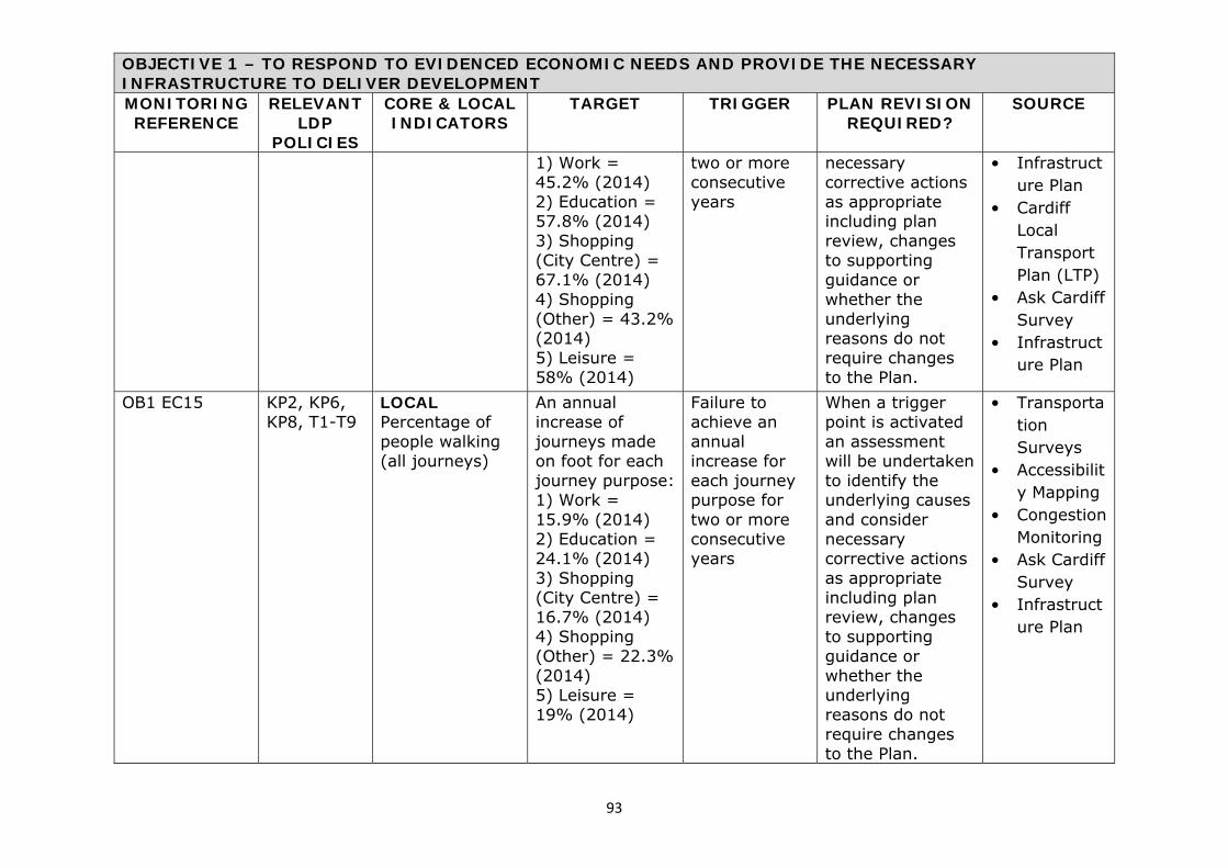
93
OBJECTIVE 1 – TO RESPOND TO EVIDENCED ECONOMIC NEEDS AND PROVIDE THE NECESSARY INFRASTRUCTURE TO DELIVER DEVELOPMENT MONITORING REFERENCE
RELEVANT LDP
POLICIES
CORE & LOCAL INDICATORS
TARGET TRIGGER PLAN REVISION REQUIRED?
SOURCE
1) Work = 45.2% (2014) 2) Education = 57.8% (2014) 3) Shopping (City Centre) = 67.1% (2014) 4) Shopping (Other) = 43.2% (2014) 5) Leisure = 58% (2014)
two or more consecutive years
necessary corrective actions as appropriate including plan review, changes to supporting guidance or whether the underlying reasons do not require changes to the Plan.
• Infrastructure Plan
• Cardiff Local Transport Plan (LTP)
• Ask Cardiff Survey
• Infrastructure Plan
OB1 EC15 KP2, KP6, KP8, T1-T9
LOCAL Percentage of people walking (all journeys)
An annual increase of journeys made on foot for each journey purpose: 1) Work = 15.9% (2014) 2) Education = 24.1% (2014) 3) Shopping (City Centre) = 16.7% (2014) 4) Shopping (Other) = 22.3% (2014) 5) Leisure = 19% (2014)
Failure to achieve an annual increase for each journey purpose for two or more consecutive years
When a trigger point is activated an assessment will be undertaken to identify the underlying causes and consider necessary corrective actions as appropriate including plan review, changes to supporting guidance or whether the underlying reasons do not require changes to the Plan.
• Transportation Surveys
• Accessibility Mapping
• Congestion Monitoring
• Ask Cardiff Survey
• Infrastructure Plan

94
OBJECTIVE 1 – TO RESPOND TO EVIDENCED ECONOMIC NEEDS AND PROVIDE THE NECESSARY INFRASTRUCTURE TO DELIVER DEVELOPMENT MONITORING REFERENCE
RELEVANT LDP
POLICIES
CORE & LOCAL INDICATORS
TARGET TRIGGER PLAN REVISION REQUIRED?
SOURCE
OB1 EC16 KP2, KP6, KP8, T1-T9
LOCAL Percentage of people cycling(all journeys)
An annual increase of journeys made by bike for each journey purpose: 1) Work = 10.6% (2014) 2) Education = 9.5% (2014) 3) Shopping (City Centre) = 5.9% (2014) 4) Shopping (Other) = 5.7% (2014) 5) Leisure = 10.1% (2014)
Failure to achieve an annual increase for each journey purpose for two or more consecutive years
When a trigger point is activated an assessment will be undertaken to identify the underlying causes and consider necessary corrective actions as appropriate including plan review, changes to supporting guidance or whether the underlying reasons do not require changes to the Plan.
• Transportation Surveys
• Accessibility Mapping
• Congestion Monitoring
• Ask Cardiff Survey
• Infrastructure Plan
OB1 EC17 KP2, KP6, KP8, T1-T9
LOCAL Percentage of people travelling by bus (all journeys)
An annual increase of journeys made by bus for each journey purpose: 1) Work = 11.1% (2014) 2) Education = 13% (2014) 3) Shopping (City Centre) = 29.4% (2014)
Failure to achieve an annual increase for each journey purpose for two or more consecutive years
When a trigger point is activated an assessment will be undertaken to identify the underlying causes and consider necessary corrective actions as appropriate including plan review, changes to supporting
• Transportation Surveys
• Accessibility Mapping
• Congestion Monitoring
• Ask Cardiff Survey
• Infrastructure Plan

95
OBJECTIVE 1 – TO RESPOND TO EVIDENCED ECONOMIC NEEDS AND PROVIDE THE NECESSARY INFRASTRUCTURE TO DELIVER DEVELOPMENT MONITORING REFERENCE
RELEVANT LDP
POLICIES
CORE & LOCAL INDICATORS
TARGET TRIGGER PLAN REVISION REQUIRED?
SOURCE
4) Shopping (Other) = 8.6% (2014) 5) Leisure = 11.2(2014)
guidance or whether the underlying reasons do not require changes to the Plan.
OB1 EC18 KP2, KP6, KP8, T1-T9
LOCAL Percentage of people travelling by train (all journeys)
An annual increase of journeys made by bus for each journey purpose: 1) Work = 5.8% (2014) 2) Education = 5.2% (2014) 3) Shopping (City Centre) = 10.6% (2014) 4) Shopping (Other) = 3.8% (2014) 5) Leisure = 8.7% (2014)
Failure to achieve an annual increase for each journey purpose for two or more consecutive years
When a trigger point is activated an assessment will be undertaken to identify the underlying causes and consider necessary corrective actions as appropriate including plan review, changes to supporting guidance or whether the underlying reasons do not require changes to the Plan.
• Transportation Surveys
• Accessibility Mapping
• Congestion Monitoring
• Ask Cardiff Survey
• Infrastructure Plan
OB1 EC19 KP2, KP6, KP8, T1-T9
LOCAL Improvement in journey times by bus
An annual 1 percent improvement in journey times for key corridors (North West Corridor, North
Failure to achieve an annual improvement in bus journey times of 1% for two or
When a trigger point is activated an assessment will be undertaken to identify the underlying causes and consider
• Transportation Surveys
• Accessibility Mapping

96
OBJECTIVE 1 – TO RESPOND TO EVIDENCED ECONOMIC NEEDS AND PROVIDE THE NECESSARY INFRASTRUCTURE TO DELIVER DEVELOPMENT MONITORING REFERENCE
RELEVANT LDP
POLICIES
CORE & LOCAL INDICATORS
TARGET TRIGGER PLAN REVISION REQUIRED?
SOURCE
East Corridor, Eastern Corridor and Southern Corridor) from adoption of the Local Development Plan
more consecutive years
necessary corrective actions as appropriate including plan review, changes to supporting guidance or whether the underlying reasons do not require changes to the Plan. The assessment will also identify congested pinch points and quantify specific corridor journey time and journey time reliability improvements that are required and establish appropriate revised targets
• Congestion Monitoring
• Ask Cardiff Survey
• Transport Assessments received through the Development Control process;
• S106 Monitoring Requirements established through the Development Control process
• Infrastructure Plan

97
OBJECTIVE 1 – TO RESPOND TO EVIDENCED ECONOMIC NEEDS AND PROVIDE THE NECESSARY INFRASTRUCTURE TO DELIVER DEVELOPMENT MONITORING REFERENCE
RELEVANT LDP
POLICIES
CORE & LOCAL INDICATORS
TARGET TRIGGER PLAN REVISION REQUIRED?
SOURCE
OB1 EC20 KP2, KP6, KP8, T1-T9
LOCAL Improvement in bus journey time reliability
An annual 1 percent improvement in journey time reliability for key corridors (North West Corridor, North East Corridor, Eastern Corridor and Southern Corridor) from adoption of the Local Development Plan
Failure to achieve an annual improvement in bus journey time reliability of 1% for two or more consecutive years
When a trigger point is activated an assessment will be undertaken to identify the underlying causes and consider necessary corrective actions as appropriate including plan review, changes to supporting guidance or whether the underlying reasons do not require changes to the Plan. The assessment will also identify congested pinch points and quantify specific corridor journey time and journey time reliability improvements that are required and establish appropriate revised targets
• Transportation Surveys
• Accessibility Mapping
• Congestion Monitoring
• Ask Cardiff Survey
• Transport Assessments received through the Development Control process;
• S106 Monitoring Requirements established through the Development

98
OBJECTIVE 1 – TO RESPOND TO EVIDENCED ECONOMIC NEEDS AND PROVIDE THE NECESSARY INFRASTRUCTURE TO DELIVER DEVELOPMENT MONITORING REFERENCE
RELEVANT LDP
POLICIES
CORE & LOCAL INDICATORS
TARGET TRIGGER PLAN REVISION REQUIRED?
SOURCE
Control process
• Infrastructure Plan
OB1 EC21 KP2, KP6, KP8, T4
LOCAL Delivery of a regional transport hub
A regional transport hub will be delivered by 2018
Failure to deliver a regional transport hub by 2018
When a trigger point is activated an assessment will be undertaken to identify the underlying causes and consider necessary corrective actions as appropriate including plan review, changes to supporting guidance or whether the underlying reasons do not require changes to the Plan.
• Cardiff Council Corporate Business Plan
• Infrastructure Plan
• Cardiff Local Transport Plan
OB1 EC22 KP2, KP6, KP8, T1-T9
LOCAL Delivery of new sustainable transportation infrastructure including: Rapid Bus Corridors, Cycle Network,
To prepare & implement a range of sustainable transport schemes including schemes
Failure to deliver projects identified in LTP timeframes and/or failure to deliver
When a trigger point is activated an assessment will be undertaken to identify the underlying causes and consider necessary
• CCC Planning Policy/ Transportation
• Infrastructure Plan
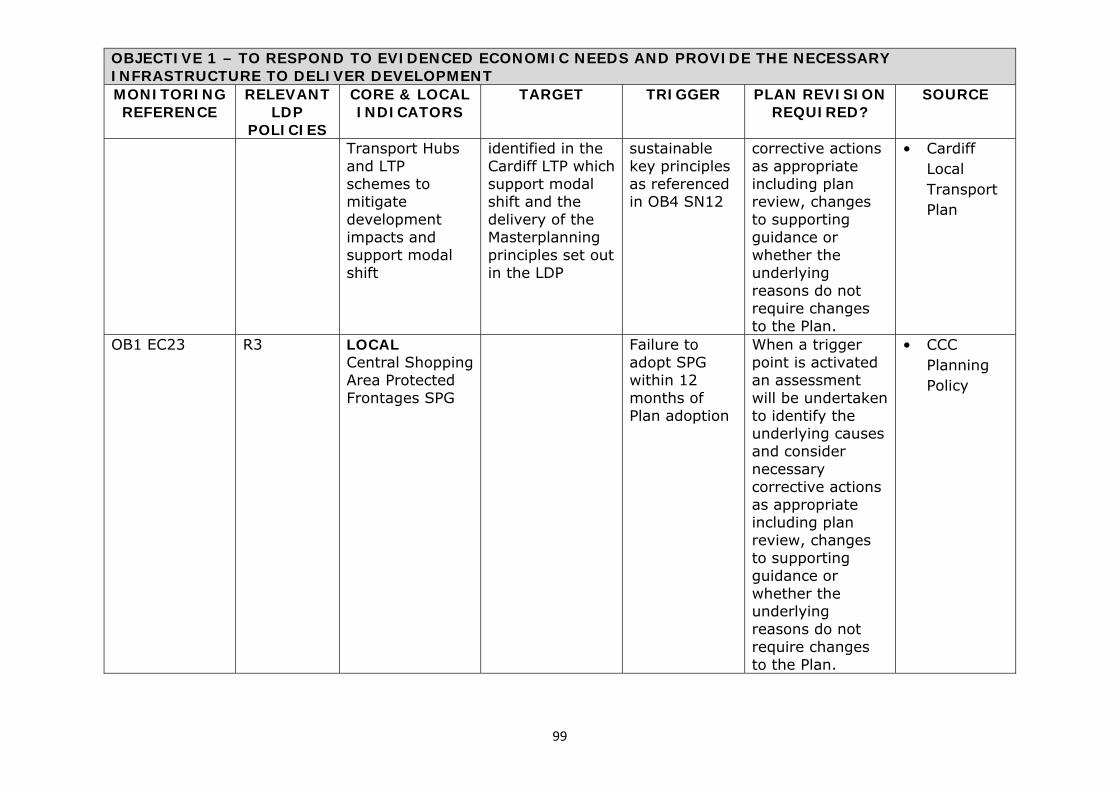
99
OBJECTIVE 1 – TO RESPOND TO EVIDENCED ECONOMIC NEEDS AND PROVIDE THE NECESSARY INFRASTRUCTURE TO DELIVER DEVELOPMENT MONITORING REFERENCE
RELEVANT LDP
POLICIES
CORE & LOCAL INDICATORS
TARGET TRIGGER PLAN REVISION REQUIRED?
SOURCE
Transport Hubs and LTP schemes to mitigate development impacts and support modal shift
identified in the Cardiff LTP which support modal shift and the delivery of the Masterplanning principles set out in the LDP
sustainable key principles as referenced in OB4 SN12
corrective actions as appropriate including plan review, changes to supporting guidance or whether the underlying reasons do not require changes to the Plan.
• Cardiff Local Transport Plan
OB1 EC23 R3 LOCAL Central Shopping Area Protected Frontages SPG
Failure to adopt SPG within 12 months of Plan adoption
When a trigger point is activated an assessment will be undertaken to identify the underlying causes and consider necessary corrective actions as appropriate including plan review, changes to supporting guidance or whether the underlying reasons do not require changes to the Plan.
• CCC Planning Policy
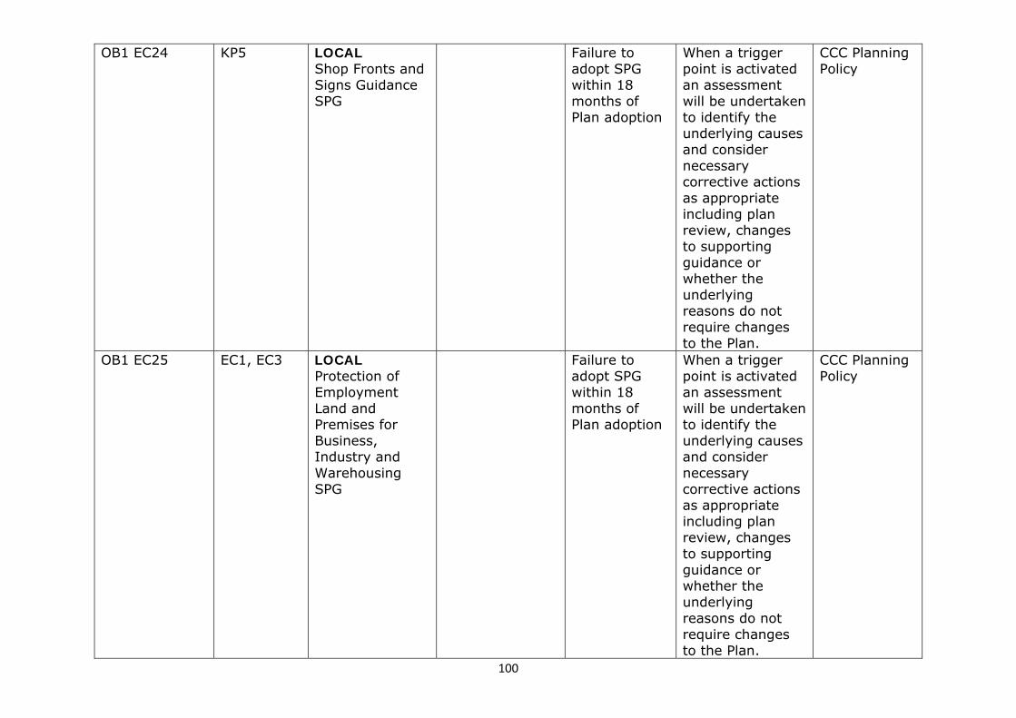
100
OB1 EC24 KP5 LOCAL Shop Fronts and Signs Guidance SPG
Failure to adopt SPG within 18 months of Plan adoption
When a trigger point is activated an assessment will be undertaken to identify the underlying causes and consider necessary corrective actions as appropriate including plan review, changes to supporting guidance or whether the underlying reasons do not require changes to the Plan.
CCC Planning Policy
OB1 EC25 EC1, EC3
LOCAL Protection of Employment Land and Premises for Business, Industry and Warehousing SPG
Failure to adopt SPG within 18 months of Plan adoption
When a trigger point is activated an assessment will be undertaken to identify the underlying causes and consider necessary corrective actions as appropriate including plan review, changes to supporting guidance or whether the underlying reasons do not require changes to the Plan.
CCC Planning Policy

101
OBJECTIVE 2 – TO RESPOND TO EVIDENCED SOCIAL NEEDS MONITORING REFERENCE
RELEVANT LDP
POLICIES
CORE & LOCAL INDICATORS
TARGET TRIGGER PLAN REVISION REQUIRED?
SOURCE
OB2 SO1 KP1 CORE The housing land supply taken from the current Housing Land Availability Study (TAN1)
A minimum 5 year supply of land for residential development is maintained throughout the Plan period
Less than a 5 year supply of residential land is recorded for any year
When a trigger point is activated an assessment will be undertaken to identify the underlying causes and consider necessary corrective actions as appropriate including plan review, changes to supporting guidance or whether the underlying reasons do not require changes to the Plan.
• Council Housing Monitoring Survey
• Joint Housing Land Availability Study
OB2 SO2 KP1 CORE The number of net general market dwellings built
Provide 22,555 net general market dwellings over the remaining Plan period in accordance with the cumulative 2 year targets set out below:
Failure to deliver the required number of dwellings for each 2 year period.
When a trigger point is activated an assessment will be undertaken to identify the underlying causes and consider necessary corrective actions as appropriate
• Council Housing Monitoring Survey
• Joint Housing Land

102
OBJECTIVE 2 – TO RESPOND TO EVIDENCED SOCIAL NEEDS MONITORING REFERENCE
RELEVANT LDP
POLICIES
CORE & LOCAL INDICATORS
TARGET TRIGGER PLAN REVISION REQUIRED?
SOURCE
2016: 2,495 2018: 4,096 2020: 4,153 2022: 4,042 2024: 4,010 2026: 3,759
including plan review, changes to supporting guidance or whether the underlying reasons do not require changes to the Plan.
Availability Study
OB2 SO3 KP1, KP2, KP4, KP13, H3
CORE The number of net additional affordable dwellings built (TAN2)
Provide 6,646 net affordable units over the remaining Plan period (representing an average of 22.8% of total housing provision). Expected delivery rate to meet the target set out below: 2016: 735 2018: 1,207 2020: 1,224 2022: 1,191 2024: 1,181 2026: 1,108
Failure to deliver the required number of dwellings for each 2 year period.
When a trigger point is activated an assessment will be undertaken to identify the underlying causes and consider necessary corrective actions as appropriate including plan review, changes to supporting guidance or whether the underlying reasons do not require changes to the Plan.
• Council Housing Monitoring Survey
• Joint Housing Land Availability Study
OB2 SO4 KP1 CORE Provide 29,201 dwellings over the remaining
Failure to deliver the required
When a trigger point is activated an assessment
• Council Housing

103
OBJECTIVE 2 – TO RESPOND TO EVIDENCED SOCIAL NEEDS MONITORING REFERENCE
RELEVANT LDP
POLICIES
CORE & LOCAL INDICATORS
TARGET TRIGGER PLAN REVISION REQUIRED?
SOURCE
Annual dwelling completions (all dwellings)
Plan period in accordance with the cumulative 2 year targets set out below: 2016: 3,230 2018: 5,303 2020: 5,377 2022: 5,233 2024: 5,191 2026: 4,866
number of dwellings for each 2 year period.
will be undertaken to identify the underlying causes and consider necessary corrective actions as appropriate including plan review, changes to supporting guidance or whether the underlying reasons do not require changes to the Plan.
Monitoring Survey
• Joint Housing Land Availability Study
OB2 SO5 KP1 LOCAL Number of windfall units completed per annum on all sites
Annual target of overall anticipated windfall contributions for the remainder of the Plan period - 488 dwellings per annum
Delivery varies by more than 10% above or below 488 dwellings per annum for any consecutive 2 year period.
When a trigger point is activated an assessment will be undertaken to identify the underlying causes and consider necessary corrective actions as appropriate including plan review, changes to supporting guidance or whether the underlying reasons do not
• Council Housing Monitoring Survey
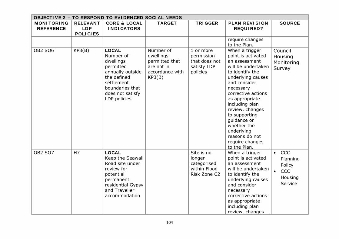
104
OBJECTIVE 2 – TO RESPOND TO EVIDENCED SOCIAL NEEDS MONITORING REFERENCE
RELEVANT LDP
POLICIES
CORE & LOCAL INDICATORS
TARGET TRIGGER PLAN REVISION REQUIRED?
SOURCE
require changes to the Plan.
OB2 SO6 KP3(B) LOCAL Number of dwellings permitted annually outside the defined settlement boundaries that does not satisfy LDP policies
Number of dwellings permitted that are not in accordance with KP3(B)
1 or more permission that does not satisfy LDP policies
When a trigger point is activated an assessment will be undertaken to identify the underlying causes and consider necessary corrective actions as appropriate including plan review, changes to supporting guidance or whether the underlying reasons do not require changes to the Plan.
Council Housing Monitoring Survey
OB2 SO7 H7 LOCAL Keep the Seawall Road site under review for potential permanent residential Gypsy and Traveller accommodation
Site is no longer categorised within Flood Risk Zone C2
When a trigger point is activated an assessment will be undertaken to identify the underlying causes and consider necessary corrective actions as appropriate including plan review, changes
• CCC Planning Policy
• CCC Housing Service

105
OBJECTIVE 2 – TO RESPOND TO EVIDENCED SOCIAL NEEDS MONITORING REFERENCE
RELEVANT LDP
POLICIES
CORE & LOCAL INDICATORS
TARGET TRIGGER PLAN REVISION REQUIRED?
SOURCE
to supporting guidance or whether the underlying reasons do not require changes to the Plan.
OB2 SO8 H7 LOCAL Provision is made for meeting identified needs for permanent Gypsy and Traveller accommodation
1. Agree project management arrangements including reporting structure and representatives - July 15 2. Agree methodology for undertaking site search and assessment – December 2015 3. Undertake Gypsy and Traveller Needs Assessment for both permanent and transit pitches in accordance with Housing (Wales) Act 2014 – Feb 2016
Failure to achieve these targets
Yes • CCC Planning Policy
• CCC Housing Service

106
OBJECTIVE 2 – TO RESPOND TO EVIDENCED SOCIAL NEEDS MONITORING REFERENCE
RELEVANT LDP
POLICIES
CORE & LOCAL INDICATORS
TARGET TRIGGER PLAN REVISION REQUIRED?
SOURCE
4. Undertake a site search and assessment and secure approval of findings – Jul 2016 5. Secure planning permission and funding (including any grant funding from Welsh Government) for identified sites(s) required to meet the short term need for 43 pitches by May 2017 6. Secure planning permission and funding (including any grant funding from Welsh Government) for identified(s) required to meet the long term need for 65 pitches by May 2021

107
OBJECTIVE 2 – TO RESPOND TO EVIDENCED SOCIAL NEEDS MONITORING REFERENCE
RELEVANT LDP
POLICIES
CORE & LOCAL INDICATORS
TARGET TRIGGER PLAN REVISION REQUIRED?
SOURCE
OB2 SO9 H7 LOCAL Provision is made for meeting identified needs for transit Gypsy and Traveller accommodation
1. Agree project management arrangements including reporting structure and representatives - July 2015 2. Agree methodology for undertaking site search and assessment – December 2015 3. Undertake Gypsy and Traveller Needs Assessment for both permanent and transit pitches in accordance with Housing (Wales) Act 2014 – Feb 2016 4. Undertake a site search and assessment and secure approval of findings – Jul 2016 5. Secure planning permission and
Failure to achieve these targets
Yes • CCC Planning Policy
• CCC Housing Service

108
OBJECTIVE 2 – TO RESPOND TO EVIDENCED SOCIAL NEEDS MONITORING REFERENCE
RELEVANT LDP
POLICIES
CORE & LOCAL INDICATORS
TARGET TRIGGER PLAN REVISION REQUIRED?
SOURCE
funding (including any grant funding from Welsh Government) for identified sites(s) required to meet short term – May 2017 6. Secure planning permission and funding (including any grant funding from Welsh Government) for identified(s) required to meet long term need – May 2021
OB2 SO10 H7 LOCAL Total number of Gypsy and Traveller pitches for residential accommodation
Ensure the existing supply of pitches is maintained. (Should existing pitches be no longer available alternative pitches will be sought)
Any net loss of existing Gypsy and Traveller pitch provision
When a trigger point is activated an assessment will be undertaken to identify the underlying causes and consider necessary corrective actions as appropriate including plan review, changes
CCC Planning Policy
CCC Housing Service

109
OBJECTIVE 2 – TO RESPOND TO EVIDENCED SOCIAL NEEDS MONITORING REFERENCE
RELEVANT LDP
POLICIES
CORE & LOCAL INDICATORS
TARGET TRIGGER PLAN REVISION REQUIRED?
SOURCE
to supporting guidance or whether the underlying reasons do not require changes to the Plan.
OB2 SO11 KP2 LOCAL Total annual dwelling completions of Strategic Housing Site A – Cardiff Central Enterprise Zone
2,150 dwellings will be delivered over the remainder of the Plan period on this Strategic Site in accordance with the 2 year cumulative delivery rates set out below. Expected delivery rates based on the JHLAS 2014 and developer intentions: 2016: 231 2018: 254 2020: 405 2022: 400 2024: 400 2026: 460
Failure to deliver the required number of dwellings for each 2 year period.
When a trigger point is activated an assessment will be undertaken to identify the underlying causes and consider necessary corrective actions as appropriate including plan review, changes to supporting guidance or whether the underlying reasons do not require changes to the Plan.
Council Housing Monitoring Survey
OB2 SO12 KP2 LOCAL Total annual
500 dwellings will be delivered
Failure to deliver the
When a trigger point is activated
Council Housing

110
OBJECTIVE 2 – TO RESPOND TO EVIDENCED SOCIAL NEEDS MONITORING REFERENCE
RELEVANT LDP
POLICIES
CORE & LOCAL INDICATORS
TARGET TRIGGER PLAN REVISION REQUIRED?
SOURCE
dwelling completions of Strategic Housing Site B – Gas Works, Ferry Road
over the remainder of the Plan period on this Strategic Site in accordance with the 2 year cumulative delivery rates set out below. Expected delivery rates are based on developer intentions: 2016: 0 2018: 80 2020: 140 2022: 170 2024: 110 2026: 0
required number of dwellings for each 2 year period.
an assessment will be undertaken to identify the underlying causes and consider necessary corrective actions as appropriate including plan review, changes to supporting guidance or whether the underlying reasons do not require changes to the Plan.
Monitoring Survey
OB2 SO13 KP2 LOCAL Total annual dwelling completions of Strategic Housing Site C – North West Cardiff
5,000 dwellings will be delivered over the remainder of the Plan period on this Strategic Site in accordance with the 2 year cumulative delivery rates set out below.
Failure to deliver the required number of dwellings for each 2 year period.
When a trigger point is activated an assessment will be undertaken to identify the underlying causes and consider necessary corrective actions as appropriate including plan review, changes
Council Housing Monitoring Survey

111
OBJECTIVE 2 – TO RESPOND TO EVIDENCED SOCIAL NEEDS MONITORING REFERENCE
RELEVANT LDP
POLICIES
CORE & LOCAL INDICATORS
TARGET TRIGGER PLAN REVISION REQUIRED?
SOURCE
Expected delivery rates are based on developer intentions: 2016: 135 2018: 624 2020: 1,060 2022: 1,060 2024: 1,060 2026: 1,060
to supporting guidance or whether the underlying reasons do not require changes to the Plan.
OB2 SO14 KP2 LOCAL Total annual dwelling completions of Strategic Housing Site D – North of Junction 33
2,000 dwellings will be delivered over the remainder of the Plan period on this Strategic Site in accordance with the 2 year cumulative delivery rates set out below. Expected delivery rates are based on developer intentions: 2016: 110 2018: 240 2020: 300 2022: 400
Failure to deliver the required number of dwellings for each 2 year period.
When a trigger point is activated an assessment will be undertaken to identify the underlying causes and consider necessary corrective actions as appropriate including plan review, changes to supporting guidance or whether the underlying reasons do not require changes to the Plan.
Council Housing Monitoring Survey

112
OBJECTIVE 2 – TO RESPOND TO EVIDENCED SOCIAL NEEDS MONITORING REFERENCE
RELEVANT LDP
POLICIES
CORE & LOCAL INDICATORS
TARGET TRIGGER PLAN REVISION REQUIRED?
SOURCE
2024: 450 2026: 500
OB2 SO15 KP2 LOCAL Total annual dwelling completions of Strategic Housing Site E – South of Creigiau
650 dwellings will be delivered over the remainder of the Plan period on this Strategic Site in accordance with the 2 year cumulative delivery rates set out below. Expected delivery rates are based on developer intentions: 2016: 150 2018: 300 2020: 200
Failure to deliver the required number of dwellings for each 2 year period.
When a trigger point is activated an assessment will be undertaken to identify the underlying causes and consider necessary corrective actions as appropriate including plan review, changes to supporting guidance or whether the underlying reasons do not require changes to the Plan.
Council Housing Monitoring Survey
OB2 SO16 KP2 LOCAL Total annual dwelling completions of Strategic Housing Site F – North East Cardiff (West of Pontprennau)
4,500 dwellings will be delivered over the remainder of the Plan period on this Strategic Site in accordance with the 2 year cumulative delivery rates
Failure to deliver the required number of dwellings for each 2 year period.
When a trigger point is activated an assessment will be undertaken to identify the underlying causes and consider necessary corrective actions as appropriate including plan
Council Housing Monitoring Survey

113
OBJECTIVE 2 – TO RESPOND TO EVIDENCED SOCIAL NEEDS MONITORING REFERENCE
RELEVANT LDP
POLICIES
CORE & LOCAL INDICATORS
TARGET TRIGGER PLAN REVISION REQUIRED?
SOURCE
set out below. Expected delivery rates are based on developer intentions: 2016: 180 2018: 1,197 2020: 808 2022: 808 2024: 808 2026: 699
review, changes to supporting guidance or whether the underlying reasons do not require changes to the Plan.
OB2 SO17 KP2 LOCAL Total annual dwelling completions of Strategic Housing Site G – East of Pontprennau Link Road
1,300 dwellings will be delivered over the remainder of the Plan period on this Strategic Site in accordance with the 2 year cumulative delivery rates set out below. Expected delivery rates are based on developer intentions: 2016: 140 2018: 375 2020: 285 2022: 270
Failure to deliver the required number of dwellings for each 2 year period.
When a trigger point is activated an assessment will be undertaken to identify the underlying causes and consider necessary corrective actions as appropriate including plan review, changes to supporting guidance or whether the underlying reasons do not require changes to the Plan.
Council Housing Monitoring Survey

114
OBJECTIVE 2 – TO RESPOND TO EVIDENCED SOCIAL NEEDS MONITORING REFERENCE
RELEVANT LDP
POLICIES
CORE & LOCAL INDICATORS
TARGET TRIGGER PLAN REVISION REQUIRED?
SOURCE
2024: 200 2026: 30
OB2 SO18 KP2, KP13 LOCAL Annual affordable dwellings completions of Strategic Housing Site A – Cardiff Central Enterprise Zone
414 affordable dwellings will be delivered over the remainder of the Plan period on this Strategic Site in accordance with the 2 year cumulative delivery rates set out below. Expected delivery rates are based on the JHLAS 2014 and developer intentions: 2016: 0 2018: 100 2020: 105 2022: 68 2024: 68 2026: 69
Failure to deliver the required number of dwellings for each 2 year period.
When a trigger point is activated an assessment will be undertaken to identify the underlying causes and consider necessary corrective actions as appropriate including plan review, changes to supporting guidance or whether the underlying reasons do not require changes to the Plan.
Council Housing Monitoring Survey
OB2 SO19 KP2, KP13 LOCAL Annual affordable dwelling completions of Strategic Housing Site B –
100 affordable dwellings will be delivered over the remainder of the Plan period on this Strategic Site in
When a trigger point is activated an assessment will be undertaken to identify the underlying causes and consider

115
OBJECTIVE 2 – TO RESPOND TO EVIDENCED SOCIAL NEEDS MONITORING REFERENCE
RELEVANT LDP
POLICIES
CORE & LOCAL INDICATORS
TARGET TRIGGER PLAN REVISION REQUIRED?
SOURCE
Gas Works, Ferry Road
accordance with the 2 year cumulative delivery rates set out below. Expected delivery rates are based on developer intentions: 2016: 0 2018: 16 2020: 28 2022: 34 2024: 22 2026: 0
necessary corrective actions as appropriate including plan review, changes to supporting guidance or whether the underlying reasons do not require changes to the Plan.
OB2 SO20 KP2, KP13 LOCAL Annual affordable dwelling completions of Strategic Housing Site C – North West Cardiff
1,500 affordable dwellings will be delivered over the remainder of the Plan period on this Strategic Site in accordance with the 2 year cumulative delivery rates set out below. Expected delivery rates are based on developer intentions:
When a trigger point is activated an assessment will be undertaken to identify the underlying causes and consider necessary corrective actions as appropriate including plan review, changes to supporting guidance or whether the underlying reasons do not

116
OBJECTIVE 2 – TO RESPOND TO EVIDENCED SOCIAL NEEDS MONITORING REFERENCE
RELEVANT LDP
POLICIES
CORE & LOCAL INDICATORS
TARGET TRIGGER PLAN REVISION REQUIRED?
SOURCE
2016: 41 2018: 187 2020: 318 2022: 318 2024: 318 2026: 318
require changes to the Plan.
OB2 SO21 KP2, KP13 LOCAL Annual affordable dwelling completions of Strategic Housing Site D - North of Junction 33
603 affordable dwellings will be delivered over the remainder of the Plan period on this Strategic Site in accordance with the 2 year cumulative delivery rates set out below. Expected delivery rates are based on developer intentions: 2016: 100 2018: 100 2020: 100 2022: 100 2024: 100 2026: 103
When a trigger point is activated an assessment will be undertaken to identify the underlying causes and consider necessary corrective actions as appropriate including plan review, changes to supporting guidance or whether the underlying reasons do not require changes to the Plan.
OB2 SO22 KP2, KP13 LOCAL Annual affordable dwelling
195 affordable dwellings will be delivered over the remainder of
When a trigger point is activated an assessment will be undertaken

117
OBJECTIVE 2 – TO RESPOND TO EVIDENCED SOCIAL NEEDS MONITORING REFERENCE
RELEVANT LDP
POLICIES
CORE & LOCAL INDICATORS
TARGET TRIGGER PLAN REVISION REQUIRED?
SOURCE
completions of Strategic Housing Site E – South of Creigiau
the Plan period on this Strategic Site in accordance with the 2 year cumulative delivery rates set out below. Expected delivery rates are based on developer intentions: 2016: 37 2018: 74 2020: 49 2022: 12 2024: 11 2026 - 11
to identify the underlying causes and consider necessary corrective actions as appropriate including plan review, changes to supporting guidance or whether the underlying reasons do not require changes to the Plan.
OB2 SO23 KP2, KP13 LOCAL Annual affordable dwelling completions of Strategic Housing Site F - North East Cardiff (West of Pontprennau)
1,050 affordable dwellings will be delivered over the remainder of the Plan period on this Strategic Site in accordance with the 2 year cumulative delivery rates set out below. Expected delivery rates
When a trigger point is activated an assessment will be undertaken to identify the underlying causes and consider necessary corrective actions as appropriate including plan review, changes to supporting guidance or

118
OBJECTIVE 2 – TO RESPOND TO EVIDENCED SOCIAL NEEDS MONITORING REFERENCE
RELEVANT LDP
POLICIES
CORE & LOCAL INDICATORS
TARGET TRIGGER PLAN REVISION REQUIRED?
SOURCE
are based on developer intentions: 2016 : 0 2018: 114 2020: 242 2022: 242 2024: 242 2026: 210
whether the underlying reasons do not require changes to the Plan.
OB2 SO24 KP2, KP13 LOCAL Annual affordable dwelling completions of Strategic Housing Site G – East of Pontprennau Link Road
390 affordable dwellings will be delivered over the remainder of the Plan period on this Strategic Site in accordance with the 2 year cumulative delivery rates set out below. Expected delivery rates are based on developer intentions: 2016: 42 2018: 113 2020: 86 2022: 81 2024: 60 2026: 8
When a trigger point is activated an assessment will be undertaken to identify the underlying causes and consider necessary corrective actions as appropriate including plan review, changes to supporting guidance or whether the underlying reasons do not require changes to the Plan.

119
OBJECTIVE 2 – TO RESPOND TO EVIDENCED SOCIAL NEEDS MONITORING REFERENCE
RELEVANT LDP
POLICIES
CORE & LOCAL INDICATORS
TARGET TRIGGER PLAN REVISION REQUIRED?
SOURCE
OB2 SO25 KP13, H3 LOCAL Changes in market value of property in Cardiff on Greenfield and Brownfield areas
Provide 6,646 affordable units over the remaining Plan period based on achieving 30% on Greenfield sites and 20% on Brownfield sites. Expected delivery rate to meet the target set out below: 2016: 1,408 2018: 1,408 2020: 1,408 2022: 1,408 2024: 1,410 2026: 1,410
An increase or decrease of 10% of market values of properties in Cardiff on Greenfield and Brownfield areas
When a trigger point is activated an assessment will be undertaken to identify the underlying causes and consider necessary corrective actions as appropriate including plan review, changes to supporting guidance or whether the underlying reasons do not require changes to the Plan.
HM Land Registry House Price Index RICS Building Cost Information Service (BICS) Tender Prices Development Appraisal Toolkit
OB2 SO26 KP1 LOCAL Need for release of additional housing land identified in the flexibility allowance
To ensure sufficient land is brought forward for development in accordance with the Plan strategy and to maintain a minimum 5 year supply of land as set out in the JHLAS.
Build rates exceed the anticipated number of completions as set out in indicator OB2 SO4 by the 1st Plan review i.e. more than 13,910 dwellings completed
When a trigger point is activated an assessment will be undertaken to identify the underlying causes and consider necessary corrective actions as appropriate including plan review, changes to supporting guidance or
Council Housing Monitoring Survey

120
OBJECTIVE 2 – TO RESPOND TO EVIDENCED SOCIAL NEEDS MONITORING REFERENCE
RELEVANT LDP
POLICIES
CORE & LOCAL INDICATORS
TARGET TRIGGER PLAN REVISION REQUIRED?
SOURCE
between 2014 - 2020
whether the underlying reasons do not require changes to the Plan.
OB2 SO27 KP13, H3 LOCAL Affordable Housing SPG
Failure to adopt SPG within 6 months of Plan adoption
No CCC Planning Policy
OB2 SO28 H5 LOCAL Houses in Multiple Occupation SPG
Failure to adopt SPG within 6 months of Plan adoption
No CCC Planning Policy
OB2 SO29
KP7
LOCAL Planning Obligations SPG incorporating Developer contributions for transport facilities and relevant sections from Affordable
housing Access,
circulation and parking requirements
Open Space
Failure to adopt SPG within 12 months of Plan adoption
No CCC Planning Policy

121
OBJECTIVE 2 – TO RESPOND TO EVIDENCED SOCIAL NEEDS MONITORING REFERENCE
RELEVANT LDP
POLICIES
CORE & LOCAL INDICATORS
TARGET TRIGGER PLAN REVISION REQUIRED?
SOURCE
Schools Public art PROW Community
Facilities Trees and
Development Waste
Collection and Storage Facilities
Biodiversity
OB2 SO30
C1
LOCAL Community Facilities and Residential Development SPG
Failure to adopt SPG within 18 months of Plan adoption
No CCC Planning Policy
OB2 SO31 C1 LOCAL Childcare Facilities SPG
Failure to adopt SPG within 18 months of Plan adoption
No CCC Planning Policy
OB2 SO32 C6 LOCAL Health SPG
Failure to adopt SPG within 18 months of Plan adoption
No CCC Planning Policy
OB2 SO33 H8 LOCAL Failure to adopt SPG
No CCC Planning Policy
122
OBJECTIVE 2 – TO RESPOND TO EVIDENCED SOCIAL NEEDS MONITORING REFERENCE
RELEVANT LDP
POLICIES
CORE & LOCAL INDICATORS
TARGET TRIGGER PLAN REVISION REQUIRED?
SOURCE
Gypsy and Traveller Sites SPG
within 18 months of Plan adoption

123
OBJECTIVE 3 - TO DELIVER ECONOMIC AND SOCIAL NEEDS IN A CO-ORDINATED WAY THAT RESPECTS CARDIFF'S ENVIRONMENT AND RESPONDS TO THE CHALLENGES OF CLIMATE CHANGE
MONITORING REFERENCE
RELEVANT LDP
POLICIES
CORE & LOCAL INDICATORS
TARGET TRIGGER PLAN REVISION REQUIRED?
SOURCE
OB3 EN1 KP3(A), KP3(B), KP5, KP15, KP16, KP18, EN14
CORE Amount of development (by TAN 15 paragraph 5.1 development category) permitted in C1 floodplain areas not meeting all TAN 15 tests
No permissions granted for highly vulnerable development within C1 floodplain area that does not meet TAN 15 tests
1 application permitted for development in any 1 year that does not meet TAN 15 tests
When a trigger point is activated an assessment will be undertaken to identify the underlying causes and consider necessary corrective actions as appropriate including plan review, changes to supporting guidance or whether the underlying reasons do not require changes to the Plan.
CCC Planning Policy

124
OBJECTIVE 3 - TO DELIVER ECONOMIC AND SOCIAL NEEDS IN A CO-ORDINATED WAY THAT RESPECTS CARDIFF'S ENVIRONMENT AND RESPONDS TO THE CHALLENGES OF CLIMATE CHANGE
MONITORING REFERENCE
RELEVANT LDP
POLICIES
CORE & LOCAL INDICATORS
TARGET TRIGGER PLAN REVISION REQUIRED?
SOURCE
OB3 EN2 KP3(A), KP3(B), KP5, KP15, KP16, KP18, EN1-EN14
CORE Amount of development (by TAN 15 paragraph 5.1 development category) permitted in C2 floodplain areas.
No permissions granted for highly vulnerable development in C2 floodplain area.
1 application permitted for development in any 1 year
When a trigger point is activated an assessment will be undertaken to identify the underlying causes and consider necessary corrective actions as appropriate including plan review, changes to supporting guidance or whether the underlying reasons do not require changes to the Plan.
CCC Planning Policy

125
OBJECTIVE 3 - TO DELIVER ECONOMIC AND SOCIAL NEEDS IN A CO-ORDINATED WAY THAT RESPECTS CARDIFF'S ENVIRONMENT AND RESPONDS TO THE CHALLENGES OF CLIMATE CHANGE
MONITORING REFERENCE
RELEVANT LDP
POLICIES
CORE & LOCAL INDICATORS
TARGET TRIGGER PLAN REVISION REQUIRED?
SOURCE
OB3 EN3 KP15, KP16, KP18, EN4, EN10 EN11 &EN14
LOCAL Percentage of water bodies of good status.
No planning consents granted planning permission contrary to the advice of Natural Resources Wales and/or Dŵr Cymru (Welsh Water)
1 application permitted for development in any 1 year
When a trigger point is activated an assessment will be undertaken to identify the underlying causes and consider necessary corrective actions as appropriate including plan review, changes to supporting guidance or whether the underlying reasons do not require changes to the Plan.
CCC Planning Policy

126
OBJECTIVE 3 - TO DELIVER ECONOMIC AND SOCIAL NEEDS IN A CO-ORDINATED WAY THAT RESPECTS CARDIFF'S ENVIRONMENT AND RESPONDS TO THE CHALLENGES OF CLIMATE CHANGE
MONITORING REFERENCE
RELEVANT LDP
POLICIES
CORE & LOCAL INDICATORS
TARGET TRIGGER PLAN REVISION REQUIRED?
SOURCE
OB3 EN4 KP15, KP16, KP18, EN4, EN10 EN11 &EN14
LOCAL Number of permissions granted where there is a known risk of deterioration in status.
No planning consents granted planning permission contrary to the advice of Natural Resources Wales and/or Dŵr Cymru (Welsh Water)
1 application permitted for development in any 1 year
When a trigger point is activated an assessment will be undertaken to identify the underlying causes and consider necessary corrective actions as appropriate including plan review, changes to supporting guidance or whether the underlying reasons do not require changes to the Plan.
CCC Planning Policy

127
OBJECTIVE 3 - TO DELIVER ECONOMIC AND SOCIAL NEEDS IN A CO-ORDINATED WAY THAT RESPECTS CARDIFF'S ENVIRONMENT AND RESPONDS TO THE CHALLENGES OF CLIMATE CHANGE
MONITORING REFERENCE
RELEVANT LDP
POLICIES
CORE & LOCAL INDICATORS
TARGET TRIGGER PLAN REVISION REQUIRED?
SOURCE
OB3 EN5 KP15, KP16, KP18, EN4, EN10 EN11 &EN14
LOCAL Number of permissions incorporating measures designed to improve water quality where appropriate.
No planning consents granted planning permission contrary to the advice of Natural Resources Wales and/or Dŵr Cymru (Welsh Water)
1 application permitted for development in any 1 year
When a trigger point is activated an assessment will be undertaken to identify the underlying causes and consider necessary corrective actions as appropriate including plan review, changes to supporting guidance or whether the underlying reasons do not require changes to the Plan.
CCC Planning Policy

128
OBJECTIVE 3 - TO DELIVER ECONOMIC AND SOCIAL NEEDS IN A CO-ORDINATED WAY THAT RESPECTS CARDIFF'S ENVIRONMENT AND RESPONDS TO THE CHALLENGES OF CLIMATE CHANGE
MONITORING REFERENCE
RELEVANT LDP
POLICIES
CORE & LOCAL INDICATORS
TARGET TRIGGER PLAN REVISION REQUIRED?
SOURCE
OB3 EN6 KP18, EN11, EN14,
LOCAL Number of planning permissions granted contrary to the advice of the Water supplier concerning adequate levels of water quality and quantity and waste water provision
No planning consents issued where there is an objection concerning provision of water quality and quantity and waste water from water supplier
1 application permitted for development in any 1 year
When a trigger point is activated an assessment will be undertaken to identify the underlying causes and consider necessary corrective actions as appropriate including plan review, changes to supporting guidance or whether the underlying reasons do not require changes to the Plan.
CCC Planning Policy

129
OBJECTIVE 3 - TO DELIVER ECONOMIC AND SOCIAL NEEDS IN A CO-ORDINATED WAY THAT RESPECTS CARDIFF'S ENVIRONMENT AND RESPONDS TO THE CHALLENGES OF CLIMATE CHANGE
MONITORING REFERENCE
RELEVANT LDP
POLICIES
CORE & LOCAL INDICATORS
TARGET TRIGGER PLAN REVISION REQUIRED?
SOURCE
OB3 EN7 KP3(A), EN1
LOCAL The number of inappropriate developments permitted within the Green Wedge that do not satisfy LDP policies
No inappropriate developments granted planning permission contrary to policies KP3 (A) and EN1
1 application permitted for development in any 1 year
When a trigger point is activated an assessment will be undertaken to identify the underlying causes and consider necessary corrective actions as appropriate including plan review, changes to supporting guidance or whether the underlying reasons do not require changes to the Plan.
CCC Planning Policy

130
OBJECTIVE 3 - TO DELIVER ECONOMIC AND SOCIAL NEEDS IN A CO-ORDINATED WAY THAT RESPECTS CARDIFF'S ENVIRONMENT AND RESPONDS TO THE CHALLENGES OF CLIMATE CHANGE
MONITORING REFERENCE
RELEVANT LDP
POLICIES
CORE & LOCAL INDICATORS
TARGET TRIGGER PLAN REVISION REQUIRED?
SOURCE
OB3 EN8 EN3 LOCAL The number of planning permissions granted contrary to Policy EN3 which would cause unacceptable harm to Special Landscape Areas
No development granted planning permission contrary to Policy EN3 which would cause unacceptable harm to Special Landscape Areas
1 application permitted for development in any 1 year
When a trigger point is activated an assessment will be undertaken to identify the underlying causes and consider necessary corrective actions as appropriate including plan review, changes to supporting guidance or whether the underlying reasons do not require changes to the Plan.
CCC Planning Policy

131
OBJECTIVE 3 - TO DELIVER ECONOMIC AND SOCIAL NEEDS IN A CO-ORDINATED WAY THAT RESPECTS CARDIFF'S ENVIRONMENT AND RESPONDS TO THE CHALLENGES OF CLIMATE CHANGE
MONITORING REFERENCE
RELEVANT LDP
POLICIES
CORE & LOCAL INDICATORS
TARGET TRIGGER PLAN REVISION REQUIRED?
SOURCE
OB3 EN9 EN8 LOCAL Ancient Semi-Natural Woodland
No inappropriate development granted planning permission contrary to Policy EN8
1 application permitted for development in any 1 year
When a trigger point is activated an assessment will be undertaken to identify the underlying causes and consider necessary corrective actions as appropriate including plan review, changes to supporting guidance or whether the underlying reasons do not require changes to the Plan.
CCC Planning Policy

132
OBJECTIVE 3 - TO DELIVER ECONOMIC AND SOCIAL NEEDS IN A CO-ORDINATED WAY THAT RESPECTS CARDIFF'S ENVIRONMENT AND RESPONDS TO THE CHALLENGES OF CLIMATE CHANGE
MONITORING REFERENCE
RELEVANT LDP
POLICIES
CORE & LOCAL INDICATORS
TARGET TRIGGER PLAN REVISION REQUIRED?
SOURCE
OB3 EN10 EN1-EN8 LOCAL The number of planning permissions granted on SSSI or SINC designated areas.
No planning permissions granted permission that would result in an unacceptable impact which could not be mitigated against on an SSSI or SINC that does not satisfy LDP policies
1 application permitted for development in any 1 year
When a trigger point is activated an assessment will be undertaken to identify the underlying causes and consider necessary corrective actions as appropriate including plan review, changes to supporting guidance or whether the underlying reasons do not require changes to the Plan.
CCC Planning Policy

133
OBJECTIVE 3 - TO DELIVER ECONOMIC AND SOCIAL NEEDS IN A CO-ORDINATED WAY THAT RESPECTS CARDIFF'S ENVIRONMENT AND RESPONDS TO THE CHALLENGES OF CLIMATE CHANGE
MONITORING REFERENCE
RELEVANT LDP
POLICIES
CORE & LOCAL INDICATORS
TARGET TRIGGER PLAN REVISION REQUIRED?
SOURCE
OB3 EN11 EN1-EN8 LOCAL Number of planning applications granted which have an adverse effect on the integrity of a Natura 2000 site
Ensure protection of European designated sites as required by paragraph 5.3.9 in Planning Policy Wales, Annex 3 in TAN 5 and policies
1 application permitted contrary to the advice of NRW or the authority’s ecologist
When a trigger point is activated an assessment will be undertaken to identify the underlying causes and consider necessary corrective actions as appropriate including plan review, changes to supporting guidance or whether the underlying reasons do not require changes to the Plan.
CCC Planning Policy

134
OBJECTIVE 3 - TO DELIVER ECONOMIC AND SOCIAL NEEDS IN A CO-ORDINATED WAY THAT RESPECTS CARDIFF'S ENVIRONMENT AND RESPONDS TO THE CHALLENGES OF CLIMATE CHANGE
MONITORING REFERENCE
RELEVANT LDP
POLICIES
CORE & LOCAL INDICATORS
TARGET TRIGGER PLAN REVISION REQUIRED?
SOURCE
OB3 EN12 EN1-EN8 LOCAL Number of planning applications granted which would result in detriment to the favourable conservation status of EU protected species in their natural range or significant harm to species protected by other statute
No application granted permission that would result in detriment to the maintenance of the favourable conservation status of EU protected species in their natural range or significant harm to species protected by other statute
1 application permitted contrary to the advice of NRW or the authority’s ecologist
When a trigger point is activated an assessment will be undertaken to identify the underlying causes and consider necessary corrective actions as appropriate including plan review, changes to supporting guidance or whether the underlying reasons do not require changes to the Plan.
CCC Planning Policy

135
OBJECTIVE 3 - TO DELIVER ECONOMIC AND SOCIAL NEEDS IN A CO-ORDINATED WAY THAT RESPECTS CARDIFF'S ENVIRONMENT AND RESPONDS TO THE CHALLENGES OF CLIMATE CHANGE
MONITORING REFERENCE
RELEVANT LDP
POLICIES
CORE & LOCAL INDICATORS
TARGET TRIGGER PLAN REVISION REQUIRED?
SOURCE
OB3 EN13 KP16, KP18, C5
LOCAL Achievement of functional open space requirement across Cardiff as set out in Policy C5
2.43 Ha functional open space per 1,000 population
Less than 2.43 Ha functional open space per 1,000 population
When a trigger point is activated an assessment will be undertaken to identify the underlying causes and consider necessary corrective actions as appropriate including plan review, changes to supporting guidance or whether the underlying reasons do not require changes to the Plan.
CCC Planning Policy
OB3 EN14 EN13 LOCAL Number of Air Quality Management Areas
No more than 4 current AQMA in action
One or more additional AQMA
No Environmental Protection Monitoring
OB3 EN15 C4&C5 LOCAL Open Space SPG
Failure to adopt SPG within 6 months of Plan adoption
No CCC Planning Policy
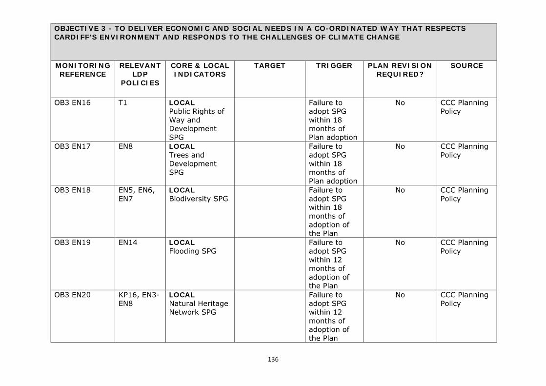
136
OBJECTIVE 3 - TO DELIVER ECONOMIC AND SOCIAL NEEDS IN A CO-ORDINATED WAY THAT RESPECTS CARDIFF'S ENVIRONMENT AND RESPONDS TO THE CHALLENGES OF CLIMATE CHANGE
MONITORING REFERENCE
RELEVANT LDP
POLICIES
CORE & LOCAL INDICATORS
TARGET TRIGGER PLAN REVISION REQUIRED?
SOURCE
OB3 EN16
T1
LOCAL Public Rights of Way and Development SPG
Failure to adopt SPG within 18 months of Plan adoption
No CCC Planning Policy
OB3 EN17
EN8
LOCAL Trees and Development SPG
Failure to adopt SPG within 18 months of Plan adoption
No CCC Planning Policy
OB3 EN18
EN5, EN6, EN7
LOCAL Biodiversity SPG
Failure to adopt SPG within 18 months of adoption of the Plan
No CCC Planning Policy
OB3 EN19
EN14
LOCAL Flooding SPG
Failure to adopt SPG within 12 months of adoption of the Plan
No CCC Planning Policy
OB3 EN20
KP16, EN3-EN8
LOCAL Natural Heritage Network SPG
Failure to adopt SPG within 12 months of adoption of the Plan
No CCC Planning Policy

137
OBJECTIVE 3 - TO DELIVER ECONOMIC AND SOCIAL NEEDS IN A CO-ORDINATED WAY THAT RESPECTS CARDIFF'S ENVIRONMENT AND RESPONDS TO THE CHALLENGES OF CLIMATE CHANGE
MONITORING REFERENCE
RELEVANT LDP
POLICIES
CORE & LOCAL INDICATORS
TARGET TRIGGER PLAN REVISION REQUIRED?
SOURCE
OB3 EN21
KP17, EN9
LOCAL Archaeologically Sensitive Areas SPG
Failure to adopt SPG within 18 months of adoption of the Plan.
No CCC Planning Policy
OBJECTIVE 4 – TO CREATE SUSTAINABLE NEIGHBOURHOODS THAT FORM PART OF A SUSTAINABLE CITY MONITORING REFERENCE
RELEVANT LDP
POLICIES
CORE & LOCAL INDICATORS
TARGET TRIGGER PLAN REVISION REQUIRED?
SOURCE
OB4 SN1 EN12 LOCAL The number and capacity of renewable energy developments permitted
An increase in the number of renewable energy schemes permitted
No increase in the number of renewable energy schemes permitted for two or more consecutive years
When a trigger point is activated an assessment will be undertaken to identify the underlying causes and consider necessary corrective actions as appropriate including plan review, changes to supporting
CCC Planning Policy

138
OBJECTIVE 4 – TO CREATE SUSTAINABLE NEIGHBOURHOODS THAT FORM PART OF A SUSTAINABLE CITY MONITORING REFERENCE
RELEVANT LDP
POLICIES
CORE & LOCAL INDICATORS
TARGET TRIGGER PLAN REVISION REQUIRED?
SOURCE
guidance or whether the underlying reasons do not require changes to the Plan.
OB4 SN2 KP12, W2 LOCAL Maintain a sufficient amount of land and facilities to cater for Cardiff's waste capacity
Maintain a sufficient capacity to cater for Cardiff’s waste (to be confirmed at a regional level in accordance with TAN21)
No trigger When a trigger point is activated an assessment will be undertaken to identify the underlying causes and consider necessary corrective actions as appropriate including plan review, changes to supporting guidance or whether the underlying reasons do not require changes to the Plan.
CCC Waste Management Section
OB4 SN3 KP12, W1, W2
LOCAL Amount of household waste recycled
Minimum Overall Recycling - 58% by 2016, 64% by 2020 and 70% by
Minimum Overall Recycling - Less than
When a trigger point is activated an assessment will be undertaken
CCC Waste Management Section

139
OBJECTIVE 4 – TO CREATE SUSTAINABLE NEIGHBOURHOODS THAT FORM PART OF A SUSTAINABLE CITY MONITORING REFERENCE
RELEVANT LDP
POLICIES
CORE & LOCAL INDICATORS
TARGET TRIGGER PLAN REVISION REQUIRED?
SOURCE
2025. Maximum Landfill = n/a by 2016, 10% by 2020 and 5% by 2025 Maximum level of energy from waste = 42% by 2016, 36% by 2020 and 30% by 2025. Biodegradable landfill allowance = 41,692t by 2016, 33,557t by 2020 and n/a by 2025.
58% by 2016, 64% by 2020 and 70% by 2025, Maximum Landfill = n/a by 2016, less than 10% by 2020 and 5% by 2025 Maximum level of energy from waste = less than 42% by 2016, 36% by 2020 and 30% by 2025. Biodegradable landfill allowance = less than 41,692t by 2016, 33,557t by
to identify the underlying causes and consider necessary corrective actions as appropriate including plan review, changes to supporting guidance or whether the underlying reasons do not require changes to the Plan.

140
OBJECTIVE 4 – TO CREATE SUSTAINABLE NEIGHBOURHOODS THAT FORM PART OF A SUSTAINABLE CITY MONITORING REFERENCE
RELEVANT LDP
POLICIES
CORE & LOCAL INDICATORS
TARGET TRIGGER PLAN REVISION REQUIRED?
SOURCE
2020 and n/a by 2025.
OB4 SN4 KP12, W1, W2
LOCAL Applications received for waste management uses on B2 sites
Maintain a sufficient range and choice of waste management facilities
1 or more applications refused in any 1 year
When a trigger point is activated an assessment will be undertaken to identify the underlying causes and consider necessary corrective actions as appropriate including plan review, changes to supporting guidance or whether the underlying reasons do not require changes to the Plan.
CCC Planning Policy
OB4 SN5 KP11, M7 LOCAL Maintain a minimum 10 year landbank of crushed rock reserves
10 year supply Less than 10 year supply
When a trigger point is activated an assessment will be undertaken to identify the underlying causes and consider necessary
SWRAWP Annual Reports

141
OBJECTIVE 4 – TO CREATE SUSTAINABLE NEIGHBOURHOODS THAT FORM PART OF A SUSTAINABLE CITY MONITORING REFERENCE
RELEVANT LDP
POLICIES
CORE & LOCAL INDICATORS
TARGET TRIGGER PLAN REVISION REQUIRED?
SOURCE
corrective actions as appropriate including plan review, changes to supporting guidance or whether the underlying reasons do not require changes to the Plan.
OB4 SN6 KP11, M6 LOCAL Amount of development within Sand Wharf Protection Area
No permanent development which would prejudice the ability to land marine dredged sand and gravel will be permitted within the safeguarded sand wharfs which is contrary to Policy M6.
1 application permitted for development in any 1 year
When a trigger point is activated an assessment will be undertaken to identify the underlying causes and consider necessary corrective actions as appropriate including plan review, changes to supporting guidance or whether the underlying reasons do not
CCC Planning Policy

142
OBJECTIVE 4 – TO CREATE SUSTAINABLE NEIGHBOURHOODS THAT FORM PART OF A SUSTAINABLE CITY MONITORING REFERENCE
RELEVANT LDP
POLICIES
CORE & LOCAL INDICATORS
TARGET TRIGGER PLAN REVISION REQUIRED?
SOURCE
require changes to the Plan.
OB4 SN7 KP11, M7 LOCAL Amount of development permitted within a mineral safeguarding area.
No permanent sterilising development as defined in MPPW/MTAN1 will be permitted within a Mineral safeguarding area which is contrary to Policy x of the Plan.
1 application permitted for development in any 1 year
When a trigger point is activated an assessment will be undertaken to identify the underlying causes and consider necessary corrective actions as appropriate including plan review, changes to supporting guidance or whether the underlying reasons do not require changes to the Plan.
CCC Planning Policy
OB4 SN8 M2 LOCAL Number of planning permissions permitted for extraction of aggregate mineral not in
0 planning permissions permitted
1 application permitted for development in any 1 year
When a trigger point is activated an assessment will be undertaken to identify the underlying causes and consider necessary
CCC Planning Policy

143
OBJECTIVE 4 – TO CREATE SUSTAINABLE NEIGHBOURHOODS THAT FORM PART OF A SUSTAINABLE CITY MONITORING REFERENCE
RELEVANT LDP
POLICIES
CORE & LOCAL INDICATORS
TARGET TRIGGER PLAN REVISION REQUIRED?
SOURCE
line with Policy M2
corrective actions as appropriate including plan review, changes to supporting guidance or whether the underlying reasons do not require changes to the Plan.
OB4 SN9 M4 LOCAL Number of planning permissions for inappropriate development e.g. dwellings/mineral working, permitted in Minerals Buffer Zones contrary to Policy M4.
1 planning permission permitted
1 application permitted for development in any 1 year
When a trigger point is activated an assessment will be undertaken to identify the underlying causes and consider necessary corrective actions as appropriate including plan review, changes to supporting guidance or whether the underlying reasons do not
CCC Planning Policy

144
OBJECTIVE 4 – TO CREATE SUSTAINABLE NEIGHBOURHOODS THAT FORM PART OF A SUSTAINABLE CITY MONITORING REFERENCE
RELEVANT LDP
POLICIES
CORE & LOCAL INDICATORS
TARGET TRIGGER PLAN REVISION REQUIRED?
SOURCE
require changes to the Plan.
OB4 SN10 M3 LOCAL Number of prohibition orders issued on dormant sites
Ensure that those dormant sites deemed not likely to be re-worked in the future (as part of the annual review) are served with prohibition orders
LPA fails to serve prohibition orders on sites that are deemed not likely to be re-worked in the future.
When a trigger point is activated an assessment will be undertaken to identify the underlying causes and consider necessary corrective actions as appropriate including plan review, changes to supporting guidance or whether the underlying reasons do not require changes to the Plan.
CCC Planning Policy
OB4 SN11 KP17, EN9 LOCAL Number of applications permitted contrary to Policy EN9 that would adversely affect Scheduled
No developments permitted over the course of the Plan where there is an outstanding objection from statutory heritage advisors or that
1 application permitted for development in any 1 year where there is an outstanding objection
When a trigger point is activated an assessment will be undertaken to identify the underlying causes and consider necessary
CCC Planning Policy

145
OBJECTIVE 4 – TO CREATE SUSTAINABLE NEIGHBOURHOODS THAT FORM PART OF A SUSTAINABLE CITY MONITORING REFERENCE
RELEVANT LDP
POLICIES
CORE & LOCAL INDICATORS
TARGET TRIGGER PLAN REVISION REQUIRED?
SOURCE
Ancient Monuments, registered historic parks and gardens, Listed Buildings or Conservation Areas
would adversely affect Scheduled Ancient Monuments, registered historic parks and gardens, Listed Buildings or Conservation Areas
from statutory heritage advisors
corrective actions as appropriate including plan review, changes to supporting guidance or whether the underlying reasons do not require changes to the Plan.
OB4 SN12 KP1, KP2, KP4, KP8, KP13, H1-H6, C1-C7, T1-T9
LOCAL Delivery of each key principle from the Strategic Sites Masterplanning Framework as embedded in the LDP to ensure delivery of key infrastructure including sustainable transportation interventions, social and community facilities,
Failure of any key principles being effectively delivered in accordance with details which are approved through the Development Management process (e.g. S106 obligations & planning conditions)
1 (or more) key principles not delivered
When a trigger point is activated an assessment will be undertaken to identify the underlying causes and consider necessary corrective actions as appropriate including plan review, changes to supporting guidance or whether the underlying reasons do not
CCC Planning Policy

146
OBJECTIVE 4 – TO CREATE SUSTAINABLE NEIGHBOURHOODS THAT FORM PART OF A SUSTAINABLE CITY MONITORING REFERENCE
RELEVANT LDP
POLICIES
CORE & LOCAL INDICATORS
TARGET TRIGGER PLAN REVISION REQUIRED?
SOURCE
together with any other key Masterplanning requirements
require changes to the Plan.
OB4 SN13 KP6 LOCAL Preparing an annual Infrastructure Plan and Infrastructure Plan Delivery Report update.
Update the Infrastructure Plan and Infrastructure Plan Delivery Report annually to reflect the latest available information with regard to key infrastructure, costs/funding and estimated timescales.
Failure to update the Infrastructure Plan and Infrastructure Plan Delivery Report annually.
No Place Making Team (Development Management)
OB4 SN14 T5 LOCAL Design and Parking Guidance SPG (incorporating Access, Circulation and Parking Requirements SPG and
Failure to adopt SPG within 6 months of adoption of the Plan
No CCC Planning Policy

147
OBJECTIVE 4 – TO CREATE SUSTAINABLE NEIGHBOURHOODS THAT FORM PART OF A SUSTAINABLE CITY MONITORING REFERENCE
RELEVANT LDP
POLICIES
CORE & LOCAL INDICATORS
TARGET TRIGGER PLAN REVISION REQUIRED?
SOURCE
sustainable design guidance)
OB4 SN15
W1, W2
LOCAL Locating Waste Management Facilities SPG
Failure to adopt SPG within 12 months of adoption of the Plan
No CCC Planning Policy
OB4 SN16 KP5 LOCAL Infill Sites Design Guidance SPG
Failure to adopt SPG within 18 months of adoption of the Plan
No CCC Planning Policy
OB4 SN17 KP5 LOCAL Tall Buildings Guidance SPG
Failure to adopt SPG within 18 months of adoption of the Plan
No CCC Planning Policy
OB4 SN18 KP5 LOCAL Householder Design Guidance SPG
Failure to adopt SPG within 18 months of adoption of the Plan
No CCC Planning Policy
OB4 SN19 KP5 LOCAL Public Art SPG
Failure to adopt SPG
No CCC Planning Policy

148
OBJECTIVE 4 – TO CREATE SUSTAINABLE NEIGHBOURHOODS THAT FORM PART OF A SUSTAINABLE CITY MONITORING REFERENCE
RELEVANT LDP
POLICIES
CORE & LOCAL INDICATORS
TARGET TRIGGER PLAN REVISION REQUIRED?
SOURCE
within 18 months of adoption of the Plan
OB4 SN20 R8 LOCAL Food Drink and Leisure Uses + Premises for Eating, Drinking and Entertainment in Cardiff City Centre SPG
Failure to adopt SPG within 18 months of adoption of the Plan
No CCC Planning Policy
OB4 SN21 W1, W2 LOCAL Waste Collection and Storage Facilities SPG
Failure to adopt SPG within 18 months of adoption of the Plan
No CCC Planning Policy
OB4 SN22 H5 LOCAL Design Guidance and Standards for Flat Conversions SPG
Failure to adopt SPG within 12 months of adoption of the Plan
No CCC Planning Policy
OB4 SN23 EN12 LOCAL Renewable Energy
Failure to adopt SPG within 12
No CCC Planning Policy

149
OBJECTIVE 4 – TO CREATE SUSTAINABLE NEIGHBOURHOODS THAT FORM PART OF A SUSTAINABLE CITY MONITORING REFERENCE
RELEVANT LDP
POLICIES
CORE & LOCAL INDICATORS
TARGET TRIGGER PLAN REVISION REQUIRED?
SOURCE
Assessments SPG
months of adoption of the Plan

150
Appendix 10: Summary of LDP process including glossary of technical terms Summary of LDP Process Introduction 4.1 As Wales has a plan-led system, it means that the LDP will be very important when making planning decisions. It sets out the Council’s proposals and policies for future development and use of land in its area. Once the plan has been adopted, decisions on planning permissions will be mostly based on the LDP. The LDP will therefore provide a measure of certainty about what kind of development will and will not be permitted during the plan period. Stage 1: Delivery Agreement 4.2 The Delivery Agreement sets out how and when you can contribute to the LDP preparation process. It has two parts: • A timetable for producing the LDP; and • A Community Involvement Scheme - this explains how developers, the
public and interested groups can contribute to plan preparation. It also explains how responses will be treated and what feedback you will receive.
4.3 A revised version of the Delivery Agreement was agreed by the Welsh Government in December 2011 and can be viewed on the Council’s website (http://www.cardiff.gov.uk/ObjView.asp?Object_ID=19592) or is available for public inspection at County Hall. Stage 2: Gathering evidence base 4.5 The LDP needs to be a sound document. This means that it shows good judgement and can be trusted. In order to achieve a sound plan, the Council has gathered economic, social and environmental information in order to provide an evidence base for the plan. The evidence base is set out in Appendix 13 and has informed the development of the vision and objectives for the plan and the Preferred Strategy. Stage 3: Preferred Strategy 4.6 The Preferred Strategy outlines the overall objectives for the plan and the strategy for growth or change, including preferred options for major development sites. The Preferred Strategy is informed by the evidence base for the plan and consultation undertaken in 2010/11 on the vision

151
and objectives and strategic options and sites. The Council consulted on the Preferred Strategy in November/December 2012. Stage 4: Deposit plan 4.7 The Deposit Plan (a full draft of the LDP) will be based on the evidence base for the plan and will be informed by comments received in response to the Preferred Strategy. This Deposit Plan presents the Preferred Strategy as agreed or amended, proposals for key areas of change, regeneration or protection and specific sites to be used for particular purposes and other specific policies and proposals. It will be accompanied by a Consultation Report outlining how comments at the previous stage have influenced the plan. Once the LDP is placed on ‘Deposit’ for six weeks consultation the Council cannot change it. Any changes to the plan are a matter for an Independent Inspector who will examine the plan to determine whether it is ‘sound’. This is the stage the plan has now reached and there will be a six week consultation period to allow comments to be made on the plan. Stage 5: Alternative Sites 4.8 During the six week consultation period on the Deposit Plan objectors may suggest alternative sites or boundaries for development to be considered. After this consultation period the Council will publish any alternative sites or boundaries that have been suggested and a further six week consultation period will be allowed for people to comment on the alternative sites and boundaries. Stage 6: Examination of the plan 4.9 Once the consultation periods are over, the Council will consider the representations and produce a final Consultation Report. Each of the main issues raised will be summarised in this report. Then the Planning Inspectorate (on behalf of the Welsh Government) will examine the report, all of the deposit representations, the Deposit Plan with its background evidence and the Sustainability Appraisal Report. The examination ensures that the LDP is based on ‘sound’ information and thinking, and that the views of those with concerns about the plan have been considered. The Inspector will decide what issues will be discussed at the examination and how they will be heard. The LDP is due to be submitted for examination in August 2014. Stage 7: Inspector’s Report 4.10 After the examination, the Inspector will review all the relevant information and consider what changes the Council should make to the LDP. He or she will then publish the Inspector’s Report outlining these

152
changes and explaining the reasons for them. The Inspector’s views are binding, the local planning authority must make any changes recommended. Stage 8: Adoption 4.11 Within eight weeks of receiving the Inspector’s Report the Council must advertise the fact that the LDP has been adopted and where it can be inspected. From the date of adoption, the High Court allows six weeks for anyone to challenge it on legal grounds. Stage 9: Monitoring and review 4.12 Once the Local Development Plan is adopted, the Council must send an Annual Monitoring Report to the Welsh Government each year. This will consider how successful the LDP has been in meeting the plan’s objectives and means that the Council will be able to compare the actual effects of the LDP against what was intended. There will be a major review of the LDP at least every four years. This may involve rewriting sections of the plan, or replacing it.

153
Diagram showing LDP Preparation Process
Community Involvement
Sustainability Appraisal & Strategic Environmental
Assessment
Stage 8 Adoption
Stage 9 Annual Monitoring Report/
4-year Review
Stage 1 Delivery Agreement
Stage 7 Inspector’s
Report
Stages 2 & 3 Gathering Evidence base
& Preferred Strategy Consultation
Stage 5 Advertise New or Alternative Sites
respondents
Stage 6 Examination
Stage 4 Deposit Plan
Plan Stages
Integral Process
If required, Plan Stage
Submission

154
Glossary of Technical Terms Adopted Plan The final, statutorily approved legal version of the Local Development Plan. Adoption The final confirmation of a development plan status by a local planning authority (LPA). Affordable Housing Housing, whether for rent, shared ownership or outright purchase, provided at a cost considered affordable in relation to incomes that are average or below average, or in relation to the price of general market housing. Annual Monitoring Report (AMR) A report submitted to the Welsh Government by the local planning authorities which assess the effectiveness of the LDP against a set of indicators and targets. Air Quality Management Area (AQMA) The Environment Act 1995 requires local authorities to review and assess the quality of air in the areas against national air quality standards and objectives. Where the UK air quality objectives are not being met and members of the public are affected they are required to declare an AQMA. Baseline A description of the present state of the area against which to measure change. Biodiversity A term used to describe the variety of life on Earth, including the wide variety of ecosystems and living organisms, animals, plants, their habitats and their genes Brownfield Land/Site Land which is, or was, previously occupied by a permanent structure (excluding agriculture or forestry buildings) and associated fixed surface infrastructure. This includes the curtilage of development, defence buildings and land used for mineral extraction and waste disposal where provision for restoration has not been made. Candidate Sites The LDP Manual (Welsh Government 2006) recommends that local planning authorities engage with developers and landowners at the evidence gathering stage of the LDP process to obtain information about

155
potential development sites that may be included in the plan. Accordingly, in November 2010, the Council formally invited developers, landowners, agents, Council departments and others with an interest in land to submit sites they wished to be considered for development or reuse through the LDP, for a range of uses, including housing, employment, retail, leisure, waste, transport (e.g. park and ride sites), open space and other community uses. Citizens Panel The Citizens Panel is made up of a representative sample of over 1,000 local residents from across Cardiff who have agreed to give their views on a number of consultation topics throughout the year. Panel members share their views by completing surveys and occasionally taking part in other activities like focus groups, workshops, or forums. Climate Change Long-term changes in temperature, precipitation, wind and all other aspects of the Earth’s climate. Often regarded as a result of human activity and fossil fuel consumption. Commitments (or committed development) All land with current planning permission or allocated in adopted development plans for development (particularly residential development). Community People living in a defined geographical area, or who share common interests. Community Involvement Scheme (CIS) The CIS identifies how the LPA intends to involve consultation bodies and the public in the preparation of the LDP. The CIS is submitted to the Welsh Government as part of the Delivery Agreement for its agreement. Community Infrastructure Levy (CIL) CIL is a method of securing generalised contributions from developers. The Government legislated for CIL in the 2008 Planning Act. Implementing Regulations followed, and CIL came into force in England and Wales on 6 April 2010. Community Strategy Local authorities are required by the Local Government Act 2000 to prepare these, with the aim of improving the social, environmental and economic well being of their areas.

156
Consultation Formal process where comments are invited on a particular topic or set of topics, or a draft document. Conservation Area Areas of special architectural or historic interest, the character or appearance of which it is desirable to preserve or enhance. Conservation Area Character Appraisal A published document defining the special architectural or historic interest that warranted the area being designated. Conversions Generally means the physical work necessary to change of use of a building from a particular use, classified in the use classes order, to another use. Can also mean the sub-division of residential properties into self-contained flats or maisonettes. Delivery Agreement A document comprising the local planning authorities timetable for the preparation of the LDP together with its Community Involvement Scheme, submitted to the Welsh Government for agreement. Deposit A formal stage of consultation in which comments are invited on the full draft LDP. Deposit LDP A full draft of the Local Development Plan which undergoes a formal consultation period. Development Development, as it is defined in planning law is the ‘carrying out of building, engineering, mining or other operations in, on, over or under land.’ (Section 55 of the 1990 Planning Act as amended). Employment Land/Site Land used for employment purposes by one or more of the following: offices, manufacturing, research and development, storage and distribution. Enterprise Zones A specially designated area within which businesses are granted numerous advantages and incentives such as income tax credits, equipment tax refunds and property tax credits. At its core, the enterprise zone is a means to targeting a specific geographical area for economic

157
revitalisation. Creating an enterprise zone encourages investment and promotes economic growth in that area. Evidence Base The information and data gathered by the LPA to justify the "soundness" of the policy approach set out in the Local Development Plan, including physical, economic, and social characteristics of an area. Examination Examination is carried out by the Planning Inspectorate on behalf of the Welsh Government and involves the examination of the report, all the deposit representations, the Deposit Local Development Plan with its background evidence and the Sustainability Appraisal Report. It ensures that the LDP is based on sound information and thinking, and that the views of those with concerns about the plan have been considered. Expressions of Interest Representations or comments on the development plan, including requests for alteration, inclusion or removal of policies or sites for development. Final Sustainability Report A term used to refer to the Sustainability Appraisal Report, produced at the deposit stage. It shows how SA/SEA has informed the preparation of the LDP and details the methodology, process and results of the LDP against the Sustainability Objectives identified in the SA/SEA Scoping Report. Greenfield Land/Site Land that has not been previously developed, usually farmland, grassland or heath. Gross Value Added (GVA) This is a measure in economics of the value of goods and services produced in an area, industry or sector of an economy. Habitat Regulation Assessment (HRA) A HRA is a requirement of European Directive 92/43/EEC which assesses the potential effects a Local Development Plan may have on one or more European sites (Natura 2000 sites). The assessment should conclude whether or not a proposal or policy in a Development Plan would adversely affect the integrity of the site in question. Housing Land Availability (HLA) The total amount of land reserved for residential use awaiting development.

158
Infrastructure Infrastructure includes services such as roads, transport facilities, water supplies, sewerage and associated waste water treatment facilities, waste management facilities, energy supplies (electricity and gas) and distribution networks and telecommunications infrastructure. Soft infrastructure includes ICT and telecommunications. Initial Sustainability Appraisal Report A term used to refer to the Sustainability Appraisal Report, produced at the Preferred Strategy stage. This assesses the LDP options against the Sustainability Appraisal framework. The report is then expanded at the Deposit LDP stage and finalised alongside the Adoption Statement. Inspector’s Report The findings of the Inspector, following an independent examination of the LDP, set out in a report that is binding upon the LPA. Key Diagram The diagrammatic interpretation of the LDP’s spatial strategy. LANDMAP LANDMAP is the national information system, devised by the Countryside Council for Wales, for taking landscape into account in decision-making (http://landmap.ccw.gov.uk/). Listed Building A building of special architectural or historic interest. Listed buildings are graded I, II* or II with grade I being the highest. Listing includes the interior as well as the exterior of the building, and any buildings or permanent structures. Local Development Plan (LDP) The required statutory development plan for each local planning authority area in Wales under Part 6 of the Planning and Compulsory Purchase Act 2004. A land use plan that is subject to independent examination, which will form the statutory development plan for a local authority area. It should include a vision, strategy, area wide policies for development types, land allocations, and where necessary policies and proposals for key areas of change and protection. Local Development Plans Wales (LDPW) Planning policy guidance document from the Welsh Government on the preparation of Local Development Plans. Local Listing (or Building of Local Importance). A locally important building valued for contribution to local scene or for local historical situations but not meriting listed building status.

159
Local Nature Reserve (LNR) Non-statutory habitats of local significance designated by local authorities where protection and public understanding of nature conservation is encouraged. Local Planning Authority (LPA) A planning authority responsible for the preparation of the LDP. Master Planning In land-use planning, a government entity’s plan for the overall utilisation of a particular area, including its allocation for residential or manufacturing uses and the corresponding environmental impacts. Minerals Aggregates Technical Advice Note (MTAN1) This was issued by the Welsh Government in March 2004. MTAN1 and sets an overarching objective which seeks to ensure a sustainably managed supply of aggregates (which are essential for construction), striking the best between environmental, economic and social costs. Mitigation Measures to avoid, reduce or offset significant adverse effects. Mixed Use Developments or proposals comprising more than one land use type on a single site. National Vocational Qualifications (NVQs) NVQs are work based awards that are achieved through assessment and training. Objectives and Indicators Objectives are what the LDP is trying to achieve, and indicators are measures that show whether or not objectives are being achieved. They can be used to help show whether planning policy is effective, or be used in helping to conduct a Sustainability Appraisal. Office of National Statistics (ONS) The ONS is the executive office of the UK Statistics Authority, a nonministerial department which reports directly to the Parliament of the United Kingdom. Open Space All space of public value including public landscaped areas, playing fields, parks and play areas, and also including areas of water such as rivers, canals, lakes and reservoirs, which can offer opportunities for sport and recreation or can also act as a visual amenity and a haven for wildlife.

160
Participation Phase Period prior to the pre-deposit Local Development Plan when stakeholders and the public will have the opportunity to influence the issues, options and policies for future growth and development to be included. Phasing The development of a site in gradual stages over a period of time rather than all at once. Planning Gain The benefits or safeguards, often for community benefit, secured by way of a planning obligation as part of a planning approval and usually provided at the developer's expense. For example, affordable housing, community facilities or mitigation measures. Planning Obligations and Agreements Legal agreements between a planning authority and a developer, or undertakings offered unilaterally by a developer, that ensure that certain extra works related to a development are undertaken. For example, the provision of highways. Sometimes called "Section 106" agreements. Planning Policy Wales (PPW) Issued by the Welsh Government setting out its national land use policies on different areas of planning. Population Projection The prediction of future populations based on the present age-sex structure, and with the present rates of fertility, mortality and migration. Pre Deposit proposals documents These include the vision, strategic options, preferred strategy, key policies, and the Sustainability Appraisal report Pre deposit stage The strategic Options and Preferred Strategy stage of LDP preparation. Proposals Map A component of the Local Development Plan showing the location of proposals on an Ordnance Survey base map. Prosiect Gwyrdd Prosiect Gwyrdd is a partnership between, Caerphilly Borough County Council, The County Council of the City and County of Cardiff, Monmouthshire County Council, Newport Council and Vale of Glamorgan Council The combined municipal waste of the five authorities makes up 40% of the total municipal waste of Wales. Prosiect Gwyrdd is committed

161
to looking for the best environmental, cost effective and practical solution for waste after recycling and composting has been maximised in each area (http://www.caerphilly.gov.uk/prosiectgwyrdd/english/home.html). Protected Species Plants and animal species afforded protection under certain Acts and Regulations. Ramsar Sites Sites designated under the Ramsar Convention to protect wetlands that are of international importance, particularly as waterfowl habitats. The Regional Technical Statement (RTS) The RTS is produced by the South Wales Regional Aggregates Working Party and sets out a regional plan for aggregate provision in south Wales and is a requirement of the Minerals Aggregates Technical Advice Note (MTAN1). Regional Transport Plan (RTP) Regional Transport Plan prepared by Sewta Representations Comments in support of, or in opposition, to the deposit Local Development Plan. United Kingdom Biodiversity Action Plan (UKBAP) This is the governmental response to the Convention on Biological Diversity signed in 1992. As of 2009 1,150 species and 65 habitats are identified as needing conservation and greater protection and are covered by UK BAPs. Unitary Development Plan (UDP) A plan prepared under the previous plan making system which reached Deposit stage in Cardiff. Scheduled Ancient Monument Nationally important monuments usually archaeological remains, that enjoy greater protection against inappropriate development through the Ancient Monuments and Archaeological Areas Act 1979. Scoping SA The process of deciding the scope and level of detail of a Sustainability Appraisal, including sustainability effects and options which need to be considered, the assessment methods to be used, and the structure and contents of the SA Report. Section 106 Agreement
162
A legal agreement under section 106 of the 1990 Town & Country Planning Act. Section 106 agreements are legal agreements between a planning authority and a developer, or undertakings offered unilaterally by a developer, that ensure that certain extra works related to a development are undertaken. South Wales Regional Aggregates Working Party (RAWP) The SWRAWP is a technical working group with membership drawn from officers of the 18 Mineral Planning Authorities in South Wales, representatives of the Quarry Products Association, British Aggregates Association, Environment Agency Wales, Countryside Council for Wales, Welsh Assembly Government, Office of the Deputy Prime Minister, Cuddy Demolition, Welsh Environment Trust and British Geological Survey (http://www.swrawpwales.org.uk/). South East Wales Economic Forum (SEWEF) The Forum is a regional partnership bringing together the ten local authorities, the Welsh Government, the private sector, universities and the third sector to discuss and address the regional economic matters of south east Wales (http://www.sewales-econforum.co.uk/home). South East Wales Strategic Planning Group (SEWSPG) Membership of the group comprises officer and political representation from the ten local authorities in the South East Wales area. The principal aim of the Group is to meet to discuss regional issues and provide an interface between the Wales Spatial Plan strategy and individual authority development plans. South East Wales Transport Alliance (Sewta) Sewta is a consortium established on 1st April 2003 by the ten authorities in south east Wales to carry out their functions in relation to public transport and some other transport matters. Sewta works in close liaison with partners representing public transport operators and users (http://sewta.net/). Sites of Importance for Nature Conservation (SINC) Locally important sites of nature conservation adopted by local authorities for planning purposes. (See also Local Nature Reserve). Site of Special Scientific Interest (SSSI) A site identified under the Wildlife and Countryside Act 1981 (as amended by the Countryside and Rights of Way Act 2000) as an area of special interest by reason of any of its flora, fauna, geological or physiographical features. Soundness

163
To be considered sound, a Local Development Plan must be justified (founded on robust and credible evidence and be the most appropriate strategy) and effective (deliverable, flexible and able to be monitored). There are ten tests of soundness set out in guidance issued by the Welsh Government and the Planning Inspectorate against which the LDP will be assessed. Special Area of Conservation (SAC) A site designated under the European Community Habitats Directive, to protect internationally important natural habitats and species. Special Protection Areas (SPA) Sites classified under the European Community Directive on Wild Birds to protect internationally important bird species. Stakeholders Interests directly affected by the LDP (and/ or SEA) - involvement generally through representative bodies. Strategic Environmental Assessment (SEA) Generic term used to describe environmental assessment as applied to polices, plans and programmes. The SEA Regulations require a formal "environmental assessment of certain plans and programmes, including those in the field of planning and land use. Strategic Opportunity Area (SOA) Strategic Opportunity Areas (SOAs) offers potential regional benefits from its sustainable development. SOAs are intended to bring greater coherence to their development, and enable public transport links to be strengthened. Submission Formal stage when the LDP is submitted to the Welsh Government for independent examination by a government-appointed planning inspector. Supplementary Planning Guidance (SPG) Supplementary Planning Guidance may cover a range of issues, both thematic and site specific and provide further detail of policies and proposals in a development plan. Sustainability Appraisal (SA) A tool for appraising policies and proposals to ensure they reflect sustainability development objects (i.e. social, environmental and economic factors). Each LPA is required by S62(6) of the Act to undertake an SA of the LDP. This form of SA fully incorporates the requirements of the SEA Directive. The term used in the LDP includes Strategic Environmental Assessment, unless otherwise made clear.

164
Sustainable Development Development that meets the needs of the present without compromising the ability of future generations to meet their own needs. Sustainable Transport Often meaning walking, cycling and public use of transport (and in some circumstances ‘car sharing’), which is considered to be less damaging to the environment and contributes less to traffic congestion than one-person car journeys. Technical Advice Notes (TANS) Documents produced by the Welsh Assembly Government to supplement Planning Policy Wales, which give detailed technical guidance to Local Planning Authorities on particular planning issues. They should be taken into account by LPAs in the development plan preparation process. Transport Corridor An area of land in which at least one main line for transport, (road, rail, canal etc.) has been built. Often new transport lines are built alongside existing ones to minimise the area affected by pollution Transport Hub A place where passengers and cargo are exchanged between vehicles or between transport modes. Public Transport Hubs include train stations, rapid transit stations, bus stops, tram stop, airports and ferry slips Travel Plan A travel plan is a package of actions designed by a workplace, school or other organisation to encourage safe, healthy and sustainable travel options. By reducing car travel, Travel Plans can improve health and wellbeing, free up car parking space, and make a positive contribution to the community and the environment Wales Spatial Plan (WSP) A plan prepared and approved by the Welsh Government under S60 of the Act, which sets out a strategic framework to guide future development and policy interventions, whether or not these relate to formal land use planning control. Under S62 (5) (b) of the Act a local planning authority must have regard to the WSP in preparing an LDP. Welsh Index of Multiple Deprivation (WIMD) The official measure of deprivation in small areas in Wales. It is a relative measure of concentrations of deprivation at the small area level. It looks at issues such as income, housing, employment, access to services, health, environment, education and community safety.

165
Windfall Site A site not specifically allocated for development in a development plan, but which unexpectedly becomes available for development during the lifetime of a plan. Most "windfalls" are referred to in a housing context.

166
Appendix 11: Tests of Soundness Self-Assessment
11.1 When the Council has finalised its LDP, it must place it on deposit for public inspection and the submission of representations, and then submit it to the Welsh Government for examination by an independent inspector. The inspector appointed by the Welsh Government (WG) must determine whether the plan is fundamentally sound having regard to ten test of soundness set out in guidance issued by the Welsh Government and the Planning Inspectorate A Guide to the Examination of Local Development Plans, Planning Inspectorate Wales, 2007.
11.2 The following table sets out the ten tests of soundness and the Council's assessment of its progress to date in meeting each of them.
Procedural Tests P1 It has been prepared
in accordance with the Delivery Agreement including the Community Involvement Scheme
The Delivery Agreement (DA) contains a timetable for LDP production and the Community Involvement Scheme (CIS) that sets out how and when stakeholders and the community can contribute to preparing the LDP and its Sustainability Appraisal (SA). Cardiff’s DA was originally approved by Council on 23rd September 2010 and agreed with the WG on 15th October 2010. The DA is kept under continual review. On 5th December 2011 WG agreed amendments to the timetable for preparing and adopting the plan. Consulting on the Deposit Plan in October 2013 fully accords with the adopted timetable. Additionally, it should be noted that the procedural requirements of the Town and Country Planning (Local Development Plan) (Wales) Regulations have been conformed with in preparing the plan.
In accordance with the DA, the Council engaged with a wide range of groups, organisations and the wider public to assist developing a consensus on the generation of alternative strategies and options together with identifying key issues. Specific measures undertaken included:
• Invitation to submit Candidate Sites - December 2010: Invitations were sent out inviting developers, landowners and others with an interest in land to submit sites they wished to be considered for development or reuse through the LDP. In addition a notice was placed in the South Wales Echo and placed on the Council website;
167
• Consultation on SA/SEA Scoping Report - November/December 2011;
• Consultation on vision and objectives – November/December 2010: In order to inform the preparation of LDP vision and objectives an extensive consultation and engagement exercise was carried out. This included:
o A Stakeholder Consultee Conference which was held on 25th November 2010:
o 4 Public Consultee Conferences held at venues around the city;
o Questionnaire contained in the November Capital Times;
o Questionnaire available on-line via the Council’s website;
o ‘Ask Cardiff’ random postal questionnaire to 5,000 households;
o Citizens’ Panel questionnaire to 1,000 households; and
o E-mail responses to website and other publicity.
• Consultation on strategic options and sites
– May/June 2011: In order to inform the preparation of the Preferred Strategy a consultation exercise on strategic options and sites was undertaken between 9th May and 10th June 2011. During this period members of the public and stakeholders were asked to give views on a series of strategic growth options for housing and employment and on candidate sites that had been put forward by developers and landowners to deliver this growth. The consultation included:
o A Stakeholder Consultee Conference which was held on 16th May 2011:
o 13 Public Consultee Conferences held at venues around the city;
o Publicity in Capital Times;

168
o Representation form available on-line via the Council’s website;
o Citizens’ Panel questionnaire to 1,000 households; and
o E-mail responses to website and other publicity.
Consultation on the Preferred Strategy – November/December 2012. In accordance with Regulation 15 of the Local Development Plan Regulations the Council undertook 6 weeks consultation on the Preferred Strategy and the Initial Sustainability Appraisal between 1st November and 14th December 2012. During this period members of the public and stakeholders were asked to give views on how the Preferred Strategy proposed to address the key environmental, economic and social issues affecting the city and how development needs will be met including the proposed broad locations of new housing, employment and other strategic requirements.
• A Stakeholder Consultee Conference which was held on 2nd November 2012:
• 4 Public Consultee Conferences held at venues around the city;
• 14 drop-in exhibitions at venues throughout the city;
• Publicity in Capital Times; • Representation form available on-line via
the Council’s website; • Citizens’ Panel questionnaire to 1,000
households; and • E-mail responses to website and other
publicity. • Consultation on Masterplanning principles
– March 2013. A series of consultation events were held during March 2013 to seek feedback from stakeholders, developers and members of the public on the LDP Masterplanning Approach.
• Engagement with key stakeholders through the preparation of various local and regional strategies –ongoing;
• Deposit Plan consultation arrangements: When the Deposit Plan is issued, extensive consultation arrangements have been put

169
in place including the facility for on-line representations using the Objective Publishing system, public exhibitions, centre-page insert into, ‘The Capital Times’ that is delivered to every house in Cardiff, production of a user-friendly leaflet that provides a non-technical summary of the LDP and how to make representations, and relevant documents will be made available via the website.
P2 The Plan and its
policies have been subjected to Sustainability Appraisal including Strategic Environmental Assessment
Following stakeholder engagement and consultation, a Scoping Report for Sustainability Appraisal (SA) and Strategic Environmental Assessment (SEA) of the Cardiff LDP was adopted by the Council's Executive and published in January 2011. An Initial Sustainability Appraisal Report was prepared in October 2012 to accompany the Preferred Strategy Consultation and assessed the Preferred Strategy against the Sustainability Objectives identified in the SA/SEA Scoping Report.
A Full Sustainability Appraisal Report has been prepared and published for consultation as part of the Council's Deposit proposals. It sets out an assessment of the Deposit Plan against the Sustainability Objectives identified in the SA/SEA Scoping Report.
The SA/SEA work has been undertaken in-house using its Sustainable Development Unit and employed Levett-Therivel Sustainability Consultants to quality assure the work undertaken (process and content), and provide advice at key stages including how to comply with the strategic Environmental Assessment Regulations.
Consistency Tests C1 It is a land use plan
which has regard to other relevant plans,
The Deposit Plan has regard to other relevant plans, policies and strategies. Section 2 of the Plan specifically identifies the national, regional

170
policies and strategies relating to the area or adjoining areas
and local policy framework within which it has been prepared.
The Deposit Plan also has regard to the plans of adjoining authorities, namely the adopted Newport and Vale of Glamorgan Unitary Development Plan and adopted Caerphilly and Rhondda Cynon Taff Local Development Plan.
Technical Appendix 1 of the SA/SEA Scoping Report includes a review of plans, policies and programmes from all levels of government (European, national, regional and local) that have been considered in undertaking SA/SEA of the Preferred Strategy. The Deposit Plan Strategy identifies and takes account of those aspects that are of significance.
The Deposit Plan has regard to national policy set out in the Wales Spatial Plan which places Cardiff at the centre of the South East - 'Capital Network' - area of Wales. In this regard the plan recognises that it is important for Wales as a whole that Cardiff becomes significant internationally and that, to achieve this, the City needs to be the focal point of a coherent and successful urban network in South East Wales. In order to ensure the region functions in this way the Plan recognises that it is important to provide an integrated transport solution for the region linked to an appropriate balance of development throughout the region.
C2 It has regard to
national policy
The Deposit Plan is consistent with national planning policy. Section 2 of the Preferred Strategy identifies the main elements of national policy which the Council has had regard to in its preparation.
Technical Appendix 1 of the SA/ SEA Scoping Report includes a review of all national plans, policies and programmes that have been considered in undertaking SA/SEA of the Plan.
The Deposit Plan takes account of those aspects of national policy that are of significance.

171
C3 It has regard to the Wales Spatial Plan
The Deposit Plan is considered to be consistent with the Wales Spatial Plan. Section 2 of the LDP directly references People Places Futures: The Wales Spatial Plan.
The Deposit Plan reflects the Spatial Plan’s vision, strategy, propositions and actions for Cardiff and the South East Wales Area (The Capital Network).
The level of growth in jobs and housing proposed in the plan together with transportation improvements will help deliver the Spatial Plan’s vision to place Cardiff at the centre of the South East - 'Capital Network' - area of Wales, helping to spread prosperity within the area and benefiting other parts of Wales.
C4 It has regard to the
Community Strategy
The Deposit Plan has full regard to the Council’s Community Strategy. Section 3 (Vision and Objectives) of the Plan directly references the 'What Matters’ Strategy 2010-2020’, and Section 3 and the Plan builds upon it. In particular, the Preferred Strategy vision is based on the economic, social and environmental vision for Cardiff as set in the Strategy. These high level visions have been translated into spatial priorities to deliver the vision and provide the context for the strategic objectives and sub objectives that lie at the heart of the plan. The Deposit Plan sets out the means of delivering these objectives.
Coherence and Effectiveness Tests CE1 The plan sets out a
coherent strategy from which its policies and allocations clearly flow and, where cross boundary issues are relevant, it is compatible with the development plans prepared by
Section 4 of the Deposit Plan sets out a coherent Strategy which flows from the key issues identified through the review of the national, regional and local policy framework, including the Wales Spatial Plan and the Community Strategy, and the evidence base.
The strategy takes into account work undertaken at the regional level with neighbouring local authorities on spatial plan area groups and studies. This includes, the recommendations of

172
neighbouring authorities
the Collaborative working Group, the Regional Waste Plan and Regional Transport Plan. This process ensures that cross boundary issues for the Deposit Plan Strategy are consistent with the development plans prepared by neighbouring authorities.
In particular, the overall Strategy and level of growth proposed is considered to strike the right balance having regard to the evidence base and also taking account of Cardiff’s wider regional responsibilities in adopting an approach that still allows other authorities to fulfil their objectives, and those set out in the Wales Spatial Plan.
CE2 The strategy,
policies and allocations are realistic and appropriate having considered the relevant alternatives and are founded on a robust and credible evidence base
The Deposit Plan is considered realistic and appropriate having considered all reasonable alternatives (in accordance with the SEA Regulations). A multitude of options and alternatives have been considered as part of the SA/SEA process.
The Deposit Plan is founded on a robust and credible evidence base and draws upon the available evidence base, including the national regional and local policy context. The key Issues section of the Deposit Plan sets out the assumptions and background to which the Plan’s policies and proposals are based. The Deposit Plan is supported by evidence from the evidence base and background technical papers
Technical Appendix 2 of the SA/SEA Scoping Report also includes a review of the evidence base that has been considered in undertaking the SA/SEA of the Deposit Plan.
The preparation process has also been participative, with the views of key stakeholders being tested through a series of consultation events and the Council’s Citizens Panel.
The extensive process of collecting relevant evidence has demonstrated that it is not always possible to reach absolute consensus on all issues and in some cases, different evidence sources may point to different conclusions. However, the Deposit Plan has taken full account of all relevant information available and where judgements have made been made, full

173
reasoning is set out within the document and supporting information to demonstrate how conclusions are realistic and appropriate having regard to the evidence base.
CE3 There are clear
mechanisms for implementation and monitoring
The Annual Monitoring Report is the principle mechanism through which the implementation of policies in the LDP are measured. The general approach to this is set out in Appendix 8 to the Deposit Plan.
CE4 It is reasonably
flexible to enable it to deal with changing circumstances
The Deposit Plan has been specifically designed to provide a flexible policy framework. It is considered sufficiently flexible to deal with unexpected changes in circumstances and has been prepared during a period that has seen economic changes, thereby allowing consideration of the flexibility of the policy response.
Finally, the AMR provides a key mechanism to monitor the delivery of the LDP. This will be used to assess whether a review is necessary in case of a change in circumstances.

174
Appendix 12: List of Supporting Documents Background Technical Papers and Assessments 1. Cardiff Deposit Local Development Plan 2006-2026 Background
Technical Paper No. 1 Population and Housing – September 2013 2. Cardiff Deposit Local Development Plan 2006-2026 Background
Technical Paper No. 2 Urban Capacity Study – September 2013 3. Cardiff Deposit Local Development Plan 2006-2026 Background
Technical Paper No. 3 Green Belt – September 2013 4. Cardiff Deposit Local Development Plan 2006-2026 Background
Technical Paper No. 4 Economic – September 2013 5. Cardiff Deposit Local Development Plan 2006-2026 Background
Technical Paper No. 5 Transportation – September 2013 6. Cardiff Deposit Local Development Plan 2006-2026 Background
Technical Paper No. 6 Infrastructure Plan – September 2013 7. Cardiff Deposit Local Development Plan 2006-2026 Background
Technical Paper No. 7 District and Local Centres 8. Cardiff Deposit Local Development Plan 2006-2026 Background
Technical Paper No. 8 City Centre Protected Shopping Frontage Assessment – September 2013
9. Cardiff Deposit Local Development Plan 2006-2026 Background Technical Paper No. 9 Minerals – September 2013
10. Cardiff Deposit Local Development Plan 2006-2026 Background Technical Paper No. 10 Waste – September 2013
11. Cardiff Deposit Local Development Plan 2006-2026 Final Sustainability Report - September 2013
12. Cardiff Deposit Local Development Plan 2006-2026 Habitat Regulations Assessment Report – September 2013
13. Cardiff Deposit Local Development Plan 2006-2026 Health Impact Assessment Report – September 2013
14. Cardiff Deposit Local Development Plan 2006-2026 Equalities Impact Assessment Report – September 2013
15. Cardiff Deposit Local Development Plan 2006-2026 Initial Consultation Report – September 2013
16. Cardiff Deposit Local Development Plan 2006-2026 Masterplanning Framework – General Principles, Strategic Framework & Site Specific Frameworks for larger sites – September 2013
17. Cardiff Deposit Local Development Plan 2006-2026 Summary of cross boundary working – September 2013

175
Evidence Base Studies 18. Edge Analytics Report on Population & Household Forecasts 19. Local housing Market Assessment 20. Affordable Housing Viability Assessment 21. Gypsy & Traveller Study Needs Assessment 22. Gypsy and Traveller Study Sites Assessment 23. Strategic Flood Consequences Assessment 24. Landscape Study Supporting Documents: Review of Landscape
Character Areas (February 2008), Review of Special Landscape Areas (August 2008)
25. Renewable Energy Assessment

176
Appendix 13: List of the Evidence Base
Topic Title Author Date Housing and Population
Cardiff Gypsy & Traveller Accommodation Assessment
ORS Apr-13
Cardiff Gypsy, Traveller and Travelling Showpeople Sites Study
Peter Brett Associates
Jul-13
Affordable Housing Viability Study
Peter Brett Associates
Aug-13
Cardiff Local Development Plan Population and Household Projections Phase 1 Report
Edge Analytics Mar-11
Cardiff Local Development Plan Population and Household Projections Phase 2 Report
Edge Analytics Jun-11
Cardiff Population and Household Forecasts – Updating the Evidence
Edge Analytics Jun-13
Cardiff Housing Monitoring Schedule
CCC Mar-13
Local Housing Market Assessment Update
HDH Planning and Development
July -13
Economy and Employment
Cardiff Employment Land Study Stage 1: Supply Audit
DTZ Apr-11
Cardiff Employment Land Study Update Stage 2: Assessing Future Requirements
DTZ Jun-11
Strategic Area Appraisals
Savills Jun-11
Cardiff Employment Land and Commercial Property Strategy
GVA Grimley Mar-09
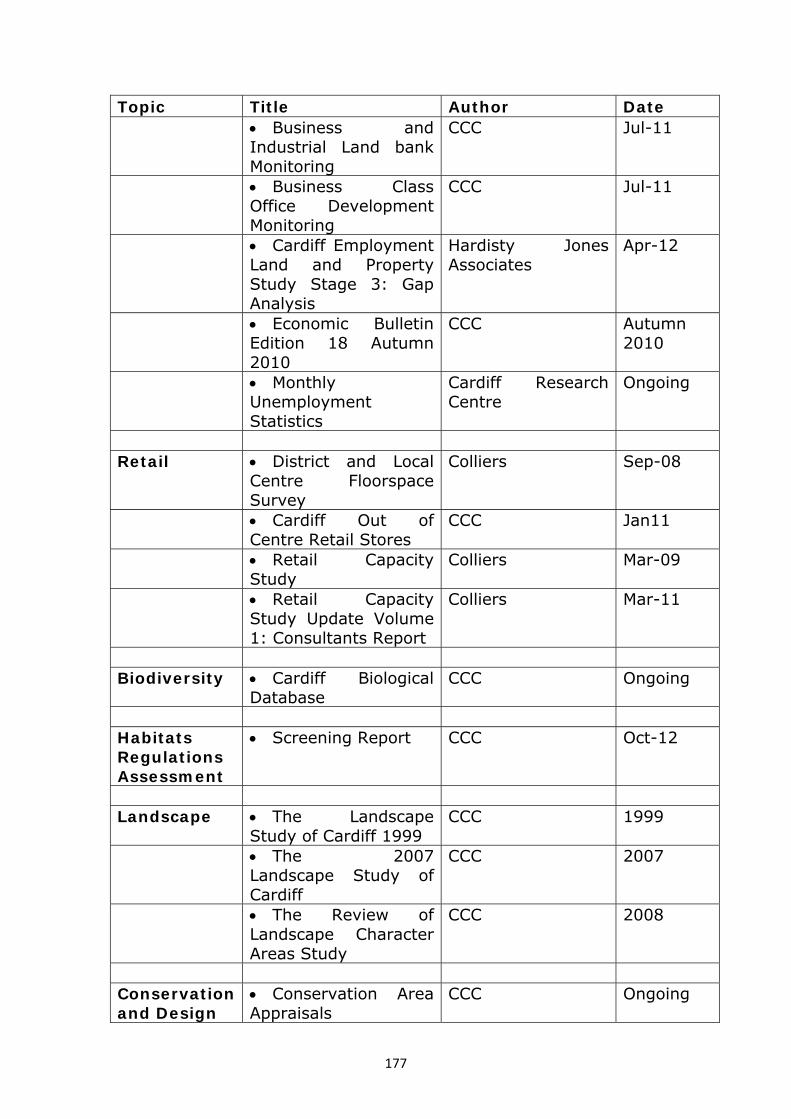
177
Topic Title Author Date Business and
Industrial Land bank Monitoring
CCC Jul-11
Business Class Office Development Monitoring
CCC Jul-11
Cardiff Employment Land and Property Study Stage 3: Gap Analysis
Hardisty Jones Associates
Apr-12
Economic Bulletin Edition 18 Autumn 2010
CCC Autumn 2010
Monthly Unemployment Statistics
Cardiff Research Centre
Ongoing
Retail District and Local
Centre Floorspace Survey
Colliers Sep-08
Cardiff Out of Centre Retail Stores
CCC Jan11
Retail Capacity Study
Colliers Mar-09
Retail Capacity Study Update Volume 1: Consultants Report
Colliers Mar-11
Biodiversity Cardiff Biological
Database CCC Ongoing
Habitats Regulations Assessment
Screening Report CCC Oct-12
Landscape The Landscape
Study of Cardiff 1999 CCC 1999
The 2007 Landscape Study of Cardiff
CCC 2007
The Review of Landscape Character Areas Study
CCC 2008
Conservation and Design
Conservation Area Appraisals
CCC Ongoing

178
Topic Title Author Date Flooding & Flood risk
Cardiff Strategic Flood Consequences Assessment: Report on Phase 1 (Scoping Study)
Atkins June-09
Cardiff Strategic Flood Consequences Assessment: Phase 2 Part 1
Atkins Nov-11
Cardiff Strategic Flood Consequences Assessment: Phase 2 Part 2
Atkins Jul-11
Cardiff Strategic Flood Consequences Assessment: Phase 3
Atkins Aug-12
Cardiff Strategic Flood Consequences Assessment: - Addendum Report
Atkins Oct-11
Open Space Cardiff Open Space
Survey 2009 CCC Sept-09
Cardiff Accessible Natural Greenspace Survey 2008
CCC Mar-08
Renewable Energy
Renewable Energy Assessment
CCC Aug 13
Regional Strategic Planning
for the Cardiff City Region
Roger Tym & Partners
Oct-11
Report of Findings Cardiff LDP Collaborative Working Group
Apr-12

179
Appendix 14: Bibliography
• STEAM Report 2010 Cardiff Council
• Cardiff Annual Traffic Flow Surveys Cardiff Council
• Cardiff Annual Patronage Surveys
2010
Cardiff Council
• Ask Cardiff Surveys: Between 2010
and 2012
Cardiff Council
• ‘What Matters’ The Ten Year Strategy
(2010-2020)
Cardiff Council
• European Directive 2009/28/EC: The
Promotion of the use of energy from
renewable sources
EU
• Cardiff and Wales Crime 2009 - 2011 Home Office
• Employee Jobs Business Register and
Employment Survey 2012
ONS
ONS GVA Statistics 2011 ONS
• Claimant Count ONS
• Population and Household growth
estimates
ONS
• Guide to the Examination of Local
Development Plans 2006
Planning Inspectorate
• Hotting Up? : An Analysis of Low
Carbon Plans and Strategies for UK
Cities 2011
RICS
• The South East Wales Regional Waste
Plan, First Review (RWP) (2008)
South East Wales Regional
Waste Group (SEWRWG)
• A Regional Transport Plan (RTP)
(2010)
South East Wales Transport
Alliance (SEWTA)

180
• The South Wales Regional Technical
Statement for Aggregates (2008)
South Wales Regional
Aggregates Working Party
(SWRAWP)
• Annual Population Survey 2011 Welsh Government
• Local Development Plans Wales 2005 Welsh Government
• Local Development Plan Manual 2006 Welsh Government
• Planning Policy Wales (Edition 4)
2011
Welsh Government
• Mineral Planning Policy Wales 2011 Welsh Government
• People Places Futures: The Wales
Spatial Plan 2008
Welsh Government
• Environment Strategy for Wales 2006 Welsh Government
• One Wales, One Planet 2009 Welsh Government
• Economic Renewal: A New Direction
2010
Welsh Government
• One Wales: Connecting the Nation –
The Wales Transport Strategy 2008
Welsh Government
• National Transport Plan 2010 Welsh Government
• Minerals Technical Advice Note 1:
Aggregates (MTAN1) 2004
Welsh Government
• Welsh Health Survey 2010 Welsh Government
• Circular 30/2007 – Planning for Gypsy
and Traveller caravan sites
Welsh Government
• Welsh Index of Multiple Deprivation
2011
Welsh Government