cardiff local development plan 2006 - 2026 · pdf filecardiff local development plan 2006 -...
TRANSCRIPT
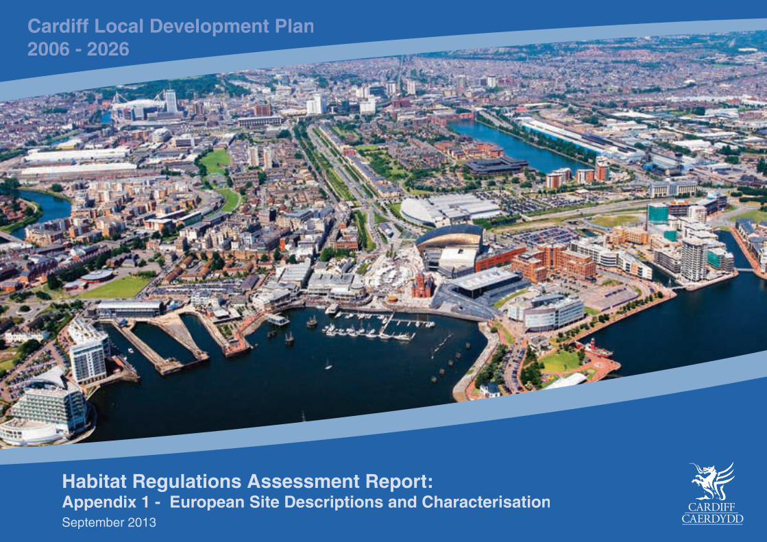
Cardiff Local Development Plan2006 - 2026
Habitat Regulations Assessment Report:Appendix 1 - European Site Descriptions and CharacterisationSeptember 2013
Habitats Regulations Assessment (HRA): A Toolkit to support HRA Screening and Appropriate Assessment Of Plans
South East Wales Strategic Planning Group (SEWSPG) 1/79 Enfusion
Appendix 1 - EUROPEAN SITE CHARACTERISATIONS Special Areas of Conservation 1. Aberbargoed Grasslands 2. Blackmill Woodlands 3. Cardiff Beech Woods 4. River Usk 5. River Wye 6. Severn Estuary Special Protection Areas 1. Severn Estuary Ramsar Sites 1. Severn Estuary All core site specific information unless otherwise stated has been referenced from the Countryside Council for Wales / Natural Resources Wales website (Natura 2000 Management Plans) and the Joint Nature Conservation Committee website (Protected Sites).
Habitats Regulations Assessment (HRA): A Toolkit to support HRA Screening and Appropriate Assessment Of Plans
South East Wales Strategic Planning Group (SEWSPG) 2/79 Enfusion
Special Areas of Conservation
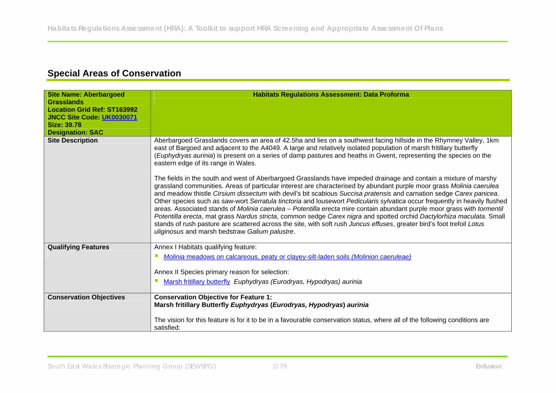
Site Name: Aberbargoed Grasslands Location Grid Ref: ST163992 JNCC Site Code: UK0030071 Size: 39.78 Designation: SAC
Habitats Regulations Assessment: Data Proforma
Site Description Aberbargoed Grasslands covers an area of 42.5ha and lies on a southwest facing hillside in the Rhymney Valley, 1km east of Bargoed and adjacent to the A4049. A large and relatively isolated population of marsh fritillary butterfly (Euphydryas aurinia) is present on a series of damp pastures and heaths in Gwent, representing the species on the eastern edge of its range in Wales. The fields in the south and west of Aberbargoed Grasslands have impeded drainage and contain a mixture of marshy grassland communities. Areas of particular interest are characterised by abundant purple moor grass Molinia caerulea and meadow thistle Cirsium dissectum with devil’s bit scabious Succisa pratensis and carnation sedge Carex panicea. Other species such as saw-wort Serratula tinctoria and lousewort Pedicularis sylvatica occur frequently in heavily flushed areas. Associated stands of Molinia caerulea – Potentilla erecta mire contain abundant purple moor grass with tormentil Potentilla erecta, mat grass Nardus stricta, common sedge Carex nigra and spotted orchid Dactylorhiza maculata. Small stands of rush pasture are scattered across the site, with soft rush Juncus effuses, greater bird’s foot trefoil Lotus uliginosus and marsh bedstraw Galium palustre.
Qualifying Features
Annex I Habitats qualifying feature: Molinia meadows on calcareous, peaty or clayey-silt-laden soils (Molinion caeruleae) Annex II Species primary reason for selection: Marsh fritillary butterfly Euphydryas (Eurodryas, Hypodryas) aurinia
Conservation Objectives
Conservation Objective for Feature 1: Marsh fritillary Butterfly Euphydryas (Eurodryas, Hypodryas) aurinia The vision for this feature is for it to be in a favourable conservation status, where all of the following conditions are satisfied:
Habitats Regulations Assessment (HRA): A Toolkit to support HRA Screening and Appropriate Assessment Of Plans
South East Wales Strategic Planning Group (SEWSPG) 3/79 Enfusion
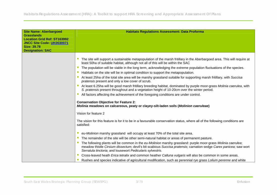
Site Name: Aberbargoed Grasslands Location Grid Ref: ST163992 JNCC Site Code: UK0030071 Size: 39.78 Designation: SAC
Habitats Regulations Assessment: Data Proforma
The site will support a sustainable metapopulation of the marsh fritillary in the Aberbargoed area. This will require at
least 50ha of suitable habitat, although not all of this will be within the SAC The population will be viable in the long term, acknowledging the extreme population fluctuations of the species. Habitats on the site will be in optimal condition to support the metapopulation. At least 25ha of the total site area will be marshy grassland suitable for supporting marsh fritillary, with Succisa
pratensis present and only a low cover of scrub. At least 6.25ha will be good marsh fritillary breeding habitat, dominated by purple moor-grass Molinia caerulea, with
S. pratensis present throughout and a vegetation height of 10-20cm over the winter period. All factors affecting the achievement of the foregoing conditions are under control. Conservation Objective for Feature 2: Molinia meadows on calcareous, peaty or clayey-silt-laden soils (Molinion caeruleae) Vision for feature 2 The vision for this feature is for it to be in a favourable conservation status, where all of the following conditions are satisfied: eu-Molinion marshy grassland will occupy at least 70% of the total site area. The remainder of the site will be other semi-natural habitat or areas of permanent pasture. The following plants will be common in the eu-Molinion marshy grassland: purple moor-grass Molinia caerulea;
meadow thistle Cirsium dissectum; devil’s bit scabious Succisa pratensis; carnation sedge Carex panicea; saw wort Serratula tinctoria; and lousewort Pedicularis sylvestris.
Cross-leaved heath Erica tetralix and common heather Calluna vulgaris will also be common in some areas. Rushes and species indicative of agricultural modification, such as perennial rye grass Lolium perenne and white
Habitats Regulations Assessment (HRA): A Toolkit to support HRA Screening and Appropriate Assessment Of Plans
South East Wales Strategic Planning Group (SEWSPG) 4/79 Enfusion
Site Name: Aberbargoed Grasslands Location Grid Ref: ST163992 JNCC Site Code: UK0030071 Size: 39.78 Designation: SAC
Habitats Regulations Assessment: Data Proforma
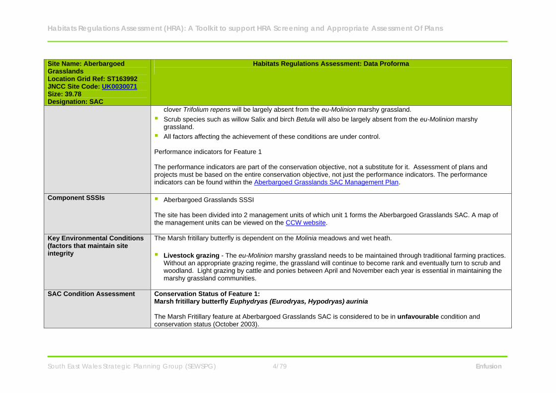
clover Trifolium repens will be largely absent from the eu-Molinion marshy grassland. Scrub species such as willow Salix and birch Betula will also be largely absent from the eu-Molinion marshy
grassland. All factors affecting the achievement of these conditions are under control. Performance indicators for Feature 1 The performance indicators are part of the conservation objective, not a substitute for it. Assessment of plans and projects must be based on the entire conservation objective, not just the performance indicators. The performance indicators can be found within the Aberbargoed Grasslands SAC Management Plan.
Component SSSIs Aberbargoed Grasslands SSSI The site has been divided into 2 management units of which unit 1 forms the Aberbargoed Grasslands SAC. A map of the management units can be viewed on the CCW website.
Key Environmental Conditions (factors that maintain site integrity
The Marsh fritillary butterfly is dependent on the Molinia meadows and wet heath. Livestock grazing - The eu-Molinion marshy grassland needs to be maintained through traditional farming practices.
Without an appropriate grazing regime, the grassland will continue to become rank and eventually turn to scrub and woodland. Light grazing by cattle and ponies between April and November each year is essential in maintaining the marshy grassland communities.
SAC Condition Assessment Conservation Status of Feature 1:
Marsh fritillary butterfly Euphydryas (Eurodryas, Hypodryas) aurinia The Marsh Fritillary feature at Aberbargoed Grasslands SAC is considered to be in unfavourable condition and conservation status (October 2003).

Habitats Regulations Assessment (HRA): A Toolkit to support HRA Screening and Appropriate Assessment Of Plans
South East Wales Strategic Planning Group (SEWSPG) 5/79 Enfusion
Site Name: Aberbargoed Grasslands Location Grid Ref: ST163992 JNCC Site Code: UK0030071 Size: 39.78 Designation: SAC
Habitats Regulations Assessment: Data Proforma
Web counts have in recent years been very low, but the species naturally undergoes significant fluctuations in population numbers due to a variety of factors, including cold and wet weather conditions and parasitic attack. Conservation Status of Feature 2: Molinia meadows on calcareous, peaty or clayey-silt-laden soils (Molinion caeruleae) The SAC report dated October 2003 states that the site is considered to be Unfavourable condition and conservation status. This is because the habitat is not in suitable condition for the marsh fritillary. In areas of the site the vegetation is too tall, is dominated by Molinia and does not have sufficient Succisa. There is only 2.3ha of good condition habitat and 9.7ha of suitable habitat within the site.
Vulnerabilities (includes existing pressures and trends)
The marsh fritillary butterfly population is under threat from: Parasites - Parasitic wasps. The Molinia meadows are under threat from: Anti-social behaviours - In previous years anti-social behaviour such as off-roading and burning have occurred at
Aberbargoed grasslands. This issues need to be addressed to prevent the eu-Molinion habitat from being damaged. CCW states that work has progressed well on the site in the past few years; the site is now stock-proof and a mixture of Welsh Black and Belted Galloways graze the land with a Limousin bull. Scrub clearance and bracken control has begun and flight lines have been cut to improve the connectivity for the butterflies. A programme has been set up to educate the local community to understand why this area is important. A newsletter has been created detailing activities on the grassland and difficulties the site is facing. This and the presence of staff and stock onsite seem to have halted the illegal burning and off-roading.
Landowner/ Management Caerphilly County Borough Council.
Habitats Regulations Assessment (HRA): A Toolkit to support HRA Screening and Appropriate Assessment Of Plans
South East Wales Strategic Planning Group (SEWSPG) 6/79 Enfusion
Site Name: Aberbargoed Grasslands Location Grid Ref: ST163992 JNCC Site Code: UK0030071 Size: 39.78 Designation: SAC
Habitats Regulations Assessment: Data Proforma
Responsibility
Habitats Regulations Assessment (HRA): A Toolkit to support HRA Screening and Appropriate Assessment Of Plans
South East Wales Strategic Planning Group (SEWSPG) 7/79 Enfusion
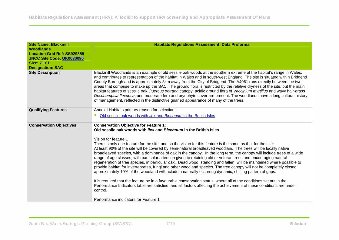
Site Name: Blackmill Woodlands Location Grid Ref: SS929859 JNCC Site Code: UK0030090 Size: 71.01 Designation: SAC
Habitats Regulations Assessment: Data Proforma
Site Description Blackmill Woodlands is an example of old sessile oak woods at the southern extreme of the habitat’s range in Wales, and contributes to representation of the habitat in Wales and in south-west England. The site is situated within Bridgend County Borough and is approximately 3km away from the City of Bridgend. The A4061 runs directly between the two areas that comprise to make up the SAC. The ground flora is restricted by the relative dryness of the site, but the main habitat features of sessile oak Quercus petraea canopy, acidic ground flora of Vaccinium myrtillus and wavy hair-grass Deschampsia flexuosa, and moderate fern and bryophyte cover are present. The woodlands have a long cultural history of management, reflected in the distinctive gnarled appearance of many of the trees.
Qualifying Features
Annex I Habitats primary reason for selection: Old sessile oak woods with Ilex and Blechnum in the British Isles
Conservation Objectives
Conservation Objective for Feature 1: Old sessile oak woods with Ilex and Blechnum in the British Isles Vision for feature 1 There is only one feature for the site, and so the vision for this feature is the same as that for the site: At least 90% of the site will be covered by semi-natural broadleaved woodland. The trees will be locally native broadleaved species, with a dominance of oak in the canopy. In the long term, the canopy will include trees of a wide range of age classes, with particular attention given to retaining old or veteran trees and encouraging natural regeneration of tree species, in particular oak. Dead wood, standing and fallen, will be maintained where possible to provide habitat for invertebrates, fungi and other woodland species. The tree canopy will not be completely closed; approximately 10% of the woodland will include a naturally occurring dynamic, shifting pattern of gaps. It is required that the feature be in a favourable conservation status, where all of the conditions set out in the Performance Indicators table are satisfied, and all factors affecting the achievement of these conditions are under control. Performance indicators for Feature 1
Habitats Regulations Assessment (HRA): A Toolkit to support HRA Screening and Appropriate Assessment Of Plans
South East Wales Strategic Planning Group (SEWSPG) 8/79 Enfusion
Site Name: Blackmill Woodlands Location Grid Ref: SS929859 JNCC Site Code: UK0030090 Size: 71.01 Designation: SAC
Habitats Regulations Assessment: Data Proforma
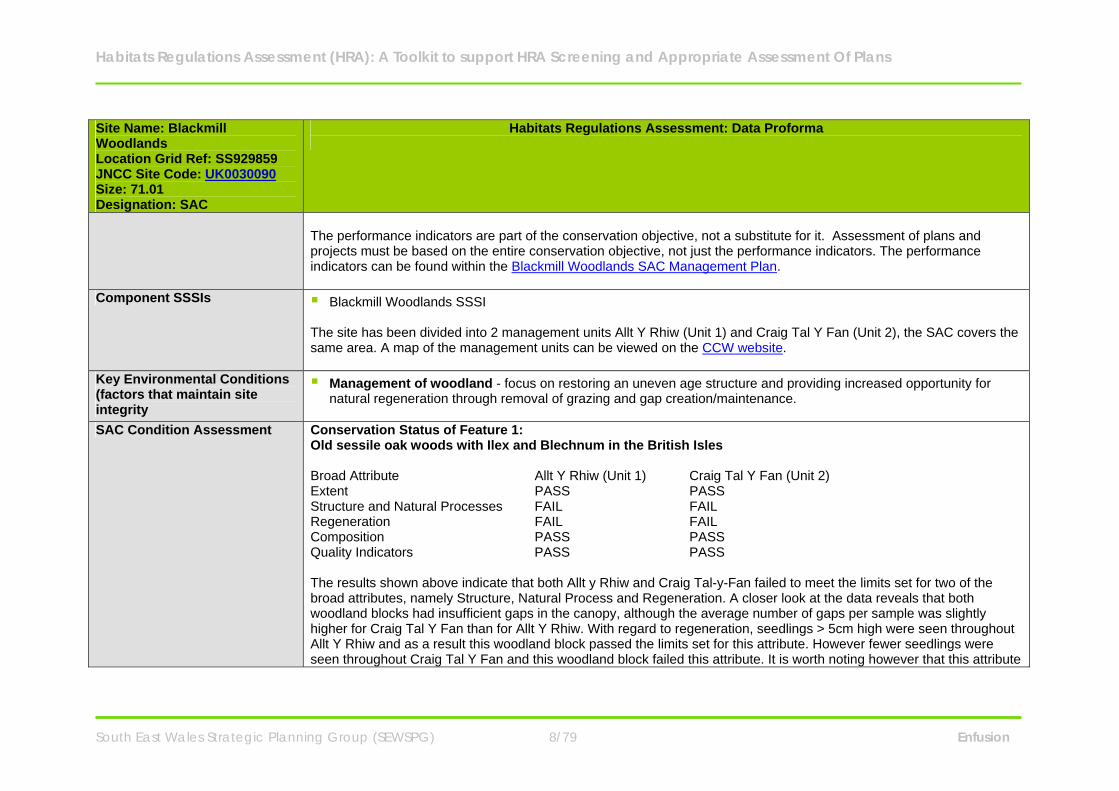
The performance indicators are part of the conservation objective, not a substitute for it. Assessment of plans and projects must be based on the entire conservation objective, not just the performance indicators. The performance indicators can be found within the Blackmill Woodlands SAC Management Plan.
Component SSSIs Blackmill Woodlands SSSI The site has been divided into 2 management units Allt Y Rhiw (Unit 1) and Craig Tal Y Fan (Unit 2), the SAC covers the same area. A map of the management units can be viewed on the CCW website.
Key Environmental Conditions (factors that maintain site integrity
Management of woodland - focus on restoring an uneven age structure and providing increased opportunity for natural regeneration through removal of grazing and gap creation/maintenance.
SAC Condition Assessment Conservation Status of Feature 1:
Old sessile oak woods with Ilex and Blechnum in the British Isles Broad Attribute Allt Y Rhiw (Unit 1) Craig Tal Y Fan (Unit 2) Extent PASS PASS Structure and Natural Processes FAIL FAIL Regeneration FAIL FAIL Composition PASS PASS Quality Indicators PASS PASS The results shown above indicate that both Allt y Rhiw and Craig Tal-y-Fan failed to meet the limits set for two of the broad attributes, namely Structure, Natural Process and Regeneration. A closer look at the data reveals that both woodland blocks had insufficient gaps in the canopy, although the average number of gaps per sample was slightly higher for Craig Tal Y Fan than for Allt Y Rhiw. With regard to regeneration, seedlings > 5cm high were seen throughout Allt Y Rhiw and as a result this woodland block passed the limits set for this attribute. However fewer seedlings were seen throughout Craig Tal Y Fan and this woodland block failed this attribute. It is worth noting however that this attribute
Habitats Regulations Assessment (HRA): A Toolkit to support HRA Screening and Appropriate Assessment Of Plans
South East Wales Strategic Planning Group (SEWSPG) 9/79 Enfusion
Site Name: Blackmill Woodlands Location Grid Ref: SS929859 JNCC Site Code: UK0030090 Size: 71.01 Designation: SAC
Habitats Regulations Assessment: Data Proforma
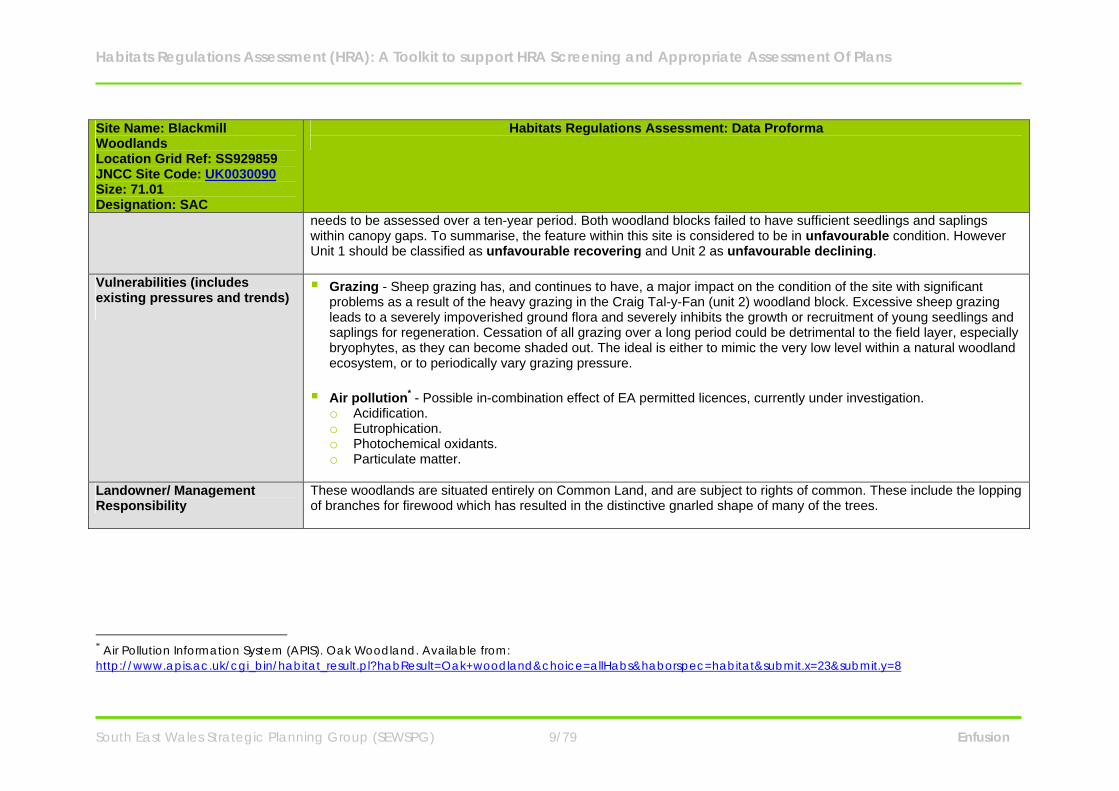
needs to be assessed over a ten-year period. Both woodland blocks failed to have sufficient seedlings and saplings within canopy gaps. To summarise, the feature within this site is considered to be in unfavourable condition. However Unit 1 should be classified as unfavourable recovering and Unit 2 as unfavourable declining.
Vulnerabilities (includes existing pressures and trends)
Grazing - Sheep grazing has, and continues to have, a major impact on the condition of the site with significant problems as a result of the heavy grazing in the Craig Tal-y-Fan (unit 2) woodland block. Excessive sheep grazing leads to a severely impoverished ground flora and severely inhibits the growth or recruitment of young seedlings and saplings for regeneration. Cessation of all grazing over a long period could be detrimental to the field layer, especially bryophytes, as they can become shaded out. The ideal is either to mimic the very low level within a natural woodland ecosystem, or to periodically vary grazing pressure.
Air pollution* - Possible in-combination effect of EA permitted licences, currently under investigation.
o Acidification. o Eutrophication. o Photochemical oxidants. o Particulate matter.
Landowner/ Management Responsibility
These woodlands are situated entirely on Common Land, and are subject to rights of common. These include the lopping of branches for firewood which has resulted in the distinctive gnarled shape of many of the trees.
* Air Pollution Information System (APIS). Oak Woodland. Available from: http://www.apis.ac.uk/cgi_bin/habitat_result.pl?habResult=Oak+woodland&choice=allHabs&haborspec=habitat&submit.x=23&submit.y=8
Habitats Regulations Assessment (HRA): A Toolkit to support HRA Screening and Appropriate Assessment Of Plans
South East Wales Strategic Planning Group (SEWSPG) 10/79 Enfusion
Site Name: Cardiff Beech Woods Location Grid Ref: ST118824 JNCC Site Code: UK0030109 Size: 115.62 Designation: SAC
Habitats Regulations Assessment: Data Proforma
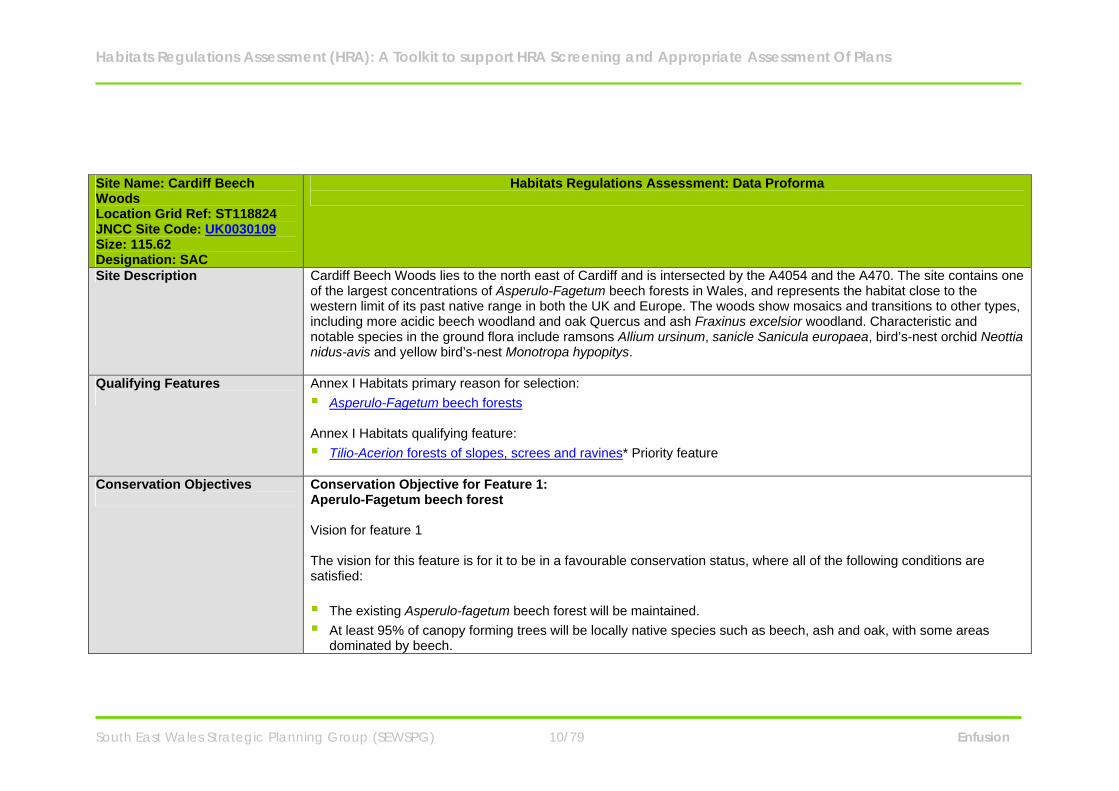
Site Description Cardiff Beech Woods lies to the north east of Cardiff and is intersected by the A4054 and the A470. The site contains one of the largest concentrations of Asperulo-Fagetum beech forests in Wales, and represents the habitat close to the western limit of its past native range in both the UK and Europe. The woods show mosaics and transitions to other types, including more acidic beech woodland and oak Quercus and ash Fraxinus excelsior woodland. Characteristic and notable species in the ground flora include ramsons Allium ursinum, sanicle Sanicula europaea, bird’s-nest orchid Neottia nidus-avis and yellow bird’s-nest Monotropa hypopitys.
Qualifying Features
Annex I Habitats primary reason for selection: Asperulo-Fagetum beech forests Annex I Habitats qualifying feature: Tilio-Acerion forests of slopes, screes and ravines* Priority feature
Conservation Objectives
Conservation Objective for Feature 1: Aperulo-Fagetum beech forest Vision for feature 1 The vision for this feature is for it to be in a favourable conservation status, where all of the following conditions are satisfied: The existing Asperulo-fagetum beech forest will be maintained. At least 95% of canopy forming trees will be locally native species such as beech, ash and oak, with some areas
dominated by beech.
Habitats Regulations Assessment (HRA): A Toolkit to support HRA Screening and Appropriate Assessment Of Plans
South East Wales Strategic Planning Group (SEWSPG) 11/79 Enfusion
Site Name: Cardiff Beech Woods Location Grid Ref: ST118824 JNCC Site Code: UK0030109 Size: 115.62 Designation: SAC
Habitats Regulations Assessment: Data Proforma
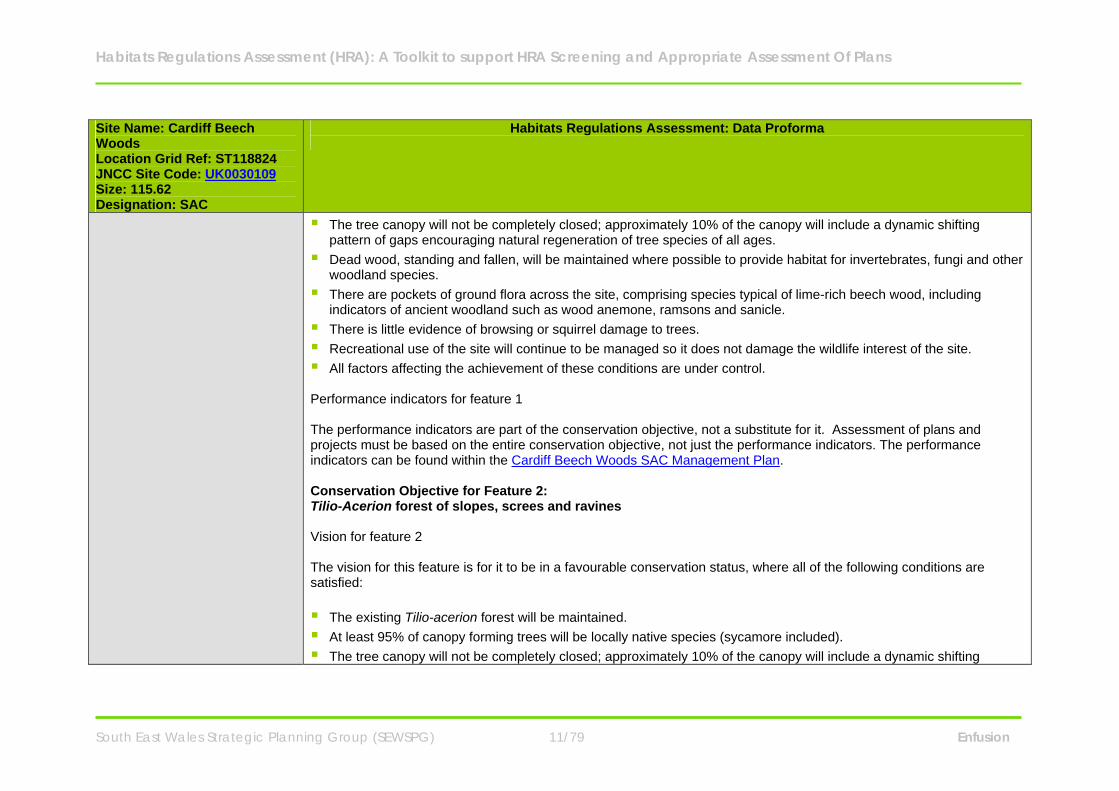
The tree canopy will not be completely closed; approximately 10% of the canopy will include a dynamic shifting pattern of gaps encouraging natural regeneration of tree species of all ages.
Dead wood, standing and fallen, will be maintained where possible to provide habitat for invertebrates, fungi and other woodland species.
There are pockets of ground flora across the site, comprising species typical of lime-rich beech wood, including indicators of ancient woodland such as wood anemone, ramsons and sanicle.
There is little evidence of browsing or squirrel damage to trees. Recreational use of the site will continue to be managed so it does not damage the wildlife interest of the site. All factors affecting the achievement of these conditions are under control. Performance indicators for feature 1 The performance indicators are part of the conservation objective, not a substitute for it. Assessment of plans and projects must be based on the entire conservation objective, not just the performance indicators. The performance indicators can be found within the Cardiff Beech Woods SAC Management Plan. Conservation Objective for Feature 2: Tilio-Acerion forest of slopes, screes and ravines Vision for feature 2 The vision for this feature is for it to be in a favourable conservation status, where all of the following conditions are satisfied: The existing Tilio-acerion forest will be maintained. At least 95% of canopy forming trees will be locally native species (sycamore included). The tree canopy will not be completely closed; approximately 10% of the canopy will include a dynamic shifting
Habitats Regulations Assessment (HRA): A Toolkit to support HRA Screening and Appropriate Assessment Of Plans
South East Wales Strategic Planning Group (SEWSPG) 12/79 Enfusion
Site Name: Cardiff Beech Woods Location Grid Ref: ST118824 JNCC Site Code: UK0030109 Size: 115.62 Designation: SAC
Habitats Regulations Assessment: Data Proforma
pattern of gaps encouraging natural regeneration of tree species of all ages. Dead wood, standing and fallen, will be maintained where possible to provide habitat for invertebrates, fungi and other
woodland species. There are pockets of ground flora across the site, comprising species typical of lime-rich beech wood, including
indicators of ancient woodland such as wood anemone, ramsons and sanicle. There is little evidence of browsing or squirrel damage to trees. Recreational use of the site will continue to be managed so it does not damage the wildlife interest of the site. All factors affecting the achievement of these conditions are under control. Performance indicators for feature 2 (see performance indicators for feature 1)
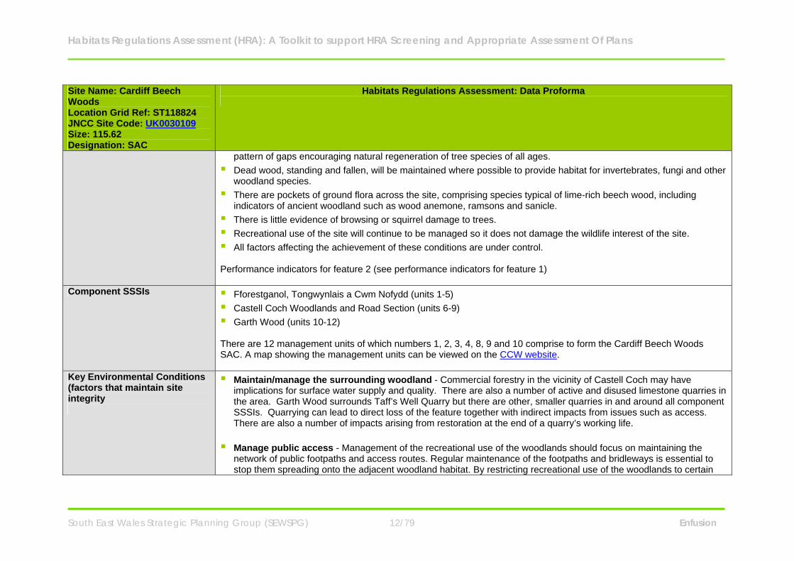
Component SSSIs Fforestganol, Tongwynlais a Cwm Nofydd (units 1-5) Castell Coch Woodlands and Road Section (units 6-9) Garth Wood (units 10-12) There are 12 management units of which numbers 1, 2, 3, 4, 8, 9 and 10 comprise to form the Cardiff Beech Woods SAC. A map showing the management units can be viewed on the CCW website.
Key Environmental Conditions (factors that maintain site integrity
Maintain/manage the surrounding woodland - Commercial forestry in the vicinity of Castell Coch may have implications for surface water supply and quality. There are also a number of active and disused limestone quarries in the area. Garth Wood surrounds Taff’s Well Quarry but there are other, smaller quarries in and around all component SSSIs. Quarrying can lead to direct loss of the feature together with indirect impacts from issues such as access. There are also a number of impacts arising from restoration at the end of a quarry’s working life.
Manage public access - Management of the recreational use of the woodlands should focus on maintaining the
network of public footpaths and access routes. Regular maintenance of the footpaths and bridleways is essential to stop them spreading onto the adjacent woodland habitat. By restricting recreational use of the woodlands to certain
Habitats Regulations Assessment (HRA): A Toolkit to support HRA Screening and Appropriate Assessment Of Plans
South East Wales Strategic Planning Group (SEWSPG) 13/79 Enfusion
Site Name: Cardiff Beech Woods Location Grid Ref: ST118824 JNCC Site Code: UK0030109 Size: 115.62 Designation: SAC
Habitats Regulations Assessment: Data Proforma
areas and paths, natural woodland processes can be left to occur away from these areas of recreational use and without the need for intervention from a public health and safety perspective.
SAC Condition Assessment Conservation Status of Feature 1
Aperulo-Fagetum beech forest The sites were monitored in March 2004 to gather the extent or condition of the habitat. The current feature status for the Asperulo-fagetum beech forest is Unfavourable - Unclassified (March 2004). The justification for the above feature status (March 2004) is as follows: CCW view is that the site is still recovering from undesirable effects of past management. Although most if not all aspects of the component sites are heading in the right direction the status is still short of favourable. Implementation of appropriate management will be addressed but in our view there is no urgent or immediate need for action. The Garth Wood component is thought to be ‘unfavourable recovering’ although a management plan has not been prepared to date so its status has not been fully assessed. The management is mostly limited intervention and for most of the site there is good age structure and gap regeneration. Natural processes could be enhanced by localised intervention and this will be addressed through management recommendations. Fforestganol a Chwm Nofydd is thought to be ‘unfavourable recovering’, although a management plan has not been prepared to date so its status has not been fully assessed. Although there are small areas of even age structure there is generally a diverse age structure. This, together with concerns at the percentage of beech at some locations, will be addressed through management recommendations. Castell Coch Woodlands and Road Section is thought to be ‘unfavourable recovering’. A full management plan has not been prepared to date so its status has not been fully assessed. There is generally an even age structure with low canopy cover. However, there is evidence of natural woodland processes, with good regeneration within the pattern of gaps. Recovery is expected over time and this could be hastened with increased localised intervention. This, together
Habitats Regulations Assessment (HRA): A Toolkit to support HRA Screening and Appropriate Assessment Of Plans
South East Wales Strategic Planning Group (SEWSPG) 14/79 Enfusion
Site Name: Cardiff Beech Woods Location Grid Ref: ST118824 JNCC Site Code: UK0030109 Size: 115.62 Designation: SAC
Habitats Regulations Assessment: Data Proforma
with concerns over the species composition (particularly ash and sycamore) at some locations will be addressed through management recommendations. Conservation Status of Feature 2 Tilio-Acerion forest of slopes, screes and ravines The sites were monitored in February 2004 to gather the extent or condition of the habitats and the species. The current feature status for the Tilio-Acerion forest of slopes, screes and ravines is Unfavourable - Recovering (February 2004). The justification for the above feature status (February 2004) is as follows: CCW view is that the site is still recovering from undesirable effects of past management. Although most if not all aspects of the component sites are heading in the right direction the status is still short of favourable. Implementation of appropriate management will be addressed but in our view there is no urgent or immediate need for action. The Garth Wood component is thought to be ‘unfavourable recovering’ although a management plan has not been prepared to date so its status has not been fully assessed. The management is mostly limited intervention and for most of the site there is good age structure and gap regeneration. Natural processes could be enhanced by localised intervention and this will be addressed through management recommendations. Fforestganol a Chwm Nofydd is thought to be ‘unfavourable recovering’, although a management plan has not been prepared to date so its status has not been fully assessed. Although there are small areas of even age structure there is generally a diverse age structure. This, together with concerns at the percentage of beech at some locations, will be addressed through management recommendations.
Vulnerabilities (includes existing pressures and trends)
Atmospheric Pollution - its location in industrialised South Wales, together with the presence of nearby quarrying and associated activities, means that there is the potential for localised atmospheric pollution. Quarry dust deposition is an issue that occasionally comes up. o Nitrogen deposition.
Habitats Regulations Assessment (HRA): A Toolkit to support HRA Screening and Appropriate Assessment Of Plans
South East Wales Strategic Planning Group (SEWSPG) 15/79 Enfusion
Site Name: Cardiff Beech Woods Location Grid Ref: ST118824 JNCC Site Code: UK0030109 Size: 115.62 Designation: SAC
Habitats Regulations Assessment: Data Proforma
o Photochemical oxidants (ozone). o Acidification.
Recreational pressure - All component SSSIs are used to a greater or lesser extent for recreation purposes. Castell Coch Woodlands and Fforestganol a Chwm Nofydd experience the most recreation pressure, and are popular for walking, climbing and mountain biking. The Taff train runs through part of the Castell Coch Woodlands site and the historic building of Castell Coch attracts many visitors, which increases the access pressure on the woodlands. The road section is becoming increasingly popular for climbing, and this is unlikely to be a problem for the geological interest of the site. However, climbing could be potentially damaging to trees at the top of the crag and needs to be kept under review. Management of access is nominally through the individual site owners but there are potential conflicts between different users which to date have been addressed through the Local Authority Access Forum. Recreation within the areas supporting this habitat feature is restricted due to the steep and rocky nature of the terrain. Therefore the recreational pressure on areas of Tilio-acerion is less than on areas of Asperulo-fagetum habitat. Nonetheless, given the high recreation pressure experienced by Fforestganol a Chwm Nofydd, which supports areas of Tilio-acerion habitat, aspects of recreational management still apply to this feature.
Mineral extraction and related activities - There are a number of active and disused limestone quarries in the area.
Garth Wood surrounds Taff’s Well Quarry but there are other, smaller quarries in and around all component SSSIs. Quarrying can lead to direct loss of the feature together with indirect impacts from issues such as access. There are also a number of impacts arising from restoration at the end of a quarry’s working life.
Development - Its location in the populated South Wales area means that there is considerable development
pressure in the vicinity including associated infrastructure on land adjacent to the site. There is the potential for a range of impacts arising from increasing urbanisation.
Commercial Forestry - Commercial forestry in the vicinity of Castell Coch may have implications for surface water
supply and quality.
Habitats Regulations Assessment (HRA): A Toolkit to support HRA Screening and Appropriate Assessment Of Plans
South East Wales Strategic Planning Group (SEWSPG) 16/79 Enfusion
Site Name: Cardiff Beech Woods Location Grid Ref: ST118824 JNCC Site Code: UK0030109 Size: 115.62 Designation: SAC
Habitats Regulations Assessment: Data Proforma
Non-native species - The presence of a number of species considered to be non-native e.g. sycamore and Japanese knotweed, is currently under review to determine any detrimental effects on the woodland communities of special interest.
Landowner/ Management Responsibility
The majority of the woodlands are owned, or in the guardianship of government agencies, with most of the remainder of the woodland covered by a Section 106 agreement. Cardiff County Council, Cadw and Forestry Commission carry out woodland management for conservation purposes and occasionally health and safety purposes.
Habitats Regulations Assessment (HRA): A Toolkit to support HRA Screening and Appropriate Assessment Of Plans
South East Wales Strategic Planning Group (SEWSPG) 17/79 Enfusion
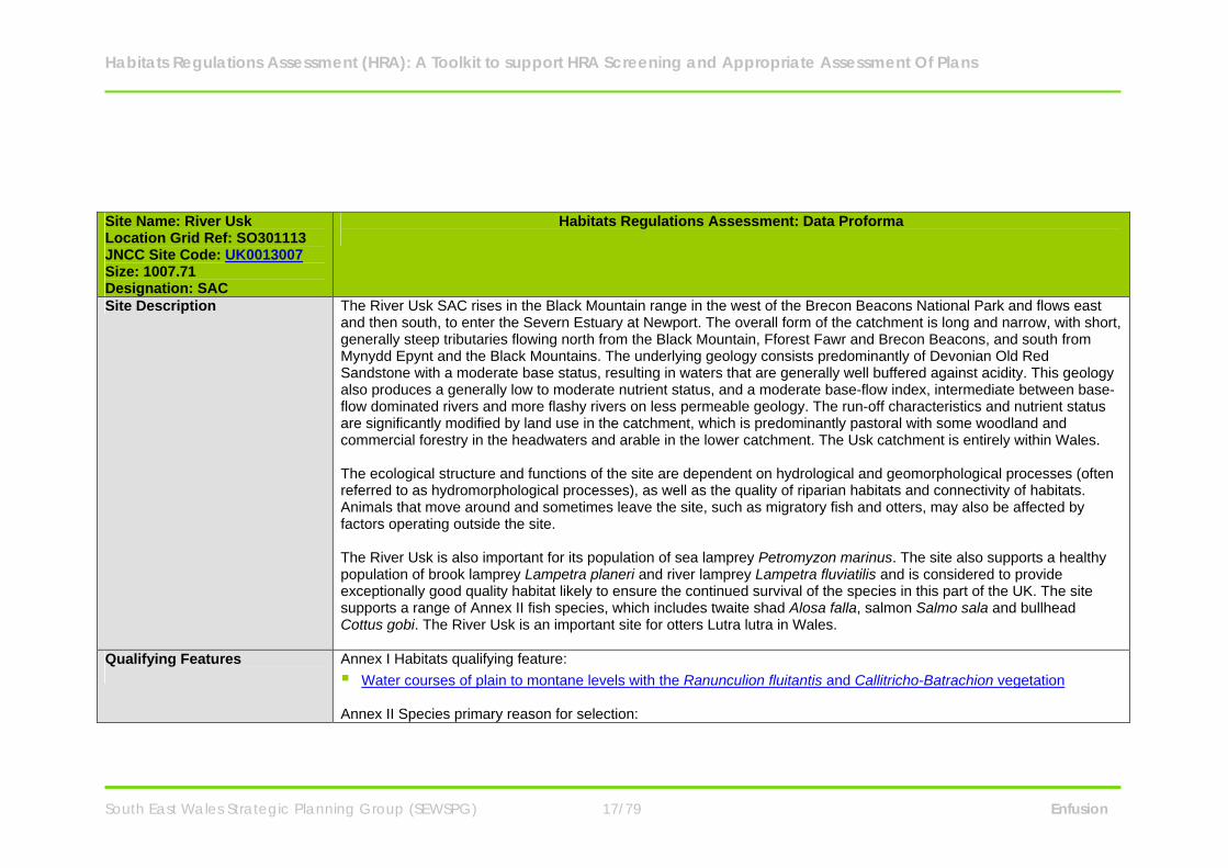
Site Name: River Usk Location Grid Ref: SO301113 JNCC Site Code: UK0013007 Size: 1007.71 Designation: SAC
Habitats Regulations Assessment: Data Proforma
Site Description The River Usk SAC rises in the Black Mountain range in the west of the Brecon Beacons National Park and flows east and then south, to enter the Severn Estuary at Newport. The overall form of the catchment is long and narrow, with short, generally steep tributaries flowing north from the Black Mountain, Fforest Fawr and Brecon Beacons, and south from Mynydd Epynt and the Black Mountains. The underlying geology consists predominantly of Devonian Old Red Sandstone with a moderate base status, resulting in waters that are generally well buffered against acidity. This geology also produces a generally low to moderate nutrient status, and a moderate base-flow index, intermediate between base-flow dominated rivers and more flashy rivers on less permeable geology. The run-off characteristics and nutrient status are significantly modified by land use in the catchment, which is predominantly pastoral with some woodland and commercial forestry in the headwaters and arable in the lower catchment. The Usk catchment is entirely within Wales. The ecological structure and functions of the site are dependent on hydrological and geomorphological processes (often referred to as hydromorphological processes), as well as the quality of riparian habitats and connectivity of habitats. Animals that move around and sometimes leave the site, such as migratory fish and otters, may also be affected by factors operating outside the site. The River Usk is also important for its population of sea lamprey Petromyzon marinus. The site also supports a healthy population of brook lamprey Lampetra planeri and river lamprey Lampetra fluviatilis and is considered to provide exceptionally good quality habitat likely to ensure the continued survival of the species in this part of the UK. The site supports a range of Annex II fish species, which includes twaite shad Alosa falla, salmon Salmo sala and bullhead Cottus gobi. The River Usk is an important site for otters Lutra lutra in Wales.
Qualifying Features
Annex I Habitats qualifying feature: Water courses of plain to montane levels with the Ranunculion fluitantis and Callitricho-Batrachion vegetation Annex II Species primary reason for selection:
Habitats Regulations Assessment (HRA): A Toolkit to support HRA Screening and Appropriate Assessment Of Plans
South East Wales Strategic Planning Group (SEWSPG) 18/79 Enfusion
Site Name: River Usk Location Grid Ref: SO301113 JNCC Site Code: UK0013007 Size: 1007.71 Designation: SAC
Habitats Regulations Assessment: Data Proforma
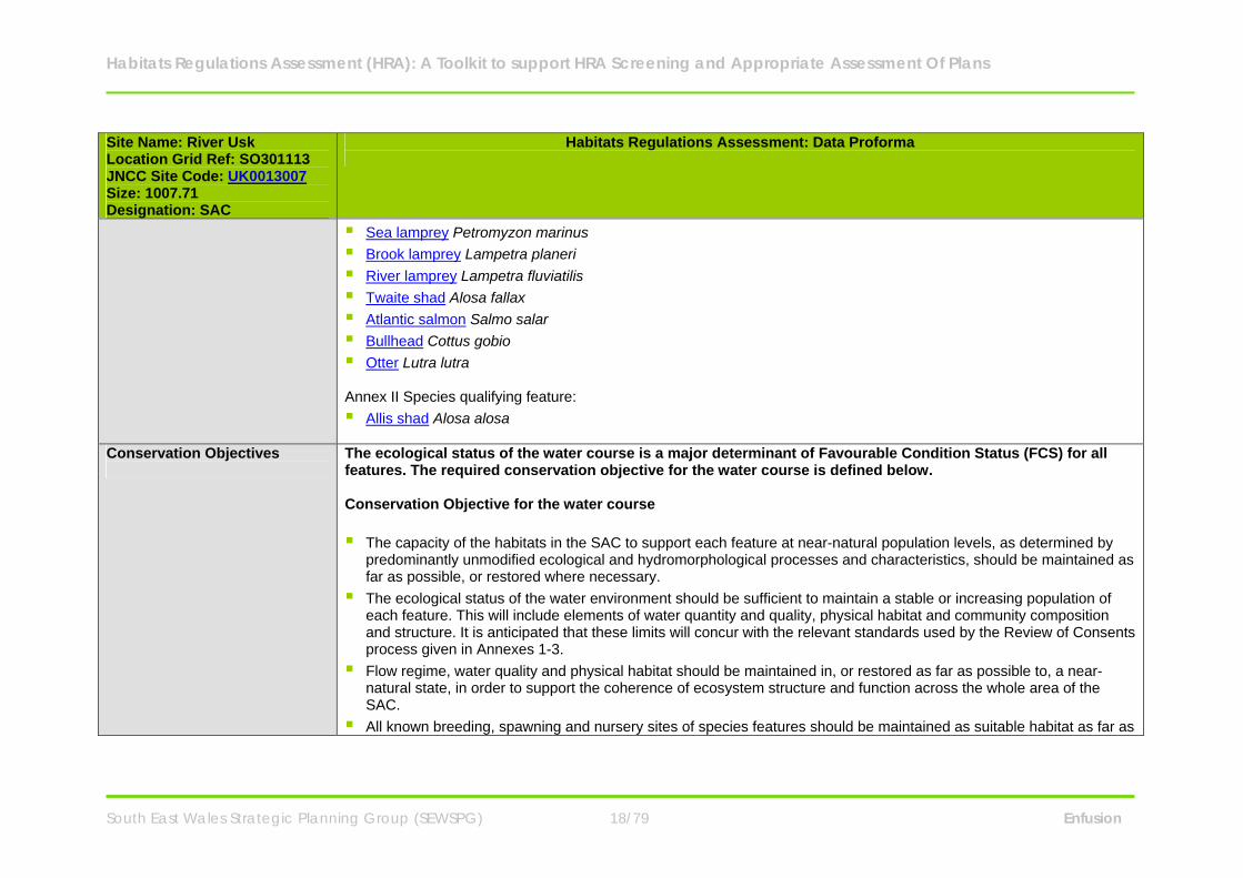
Sea lamprey Petromyzon marinus Brook lamprey Lampetra planeri River lamprey Lampetra fluviatilis Twaite shad Alosa fallax Atlantic salmon Salmo salar Bullhead Cottus gobio Otter Lutra lutra Annex II Species qualifying feature: Allis shad Alosa alosa
Conservation Objectives
The ecological status of the water course is a major determinant of Favourable Condition Status (FCS) for all features. The required conservation objective for the water course is defined below. Conservation Objective for the water course The capacity of the habitats in the SAC to support each feature at near-natural population levels, as determined by
predominantly unmodified ecological and hydromorphological processes and characteristics, should be maintained as far as possible, or restored where necessary.
The ecological status of the water environment should be sufficient to maintain a stable or increasing population of each feature. This will include elements of water quantity and quality, physical habitat and community composition and structure. It is anticipated that these limits will concur with the relevant standards used by the Review of Consents process given in Annexes 1-3.
Flow regime, water quality and physical habitat should be maintained in, or restored as far as possible to, a near-natural state, in order to support the coherence of ecosystem structure and function across the whole area of the SAC.
All known breeding, spawning and nursery sites of species features should be maintained as suitable habitat as far as
Habitats Regulations Assessment (HRA): A Toolkit to support HRA Screening and Appropriate Assessment Of Plans
South East Wales Strategic Planning Group (SEWSPG) 19/79 Enfusion
Site Name: River Usk Location Grid Ref: SO301113 JNCC Site Code: UK0013007 Size: 1007.71 Designation: SAC
Habitats Regulations Assessment: Data Proforma
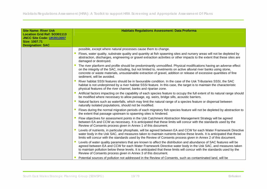
possible, except where natural processes cause them to change. Flows, water quality, substrate quality and quantity at fish spawning sites and nursery areas will not be depleted by
abstraction, discharges, engineering or gravel extraction activities or other impacts to the extent that these sites are damaged or destroyed.
The river planform and profile should be predominantly unmodified. Physical modifications having an adverse effect on the integrity of the SAC, including, but not limited to, revetments on active alluvial river banks using stone, concrete or waste materials, unsustainable extraction of gravel, addition or release of excessive quantities of fine sediment, will be avoided.
River habitat SSSI features should be in favourable condition. In the case of the Usk Tributaries SSSI, the SAC habitat is not underpinned by a river habitat SSSI feature. In this case, the target is to maintain the characteristic physical features of the river channel, banks and riparian zone.
Artificial factors impacting on the capability of each species feature to occupy the full extent of its natural range should be modified where necessary to allow passage, eg. weirs, bridge sills, acoustic barriers.
Natural factors such as waterfalls, which may limit the natural range of a species feature or dispersal between naturally isolated populations, should not be modified.
Flows during the normal migration periods of each migratory fish species feature will not be depleted by abstraction to the extent that passage upstream to spawning sites is hindered.
Flow objectives for assessment points in the Usk Catchment Abstraction Management Strategy will be agreed between EA and CCW as necessary. It is anticipated that these limits will concur with the standards used by the Review of Consents process given in Annex 1 of this document.
Levels of nutrients, in particular phosphate, will be agreed between EA and CCW for each Water Framework Directive water body in the Usk SAC, and measures taken to maintain nutrients below these levels. It is anticipated that these limits will concur with the standards used by the Review of Consents process given in Annex 2 of this document.
Levels of water quality parameters that are known to affect the distribution and abundance of SAC features will be agreed between EA and CCW for each Water Framework Directive water body in the Usk SAC, and measures taken to maintain pollution below these levels. It is anticipated that these limits will concur with the standards used by the Review of Consents process given in Annex 3 of this document.
Potential sources of pollution not addressed in the Review of Consents, such as contaminated land, will be
Habitats Regulations Assessment (HRA): A Toolkit to support HRA Screening and Appropriate Assessment Of Plans
South East Wales Strategic Planning Group (SEWSPG) 20/79 Enfusion
Site Name: River Usk Location Grid Ref: SO301113 JNCC Site Code: UK0013007 Size: 1007.71 Designation: SAC
Habitats Regulations Assessment: Data Proforma
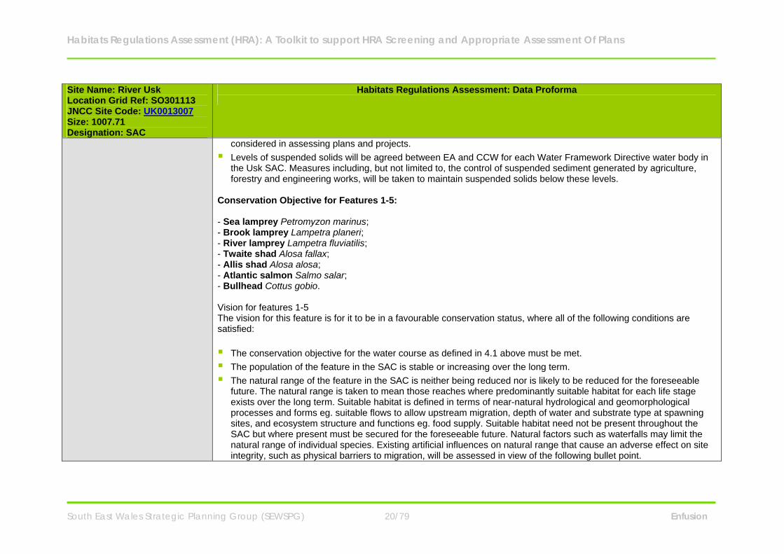
considered in assessing plans and projects. Levels of suspended solids will be agreed between EA and CCW for each Water Framework Directive water body in
the Usk SAC. Measures including, but not limited to, the control of suspended sediment generated by agriculture, forestry and engineering works, will be taken to maintain suspended solids below these levels.
Conservation Objective for Features 1-5: - Sea lamprey Petromyzon marinus; - Brook lamprey Lampetra planeri; - River lamprey Lampetra fluviatilis; - Twaite shad Alosa fallax; - Allis shad Alosa alosa; - Atlantic salmon Salmo salar; - Bullhead Cottus gobio. Vision for features 1-5 The vision for this feature is for it to be in a favourable conservation status, where all of the following conditions are satisfied: The conservation objective for the water course as defined in 4.1 above must be met. The population of the feature in the SAC is stable or increasing over the long term. The natural range of the feature in the SAC is neither being reduced nor is likely to be reduced for the foreseeable
future. The natural range is taken to mean those reaches where predominantly suitable habitat for each life stage exists over the long term. Suitable habitat is defined in terms of near-natural hydrological and geomorphological processes and forms eg. suitable flows to allow upstream migration, depth of water and substrate type at spawning sites, and ecosystem structure and functions eg. food supply. Suitable habitat need not be present throughout the SAC but where present must be secured for the foreseeable future. Natural factors such as waterfalls may limit the natural range of individual species. Existing artificial influences on natural range that cause an adverse effect on site integrity, such as physical barriers to migration, will be assessed in view of the following bullet point.
Habitats Regulations Assessment (HRA): A Toolkit to support HRA Screening and Appropriate Assessment Of Plans
South East Wales Strategic Planning Group (SEWSPG) 21/79 Enfusion
Site Name: River Usk Location Grid Ref: SO301113 JNCC Site Code: UK0013007 Size: 1007.71 Designation: SAC
Habitats Regulations Assessment: Data Proforma
There is, and will probably continue to be, a sufficiently large habitat to maintain the feature’s population in the SAC on a long-term basis.
Performance indicators for features 1-5 The performance indicators are part of the conservation objective, not a substitute for it. Assessment of plans and projects must be based on the entire conservation objective, not just the performance indicators. The performance indicators can be found within the River Usk SAC Management Plan . Conservation Objective for Feature 6: - European otter Lutra lutra Vision for feature 6 The vision for this feature is for it to be in a favourable conservation status, where all of the following conditions are satisfied: The population of otters in the SAC is stable or increasing over the long term and reflects the natural carrying capacity
of the habitat within the SAC, as determined by natural levels of prey abundance and associated territorial behaviour. The natural range of otters in the SAC is neither being reduced nor is likely to be reduced for the foreseeable future.
The natural range is taken to mean those reaches that are potentially suitable to form part of a breeding territory and/or provide routes between breeding territories. The whole area of the Usk SAC is considered to form potentially suitable breeding habitat for otters. The size of breeding territories may vary depending on prey abundance. The population size should not be limited by the availability of suitable undisturbed breeding sites. Where these are insufficient they should be created through habitat enhancement and where necessary the provision of artificial holts. No otter breeding site should be subject to a level of disturbance that could have an adverse effect on breeding success. Where necessary, potentially harmful levels of disturbance must be managed.
The safe movement and dispersal of individuals around the SAC is facilitated by the provision, where necessary, of suitable riparian habitat, and underpasses, ledges, fencing etc at road bridges and other artificial barriers.

Habitats Regulations Assessment (HRA): A Toolkit to support HRA Screening and Appropriate Assessment Of Plans
South East Wales Strategic Planning Group (SEWSPG) 22/79 Enfusion
Site Name: River Usk Location Grid Ref: SO301113 JNCC Site Code: UK0013007 Size: 1007.71 Designation: SAC
Habitats Regulations Assessment: Data Proforma
Performance indicators for feature 6 (see performance indicators for features 1 - 5) Conservation Objective for Feature 7: - Water courses of plain to montane levels with the Ranunculion fluitantis and Callitricho-Batrachion vegetation Vision for feature 7 The performance indicators are part of the conservation objective, not a substitute for it. Assessment of plans and projects must be based on the entire conservation objective, not just the performance indicators. The conservation objectives for the water course as defined above must be met. The natural range of the plant communities represented within this feature should be stable or increasing in the SAC.
The natural range is taken to mean those reaches where predominantly suitable habitat exists over the long term. Suitable habitat and associated plant communities may vary from reach to reach. Suitable habitat is defined in terms of near-natural hydrological and geomorphological processes and forms eg. depth and stability of flow, stability of bed substrate, and ecosystem structure and functions eg. nutrient levels, shade. Suitable habitat for the feature need not be present throughout the SAC but where present must be secured for the foreseeable future, except where natural processes cause it to decline in extent.
The area covered by the feature within its natural range in the SAC should be stable or increasing. The conservation status of the feature’s typical species should be favourable. The typical species are defined with
reference to the species composition of the appropriate JNCC river vegetation type for the particular river reach, unless differing from this type due to natural variability when other typical species may be defined as appropriate.
Performance indicators for feature 7 (see performance indicators for features 1 - 5)
Component SSSIs River Usk (Upper Usk) SSSI River Usk (Lower Usk) SSSI River Usk (Tributaries) SSSI
Habitats Regulations Assessment (HRA): A Toolkit to support HRA Screening and Appropriate Assessment Of Plans
South East Wales Strategic Planning Group (SEWSPG) 23/79 Enfusion
Site Name: River Usk Location Grid Ref: SO301113 JNCC Site Code: UK0013007 Size: 1007.71 Designation: SAC
Habitats Regulations Assessment: Data Proforma
Penllwyn-yr-hendy SSSI Coed Dyrysiog SSSI Coed Nant Menascin SSSI Coed Ynysfaen SSSI The SAC has been divided into 10 management units: Units 1 to 3 - River Usk (Lower Usk) SSSI. Units 4 to 6 - River Usk (Upper Usk) SSSI. Units 7 to 10 - River Usk (Tributaries) SSSI. A map showing the various management units can be seen within the River Usk SAC Management Plan.
Key Environmental Conditions (factors that maintain site integrity
Hydrological processes: o River flow (level and variability) and water chemistry, determine a range of habitat factors of critical importance
to the SAC features, including current velocity, water depth, wetted area, substrate quality, dissolved oxygen levels and water temperature. Maintenance of both high ‘spate’ flows and base-flows is essential. Reduction in flows may reduce the ability of the adults of migratory fish to reach spawning sites. Water-crowfoot vegetation thrives in relatively stable, moderate flows and clean water. The flow regime should be characteristic of the river in order to support the functioning of the river ecosystem.
Geomorphological processes - of erosion by water and subsequent deposition of eroded sediments downstream,
create the physical structure of the river habitats. Whilst some sections of the river are naturally stable, especially where they flow over bedrock, others undergo constant and at times rapid change through the erosion and deposition of bed and bank sediments as is typical of meandering sections within floodplains (called ‘alluvial’ rivers). These processes help to sustain the river ecosystem by allowing a continued supply of clean gravels and other important substrates to be transported downstream. In addition, the freshly deposited and eroded surfaces, such as shingle banks and earth cliffs, enable processes of ecological succession to begin again, providing an essential habitat for specialist, early-successional species. Lampreys need clean gravel for spawning, and marginal silt or sand for the
Habitats Regulations Assessment (HRA): A Toolkit to support HRA Screening and Appropriate Assessment Of Plans
South East Wales Strategic Planning Group (SEWSPG) 24/79 Enfusion
Site Name: River Usk Location Grid Ref: SO301113 JNCC Site Code: UK0013007 Size: 1007.71 Designation: SAC
Habitats Regulations Assessment: Data Proforma
burrowing juvenile ammocoetes. Processes at the wider catchment scale generally govern processes of erosion and deposition occurring at the reach scale, although locally, factors such as the effect of grazing levels on riparian vegetation structure may contribute to enhanced erosion rates. In general, management that interferes with natural geomorphological processes, for example preventing bank erosion through the use of hard revetments or removing large amounts of gravel, are likely to be damaging to the coherence of the ecosystem structure and functions.
Riparian habitats - including bank sides and habitats on adjacent land, are an integral part of the river ecosystem. Diverse and high quality riparian habitats have a vital role in maintaining the SAC features in a favourable condition. The type and condition of riparian vegetation influences shade and water temperature, nutrient run-off from adjacent land, the availability of woody debris to the channel and inputs of leaf litter and invertebrates to support in-steam consumers. Light, temperature and nutrient levels influence in-stream plant production and habitat suitability for the SAC features. Woody debris is very important as it provides refuge areas from predators, traps sediment to create spawning and juvenile habitat and forms the base of an important aquatic food chain. Otters require sufficient undisturbed riparian habitats as breeding and resting sites. It is important that appropriate amounts of tree cover, in general at least 50% high canopy cover, tall vegetation and other semi-natural habitats are maintained on the riverbanks and in adjacent areas, and that they are properly managed to support the SAC features. This may be achieved, for example, through managing grazing levels, selective coppicing of riparian trees and restoring adjacent wetlands. In the urban sections the focus may be on maintaining the river as a communication corridor but this will still require that sufficient riparian habitat is present and managed to enable the river corridor to function effectively.
Habitat connectivity - is an important property of a river ecosystem structure and function. Many of the fish that
spawn in the river are migratory, depending on the maintenance of suitable conditions on their migration routes to allow the adults to reach available spawning habitat and juvenile fish to migrate downstream. For resident species, dispersal to new areas, or the prevention of dispersal causing isolated populations to become genetically distinct, may be important factors. Naturally isolated feature populations that are identified as having important genetic distinctiveness should be maintained. Artificial obstructions including weirs and bridge sills can reduce connectivity for some species. In addition, reaches subject to depleted flow levels, pollution, or disturbance due to noise, vibration or light, can all inhibit the movement of sensitive species. The dispersal of semi-terrestrial species such as the otter can be adversely affected by structures such as bridges under certain flow conditions; therefore, these must be designed to allow safe passage. The continuity of riparian habitats enables a wide range of terrestrial species, for example
Habitats Regulations Assessment (HRA): A Toolkit to support HRA Screening and Appropriate Assessment Of Plans
South East Wales Strategic Planning Group (SEWSPG) 25/79 Enfusion
Site Name: River Usk Location Grid Ref: SO301113 JNCC Site Code: UK0013007 Size: 1007.71 Designation: SAC
Habitats Regulations Assessment: Data Proforma
lesser horseshoe bats, to migrate and disperse through the landscape. Connectivity should be maintained or restored where necessary as a means to ensure access for the features to sufficient habitat within the SAC.
SAC Condition Assessment Conservation status of Feature 1: Sea lamprey Petromyzon marinus
Status: Unfavourable: Unclassified. Sea lamprey monitoring showed that overall catchment mean ammocoete density considerably exceeded the JNCC target threshold and also complied with targets for spawning site and ammocoete distribution. A caveat on the latter is uncertainty over whether the natural range of sea lamprey extends above Brecon weir: this is assumed not to be the case. Factors leading to an unfavourable assessment are the presence of probable partial barriers further downstream (notably Crickhowell Bridge), and flow depletion resulting from abstractions including Brecon canal and Prioress Mill public water supply abstraction. The latter in particular has been shown to have effects both on a seasonal timescale by reducing spate flows during the migration period and on a diurnal timescale by substantially depleting flows during the night time to the extent that sea lamprey nests and nursery areas are likely to be exposed above the water level. The effect of the Brecon canal abstraction has been shown to comprise a substantial depletion of flows, at least locally, during low flow periods with a resulting reduction in river depth downstream of the off-take weir. Conservation status of Feature 2: Brook lamprey Lampetra planeri and River lamprey Lampetra fluviatilis Status: Favourable. Brook/river lamprey monitoring showed that overall catchment mean ammocoete density considerably exceeded the JNCC target threshold and also complied with targets for ammocoete distribution1. It has not been possible to distinguish between these two species during monitoring, due to the reliance on juvenile stages (ammocoetes). Anecdotal evidence suggests that both species are likely to be present in many reaches, though brook lamprey are expected to predominate in the headwaters and river lamprey may be the more abundant species in the main channel and the lower reaches of larger tributaries. More information on the relative abundance of these two species in different parts of the Usk SAC is desirable. Records of spawning adult river lamprey would be particularly useful.
Habitats Regulations Assessment (HRA): A Toolkit to support HRA Screening and Appropriate Assessment Of Plans
South East Wales Strategic Planning Group (SEWSPG) 26/79 Enfusion
Site Name: River Usk Location Grid Ref: SO301113 JNCC Site Code: UK0013007 Size: 1007.71 Designation: SAC
Habitats Regulations Assessment: Data Proforma
Conservation status of Feature 3: Twaite shad Alosa fallax and Allis shad Alosa alosa Status: Unfavourable: Unclassified. Monitoring of these species in the Usk relies on two methods, Kick sampling for eggs provides qualitative information on spawning distribution, Netting for juveniles in the lower river and tidal reaches during late summer/autumn when juveniles drift downstream towards the estuary. These methods do not distinguish between the two species. Allis shad is thought to be rare, with no recent records in the Usk, while twaite shad is relatively common. Kick sampling for eggs is only able to give a broad scale indication of presence or absence at sampled locations. Netting for juveniles gives a quantitative estimate of abundance, though may be subject to a high degree of uncertainty due to sampling error. This uncertainty is likely to be compounded by variation between years in the size of the adult run, spawning success and resulting numbers of juveniles. Poor adult runs are likely to result from unsuitable flows during the March to June migration period, in particular prolonged low flows, while poor survival of eggs and juveniles is related to spate flows in the mid to late summer which can flush them into the estuary prematurely. CSM guidance states that adult run size should comply with an agreed target for each river, with no drop in the annual run greater than would be expected from variations in natural mortality alone. This attribute is not currently assessed in the Usk due to the absence of a fish counter. The current unfavourable status results from a precautionary assessment of feature distribution and abundance, and from the presence of adverse factors, in particular flow depletion and physical barriers to migration. Conservation status of Feature 4: Atlantic salmon Salmo salar Status: Unfavourable: Unclassified. Monitoring of Atlantic salmon in the Usk relies on two methods,
1. Estimation of adult run size from angling catch returns, 2. Electro-fishing for juveniles in nursery areas.
The estimate of adult numbers is converted into an estimate of numbers of eggs deposited which is compared against an Egg Deposition Target (EDT), calculated by considering the area of suitable spawning habitat within the catchment. The
Habitats Regulations Assessment (HRA): A Toolkit to support HRA Screening and Appropriate Assessment Of Plans
South East Wales Strategic Planning Group (SEWSPG) 27/79 Enfusion
Site Name: River Usk Location Grid Ref: SO301113 JNCC Site Code: UK0013007 Size: 1007.71 Designation: SAC
Habitats Regulations Assessment: Data Proforma
equivalent adult run to achieve the EDT is described in terms of a Conservation Limit, which must be exceeded 4 years in 5 for the Management Target to be considered attained. Electro-fishing for juveniles is either quantitative or semi-quantitative, and estimated juvenile densities are classified in one of six categories A to F. The monitoring guidance produced by the LIFE in UK Rivers project recommends that ideally juvenile densities should be compared to predicted densities for the sample reach using the HABSCORE model6. These targets are calculated and monitored by the Environment Agency as part of the Salmon Action Plan for the Usk. The current unfavourable status results from a precautionary assessment of feature distribution and abundance, in particular the results of juvenile surveys, and from the presence of adverse factors, in particular flow depletion and localised water quality failures. Conservation status of Feature 5: Bullhead Cottus gobio Status: Unfavourable: Unclassified. The current unfavourable status results from the presence of adverse factors, in particular flow depletion and localised water quality failures. Records obtained from juvenile salmon monitoring show that bullhead are widespread in the main river and tributaries. There is a need for quantitative information on bullhead abundance, which will be addressed by targeted monitoring in 2007. Conservation status of Feature 6: European otter Lutra lutra Status: Favourable. The conservation status of otters in the Usk SAC is determined by monitoring their distribution, breeding success, and the condition of potential breeding and feeding habitat outlined in the Performance Indicators. Their current condition can be considered favourable, but with scope for further improvement, if habitat and other natural factors can be maintained and enhanced. Conservation status of Feature 7: Water courses of plain to montane levels with the Ranunculion fluitantis and Callitricho-Batrachion vegetation Status: Unfavourable: Unclassified. The present unfavourable status of the feature results from the over-abundance of invasive non-native species of bankside plant communities, which are included within the feature definition. These are predominantly giant hogweed and Himalayan balsam in the lower reaches of the main river.
Habitats Regulations Assessment (HRA): A Toolkit to support HRA Screening and Appropriate Assessment Of Plans
South East Wales Strategic Planning Group (SEWSPG) 28/79 Enfusion
Site Name: River Usk Location Grid Ref: SO301113 JNCC Site Code: UK0013007 Size: 1007.71 Designation: SAC
Habitats Regulations Assessment: Data Proforma
Vulnerabilities (includes existing pressures and trends)
Abstraction levels - Entrainment in water abstractions directly impacts on lamprey population dynamics through reduced recruitment and survival rates. The impact of flow depletion resulting from a small number of major abstractions was highlighted in the Review of Consents process.
Eutrophication - factors that are important to the favourable conservation status of this feature include flow,
substrate quality and water quality, which in turn influence species composition and abundance. These factors often interact, producing unfavourable conditions by promoting the growth of a range of algae and other species indicative of eutrophication. Under conditions of prolonged low flows and high nutrient status, epiphytic algae may suppress the growth of aquatic flowering plants.
Diffuse Pollution - The Atlantic salmon is the focus for much of the management activity carried out on the Usk. The
relatively demanding water quality and spawning substrate quality requirements of this feature mean that reduction in diffuse pollution and siltation impacts is a high priority. In the Usk catchment, the most significant sources of diffuse pollution and siltation are from agriculture, including fertiliser run-off, livestock manure, silage effluent and soil erosion from ploughed land. The most intensively used areas such as heavily trampled gateways and tracks can be especially significant sources of polluting run-off. Farm operations should avoid ploughing land which is vulnerable to soil erosion or leaving such areas without crop cover during the winter. Contamination by synthetic pyrethroid sheep dips, which are extremely toxic to aquatic invertebrates, has a devastating impact on crayfish populations and can deprive fish populations of food over large stretches of river. These impacts can arise if recently dipped sheep are allowed access to a stream or hard standing area, which drains into a watercourse. Pollution from organophosphate sheep dips and silage effluent can be very damaging locally. Pollution from slurry and other agricultural and industrial chemicals, including fuels, can kill all forms of aquatic life. All sheep dips and silage, fuel and chemical storage areas should be sited away from watercourses or bunded to contain leakage. Recently dipped sheep should be kept off stream banks. Discharges from sewage treatment works, urban drainage, engineering works such as road improvement schemes, contaminated land, and other domestic and industrial sources can also be significant causes of pollution, and must be managed appropriately. Pollution of rivers with toxic chemicals, such as PCBs, was one of the major factors identified in the widespread decline of otters during the last century.
Habitats Regulations Assessment (HRA): A Toolkit to support HRA Screening and Appropriate Assessment Of Plans
South East Wales Strategic Planning Group (SEWSPG) 29/79 Enfusion
Site Name: River Usk Location Grid Ref: SO301113 JNCC Site Code: UK0013007 Size: 1007.71 Designation: SAC
Habitats Regulations Assessment: Data Proforma
Barriers to migration - There are few barriers to migration for the anadromous species and where barriers exist, investigation is proposed to analyse for potential impacts and remedy them through multi-species fish passes. Crickhowell Bridge is considered to be the most significant barrier to fish migration in the Usk. Management to reduce or remove the effect of this barrier is a high priority for the River Usk SAC. Artificial physical barriers are probably the single most important factor in the decline of shad in Europe. Impassable obstacles between suitable spawning areas and the sea can eliminate breeding populations of shad. Both species (but particularly allis shad) can make migrations of hundreds of kilometres from the estuary to spawning grounds in the absence of artificial barriers. Existing fish passes designed for salmon are often not effective for shad.
Development pressure - in the lower catchment can cause temporary physical, acoustic, chemical and sediment
barrier effects that need to be addressed in the assessment of specific plans and projects. Noise/vibration e.g. due to impact piling, drilling, salmon fish counters present within or in close proximity to the river can create a barrier to shad migration. Land on both sides of the river in Newport is potentially highly contaminated. Contamination of the river can arise when this is disturbed e.g. as a result of development. Contamination can also arise from pollution events (which could be shipping or industry related). Barriers resulting from vibration, chemicals, low dissolved oxygen and artificially high sediment levels must be prevented at key times (generally March to June).
Invasive non-native plants - are a detrimental impact on the water courses of plain to montane levels with the
Ranunculion fluitantis and Callitricho-Batrachion vegetation. Giant hogweed, Himalayan balsam and Japanese knotweed should be actively managed to control their spread and hopefully reduce their extent in the SAC.
Artificially enhanced densities of other fish - may introduce unacceptable competition or predation pressure and
the aim should be to minimise these risks in considering any proposals for stocking. External factors - operating outside the SAC, may also be influential, particularly for the migratory fish and otters.
For example, salmon may be affected by barriers to migration in the Severn Estuary, inshore fishing and environmental conditions prevailing in their north Atlantic feeding grounds. Otters may be affected by developments that affect resting and breeding sites outside the SAC boundary.
Habitats Regulations Assessment (HRA): A Toolkit to support HRA Screening and Appropriate Assessment Of Plans
South East Wales Strategic Planning Group (SEWSPG) 30/79 Enfusion
Site Name: River Usk Location Grid Ref: SO301113 JNCC Site Code: UK0013007 Size: 1007.71 Designation: SAC
Habitats Regulations Assessment: Data Proforma
Landowner/ Management Responsibility
N/A
Habitats Regulations Assessment (HRA): A Toolkit to support HRA Screening and Appropriate Assessment Of Plans
South East Wales Strategic Planning Group (SEWSPG) 31/79 Enfusion
Site Name: River Wye Location Grid Ref: SO109369 JNCC Site Code: UK0012642 Size: 2234.89 Designation: SAC
Habitats Regulations Assessment: Data Proforma
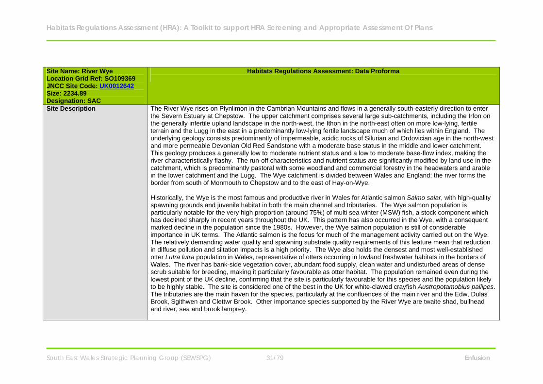
Site Description The River Wye rises on Plynlimon in the Cambrian Mountains and flows in a generally south-easterly direction to enter the Severn Estuary at Chepstow. The upper catchment comprises several large sub-catchments, including the Irfon on the generally infertile upland landscape in the north-west, the Ithon in the north-east often on more low-lying, fertile terrain and the Lugg in the east in a predominantly low-lying fertile landscape much of which lies within England. The underlying geology consists predominantly of impermeable, acidic rocks of Silurian and Ordovician age in the north-west and more permeable Devonian Old Red Sandstone with a moderate base status in the middle and lower catchment. This geology produces a generally low to moderate nutrient status and a low to moderate base-flow index, making the river characteristically flashy. The run-off characteristics and nutrient status are significantly modified by land use in the catchment, which is predominantly pastoral with some woodland and commercial forestry in the headwaters and arable in the lower catchment and the Lugg. The Wye catchment is divided between Wales and England; the river forms the border from south of Monmouth to Chepstow and to the east of Hay-on-Wye. Historically, the Wye is the most famous and productive river in Wales for Atlantic salmon Salmo salar, with high-quality spawning grounds and juvenile habitat in both the main channel and tributaries. The Wye salmon population is particularly notable for the very high proportion (around 75%) of multi sea winter (MSW) fish, a stock component which has declined sharply in recent years throughout the UK. This pattern has also occurred in the Wye, with a consequent marked decline in the population since the 1980s. However, the Wye salmon population is still of considerable importance in UK terms. The Atlantic salmon is the focus for much of the management activity carried out on the Wye. The relatively demanding water quality and spawning substrate quality requirements of this feature mean that reduction in diffuse pollution and siltation impacts is a high priority. The Wye also holds the densest and most well-established otter Lutra lutra population in Wales, representative of otters occurring in lowland freshwater habitats in the borders of Wales. The river has bank-side vegetation cover, abundant food supply, clean water and undisturbed areas of dense scrub suitable for breeding, making it particularly favourable as otter habitat. The population remained even during the lowest point of the UK decline, confirming that the site is particularly favourable for this species and the population likely to be highly stable. The site is considered one of the best in the UK for white-clawed crayfish Austropotamobius pallipes. The tributaries are the main haven for the species, particularly at the confluences of the main river and the Edw, Dulas Brook, Sgithwen and Clettwr Brook. Other importance species supported by the River Wye are twaite shad, bullhead and river, sea and brook lamprey.
Habitats Regulations Assessment (HRA): A Toolkit to support HRA Screening and Appropriate Assessment Of Plans
South East Wales Strategic Planning Group (SEWSPG) 32/79 Enfusion
Site Name: River Wye Location Grid Ref: SO109369 JNCC Site Code: UK0012642 Size: 2234.89 Designation: SAC
Habitats Regulations Assessment: Data Proforma
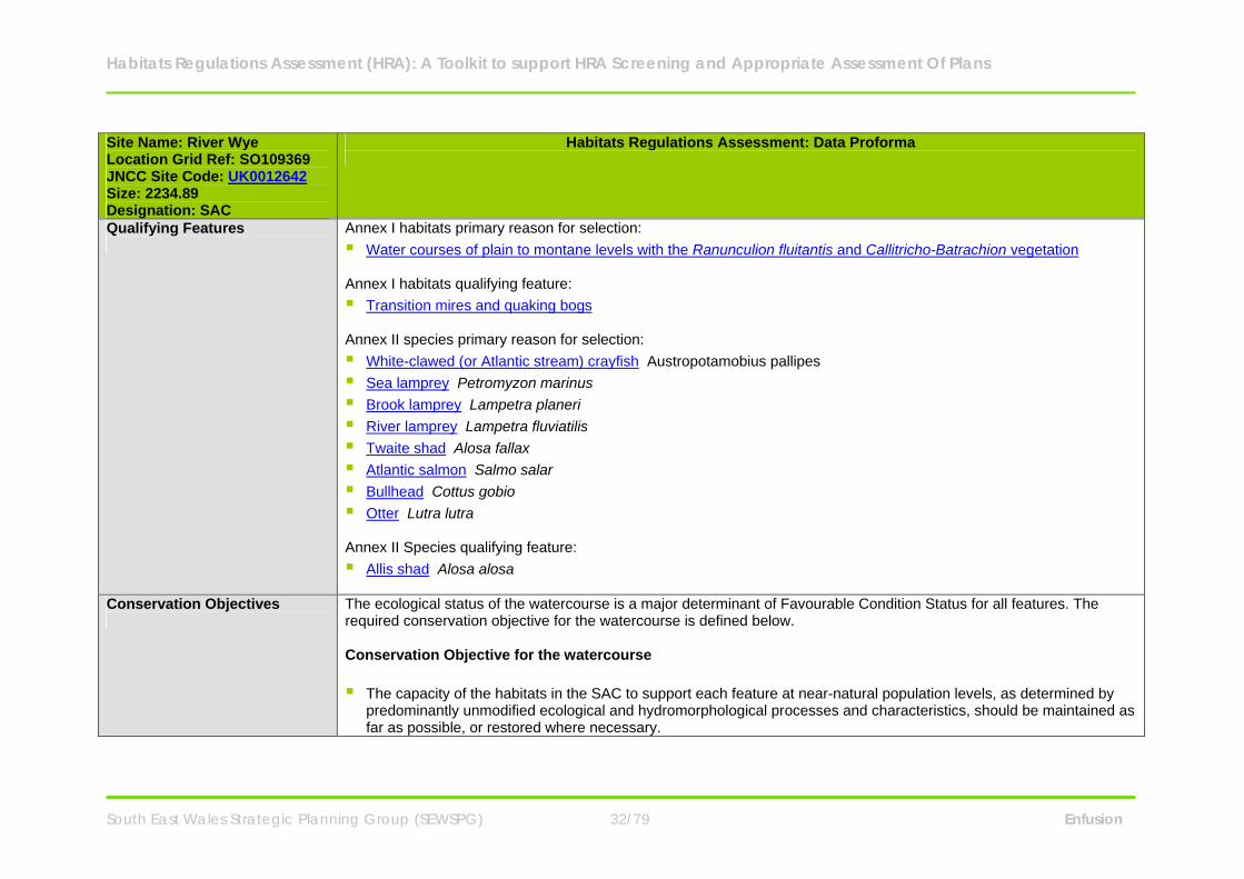
Qualifying Features
Annex I habitats primary reason for selection: Water courses of plain to montane levels with the Ranunculion fluitantis and Callitricho-Batrachion vegetation Annex I habitats qualifying feature: Transition mires and quaking bogs Annex II species primary reason for selection: White-clawed (or Atlantic stream) crayfish Austropotamobius pallipes Sea lamprey Petromyzon marinus Brook lamprey Lampetra planeri River lamprey Lampetra fluviatilis Twaite shad Alosa fallax Atlantic salmon Salmo salar Bullhead Cottus gobio Otter Lutra lutra Annex II Species qualifying feature: Allis shad Alosa alosa
Conservation Objectives
The ecological status of the watercourse is a major determinant of Favourable Condition Status for all features. The required conservation objective for the watercourse is defined below. Conservation Objective for the watercourse The capacity of the habitats in the SAC to support each feature at near-natural population levels, as determined by
predominantly unmodified ecological and hydromorphological processes and characteristics, should be maintained as far as possible, or restored where necessary.
Habitats Regulations Assessment (HRA): A Toolkit to support HRA Screening and Appropriate Assessment Of Plans
South East Wales Strategic Planning Group (SEWSPG) 33/79 Enfusion
Site Name: River Wye Location Grid Ref: SO109369 JNCC Site Code: UK0012642 Size: 2234.89 Designation: SAC
Habitats Regulations Assessment: Data Proforma
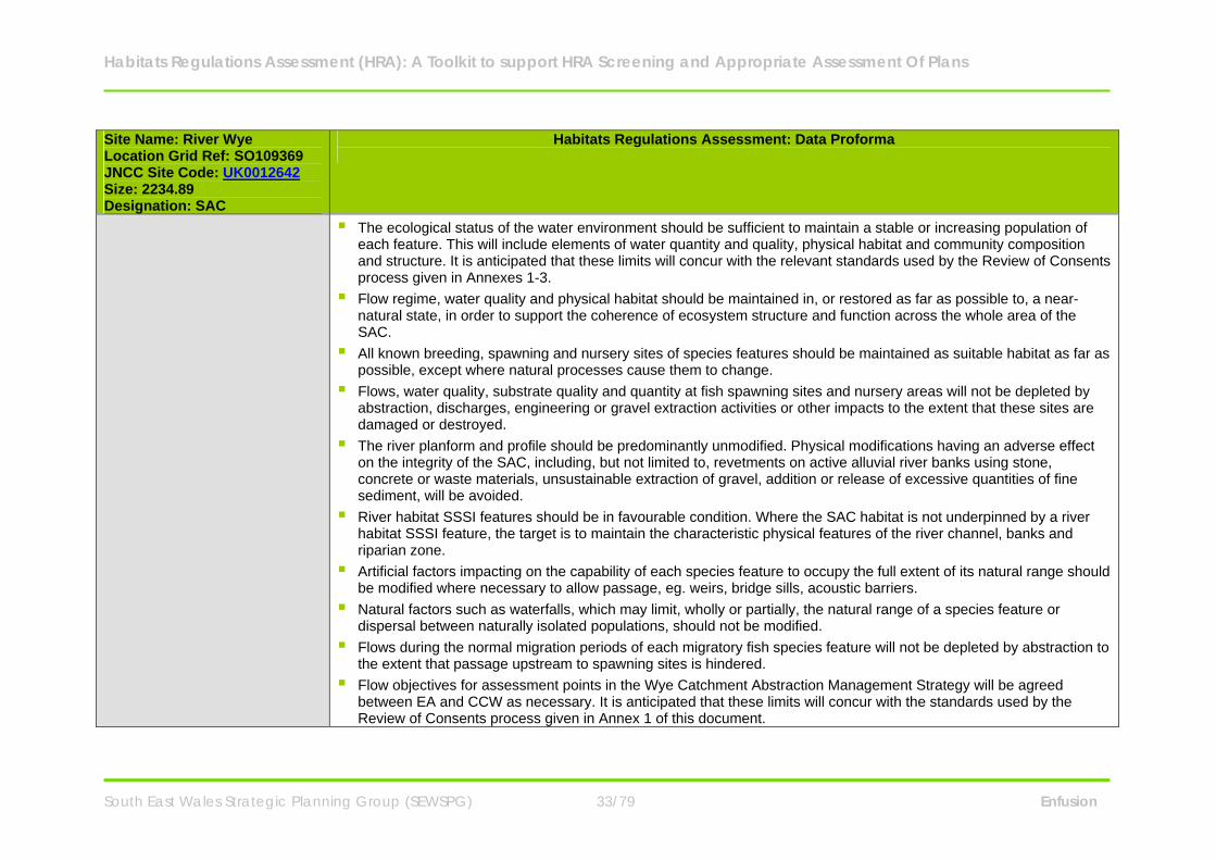
The ecological status of the water environment should be sufficient to maintain a stable or increasing population of each feature. This will include elements of water quantity and quality, physical habitat and community composition and structure. It is anticipated that these limits will concur with the relevant standards used by the Review of Consents process given in Annexes 1-3.
Flow regime, water quality and physical habitat should be maintained in, or restored as far as possible to, a near-natural state, in order to support the coherence of ecosystem structure and function across the whole area of the SAC.
All known breeding, spawning and nursery sites of species features should be maintained as suitable habitat as far as possible, except where natural processes cause them to change.
Flows, water quality, substrate quality and quantity at fish spawning sites and nursery areas will not be depleted by abstraction, discharges, engineering or gravel extraction activities or other impacts to the extent that these sites are damaged or destroyed.
The river planform and profile should be predominantly unmodified. Physical modifications having an adverse effect on the integrity of the SAC, including, but not limited to, revetments on active alluvial river banks using stone, concrete or waste materials, unsustainable extraction of gravel, addition or release of excessive quantities of fine sediment, will be avoided.
River habitat SSSI features should be in favourable condition. Where the SAC habitat is not underpinned by a river habitat SSSI feature, the target is to maintain the characteristic physical features of the river channel, banks and riparian zone.
Artificial factors impacting on the capability of each species feature to occupy the full extent of its natural range should be modified where necessary to allow passage, eg. weirs, bridge sills, acoustic barriers.
Natural factors such as waterfalls, which may limit, wholly or partially, the natural range of a species feature or dispersal between naturally isolated populations, should not be modified.
Flows during the normal migration periods of each migratory fish species feature will not be depleted by abstraction to the extent that passage upstream to spawning sites is hindered.
Flow objectives for assessment points in the Wye Catchment Abstraction Management Strategy will be agreed between EA and CCW as necessary. It is anticipated that these limits will concur with the standards used by the Review of Consents process given in Annex 1 of this document.
Habitats Regulations Assessment (HRA): A Toolkit to support HRA Screening and Appropriate Assessment Of Plans
South East Wales Strategic Planning Group (SEWSPG) 34/79 Enfusion
Site Name: River Wye Location Grid Ref: SO109369 JNCC Site Code: UK0012642 Size: 2234.89 Designation: SAC
Habitats Regulations Assessment: Data Proforma
Levels of nutrients, in particular phosphate, will be agreed between EA and CCW for each Water Framework Directive water body in the Wye SAC, and measures taken to maintain nutrients below these levels. It is anticipated that these limits will concur with the standards used by the Review of Consents process given in Annex 2 of this document.
Levels of water quality parameters that are known to affect the distribution and abundance of SAC features will be agreed between EA and CCW for each Water Framework Directive water body in the Wye SAC, and measures taken to maintain pollution below these levels. It is anticipated that these limits will concur with the standards used by the Review of Consents process given in Annex 3 of this document.
Potential sources of pollution not addressed in the Review of Consents, such as contaminated land, will be considered in assessing plans and projects.
Levels of suspended solids will be agreed between EA and CCW for each Water Framework Directive water body in the Wye SAC. Measures including, but not limited to, the control of suspended sediment generated by agriculture, forestry and engineering works, will be taken to maintain suspended solids below these levels.
Conservation Objective for Features 1-5: - Sea lamprey Petromyzon marinus; - Brook lamprey Lampetra planeri; - River lamprey Lampetra fluviatilis; - Twaite shad Alosa fallax; - Allis shad Alosa alosa; - Atlantic salmon Salmo salar; - Bullhead Cottus gobio. Vision for features 1-5 The vision for this feature is for it to be in a favourable conservation status, where all of the following conditions are satisfied: The conservation objective for the water course as defined in 4.1 above must be met. The population of the feature in the SAC is stable or increasing over the long term.
Habitats Regulations Assessment (HRA): A Toolkit to support HRA Screening and Appropriate Assessment Of Plans
South East Wales Strategic Planning Group (SEWSPG) 35/79 Enfusion
Site Name: River Wye Location Grid Ref: SO109369 JNCC Site Code: UK0012642 Size: 2234.89 Designation: SAC
Habitats Regulations Assessment: Data Proforma
The natural range of the feature in the SAC is neither being reduced nor is likely to be reduced for the foreseeable future. The natural range is taken to mean those reaches where predominantly suitable habitat for each life stage exists over the long term. Suitable habitat is defined in terms of near-natural hydrological and geomorphological processes and forms eg. suitable flows to allow upstream migration, depth of water and substrate type at spawning sites, and ecosystem structure and functions eg. food supply. Suitable habitat need not be present throughout the SAC but where present must be secured for the foreseeable future. Natural factors such as waterfalls may limit the natural range of individual species. Existing artificial influences on natural range that cause an adverse effect on site integrity, such as physical barriers to migration, will be assessed in view of the following bullet point.
There is, and will probably continue to be, a sufficiently large habitat to maintain the feature’s population in the SAC on a long-term basis.
Performance indicators for features 1-5 The performance indicators are part of the conservation objective, not a substitute for it. Assessment of plans and projects must be based on the entire conservation objective, not just the performance indicators. The performance indicators can be found within the River Wye SAC Management Plan. Conservation Objective for Feature 6: - European otter Lutra lutra Vision for feature 6 The vision for this feature is for it to be in a favourable conservation status, where all of the following conditions are satisfied: The population of otters in the SAC is stable or increasing over the long term and reflects the natural carrying capacity
of the habitat within the SAC, as determined by natural levels of prey abundance and associated territorial behaviour. The natural range of otters in the SAC is neither being reduced nor is likely to be reduced for the foreseeable future.
The natural range is taken to mean those reaches that are potentially suitable to form part of a breeding territory and/or provide routes between breeding territories. The whole area of the Wye SAC is considered to form potentially
Habitats Regulations Assessment (HRA): A Toolkit to support HRA Screening and Appropriate Assessment Of Plans
South East Wales Strategic Planning Group (SEWSPG) 36/79 Enfusion
Site Name: River Wye Location Grid Ref: SO109369 JNCC Site Code: UK0012642 Size: 2234.89 Designation: SAC
Habitats Regulations Assessment: Data Proforma
suitable breeding habitat for otters. The size of breeding territories may vary depending on prey abundance. The population size should not be limited by the availability of suitable undisturbed breeding sites. Where these are insufficient they should be created through habitat enhancement and where necessary the provision of artificial holts. No otter breeding site should be subject to a level of disturbance that could have an adverse effect on breeding success. Where necessary, potentially harmful levels of disturbance must be managed.
The safe movement and dispersal of individuals around the SAC is facilitated by the provision, where necessary, of suitable riparian habitat, and underpasses, ledges, fencing etc at road bridges and other artificial barriers.
Performance indicators for feature 6 (see performance indicators for features 1 - 5) Conservation Objective for Feature 7: - Water courses of plain to montane levels with the Ranunculion fluitantis and Callitricho-Batrachion vegetation Vision for feature 7 The vision for this feature is for it to be in a favourable conservation status, where all of the following conditions are satisfied: The conservation objectives for the water course as defined above must be met. The natural range of the plant communities represented within this feature should be stable or increasing in the SAC.
The natural range is taken to mean those reaches where predominantly suitable habitat exists over the long term. Suitable habitat and associated plant communities may vary from reach to reach. Suitable habitat is defined in terms of near-natural hydrological and geomorphological processes and forms eg. depth and stability of flow, stability of bed substrate, and ecosystem structure and functions eg. nutrient levels, shade. Suitable habitat for the feature need not be present throughout the SAC but where present must be secured for the foreseeable future, except where natural processes cause it to decline in extent.
The area covered by the feature within its natural range in the SAC should be stable or increasing. The conservation status of the feature’s typical species should be favourable. The typical species are defined with
reference to the species composition of the appropriate JNCC river vegetation type for the particular river reach, unless differing from this type due to natural variability when other typical species may be defined as appropriate.
Habitats Regulations Assessment (HRA): A Toolkit to support HRA Screening and Appropriate Assessment Of Plans
South East Wales Strategic Planning Group (SEWSPG) 37/79 Enfusion
Site Name: River Wye Location Grid Ref: SO109369 JNCC Site Code: UK0012642 Size: 2234.89 Designation: SAC
Habitats Regulations Assessment: Data Proforma
Performance indicators for feature 7 (see performance indicators for features 1 - 5) Conservation Objective for Feature 8: - White-clawed crayfish Austropotamobius pallipes Vision for feature 8 The vision for this feature is for it to be in a favourable conservation status, where all of the following conditions are satisfied: The conservation objective for the water course as defined in 4.1 above must be met. The population of the feature in the SAC is stable or increasing over the long term. The natural range of the feature in the SAC is neither being reduced nor is likely to be reduced for the foreseeable
future. The natural range is taken to mean those reaches where predominantly suitable habitat for each life stage exists over the long term. Suitable habitat is defined in terms of near-natural hydrological and geomorphological processes and forms e.g. substrate type, water hardness and temperature, and ecosystem structure and functions e.g. food supply, absence of invasive non-native competitors. Suitable habitat need not be present throughout the SAC but where present must be secured for the foreseeable future. Natural factors such as waterfalls may limit the natural range of individual species. Existing artificial influences on natural range that cause an adverse effect on site integrity will be assessed in view of the objective below.
There is, and will probably continue to be, a sufficiently large habitat to maintain the feature’s population in the SAC on a long-term basis.
Performance indicators for feature 8 (see performance indicators for features 1 - 5) Conservation Objective for Feature 9: - Quaking bogs and transition mires

Habitats Regulations Assessment (HRA): A Toolkit to support HRA Screening and Appropriate Assessment Of Plans
South East Wales Strategic Planning Group (SEWSPG) 38/79 Enfusion
Site Name: River Wye Location Grid Ref: SO109369 JNCC Site Code: UK0012642 Size: 2234.89 Designation: SAC
Habitats Regulations Assessment: Data Proforma
Vision for feature 9 The vision for this feature is for it to be in a favourable conservation status, where all of the following conditions are satisfied: The conservation objective for the water course as defined in 4.1 above must be met. The natural range of the plant communities represented within this feature should be stable or increasing in the SAC.
The natural range is taken to mean those reaches where near-natural hydrological and geomorphological processes and landforms favour the development of this habitat. The feature need not be present in all suitable locations in the SAC but where present must be secured for the foreseeable future.
The area covered by the feature within its natural range in the SAC should be stable or increasing. The conservation status of the feature’s typical species should be favourable. The typical species are defined with
reference to the species composition of the appropriate NVC type(s), unless differing from this type due to natural variability/local distinctiveness when other typical/indicator species may be defined as appropriate.
Performance indicators for feature 9 (see performance indicators for features 1 - 5)
Component SSSIs The site has been divided into management units to enable practical communication about features, objectives, and management. This will also allow CCW to differentiate between the different designations where necessary. In the management plan units have been based on the following: SSSI boundaries Natural hydromorphology, where there are significant differences in management issues/key features between
reaches Units partly within England coincide with Natural England’s equivalent units, as far as is practicable The units include one or more of EA’s River Basin Management Plan water bodies; as far as is practicable, unit
boundaries coincide with these water body boundaries.
Habitats Regulations Assessment (HRA): A Toolkit to support HRA Screening and Appropriate Assessment Of Plans
South East Wales Strategic Planning Group (SEWSPG) 39/79 Enfusion
Site Name: River Wye Location Grid Ref: SO109369 JNCC Site Code: UK0012642 Size: 2234.89 Designation: SAC
Habitats Regulations Assessment: Data Proforma
The component SSSIs and management units that comprise to form the River Wye SAC are: River Wye (Lower Wye) SSSI - Management units 1A to 1D; River Wye (Upper Wye) SSSI - Management units 2A & 2B; River Wye (Tributaries) SSSI - Management unit 3; Afon Llynfi SSSI - Management unit 4; Duhonw SSSI - Management unit 5; Afon Irfon SSSI - Management unit 6; River Ithon SSSI - Management unit 7; Upper Wye Tributaries SSSI - Management unit 8; and Colwyn Brook Marshes (North & South) SSSI - Management units 9A to 9G & 10A & 10E. Note: a number of smaller SSSI have part of their area included within the River Wye SAC. These are not all included separately here, but management actions for adjacent SAC units also apply to these sites. Maps containing the component SSSIs and management units can be viewed on the CCW website.
Key Environmental Conditions (factors that maintain site integrity
The ecological structure and functions of the site are dependent on hydrological and geomorphological processes (often referred to as hydromorphological processes), as well as the quality of riparian habitats and connectivity of habitats. Animals that move around and sometimes leave the site, such as migratory fish and otters, may also be affected by factors operating outside the site. Hydrological processes in particular river flow (level and variability) and water chemistry, determine a range of
habitat factors of importance to the SAC features, including current velocity, water depth, wetted area, substrate quality, dissolved oxygen levels and water temperature. Maintenance of both high ‘spate’ flows and base-flows is essential. Reductions in flow may reduce the ability of the adult migratory fish to reach spawning sites. Water-crowfoot vegetation thrives in relatively stable, moderate flows and clean water. The flow regime should be characteristic of the river in order to support the functioning of the river ecosystem.
Habitats Regulations Assessment (HRA): A Toolkit to support HRA Screening and Appropriate Assessment Of Plans
South East Wales Strategic Planning Group (SEWSPG) 40/79 Enfusion
Site Name: River Wye Location Grid Ref: SO109369 JNCC Site Code: UK0012642 Size: 2234.89 Designation: SAC
Habitats Regulations Assessment: Data Proforma
Geomorphological processes of erosion by water and subsequent deposition of eroded sediments downstream create the physical structure of the river habitats. While some sections of the river are naturally stable, especially where they flow over bedrock, others undergo continual and at times rapid change through the erosion and deposition of bed and bank sediments as is typical of meandering sections within floodplains (called ‘alluvial’ rivers). These processes help to sustain the river ecosystem by allowing a continued supply of clean gravels and other important substrates to be transported downstream. In addition, the freshly deposited and eroded surfaces, such as shingle banks and earth cliffs, enable processes of ecological succession to begin again, providing an essential habitat for specialist, early-successional species. Processes at the wider catchment scale generally govern processes of erosion and deposition occurring at the reach scale, although locally factors such as the effect of grazing levels on riparian vegetation structure may contribute to enhanced erosion rates. In general, management that interferes with natural geomorphological processes, for example preventing bank erosion through the use of hard revetments or removing large amounts of gravel, are likely to be damaging to the coherence of the ecosystem structure and functions.
Riparian habitats including bank sides and habitats on adjacent land, are an integral part of the river ecosystem.
Diverse and high quality riparian habitats have a vital role in maintaining the SAC features in a favourable condition. The type and condition of riparian vegetation influences shade and water temperature, nutrient run-off from adjacent land, the availability of woody debris to the channel and inputs of leaf litter and invertebrates to support in-steam consumers. Light, temperature and nutrient levels influence in-stream plant production and habitat suitability for the SAC features. Woody debris is very important as it provides refuge areas from predators, traps sediment to create spawning and juvenile habitat and forms the base of an important aquatic food chain. Otters require sufficient undisturbed riparian habitat for breeding and resting sites. It is important that appropriate amounts of tree cover, in general at least 50% high canopy cover, tall vegetation and other semi-natural habitats are maintained on the riverbanks and in adjacent areas, and that they are properly managed to support the SAC features. This may be achieved for example, through managing grazing levels, selective coppicing of riparian trees and restoring adjacent wetlands. In the urban sections the focus may be on maintaining the river as a communication corridor but this will still require that sufficient riparian habitat is present and managed to enable the river corridor to function effectively. Overhanging trees provide valuable shade and food sources for Atlantic salmon whilst tree root systems provide important cover and flow refuges for juveniles. Bullheads are particularly associated with woody debris in lowland reaches, where it is likely that it provides an alternative source of cover from predators and floods. It may also be
Habitats Regulations Assessment (HRA): A Toolkit to support HRA Screening and Appropriate Assessment Of Plans
South East Wales Strategic Planning Group (SEWSPG) 41/79 Enfusion
Site Name: River Wye Location Grid Ref: SO109369 JNCC Site Code: UK0012642 Size: 2234.89 Designation: SAC
Habitats Regulations Assessment: Data Proforma
used as an alternative spawning substrate. Debris dams and woody debris should be retained where characteristic of the river/reach. Woody debris removal should be minimised, and restricted to essential activities such as flood defence.
Habitat connectivity is an important property of river ecosystem structure and function. Many of the fish that spawn
in the river are migratory, depending on the maintenance of suitable conditions on their migration routes to allow the adults to reach available spawning habitat and juvenile fish to migrate downstream. For resident species, dispersal to new areas, or the prevention of dispersal causing isolated populations to become genetically distinct, may be important factors. Naturally isolated feature populations that are identified as having important genetic distinctiveness should be maintained.
In all river types, artificial barriers should be made passable. Physical modification of barriers is required where depth/velocity/duration of flows is unsuitable to allow passage. Complete or partial natural barriers to potentially suitable spawning areas should not be modified or circumvented. Certain areas of the SAC are critical to the movement of otters both within the system and to adjacent sites. The Wye SAC provides a key movement corridor for otters passing between the relatively high densities in mid Wales and the south-east Wales coastal strip (Seven Estuary and Gwent Levels). The function of this aspect of the site should be protected through the maintenance of suitable resting sites (in terms of size, quality and levels of disturbance) through urban centres such as Monmouth. Connectivity should be maintained, or restored where necessary, as a means to ensure access for the features to sufficient habitat within the SAC.
External factors operating outside the SAC, may also be influential, particularly for the migratory fish and otters. For
example, salmon may be affected by barriers to migration in the Severn Estuary, inshore fishing and environmental conditions prevailing in their north Atlantic feeding grounds. Otters may be affected by developments that affect resting and breeding sites outside the SAC boundary.
SAC Condition Assessment Conservation status of Feature 1: Sea lamprey Petromyzon marinus
Conservation status (2006)
Habitats Regulations Assessment (HRA): A Toolkit to support HRA Screening and Appropriate Assessment Of Plans
South East Wales Strategic Planning Group (SEWSPG) 42/79 Enfusion
Site Name: River Wye Location Grid Ref: SO109369 JNCC Site Code: UK0012642 Size: 2234.89 Designation: SAC
Habitats Regulations Assessment: Data Proforma
Status within the site: Favourable: Unclassified. Sea lamprey monitoring showed that overall catchment mean ammocoete density considerably exceeded the JNCC target threshold and also complied with targets for spawning site and ammocoete distribution. Sea lamprey ammocoetes were recorded in good numbers immediately upstream of the falls at Rhayader, their most upstream recorded site on the main Wye. They were also recorded in the Irfon and Ithon tributaries. Conservation status of Feature 2: Brook lamprey Lampetra planeri and River lamprey Lampetra fluviatilis Conservation status (2006) Status within the site: Favourable: Unclassified. Brook/river lamprey monitoring showed that overall catchment mean ammocoete density considerably exceeded the JNCC target threshold. However, Lampetra ammocoetes were recorded at only 30 of the 54 sample sites (56%) thus failed to meet the criterion of presence at least two thirds of sites within their natural range. Consequently, the feature may be in unfavourable condition. Further clarification is needed concerning a number of sample sites in the upper reaches (Upper Wye and Elan), which may reflect unsuitable habitat and be outside the natural ranges of the species. It has not been possible to distinguish between these two species during monitoring, due to the reliance on juvenile stages (ammocoetes). Anecdotal evidence suggests that both species are likely to be present in many reaches, though brook lamprey are expected to predominate in the headwaters and river lamprey may be the more abundant species in the main channel and the lower reaches of larger tributaries. More information on the relative abundance of these two species in different parts of the Wye SAC is desirable. Records of spawning adult river lamprey would be particularly useful. Conservation status of Feature 3: Twaite shad Alosa fallax and Allis shad Alosa alosa Conservation status (2006) Status within the site: Unfavourable: Unclassified. Physical barriers to migration are a major cause of unfavourable status of these species in Europe as a whole; however,

Habitats Regulations Assessment (HRA): A Toolkit to support HRA Screening and Appropriate Assessment Of Plans
South East Wales Strategic Planning Group (SEWSPG) 43/79 Enfusion
Site Name: River Wye Location Grid Ref: SO109369 JNCC Site Code: UK0012642 Size: 2234.89 Designation: SAC
Habitats Regulations Assessment: Data Proforma
there are not thought to be any significant barriers to shad migration in the Wye. The current unfavourable status results from a precautionary assessment of feature abundance, and from the presence of adverse factors, in particular the potential for damaging flow depletion and entrainment/impingement in water intakes. Conservation status of Feature 4: Atlantic salmon Salmo salar Conservation status (2006) Status within the site: Unfavourable: Unclassified. The current unfavourable status results from failure of the Management Target for adult run size as well as a precautionary assessment of juvenile distribution and abundance and the presence of adverse factors, in particular the potential for flow depletion and localised water quality failures. Acidification due to forestry is a factor in the upper reaches of the Wye and Irfon. Conservation status of Feature 5: Bullhead Cottus gobio Conservation status (2006) Status within the site: Unfavourable: Unclassified. The current unfavourable status results from the presence of adverse factors, in particular localised water quality failures. Records obtained from juvenile salmon monitoring show that bullhead are widespread in the main river and tributaries. Quantitative information on bullhead abundance is being provided through targeted monitoring. Conservation status of Feature 6: European otter Lutra lutra Conservation status (2006) Status within the site: Unfavourable. The conservation status of otters in the Wye SAC is determined by monitoring their distribution, breeding success, and the condition of potential breeding and feeding habitat as outlined in the
Habitats Regulations Assessment (HRA): A Toolkit to support HRA Screening and Appropriate Assessment Of Plans
South East Wales Strategic Planning Group (SEWSPG) 44/79 Enfusion
Site Name: River Wye Location Grid Ref: SO109369 JNCC Site Code: UK0012642 Size: 2234.89 Designation: SAC
Habitats Regulations Assessment: Data Proforma
Performance Indicators. Their current condition is considered unfavourable due a lack of suitable breeding sites around the middle reaches of the river. Conservation status of Feature 7: Water courses of plain to montane levels with the Ranunculion fluitantis and Callitricho-Batrachion vegetation Conservation status (2006) Status within the site: Unfavourable: Declining. The present unfavourable status of the feature results from declining water quality in some tributaries of the Wye e.g. parts of the Ithon and Llynfi sub-catchments, due mainly to diffuse pollution from agriculture. A further adverse factor is the over-abundance of invasive non-native species of bankside plant communities, which are included within the feature definition. Japanese knotweed and Himalayan balsam are widespread in the catchment, including the Irfon sub-catchment. Conservation status of Feature 8: White-clawed crayfish Austropotamobius pallipes Conservation status (2006) Status within the site: Unfavourable: Declining. There is considerable anecdotal evidence of a major decline in the distribution and abundance of the native white-clawed crayfish in the Wye catchment over the last few decades. Native crayfish may have been lost from the main river channel, from tributaries such as the Duhonw and Ithon and have almost disappeared from the Afon Irfon. Significant populations within the Wye SAC are now confined to the Sgithwen, Cletwr, Edw, Llynfi Dulas and Builth Road Dulas. The most recent assessment of the condition of crayfish in the Wye SAC, using modified Common Standards Monitoring techniques, found that populations are unfavourable.
Vulnerabilities (includes existing pressures and trends)
Abstraction levels - entrainment in water abstractions directly impacts on species population dynamics through reduced recruitment and survival rates. The impact of flow depletion resulting from a small number of major abstractions was highlighted in the Review of Consents process. As a result of this process, flow targets have been

Habitats Regulations Assessment (HRA): A Toolkit to support HRA Screening and Appropriate Assessment Of Plans
South East Wales Strategic Planning Group (SEWSPG) 45/79 Enfusion
Site Name: River Wye Location Grid Ref: SO109369 JNCC Site Code: UK0012642 Size: 2234.89 Designation: SAC
Habitats Regulations Assessment: Data Proforma
set which are considered likely to significantly reduce or remove the potential impacts on SAC features. Eutrophication - factors that are important to the favourable conservation status of this feature include flow,
substrate quality and water quality, which in turn influence species composition and abundance. These factors often interact, producing unfavourable conditions by promoting the growth of a range of algae and other species indicative of eutrophication. Under conditions of prolonged low flows and high nutrient status, epiphytic algae may suppress the growth of aquatic flowering plants.
Diffuse Pollution - in the Wye catchment the most significant sources of diffuse pollution and siltation are from
agriculture, including fertiliser run-off, livestock manure, silage effluent and soil erosion from ploughed land. The most intensively used areas such as heavily trampled gateways and tracks can be especially significant sources of polluting run-off. Preventative measures can include surfacing of tracks and gateways, moving feeding areas, and separating clean and dirty water in farmyards. Farm operations should avoid ploughing land which is vulnerable to soil erosion or leaving such areas without crop cover during the winter.
Among toxic pollutants, sheep dip and silage effluent present a particular threat to aquatic animals in this predominantly rural area. Contamination by synthetic pyrethroid sheep dips, which are extremely toxic to aquatic invertebrates, has a devastating impact on crayfish populations and can deprive fish populations of food over large stretches of river. These impacts can arise if recently dipped sheep are allowed access to a stream or hard standing area, which drains into a watercourse. Pollution from organophosphate sheep dips and silage effluent can be very damaging locally. Pollution from slurry and other agricultural and industrial chemicals, including fuels, can kill all forms of aquatic life. All sheep dips and silage, fuel and chemical storage areas should be sited away from watercourses or bunded to contain leakage. Recently dipped sheep should be kept off stream banks. Discharges from sewage treatment works, urban drainage, engineering works such as road improvement schemes, contaminated land, and other domestic and industrial sources can also be significant causes of pollution, and must be managed appropriately. Used dip should be disposed of strictly in accordance with Environment Agency Regulations and guidelines. Statutory and voluntary agencies should work closely with landowners and occupiers to minimise the risk of any pollution incidents and enforce existing regulations. Measures to control diffuse pollution in the water environment, including ‘Catchment Sensitive Farming’, may be implemented as a result of the Water Framework
Habitats Regulations Assessment (HRA): A Toolkit to support HRA Screening and Appropriate Assessment Of Plans
South East Wales Strategic Planning Group (SEWSPG) 46/79 Enfusion
Site Name: River Wye Location Grid Ref: SO109369 JNCC Site Code: UK0012642 Size: 2234.89 Designation: SAC
Habitats Regulations Assessment: Data Proforma
Directive and, along with existing agri-environment schemes, will help to achieve the conservation objectives for the SAC. Pollution of rivers with toxic chemicals, such as PCBs, was one of the major factors identified in the widespread decline of otters during the last century. There should be no increase in pollutants potentially toxic to otters.
Barriers to migration - Artificial obstructions including weirs and bridge sills can reduce connectivity for some species. In addition, reaches subject to depleted flow levels, pollution, or disturbance due to noise, vibration or light, can all inhibit the movement of sensitive species. The dispersal of semi-terrestrial species, such as the otter, can be adversely affected by structures such as bridges under certain flow conditions, therefore these must be designed to allow safe passage.
Development pressure - can cause temporary physical, acoustic, chemical and sediment barrier effects that need to
be addressed in the assessment of specific plans and projects. Noise/vibration eg. due to impact piling, drilling, salmon fish counters present within or in close proximity to the river can create a barrier to shad migration. Barriers resulting from vibration, chemicals, low dissolved oxygen and artificially high sediment levels must be prevented at key times. Engineering works such as bridge repairs in reaches where white-clawed crayfish are known to occur should include appropriate pollution prevention measures and a crayfish rescue by a suitably licensed person where there is a risk of physical damage to crayfish.
Invasive and non-native species - are a detrimental impact on the water courses of plain to montane levels with the
Ranunculion fluitantis and Callitricho-Batrachion vegetation. Giant hogweed, Himalayan balsam and Japanese knotweed should be actively managed to control their spread and hopefully reduce their extent in the SAC. The American signal crayfish is present in the Wye catchment and poses a very serious threat to the continued existence of the native white-clawed crayfish in the site and in Wales. Native crayfish are unable to co-exist where signal crayfish are present, due to the latter’s superior competitive ability and a disease, crayfish plague, which it carries but to which native crayfish have no immunity. American signal crayfish and crayfish plague are widespread and abundant in nearby catchments such as the Lugg, Arrow and Severn. Crayfish plague can be transferred to streams on wet fishing gear, boots, canoes, machinery, stocked fish etc., so measures such as raising awareness, disinfection facilities and where appropriate restrictions on access, should be implemented where a significant risk is identified. Signal crayfish are also extremely harmful to fish communities and the overall ecology of the river. It is illegal to release non-native crayfish into the wild, to keep live crayfish in most of Wales or to trap crayfish without a licence
Habitats Regulations Assessment (HRA): A Toolkit to support HRA Screening and Appropriate Assessment Of Plans
South East Wales Strategic Planning Group (SEWSPG) 47/79 Enfusion
Site Name: River Wye Location Grid Ref: SO109369 JNCC Site Code: UK0012642 Size: 2234.89 Designation: SAC
Habitats Regulations Assessment: Data Proforma
from the Environment Agency. Bullhead densities have been found to be negatively correlated with densities of non-native crayfish, suggesting competitive and/or predator-prey interactions. Non-native crayfish should be absent from the SAC.
Artificially enhanced densities of other fish - may introduce unacceptable competition or predation pressure and
the aim should be to minimise these risks in considering any proposals for stocking. A small-scale salmon rearing and stocking programme is currently in operation in the Wye, run by the Wye and Usk Foundation. The management objectives for SAC salmon populations are to attain naturally self-sustaining populations. Salmon stocking should not be routinely used as a management measure. Salmon stocking represents a loss of naturalness and, if successful, obscures the underlying causes of poor performance (potentially allowing these risks to perpetuate). It carries various ecological risks, including the loss of natural spawning from broodstock, competition between stocked and naturally produced individuals, disease introduction and genetic alterations to the population. Therefore, there is a presumption that salmon stocking in the Wye SAC will be phased out over time. The presence of artificially high densities of salmonids and other fish will create unacceptably high levels of predatory and competitive pressure on juvenile and adult bullhead. Stocking of fish should be avoided in the SAC.
External factors - operating outside the SAC, may also be influential, particularly for the migratory fish and otters.
For example, salmon may be affected by barriers to migration in the Severn Estuary, inshore fishing and environmental conditions prevailing in their north Atlantic feeding grounds. Otters may be affected by developments that affect resting and breeding sites outside the SAC boundary.
Landowner/ Management Responsibility
N/A
Habitats Regulations Assessment (HRA): A Toolkit to support HRA Screening and Appropriate Assessment Of Plans
South East Wales Strategic Planning Group (SEWSPG) 48/79 Enfusion
Site Name: Severn Estuary Location Grid Ref: ST321748 JNCC Site Code: UK0013030 Size: 73715.4 Designation: cSAC
Habitats Regulations Assessment: Data Proforma
Site Description The Severn Estuary is the largest coastal plain estuary in the UK with extensive mudflats and sandflats, rocky shore platforms, shingle and islands. Saltmarsh fringes the coast, backed by grazing marsh with freshwater and occasional brackish ditches. The estuary’s classic funnel shape, unique in the UK, is a factor causing the Severn to have the second highest tidal range in the world (after the Bay of Fundy in Canada) at more than 12 meters. This tidal regime results in plant and animal communities typical of the extreme physical conditions of strong flows, mobile sediments, changing salinity, high turbidity and heavy scouring. The resultant low diversity invertebrate communities, that frequently include populations of ragworms, lugworms and other invertebrates in high densities, form an important food source for passage and wintering birds. The site is important in the spring and autumn migration periods for waders moving along the west coast of Europe, as well as in winter for large numbers of waterbirds including swans, geese, ducks and waders. These bird populations are regarded as internationally important. Glassworts and annual sea-blite colonise the open mud, with beds of all three species of eelgrass Zostera occurring on more sheltered mud and sandbanks. Large expanses of common cord-grass also occur on the outer marshes. Heavily grazed saltmarsh fringes the estuary with a range of saltmarsh types present. The middle marsh sward is dominated by common saltmarsh-grass with typical associated species. In the upper marsh, red fescue and saltmarsh rush become more prominent. Areas of saltmarsh fringe the estuary, mostly grazed with a range of vegetation communities. There are gradual and stepped transitions between bare mudflat to upper marsh and grassland. Main vegetation types are: upper saltmarsh with Festuca rubra and Juncus gerardii; middle marsh dominated by Puccinellia maritima with Glaux maritima and Triglochin maritima; dense monocultures of Spartina anglica at the edge of the mudflats-brackish pools and depressions with Phragmites australis and Bolboschoenus maritimus.
Qualifying Features
Annex I Habitats primary reason for selection: Estuaries Mudflats and sandflats not covered by seawater at low tide Atlantic salt meadows (Glauco-Puccinellietalia maritimae)
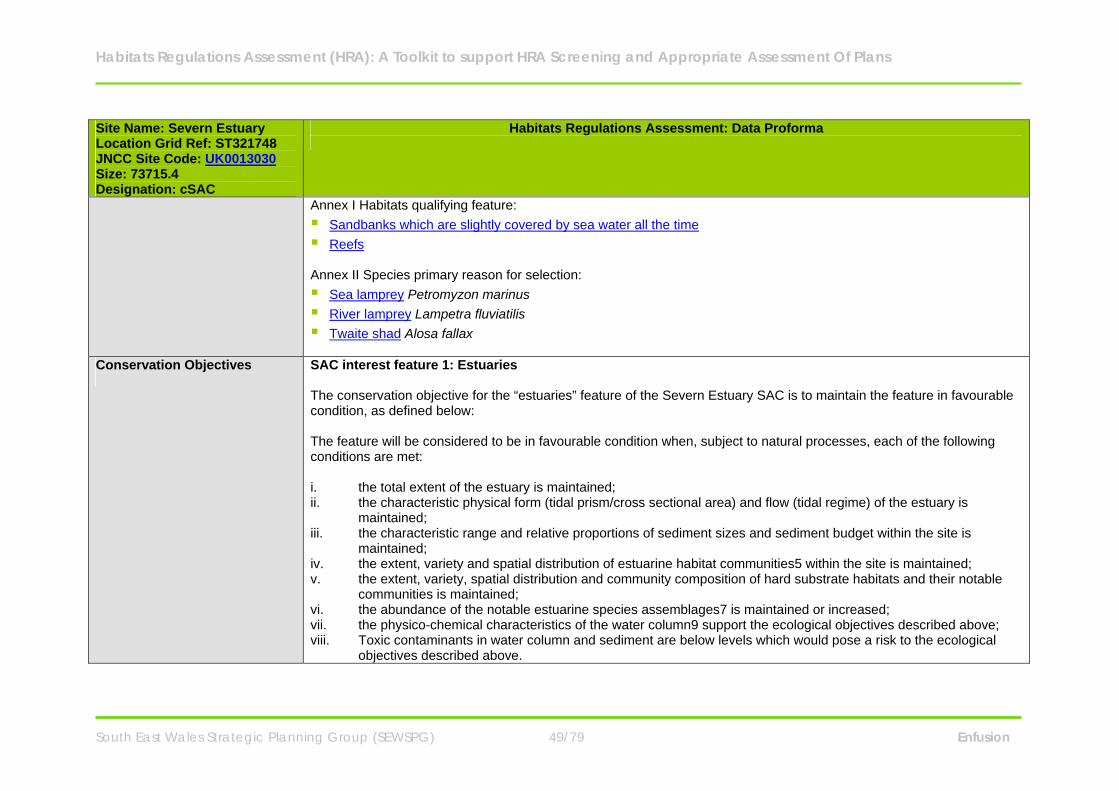
Habitats Regulations Assessment (HRA): A Toolkit to support HRA Screening and Appropriate Assessment Of Plans
South East Wales Strategic Planning Group (SEWSPG) 49/79 Enfusion
Site Name: Severn Estuary Location Grid Ref: ST321748 JNCC Site Code: UK0013030 Size: 73715.4 Designation: cSAC
Habitats Regulations Assessment: Data Proforma
Annex I Habitats qualifying feature: Sandbanks which are slightly covered by sea water all the time Reefs Annex II Species primary reason for selection: Sea lamprey Petromyzon marinus River lamprey Lampetra fluviatilis Twaite shad Alosa fallax
Conservation Objectives
SAC interest feature 1: Estuaries The conservation objective for the “estuaries” feature of the Severn Estuary SAC is to maintain the feature in favourable condition, as defined below: The feature will be considered to be in favourable condition when, subject to natural processes, each of the following conditions are met: i. the total extent of the estuary is maintained; ii. the characteristic physical form (tidal prism/cross sectional area) and flow (tidal regime) of the estuary is
maintained; iii. the characteristic range and relative proportions of sediment sizes and sediment budget within the site is
maintained; iv. the extent, variety and spatial distribution of estuarine habitat communities5 within the site is maintained; v. the extent, variety, spatial distribution and community composition of hard substrate habitats and their notable
communities is maintained; vi. the abundance of the notable estuarine species assemblages7 is maintained or increased; vii. the physico-chemical characteristics of the water column9 support the ecological objectives described above; viii. Toxic contaminants in water column and sediment are below levels which would pose a risk to the ecological
objectives described above.
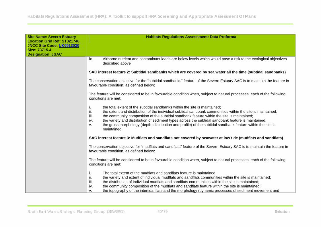
Habitats Regulations Assessment (HRA): A Toolkit to support HRA Screening and Appropriate Assessment Of Plans
South East Wales Strategic Planning Group (SEWSPG) 50/79 Enfusion
Site Name: Severn Estuary Location Grid Ref: ST321748 JNCC Site Code: UK0013030 Size: 73715.4 Designation: cSAC
Habitats Regulations Assessment: Data Proforma
ix. Airborne nutrient and contaminant loads are below levels which would pose a risk to the ecological objectives described above
SAC interest feature 2: Subtidal sandbanks which are covered by sea water all the time (subtidal sandbanks) The conservation objective for the “subtidal sandbanks” feature of the Severn Estuary SAC is to maintain the feature in favourable condition, as defined below: The feature will be considered to be in favourable condition when, subject to natural processes, each of the following conditions are met: i. the total extent of the subtidal sandbanks within the site is maintained; ii. the extent and distribution of the individual subtidal sandbank communities within the site is maintained; iii. the community composition of the subtidal sandbank feature within the site is maintained; iv. the variety and distribution of sediment types across the subtidal sandbank feature is maintained; v. the gross morphology (depth, distribution and profile) of the subtidal sandbank feature within the site is
maintained. SAC interest feature 3: Mudflats and sandflats not covered by seawater at low tide (mudflats and sandflats) The conservation objective for “mudflats and sandflats” feature of the Severn Estuary SAC is to maintain the feature in favourable condition, as defined below: The feature will be considered to be in favourable condition when, subject to natural processes, each of the following conditions are met: i. The total extent of the mudflats and sandflats feature is maintained; ii. the variety and extent of individual mudflats and sandflats communities within the site is maintained; iii. the distribution of individual mudflats and sandflats communities within the site is maintained; iv. the community composition of the mudflats and sandflats feature within the site is maintained; v. the topography of the intertidal flats and the morphology (dynamic processes of sediment movement and
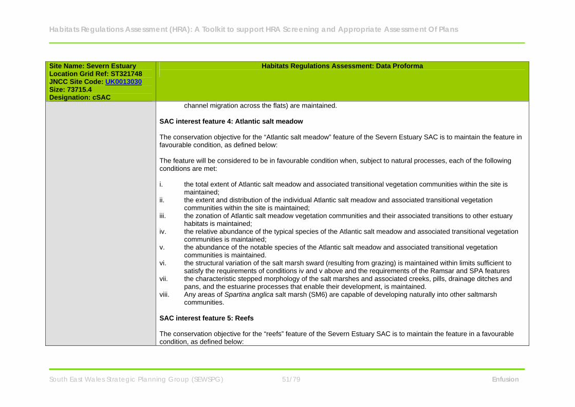
Habitats Regulations Assessment (HRA): A Toolkit to support HRA Screening and Appropriate Assessment Of Plans
South East Wales Strategic Planning Group (SEWSPG) 51/79 Enfusion
Site Name: Severn Estuary Location Grid Ref: ST321748 JNCC Site Code: UK0013030 Size: 73715.4 Designation: cSAC
Habitats Regulations Assessment: Data Proforma
channel migration across the flats) are maintained. SAC interest feature 4: Atlantic salt meadow The conservation objective for the “Atlantic salt meadow” feature of the Severn Estuary SAC is to maintain the feature in favourable condition, as defined below: The feature will be considered to be in favourable condition when, subject to natural processes, each of the following conditions are met: i. the total extent of Atlantic salt meadow and associated transitional vegetation communities within the site is
maintained; ii. the extent and distribution of the individual Atlantic salt meadow and associated transitional vegetation
communities within the site is maintained; iii. the zonation of Atlantic salt meadow vegetation communities and their associated transitions to other estuary
habitats is maintained; iv. the relative abundance of the typical species of the Atlantic salt meadow and associated transitional vegetation
communities is maintained; v. the abundance of the notable species of the Atlantic salt meadow and associated transitional vegetation
communities is maintained. vi. the structural variation of the salt marsh sward (resulting from grazing) is maintained within limits sufficient to
satisfy the requirements of conditions iv and v above and the requirements of the Ramsar and SPA features vii. the characteristic stepped morphology of the salt marshes and associated creeks, pills, drainage ditches and
pans, and the estuarine processes that enable their development, is maintained. viii. Any areas of Spartina anglica salt marsh (SM6) are capable of developing naturally into other saltmarsh
communities. SAC interest feature 5: Reefs The conservation objective for the “reefs” feature of the Severn Estuary SAC is to maintain the feature in a favourable condition, as defined below:
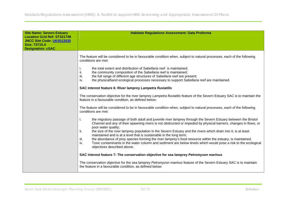
Habitats Regulations Assessment (HRA): A Toolkit to support HRA Screening and Appropriate Assessment Of Plans
South East Wales Strategic Planning Group (SEWSPG) 52/79 Enfusion
Site Name: Severn Estuary Location Grid Ref: ST321748 JNCC Site Code: UK0013030 Size: 73715.4 Designation: cSAC
Habitats Regulations Assessment: Data Proforma
The feature will be considered to be in favourable condition when, subject to natural processes, each of the following conditions are met: i. the total extent and distribution of Sabellaria reef is maintained; ii. the community composition of the Sabellaria reef is maintained; iii. the full range of different age structures of Sabellaria reef are present; iv. the physical5and ecological processes necessary to support Sabellaria reef are maintained. SAC interest feature 6: River lamprey Lampetra fluviatilis The conservation objective for the river lamprey Lampetra fluviatilis feature of the Severn Estuary SAC is to maintain the feature in a favourable condition, as defined below: The feature will be considered to be in favourable condition when, subject to natural processes, each of the following conditions are met: i. the migratory passage of both adult and juvenile river lamprey through the Severn Estuary between the Bristol
Channel and any of their spawning rivers is not obstructed or impeded by physical barriers, changes in flows, or poor water quality;
ii. the size of the river lamprey population in the Severn Estuary and the rivers which drain into it, is at least maintained and is at a level that is sustainable in the long term;
iii. the abundance of prey species forming the river lamprey’s food resource within the estuary, is maintained. iv. Toxic contaminants in the water column and sediment are below levels which would pose a risk to the ecological
objectives described above. SAC interest feature 7: The conservation objective for sea lamprey Petromyzon marinus The conservation objective for the sea lamprey Petromyzon marinus feature of the Severn Estuary SAC is to maintain the feature in a favourable condition, as defined below:
Habitats Regulations Assessment (HRA): A Toolkit to support HRA Screening and Appropriate Assessment Of Plans
South East Wales Strategic Planning Group (SEWSPG) 53/79 Enfusion
Site Name: Severn Estuary Location Grid Ref: ST321748 JNCC Site Code: UK0013030 Size: 73715.4 Designation: cSAC
Habitats Regulations Assessment: Data Proforma
The feature will be considered to be in favourable condition when, subject to natural processes, each of the following conditions are met: i. the migratory passage of both adult and juvenile sea lamprey through the Severn Estuary between the Bristol
Channel and any of their spawning rivers is not obstructed or impeded by physical barriers, changes in flows, or poor water quality;
ii. the size of the sea lamprey population in the Severn Estuary and the rivers which drain into it, is at least maintained as is at a level that is sustainable in the long term;
iii. the abundance of prey species forming the sea lamprey’s food resource within the estuary, is maintained. vi. Toxic contaminants in the water column and sediment are below levels which would pose a risk to the ecological
objectives described above. SAC interest feature 8: The conservation objective for twaite shad Alosa fallax The conservation objective for the twaite Shad Alosa fallax feature of the Severn Estuary SAC is to maintain the feature in a favourable condition, as defined below: The feature will be considered to be in favourable condition when, subject to natural processes, each of the following conditions are met: i. the migratory passage of both adult and juvenile twaite shad through the Severn Estuary between the Bristol
Channel and their spawning rivers is not obstructed or impeded by physical barriers, changes in flows or poor water quality;
ii. the size of the twaite shad population within the Severn Estuary and the rivers draining into it is at least maintained and is at a level that is sustainable in the long term.
iii. the abundance of prey species forming the twaite shad’s food resource within the estuary, in particular at the salt wedge, is maintained.
iv. Toxic contaminants in the water column and sediment are below levels which would pose a risk to the ecological objectives described above.
Habitats Regulations Assessment (HRA): A Toolkit to support HRA Screening and Appropriate Assessment Of Plans
South East Wales Strategic Planning Group (SEWSPG) 54/79 Enfusion
Site Name: Severn Estuary Location Grid Ref: ST321748 JNCC Site Code: UK0013030 Size: 73715.4 Designation: cSAC
Habitats Regulations Assessment: Data Proforma
Component SSSIs N/A
Key Environmental Conditions (factors that maintain site integrity
Hydrodynamic and sedimentary regime - The conservation of the site features is dependent on the tidal regime. The tidal range in the Severn Estuary is the second-highest in the world and the scouring of the seabed and strong tidal streams result in natural erosion of the habitats and the presence of high sediment loads.
Maintain suitable distance between the site and development - to allow for managed retreat of intertidal habitats
and avoid coastal squeeze. Manage public access and activities.
SAC Condition Assessment N/A
Vulnerabilities (includes existing pressures and trends)
Physical loss of supporting habitats through removal - The physical loss of areas of intertidal habitats may be caused directly through change of land use or indirectly as a consequence of changes to sedimentation processes (e.g. coastal defences) as well as via the effects of smothering by artificial structures (e.g. jetties) or the disposal of spoils. The intertidal mudflats and sandflats and the saltmarsh are highly sensitive to removal by land reclamation and barrage construction. Information provided by NE and CCW states that large areas of the European marine site are not currently under threat, however when combined with a high level of sensitivity this leads to a moderate vulnerability.
Contamination by synthetic and/or non-synthetic toxic compounds - At the moment there is no evidence to
show that this is the case on the Severn Estuary, but the estuary is vulnerable to oil spills and there is a continuous discharge of toxins into the estuary, some of which bind to the sediments. NE and CCW identify this is an area which requires further assessment. The intertidal mudflats and sandflats and the saltmarsh are currently highly vulnerable to the introduction of synthetic and non-synthetic compounds.
Damage by abrasion or selective extraction - Saltmarsh may be physically damaged from overgrazing or eroded
Habitats Regulations Assessment (HRA): A Toolkit to support HRA Screening and Appropriate Assessment Of Plans
South East Wales Strategic Planning Group (SEWSPG) 55/79 Enfusion
Site Name: Severn Estuary Location Grid Ref: ST321748 JNCC Site Code: UK0013030 Size: 73715.4 Designation: cSAC
Habitats Regulations Assessment: Data Proforma
when boats are moored on it and when paths are worn through it to reach moored boats on foot or via vehicles. Currently all supporting habitats are considered to be moderately vulnerable to abrasion. Intertidal habitats are highly sensitive to damage by direct and indirect effects of aggregate dredging. The intertidal mudflats and sandflats and the shingle and rocky shore are therefore considered by NE and CCW to be highly vulnerable to selective extraction.
Changes in nutrient and/or organic loading - Changes in organic or nutrient loading can change the species
composition of the plants on the saltmarsh and thus the structure of the sward. Increases in nutrients can also cause excessive algal growth on the mudflats, denying the birds access to their invertebrate prey and changing the invertebrate species composition in the sediment. Though the water quality has been improved in recent years there are still local areas of concern and any increase in nutrient loading should be avoided. At present the intertidal mudflats and sandflats are moderately vulnerable to this category of operation.
Inappropriate grazing - Much of the saltmarsh is managed by grazing and changes in management can alter the
availability of prey and suitability of roosting sites. The saltmarsh is currently highly vulnerable to the selective extraction of species.
Landowner/ Management Responsibility
N/A
Habitats Regulations Assessment (HRA): A Toolkit to support HRA Screening and Appropriate Assessment Of Plans
South East Wales Strategic Planning Group (SEWSPG) 56/79 Enfusion
Special Protection Areas Site Name: Severn Estuary Location (Lat & Long): 51 13 29 N 03 02 57 W JNCC Site Code: UK9015022 Size: 24662.98 Designation: SPA
Habitats Regulations Assessment: Data Proforma
Site Description The Severn Estuary is the largest coastal plain estuary in the UK with extensive mudflats and sandflats, rocky shore platforms, shingle and islands. Saltmarsh fringes the coast, backed by grazing marsh with freshwater and occasional brackish ditches. The estuary’s classic funnel shape, unique in the UK, is a factor causing the Severn to have the second highest tidal range in the world (after the Bay of Fundy in Canada) at more than 12 meters. This tidal regime results in plant and animal communities typical of the extreme physical conditions of strong flows, mobile sediments, changing salinity, high turbidity and heavy scouring. The resultant low diversity invertebrate communities, that frequently include populations of ragworms, lugworms and other invertebrates in high densities, form an important food source for passage and wintering birds. The site is important in the spring and autumn migration periods for waders moving along the west coast of Europe, as well as in winter for large numbers of waterbirds including swans, geese, ducks and waders. These bird populations are regarded as internationally important. Glassworts and annual sea-blite colonise the open mud, with beds of all three species of eelgrass Zostera occurring on more sheltered mud and sandbanks. Large expanses of common cord-grass also occur on the outer marshes. Heavily grazed saltmarsh fringes the estuary with a range of saltmarsh types present. The middle marsh sward is dominated by common saltmarsh-grass with typical associated species. In the upper marsh, red fescue and saltmarsh rush become more prominent. Areas of saltmarsh fringe the estuary, mostly grazed with a range of vegetation communities. There are gradual and stepped transitions between bare mudflat to upper marsh and grassland. Main vegetation types are: upper saltmarsh with Festuca rubra and Juncus gerardii; middle marsh dominated by Puccinellia maritima with Glaux maritima and Triglochin maritima; dense monocultures of Spartina anglica at the edge of the mudflats-brackish pools and depressions with Phragmites australis and Bolboschoenus maritimus.
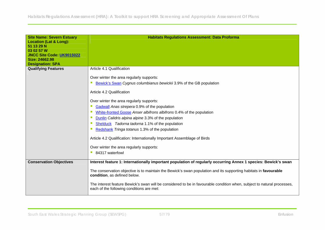
Habitats Regulations Assessment (HRA): A Toolkit to support HRA Screening and Appropriate Assessment Of Plans
South East Wales Strategic Planning Group (SEWSPG) 57/79 Enfusion
Site Name: Severn Estuary Location (Lat & Long): 51 13 29 N 03 02 57 W JNCC Site Code: UK9015022 Size: 24662.98 Designation: SPA
Habitats Regulations Assessment: Data Proforma
Qualifying Features
Article 4.1 Qualification Over winter the area regularly supports: Bewick’s Swan Cygnus columbianus bewickii 3.9% of the GB population Article 4.2 Qualification Over winter the area regularly supports: Gadwall Anas strepera 0.9% of the population White-fronted Goose Anser albifrons albifrons 0.4% of the population Dunlin Calidris alpina alpine 3.3% of the population Shelduck Tadorna tadorna 1.1% of the population Redshank Tringa totanus 1.3% of the population Article 4.2 Qualification: Internationally Important Assemblage of Birds Over winter the area regularly supports: 84317 waterfowl
Conservation Objectives
Interest feature 1: Internationally important population of regularly occurring Annex 1 species: Bewick’s swan The conservation objective is to maintain the Bewick’s swan population and its supporting habitats in favourable condition, as defined below. The interest feature Bewick’s swan will be considered to be in favourable condition when, subject to natural processes, each of the following conditions are met:
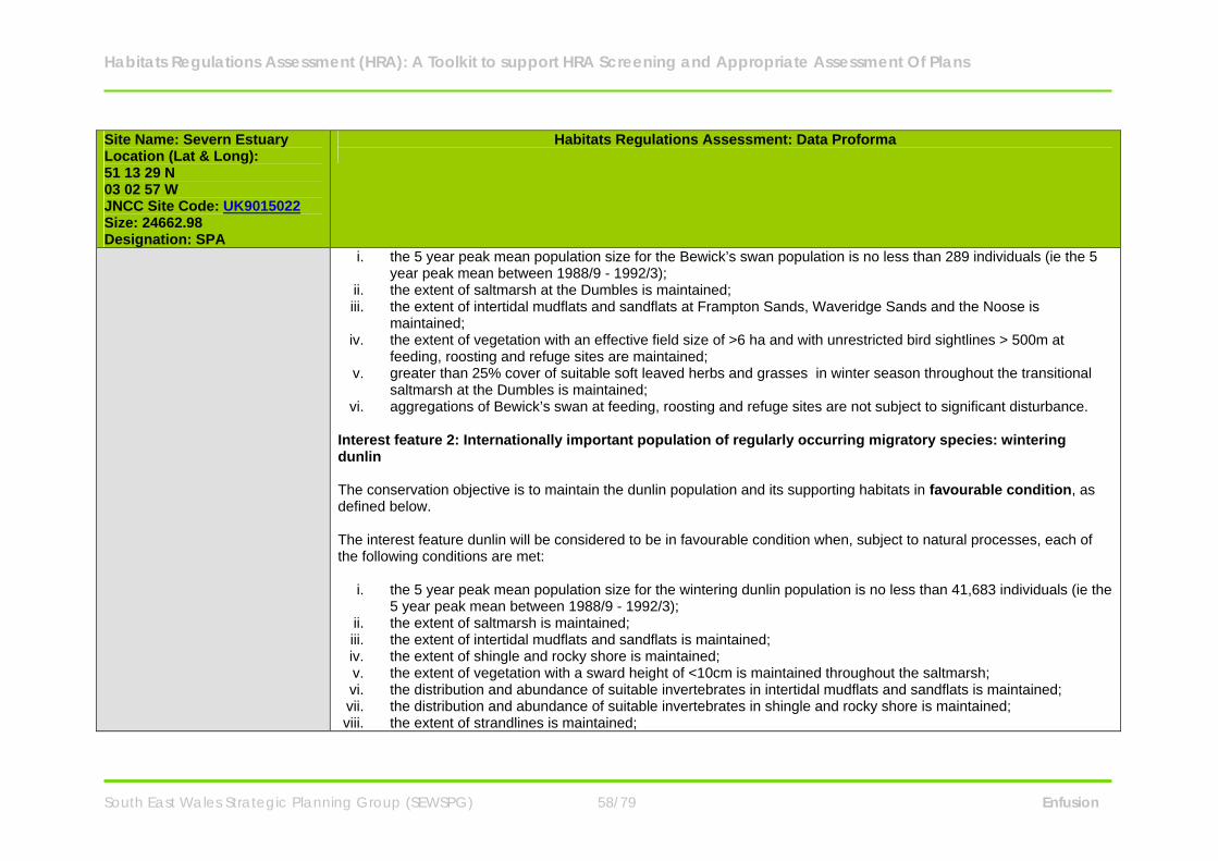
Habitats Regulations Assessment (HRA): A Toolkit to support HRA Screening and Appropriate Assessment Of Plans
South East Wales Strategic Planning Group (SEWSPG) 58/79 Enfusion
Site Name: Severn Estuary Location (Lat & Long): 51 13 29 N 03 02 57 W JNCC Site Code: UK9015022 Size: 24662.98 Designation: SPA
Habitats Regulations Assessment: Data Proforma
i. the 5 year peak mean population size for the Bewick’s swan population is no less than 289 individuals (ie the 5 year peak mean between 1988/9 - 1992/3);
ii. the extent of saltmarsh at the Dumbles is maintained; iii. the extent of intertidal mudflats and sandflats at Frampton Sands, Waveridge Sands and the Noose is
maintained; iv. the extent of vegetation with an effective field size of >6 ha and with unrestricted bird sightlines > 500m at
feeding, roosting and refuge sites are maintained; v. greater than 25% cover of suitable soft leaved herbs and grasses in winter season throughout the transitional
saltmarsh at the Dumbles is maintained; vi. aggregations of Bewick’s swan at feeding, roosting and refuge sites are not subject to significant disturbance.
Interest feature 2: Internationally important population of regularly occurring migratory species: wintering dunlin The conservation objective is to maintain the dunlin population and its supporting habitats in favourable condition, as defined below. The interest feature dunlin will be considered to be in favourable condition when, subject to natural processes, each of the following conditions are met:
i. the 5 year peak mean population size for the wintering dunlin population is no less than 41,683 individuals (ie the 5 year peak mean between 1988/9 - 1992/3);
ii. the extent of saltmarsh is maintained; iii. the extent of intertidal mudflats and sandflats is maintained; iv. the extent of shingle and rocky shore is maintained; v. the extent of vegetation with a sward height of <10cm is maintained throughout the saltmarsh; vi. the distribution and abundance of suitable invertebrates in intertidal mudflats and sandflats is maintained; vii. the distribution and abundance of suitable invertebrates in shingle and rocky shore is maintained; viii. the extent of strandlines is maintained;
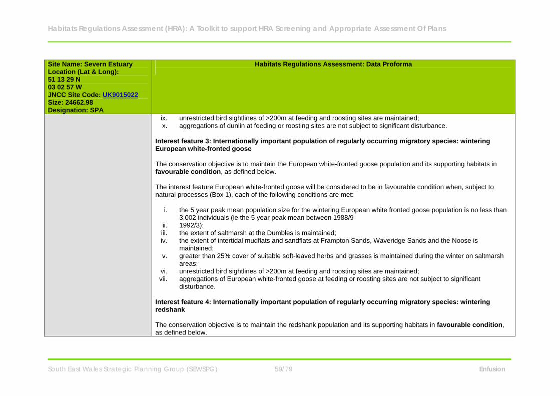
Habitats Regulations Assessment (HRA): A Toolkit to support HRA Screening and Appropriate Assessment Of Plans
South East Wales Strategic Planning Group (SEWSPG) 59/79 Enfusion
Site Name: Severn Estuary Location (Lat & Long): 51 13 29 N 03 02 57 W JNCC Site Code: UK9015022 Size: 24662.98 Designation: SPA
Habitats Regulations Assessment: Data Proforma
ix. unrestricted bird sightlines of >200m at feeding and roosting sites are maintained; x. aggregations of dunlin at feeding or roosting sites are not subject to significant disturbance.
Interest feature 3: Internationally important population of regularly occurring migratory species: wintering European white-fronted goose The conservation objective is to maintain the European white-fronted goose population and its supporting habitats in favourable condition, as defined below. The interest feature European white-fronted goose will be considered to be in favourable condition when, subject to natural processes (Box 1), each of the following conditions are met:
i. the 5 year peak mean population size for the wintering European white fronted goose population is no less than 3,002 individuals (ie the 5 year peak mean between 1988/9-
ii. 1992/3); iii. the extent of saltmarsh at the Dumbles is maintained; iv. the extent of intertidal mudflats and sandflats at Frampton Sands, Waveridge Sands and the Noose is
maintained; v. greater than 25% cover of suitable soft-leaved herbs and grasses is maintained during the winter on saltmarsh
areas; vi. unrestricted bird sightlines of >200m at feeding and roosting sites are maintained; vii. aggregations of European white-fronted goose at feeding or roosting sites are not subject to significant
disturbance. Interest feature 4: Internationally important population of regularly occurring migratory species: wintering redshank The conservation objective is to maintain the redshank population and its supporting habitats in favourable condition, as defined below.
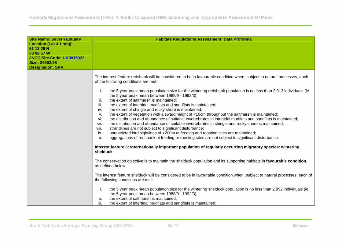
Habitats Regulations Assessment (HRA): A Toolkit to support HRA Screening and Appropriate Assessment Of Plans
South East Wales Strategic Planning Group (SEWSPG) 60/79 Enfusion
Site Name: Severn Estuary Location (Lat & Long): 51 13 29 N 03 02 57 W JNCC Site Code: UK9015022 Size: 24662.98 Designation: SPA
Habitats Regulations Assessment: Data Proforma
The interest feature redshank will be considered to be in favourable condition when, subject to natural processes, each of the following conditions are met:
i. the 5 year peak mean population size for the wintering redshank population is no less than 2,013 individuals (ie the 5 year peak mean between 1988/9 - 1992/3);
ii. the extent of saltmarsh is maintained; iii. the extent of intertidal mudflats and sandflats is maintained; iv. the extent of shingle and rocky shore is maintained; v. the extent of vegetation with a sward height of <10cm throughout the saltmarsh is maintained; vi. the distribution and abundance of suitable invertebrates in intertidal mudflats and sandflats is maintained; vii. the distribution and abundance of suitable invertebrates in shingle and rocky shore is maintained; viii. strandlines are not subject to significant disturbance; ix. unrestricted bird sightlines of >200m at feeding and roosting sites are maintained; x. aggregations of redshank at feeding or roosting sites are not subject to significant disturbance.
Interest feature 5: Internationally important population of regularly occurring migratory species: wintering shelduck The conservation objective is to maintain the shelduck population and its supporting habitats in favourable condition, as defined below. The interest feature shelduck will be considered to be in favourable condition when, subject to natural processes, each of the following conditions are met:
i. the 5 year peak mean population size for the wintering shelduck population is no less than 2,892 individuals (ie the 5 year peak mean between 1988/9 - 1992/3);
ii. the extent of saltmarsh is maintained; iii. the extent of intertidal mudflats and sandflats is maintained;
Habitats Regulations Assessment (HRA): A Toolkit to support HRA Screening and Appropriate Assessment Of Plans
South East Wales Strategic Planning Group (SEWSPG) 61/79 Enfusion
Site Name: Severn Estuary Location (Lat & Long): 51 13 29 N 03 02 57 W JNCC Site Code: UK9015022 Size: 24662.98 Designation: SPA
Habitats Regulations Assessment: Data Proforma
iv. the extent of shingle and rocky shore is maintained; v. the distribution and abundance of suitable invertebrates in intertidal mudflats and sandflats is maintained; vi. unrestricted bird sightlines of >200m at feeding and roosting sites are maintained; aggregations of shelduck at
feeding or roosting sites are not subject to significant disturbance. Interest Feature 6: SPA interest feature 6: Internationally important population of regularly occurring migratory species: wintering gadwall The conservation objective is to maintain the gadwall population and its supporting habitats in favourable condition, as defined below: The interest feature gadwall will be considered to be in favourable condition when, subject to natural processes2, each of the following conditions are met:
i. the 5 year peak mean population size for the wintering gadwall population is no less than 330 (ie the 5 year peak mean between 1988/9 - 1992/3);
ii. the extent of intertidal mudflats and sandflats (Appendix 8) is maintained; iii. unrestricted bird sightlines of >200m at feeding and roosting sites are maintained; iv. aggregations of gadwall at feeding or roosting sites are not subject to significant disturbance. v. Interest feature 7: Internationally important assemblage of waterfowl
The conservation objective is to maintain the waterfowl assemblage and its supporting habitats in favourable condition, as defined below. The interest feature waterfowl assemblage will be considered to be in favourable condition when, subject to natural processes (Box1), each of the following conditions are met:
i. the 5 year peak mean population size for the waterfowl assemblage is no less than 68,026 individuals (ie the 5 year peak mean between 1988/9 - 1992/3);
ii. the extent of saltmarsh is maintained;
Habitats Regulations Assessment (HRA): A Toolkit to support HRA Screening and Appropriate Assessment Of Plans
South East Wales Strategic Planning Group (SEWSPG) 62/79 Enfusion
Site Name: Severn Estuary Location (Lat & Long): 51 13 29 N 03 02 57 W JNCC Site Code: UK9015022 Size: 24662.98 Designation: SPA
Habitats Regulations Assessment: Data Proforma
iii. the extent of intertidal mudflats and sandflats is maintained; iv. the extent of shingle and rocky shore is maintained; v. extent of vegetation of <10cm throughout the saltmarsh is maintained; vi. the distribution and abundance of suitable invertebrates in intertidal mudflats and sandflats is maintained; vii. the distribution and abundance of suitable invertebrates in shingle and rocky shore is maintained; viii. greater than 25% cover of suitable soft leaved herbs and grasses during the winter on saltmarsh areas is
maintained; ix. strandlines are not subject to significant disturbance; x. unrestricted bird sightlines of >500m at feeding and roosting sites are maintained; xi. waterfowl aggregations at feeding or roosting sites are not subject to significant disturbance.
Component SSSIs Severn Estuary SSSI
Flat Holm SSSI Bridgwater Bay SSSI Penarth Coast SSSI Steep Holm SSSI Sully Island SSSI Upper Severn Estuary SSSI Maps of the site can be viewed on the CCW website.
Key Environmental Conditions (factors that maintain site integrity
Key supporting habitats for the Annex I species: Intertidal mudflats and sandflats:
o Habitat extent - The focal area for the Bewick’s swans is the upper Severn Estuary in the vicinity of the New Grounds, Slimbridge area. The mudflats and sandflats exposed as the tide falls where the estuary widens in the
Habitats Regulations Assessment (HRA): A Toolkit to support HRA Screening and Appropriate Assessment Of Plans
South East Wales Strategic Planning Group (SEWSPG) 63/79 Enfusion
Site Name: Severn Estuary Location (Lat & Long): 51 13 29 N 03 02 57 W JNCC Site Code: UK9015022 Size: 24662.98 Designation: SPA
Habitats Regulations Assessment: Data Proforma
upper reaches of the site at Waveridge Sands, Frampton Sands and The Noose are used as safe refuge areas when the birds are disturbed.
o Unimpeded sightlines at feeding and roosting sites - Bewick’s swan require unrestricted views >500m to allow early detection of predators when feeding and roosting.
Saltmarsh communities:
o Habitat extent - The birds feed on the saltmarsh and the transition from saltmarsh to coastal grazing marsh in front of the sea defences in the upper estuary at The Dumbles, where areas of the high marsh are mainly affected only by brackish water during tidal inundation.
o Vegetation characteristics - Bewick’s swan graze on a range of ‘soft’ meadow grasses such as Agrostis stolonifera and Alopecurus geniculatus found in wet meadows which are outwith the European marine site boundary.
o Unimpeded sightlines at feeding and roosting sites - Bewick’s swan require unrestricted views >500m to allow early detection of predators when feeding and roosting.
Key supporting habitats for populations of regularly occurring migratory species and assemblage of waterfowl: Intertidal mudflats and sandflats:
o Habitat extent - Intertidal mudflats and sandflats and their communities are important habitats as they provide both roosting and feeding areas. The European white-fronted geese roost at night on estuarine sandbanks and usually fly less than 10km to the daytime feeding grounds. Therefore conservation of traditional roosting sites is necessary to enable the population to exploit potential feeding habitats.
o Food availability - Most of the waders and waterfowl within the assemblage including the internationally important regularly occurring migratory birds feed on invertebrates within and on the sediments.
o Unimpeded sightlines at feeding and roosting sites - Waterfowl require unrestricted views >500m to allow early detection of predators when feeding and roosting.
Saltmarsh:
o Habitat extent - Saltmarsh and their communities are important habitats as they provide both roosting and feeding

Habitats Regulations Assessment (HRA): A Toolkit to support HRA Screening and Appropriate Assessment Of Plans
South East Wales Strategic Planning Group (SEWSPG) 64/79 Enfusion
Site Name: Severn Estuary Location (Lat & Long): 51 13 29 N 03 02 57 W JNCC Site Code: UK9015022 Size: 24662.98 Designation: SPA
Habitats Regulations Assessment: Data Proforma
areas. Upper and lower saltmarsh provide important feeding and roosting areas for the internationally important migratory birds throughout the estuary.
o Food availability - The saltmarshes provide a rich feeding habitat for redshank and shelduck, which feed on invertebrate species in the sediments, such as the mudsnail Hydrobia. The European white-fronted geese graze on a range of saltmarsh grasses and herbs such as common saltmarsh grass Puccinellia maritime and sea barley Hordeum marinum. The birds feed on the saltmarsh and the transition to coastal grazing marsh in front of the sea defences in the upper estuary and particularly at the The Dumbles.
o Vegetation characteristics - Vegetation of <10 cm is required throughout areas used by roosting waders. This is managed by grazing.
o Unimpeded sightlines at feeding and roosting sites - Waterfowl require unrestricted views >500m to allow early detection of predators when feeding and roosting. The saltmarshes also have an important function providing a safe haven from the tides that flood the mudflats twice a day. The low-growing dense vegetation provides a suitable roosting habitat for redshank and dunlin, which prefer to roost on areas of short vegetation ensuring good visibility.
Shingle and rocky shore:
o Habitat extent - the shingle and rocks in the estuary provide feeding areas for dunlin and redshank and some limited foraging at high tide. It is also provides important roost sites at high tide particularly for the dunlin and redshank. Many of the rocks are off shore and are therefore generally free from human disturbance. These include Guscar Rocks in the upper reaches, Blackstone Rocks at Clevedon and Stert Island in Bridgwater Bay.
o Food availability - see above. o Unimpeded sightlines at feeding and roosting sites - Waterfowl require unrestricted views >500m to allow early
detection of predators when feeding and roosting.
Wet coastal grazing marsh, improved grassland and open standing waters - these supporting habitats lie outside the European marine site boundary but within the SPA. They provide key areas for feeding and roosting for all the migratory species particularly at high tide.
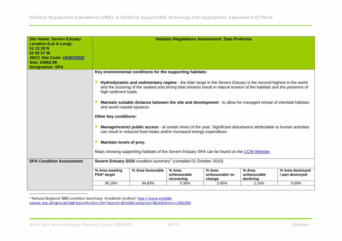
Habitats Regulations Assessment (HRA): A Toolkit to support HRA Screening and Appropriate Assessment Of Plans
South East Wales Strategic Planning Group (SEWSPG) 65/79 Enfusion
Site Name: Severn Estuary Location (Lat & Long): 51 13 29 N 03 02 57 W JNCC Site Code: UK9015022 Size: 24662.98 Designation: SPA
Habitats Regulations Assessment: Data Proforma
Key environmental conditions for the supporting habitats: Hydrodynamic and sedimentary regime - the tidal range in the Severn Estuary is the second-highest in the world
and the scouring of the seabed and strong tidal streams result in natural erosion of the habitats and the presence of high sediment loads.
Maintain suitable distance between the site and development - to allow for managed retreat of intertidal habitats
and avoid coastal squeeze. Other key conditions: Manage/restrict public access - at certain times of the year. Significant disturbance attributable to human activities
can result in reduced food intake and/or increased energy expenditure. Maintain levels of prey. Maps showing supporting habitats of the Severn Estuary SPA can be found on the CCW Website.
SPA Condition Assessment Severn Estuary SSSI condition summary1 (compiled 01 October 2010). % Area meeting PSA* target
% Area favourable % Area unfavourable recovering
% Area unfavourable no change
% Area unfavourable declining
% Area destroyed / part destroyed
95.19% 94.83% 0.36% 2.65% 2.16% 0.00%
1 Natural England SSSI condition summary. Available [online]: http://www.english-nature.org.uk/special/sssi/reportAction.cfm?report=sdrt18&category=S&reference=1002284
Habitats Regulations Assessment (HRA): A Toolkit to support HRA Screening and Appropriate Assessment Of Plans
South East Wales Strategic Planning Group (SEWSPG) 66/79 Enfusion
Site Name: Severn Estuary Location (Lat & Long): 51 13 29 N 03 02 57 W JNCC Site Code: UK9015022 Size: 24662.98 Designation: SPA
Habitats Regulations Assessment: Data Proforma
*PSA target - The Government's Public Service Agreement (PSA) target to have 95% of the SSSI area in favourable or recovering condition by 2010.
Vulnerabilities (includes existing pressures and trends)
Internationally important populations of regularly occurring Annex 1 species: Physical loss of supporting habitats through removal - The physical loss of areas of intertidal habitats may be
caused directly through change of land use or indirectly as a consequence of changes to sedimentation processes (e.g. coastal defences) as well as via the effects of smothering by artificial structures (e.g. jetties) or the disposal of spoils. Activities or developments resulting in physical loss of the intertidal supporting habitats are likely to reduce the availability of feeding and roosting habitat and thus be detrimental to the favourable condition of the SPA interest features including the Annex 1 species, Bewick’s swan. The intertidal mudflats and sandflats and the saltmarsh are highly sensitive to removal by land reclamation and barrage construction. Information provided by NE and CCW states that large areas of the European marine site are not currently under threat, however when combined with a high level of sensitivity this leads to a moderate vulnerability.
Noise or visual disturbance - Overwintering birds are disturbed by sudden movements and sudden noises. This can
displace the birds from their feeding grounds. Disturbance can prevent the birds from feeding and in response they either a) decrease their energy intake at their present (disturbed) feeding site through displacement activity, or b) move to an alternative less favoured feeding site. Such a response affects energy budgets and thus survival. There is intermittent disturbance from both the landward and seaward side of the site. Bewick’s swans are mainly affected by disturbance from the landward side and any increase in disturbance should be avoided. At present NE and CCW assess that the Annex 1 species are moderately vulnerable to noise and visual disturbance on the intertidal mudflats and sandflats and highly vulnerable to this category of operation on the saltmarsh.
Contamination by synthetic and/or non-synthetic toxic compounds - Waterfowl are subject to the accumulation
of toxins through the food chain or through direct contact with toxic substances when roosting or feeding. Their ability to feed can also be affected by the abundance or change in palatability of their prey caused by toxic contamination. At the moment there is no evidence to show that this is the case, but the estuary is vulnerable to oil spills and there is a
Habitats Regulations Assessment (HRA): A Toolkit to support HRA Screening and Appropriate Assessment Of Plans
South East Wales Strategic Planning Group (SEWSPG) 67/79 Enfusion
Site Name: Severn Estuary Location (Lat & Long): 51 13 29 N 03 02 57 W JNCC Site Code: UK9015022 Size: 24662.98 Designation: SPA
Habitats Regulations Assessment: Data Proforma
continuous discharge of toxins into the estuary, some of which bind to the sediments. NE and CCW identify this is an area which requires further assessment. They also identify Bewick’s swans as currently moderately vulnerable to toxic contamination.
Internationally important waterfowl assemblage including populations of regularly occurring migratory species: Physical loss through removal - The physical loss of areas of intertidal habitats may be caused directly through
change of land use or indirectly as a consequence of changes to sedimentation processes (e.g. coastal defences) as well as via the effects of smothering by artificial structures (e.g. jetties) or the disposal of spoils. Eelgrass beds are being affected by siltation due to changes in sediment movement after construction of the Second Severn Crossing which has resulted in smothering. Activities or developments resulting in physical loss of the intertidal supporting habitats are likely to reduce the availability of food and roosting habitat and thus be detrimental to the favourable condition of the SPA interest features including all the migratory species and waterfowl assemblage. All three supporting habitats are highly sensitive to removal by land reclamation and barrage construction. Information provided by NE and CCW states that large areas of the European marine site are not currently under threat, however when combined with a high level of sensitivity this leads to a moderate vulnerability.
Damage by abrasion or selective extraction - Saltmarsh may be physically damaged from overgrazing or eroded
when boats are moored on it and when paths are worn through it to reach moored boats on foot or via vehicles. Currently all supporting habitats are considered to be moderately vulnerable to abrasion. Intertidal habitats are highly sensitive to damage by direct and indirect effects of aggregate dredging. The intertidal mudflats and sandflats and the shingle and rocky shore are therefore considered by NE and CCW to be highly vulnerable to selective extraction.
Noise or visual disturbance - Overwintering birds are disturbed by sudden movements and sudden noises. This can
have the effect of displacing the birds from their feeding grounds. Disturbance can prevent the birds from feeding and in response they either a) decrease their energy intake at their present (disturbed) feeding site through displacement activity, or b) move to an alternative less favoured feeding site. Such a response affects energy budgets and thus survival. There is intermittent disturbance to the internationally important migratory species and the waterfowl

Habitats Regulations Assessment (HRA): A Toolkit to support HRA Screening and Appropriate Assessment Of Plans
South East Wales Strategic Planning Group (SEWSPG) 68/79 Enfusion
Site Name: Severn Estuary Location (Lat & Long): 51 13 29 N 03 02 57 W JNCC Site Code: UK9015022 Size: 24662.98 Designation: SPA
Habitats Regulations Assessment: Data Proforma
assemblage from both the landward and seaward side of the site which has increased in recent years, due to the estuary becoming more populated and the development of all weather recreational pursuits. All supporting habitats are currently highly vulnerable to noise and visual disturbance.
Contamination by synthetic and/or non-synthetic toxic compounds - Waterfowl are subject to the accumulation
of toxins through the food chain or through direct contact with toxic substances when roosting or feeding. Their ability to feed can also be affected by the abundance or change in palatability of their prey caused by toxic contamination. At the moment there is no evidence to show that this is the case on the Severn Estuary, but the estuary is vulnerable to oil spills and there is a continuous discharge of toxins into the estuary, some of which bind to the sediments. NE and CCW identify this is an area which requires further assessment. The intertidal mudflats and sandflats and the saltmarsh are currently highly vulnerable to the introduction of synthetic and non-synthetic compounds.
Changes in nutrient and/or organic loading - Changes in organic or nutrient loading can change the species
composition of the plants on the saltmarsh and thus the structure of the sward. Increases in nutrients can also cause excessive algal growth on the mudflats, denying the birds access to their invertebrate prey and changing the invertebrate species composition in the sediment. Though the water quality has been improved in recent years there are still local areas of concern and any increase in nutrient loading should be avoided. At present the intertidal mudflats and sandflats are moderately vulnerable to this category of operation.
Biological disturbance through the selective extraction of species - Wildfowling is carried out all around the
estuary. NE and CCW have not established that it has a detrimental effect on the overall bird populations but state that wildfowling needs to be exercised in a managed and sustainable manner preferably by a British Association of Shooting and Conservation (BASC) affiliated association, applying the BASC wildfowlers code of conduct. Bait digging is also carried out around the estuary. If too large an area is regularly dug over, it can change the availability of prey in the sediment as the area needs a period of recovery and recolonisation. The removal of strandline vegetation by beach cleaning removes an important habitat for invertebrates, as well as many of the invertebrates themselves, reducing the quantity and variety of prey available to the birds. Much of the saltmarsh is managed by grazing and changes in management can alter the availability of prey and suitability of roosting sites. The saltmarsh is

Habitats Regulations Assessment (HRA): A Toolkit to support HRA Screening and Appropriate Assessment Of Plans
South East Wales Strategic Planning Group (SEWSPG) 69/79 Enfusion
Site Name: Severn Estuary Location (Lat & Long): 51 13 29 N 03 02 57 W JNCC Site Code: UK9015022 Size: 24662.98 Designation: SPA
Habitats Regulations Assessment: Data Proforma
currently highly vulnerable to the selective extraction of species.
Landowner/ Management Responsibility
N/A
Ramsar Sites Site Name: Severn Estuary Location (Lat & Long): 51 13 29 N 03 02 57 W JNCC Site Code: UK11081 Size: 24662.98 Designation: Ramsar
Habitats Regulations Assessment: Data Proforma
Site Description The Severn Estuary is the largest coastal plain estuary in the UK with extensive mudflats and sandflats, rocky shore platforms, shingle and islands. Saltmarsh fringes the coast, backed by grazing marsh with freshwater and occasional brackish ditches. The estuary’s classic funnel shape, unique in the UK, is a factor causing the Severn to have the second highest tidal range in the world (after the Bay of Fundy in Canada) at more than 12 meters. This tidal regime results in plant and animal communities typical of the extreme physical conditions of strong flows, mobile sediments, changing salinity, high turbidity and heavy scouring. The resultant low diversity invertebrate communities, that frequently include populations of ragworms, lugworms and other invertebrates in high densities, form an important food source for passage and wintering birds. The site is important in the spring and autumn migration periods for waders moving along the west coast of Europe, as well as in winter for large numbers of waterbirds including swans, geese, ducks and waders. These bird populations are regarded as internationally important.
Habitats Regulations Assessment (HRA): A Toolkit to support HRA Screening and Appropriate Assessment Of Plans
South East Wales Strategic Planning Group (SEWSPG) 70/79 Enfusion
Site Name: Severn Estuary Location (Lat & Long): 51 13 29 N 03 02 57 W JNCC Site Code: UK11081 Size: 24662.98 Designation: Ramsar
Habitats Regulations Assessment: Data Proforma
Glassworts and annual sea-blite colonise the open mud, with beds of all three species of eelgrass Zostera occurring on more sheltered mud and sandbanks. Large expanses of common cord-grass also occur on the outer marshes. Heavily grazed saltmarsh fringes the estuary with a range of saltmarsh types present. The middle marsh sward is dominated by common saltmarsh-grass with typical associated species. In the upper marsh, red fescue and saltmarsh rush become more prominent. Areas of saltmarsh fringe the estuary, mostly grazed with a range of vegetation communities. There are gradual and stepped transitions between bare mudflat to upper marsh and grassland. Main vegetation types are: upper saltmarsh with Festuca rubra and Juncus gerardii; middle marsh dominated by Puccinellia maritima with Glaux maritima and Triglochin maritima; dense monocultures of Spartina anglica at the edge of the mudflats-brackish pools and depressions with Phragmites australis and Bolboschoenus maritimus.
Qualifying Features
Ramsar criterion 1 Immense tidal range (second-largest in world) creating diversity of physical environment and biological communities. Ramsar criterion 3 Due to unusual estuarine communities, reduced diversity and high productivity. Ramsar criterion 4 This site is important for the run of migratory fish between sea and river via estuary. Species include Salmon Salmo
salar, sea trout S. trutta, sea lamprey Petromyzon marinus, river lamprey Lampetra fluviatilis, allis shad Alosa alosa, twaite shad A. fallax, and eel Anguilla anguilla. It is also of particular importance for migratory birds during spring and autumn.
Ramsar criterion 5 Species with peak counts in winter: 70919 waterfowl
Habitats Regulations Assessment (HRA): A Toolkit to support HRA Screening and Appropriate Assessment Of Plans
South East Wales Strategic Planning Group (SEWSPG) 71/79 Enfusion
Site Name: Severn Estuary Location (Lat & Long): 51 13 29 N 03 02 57 W JNCC Site Code: UK11081 Size: 24662.98 Designation: Ramsar
Habitats Regulations Assessment: Data Proforma
Ramsar criterion 6 Species with peak counts in winter: Bewick’s swan Greater white-fronted goose Common shelduck Gadwall Dunlin Common redshank Ramsar criterion 8 The fish of the whole estuarine and river system is one of the most diverse in Britain, with over 110 species recorded.
Salmon Salmo salar, sea trout S. trutta, sea lamprey Petromyzon marinus, river lamprey Lampetra fluviatilis, allis shad Alosa alosa, twaite shad A. fallax, and eel Anguilla Anguilla use the Severn Estuary as a key migration route to their spawning grounds in the many tributaries that flow into the estuary. The site is important as a feeding and nursery ground for many fish species particularly allis shad Alosa alosa and twaite shad A. fallax which feed on mysid shrimps in the salt wedge.
Conservation Objectives
Ramsar interest feature 1: Estuaries The conservation objective for the “estuaries” feature of the Severn Estuary Ramsar Site is to maintain the feature in
favourable condition, as defined by the conservation objective for the SAC “estuaries” feature” (please refer to Severn Estuary SAC in this document).
Ramsar interest feature 2: Assemblage of migratory fish species The conservation objective for the “assemblage of migratory fish species” feature of the Severn Estuary Ramsar Site is
Habitats Regulations Assessment (HRA): A Toolkit to support HRA Screening and Appropriate Assessment Of Plans
South East Wales Strategic Planning Group (SEWSPG) 72/79 Enfusion
Site Name: Severn Estuary Location (Lat & Long): 51 13 29 N 03 02 57 W JNCC Site Code: UK11081 Size: 24662.98 Designation: Ramsar
Habitats Regulations Assessment: Data Proforma
to maintain the feature in favourable condition, as defined below: The feature will be considered to be in favourable condition when, subject to natural processes, each of the following conditions are met:
i. the migratory passage of both adults and juveniles of the assemblage of migratory fish species through the Severn Estuary between the Bristol Channel and any of their spawning rivers is not obstructed or impeded by physical barriers, changes in flows, or poor water quality;
ii. the size of the populations of the assemblage species in the Severn Estuary and the rivers which drain into it, is at least maintained and is at a level that is sustainable in the long term;
iii. the abundance of prey species forming the principle food resources for the assemblage species within the estuary, is maintained.
iv. Toxic contaminants in the water column and sediment are below levels which would pose a risk to the ecological objectives described above.
Ramsar interest feature 3: Internationally important populations of waterfowl : Bewick’s swan The conservation objective for the “Bewick’s swan” feature of the Severn Estuary Ramsar Site is to maintain the
feature in favourable condition, as defined by the conservation objective for the SPA “Bewick’s swan ” feature Ramsar interest feature 4 : Internationally important populations of waterfowl : European white-fronted goose The conservation objective for the “European white-fronted goose” feature of the Severn Estuary Ramsar Site is to
maintain the feature in favourable condition, as defined by the conservation objective for the SPA “wintering European white-fronted goose” feature
Ramsar interest feature 5: Internationally important populations of waterfowl : dunlin The conservation objective for the “dunlin” feature of the Severn Estuary Ramsar Site is to maintain the feature in
favourable condition, as defined by the conservation objective for the SPA “wintering dunlin ” feature Ramsar interest feature 6: Internationally important populations of waterfowl : redshank
Habitats Regulations Assessment (HRA): A Toolkit to support HRA Screening and Appropriate Assessment Of Plans
South East Wales Strategic Planning Group (SEWSPG) 73/79 Enfusion
Site Name: Severn Estuary Location (Lat & Long): 51 13 29 N 03 02 57 W JNCC Site Code: UK11081 Size: 24662.98 Designation: Ramsar
Habitats Regulations Assessment: Data Proforma
The conservation objective for the “redshank” feature of the Severn Estuary Ramsar Site is to maintain the feature in favourable condition, as defined by the conservation objective for the SPA “wintering redshank” feature
Ramsar interest feature 7: Internationally important populations of waterfowl: shelduck The conservation objective for the “shelduck” feature of the Severn Estuary Ramsar Site is to maintain the feature in
favourable condition, as defined by the conservation objective for the SPA “wintering shelduck” feature Ramsar interest feature 8: Internationally important populations of waterfowl : gadwall The conservation objective for the “gadwall” feature of the Severn Estuary Ramsar Site is to maintain the feature in
favourable condition, as defined by the conservation objective for the SPA “wintering gadwall” feature Ramsar interest feature 9: Internationally important assemblage of waterfowl The conservation objective for the “internationally important assemblage of waterfowl” feature of the Severn Estuary
Ramsar Site is to maintain the feature in favourable condition, as defined by the conservation objective for the SPA “internationally important assemblage of waterfowl” feature
Component SSSIs Sully Island SSSI Steep Holm SSSI Bridgwater Bay SSSI Flat Holm SSSI Severn Estuary SSSI Severn Estuary SSSI Flat Holm SSSI Upper Severn Estuary SSSI Bridgwater Bay SSSI Penarth Coast SSSI
Habitats Regulations Assessment (HRA): A Toolkit to support HRA Screening and Appropriate Assessment Of Plans
South East Wales Strategic Planning Group (SEWSPG) 74/79 Enfusion
Site Name: Severn Estuary Location (Lat & Long): 51 13 29 N 03 02 57 W JNCC Site Code: UK11081 Size: 24662.98 Designation: Ramsar
Habitats Regulations Assessment: Data Proforma
Steep Holm SSSI Sully Island SSSI Upper Severn Estuary SSSI
Key Environmental Conditions (factors that maintain site integrity
Key supporting habitats for the Berwick’s swan: Intertidal mudflats and sandflats:
o Habitat extent - The focal area for the Bewick’s swans is the upper Severn Estuary in the vicinity of the New Grounds, Slimbridge area. The mudflats and sandflats exposed as the tide falls where the estuary widens in the upper reaches of the site at Waveridge Sands, Frampton Sands and The Noose are used as safe refuge areas when the birds are disturbed.
o Unimpeded sightlines at feeding and roosting sites - Bewick’s swan require unrestricted views >500m to allow early detection of predators when feeding and roosting.
Saltmarsh communities:
o Habitat extent - The birds feed on the saltmarsh and the transition from saltmarsh to coastal grazing marsh in front of the sea defences in the upper estuary at The Dumbles, where areas of the high marsh are mainly affected only by brackish water during tidal inundation.
o Vegetation characteristics - Bewick’s swan graze on a range of ‘soft’ meadow grasses such as Agrostis stolonifera and Alopecurus geniculatus found in wet meadows which are outwith the European marine site boundary.
o Unimpeded sightlines at feeding and roosting sites - Bewick’s swan require unrestricted views >500m to allow early detection of predators when feeding and roosting.
Key supporting habitats for populations of regularly occurring migratory species and assemblage of waterfowl Intertidal mudflats and sandflats:
o Habitat extent - Intertidal mudflats and sandflats and their communities are important habitats as they provide both
Habitats Regulations Assessment (HRA): A Toolkit to support HRA Screening and Appropriate Assessment Of Plans
South East Wales Strategic Planning Group (SEWSPG) 75/79 Enfusion
Site Name: Severn Estuary Location (Lat & Long): 51 13 29 N 03 02 57 W JNCC Site Code: UK11081 Size: 24662.98 Designation: Ramsar
Habitats Regulations Assessment: Data Proforma
roosting and feeding areas. The European white-fronted geese roost at night on estuarine sandbanks and usually fly less than 10km to the daytime feeding grounds. Therefore conservation of traditional roosting sites is necessary to enable the population to exploit potential feeding habitats.
o Food availability - Most of the waders and waterfowl within the assemblage including the internationally important regularly occurring migratory birds feed on invertebrates within and on the sediments.
o Unimpeded sightlines at feeding and roosting sites - Waterfowl require unrestricted views >500m to allow early detection of predators when feeding and roosting.
Saltmarsh:
o Habitat extent - Saltmarsh and their communities are important habitats as they provide both roosting and feeding areas. Upper and lower saltmarsh provide important feeding and roosting areas for the internationally important migratory birds throughout the estuary.
o Food availability - The saltmarshes provide a rich feeding habitat for redshank and shelduck, which feed on invertebrate species in the sediments, such as the mudsnail Hydrobia. The European white-fronted geese graze on a range of saltmarsh grasses and herbs such as common saltmarsh grass Puccinellia maritime and sea barley Hordeum marinum. The birds feed on the saltmarsh and the transition to coastal grazing marsh in front of the sea defences in the upper estuary and particularly at the The Dumbles.
o Vegetation characteristics - Vegetation of <10 cm is required throughout areas used by roosting waders. This is managed by grazing.
o Unimpeded sightlines at feeding and roosting sites - Waterfowl require unrestricted views >500m to allow early detection of predators when feeding and roosting. The saltmarshes also have an important function providing a safe haven from the tides that flood the mudflats twice a day. The low-growing dense vegetation provides a suitable roosting habitat for redshank and dunlin, which prefer to roost on areas of short vegetation ensuring good visibility.
Shingle and rocky shore:
o Habitat extent - the shingle and rocks in the estuary provide feeding areas for dunlin and redshank and some limited foraging at high tide. It is also provides important roost sites at high tide particularly for the dunlin and
Habitats Regulations Assessment (HRA): A Toolkit to support HRA Screening and Appropriate Assessment Of Plans
South East Wales Strategic Planning Group (SEWSPG) 76/79 Enfusion
Site Name: Severn Estuary Location (Lat & Long): 51 13 29 N 03 02 57 W JNCC Site Code: UK11081 Size: 24662.98 Designation: Ramsar
Habitats Regulations Assessment: Data Proforma
redshank. Many of the rocks are off shore and are therefore generally free from human disturbance. These include Guscar Rocks in the upper reaches, Blackstone Rocks at Clevedon and Stert Island in Bridgwater Bay.
o Food availability - see above. o Unimpeded sightlines at feeding and roosting sites - Waterfowl require unrestricted views >500m to allow early
detection of predators when feeding and roosting.
Wet coastal grazing marsh, improved grassland and open standing waters - these supporting habitats lie outside the European marine site boundary but within the SPA. They provide key areas for feeding and roosting for all the migratory species particularly at high tide.
Key environmental conditions for the supporting habitats: Hydrodynamic and sedimentary regime - the tidal range in the Severn Estuary is the second-highest in the world
and the scouring of the seabed and strong tidal streams result in natural erosion of the habitats and the presence of high sediment loads.
Maintain suitable distance between the site and development - to allow for managed retreat of intertidal habitats
and avoid coastal squeeze. Other key conditions: Manage/restrict public access - at certain times of the year. Significant disturbance attributable to human activities
can result in reduced food intake and/or increased energy expenditure. Maintain levels of prey.
Habitats Regulations Assessment (HRA): A Toolkit to support HRA Screening and Appropriate Assessment Of Plans
South East Wales Strategic Planning Group (SEWSPG) 77/79 Enfusion
Site Name: Severn Estuary Location (Lat & Long): 51 13 29 N 03 02 57 W JNCC Site Code: UK11081 Size: 24662.98 Designation: Ramsar
Habitats Regulations Assessment: Data Proforma
Ramsar Condition Assessment N/A
Vulnerabilities (includes existing pressures and trends)
Physical loss of supporting habitats through removal - The physical loss of areas of intertidal habitats may be caused directly through change of land use or indirectly as a consequence of changes to sedimentation processes (e.g. coastal defences) as well as via the effects of smothering by artificial structures (e.g. jetties) or the disposal of spoils. Activities or developments resulting in physical loss of the intertidal supporting habitats are likely to reduce the availability of feeding and roosting habitats. The intertidal mudflats and sandflats and the saltmarsh are highly sensitive to removal by land reclamation and barrage construction. Information provided by NE and CCW states that large areas of the European marine site are not currently under threat, however when combined with a high level of sensitivity this leads to a moderate vulnerability.
Noise or visual disturbance - Overwintering birds are disturbed by sudden movements and sudden noises. This can
displace the birds from their feeding grounds. Disturbance can prevent the birds from feeding and in response they either a) decrease their energy intake at their present (disturbed) feeding site through displacement activity, or b) move to an alternative less favoured feeding site. Such a response affects energy budgets and thus survival. There is intermittent disturbance to the internationally important migratory species and the waterfowl assemblage from both the landward and seaward side of the site which has increased in recent years, due to the estuary becoming more populated and the development of all weather recreational pursuits. Bewick’s swans are mainly affected by disturbance from the landward side and any increase in disturbance should be avoided. All supporting habitats are currently highly vulnerable to noise and visual disturbance.
Contamination by synthetic and/or non-synthetic toxic compounds - Waterfowl are subject to the accumulation
of toxins through the food chain or through direct contact with toxic substances when roosting or feeding. Their ability to feed can also be affected by the abundance or change in palatability of their prey caused by toxic contamination. At the moment there is no evidence to show that this is the case, but the estuary is vulnerable to oil spills and there is a continuous discharge of toxins into the estuary, some of which bind to the sediments. NE and CCW identify this is an area which requires further assessment. The intertidal mudflats and sandflats and the saltmarsh are currently highly vulnerable to the introduction of synthetic and non-synthetic compounds.
Habitats Regulations Assessment (HRA): A Toolkit to support HRA Screening and Appropriate Assessment Of Plans
South East Wales Strategic Planning Group (SEWSPG) 78/79 Enfusion
Site Name: Severn Estuary Location (Lat & Long): 51 13 29 N 03 02 57 W JNCC Site Code: UK11081 Size: 24662.98 Designation: Ramsar
Habitats Regulations Assessment: Data Proforma
Damage by abrasion or selective extraction - Saltmarsh may be physically damaged from overgrazing or eroded
when boats are moored on it and when paths are worn through it to reach moored boats on foot or via vehicles. Currently all supporting habitats are considered to be moderately vulnerable to abrasion. Intertidal habitats are highly sensitive to damage by direct and indirect effects of aggregate dredging. The intertidal mudflats and sandflats and the shingle and rocky shore are therefore considered by NE and CCW to be highly vulnerable to selective extraction.
Changes in nutrient and/or organic loading - Changes in organic or nutrient loading can change the species
composition of the plants on the saltmarsh and thus the structure of the sward. Increases in nutrients can also cause excessive algal growth on the mudflats, denying the birds access to their invertebrate prey and changing the invertebrate species composition in the sediment. Though the water quality has been improved in recent years there are still local areas of concern and any increase in nutrient loading should be avoided. At present the intertidal mudflats and sandflats are moderately vulnerable to this category of operation.
Biological disturbance through the selective extraction of species - Wildfowling is carried out all around the
estuary. NE and CCW have not established that it has a detrimental effect on the overall bird populations but state that wildfowling needs to be exercised in a managed and sustainable manner preferably by a British Association of Shooting and Conservation (BASC) affiliated association, applying the BASC wildfowlers code of conduct. Bait digging is also carried out around the estuary. If too large an area is regularly dug over, it can change the availability of prey in the sediment as the area needs a period of recovery and recolonisation. The removal of strandline vegetation by beach cleaning removes an important habitat for invertebrates, as well as many of the invertebrates themselves, reducing the quantity and variety of prey available to the birds. Much of the saltmarsh is managed by grazing and changes in management can alter the availability of prey and suitability of roosting sites. The saltmarsh is currently highly vulnerable to the selective extraction of species.
Landowner/ Management Responsibility
N/A
Habitats Regulations Assessment (HRA): A Toolkit to support HRA Screening and Appropriate Assessment Of Plans
South East Wales Strategic Planning Group (SEWSPG) 79/79 Enfusion
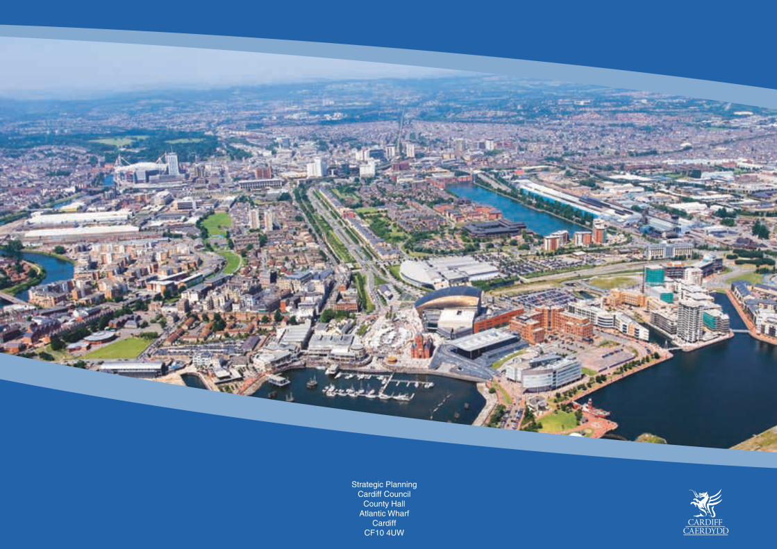
Strategic Planning
Cardiff CouncilCounty Hall
Atlantic WharfCardiff
CF10 4UW