australian curriculum year 3 geography sample … · australian curriculum . year 3 geography ....
TRANSCRIPT
1495
1
© The State of Queensland (Queensland Curriculum and Assessment Authority) and its licensors 2014. All web links correct at time of publication.
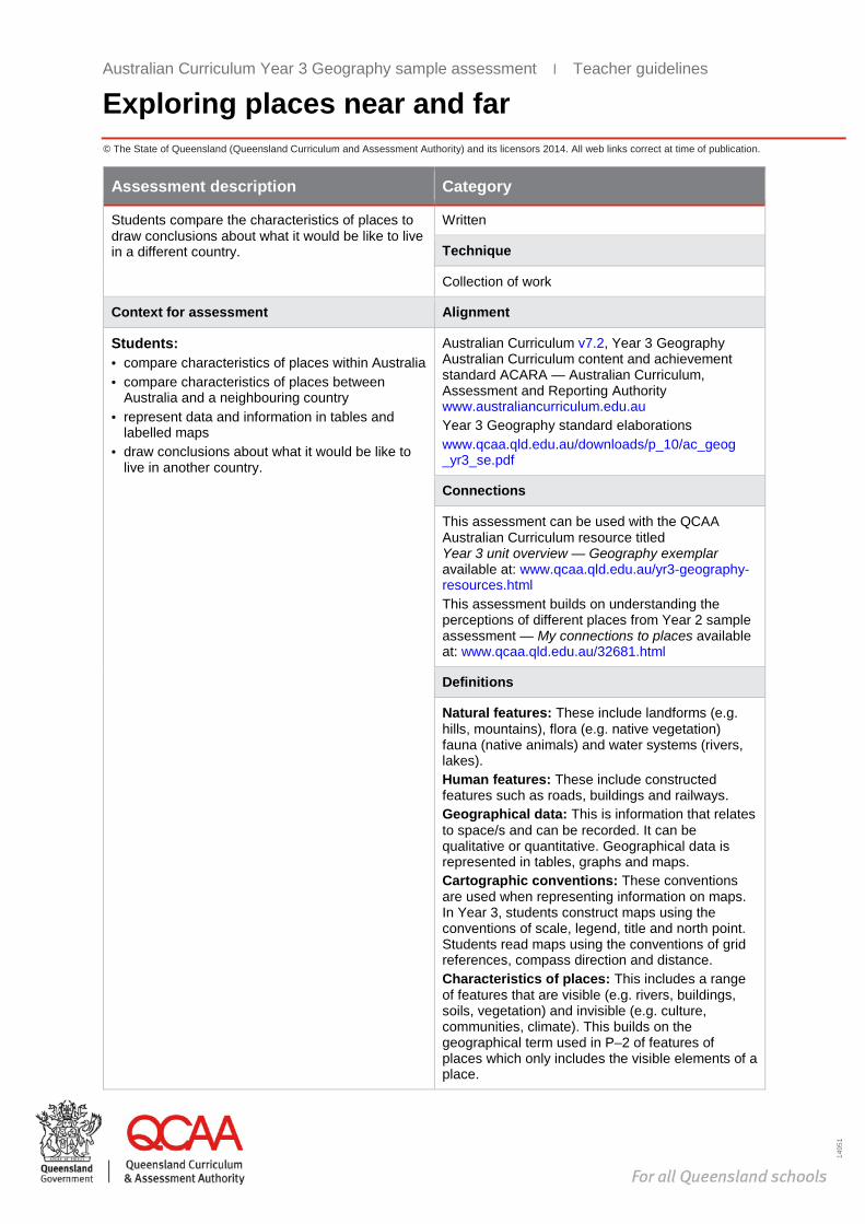
Assessment description Category
Students compare the characteristics of places to draw conclusions about what it would be like to live in a different country.
Written
Technique
Collection of work
Context for assessment Alignment
Students: · compare characteristics of places within Australia · compare characteristics of places between
Australia and a neighbouring country · represent data and information in tables and
labelled maps · draw conclusions about what it would be like to
live in another country.
Australian Curriculum v7.2, Year 3 Geography Australian Curriculum content and achievement standard ACARA — Australian Curriculum, Assessment and Reporting Authority www.australiancurriculum.edu.au Year 3 Geography standard elaborations www.qcaa.qld.edu.au/downloads/p_10/ac_geog _yr3_se.pdf
Connections
This assessment can be used with the QCAA Australian Curriculum resource titled Year 3 unit overview — Geography exemplar available at: www.qcaa.qld.edu.au/yr3-geography-resources.html This assessment builds on understanding the perceptions of different places from Year 2 sample assessment — My connections to places available at: www.qcaa.qld.edu.au/32681.html
Definitions
Natural features: These include landforms (e.g. hills, mountains), flora (e.g. native vegetation) fauna (native animals) and water systems (rivers, lakes). Human features: These include constructed features such as roads, buildings and railways. Geographical data: This is information that relates to space/s and can be recorded. It can be qualitative or quantitative. Geographical data is represented in tables, graphs and maps. Cartographic conventions: These conventions are used when representing information on maps. In Year 3, students construct maps using the conventions of scale, legend, title and north point. Students read maps using the conventions of grid references, compass direction and distance. Characteristics of places: This includes a range of features that are visible (e.g. rivers, buildings, soils, vegetation) and invisible (e.g. culture, communities, climate). This builds on the geographical term used in P–2 of features of places which only includes the visible elements of a place.
Australian Curriculum Year 3 Geography sample assessment ׀ Teacher guidelines
Exploring places near and far

Australian Curriculum Year 3 Geography
Exploring places near and far Unit 1: Investigating how places are similar and different
Teacher guidelines
Climate: This is the average weather (temperature and rainfall) measured in a place over a period of time. Perception: From Year 3, students explore feelings about places in order to imagine what it would be like to live in places they may not have visited. They use a range of sources to explore their own and others’ feelings about places. Pattern/patterns of data: A regularity in data presented in graphs or maps, e.g. an increase in temperature in the summer months of the year. Australia’s neighbours: The Year 3 Geography curriculum refers to studies of Australia’s neighbouring countries. For the purpose of this assessment this is identified as countries of the Asia–Pacific such as New Zealand, the Pacific Island nations, Papua New Guinea, Timor-Leste and Indonesia.
In this assessment
Teacher guidelines
Task-specific standards — continua
Task-specific standards — matrix
Assessment resource: Sample photographs — Life in the Maldives
Assessment resource: Framework for comparing countries
Assessment resource: Average temperature and rainfall data
Student booklet

Australian Curriculum Year 3 Geography
Exploring places near and far Unit 1: Investigating how places are similar and different
Teacher guidelines
Teacher guidelines
Identify curriculum Content descriptions to be taught
Geographical Knowledge and Understanding Geographical Inquiry and Skills
· The representation of Australia as states and territories, and Australia’s major natural and human features (ACHGK014)
· The location of Australia’s neighbouring countries and their diverse characteristics (ACHGK016)
· The main climate types of the world and the similarities and differences between the climates of different places (ACHGK017)
Collecting, recording, evaluating and representing · Collect and record relevant geographical data and
information, for example, by observing by interviewing, conducting surveys, measuring, or from sources such as maps, photographs, satellite images, the media and the internet (ACHGS020)
· Represent data by constructing tables and graphs (ACHGS021)
· Represent the location of places and their features by constructing large-scale maps that conform to cartographic conventions including scale, legend, title and north point, and describe their location using simple grid references, compass direction and distance (ACHGS022)
Interpreting, analysing and concluding · Interpret geographical data to identify distributions
and patterns and draw conclusions (ACHGS023) Communicating · Present findings in a range of communication forms,
for example, written, oral, digital, graphic, tabular, and visual, and use geographical terminology (ACHGS024)
General capabilities (GCs) and cross-curriculum priorities (CCPs) This assessment may provide opportunities to engage with the following GCs and CCPs. Refer also to the Resources tab on the P–10 Geography curriculum and assessment page: www.qcaa.qld.edu.au/yr3-geography-overview.html
Literacy
Numeracy
ICT capability
Critical and creative thinking
Personal and social capability
Ethical understanding
Intercultural understanding
Aboriginal and Torres Strait Islander histories and cultures
Asia and Australia’s engagement with Asia
Sustainability
Achievement standard This assessment provides opportunities for students to demonstrate the following highlighted aspects.
By the end of Year 3, students describe the characteristics of different places at the local scale and identify and describe similarities and differences between the characteristics of these places. They identify interconnections between people and places. They describe the location of selected countries and the distribution of features of places. Students recognise that people have different perceptions of places and how this influences views on the protection of places. Students pose simple geographical questions and collect information from different sources to answer
Australian Curriculum Year 3 Geography
Exploring places near and far Unit 1: Investigating how places are similar and different
Teacher guidelines
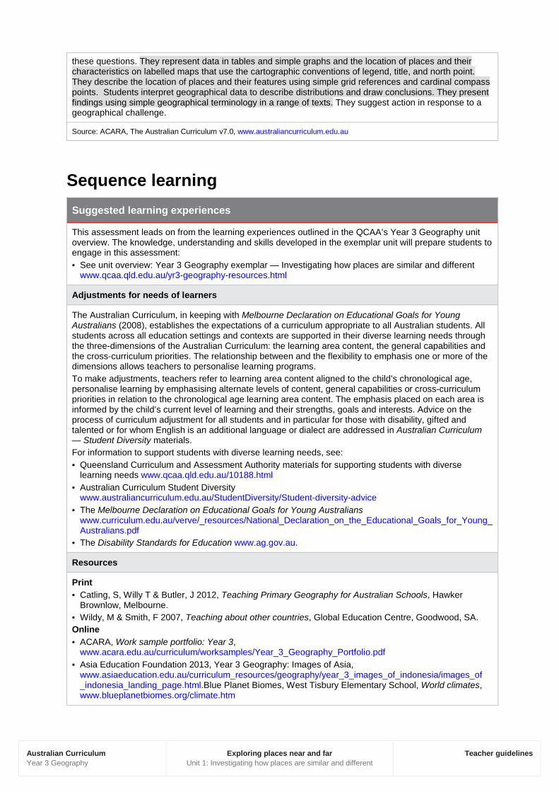
these questions. They represent data in tables and simple graphs and the location of places and their characteristics on labelled maps that use the cartographic conventions of legend, title, and north point. They describe the location of places and their features using simple grid references and cardinal compass points. Students interpret geographical data to describe distributions and draw conclusions. They present findings using simple geographical terminology in a range of texts. They suggest action in response to a geographical challenge.
Source: ACARA, The Australian Curriculum v7.0, www.australiancurriculum.edu.au
Sequence learning Suggested learning experiences
This assessment leads on from the learning experiences outlined in the QCAA’s Year 3 Geography unit overview. The knowledge, understanding and skills developed in the exemplar unit will prepare students to engage in this assessment: · See unit overview: Year 3 Geography exemplar — Investigating how places are similar and different
www.qcaa.qld.edu.au/yr3-geography-resources.html
Adjustments for needs of learners
The Australian Curriculum, in keeping with Melbourne Declaration on Educational Goals for Young Australians (2008), establishes the expectations of a curriculum appropriate to all Australian students. All students across all education settings and contexts are supported in their diverse learning needs through the three-dimensions of the Australian Curriculum: the learning area content, the general capabilities and the cross-curriculum priorities. The relationship between and the flexibility to emphasis one or more of the dimensions allows teachers to personalise learning programs. To make adjustments, teachers refer to learning area content aligned to the child’s chronological age, personalise learning by emphasising alternate levels of content, general capabilities or cross-curriculum priorities in relation to the chronological age learning area content. The emphasis placed on each area is informed by the child’s current level of learning and their strengths, goals and interests. Advice on the process of curriculum adjustment for all students and in particular for those with disability, gifted and talented or for whom English is an additional language or dialect are addressed in Australian Curriculum — Student Diversity materials. For information to support students with diverse learning needs, see: · Queensland Curriculum and Assessment Authority materials for supporting students with diverse
learning needs www.qcaa.qld.edu.au/10188.html · Australian Curriculum Student Diversity
www.australiancurriculum.edu.au/StudentDiversity/Student-diversity-advice · The Melbourne Declaration on Educational Goals for Young Australians
www.curriculum.edu.au/verve/_resources/National_Declaration_on_the_Educational_Goals_for_Young_Australians.pdf
· The Disability Standards for Education www.ag.gov.au.
Resources
Print · Catling, S, Willy T & Butler, J 2012, Teaching Primary Geography for Australian Schools, Hawker
Brownlow, Melbourne. · Wildy, M & Smith, F 2007, Teaching about other countries, Global Education Centre, Goodwood, SA. Online · ACARA, Work sample portfolio: Year 3,
www.acara.edu.au/curriculum/worksamples/Year_3_Geography_Portfolio.pdf · Asia Education Foundation 2013, Year 3 Geography: Images of Asia,
www.asiaeducation.edu.au/curriculum_resources/geography/year_3_images_of_indonesia/images_of _indonesia_landing_page.html.Blue Planet Biomes, West Tisbury Elementary School, World climates, www.blueplanetbiomes.org/climate.htm

Australian Curriculum Year 3 Geography
Exploring places near and far Unit 1: Investigating how places are similar and different
Teacher guidelines
· Bureau of Meteorology, Australian Government, www.bom.gov.au · Central Intelligence Agency, US Government, The World Factbook:
https://www.cia.gov/library/publications/the-world-factbook · Geogspace, Australian Geography Teachers Association:
- Role cards: Children in different places, www.geogspace.edu.au/verve/_resources/2.1.6.3_1_role_card_statements.pdf.
- Climate graphs, www.geogspace.edu.au/verve/_resources/2.3.2.2_2_climate_graphs.pdf
· Global Education, Australian Government Department of Foreign Affairs and Trade, Teaching and learning, www.globaleducation.edu.au/teaching-and-learning/australian-curriculum.html
· Spatial technologies, such as: · Google Earth www.google.com/earth · Google Maps www.google.com.au/maps · Queensland Curriculum and Assessment Authority, G20 for schools, Interactive map (Climate zones),
http://g20.qcaa.qld.edu.au/#level=basic · Queensland Curriculum and Assessment Authority, G20 for schools, Primary virtual field trip using
Google Earth and Queensland Globe, https://www.qcaa.qld.edu.au/virtual-field-trips.html · Queensland Curriculum and Assessment Authority, Year 3 Geography Australian Curriculum in
Queensland, www.qcaa.qld.edu.au/yr3-geography-overview.html · World Climate Charts, www.climate-charts.com · World Meteorological Organization, World Weather Information Service,
http://worldweather.wmo.int/en/home.html Objects · Digital photos and images of places in Australia and a selected country of the Asia–Pacific

Australian Curriculum Year 3 Geography
Exploring places near and far Unit 1: Investigating how places are similar and different
Teacher guidelines
Develop assessment Preparing for the assessment
Provide students with opportunities to: · develop skills of:
- collecting data from reliable sources - representing data and information in simple tables and graphs - reading and interpreting maps using cartographic conventions of grid references, direction,
compass points and legends - representing locations and features of places on maps using shading and accurate labelling
conventions · discuss feelings about places they have visited or use their imagination (building on the Year 2 sample
assessment — My connections to places). Use a range of source materials to help students think about their own and others’ feelings about places
· review geographical terminology and provide examples of: - features of places (natural, managed and human) - interconnections (interactions between place and people, environmental features, settlement
patterns) - geographical data (information that can be recorded from sources such as photographs, satellite
images, surveys, measuring, counting, observing and displayed in tables, graphs and in maps) · explain and provide examples of new geographical terminology to focus on in the assessment
including: - characteristics of places (features that are visible, such as landforms and that are invisible, such
as culture) - climate (average weather measured by rainfall and temperature over time) - perception of places (feelings about places that explain why places are special or significant)
· discuss how to observe, record and reflect on features of places using simple geographical terminology and descriptive language in a range of source material provided.
Implementing
Section 1. Comparing places in Australia
Student role · Use a map to locate the town or city where you
live and a town or city in a different state of Australia that you would like to visit.
· Record location of the two places using: - grid references - compass points (north, south, east, west).
· Collect and record the latest data that shows: - population size - average annual temperature - average annual rainfall.
· Record the source and date of the data. · Describe the location of the places in your table
using directional language and positional language. Compare the locations on a map with other students.
· Describe each place using the selected geographical data. What is the same? What is different?
· Complete the questions in Section 1.
Teacher role · Provide students with access to sources of data
and information (including Assessment resource: Average temperature and rainfall data) to locate and identify features of places.
· Check that data comes from reliable source/s and round data up or down to whole numbers as decimals are not introduced until Year 4 in the Australian Curriculum: Mathematics.
· Review the features of a simple data table including :
- title - column headings - order and classification of data - purpose of data tables (comparison,
classification). · Model how to locate places accurately with grid
references using an atlas, street map, interactive map or spatial technologies.
· Discuss why grid references are used in reading a map.

Australian Curriculum Year 3 Geography
Exploring places near and far Unit 1: Investigating how places are similar and different
Teacher guidelines
· Practise using cardinal points (N, S, E, W) of a compass to describe the location and direction of places. Where appropriate, extend this understanding to NE, SW, SE and NW.
· Model how to use a data table to describe and compare places using the selected data.
· Guide students to complete Section 1.
Section 2. Comparing countries
Student role · Select a neighbouring country in the Asia–Pacific
region to use as a case study. Choose a town/village/city you would like to explore.
· Read and view photographs, stories and other sources about the chosen case study.
· Explore the location of the case study using Google Earth. Observe the natural and human features of the place.
· Collect and record selected data identified in the table in Section 2.
· Record the source and date of the selected data. · Complete the questions in Section 2.
Teacher role · Provide feedback on students’ early effort to
collect and use geographical data to compare places in Australia. This will support students to understand the skills and build on them throughout the assessment.
· Provide students with access to sources of data (including Assessment resource: Average temperature and rainfall data) and information to locate and identify features of places.
· Guide students to complete Section 2.
Section 3. Representing data
Student role · Use the model of a column graph as a guide to
completing Section 3. · Check that you have completed the conventions
of the graph. · Discuss the pattern of data represented in the
graph.
Teacher role · Interpret the model column graph provided with
the students. Explain how geographers use data to identify distributions and patterns over time.
· Discuss the pattern of rainfall in the column graph. Focus on what months of the year are the driest and the wettest.
· Identify the conventions of a simple column graph that include a title and labelled intervals on the x and y axes. Provide models of graphs and identify how to read the data in the graphs.
· Support students to self-reflect on the accuracy and presentation of their graphs before proceeding.
· Explain the geographical term ‘patterns of data’.
Section 4. Representing places
Student role · Use the base map of the Asia–Pacific region in
Section 4 to locate and label Australia’s neighbouring countries.
· Use the QCAA G20 Interactive map at http://g20.qcaa.qld.edu.au/#level=basic to locate and shade climate zones identified in the table.
· Use cartographic conventions of title, key and north point to complete a labelled map.
· Read the climate zone resource/s your teacher provides.
· Describe the features of the climate zones on your map to other students. What would it feel like to live in these places?
Teacher role · Provide examples of well-labelled maps. Identify
the cartographic conventions that are used. · Review maps that use shading to show
distribution of geographical features, such as population density. These may include topographic or thematic maps.
· Describe the patterns and distributions in these maps.
· Check student understanding in using the QCAA G20 Interactive map at http://g20.qcaa.qld. edu.au/#level=basic to locate climate zones in the identified base map.
· Provide access to resources that describe climate zones, e.g. Blue Planet Biomes, www.blueplanetbiomes.org/climate.htm.

Australian Curriculum Year 3 Geography
Exploring places near and far Unit 1: Investigating how places are similar and different
Teacher guidelines
Section 5. Drawing conclusions
Student role · Discuss in small groups what the characteristics
of places are that are liked and disliked. · Use the data and information provided to
summarise key points in the table provided. · Review the differences and similarities observed
in data and information that are recorded in the table. Check for sufficient detail.
· Complete the questions in Section 5, providing evidence from data and information in Sections 1–4 and other source material.
· Use feedback from others to improve responses in Section 5.
Teacher role · Provide students with a range of sources,
including photographs to explore the geographical idea of ‘perception’ of places. In Year 3, students focus on their feelings about places informed by the imagination using geographical sources.
· Share ideas about what students like and dislike about places. Focus on characteristics that are visible (vegetation, shopping centres, parks) and invisible (traditions, education, hours of work, length of school day).
· Use Assessment resource: Sample photographs — Life in the Maldives as a guide to the range of features to explore in images selected.
· Use Assessment resource: Framework for comparing countries to guide students to analyse sources.
· Provide an opportunity for students to review Section 5 responses using self- and peer- assessment tools.
· Review the descriptors in the Task-specific standards with the students to assist them to finalise their responses.
Make judgments When making judgments about the evidence in student’s responses to this assessment, teachers are advised to use the task-specific standards provided. The development of these task-specific standards has been informed by the Queensland Geography standard elaborations. See www.qcaa.qld.edu.au/downloads/p_10/ac_geog_yr3_se.pdf.
The Queensland standard elaborations for Geography The Queensland Year 3 standard elaborations for Geography are a resource to assist teachers to make consistent and comparable evidence-based A to E (or the Early Years equivalent) judgments. They should be used in conjunction with the Australian Curriculum achievement standard and content descriptions for the relevant year level.
The Queensland Geography standard elaborations provide a basis for judging how well students have demonstrated what they know, understand and can do using the Australian Curriculum achievement standard.
The Australian Curriculum achievement standards dimensions of Understanding and Skills are used to organise the Queensland Geography standard elaborations.
The valued features of Geography, drawn from the achievement standard and the content descriptions are organised as:
· Knowledge and understanding
· Questioning and researching
· Interpreting and analysing
· Communicating.

Australian Curriculum Year 3 Geography
Exploring places near and far Unit 1: Investigating how places are similar and different
Teacher guidelines
Task-specific standards Task-specific standards give teachers:
· a tool for directly matching the evidence of learning in the response to the standards
· a focal point for discussing students’ responses
· a tool to help provide feedback to students.
Task-specific standards are not a checklist; rather they are a guide that:
· highlights the valued features that are being targeted in the assessment and the qualities that will inform the overall judgment
· specifies particular targeted aspects of the curriculum content and achievement standard
· aligns the valued feature, task-specific descriptor and assessment
· allows teachers to make consistent and comparable on-balance judgments about a child’s work by matching the qualities of students’ responses with the descriptors
· clarifies the curriculum expectations for learning at each of the five grades (A–E or the Early Years equivalent)
· shows the connections between what students are expected to know and do, and how their responses will be judged and the qualities that will inform the overall judgment
· supports evidence-based discussions to help students gain a better understanding of how they can critique their own responses and achievements, and identify the qualities needed to improve
· encourages and provides the basis for conversations among teachers, students and parents/carers about the quality of students’ work and curriculum expectations and related standards.
Task-specific valued features Task-specific valued features are the discrete aspects of the valued features of Geography targeted in a particular assessment and incorporated into the task-specific standards for that assessment. They are selected from the Queensland Geography standard elaborations valued features drawn from the Australian Curriculum achievement standard and content descriptions.
Task-specific valued features for this assessment
The following table identifies the valued features for this assessment and makes explicit the understandings and skills that students will have the opportunity to demonstrate. This ensures that the alignment between what is taught, what is assessed and what is reported is clear.

Australian Curriculum Year 3 Geography
Exploring places near and far Unit 1: Investigating how places are similar and different
Teacher guidelines
Australian Curriculum achievement standard dimensions
Valued features
Task-specific valued features
Und
erst
andi
ng a
nd S
kills
Geographical Knowledge and Understanding
Knowledge and understanding
Identify and describe: · characteristics of different places
within Australia and in a neighbouring country
· similarities and differences between the characteristics of places
· different perceptions people have of places
· the location of selected countries · the distribution of features of
places Sections 1, 2, 4 and 5
Geographical Inquiry and Skills
Interpreting and analysing
Draws conclusions based on the interpretation of data and information. Section 5
Communicating Presents findings that: · use simple geographical
terminology · represent data in tables and a
column graph using conventions · represent the location of places
and their characteristics on labelled maps
Sections 1–5
The task-specific standards for this assessment are provided in two models using the same task-specific valued features:
· a matrix
· a continua
Matrix and continua Task-specific standards can be prepared as a matrix or continua. Both the continua and the matrix:
· use the Queensland standard elaborations to develop task-specific descriptors to convey expected qualities in students’ work — A to E (or the Early Years equivalent)
· highlight the same valued features from the Queensland standard elaborations that are being targeted in the assessment and the qualities that will inform the overall judgment
· incorporate the same task-specific valued features, i.e. make explicit the particular understanding/skills that students have the opportunity to demonstrate for each selected valued feature

Australian Curriculum Year 3 Geography
Exploring places near and far Unit 1: Investigating how places are similar and different
Teacher guidelines
· provide a tool for directly matching the evidence of learning in the child’s response to the standards to make an on-balance judgment about achievement
· assist teachers to make consistent and comparable evidence-based A to E (or the Early Years equivalent) judgments.
Continua
The continua model of task-specific standards uses the dimensions of the Australian Curriculum achievement standard to organise task-specific valued features and standards as a number of reference points represented progressively along an A to E (or Early Years equivalent) continuum. The task-specific valued features at each point are described holistically. The task-specific descriptors of the standard use the relevant degrees of quality described in the Queensland standard elaborations.
Teachers determine a position along each continuum that best matches the evidence in the student’s responses to make an on-balance judgment about achievement on the task.
The continua model is a tool for making an overall on-balance judgment about the assessment and for providing feedback on task specific valued features.
Matrix
The matrix model of task-specific standards uses the structure of the Queensland standard elaborations to organise the task-specific valued features and standards A to E (or the Early Years equivalent). The task-specific descriptors of the standard described in the matrix model use the same degrees of quality described in the Queensland standard elaborations.
Teachers make a judgment about the task-specific descriptor in the A to E (or the Early Years equivalent) cell of the matrix that best matches the evidence in the student’s responses in order to make an on-balance judgment about how well the pattern of evidence meets the standard.
The matrix is a tool for making both overall on-balance judgments and analytic judgments about the assessment. Achievement in each valued feature of the Queensland standard elaboration targeted in the assessment can be recorded and feedback can be provided on the task-specific valued features.

Australian Curriculum Year 3 Geography
Exploring places near and far Unit 1: Investigating how places are similar and different
Teacher guidelines
Use feedback Feedback to students
Evaluate the information gathered from the assessment to inform teaching and learning strategies. Focus feedback on the child’s personal progress and the next steps in the learning journey. Offer feedback that: · prompts students to accurately locate places and their features on a map using
cartographic conventions · models how to describe a range of characteristics of places using suitable source
material · develops language to describe feelings about places using questions as prompts · supports the development of texts to compare places to identify what is the same and
what is different · supports students to use their imagination to describe life in a different place · scaffolds how to read and interpret geographical sources such as annotated maps and
photographs. The task-specific standards for this assessment can be used as a basis for providing feedback to students.
Resources For guidance on providing feedback, see the professional development packages titled: · About feedback
www.qcaa.qld.edu.au/downloads/p_10/as_feedback_about.docx · Seeking and providing feedback
www.qcaa.qld.edu.au/downloads/p_10/as_feedback_provide.docx

1503
61
© The State of Queensland (Queensland Curriculum and Assessment Authority) and its licensors 2014. All web links correct at time of publication.
Purpose of assessment: Compare the characteristics of places to draw conclusions about what it would be like to live in another country.
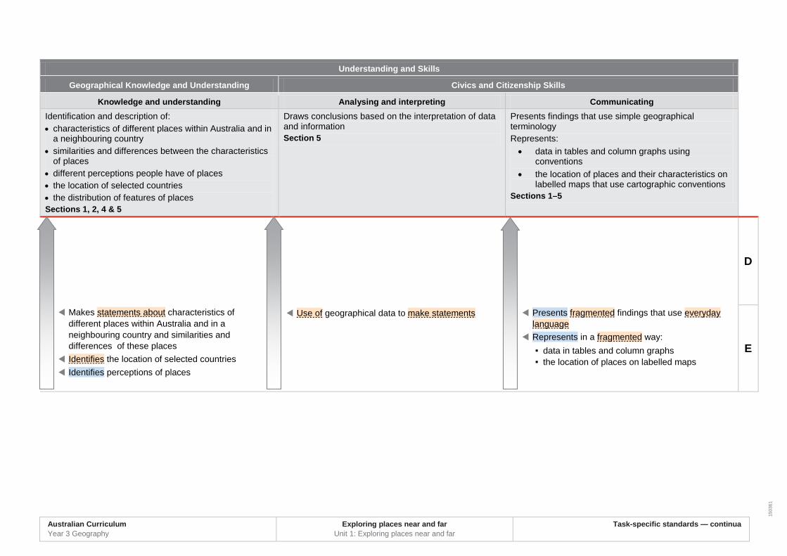
Understanding and Skills
Geographical Knowledge and Understanding Geographical Inquiry and Skills
Knowledge and understanding Interpreting and analysing Communicating Describes characteristics of different places within Australia and in a neighbouring country and identifies and describes similarities and differences between the characteristics of these places Describes the location of selected countries and the distribution of features of places Identifies different perceptions people have of places Sections 1, 2, 4 & 5
Interprets geographical data to describe spatial distributions and draw reasoned conclusions Section 5
Presents findings that use simple geographical terminology Represents: • data in tables and column graphs
• the location of places and their characteristics on labelled maps that use cartographic conventions
Sections 1–5
A
B
C
Australian Curriculum Year 3 Geography sample assessment ׀ Task-specific standards — continua
Exploring places near and far Name ...................................................
Interprets geographical data and information to describe spatial distributions to draw reasoned conclusions
Purposefully presents findings that use relevant geographical terminology
Accurately represents in detail: ▪ data in tables and column graphs ▪ the location of places and their characteristics
on labelled maps that use cartographic conventions
Comprehensively describes characteristics of
different places within Australia and in a neighbouring country and identifies and comprehensively describes similarities and differences between the characteristics of these places
Comprehensively describes the location of selected countries and the distribution of features of places
Identifies and describes in detail different perceptions people have of places
Describes characteristics of different places within Australia and in a neighbouring country and identifies and describes similarities and differences between the characteristics of these places
Describes the location of selected countries and the distribution of features of places
Identifies different perceptions people have of places
Interprets geographical data and information to describe spatial distributions and draw conclusions
Presents findings that use simple geographical terminology
Represents: ▪ data in tables and column graphs ▪ the location of places and their characteristics
on labelled maps that use cartographic conventions
Australian Curriculum Year 3 Geography
Exploring places near and far Unit 1: Exploring places near and far
Task-specific standards — continua
1503
61
Understanding and Skills
Geographical Knowledge and Understanding Civics and Citizenship Skills
Knowledge and understanding Analysing and interpreting Communicating Identification and description of: • characteristics of different places within Australia and in
a neighbouring country • similarities and differences between the characteristics
of places • different perceptions people have of places • the location of selected countries • the distribution of features of places Sections 1, 2, 4 & 5
Draws conclusions based on the interpretation of data and information Section 5
Presents findings that use simple geographical terminology Represents: • data in tables and column graphs using
conventions • the location of places and their characteristics on
labelled maps that use cartographic conventions Sections 1–5
D
E
Use of geographical data to make statements Presents fragmented findings that use everyday language
Represents in a fragmented way: ▪ data in tables and column graphs ▪ the location of places on labelled maps
Makes statements about characteristics of different places within Australia and in a neighbouring country and similarities and differences of these places
Identifies the location of selected countries Identifies perceptions of places
Australian Curriculum Year 3 Geography
Exploring places near and far Unit 1: Exploring places near and far
Task-specific standards — continua
1503
60
© The State of Queensland (Queensland Curriculum and Assessment Authority) and its licensors 2014. All web links correct at time of publication.
Purpose of assessment: Compare the characteristics of places to draw conclusions about what it would be like to live in another country.
A B C D E
Und
erst
andi
ng a
nd S
kills
Geo
grap
hica
l Kno
wle
dge
an
d U
nder
stan
ding
Kno
wle
dge
and
unde
rsta
ndin
g
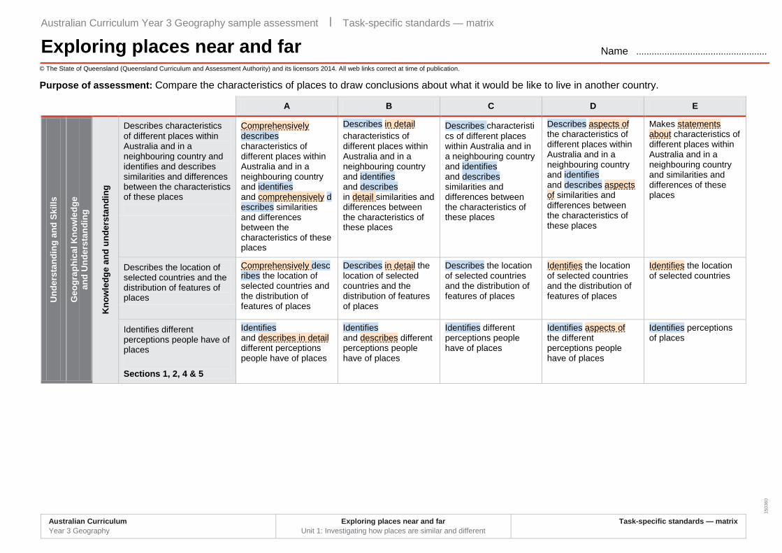
Describes characteristics of different places within Australia and in a neighbouring country and identifies and describes similarities and differences between the characteristics of these places
Comprehensively describes characteristics of different places within Australia and in a neighbouring country and identifies and comprehensively describes similarities and differences between the characteristics of these places
Describes in detail characteristics of different places within Australia and in a neighbouring country and identifies and describes in detail similarities and differences between the characteristics of these places
Describes characteristics of different places within Australia and in a neighbouring country and identifies and describes similarities and differences between the characteristics of these places
Describes aspects of the characteristics of different places within Australia and in a neighbouring country and identifies and describes aspects of similarities and differences between the characteristics of these places
Makes statements about characteristics of different places within Australia and in a neighbouring country and similarities and differences of these places
Describes the location of selected countries and the distribution of features of places
Comprehensively describes the location of selected countries and the distribution of features of places
Describes in detail the location of selected countries and the distribution of features of places
Describes the location of selected countries and the distribution of features of places
Identifies the location of selected countries and the distribution of features of places
Identifies the location of selected countries
Identifies different perceptions people have of places Sections 1, 2, 4 & 5
Identifies and describes in detail different perceptions people have of places
Identifies and describes different perceptions people have of places
Identifies different perceptions people have of places
Identifies aspects of the different perceptions people have of places
Identifies perceptions of places
Australian Curriculum Year 3 Geography sample assessment ׀ Task-specific standards — matrix
Exploring places near and far Name ...................................................
Australian Curriculum Year 3 Geography
Exploring places near and far Unit 1: Investigating how places are similar and different
Task-specific standards — matrix

Australian Curriculum Year 3 Geography sample assessment ׀ Task-specific standards — matrix
Exploring places near and far Name ................................................... © The State of Queensland (Queensland Curriculum and Assessment Authority) and its licensors 2014. All web links correct at time of publication.
Purpose of assessment: Compare the characteristics of places to draw conclusions about what it would be like to live in another country.
A B C D E
Und
erst
andi
ng a
nd S
kills
Geo
grap
hica
l Inq
uiry
an
d S
kills
Inte
rpre
ting
and
anal
ysin
g Interprets geographical data to describe spatial distributions and draw reasoned conclusions Section 5
Interprets geographical data and information to:describe spatial distributions to draw reasoned conclusions
Interprets geographical data and information to describe spatial distributions to draw informed conclusions
Interprets geographical data and information to describe spatial distributions and draw conclusions
Interprets geographical data and information to identify distributions and draw partial conclusions
Use of geographical data to make statements
Com
mun
icat
ing
Presents findings that use simple geographical terminology
Purposefully presents findings that use relevant geographical terminology
Effectively presents findings that: use relevant geographical terminology
Presents findings that use simple geographical terminology
Partially presents findings that use everyday language
Presents fragmented findings that use everyday language
Represents: • data in tables and
column graphs • the location of
places and their characteristics on labelled maps that use cartographic conventions
Sections 1–5
Accurately represents in detail: • data in tables and
column graphs
• the location of places and their characteristics on labelled maps that use cartographic conventions
Represents in detail: • data in tables and
column graphs
• the location of places and their characteristics on labelled maps that use cartographic conventions
Represents: • data in tables and
column graphs
• the location of places and their characteristics on labelled maps that use cartographic conventions
Partially represents: • data in tables and
column graphs
• the location of places and on maps that use aspects of cartographic conventions
Represents in a fragmented way: • data in tables and
column graphs
• the location of places on labelled maps
Australian Curriculum Year 3 Geography
Exploring places near and far Unit 1: Investigating how places are similar and different
Task-specific standards — matrix

1495
1
Framework for comparing countries Use these questions as a guide to comparing the characteristics of places and assessing what it may be like to live in a neighbouring country.
• What types of natural vegetation are found there?
• What kinds of natural animals are found there?
• What types of landforms can you see?
• What is the size of the population? How is distributed?
• Where do people live? • How big or small is the size of the familiy?
• What is the highest and lowest temperature?
• How often does it rain? • How does the climate affect the way people live?
• How do the seasons change the environmental features?
• How is the land used? • How do people travel between places?
• What are the buildings and houses like?
• Where do people shop? • What kinds of products are made there?
• What are the schools like?
• What kinds of services are provided?
Built features
Climate ̶ temperature,
rainfall, seasons
Natural features ̶
landforms, flora, fauna
Population features
Australian Curriculum Year 3 Geography sample assessment ׀ Assessment resource
Exploring places near and far

Australian Curriculum Year 3 Geography
Exploring places near and far Unit1: Investigating how places are similar and different
Assessment resource
Image sources
Farming, Lombok Agriculture Indonesia, Department of Foreign Affairs and Trade's photostream, Creative Commons: Attribution 2.0 Generic, https://www.flickr.com/photos/dfataustralianaid/10665909933
Highway, Jakarta, Java So Traffic, basibanget's photostream, Creative Commons: Attribution 2.0 Generic, https://www.flickr.com/photos/basibanget/1067750012
Bandung City, Java Bandung, Phallin Ooi's photostream, Creative Commons: Attribution 2.0 Generic, https://www.flickr.com/photos/phalinn/8065144756
Tarsier Tarsier in Bohol, Philippines, Roberto Verzo's photostream, Creative Commons: Attribution 2.0 Generic, https://www.flickr.com/photos/verzo/1009489040
Lake Toba, Silimakuta, Sumatra IMG_3031, Ken Marshall's photostream, Creative Commons: Attribution 2.0 Generic, https://www.flickr.com/photos/kenner116/6441494071
Mount Rinjani Beautiful surroundings of Mount Rinjani, Trekking Rinjani's photostream, Creative Commons: Attribution 2.0 Generic, https://www.flickr.com/photos/trekkingrinjani/5936453534
Images originally published in: QCAA’s G20 learning support resource, Indonesia: Environment http://g20.qcaa.qld.edu.au/downloads/pdf/G20_environment_indonesia.pdf
1495
1
© The State of Queensland (Queensland Curriculum and Assessment Authority) and its licensors 2014. All web links correct at time of publication.
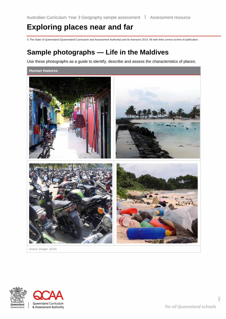
Sample photographs — Life in the Maldives Use these photographs as a guide to identify, describe and assess the characteristics of places.
Human features
Source: Images QCAA
Australian Curriculum Year 3 Geography sample assessment ׀ Assessment resource
Exploring places near and far
Australian Curriculum Year 3 Geography
Exploring places near and far Unit 1: Investigating how places are similar and different
Assessment resource
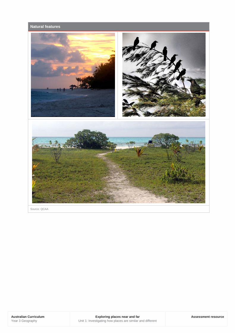
Natural features
Source: QCAA

1495
1
© The State of Queensland (Queensland Curriculum and Assessment Authority) and its licensors 2014. All web links correct at time of publication.
Temperature and rainfall data sources1 Average temperature in 2013 — Australian cities
Brisbane
Jan Feb Mar April May Jun July Aug Sep Oct Nov Dec Annual average
26 26 24 22 19 17 16 17 20 22 23 25 21
Canberra
Jan Feb Mar April May Jun July Aug Sep Oct Nov Dec Annual average
26 20 18 13 9 6 5 7 9 12 15 18 13
Sydney
Jan Feb Mar April May Jun July Aug Sep Oct Nov Dec Annual average
22 23 22 19 18 13 13 14 17 19 20 22 19
Hobart
Jan Feb Mar April May Jun July Aug Sep Oct Nov Dec Annual average
17 22 26 14 19 9 9 10 11 13 14 16 15
Darwin
Jan Feb Mar April May Jun July Aug Sep Oct Nov Dec Annual average
28 29 28 28 27 25 25 26 28 29 30 29 28
Data source: Commonwealth of Australia 2014, Bureau of Meteorology, CC BY 3.0, www.bom.gov.au via World Meteorological Organization, World Weather Information Service, www.worldweather.org
1 All values in this resource have been rounded to whole numbers as the Australian Curriculum: Mathematics does not expect students to use decimal places until Year 4.
Australian Curriculum Year 3 Geography sample assessment ׀ Assessment resource
Exploring places near and far
Australian Curriculum Year 3 Geography
Exploring places near and far Unit 1: Investigating how places are similar and different
Assessment resource
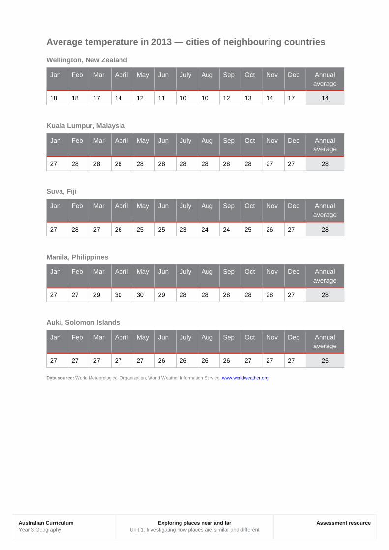
Average temperature in 2013 — cities of neighbouring countries
Wellington, New Zealand
Jan Feb Mar April May Jun July Aug Sep Oct Nov Dec Annual average
18 18 17 14 12 11 10 10 12 13 14 17 14
Kuala Lumpur, Malaysia
Jan Feb Mar April May Jun July Aug Sep Oct Nov Dec Annual average
27 28 28 28 28 28 28 28 28 28 27 27 28
Suva, Fiji
Jan Feb Mar April May Jun July Aug Sep Oct Nov Dec Annual average
27 28 27 26 25 25 23 24 24 25 26 27 28
Manila, Philippines
Jan Feb Mar April May Jun July Aug Sep Oct Nov Dec Annual average
27 27 29 30 30 29 28 28 28 28 28 27 28
Auki, Solomon Islands
Jan Feb Mar April May Jun July Aug Sep Oct Nov Dec Annual average
27 27 27 27 27 26 26 26 26 27 27 27 25
Data source: World Meteorological Organization, World Weather Information Service, www.worldweather.org

Australian Curriculum Year 3 Geography
Exploring places near and far Unit 1: Investigating how places are similar and different
Assessment resource
Average rainfall in 2013 — Australian cities
Brisbane
Jan Feb Mar April May Jun July Aug Sep Oct Nov Dec Annual average
112 155 127 120 104 64 51 30 30.2 70 102 118 91
Canberra
Jan Feb Mar April May Jun July Aug Sep Oct Nov Dec Annual average
62 54 53 50 48 40 42 48 53 65 64 53 52
Sydney
Jan Feb Mar April May Jun July Aug Sep Oct Nov Dec Annual average
96 129 111 140 120 117 80 94 70 83 104 80 102
Hobart
Jan Feb Mar April May Jun July Aug Sep Oct Nov Dec Annual average
44 36 39 44 36 43 47 60 59 56 49 57 48
Darwin
Jan Feb Mar April May Jun July Aug Sep Oct Nov Dec Annual average
465 373 335 107 25 2 1 6 17 65 137 276 150.8
Data source: Commonwealth of Australia 2014, Bureau of Meteorology, CC BY 3.0, www.bom.gov.au via World Meteorological Organization, World Weather Information Service, www.worldweather.org

Australian Curriculum Year 3 Geography
Exploring places near and far Unit 1: Investigating how places are similar and different
Assessment resource
Average rainfall in 2013 — cities of neighbouring countries
Wellington, New Zealand
Jan Feb Mar April May Jun July Aug Sep Oct Nov Dec Annual average
59 61 67 68 86 100 113 93 75 95 75 65 80
Kuala Lumpur, Malaysia
Jan Feb Mar April May Jun July Aug Sep Oct Nov Dec Annual average
169 165 240 259 204 125 127 156 193 253 287 246 202
Suva, Fiji
Jan Feb Mar April May Jun July Aug Sep Oct Nov Dec Annual average
315 286 371 391 267 164 142 159 184 234 264 263 253
Manila, Philippines
Jan Feb Mar April May Jun July Aug Sep Oct Nov Dec Annual average
19 8 11 21 165 265 420 486 330 271 129 75 183
Auki, Solomon Islands
Jan Feb Mar April May Jun July Aug Sep Oct Nov Dec Annual average
397 385 428 257 223 178 239 227 212 227 224 293 274
Data source: World Meteorological Organization, World Weather Information Service, www.worldweather.org

1495
1
© The State of Queensland (Queensland Curriculum and Assessment Authority) and its licensors 2014. All web links correct at time of publication.
Image: Bandung, Phalinn Ooi’s photostream, Creative Commons Attribution 2.0: www.flickr.com/photos/phalinn/8065144756
Compare the characteristics of places to draw conclusions about what it would be like to live in a different country.
You will: · compare characteristics of places within Australia · compare characteristics of places between Australia and a neighbouring country · represent data and information in tables and labelled maps · draw conclusions about what it would be like to live in another country.
Australian Curriculum Year 3 Geography sample assessment ׀ Exploring places near and far: Student booklet
Exploring places near and far
Australian Curriculum Year 3 Geography
Exploring places near and far Unit 1: Investigating how places are similar and different
Student booklet
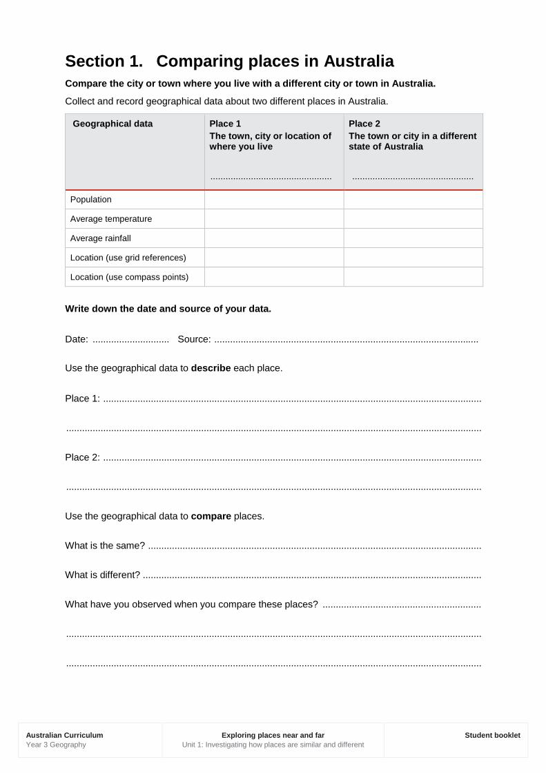
Section 1. Comparing places in Australia Compare the city or town where you live with a different city or town in Australia.
Collect and record geographical data about two different places in Australia.
Geographical data Place 1 The town, city or location of where you live
................................................
Place 2 The town or city in a different state of Australia
................................................
Population
Average temperature
Average rainfall
Location (use grid references)
Location (use compass points)
Write down the date and source of your data.
Date: ............................. Source: ....................................................................................................
Use the geographical data to describe each place.
Place 1: ...............................................................................................................................................
.............................................................................................................................................................
Place 2: ...............................................................................................................................................
.............................................................................................................................................................
Use the geographical data to compare places.
What is the same? ..............................................................................................................................
What is different? ................................................................................................................................
What have you observed when you compare these places? ............................................................
.............................................................................................................................................................
.............................................................................................................................................................
Australian Curriculum Year 3 Geography
Exploring places near and far Unit 1: Investigating how places are similar and different
Student booklet
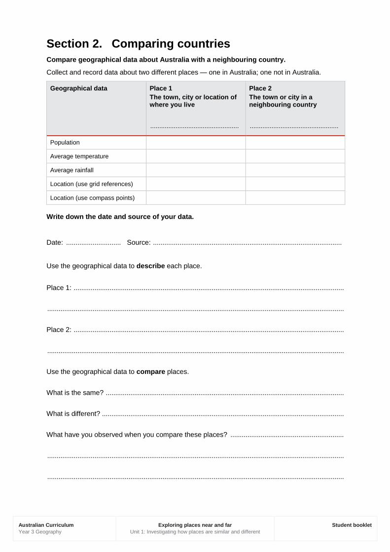
Section 2. Comparing countries Compare geographical data about Australia with a neighbouring country.
Collect and record data about two different places — one in Australia; one not in Australia.
Geographical data Place 1 The town, city or location of where you live
.................................................
Place 2 The town or city in a neighbouring country
.................................................
Population
Average temperature
Average rainfall
Location (use grid references)
Location (use compass points)
Write down the date and source of your data.
Date: ............................. Source: ....................................................................................................
Use the geographical data to describe each place.
Place 1: ...............................................................................................................................................
.............................................................................................................................................................
Place 2: ...............................................................................................................................................
.............................................................................................................................................................
Use the geographical data to compare places.
What is the same? ..............................................................................................................................
What is different? ................................................................................................................................
What have you observed when you compare these places? ............................................................
.............................................................................................................................................................
.............................................................................................................................................................

Australian Curriculum Year 3 Geography
Exploring places near and far Unit 1: Investigating how places are similar and different
Student booklet
Section 3. Representing data Collect and record monthly rainfall amounts for one of the places in your data tables.
Represent the data for one year on a simple column graph like the one below.
Date: 2014 Source: Commonwealth of Australia, Bureau of Meteorology
Jan Feb Mar April May Jun July Aug Sep Oct Nov Dec
7 1 70 21 138 44 140 167 144 38 10 2
Check you have included the following graph conventions:
title
horizontal axis (x) labelled with the months of the year
vertical axis (y) labelled with numbers
a scale on the y axis that increases by the same amount (e.g. 5, 10, 15, 20 …)
intervals of spaces on the x and y axis.
0
20
40
60
80
100
120
140
160
180
Jan Feb Mar Apr May Jun Jul Aug Sep Oct Nov Dec
Uni
ts (m
m)
Month
Perth's rainfall in 2013
Title
Horizontal axis (x)
Vertical axis (y)
A scale on the y axis that increases by the
same amount
Intervals of spaces on the x and
y axis
Dat
a so
urce
: Com
mon
wea
lth o
f Aus
tralia
201
4, B
urea
u of
Met
eoro
logy
, Dai
ly
rain
fall:
Per
th M
etro
, CC
BY
3.0
, ww
w.b
om.g
ov.a
u/cl
imat
e/da
ta/in
dex.
shtm
l

Australian Curriculum Year 3 Geography
Exploring places near and far Unit 1: Investigating how places are similar and different
Student booklet
Title: ...................................................................................................................................................
Geographers look at patterns in data over time.
Describe the pattern of rainfall during the year. What months are the wettest? What months are the driest? Overall is there a big change in rainfall over the year?
.............................................................................................................................................................
.............................................................................................................................................................

Australian Curriculum Year 3 Geography
Exploring places near and far Unit 1: Investigating how places are similar and different
Student booklet
Section 4: Representing places
Locate and label Australia’s neighbouring countries, including:
· Papua New Guinea · Fiji · New Zealand · Malaysia
· Philippines · New Caledonia · Solomon Islands
Locate and shade the following climate zones:
· Tropical · Hot arid (desert) · Temperate · Cold arid (desert)
Complete your map using the following cartographic conventions:
· Title · Legend (key) · North point

Australian Curriculum Year 3 Geography
Exploring places near and far Unit 1: Investigating how places are similar and different
Student booklet
Describe the climate in each zone. Your teacher will provide you with information sources to help you.
Tropical:
.............................................................................................................................................................
.............................................................................................................................................................
Temperate:
.............................................................................................................................................................
.............................................................................................................................................................
Hot arid:
.............................................................................................................................................................
.............................................................................................................................................................
Cold arid:
.............................................................................................................................................................
.............................................................................................................................................................
Which climate you would most like to like to live in and why?
.............................................................................................................................................................
.............................................................................................................................................................
Australian Curriculum Year 3 Geography
Exploring places near and far Unit 1: Investigating how places are similar and different
Student booklet
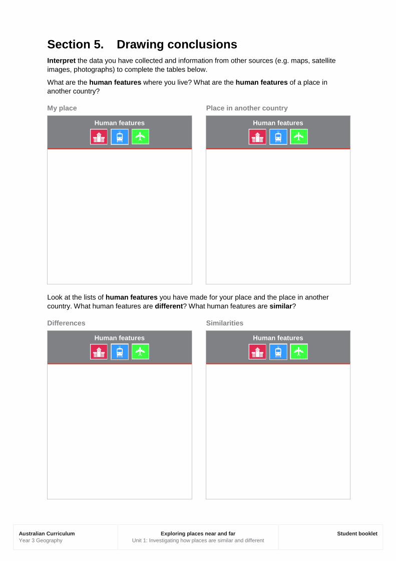
Section 5. Drawing conclusions Interpret the data you have collected and information from other sources (e.g. maps, satellite images, photographs) to complete the tables below.
What are the human features where you live? What are the human features of a place in another country?
My place Place in another country
Human features
Human features
Look at the lists of human features you have made for your place and the place in another country. What human features are different? What human features are similar?
Differences Similarities
Human features
Human features

Australian Curriculum Year 3 Geography
Exploring places near and far Unit 1: Investigating how places are similar and different
Student booklet
What are the natural features where you live? What are the natural features of a place in another country?
My place Place in another country
Natural features
Natural features
Look at the lists of natural features you have made for your place and the place in another country. What natural features are different? What natural features are similar?
Differences Similarities
Natural features
Natural features
Australian Curriculum Year 3 Geography
Exploring places near and far Unit 1: Investigating how places are similar and different
Student booklet
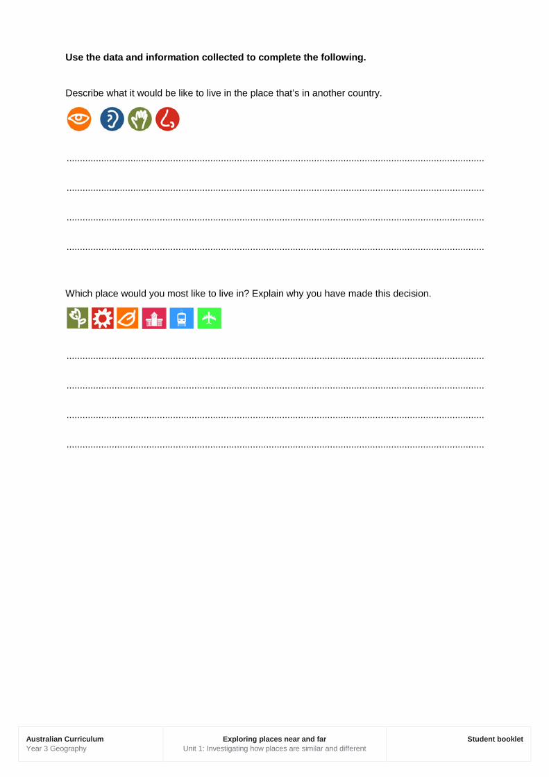
Use the data and information collected to complete the following.
Describe what it would be like to live in the place that’s in another country.
.............................................................................................................................................................
.............................................................................................................................................................
.............................................................................................................................................................
.............................................................................................................................................................
Which place would you most like to live in? Explain why you have made this decision.
.............................................................................................................................................................
.............................................................................................................................................................
.............................................................................................................................................................
.............................................................................................................................................................