australian curriculum year 4 geography sample … curriculum year 4 geography sample assessment ׀...
TRANSCRIPT
XXX
XX
© The State of Queensland (Queensland Curriculum and Assessment Authority) and its licensors 2014. All web links correct at time of publication.
Assessment description Category
Students propose individual actions in response to the geographical challenge of sustaining environments.
Written and multimodal
Technique
Collection of work
Context for assessment Alignment
Students will: · describe the relative locations of places and
countries in different continents · compare the characteristics of different
environments · represent data and information in tables, maps
and in a comparative column graph · interpret data and information to identify patterns,
spatial distributions and draw conclusions · propose actions for sustaining environments.
Australian Curriculum v7.2, Year 4 Geography Australian Curriculum content and achievement standard ACARA — Australian Curriculum, Assessment and Reporting Authority www.australiancurriculum.edu.au Year 4 Geography standard elaborations www.qcaa.qld.edu.au//downloads/p_10/ac_geog _yr4_se.pdf
Connections
This assessment can be used with the QCAA Australian Curriculum resource titled Year 4 unit overview: Geography exemplar —Investigating how environments sustain all life available at: www.qcaa.qld.edu.au/downloads/p_10/ac_geog _yr4_unit_overview.docx
Definitions
Continents: The world’s seven main continuous expanses of land. This includes Europe, Asia, Africa, North America, South America, Australia and Antarctica. Sustainability: This concept is the focus of Year 4 Geography. Students learn about the capacity of the environment to continue to support our lives and the lives of other living things into the future. Natural resources: Materials provided by the environment that are used in production and consumption, e.g. water, timber, oil and food grown as crops. Habitat: A natural environment in which a particular species of animal lives. Climate zone: Major climate zones include tropical, temperate, continental, polar and arid. Vegetation zone: Geographical areas where types of natural vegetation are located. These include grassland, deciduous forest, tundra, desert, coniferous forests and tropical forests. Spatial distribution: The arrangement of a geographical phenomenon or activity across the surface of the Earth, e.g. most of Queensland’s population is concentrated in the south-east coastal area. Deforestation: The process of clearing forests. Relative location: Location in relation to other places described in terms of distance or direction. Comparative column graph: This is used to compare two sets of data on the same axis such as comparing rainfall in two places over the year. Annotated map: A visual way to communicate geographical information in relation to location and characteristics of places on a map.
Australian Curriculum Year 4 Geography sample assessment ׀ Teacher guidelines
Sustaining environments

Australian Curriculum Year 4 Geography
Sustaining environments Unit 1: Investigating how environments sustain all life
Teacher guidelines
In this assessment
Teacher guidelines
Task-specific standards — continua
Task-specific standards — matrix
Assessment resource: Sample annotated map
Assessment resource: Graphic organisers
Assessment resource: Rainfall data sources
Assessment resource: Sustainability links
Student booklet
Teacher guidelines
Identify curriculum Content descriptions to be taught
Geographical Knowledge and Understanding Geographical Inquiry and skills
· The location of the major countries of Africa and South America in relation to Australia, and their main characteristics, including the types of natural vegetation and native animals in at least two countries from both continents (ACHGK020)
· The types of natural vegetation and the significance of vegetation to the environment and to people (ACHGK021)
· The importance of environments to animals and people, and different views on how they can be protected (ACHGK022)
· The natural resources provided by the environment, and different views on how they could be used sustainably (ACHGK024)
Collecting, recording, evaluating and representing · Represent data by constructing tables and graphs
(ACHGS028) · Represent the location of places and their
features by constructing large-scale maps that conform to cartographic conventions including scale, legend, title and north point, and describe their location using simple grid references, compass direction and distance (ACHGS029)
Interpreting, analysing and concluding · Interpret geographical data to identify
distributions and patterns and draw conclusions (ACHGS030)
Communicating · Present findings in a range of communication
forms, for example, written, oral, digital, graphic, tabular and visual, and use geographical terminology (ACHGS031)
Reflecting and responding · Reflect on their learning to propose individual
action in response to a contemporary geographical challenge and identify the expected effects of the proposal (ACHGS032)
General capabilities (GCs) and cross-curriculum priorities (CCPs) This assessment may provide opportunities to engage with the following GCs and CCPs. Refer also to the Resources tab on the P–10 Geography curriculum and assessment page: www.qcaa.qld.edu.au/yr4-geography-resources.html.
Australian Curriculum Year 4 Geography
Sustaining environments Unit 1: Investigating how environments sustain all life
Teacher guidelines
Literacy
Numeracy
ICT capability
Critical and creative thinking
Personal and social capability
Ethical understanding
Intercultural understanding
Aboriginal and Torres Strait Islander histories and cultures
Sustainability
Achievement standard This assessment provides opportunities for students to demonstrate the following highlighted aspects.
By the end of Year 4, students describe and compare the characteristics of places in different locations at the national scale. They identify and describe the interconnections between people and the environment. They describe the location of selected countries in relative terms and identify simple patterns in the distribution of features of places. Students recognise the importance of the environment and identify different views on how to respond to a geographical challenge. Students develop geographical questions to investigate and collect and record information and data from different sources to answer these questions. They represent data and the location of places and their characteristics in simple graphic forms, including large-scale maps that use the cartographic conventions of scale, legend, title and north point. They describe the location of places and their features using simple grid references, compass direction and distance. Students interpret data to identify spatial distributions and simple patterns and draw conclusions. They present findings using geographical terminology in a range of texts. They propose individual action in response to a local geographical challenge and identify the expected effects of their proposed action.
Source: ACARA, The Australian Curriculum v7.0, www.australiancurriculum.edu.au
Sequence learning Suggested learning experiences
This assessment leads on from the learning experiences outlined in the QCAA’s Year 4 Geography unit overview. The knowledge, understanding and skills developed in the exemplar unit will prepare students to engage in this assessment: · See Unit overview: Year 4 Geography exemplar — Investigating how environments sustain all life
www.qcaa.qld.edu.au/downloads/p_10/ac_geog_yr4_unit_overview.docx
Adjustments for needs of learners
The Australian Curriculum, in keeping with Melbourne Declaration on Educational Goals for Young Australians (2008), establishes the expectations of a curriculum appropriate to all Australian students. All students across all education settings and contexts are supported in their diverse learning needs through the three-dimensions of the Australian Curriculum: the learning area content, the general capabilities and the cross-curriculum priorities. The relationship between and the flexibility to emphasis one or more of the dimensions allows teachers to personalise learning programs. To make adjustments, teachers refer to learning area content aligned to the child’s chronological age, personalise learning by emphasising alternate levels of content, general capabilities or cross-curriculum priorities in relation to the chronological age learning area content. The emphasis placed on each area is informed by the child’s current level of learning and their strengths, goals and interests. Advice on the process of curriculum adjustment for all students and in particular for those with disability, gifted and talented or for whom English is an additional language or dialect are addressed in Australian Curriculum — Student Diversity materials.
Australian Curriculum Year 4 Geography
Sustaining environments Unit 1: Investigating how environments sustain all life
Teacher guidelines
For information to support students with diverse learning needs, see: · Queensland Curriculum and Assessment Authority materials for supporting students with diverse
learning needs www.qcaa.qld.edu.au/10188.html · Australian Curriculum Student Diversity
www.australiancurriculum.edu.au/StudentDiversity/Student-diversity-advice · The Melbourne Declaration on Educational Goals for Young Australians
www.curriculum.edu.au/verve/_resources/National_Declaration_on_the_Educational_Goals_for_Young_Australians.pdf
· The Disability Standards for Education www.ag.gov.au.
Resources
Print - Australia Geography Teachers Association 2008, Keys to Geography: Essential skills and tools,
Macmillan, South Yarra. - Catling, S, Willy, T & Butler, J 2012, Teaching Primary Geography for Australian Schools, Hawker
Brownlow, Melbourne. Online · Aboriginal land care, Creative spirits, Jens Korff, www.creativespirits.info/aboriginalculture/land/
aboriginal-land-care · ACARA, Work sample portfolio: Year 4,
www.acara.edu.au/curriculum/worksamples/Year_4_Geography_Portfolio.pdf · Education for Sustainability, Ministry of Education, New Zealand Government, Curriculum resources and
tools, http://efs.tki.org.nz/Curriculum-resources-and-tools · Geogspace, Australian Geography Teachers Association, Climate graphs,
www.geogspace.edu.au/verve/_resources/2.3.2.2_2_climate_graphs.pdf · Global education project, Teacher resource to encourage global thinking across the curriculum,
www.globaleducation.edu.au/resources-gallery/resource-gallery-templates.html · Queensland Curriculum and Assessment Authority, G20 for schools, Interactive map (Climate and
vegetation zones), http://g20.qcaa.qld.edu.au/#level=basic · Queensland Curriculum and Assessment Authority, Year 4 Geography Australian Curriculum in
Queensland, www.qcaa.qld.edu.au/yr4-geography-overview.html · Spatial technologies, such as:
- Google Earth, www.google.com/earth - Google Maps, www.google.com.au/maps
· Wildlife News, The disappearing savannah, http://wildlifenews.co.uk/2012/12/the-disappearing-savannah · World Climate Charts, www.climate-charts.com · World Meteorological Organization, World Weather Information Service,
http://worldweather.wmo.int/en/home.html · World biomes, including climate zones — Blue Planet Biomes, World biomes,
blueplanetbiomes.org/world_biomes.htm · World Wildlife Fund Australia, www.wwf.org.au:
- Living Planet Report 2012, www.wwf.org.au/our_work/people_and_the_ environment/human_footprint/living_planet_report_2012/
- Sustainable living to reduce your personal footprint, www.wwf.org.au/what_you_can_do/change_the_way_you_live/sustainable_living/ (For more ideas for sustainability, see also: Assessment resource: Sustainability links)
Objects · large-scale outline maps · models of maps that conform to cartographic conventions including border, source, scale, legend, and
north point · coloured pencils
Australian Curriculum Year 4 Geography
Sustaining environments Unit 1: Investigating how environments sustain all life
Teacher guidelines
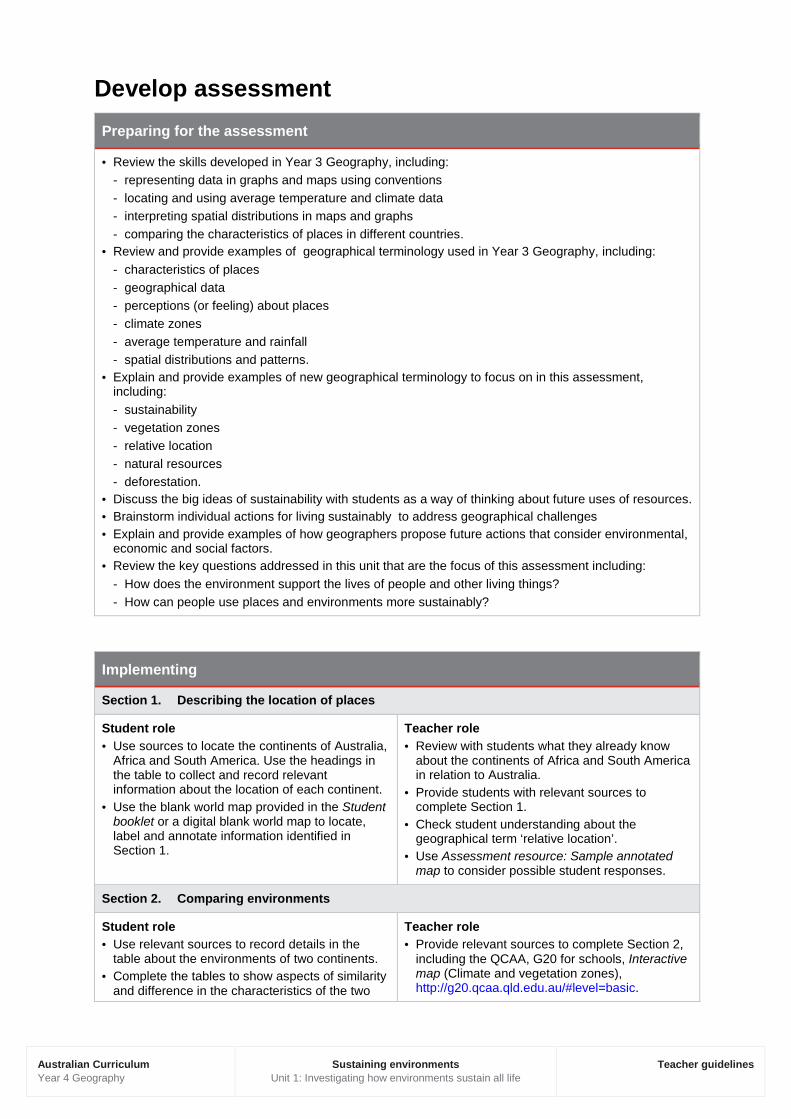
Develop assessment Preparing for the assessment
· Review the skills developed in Year 3 Geography, including: - representing data in graphs and maps using conventions - locating and using average temperature and climate data - interpreting spatial distributions in maps and graphs - comparing the characteristics of places in different countries.
· Review and provide examples of geographical terminology used in Year 3 Geography, including: - characteristics of places - geographical data - perceptions (or feeling) about places - climate zones - average temperature and rainfall - spatial distributions and patterns.
· Explain and provide examples of new geographical terminology to focus on in this assessment, including: - sustainability - vegetation zones - relative location - natural resources - deforestation.
· Discuss the big ideas of sustainability with students as a way of thinking about future uses of resources. · Brainstorm individual actions for living sustainably to address geographical challenges · Explain and provide examples of how geographers propose future actions that consider environmental,
economic and social factors. · Review the key questions addressed in this unit that are the focus of this assessment including:
- How does the environment support the lives of people and other living things? - How can people use places and environments more sustainably?
Implementing
Section 1. Describing the location of places
Student role · Use sources to locate the continents of Australia,
Africa and South America. Use the headings in the table to collect and record relevant information about the location of each continent.
· Use the blank world map provided in the Student booklet or a digital blank world map to locate, label and annotate information identified in Section 1.
Teacher role · Review with students what they already know
about the continents of Africa and South America in relation to Australia.
· Provide students with relevant sources to complete Section 1.
· Check student understanding about the geographical term ‘relative location’.
· Use Assessment resource: Sample annotated map to consider possible student responses.
Section 2. Comparing environments
Student role · Use relevant sources to record details in the
table about the environments of two continents. · Complete the tables to show aspects of similarity
and difference in the characteristics of the two
Teacher role · Provide relevant sources to complete Section 2,
including the QCAA, G20 for schools, Interactive map (Climate and vegetation zones), http://g20.qcaa.qld.edu.au/#level=basic.
Australian Curriculum Year 4 Geography
Sustaining environments Unit 1: Investigating how environments sustain all life
Teacher guidelines
environments in the continents of Africa and South America.
· Check that completed tables have sufficient detail to describe and compare the characteristics of the environments.
· Provide an exemplar of a detailed description and comparison of characteristics of different places. If appropriate, use a different graphic organiser such as a Venn diagram to organise ideas and compare features. See: - Assessment resource: Graphic organisers - example of a completed Venn diagram to show
students: www.learnnc.org/reference/ Venn+diagram.
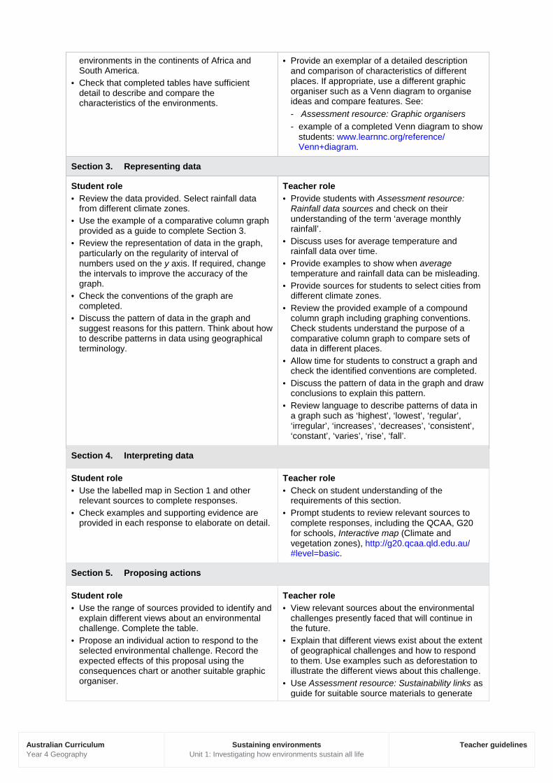
Section 3. Representing data
Student role · Review the data provided. Select rainfall data
from different climate zones. · Use the example of a comparative column graph
provided as a guide to complete Section 3. · Review the representation of data in the graph,
particularly on the regularity of interval of numbers used on the y axis. If required, change the intervals to improve the accuracy of the graph.
· Check the conventions of the graph are completed.
· Discuss the pattern of data in the graph and suggest reasons for this pattern. Think about how to describe patterns in data using geographical terminology.
Teacher role · Provide students with Assessment resource:
Rainfall data sources and check on their understanding of the term ‘average monthly rainfall’.
· Discuss uses for average temperature and rainfall data over time.
· Provide examples to show when average temperature and rainfall data can be misleading.
· Provide sources for students to select cities from different climate zones.
· Review the provided example of a compound column graph including graphing conventions. Check students understand the purpose of a comparative column graph to compare sets of data in different places.
· Allow time for students to construct a graph and check the identified conventions are completed.
· Discuss the pattern of data in the graph and draw conclusions to explain this pattern.
· Review language to describe patterns of data in a graph such as ‘highest’, ‘lowest’, ‘regular’, ‘irregular’, ‘increases’, ‘decreases’, ‘consistent’, ‘constant’, ‘varies’, ‘rise’, ‘fall’.
Section 4. Interpreting data
Student role · Use the labelled map in Section 1 and other
relevant sources to complete responses. · Check examples and supporting evidence are
provided in each response to elaborate on detail.
Teacher role · Check on student understanding of the
requirements of this section. · Prompt students to review relevant sources to
complete responses, including the QCAA, G20 for schools, Interactive map (Climate and vegetation zones), http://g20.qcaa.qld.edu.au/ #level=basic.
Section 5. Proposing actions
Student role · Use the range of sources provided to identify and
explain different views about an environmental challenge. Complete the table.
· Propose an individual action to respond to the selected environmental challenge. Record the expected effects of this proposal using the consequences chart or another suitable graphic organiser.
Teacher role · View relevant sources about the environmental
challenges presently faced that will continue in the future.
· Explain that different views exist about the extent of geographical challenges and how to respond to them. Use examples such as deforestation to illustrate the different views about this challenge.
· Use Assessment resource: Sustainability links as guide for suitable source materials to generate
Australian Curriculum Year 4 Geography
Sustaining environments Unit 1: Investigating how environments sustain all life
Teacher guidelines
discussion. · Review the role of geography in developing
actions to respond to present and future challenges.
· Review graphic organisers identified in Assessment resource: Graphic organisers. Discuss how these tools develop geographical thinking.
Make judgments When making judgments about the evidence in student’s responses to this assessment, teachers are advised to use the task-specific standards provided. The development of these task-specific standards has been informed by the Queensland Geography standard elaborations. See www.qcaa.qld.edu.au/downloads/p_10/ac_geog_yr3_se.pdf.
The Queensland standard elaborations for Geography The Queensland Year 4 standard elaborations for Geography are a resource to assist teachers to make consistent and comparable evidence-based A to E (or the Early Years equivalent) judgments. They should be used in conjunction with the Australian Curriculum achievement standard and content descriptions for the relevant year level.
The Queensland Geography standard elaborations provide a basis for judging how well students have demonstrated what they know, understand and can do using the Australian Curriculum achievement standard.
The Australian Curriculum achievement standards dimensions of Understanding and Skills are used to organise the Queensland Geography standard elaborations.
The valued features of Geography, drawn from the achievement standard and the content descriptions are organised as:
· Knowledge and understanding
· Interpreting and analysing
· Communicating.
Task-specific standards Task-specific standards give teachers:
· a tool for directly matching the evidence of learning in the response to the standards
· a focal point for discussing students’ responses
· a tool to help provide feedback to students.
Task-specific standards are not a checklist; rather they are a guide that:
· highlights the valued features that are being targeted in the assessment and the qualities that will inform the overall judgment
· specifies particular targeted aspects of the curriculum content and achievement standard
· aligns the valued feature, task-specific descriptor and assessment
Australian Curriculum Year 4 Geography
Sustaining environments Unit 1: Investigating how environments sustain all life
Teacher guidelines
· allows teachers to make consistent and comparable on-balance judgments about a child’s work by matching the qualities of students’ responses with the descriptors
· clarifies the curriculum expectations for learning at each of the five grades (A–E or the Early Years equivalent)
· shows the connections between what students are expected to know and do, and how their responses will be judged and the qualities that will inform the overall judgment
· supports evidence-based discussions to help students gain a better understanding of how they can critique their own responses and achievements, and identify the qualities needed to improve
· encourages and provides the basis for conversations among teachers, students and parents/carers about the quality of students’ work and curriculum expectations and related standards.
Task-specific valued features Task-specific valued features are the discrete aspects of the valued features of Geography targeted in a particular assessment and incorporated into the task-specific standards for that assessment. They are selected from the Queensland Geography standard elaborations valued features drawn from the Australian Curriculum achievement standard and content descriptions.
Task-specific valued features for this assessment
The following table identifies the valued features for this assessment and makes explicit the understandings and skills that students will have the opportunity to demonstrate. This ensures that the alignment between what is taught, what is assessed and what is reported is clear.

Australian Curriculum Year 4 Geography
Sustaining environments Unit 1: Investigating how environments sustain all life
Teacher guidelines
Australian Curriculum achievement standard dimensions
Australian Curriculum achievement standard
Queensland standard elaborations valued features
Task-specific valued features
Und
erst
andi
ng a
nd S
kills
Geographical Knowledge and Understanding
Knowledge and understanding
Describe and compare the characteristics of places in the continents of Australia, South America and Africa. Describe the location of selected countries in relative terms. Identify different views on sustaining environments. Recognise the importance of the environment. Sections 1, 2, 4 and 5
Geographical Inquiry and Skills
Interpreting and analysing
Interpret geographical data to identify spatial distributions, simple patterns and draw conclusions. Propose individual action in response to a geographical challenge and identify the expected effects of the proposed action. Sections 4 and 5
Communicating Present findings about sustainability of environments using geographical terminology. Represent rainfall data in a comparative column graph and the location of places and their characteristics on a large-scale map that uses the cartographic conventions of scale, legend, title and north point. Sections 1, 3 and 5
The task-specific standards for this assessment are provided in two models using the same task-specific valued features:
· a matrix
· a continua
Matrix and continua Task-specific standards can be prepared as a matrix or continua. Both the continua and the matrix:
· use the Queensland standard elaborations to develop task-specific descriptors to convey expected qualities in students’ work — A to E (or the Early Years equivalent)
· highlight the same valued features from the Queensland standard elaborations that are being targeted in the assessment and the qualities that will inform the overall judgment
Australian Curriculum Year 4 Geography
Sustaining environments Unit 1: Investigating how environments sustain all life
Teacher guidelines
· incorporate the same task-specific valued features, i.e. make explicit the particular understanding / skills that students have the opportunity to demonstrate for each selected valued feature
· provide a tool for directly matching the evidence of learning in the child’s response to the standards to make an on-balance judgment about achievement
· assist teachers to make consistent and comparable evidence-based A to E (or the Early Years equivalent) judgments.
Continua
The continua model of task-specific standards uses the dimensions of the Australian Curriculum achievement standard to organise task-specific valued features and standards as a number of reference points represented progressively along an A to E (or Early Years equivalent) continuum. The task-specific valued features at each point are described holistically. The task-specific descriptors of the standard use the relevant degrees of quality described in the Queensland standard elaborations.
Teachers determine a position along each continuum that best matches the evidence in the student’s responses to make an on-balance judgment about achievement on the task.
The continua model is a tool for making an overall on-balance judgment about the assessment and for providing feedback on task specific valued features.
Matrix
The matrix model of task-specific standards uses the structure of the Queensland standard elaborations to organise the task-specific valued features and standards A to E (or the Early Years equivalent). The task-specific descriptors of the standard described in the matrix model use the same degrees of quality described in the Queensland standard elaborations.
Teachers make a judgment about the task-specific descriptor in the A to E (or the Early Years equivalent) cell of the matrix that best matches the evidence in the student’s responses in order to make an on-balance judgment about how well the pattern of evidence meets the standard.
The matrix is a tool for making both overall on-balance judgments and analytic judgments about the assessment. Achievement in each valued feature of the Queensland standard elaboration targeted in the assessment can be recorded and feedback can be provided on the task-specific valued features.
Australian Curriculum Year 4 Geography
Sustaining environments Unit 1: Investigating how environments sustain all life
Teacher guidelines
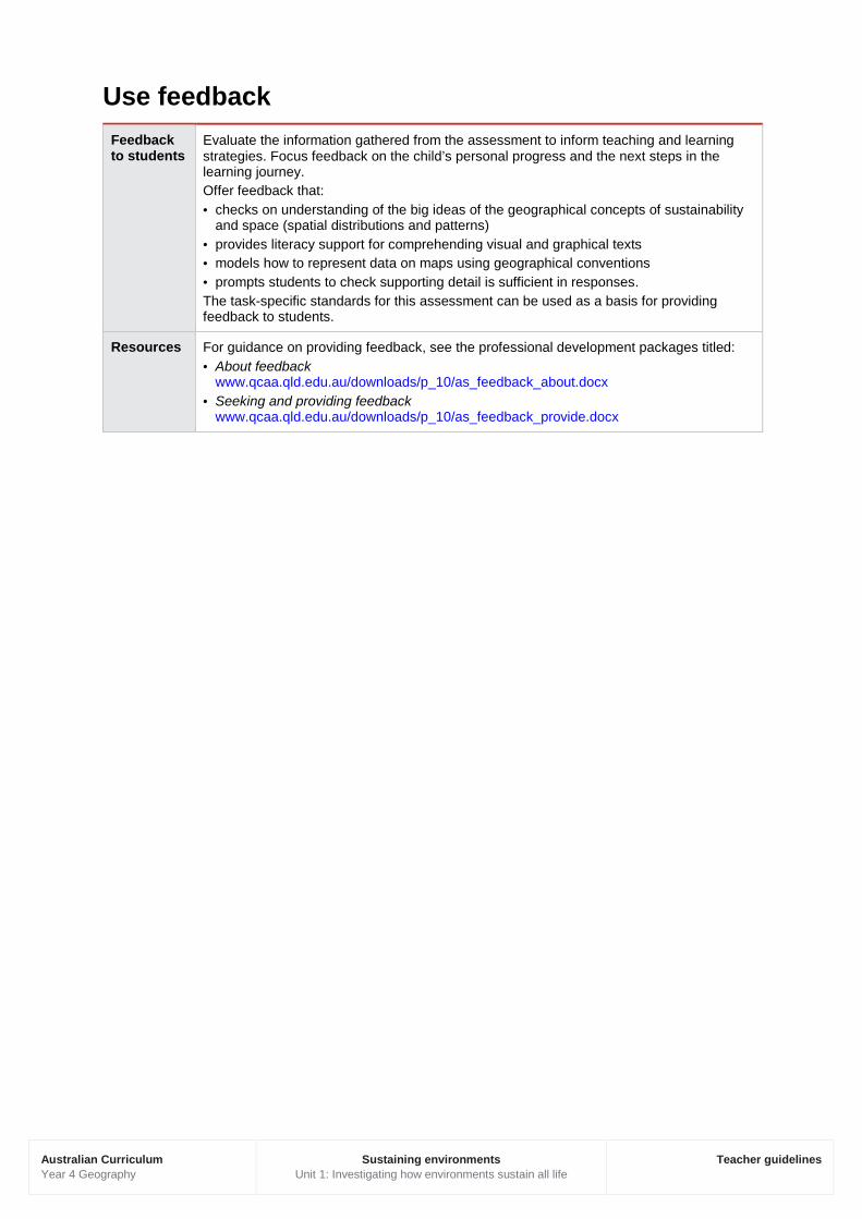
Use feedback Feedback to students
Evaluate the information gathered from the assessment to inform teaching and learning strategies. Focus feedback on the child’s personal progress and the next steps in the learning journey. Offer feedback that: · checks on understanding of the big ideas of the geographical concepts of sustainability
and space (spatial distributions and patterns) · provides literacy support for comprehending visual and graphical texts · models how to represent data on maps using geographical conventions · prompts students to check supporting detail is sufficient in responses. The task-specific standards for this assessment can be used as a basis for providing feedback to students.
Resources For guidance on providing feedback, see the professional development packages titled: · About feedback
www.qcaa.qld.edu.au/downloads/p_10/as_feedback_about.docx · Seeking and providing feedback
www.qcaa.qld.edu.au/downloads/p_10/as_feedback_provide.docx
1503
63
© The State of Queensland (Queensland Curriculum and Assessment Authority) and its licensors 2014. All web links correct at time of publication.
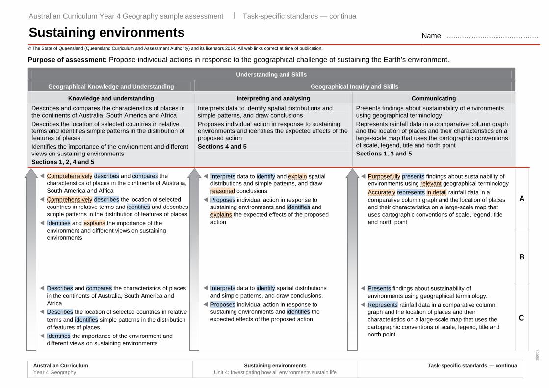
Purpose of assessment: Propose individual actions in response to the geographical challenge of sustaining the Earth’s environment.
Understanding and Skills
Geographical Knowledge and Understanding Geographical Inquiry and Skills
Knowledge and understanding Interpreting and analysing Communicating Describes and compares the characteristics of places in the continents of Australia, South America and Africa Describes the location of selected countries in relative terms and identifies simple patterns in the distribution of features of places Identifies the importance of the environment and different views on sustaining environments Sections 1, 2, 4 and 5
Interprets data to identify spatial distributions and simple patterns, and draw conclusions Proposes individual action in response to sustaining environments and identifies the expected effects of the proposed action Sections 4 and 5
Presents findings about sustainability of environments using geographical terminology Represents rainfall data in a comparative column graph and the location of places and their characteristics on a large-scale map that uses the cartographic conventions of scale, legend, title and north point Sections 1, 3 and 5
A
B
C
Australian Curriculum Year 4 Geography sample assessment ׀ Task-specific standards — continua
Sustaining environments Name ...................................................
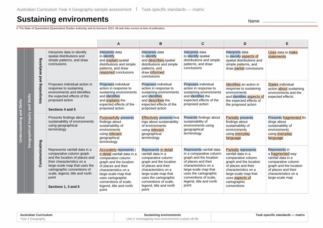
Interprets data to identify and explain spatial distributions and simple patterns, and draw reasoned conclusions
Proposes individual action in response to sustaining environments and identifies and explains the expected effects of the proposed action
Purposefully presents findings about sustainability of environments using relevant geographical terminology Accurately represents in detail rainfall data in a comparative column graph and the location of places and their characteristics on a large-scale map that uses cartographic conventions of scale, legend, title and north point
Comprehensively describes and compares the characteristics of places in the continents of Australia, South America and Africa
Comprehensively describes the location of selected countries in relative terms and identifies and describes simple patterns in the distribution of features of places
Identifies and explains the importance of the environment and different views on sustaining environments
Describes and compares the characteristics of places in the continents of Australia, South America and Africa
Describes the location of selected countries in relative terms and identifies simple patterns in the distribution of features of places
Identifies the importance of the environment and different views on sustaining environments
Interprets data to identify spatial distributions and simple patterns, and draw conclusions.
Proposes individual action in response to sustaining environments and identifies the expected effects of the proposed action.
Presents findings about sustainability of environments using geographical terminology.
Represents rainfall data in a comparative column graph and the location of places and their characteristics on a large-scale map that uses the cartographic conventions of scale, legend, title and north point.
Australian Curriculum Year 4 Geography
Sustaining environments Unit 4: Investigating how all environments sustain life
Task-specific standards — continua
1503
63
Understanding and Skills
Geographical Knowledge and Understanding Geographical Inquiry and Skills
Knowledge and understanding Interpreting and analysing Communicating Describes and compares the characteristics of places in the continents of Australia, South America and Africa. Describes the location of selected countries in relative terms. Identifies different views on sustaining environments. Recognises the importance of the environment. Sections 1, 2, 4 and 5
Interprets geographical data to identify spatial distributions, simple patterns and draw conclusions. Proposes individual action in response to a geographical challenge and identify the expected effects of the proposed action. Sections 4 and 5
Presents findings about sustainability of environments using geographical terminology. Represents rainfall data in a comparative column graph and the location of places and their characteristics on a large-scale map that uses the cartographic conventions of scale, legend, title and north point. Sections 1, 3 and 5
D
E
Uses data to make statements States individual action about sustaining
environments and the expected effects
Presents fragmented findings about sustainability of environments using everyday language
Represents in a fragmented way rainfall data in a comparative column graph and the location of places and their characteristics on a large-scale map
Makes statements about the characteristics of places in the continents of Australia, South America and Africa
Identifies the location of selected countries and makes statements about the features of places
Makes statements about the environment and views on sustaining environments
Australian Curriculum Year 4 Geography
Sustaining environments Unit 4: Investigating how all environments sustain life
Task-specific standards — continua
1503
62
© The State of Queensland (Queensland Curriculum and Assessment Authority) and its licensors 2014. All web links correct at time of publication.
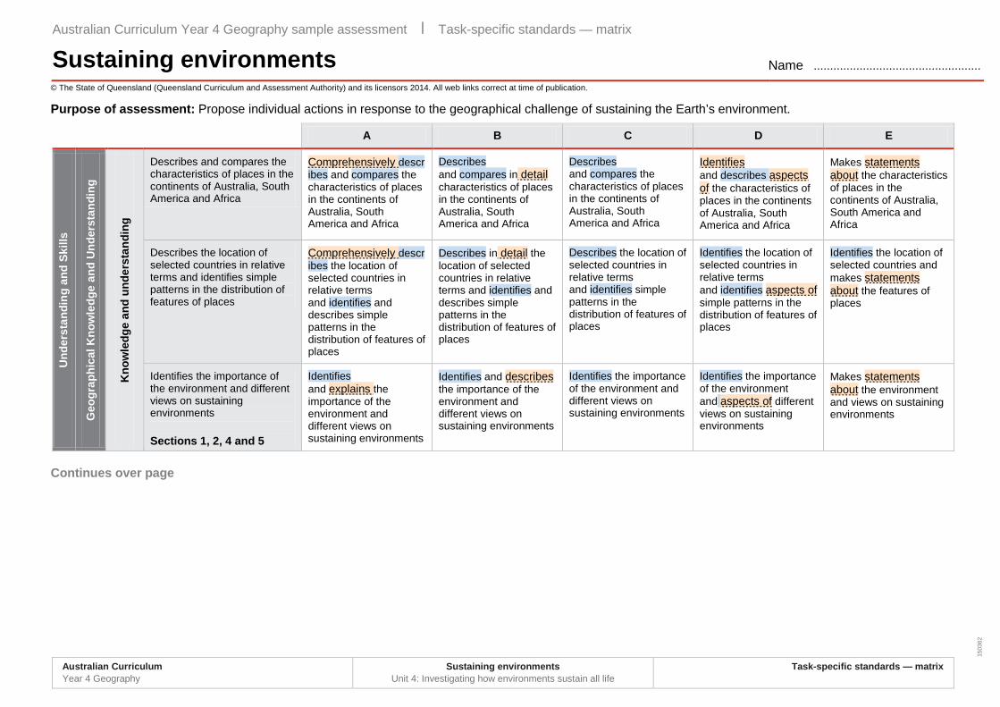
Purpose of assessment: Propose individual actions in response to the geographical challenge of sustaining the Earth’s environment.
A B C D E
Und
erst
andi
ng a
nd S
kills
Geo
grap
hica
l Kno
wle
dge
and
Und
erst
andi
ng
Kno
wle
dge
and
unde
rsta
ndin
g
Describes and compares the characteristics of places in the continents of Australia, South America and Africa
Comprehensively describes and compares the characteristics of places in the continents of Australia, South America and Africa
Describes and compares in detail characteristics of places in the continents of Australia, South America and Africa
Describes and compares the characteristics of places in the continents of Australia, South America and Africa
Identifies and describes aspects of the characteristics of places in the continents of Australia, South America and Africa
Makes statements about the characteristics of places in the continents of Australia, South America and Africa
Describes the location of selected countries in relative terms and identifies simple patterns in the distribution of features of places
Comprehensively describes the location of selected countries in relative terms and identifies and describes simple patterns in the distribution of features of places
Describes in detail the location of selected countries in relative terms and identifies and describes simple patterns in the distribution of features of places
Describes the location of selected countries in relative terms and identifies simple patterns in the distribution of features of places
Identifies the location of selected countries in relative terms and identifies aspects of simple patterns in the distribution of features of places
Identifies the location of selected countries and makes statements about the features of places
Identifies the importance of the environment and different views on sustaining environments Sections 1, 2, 4 and 5
Identifies and explains the importance of the environment and different views on sustaining environments
Identifies and describes the importance of the environment and different views on sustaining environments
Identifies the importance of the environment and different views on sustaining environments
Identifies the importance of the environment and aspects of different views on sustaining environments
Makes statements about the environment and views on sustaining environments
Continues over page
Australian Curriculum Year 4 Geography sample assessment ׀ Task-specific standards — matrix
Sustaining environments Name ...................................................
Australian Curriculum Year 4 Geography
Sustaining environments Unit 4: Investigating how environments sustain all life
Task-specific standards — matrix
© The State of Queensland (Queensland Studies Authority) and its licensors 2013. All web links correct at time of publication.
A B C D E
Und
erst
andi
ng a
nd S
kills
Geo
grap
hica
l Inq
uiry
and
Ski
lls
Inte
rpre
ting
and
anal
ysin
g
Interprets data to identify spatial distributions and simple patterns, and draw conclusions
Interprets data to identify and explain spatial distributions and simple patterns, and draw reasoned conclusions
Interprets data to identify and describes spatial distributions and simple patterns, and draw informed conclusions
Interprets data to identify spatial distributions and simple patterns, and draw conclusions
Interprets data to identify aspects of spatial distributions and simple patterns, and draw partial conclusions
Uses data to make statements
Proposes individual action in response to sustaining environments and identifies the expected effects of the proposed action Sections 4 and 5
Proposes individual action in response to sustaining environments and identifies and explains the expected effects of the proposed action
Proposes individual action in response to sustaining environments and identifies and describes the expected effects of the proposed action
Proposes individual action in response to sustaining environments and identifies the expected effects of the proposed action
Identifies an action in response to sustaining environments and identifies aspects of the expected effects of the proposed action
States individual action about sustaining environments and the expected effects
Com
mun
icat
ing
Presents findings about sustainability of environments using geographical terminology
Purposefully presents findings about sustainability of environments using relevant geographical terminology
Effectively presents findings about sustainability of environments using relevant geographical terminology
Presents findings about sustainability of environments using geographical terminology
Partially presents findings about sustainability of environments using everyday language
Presents fragmented findings about sustainability of environments using everyday language
Represents rainfall data in a comparative column graph and the location of places and their characteristics on a large-scale map that uses the cartographic conventions of scale, legend, title and north point Sections 1, 3 and 5
Accurately represents in detail rainfall data in a comparative column graph and the location of places and their characteristics on a large-scale map that uses cartographic conventions of scale, legend, title and north point
Represents in detail rainfall data in a comparative column graph and the location of places and their characteristics on a large-scale map that uses the cartographic conventions of scale, legend, title and north point
Represents rainfall data in a comparative column graph and the location of places and their characteristics on a large-scale map that uses the cartographic conventions of scale, legend, title and north point
Partially represents rainfall data in a comparative column graph and the location of places and their characteristics on a large-scale map that uses aspects of cartographic conventions
Represents in a fragmented way rainfall data in a comparative column graph and the location of places and their characteristics on a large-scale map
Australian Curriculum Year 4 Geography sample assessment ׀ Task-specific standards — matrix
Sustaining environments Name ...................................................
Australian Curriculum Year 4 Geography
Sustaining environments Unit 4: Investigating how environments sustain all life
Task-specific standards — matrix
1499
2
© The State of Queensland (Queensland Curriculum and Assessment Authority) and its licensors 2014. All web links correct at time of publication.
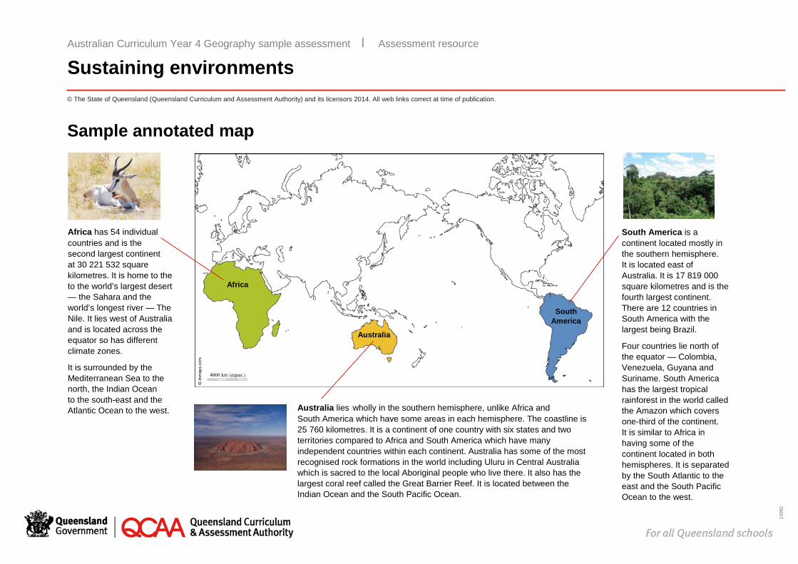
Sample annotated map
Australian Curriculum Year 4 Geography sample assessment ׀ Assessment resource
Sustaining environments
South America is a continent located mostly in the southern hemisphere. It is located east of Australia. It is 17 819 000 square kilometres and is the fourth largest continent. There are 12 countries in South America with the largest being Brazil.
Four countries lie north of the equator — Colombia, Venezuela, Guyana and Suriname. South America has the largest tropical rainforest in the world called the Amazon which covers one-third of the continent. It is similar to Africa in having some of the continent located in both hemispheres. It is separated by the South Atlantic to the east and the South Pacific Ocean to the west.
Africa has 54 individual countries and is the second largest continent at 30 221 532 square kilometres. It is home to the to the world’s largest desert — the Sahara and the world’s longest river — The Nile. It lies west of Australia and is located across the equator so has different climate zones.
It is surrounded by the Mediterranean Sea to the north, the Indian Ocean to the south-east and the Atlantic Ocean to the west. Australia lies wholly in the southern hemisphere, unlike Africa and
South America which have some areas in each hemisphere. The coastline is 25 760 kilometres. It is a continent of one country with six states and two territories compared to Africa and South America which have many independent countries within each continent. Australia has some of the most recognised rock formations in the world including Uluru in Central Australia which is sacred to the local Aboriginal people who live there. It also has the largest coral reef called the Great Barrier Reef. It is located between the Indian Ocean and the South Pacific Ocean.
Africa
South America
Australia
1499
2
© The State of Queensland (Queensland Curriculum and Assessment Authority) and its licensors 2014. All web links correct at time of publication.
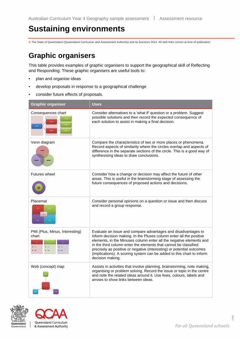
Graphic organisers This table provides examples of graphic organisers to support the geographical skill of Reflecting and Responding. These graphic organisers are useful tools to:
· plan and organise ideas
· develop proposals in response to a geographical challenge
· consider future effects of proposals.
Graphic organiser Uses
Consequences chart
Consider alternatives to a 'what if' question or a problem. Suggest possible solutions and then record the expected consequence of each solution to assist in making a final decision.
Venn diagram
Compare the characteristics of two or more places or phenomena. Record aspects of similarity where the circles overlap and aspects of difference in the separate sections of the circle. This is a good way of synthesising ideas to draw conclusions.
Futures wheel
Consider how a change or decision may affect the future of other areas. This is useful in the brainstorming stage of assessing the future consequences of proposed actions and decisions.
Placemat
Consider personal opinions on a question or issue and then discuss and record a group response.
PMI (Plus, Minus, Interesting) chart
Evaluate an issue and compare advantages and disadvantages to inform decision making. In the Pluses column enter all the positive elements, in the Minuses column enter all the negative elements and in the third column enter the elements that cannot be classified precisely as positive or negative (Interesting) or potential outcomes (Implications). A scoring system can be added to this chart to inform decision making.
Web (concept) map
Assists in activities that involve planning, brainstorming, note making, organising or problem solving. Record the issue or topic in the centre and note the related ideas around it. Use lines, colours, labels and arrows to show links between ideas.
Australian Curriculum Year 4 Geography sample assessment ׀ Assessment resource
Sustaining environments
1499
2
© The State of Queensland (Queensland Curriculum and Assessment Authority) and its licensors 2014. All web links correct at time of publication.
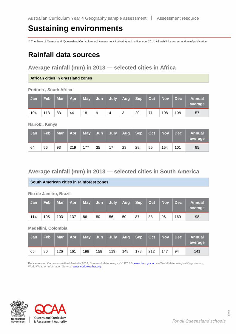
Rainfall data sources Average rainfall (mm) in 2013 — selected cities in Africa
African cities in grassland zones
Pretoria , South Africa
Jan Feb Mar Apr May Jun July Aug Sep Oct Nov Dec Annual average
104 113 83 44 18 9 4 3 20 71 108 108 57
Nairobi, Kenya
Jan Feb Mar Apr May Jun July Aug Sep Oct Nov Dec Annual average
64 56 93 219 177 35 17 23 28 55 154 101 85
Average rainfall (mm) in 2013 — selected cities in South America
South American cities in rainforest zones
Rio de Janeiro, Brazil
Jan Feb Mar Apr May Jun July Aug Sep Oct Nov Dec Annual average
114 105 103 137 86 80 56 50 87 88 96 169 98
Medellini, Colombia
Jan Feb Mar Apr May Jun July Aug Sep Oct Nov Dec Annual average
65 80 126 161 199 158 119 148 178 212 147 94 141
Data sources: Commonwealth of Australia 2014, Bureau of Meteorology, CC BY 3.0, www.bom.gov.au via World Meteorological Organization, World Weather Information Service, www.worldweather.org
Australian Curriculum Year 4 Geography sample assessment ׀ Assessment resource
Sustaining environments
1499
2
© The State of Queensland (Queensland Curriculum and Assessment Authority) and its licensors 2014. All web links correct at time of publication.
Sustainability links The World Wide Fund for Nature (WWF) is an international non-government organisation that works on the conservation, research and restoration of the environment.
The following videos produced by WWF provide an overview of environmental challenges and propose individual actions for sustainable living. These may be used as examples for students.
Title Synopsis
The world’s largest rainforest: The Amazon www.youtube.com/watch?v=bYAZ3NWVgtc
‘Identifies the significance of the Amazon as the world’s largest rainforest that is home to one in ten known species on Earth.’ (4 September 2013)
Change the way you think www.youtube.com/watch?v=nDTmjR_GG1w
‘We live on a finite planet and sometimes our impact on it is greater than we realise. This video identifies how individual actions we take every day impact on the world’s environment.’ (3 February 2009)
Change the way you think about food www.youtube.com/watch?v=s_JLmxhnpNY
‘How do we balance the needs of a growing population with a finite planet? This video identifies ways of meeting the challenge of feeding another 2 billion people by the year 2050.’ (12 October 2011)
How your T-shirt can make the difference www.youtube.com/watch?v=10ypcpbWIFo
‘Did you know that the T-shirt on your back has a major impact on the planet? Producing it takes a lot of energy to get it from the cotton fields to your closet. But some of your T-shirt's biggest impacts are in how you care for it. Here's how you can help reduce its effect on the environment.’ (14 January 2013)
Change the way you think about your laptop www.youtube.com/watch?v=EfKOwS3IxhU
‘Do you know what goes into making your laptop? Raw materials for electronic goods are mined from tropical rainforests, but as resources dry up, recycling aluminium is key. This video provides an insight into what our world would be like if more products recycled or reused existing materials.’ (12 October 2011)
Australian Curriculum Year 4 Geography sample assessment ׀ Assessment resource
Sustaining environments
1499
2
© The State of Queensland (Queensland Curriculum and Assessment Authority) and its licensors 2014. All web links correct at time of publication.
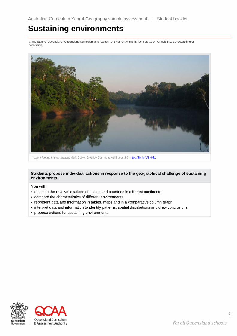
Image: Morning in the Amazon, Mark Goble, Creative Commons Attribution 2.0, https://flic.kr/p/8XNkq
Students propose individual actions in response to the geographical challenge of sustaining environments.
You will: · describe the relative locations of places and countries in different continents · compare the characteristics of different environments · represent data and information in tables, maps and in a comparative column graph · interpret data and information to identify patterns, spatial distributions and draw conclusions · propose actions for sustaining environments.
Australian Curriculum Year 4 Geography sample assessment ׀ Student booklet
Sustaining environments
Australian Curriculum Year 4 Geography
Sustaining environments Unit 1: Investigating how
environments sustain all life
Student booklet
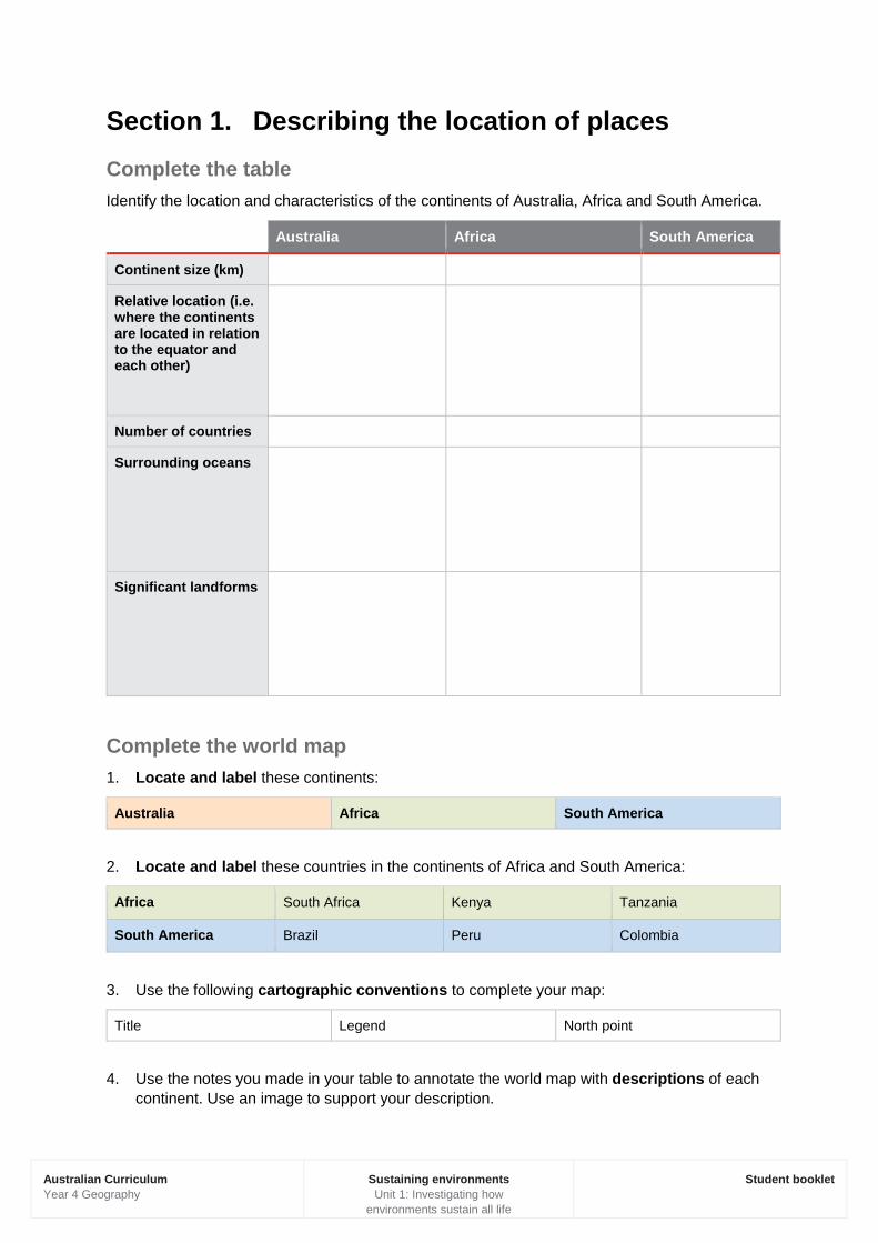
Section 1. Describing the location of places Complete the table Identify the location and characteristics of the continents of Australia, Africa and South America.
Australia Africa South America
Continent size (km)
Relative location (i.e. where the continents are located in relation to the equator and each other)
Number of countries
Surrounding oceans
Significant landforms
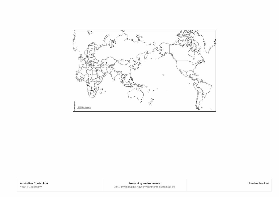
Complete the world map 1. Locate and label these continents:
Australia Africa South America
2. Locate and label these countries in the continents of Africa and South America:
Africa South Africa Kenya Tanzania
South America Brazil Peru Colombia
3. Use the following cartographic conventions to complete your map:
Title Legend North point
4. Use the notes you made in your table to annotate the world map with descriptions of each continent. Use an image to support your description.
Australian Curriculum Year 4 Geography
Sustaining environments Unit1: Investigating how environments sustain all life
Student booklet
Australian Curriculum Year 4 Geography
Sustaining environments Unit1: Investigating how
environments sustain all life
Student booklet
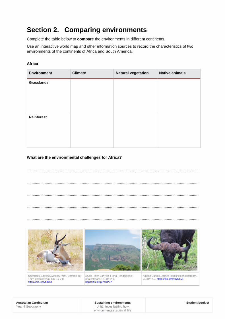
Section 2. Comparing environments Complete the table below to compare the environments in different continents.
Use an interactive world map and other information sources to record the characteristics of two environments of the continents of Africa and South America.
Africa
Environment Climate Natural vegetation Native animals
Grasslands
Rainforest
What are the environmental challenges for Africa?
.............................................................................................................................................................
.............................................................................................................................................................
.............................................................................................................................................................
.............................................................................................................................................................
.............................................................................................................................................................
Springbok, Etosha National Park, Damien du Toit's photostream, CC BY 2.0, https://flic.kr/p/hT35r
Blyde River Canyon, Fiona Henderson's photostream, CC BY 2.0, https://flic.kr/p/7oKP97
African Buffalo, James Hopkirk's photostream, CC BY 2.0, https://flic.kr/p/5DMEZP

Australian Curriculum Year 4 Geography
Sustaining environments Unit1: Investigating how
environments sustain all life
Student booklet
South America
Environment Climate Natural vegetation Native animals
Grasslands
Rainforest
What are the environmental challenges for South America?
.............................................................................................................................................................
.............................................................................................................................................................
.............................................................................................................................................................
.............................................................................................................................................................
.............................................................................................................................................................
IMG_6346/Brazil/Mato Grosso Do Sul/Pantanal/Giant Antéater/Grand Fourmilier/Tamanoir, dany13's photostream, CC BY 2.0, https://flic.kr/p/j4hDiB
Golden lion tamarin, Bart van Dorp's photostream, CC BY 2.0, https://flic.kr/p/npxmd1
Amazon rainforest near Puerto Maldonado, Ivan Mlinaric's photostream, CC BY 2.0, https://flic.kr/p/5RGCpJ
Australian Curriculum Year 4 Geography
Sustaining environments Unit1: Investigating how
environments sustain all life
Student booklet
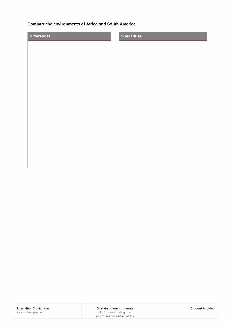
Compare the environments of Africa and South America.
Differences Similarities
Australian Curriculum Year 4 Geography
Sustaining environments Unit1: Investigating how
environments sustain all life
Student booklet
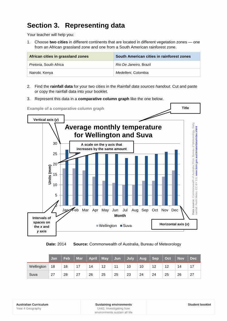
Section 3. Representing data Your teacher will help you:
1. Choose two cities in different continents that are located in different vegetation zones — one from an African grassland zone and one from a South American rainforest zone.
African cities in grassland zones South American cities in rainforest zones
Pretoria, South Africa Rio De Janeiro, Brazil
Nairobi, Kenya Medelleni, Colombia
2. Find the rainfall data for your two cities in the Rainfall data sources handout. Cut and paste or copy the rainfall data into your booklet.
3. Represent this data in a comparative column graph like the one below.
Example of a comparative column graph
Date: 2014 Source: Commonwealth of Australia, Bureau of Meteorology
Jan Feb Mar April May Jun July Aug Sep Oct Nov Dec
Wellington 18 18 17 14 12 11 10 10 12 12 14 17
Suva 27 28 27 26 25 25 23 24 24 25 26 27
0
5
10
15
20
25
30
Jan Feb Mar Apr May Jun Jul Aug Sep Oct Nov Dec
Uni
ts (m
m)
Month
Average monthly temperature for Wellington and Suva
Wellington Suva
Title
Vertical axis (y)
A scale on the y axis that increases by the same amount
Intervals of spaces on the x and
y axis
Dat
a so
urce
: Com
mon
wea
lth o
f Aus
tralia
201
4, B
urea
u of
Met
eoro
logy
, Dai
ly
rain
fall:
Per
th M
etro
, CC
BY
3.0
, ww
w.b
om.g
ov.a
u/cl
imat
e/da
ta/in
dex.
shtm
l
Horizontal axis (x)
Australian Curriculum Year 4 Geography
Sustaining environments Unit1: Investigating how
environments sustain all life
Student booklet
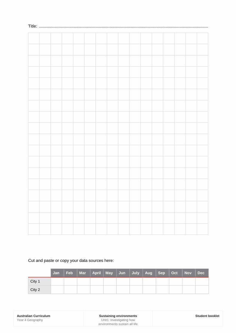
Title: ....................................................................................................................................................
Cut and paste or copy your data sources here:
Jan Feb Mar April May Jun July Aug Sep Oct Nov Dec
City 1
City 2
Australian Curriculum Year 4 Geography
Sustaining environments Unit1: Investigating how
environments sustain all life
Student booklet
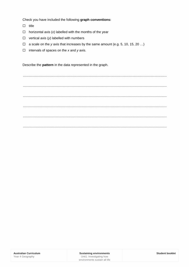
Check you have included the following graph conventions:
title
horizontal axis (x) labelled with the months of the year
vertical axis (y) labelled with numbers
a scale on the y axis that increases by the same amount (e.g. 5, 10, 15, 20 …)
intervals of spaces on the x and y axis.
Describe the pattern in the data represented in the graph.
.............................................................................................................................................................
.............................................................................................................................................................
.............................................................................................................................................................
.............................................................................................................................................................
.............................................................................................................................................................
.............................................................................................................................................................
Australian Curriculum Year 4 Geography
Sustaining environments Unit1: Investigating how
environments sustain all life
Student booklet
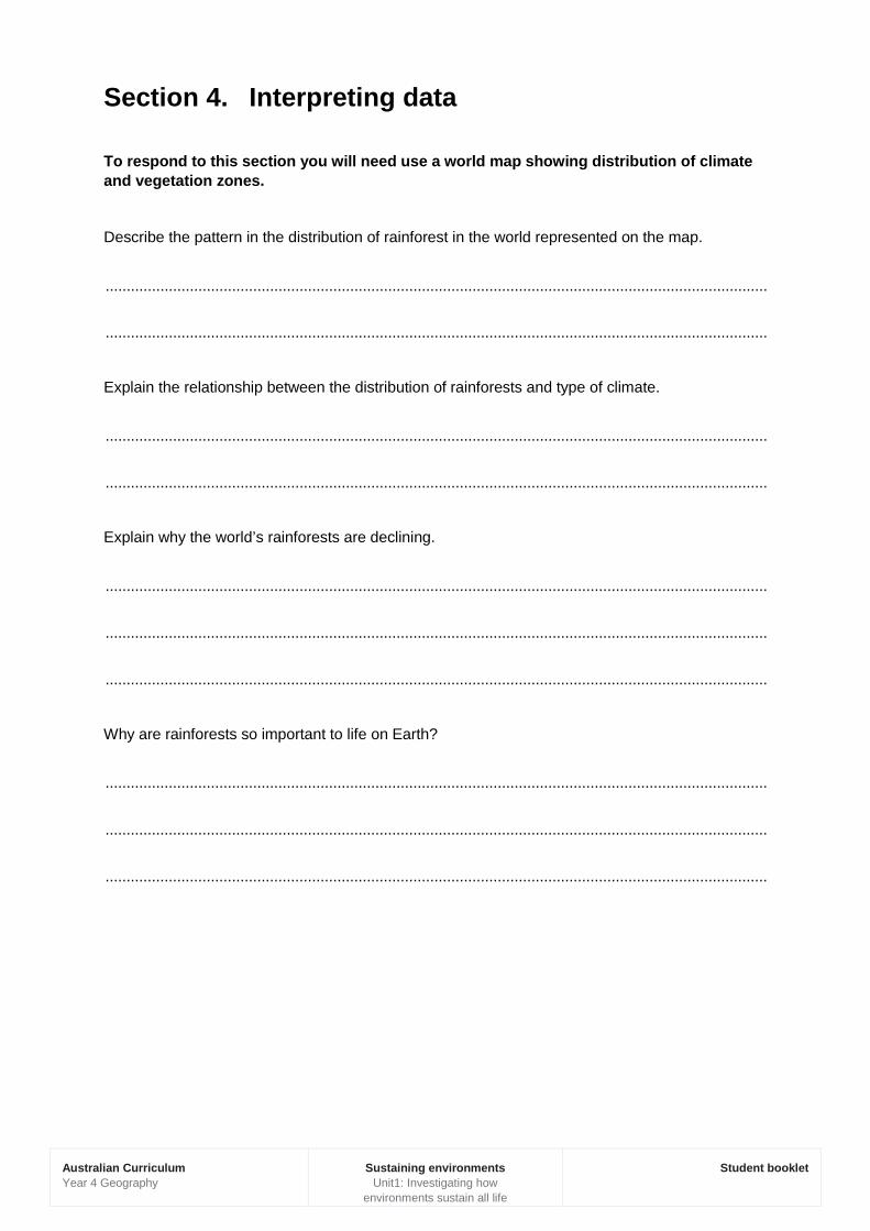
Section 4. Interpreting data
To respond to this section you will need use a world map showing distribution of climate and vegetation zones.
Describe the pattern in the distribution of rainforest in the world represented on the map.
.............................................................................................................................................................
.............................................................................................................................................................
Explain the relationship between the distribution of rainforests and type of climate.
.............................................................................................................................................................
.............................................................................................................................................................
Explain why the world’s rainforests are declining.
.............................................................................................................................................................
.............................................................................................................................................................
.............................................................................................................................................................
Why are rainforests so important to life on Earth?
.............................................................................................................................................................
.............................................................................................................................................................
.............................................................................................................................................................
Australian Curriculum Year 4 Geography
Sustaining environments Unit1: Investigating how environments sustain all life
Student booklet
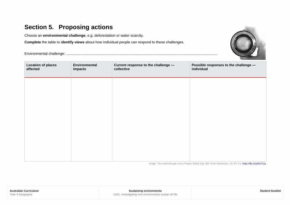
Section 5. Proposing actions Choose an environmental challenge, e.g. deforestation or water scarcity.
Complete the table to identify views about how individual people can respond to these challenges.
Environmental challenge: ........................................................................................................................................................
Location of places affected
Environmental impacts
Current response to the challenge — collective
Possible responses to the challenge — individual
Image: The world through a lens Project 365(2) Day 356, Keith Williamson, CC BY 2.0, https://flic.kr/p/9cZ7ya
Australian Curriculum Year 4 Geography
Sustaining environments Unit1: Investigating how environments sustain all life
Student booklet
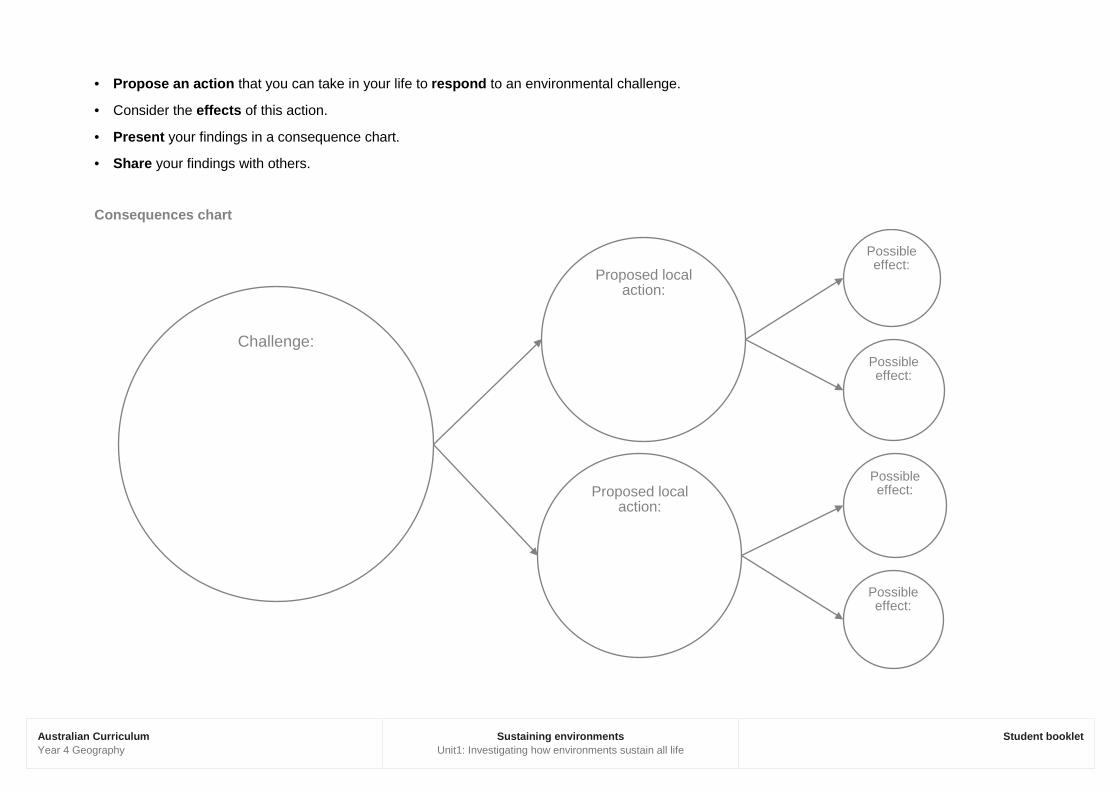
· Propose an action that you can take in your life to respond to an environmental challenge.
· Consider the effects of this action.
· Present your findings in a consequence chart.
· Share your findings with others.
Consequences chart
Challenge:
Proposed local action:
Possible effect:
Possible effect:
Proposed local action:
Possible effect:
Possible effect: