australian curriculum year 2 geography sample … · australian curriculum year 2 geography sample...
TRANSCRIPT

1469
3
© The State of Queensland (Queensland Curriculum and Assessment Authority) and its licensors 2014. All web links correct at time of publication.
Assessment description Category
Children communicate findings about connections to places and the factors that influence these connections in a multimodal presentation.
Spoken/signed and multimodal
Technique
Guided research
Context for assessment Alignment
Children develop geographical skills of inquiry that include: • posing geographical questions about places that
connect themselves and others • interview parents/carers and some significant
elders to collect information to answer questions • represent places of connection on a labelled map • interpret the information they have collected • communicate findings in a multimodal
presentation • reflect on the significance of connections to
places.
Australian Curriculum v7.1, Year 2 Geography Australian Curriculum content and achievement standard ACARA — Australian Curriculum, Assessment and Reporting Authority www.australiancurriculum.edu.au. Year 2 Geography standard elaborations www.qcaa.qld.edu.au/downloads/p_10/ac_geog_yr2_se.pdf.
Connections
This assessment can be used with the QCAA Australian Curriculum resource titled Year 2 unit overview: Geography exemplar — Connections between people and places available at: www.qcaa.qld.edu.au/downloads/p_10/ac_geog_yr2_unit_overview.docx.
Definitions
Interconnection: This concept is introduced in Year 2 Geography and focuses on connections children have to places at a local level and in more distant locations. Connections such as the movement of people, flow of goods and services, cultural influences, exchange of ideas and information have a strong influence on the characteristics of places. This is a holistic way of thinking that is important to the study of geography.
In this assessment
Teacher guidelines
Task-specific standards — continua
Task-specific standards — matrix
Assessment resource: Sample interview questions
Assessment resource: Sample oral presentation transcript
Assessment resource: Question starter grid
Student booklet
Australian Curriculum Year 2 Geography sample assessment ׀ Teacher guidelines
My connections to places

Australian Curriculum Year 2 Geography
My connections to places Unit: Connections between people and places
Teacher guidelines
Teacher guidelines
Identify curriculum Content descriptions to be taught
Geographical Knowledge and Understanding Geographical Inquiry and Skills
• The connections of people in Australia to other places in Australia, the countries of the Asia region, and across the world (ACHGK012)
• The ways in which Aboriginal and Torres Strait Islander Peoples maintain special connections to particular Country/Place (ACHGK011)
• The influence of purpose, distance and accessibility on the frequency with which people visit places (ACHGK013)
Observing, questioning and planning • Pose geographical questions about familiar and
unfamiliar places (ACHGS013) Collecting, recording, evaluating and representing • Collect and record geographical data and
information, for example, by observing, by interviewing, or from sources such as, photographs, plans, satellite images, story books and films (ACHGS014)
• Represent data and the location of places and their features by constructing tables, plans and labelled maps (ACHGS015)
Interpreting, analysing and concluding • Draw conclusions based on the interpretation of
geographical information sorted into categories (ACHGS016)
General capabilities (GCs) and cross-curriculum priorities (CCPs) This assessment may provide opportunities to engage with the following GCs and CCPs. Refer also to the Resources tab on the P–10 Geography curriculum and assessment page: www.qcaa.qld.edu.au/yr2-geography-curriculum.html.
Literacy
Numeracy
ICT capability
Critical and creative thinking
Personal and social capability
Ethical understanding
Intercultural understanding
Aboriginal and Torres Strait Islander histories and cultures
Asia and Australia’s engagement with Asia
Sustainability
Achievement standard This assessment provides opportunities for children to demonstrate the following highlighted aspects.
By the end of Year 2, students identify the features that define places and recognise that places can be described at different scales. They describe how people in different places are connected to each other and identify factors that influence these connections. Students recognise that the world can be divided into major geographical divisions. They explain why places are important to people. Students pose questions about familiar and unfamiliar places and collect information to answer these questions. They represent data and the location of places and their features in tables, plans and on labelled maps. They interpret geographical information to draw conclusions. Students present findings in a range of texts and use simple geographical terms to describe the direction and location of places. They suggest action in response to the findings of their inquiry.
Source: ACARA, The Australian Curriculum v7.1, www.australiancurriculum.edu.au

Australian Curriculum Year 2 Geography
My connections to places Unit: Connections between people and places
Teacher guidelines
Sequence learning Suggested learning experiences
This assessment leads on from the learning experiences outlined in the QSA’s Year 2 Geography unit overview. The knowledge, understanding and skills developed in the exemplar unit will prepare children to engage in this assessment: • See unit overview — Year 2 Geography exemplar — Connections between people and places
www.qcaa.qld.edu.au/downloads/p_10/ac_geog_yr2_unit_overview.docx
Adjustments for needs of learners
The Australian Curriculum, in keeping with Melbourne Declaration on Educational Goals for Young Australians (2008), establishes the expectations of a curriculum appropriate to all Australian children. All children across all education settings and contexts are supported in their diverse learning needs through the three-dimensions of the Australian Curriculum: the learning area content, the general capabilities and the cross-curriculum priorities. The relationship between and the flexibility to emphasis one or more of the dimensions allows teachers to personalise learning programs. To make adjustments, teachers refer to learning area content aligned to the child’s chronological age, personalise learning by emphasising alternate levels of content, general capabilities or cross-curriculum priorities in relation to the chronological age learning area content. The emphasis placed on each area is informed by the child’s current level of learning and their strengths, goals and interests. Advice on the process of curriculum adjustment for all children and in particular for those with disability, gifted and talented or for whom English is an additional language or dialect are addressed in Australian Curriculum — Student Diversity materials. For information to support children with diverse learning needs, see: • Queensland Curriculum and Assessment Authority materials for supporting children with diverse
learning needs www.qcaa.qld.edu.au/10188.html • Australian Curriculum Student Diversity
www.australiancurriculum.edu.au/StudentDiversity/Student-diversity-advice • The Melbourne Declaration on Educational Goals for Young Australians
www.curriculum.edu.au/verve/_resources/National_Declaration_on_the_Educational_Goals_for_Young_Australians.pdf
• The Disability Standards for Education www.ag.gov.au.
Resources
Print • Catling, S, Willy T & Butler, J 2012, Teaching Primary Geography for Australian Schools, Hawker
Brownlow, Melbourne. Online • ACARA, Work sample portfolio: Year 2,
www.acara.edu.au/curriculum/worksamples/Year_2_Geography_Portfolio.pdf. • Geogspace, Australian Geography Teachers of Australia, Mapping world interconnections,
www.geogspace.edu.au/core-units/f-4/exemplars/year-2/f4-exemplars-y2-illus2.html. • Queensland Curriculum and Assessment Authority, G20 for schools, Primary virtual field trip using
Google Earth and Queensland Globe, https://www.qcaa.qld.edu.au/virtual-field-trips.html. • Queensland Curriculum and Assessment Authority, G20 for schools, G20 Interactive Map,
http://g20.qcaa.qld.edu.au. • Queensland Curriculum and Assessment Authority, Year 2 Geography Australian Curriculum in
Queensland, www.qcaa.qld.edu.au/yr2-geography-overview.html. • Spatial technologies, such as: − Google Earth www.google.com/earth − Google Maps www.google.com.au/maps.
Objects • Digital photos and images of places visited
Australian Curriculum Year 2 Geography
My connections to places Unit: Connections between people and places
Teacher guidelines
Develop assessment Preparing for the assessment
The assessment task requires students to collect a variety of photos of places that are important to them. The teacher shares a variety of photos that reflect places that are important to them to model photos and pictures that may be suitable for the students’ presentation. • Make a judgment (dependent on the context of the classroom) as to whether the students will represent
the data on a printed or electronic map. • Provide students with a task outline. • Review the geographical concept of interconnections between people and places. Explain how people
connect to other places, through relationships with families and friends, sport, recreation, history, cultural landmarks, retail, holidays, and services such as schools and hospitals.
Implementing
Section 1. Posing questions, collecting and recording data
Child role Develop a set of questions to share collaboratively with the class. • Participate with the class during a guided
discussion to review and select questions to take home to research.
• Decide on possible sources to find out about how people in different places are connected to each other, why places are important to them, and how facts such as location and distance influence the connections. Students may interview more than one source.
• Interview an adult such as parent/carer or grandparent/elder to answer questions posed. Record responses in Section 1 of the Student booklet.
• Collect a range of photographs that support the question responses.
Teacher role • Guide the children to: − write a list of questions to answer at home
when interviewing and researching places that are important to them
− work independently to write their own questions before collaborating as a whole class. Use Assessment resource: Question starter grid to assist children in posing questions
− review and select questions to take home to research. Complete the table in Section 1 of the Student booklet to record questions and interview responses
− understand that they did not need to have travelled to places to stay connected
− make a list of reasons for connections to places such as family visits, recreation, holidays, shopping, history, culture, religion or a sister school
− discuss how connections are influenced by access to and cost of transport, distance and technology.
• See Assessment Resource: Sample interview questions for examples of questions to pose about places.
• Support children during the inquiry process to record findings from their research.
Section 2. Representing places on a labelled map
Child role Use a base map (local, state, national, world level) provided to: • identify their places of connections • locate places of connections identified in the
interview with an adult • show the relative location of these places to
where children live
Teacher role • Select base maps (local, state, national, world
level) for children to identify: − places they are connected to − places of connection for an adult.
• Provide children with access to sources such as Google Maps to identify locations of places.
• Review features of a labelled map with

Australian Curriculum Year 2 Geography
My connections to places Unit: Connections between people and places
Teacher guidelines
• annotate the map to give reasons for the connections, e.g. place of birth. Alternatively, use a simple legend to identify reasons for connections
• share the labelled map with others and check on clarity of detail
• discuss with others what is similar and different about the identified connections
• describe the patterns revealed in the map.
annotations. Use examples of maps in storybooks or a treasure map.
• Use examples provided in the ACARA Work sample portfolio as a guide: www.acara.edu.au/curriculum/worksamples/ Year_2_Geography_Portfolio.pdf.
• Show children the QCAA interactive G20 world map to identify how the map is labelled to show the location of places: http://g20.qcaa.qld.edu.au.
Section 3. Interpreting information
Child role Use data collected from the interview and the labelled map to respond to questions: • talk about your responses with others to check
they are clear and detailed.
Teacher role Guide children to use the data collected to respond to questions: • model responses to questions using simple
geographical terms.
Section 3. Communicating findings
Child role Plan and rehearse a presentation of findings about: • how they are connected to places and how
factors such as location and distance influence the connections. This includes: − marking on a local, national or world map
places they investigated that are important to them
− using the responses gathered from their sources that have been recorded in Section 1
− interpreting information using responses in Section 3
− using digital technologies to develop a multimodal presentation using the scanned labelled map, table and photos to support the findings.
• Reflect on what was learnt in this inquiry: − Why are the places identified important to you
and others? − How can you learn more about places that are
important to you? − What have you learnt in your talk with an adult
about places you haven’t visited? − How can you learn more about these places? − What would you do better next time?
Teacher role Guide the children to: • use the information collected in the interview with
an adult • use digital technologies to present findings (e.g.
scanning maps and photos; using multimodal presentation tools, such as PowerPoint)
• seek feedback using the questions provided.
Make judgments When making judgments about the evidence in children’s responses to this assessment, teachers are advised to use the task-specific standards provided. The development of these task-specific standards has been informed by the Queensland Geography standard elaborations. See www.qcaa.qld.edu.au/downloads/p_10/ac_geog_yr2_se.pdf.

Australian Curriculum Year 2 Geography
My connections to places Unit: Connections between people and places
Teacher guidelines
The Queensland standard elaborations for Geography The Queensland Year 2 standard elaborations for Geography are a resource to assist teachers
to make consistent and comparable evidence-based A to E (or the Early Years equivalent) judgments. They should be used in conjunction with the Australian Curriculum achievement standard and content descriptions for the relevant year level.
The Queensland Geography standard elaborations provide a basis for judging how well children have demonstrated what they know, understand and can do using the Australian Curriculum achievement standard.
The Australian Curriculum achievement standards dimensions of Understanding and Skills are used to organise the Queensland Geography standard elaborations.
The valued features of Geography, drawn from the achievement standard and the content descriptions are organised as:
• Knowledge and understanding
• Questioning and researching
• Interpreting and analysing
• Communicating.
Task-specific standards Task-specific standards give teachers:
• a tool for directly matching the evidence of learning in the response to the standards
• a focal point for discussing children’s responses
• a tool to help provide feedback to children.
Task-specific standards are not a checklist; rather they are a guide that:
• highlights the valued features that are being targeted in the assessment and the qualities that will inform the overall judgment
• specifies particular targeted aspects of the curriculum content and achievement standard
• aligns the valued feature, task-specific descriptor and assessment
• allows teachers to make consistent and comparable on-balance judgments about a child’s work by matching the qualities of children’s responses with the descriptors
• clarifies the curriculum expectations for learning at each of the five grades (A–E or the Early Years equivalent)
• shows the connections between what children are expected to know and do, and how their responses will be judged and the qualities that will inform the overall judgment
• supports evidence-based discussions to help children gain a better understanding of how they can critique their own responses and achievements, and identify the qualities needed to improve
• encourages and provides the basis for conversations among teachers, children and parents/carers about the quality of children’s work and curriculum expectations and related standards.

Australian Curriculum Year 2 Geography
My connections to places Unit: Connections between people and places
Teacher guidelines
Task-specific valued features Task-specific valued features are the discrete aspects of the valued features of Geography targeted in a particular assessment and incorporated into the task-specific standards for that assessment. They are selected from the Queensland Geography standard elaborations valued features drawn from the Australian Curriculum achievement standard and content descriptions.
Task-specific valued features for this assessment
The following table identifies the valued features for this assessment and makes explicit the understandings and skills that children will have the opportunity to demonstrate. This ensures that the alignment between what is taught, what is assessed and what is reported is clear.
Australian Curriculum achievement standard dimensions
Australian Curriculum achievement standard
Queensland standard elaborations valued features
Task-specific valued features
Und
erst
andi
ng a
nd S
kills
Geographical Knowledge and Understanding
Knowledge and understanding
Describes: • how people in different places are
connected to each other and identifies factors that influence these connection
• why places are important to people Section 3
Geographical Inquiry and Skills
Questioning and researching
Poses questions about familiar and unfamiliar places Collects relevant information from sources Section 1
Interpreting and analysing
Interprets geographical information to draw conclusions Sections 2 and 3
Communicating Presents findings in oral and digital form that: • use simple geographical terms to • describe the direction and location of
places • represent data and the location of • familiar places on a labelled map Sections 2, 3 and 4
The task-specific standards for this assessment are provided in two models using the same task-specific valued features:
• a matrix
• a continua.

Australian Curriculum Year 2 Geography
My connections to places Unit: Connections between people and places
Teacher guidelines
Matrix and continua Task-specific standards can be prepared as a matrix or continua. Both the continua and the matrix:
• use the Queensland standard elaborations to develop task-specific descriptors to convey expected qualities in children’s work — A to E (or the Early Years equivalent)
• highlight the same valued features from the Queensland standard elaborations that are being targeted in the assessment and the qualities that will inform the overall judgment
• incorporate the same task-specific valued features, i.e. make explicit the particular understanding / skills that children have the opportunity to demonstrate for each selected valued feature
• provide a tool for directly matching the evidence of learning in the child’s response to the standards to make an on-balance judgment about achievement
• assist teachers to make consistent and comparable evidence-based A to E (or the Early Years equivalent) judgments.
Continua
The continua model of task-specific standards uses the dimensions of the Australian Curriculum achievement standard to organise task-specific valued features and standards as a number of reference points represented progressively along an A to E (or Early Years equivalent) continuum. The task-specific valued features at each point are described holistically. The task-specific descriptors of the standard use the relevant degrees of quality described in the Queensland standard elaborations.
Teachers determine a position along each continuum that best matches the evidence in the children’s responses to make an on-balance judgment about achievement on the task.
The continua model is a tool for making an overall on-balance judgment about the assessment and for providing feedback on task specific valued features.
Matrix
The matrix model of task-specific standards uses the structure of the Queensland standard elaborations to organise the task-specific valued features and standards A to E (or the Early Years equivalent). The task-specific descriptors of the standard described in the matrix model use the same degrees of quality described in the Queensland standard elaborations.
Teachers make a judgment about the task-specific descriptor in the A to E (or the Early Years equivalent) cell of the matrix that best matches the evidence in the children’s responses in order to make an on-balance judgment about how well the pattern of evidence meets the standard.
The matrix is a tool for making both overall on-balance judgments and analytic judgments about the assessment. Achievement in each valued feature of the Queensland standard elaboration targeted in the assessment can be recorded and feedback can be provided on the task-specific valued features.

Australian Curriculum Year 2 Geography
My connections to places Unit: Connections between people and places
Teacher guidelines
Use feedback Feedback to children
Evaluate the information gathered from the assessment to inform teaching and learning strategies. Focus feedback on the child’s personal progress and the next steps in the learning journey. Offer feedback that: • prompts children to ask geographical questions that relate to places visited and
connected to • communicates with parents, family or community member about the interview process • checks for understanding about features marking places on a map using basic
conventions • identifies how children can improve their presentation. The task-specific standards for this assessment can be used as a basis for providing feedback to children.
Resources For guidance on providing feedback, see the professional development packages titled: • About feedback
www.qcaa.qld.edu.au/downloads/p_10/as_feedback_about.docx • Seeking and providing feedback
www.qcaa.qld.edu.au/downloads/p_10/as_feedback_provide.docx

1503
59
© The State of Queensland (Queensland Curriculum and Assessment Authority) and its licensors 2014. All web links correct at time of publication.
Purpose of assessment: Present findings about how people in different places are connected to each other, why places are important to them and how factors such as location and distance influence the connections.
Understanding and Skills
Geographical Knowledge and Understanding
Geographical Inquiry and Skills
Knowledge and understanding Questioning and researching Interpreting and analysing Communicating Describes how people in different places are connected to each other and identifies factors that influence these connections Explains why places are important to people Section 3
Poses questions about familiar and unfamiliar places and collects information to answer these questions Section 1
Interprets geographical information to draw conclusions Sections 2 and 3
Presents findings in oral and digital form that use simple geographical terms to describe the direction and location of places Represents data and the location of places on a labelled map Sections 2, 3 and 4
AP
MC
WW
Australian Curriculum Year 2 Geography sample assessment ׀ Task-specific standards — continua
My connections to places Name ...................................................
Interprets geographical information to draw reasoned conclusions
Describes how people in different places are connected to each other and identifies factors that influence these connections including technology, transport
Explains why places are important to people
Interprets geographical information to draw conclusions
Clearly and effectively presents findings that use relevant geographical terms to clearly describe the direction and location of places
Accurately represents in detail data and the location of familiar places on a labelled map
Presents findings that: use simple geographical terms to describe direction and location
Represents data and the location of familiar places on a labelled map
Poses questions about familiar and unfamiliar places and collects in a considered way relevant information to answer these questions
Poses questions about familiar places and unfamiliar places and collects information to answer these questions
Clearly describes in an informed way how people are connected to each other and identifies factors that influence these connections including technology and transport
Clearly explains in an informed way why places are important to people
Australian Curriculum Year 2 Geography
My connections to places Unit 2: Connections between people and places
Task-specific standards — continua

Understanding and Skills
Geographical Knowledge and Understanding
Geographical Inquiry and Skills
Knowledge and understanding Questioning and researching Interpreting and analysing Communicating Describes: • how people in different places are
connected to each other and identify factors that influence these connection
• why places are important to people Section 3
Poses questions about familiar and unfamiliar places Collects relevant information from sources Section 1
Interprets geographical information to draw conclusions Sections 2 and 3
Presents findings in oral and digital form that: • use simple geographical terms to
describe the direction and location of places
• represent data and the location of familiar places on a labelled map
Sections 2, 3 and 4
EX
BA
Australian Curriculum Year 2 Geography sample assessment ׀ Task-specific standards — continua
My connections to places Name ...................................................
Interprets geographical information with direction to make statements about connections
Presents findings with direction that:use everyday language
Represents data and the location of familiar places with direction on a labelled map
Poses questions about familiar places and unfamiliar places with direction and collects information with direction to answer these questions
Describes with direction connections to different places and identifies with direction factors that influence these connections
Australian Curriculum Year 2 Geography
My connections to places Unit 2: Connections between people and places
Task-specific standards — continua

1503
58
© The State of Queensland (Queensland Curriculum and Assessment Authority) and its licensors 2014. All web links correct at time of publication.
Purpose of assessment: Present findings about how people in different places are connected to each other, why places are important to them and how factors such as location and distance influence the connections.
Applying (AP)
Making connections (MC)
Working with (WW)
Exploring (EX)
Becoming aware (BA)
Und
erst
andi
ng a
nd S
kills
Geo
grap
hica
l Kno
wle
dge
and
Und
erst
andi
ng
Kno
wle
dge
and
unde
rsta
ndin
g
Describes how people in different places are connected to each other and identifies factors that influence these connections Section 3
Clearly describes in an informed way how people are connected to each other and identifies factors that influence these connections including technology and transport e.g. ‘ __ is important to me. I travel there by plane to visit my Grandmother who lives there. __ is far away. It is to the north of where I live so we don’t go to visit her very often. It is important for us to go because __ . Even though we go to __ to see Grandma on the plane, we Skype her and ring her all the time so we feel very close and very connected to Grandma.’
Describes in an informed way: how people in different places are connected to each other and identifies factors that influence these connections including technology and transport
Describes how people in different places are connected to each other and identifies factors that influence these connections including technology and transport e.g. ‘__ is a very important place to me because we go there every Sunday to go to __ . We go there to catch up with friends. It is so easy to get to __ . We just walk. It is close by.’
Describes with guidance how people in different places are connected to each other and identifies with guidance factors that influence these connections
Describes with direction connections to different places and identifies with direction factors that influence these connections
Explains why places are important to people Section 3
Clearly explains in an informed way why places are important to people
Explains in an informed way why places are important to people
Explains why places are important to people
Explains with guidance why places are important to people
Explains with direction why places are important to people
Australian Curriculum Year 2 Geography sample assessment ׀ Task-specific standards — matrix
My connections to places Name ...................................................
Australian Curriculum Year 2 Geography
My connections to places Unit 2: Connections between people and places
Task-specific standards — matrix

© The State of Queensland (Queensland Curriculum and Assessment Authority) and its licensors 2014. All web links correct at time of publication.
Purpose of assessment: Present findings about how people in different places are connected to each other, why places are important to them and how factors such as location and distance influence the connections.
Applying (AP)
Making connections (MC)
Working with (WW)
Exploring (EX)
Becoming aware (BA)
Und
erst
andi
ng a
nd S
kills
Geo
grap
hica
l Inq
uiry
and
Ski
lls
Que
stio
ning
and
re
sear
chin
g
Poses questions about familiar and unfamiliar places and collects information to answer these questions Section 1
Poses questions about familiar and unfamiliar places and collects in a considered way relevant information to answer these questions
Poses questions about familiar and unfamiliar places and collects relevant information to answer these questions
Poses questions about familiar places and unfamiliar places and collects information to answer these questions
Poses questions about familiar places and unfamiliar places with guidance and collects information with guidance to answer these questions
Poses questions about familiar places and unfamiliar places with direction and collects information with direction to answer these questions
Inte
rpre
ting
and
an
alys
ing
Interprets geographical information to draw conclusions Sections 2 and 3
Interprets geographical information to draw reasoned conclusions
Interprets geographical information to draw informed conclusions
Interprets geographical information to draw conclusions
Interprets geographical information with guidance to make statements about connections
Interprets geographical information with direction to make statements about connections
Com
mun
icat
ing
Presents findings in oral and digital form that use simple geographical terms to describe the direction and location of places
Clearly and effectively presents findings that use relevant geographical terms to clearly describe the direction and location of places, e.g. ‘__ is important to me. It is north of where I live’
Effectively presents findings that use relevant geographical terms to describe the direction and location of places, e.g. ‘__ is important to me. It is on the opposite side of town’
Presents findings that use simple geographical terms to describe direction and location, e.g. ‘__ is important to me. It is far away’
Presents findings with guidance that use everyday language to identify direction and location, e.g. ‘It is down the road’
Presents findings with direction that use everyday language
Represents data and the location of familiar places on a labelled map Sections 2, 3 and 4
Accurately represents in detail data and the location of familiar places on a labelled map
Represents in detail data and the location of familiar places on a labelled map
Represents data and the location of familiar places on a labelled map
Represents data and the location of familiar places with guidance on a labelled map
Represents data and the location of familiar places with direction on a labelled map
Australian Curriculum Year 2 Geography sample assessment ׀ Task-specific standards — matrix
My connections to places Name ...................................................
Australian Curriculum Year 2 Geography
My connections to places Unit 2: Connections between people and places
Task-specific standards — matrix

1469
3
© The State of Queensland (Queensland Curriculum and Assessment Authority) and its licensors 2014. All web links correct at time of publication.
Sample interview questions
Image Source: www.qcaa.qld.edu.au/30938.html
• What was it like when you were a child?
Australian Curriculum Year 2 Geography sample assessment ׀ Assessment resource
My connections to places
• What places are close by (or far away) that you travel to and are important to you?
• Where did you live? • Where did you travel to?
• How did you connect with places that were important to you?
• How often did/do you travel to these places?
• Why did/do you travel to these places?
• Why do I communicate with these places?
• What places close by (or far away) do you connect with using technology, e.g. email, Skype, phone? Wh i lik
• What was it like when you were a child?

1469
3
© The State of Queensland (Queensland Curriculum and Assessment Authority) and its licensors 2014. All web links correct at time of publication.
Sample oral presentation transcript The following transcript of an oral presentation would be accompanied by multimedia features — map, photos and other sources — in a multimodal presentation.
Sample ‘Applying’ response There are many places that are important to me and that I am connected to. As you can see from my map, Melbourne, which is south of Brisbane, is a place that I connect with because that is where my Grandma and my aunties and cousins live. My mum grew up there too. We go there for birthdays and Christmas celebrations. Christmas is an important time for our family so that is why we go to there every December. Last year, we even went for our aunty’s wedding and we went and watched a cricket match. I have to travel there by plane because it is too far away for us to drive.
Because we have to travel there on a plane, we can’t go every day. So I connect with my family in Melbourne by Skyping, emailing and sending text messages. That way, we can connect with our family every day without ever leaving the house. I even used Skype to interview my grandma for this talk.
Many years ago, not many people travelled on planes. Grandma said she never travelled far because they only ever walked places or she rode her bike. She said that people in her days only wrote letters to each other and they didn’t really connect with people in other places because they didn’t have mobile phones or computers. Technology has helped us to connect with people in all different places. Maybe when I am older I can visit the Northern Hemisphere.
Sample ‘Working with’ response Japan is important to me because I talk to my friend who lives there. Japan is far away from Australia at the top of the world, as you can see in my map. I would have to travel by plane to get there so I have never been to Japan. We talk by emailing and sometimes Skype. I am excited because my friend said the Olympic Games will be in Japan when I am older so maybe I can travel there with all the athletes.
Mum said she never had email or Skype when she was a girl so she used to have to send letters. She said it was harder to go on a plane. I don’t think it would have been easy to have a friend in Japan when my mum was in school.
Australian Curriculum Year 2 Geography sample assessment ׀ Assessment resource
My connections to places

1469
3
© The State of Queensland (Queensland Curriculum and Assessment Authority) and its licensors 2014. All web links correct at time of publication.
Question starter grid The following question starter grid may be useful in assisting children to pose questions. What, where and why are highlighted as they relate more to the focus of this assessment.
What is? Where is?
Which is? Who is? Why is? How is?
What did? Where did? Which did? Who did? Why did? How did?
What can? Where can? Which can? Who can? Why can? How can?
What would? Where would? Which would? Who would? Why would? How would?
What might? Where might? Which might? Who might? Why might? How might?
Australian Curriculum Year 2 Geography sample assessment ׀ Assessment resource
My connections to places

1469
3
© The State of Queensland (Queensland Curriculum and Assessment Authority) and its licensors 2014. All web links correct at time of publication.
Image: Train to Kuranda, Birgit Juel Martinsen, Creative Commons Attribution 2.0, https://flic.kr/p/9fwo9g
Communicate findings about connections to different places in a multimodal presentation.
You will: • pose questions about places that connect you and others • talk to an adult in your life to collect information and help you answer your questions • use Google Maps (electronically or in print form) to mark on a map (world, Australia or local map) places that are important to you, and connected to you and others • interpret the information you have collected • communicate your findings in a multimodal presentation • reflect on the importance of connections to places.
Australian Curriculum Year 2 Geography sample assessment ׀ Student booklet
My connections to places

Australian Curriculum Year 2 Geography
My connections to places Unit 2: Connections between people and places
Student booklet
Section 1. Posing questions, collecting and recording data Pose questions to ask an adult in your life about connections to places, the frequency of visits to places and what influences connections. Record your questions and responses in the table.
Question: ______________________ ____________________________________________________________________________________
Response:
____________________________________________
____________________________________________
____________________________________________
____________________________________________
How am I connected to other places?
What are the reasons for these connections?
Tally of visits to places
Place Tally
Australian Curriculum Year 2 Geography
My connections to places Unit 2: Connections between people and places
Student booklet
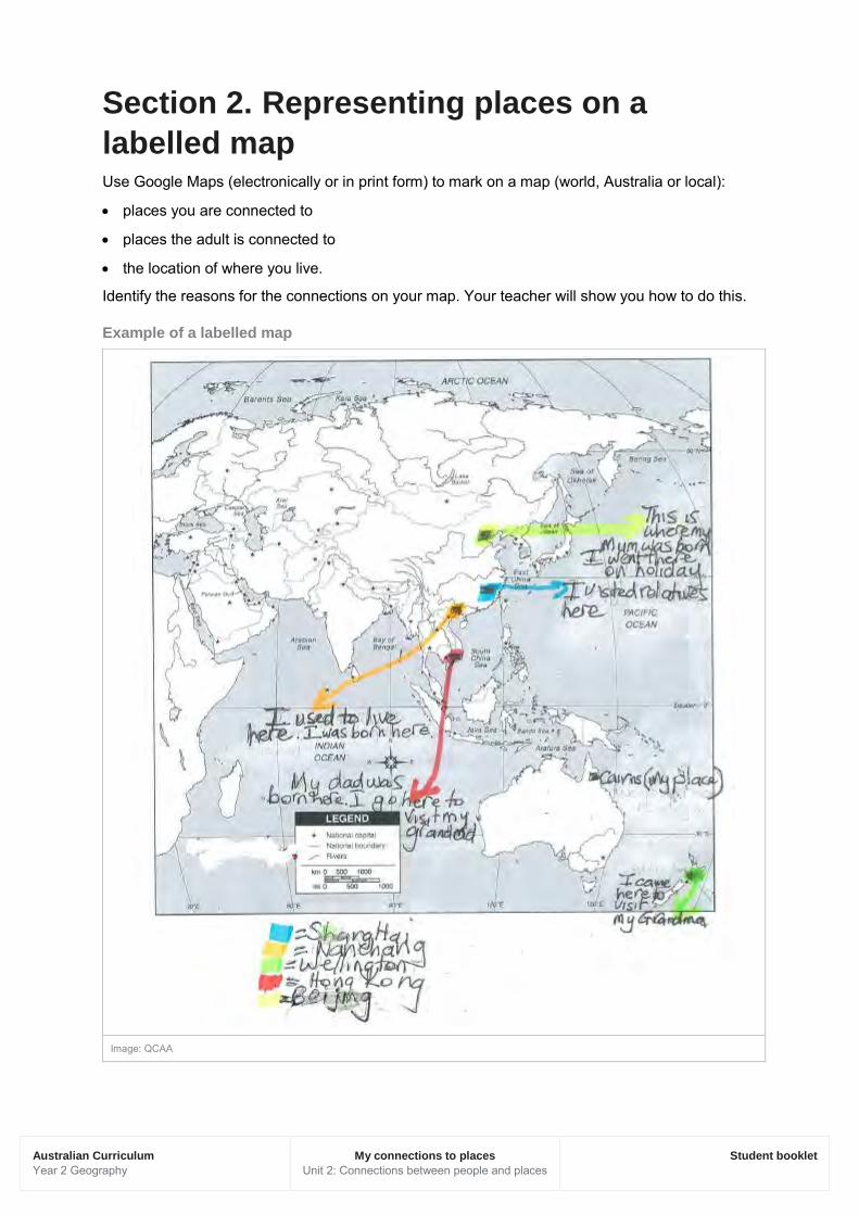
Section 2. Representing places on a labelled map Use Google Maps (electronically or in print form) to mark on a map (world, Australia or local):
• places you are connected to
• places the adult is connected to
• the location of where you live.
Identify the reasons for the connections on your map. Your teacher will show you how to do this.
Example of a labelled map
Image: QCAA

Australian Curriculum Year 2 Geography
My connections to places Unit 2: Connections between people and places
Student booklet
Section 3. Interpreting information Use your data collected from the interview and labelled map to respond to the following questions.
1. Where are the places on your map located? Make sure you talk about where these places are using words such as north, south, west, far away or discuss different continents and hemispheres.
___________________________________________________________________________
___________________________________________________________________________
___________________________________________________________________________
___________________________________________________________________________
___________________________________________________________________________
___________________________________________________________________________
2. Why are these places important to you?
___________________________________________________________________________
___________________________________________________________________________
___________________________________________________________________________
___________________________________________________________________________
___________________________________________________________________________
3. Why are you connected to these places?
___________________________________________________________________________
___________________________________________________________________________
___________________________________________________________________________
___________________________________________________________________________
___________________________________________________________________________
___________________________________________________________________________
___________________________________________________________________________
Australian Curriculum Year 2 Geography
My connections to places Unit 2: Connections between people and places
Student booklet
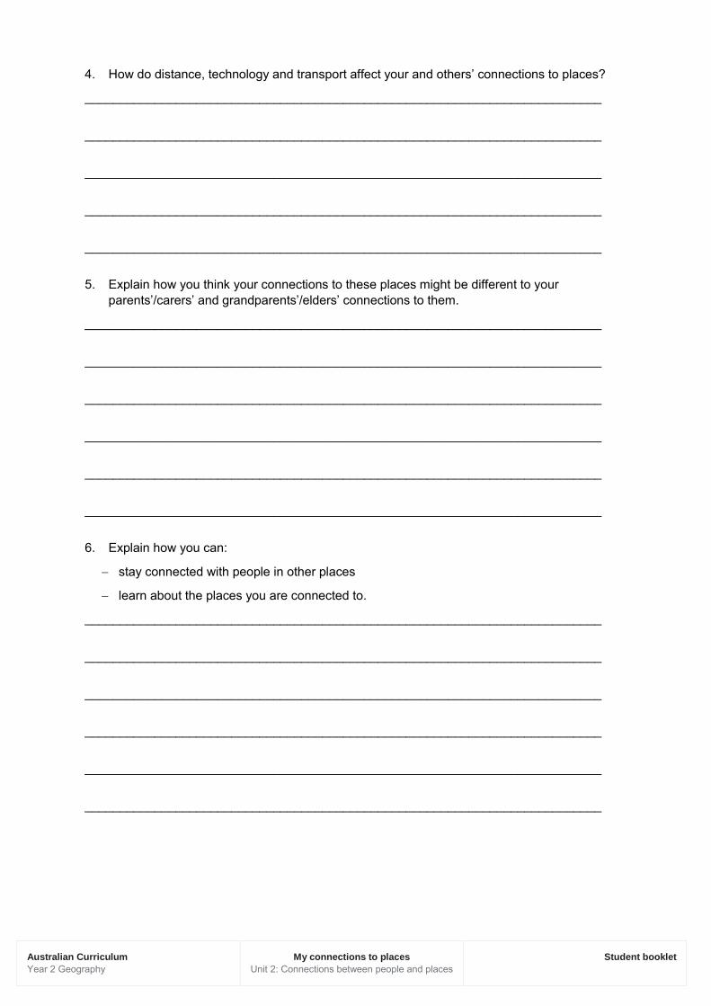
4. How do distance, technology and transport affect your and others’ connections to places?
__________________________________________________________________________
__________________________________________________________________________
__________________________________________________________________________
__________________________________________________________________________
__________________________________________________________________________
5. Explain how you think your connections to these places might be different to your parents’/carers’ and grandparents’/elders’ connections to them.
__________________________________________________________________________
__________________________________________________________________________
__________________________________________________________________________
__________________________________________________________________________
__________________________________________________________________________
__________________________________________________________________________
6. Explain how you can:
− stay connected with people in other places
− learn about the places you are connected to.
__________________________________________________________________________
__________________________________________________________________________
__________________________________________________________________________
__________________________________________________________________________
__________________________________________________________________________
__________________________________________________________________________
Australian Curriculum Year 2 Geography
My connections to places Unit 2: Connections between people and places
Student booklet
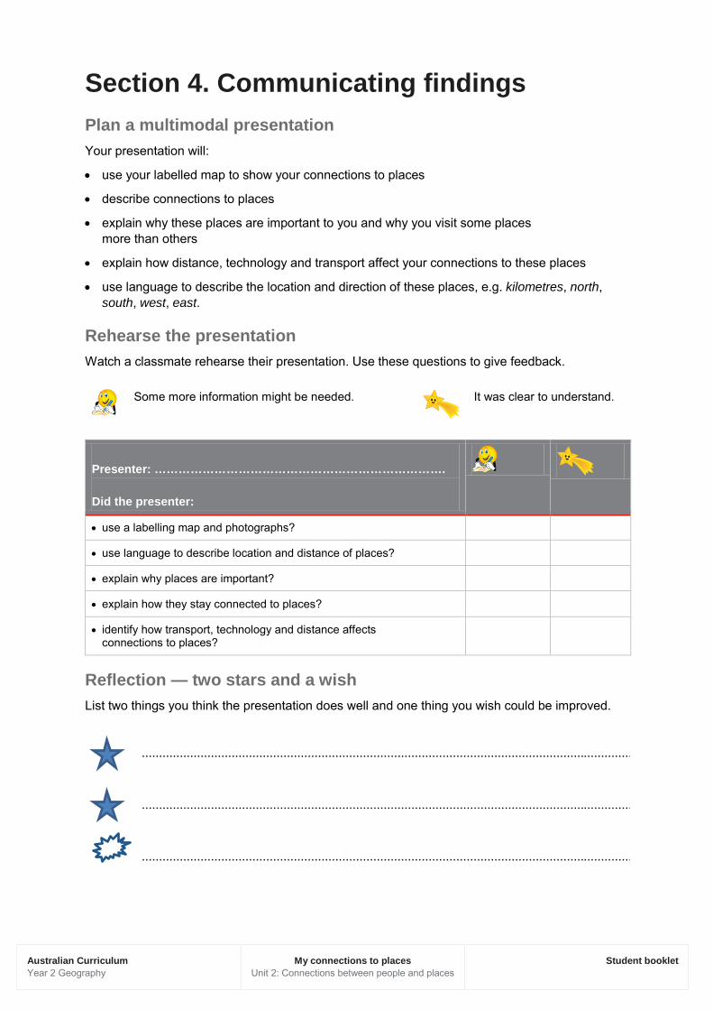
Section 4. Communicating findings Plan a multimodal presentation Your presentation will:
• use your labelled map to show your connections to places
• describe connections to places
• explain why these places are important to you and why you visit some places more than others
• explain how distance, technology and transport affect your connections to these places
• use language to describe the location and direction of these places, e.g. kilometres, north, south, west, east.
Rehearse the presentation Watch a classmate rehearse their presentation. Use these questions to give feedback.
Some more information might be needed.
It was clear to understand.
Presenter: ………………………………………………………………. Did the presenter:
• use a labelling map and photographs?
• use language to describe location and distance of places?
• explain why places are important?
• explain how they stay connected to places?
• identify how transport, technology and distance affects connections to places?
Reflection — two stars and a wish List two things you think the presentation does well and one thing you wish could be improved.
..............................................................................................................................................
..............................................................................................................................................
..............................................................................................................................................