august 2013 professional land surveyors of colorado volume 44, issue 3
TRANSCRIPT
Becky RolandExecutive DirectorPLSC, IncPO Box 460022Denver, CO 80246
Prst stdU.S. Postage
PAIDDenver, CO
Permit No. 1222
August 2013
Professional Land Surveyors of Colorado Volume 44, Issue 3
SIDE SHOTS
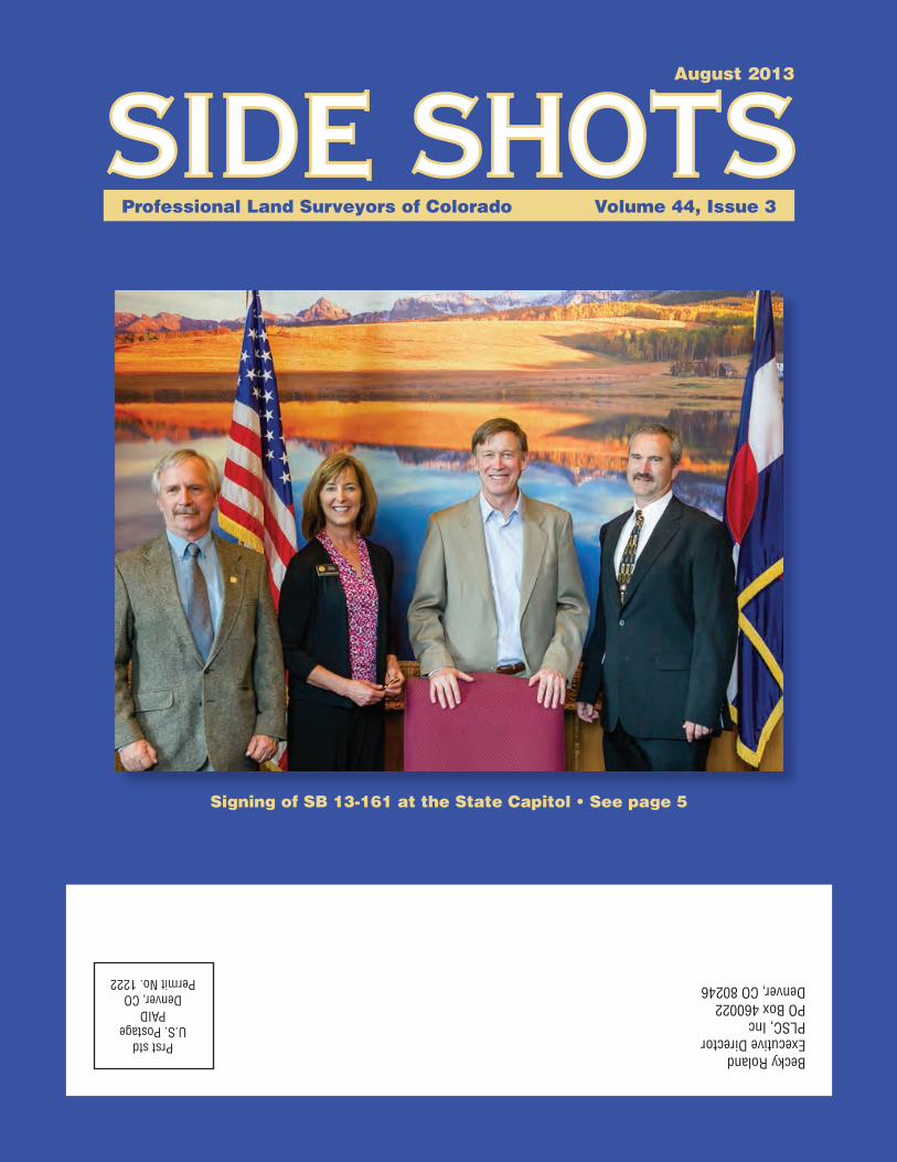
Signing of SB 13-161 at the State Capitol • See page 5


3 • SIDE SHOTS
Professional Land Surveyors of Colorado, Inc.
AFFILIATE—NATIONAL SOCIETY OF PROFESSIONAL SURVEYORS
MEMBER—COLORADO ENGINEERING COUNCILMEMBER—WESTERN FEDERATION OF
PROFESSIONAL SURVEYORS
OFFICERS (2013)
Roger NelsonPresident
2450 South Peoria Street . Aurora, Colorado 80014O: (303) 353-3916
Micheal BouchardVice President
4755 Forge Road, Suite 150 . Colorado Springs, CO 80907O: (719) 590-9194
Terry MawSecretary/Treasurer
8055 E. Tufts Avenue, Suite 850 . Denver, CO 80237O: (719) 590-9194
Becky RolandExecutive Director
PO Box 460022 . Denver, CO 80246Phoenix AMC O: (303) 551-3266 F: (720) 230-4846
2013 PLSC CHAPTER ORGANIZATION
CENTRAL COLORADO PROFESSIONAL SURVEYORSPresident: Chris Raml
Vice President, David Kuxhausen; Secretary, Mark Wilson; Treasurer, Aaron Willis
Directors: Shawn Clarke, George Robinson, John Wilhelm, Kevin Kucharczyk, Terry Pickering, Ken Baker, Tony Perazzo
NORTHERN CHAPTER - PLSC, INC.President: Kayce Wohlman
President-elect: Laine Landau; Secretary/Treasurer, Rob HintzDirectors: Paul Bacus, Bob Edmonds, Steve Varriano, Douglas Ritter
President Emeritus: Ron Perkins
NORTHWEST 1/4 COLORADO LAND SURVEYORSPresident: Brian T. Kelly
Vice President, William Whelan; Secretary/Treasurer, Jeff Gustafson;Gordon Dowling, Immediate Past President and Director
Directors: Thomas H. Effinger, Skidge Moon, Walter Magill, Lloyd Powers, Peter Epp
SOUTHERN COLORADO PROFESSIONAL LAND SURVEYORS
President: Joe AlessiVice President: Steve Parker; Secretary: Bill Brooks;
Treasurer: Dan HantenDirectors: Nathan Lira, Jon Tessin, Steve McAnally,
Lyle Bissegger, Don Hulsey
SOUTHWESTERN Chapter - PLSC, Inc.President: Joshua Casselberry
Vice President, Robert L. Trudeaux; Secretary, Parker NewbyTreasurer, Ed Young
WESTERN COLORADO LAND SURVEYORSPresident: Richard Bullen
Vice President: Jonathan Kobylarz; Sec’y-Treas.: Brian BowkerDirectors: Leslie Doehling, Patrick Green, Scott Thompson,
Peter Krick, Tom Sylvester, Ben Elliott, Mark Wagner
COLORADO SPATIAL REFERENCE NETWORKPresident: Jan Sterling
Vice President, Eric Carson; Secretary, (vacant); Treasurer, Chris DudaDirectors: Jon Doty, Larry Rector, Harold Schuch,
Kayce Wohlman, Brian Dennis
Side Shots is the official publication of the Professional Land Surveyors of Colorado, Inc. and is published quarterly for the betterment of the surveying profession.
Roger Nelson Micheal Bouchard President Vice President
For Editorial Correspondence, contact:John B. Guyton
Editor: Side Shots5385 Centennial Trail, Boulder, CO 80303
303-443-7001 • [email protected] publication is not copyrighted and articles may be reprinted with due credit.
Statements made and opinions expressed are from the contributors and do not necessarily express the official views of the Professional Land Surveyors of Colorado, Inc.
Deadlines for editorials, articles, pictures and advertising are January 1, April 1, July 1 and October 1. All material received after the current deadline will appear
in the next issue of Side Shots.
We would like to invite anyone who is interested to advertise in Side Shots. Do you have something you want to sell, trade or buy? Why not use Side Shots for your
next ad? We can also reproduce business cards for advertising. Ad space reservation must be arranged with Becky Roland, PO Box 460022, Denver, CO 80246; 303-551-3266.
(Deadlines: January 1, April 1, July 1 and October 1).
Current Advertising Rates:Business card size or less - Member $25.00; Non-member $30.00
One-Half Page - Member $115.00; Non-member $150.00Full Page - Member $225.00; Non-member $300.00
Color advertisements — add 33 percent
SIDE SHOTSAugust Journal 2013
Volume 44 Number 3
■ President’s Letter ................................................................4
■ From the Editor ...................................................................5
■ Geospatial Education and Research Courses at
University of Colorado – Denver ........................................7
■ Survey Interns .....................................................................8
■ Control Points #21 ..............................................................9
■ Rule of the Month .............................................................10
■ Sunset ...............................................................................11
■ Stapleton a New Product by City and County
of Denver .........................................................................12
■ State Board Update ..........................................................14
■ BLM Cadastral Survey Letter ...........................................15
■ GPS Day, 2013 ..................................................................16
■ In Memoriam .....................................................................18
■ PLSC Board of Directors Meeting Agenda .......................19
■ Chapter News ...................................................................23
■ Sustaining Members .........................................................25

SIDE SHOTS • 4
PROFESSIONAL LAND SURVEYORS OF COLORADO, INC.P.O. Box 704 Conifer, CO. 80433
AFFILIATE – NATIONAL SOCIETY OF PROFESSIONAL SURVEYORSMEMBER- WESTERN FEDERATION OF PROFESSIONAL SURVEYORS
OFFICERS (2011-2012)
MICHEAL BOUCHARDVICE PRESIDENTO: (719) 590-9194
TOM ADAMSPAST PRESIDENTO: (719) 546-5454
ROGER NELSONPRESIDENT
O: (303) [email protected]
TERRY MAWSECRETARY/TREASURER
O: (719) [email protected]
BECKY ROLANDEXECUTIVE DIRECTOR
O: (303) [email protected]
DIRECTORS (2011-2014)
TODD BEERSO: (720) 225-4646
PETER KRICKO: (970) 256-4003
WILLIAM BUNTROCKO: (303) 829-4047
PARKER NEWBYO: (970) 247-1705
DIRECTORS (2013-2016)
KAYCE WOHLMANO: (303) 443-3282
LEIF JOYO:(970) 878-5292
PATRICK GREENO: (970) 245-4099
ALAN BLAIRO: (303) 808-0981
WFPS DELEGATES (2013-2014)
JOHN B. GUYTONO: (303) 443-7001
MICHEAL BOUCHARDO: (719) 590-9194
NSPS GOVERNOR (2013-2014)
WARREN D. WARDO: (970) 725-3347
DEDICATED TO THE IMPROVEMENT OF LAND SURVEYING EDUCATION AND PRACTICE.
I would like to take this opportunity to provide an update of some PLSC accomplishments. First we have migrated to a new website design thanks to Brian Dennis and Becky Roland for their efforts to accomplish this task. The new website is organized in a manner we believe will make navigation more intuitive so I encour-age you to visit http://www.plsc.net/ to see the progress. Should you have any website request or suggestions please contact Becky Roland or Brian Dennis. We do appreciate feedback and will work to meet our membership’s request. Second, we have made headway with the home that Bob Stollard willed to the PLSC. Becky has secured the deed and it has been signed and recorded. The next steps are to meet with Section 8 Housing and the current tenants to discuss the PLSC’s intentions to sell the property. The PLSC Board discussed the requirements of being a landlord and decided that the maintenance and effort outweigh the reward. In addition, we will be securing a real estate agent to place the home on the market. It is PLSC’s intention to find a buyer that will continue the Section 8 status and allow the current tenant to remain in the home. Should we not be able to meet this criteria then we will sell the home on the open market. The funds generated from the sale will be placed in the PLSC’s general operating account for use as reserves and for special projects. Credit will be given in Bob Stollard’s name should a special project be funded from this money. Thirdly, the PLSC provided participating funds for two Colorado teachers to attend the West-Fed sponsored TWIST program. Be sure to pass along a big thanks to Mike Bouchard who initiated this effort.
The PLSC education committee is in full swing planning our next Surveyors’ Summit. Several key speakers have been identified and will be secured in the coming months. Once the tracts and speakers have been committed, periodic email blasts advertising the conference will be sent out. We hope that early notice and reminders will provide an opportunity for regular attendees to invite fellow surveyors to this education opportunity.
The Legislative committee has been meeting to digest and act upon recommenda-tions from this year’s Surveyor Summit open forum discussion regarding Improvement Location Certificates (ILC’s). Look for updates in the coming issues of Side Shots that will define PLSC’s path forward. The culmination of working with representatives from the Architects and Engineers is that Governor Hickenlooper signed Senate Bill 13-161. Alan Blair has an article in this issue of Side Shots that summarizes the results of the new law.
The PLSC membership committee is working with each chapter to promote a membership drive. The current list of all Colorado licensed professional land surveyors and land surveyor interns has been provided to each chapter along with a zip code map for use in determining the geographic extent that mailings should include. The membership committee is also working to develop a Colorado state map that depicts the general geographic coverage for each PLSC chapter. We anticipate posting this
continued on page 5
5 • SIDE SHOTS
map on the website so that those interested in member-ship can easily determine their nearest chapter.
I encourage each Chapter to nominate a member for the PLSC web page monthly member spotlight. A brief description of the member’s general information, contri-butions, and a photo is all that is required for submittal to Becky Roland. This section of the web site will be updat-ed monthly once we have a backlog of submittals.
The PLSC Board has identified/reaffirmed the follow-ing goals for 2013-2014: • Maintain financial stability through monitor of budget and expenditures.
• Encourage and assist with all chapter mem-bership drive. • Support and participate with public outreach. • Promotion of CSRN GPS Day • Promotion of the Trig Star program • Support of the TWIST program
In closing, be safe out there and may your projects be rewarding and profitable.
Sincerely,Roger D. Nelson, PLS, CFedS
President’s Letter cont.
F R O M T H E E D I T O R
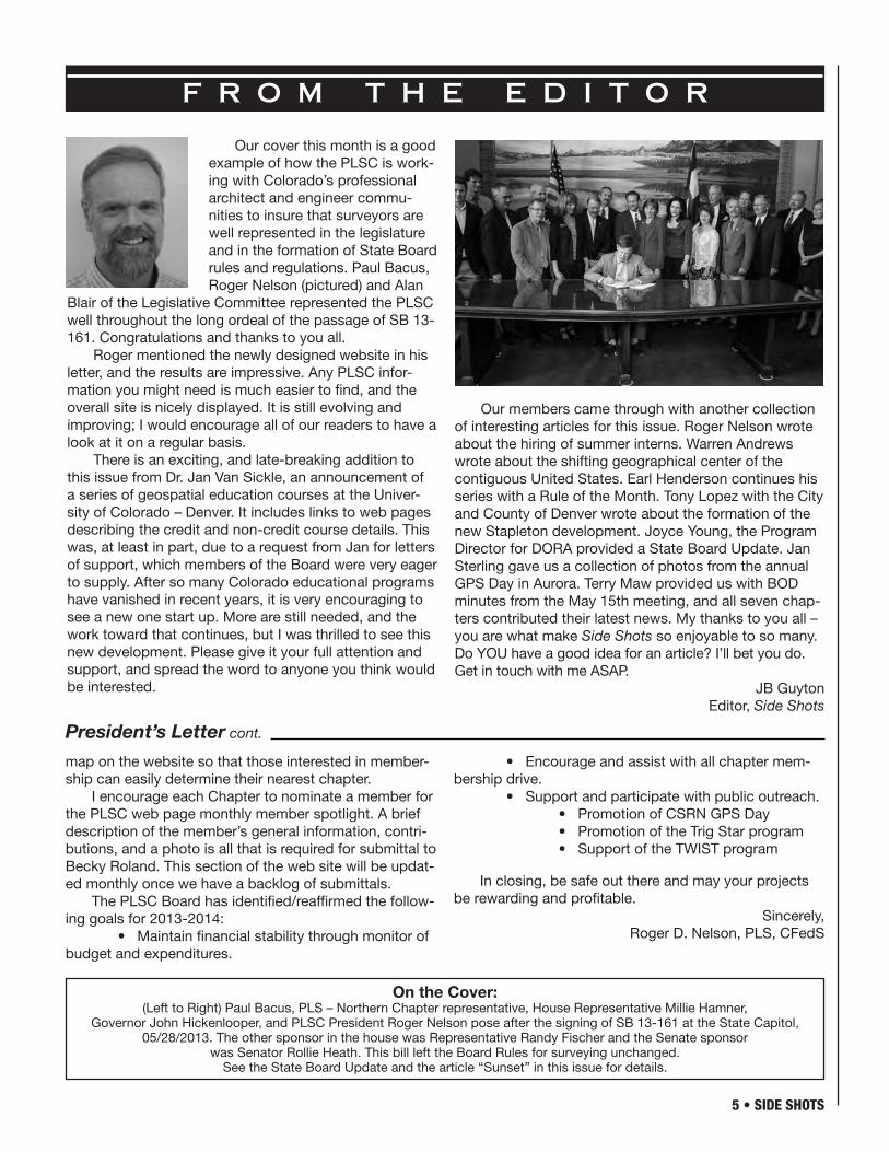
Our cover this month is a good example of how the PLSC is work-ing with Colorado’s professional architect and engineer commu-nities to insure that surveyors are well represented in the legislature and in the formation of State Board rules and regulations. Paul Bacus, Roger Nelson (pictured) and Alan
Blair of the Legislative Committee represented the PLSC well throughout the long ordeal of the passage of SB 13-161. Congratulations and thanks to you all.
Roger mentioned the newly designed website in his letter, and the results are impressive. Any PLSC infor-mation you might need is much easier to find, and the overall site is nicely displayed. It is still evolving and improving; I would encourage all of our readers to have a look at it on a regular basis.
There is an exciting, and late-breaking addition to this issue from Dr. Jan Van Sickle, an announcement of a series of geospatial education courses at the Univer-sity of Colorado – Denver. It includes links to web pages describing the credit and non-credit course details. This was, at least in part, due to a request from Jan for letters of support, which members of the Board were very eager to supply. After so many Colorado educational programs have vanished in recent years, it is very encouraging to see a new one start up. More are still needed, and the work toward that continues, but I was thrilled to see this new development. Please give it your full attention and support, and spread the word to anyone you think would be interested.
Our members came through with another collection of interesting articles for this issue. Roger Nelson wrote about the hiring of summer interns. Warren Andrews wrote about the shifting geographical center of the contiguous United States. Earl Henderson continues his series with a Rule of the Month. Tony Lopez with the City and County of Denver wrote about the formation of the new Stapleton development. Joyce Young, the Program Director for DORA provided a State Board Update. Jan Sterling gave us a collection of photos from the annual GPS Day in Aurora. Terry Maw provided us with BOD minutes from the May 15th meeting, and all seven chap-ters contributed their latest news. My thanks to you all – you are what make Side Shots so enjoyable to so many. Do YOU have a good idea for an article? I’ll bet you do. Get in touch with me ASAP.
JB GuytonEditor, Side Shots
On the Cover:(Left to Right) Paul Bacus, PLS – Northern Chapter representative, House Representative Millie Hamner,
Governor John Hickenlooper, and PLSC President Roger Nelson pose after the signing of SB 13-161 at the State Capitol, 05/28/2013. The other sponsor in the house was Representative Randy Fischer and the Senate sponsor
was Senator Rollie Heath. This bill left the Board Rules for surveying unchanged. See the State Board Update and the article “Sunset” in this issue for details.

© 2013, Trimble Navigation Limited. All rights reserved. Trimble, the Globe & Triangle Logo, xFill, and SurePoint are trademarks of Trimble Navigation Limited, registered in the United States Patent and Trademark Offi ce and/or in other countries. All other trademarks are the property of their respective owners.
When you’re in the fi eld, some days are simple and straightforward. Then, there are the other days: when temperatures are so hot and the air is so thick, you can barely breathe. Days when you’re four hours from civilization and you just lost your signal. It’s for times like these that Trimble designed the all-new Trimble R10 GNSS receiver. It’s lighter and better balanced for less fatigue on long days. The Trimble R10 offers a number of radical new innovations—including Trimble SurePoint™ and Trimble xFill™ technologies—that make getting measurements faster and easier, no matter the conditions. Because extreme working conditions require extreme innovations.
See it yourself at trimble.com/R10showcase.
OUT HERE, YOU DON’T JUST MEASURE BOUNDARIES. YOU PUSH THEM.
FOR MORE INFORMATION
CALL YOUR TRIMBLE DEALER
Frontier Precision Denver, CO
800-652-1522
Vectors Inc Denver, CO
303-283-0343

7 • SIDE SHOTS
I want to thank you very much indeed for responding to the request for letters of support for the Geospatial Edu-cation and Research in the College of Engineering and Applied Science at University of Colorado Denver. You have made a difference. The program for has been given the green light and a start has been made. Here it is. These are the courses that will be on offer online starting August 19, 2013 and they will also be taught in the classroom at this schedule. GPS/GNSS CVEN 5800 Friday 3.30pm - 6.15 pm
Practical High Definition Surveying (HDS) LiDAR for Engineers and Architects CVEN 5800 Tuesday: 1.00pm-3.45pm
Intro to Building Information Modeling (BIM) CVEN 5800-004 Tuesday: 4.00pm-6.45pm
Introduction to GEOINT CVEN 5800 Wednesday: 4.00pm-6.45pm
GIS Spatial Database Development CVEN 5382 Tues/Thurs: 6.30pm-7.45pm
GIS Laboratory CVEN 5386 Saturday: 9:00am-2:00pm
Geomatics for GIS CVEN 5800-015 Thursday 5.00pm - 9pm
These courses will be taught by
Dr. Jan Van Sickle, Van Sickle LLChttp://www.linkedin.com/profile/view?id=3853618&trk=tab_pro
Dr. Jacek Grodecki, Senior Director, Research and Development at GeoEye http://www.linkedin.com/profile/view?id=14575232&locale=en_US&trk=tyah2
Dr. Apostol Panayotov, University of Colorado Denverhttp://www.linkedin.com/profile/view?id=11751179&locale=en_US&trk=tyah
Dr. Delmar (Andy) Anderson, Independent Consultant at Del Consultinghttp://www.linkedin.com/profile/view?id=251678973&locale=en_US&trk=tyah
Thank you again.
If you, or anyone you know, wants to sign up for these classes here are the links to credit and non-credit admissions
credit: http://www.ucdenver.edu/admissions/non-degree/Pages/default.aspx
non-Credit: http://www.ucdenver.edu/academics/colleges/Engineering/discover/ContinuingEngineeringEducation-Program/Documents/CEEPRegForm2137.pdf
Any questions can be directed to Ms. Heidi Utt, Academic Services Program Manager Continuing Engineering Education Program University of Colorado Denver PO Box 173364, Campus Box #115 Denver, Colo. 80217-3364
Office: North Classroom Bldg. Room #3024Phone: 303-556-4907Fax: 303-556-6688Cell: 720-935-3057Email: [email protected]
Geospatial Education and Research Courses at University of Colorado – Denver
By Jan Van Sickle
SIDE SHOTS • 8
Have you ever considered hiring a survey intern? Who benefi ts from hiring a survey intern over the sum-mer months? First, this can be a way of balancing the typical rise in summer demand for fi eld crews with the requirement of increasing labor force. When typical survey crew demands begin to diminish it is time for the student surveyor to return to college to resume their class work. The availability of interns coincides with the seasonal survey demand and keeps survey companies from experiencing staffi ng up and then having to layoff when demand decreases. Second, this is an opportunity for employers to “test drive” potential employees. If a good fi t exist between an intern and an employer, then arrangements can be made to secure future employment of the intern. Third, hiring interns encourages surveyor education and provides real world context for interns to bring back to the classroom and share with fellow stu-dents, as well as being an opportunity for professional land surveyors to give back to the community.
The intern benefi ts from gaining real survey experi-ence for inclusion on their resume and has an opportu-nity to reconcile reality against theoretical knowledge.
Interns are also able to replenish much needed funds for the coming college semesters. As mentioned above, the intern also gets to shop for potential long term employ-ment and begin developing their surveyor network.
How do you begin a survey summer intern program? First, contact a college early that has a survey program and let them know of your interest in hiring a student over the summer. The appropriate contact can be the placement offi ce or the head of the survey department. I recommend conducting multiple phone interviews with several potential interns to determine the right fi t for your business. Once the individual has been identifi ed and terms have been agreed to, it is desirable to assist the intern with fi nding reasonable lodging. An existing employee could offer lodging which would benefi t that existing employee with rental income over the summer or arrangements can be made with extended stay suites local to your business. There is a little effort required to successfully implement an intern program, but the re-wards are well worth the effort investment to smooth the seasonal labor demands.
Survey InternsBy Roger Nelson, PLS
- AutoCAD LT- AutoCAD- Map 3D- Civil 3D- Infrastructure Design Suites- Infrastructure Map Server- Raster Design- Design Review- Subscription
- State of the art training facility- Implementation & customization- Workflow analysis consulting- Styles & standards set-up- License activation support- License compliance- Techincal support- Pilot projects- Transition assistance- On-site consulting- Government Specialist
with customized drafting and design software solutions since 1994
Architecture, Engineering & ConstructionSilver Partner
Authorized Government Partner

9 • SIDE SHOTS
Perhaps you have wondered, where is the center of the United States? But there has been more than one. There was a center of the U.S. of the thirteen original states. That center then changed each time an addi-tional state was added to the Union. In 1861 that center changed radically when the Confederate States seced-ed from the Union but came back to the same spot in 1865. In 1912 it changed again with the addition of New Mexico and Arizona as states. That point still holds to-day as the Geographic Center of the Contiguous United States. But guess what happened again in 1959? The states of Alaska and Hawaii were added to the U.S. and the center changed again. If Puerto Rico ever becomes the 51st state or maybe Guam, the center would change again.
Where are these centers? They’re harder to find than the four corners monument (in the S.W. corner of Colorado) but they do exist. The 1912 to 1959 center monument is near Lebanon, Kansas, and has a large cairn and brass plaque as shown in the illustration marked, “The Geographic Center of the United States.”
Lat. 39˚50’[N] Long. 98˚35’[W]NE ¼ - SE ¼ - S32 – T2S – R11W”
The 1959 to present center is some 21 miles north of Belle Fourche, Butte County, South Dakota, and is marked with a large flat granite marker (flush with the ground like the four corners marker) with flagpole and flag. The interesting part about locating the Lebanon, Kansas center was using the old draftsman’s method for locating the center, or centroid, of an irregular area. A cardboard cutout was made of the 48 state area. Then the centroid was found by balancing the cardboard cutout on a point. The Coast and Geodetic Survey with their legendary precision said they could only guarantee the position within twenty miles.
Control Points – Number 21By Warren Andrews, PLS
The Center
In Belle Fourche, South Dakota
Plaque in Lebanon, Kansas
Images courtesy of Wikipedia.com

SIDE SHOTS • 10
What direction is “Northerly”? How many times have we read this in a description about property? Is it True North? State Plane Grid North? Magnetic North? Clap a 90° from sunset north? Is it parallel to the east section line? And how many degrees off of any of these defini-tions of north can you get before you’ve gone beyond the definition of “Northerly”? If these are the kinds of things your mind conjures up when you read the word “Northerly” or any other “...ly” word in a description, then you are most definitely heading in the wrong direction.
Here we go again. I’m going to say it again, and I may never stop saying it. We are, 99% of the time, retracement surveyors, so our duty is to find the best evidence of the location of the property line as originally laid out. Did you notice I didn’t say “surveyed”? There’s a very good possibility that if the word “Northerly” was used in a description that the line was NOT surveyed, at least not by a trained surveyor. But that does NOT make the original property line location any less valid. It may even have been clapped and paced. That’s okay. Don’t panic. Clapping and pacing is still a valid way of measuring today just like using a plane table is still valid, or a Gunter’s chain is still valid. We have more precise equipment available to us, and generally it’s more cost effective to use it, but it’s not a requirement. The import-ant thing to remember is that the modern equipment is NOT more accurate, it’s only more precise. I believe that A. C. Mulford in his book Boundaries and Landmarks is the person first credited with the quote “...it is far more important to have a somewhat faulty measurement of the spot where the line truly exists than it is to have an extremely accurate measurement of the place where the line does not exist at all.” Mulford should have used the word precise instead of accurate, but hey, it was 1912.
I ran across another wonderful quote recently in a publication that was given to me by a colleague. It is from the case of Johnson v. Westrick, 200 Wis. 405 (1930). It is also still applicable today. In trying to deter-
mine a street ROW, which, by the way, is only another property line, the court stated, “It was held that the east line of the street was where the original surveyor placed it, not where it should be according to resurveys or subsequent surveys; that subsequent surveys are worse than useless; they only serve to confuse, unless they agree with the original survey.” (emphasis added) In the case of the “...ly” words, we must ask, who was the original surveyor? It may have been the property owners. That’s okay. They are allowed to do that. And that may be precisely why the “...ly” word was used because they didn’t know what the precise bearing was that they were measuring. But if they put monuments in the ground then those original monuments define those locations accu-rately, even if we measure them today as “too far off”. And remember, those monuments won’t look like yours and mine. They may be fence corners. They may be axles. They may even be a whiskey bottle. (How precise do you think those corners would be? :) But again, that’s okay. Those are all valid.
So let’s stop and think about this for a moment. If the description used a “...ly” word, then it doesn’t matter if it was surveyed by a trained land surveyor or by a father/son farmer duo for the son’s inheritance. In either case, the folks involved didn’t have a precise idea of what direction they were measuring. So how are we, as equip-ment savvy precise modern measurers going to ever determine that direction by using some mathematical methodology? It ain’t going to happen. And yet our duty is still to “follow in the footsteps” of whoever that was. How can we do that with a calculator/computer/data col-lector/total station/GPS unit that we paid $150,000 for? Easy, lift your eyes up and away from the screen.
My suggestion is that when you first read a “...ly” word do what a friend of mine recently said to me, “Quit reading the description. Look up. Look around. And look for the property.” 90% of the time the definition of North-erly will be right in front of you.
Rule of the MonthBy Earl Henderson, PLS

11 • SIDE SHOTS
Periodically (approximately every 12 years) in the State of Colorado our state government reviews regu-lated professions’ statute laws. This gives the governing bodies and concerned groups a chance to review the statutes to determine if regulation should continue and to clarify and update our laws. In 2013 the rules specif-ic to our profession underwent this sunset review and PLSC was extensively involved in this process. Some of the suggestions like allowing surveyors licensed in other states to solicit survey work in Colorado prior to becom-ing licensed here were successfully challenged by PLSC. PLSC’s efforts included lobbying and testifying in front of two committee hearings.
One of DORA’s objectives for this sunset review was to, where possible, standardize the administration of Ar-chitects, Engineers, and Surveyors professions. We have over the past few years started upon this path as we were known as Certificants, Registrants and licensees. If you have acquired a seal since 2004 the seal now refers to us as Licensed Land Surveyors instead of Registered. Further, the certificates that were issued when we were accepted by the board are no longer provided by the
board. Therefore during the sunset review the terms registration and certification and their variants have been replaced by the appropriate use of license.
Probably the most significant change was the modification of the ILC. Prior to this legislation there was a prohibition keeping the owner or buyer of a property from ordering an ILC. This has been removed and if the person who orders the ILC is not the owner or buyer, a copy shall be provided to the owner or buyer. The certifi-cation requirement has also been modified to specify not only for whom it was prepared, but, “This certificate is valid only for use by (individual or firm) and describes the parcel’s appearance on (date).”
So sunset has ended once again. These laws came into effect on July 1, 2013 and will remain in effect until the next scheduled review when they expire on Septem-ber 1, 2024. This does not mean that there are no further changes to be made. It has been requested that the Leg-islative Committee review the use and abuse of the ILC and come up with viable solutions which I can assure you is no small task. Stay tuned.
SunsetBy Paul Bacus, PLS

SIDE SHOTS • 12
As a member of the Public Works Team and being one of the 5 employ-ees that work for the City and County with the name Tony Lopez, I am the Tony that has been given the task of reviewing ALL Development at Sta-pleton, while representing the City Surveyor’s Office, Right of Way Ser-vices. Other parts of Denver also have Development Review, but Stapleton is slightly more complicated. When Sta-pleton International Airport was to close and become a newly developed area, the FAA (Federal Aviation Admin-istration) became involved, and because the land was originally obtained from the Federal Government (via the Rocky Mountain Arsenal), a possibility existed that said land would revert back to the Government. The City was able to function around this stipulation by constructing DIA (Denver International Airport). FAA sanctions the fact that Stapleton is owned by the Aviation Department of the City and County of Denver, now with an office oper-ating out of DIA.
Before any land can be developed it has to be deeded to the Stapleton Development Corporation (SDC) from the Aviation Department (also known as City and County of Denver). SDC then deeds it to Park Creek Metropolitan District (PCMD) for future streets or parks or to Forest City for future residential or retail develop-ment. Forest City has first right of refusal and can deed it to private developers.
My job is to review all legal descriptions that are as-sociated with the deed transfers so DIA can feel comfort-able with the sale. These deeds represent developments proposed and are called “takedowns.” With portions of land now out of DIA’s ownership, both Forest City and PCMD can propose creating a subdivision plat which will create lots, blocks, and tracts. The subdivision will have a legal description for my review, and will require that I am comfortable with all the surrounding plats, deeds or Stapleton property not yet deeded. Since the area is new, I will also need to supply street names which make sense and project our existing street name grid. When the subdivision plat is recorded, several site develop-ment reviews are submitted, which also have legal de-scriptions for review by me. At Stapleton another review process becomes necessary. Formerly called Residential Development Plan, and now called Site Development Plan, they are full-sized drawing sets which can be up to 50 sheets or even more.
All of the private alleys have either public sewers, both sanitary and storm, or private sewers. The City, per previous agreement, will need to obtain an easement
for said sewers and PNEE’s (Permanent Non Exclusive Easement) for private sewers, again prompting the need for more legal description reviews.
All of the Streets created by subdivision plat are actually tracts with predetermined street names and labeled as Future Right of Way. Park Creek Metropolitan District will build the streets after platting and will build all infrastructure relating to said streets provided that the takedown by deeds gave the property to PCMD.
As part of the review for all parcels, subdivisions, site plans, site developments, easements and any recorded documents, line work must be drawn and checked as it is being drawn. I have presently updated on a day to day basis all that is submitted and have an AutoCAD draw-ing called “Stapleton Master Map October 2012.” This drawing is saved every other month and named with a month and year. Presently this drawing has 736 layers, and does not have the line work geometry for the internal lot lines and street lines. There is a separate method for checking all the line work internally and is either done by the new template application created by our staff or by a state plane application originally called Starter Kit 2011. The purpose of creating all line work and checking it is to provide a product to GIS, which is now being taken from the Starter Kit, adjusted to the new application called Parcel Fabric and exported to our GIS map being used by all. My responsibilities for internal subdivision line work approval did not start until about Stapleton Filing No. 23, and is stored and created in our shared drive on the K: drive.
Eventually the tracts will need to be accepted by the Public Works Department as properly built streets and Park Creek Metropolitan District will deed them back to the City and now will require more legal description review and will also need to be dedicated by resolution as Public Right of Way.
Stapleton was predicted to take about 20 years to build, and being as it is now 2013, it appears that the prediction is close.
Stapleton a New Product by City and County of Denver
By Tony Lopez, PLS
Tony Lopez


SIDE SHOTS • 14
As you know from the February 2013 issue of Side Shots, I am the new Program Director for the Board of Licensure for Architects, Professional Engineers and Professional Land Surveyors (the Board).
Since assuming my new position I have had the opportunity to meet some of you at the 3rd Annual Rocky Mountain Surveyors Summit. At that Summit, I attended the panel discussion regarding Improvement Location Certificates. It was clear that the use of the ILC continues to be a significant issue for the surveying com-munity, which then becomes an issue for the citizens of Colorado. It is my hope that this issue continues to be explored to address the proper use of the ILC.
We are in the beginning stages of a review of the Board Rules to address any changes needed as a result of the 2013 Sunset Review that took place in the 2013 legislative session. Upon initial review of the revisions, it does not appear that there will be a need for any chang-
es to the rules regarding surveying. You can sign up to receive notification of upcoming rulemaking activities at DORA Alerts here: http://cdn.colorado.gov/cs/Satellite/DORA/CBON/DORA/1251628237984
You can access the final draft revisions at www.col-orado.gov by utilizing the “Search for a bill” feature. The Senate Bill number is SB13-161.
Please keep an eye out for the renewal postcards that will be sent out approximately 6 weeks before the October 31, 2013 expiration of your license. The Board newsletter will be released around the time of renewals as well.
I look forward to learning more about the surveying industry in the coming months and expect to continue to foster the practice of open communication between the PLS community and the Board.
You can email me at [email protected] or 303.894.7781 for questions or concerns.
State Board UpdateBy Joyce J. Young, Program Director
State Board of Licensure for Architects, Professional Engineers,and Professional Land Surveyors
Custom orders your way … when you need them.
When your name is on it, our name is behind it.
Berntsen delivers.
Your deadlines deadlines
The professional’s choice in survey products • www.berntsen.com • 877.686.8561
areour

15 • SIDE SHOTS

SIDE SHOTS • 16
GPS Day, 2013Utah Park, Aurora, Colorado – May 11, 2013
See the CSRN Chapter News in this issue for detailsPhotos courtesy of Jan Sterling, PLS


SIDE SHOTS • 18
DISTANCE DELIVERY OF COURSES FOR
LAND SURVEYORS Now it is possible to pursue or advance a career in land surveying via distance delivery. • Select courses individually or as part of the degree completion
program. • Enroll year-around; take six months to complete a course. • Take exams close to home or work. • Communicate with your instructor by e-mail or telephone.
Twelve Self-Paced DVD Lecture Courses SUR 1510-4 Surveying I SUR 2520-4 Surveying II SUR 2530-4 Route Surveying SUR 2550-3 Surveying Computations SUR 3100-3 Survey Data Adjustment/Analysis I SUR 3150-2 Astronomy for Surveyors SUR 3220-2 Real Property Descriptions SUR 3300-3 Photogrammetry SUR 3540-3 Boundary Law I SUR 3700-3 Geodesy I SUR 4510-3 Map Projections and Coordinate Systems SUR 4540-3 Boundary Law II
On-line Course COM 3615-3 Technical Writing for Surveyors and Engineers
For more information and registration visit our web site: www.mscd.edu/surdd or send an email to [email protected] or call Extended Campus at 303-721-1313.
Extended Campus
We were sad-dened to hear of the passing of BLM riparian survey spe-cialist and mentor to many, James A. Simpson.
Jim graduated from the Uni-versity of New Mexico in 1950 with a bachelor of science in civil engineering. He held a U.S. mineral surveyor’s license and surveyed many of the uranium claims in New Mexico as well as mineral claims in Oregon. In 1966, he earned his master’s degree in civil engineering from Purdue University on a teach-ing fellowship and accepted a po-sition at Oregon Technical Institute in Klamath Falls, Ore. In 1971, the Bureau of Land Management asked him to design a training program for Cadastral surveyors at the Universi-ty of Portland, and in 1976 he was accepted for the new BLM position of specialist in riparian boundary surveys with nationwide responsi-bilities in water boundary determi-nations. In that position, he traveled extensively and testified in many court cases for the government. He is the author of many professional papers and publications, the last of which is the manual, “River and Lake Boundaries,” which is held in high regard by his fellow surveyors. Jim drove with his wife from King-man, AZ to Durango and presented a well-attended seminar at their 2007 Four Corners conference. His dedication to teaching was evident as he presented an 8-hour course at age 84.
In MemoriamJames A.
Simpson, PE PLS

19 • SIDE SHOTS
Call to Order: (Roger)Recognition of PLSC Board Members and Officers:Officers: Roger Nelson (Central), Mike Bouchard (VP
- Southern), Terry Maw (Treasurer - Southern), and Becky Roland (Exec. Director).
Board: Todd Beers (Central), Alan Blair (Central), Bill Buntrock (Central), Patrick Green (Western), Leif Joy (NW1/4), Peter Krick (Western), Parker Newby (SW), and Kayce Wohlman (Northern).
Exofficio: Brian Dennis (CSRN)Nonvoting: Warren Ward, Tom Adams (Past Presi-
dent), J.B. Guyton.
County Surveyors Representative: Patrick Green – Also Board Member
Present: Mike Bouchard, Terry Maw, Bill Buntrock, Patrick Green, Steve Parker, Peter Krick, Pamela From-hertz, Leif Joy, JB Guyton, , Alan Blair, Becky Roland
Absent: Todd Beers, Parker Newby, Kayce Wohlman, Terry Maw
Quorum present (6 voting members) Welcome of Guests: Pamela Fromhertz and Steve
ParkerAdditions, deletions and modifications to agenda:
none.Approval of Minutes from Previous meeting(s): (Terry
Maw)
MOTION: To approve the Minutes (Joy). Seconded (Patrick)
2: 2013 Budget – Terry Maw & Becky Roland 3.2 –2013 Budget Status Have consolidated two of the operating
accounts at Wells Fargo. Treasurer Maw has recom-mended electronic transfers for all payments to avoid having to update the mailing address each year for Chapters. PLSC could also make this same arrange-ment for other vendors/individuals. As soon as a transfer is made, an email will be sent to the Chapter officers (President and Treasurer). PLSC would need the name of the bank, account number and routing number. Board consensus is to move forward. Becky will send a memo to each Chapter President and Treasurer requesting the information.
There are three investment accounts that do not have a current Board or Executive Director as a signer.
MOTION: To approve signers of the investment accounts to be the current President, Vice President, Treasurer and Executive Director. (Roger)
Seconded (Alan)Approved unanimously
3.3 - Membership Drive Status update John Wilhelm is finalizing the Central Chapter
drive3.4 – PLSC Membership Application – on website,
on-line renewal. Status update
3: PLSC Website - Updates, Protocol, etc. 5.1 – Authorized Access – Currently Becky Ro-
land. Status update Becky to solicit Chapters on what pages
they would like maintain on the PLSC website. Some Chapters might want to just maintain pages on PLSC’s site and not maintain separate web pages (Central, Southern, CSRN)
5.2 – PLSC Articles of Incorporation – CSRN – Vote approved at membership meeting.
There are some items that we want posted that need to be provided to us, which are listed below:
One paragraph or less, descriptions of each PLSC committee describing its purpose and the chair name and contact for each committee.
Board member photos. Becky has suggested casual photos (family time or activity) to show personality ver-sus formal corporate head shots.
Board member bios. I would prefer the bios used during the election process. Members should know who their representatives are and this is a good place for company marketing to keep the companies engaged. (Roger, Kayce, Patrick Green have submitted)
Submittals for Member Spotlight area. This will need to come from the Board initially to show a monthly change until we get the chapters to submit (JB, Paul Bacaus)
Current PLSC Constitution and Bylaws Suggestions for an expanded “Mission” & “Purpose”
Statement that is inviting and explains better the PLSC goals
2013 PLSC Goals – All Chapter Membership Drive; Financial Stability; Public Outreach (CSRN GPS Day had 70 attendees), Trig STAR for each Chapter, TwiST – post now and have winners post article on website in Side Shots; Stewardship/Advocacy, active legislative commit-tee, inform members/public on legislative actions related to surveyors/surveying.
4: 2014 Surveyor’s Summit, Chair Todd BeersVenue, Sponsors, Tract assignments, speakers,
advertisements 6.1 – List of Activities with Due dates. 6.2 – Assignments 6.3 – ILC Panel Discussion 6.4 – Metro Survey Equipment Donation? If we repeat a topic, experiment with one
topic to see if the second presentation is attended well. If we experiment with the Saturday ses-
PLSC Board of Directors Meeting AgendaMay 15, 2013, 4:00 p.m.

SIDE SHOTS • 20
sion, possibly look at ½ day to make sure that field tech-nicians can still attend. Maybe field topics on Saturday.
Any suggestions from the Board should be pro-vided to the Committee for consideration. The decision remains within the Education Committee.
Chapter Summit Meeting seen as a success.
Next Side Shots deadline is July 1. JB Guyton is looking for articles for the next issue.
Project highlight – 2 short articles per issue and then the Board reviews these for recognition at the Sum-mit each year? Give a free registration at Summit? Can we solicit to Counties to submit highway projects, etc.? (Patrick will contact counties, Alan will ask contractors he works with for right-of-way projects coming up, and Roger will contact Federal Highways)
Personal stories/ 40th Parallel 5: Bob Stollard’s House (Update?). – Deed to be
signed & recorded. Have the deed; Roger will sign and Becky will
get it recorded with the City and County of Denver; Roger and Becky will then go to the house to inform the current tenant on status. Becky has contacted Section 8 Housing and a realtor. She will report back on any addi-tional steps that need to be taken and initial asking price for sale of the house.
6: PLSC 2013 Goals – See above Board consensus is to meet every two months.7: Reports:President, Roger Nelson – Nothing more to add be-
yond what has been discussed.Vice President, Mike Bouchard – Nothing more to
add beyond what has been discussed.Secretary-Treasurer, Terry Maw – Becky and Terry
will update the budget and sent to the Board. Future reports need to be reported prior to each Board meeting
Executive Director, Becky Roland – Revise By-Laws to remove procedures – work so it is ready for the Sum-mit to vote on.
NSPS Governor – Warren Ward WFPS Delegates Mike Bouchard and JB Guyton
- Next meeting is June 2 in San Francisco. Notes from the meeting will be printed in Side Shots. Need to make sure to let teachers know about Twist, Trig STAR and GPS Day.
Front Range Surveying and Mapping Program, JB Guyton, Chair
Lynn Paton on-line program. Jan Van Sickle has been working with CU Denver on a geo-spatial-type program (4 year program). Nothing on the immediate horizon for an in-person education program. Alan Blair volunteered to assist JB.
Based on the discussion relating to the health of the profession, it was noted that outreach to GIS and users of surveying services be made through articles in their industry magazines/events.
Roger asked Leif to write an article on work that they have been doing on the Western Slopes for Side Shots.
Pam asked that someone join the GIS listserve to answer the questions that come up related to surveying. JB offered and Steve Parker is willing to assist.
8: Standing CommitteesLegislative Committee – Alan Blair, Chair – Status
of Sunset Legislation – Created a blog on ILCs; Bill to be signed on 5/22 – Alan and Roger to attend (photo for website and Side Shots)
Survey Monumentation and StandardsMembership Committee, Mike Bouchard, Chair –
nothing to report beyond previous agenda item; Roger asked Mike to send an email to Chapters to remind them about member drives (Southern and Central Chapters have drives in the works)
Ethics and Fair Practices, Patrick Green, Chair – no report
Education Committee, Todd Beers, Chair – Mentor? – no report
Liaison Committee, (QBS Colorado) ? Chair – wait until QBS decides their future structure
Special Committees – no reportTrig Star - See previous agenda items; Warren has
made presentations and promoted Trig StarGIS-In-The-Rockies – Kayce Wohlman – Call for
Abstracts sent9: ChaptersSouthern – Joe Alessi, President – Members meeting
next Tuesday – Todd Beers to present on the value of membership; Board members calling lapsed members; golf tournament in August; new website
Central – Chris Raml, President – Membership drive; baseline; next meeting at Table Mountain 4th Thursday
Northern –Kayce Wohlman, President – no reportNW ¼ - Brian T. Kelly, President – Push for GPS
CORS Station in SteamboatWestern – Richard Bullen –Western Slope exofficio
appointment - Peter Krick – Annual Spring Seminar Fri-day with Board Meeting
Southwestern – Josh Casselberry, President – Sem-inar June 7-8 information is posted online; baseline assistance; Durango CORS Station is up and running; Chapter page within PLSC site; Roger/Becky to provide quote on Refresher Course material/presentations (initial-ly pay back expense to convert the tapes and then split the proceeds)
CSRN – Jan Sterling, President – Need to identify a successor for Jan; GPS Day was successful; Looking at possible presentations in June
10: Next Meeting Date and Location: July 17 at 4PM @ Merrick Office, 5970 Greenwood Plaza Blvd., Green-wood Village, CO. or call in on Go To Meeting.
11: Adjourn: Maw motion, Krick 2nd 6:15pm

Wagner Equipment Co. is now your service solution for Trimble surveying equipment. With the most experienced service department in the region, we have the resources to fulfill our commitment to total customer satisfaction. Wagner repair services the complete line of Trimble surveying solutions.
• GPS field surveying systems
• GPS infrastructure solutions
• Robotic and servo-driven total stations
• Digital levels
• Trimble Data Controllers
TotalService SolutionsProvider
Your authorized dealer for Machine Control Solutions
www.wagnerequipment.comCall: 1-866-903-2335

SIDE SHOTS • 22
EXCEPTIONAL CONTENT-RICH CONFERENCE:• Outstanding Sessions• Networking• 2 Great Keynotes: • JAMES FEE Spatially Adjusted Owner/Founder; Planet Geospatial Founder • FRANK BIASI National Geographic Maps - Digital Development Director• Presentation Opportunities – Sessions, Posters & Maps• Onsite Job Fair• Pre-Conference Workshops• Post-Conference Tours: NREL (National Renewable Energy Lab) & MetCom (911 Communication Center) Join us October 9 & 10 for the 26th Annual GIS in the Rockies Conference at The Cable Center on the University of Denver campus.
GIS in the Rockies October 9 & 10
Denver
GISintheRockies.org

23 • SIDE SHOTS
C H A P T E R N E W S
CCPSI hope everyone is having a great
time this summer enjoying the sun and taking in whatever hobby it is that you enjoy this time of year.
Our special project for 2013 is to construct a new baseline in the Denver metro area for all members of the land surveying community to utilize. We have found a suitable location on Highway 2 in Commerce City and hope to have it complete by the time you read this installment of Side Shots. More information will follow as it will be measured by the NGS and published for public use in 2014. Thanks to Pam Fromhertz and everyone else who donated their time and other resources to make this happen!
The CCPS had hoped to con-tinue to have topics and speakers at our general membership meet-ings this year that would be just as interesting as those we had in 2012, and I think we have succeeded! I want to give thanks to everyone who was willing to donate their time and present as one of our guest speakers so far this year.
Our June meeting was well attended as Apostol (Toly) Panayotov put on a well-received presentation about low-distortion projections and the new Geomatics program he is involved with at UCD. Please contact Dave Kuxhausen, or myself, if you would like contact information for Toly. If you have a speaker in mind for a future meeting please let me know. These are great venues to discuss anything regarding the land surveying profession.
The 2013 CCPS board of direc-tors consists of: Officers; Christo-pher Raml, President; David Kuxhau-sen, Vice President; Mark Wilson, Secretary; Aaron Willis, Treasurer. The directors are Shawn Clarke, George Robinson, John Wilhelm, Ter-ry Pickering, Kevin Kucharczyk, Ken Baker, and Tony Perazzo. Thanks to all of you who serve on our board.
Please visit us at www.central-cosurveypro.com for contact infor-mation, meeting details, and general CCPS news.
Christopher Raml, PLSCCPS President
CSRNThe CSRN had another success-
ful event on May 11, 2013 with the 3rd Annual GPS Day. The weather was perfect for a day outside talking with people about GPS, GIS, and Land Surveying. Boy Scouts, Girl Scouts, high school teachers, col-lege students, surveyors, and GIS professionals were some of the peo-ple that came and enjoyed the event. Interesting and interactive displays were presented by Compass Tools, Frontier Precision, GeoShack/Rocky Mountain Lasers, and Wagner Cat. The City of Aurora GIS coordinator, Bill Keever, discussed GIS and had a contest for kids to color in the limits of different cities. Pam Fromhertz, of NOAA had a continuous audience discussing NGS’s Mission and major NGS projects. The PLSC President, Roger Nelson, discussed the Unit-ed States Public Land System and how America divided the land for personal ownership and Todd Beers demonstrated how aliquot division of sections was done. CSRN member Steve Parker managed the Geocach-ing course with handheld GPS units provided by Compass Tools.
The highlight of the day with much participation was the GPS Stake Out Course sponsored by Wagner Cat and Brennan O’Neil. Fol-lowing the Trimble slogan, precision GPS can put you “Right of the Mon-ey,” Brennan hid fifty one dollar coins in the grass and participants using precision GPS equipment found them. Once word got out that the participants got to keep the coins, there was a line to see Brennon O’Neil and his GPS equipment.
The CSRN still needs a Secre-tary, which is an officer position of the CSRN. If anyone is interested,
contact Jan Sterling at [email protected]. The CSRN is canceling the sum-mer general board meetings due to everyone’s busy schedules and the next meeting will be held September 19th, at a location to be announced later. Emails will be sent out when the location is tied down. The CSRN wishes everyone a wonderful and safe summer.
Jan Sterling, PLSCSRN President
NC-PLSCOur group is now on our sum-
mer hiatus and will kick back in full swing September 4th (location to be determined). This presentation we’ll discuss goals and look to fill a Director position that will be opening up. Please submit an email to me if you’re interested in filling this role. It’s a great resume builder, helps support your surveying community and allows you the opportunity to really change the goals and direc-tion our chapter will take in coming years.
Warren Ward provided our group with a presentation on NSPS this past May. He’s going around to all of the Chapters of the PLSC and providing this service. I encourage everyone to attend. The NSPS wants to join forces with all state surveying organizations so we can have one voice.
David Tomaschow, a Surveyor with the Forest Service provided a presentation in April on record keeping at the Forest Service and provided excellent background on their organization. Anyone perform-ing Forest Service work would have found this presentation of value. He also passed around some real trea-sures; old forest service maps.
Our group hopes to see you this fall when we bring in new and exciting presenters. We’re also antic-ipating more projects. These include TrigSTAR, establishing a new CORS station, and the booklet production. If you have any ideas or suggestions,

SIDE SHOTS • 24
please forward them to me. We’re always looking for new innovative ways to help our constituents.
Kayce D. Wohlman, PLSNorthern Chapter President
NW ¼ CLSSummer is well upon us here in
the NW corner of the state. We only wish the economy heated up as fast as the forest fires!
Garfield, Routt and Moffat Counties - three of the counties that comprise a good part of the NW ¼ - are showing similar recoveries from the economic recessions of years past. Property assessed valuations are down 25-35%, depending on which county you reside in, and in the case of Garfield County, property tax from Oil and Gas receipts are down 31%. Garfield County receives 71% of its property tax revenue from Oil and Gas, so the impact is over $10 million of lost revenue, which carries through to delayed capital improvement projects, which of course impacts surveying. The same trend is also impacting Rio Blanco, Routt, Moffat, Jackson and Grand Counties, although only Rio Blanco County has anywhere near the Oil and Gas property tax revenue that Garfield County does. Therefore, all of the affected Counties in this part of the State are typically delaying or shelving capital improvement projects, unless there is a substantial federal or state grant involved.
Years past have shown this part of the State recovering a year or two after the Front Range. It appears the real estate market bottomed out last year and values are headed up. This has increased the number of sales in Routt County year to date, which of course has a positive impact on surveying. House values in the real estate market are typically selling for 60-70% of replacement costs, which is not helping the recovery of commercial and residential building. To sum it up, oil and gas surveys are down, real estate surveys are up,
construction surveying is down and overall most surveying companies are at personnel levels lower than historic memory.
We can see the recovery in the surveying job market along the Front Range and in other states, but the trend listed above for the NW 1/4 region of being a year or two behind also seems to be holding true in the surveying job market. It should be interesting to see what companies do as the market recovers. If the past five years are any evidence, most companies are trying to work out cooperative arrangements with other surveying companies to cover a short term need as opposed to hiring new personnel. Until there is real confidence that the recovery is here to stay, long term hiring in many cases could be two to three years away for this region.
Brian T. Kelly, PLSVice-President
SCPLSAlmost a year to date from last
year’s Waldo Canyon Fire, we now have experienced the worst fire in Colorado history. The Black Forest fire burned 509 homes and two people lost their lives. The commu-nity again thanks the fire fighters, the military, law enforcement and all the volunteers who have selflessly offered endless hours of service. Special fund raisers are to benefit the homeowners without insurance. Our hearts go out to all who have lost their homes and lifetime posses-sions.
The May Membership Meeting was held at the Colorado Springs offices of the Farnsworth Group. The theme was “Right of Entry for the Land Surveyor.” We were honored to have two dynamic guest speakers discuss the Colorado Right of Entry for Land Surveyors, conceal carry permitting, firearms training oppor-tunities, and how the new Colorado gun laws may impact our everyday lives.
The first speaker was Tim Prie-be, an attorney with a practice dedi-cated to business law and litigation. Mr. Priebe is certified through NRA to teach the Basic Pistol Course, as a former San Diego police officer and a weapons instructor at Fort Carson. Mr. Priebe presented the Colorado Revised Statues pertaining to Right of Entry and the process described in the law.
Second speaker was Paul Paradis, a local firearms store owner, an expert in court related firearms cases, and an instructor for conceal carry permitting in Colorado. Mr. Paradis discussed the responsibility and training needed to comply with the standards of the law for a conceal carry permit.
The meeting was educational and revealed valuable information that the Land Surveyor must comply with the Law as it relates to access across public and private land.
Joseph Alessi, PLSPresident, Southern Chapter
SWC – PLSCThe SWPLSC held our most
recent chapter meeting on Tuesday, May 14 in Durango. We had the hon-or of hosting Warren Ward on behalf of the NSPS. Some of our mem-bers have volunteered for Trigstar, which is a high school testing that includes trigonometry survey related questions. We will be working with Durango High School and Animas High School.
Our annual seminar had a great turnout of attendees. A good number of our attendees are from the neigh-boring state of New Mexico. There were also folks from Arizona and Utah. We hosted Dennis Mouland, Milton Denny, Pamela Fromhertz and Alison Walls as speakers. We are working on updating the chap-ter website with current officers, meeting minutes and time/location information.
Our next meeting is scheduled for
C H A P T E R N E W S

25 • SIDE SHOTS
C H A P T E R N E W S
Tuesday, September 10. Look for guest speaker information, time and location in the upcoming email.
Joshua J. Casselberry, PLSPresident, SWC-PLSC
WCLSMany thanks to all who partici-
pated in the WCLS Spring Seminar. Special thanks to Mr. Dave Pehr for sharing his knowledge with us. Peter Krick, Dennis Shellhorn and Brian
Bowker did an excellent job putting the seminar together. Thank you to Souder, Miller & Associates for spon-soring the morning break. Thanks to the vendors and others that provided door prizes, including: BLM (Dave Ginther), Vectors, Frontier Precision, Safety Tek Industries, Berntsen Inter-national, Blue Marble Geographics and Grand Valley Reprographics. We had a large amount of door prizes and Dave Henderhan was the win-
ner of the IPOD Touch donated by WCLS. Thanks again for helping to make the seminar a success.
Our next meeting will be on July 10th and it will be a family BBQ. The BBQ will be at the grand shelter at Canyon View Park and will start at 6:00. Please RSVP to Richard at (970) 245-4921.
Richard BullenPresident, WCLS
S U S T A I N I N G M E M B E R SAccurAte core Drilling, inc.
15550 Hwy. 86Kiowa, CO 80117
303-898-4385
AssurAnce risk MAnAgers2851 S. Parker Road
Suite 760Aurora, CO 80014
303-454-9562
terry c BArnesRange West, Inc.
P.O. Box 589Silverthorne, CO 80498
(970) 468-6281
Berntsen internAtionAl, inc.P.O. Box 8670Madison, WI 0608-249-8549
cAD-112130 N. Pennsylvania Street
Thornton, CO 80241303-427-2231
cArlson softwAre12161 W. Layton Avenue
Morrison, CO 80465303-482-1836
coMM-tech5398 Manhattan Circle
Boulder, CO 80303303-530-4976
coMpliAnce solutions3980 Quebec Street
2nd FloorDenver, CO 80207
303-307-9220
DAviD evAns AnD AssociAtes, inc1331 17th Avenue
Suite 900Denver, CO 80202
720-946-0969
DiversifieD unDergrounD inc.2851 S. County Road, #137
Bennett, CO 80102
encoMpAss services, llc394 Lake Avenue S.
Suite 510-DDuluth, MN 55802
esri380 New York StreetRedlands, CA 92373
909-793-2853
flAtirons surveying & engineering, inc.
3825 Iris Avenue Suite 395
Boulder, CO 80301303-443-7001
four points surveying & engineering, inc.
P.O. Box 775966Steamboat Springs, CO 80477
frontier precision inc5480 West 60th Ave., Unit A
Arvada, CO 80003720-214-3500
hixon Mfg & supply co8775 E Orchard Road
Suite 807Englewood, CO 80111
303694-0012
holMAn’s usA, llc6201 Jefferson St. NE
Albuquerque, NM 87109
roBert r JohnsRange West, Inc
P.O. Box 589Silverthorne, CO 80498
(970) 468-6281
ngs/noAAPamela Fromhertz
c/o USGS Core Science InformaticsBuilding 810, MS 306
Denver, CO 80225303-202-4082
nv 58000 South Chester Street
Suite 200Centennial, CO 80112
303-220-6400
power surveying coMpAny inc.120 W. 84th AvenueThornton, CO 80260
303-702-1617
pwsi lAnD surveyors3545 S. Platte River Drive, #M-3
Sheridan, CO 80110303-904-1345
DiAne sierrA10355 Westmoor DriveWestminster, CO 80021
sitewise corporAtion7000 N Broadway #3-305
Denver, CO 80221303 459 6531
sklD inforMAtion services9540 East Jewell Avenue
Suite ADenver, CO 80247
303-695-3850
surveying & MApping, inc.4801 Southwest Parkway
Bldg. 2 #100Austin, TX 78735
surv-kAp llcP.O. Box 27367
Tucson, AZ 85726520-622-6011
terrAMetrA resources2919 Bryn Mawr PlaceLongmont, CO 80503
terrAMetrix, llc4852 S 133rd Street
Suite 105Omaha, NE 68137
402-618-3165w
totAl postioning solutions5385 Quebec Street
Commerce City, CO 80022303-853-0311
triMBle10355 Westmoor DriveWestminster, CO 80021
unDergrounD consulting solutions2701 W. Oxford Avenue, Suite 6
Englewood, CO 80110303-904-7422
vectors, inc8811 E Hampden Avenue
Ste 110Denver, CO 80231
303-283-0343
western reseArch & DevelopMent634 Suntrail Drive
Loveland, CO 80538307-632-5656
woolpert16916 E. Costilla Ave.Foxfield, CO 80116
these firms support our organization. please show them your appreciation
with your patronage.

SIDE SHOTS • 26
Complete Photogrammetric Services
MAP MAP WWORKSORKSContact: Ralph Vomaske, Certified Photogrammetist, ASPRS
7625 W. 5th Ave. #203E • Lakewood, CO 80226
Phone: 303-445-1856
E-mail: [email protected]

27 • SIDE SHOTS
Call Toll Free 1-800-545-0932
Item#: Designjet-T520-36$2,850.00 Includes ZERO Dollar Shipping! Valid until 5/31/13Fast & Professional ResultsEasy & Convenient PrintingPrint From Virtually Anywhere
Carlson Civil Suite-Survey, Civil, Hydrology & GISDramatically increase your productivity while you save both time and money. Need Pricing? Call Amy at 1-800-545-0932 Today! Or Order Now at Holmans.com.
Surveying I Computers I Plotters
HP Designjet T520 36”
Prices are subject to change without notice. Limited Quantities. Plus sales tax if applicable.
