application for development procedures & instructions
TRANSCRIPT

APPLICATION FOR DEVELOPMENT
Procedures & Instructions
NOTE: ALL PLAN SETS MUST BE FOLDED BEFORE SUBMISSION
Revised: November 10, 2015 1. Submit one (1) completed Jersey City General Development Application and one full size, signed and clearly sealed, stapled and FOLDED set of development plans, along with a $150 deposit and supporting documents as described within the General Development Application instructions. Applicant will receive a signed “Receipt of Documents” which only certifies that materials were submitted on a specific date and accepted by a specific member of the City Planning Division staff. This “Receipt” is not an indication of the “completeness” of submitted materials or that the documents submitted constitute a valid application. 2. Within 45 days of receipt of the materials listed in Paragraph 1 above, the applicant will receive a letter indicating if the documents provided constitute a valid Application for Development. This evaluation will contain a Jersey City Development Case Number and identify the Review Planner assigned to your application. Please address all future correspondence relating to this application to the Review Planner and include the Case Number, the property address, and the Block(s) and Lot(s). Further document submissions may be necessary in order to qualify as a valid Application for Development, and to thereafter be deemed “complete”. 3. Upon notification by the Review Planner that the application submittals are valid and ready to be sent to the Review Agents, the applicant will promptly submit one (1) additional set per Review Agent, of full size, signed and clearly sealed, stapled and FOLDED development plans bundled with an additional set of the full application documents and all supplemental information to the Review Planner for distribution to the Review Agents listed below. Each set of plans and documentation will be submitted in individual, unsealed and unaddressed envelopes of sufficient size to completely and neatly contain each package of documents. These envelopes will be delivered in a cardboard box(es) as needed. City Planning will then distribute the packages to the review agents through the city’s Messenger Service. The Messengers will be provided by City Planning with a Delivery Confirmation Signature Sheet for each particular application, which will be returned to City Planning by the Messenger Service upon completion of the delivery. 4. Each review agent may review and comment on the application and must respond within 14 days of receipt of plans and application documents delivered in Step 3 above. The review agents will be responsible for sending their individual comments to the following: 1.) the applicant; 2.) the applicant’s professionals, such as the applicant’s architects, engineers and attorneys; 3.) the Review Planner from the Division of City Planning assigned to the particular project.

5. The applicant may contact each Review Agent directly to address their individual comments. The applicant must contemporaneously provide the Review Planner with a copy of any and all correspondence sent to any Review Agent. The Contact Information for the Review Agents is provided in the attached application pakcage. 6. If any revisions are made to the development plans submitted under Step 3. as a result of comments from any Review Agent, the applicant must submit one (1) set per Review Agent of such revised plans, bearing a clearly visible revision date, full size, signed and clearly sealed, stapled and FOLDED, and placed in appropriately sized boxes, to the Review Planner for further distribution to the Review Agents by the Division of City Planning via the Messenger Service. Each time a revised plan is submitted to the Division of City Planning, it shall be accompanied by a cover letter listing all the changes and which review agent requested them, with all changes graphically called out by the use of “clouding” around the changed areas. Drawings without revision dates will NOT be accepted and will be returned at the applicant’s expense. 7. The Review Planner will determine if the application is “complete” based upon the content of the Review Agents’ comments, including those of the Review Planner. Once deemed complete, the applicant will be assigned a hearing date and a submission deadline by the Division of City Planning, and will be notified of such in writing and/or email. Upon notification, the applicant shall promptly submit the required number of signed and clearly sealed, stapled and FOLDED development plans to the Review Planner. The required number of sets of development plans to be submitted is as follows: a minimum of: fourteen (14) sets for a case before the Planning Board, or eleven (11) sets for a case before the Zoning Board of Adjustment. 8. The plans submitted in Number 7 above shall be the same plans that all Review Agents and the Review Planner had reviewed in their last round of review and comment letters. They shall be submitted to the Division of City Planning at least 10 days prior to the scheduled hearing date for a timely distribution. 9. If the plans submitted in Number 8 above are not submitted on time, your case will be carried to the next regular meeting of the Board, within the limits of the Municipal Land Use Law. NO applications will be heard by the Planning Board, Zoning Board, or Historic Preservation Commission unless fees have been paid in full.

Page 1 of 6
6. APPLICANT
Applicant’s Name Street Address
Phone
Fax
City State Zip
e-Mail address
CITY OF JERSEY CITY GENERAL DEVELOPMENT
APPLICATION
THIS SECTION TO BE COMPLETED BY CITY STAFF ONLY
Intake Date: Date Validated as an Application for Development: Date Deemed Complete:
Application No.
1. SUBJECT Address: ________________________________ Block & Lots: ____________________ PROPERTY Ward: ______
2. BOARD Planning Board Zoning Board of Adjustment DESIGNATION 3. APPROVALS BEING SOUGHT
Conceptual Plan/Informal Review ”c” variance(s)/Deviation ”A” appeal Minor Site Plan (d) variance(s): use,
density, etc. Waiver of Site Plan
Requirements Preliminary Major Site Plan Minor Subdivision Interpretation (“B” appeal) Final Major Site Plan Prelim. Major Subdivision Site Plan Amendment Conditional Use Final Major Subdivision Other (fill in) ____________
4. PROPOSED DEVELOPMENT
Name & Nature of Use (describe project)
5. VARIANCE/ DEVIATION NOTES
Sections of the Land Development Ordinance or Redevelopment Plan from which relief is requested (List Variances/Deviations): Applicant’s reasons for the Planning Board or Board of Adjustment to grant relief:

Page 2 of 6
7. OWNER
Owner’s Name Street Address
Phone Fax City State Zip
8. APPLICANT’S ATTORNEY
Attorney’s Name Street Address
Firm’s Name City State Zip
Phone Fax e-mail address
9. PLAN PREPARERS
Engineer’s Name & License Number Street Address
Firm’s Name City State Zip
Phone Fax e-mail address
Surveyor’s Name & License Number Street Address
Firm’s Name City State Zip
Phone Fax e-mail address
Planner’s Name & License Number Street Address
Firm’s Name City State Zip
Phone Fax e-mail address
__________________________________________ Architect’s Name & License Number __________________________________________ Firm’s Name __________________________________________
Phone Fax
____________________________________________ Street Address ____________________________________________ City State Zip ____________________________________________ e-mail address
Page 3 of 6
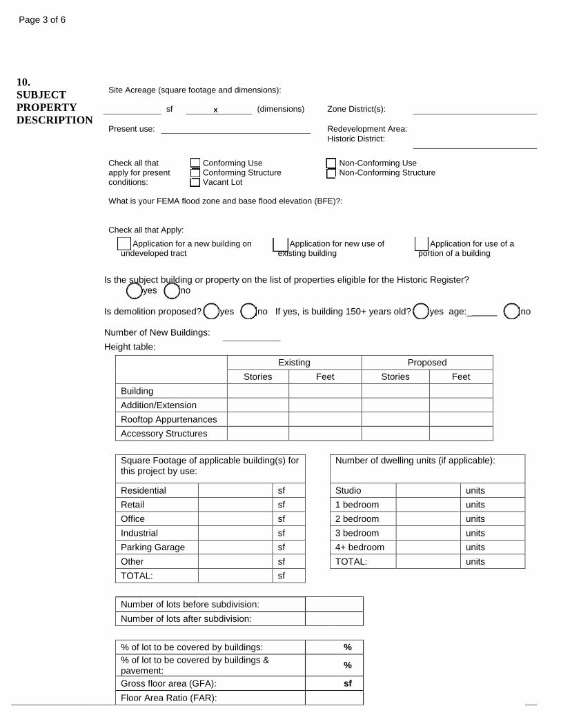
10. SUBJECT PROPERTY DESCRIPTION
Site Acreage (square footage and dimensions):
sf
x (dimensions)
Zone District(s):
Present use:
Redevelopment Area:
Historic District: Check all that apply for present conditions:
Conforming Use Conforming Structure Vacant Lot
Non-Conforming Use Non-Conforming Structure
What is your FEMA flood zone and base flood elevation (BFE)?:
Check all that Apply:
Application for a new building on undeveloped tract
Application for new use of existing building
Application for use of a portion of a building
Is the subject building or property on the list of properties eligible for the Historic Register? yes no Is demolition proposed? yes no If yes, is building 150+ years old? yes age:_ no Number of New Buildings: Height table:
Existing Proposed
Stories Feet Stories Feet Building Addition/Extension
Rooftop Appurtenances Accessory Structures
Square Footage of applicable building(s) for
this project by use: Number of dwelling units (if applicable):
Residential sf Studio units Retail sf 1 bedroom units Office sf 2 bedroom units Industrial sf 3 bedroom units Parking Garage sf 4+ bedroom units Other sf TOTAL: units TOTAL: sf
Number of lots before subdivision: Number of lots after subdivision: % of lot to be covered by buildings: % % of lot to be covered by buildings &
pavement: %
Gross floor area (GFA): sf Floor Area Ratio (FAR):

Page 4 of 6
11. PARKING & SIGNAGE
Number of parking spaces & dimensions: number: / Dimensions: Number of loading spaces & dimensions: number: / Dimensions: Number of Signs: Height of monument and/or pylon signs:
12. INFRA-STRUCTURE
WATER Is public water being extended to the tract and/or reused? If yes, Yes No specify size and material.
Size Material
Does the existing water service have a curb stop? Yes No Is there existing combined fire/domestic service? Yes No Is there existing domestic service only? Yes No Is new water service being proposed? Yes No Is there new combined fire/domestic service? Yes No Is there new domestic service only? Yes No
SEWER Is existing sewer service proposed to be reused? If yes, Yes No specify size and material.
Size Material
Will there be sewer curb cleanout? Yes No Are minimum slope requirements satisfied as per National Standard Plumbing Code? Yes No
Is new sewer service proposed? Yes No Are storm drains proposed? Yes No Are any new streets or utility extensions proposed? Yes No
MISC
Are existing streets being widened Yes No Are utilities underground Yes No Is site in a flood plain? Yes No Is soil removal or fill proposed? If yes, specify total in cubic yards. Yes No Are any structures being removed? Yes No Is the application for additional buildings and/or improvements to a tract having existing buildings and/or improvements? Yes No
Is the property within 200 feet of an adjacent municipality? If yes, which? Yes No
Municipalities: Is the property on a County Road? Yes No Are there deed restrictions, covenants, and/or easements affecting the tract? If yes, attach 2 copies. Yes No
Are there any performance guarantees and/or maintenance agreements with the City Council? If yes, attach 2 copies. Yes No

Page 5 of 6
13. TYPE OF DEVELOPMENT
REQUIRED FOR ALL DEVELOPMENT APPLICATIONS
Total number
of new residential
units created
Total number of
affordable housing units*
created
Total number of residential units
demolished
New structure containing residential units Conversion from a non-residential structure to a structure containing residential units Conversion from market rate housing units to NJ COAH defined affordable housing units
*According to NJ COAH definitions at N.J.A.C. 5:94 et seq.
Moderate Income Low Income Very Low
Income Age Restricted Rental Units
Number of affordable housing units created*
*According to NJ COAH definitions at N.J.A.C. 5:94 et seq.
Use Group Description (These descriptions are pursuant to NJ Council on Affordable Housing N.J.A.C. 5:94 Appendix E, and are for the sole purpose of calculating affordable housing obligation.)
Gross Floor Area
of New Construction
Gross Floor
Area of Demolition
B: Office buildings. Places where business transactions of all kinds occur. Includes banks, corporate offices, government offices, professional offices, car showrooms and outpatient clinics.
M: Mercantile uses. Buildings used to display and sell products. Includes retail stores, strip malls, shops and gas stations. F: Factories where people make, process, or assemble products. F use group includes F1 and F2. S: Storage uses. Includes warehouses, parking garages, and lumberyards. S group includes S1 and S2. H: High Hazard manufacturing, processing, generation and storage uses. H group includes H1, H2, H3, H4 and H5.
A1: Assembly uses including concert halls and TV studios.
A2: Assembly uses including casinos, night clubs, restaurants and taverns. A3: Assembly uses including libraries, lecture halls, arcades, galleries, bowling alleys, funeral parlors, gymnasiums and museums, but excluding houses of worship
A4: Assembly uses including arenas, skating rinks and pools. A5: Assembly uses including bleachers, grandstands, amusement park structures and stadiums
E: Schools K – 12 I: Institutional uses such as hospitals, nursing homes, assisted living facilities and jails. I group includes I1, I2, I3 and I4.
R1: Hotels, motels and dormitories
U: Miscellaneous uses. Fences, tanks, sheds, greenhouses, etc.

Page 6 of 6
14. APPROVAL HISTORY
List all past approvals, denials, appeals, or other activity for the subject property. If there are previous approvals, attach 2 copies of the approving resolution.
Check here if none
CITY JOB/CASE NUMBER APPROVED DENIED DATE Subdivision
Site Plan
Variance(s)
Building Permit
15. FEES (see attached fee schedule)
STAFF CALCULATIONS ONLY Subdivision $
Site Plan $
Variance(s) $
TOTAL DUE $
Amount Paid $
BALANCE DUE $
16. ATTACHMENTS
Please Attach the required additional forms and information, if applicable (see attached FORMS and CHECKLISTS)
17. CERTIFICATION
I certify that the foregoing statements and the attached materials submitted are true. I further certify that I am the individual applicant or that I am an Officer of the Corporate Applicant and that I am authorized to sign the application for the Corporation or that I am a General Partner of the Partnership Applicant. I hereby permit authorized City official to inspect my property in conjunction with this application. Sworn to and subscribed before me this date
Signature of Applicant Property Owner Authorizing Application if other than Applicant Notary Public

Minor Subdivision ChecklistJersey City Land Development Ordinance
CASE #:DATE: PROPERTY ADDRESS:APPLICANT:OWNER:
WaiverYes No N/A requested * Remarks (for staff only)
1.
2.A) One when initial application is filed.B) Review agent sets (when instructed by Staff)C) Fourteen for planning Board (when complete)D) Eleven for Zoning Board (when complete)
(1)
(2)
(3)
(4)
(5) Zoning table(6)
(a)
(b)
(c)
(d)
(e) Any building line restrictions of record.(f)
(g)
(h)
(I)
(j) Dates of drawings and revisions, if any.(k) Graphic scale(l) Project title(m)
All new property lines shall be shown in heavy broken lines.Tax block, lot number(s) and street addresses
A definite point of beginning, referenced by adjacent lines.Each boundary of the survey, shown by metes, bounds and bearings, indicated by magnetic, true north or relative bearing.
A key map at a scale not less than 1" to 600' depicting a 1000' radius clearly identifying zoning district, streets and lots involved in the application. To be located on the first numbered drawing sheet.The scale shall be a minimum of 1"=20' for tracts up to 40 acres and 1"=50' for tracts over 40
All property lines not to change shall be indicated by heavy solid lines.
North arrow: to be designed so that the north is facing the top of the page.
Any right-of-way or other permanent easement existing on the property.
All property lines to be changed shall be indicated by broken lines.
The area(s) of both the original and proposed lots.
Plat Details
The subdivision plat size shall be one of the following:8.5x13"; 15x21"; 24x36"; or 30x42".
Application Requirements, Development Procedures & Checklists
Submitted
Minor Subdivision Checklist
Signature and seal of map preparer; Licensed Engineer, Architect or Land Surveyor in New Jersey on all pages.
Originally signed and sealed maps as described:
Completed General Development Application (applicable sections).

Minor Subdivision Checklist
WaiverYes No N/A requested * Remarks (for staff only)
3.4.5.6.7.
* If a waiver is requested, please supply detailed reasons for the request. Attach additional sheets if necessary.
8. Current color site photo and photo including adjacent properties, where applicable.
Certificate of tax and water bills paidApplication Fee10% disclosure, if applicable
Submitted
Affidavit of PerformanceAffidavit of Ownership

Preliminary and Final Major Subdivision
Jersey City Land Development Ordinance Application Requirements, Development Procedures & Checklists
CASE #:DATE: PROPERTY ADDRESS:APPLICANT:OWNER:
Waiver RemarksYes No N/A requested * (for staff only)
2.3.4.
A) One when initial application is filed.B) Review agent sets (when instructed by Staff)C) Fourteen for planning Board (when complete)D) Eleven for Zoning Board (when complete)
(1)
(2)
(3)
(4)
(5) Zoning table(6)
(a)
(b)
(c)
(d)
(e)(f)
(g)
(h)
(I)
(j)(k)(l)(m)
The subdivision plat size shall be one of the following:
Tax block, lot number(s) and street addressesaddress:
North arrow: to be designed so that the north is facing the top of the page.
Each boundary of the survey, shown by metes, bounds and bearings, indicated by magnetic, true north or relative bearing.
Completed General Development Application (applicable sections).
The following number of maps as described, and metes and bounds description bearing original signature and seal of the New Jersey licensed surveyor preparing them, shall be submitted:
Preliminary and Final Major Subdivision Checklist
Submitted
1.
Signature and seal of map preparer; Licensed Engineer, Architect or Land Surveyor in New Jersey on all pages.A key map at a scale not less than 1" to 600' depicting a 1000' radius clearly identifying zoning district, streets and lots involved in the application. To be located on the first numbered drawing sheet.
Plat DetailsA definite point of beginning, referenced by adjacent lines.
Project title
Dates of drawings and revisions, if any.
All property lines not to change shall be indicated by heavy solid lines.All property lines to be changed shall be indicated by broken lines.All new property lines shall be shown in heavy broken lines.
Graphic scale
The scale shall be a minimum of 1"=20' for tracts up to 40 acres and 1"=50' for tracts over 40 acres.
Any building line restrictions of record.
Any right-of-way or other permanent easement existing on the property.
The area(s) of both the original and proposed lots.
Affidavit of OwnershipAffidavit of Performance
8.5x13"; 15x21"; 24x36"; or 30x42".

Preliminary and Final Major Subdivision
WaiverYes No N/A requested * Remarks (for staff only)
5.
6.7.8.
10* If a waiver is requested, please supply detailed reasons for the request. Attach additional sheets if necessary.
Current color site photo and photo including adjacent properties, where applicable.
9.
Submitted
Review agent signature sheet, if applicable
10% disclosure, if applicable
Certified list and block diagram of all property owners
Application FeeCertificate of tax and water bills paid
within 200'.
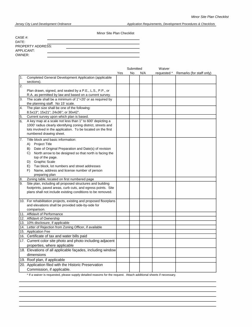
Minor Site Plan Checklist
Jersey City Land Development Ordinance
CASE #:DATE: PROPERTY ADDRESS:APPLICANT:OWNER:
WaiverYes No N/A requested * Remarks (for staff only)
1.
2.
3.
4.
5.6.
7.A)B)C)
D)E)F)
8. Zoning table, located on first numbered page9.
11.12.13.14.15.16.17.
19.
* If a waiver is requested, please supply detailed reasons for the request. Attach additional sheets if necessary.
10. For rehabilitation projects, existing and proposed floorplans and elevations shall be provided side-by-side for comparison.
Roof plan, if applicableApplication filed with the Historic Preservation Commission, if applicable.
Application Requirements, Development Procedures & Checklists
Submitted
Project TitleDate of Original Preparation and Date(s) of revision
A key map at a scale not less than 1" to 600' depicting a 1000' radius clearly identifying zoning district, streets and lots involved in the application. To be located on the first numbered drawing sheet.
Current survey upon which plan is based.
Title block and basic information:
8.5x13"; 15x21"; 24x36"; or 30x42".
Certificate of tax and water bills paid
Affidavit of Ownership
Application Fee
Current color site photo and photo including adjacent properties, where applicable
Letter of Rejection from Zoning Officer, if available10% disclosure, if applicable
Affidavit of Performance
North arrow to be designed so that north is facing the top of the page.
Name, address and license number of person preparing plan
Site plan, including all proposed structures and building footprints, paved areas, curb cuts, and egress points. Site plans shall not include existing conditions to be removed.
The plan size shall be one of the following:
Graphic Scale
20.
Minor Site Plan Checklist
Tax block, lot numbers and street addresses
Completed General Development Application (applicable sections).
Plan drawn, signed, and sealed by a P.E., L.S., P.P., or R.A. as permitted by law and based on a current survey.The scale shall be a minimum of 1"=20' or as required by the planning staff. No 15' scale.
18. Elevations of all applicable façades, including window dimensions

Preliminary and Final Major Site Plan ChecklistJersey City Land Development Ordinance
CASE #:DATE: PROPERTY ADDRESS:APPLICANT:OWNER:
WaiverYes No N/A requested * Remarks (for staff only)
1.
2.3.4. 5.
7.8.9. The following number of plans shall be submitted:
A) One when initial application is filed.B) Review agent sets (when instructed by Staff)C) Fourteen for planning Board (when complete)D) Eleven for Zoning Board (when complete)
10. All plans shall include:
C)
(1)(2)(3)(4)(5)(6)(7)(8)
(9)(10)(11)(12)
(13)(14)(15)(16)(17)(18)
11.
Zoning comparison chart (contrasting existing standards in the use zone or general zoning requirements with proposed site details as listed below with variance or design standard waiver request, if any, clearly noted). One table per plan set, to be located on the first numbered drawing sheet.
Bike parking (# of spaces)
Application Requirements, Development Procedures & Checklists
Submitted
Design standards (list all for which a waiver is requested)
Preliminary and Final Major Site Plan Checklist
Vehicle parking (# of spaces, dimensions)
Loading (# of berths, dimensions)
Lot Dimensions
Gross floor area
Completed General Development Application (applicable sections).
Signage
Signature and seal of map preparer; Licensed Engineer, Architect or Land Surveyor in New Jersey on all pages.
Density
Affidavit of OwnershipAffidavit of Performance
Floor Area Ratio
10% disclosure, if applicable
A key map at a scale not less than 1" to 600' depicting a 1000' radius clearly identifying zoning district, streets and lots involved in the application. To be located on the first numbered drawing sheet.
Bonus provisions
The scale shall be a minimum of 1"=20' for tracts up to
Planning Completeness
Letter of Rejection from Zoning Officer, if available
Application FeeCertificate of tax and water bills paid
Height
Buffer areas
Access (circulation, driveway width, curbcut dimensions)
Lot size in square feet
A)
40 acres or 1"=50' for tracts over 40 acres. (No 15' scale)
lot coverage
Setbacks
Building coverage for each structure, if more than one is part of the development parcel.
Landscaping
B)
Current color site photo and photo including adjacent properties, where applicable.
6.

Preliminary and Final Major Site Plan Checklist
WaiverYes No N/A requested * Remarks (for staff only)
12. Map size: 8.5x13"; 15x21"; 24x36"; or 30x42".13. The following details shall be on all site plans:
A)B)C)D)E)F)
(1)(2)(3)(4)(5)(6) Maintenance procedures and guarantees
G)
H)I)
J)
K)L)
M)
N)
O)
P)
Q)
R)
S)
T)
U)
V)
W)
X)
(1)(2)(3)(4)(5)(6)(7)(8)
Y)
Z)AA)
Utility connection points into proposed structures (eg: façade conduits, transformers) to be detailed on site plans and façade elevations.
Site plan, including all proposed structures and building footprints, paved areas, curb cuts, and egress points. Site plans shall not include existing conditions to be removed.
Recreation areas: location, square footage, materials, equipment and lighting
Signs: red
Asphalt paved areas: gray concrete
Elevation of roof indicating heating, ventilation and air-conditioning equipment, communication equipment, and antennae specifying screening height, colors and materials.
Type
Water: light blue
Landscaped areas: light green
Paved areas: beige
Locations of all mechanical and other equipment
Submitted
Floor plans with all room dimensions including basement plan and roof plan.
Refuse: location of dumpster, etc., screening height, materials, details of removal path.
Fences/walls: height, materials, width of internal details (e.g.: pickets), spacing of internal details.
Square Footage
Dates of drawings and revisions, if any
Landscaping
Lighting fixtures: black
Elevations of all façades indicating colors and materials and window dimensions
North arrow
Lighting; wattage, location, height, attachment details, areas of diffusion
Signage: Lettering, dimensions, location, materials equipment, and lighting.
Trees and shrubs: dark green
Enlarged elevations of the first two floors, including details of windows, doors, signs, lighting, façade materials, etc. at 1/4" scale where appropriateEnlarged details of typical upper story windows, including dimensions, glazing details, sills and headers, projections, etc. at 1/4" scale where appropriate
Demolition Plan, if applicable
Buildings: dark brown
One illustrative site plan depicting details using the following color scheme:
For rehabilitation projects, existing and proposed floorplans and elevations shall be provided side-by-side for comparison.
Survey showing block and lot numbers with metes and bounds description; existing and proposed easements, and size and location of any existing or proposed structures with setbacks dimensions.
Graphic Scale
Materials used in paved areas and walks and all other surface treatments.
Circulation: parking spaces, dimensions, aisle widths, location of accessible bike racks/storage, car sharing, sidewalk details, etc.
Visual assessment, if required
Project title
Tax block, lot numbers and street address of site
Shadow study, if applicable
Caliper
HeightPlanting Schedule

Preliminary and Final Major Site Plan Checklist
WaiverYes No N/A requested * Remarks (for staff only)
14.
15.
16.
Engineering Completeness
1.
A)
B)
C)
E)
F)
G)
H)
I)J)
K)
L)M)
N)
* If a waiver is requested, please supply detailed reasons for the request. Attach additional sheets if necessary.
Water service connections including valves, hydrants
Proposed and exact location of above and below- ground utilities and amenities, including but not limited to traffic control poles, hydrants, street furniture, and signal boxes.
Submitted
Indication if property contains a right-of-way preservation area , per map 4.4-1 of the Jersey City Master Plan Circulation Element.
Indication of review/approval (if applicable) by Environmental Commission, Department of Environmental Protection, Army Corps of Engineers
Also, all existing conditions and structures in the adjacent public right-of-way, including but not limited to signposts, hydrants, street trees and tree pits, bus stops, etc.
Parking lot drainage
Existing public rights-of-way with the existing and proposed utilities and service connections to the project showing pipe sizes, materials, lengths, rim and invert elevations for sewers, valves and other relevant information.
The following engineering details shall be included on Plans. Plans will be forwarded to the Division of Engineering and/or other appropriate municipal review agents for comment:
Survey, signed and sealed by a licensed surveyor, showing block and lot numbers with metes and bounds description; existing and proposed easements, and size and location of any existing or proposed structures with setbacks dimensions.
Topographic data with existing and proposed
Water supply system demand, strategy and design
Entrance to the project from public streets with curbs, drop curbs, aprons, and sidewalks.
Standards and details for curbs, wheel stops, walks, catch basins, trenches, street grade and intersections, pavement cross sections and profiles, traffic control and directional signs.
Sanitary sewer system demand, strategy and design
Storm system demand, strategy and design with drainage calculations and impact on existing drainage detailed in an Engineering Report, in compliance with the Stormwater Control Ordinance.
D)elevations.
Proposed erosion control plan and method of control
Traffic study, if required by Planning Director, showing existing and proposed traffic flows and volumes. (Per §345-17)
Application filed with Historic Preservation Commission, if applicable
Location of project relative to adjacent properties and improvements, including encroachments

"C" "D" Variance Checklist
Jersey City Land Development Ordinance
CASE #:DATE: PROPERTY ADDRESS:APPLICANT:OWNER:
WaiverYes No N/A requested * Remarks (for staff only)
1.
2.3.4.
5.6.
7.
8.
9.
10.
A)
B)
C)
(1)(2)(3)(4)(5)(6)(7)(8)
(9)(10)(11)(12)
A Key Map at a scale not less than 1" to 600' depicting a 1000' radius clearly identifying zoning districts, streets and lots involved in the application. To be located on the first numbered drawing sheet.
DensityHeightFloor Area Ratio
Fourteen sets of folded plans (once complete) of proposed buildings or alterations with the following information:
Notice to property owners (Must be submitted at least 14 days prior to the hearing for staff review)
Zoning comparison chart (contrasting existing standards in the use zone or general zoning requirements with proposed site details as listed below with variances, deviations, or design standard waiver requests. If any, clearly noted.One table per plan set, to be located on the first numbered drawing sheet.
Original certified list and block diagram of all property owners within 200 feet.
Affidavit of Vacant and Nonconforming Use indicating length of time property has been vacant, if applicable.
"C" & "D" Variance Checklist
Completed General Development Application (applicable sections).Affidavit of Performance.Affidavit of Ownership
All pages must bear an original signature and seal of an engineer or architect licensed in New Jersey.
Application Requirements, Development Procedures & Checklists
Submitted
A statement of Principal Points relative to the Variance as per NJSA-40:55D-70(c) and (d)
Current survey upon which plan is based.
One copy of the application for Building Permits or Certificate of Occupancy, if available.
Landscaping
Vehicle Parking (# of spaces, dimensions)
Signage
Bike Parking (# of spaces)
Bonus provisionsBuilding coverage for each structure, if more than one is part of the development parcel.
Loading (# of berths, dimensions)
Setbacks
Access (circulation, driveway width, curbcut dimensions)

"C" "D" Variance Checklist
WaiverYes No N/A requested * Remarks (for staff only)
(13)(14)(15)(16)(17)(18)
D)
E)
F)G)
H)
I)
J)K)
L)M)N)O)
11.
13.14.15.
17.
A) Certified Mail Receipts(1) Mounted on 8.5x11 bound paper(2)(3)
B) Affidavit of Proof of ServiceC) Affidavit of Publication* If a waiver is requested, please supply detailed reasons for the request. Attach additional sheets if necessary.
Elevations, with details of materials and colors, for all applicable facades and window dimensions.
The scale shall be a minimum of: 1"=20' for tracts up to 40 acres or 1"=50" for tracts over 40 acres. (No 15' scale)
Notice of Rejection which has been signed by the Zoning Officer, if available
North arrow, designated so that the north arrow is facing the top of the page.Street addresses and block number(s)Dates of drawings and revisions, if any
Site plan, including all proposed structures and building footprints, paved areas, curb cuts, and egress points. Site plans shall not include existing conditions to be removed.
Design standards (list all for which a waiver is requested)
Gross floor arealot coverage
Demolition Plan, if applicableFloor plans with all room dimensions, including basement plan and roof plan
For rehabilitation projects, existing and proposed floorplans and elevations shall be provided side-by-side for comparison.
Sign details, if applicable
Project title
Lot DimensionsLot size in square feetBuffer areas
Submitted
Graphic Scale
US Postal from 3877 will be accepted in lieu of the mounted receipts, provided that the addresses are arranged in the same order as indicated on the certified list). RETURN RECEIPT POSTCARDS WILL NOT BE ACCEPTED
The following must be submitted at least 2 days prior to the hearing:
10% disclosure statement, if applicable
Application FeeCertificate of tax and water bills paid
Arranged in the same order as indicated on the certified list of property owners (a properly certified
Application filed with the Historic Preservation Commission, if applicable.
16.
Six to a page
Current color site photo and photo including adjacent properties, where applicable.
12.

"A" "B" Appeals Checklist
Jersey City Land Development Ordinance
CASE #:DATE: PROPERTY ADDRESS:APPLICANT:OWNER:
WaiverYes No N/A requested * Remarks (for staff only)
1.
2.3.4.
5.
6.
7.8.
9.
11.
A) Certified Mail Receipts(1) Mounted on 8.5x11 bound paper(2) Six to a page(3)
B) Affidavit of Proof of ServiceC) Affidavit of Publication* If a waiver is requested, please supply detailed reasons for the request. Attached additional sheets if necessary.
The following must be submitted at least 2 days prior to the hearing:
Notice of Appeal from the opinion of the zoning officer
Notice to property owners. (Must be submitted at least 14 days prior to the hearing for staff review.)
10.
Arranged in the same order as indicated on the certified list of property owners (a properly certified US Postal form 3877 will be accepted in lieu of the mounted receipts, provided that the addresses are arranged in the same order as indicated on the certified list). RETURN RECEIPT POSTCARDS WILL NOT BE ACCEPTED
A Statement of Principal Points relative to the appeal as per N.J.S.A. 40:55D-70(a) or (b).
Application Fee
Certified list and block diagram of all property owners within 200 feet.
if applicable.
Application Requirements, Development Procedures & Checklists
Submitted
"A" and "B" appeals Checklist
Completed General Development Application (applicable sections).Affidavit of Performance.Affidavit of Ownership.One copy of the application for Building Permits or Certificate of Occupancy, if available.Notice of Rejection which has been signed by the Zoning Officer, if available

Review Agent Contact Sheet
The mailing address and contact person (with phone and FAX numbers) for the Review Agents are provided below:
Agency Address Contact Person
1. 1) Division of Engineering
13-15 Linden Avenue East
Jersey City NJ 07305
Stanley Huang
Phone: 547-5965
FAX: 547-4729
2. 2) Bureau of Water
3) 555 Route 440
Jersey City, NJ 07305
Rajiv Prakash
Phone: 209-0319
FAX: 432-3795
3.
4) Jersey City Municipal Utilities Authority
555 Route 440
Jersey City, NJ 07305
Ruth Mogro
Phone: 209-0319
FAX: 432-3795
4. 5) Division of Traffic Engineering
13-15 Linden Avenue East
Jersey City NJ 07305
Lichuan Wang
Phone: 547-5072
FAX: 547-4703
5. 6) Division of Zoning
30 Montgomery St, Room # 409
Jersey City, NJ 07302
Nick Taylor
Phone: 547-6564/4832
FAX: 547-5216
6. Department of Public Works
13-15 Linden Avenue East
Jersey City NJ 07305
Mark Redfield
Phone: 547-4402
FAX: 547-4803
7. Tax Assessor
280 Grove Street, Room #101
Jersey City, NJ 07302
Ed Toloza
Phone: 547-4707
SUBDIVISION ONLY
8. 7) Tax Map Room
280 Grove Street, Room #101
Jersey City, NJ 07302
Lucien Taduran
Phone: 547-5167

Community Notice Requirements
As required by stipulations in certain Redevelopment Plans, special notice of applications made to the Division of City Planning must also be submitted to local community groups. Affidavit of mailing is required to be submitted to the Division of City Planning for the project file.
1. Morris Canal Redevelopment Area a. As per §VI of the Plan, notice to the community must be made not less than
twenty-one (21) calendar days prior to the Planning Board hearing for which it scheduled. An affidavit showing proof of submission of site plan and application shall be submitted to the Division of City Planning not less than ten (10) calendar days prior to said hearing.
b. There are three community groups which must be notified. They are as follows: i. Morris Canal Redevelopment Area Coalition
c/o June Jones & Sr. Julia Scanlan 317-319 Pacific Ave. Jersey City, NJ 07304
ii. Lafayette Neighborhood Action Coalition c/o Dianna Guadagnino 287 Communipaw Ave. Jersey City, NJ 07304
iii. Communipaw Avenue Block Association
c/o Ms. Rosalyn Browne 384 Communipaw Ave. Jersey City, NJ 07304
2. Monticello Avenue Redevelopment Plan Area
a. As per §IV.A of the Plan, notice to the community must be made not less than forty-five (45) calendar days prior to the Planning Board hearing for which it scheduled. An affidavit showing proof of submission of site plan and application shall be submitted to the Division of City Planning not less than twenty-one (21) calendar days prior to said hearing.
b. There is one community group who must be notified: i. Monticello Community Development Corporation (MCDC)
c/o Michelle Massey 37 Emory St. Jersey City, NJ 07304
3. Canal Crossing Redevelopment Plan Area
a. As per §V. H. of the Plan, the following agents of GRACO shall be notified of any development application, remediation application, development activity or remediation activity at least 14 days prior to site work commencement and application submission.
b. There are four representatives who must be contacted: i. Felicia Collis 189 Clerk Street [email protected]
ii. Joyce Willis 191 Randolph Ave [email protected] iii. Teresa Patteron 185 Arlington Ave [email protected] iv. Ed Vergara 47 Gallinson Dr.
New Providence, NJ 07974 [email protected]

AFFIDAVIT OF PERFORMANCE
I,______________________________________________________________________ (Property Owner/Architect/Engineer) hereby certify that the Site Plan submitted to the Planning Board/Zoning Board of
Adjustment [cross out inapplicable Board] for property at
#______________________________________________________________________;
Block(s)___________________________, Lot(s)________________________________
_______________________________________________________________________,
is a full and complete representation of the Site Plan and that it shall be completed as
submitted.
______________________________________ (Property Owner/Architect/Engineer) Sworn before me this ______________________day of _______________________________, 20______ Notary Public

AFFIDAVIT OF OWNERSHIP STATE OF NEW JERSEY ss. COUNTY OF HUDSON I,__ ____________________of full age, being duly sworn
(print owner's name)
according to law on his/her oath deposes and says, that he/she resides or works at ______ _________________________________________________
(owner's address)
in the Town/City of ____Jersey City___________________________________in the County of___Hudson_____________________and State of ____NJ_____________________________is the owner in fee of all that certain lot, piece or parcel of land situated, lying and being in the City of Jersey City aforesaid, and known and designated as: _________________ (property address)
Block: Lot(s): Block: Lot(s): Block: Lot(s): Block: Lots(s):
and that he/she authorizes___ _______________________________________to
(name of applicant) make the annexed application in his/her behalf, and that the statements of fact contained in said application are true. By:____________________________________
(signature of owner) Sworn to before me this _________________day of____________________20_____ Notary Public

PAYMENT OF TAXES
Every application submitted to the Planning Board or Zoning Board of Adjustment shall be accompanied by
verification of tax payments or balance due for the property which is the subject of subject of such application.
This verification must be obtained from the City Tax Collector.
TO: CITY TAX COLLECTOR, CITY HALL, ROOM 101
FROM:
APPLICANT _____________________________________________________________
_____________________________________________________________
_____________________________________________________________
PROPERTY IN QUESTION _________________________________________________
_________________________________________________
_________________________________________________
Please provide notice that no taxes or assessments are due on the above referenced property or indicate the
balance due. This request is in conjunction with my application before the Planning Board or Zoning Board of
Adjustment.
There is a $5.00 per lot fee for this request.
IMPORTANT
This form is to be forwarded to the City Tax Collector ONLY. It is not to be returned to the Board Secretary
unless the property is tax exempt.

Verification of Payment of Water Bill
All applications submitted to the Planning Board or Zoning Board of Adjustment shall be accompanied by a Water Clearance Certificate. A request for a Water Clearance Certificate can be obtained from United Water – METER OFFICE, at no charge, by phone, fax or mail. All mailed requests must contain a self-addressed/stamped envelope for the return of the certificate.
United Water of Jersey City 25 Troy Street
Jersey City, N.J. 07306 Ph: (201) 420-6592 Fax: (201) 656-8383 Hours of Operation:
8:00-12:00 PM and 1:00-4:30 PM

REQUEST FOR CERTIFIED LIST OF PROPERTY OWNERS
TO: LUCIEN TADURAN, TAX MAP ROOM, ROOM # B1, CITY HALL, 280 GROVE ST, JC
Attached please find my check in the amount of ten dollars ($10) for a certified list of property owners within a two hundred foot (200’) radius of (give property address). Street Address___________________________________________________________________; Block___________________ Lot(s):_________________________________________________ Block___________________ Lot(s):_________________________________________________ Block___________________ Lot(s):_________________________________________________ Block___________________ Lot(s):_________________________________________________ This is required in conjunction with my application for a major subdivision and/or variance. ____________________________________ APPLICANT ____________________________________ ADDRESS ____________________________________ IMPORTANT This form is to be forwarded to the Map Room ONLY. It is not to be returned to the Board Secretary. The original Certified List of Property Owners is to be submitted to the Division of City Planning with your application. Keep a copy for your use in mailing out required notice.

NOTICE OF HEARING
Please be advised that an Application(s) for ________________________________________________
___________________________________________________________________________________________
___________________________________________________________________________________________ (State application(s) type and specify type of variance(s), if any)
And any other variance(s) the Board may deem as required, has been filed with the Jersey City _________________________________________________________________________________ for property (Specify Planning Board or Board of Adjustment)
located at ___________________________________________________________________________________ (Address)
___________________________________________________________________________________________
Block(s) ______________________________ Lot(s) ________________________________________________
The purpose of this application is to: _____________________________________________________________
___________________________________________________________________________________________
___________________________________________________________________________________________
___________________________________________________________________________________________ (Describe proposal) Any person interested in this application will have the opportunity to address the Board at the meeting of
_____________________________at_____________________________________________________________ (Date of hearing) (Time: 5:30 pm Planning Board/6:00 pm Board of Adjustment) in the Council Chambers of City Hall, 280 Grove Street, Jersey City, New Jersey 07302.
Plans are available for public inspection on any working day between 9:00 am and 4:00 pm at the City
Planning Division, 30 Montgomery Street, Suite 1400 Jersey City, New Jersey 07302.
By: ________________________________________ Applicant (Please print name)
________________________________________
Signature

AFFIDAVIT OF PROOF OF SERVICE PROOF OF SERVICE OF NOTICES REQUIRED BY STATUTE MUST BE FILED AND VERIFIED WITH THE DIVISION OF CITY PLANNING AT LEAST TWO DAYS PRIOR TO THE MEETING OR THE CASE WILL NOT BE HEARD. STATE OF NEW JERSEY ) COUNTY OF ___________)ss. __________________, of full age, being duly sworn according to law, deposes and says, that (s)he resides/works at __________________ in the Town/City of _______________ County of ______________ and State of __________________ that (s)he is(are) the applicant in a proceeding before the Planning Board/Zoning Board of Adjustment [cross out inapplicable Board] of the City of Jersey City, which has the Case # __________ and relates to premises located at: # Block(s)___ , Lot(s)_____________ that on, _____________, 201_____, (s)he gave written notice of the hearing on this application to each and all of the persons upon whom service must be had, in the required form and according to the attached lists, and in the manner indicated thereon. _____________________________ Applicant's Signature Sworn to and Subscribed before me This___________day of______________201 . ____________________________ Notary Public

Jersey City Land Development Ordinance Application Requirements, Development Procedures & Checklists
345-32 NON-REFUNDABLE APPLICATION FEES A. There shall be a non-refundable fee for applications to the Jersey City Planning Board, Zoning
Board of Adjustment, and Historic Preservation Commission as provided by law and established
herein. The fees provided for shall be non-refundable and are for purposes of offsetting the
administrative and clerical costs of running these Boards.
B. The City of Jersey City and its agencies, such as the Housing Authority, Parking Authority, and
Board of Education, as well as applications for affordable housing developments and
applications for Certificates of Appropriateness and Certificates of No Effect submitted by non-
profit entities for property within a designated Historic District are exempt from the fees
described herein.
11/10/2015
345-33 FEES
A. Applicable Fees
1. Every application for review or hearing before the Zoning Board of Adjustment, or the
Planning Board shall be initially accompanied by a check for $150, and every
application to the Historic Preservation Commission shall be initially accompanied by a
check for $10. Balance due will be determined upon City Planning Staff’s review in
accordance with the amount(s) as provided in Fee Table I.
2. The applicant shall arrange to provide the Division of City Planning with two copies of
the transcript for its files and shall pay the complete cost of the transcript of his or her
application. Any balance due the transcription firm engaged by the Division for its
services shall be payable immediately upon billing.
3. Copies of resolutions rendered by either the Board of Adjustment or the Planning Board
shall be available to any person requesting them at their sole cost and expense. Any
applicant shall receive a copy of the decision rendered at no additional cost. Minutes of
either the Board of Adjustment or the Planning Board shall also be available on request
to any person or applicant at their sole cost and expense. Amounts charged shall be as
provided for in the City’s ordinance regulating photocopy and documents fees.
4. Performance guarantees may be required by the Zoning Board of Adjustment or the
Planning Board pursuant to N.J.S.A. 40:55D-53.
5. The Zoning Officer and the Division of Zoning Enforcement may establish reasonable
fees to cover administrative costs for the issuance of permits, certificates or
authorizations pursuant to N.J.S.A. 40:55D-18.

Updated 11/10/2015
Page 1
B. Schedule of Fees.
Application Type Application Fees Zoning Officer and Division of
Zoning Enforcement Applications Non-Refundable
Plan Review & Determination $100
Certificate of Occupancy Review & Determination $100
Zoning Determination $100
Pre-existing Curbcut Determination $25
Application Type Application Fees Planning Board and
Board of Adjustment Applications Non-Refundable
Minor Site Plan - Cell Antenna Application $2,500
Minor Site Plan - Signage and Storefronts $200 Minor Site Plan - Other $350
Preliminary Major Site Plan Residential $50 per Dwelling Unit or a Minimum of $500
Preliminary Major Site Plan With principal buildings over 1,000 sq. ft. GFA:
Non Residential $50 per 1000 sq. ft. GFA or part thereof or a minimum
of $500 Preliminary Major Site Plan Without principal building over 1,000 sq. ft. GFA:
Non Residential $50 per 1,000 sq. ft. lot area or part thereof or a
minimum of $500 Final Major Site Plan 50% of current Preliminary Major Site Plan Fee
Site Plan Amendment 50% of the current application fee or a minimum of
$1,000 Administrative Amendment $100
Conceptual Site Plan $500 (to be deducted from Fees for formal Application
for Development) Extension of Site Plan Approval $300
Minor Subdivision $500 Preliminary Major Subdivision $1,000 plus $100 per lot

Updated 11/10/2015
Page 2
Final Major Subdivision 50% of current Preliminary Major Subdivision fee
SPECIAL MEETING REQUESTED BY APPLICANT $1,000
REZONING OR REDEVELOPMENT PLAN AMENDMENT REQUESTED BY DEVELOPER
Fee as specified in applicable redevelopment plan, or $1,000, if no fee specified in plan.
APPEALS, INTERPRETATIONS AND VARIANCES $150
"a" & "b" Appeals and Interpretations as per N.J.S.A. 40:55D-70 a & b $150
"c" Variance as per N.J.S.A. 40:55D-70(c) & deviation from redevelopment plan
$500 for the first variance or deviation when not accompanied by a Major or Minor Site Plan or
Subdivision
$300 for the first variance or deviation when accompanied by a Major or Minor Site Plan or
Subdivision
$150 for each additional
"d" Variance as per N.J.S.A. 40:55D-70 (d)
$1,000 for the first variance
$250 for each additional
Extension of Variance Approval $300 (when not filed concurrently with extension of
Site Plan)

Updated 11/10/2015
Page 3
Application Type Application Fees Historic Preservation
Commission Applications Non-Refundable CERTIFICATE OF NO EFFECT
Non-Residential With Principal Building $40 per 1,000 square feet GFA or part thereof
Without Principal Building $40 per 1,000 square feet of lot area or part thereof Unlit Interior window sign only $40
Sidewalk repair/replacement when not filed concurrently with other work
$40 for first 25 linear feet of frontage, additional $20 for each 25 feet of frontage over 25 or part thereof
Residential Interior work only $10 per affected dwelling unit to a Maximum of $60
Exterior work only or Interior & exterior work filed concurrently $20 per dwelling unit to a maximum of $750
Sidewalk repair/replacement when not filed concurrently with other work $20 per dwelling unit to a maximum of $60
CERTIFICATE OF APPROPRIATENESS (COA) Residential
New Construction on Vacant Land $500 All Others:
1-4 Dwelling Units $100 5 Dwelling Units or over $20 per dwelling unit to a maximum of $1,000
Non-Residential With Principal Building $100 per 1,000 square feet of GFA or part thereof
Without Principal Building $100 per 1,000 square feet lot area or part thereof Exterior Sign application only $100
Outdoor Café only $100 Extension of COA Approval $200
SPECIAL MEETING REQUESTED BY APPLICANT $700
[Amended 5-28-2008 by Ord. No. 08-072; 11-10-2010 by Ord. No. 10-133; 2-23-2011 by Ord. No. 11-021; 9-27-2011 by Ord. No. 11-112; Amended 11-10-2015 by Ord. No. 15-147]


DOWNTOWN CONSTRUCTION COORDINATION COMMITTEE 5/06
The Office of the Mayor, the Office of the Construction Code Official and the
Downtown Coalition of Neighborhood Associations have agreed on the following
“construction rules of engagement” and request that you incorporate them into your
planning process and those of your sub-contractors and suppliers. Failure to respect
these agreed upon guidelines will impair relations with the surrounding community
and may affect your permit applications and the schedule of your project.
1. No monthly/extended permitting. Except in certain carefully defined situations off-hours
permits (weeknights or weekends) will only be granted on a week by week basis. Applications should be
submitted at least 3 days prior to the date requested and, whenever possible, advance notice should be provided
to community representatives to allow for notification of the affected residents.
2. No weekend or night permitting within 600 feet of residential buildings. Unless
there is a true emergency “in the interest of public health and safety”. Permit applicants should adequately
detail their reason and indicate why work cannot be performed during normal working hours.
3. Full time, on-site seismic monitoring for any pile driving or similar heavy
work within 250 feet of designated historic residential structures. A qualified
consultant should be retained to conduct such work, which should include a pre-construction survey to establish
“base-line” conditions.
4. Even during construction, “best available” efforts to minimize noise and
preserve air quality and sanitation must be made. State and City idling laws require trucks
waiting more than five minutes to load or unload to stop their engines. All drivers working for you or your
suppliers and contractors should be notified and reminded on a regular basis. County law requires that soil and
debris piles be covered or otherwise managed to minimize dust in the area. Regular street-cleaning and wash-
down should be funded by all active projects. Where pumps, compressors, generators or other continuous duty
equipment are used, “best available” technology should be required to minimize adverse impacts, including use
of electric driven equipment. This is required for off-hours work permits.
5. Impact on resident zone parking should be minimized. While safe truck routes and
construction sites take priority over resident parking, every effort should be made to minimize the impact on
zoned resident parking. Safety and efficient work practice for construction activities should take priority over
resident parking however resident parking should take priority over construction worker parking. Due to the
lack of space in the area construction workers should arrive by public transportation. This should be discussed
with sub-contractors and addressed in their contracts, and is required for off-hours work permits.
6. Truck routing should maximize safety and minimize impact on historic
structures and residential community. Pedestrian safety must take priority over construction
schedules. Safe clearly marked pedestrian right-of-way must be maintained and pedestrians given the right of
way at all crosswalks. Local speed limits and prohibition of trucks on residential streets should be addressed
with delivery personnel and strictly enforced. For regular deliveries (ie cement, steel, etc) a route map should be
provided to drivers. Truck routes should be designed such that, wherever possible, loaded trucks travel the
shortest distance through or adjacent to historic districts. Construction deliveries and trash collection should
only take place between 7 am and 6 pm weekdays. Traffic laws and routes should be addressed with drivers
before they come to the job. Where necessary or appropriate, such as for a large number of deliveries, off-duty
police should be hired to ensure safe traffic flow.
7. Emergency Generator testing. Inasmuch as the nature of this activity is “testing” and not
“emergency” it should be performed only during normal working hours. Inconvenience or discomfort of
business tenants does not justify granting of permits for weekend or evening testing. This includes repair of
such equipment during non-emergency conditions.