appendix r -- construction/reclamation plans and documentation · pdf filekeystone xl project...
TRANSCRIPT
Keystone XL Project
APPENDIX R
Construction/Reclamation Plans and Documentation
March 2013

Keystone XL Project
-This page intentionally left blank-
March 2013

Keystone XL Project
1. Construction/Reclamation (Con/Rec) Units
March 2013

TransCanada Keystone XL Pipeline Project Supplemental Environmental Report for the Nebraska Reroute
Draft Final August 31, 2012
Appendix R Supplemental EIS
H.1-1
Construction/Reclamation (Con/Rec) Units
Cropland
Farmed cropland includes areas of agricultural production that are tilled either annually or occasionally. Agricultural products include wheat, corn, milo, oats, soybeans, and alfalfa. Cropland occurs on all spreads throughout the Keystone XL Project. Primary areas include central Montana, central and southern South Dakota, and southern Nebraska. Based on these descriptions construction recommendations and reclamation recommendations were developed.
Conservation Reserve Program
Lands enrolled in the Conservation Reserve Program (CRP) under contract with the USDA Farm Service Agency. Landowners convert erodible or environmentally sensitive acreage to native grasses or introduced grasses and forbs, wildlife plantings, trees, or riparian buffers per the terms of a multiyear contract. The unit locations are scattered throughout the project. Refer to Alignment Sheets and/or Keystone field verification for specific locations.
Forest
Forest areas are dominated by native and introduced trees. Typical species include green ash, boxelder, plains cottonwood, elm, oak, mulberry, and eastern red cedar. In northern areas this unit is primarily located on floodplains, in deep draws, and on steeper slopes. In southern areas of the project the unit may also occur on flat topography and along roads and fencelines.
Improved Pasture and Hayland
Improved pastures and haylands are managed grasslands that have typically been planted with grasses for livestock forage or hay production. Improved pastures and haylands are often dominated by crested wheatgrass, smooth brome and legumes in various combinations, or seeded native tall grasses, depending on Project location. Improved pastures and haylands occur on all spreads throughout the Keystone XL Project area.
Mixed Grasslands
Mixed grasslands are dominated by native perennial grasses such as western wheatgrass, needle-and-thread, blue grama, Sandberg bluegrass, prairie junegrass, little bluestem, prairie sandreed, green needlegrass and bluebunch wheatgrass. Mixed grasslands are dominated by native perennial grasses such as western wheatgrass, needle-and-thread, blue grama, Sandberg bluegrass, prairie junegrass, little bluestem, prairie sandreed, green needlegrass and bluebunch wheatgrass.
Riparian
Riparian woodlands include forested and shrub dominated areas around streams and rivers. Common trees and shrubs include plains cottonwood, green ash, box elder, Russian olive, sandbar willow, Wood’s rose, snowberry, and silver sagebrush. Herbaceous under stories are often dominated by Kentucky bluegrass, western wheatgrass, and redtop. Primarily located on floodplains and terraces along streams and rivers, this Con/Rec Unit is relatively limited on the Keystone XL Project.

Appendix R Supplemental EIS
TransCanada Keystone XL Pipeline Project Supplemental Environmental Report for the Nebraska Reroute
Draft Final August 31, 2012
Shelterbelt
Planted tree and shrub shelterbelts and windbreaks. Common northern species are: plains cottonwood, Chinese elm, American elm, Austrian pine, Siberian peashrub, and lilac. Common southern species are: Osage orange, eastern red cedar, locust, and hawthorne. Typically located at field margins, near roadsides, or around residences. Refer to Alignment Sheets and/or Keystone field verification for specific locations.
Sandy Prairie
Native prairie on sandy soils dominated primarily by warm- season grasses such as little bluestem, sand bluestem, prairie sandreed, and switchgrass. Topography is typically flat to gently rolling. The Sandy Prairie unit occurs in southern South Dakota and northern Nebraska. The unit is interspersed with hay meadows and crop land.
Tall Grasslands
Tall grasslands are dominated by tall warm-season grass species including big bluestem, switchgrass, Indiangrass, and little bluestem, and shorter warm season grasses such as blue grama and sideoats grama. Tall grasslands occur in southern South Dakota and throughout Nebraska in areas that are not farmed or a part of the Sandy Prairies. Many of the grass species within the Con/Rec Unit are the same as those occurring within the Sandy Prairies and subirrrigate prairie Con/Rec Units, but topography, soil type, and hydrology differ between those types and this unit.
Subirrigated Pasture
The Subirrigated Pasture type includes subirrigated plains and hay meadows. Soils are typically fine sands, with narrow clay bands in some areas. Topography is typically flat. The water table within this Con/Rec Unit is often within six feet of the surface. Native grasses include big bluestem, switchgrass, and little bluestem; introduced grasses include timothy, orchardgrass, and Kentucky bluegrass . Wetlands may occur adjacent to, but not part of, this Con/Rec Unit. Subirrigated Pastures occur in southern South Dakota and portions of Nebraska, primarily in Tripp, Keya Paha, Rock, Holt, Antelope, and Nance counties.
Reclamation of Contractor Camps, Pipeyards, and Contractor Yards
Contractor camps, contractor yards, pipe storage yards, staging areas, and other temporary facilities. Several yards and facilities are associated with each construction Spread. Refer to project maps for exact location.
Con/Rec units and their descriptions are not tied to either the land use categories or vegetation cover described elsewhere in this SER. They are not intended to replace either, but is a tool to provide the construction contractor with specific measures to implement for the land uses/vegetative cover encountered along the route. The surveys and results for the FEIS route with surveys for the new route will be conducted prior to construction.
H.1-2

Appendix R Supplemental EIS
Table H-1 Construction/Reclamation Unit Development Timeline
Date Item Outcome
Summer 2008 Began initial agency and university contact regarding reclamation in Nebraska, primarily in the Sand Hills.
Obtained expert advice regarding topsoil salvage, erosion control, and revegetation seed mixtures.
Summer 2009 Completed construction/ reclamation survey along the proposed route within the Sand Hills.
Rerouted centerline to avoid excessively steep slopes and ridges. Rerouted centerline to place project in soil accumulation areas such as valleys and swales rather than areas prone to scour to the extent possible. Identified primary native species growing within the Sand Hills and mapped noxious weeds. Mapped slopes and topsoil depths and designed erosion control specific to the topography.
Fall 2009 Completed additional construction/ reclamation survey on the remainder of the proposed route in Nebraska
Mapped areas of native grassland, pasture, cropland, shelterbelts, and wet meadows. Mapped slopes, noxious weeds, typical topsoil depths, and land use features.
Winter 2009 Initiated contact with Farm Service Agency (FSA) to obtain location and information on Conservation Reserve Program (CRP) tracts.
Obtained signed landowner permission to collect CRP data on their land through the FSA. Submitted a formal request to FSA for CRP locations, conservation practices, and revegetated seed mixtures in Spring 2011. Obtained CRP locations and data Spring 2012.
Summer 2010 Met with state NRCS State Resource Conservationist and State Soil Scientist in Lincoln to discuss and review construction/ reclamation units.
Productive meeting. NRCS suggested revisions to soil salvage depths for Sand Hills soil types and made minor revisions to the revegetation seed mixtures.
Summer 2010 Completed landowner sponsored site visit of Sand Hills. Attendees included local landowners, county NRCS agents, UNL extension professionals, and Keystone representatives.
Reviewed construction/reclamation methods in the Sand Hills and other parts of Nebraska. Presented slide show on pipeline construction and reclamation. Reviewed construction/reclamation units with local agency and UNL personnel and slightly revised seed mixtures per agency recommendations.
Summer 2011 Responded to U.S. Fish and Wildlife Service and Nebraska Game Fish and Parks Commission request to use local ecotype seed for revegetation within Sand Hills and Marsh Plains on the project.
Contacted 20 seed large and small seed contractors in the Midwest and Great Plains to determine if local ecotype seed could be collected in enough quantity and of high enough quality to meet revegetation requirements and landowner expectations. Less than 2% of the required seed was available at the time or could be obtained in the future from local ecotypes.
Fall 2011 Met with USFWS, NGPC, UNL, state level NRCS, DOS, and Keystone
representatives to resolve question of local ecotype seed.
Determined a list of native grass seed varieties in order of preference based on the proximity of the variety to the project. Revised seed mixtures to reflect seed preference.

Appendix R Supplemental EIS
Table H-1 Construction/Reclamation Unit Development Timeline
Date Item Outcome
Determined that local ecotype seed was not available in enough quantity or quality, or with enough reliability to meet revegetation requirements and landowner expectations.
Spring/Summer 2012
Completed construction/reclamation surveys on the preferred Nebraska reroute as well as numerous route variations.
Mapped areas of native grassland, pasture, cropland, shelterbelts, and wet meadows. Mapped slopes, noxious weeds, typical topsoil depths, and land use features.

Appendix R Supplemental EIS
Table H-2 Surveyed Mileage of Construction/Reclamation Types on Nebraska FEIS Route
Construction/Reclamation Miles
Cropland 149.5
Conservation Reserve Program 3.7
Forest 1.8
Improved Pasture/Hayland 15.7
Mixed Grassland 3.9
Un-surveyed Preferred Route 90.1
Riparian 0.4
Sandy Prairie 3.0
Shelterbelt 1.1
Subirrigated Pasture 1.2
Tall Grassland 2.9

Keystone XL Project
2. Construction/Reclamation (Con/Rec) Unit Specifications
March 2013

Appendix R Supplemental EIS
CONSTRUCTION/RECLAMATION UNIT SPECIFICATIONS: CROP KEYSTONE XL
UNIT NAME: CROPLAND
UNIT CODE: CROP
UNIT DESCRIPTION: Farmed cropland includes areas of agricultural production that are tilled either annually or occasionally. Agricultural products include wheat, corn, milo, oats, soybeans, and alfalfa.
UNIT LOCATION: Cropland occurs on all spreads throughout the Keystone XL Project. Primary areas include central Montana, central and southern South Dakota, and southern Nebraska.
UNIT GOALS: • Maintain soil productivity and prevent accelerated erosion. • Complete all work to standards specified in the CMR Plan, contract documents and Details, applicable permits, easement descriptions, and Keystone’s satisfaction.
SPECIAL CONSIDERATIONS:
1. Agricultural terraces may be present within this Con/Rec Unit and will be reconstructed as directed by Keystone.
2. Seeding will be completed by the Landowner unless otherwise directed by Keystone.
CONSTRUCTION
ROW WIDTH: Typically 110 feet.
CLEARING: As specified in the CMR Plan. ADDITIONAL REQUIREMENTS: None unless otherwise directed by Keystone.
TOPSOIL SALVAGE: As specified in the CMR Plan to maintain the topsoil resource and reclamation potential. ADDITIONAL REQUIREMENTS: A. Salvage topsoil horizon at depths shown on Alignment Sheets or as directed by Keystone. B. The typical topsoil salvage depth is 6 – 12 inches.
TRENCHING: As specified in the CMR Plan. ADDITIONAL REQUIREMENTS: None unless otherwise directed by Keystone.
BACKFILL, DECOMPACTION AND REGRADING:
As specified in the CMR Plan to avoid slumping over the trench, relieve compaction, and match adjacent topography.
ADDITIONAL REQUIREMENTS: None unless otherwise directed by Keystone.
TEMPORARY EROSION CONTROL:
As specified in the CMR Plan and authorized by Keystone to limit dust, prevent off-site sedimentation or erosion, and accelerated erosion on the ROW.
RECLAMATION
SEEDBED PREPARATION:
Prepare seedbed as specified in the CMRP. ADDITIONAL REQUIREMENTS: A. Dirt clods should typically be smaller than 3-4 inches in diameter to aid in wind and water
erosion control, and if not being seeded by Keystone.
SEEDING METHOD, SEED MIX AND RATE:
Seeding will be completed by the Landowner unless otherwise directed by Keystone. If the potential for erosion is high, an annual cover crop may be seeded as directed by Keystone.
SEEDING DATE: Not applicable.
MULCHING AND MATTING:
Mulching and matting will typically not be completed within this Con/Rec Unit. If the potential for erosion is high, an annual cover crop or mulching may be required as directed by Keystone.
SLOPE AND TRENCH BREAKERS:
Slope breakers will typically not be constructed within this Con/Rec Unit. Trench breakers will be constructed where directed by Keystone.
ADDITIONAL REQUIREMENTS: A. Reconstruct agricultural terraces as described in the CMRP and as directed by Keystone.
MANAGEMENT PRACTICES
1. Provide for livestock and wildlife access across the trench at locations convenient to livestock and the landowner if necessary. 2. Construction and reclamation practices may be modified from those presented to suit site conditions or permit requirements
with Keystone approval. 3. Monitor soil stability post construction.
WESTECH Environmental Services, Inc. October 2010
Helena, MT
CONSTRUCTION/RECLAMATION UNIT SPECIFICATIONS: CRP KEYSTONE XL
Appendix R Supplemental EIS
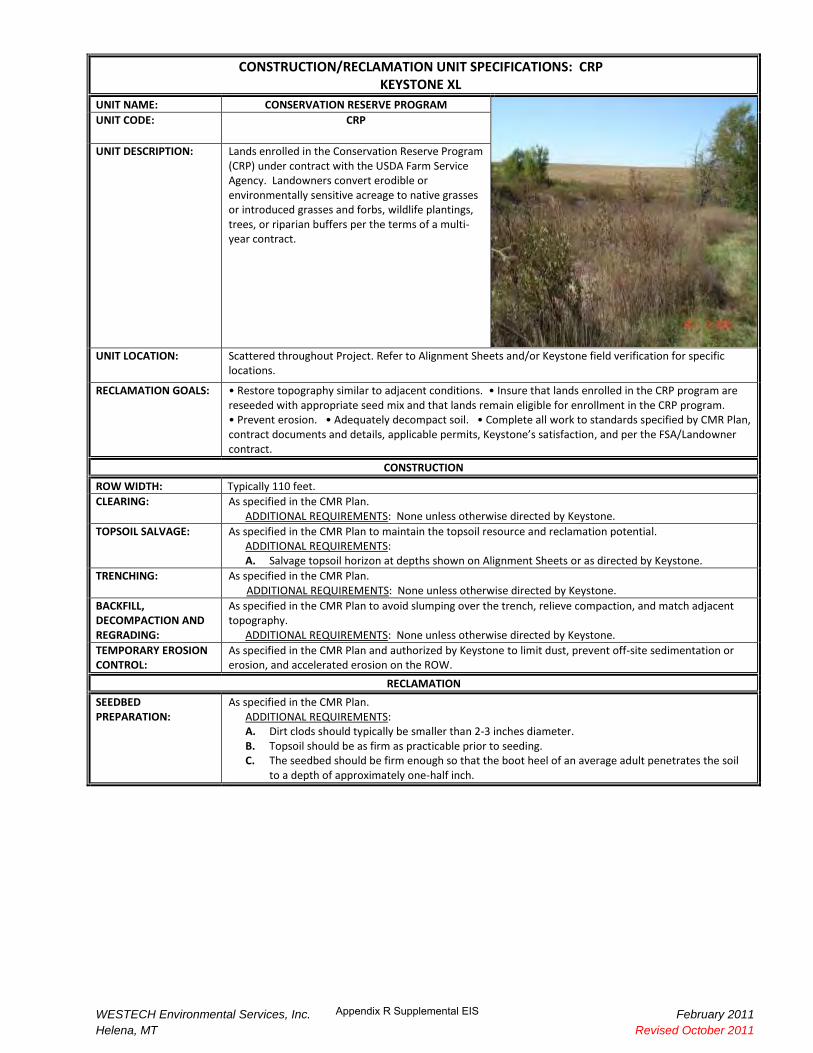
UNIT NAME: CONSERVATION RESERVE PROGRAM
UNIT CODE: CRP
UNIT DESCRIPTION: Lands enrolled in the Conservation Reserve Program (CRP) under contract with the USDA Farm Service Agency. Landowners convert erodible or environmentally sensitive acreage to native grasses or introduced grasses and forbs, wildlife plantings, trees, or riparian buffers per the terms of a multi-year contract.
UNIT LOCATION: Scattered throughout Project. Refer to Alignment Sheets and/or Keystone field verification for specific locations.
RECLAMATION GOALS: • Restore topography similar to adjacent conditions. • Insure that lands enrolled in the CRP program are reseeded with appropriate seed mix and that lands remain eligible for enrollment in the CRP program. • Prevent erosion. • !dequately decompact soil. • Complete all work to standards specified by CMR Plan, contract documents and details, applicable permits, Keystone’s satisfaction, and per the FSA/Landowner contract.
CONSTRUCTION
ROW WIDTH: Typically 110 feet.
CLEARING: As specified in the CMR Plan. ADDITIONAL REQUIREMENTS: None unless otherwise directed by Keystone.
TOPSOIL SALVAGE: As specified in the CMR Plan to maintain the topsoil resource and reclamation potential. ADDITIONAL REQUIREMENTS: A. Salvage topsoil horizon at depths shown on Alignment Sheets or as directed by Keystone.
TRENCHING: As specified in the CMR Plan. ADDITIONAL REQUIREMENTS: None unless otherwise directed by Keystone.
BACKFILL, DECOMPACTION AND REGRADING:
As specified in the CMR Plan to avoid slumping over the trench, relieve compaction, and match adjacent topography.
ADDITIONAL REQUIREMENTS: None unless otherwise directed by Keystone.
TEMPORARY EROSION CONTROL:
As specified in the CMR Plan and authorized by Keystone to limit dust, prevent off-site sedimentation or erosion, and accelerated erosion on the ROW.
RECLAMATION
SEEDBED PREPARATION:
As specified in the CMR Plan. ADDITIONAL REQUIREMENTS: A. Dirt clods should typically be smaller than 2-3 inches diameter. B. Topsoil should be as firm as practicable prior to seeding. C. The seedbed should be firm enough so that the boot heel of an average adult penetrates the soil
to a depth of approximately one-half inch.
WESTECH Environmental Services, Inc. February 2011 Helena, MT Revised October 2011

Appendix R Supplemental EIS
CONSTRUCTION/RECLAMATION UNIT SPECIFICATIONS: CRP KEYSTONE XL
SEEDING METHOD, SEED MIX AND RATE:
As specified in the CMR Plan. See Detail 70 for a description of seeding procedures and approved equipment.
ADDITIONAL REQUIREMENTS: A. Seed will be provided by Keystone and managed by the Contractor. The Contractor will store
seed a dry, secure location. B. The Contractor will store any unused seed in a dry, secure location and notify Keystone as to the
seed’s disposition. Keystone may elect to change the storage location. C. Cover crop: To reduce erosion, an annual cover crop may be seeded per Keystone direction. D. Approved Seed Mix: The seed mix for each CRP tract may vary depending on each CRP contract
with the Farm Service Agency. The Contractor will seed the mix provided by, or specified by, Keystone at each CRP tract.
NRCS RECOMMENDED SEEDING DATES:
August 1 to June 15, depending on climatic conditions. These dates may be altered at Keystone direction. Seeding outside these dates may be allowed with Keystone approval.
MULCHING AND MATTING:
As specified in the CMR Plan at locations shown on Alignment Sheets or as directed by Keystone. Refer to Detail 4 for erosion control matting and Detail 47 for straw mulch.
ADDITIONAL REQUIREMENTS: None unless otherwise directed by Keystone.
SLOPE AND TRENCH BREAKERS:
As specified in the CMR Plan at locations shown on Alignment Sheets or as directed by Keystone. Refer to Detail 3 for slope breakers and Detail 7 for trench breakers.
ADDITIONAL REQUIREMENTS: None unless otherwise directed by Keystone.
ADDITIONAL PRACTICES
1. Provide for livestock and wildlife access across the trench at locations convenient to livestock and the landowner as practicable per the CMR Plan.
2. Construction and reclamation practices may be modified from those presented to suit site conditions or permit requirements with Keystone approval.
3. Monitor revegetation and soil stability post construction. 4. Monitor and control noxious weeds as specified in the state Noxious Weed Management Plans.
WESTECH Environmental Services, Inc. February 2011 Helena, MT Revised October 2011

CONSTRUCTION/RECLAMATION UNIT SPECIFICATIONS: FOR KEYSTONE XL W/W�>/E��WZK:��d
Appendix R Supplemental EIS
UNIT NAME: FOREST UNIT CODE: FOR
UNIT DESCRIPTION: Forest areas are dominated by native and introduced trees. Typical species include green ash, boxelder, plains cottonwood, elm, oak, mulberry, and eastern red cedar.
UNIT LOCATION: In northern areas this unit is primarily located on floodplains, in deep draws, and on steeper slopes. In southern areas of the project the unit may also occur on flat topography and along roads and fencelines.
UNIT GOALS: • Prevent damage to vegetation adjacent to the ROW when removing trees. • Restore native grass understory. • Stabilize slopes to prevent erosion. • Adequately decompact soil. • Complete all work to standards specified in the CMR Plan, contract documents and details, applicable permits, and Keystone’s satisfaction.
SPECIAL CONSIDERATIONS:
1. Dispose of excess wood debris as specified in the CMR Plan or as agreed to with local landowners per Keystone direction.
CONSTRUCTION
ROW WIDTH: Typically 110 feet in Montana and Nebraska. 85 feet in South Dakota. CLEARING: As specified in the CMR Plan.
ADDITIONAL REQUIREMENTS: A. Salvage timber if directed by landowner. B. Fell and clear trees in a manner that avoids injuring adjacent trees. C. Tree stumps shall be removed for 5 feet either side of the trench line, where necessary for safe
and level construction, and to allow feathering out spoil. D. Where necessary on living trees with overhanging branches, cut broken branches at the fork;
preserve the branch collar on the standing tree. E. Dispose of woody debris according to landowner direction as approved by Keystone; otherwise
chip and incorporate with subsoil (amount not to inhibit revegetation) or remove to designated site approved by Keystone.
TOPSOIL SALVAGE: As specified in the CMR Plan to maintain the topsoil resource and reclamation potential. ADDITIONAL REQUIREMENTS: A. Salvage topsoil horizon at depths shown on Alignment Sheets or as directed by Keystone.
TRENCHING: As specified in the CMR Plan. ADDITIONAL REQUIREMENTS: None unless otherwise directed by Keystone.
BACKFILL, DECOMPACTION AND REGRADING:
As specified in the CMR Plan to avoid slumping over the trench, relieve compaction, and match adjacent topography.
ADDITIONAL REQUIREMENTS: None unless otherwise directed by Keystone. TEMPORARY EROSION CONTROL:
As specified in the CMR Plan and authorized by Keystone to limit dust, prevent off-site sedimentation or erosion, and accelerated erosion on the ROW.
RECLAMATION
SEEDBED PREPARATION:
As specified in the CMR Plan. ADDITIONAL REQUIREMENTS: A. Dirt clods should typically be smaller than 2-3 inches diameter. B. Topsoil should be as firm as practicable prior to seeding.

Appendix R Supplemental EIS
CONSTRUCTION/RECLAMATION UNIT SPECIFICATIONS: FOR KEYSTONE XL W/W�>/E��WZK:��d
SEEDING METHOD, SEED MIX AND RATE:
As specified in the CMR Plan. See Detail 70 for a description of seeding procedures and approved equipment.
ADDITIONAL REQUIREMENTS: A. Forested areas will be seeded with the native grass species that occur in forest openings and
understories unless otherwise requested by the landowner. The appropriate seed mix for each FOR Con/Rec Unit is shown in the Revegetation Band on the Alignment Sheets.
B. The FOR Con/Rec Unit will be drill seeded unless slopes are too steep or soils are too rocky to safely operate seeding equipment, in which case, broadcast seeding will be conducted. Broadcast seed will be applied at twice the drill seed PLS/acre rate.
C. Seed will be provided by Keystone and managed by the Contractor. The Contractor will store seed a dry, secure location.
D. The Contractor will store any unused seed in a dry, secure location and notify Keystone as to the seed’s disposition. Keystone may elect to change the storage location.
E. Cover crop: To reduce erosion, an annual cover crop may be seeded per Keystone direction.
NRCS RECOMMENDED SEEDING DATES:
As appropriate for the specified mix, for example, if seeding the TG seed mix utilize the TG seeding dates.
MULCHING AND MATTING:
As specified in the CMR Plan at locations shown on Alignment Sheets or as directed by Keystone. Refer to Detail 4 for erosion control matting, Detail 47 for straw mulch, and Detail 64 for wood mulch.
SLOPE AND TRENCH BREAKERS:
As specified in the CMR Plan at locations shown on Alignment Sheets or as directed by Keystone. Refer to Detail 3 for slope breakers and Detail 7 for trench breakers.
ADDITIONAL REQUIREMENTS: None unless otherwise directed by Keystone.
MANAGEMENT PRACTICES
1. Provide for livestock and wildlife access across the trench at locations convenient to livestock and the landowner as practicable per the CMR Plan.
2. Construction and reclamation practices may be modified from those presented to suit site conditions or permit requirements with Keystone approval.
3. Monitor revegetation and soil stability post construction. 4. Monitor and control noxious weeds as specified in state Noxious Weed Management Plans.

CONSTRUCTION/RECLAMATION UNIT SPECIFICATIONS: IPH KEYSTONE XL
Appendix R Supplemental EIS
UNIT NAME: IMPROVED PASTURE AND HAYLAND
UNIT CODE: IPH
UNIT DESCRIPTION: Improved pastures and haylands are managed grasslands that have typically been planted with grasses for livestock forage or hay production. Improved pastures and haylands are often dominated by crested wheatgrass, smooth brome and legumes in various combinations, or seeded native tall grasses, depending on Project location.
UNIT LOCATION: Improved pastures and haylands occur on all spreads throughout the Keystone XL Project area.
UNIT GOALS: • Re-establish vegetation and prevent accelerated erosion. • Maintain livestock grazing and hayland production • Complete all work to standards specified in the CMR Plan, contract documents and Details, applicable permits, easement descriptions, and Keystone’s satisfaction.
.
SPECIAL CONSIDERATIONS:
None unless otherwise directed by Keystone.
CONSTRUCTION
ROW WIDTH: Typically 110 feet.
CLEARING: As specified in the CMR Plan. ADDITIONAL REQUIREMENTS: None unless otherwise directed by Keystone.
TOPSOIL SALVAGE: As specified in the CMR Plan to maintain the topsoil resource and reclamation potential. ADDITIONAL REQUIREMENTS: A. Salvage topsoil horizon at depths shown on Alignment Sheets or as directed by Keystone.
TRENCHING: As specified in the CMR Plan. ADDITIONAL REQUIREMENTS: None unless otherwise directed by Keystone.
BACKFILL, DECOMPACTION AND REGRADING:
As specified in the CMR Plan to avoid slumping over the trench, relieve compaction, and match adjacent topography.
ADDITIONAL REQUIREMENTS: None unless otherwise directed by Keystone.
TEMPORARY EROSION CONTROL:
As specified in the CMR Plan and authorized by Keystone to limit dust, prevent off-site sedimentation or erosion, and accelerated erosion on the ROW.
RECLAMATION
SEEDBED PREPARATION:
As specified in the CMR Plan. ADDITIONAL REQUIREMENTS: A. Dirt clods should typically be smaller than 2-3 inches diameter. B. Topsoil should be as firm as practicable prior to seeding. C. The seedbed should be firm enough so that the boot heel of an average adult penetrates the
soil to a depth of approximately one-half inch.
WESTECH Environmental Services, Inc. Helena, MT Revised May 2012

Appendix R Supplemental EIS
WESTECH Environmental Services, Inc. Helena, MT Revised May 2012
1
2
-
-
-
-
2
1
CONSTRUCTION/RECLAMATION UNIT SPECIFICATIONS: IPH KEYSTONE XL
SEEDING METHOD, SEED MIX AND RATE:
As specified in the CMR Plan. See Detail 70 for a description of seeding procedures and approved equipment.
ADDITIONAL REQUIREMENTS: A. Seed will be provided by Keystone and managed by the Contractor. The Contractor will
store seed a dry, secure location. B. The Contractor will store any unused seed in a dry, secure location and notify Keystone as to the seed’s disposition. Keystone may elect to change the storage location.
C. Cover crop: To reduce erosion, an annual cover crop may be seeded per Keystone direction.
D. The seed mix will vary depending on the pasture’s location. The appropriate seed mix will be seeded at locations shown on the Alignment Sheets, unless otherwise directed by the landowner, or as directed by Keystone. Four seed mixes will typically be drill-seeded as shown below:
Improved Pasture and Hayland Seed Mixture Brome (BR)
DRILL SEEDING RATE1
SCIENTIFIC NAME COMMON NAME VARIETY2
Pounds PLS/ Acre
PLS/ sq.ft.
GRASSES:
Bromus inermis Smooth brome
AC Rocket, AC Knowles hybrid, Carlton, Signal, Magna, Manchar, Badger, Radisson, Rebound, Barton, Baylor, Saratoga, Lincoln, Cottonwood, Bravo, Jubilee, Polar, Elsberry
8.00 24
TOTAL 8.00 24
Based on a drill seeding rate of 24 Pure Live Seed (PLS) per square foot. Where broadcast seeding is used, the rate will be doubled. Other species such as crested wheatgrass, alfalfa, yellow sweetclover, or clover may be present in the field adjacent to the ROW
and are expected to spread to the ROW in a relatively short period. NOTE: Species or rates may be revised based on commercial availability or site-specific conditions.
Improved Pasture and Hayland Seed Mixture Crested Wheatgrass (CW)
DRILL SEEDING RATE1
SCIENTIFIC NAME COMMON NAME VARIETY2
Pounds PLS/ Acre
PLS/ sq.ft.
GRASSES:
Agropyron cristatum Crested wheatgrass Fairway (Ephraim, Ruff, Parkway, NU-ARS-AC2, RoadCrest, Douglas) Hybrid (HyCrest, HyCrest II)
8.00 32
TOTAL 8.00 32
Based on a drill seeding rate of 32 Pure Live Seed (PLS) per square foot. Where broadcast seeding is used, the rate will be doubled. Other species such as smooth brome, alfalfa, or sweetclover may be present in the field adjacent to the ROW and are expected to
spread to the ROW in a relatively short period. NOTE: Species or rates may be revised based on commercial availability or site-specific conditions.

Appendix R Supplemental EIS
-
-
-
-
-
-
-
1
2
3
-
-
-
-
-
-
-
1
2
WESTECH Environmental Services, Inc. Helena, MT Revised May 2012
CONSTRUCTION/RECLAMATION UNIT SPECIFICATIONS: IPH KEYSTONE XL
Improved Pasture and Hayland Seed Mixture Introduced Pasture (IP)
DRILL SEEDING RATE1
SCIENTIFIC NAME COMMON NAME VARIETY2
Pounds PLS/ Acre
PLS/ sq.ft.
GRASSES:
Agropyron cristatum Crested wheatgrass Fairway (Ephraim, Ruff, Parkway, NU-ARS-AC2, RoadCrest, Douglas) Hybrid (HyCrest, HyCrest II)
2.00 6
Agropyron intermedium Intermediate wheatgrass Manifest, Haymaker, Beefmaker, Reliant, Clarke, Slate, Chief, Oahe, Rush, Amur, Greendar, Tegmar
2.00 4
Bromus inermis Smooth brome
AC Rocket, AC Knowles hybrid, Carlton, Signal, Magna, Manchar, Badger, Radisson, Rebound, Barton, Baylor, Saratoga, Lincoln, Cottonwood, Bravo, Jubilee, Polar, Elsberry
2.00 6
Dactylis glomerata Orchardgrass Chinook, Kay, Potomac, Baridana, Barula 0.25 4
Medicago sativa3 Alfalfa Many varieties 1.00 5
Melilotus officinalis Yellow sweetclover Many varieties 0.25 2
TOTAL 7.50 27
Improved Pasture and Hayland Seed Mixture Tall Grassland Seed Mixture (TG)
DRILL SEEDING RATE1
SCIENTIFIC NAME COMMON NAME VARIETY2
Pounds PLS/ Acre
PLS/ sq.ft.
GRASSES:
Agropyron smithii Western wheatgrass Rodan, Walsh, Flintlock, Rosana 4.00 8
Andropogon gerardii Big bluestem Sunnyview, Bison, Bonilla, Champ, Rountree, Bonanza
3.00 9
Bouteloua curtipendula Sideoats grama Pierre, Butte 3.00 14
Lolium perenne Perennial ryegrass Linn 5.00 26
Panicum virgatum Switchgrass Forestburg, Nebraska 28, Pathfinder, Summer, Trailblazer
0.75 7
Schizachyrium scoparium Little bluestem Camper, Blaze, Pastura 2.00 12
Sorghastrum nutans Indiangrass hawk, Holt, Nebraska 54 3.00 12 Chief, Toma
TOTAL 20.75 88
Based on a drill seeding rate of 27 Pure Live Seed (PLS) per square foot. Where broadcast seeding is used, the rate will be doubled. This may not be a complete list; other named varieties listed by USDA-NRCS in Montana and South Dakota are acceptable. Alfalfa must be planted by mid-August to ensure survival, otherwise, delete from mix.
NOTE: Species or rates may be revised based on commercial availability or site-specific conditions.
Based on a drill seeding rate of 88 Pure Live Seed (PLS) per square foot. Where broadcast seeding is used, the rate will be doubled. This may not be a complete list; other named varieties listed by USDA-NRCS in South Dakota and Nebraska are acceptable.
NOTE: Species or rates may be revised based on commercial availability or site-specific conditions.
NRCS RECOMMENDED SEEDING DATES:
August 1 to June 15, depending on climatic conditions. These dates may be altered at Keystone direction. Seeding outside these dates may be allowed with Keystone approval.
MULCHING AND MATTING:
As specified in the CMR Plan at locations shown on Alignment Sheets or as directed by Keystone. Refer to Detail 4 for erosion control matting and Detail 47 for straw mulch.
ADDITIONAL REQUIREMENTS: None unless otherwise directed by Keystone.
SLOPE AND TRENCH BREAKERS:
As specified in the CMR Plan at locations shown on Alignment Sheets or as directed by Keystone. Refer to Detail 3 for slope breakers and Detail 7 for trench breakers.
ADDITIONAL REQUIREMENTS: None unless otherwise directed by Keystone.
MANAGEMENT PRACTICES
1. Provide for livestock and wildlife access across the trench at locations convenient to livestock and the landowner as practicable per the CMR Plan.
2. Construction and reclamation practices may be modified from those presented to suit site conditions or permit requirements with Keystone approval.
3. Monitor revegetation and soil stability post construction. 4. Monitor and control noxious weeds as specified in the state Noxious Weed Management Plans.

CONSTRUCTION/RECLAMATION UNIT SPECIFICATIONS: MG KEYSTONE XL
Appendix R Supplemental EIS
UNIT CODE:
MIXED GRASSLANDS UNIT NAME:
MG
UNIT DESCRIPTION: Mixed grasslands are dominated by native perennial grasses such as western wheatgrass, needle-and-thread, blue grama, Sandberg bluegrass, prairie junegrass, little bluestem, prairie sandreed, green needlegrass and bluebunch wheatgrass.
UNIT LOCATION: Mixed grasslands are the most extensive native vegetation type on the Keystone XL Project and occur primarily south of the Missouri River in Montana and throughout South Dakota.
UNIT GOALS: • Re-establish native vegetation and prevent accelerated erosion. • Maintain wildlife habitat and livestock grazing production. • Complete all work to standards specified in the CMR Plan, contract documents and Details, applicable permits, easement descriptions, and Keystone’s satisfaction.
SPECIAL CONSIDERATIONS:
None unless otherwise directed by Keystone.
CONSTRUCTION
ROW WIDTH: Typically 110 feet.
CLEARING: As specified in the CMR Plan. ADDITIONAL REQUIREMENTS: None unless otherwise directed by Keystone.
TOPSOIL SALVAGE:
A. Salvage topsoil horizon at depths shown on Alignment Sheets or as directed by Keystone.
As specified in the CMR Plan to maintain the topsoil resource and reclamation potential. ADDITIONAL REQUIREMENTS:
TRENCHING: As specified in the CMR Plan. ADDITIONAL REQUIREMENTS: None unless otherwise directed by Keystone.
BACKFILL, DECOMPACTION AND REGRADING:
As specified in the CMR Plan to avoid slumping over the trench, relieve compaction, and match adjacent topography.
ADDITIONAL REQUIREMENTS: None unless otherwise directed by Keystone.
TEMPORARY EROSION CONTROL:
As specified in the CMR Plan and authorized by Keystone to limit dust, prevent off-site sedimentation or erosion, and accelerated erosion on the ROW.
RECLAMATION
SEEDBED PREPARATION:
As specified in the CMR Plan. ADDITIONAL REQUIREMENTS: A. Dirt clods should typically be smaller than 2-3 inches diameter. B. Topsoil should be as firm as practicable prior to seeding. C. The seedbed should be firm enough so that the boot heel of an average adult penetrates the soil
to a depth of approximately one-half inch.
WESTECH Environmental Services, Inc. Helena, MT Revised May 2012

Appendix R Supplemental EIS
-
-
-
-
-
-
-
-
-
-
-
-
-
-
-
-
-
-
-
-
-
1
2
CONSTRUCTION/RECLAMATION UNIT SPECIFICATIONS: MG KEYSTONE XL
As specified in the CMR Plan. See Detail 70 for a description of seeding procedures and approved equipment. SEEDING METHOD,
SEED MIX AND RATE: ADDITIONAL REQUIREMENTS: A. Seed will be provided by Keystone and managed by the Contractor. The Contractor will store
seed a dry, secure location. B. The Contractor will store any unused seed in a dry, secure location and notify Keystone as to
the seed’s disposition. Keystone may elect to change the storage location. C. The MG seed mix will be applied at locations shown on the Alignment Sheets , unless otherwise
directed by the landowner, or as directed by Keystone. The MG seed mix will be drill seeded unless slopes are too steep or soils are too rocky to safely operate seeding equipment, in which case, broadcast seeding will be conducted.
D. Cover crop: To reduce erosion, an annual cover crop may be seeded per Keystone direction.
Mixed Grassland Seed Mixture MG-1
DRILL
SEEDING RATE1
SCIENTIFIC NAME COMMON NAME VARIETY2
Pounds PLS/ Acre
PLS/ sq.ft.
GRASSES:
Agropyron smithii Western wheatgrass Rosana, Rodan 3.00 8
Agropyron spicatum Bluebunch wheatgrass Goldar 1.50 5
Agropyron trachycaulum Slender wheatgrass Pryor 1.00 3
Bouteloua gracilis Blue grama Bad River 0.30 6
Calamovilfa longifolia Prairie sandreed Goshen, Bowman 0.75 5
Koeleria cristata Prairie junegrass VNS 0.10 5
Poa sandbergii Sandberg bluegrass VNS, High Plains 0.25 5
Schizachyrium scoparium Little bluestem Badlands, Itasca 0.50 3
Stipa comata Needle-and-thread VNS 2.00 5
TOTAL 9.4 45
VNS: Variety not specified Based on a drill seeding rate of 45 Pure Live Seed (PLS) per square foot. Where broadcast seeding is used, the rate will be doubled. This may not be a complete list; other named varieties listed by USDA-NRCS in Montana are acceptable.
NOTE: Species or rates may be revised based on commercial availability or site-specific conditions.
Mixed Grassland Seed Mixture MG-2
DRILL
SEEDING RATE 1
SCIENTIFIC NAME COMMON NAME VARIETY 2
Pounds PLS/ Acre
PLS/ sq.ft.
GRASSES: Agropyron smithii 3
Western wheatgrass Rosana, Rodan, Walsh 2.50 6
Agropyron trachycaulum Slender wheatgrass Pryor 1.00 3
Bouteloua gracilis Blue grama Bad River 0.30 6
Buchloe dactyloides Buffalograss Tatanka, Bismarck ecotype 3.00 4
Calamovilfa longifolia Prairie sandreed Goshen, Pronghorn 0.50 3
Distichlis spicata Inland saltgrass VNS 0.25 3
Koeleria cristata Prairie junegrass VNS 0.10 5
Poa sandbergii Sandberg bluegrass VNS, High Plains 0.20 4
Schizachyrium scoparium Little bluestem Badlands, Itasca 0.50 3
Stipa comata Needle-and-thread VNS 2.00 5
Stipa viridula Green needlegrass Lodorm, AC Mallard Ecovar 0.75 3
TOTAL 11.10 45
VNS: Variety not specified Based on a drill seeding rate of 45 Pure Live Seed (PLS) per square foot. Where broadcast seeding is used, the rate will be doubled. This may not be a complete list; other named varieties listed by USDA-NRCS in Montana and South Dakota are acceptable. If western wheatgrass is unavailable, thickspike wheatgrass (Agropyron dasystachyum var. Critana, Bannock, or Elbee) may be
substituted at a rate of 2.0 PLS pounds per acre. NOTE: Species or rates may be revised based on commercial availability or site-specific conditions.
1
2
3
WESTECH Environmental Services, Inc. Helena, MT Revised May 2012

-
-
-
-
-
-
-
-
-
-
1
2
3
Appendix R Supplemental EIS
CONSTRUCTION/RECLAMATION UNIT SPECIFICATIONS: MG KEYSTONE XL
Mixed Grassland Seed Mixture MG-3
DRILL SEEDING RATE1
SCIENTIFIC NAME COMMON NAME VARIETY2
Pounds PLS/ Acre
PLS/ sq.ft.
GRASSES:
Agropyron smithii3 Western wheatgrass Rosana, Rodan, Walsh 3.00 7
Agropyron trachycaulum Slender wheatgrass Pryor 1.00 3
Andropogon gerardii Big bluestem Sunnyview, Bison, Bonilla, Bonanza
1.50 4
Bouteloua curtipendula Sideoats grama Butte, Pierre, Trailway 1.25 6
Bouteloua gracilis Blue grama Bad River 0.20 4
Calamovilfa longifolia Prairie sandreed Goshen, Pronghorn 1.00 6
Koeleria cristata Prairie junegrass VNS 0.10 5
Schizachyrium scoparium Little bluestem Blaze, CamperBadlands, Itasca
1.00 6
Stipa viridula Green needlegrass Lodorm, AC Malard Ecovar 1.00 4
TOTAL 10.05 45
VNS: Variety not specified Based on a drill seeding rate of 45 Pure Live Seed (PLS) per square foot. Where broadcast seeding is used, the rate will be doubled. This may not be a complete list; other named varieties listed by USDA-NRCS in South Dakota and Nebraska are acceptable. If western wheatgrass is unavailable, thickspike wheatgrass (Agropyron dasystachyum var. Critana, Bannock, or Elbee) may be
substituted at a rate of 2.0 PLS pounds per acre. NOTE: Species or rates may be revised based on commercial availability or site-specific conditions.
NRCS RECOMMENDED SEEDING DATES:
August 1 to June 15, depending on climatic conditions. These dates may be altered at Keystone direction. Seeding outside these dates may be allowed with Keystone approval.
MULCHING AND MATTING:
As specified in the CMR Plan at locations shown on Alignment Sheets or as directed by Keystone. Refer to Detail 4 for erosion control matting, Detail 47 for straw mulch, and Detail 64 for wood mulch.
ADDITIONAL REQUIREMENTS: None unless otherwise directed by Keystone.
SLOPE AND TRENCH BREAKERS:
As specified in the CMR Plan at locations shown on Alignment Sheets or as directed by Keystone. Refer to Detail 3 for slope breakers and Detail 7 for trench breakers.
ADDITIONAL REQUIREMENTS: None unless otherwise directed by Keystone.
MANAGEMENT PRACTICES
1. Provide for livestock and wildlife access across the trench at locations convenient to livestock and the landowner as practicable per the CMR Plan.
2. Construction and reclamation practices may be modified from those presented to suit site conditions or permit requirements with Keystone approval.
3. Monitor revegetation and soil stability post construction. 4. Monitor and control noxious weeds as specified in the Montana and South Dakota Noxious Weed Management Plans.
WESTECH Environmental Services, Inc. Helena, MT Revised May 2012

CONSTRUCTION/RECLAMATION UNIT SPECIFICATIONS: RIP KEYSTONE XL
Appendix R Supplemental EIS
UNIT NAME: RIPARIAN
UNIT CODE: RIP
UNIT DESCRIPTION: Riparian woodlands include forested and shrub dominated areas around streams and rivers. Common trees and shrubs include plains cottonwood, green ash, box elder, Russian olive, sandbar willow, Wood’s rose, snowberry, and silver sagebrush. Herbaceous understories are often dominated by Kentucky bluegrass, western wheatgrass, and redtop.
UNIT LOCATION: Primarily located on floodplains and terraces along streams and rivers. This Con/Rec Unit is relatively limited on the Keystone XL Project.
UNIT GOALS: • Prevent damage to vegetation adjacent to the ROW when removing trees. • Restore native grass understory. • Stabilize slopes to prevent erosion. • !dequately decompact soil. • Complete all work to standards specified in the CMR Plan, contract documents and details, applicable permits, and Keystone’s satisfaction.
SPECIAL CONSIDERATIONS:
1. Note that this type may be adjacent to or associated with wetlands and stream crossings. 2. Implement wetland and stream crossing procedures as shown on Alignment Sheets or directed by
Keystone. 3. Wetland or stream crossing procedures will take precedent over this Con/Rec Unit should discrepancies
occur.
CONSTRUCTION
ROW WIDTH: Typically 110 feet.
CLEARING: As specified in the CMR Plan. ADDITIONAL REQUIREMENTS: A. Salvage timber if directed by landowner. B. Fell and clear trees to avoid injuring adjacent trees. C. Tree stumps shall be removed for 5 feet either side of the trench line and where necessary for safe
and level construction. D. Where necessary on living trees with overhanging branches, cut broken branches at the fork;
preserve the branch collar on the standing tree. E. Dispose of woody debris according to landowner direction as approved by Keystone; otherwise
chip and incorporate with subsoil (amount not to inhibit revegetation) or remove to designated site approved by Keystone.
F. Mow shrubby vegetation to ground level and leave rootstock intact unless grading is necessary.
TOPSOIL SALVAGE: As specified in the CMR Plan to maintain the topsoil resource and reclamation potential. ADDITIONAL REQUIREMENTS: A. Salvage topsoil horizon at depths shown on Alignment Sheets or as directed by Keystone.
TRENCHING: As specified in the CMR Plan. ADDITIONAL REQUIREMENTS: None unless otherwise directed by Keystone.
BACKFILL, DECOMPACTION AND REGRADING:
As specified in the CMR Plan to avoid slumping over the trench, relieve compaction, and match adjacent topography.
ADDITIONAL REQUIREMENTS: None unless otherwise directed by Keystone.
TEMPORARY EROSION CONTROL:
As specified in the CMR Plan and authorized by Keystone to limit dust, prevent off-site sedimentation or erosion, and accelerated erosion on the ROW.
ADDITIONAL REQUIREMENTS: A. Insure adequate erosion control is in place during construction to prevent sediment from
reaching any associated streams or rivers.
WESTECH Environmental Services, Inc.
Helena, MT Revised May 2012

WESTECH Environmental Services, Inc.
Helena, MT Revised May 2012
-
-
-
-
-
Appendix R Supplemental EIS
1
2
3
CONSTRUCTION/RECLAMATION UNIT SPECIFICATIONS: RIP KEYSTONE XL
RECLAMATION
SEEDBED PREPARATION:
As specified in the CMR Plan. ADDITIONAL REQUIREMENTS: A. Dirt clods should typically be smaller than 2-3 inches diameter. B. Topsoil should be as firm as practicable prior to seeding.
SEEDING METHOD, SEED MIX AND RATE:
As specified in the CMR Plan. See Detail 70 for a description of seeding procedures and approved equipment.
ADDITIONAL REQUIREMENTS:
A. Seed will be provided by Keystone and managed by the Contractor. The Contractor will store seed a dry, secure location.
B. The Contractor will store any unused seed in a dry, secure location and notify Keystone as to the seed’s disposition. Keystone may elect to change the storage location.
C. The RIP seed mix will be applied at locations shown on the Alignment Sheets or as directed by Keystone. The RIP seed mix will be drill seeded unless slopes are too steep or soils are too rocky to safely operate seeding equipment, in which case, broadcast seeding will be conducted.
D. Cover crop: To reduce erosion, an annual cover crop may be seeded per Keystone direction.
Riparian Seed Mixture (RIP)
DRILL
SEEDING RATE 1
SCIENTIFIC NAME COMMON NAME VARIETY 2
Pounds PLS/ Acre
PLS/ sq.ft.
GRASSES:
Agropyron smithii Western wheatgrass Rosanna, Rodan, Walsh 5.00 13
Agropyron trachycaulum Slender wheatgrass Pryor 1.00 3
Bouteloua gracilis Blue grama Bad River 0.20 4
Elymus canadensis Canada wildrye VNS 3.00 8
Stipa viridula Green needlegrass Lodorm 2.50 10
TOTAL 11.70 38 VNS: Variety not specified Based on a drill seeding rate of 38 Pure Live Seed (PLS) per square foot. Where broadcast seeding is used, the rate will be doubled. This may not be a complete list; other named varieties listed by USDA-NRCS in Montana and South Dakota are acceptable. In Spreads 4-6, big bluestem and switchgrass will be added to the mix at the rates shown below:
Panicum virgatum-Switchgrass, (Varieties Forestburg, Nebraksa 28, Pathfinder, Summer, Trailblazer), at 2.00 pounds PLS/acre Andropogon gerardii-Big bluestem, (Varieties Sunnyview, Bison, Bonilla, Champ, Rountree, Bonanza), at 3.00 pounds PLS/acre
NOTE: Species or rates may be revised based on commercial availability or site-specific conditions.
NRCS RECOMMENDED SEEDING DATES:
August 1 to June 15, depending on climatic conditions. These dates may be altered at Keystone direction. Seeding outside these dates may be allowed with Keystone approval.
MULCHING AND MATTING:
As specified in the CMR Plan at locations shown on Alignment Sheets or as directed by Keystone. Refer to Detail 4 for erosion control matting, Detail 47 for straw mulch, and Detail 64 for wood mulch.
ADDITIONAL REQUIREMENTS: A. Respread wood debris may negate the need for straw mulch per Keystone direction.
SLOPE AND TRENCH BREAKERS:
As specified in the CMR Plan at locations shown on Alignment Sheets or as directed by Keystone. Refer to Detail 3 for slope breakers and Detail 7 for trench breakers.
ADDITIONAL REQUIREMENTS: None unless otherwise directed by Keystone.
MANAGEMENT PRACTICES
1. Provide for livestock and wildlife access across the trench at locations convenient to livestock and the landowner as practicable per the CMR Plan.
2. Construction and reclamation practices may be modified from those presented to suit site conditions or permit requirements with Keystone approval.
3. Monitor revegetation and soil stability post construction. Monitor and control noxious weeds per the Noxious Weed Plan.

Appendix R Supplemental EIS
CONSTRUCTION/RECLAMATION UNIT SPECIFICATIONS: SB UNIT NAME: SHELTERBELT UNIT CODE: SB
UNIT DESCRIPTION: Planted tree and shrub shelterbelts and windbreaks. Common northern species are: plains cottonwood, Chinese elm, American elm, Austrian pine, Siberian peashrub, and lilac. Common southern species are: Osage orange, eastern red cedar, locust, and hawthorne.
UNIT LOCATION: Typically located at field margins, near roadsides, or around residences. Refer to Alignment Sheets and/or Keystone field verification for specific locations.
RECLAMATION GOALS: • Prevent damage to vegetation adjacent to the ROW when removing trees. • Restore grass understory. • Provide non-vegetated windbreaks. • Adequately decompact soil. • Complete all work to standards specified by CMR Plan, contract documents and details, applicable permits, and Keystone’s satisfaction.
CONSTRUCTION
ROW WIDTH: 110 feet unless otherwise directed by Alignment Sheets and/or Keystone. CLEARING:
1. Salvage timber if directed by landowner. 2. Fell and clear trees to avoid injuring adjacent trees. 3. Tree stumps shall be removed for 5 feet either side of the trench line and where necessary for safe and level
construction. 4. Where necessary on living trees with overhanging branches, cut broken branches at the fork; preserve the
branch collar on the standing tree. 5. Dispose of woody debris according to landowner direction; otherwise chip and incorporate with subsoil
(amount not to inhibit revegetation) or remove to designated site approved by Keystone. Do not bury debris in trench.
TOPSOIL SALVAGE: 1. Salvage topsoil only over the trench unless additional grading is necessary to facilitate construction, then salvage topsoil from entire area to be graded.
2. Salvage entire topsoil horizon, or up to 12 inches, whichever is less, unless otherwise directed by Keystone. TOPSOIL and SPOIL PLACEMENT:
1. Store topsoil and spoil in windrows along edge of ROW or in other configurations convenient to the work per Keystone direction.
2. Maintain separation between topsoil and spoil piles. 3. Maintain gaps in topsoil and spoil windrows to prevent stormwater ponding.
TRENCHING: 1. Trench according to CMR Plan, SWPPP, and contract documents. 2. Dewater trench as necessary according to CMR Plan, SWPPP, and Keystone direction to minimize damage to
adjacent lands, waterways, or crops. BACKFILL, DECOMPACTION AND REGRADING:
1. Backfill, decompact and regrade per Con/Rec Detail B,D&R.
TEMPORARY EROSION CONTROL:
As directed by CMR Plan, SWPPP, and/or Keystone:
1. Stabilize topsoil and spoil piles with water or biodegradable tackifier as necessary to prevent wind erosion. 2. Install other erosion control as necessary to prevent erosion within the ROW, and off-ROW impacts. 3. Maintain and/or reinstall erosion control features to ensure proper function at all times.
RECLAMATION
SEEDBED PREPARATION:
1. Disc or harrow the regraded ROW to produce a consistent seedbed with clods typically less than 4 inches in diameter.
2. Prepare a seedbed that is free of competing vegetation and not subject to excessive erosion. A firm seedbed will ensure that seed is placed at the proper depth.

Appendix R Supplemental EIS
CONSTRUCTION/RECLAMATION UNIT SPECIFICATIONS: SB SEEDING METHOD, SEED MIX AND RATE:
As specified in the CMR Plan. See Detail 70 for a description of seeding procedures and approved equipment.
ADDITIONAL REQUIREMENTS: A. Seed will be provided by Keystone and managed by the Contractor. The Contractor will store seed a
dry, secure location. B. The Contractor will store any unused seed in a dry, secure location and notify Keystone as to the
seed’s disposition. Keystone may elect to change the storage location. C. Areas within the SB type will be seeded as shown on the alignment sheets, unless otherwise
directed by the landowner, or as directed by Keystone. D. Cover crop: To reduce erosion, an annual cover crop may be seeded per Keystone direction.
NRCS RECOMMENDED SEEDING DATES:
August 1 to June 15, depending on climatic conditions. These dates may be altered at Keystone direction. Seeding outside these dates may be allowed with Keystone approval.
PLANTING: Replace trees as directed by Keystone. PERMANENT EROSION CONTROL:
Install permanent slope and trench breakers, mulching, and matting as directed by CMR Plan, SWPPP, and Keystone.
ADDITIONAL PRACTICES
1. Install windfence across the ROW in areas where trees and/or shrubs have been removed as directed by Keystone. 2. Avoid mixing topsoil and subsoil through rutting per the CMR Plan. 3. Construction and reclamation practices may be modified per Keystone.

WESTECH Environmental Services, Inc. May 2012
Helena, MT
CONSTRUCTION/RECLAMATION UNIT SPECIFICATIONS: SP KEYSTONE XL
Appendix R Supplemental EIS
UNIT NAME: SANDY PRAIRIE
UNIT CODE: SP
UNIT DESCRIPTION: Native prairie on sandy soils dominated primarily by warm- season grasses such as little bluestem, sand bluestem, prairie sandreed, and switchgrass. Topography is typically flat to gently rolling.
UNIT LOCATION: The Sandy Prairie unit occurs in southern South Dakota and northern Nebraska. The unit is interspersed with hay meadows and crop land.
UNIT GOALS: • Maintain soil structure and stability. • Restore native grass species. • Maintain wildlife habitat and livestock grazing production. • Complete all work to standards specified in the CMR Plan, contract documents and Details, applicable permits, easement descriptions, and Keystone’s satisfaction.
SPECIAL CONSIDERATIONS:
1. Incorporate supplementary construction and reclamation procedures that may be provided by Keystone.
2. Stabilize topsoil salvage piles with bio-degradable tackifier. 3. Apply straw or native hay mulch for erosion control after clean-up as directed by Keystone. 4. Install erosion control matting after regrading as specified by Keystone. Install erosion control matting
over native hay mulch as specified by Keystone. In some areas, tackifier may be used in place of matting if approved by Keystone.
5. Do not decompact the ROW unless specifically directed by Keystone. 6. Seed mix will be applied in two procedures with a drill and broadcast seeder in some locations as
described under Seeding Method, Seed Mix and Rate.
CONSTRUCTION
ROW WIDTH: Typically 110 feet.
CLEARING: As specified in the CMR Plan. ADDITIONAL REQUIREMENTS: 1. Leave root crowns and root structures in place to the maximum extent practicable.
TOPSOIL SALVAGE: As specified in the CMR Plan to maintain the topsoil resource and reclamation potential. ADDITIONAL REQUIREMENTS: A. Utilize trench and working salvage (Detail 54) on slopes less than 5% where shown on Alignment
Sheets or as directed by Keystone. B. Where grading is necessary, salvage topsoil from entire area to be graded (Detail 53). C. Salvage topsoil horizon at depths as shown on Alignment Sheets or as directed by Keystone. D. Stabilize topsoil salvage piles with bio-degradable tackifier as directed by Keystone.
TRENCHING: As specified in the CMR Plan. ADDITIONAL REQUIREMENTS: A. Anticipate trenchwall instability. B. Insure that topsoil (salvaged or unsalvaged) is not lost to trench caving.
BACKFILL, DECOMPACTION AND REGRADING:
As specified in the CMR Plan to avoid slumping over the trench and match adjacent topography. ADDITIONAL REQUIREMENTS: A. Do not decompact the ROW (subsoil or topsoil) unless specifically directed by Keystone. B. Avoid scalping of undisturbed topsoil on the ROW when backfilling spoil and redistributing
stockpiled topsoil.
TEMPORARY EROSION CONTROL:
As specified in the CMR Plan to limit dust, prevent off-site sedimentation or erosion, and accelerated erosion on the ROW.
ADDITIONAL REQUIREMENTS: A. Stabilize topsoil salvage piles with biodegradable tackifier as directed by Keystone. B. Install other erosion control to prevent erosion within the ROW, and off-ROW impacts as directed
by Keystone. C. Maintain and/or reinstall erosion control features to ensure proper function at all times.

Appendix R Supplemental EIS
WESTECH Environmental Services, Inc. May 2012
Helena, MT
1
CONSTRUCTION/RECLAMATION UNIT SPECIFICATIONS: SP KEYSTONE XL
RECLAMATION
SEEDBED PREPARATION:
As specified in the CMR Plan. ADDITIONAL REQUIREMENTS: A. Additional seedbed preparation may be necessary within this Con/Rec Unit at Keystone direction. B. Cultipack or roll ROW to firm topsoil prior to reseeding as authorized by Keystone. C. Composted manure may be used where and as directed by Keystone. Fresh manure is not
acceptable.
SEEDING METHOD, SEED MIX AND RATE:
As specified in the CMR Plan. See Detail 70 for a description of seeding procedures and approved equipment.
ADDITIONAL REQUIREMENTS: A. Where topography allows drill seeding, seed will be applied in two applications. The first application
will be completed with an approved drill seeder using half the seed mix shown below; the second application will be completed with an approved broadcast seeder using the remaining half. Where topography is too steep or loose to operate a drill seeder, the entire seed mix will be applied using an approved broadcast seeder.
B. Seed will be provided by Keystone and managed by the Contractor. The Contractor will store seed in a dry, secure location.
C. The Contractor will store any unused seed in a dry, secure location and notify Keystone as to the seed’s disposition. Keystone may elect to change the storage location.
D. The SH seed mix will be applied at locations shown on the Alignment Sheets or as directed by Keystone.
E. Use a chain to cover broad-cast seeded areas. Do not use a harrow to cover broadcast-seeded areas in the Sandy Prairies unless directed by Keystone. Use of a harrow may bury seed too deeply.
F. Cover crop: To aid in managing wind and water erosion potential, an annual cover crop (perennial ryegrass (var. Linn), a Keystone-approved annual grass/crop, or QuickGuard) may be seeded per Keystone direction.
Sandy Prairie (SP) Seed Mixture
BROADCAST SEEDING RATE1
SCIENTIFIC NAME COMMON NAME Pounds PLS/
Acre PLS/ sq.ft. Percent in
Mix
NRCS Allowable
Percentage Range
Listed Varieties by Preference
GRASSES:
Agropyron smithii Western wheatgrass 1.25 3 2.4%
0 – 5 1. Rodan; 2. Rosana; 3. Barton
Andropogon hallii Sand bluestem 12.00 31 24.4%
20 – 40 1. Goldstrike; 2. Garden County; 3. Champ
Bouteloua gracilis Blue grama 0.25 5 3.9%
0 – 10 1. Bad River
Calamovilfa longifolia Prairie sandreed 3.25 20 15.7%
15 – 25 1. Goshen; 2. Pronghorn
Elymus Canadensis Canada wildrye 1.25 3 2.4%
0 – 5 1. Mandan
Eragrosts trichodes Sand lovegrass 0.50 15 11.8%
5 – 15 1. Nebraska 27
Panicum virgatum Switchgrass 1.50 13 10.2%
5 – 15 1. Nebraska 28; 2. Pathfinder
Schizachyrium scoparium Little bluestem 4.50 27 21.3%
15 – 25 1. Camper; 2. Pastura; 3. Blaze
Sorghastrum nutans Indiangrass 2.50 10 7.9%
5 – 15 1. Holt; 2. Nebraska 54
TOTAL 27.00 127 100
Based on a broadcast seeding rate of approximately 127 Pure Live Seed (PLS) per square foot; total PLS/sq ft does not include perennial ryegrass which is used as a companion crop. Seed rates will be halved where drill seeding is used.

WESTECH Environmental Services, Inc. May 2012
Helena, MT
Appendix R Supplemental EIS
CONSTRUCTION/RECLAMATION UNIT SPECIFICATIONS: SP KEYSTONE XL
NRCS RECOMMENDED SEEDING DATES:
November 1 to June 30, depending on climatic conditions. These dates may be altered at Keystone direction. Seeding outside these dates may be allowed with Keystone approval.
MULCHING AND MATTING:
As specified in the CMR Plan at locations shown on Alignment Sheets or as directed by Keystone. Refer to Detail 4 for erosion control matting, Detail 47 for weed free native hay or straw mulch. Cornstalks may be used for mulch with Keystone approval.
ADDITIONAL REQUIREMENTS: A. All portions of the Project within this Con/Rec Unit will receive a companion crop specified by the
NRCS and Keystone, and either straw mulch, cornstalk mulch, and/or erosion control matting at locations shown on Alignment Sheets or as directed by Keystone.
B. Erosion control matting may be applied over native hay or straw mulch as directed by Keystone. C. Biodegradable pins approved by Keystone will be used in place of metal staples to anchor erosion
control matting within this Con/Rec Unit.
SLOPE AND TRENCH BREAKERS:
Slope breakers are not anticipated in this Con/Rec Unit unless specifically directed by Keystone since most erosion is caused by wind rather than water. Trench breakers will be installed where directed by Keystone.
MANAGEMENT PRACTICES
1. Provide for livestock and wildlife access across the trench at locations convenient to livestock and the landowner as practicable per the CMR Plan.
2. Construction and reclamation practices may be modified from those presented to suit site conditions or permit requirements with Keystone approval.
3. Monitor revegetation and soil stability post construction. Areas of failed reclamation will be repaired. 4. Monitor and control noxious weeds as specified in the Nebraska and South Dakota Noxious Weed Management Plans.
WESTECH Environmental Services, Inc. Revised May 2012
Helena, MT
CONSTRUCTION/RECLAMATION UNIT SPECIFICATIONS: TG KEYSTONE XL
Appendix R Supplemental EIS
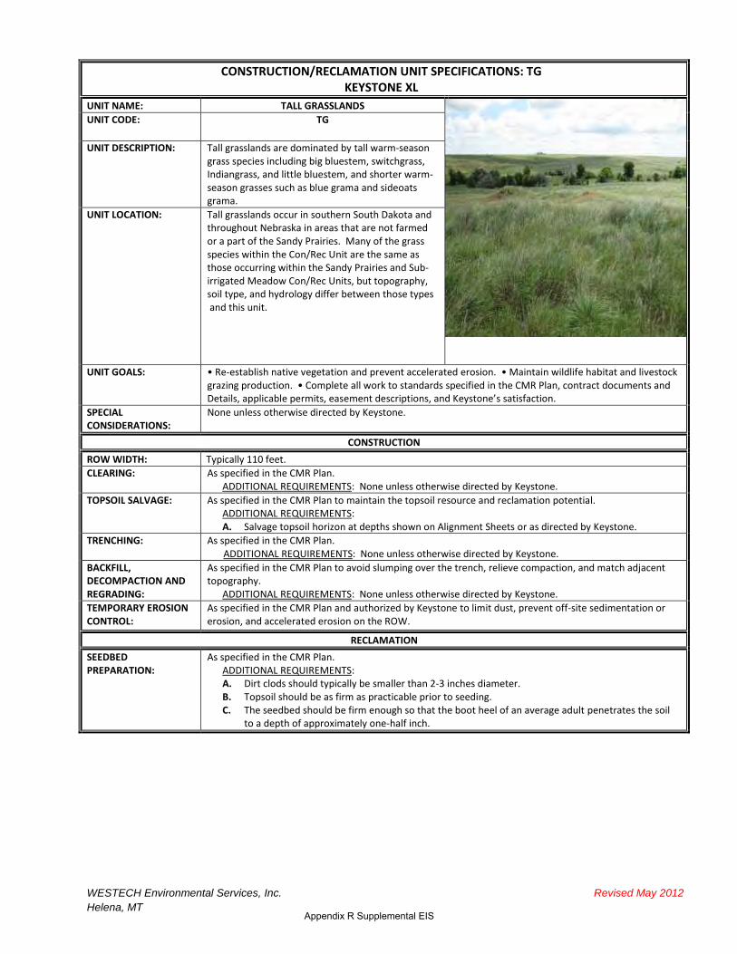
UNIT NAME: TALL GRASSLANDS
UNIT CODE: TG
UNIT DESCRIPTION: Tall grasslands are dominated by tall warm-season grass species including big bluestem, switchgrass, Indiangrass, and little bluestem, and shorter warm-season grasses such as blue grama and sideoats grama.
UNIT LOCATION: Tall grasslands occur in southern South Dakota and throughout Nebraska in areas that are not farmed or a part of the Sandy Prairies. Many of the grass species within the Con/Rec Unit are the same as those occurring within the Sandy Prairies and Sub-irrigated Meadow Con/Rec Units, but topography, soil type, and hydrology differ between those types and this unit.
UNIT GOALS: • Re-establish native vegetation and prevent accelerated erosion. • Maintain wildlife habitat and livestock grazing production. • Complete all work to standards specified in the CMR Plan, contract documents and Details, applicable permits, easement descriptions, and Keystone’s satisfaction.
SPECIAL CONSIDERATIONS:
None unless otherwise directed by Keystone.
CONSTRUCTION
ROW WIDTH: Typically 110 feet.
CLEARING: As specified in the CMR Plan.
TOPSOIL SALVAGE:
ADDITIONAL REQUIREMENTS: None unless otherwise directed by Keystone.
As specified in the CMR Plan to maintain the topsoil resource and reclamation potential. ADDITIONAL REQUIREMENTS: A. Salvage topsoil horizon at depths shown on Alignment Sheets or as directed by Keystone.
TRENCHING: As specified in the CMR Plan. ADDITIONAL REQUIREMENTS: None unless otherwise directed by Keystone.
BACKFILL, DECOMPACTION AND REGRADING:
As specified in the CMR Plan to avoid slumping over the trench, relieve compaction, and match adjacent topography.
ADDITIONAL REQUIREMENTS: None unless otherwise directed by Keystone.
TEMPORARY EROSION CONTROL:
As specified in the CMR Plan and authorized by Keystone to limit dust, prevent off-site sedimentation or erosion, and accelerated erosion on the ROW.
RECLAMATION
SEEDBED PREPARATION:
As specified in the CMR Plan. ADDITIONAL REQUIREMENTS: A. Dirt clods should typically be smaller than 2-3 inches diameter. B. Topsoil should be as firm as practicable prior to seeding. C. The seedbed should be firm enough so that the boot heel of an average adult penetrates the soil
to a depth of approximately one-half inch.

EIS
WESTECH Environmental Services, Inc. Revised May 2012
Helena, MT
-
-
-
-
-
-
-
1
2
CONSTRUCTION/RECLAMATION UNIT SPECIFICATIONS: TG KEYSTONE XL
SEEDING METHOD, SEED MIX AND RATE:
As specified in the CMR Plan. See Detail 70 for a description of seeding procedures and approved equipment.
ADDITIONAL REQUIREMENTS: A. Seed will be provided by Keystone and managed by the Contractor. The Contractor will store
seed a dry, secure location. B. The Contractor will store any unused seed in a dry, secure location and notify Keystone as to
the seed’s disposition. Keystone may elect to change the storage location. C. The TG seed mix will be applied at locations shown on the Alignment Sheets, unless otherwise
directed by the landowner, or as directed by Keystone. The TG seed mix will be drill seeded unless slopes are too steep or soils are too rocky to safely operate seeding equipment, in which case, broadcast seeding will be conducted.
D. Cover crop: If permanent seeding is delayed to the following growing season, perennial ryegrass (var. Linn) or another annual crop may be seeded per Keystone direction.
Tall Grassland Seed Mixture (TG)
DRILL
SEEDING RATE 1
SCIENTIFIC NAME COMMON NAME VARIETY 2
Pounds PLS/
Acre PLS/
sq.ft.
GRASSES:
Agropyron smithii Western wheatgrass Rodan, Walsh, Flintlock, Rosana 4.00 10
Andropogon gerardii Big bluestem Sunnyview, Bison, Bonilla, Champ,
Rountree, Bonanza 5.00 15
Bouteloua curtipendula Sideoats grama Pierre, Butte 3.00 14
Panicum virgatum Switchgrass Forestburg, Nebraska 28, Pathfinder,
Summer, Trailblazer 0.75 7
Schizachyrium scoparium Little bluestem Camper, Blaze, Pastura 2.00 12
Sorghastrum nutans Indiangrass Chief, Tomahawk, Holt, Nebraska 54 3.00 12
TOTAL 17.75 70
Based on a drill seeding rate of 70 Pure Live Seed (PLS) per square foot excluding perennial ryegrass. Where broadcast seeding is used, the rate will be doubled. This may not be a complete list; other named varieties listed by USDA-NRCS in South Dakota and Nebraska are acceptable.
NOTE: Species or rates may be revised based on commercial availability or site-specific conditions.
NRCS RECOMMENDED SEEDING DATES:
November 1 to June 30, depending on climatic conditions. These dates may be altered at Keystone direction. Seeding outside these dates may be allowed with Keystone approval.
MULCHING AND MATTING:
As specified in the CMR Plan at locations shown on Alignment Sheets or as directed by Keystone. Refer to Detail 4 for erosion control matting, Detail 47 for straw mulch, and Detail 64 for wood mulch.
ADDITIONAL REQUIREMENTS: None unless otherwise directed by Keystone.
SLOPE AND TRENCH BREAKERS:
As specified in the CMR Plan at locations shown on Alignment Sheets or as directed by Keystone. Refer to Detail 3 for slope breakers and Detail 7 for trench breakers.
ADDITIONAL REQUIREMENTS: None unless otherwise directed by Keystone.
MANAGEMENT PRACTICES
1. Provide for livestock and wildlife access across the trench at locations convenient to livestock and the landowner as practicable per the CMR Plan.
2. Construction and reclamation practices may be modified from those presented to suit site conditions or permit requirements with Keystone approval.
3. Monitor revegetation and soil stability post construction. 4. Monitor and control noxious weeds as specified in the South Dakota and Nebraska Noxious Weed Management Plans.
Appendix R Supplemental EIS

CONSTRUCTION/RECLAMATION UNIT SPECIFICATIONS: SBP KEYSTONE XL W/W�>/E��WZK:��d
UNIT NAME: SUBIRRIGATED PASTURE
UNIT CODE: SBP
UNIT DESCRIPTION: The Subirrigated Pasture type includes subirrigated plains and hay meadows. Soils are typically fine sands, with narrow clay bands in some areas. Topography is typically flat. The water table within this Con/Rec Unit is often within six feet of the surface. Native grasses include big bluestem, switchgrass, and little bluestem; introduced grasses include timothy, orchardgrass, and Kentucky bluegrass . Wetlands may occur adjacent to, but not part of, this Con/Rec Unit.
UNIT LOCATION: Subirrigated Pastures occur in southern South Dakota and portions of Nebraska, primarily in Tripp, Keya Paha, Rock, Holt, Antelope, and Nance counties.
UNIT GOALS: • Maintain soil structure and stability to the greatest extent practicable. • Restore native grass species. • Maintain wildlife habitat and hay and livestock grazing production. • Complete all work to standards specified in the CMR Plan, contract documents and Details, applicable permits, easement descriptions, and Keystone’s satisfaction.
SPECIAL CONSIDERATIONS:
1. Anticipate trench wall instability 2. Anticipate trench water management procedures to be employed throughout construction. 3. Do not decompact the ROW unless specifically directed by Keystone. 4. Backfilling, final cleanup, erosion control, and reseeding must be conducted progressively w ith the
minimal time practicable between procedures. 5. The ROW will not be utilized for access or project traffic following final cleanup within this Con/Rec Unit.
CONSTRUCTION
ROW WIDTH: Typically 110 feet. Note that extra workspace has been identified in many areas within this Con/Rec unit to allow for spoil storage if a wide trench is required. Do not utilize the additional workspace unless necessary and directed by Keystone.
CLEARING: As specified in the CMR Plan. ADDITIONAL REQUIREMENTS:
A. Do not clear more than 110 feet of ROW unless directed by Keystone. B. Leave root crowns and root structures in place to the maximum extent practicable. C. Minimize clearing equipment on the ROW.
TOPSOIL SALVAGE: As specified in the CMR Plan to maintain the topsoil resource and reclamation potential. ADDITIONAL REQUIREMENTS: A. Salvage topsoil from the entire work area except under topsoil storage piles (Detail 53). B. Stabilize topsoil salvage piles with bio-degradable tackifier as directed by Keystone and maintain until
topsoil replacement. C. Salvage topsoil horizon at depths as shown on Alignment Sheets or as directed by Keystone. D. Additional topsoil salvage may be necessary outside of the 110 foot Right-of-way, if additional
workspace is needed to accommodate a wide trench and additional spoil. TRENCHING: As specified in the CMR Plan.
ADDITIONAL REQUIREMENTS: A. Anticipate substantial trench instability. B. Insure that topsoil (salvaged or unsalvaged) is not lost to trench caving. C. Trench dewatering or other construction procedures, such as floating the pipe, that are suitable for
use in saturated or flooded conditions may be necessary. The actual methods used to construct the trench, dewater the trench, and lay the pipe will be approved by Keystone.
Appendix R Supplemental EIS

Appendix R Supplemental EIS
CONSTRUCTION/RECLAMATION UNIT SPECIFICATIONS: SBP KEYSTONE XL W/W�>/E��WZK:��d
BACKFILL, DECOMPACTION AND REGRADING:
As specified in the CMR Plan to avoid slumping over the trench and match adjacent topography. ADDITIONAL REQUIREMENTS: A. Do not decompact the ROW (subsoil or topsoil) unless specifically directed by Keystone. B. Avoid scalping undisturbed topsoil when redistributing stockpiled topsoil. C. Backfilling, final cleanup, erosion control, and reseeding must be conducted progressively with the
minimal time practicable between procedures.
TEMPORARY and PERMANENT EROSION CONTROL:
As specified in the CMR Plan to limit dust, prevent off-site sedimentation or erosion, and accelerated erosion on the ROW.
ADDITIONAL REQUIREMENTS: A. Implement procedures to prevent anticipated sediment from saturated spoil and topsoil from
flowing outside the ROW boundaries. B. RoW stabilization measures must be carried out immediately following any topsoil replacement
activities. This will consist of; straw mulch application across the entire RoW, installation of erosion control matting on slopes as specified by Keystone, use of NRCS recommended cover crops, and application of tackifiers or hydromulch in place of matting if approved by Keystone.
C. Maintain and/or reinstall erosion control features to ensure proper function at all times.
RECLAMATION
SEEDBED PREPARATION:
As specified in the CMR Plan. ADDITIONAL REQUIREMENTS: A. Dirt clods should typically be smaller than 2-3 inches diameter. B. Topsoil should be as firm as practicable prior to seeding. C. The seedbed should be firm enough so that the boot heel of an average adult penetrates the soil to a
depth of approximately one-half inch.

Appendix R Supplemental EIS
1
CONSTRUCTION/RECLAMATION UNIT SPECIFICATIONS: SBP KEYSTONE XL W/W�>/E��WZK:��d
SEEDING METHOD, SEED MIX AND RATE:
As specified in the CMR Plan. See Detail 70 for descriptions of seeding procedures and approved equipment. ADDITIONAL REQUIREMENTS:
Due to seasonal constraints relative to successful re-establishment seeding must be conducted prior to July 15thto allow for adequate length of growing season to avoid winter-kill. Any areas unable to be re-seeded by this date will need to be deferred until after Oct 1 to ensure seed germination does not occur until after frost conditions to avoid winter-kill.
A. Seed will be provided by Keystone and managed by the Contractor. The Contractor will store seed in a dry, secure location.
B. The Contractor will store any unused seed in a dry, secure location and notify Keystone as to the seed’s disposition. Keystone may elect to change the storage location.
C. A seed mix of native species will be used in areas designated MA on the Revegetation Band of the Alignment Sheets. The seed mix will be drill seeded unless slopes are too steep or soils are too rocky to safely operate seeding equipment, in which case, broadcast seeding will be conducted.
D. Cover crop: To aid in managing wind and water erosion potential, an annual cover crop (perennial ryegrass (var. Linn), a Keystone-approved annual grass/crop, QuickGuard), or Proso millet may be seeded to those areas planted prior to the October 1st date as per Keystone direction.
Subirrigated Pasture (SBP) Seed Mixture
DRILL SEEDING RATE1
SCIENTIFIC NAME COMMON NAME Pounds PLS/
Acre PLS/ sq.ft. Percent in
Mix Percentage
Range
Allowable NRCS
Listed Varieties by Preference
GRASSES:
Agropyron smithii Western wheatgrass 2.50 6 9.0% 0 - 20 1. Rodan;
2. Rosana; 3. Barton
Andropogon gerardii Big bluestem 6.00 23 34.3% 30 – 40 1. Pawnee; 2. Champ; 3. Bonanza
Elymus Canadensis Canada wildrye 1.25 3 4.4% 0 – 5 1. Mandan
Panicum virgatum Switchgrass 1.00 9 13.4% 5 – 20 1. Nebraska 28; 2. Pathfinder; 3. Forestburg
Schizachyrium scoparium Little bluestem 1.75 10 14.9% 10 – 20 1. Camper;
2. Pastura; 3. Blaze
Sorghastrum nutans Indiangrass 4.00 16 23.9% 15 – 30 1. Holt; 2. Nebraska 54
TOTAL 16.50 67 100
Based on a drill seeding rate of 67 Pure Live Seed (PLS) per square foot. Where broadcast seeding is used, the rate will be doubled. NOTE: Species or rates may be revised based on commercial availability or site-specific conditions.
NRCS RECOMMENDED SEEDING DATES:
October 1 to July 15, depending on climatic conditions. These dates may be altered at Keystone direction. Seeding outside these dates may be allowed with Keystone approval.

Appendix R Supplemental EIS
CONSTRUCTION/RECLAMATION UNIT SPECIFICATIONS: SBP KEYSTONE XL W/W�>/E��WZK:��d
MULCHING AND MATTING:
As specified in the CMR Plan at locations shown on Alignment Sheets or as directed by Keystone. Refer to Detail 4 for erosion control matting, Detail 47 for weed free native hay or straw mulch. Cornstalks may be used for mulch with Keystone approval. ADDITIONAL REQUIREMENTS: A. All portions of the Project within this Con/Rec Unit will receive a companion crop for those areas
seeded prior to July 15th. No companion crops will be applied with those areas seeded on or after Oct 1.
B. All portions of the project within this Con/Rec Unit will receive and either straw mulch, cornstalk mulch, and/or erosion control matting at locations shown on Alignment Sheets or as directed by Keystone.
C. RoW stabilization measures of all topsoils will consist of; straw mulch application across the entire RoW, installation of erosion control matting on slopes as specified by Keystone, and application of tackifiers or hydromulch may be used in place of matting if approved by Keystone.
D. Erosion control matting may be applied over native hay or straw mulch as directed by Keystone. E. Biodegradable pins approved by Keystone will be used in place of metal staples to anchor erosion
control matting within this Con/Rec Unit. F. Areas where erosion control matting has been installed will be fenced to prevent livestock access as
directed by Keystone.
SLOPE AND TRENCH BREAKERS:
Slope breakers are not required in this Con/Rec Unit unless specifically directed by Keystone. Trench breakers will be installed as directed by Keystone.
MANAGEMENT PRACTICES
1. Provide for livestock and wildlife access across the trench at locations convenient to livestock and the landowner as practicable per the CMR Plan.
2. Construction and reclamation practices may be modified from those presented to suit site conditions or permit requirements with Keystone approval.
3. Monitor revegetation and soil stability post construction. Areas of failed reclamation will be repaired. 4. Monitor and control noxious weeds as specified in the Nebraska and South Dakota Noxious Weed Management Plans.

Appendix R Supplemental EIS
RECLAMATION OF CONTRACTOR CAMPS, PIPE YARDS AND CONTRACTOR YARDS
UNIT NAME:
Contractor Camp, Contractor Yard and Pipe Yard Facilities
UNIT CODE: YARD
UNIT DESCRIPTION: Contractor camps, contractor yards, pipe storage yards, staging areas, and other temporary facilities.
UNIT LOCATION: Several yards and facilities are associated with each construction Spread. Refer to project maps for exact locations.
UNIT GOALS: Salvage and maintain topsoil.
Prevent off-site erosion.
De-compact subsoil prior to respreading topsoil.
Re-establish grade to match adjacent contours.
Remove all construction and facility debris and material.
Re-establish site capacity and productivity unless otherwise specified.
Complete all work to standards specified in the CMR Plan, contract documents and details, applicable permits, landowner easement agreements, and Keystone’s satisfaction.
CONSTRUCTION
TOPSOIL SALVAGE: 1. Prepare area per site specific drawings or as directed by Keystone. 2. Salvage topsoil. Salvage the entire topsoil horizon (A horizon), or up to 12 inches, whichever is less,
unless otherwise directed by Keystone. Salvage herbaceous and small shrub vegetation with topsoil. Where frozen topsoil conditions are encountered, appropriate topsoil salvaging methods and proper equipment (i.e., frozen topsoil cutter or equivalent) must be used to ensure no topsoil/ subsoil mixing occurs, and the equivalent land capability is maintained.
3. If subsoil is stored, maintain an adequate gap between subsoil and topsoil to prevent mixing per Keystone direction.
TOPSOIL PLACEMENT: 1. Grade the site to direct water away from the Yard or Facility and towards silt fence which surrounds the perimeter of the Yard of Facility.
2. Store topsoil in windrows along the site perimeter, leaving gaps for drainage. 3. Maintain topsoil windrows to prevent stormwater ponding.
TEMPORARY EROSION CONTROL:
As detailed by the CMR Plan, SWPPP, and/or Keystone: 1. Stabilize topsoil piles with biodegradable tackifier as necessary to prevent wind erosion. 2. Install and silt fence around the perimeter of the Yard or Facility to prevent off-site sedimentation.
Ensure adequate distance between the edge of topsoil piles and perimeter silt fence to allow for water ponding or soil sloughing.
3. Maintain and/or reinstall silt fence or other erosion control features to ensure proper function at all times.
4. Use and maintain appropriate materials (soil, gravel, etc.) for adequate access (entry/exit). Ensure that access point materials and/or sources have been approved by county or municipal authorities as necessary (e.g. weed-free gravel).
RECLAMATION
CLEANUP 1. Remove all project-related construction debris and structures, including gravel, geo-textile, buildings, utilities, material, and trash from the Yard or Facility unless otherwise agreed to by the landowner and Keystone.
WESTECH Environmental Services, Inc. October 2010
Helena, Montana

EIS
WESTECH Environmental Services, Inc. October 2010
Helena, Montana
RECLAMATION OF CONTRACTOR CAMPS, PIPE YARDS AND CONTRACTOR YARDS
DECOMPACTION AND REGRADING:
1. Decompact subsoil prior to replacing topsoil by ripping or chiseling the subsoil a minimum of three passes, to a depth of approximately 18 inches. Rip or chisel in alternating cross patterns if practical. Avoid damage to subsurface features (e.g. pipe, electrical lines, etc.) If large clay clods or rocks are brought to the surface during ripping, consult with Keystone to modify the procedure.
2. Test decompacted subsoil at representative, regular intervals and compare to adjacent, undisturbed areas with the same soil type and moisture condition. Keystone to determine the adequacy of decompaction.
3. Grade or disk subsoil to break any subsoil clods to less than 6 inches average diameter. Smaller subsoil clods minimize subsequent mixing between subsoil and topsoil.
4. Remove rocks that have been exposed on the surface due to construction activity prior to topsoil replacement. Any rock left on the Yard or Facility must be of equivalent quantity, size, and distribution to that on immediately adjacent lands. Rock may be removed manually or with a rock picker provided that topsoil preservation is assured. Rock removed from the Yard or Facility shall be removed from the landowner’s premises and properly disposed of, or, disposed of on the landowner’s premises at a location that is mutually acceptable to the landowner and Keystone.
5. Replace salvaged topsoil to pre-existing depths. Regrade the Yard or Facility to insure that final grade matches adjacent contour.
6. Ensure that drainage from the site is similar to pre-construction conditions unless otherwise directed by the landowner and Keystone.
SEEDBED PREPARATION:
1. Disc or harrow the regraded site to produce a consistent seedbed with topsoil clods typically less than 3 inches in diameter.
2. Prepare a seedbed that is free of competing vegetation and not subject to excessive erosion. A firm seedbed will ensure that seed is placed at the proper depth.
SEEDING METHOD Drill Seeding 1. Drill seeding will be the primary method of seeding Yards and Facilities. 2. Seeding equipment should provide proper seed depth, uniform seeding rate, and good seed to soil
contact. The row spacing shall not exceed 8 inches unless approved by Keystone. 3. Drill seeding equipment must be of the range or reclamation type commonly used for applying grass
and/or fluffy seed (e.g. Truax or Keystone approved equivalent). The drill seeder must regulate the seed application rate and planting depth and shall be equipped with press wheels. Planting depth shall be regulated by depth bands or coulters. Seed must be uniformly distributed in the drill hopper during drilling operation.
4. Seeding depths shall be at least ¼ inch and a maximum of ½ inch. 5. The drills shall be calibrated to monitor seeding rate and operated at an appropriate speed to maintain
the specified seeding rate and depth. Broadcast Seeding 1. Broadcast seeding will typically be conducted on steep slopes, rocky areas, and in confined areas as
needed with Keystone direction. 2. When broadcast seeding, double seed application rates from those shown for drill seeding. 3. Broadcast seeding will not be completed during high wind periods as determined by Keystone. 4. Seed will be broadcast using manually or mechanically operated cyclone-type bucket spreaders or a
drop-seeder (e.g. Brillion). Seed will be mixed as necessary to prevent bridging. 5. Broadcast seeding by hand shall be with a Cyclone shoulder strap broadcast spreader or a Keystone
approved equivalent. Distributing seed by hand without a mechanical broadcaster will not be allowed. 6. Following any broadcast seeding, good seed/soil contact shall be established by dragging a roller
harrow or flexible meadow harrow over the seeded area. All seed that is broadcasted shall be dragged unless otherwise specified by Keystone. On small areas, hand ranking may be used to cover seed.
7. Hydraulic seeding equipment (hydro-seeder) may be used per Keystone direction.
SEED MIX AND RATE: Keystone will provide an appropriate seed mix for each site unless otherwise agreed to with the
landowner.
SEEDING DATE: Seeding dates will vary depending upon the ecological region of the Yard or Facility and will be specified by Keystone.
PERMANENT EROSION CONTROL:
Install any permanent erosion control items consistent with the CMR Plan and Keystone direction. Typical erosion control may include: • Cover crops as specified by Keystone. • Straw mulch or biodegradable tackifier applied at a rate recommended by the manufacturer. Straw
lengths will be approximately 8 inches. Straw mulch will be uniformly applied at 2 tons per acre and crimped to a depth of 2 to 3 inches. Crimping shall be completed with a crimper (not a farm disc) or tracked vehicle in excessively steep terrain.
Appendix R Supplemental EIS

Appendix R Supplemental EIS
RECLAMATION OF PIPE YARDS AND CONTRACTOR YARDS (In Sandy Prairie Areas) TOPSOIL SALVAGE THROUGH CLEANUP
1. Complete these procedures as described for RECLAMATION OF CONTRACTOR CAMPS, PIPE YARDS AND CONTRACTOR YARDS
DECOMPACTION AND REGRADING:
1. Do not decompact subsoil unless directed by Keystone 2. Replace salvaged topsoil to pre-existing depths and adjacent contour. 3. Ensure that drainage from the site is similar to pre-construction conditions unless otherwise directed by
the landowner and Keystone.
SEEDBED PREPARATION:
1. Disc or harrow the regraded site to produce a consistent seedbed with topsoil clods typically less than 3 inches in diameter. If clods are typically less than 3 inches once topsoil has been respread, do not disc or harrow.
2. Prepare a seedbed that is free of competing vegetation and not subject to excessive erosion. A firm seedbed will ensure that seed is placed at the proper depth.
SEEDING METHOD 1. Yards and Facilities within Sandy Prairie areas will be drill seeded and broadcast seeded. 2. Drill and broadcast seed according to methods described for RECLAMATION OF PIPE YARDS AND
CONTRACTOR YARDS (In Non-Sandy Prairie Areas).
SEED MIX AND RATE: Keystone will provide an appropriate seed mix for each site unless otherwise agreed to with the
landowner. Sufficient seed will be provided to drill seed and broadcast seed each Yard or Facility within
Sandy Prairie Areas. Bags will be labeled to identify which will be used for drill seeding, and which will be
used for broadcast seeding.
SEEDING DATE: Seeding dates will be based on regional ecological requirements and will be specified by Keystone.
PERMANENT EROSION CONTROL:
Install any permanent erosion control items consistent with the CMR Plan and Keystone direction. Typical erosion control may include:
• Cover crops as specified by Keystone. •
Straw mulch or biodegradable tackifier applied at a rate recommended by the manufacturer. Straw lengths will be approximately 8 inches. Straw mulch will be uniformly applied at 2 tons per acre and crimped to a depth of 2 to 3 inches. Crimping shall be completed with a crimper (not a farm disc) or tracked vehicle in excessively steep terrain.
WESTECH Environmental Services, Inc. October 2010
Helena, Montana

3. Supporting Emails and Letters
Keystone XL Project
March 2013

Appendix R Supplemental EIS
Phone Conversation with Dr. Dave Wedin on July 17th 2008 at 2:30pm Grasslands EcologistUniversity of Nebraska - School of Natural Resources402-472-9608 (o)402-730-8543 (c)
Seed Suggestions: Use mixture of warm and cool season grasses Species composition is very important
Other Comments: Northerly winds in March/April are the most erosive. Winds switch to southerly in late May. If our client is interested in working with a university partner, they would be interested Upland - Native grasses, 85% of area. Lowlands - More non-native species, moist hay meadows, 15% of area. South Dakota has more invasive species than Nebraska Will need to develop a plan to keep out invasive species
References: Walton John - looking into success of seeding along highways throughout the Sandhills Dave Stock - provides seed mixes and most likely tailors mixes to the Sandhills region

Appendix R Supplemental EIS
Phone Conversation with Dr. Jerry Volesky on July 15th 2008 at 12:30pm Associate Professor - Extension Range and Forage Specialist University of Nebraska Cooperative Extension 308-696-6710
Challenges: Wind erosion potential Heavy rain Native grasses often slow to establish Most of sandhills are pasture land - how to fence of area without completely cutting pasture land in half? Specific stabilized areas for cattle to cross? Variable rain - trouble growing seed if no rain
Blowouts: Usually caused by cattle near watertanks or along oddly shaped fencing
Seed Suggestions: Use native seed: 3 to 4 species of warm season grasses as well as 1 to 2 species of cool season grasses in seed mix Native seed is often very slow to establish Use of a cover crop along with native seed is important for faster establishment (such as rye/wheat/oat)
Mulch Suggestions: Spread mulch, hay, tree branches over disturbance Crimp mulch/hay into ground
Other Suggestions: Use temporary fencing to protect vegetation from livestock until it is well established Strip & replace topsoil - important for the successful re-establishment of vegetation (even though it may look like all the other sand out there)
Other Comments: "110 feet of disturbance is really not that significant" ridges tend to oriented in NW to SE direction from prevailing winds most suceptible to erosion when crossing ridges Two types of areas: meadows and rolling hills/dunes. Meadows have higher water table, are subirrigated, have high organic content, and erosion is not much of a concern Sandhills Biocomplexity Project - used herbicide to kill plants - no erosion seen until area was disked - root matting remained intact and stabilized soil until sufficient subsoil disturbance occurred.
References: Nebraska Department of Roads - usually use mulch and sometimes matting on steep slopes Use past knowledge from pipelines through the area South Dakota State University - Eric Mousel and Sandy Smart (both are grassland/rangeland specialists who previously worked at University of Nebraska) Will send several journal publications Bluestem-Sandreed Establishment Erosion-Blowouts Revegetation Sandhills Seedbank Characteristics-Sandhills
My Thoughts:

Appendix R Supplemental EIS
Dr. Volesky was very helpful and is a great resource with good information about seed and mulch. However, he did not know very much about other types of BMPs such as wind fence, soil stabilizers, wattles, etc…

Appendix R Supplemental EIS
Phone Conversation with Bob Atkenson on July 17th 2008 at 3pm Area Engineer NRCS - Holt County, Nebraska 402-336-3796
Seed Suggestions: Use the typical critical area seed mix & then mulch at 4000 Ibs/acre of prairie hay mulch - will email me the seed mix
Other Suggestions: Can use waterbars on steep slopes, snow fence in windy areas, hay/straw bales where necessary
Other Comments: South Dakota will have more water erosion issues and require typical controls like silt fence
My Thoughts: May have some experience and good information, but not very willing to take time and talk to me over the phone.

Appendix R Supplemental EIS
Phone Conversation with Dr. David Loope on July 17th 2008 at 9:30am Geosciences Professor University of Nebraska 402-472-2647
Other Suggestions: Mould surface to existing contours Plant grass as well as shrubs
Other Comments: Department of Roads has fairly large cuts and fill on the N-S highways, and it does not look like they have trouble stabilizing the area - "nothing looks out of control"
References: Contact Hightway Department or Department of Roads - use "mesh" on slopes "Atlas of the Sand Hills" edited by Anne Bleed and Charles Flowerday - can purchase from Nebraska School of Natural Resources

Appendix R Supplemental EIS
Email from Gabe Robertson on July 18th 2008 at 2pm Highway Environmental Programs Specialist (Roadside Stabilization)Nebraska Department of Roads402-479-4685
Hi Emily,Here are some recommendations from a couple of the folks in our Roadside Stabilization Unit. You’ll see that a lot of emphasis is placed on salvaging the topsoil from the project to re-apply after construction. That canobviously have a huge impact on vegetation establishment. I know we also use a slope protection netting in specific areas where wind is a concern. This is a photo-degradable, black synthetic mesh that is placed onslopes, over the seeded and mulched area, and will help provide some wind erosion control until the vegetationhas enough time to get established. Usually these nets will break down in about a year.Please see the rest of the comments below and feel free to contact me with any other questions you have.
The most important thing is to salvage what little topsoil is there for the seed bank and soil critters that help theplants grow.We also use a lot of composted manure and I know the maintenance people use that when they have blowouts.She might also want to check with NRCS Nebraska.
Composted manure, incorporated into the top 6”, from local feedlots can also help to improve vegetationestablishment
Assuming that this is a buried pipeline proposed for cattle country, the proponent should expect to place exclusionfencing to protect new seeding areas during seedling establishment and initial growth (probably needs to befenced for the first year or two). The fences will have to be placed so that cattle can still access water, shade, nutrient blocks, etc. The proponent will want input from the affected landowners in this regard. Cattle are naturally curious, and will be drawn to anything that is new and different, fencing included. Species composition of seed mixtures for re-vegetation will depend on what land use types the pipeline istraversing. Landowners who have tame pasture will likely want the same types of grasses post-project. Native grassland pasture-owners likely will want native species to be planted. In short, put it back like you found it tohave happy landowners.The best one thing that can be done during construction to improve re-vegetation success: salvage, store, thenrespread the top 8 inches of soil. This sandy stuff may not look like topsoil, but the soil microbes, the little bit oforganic matter, and other biological stuff in that layer will help immensely in getting the place reclaimed.Native grassland seeding: NDOR uses seed mixtures that are dominated by species known to tolerate sandysoils (species are provided below), used in tandem with 4 tons of prairie hay mulch per acre of disturbance, and where wind is a concern, the seeded area is overlain with staked netting.Recommended grass species for the native grassland seed mixtures: Sand bluestem, little bluestem, sand lovegrass, sand dropseed, sideoats grama, blue grama, prairie sandreed, Canada wildrye, thickspike wheatgrass, prairie junegrass, green needlegrass (in the northern Sandhills), switchgrass, and western wheatgrass.Quick vegetation establishment: NDOR uses a cover crop in concert with the seed mixture. Cereal rye performswell as cover crop in sandy soils. However, the cover crop grows actively for only a few months. Certain of the species listed above can get going earlier than others. NDOR relies on Canada wildrye, little bluestem, sideoatsgrama, sand lovegrass, sand dropseed, and thickspike wheatgrass for early establishment of permanent cover. Again, salvage and respread of topsoil is important for rapid response and success of the seeding.
My Thoughts: Was very helpful over email. If there are any questions I'm sure he would be willing to talk over the phone.

Appendix R Supplemental EIS
From: Robertson, Gabe To: [email protected] Subject: FW: Sandhills reclamation Date: Wednesday, April 29, 2009 8:34:39 AM Attachments: SECTION 810.docx
John,
Here are some answers to your questions. I also attached the NDOR Slope Protection Spec for your reference.
Let me know if you need anything else.
Gabe
Thanks for your additional help. I have a couple of specific questions regarding procedures the highway department has used to reclaim road cuts in the Sandhills.
1. What application rate (tons/acre) do you use when adding composted manure to a site? We typically use manure on the shoulders, 0.2 cy per linear yard; I think the goal is to have 2-3” depth. On steep slopes we use native hay broadcast and drilled as Carol described. Slope protection netting is placed over the hay. I’ve attached the latest version of the specification.
2. What equipment do you use to apply composted manure to steep slopes and what equipment do you use to work the manure into the soil on steep slopes? Generally use a regular manure spreader and then disk lightly into the soil.
3. Do you ever incorporate woody debris or other items when backfilling an area to provide subsoil structure and prevent erosion? Woody debris - - no. Crimped mulch is used frequently, as is erosion control netting.
4. Do you typically broadcast seed or hydro-seed steep slopes? Not sure about steep slopes, but the typical method for Sandhills projects is to drill at a lighter rate (a 3000 square yard rate seeded over one acre, then broadcast the remainder of the seed over the soil surface prior to application of mulch.
5. What total seed rate do you apply (pounds PLS/acre)? Please specify if this rate is for drill seeding or broadcast seeding. NDOR uses a mixture of cool- and warm-season grasses, legumes and forbs that total between 35-45 PLS pounds per acre. As indicated in #4, that quantity is drilled AND broadcast.
They might want to consider using a bonded fiber matrix application over steep slopes.

1
Appendix R Supplemental EIS
TransCanada-Keystone XL 3LSHOLQH�3URMHFW
Contact Record
Date/Time: 6.30.10 0900-1300 Meeting Phone Conversation E-Mail (attach) (highlight)
Agency/Organization(s): NRCS – Nebraska State Office
WESTECH Environmental Services, Inc.
Person(s) Involved: Mike Kucera (State Resource Conservationist – NRCS), Cam Loerch (State Soil
Scientist – NRCS), Dan Shurtliff (Soil Scientist – NRCS)
John Beaver, Lisa Larsen, WESTECH
Notes: JB stated the purpose of the meeting was to describe the project, explain reclamation
planning and techniques, address questions and concerns and incorporate recommendations
where possible on Spreads 8, 9 and 10 in Nebraska. JB outlined the Fall 2009 reclamation surveys,
explained how the CON/REC units were developed, and showed how alignment sheets are used.
The NRCS was generally impressed with the amount of reclamation planning that has been
accomplished. Questions and concerns are summarized below.
MK: Suggested reviewing Range Site and Ecological Site information.
MK: What is the consistency of the product in the line? JB/LL did not know – will find out.
MK: Mulch rates – NRCS recommends 2 tons hay/straw per acre without tackifer and 1 ton
hay/straw per acre with tackifer on slopes >5 percent. NRCS favors native grass hay in the
Sandhills and believes it is more available than straw and probably cheaper. JB described
typical mulching techniques.
MK: Recommended using NRCS Standards for mulching (484), companion crops (550 DP), and
cover crops (550 DP and 340). LL stated they were used.
MK/
CL/DS: Need to avoid WRP’s (Wetland Reserve Program) in York and Wheeler counties. JB thought
they had been avoided – will check. MK said NRCS previously gave this information to
TransCanada.
JB:
There was considerable concern regarding potential impacts to wetlands known as
“rainwater basins” that are associated with Filmore, Scott and Marr Lake soils in Merrick,
York and Filmore counties. Need to avoid draining them and should treat as a pothole.
The group looked at potential rainwater basins near MP’s 768, 770 and 775. Need to
identify via SURGO data base and provide mitigation.
Sandhills Reclamation – JB discussed re-routes, soil salvage, erosion control, seeding and
fencing. MK/CL/DS recommended salvaging 8-10” rather than 6-8”, matting slopes >30
percent (which JB said was already the plan), and using native hay as mulch (which JB and
LL agreed to present to TransCanada).

Appendix R Supplemental EIS
MK: Use drill seed when possible in Sandhills. Drill rates should be 60 PLS per square
foot, 120 PLS per square foot if broadcasting, exclusive of companion crop. Should utilize
seeding windows in 550 DP; LL explained that seeding along a pipeline is difficult due to
access issues, replaced fences, etc. The NRCS is concerned that seeding grass outside of
the recommended timeframes will result in substantial revegetation failure. MK was very
clear that the NRCS would not recommend or condone seeding grass outside of the
appropriate season.
Rated cover/companion crops from best to worst: oats, wheat, triticale, cereal rye.
For seedbed preparation, dirt clods should be no larger than 2-3 inches diameter.
Does not want crested wheatgrass seeded in Nebraska. Between MP 598.2 – 599.2 in the
first 2-3 miles of northern Nebraska, crested wheatgrass fields were documented at two
locations for a total of about 1800 feet (4-5 acres). Presumably the landowner wants it
reseeded to crested, so no changes will be made. The IPH-IP mix which also includes
crested wheatgrass is not prescribed anywhere in Nebraska.
Seed mixes – see attached CON/REC units showing track changes.
Is follow up required? 1.
2.
Find out what the physical consistency of the oil product in the pipeline is.
Confirm that no WRP’s are crossed by Project.
3. Identify rainwater basins and provide mitigation.
Commitments made: 1. Change salvage depth in Sandhills from 6-8” to 8-10” on alignment sheets.
2. Specify matting on slopes >30% in Sandhills. We believe this is already done
but will check language in DTL 4.
3. Confirm there is no IPH-CW in Nebraska (done).
Recorded by: Lisa Larsen, John Beaver, WESTECH
2

Appendix R Supplemental EIS
From: Lisa Larsen To: "Kucera, Michael - Lincoln, NE" Cc: "John Beaver"; [email protected]; [email protected]; [email protected] Subject: Keystone XL Project Reclamation Date: Tuesday, July 20, 2010 1:21:54 PM Attachments: NEB ConRec revisions.pdf
Hello Mike-
John Beaver and I very much appreciated meeting with you, Dan Shurtliff and Cam Loerch on June 30 to discuss the Keystone XL Project. I have attached revised CON/REC units showing changes made in response to your feedback in track change mode to facilitate your review.
We have not yet determined the consistency of the pipeline product but will let you know when we find out. We are in the process of confirming that no WRP’s are crossed by the project and identifying the potential presence of rainwater basins. We did determine that the ONLY crested wheatgrass proposed in Nebraska is in two existing crested WG fields in the first 2-3 miles of northern Nebraska (4-5 acres); assuming this is what the landowner desires, we’ll use CWG in these two locations only.
Please let us know if you have any questions or concerns, or require additional information.
Lisa Larsen
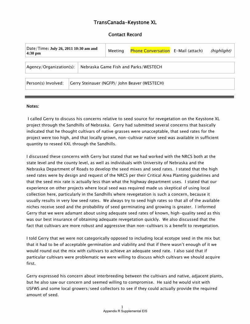
1
Appendix R Supplemental EIS
TransCanada-Keystone XL
Contact Record
Date/Time: July 26, 2011 10:30 am and
4:30 pm Meeting Phone Conversation E-Mail (attach) (highlight)
Agency/Organization(s): Nebraska Game Fish and Parks/WESTECH
Person(s) Involved: Gerry Steinauer (NGFP)/ John Beaver (WESTECH)
Notes:
I called Gerry to discuss his concerns relative to seed source for revegetation on the Keystone XL
project through the Sandhills of Nebraska. Gerry had submitted several concerns that basically
indicated that he thought cultivars of native grasses were unacceptable, that seed rates for the
project were too high, and that locally grown, non-cultivar native seed was available in sufficient
quantity to reseed KXL through the Sandhills.
I discussed these concerns with Gerry but stated that we had worked with the NRCS both at the
state level and the county level, as well as individuals with University of Nebraska and the
Nebraska Department of Roads to develop the seed mixes and seed rates. I stated that the high
seed rates were by design and request of the NRCS per their Critical Area Planting guidelines and
that the seed mix rate is actually less than what the highway department uses. I stated that our
experience on other projects where local seed was required made us skeptical of using local
collection here, particularly in the Sandhills where revegetation is such a concern, because it
usually results in very low seed rates. We always try to seed high rates so that all of the available
niches receive seed and the probability of seed germinating and growing is greater. I informed
Gerry that we were adamant about using adequate seed rates of known, high-quality seed as this
was our best insurance of obtaining adequate revegetation quickly. We also discussed that the
fact that cultivars are more robust and aggressive than non-cultivars is a benefit to revegetation.
I told Gerry that we were not categorically opposed to including local ecotype seed in the mix but
that it had to be of acceptable germination and viability and that if there wasn’t enough of it we
would round out the mix with cultivars to achieve an adequate seed rate. I also said that if
particular cultivars were problematic we were willing to discuss which cultivars we should acquire
first.
Gerry expressed his concern about interbreeding between the cultivars and native, adjacent plants,
but he also saw our concern and seemed willing to compromise. He said he would visit with
USFWS and some local growers/seed collectors to see if they could actually provide the required
amount of seed.

2
Appendix R Supplemental EIS
Gerry called me back around 4:00 pm and said that he had spoken with growers and the USFWS.
He basically had three points:
1. He said that for some species, such as big bluestem, there would probably be enough seed
that is grown by producers – not collected in the wild – but is also of a preferred variety to
satisfy the project’s needs. He said that for other species there probably was not enough
supply to satisfy the demand if cultivars from several sources were not used. In these
cases cultivars would be acceptable.
2. Gerry said that the USFWS did not consider reseeding with cultivars in ABB habitat to be
adequate mitigation and that if cultivars were used the mitigation payments would be
higher. Gerry said that the USFWS had noted that some species, such as smooth brome
(which is a non-native grass and therefore not included in the Marsh Plains of Sandhills
seed mix), are rhizomatous and can impede ABB burying their prey. Gerry pointed out to
the USFWS that several native grasses, including those that grow in ABB habitat are also
rhizomatous. I don’t believe the USFWS had much of a response to this.
3. The EIS would probably state that Keystone will have to consult with USFWS and NDGFP on
seed mixes in the Sandhills.
Gerry asked if pipelines typically reseed wetlands. I said not unless required by the USACE since
wetlands typically revegetate quickly on their own with appropriate species that are present prior
to construction. Gerry indicated that this was his experience also.
In summary it seems that there is opportunity to discuss meeting the concerns of the NDGFP and
USFWS regarding seed source and also Keystone’s concerns regarding seed rates and seed quality.
However, this option will probably not be available for areas designated as ABB habitat because
the USFWS has decided that only native ecotypes of locally collected seed will suffice as mitigation.
Personally I doubt that there is any research whatsoever that compares ABB use of habitat
dominated by cultivars of native species to habitat dominated by non-cultivars of native species.
Is follow up required? Generally this issue should be pursued with USFWS, NDGFP, and NRCS, etc. to
resolve the problem.
Commitments made: none
Recorded by: John Beaver
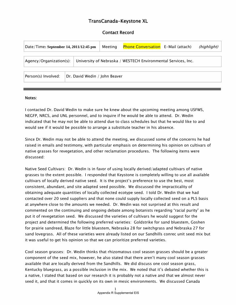
Appendix R Supplemental EIS1
TransCanada-Keystone XL
Contact Record
Date/Time: September 14, 2011/12:45 pm Meeting Phone Conversation E-Mail (attach) (highlight)
Agency/Organization(s): University of Nebraska / WESTECH Environmental Services, Inc.
Person(s) Involved: Dr. David Wedin / John Beaver
Notes:
I contacted Dr. David Wedin to make sure he knew about the upcoming meeting among USFWS,
NEGFP, NRCS, and UNL personnel, and to inquire if he would be able to attend. Dr. Wedin
indicated that he may not be able to attend due to class schedules but that he would like to and
would see if it would be possible to arrange a substitute teacher in his absence.
Since Dr. Wedin may not be able to attend the meeting, we discussed some of the concerns he had
raised in emails and testimony, with particular emphasis on determining his opinion on cultivars of
native grasses for revegetation, and other reclamation procedures. The following items were
discussed:
Native Seed Cultivars: Dr. Wedin is in favor of using locally derived/adapted cultivars of native
grasses to the extent possible. I responded that Keystone is completely willing to use all available
cultivars of locally derived native seed. It is the project’s preference to use the best, most
consistent, abundant, and site adapted seed possible. We discussed the impracticality of
obtaining adequate quantities of locally collected ecotype seed. I told Dr. Wedin that we had
contacted over 20 seed suppliers and that none could supply locally collected seed on a PLS basis
at anywhere close to the amounts we needed. Dr. Wedin was not surprised at this result and
commented on the continuing and ongoing debate among botanists regarding “racial purity” as he
put it of revegetation seed. We discussed the varieties of cultivars he would suggest for the
project and determined the following preferred varieties: Goldstrike for sand bluestem, Goshen
for prairie sandreed, Blaze for little bluestem, Nebraska 28 for switchgrass and Nebraska 27 for
sand lovegrass. All of these varieties were already listed on our Sandhills conrec unit seed mix but
it was useful to get his opinion so that we can prioritize preferred varieties.
Cool season grasses: Dr. Wedin thinks that rhizomatous cool season grasses should be a greater
component of the seed mix, however, he also stated that there aren’t many cool season grasses
available that are locally derived from the Sandhills. We did discuss one cool season grass,
Kentucky bluegrass, as a possible inclusion in the mix. We noted that it’s debated whether this is
a native, I stated that based on our research it is probably not a native and that we almost never
seed it, and that it comes in quickly on its own in mesic environments. We discussed Canada

2
Appendix R Supplemental EIS
widlrye which is a cool season rhizomatous grass and that we’ve included in the seed mix,
although as Dr. Wedin noted in a previous email comment, the species is not noted for growing in
the eastern Sandhills. I stated that NDOR apparently used this pretty extensively and
recommended it. Western wheatgrass, which is also in the mix and Dr. Wedin had noted may not
occur in the eastern Sandhills, was recommended by the state NRCS office. I also noted that
USFWS does not want rhizomatous grasses (cool season or warm season) because, based on
research regarding smooth brome, they think rhizomatous grasses will negatively affect American
Burying Beetle. We both noted the irony of this given that many native grasses where ABB occur
are rhizomatous. However, Keystone is fully in favor of using native cool season rhizomatous
grasses if we can get clear direction from agencies.
Fencing: Dr. Wedin believes the ROW should be fenced to prevent excess cattle grazing. I
responded that Keystone was willing to fence areas, particularly steep slopes, to prevent excess
grazing and that this has to be coordinated with landowners since some want fencing, others
don’t, and if fencing is installed we want to make sure that water sources, trails, gates, etc. aren’t
cut off from use.
Forbs and Shrubs: We discussed including forbs and shrubs in the seed mix. I responded that we
weren’t opposed to this but that based on monitoring on other projects, forbs (including native
perennial forbs) respond quickly to disturbance and are quick pioneers. He noted that there aren’t
many shrubs in the Sandhills other than sand cherry. We talked about planting bare root stock,
which WESTECH has done on some projects, and that unless there’s a particular visual area or
other special resource that you don’t get much for the effort since it’s difficult to get enough
shrubs to plant in large quantities throughout the project. (As a side note there aren’t many sand
cherry crossed by the project).
Mulch: Dr. Wedin thinks that native hay mulch could be helpful on the project as it will contain
seeds of several species that we would like to volunteer on the ROW. I responded that the project
is certainly willing to use native hay, particularly if it can be crimped into the soil so it doesn’t just
blow away. Dr. Wedin indicated, though, that most native Sandhills hay is actually from the sub-
irrigated meadows rather than the upland stabilized dunes, so that some of the species in the hay
probably wouldn’t grow well in the drier dunes.
Fire: Dr. Wedin believes a fire control plan should be specifically developed for the project. He
stated that wildfires can burn thousands of acres in a short time in the Sandhills. I responded that
I frankly didn’t know what Keystone’s requirements/commitments were in this area. We discussed
the natural fire return interval in the Sandhills which Dr. Wedin thought might have been around
10 years.
In summary, the conversation was cordial and helpful. My impression is that Dr. Wedin is clearly
in favor of using cultivars as long as the project prioritizes getting those cultivars that are derived
from Sandhills origin – this is Keystone’s preference anyway. He would also like to see more cool
season rhizomatous grasses in the mix but stated that once the mix is built around a “backbone”
of locally derived native grass cultivars, that he isn’t sure what other seed mix recommendations
would be. Other than this, Dr. Wedin’s overall concern is that commitments that are stated or

3
Appendix R Supplemental EIS
alluded to in the FEIS are consistently implemented including follow-up monitoring and repair as
necessary.
Is follow up required? Check on potential for conference call connection if Dr. Wedin cannot make it to
Grand Island for the meeting.
Commitments made: None specifically with Dr. Wedin although we will pursue the preferred varieties
of native grasses assuming that USFWS does not preclude their use.
Recorded by: John Beaver

Appendix R Supplemental EIS
From: Jonathan Minton To: Kucera, Michael - NRCS, Lincoln, NE; [email protected]; [email protected];
[email protected]; [email protected]; "[email protected]"; "[email protected]"; Vickers, Shaun - NRCS, Lincoln, NE
Cc: Jon Schmidt; Stephen Craycroft; John Beaver Subject: Final seed mix meeting minutes from 9-22-11 Date: Monday, October 31, 2011 1:55:28 PM Attachments: KXL Phase IV USFWS NGPC NRCS Sandhills Seed Mix Meeting 10-31-11 (FINAL).doc
All,
Thank you for your input and time in finalizing the seed mixes in the sand hills region of Nebraska. The final meeting minutes with the seed mixes are attached for your files.
Thanks,
The new identity of Trow Engineering Consultants, Inc.
Jonathan Minton Environmental Project Manager exp Energy Services Inc. t: (713) 693-6402 | m: (281) 433-9428 | f: (713) 693-6498 2700 Post Oak Blvd., Ste 400 Houston, Texas 77056 USA
exp.com | legal disclaimer

Appendix R Supplemental EIS
KXL Phase IV (.H\VWRQH�;/�3LSHOLQH�3URMHFW�)
USFWS, NGPC, and NRCS Meeting – Grand Island USFWS Office
9/22/11 1:00 PM – 3:00 PM
Attendees:
Martha Tacha (USFWS), Mike Fritz (NGPC), Gerry Steinauer (NGPC), David Wedin (UNL), Jerry Volesky (UNL), Mike Kucera (NRCS), John Beaver (Keystone/Westech), and Jonathan Minton (Keystone/exp)
On the Phone: Nicole Gibson (DOS) and Steve Craycroft (Keystone)
Meeting Objectives
The purpose of the meeting was to review the seed mix that had been developed for the sand hills region of Nebraska and come to final seed mix approved by NGPC, USFWS, and NRCS.
Issues / Comments
• Keystone presented the seed mix that had been developed through multiple agency consultations. There was a significant discussion on sand hills species and sub-irrigated fields species as well as use of cultivars. Keystone then presented the Sandhills and Marsh Plains con/rec units and seed mixes.
• Keystone presented information on availability of locally collected native seed and discussed the seed rates necessary to ensure reclamation success.
• It was agreed within the meeting that cultivars were appropriate but that preference would be given to cultivars developed in Nebraska or adjacent states.
• Mike Kucera provided NRCS information on cultivars and seeding rates (after the meeting he emailed a seed mix calculator utilized by NRCS for Keystone to use).
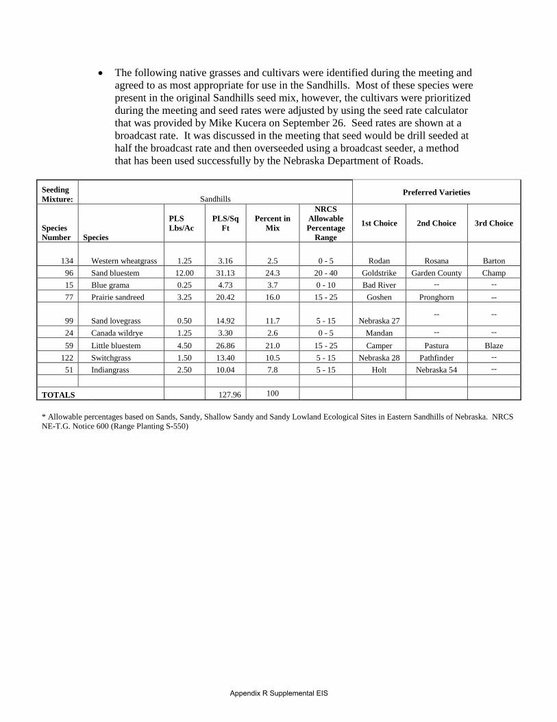
Appendix R Supplemental EIS
• The following native grasses and cultivars were identified during the meeting and agreed to as most appropriate for use in the Sandhills. Most of these species were present in the original Sandhills seed mix, however, the cultivars were prioritized during the meeting and seed rates were adjusted by using the seed rate calculator that was provided by Mike Kucera on September 26. Seed rates are shown at a broadcast rate. It was discussed in the meeting that seed would be drill seeded at half the broadcast rate and then overseeded using a broadcast seeder, a method that has been used successfully by the Nebraska Department of Roads.
Seeding Mixture: Sandhills
Preferred Varieties
Species Number Species
PLS Lbs/Ac
PLS/Sq Ft
Percent in Mix
NRCS Allowable Percentage
Range
1st Choice 2nd Choice 3rd Choice
134 Western wheatgrass 1.25 3.16 2.5 0 - 5 Rodan Rosana Barton 96 Sand bluestem 12.00 31.13 24.3 20 - 40 Goldstrike Garden County Champ 15 Blue grama 0.25 4.73 3.7 0 - 10 Bad River - -77 Prairie sandreed 3.25 20.42 16.0 15 - 25 Goshen Pronghorn -
99 Sand lovegrass 0.50 14.92 11.7 5 - 15 Nebraska 27 -- --
24 Canada wildrye 1.25 3.30 2.6 0 - 5 Mandan -- --
59 Little bluestem 4.50 26.86 21.0 15 - 25 Camper Pastura Blaze 122 Switchgrass 1.50 13.40 10.5 5 - 15 Nebraska 28 Pathfinder -
51 Indiangrass 2.50 10.04 7.8 5 - 15 Holt Nebraska 54 -
TOTALS 127.96 100
* Allowable percentages based on Sands, Sandy, Shallow Sandy and Sandy Lowland Ecological Sites in Eastern Sandhills of Nebraska. NRCS NE-T.G. Notice 600 (Range Planting S-550)

Appendix R Supplemental EIS
•
•
•
• The following native grasses and cultivars were identified during the meeting and agreed to as most appropriate for use in the Marsh Plains. Most of these species were present in the original Marsh Plains seed mix, however, the cultivars were prioritized during the meeting and seed rates were adjusted by using the seed rate calculator that was provided by Mike Kucera on September 26. Seed rates are shown at a drill rate. These seed rates were submitted for review by the group on 10.25.2011 and were revised as shown below by Mike Kucera on 10.26.2011.
Seeding Mixture: Marsh Plains
Preferred Varieties
Species Number Species
PLS Lbs/Ac
PLS/Sq Ft
Percent in Mix
NRCS Allowable Percentage
Range
1st Choice 2nd Choice 3rd Choice
9 Big bluestem 6.00 22.73 33.5 30 - 40 Pawnee Champ Bonanza
122 Switchgrass 1.00 8.93 13.2 5 - 20 Nebraska 28 Pathfinder Forestburg 59 Little bluestem 1.75 10.45 15.4 10 - 20 Camper Pastura Blaze 51 Indiangrass 4.00 16.07 23.7 15 - 30 Holt Nebraska 54 -24 Canada wildrye 1.25 3.30 4.9 0 - 5 Mandan - -
134 Western wheatgrass
2.50 6.31 9.3 0-20 Rodan Rosana Barton
TOTALS 67.79 100
* Allowable percentages based on Subirrigated Ecological Sites in Eastern Sandhills of Nebraska. NRCS NE-T.G. Notice 600 (Range Planting S-550)
• Mike Kucera offered the following collection radii for non-varietal seed that might be used on the project: • Warm Season Grass Seedlots without a Variety Stated on the seedtag (includes
source identified, VNS, Native Harvest, Common, etc.):
• South - 250 miles (southern sources should be given preference over seed from northern sources.)
• North - 150 miles
• East or West - 200 miles
• Mike Kucera also provided internet links to seeding and mulching NRCS publications NE550DP and NE 484DP, which have been utilized in developing the seeding and mulching specifications for the project.