appendix d - california
TRANSCRIPT

Appendix DCultural Resources Assessment

Rincon Consultants, Inc.
4 4 9 1 5 t h S t r e e t , S u i t e 3 0 3
Oak land , Ca l i fo rn ia 94612
5 1 0 8 3 4 4 4 5 5 O F F I C E A N D F A X
i n f o @ r i n co n co n su l t a n t s . co m
w w w . r i n co n co n s u l t a n t s . co m
E n v i r o n m e n t a l S c i e n t i s t s P l a n n e r s E n g i n e e r s
July 10, 2018 Project No: 18-05847 Samuel J. Gutierrez, Associate Planner City of Palo Alto Planning & Community Environment Department 250 Hamilton Avenue Palo Alto, CA 94301 Via email: [email protected] Subject: Cultural Resources Assessment for 4256 El Camino Real Hotel Project, City of Palo
Alto, Santa Clara County, California Dear Mr. Gutierrez: Rincon Consultants, Inc. (Rincon) has conducted a cultural resources assessment of the proposed 4256 El Camino Real Hotel Project in the City of Palo Alto, Santa Clara County, California. This assessment documents the results of cultural resources tasks performed by Rincon; specifically, a cultural resources records search, a Sacred Lands File search, a site visit and archival research and an architectural history evaluation. This project is subject to the California Environmental Quality Act (CEQA).
Project Description The project site is located at 4256 El Camino Real in the City of Palo Alto in Santa Clara County. The project site totals 12,947 square feet and is developed with a 3,300-square foot, one-story restaurant building. The proposed project involves the demolition of the existing building and construction of a new approximately 51,300-square foot, five-story, hotel building. The hotel would include 100 guest rooms, underground parking with mechanical lifts, and a large exterior courtyard.
Cultural Resources Records Search Rincon conducted a search of the California Historical Resources Information System (CHRIS) at the Northwest Information Center (NWIC) located at Sonoma State University on June 18, 2018. The search was performed to identify previously recorded cultural resources, as well as previously conducted cultural resources studies on the project site and a 0.8-kilometer (0.5-mile) radius surrounding it. The CHRIS search included a review of available records at the NWIC, as well as the National Register of Historic Places (NRHP), the California Register of Historical Resources (CRHR), the Office of Historic Preservation Historic Properties Directory, the California Inventory of Historic Resources, the Archaeological Determinations of Eligibility list, and historic maps.

City of Palo Alto
4256 El Camino Real Project
Page 2
The NWIC records search identified a total of 19 previous studies within a 0.5-mile radius of the project site, none of which include the project site (Table 1). Table 1. Previous Studies Within 0.5-Mile of the Project Site
Report Number Author Year Title Relationship to Project Site
S-0008589 Cartier, R. 1981
Cultural Resource Evaluation of the Terman School Low-Cost Housing Project near Arastradero and Pomona Avenue in
the City of Palo Alto, County of Santa Clara
Outside
S-010077 Cartier, R. and G. A.
Laffey 1988
Archaeological Excavation at CA-SCL-600 on Adobe Creek in the City of Palo Alto,
County of Santa Clara Outside
S-016691 Cartier, R. J. C.
Wizorek, and K. Holanda
1994 Cultural Resource Evaluation of the Adobe Creek Project in the County of Santa Clara
Outside
S-017764 Davy, D. M. 1996
Cultural Resources Inventory of a Commercial Development Project at Mason and Depot Streets, Vacaville,
Solano County, California
Outside
S-017800 Waechter, S. A. 1996 A Cultural Resources Study of the Ishaq Parcel at the Intersection of Mason and
Depot Streets, Vacaville, California Outside
S-019407 Carter, R. 1997 Cultural Resource Evaluation for the Tree Farm Project on El Camino Real in the City
of Los Altos Outside
S-020343 Price, B. A. 1998 Cultural Resources Assessment, Pacific Bell Mobile Services Facility SF-619-05,
Palo Alto, Santa Clara County Outside
S-029573 Goodrich, J. and J.
Holson 2000
Final Report, Archaeological Survey and Record Search for the Six Fluor Global Fiber Optic Segments, Mountain View,
Palo Alto, and San Mateo County, California
Outside
S-029657 Nelson, W. J., T.
Norton, L. Chiea, and R. Pribish
2002
Archaeological Inventory for the Caltrain Electrification Program Alternative in San
Francisco, San Mateo, and Santa Clara Counties, California
Outside
S-029657a Herbert, R. F. 2002
Finding of No Adverse Effect, Caltrain Electrification Program, San Francisco, San Mateo, and Santa Clara Counties,
California
Outside

City of Palo Alto
4256 El Camino Real Project
Page 3
Report Number Author Year Title Relationship to Project Site
S-029657b Herbert, R. F. 2002
Historic Property Survey for the Proposed Caltrain Electrification Program, San
Francisco, San Mateo, and Santa Clara Counties, California
Outside
S-029567c Mellon, K. 2002 FTA021021A; Caltrain Electrification
Program, San Francisco, San Mateo, and Santa Clara Counties
Outside
S-029657d Bunse, M. 2003
Final Finding of Effect Amendment, Caltrain Electrification Project, San
Francisco, San Mateo, and Santa Clara Counties, California
Outside
S-029657f Waechter, S. A., J.
Meyer, and L. Leach-Palm
2008
Cultural Resources Addendum for the Caltrain Electrification Program
Alternative: San Francisco, San Mateo, and Santa Clara Counties, California
Outside
S-029657g Bunse, M. 2008
Addendum Finding of Effect, Caltrain Electrification Program, San Francisco to San Jose (MP 0.0 to 52.0); San Francisco,
San Mateo, and Santa Clara Counties, California
Outside
S-032250 Lapin, P. 2003
Historic Property Survey Report, Mission Bells Project, State Route 82/Interstate
101, San Mateo and Santa Clara Counties, California
Outside
S-035009 Holman, M. P. 2007
Archaeological Literature Review and Field Inspection of 488 West Charleston
Road, Palo Alto, Santa Clara County, California
Outside
S-036436 Billat, L. 2009 New Tower (“NT”) Submission Packet, FCC Form 620, Elks Lodge, Project Number: SF-
04619B Outside
S-043525 Unknown 2002
Draft Inventory and Evaluation of Historic Resources, Caltrain Electrification
Program, San Francisco to Gilroy (MP 0.0 to 77.4)
Outside
Source: Northwest Information Center, June 2018
The NWIC records search identified three previously recorded cultural resources within a 0.5-mile radius of the project site, none of which are located on the project site (Table 2). Of the resources within the search radius, each is a prehistoric archaeological site.

City of Palo Alto
4256 El Camino Real Project
Page 4
Table 2. Recorded Resources within 0.5-Mile of Project Site
Primary Number Trinomial
Resource Type Description
Recorder(s) and Year(s)
NRHP/CRHR Status
Relationship to Project Site
P-43-000592
CA-SCL-597 Prehistoric
site Shell midden
B. Bocek and W. Caldwell 1949
Unknown Outside
P-43-000595
CA-SCL-600 Prehistoric
site Shell midden
I. Van Zandt and R. Cartier 1986; J. Martinez 2010
Recommended eligible for
NRHP Outside
P-43-000669
CA-SCL-707 Prehistoric
site Shell midden
I. Van Zandt and R. Cartier 1986; J. Martinez 2010
Recommended eligible for
NRHP Outside
Source: Northwest Information Center, June 2018
Native American Outreach On June 5, 2018, Rincon contacted the Native American Heritage Commission (NAHC) and requested a search of the Sacred Lands File (SLF). The NAHC emailed a response on June 20, 2018, stating that the SLF search was returned with negative results.
Architectural History Evaluation Rincon completed of California Department of Parks and Recreation (DPR) 523 Series forms for the property at 4256 El Camino Real. The purpose of this work was to determine whether the subject property appeared to be eligible for inclusion in the National Register of Historic Places (NRHP), the California Register of Historical Resources (CRHR), and the Palo Alto Historic Inventory, as detailed in the City of Palo Alto Historic Preservation Ordinance (Title 16 Palo Alto Municipal Code, Section 49). On June 11, 2018, Architectural Historian Aisha Fike conducted the field survey of the property and archival research at the City of Palo Alto Department of Building and Safety. Ms. Fike meets the Secretary of the Interior’s Professional Qualification Standards (PQS) for architectural history and history, and has 10 years of experience as an architectural historian and historian in California. Architectural Historian James Williams carried out additional secondary source research and prepared the DPR forms, evaluating the property for eligibility for listing in the NRHP, the CRHR, and the Palo Alto Historic Inventory. Mr. Williams meets the Secretary of the Interior’s Professional Qualification Standards (PQS) for architectural history and history, and has 4 years of experience as an architectural historian and historian in California. Architectural History Program Manager Shannon Carmack reviewed the DPR forms prepared for this study. Ms. Carmack meets the Secretary of the Interior’s Professional Qualification Standards (PQS) for architectural history and history, and has 18 years of experience as an architectural historian and historian in California. The DPR forms for 4256 El Camino Real summarize the results of site visits and archival and secondary-source research for the subject property and conclude that the property does not appear to be eligible for listing in the NRHP, the CRHR, or the Palo Alto Historic Inventory.

City of Palo Alto
4256 El Camino Real Project
Page 5
The subject property opened as a Denny’s restaurant in 1964. Aerial photographs available at the time of the present study indicate that the subject property and surrounding lands were in use primarily as orchards as late as 1948. In the years leading up to the 1964 construction of the Denny’s restaurant, agricultural land uses gradually gave way to commercial and residential development along, and adjacent to, the stretch of El Camino Real on which the building is located. By 1956, several homes had been completed in the Palo Alto Orchards subdivision located immediately north of the subject property. In addition, what appears to have been commercial development along both sides of El Camino Real continued steadily in the 1950s and 1960s. Just south of the subject property, the current a large hotel complex opened by 1968, as suggested by an aerial photograph taken that year. The subject property operated as a Denny’s restaurant until 2007. In 2012, the property became home to the Su Hong restaurant. In 2013, long-time owner David King sold the property. The subject building’s design is the work of the architecture firm Armet and Davis. This partnership, established in 1947 by Louis Armet and Eldon Davis, was responsible for the construction of as many as 4,000 eateries, including the prototypes of buildings constructed and operated by the chains Denny’s and Bob’s Big Boy. Often, these buildings incorporated features of Googie-style architecture, a school of design which, the Los Angeles Conservancy explains, “combined elements of futurism with the city’s car culture to produce eating establishments with undulating forms, dramatically angled roofs, dazzling signage, and glass expanses.” The subject building is based on the firm’s oft-replicated 1958 prototype design for Denny’s restaurants. This design represents a relatively restrained approach to Googie architecture, in that it incorporates only some of the more staid elements of the style. Most notably, the building features a boomerang roof and generous use of windows along its front and side exteriors. Criterion A of the NRHP and Criterion 1 of the CRHR ask whether a property is associated with any events significant to historical developments at the local, state, or national level. The subject property is not associated with the development of the historic El Camino Real, nor does it appear to be significant within the context of commercial and restaurant development along the El Camino Real corridor. There is no evidence to suggest the property is uniquely associated with any significant postwar events or patterns of development in local, state or national history. As a result, the subject property does not appear to be eligible for listing in the NRHP under Criterion A or the CRHR under Criterion 1. Under Criterion B of the NRHP and Criterion 2 of the CRHR a property evaluated for potential associations with persons who have made significant contributions to our past. Because research conducted for this study failed to uncover any pertinent information of substance on past and present owners of the subject property, it does not appear to be eligible for listing in the NRHP under Criterion B or the CRHR under Criterion 2. Criterion C of the NRHP and Criterion 2 of the CRHR ask whether a property embodies the distinctive characteristics of a type, period, or method of construction, or represents the work of a master, or possess high artistic values. The Googie-style building on the property is not a distinctive example of the style. Further, although the architecture firm Armet and Davis were noted practitioners of the Googie variant of mid-century architectural modernism, the subject property is not a notable example of their work in that style. The subject property consequently does not appear to merit listing on the NRHP under Criterion C or the CRHR under Criterion 3. Additionally, the subject property does not appear to be significant as a source, or likely source, of important historical information, nor does it appear likely to yield important information about historic

City of Palo Alto
4256 El Camino Real Project
Page 6
construction methods, materials, or technologies. It therefore does not appear to be eligible for listing in the NRHP under Criterion D or the CRHR under Criterion 4. Furthermore, the property is neither listed in nor eligible for inclusion in the Palo Alto Historic Inventory. Available evidence does not suggest the property is significantly associated with the lives of any important historic people or events in Palo Alto, nor that the building is a rare or particularly representative example of its business type or style of architecture. Further, the building in question is not a distinctive example of the work of the firm Armet and Davis. As a result, the subject property does not meet the criteria for listing in the Palo Alto Historic Inventory.
Findings The project site is located in an urbanized area of Palo Alto and is currently developed with a single-story restaurant building, surface parking lot, and minimal landscaping. The building was evaluated and found ineligible for listing in the NRHP, the CRHR and the City of Palo Alto Historic Inventory; it is not a historical resource for the purposes of CEQA. A California Historical Resource Information System (CHRIS) records search conducted at the Northwest Information Center (NWIC) of the project site and a 0.5-mile radius did not indicate the presence of cultural resources within or directly adjacent to the project site. No archaeological resources were identified on or directly adjacent to the project site as a result of the CHRIS records search conducted at the NWIC. However, three prehistoric habitation sites are located within a 0.5-mile radius of the project site. According to the City’s Archaeologically Sensitive Areas Map, the project site is in a moderate sensitivity area (City of Palo Alto 2014a). Based on the sites recorded in the search radius and the City’s sensitivity map, the project vicinity is considered sensitive for buried archaeological resources. The proposed project would include excavation for a below-grade parking structure. The site has been previously graded and disturbed during construction of the existing building and surface parking lot. However, new ground disturbance would be below the level of past disturbance. Because project ground disturbance would extend below the level of past disturbance and because of the sensitivity of the project vicinity, there is the possibility of encountering undisturbed subsurface archaeological resources that may be considered important examples of California history or prehistory. In the event that such resources are unearthed during construction, applicable regulatory requirements pertaining to the handling and treatment of such resources would apply. If archaeological resources are identified, as defined by Section 21083.2 of the Public Resources Code, the site would be required to be treated in accordance with the provisions of Section 21083.2 of the Public Resources Code as appropriate. In addition, mitigation measures CR-1 and CR-2 are required in order to ensure that impacts would be less than significant.
CR-1 Worker’s Environmental Awareness Program (WEAP). A qualified archaeologist shall be retained to conduct WEAP training for archaeological sensitivity for all construction personnel prior to the commencement of any ground disturbing activities. Archaeological sensitivity training should include a description of the types of cultural resources that may be encountered, cultural sensitivity issues, regulatory issues, and the proper protocol for treatment of the materials in the event of a find.
City of Palo Alto
4256 El Camino Real Project
Page 7
CR-2 Resource Recovery Procedures. In the event that archaeological resources are unearthed during project construction, all earth-disturbing work in the vicinity of the find must be temporarily suspended or redirected until an archaeologist has evaluated the nature and significance of the find. If the discovery proves to be significant under CEQA, additional work such as preservation in place or archaeological data recovery, shall occur as required by the archeologist in coordination with City staff and descendants and/or stakeholder groups, as warranted. After the find has been appropriately mitigated, work in the area may resume. A Native American representative shall be retained to monitor any mitigation work associated with Native American cultural material.
Sincerely,
Rincon Consultants, Inc. Hannah Haas, M.A., RPA Archaeologist
Shannon Carmack Architectural History Program Manager
Joe Power, AICP CEP Principal
Attachment: DPR 523 Form – 4256 El Camino Real

State of California The Resources Agency Primary # __________________________________________________ DEPARTMENT OF PARKS AND RECREATION HRI # _____________________________________________________ Trinomial __________________________________________________
PRIMARY RECORD NRHP Status Code _______6Z_______________________________ Other Listings: Review Code Reviewer: Date: Page 1 of 7 Resource Name or #: 4256 El Camino Real
DPR 523A (1/95) *Required Information
P1. Other Identifier: Denny’s Restaurant *P2. Location: Not for Publication Unrestricted *a. County: Santa Clara County
and (P2b and P2c or P2d. Attach a Location Map as necessary.) *b. USGS 7.5' Quad: Mountain View Date: 1999 T 6S; R 2W; ¼ of ¼ of Sec ; B.M. c. Address: 4256 El Camino Real City: Palo Alto Zip: 94306 d. UTM: Zone: 12; mE/ mN (G.P.S.) e. Other Locational Data: (e.g., parcel #, directions to resource, elevation, etc., as appropriate): APN: 167-08-042
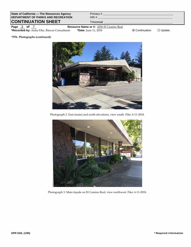
*P3a. Description: (Describe resource and its major elements. Include design, materials, condition, alterations, size, setting, and boundaries) The subject property at 4256 El Camino Real is located in an urbanized, predominantly commercial area of Palo Alto. Situated on the parcel is a one-story restaurant constructed in 1964 and designed by the architecture firm Armet and Davis in a restrained iteration of the Googie style. Built on a generally rectangular plan, the building features a main elevation that faces El Camino Real to the east. This side of the building includes large aluminum-framed windows situated atop a scored-stucco-clad knee wall and separated by a series of steel posts and a column clad in a fieldstone veneer (Photograph 2). Just south of the column, is a segmented, floor-to-ceiling, aluminum-framed window, which wraps around to form a commercial door and window assembly on the building’s southeast corner. Excepting portions of a 1992 rear addition, the northern and southern facades feature a design and construction materials similar to those of the street-facing exterior (Photographs 2 and 3). An additional commercial entry door—in use as the primary public entrance—opens on the northern elevation and is accessible by a non-original, concrete ADA-accessible ramp (Photograph 3). A heavily massed boomerang roof shelters the 1964 portion of the building and includes broad eaves on the north, south, and east. Along the main façade, the overhang protects a low concrete planter that zig-zags generally north to south (Photograph 2). The 1992 rear addition consists of a stucco-clad and flat roofed extension (Photograph 4). Landscaping on the property is limited, as an asphalt-paved parking lot occupies nearly all of the parcel’s open space. Three mature, planted trees stand curbside, spaced evenly in front of the building. (See Photographs 2-5).
*P3b. Resource Attributes: (List attributes and codes) HP6. 1-3 Story Commercial Building *P4. Resources Present: Building Structure Object Site District Element of District Other (Isolates, etc)
P5b. Description of Photo: Photograph 1. 4256 El Camino Real, view west. *P6. Date Constructed/Age and Sources: Historic Prehistoric Both 1964/City of Palo Alto *P7. Owner and Address: Mircea Voskerician Bayshore Road Palo Alto, Ca *P8. Recorded by: (Name, affiliation, and address) Aisha Fike Rincon Consultants, Inc. 250 East 1st Street, 301 Los Angeles, CA 90012 *P9. Date Recorded: June 11, 2018 *P10. Survey Type: Intensive
*P11. Report Citation: Cultural Resources Assessment for the 4256 El Camino Real Hotel Project, Palo Alto, Santa Clara County, California. Prepared for the City of Palo Alto, CA.
*Attachments: NONE Location Map Sketch Map Continuation Sheet Building, Structure, and Object Record Archaeological Record District Record Linear Feature Record Milling Station Record Rock Art Record Artifact Record Photograph Record Other (List):
State of California The Resources Agency Primary # __________________________________________________ DEPARTMENT OF PARKS AND RECREATION HRI # _____________________________________________________
BUILDING, STRUCTURE, AND OBJECT RECORD Page 2 of 7 *NRHP Status Code 6Z Resource Name or #: 4256 El Camino Real
DPR 523B (1/95) *Required Information
B1. Historic Name: Denny’s Restaurant B2. Common Name: Su Hong Chinese Restaurant B3. Original Use: Restaurant B4. Present Use: Restaurant
*B5. Architectural Style: Mid-Century Modern, Googie *B6. Construction History: (Construction date, alterations, and date of alterations)
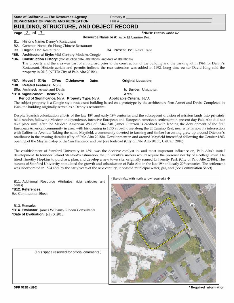
The property and the area was part of an orchard prior to the construction of the building and the parking lot in 1964 for Denny’s Restaurant. Historic aerials and permits indicate the rear extension was added in 1992. Long time owner David King sold the property in 2013 (NETR; City of Palo Alto 2018a).
*B7. Moved? No Yes Unknown Date: Original Location: *B8. Related Features: None B9a. Architect: Armet and Davis b. Builder: Unknown
*B10. Significance: Theme: NA Area: Period of Significance: N/A Property Type: N/A Applicable Criteria: N/A
The subject property is a Googie-style restaurant building based on a prototype by the architecture firm Armet and Davis. Completed in 1964, the building originally served as a Denny’s restaurant. Despite Spanish colonization efforts of the late 18th and early 19th centuries and the subsequent division of mission lands into privately held ranchos following Mexican independence, intensive European and European American settlement in present-day Palo Alto did not take place until after the Mexican American War of 1846-1848. James Otterson is credited with leading the development of the first European American community in area, with his opening in 1853 a roadhouse along the El Camino Real, near what is now its intersection with California Avenue. Taking the name Mayfield, a community devoted to farming and timber harvesting grew up around Otterson’s roadhouse in the ensuing decades (City of Palo Alto 2018b). Development in and around Mayfield intensified following the October 1863 opening of the Mayfield stop of the San Francisco and San Jose Railroad (City of Palo Alto 2018b; Caltrain 2018). The establishment of Stanford University in 1891 was the decisive catalyst in, and most important influence on, Palo Alto’s initial development. In founder Leland Stanford’s estimation, the university’s success would require the presence nearby of a college town. He hired Timothy Hopkins to purchase, plan, and develop a new town site, originally named University Park (City of Palo Alto 2018b). The success of Stanford University stimulated the growth and urbanization of Palo Alto in the late 19th and early 20th centuries. The settlement was incorporated in 1894 and, by the early years of the next century, it boasted municipal water, gas, and (See Continuation Sheet) B11. Additional Resource Attributes: (List attributes and codes)
*B12. References: See Continuation Sheet B13. Remarks:
*B14. Evaluator: James Williams, Rincon Consultants *Date of Evaluation: July 3, 2018
(This space reserved for official comments.)
(Sketch Map with north arrow required.)
State of California The Resources Agency Primary # __________________________________________________ DEPARTMENT OF PARKS AND RECREATION HRI # _____________________________________________________
CONTINUATION SHEET Trinomial _________________________________________________ Page 3 of 7 Resource Name or #: 4256 El Camino Real *Recorded by: Aisha Fike, Rincon Consultants *Date: June 11, 2018 Continuation Update
DPR 523L (1/95) *Required Information
*P5b. Photographs (continued):
Photograph 2. East (main) and north elevations, view south. Fike: 6-11-2018.
Photograph 3. Main façade on El Camino Real, view northwest. Fike: 6-11-2018.

State of California The Resources Agency Primary # __________________________________________________ DEPARTMENT OF PARKS AND RECREATION HRI # _____________________________________________________
CONTINUATION SHEET Trinomial _________________________________________________ Page 4 of 7 Resource Name or #: 4256 El Camino Real *Recorded by: Aisha Fike, Rincon Consultants *Date: June 11, 2018 Continuation Update
DPR 523L (1/95) *Required Information
Photograph 4. Rear addition, view northeast. Fike: 6-11-2018.
Photograph 5. South elevation, view northeast. Fike: 6-11-2018.
State of California The Resources Agency Primary # __________________________________________________ DEPARTMENT OF PARKS AND RECREATION HRI # _____________________________________________________
CONTINUATION SHEET Trinomial _________________________________________________ Page 5 of 7 Resource Name or #: 4256 El Camino Real *Recorded by: Aisha Fike, Rincon Consultants *Date: June 11, 2018 Continuation Update
DPR 523L (1/95) *Required Information
*B10. Significance (continued): electrical services, plus a streetcar line that served University Avenue and the Stanford University campus. In 1925, Palo Alto annexed neighboring Mayfield (City of Palo Alto 2018b). In the 1920s, the popularization of the automobile led to the improvement of El Camino Real as a regional thoroughfare and a component of the state highway system. Palo Alto experienced marked growth in the decade and a half following World War II. Between 1940 and 1960, the city’s population grew from around 16,000 to over 52,000 (Heritage Services 2016). This rapid trebling of Palo Alto’s population accompanied significant economic development, especially in the education, high technology, and healthcare sectors. Booms in the research and high technology sectors took place—exemplified and fueled by the establishment of Stanford Industrial Park (SIP) in 1953. The local healthcare industry also received a boost in the 1950s, when Stanford Hospital and the Palo Alto Veterans Administration hospital opened (City of Palo Alto 2018b; Heritage Services). New residential subdivisions and modern shopping centers quickly replaced the city’s orchards, appearing mostly along U.S. 101 and Oregon Expressway (Heritage Services; NETR Online). Through the second half of the 20th century, Palo Alto’s role in the high-tech industry made it a nexus of growth of the Silicon Valley (City of Palo Alto 2018b). The subject property opened as a Denny’s restaurant in 1964 (ERAS Environmental). Aerial photographs available at the time of the present study indicate that the subject property and surrounding lands were in use primarily as orchards as late as 1948 (NETR Online). In the years leading up to the 1964 construction of the Denny’s restaurant, agricultural land uses gradually gave way to commercial and residential development along, and adjacent to, El Camino Real. By 1956, several homes had been completed in the Palo Alto Orchards subdivision located immediately north of the subject property. In addition, what appears to have been commercial development along both sides of El Camino Real continued steadily in the 1950s and 1960s. Just south of the subject property, the current Crowne Plaza hotel opened by 1968, as suggested by an aerial photograph taken that year (NETR Online). The subject property operated as a Denny’s restaurant until 2007. In 2012, the property became home to the Su Hong restaurant (ERAS Environmental). In 2013, long-time owner David King sold the property (City of Palo Alto 2018a). The subject building’s design is the work of the architecture firm Armet and Davis. This partnership, established in 1947 by Louis Armet and Eldon Davis, was responsible for the construction of as many as 4,000 eateries, including the prototypes of buildings constructed and operated by the chains Denny’s and Bob’s Big Boy. Often, these buildings incorporated features of Googie-style architecture, a school of design which, the Los Angeles Conservancy explains, “combined elements of futurism with the city’s car culture to produce eating establishments with undulating forms, dramatically angled roofs, dazzling signage, and glass expanses” (Los Angeles Conservancy). The subject building is based on the firm’s oft-replicated 1958 prototype design for Denny’s restaurants (WDAHP). This design represents a relatively restrained approach to Googie architecture, in that it incorporates only some of the more staid elements of the style. Most notably, the building features a boomerang roof and generous use of windows along its front and side exteriors. Evaluation The restaurant property at 4256 El Camino Real is not eligible for listing under the criteria established by the National Register of Historic Place (NRHP), the California Register of Historical Resources (CRHR) or the City of Palo Alto Historic Inventory.
The building on the property was constructed as Denny’s Restaurant in 1964. Background research through historic newspapers, building permits, City Directories and heritage research through Ancestry.com did not provide any pertinent information regarding the restaurant, the owners or the builder of the building. It is not associated with the development of the historic El Camino Real, nor does it appear to be significant within the context of commercial and restaurant development along the alignment. There is no evidence to suggest the property is uniquely associated with any significant postwar events or patterns of development in local, state or national history. As a result, the subject property does not appear to be eligible for listing in the NRHP under Criterion A or the CRHR under Criterion 1. Additionally, although the Denny’s restaurant chain operated from the property from 1964 through as recently as 2007, this longevity of use and ownership itself is not sufficient to merit NRHP or CRHR listing. The building is an altered example of a widely used design for Denny’s restaurants and is not emblematic of any significant event in the history of that company or in the history of postwar commercial eateries. Additionally, available evidence does not suggest the property’s subsequent owners, David and Zhen Cheng King, have made any significant contributions to history. Because of this, the subject property does not appear to be eligible for listing in the NRHP under Criterion B or the CRHR under Criterion 2. The Googie-style building on the property is not a distinctive example of the style, nor is it the significant work of any known master architect or builder. While the building’s designers, the architecture firm Armet and Davis, were noted practitioners of the Googie variant of mid-century architectural modernism, the subject property is not a notable representative of their work or of the Googie style. The subject property consequently does not appear to merit listing on the NRHP under Criterion C or the CRHR under Criterion 3. Finally, the property does not appear to be significant as a source, or likely source, of important historical information, nor does it appear likely to yield important information about historic construction methods, materials, or technologies. It therefore does not appear to be eligible for listing in the NRHP under Criterion D or the CRHR under Criterion 4.

State of California The Resources Agency Primary # __________________________________________________ DEPARTMENT OF PARKS AND RECREATION HRI # _____________________________________________________
CONTINUATION SHEET Trinomial _________________________________________________ Page 6 of 7 Resource Name or #: 4256 El Camino Real *Recorded by: Aisha Fike, Rincon Consultants *Date: June 11, 2018 Continuation Update
DPR 523L (1/95) *Required Information
*B10. Significance (continued): Furthermore, the property is neither listed in nor eligible for inclusion in the Palo Alto Historic Inventory. In making this determination, the present study considered the following Criteria for Designation established in the Palo Alto Historic Preservation Ordinance (Municipal Code Section 16.49.040):
The structure or site is identified with the lives of historic people or with important events in the city, state or nation; The structure or is site is particularly representative of an architectural style or way of life important to the city, state or nation; The structure or site is an example of a type of building which was once common, but is now rare; The structure or site is connected with a business or use which was once common, but is now rare; The architect or building was important;
The structure or site contains elements demonstrating outstanding attention to architectural design, detail, materials or craftsmanship.
Available evidence does not suggest the property is significantly associated with the lives of any important historic people or events in Palo Alto, nor that the building is a rare or particularly representative example of the Googie style of architecture. Further, the building in question is not a distinctive example of the work of the firm Armet and Davis. As a result, the subject property does not meet the criteria for listing in the Palo Alto Historic Inventory.
*B12. References (continued): Ancestry.com: US Census, Palo Alto City Directories, Marriage/Birth/Death Certificates. Caltrain, 2018, “Early Milestones,” http://www.caltrain.com/about/Caltrain150/Milestones/Early_Milestones.html. Accessed June 30,
2018. City of Palo Alto, 2018a. Parcel Reports, http://199.33.32.49/ParcelReports/. Accessed June 30, 2018. City of Palo Alto, 2018b, “History of Palo Alto,”
https://www.cityofpaloalto.org/gov/depts/pln/historic_preservation/history_of_palo_alto.asp. Accessed June 30, 2018. City of Palo Alto Planning & Community Environment, Historic Preservation, Palo Alto Historic Inventory, established under the Historic
Preservation Ordinance (Municipal Code Section 16.49.040), adopted by the City Council 1979, https://www.cityofpaloalto.org/gov/depts/pln/historic_preservation/historic_registers/local_inventory.asp. Accessed June 30, 2018.
City of Palo Alto Development Services, Building Permits, 285 Hamilton Avenue, Palo Alto. Eras Environmental, Inc., 2013, Phase I Environmental Site Assessment, 4256 El Camino Real, Palo Alto California. Heritage Services, 2016, Stanford Research Park: Framework for Historic Resource Evaluation. Los Angeles Conservancy, 2018, “Armet & Davis,” https://www.laconservancy.org/architects/armet-davis. Accessed June 30, 2018. Nationwide Environmental Title Research, LLC (NETR), historicaerials.com: 4256 El Camino Real, Palo Alto, 1948, 1956, 1960, 1968, 1980,
1991, 1993. Accessed June 30, 2018. Newspapers.com. Accessed June 2018. Washington Department of Archaeology and Historic Preservation (WDAHP), 2017, “Historic Property Report: Jenny’s Diner,”
http://midcenturyspokane.org/wp-content/uploads/2017/02/Jennys-Diner.pdf.

State of California The Resources Agency Primary # __________________________________________________ DEPARTMENT OF PARKS AND RECREATION HRI # _____________________________________________________
LOCATION MAP Trinomial _________________________________________________ Page 7 of 7 Resource Name or #: 4256 El Camino Real *Map Name: Palo Alto/Mountain View Quadrangle *Scale: 1:24,000 *Date of Map: 1991
DPR 523J (1/95) *Required Information