appendix 11a air quality assessment - multifuel...
TRANSCRIPT

Ferrybridge Multifuel 2 (FM2) Document Ref: P-aD.1
Preliminary Environmental Information (PEI) Report Volume II
Appendix 11A Air Quality Assessment
Multifuel Energy Limited October 2013
Ferrybridge Multifuel 2 (FM2) Document Ref: P-aD.1
Preliminary Environmental Information (PEI) Report Volume II
11A. INTRODUCTION
11A.1. Scope 11A.1.1. This Technical Appendix describes the detailed dispersion modelling of point source emissions and the
detailed dispersion modelling of traffic emissions undertaken in support of the Air Quality chapter, including determination of future baseline and Proposed Development contributions.
11A.1.2. Section 11A.2 describes the methodology and data assumptions used in process emissions modelling; Section 11A.3 describes the methodology and data assumptions used in traffic emissions modelling; Section 11A.4 presents the results of the future baseline and impact assessment on human health receptors; Section 11A.5 presents the results of the habitats air quality impact assessment.
11A.1.3. The emissions envisaged from the FM1 plant now under construction have been modelled and the predicted process contributions (PCs) have been added to the traffic contributions (TC) associated with the operation of the power station and the existing baseline concentrations, to establish the modified baseline concentrations at off-site and sensitive receptor locations.
11A.1.4. Emissions from the Proposed Development point source and associated traffic have been modelled to determine the likely worst-case PC and TC for FM2 and these have been added to the modified baseline to determine the Predicted Environmental Concentration (PEC) at sensitive receptor locations for assessment against air quality standards. Full commissioning of the Proposed Development is assumed to have been completed by 2018.
11A.2. Process emissions modelling
Air Quality Standards 11A.2.1. The assessment has been made with reference to the air quality standards and objectives defined in
legislation (Refs 11A-1 – 11A-3). In addition, where legislative limits are not specified for the pollutant species potentially released from the Proposed Development, Environmental Assessment Levels (EALs), published in the Environment Agency’s Environmental Permitting Regulations - H1 Environmental Risk Assessment document (EPR H1) (Ref. 11A-4), have been used to assess the potential health effects on the general population. These are provided in Tables 11a.1 and 11a.2 below.
Table 11A.1 Air Quality Strategy Objectives
Pollutant Objective
(µg/m3) Averaging
period Percentile To be met by
Nitrogen dioxide (NO2) 200 1 hour
99.8th or 18 exceedances/year
31 Dec 05
40 Annual Mean 31 Dec 05
Oxides of nitrogen (NOx, as NO2) 2
75 Daily Mean -
30 Annual Mean 31 Dec 00
Particulate matter (PM10) 50 24 hour
90.4th or 35 exceedances/year
31 Dec 04
40 Annual Mean 31 Dec 04
Particulate matter (PM2.5) 25 Annual Mean 1 Jan 15
Pollutant Objective
(µg/m3) Averaging
period Percentile To be met by
Carbon monoxide (CO) 10,000 8-hour 100th 31 Dec 03
Benzene 5 Annual Mean 31 Dec 10
1,3 butadiene 2.25 Annual Mean 31 Dec 03
Lead 0.25 Annual Mean 31 Dec 08
Sulphur dioxide (SO2)
266 15 minute 99.9th or 35 exceedances/year
31 Dec 05
350 1 hour 99.7th or 24 exceedances/year
31 Dec 04
125 24 hour 99.2nd or 3 exceedances/year
31 Dec 04
20 2 Annual Mean 31 Dec 00
Polycyclic Aromatic Hydrocarbons (PAH)1 0.25 ng/m3 Annual Mean 31 Dec 10
Table Notes 1. This objective applies to benzo(a)pyrene only but this has been used as a surrogate species for all PAHs
in this assessment. 2. Critical Level for Vegetation and Ecosystems
Table 11A.2 Environmental Assessment Levels for Other Identified Study Species
Pollutant EAL (μg/m3) Averaging period
Cadmium (Cd) and Thallium (Tl) (Cd used as worst-case)
0.005 Annual
Mercury (Hg) 7.5 1 hour
0.25 Annual
Other Heavy Metals (Sb, As, Pb, Cr, Co, Cu, Mn, Ni and V) 1
5 Annual
150 1 hour
Hydrogen Chloride (HCl) 750 1 hour
Hydrogen Fluoride (HF)
160 1 hour
16 Annual
5 2 Daily
0.5 2 Weekly
Ammonia (NH3)
2,500 1 hour
180 Annual
1 3 Annual
Dioxins N/A N/A
Table Notes:
Multifuel Energy Limited October 2013 Page 1 of Appendix 11A
Ferrybridge Multifuel 2 (FM2) Document Ref: P-aD.1
Preliminary Environmental Information (PEI) Report Volume II
1. Sb, Cr (II) and Cr (III) have the most stringent EALs therefore their use allows a conservative assessment to be carried out. 2. Critical Level for Vegetation and Ecosystems 3. Critical Level for Vegetation and Ecosystems, Lichens and Bryophytes
11A.2.2. The AQS does not contain objectives for heavy metals and local authorities have currently no statutory obligation to review and assess air quality against them. In addition, the Air Quality Standards Regulations 2010 (Ref. 11A-1) includes annual mean target values for arsenic (6 ng/m3), cadmium (5 ng/m3) and nickel (20 ng/m3) which only apply to the content of the relevant pollutant in the PM10 fraction, in ambient air. The target values are intended to be attained by 31st December 2012, "in so far as is possible". The target values are derived from the Fourth Air Quality Directive (Council Directive 2004/107/EC) (Ref. 11A-3), which states that these values would not require any control measures entailing disproportionate costs. For industrial installations, this would not involve measures beyond the application of Best Available Techniques (BAT). In particular, the Directive states that these target values are not to be considered as environmental quality standards.
Dispersion Model Selection 11A.2.3. Dispersion modelling calculates the predicted ground level concentrations arising from the emissions to
atmosphere, based on Gaussian approximation techniques. The model employed has been developed for UK regulatory use and its use in such assessments is approved by the Environment Agency.
11A.2.4. ADMS5 uses a continuous calculation method to determine the conditions of the receiving atmosphere based on the Monin-Obukhov length, which represents the height of the boundary layer and the degree of turbulence within the atmosphere. This is generally regarded as a more comprehensive modelling approach than that employed by older models such as ISC, which use discrete approximations to the atmospheric conditions known as Pasquill stability classes. The degree of turbulence in the atmosphere affects the rate at which pollutants from point sources are dispersed in the environment. The more unstable the atmosphere, for example due to high solar insolation, the greater the degree of mixing. While this is in principle the desired effect for the release of pollutants through stacks at elevated heights, this can also lead to localised peak concentrations if the plume is rapidly brought to ground level.
11A.2.5. ADMS5 utilises site-specific hourly sequential meteorological data to enable a realistic assessment of dispersion from point sources to be conducted for meteorological conditions that are directly applicable to the site.
11A.2.6. Various parameters can affect the degree of dispersion from a source, and these are accounted for in the modelling scenario where appropriate. The presence of elevated or complex terrain in the vicinity of the source can affect the flow pattern of the wind field, which can in turn bring a plume to ground more rapidly. Buildings of sufficient height located close to the emissions sources can affect dispersion – inducing downwash in the emitted plume and entraining pollutants towards ground level.
11A.2.7. Sensitivity of the predicted concentrations to variations in these model representations has been undertaken to ensure that the reported results provide a realistic worst-case assessment.
Modified Baseline - FM1 Emission Parameters 11A.2.8. The FM1 plant includes two boilers, each venting to atmosphere via a dedicated flue, contained within a
common windshield. These have been modelled as a single emission source.
11A.2.9. The relevant stack and emission parameters are provided in Table 11A.3 and 11A.4 below.
Table 11A.3 FM1 Stack Release Parameters
Parameter Value
Number of Stacks 1
Stack Location 447243, 424992
Stack Height (m) 100
Efflux Velocity (m/s) 20.8
Emission Temperature (°C) 140
Combined Volumetric Flow (Nm3/hr) 412,800
Effective Combined Flue Diameter 3.3
Pollutant Emission Rates See Table 11A.4 below.
11A.2.10. The assessment of the emissions has been based on Emission Limit Values (ELVs), as defined in the Environmental Permit for the plant (Ref: EPR/SP3239FU). The ELVs used in the assessment are presented in Table 11A.4 below, together with the mass release rates from the operational Proposed Development when the volumetric flow from the two boilers is taken into account.
11A.2.11. It is assumed that both boilers are operating concurrently at maximum load (peak emission flow rate) and at the ELVs. The model therefore represents the worst-case estimation of FM1 process contributions to the modified baseline.
Table 11A.4 FM1 Emission Limit Values and Release Rates
Pollutant Daily Average ELV
(mg/Nm3) FM1 Release Rates (g/s)
Oxides of Nitrogen 200 23.3
Sulphur Dioxide 50 5.8
Particulates 10 1.2
Carbon Monoxide 50 5.8
Hydrogen Chloride 10 1.2
Hydrogen Fluoride 1 0.12
Volatile Organic Compounds1 10 1.3
Cadmium and Thallium 0.05 0.0060
Mercury 0.05 0.0060
Other Metals2 0.5 0.060
Ammonia3 10 1.2
Dioxins and furans 1 x 10⁻⁷ 1.2 x 10⁻⁸
Table Notes: 1. VOCs conservatively assumed to be 100% benzene 2. Includes Sb, As, Pb, Cr, Co, Cu, Mn, Ni and V 3. Emission rate derived for SNCR abatement from the Best Available Technique Reference Document for Waste Incineration.
Multifuel Energy Limited October 2013 Page 2 of Appendix 11A
Ferrybridge Multifuel 2 (FM2) Document Ref: P-aD.1
Preliminary Environmental Information (PEI) Report Volume II
Proposed Development Emission Parameters 11A.2.12. The Proposed Development includes two boilers, each venting to atmosphere via a dedicated flue,
contained within a common windshield. These have been modelled as a single emission source assuming both boilers are operational concurrently, therefore representing a worst-case impact assessment.
11A.2.13. The relevant stack and emission parameters are provided in Tables 11A.5 and 11A.6.
Table 11A.5 FM2 Stack Release Parameters
Parameter Value
Number of Stacks 1 (twin flue)
Stack Location 447272, 425342
Stack Height (m) 120
Efflux Velocity (m/s) 15.3
Emission Temperature (°C) 140
Combined Volumetric Flow (Nm3/hr) for 2 process lines 482,000
Effective Combined Flue Diameter within single stack 4.0
Pollutant Emission Rates See Table 11a.6 below.
Table Notes: 1. Reference conditions 273K, 0% O2, dry
Table 11A.6 FM2 Emission Limit Values and Release Rates
Pollutant Daily Average ELV (mg/Nm3)
FM1 Release Rates (g/s)
Oxides of Nitrogen 200 26.8
Sulphur Dioxide 50 6.7
Particulates 10 1.3
Carbon Monoxide 50 6.7
Hydrogen Chloride 10 1.3
Hydrogen Fluoride 1 0.13
Volatile Organic Compounds1 10 1.3
Cadmium and Thallium 0.05 0.0067
Mercury 0.05 0.0067
Other Metals2 0.5 0.067
Ammonia3 10 1.3
Dioxins and furans 1 x 10⁻⁷ 1.3 x 10⁻⁸
Table Notes: 1. VOCs conservatively assumed to be 100% benzene 2. Includes Sb, As, Pb, Cr, Co, Cu, Mn, Ni and V
3. Emission rate derived for SNCR abatement from the Best Available Technique Reference Document for Waste Incineration.
11A.3. Meteorological Data 11A.3.1. Actual measured hourly-sequential meteorological data is available for input into dispersion models, and it is
important to select data as representative as possible for the site that is modelled. This is usually achieved by selecting a meteorological station as close to the site as possible, although other stations may be used if the local terrain and conditions vary considerably, or if the station does not provide sufficient data.
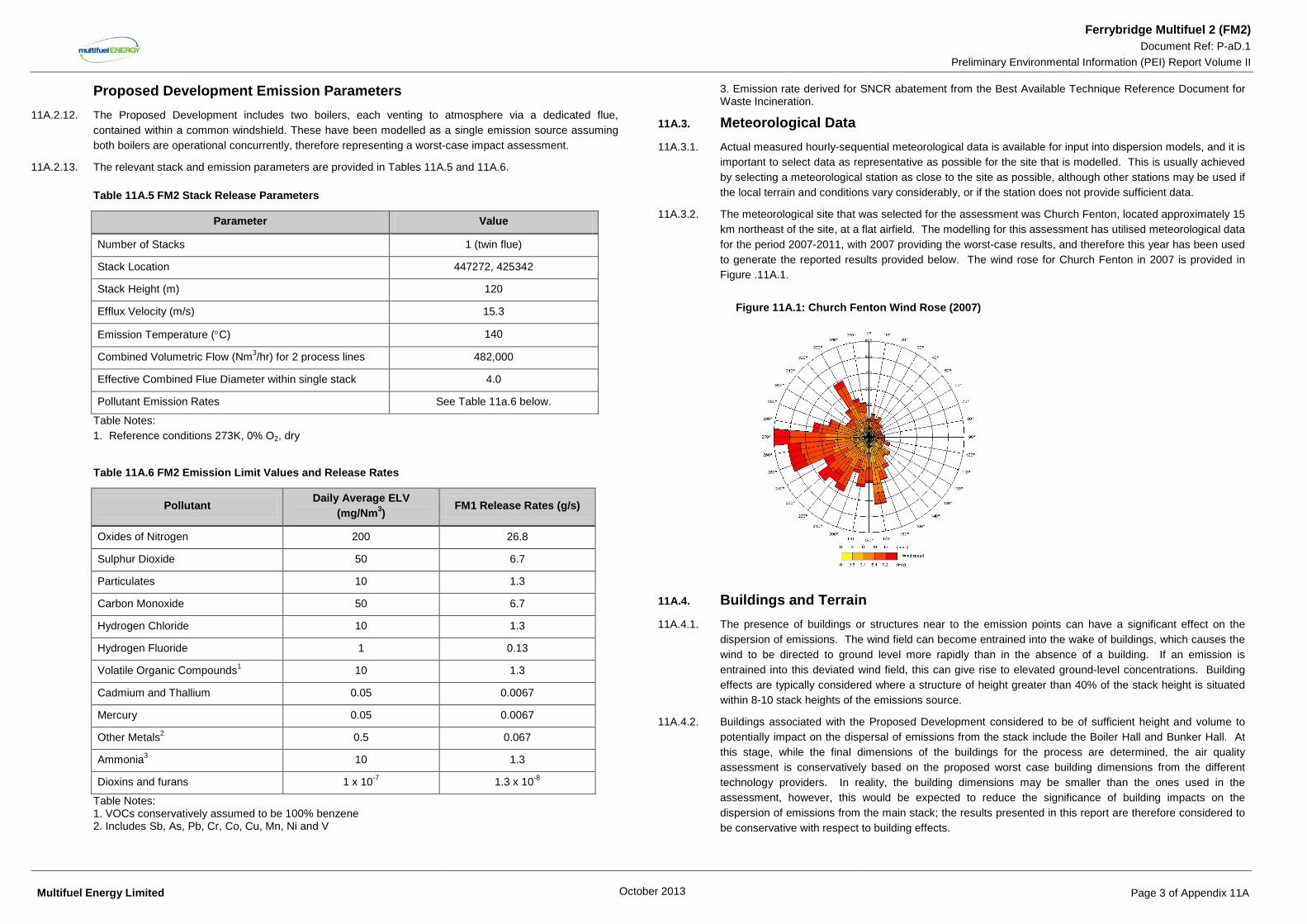
11A.3.2. The meteorological site that was selected for the assessment was Church Fenton, located approximately 15 km northeast of the site, at a flat airfield. The modelling for this assessment has utilised meteorological data for the period 2007-2011, with 2007 providing the worst-case results, and therefore this year has been used to generate the reported results provided below. The wind rose for Church Fenton in 2007 is provided in Figure .11A.1.
Figure 11A.1: Church Fenton Wind Rose (2007)
11A.4. Buildings and Terrain 11A.4.1. The presence of buildings or structures near to the emission points can have a significant effect on the
dispersion of emissions. The wind field can become entrained into the wake of buildings, which causes the wind to be directed to ground level more rapidly than in the absence of a building. If an emission is entrained into this deviated wind field, this can give rise to elevated ground-level concentrations. Building effects are typically considered where a structure of height greater than 40% of the stack height is situated within 8-10 stack heights of the emissions source.
11A.4.2. Buildings associated with the Proposed Development considered to be of sufficient height and volume to potentially impact on the dispersal of emissions from the stack include the Boiler Hall and Bunker Hall. At this stage, while the final dimensions of the buildings for the process are determined, the air quality assessment is conservatively based on the proposed worst case building dimensions from the different technology providers. In reality, the building dimensions may be smaller than the ones used in the assessment, however, this would be expected to reduce the significance of building impacts on the dispersion of emissions from the main stack; the results presented in this report are therefore considered to be conservative with respect to building effects.
Multifuel Energy Limited October 2013 Page 3 of Appendix 11A
Ferrybridge Multifuel 2 (FM2) Document Ref: P-aD.1
Preliminary Environmental Information (PEI) Report Volume II 11A.4.3. The FM1 plant buildings that could affect dispersion from the FM1 stack, for modified baseline
determination, include the boiler hall and bunker hall.
11A.4.4. In addition, the existing Ferrybridge ‘C’ cooling towers have the height potential to affect dispersion from the Proposed Development stack and are situated within 8-10 stack heights of the Proposed Development.
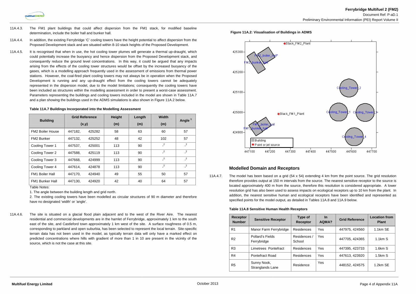
11A.4.5. It is recognised that when in use, the hot cooling tower plumes will generate a thermal up-draught, which could potentially increase the buoyancy and hence dispersion from the Proposed Development stack, and consequently reduce the ground level concentrations. In this way, it could be argued that any impacts arising from the effects of the cooling tower structures would be offset by the increased buoyancy of the gases, which is a modelling approach frequently used in the assessment of emissions from thermal power stations. However, the coal-fired plant cooling towers may not always be in operation when the Proposed Development is running and any up-draught effect from the cooling towers cannot be adequately represented in the dispersion model, due to the model limitations; consequently the cooling towers have been included as structures within the modelling assessment in order to present a worst-case assessment. Parameters representing the buildings and cooling towers included in the model are shown in Table 11A.7 and a plan showing the buildings used in the ADMS simulations is also shown in Figure 11A.2 below.
Table 11A.7 Buildings Incorporated into the Modelling Assessment
Building Grid Reference
(x,y)
Height
(m)
Length
(m)
Width
(m) Angle 1
FM2 Boiler House 447182, 425282 58 63 60 57
FM2 Bunker 447132, 425252 48 42 102 57
Cooling Tower 1 447537, 425001 113 90 -2 -2
Cooling Tower 2 447588, 425119 113 90 -2 -2
Cooling Tower 3 447668, 424999 113 90 -2 -2
Cooling Tower 4 447614, 424878 113 90 -2 -2
FM1 Boiler Hall 447170, 424940 49 55 50 57
FM1 Bunker Hall 447130, 424920 42 40 64 57
Table Notes: 1. The angle between the building length and grid north. 2. The existing cooling towers have been modelled as circular structures of 90 m diameter and therefore have no designated ‘width’ or ‘angle’.
11A.4.6. The site is situated on a glacial flood plain adjacent and to the west of the River Aire. The nearest residential and commercial developments are in the hamlet of Ferrybridge, approximately 1 km to the south east of the site, and Castleford town approximately 1 km west of the site. A surface roughness of 0.5 m, corresponding to parkland and open suburbia, has been selected to represent the local terrain. Site-specific terrain data has not been used in the model, as typically terrain data will only have a marked effect on predicted concentrations where hills with gradient of more than 1 in 10 are present in the vicinity of the source, which is not the case at this site.
Figure 11A.2: Visualisation of Buildings in ADMS
Modelled Domain and Receptors 11A.4.7. The model has been based on a grid (54 x 54) extending 4 km from the point source. The grid resolution
therefore provides output at 150 m intervals from the source. The nearest sensitive receptor to the source is located approximately 400 m from the source, therefore this resolution is considered appropriate. A lower resolution grid has also been used to assess impacts on ecological receptors up to 10 km from the plant. In addition, the nearest sensitive human and ecological receptors have been identified and represented as specified points for the model output, as detailed in Tables 11A.8 and 11A.9 below.
Table 11A.8 Sensitive Human Health Receptors
Receptor Number
Sensitive Receptor Type of Receptor
In AQMA?
Grid Reference Location from Plant
R1 Manor Farm Ferrybridge Residences Yes 447975, 424560 1.1km SE
R2 Pollard’s Fields Ferrybridge
Residences / School
Yes 447705, 424365 1.1km S
R3 Limetrees Pontefract Residences Yes 447395, 423733 1.6km S
R4 Pontefract Road Residences Yes 447613, 423920 1.5km S
R5 Sunny Nook, Stranglands Lane
Residence Yes
448152, 424575 1.2km SE
Multifuel Energy Limited October 2013 Page 4 of Appendix 11A
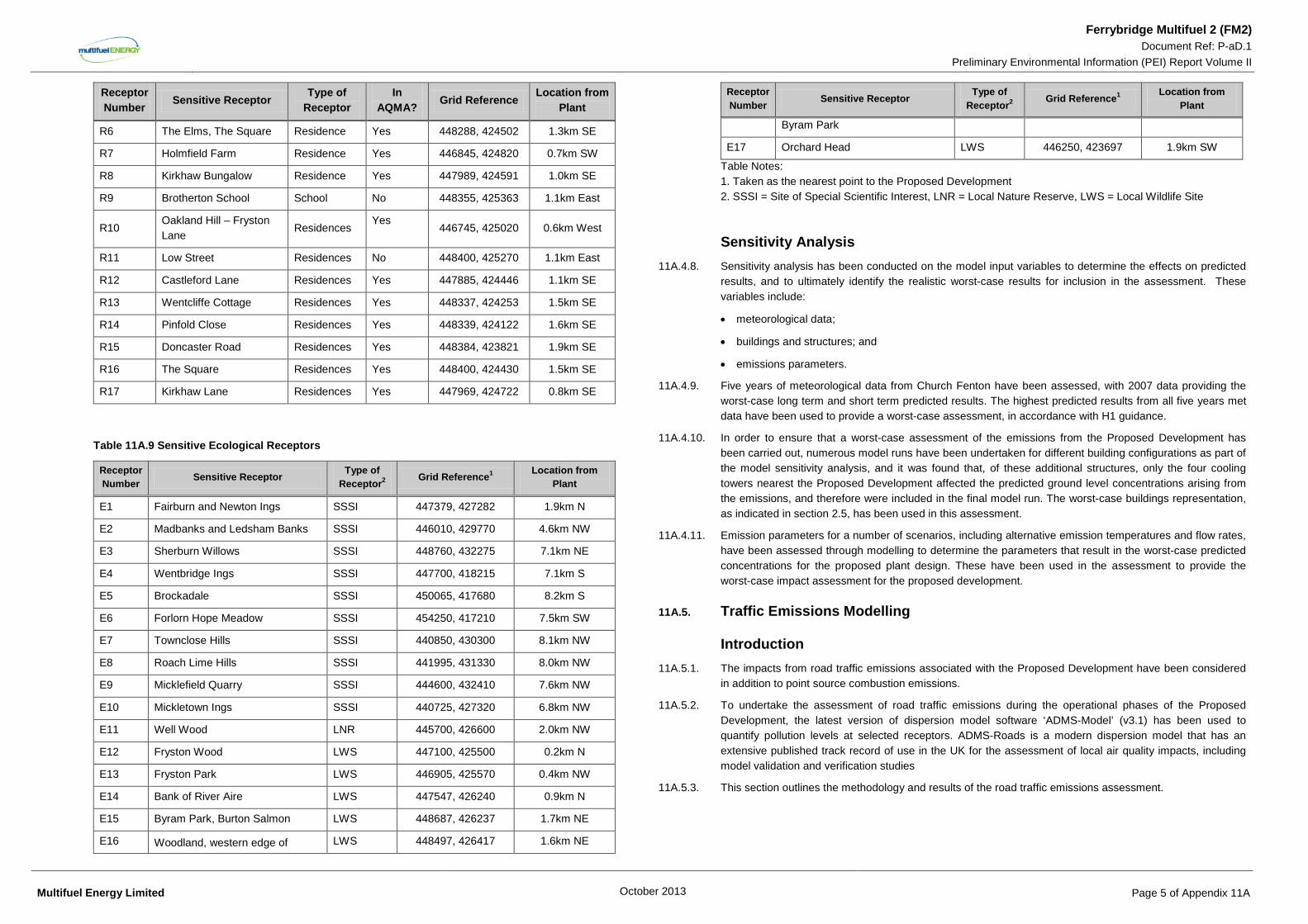
Ferrybridge Multifuel 2 (FM2) Document Ref: P-aD.1
Preliminary Environmental Information (PEI) Report Volume II
Receptor Number Sensitive Receptor
Type of Receptor
In AQMA? Grid Reference
Location from Plant
R6 The Elms, The Square Residence Yes 448288, 424502 1.3km SE
R7 Holmfield Farm Residence Yes 446845, 424820 0.7km SW
R8 Kirkhaw Bungalow Residence Yes 447989, 424591 1.0km SE
R9 Brotherton School School No 448355, 425363 1.1km East
R10 Oakland Hill – Fryston Lane
Residences Yes
446745, 425020 0.6km West
R11 Low Street Residences No 448400, 425270 1.1km East
R12 Castleford Lane Residences Yes 447885, 424446 1.1km SE
R13 Wentcliffe Cottage Residences Yes 448337, 424253 1.5km SE
R14 Pinfold Close Residences Yes 448339, 424122 1.6km SE
R15 Doncaster Road Residences Yes 448384, 423821 1.9km SE
R16 The Square Residences Yes 448400, 424430 1.5km SE
R17 Kirkhaw Lane Residences Yes 447969, 424722 0.8km SE
Table 11A.9 Sensitive Ecological Receptors
Receptor Number Sensitive Receptor Type of
Receptor2 Grid Reference1 Location from Plant
E1 Fairburn and Newton Ings SSSI 447379, 427282 1.9km N
E2 Madbanks and Ledsham Banks SSSI 446010, 429770 4.6km NW
E3 Sherburn Willows SSSI 448760, 432275 7.1km NE
E4 Wentbridge Ings SSSI 447700, 418215 7.1km S
E5 Brockadale SSSI 450065, 417680 8.2km S
E6 Forlorn Hope Meadow SSSI 454250, 417210 7.5km SW
E7 Townclose Hills SSSI 440850, 430300 8.1km NW
E8 Roach Lime Hills SSSI 441995, 431330 8.0km NW
E9 Micklefield Quarry SSSI 444600, 432410 7.6km NW
E10 Mickletown Ings SSSI 440725, 427320 6.8km NW
E11 Well Wood LNR 445700, 426600 2.0km NW
E12 Fryston Wood LWS 447100, 425500 0.2km N
E13 Fryston Park LWS 446905, 425570 0.4km NW
E14 Bank of River Aire LWS 447547, 426240 0.9km N
E15 Byram Park, Burton Salmon LWS 448687, 426237 1.7km NE
E16 Woodland, western edge of LWS 448497, 426417 1.6km NE
Receptor Number Sensitive Receptor Type of
Receptor2 Grid Reference1 Location from Plant
Byram Park
E17 Orchard Head LWS 446250, 423697 1.9km SW
Table Notes: 1. Taken as the nearest point to the Proposed Development 2. SSSI = Site of Special Scientific Interest, LNR = Local Nature Reserve, LWS = Local Wildlife Site
Sensitivity Analysis 11A.4.8. Sensitivity analysis has been conducted on the model input variables to determine the effects on predicted
results, and to ultimately identify the realistic worst-case results for inclusion in the assessment. These variables include:
• meteorological data;
• buildings and structures; and
• emissions parameters.
11A.4.9. Five years of meteorological data from Church Fenton have been assessed, with 2007 data providing the worst-case long term and short term predicted results. The highest predicted results from all five years met data have been used to provide a worst-case assessment, in accordance with H1 guidance.
11A.4.10. In order to ensure that a worst-case assessment of the emissions from the Proposed Development has been carried out, numerous model runs have been undertaken for different building configurations as part of the model sensitivity analysis, and it was found that, of these additional structures, only the four cooling towers nearest the Proposed Development affected the predicted ground level concentrations arising from the emissions, and therefore were included in the final model run. The worst-case buildings representation, as indicated in section 2.5, has been used in this assessment.
11A.4.11. Emission parameters for a number of scenarios, including alternative emission temperatures and flow rates, have been assessed through modelling to determine the parameters that result in the worst-case predicted concentrations for the proposed plant design. These have been used in the assessment to provide the worst-case impact assessment for the proposed development.
11A.5. Traffic Emissions Modelling
Introduction 11A.5.1. The impacts from road traffic emissions associated with the Proposed Development have been considered
in addition to point source combustion emissions.
11A.5.2. To undertake the assessment of road traffic emissions during the operational phases of the Proposed Development, the latest version of dispersion model software ‘ADMS-Model’ (v3.1) has been used to quantify pollution levels at selected receptors. ADMS-Roads is a modern dispersion model that has an extensive published track record of use in the UK for the assessment of local air quality impacts, including model validation and verification studies
11A.5.3. This section outlines the methodology and results of the road traffic emissions assessment.
Multifuel Energy Limited October 2013 Page 5 of Appendix 11A
Ferrybridge Multifuel 2 (FM2) Document Ref: P-aD.1
Preliminary Environmental Information (PEI) Report Volume II
Study Pollutants 11A.5.4. The incomplete combustion of fuel in vehicle engines results in the presence of hydrocarbons (HC) such as
benzene and 1,3-butadiene, and sulphur dioxide (SO2), carbon monoxide (CO), PM10 and PM2.5 in exhaust emissions. In addition, at the high temperatures and pressures found within vehicle engines, some of the nitrogen in the air and fuel is oxidised to form NOx, mainly in the form of nitric oxide (NO), which is then converted to NO2 in the atmosphere. NO2 is associated with adverse effects on human health. Better emission control technology and fuel specifications are expected to reduce emissions per vehicle in the long term.
11A.5.5. Although SO2, CO, benzene and 1,3-butadiene are also present in motor vehicle exhaust emissions, detailed consideration of the associated impacts on local air quality is not considered relevant in the context of this Proposed Development. This is because road traffic emissions of these substances have been reviewed by the local authority and nowhere within Wakefield Metropolitan Borough Council administrative area is at risk of exceeding these objectives. The Proposed Development would not be capable of compromising the achievement of the relevant air quality objectives for the protection of human health. Emissions of SO2, CO, benzene and 1,3-butadiene from road traffic are therefore not considered further within this assessment.
11A.5.6. During operation, the Proposed Development has the potential to change vehicle movements on the surrounding road network. An increase in vehicle emissions can increase the exposure at sensitive receptors to concentrations of NO2 and particulate matter (PM10 and PM2.5). This assessment will quantify the concentration of the pollutants most commonly associated with vehicle emissions at the worst affected receptor locations.
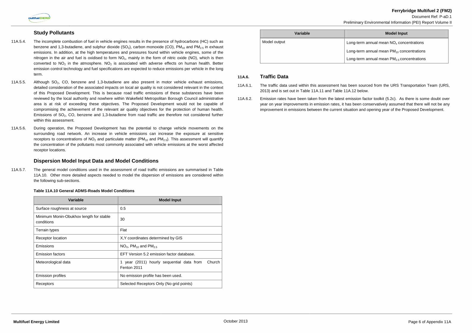
Dispersion Model Input Data and Model Conditions 11A.5.7. The general model conditions used in the assessment of road traffic emissions are summarised in Table
11A.10. Other more detailed aspects needed to model the dispersion of emissions are considered within the following sub-sections.
Table 11A.10 General ADMS-Roads Model Conditions
Variable Model Input
Surface roughness at source 0.5
Minimum Monin-Obukhov length for stable conditions
30
Terrain types Flat
Receptor location X,Y coordinates determined by GIS
Emissions NOX, PM10 and PM2.5
Emission factors EFT Version 5.2 emission factor database.
Meteorological data 1 year (2011) hourly sequential data from Church Fenton 2011
Emission profiles No emission profile has been used.
Receptors Selected Receptors Only (No grid points)
Variable Model Input
Model output Long-term annual mean NOx concentrations
Long-term annual mean PM10 concentrations
Long-term annual mean PM2.5 concentrations
11A.6. Traffic Data 11A.6.1. The traffic data used within this assessment has been sourced from the URS Transportation Team (URS,
2013) and is set out in Table 11A.11 and Table 11A.12 below.
11A.6.2. Emission rates have been taken from the latest emission factor toolkit (5.2c). As there is some doubt over year on year improvements in emission rates, it has been conservatively assumed that there will not be any improvement in emissions between the current situation and opening year of the Proposed Development.
Multifuel Energy Limited October 2013 Page 6 of Appendix 11A
Ferrybridge Multifuel 2 (FM2) Document Ref: P-aD.1
Preliminary Environmental Information (PEI) Report Volume II
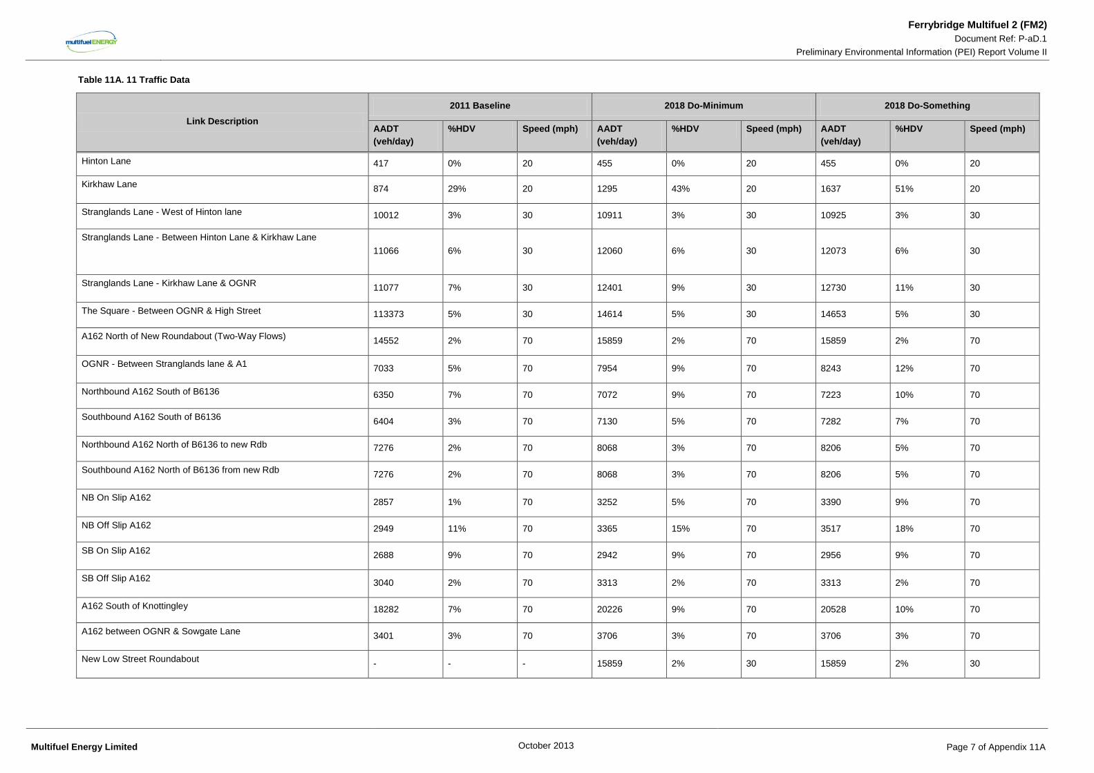
Table 11A. 11 Traffic Data
Link Description 2011 Baseline 2018 Do-Minimum 2018 Do-Something
AADT (veh/day)
%HDV Speed (mph) AADT (veh/day)
%HDV Speed (mph) AADT (veh/day)
%HDV Speed (mph)
Hinton Lane 417 0% 20 455 0% 20 455 0% 20
Kirkhaw Lane 874 29% 20 1295 43% 20 1637 51% 20
Stranglands Lane - West of Hinton lane 10012 3% 30 10911 3% 30 10925 3% 30
Stranglands Lane - Between Hinton Lane & Kirkhaw Lane 11066 6% 30 12060 6% 30 12073 6% 30
Stranglands Lane - Kirkhaw Lane & OGNR 11077 7% 30 12401 9% 30 12730 11% 30
The Square - Between OGNR & High Street 113373 5% 30 14614 5% 30 14653 5% 30
A162 North of New Roundabout (Two-Way Flows) 14552 2% 70 15859 2% 70 15859 2% 70
OGNR - Between Stranglands lane & A1 7033 5% 70 7954 9% 70 8243 12% 70
Northbound A162 South of B6136 6350 7% 70 7072 9% 70 7223 10% 70
Southbound A162 South of B6136 6404 3% 70 7130 5% 70 7282 7% 70
Northbound A162 North of B6136 to new Rdb 7276 2% 70 8068 3% 70 8206 5% 70
Southbound A162 North of B6136 from new Rdb 7276 2% 70 8068 3% 70 8206 5% 70
NB On Slip A162 2857 1% 70 3252 5% 70 3390 9% 70
NB Off Slip A162 2949 11% 70 3365 15% 70 3517 18% 70
SB On Slip A162 2688 9% 70 2942 9% 70 2956 9% 70
SB Off Slip A162 3040 2% 70 3313 2% 70 3313 2% 70
A162 South of Knottingley 18282 7% 70 20226 9% 70 20528 10% 70
A162 between OGNR & Sowgate Lane 3401 3% 70 3706 3% 70 3706 3% 70
New Low Street Roundabout - - - 15859 2% 30 15859 2% 30
Multifuel Energy Limited October 2013 Page 7 of Appendix 11A
Ferrybridge Multifuel 2 (FM2) Document Ref: P-aD.1
Preliminary Environmental Information (PEI) Report Volume II
11A.7. Background Data 11A.7.1. For each receptor considered in this study a receptor-specific background concentration has been
determined, based on the receptor Defra grid square concentration (Defra 2010 background maps for 2013). Where the road component has been explicitly modelled for this assessment, contributions to annual mean NO2, PM10 and PM2.5 from Primary A Roads and motorway road sources in the modelling domain were removed from the background (sector removal as per LAQM TG(09) guidance (Ref 11A-5) and the modelled road contribution has been added.
11A.7.2. Due to the uncertainty in the assumption that year on year background concentrations will decrease, the 2012 mapped background data has been used for both the baseline and future year assessment.
Bias Adjustment of Road Contribution Pollutant Concentrations 11A.7.3. There is one monitoring location (diffusion tube site 51) within the road traffic model study area. Following
the model verification methodology described in LAQM TG(09) (Defra, 2009), modelled predictions were made of annual mean NO2 concentrations at the location of the diffusion tube. A comparison of the unadjusted predictions and the measured concentrations at this location was undertaken. This showed that the model under-predicted annual mean concentrations of NO2. As described in LAQM TG(09), the adjustment was made to predicted road NOx contributions. An adjustment factor of 1.99 was used to correct bias across the study area.
11A.7.4. In the absence of measured or monitored PM10 and PM2.5 data that is suitable for use in model verification, the same road NOX factor has also been applied to their road contributions, as per the methodology described in LAQM TG(09).
NOx to NO2 Conversion 11A.7.5. To accompany the publication of the guidance document LAQM TG(09), a NOX to NO2 converter was made
available as a tool to calculate the road NO2 contribution from modelled road NOX contributions. The tool comes in the form of an MS Excel spreadsheet and uses borough specific data to calculate annual mean concentrations of NO2 from dispersion model output values of annual mean concentrations of NOX. This tool was used to calculate the total NO2 concentrations at receptors from the modelled road NOX contribution and the associated background concentration. Due to the location of the proposed development, the ‘All Other Urban Traffic’ setting was selected.
Predicting the Number of Days in which the PM10 24-hr Mean Objective is Exceeded
11A.7.6. The guidance document LAQM TG(03) set out the method by which the number of days in which the PM10
24-hr objective is exceeded can be obtained based on a relationship with the predicted PM10 annual mean concentration. The most recent guidance (Defra, 2009) suggests no change to this method. As such, the formula used within this assessment is:
5.182063*0014.0 of No. −+=C
CsExceedance
Where C is the annual mean concentration of PM10.
Predicting the Number of Days in which the NO2 hourly Mean Objective is Exceeded
11A.7.7. Research projects completed on behalf of Defra and the Devolved Administrations (Laxen and Marner (2003) and AEAT (2008)) have concluded that the hourly mean NO2 objective is unlikely to be exceeded if annual mean concentrations are predicted to be less the 60 µg/m3.
11A.7.8. In 2003, Laxen and Marner concluded:
11A.7.9. “…local authorities could reliably base decisions on likely exceedances of the 1-hour objective for nitrogen dioxide alongside busy streets using an annual mean of 60 µg/m3 and above.”
11A.7.10. The findings presented by Laxen and Marner (2003) are further supported by AEAT (2008) who revisited the investigation to complete an updated analysis including new monitoring results and additional monitoring sites. The recommendations of this report are:
11A.7.11. “Local authorities should continue to use the threshold of 60 µg/m3 NO2 as the trigger for considering a likely exceeaence of the hourly mean nitrogen dioxide objective.”
11A.7.12. Therefore this assessment will evaluate the likelihood of exceeding the hourly mean NO2 objective by comparing predicted annual mean NO2 concentrations at all receptors to an annual mean equivalent threshold of 60 µg/m3 NO2. Where predicted concentrations are below this value, it can be concluded with confidence that the hourly mean NO2 objective (200 µg/m3 NO2 not more than 18 times per year) will be achieved.
Method for Assessment of Significance 11A.7.13. EPR H1 indicates that for the assessment of point source emissions, long term ground level concentrations
arising from point sources which are less than 1% of an air quality objective or EAL can be treated as insignificant (or negligible). Similarly, short term ground level concentrations arising from point sources which are less than 10% of an air quality objective or EAL can also be treated as insignificant (or negligible). Where emissions are not screened as negligible, the descriptive terms for the significance of the effect outlined in Table 11A.12 below have been applied.
11A.7.14. The significance of effects of point source emissions on ecological receptors, through deposition of nutrient nitrogen or acidity, has been evaluated using the Environment Agency insignificance criterion of 1% of the long term objective, as above.
11A.7.15. With regard to road traffic, the change in pollutant concentrations with respect to baseline concentrations has been quantified at receptors that are representative of exposure to impacts on local air quality within the study area. The absolute magnitude of pollutant concentrations in the baseline and with development scenario is also quantified and this is used to consider the risk of the air quality limit values being exceeded in each scenario.
11A.7.16. For a change of a given magnitude, the Institute of Air Quality Management (IAQM, 2009) have published recommendations for describing the magnitude of impacts at individual receptors and describing the significance (Table 11A.13) of such impacts. For example a change in predicted annual mean concentrations of NO2 or PM10 of less than 0.4 µg/m3 is considered to be so small a to be imperceptible. A change (impact) that is imperceptible, given normal bounds of variation, would not be capable of having a direct effect on local air quality that could be considered to be significant. The magnitude of change is divided into four classes as defined in Table 11A.13.
Multifuel Energy Limited October 2013 Page 8 of Appendix 11A

Ferrybridge Multifuel 2 (FM2) Document Ref: P-aD.1
Preliminary Environmental Information (PEI) Report Volume II Table 11A.12 Magnitude of Changes in Ambient Pollutant Concentrations of NO2 and PM10
Magnitude of Change
Annual Mean Concentrations of
NO2 (µg/m3)
Annual Mean Concentrations of
PM10 (µg/m3)
Exceedances of the 24-hr mean objective for PM10
(days)
Large Increase/decrease
>4
Increase/decrease
>4
Increase/decrease
>4
Medium Increase/decrease
2 - 4
Increase/decrease
2 - 4
Increase/decrease
2 to 4
Small Increase/decrease
0.4 - 2
Increase/decrease
0.4 - 2
Increase/decrease
1 to 2
Imperceptible Increase/decrease
< 0.4
Increase/decrease
< 0.4
Increase/decrease
< 1
11A.7.17. The magnitude of the change in the predicted number of exceedances of the 24-hour objective is directly
derived from the predicted annual mean value using the relationship defined in the DMRB Screening Tool. The magnitude descriptors for 24-hour mean PM10 in the table above are as proposed by Environmental Protection UK (EPUK, 2010).
11A.7.18. All relevant receptors that have been selected to represent locations where people are likely to be present are based on impacts on human health. The air quality objective values have been set at concentrations that provide protection to all members of society, including more vulnerable groups such as the very young, elderly or unwell. As such the sensitivity of receptors was considered in the definition of the air quality objective values and therefore no additional subdivision of human health receptors on the basis of building or location type is necessary.
11A.7.19. For receptors that are predicted to experience a perceptible change, the effect of the change on local air quality and the risk of exceeding the air quality objective value is summarised in Table 11A.14 for annual mean concentrations of NO2 and PM10.
Table 11A.13. Magnitude of Changes in Ambient Pollutant Concentrations of NO2 and PM10
Absolute Concentration in Relation to Objective/Limit Value
Change in Concentration
Small Medium Large
Increase with Scheme
Above Objective/Limit Value With Scheme (>40 µg/m3)
Slight Adverse Moderate Adverse Substantial Adverse
Just Below Objective/Limit Value With Scheme (36 - 40 µg/m3)
Slight Adverse Moderate Adverse Moderate Adverse
Below Objective/Limit Value With Scheme (30 - 36 µg/m3)
Negligible Slight Adverse Slight Adverse
Well Below Objective/Limit Value With Scheme (<30 µg/m3)
Negligible Negligible Slight Adverse
Absolute Concentration in Relation to Objective/Limit Value
Change in Concentration
Small Medium Large
Increase with Scheme
Decrease with Scheme
Above Objective/Limit Value Without Scheme (>40 µg/m3)
Slight Beneficial Moderate Beneficial Substantial Beneficial
Just Below Objective/Limit Value Without Scheme (36 - 40 µg/m3)
Slight Beneficial Moderate Beneficial Moderate Beneficial
Below Objective/Limit Value Without Scheme (30 - 36 µg/m3)
Negligible Slight Beneficial Slight Beneficial
Well Below Objective/Limit Value Without Scheme (<30 µg/m3)
Negligible Negligible Slight Beneficial
11A.7.20. The criteria in Table 11.1 relate to air quality statistics that are elevated about the objective values in many urban locations: this is not the case with PM2.5. A change in the annual mean concentration of PM2.5 equivalent to 1% of the objective value is 0.25 µg/m3. Changes above 0.25 µg/m3 would be considered to be a small change (up to 1.25 µg/m3).
11A.7.21. A small increase in annual mean concentrations of NO2 and PM10, at receptors exposed to baseline concentrations that are just below the objective value (36 µg/m3 to 40 µg/m3) is considered to have a minor adverse effect as the minor increase in the risk of exceeding the objective value is significant. However, a small increase in annual mean concentrations of NO2 and PM10 at receptors exposed to baseline concentrations that are below or well below (< 36 µg/m3) is not likely to affect the achievement of the objective value and is therefore not a significant effect (negligible).
11A.7.22. The equivalent values for just below the annual mean PM2.5 objective value where a small increase would cause a minor adverse effect on air quality is 22.5 to 25 µg/m3. Where baseline annual mean PM2.5 concentrations at a receptor are well below the objective (< 18.75 µg/m3), a small increase is not likely to have a significant effect on air quality.
Assessment of Significance 11A.7.23. The significance of all the reported impacts is then considered for the development in overall terms. The
potential for the scheme to contribute to or interfere with the successful implementation of policies and strategies for the management of local air quality are considered if relevant, but the principal focus is any change to the likelihood of future achievement of the air quality objective values set out in Table 11A.1 for the following pollutants:
• Annual mean nitrogen dioxide (NO2) concentration of 40 µg/m3;
• Annual mean particulate matter (PM10) concentration of 40 µg/m3;
• Annual mean fine particulate matter (PM2.5) concentrations of 25 µg/m3; and
• 24-hour mean PM10 concentration of 50 µg/m3 not to be exceeded on more than 35 days per year.
11A.7.24. The achievement of local authority goals for local air quality management are directly linked to the achievement of the air quality objective values described above and as such this assessment focuses on the likelihood of future achievement of the air quality objective values.
Multifuel Energy Limited October 2013 Page 9 of Appendix 11A
Ferrybridge Multifuel 2 (FM2) Document Ref: P-aD.1
Preliminary Environmental Information (PEI) Report Volume II 11A.7.25. In terms of the significance of the consequences of any adverse impacts, an effect is reported as being
either ‘not significant’ or as being ‘significant’. Effects found to be ‘minor’ are considered to be ‘not significant’, although they may be a matter or local concern. ‘Negligible’ effects are considered to be ‘not significant’.
11A.8. Results and Discussion
Modified Baseline Calculations - FM1 Process and Road Contributions 11A.8.1. It is considered that the modelled parameters used will result in a conservative estimation of the FM1
process contribution to the modified baseline. These include:
• Use of the worst-case meteorological year (2011) for the reported results;
• Assessment of emission concentrations at the WID limits, when average concentrations are likely to be below these values;
• Assumption that 70% of NOx emissions are converted to NO2 in the stack vicinity in the long term;
• Assumption that 100% of particulate emissions are PM10 or below;
• 100% plant availability and operation per year;
• Inclusion of buildings within the model, especially the inclusion of the existing Ferrybridge ‘C’ cooling towers and excluding potential up-draught effects from the cooling tower thermal plumes in the assessment.
11A.8.2. The assessment undertaken for 2018 assumes that there has been no improvement in either background pollutant concentrations for NO2 or PM10 or vehicle emission factors. This is considered to be a conservative approach for 2018 as some improvements are anticipated in both background pollutant concentrations and also vehicle emissions by this date.
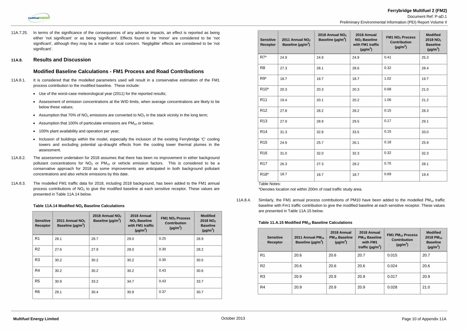
11A.8.3. The modelled FM1 traffic data for 2018, including 2018 background, has been added to the FM1 annual process contributions of NO2 to give the modified baseline at each sensitive receptor. These values are presented in Table 11A.14 below.
Table 11A.14 Modified NO2 Baseline Calculations
Sensitive Receptor
2011 Annual NO2 Baseline (µg/m3)
2018 Annual NO2 Baseline (µg/m3)
2018 Annual NO2 Baseline
with FM1 traffic (µg/m3)
FM1 NO2 Process Contribution
(µg/m3)
Modified 2018 NO2 Baseline (µg/m3)
R1 28.1 28.7 29.0 0.25 28.9
R2 27.6 27.9 28.0 0.30 28.2
R3 30.2 30.2 30.2 0.30 30.5
R4 30.2 30.2 30.2 0.43 30.6
R5 30.9 33.2 34.7 0.43 33.7
R6 29.1 30.4 30.9 0.37 30.7
Sensitive Receptor
2011 Annual NO2 Baseline (µg/m3)
2018 Annual NO2 Baseline (µg/m3)
2018 Annual NO2 Baseline
with FM1 traffic (µg/m3)
FM1 NO2 Process Contribution
(µg/m3)
Modified 2018 NO2 Baseline (µg/m3)
R7* 24.9 24.9 24.9 0.41 25.3
R8 27.3 28.1 28.6 0.32 28.4
R9* 18.7 18.7 18.7 1.02 19.7
R10* 20.3 20.3 20.3 0.68 21.0
R11 19.4 20.1 20.2 1.06 21.2
R12 27.8 28.2 28.2 0.15 28.3
R13 27.9 28.9 29.5 0.17 29.1
R14 31.3 32.8 33.5 0.15 33.0
R15 24.9 25.7 26.1 0.18 25.9
R16 31.0 32.0 32.3 0.32 32.3
R17 26.3 27.3 28.2 0.75 28.1
R18* 18.7 18.7 18.7 0.69 19.4
Table Notes: *Denotes location not within 200m of road traffic study area.
11A.8.4. Similarly, the FM1 annual process contributions of PM10 have been added to the modelled PM10 traffic baseline with Fm1 traffic contribution to give the modified baseline at each sensitive receptor. These values are presented in Table 11A.15 below.
Table 11.A.15 Modified PM10 Baseline Calculations
Sensitive Receptor
2011 Annual PM10 Baseline (µg/m3)
2018 Annual PM10 Baseline
(µg/m3)
2018 Annual PM10 Baseline
with FM1 traffic (µg/m3)
FM1 PM10 Process Contribution
(µg/m3)
Modified 2018 PM10 Baseline (µg/m3)
R1 20.6 20.6 20.7 0.015 20.7
R2 20.6 20.6 20.6 0.024 20.6
R3 20.9 20.9 20.9 0.017 20.9
R4 20.9 20.9 20.9 0.028 21.0
Multifuel Energy Limited October 2013 Page 10 of Appendix 11A
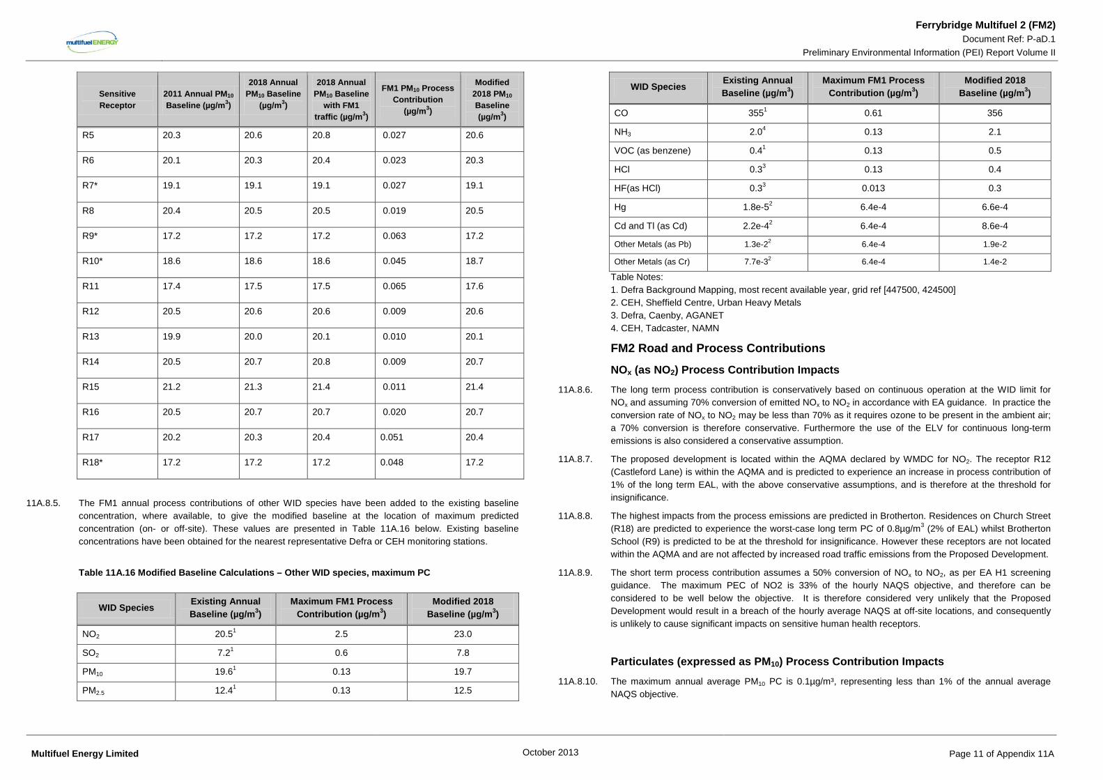
Ferrybridge Multifuel 2 (FM2) Document Ref: P-aD.1
Preliminary Environmental Information (PEI) Report Volume II
Sensitive Receptor
2011 Annual PM10 Baseline (µg/m3)
2018 Annual PM10 Baseline
(µg/m3)
2018 Annual PM10 Baseline
with FM1 traffic (µg/m3)
FM1 PM10 Process Contribution
(µg/m3)
Modified 2018 PM10 Baseline (µg/m3)
R5 20.3 20.6 20.8 0.027 20.6
R6 20.1 20.3 20.4 0.023 20.3
R7* 19.1 19.1 19.1 0.027 19.1
R8 20.4 20.5 20.5 0.019 20.5
R9* 17.2 17.2 17.2 0.063 17.2
R10* 18.6 18.6 18.6 0.045 18.7
R11 17.4 17.5 17.5 0.065 17.6
R12 20.5 20.6 20.6 0.009 20.6
R13 19.9 20.0 20.1 0.010 20.1
R14 20.5 20.7 20.8 0.009 20.7
R15 21.2 21.3 21.4 0.011 21.4
R16 20.5 20.7 20.7 0.020 20.7
R17 20.2 20.3 20.4 0.051 20.4
R18* 17.2 17.2 17.2 0.048 17.2
11A.8.5. The FM1 annual process contributions of other WID species have been added to the existing baseline concentration, where available, to give the modified baseline at the location of maximum predicted concentration (on- or off-site). These values are presented in Table 11A.16 below. Existing baseline concentrations have been obtained for the nearest representative Defra or CEH monitoring stations.
Table 11A.16 Modified Baseline Calculations – Other WID species, maximum PC
WID Species Existing Annual Baseline (µg/m3)
Maximum FM1 Process Contribution (µg/m3)
Modified 2018 Baseline (µg/m3)
NO2 20.51 2.5 23.0
SO2 7.21 0.6 7.8
PM10 19.61 0.13 19.7
PM2.5 12.41 0.13 12.5
WID Species Existing Annual Baseline (µg/m3)
Maximum FM1 Process Contribution (µg/m3)
Modified 2018 Baseline (µg/m3)
CO 3551 0.61 356
NH3 2.04 0.13 2.1
VOC (as benzene) 0.41 0.13 0.5
HCl 0.33 0.13 0.4
HF(as HCl) 0.33 0.013 0.3
Hg 1.8e-52 6.4e-4 6.6e-4
Cd and Tl (as Cd) 2.2e-42 6.4e-4 8.6e-4
Other Metals (as Pb) 1.3e-22 6.4e-4 1.9e-2
Other Metals (as Cr) 7.7e-32 6.4e-4 1.4e-2
Table Notes: 1. Defra Background Mapping, most recent available year, grid ref [447500, 424500] 2. CEH, Sheffield Centre, Urban Heavy Metals 3. Defra, Caenby, AGANET 4. CEH, Tadcaster, NAMN
FM2 Road and Process Contributions
NOx (as NO2) Process Contribution Impacts 11A.8.6. The long term process contribution is conservatively based on continuous operation at the WID limit for
NOx and assuming 70% conversion of emitted NOx to NO2 in accordance with EA guidance. In practice the conversion rate of NOx to NO2 may be less than 70% as it requires ozone to be present in the ambient air; a 70% conversion is therefore conservative. Furthermore the use of the ELV for continuous long-term emissions is also considered a conservative assumption.
11A.8.7. The proposed development is located within the AQMA declared by WMDC for NO2. The receptor R12 (Castleford Lane) is within the AQMA and is predicted to experience an increase in process contribution of 1% of the long term EAL, with the above conservative assumptions, and is therefore at the threshold for insignificance.
11A.8.8. The highest impacts from the process emissions are predicted in Brotherton. Residences on Church Street (R18) are predicted to experience the worst-case long term PC of 0.8µg/m3 (2% of EAL) whilst Brotherton School (R9) is predicted to be at the threshold for insignificance. However these receptors are not located within the AQMA and are not affected by increased road traffic emissions from the Proposed Development.
11A.8.9. The short term process contribution assumes a 50% conversion of NOx to NO2, as per EA H1 screening guidance. The maximum PEC of NO2 is 33% of the hourly NAQS objective, and therefore can be considered to be well below the objective. It is therefore considered very unlikely that the Proposed Development would result in a breach of the hourly average NAQS at off-site locations, and consequently is unlikely to cause significant impacts on sensitive human health receptors.
Particulates (expressed as PM10) Process Contribution Impacts 11A.8.10. The maximum annual average PM10 PC is 0.1µg/m³, representing less than 1% of the annual average
NAQS objective.
Multifuel Energy Limited October 2013 Page 11 of Appendix 11A
Ferrybridge Multifuel 2 (FM2) Document Ref: P-aD.1
Preliminary Environmental Information (PEI) Report Volume II 11A.8.11. The PM10 maximum process contribution (as the 90.4th percentile of 24-hourly averages) is predicted to
be 0.2 µg/m3, representing <1% of the NAQS objective. Due to the relatively high baseline concentration (taken to be 39µg/m³, twice the annual average concentration) the predicted environmental concentration of PM10 is 79%, however it is considered very unlikely that the contribution from the Proposed Development would lead to an exceedance of the NAQS objective.
Particulates (expressed as PM2.5) Process Contribution Impacts 11A.8.12. The PM10 assessment above includes the proportion of released particulates that is of PM2.5 or less, and
therefore in order to carry out a conservative assessment, it has been assumed here that the whole PM10 release occurs as PM2.5.
11A.8.13. The maximum predicted annual concentration, of 0.1 µg/m³, represents <1% of the PM2.5 limit value. The estimated baseline concentration is 12.5µg/m3, representing 63% of the target value; it is therefore considered very unlikely that the process contribution would result in failure to achieve the limit value or national exposure reduction target.
Sulphur Dioxide Process Contribution Impacts 11A.8.14. Short-term process contributions of SO2 are screened as insignificant according to the H1 criteria since the
PCs for the different averaging periods are less than 10% of the respective NAQS objectives. The PECs for SO2 are 10% for the 15-minute mean, 7% for the hourly mean and 14% for the 24-hour mean, and therefore can be considered to be well below the relevant NAQS objectives.
Carbon Monoxide Process Contribution Impacts 11A.8.15. The predicted process contribution of CO from the Proposed Development represents <1% of the NAQS 8-
hour running mean objective at the location of the maximum predicted concentration.
Ammonia Process Contribution Impacts 11A.8.16. The maximum annual average process contribution of ammonia is predicted to be 0.1 µg/m3, representing
<1% of the EAL.
11A.8.17. The maximum hourly average process contribution is <1% of the short term EAL for ammonia.
Volatile Organic Compounds Process Contribution Impacts 11A.8.18. The maximum predicted environmental concentration resulting from the Proposed Development represents
12% of the NAQS for benzene (used as a conservative surrogate assessment species) and is therefore is well below the objective. Given the conservative assumptions made in the assessment, it is considered unlikely that process contributions would result in risk to the attainment of the NAQS objective for benzene.
Acid Gases (Hydrogen Chloride and Hydrogen Fluoride) Process Contribution Impacts
11A.8.19. The maximum hourly average process contribution of hydrogen chloride is predicted to be less than 1% of the EAL.
11A.8.20. The maximum annual average process contribution of hydrogen fluoride is predicted to be less than 1% of the EAL.
11A.8.21. The maximum hourly average process contribution of hydrogen fluoride is less than 1% of the short term EAL.
Mercury Process Contribution Impacts 11A.8.22. The maximum annual average process contribution of mercury is predicted to be less than 1% of the EAL.
11A.8.23. The maximum hourly average process contribution is less than 1% of the short term EAL.
Cadmium and Thallium Process Contribution Impacts 11A.8.24. The maximum annual average process contribution of the Proposed Development is predicted to be 6% of
the EAL for cadmium (Cd), as a result of emissions conservatively assumed to be at WID limits continuously. An estimate of the background concentration for Cd has been obtained for this assessment from Defra’s Urban Heavy Metals Monitoring Network, operated by the National Physical Laboratory. The background concentrations are measured as the particulate fraction and are taken from the nearest background site, in Sheffield Centre. The estimate for background Cd is 0.2ng/m³. The PEC, including the modified baseline with FM1 contributions, is therefore predicted to be 22% of the EAL and the process contribution is considered unlikely to present a risk of exceedance of the EAL.
Other Metals (incl. Sb, As, Pb, Cr, Co, Cu, Mn, Ni, V) Process Contribution Impacts 11A.8.25. The maximum annual average process contribution of metals, assuming emissions at the WID limit for total
heavy metals are wholly comprised of lead, is 0.003μg/m³, representing 1% of the long term NAQS objective, which means this species is screened as having an insignificant impact; given this worst case assumption it is considered that process contributions are therefore unlikely to result in risk of exceedance of the objective.
11A.8.26. The hourly average process contribution of metals resulting from the Proposed Development is <1% of the most stringent short term (hourly mean) EAL (antimony, Sb) for the above species.
11A.8.27. Further analysis of the potential impacts from arsenic, nickel and chromium (VI) has not been conducted at this design stage. In particular the proportion of total chromium in a heavy metals release, and the proportion of chromium(VI) within that, are both unknowns at this stage as they are for any plant prior to construction and commissioning. Until actual emissions monitoring can be undertaken, the situation is further complicated by the unknown split between particulate and vapour phase releases. Therefore no assessment against specific individual metals guideline values can reliably be made at this stage.
11A.8.28. More detailed assessment will be conducted in line with the revised guidance issued by the Environment Agency in June 2011, “Impact Assessment for Group 3 Metals Stack Releases,” and the predicted impacts will be included in the DCO application, at a later stage of process design.
11A.8.29. The emissions of heavy metals have been assessed above based on emissions at the WID Emission Limit Value of 0.5mg/m3. It should be noted that this limit is set for gaseous and the vapour forms of the relevant heavy metal emissions as well as their compounds and not the PM10 particulate phase of heavy metals,
Multifuel Energy Limited October 2013 Page 12 of Appendix 11A

Ferrybridge Multifuel 2 (FM2) Document Ref: P-aD.1
Preliminary Environmental Information (PEI) Report Volume II
which is likely to be lower than the WID ELV, and therefore it is considered that assessing emissions at the WID limit against particulate phase standards represents a very conservative assessment.
11A.8.30. The Proposed Development process contributions (PCs) and traffic contributions (TCs) of NO2, PM10 and PM2.5 have been added to the modified baseline at each sensitive receptor to give the Predicted Environmental Concentration (PEC). These values are presented in Tables 11A.17, 11A.18 and 11A.19 below. The number of days that may exceed the 50 µg/m³ air quality objective with the Proposed Development against the modified baseline has also been considered.
11A.8.31. All receptor locations are predicted to comply with the NO2 annual average NAQS objective. Annual average increases in concentration of NO2 with the Proposed Development are predicted to range between 0.2 and 1.9 µg/m³. These changes equate to imperceptible and small magnitude changes in concentration. The biggest changes in NO2 annual average concentration are predicted at Receptor R5 on Stranglands Lane close to the site.
11A.8.32. All receptor locations are predicted to comply with the PM10 annual average NAQS objective and no locations are anticipated to exceed the 24-hour PM10 NAQS objective. Annual average increases in concentration of PM10 with the Proposed Development are predicted to range between less than 0.1 and 0.2 µg/m³. These changes in annual average and 24-hour PM10 concentration are considered to be of an imperceptible magnitude.
11A.8.33. All receptor locations are predicted to comply with the PM2.5 annual average NAQS objective. Annual average increases in concentration of PM2.5 with the Proposed Development are predicted to range between less than 0.1 and 0.1 µg/m³. These changes are considered to be of an imperceptible magnitude.
Table 11A.17: Proposed Development NO2 Operational Contributions
Sensitive Receptor
Modified 2018 NO2 Baseline
(µg/m3)
2018 NO2 FM2 TC (µg/m3)
NO2 FM2 PC (µg/m3)
PEC (µg/m3) cumulative change (µg/m3)
R1 28.9 0.3 0.3 29.5 0.6
R2 28.2 0.1 0.3 28.5 0.3
R3 30.5 <0.1 0.1 30.6 0.1
R4 30.6 <0.1 0.1 30.8 0.1
R5 33.7 1.5 0.3 35.4 1.8
R6 30.7 0.6 0.2 31.5 0.8
R7* 25.3 <0.1 0.1 25.3 0.1
R8 28.4 0.6 0.3 29.3 0.9
R9* 19.7 <0.1 0.4 20.1 0.4
R10* 21.0 <0.1 0.0 21.1 <0.1
R11 21.2 0.1 0.4 21.6 0.4
R12 28.3 0.1 0.4 28.8 0.5
R13 29.1 0.6 0.2 29.9 0.8
R14 33.0 0.7 0.3 33.9 0.9
R15 25.9 0.4 0.3 26.6 0.7
Sensitive Receptor
Modified 2018 NO2 Baseline
(µg/m3)
2018 NO2 FM2 TC (µg/m3)
NO2 FM2 PC (µg/m3)
PEC (µg/m3) cumulative change (µg/m3)
R16 32.3 0.3 0.2 32.8 0.5
R17 28.1 0.9 0.3 29.2 1.2
R18* 19.4 <0.1 0.8 20.1 0.8
Table Notes: *Denotes location not within 200 metres of road traffic study area
Table 11A.18: Proposed Development PM10 Operational Contributions
Sensitive Receptor
Modified 2018 PM10 Baseline
(µg/m3)
2018 PM10 FM2 TC (µg/m3)
PM10 FM2 PC (µg/m3)
PEC (µg/m3) cumulative change (µg/m3)
R1 20.7 <0.1 <0.1 20.7 <0.1
R2 20.6 <0.1 <0.1 20.7 <0.1
R3 20.9 <0.1 <0.1 21.0 <0.1
R4 21.0 <0.1 <0.1 21.0 <0.1
R5 20.6 0.1 <0.1 20.8 0.26
R6 20.3 0.1 <0.1 20.4 0.1
R7* 19.1 <0.1 <0.1 19.2 <0.1
R8 20.5 <0.1 <0.1 20.6 0.1
R9* 17.2 <0.1 <0.1 17.3 <0.1
R10* 18.7 <0.1 <0.1 18.7 <0.1
R11 17.6 <0.1 <0.1 17.6 <0.1
R12 20.6 <0.1 <0.1 20.6 <0.1
R13 20.1 0.1 <0.1 20.1 0.1
R14 20.7 0.1 <0.1 20.8 0.1
R15 21.4 <0.1 <0.1 21.4 0.1
R16 20.7 <0.1 <0.1 20.8 <0.1
R17 20.4 0.1 <0.1 20.4 0.1
R18* 17.2 <0.1 <0.1 17.2 <0.1
Multifuel Energy Limited October 2013 Page 13 of Appendix 11A
Ferrybridge Multifuel 2 (FM2) Document Ref: P-aD.1
Preliminary Environmental Information (PEI) Report Volume II
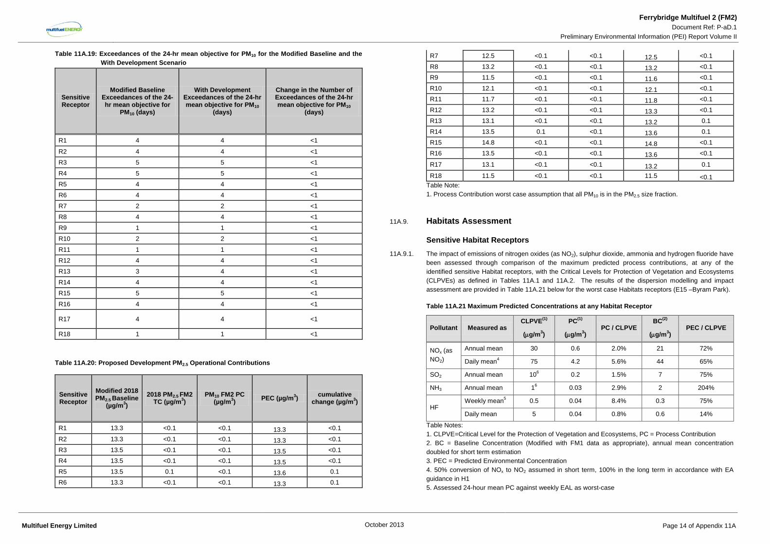
Table 11A.19: Exceedances of the 24-hr mean objective for PM10 for the Modified Baseline and the With Development Scenario
Sensitive Receptor
Modified Baseline Exceedances of the 24-hr mean objective for
PM10 (days)
With Development Exceedances of the 24-hr mean objective for PM10
(days)
Change in the Number of Exceedances of the 24-hr mean objective for PM10
(days)
R1 4 4 <1
R2 4 4 <1
R3 5 5 <1
R4 5 5 <1
R5 4 4 <1
R6 4 4 <1
R7 2 2 <1
R8 4 4 <1
R9 1 1 <1
R10 2 2 <1
R11 1 1 <1
R12 4 4 <1
R13 3 4 <1
R14 4 4 <1
R15 5 5 <1
R16 4 4 <1
R17 4 4 <1
R18 1 1 <1
Table 11A.20: Proposed Development PM2.5 Operational Contributions
Sensitive Receptor
Modified 2018 PM2.5 Baseline
(µg/m3) 2018 PM2.5 FM2
TC (µg/m3) PM10 FM2 PC
(µg/m3) PEC (µg/m3) cumulative change (µg/m3)
R1 13.3 <0.1 <0.1 13.3 <0.1
R2 13.3 <0.1 <0.1 13.3 <0.1
R3 13.5 <0.1 <0.1 13.5 <0.1
R4 13.5 <0.1 <0.1 13.5 <0.1
R5 13.5 0.1 <0.1 13.6 0.1
R6 13.3 <0.1 <0.1 13.3 0.1
R7 12.5 <0.1 <0.1 12.5 <0.1
R8 13.2 <0.1 <0.1 13.2 <0.1
R9 11.5 <0.1 <0.1 11.6 <0.1
R10 12.1 <0.1 <0.1 12.1 <0.1
R11 11.7 <0.1 <0.1 11.8 <0.1
R12 13.2 <0.1 <0.1 13.3 <0.1
R13 13.1 <0.1 <0.1 13.2 0.1
R14 13.5 0.1 <0.1 13.6 0.1
R15 14.8 <0.1 <0.1 14.8 <0.1
R16 13.5 <0.1 <0.1 13.6 <0.1
R17 13.1 <0.1 <0.1 13.2 0.1
R18 11.5 <0.1 <0.1 11.5 <0.1 Table Note: 1. Process Contribution worst case assumption that all PM10 is in the PM2.5 size fraction.
11A.9. Habitats Assessment
Sensitive Habitat Receptors 11A.9.1. The impact of emissions of nitrogen oxides (as NO2), sulphur dioxide, ammonia and hydrogen fluoride have
been assessed through comparison of the maximum predicted process contributions, at any of the identified sensitive Habitat receptors, with the Critical Levels for Protection of Vegetation and Ecosystems (CLPVEs) as defined in Tables 11A.1 and 11A.2. The results of the dispersion modelling and impact assessment are provided in Table 11A.21 below for the worst case Habitats receptors (E15 –Byram Park).
Table 11A.21 Maximum Predicted Concentrations at any Habitat Receptor
Pollutant Measured as CLPVE(1)
(µg/m3)
PC(1)
(µg/m3) PC / CLPVE
BC(2)
(µg/m3) PEC / CLPVE
NOx (as NO2)
Annual mean 30 0.6 2.0% 21 72%
Daily mean4 75 4.2 5.6% 44 65%
SO2 Annual mean 106 0.2 1.5% 7 75%
NH3 Annual mean 16 0.03 2.9% 2 204%
HF Weekly mean5 0.5 0.04 8.4% 0.3 75%
Daily mean 5 0.04 0.8% 0.6 14%
Table Notes: 1. CLPVE=Critical Level for the Protection of Vegetation and Ecosystems, PC = Process Contribution 2. BC = Baseline Concentration (Modified with FM1 data as appropriate), annual mean concentration doubled for short term estimation 3. PEC = Predicted Environmental Concentration 4. 50% conversion of NOx to NO2 assumed in short term, 100% in the long term in accordance with EA guidance in H1 5. Assessed 24-hour mean PC against weekly EAL as worst-case
Multifuel Energy Limited October 2013 Page 14 of Appendix 11A
Ferrybridge Multifuel 2 (FM2) Document Ref: P-aD.1
Preliminary Environmental Information (PEI) Report Volume II
6. CLPVE for Lichens and Bryophytes assumed as worst-case
11A.9.2. For other species potentially emitted from the proposed development, including those species defined in the WID, there are no defined ecological air quality environmental assessment levels and therefore no assessment has been made of these species.
11A.9.3. Deposition impacts are discussed in further below.
NOx (as NO2) 11A.9.4. The maximum annual average process contribution at the worst-case receptor (Byram Park) is predicted to
be 2% of the CLPVE. Combined with the relatively high baseline concentration, this results in a PEC representing 72% of the CLPVE for NO2. It is considered that, based on the conservative assumptions made in the assessment, the process contribution is unlikely to result in exceedance of the CLPVE objective.
Sulphur Dioxide 11A.9.5. Even with worst case assumption of emissions continuously at the WID limit values, the annual average
SO2 process contribution at the worst-case habitat receptor is only predicted to be 1.5% of the annual average CLPVE defined for the most sensitive plants (lichens and bryophytes). Combined with the relatively high estimation of baseline concentration, this results in a PEC representing 75% of CLPVE for SO2. It is considered that, based on the conservative assumptions made in the assessment, the process contribution is unlikely to result in exceedance of the CLPVE objective.
Ammonia 11A.9.6. The worst-case annual average process contribution of ammonia at any habitat site occurs is predicted to
be 1% of the CLPVE defined for higher plants or 3% of the CLPVE for sensitive species.
11A.9.7. Whilst it is recognised that the predicted environmental concentrations at the Habitat Receptors represent up to 200% of the CLPVE for more sensitive lichen communities and bryophytes, this is composed almost wholly of the background concentration that was used in the assessment. As detailed in the assessment, the background ammonia concentration of 2.3 µg/m3 was obtained from passive sampling undertaken at Tadcaster, 20km north of the site, by CEH. This site is located in a largely rural area, where levels of ammonia are likely to be higher than in urban areas, due to its use in farming practices. It is therefore believed that the use of the background concentration from Tadcaster will lead to a conservative assessment of ammonia impacts for the Proposed Development.
11A.9.8. Given the conservative nature of the assessment, it is considered that the actual increase in ammonia concentration at the identified sensitive receptors as a result of the process contributions will be less than those indicated above. In addition, given the large reduction in the emissions of nitrogen oxides, which will be achieved by the use of SNCR abatement, and the resulting reduction in environmental impacts from nitrogen deposition, it is considered that the use of SNCR at the Proposed Development represents the use of Best Available Techniques, and will ensure the environmental impacts of the Proposed Development will be controlled and minimised as far as practicable.
Hydrogen Fluoride 11A.9.9. The daily mean PEC of hydrogen fluoride at the worst-case ecological receptor is 0.04 μg/m3 representing
less than 1% of the CLPVE. The daily mean PEC has also been compared with the weekly mean CLPVE for HF, and whilst this represents an overestimation of the potential impact, the PEC is only 8% of the
weekly objective. Given the worst-case assumptions made in the report, it is therefore considered that emissions of HF are unlikely to result in risk to the CLPVE objectives.
Deposition Impacts
Nutrient Nitrogen 11A.9.10. An assessment of nutrient enrichment has been undertaken by applying deposition velocities to the
predicted annual average NO2 and NH3 concentrations at the worst affected Statutory Habitat site, determined through dispersion modelling, to calculate nitrogen deposition rates. These deposition rates have then been compared to the critical loads for nitrogen available for the site. The deposition rates have been taken from EA guidance AQTAG06 and have been selected for the most sensitive species at the habitat receptor (grassland/woodland).
11A.9.11. Non-statutory habitat sites have not been assessed as the sensitive species present at these receptors and their associated critical loads for nutrient and acid deposition are not on public records and no critical levels are available.
11A.9.12. A review of the habitats closest to the Proposed Development has identified that the most sensitive habitat type to nitrogen deposition is ‘Fens and Marshes –Lowland Valley Mires’ present at Fairburn and Newton Ings SSSI. This habitat has a critical load range of 5-10 kg nitrogen per hectare per year (N/ha/yr).
11A.9.13. Wet deposition of nitrogen within the locality (10 km) of combustion emissions is considered to be insignificant, particularly as the NOx emissions are dominated by emissions of NO, which is relatively insoluble in water; wet deposition typically occurs over longer distances and in particular at upland locations (Ref 1). It has therefore been screened out of this impact assessment.
11A.9.14. The APIS site indicates that the Fairburn and Newton Ings site is already subject to a nitrogen deposition rate of 21.5 kg N/ha/yr, which is 6.5 kg N/yr higher than the highest critical load.
11A.9.15. Relative to the current rate of deposition, plus potential worst-case contribution from FM1, the maximum increase in nitrogen deposition predicted with the Proposed Development represents an increase of <1%.
11A.9.16. Comparing the increase in nitrogen deposition from the Proposed Development with the critical load range shows an increase of <1%. Given the worst-case assumptions made in this assessment, the process contributions are considered unlikely to result in significant impacts at this receptor.
Table 11A.22 Nitrogen Deposition at Identified Habitat Receptors
Receptors Critical Load1
(kg N/ha/y)
Background N- Deposition, including
FM1 contribution
(kg N/ha/yr)
Dry Deposition
Predicted N-Deposition (kg
N/ha/yr)2
Predicted N-deposition/
Critical Load
E1 10-15 21.5 0.1 <1%
Table Notes 1 The most stringent Critical Load has been used 2 Assumes deposition velocities of 0.0015m/s for NO2 and 0.02m/s for NH3 for grassland
Acid Deposition 11A.9.17. Increases in acidity from deposition contributions of SO2 and NO2 from the process contribution have been
considered. In this assessment, the values of nitrogen deposition (kg/N/ha/yr) and sulphur deposition (kg/S/ha/yr) have been determined from long term deposition concentrations (µg/m2/s) using standard
Multifuel Energy Limited October 2013 Page 15 of Appendix 11A
Ferrybridge Multifuel 2 (FM2) Document Ref: P-aD.1
Preliminary Environmental Information (PEI) Report Volume II
conversion factors (molar equivalents). These deposition rates have been used to derive kiloequivalents/ha/yr (keq/ha/yr), which are the units in which acidity critical loads are described. The conversion has been undertaken using standard conversion units of 1/14 for nitrogen and 1/16 for sulphur. The acidity deposition rates and background deposition rates have been used within the Critical Load Function Tool (APIS) to determine whether the contribution will result in exceedance of the defined critical levels for the most sensitive feature.
11A.9.18. The highest predicted process contribution to acid deposition is at E1 – Fairburn and Newton Ings. The most sensitive feature present at this site is ‘Fens and Marshes –Lowland Valley Mires’. The background deposition at this location is currently below the critical levels for sulphur and below the upper critical level defined for nitrogen; the total acid deposition is below the critical level.
11A.9.19. The total process contribution to acid deposition is <1% of the upper critical load and the total PEC, including baseline contribution, is 39% of the upper critical load.
Table 11A.23 Acid Deposition at Identified Habitat Receptors
Receptor
Acidity Critical Loads Total Background
Deposition, incl FM1 contribution (N: S: )
(keq /ha/yr)
Process contribution to Acid Deposition
(keq N/ha/yr)
(keq S/Ha/yr)
Predicted N-Deposition (keq N/ha/yr) [% of
CL]
Predicted S-Deposition (keq
S/ha/yr) [% of CL]
E1 0.44-4.29 4.07 1.68(N: 1.40; S: 0.28) 0.007 [<1%] 0.008 [<1%]
Table Notes: 1. Deposition velocities, for NO2 and NH3 as before, for SO2 = 0.012m/s (grassland) 2. Conversion factors for ug/m2/s to kg S or N /Ha/yr = NO2 (96.0), SO2, (157.7), NH3 (259.7); conversion factors for kg/Ha/yr to keq/Ha/yr = N (14), S(16)
Heavy Metals 11A.9.20. The impacts resulting from deposition of emitted heavy metal species are not anticipated to result in
exceedance of the Maximum Deposition Rates, defined in H1. A full assessment of heavy metal deposition impacts will be included in the DCO application, at a later stage of process design.
11A.10. Other Impacts
Dioxins Statement 11A.10.1. Emissions of dioxins from the Proposed Development will be controlled to within the ELVs set out in the
WID. At this design stage of the development, it is not possible to fully characterize the process emission parameters and therefore no formal assessment of dioxins impacts has yet been undertaken. However the assessment of dioxins impacts on human health through inhalation exposure and ingestion exposure for releases from the FM1 plant were determined to be insignificant. The Proposed Development is anticipated to be comparable to the FM1 plant in terms of emissions and therefore the impacts from dioxin releases also comparable. In combination, the impacts from both plants are anticipated to be insignificant. Further assessment of the potential impacts from the Proposed Development and cumulative process contributions will be made and presented for the DCO application, at a later stage of process design.
Odour Statement 11A.10.2. Odour generation will be minimised by ensuring that the flow of fuel through the site from receipt to
combustion is continuous and by managing fuel stocks so that older fuel is combusted first. Buildings will be kept at a slight negative pressure to stop odour release into the environment, with the air drawn into the plant for use as primary combustion air. The remainder of the process buildings will have suitable air extraction to air treatment equipment. Odour levels around the plant will be monitored to assess the effectiveness of the installed odour control measures. At this design stage there are not anticipated to be any odour releases that are likely to result in significant impacts. A full odour assessment will be prepared for the DCO application at a later stage of process design.
Visible Plumes Statement 11A.10.3. There is the potential for visible plumes to occur from the multi fuel power station main stack as a result of
the water content and temperature of the flue gas. The European Waste Incineration Best Available Techniques Reference Document (BREF Note) (Ref. 12), states that plume visibility can be greatly reduced by maintaining stack release temperatures above 140°C.
11A.10.4. Recovery of waste heat from the flue gas, which increases the thermal efficiency of the process, means the flue gas may be emitted below this temperature and therefore there may be potential for visible plume impacts. However at this design stage the heat balance has not been finalised and therefore this potential has not been assessed. The on-going design process will consider the potential for visible plume impacts, and in particular the potential for plume grounding, and the final process design will ensure that visible plume impacts will be minimised.
11A.11. References Ref 11A-1 The Air Quality Standards Regulations 2010, No. 1001, The National Archives
Ref 11A-2 Council of European Communities (2008), Directive 2008/50/EC on Ambient Air Quality and Cleaner Air for Europe
Ref 11A-3 Council of European Communities (2004), Directive 2004/107/EC of the European Parliament and of the Council of 15 December 2004 relating to arsenic, cadmium, mercury, nickel and polycyclic hydrocarbons in ambient air
Ref 11A-4 Environmental Permitting Regulations Horizontal Guidance, 2011, Environmental Risk Assessment, Annex F – Air Quality, Environment Agency
Ref 11A-5 Air Quality Management Technical Guidance 2009, LAQM, Defra
Multifuel Energy Limited October 2013 Page 16 of Appendix 11A