annemarie wilshaw our ref: app/h0900/a/12/2187327 …€¦ · · 2013-12-13following the close of...
TRANSCRIPT
Annemarie Wilshaw Endecom UK Limited SITA UK, North Tyneside Transfer Station Wallsend Road North Shields Tyne and Wear NE29 7SH
Our Ref: APP/H0900/A/12/2187327 Your Ref:
12 December 2013 Dear Madam, TOWN AND COUNTRY PLANNING ACT 1990 – SECTION 78 APPEAL BY ENDECOM UK LIMITED LAND AT KEELE HEAD OPEN CAST, SOUTH OF C4006, NR PICA, WORKINGTON, (APPLICATION REF: 4/10/9001) 1. I am directed by the Secretary of State to say that consideration has been given to the
report of the Inspector, Jonathan G King BA(Hons) DipTP MRTPI, who held a public local inquiry between 25 June and 5 July 2013 into your company’s appeal against the refusal of Cumbria County Council (“the Council”) to grant planning permission for the development of a waste management facility for Low and Very Low Level Radioactive Waste (LLW & VLLW) comprising: enabling restoration, propose-built disposal area, waste reception building, surface water attenuation lagoons, weighbridge and gate house, access roads and ancillary development (application reference 4/10/9001, dated 18 December 2009) at land at Keekle Head Open Cast, South of C4006, Nr Pica, Workington, CA14 4QF.
2. On 19 February 2013 the appeal was recovered for the Secretary of State's determination, in pursuance of section 79 of, and paragraph 3 of Schedule 6 to, the Town and Country Planning Act 1990, because the appeal involves proposals for development of major importance having more than local significance.
Inspector’s recommendation and summary of the decision
3. The Inspector, whose report is enclosed with this letter, recommended that the appeal be dismissed and planning permission refused. For the reasons given in this letter, the Secretary of State agrees with the Inspector’s recommendations. All paragraph numbers, unless otherwise stated, refer to the Inspector’s report (IR).
Procedural matters
4. The Secretary of State notes that the Council issued in August 2008 an Enforcement Notice (EN) that seeks to restore the site of the previous mining permission on the appeal site, as detailed in the Reinstatement and Aftercare Management Plan (RAMP);
Jean Nowak, Decision Officer Planning Casework Division Department for Communities and Local Government 1/H1, Eland House Bressenden Place London, SW1E 5DU
Tel 0303 444 1626 Email [email protected]
and that the Council have withheld taking action against the non-compliance with the EN pending the outcome of this planning appeal (IR1.34). He also notes (IR6.16-6.20 and IR6.83) that both parties agree that the baseline for comparing environmental effects (principally the effects on the landscape and on habitat) is the restoration scheme required under the terms of the EN; but that there are doubts regarding what could be achieved under those terms and the extent to which the EN would require full compliance with all the requirements of the RAMP. However, the Secretary of State agrees with the Inspector (IR6.20) these issues do not affect the baseline, which he has used in the determination of this appeal.
5. The Secretary of State has also had regard to the permission granted on 16 July 2013 (after the closure of the Inquiry) for the alteration of existing, and the construction of new, facilities for the recovery and disposal of hazardous waste and the disposal of LLW at the East Northamptonshire Resource Management Facility (ENRMF) (IR6.234). He notes that the Inspector afforded the parties the opportunity to make written representations about the implications of that decision for this appeal and that these representations have been incorporated into his report (IR6.234).
6. In reaching his decision the Secretary of State has taken into account the Environmental Statement (ES) which was submitted under the Town and Country Planning (Environmental Impact Assessment) (England and Wales) Regulations 1999 (IR1.58). The Secretary of State is satisfied that the ES complies with the above regulations and that sufficient information has been provided for him to assess the environmental impact of the application.
7. The Secretary of State has carefully considered the Inspector’s comments at IR1.60-1.63 regarding the Habitats Regulations Appraisals that have been carried out on behalf of the Council and is satisfied that there would be no adverse effect on the integrity of any European Site or protected species as a result of implementing the appeal proposals. Notwithstanding the fact that, at the time of the Inquiry, an Environmental Permit had not been sought (IR1.64), the Secretary of State is also satisfied that the freshwater pearl mussels would be protected by the Environmental Permitting Regulations 2010 (IR1.63).
Matters arising after the close of the inquiry
8. Following the close of the inquiry, the Secretary of State received representations from those listed at Annex A. He has given careful consideration to this correspondence, but is satisfied that it does not raise any new issues not covered at the inquiry and upon which he requires further information. Copies of this correspondence may be obtained, on written request, from the address at the bottom of the first page of this letter.
Policy Considerations
9. In deciding this appeal, the Secretary of State has had regard to section 38(6) of the Planning and Compulsory Purchase Act 2004 which requires that proposals be determined in accordance with the development plan unless material considerations indicate otherwise. In this case, the development plan comprises the Cumbria Minerals and Waste Development Framework Core Strategy (CS), Cumbria County Council’s Generic Development Control Policies Plan (GDCPP) and the saved policies of the Copeland Borough Local Plan 2001-2016 (LP).
10. On 5 December 2013, Copeland Borough Council adopted their Core Strategy and Development Management Policies Plan. However, the Secretary of State is satisfied

that this raises no new issues in relation to the appeal scheme on which he needed to refer back to the parties.
11. The Secretary of State has also had regard to the County Council’s emerging Minerals and Waste Local Plan 2013-2028. However, as that is at an early stage of preparation, he agrees with the Inspector that it should not be accorded significant weight (IR6.13).
12. Other material considerations which the Secretary of State has taken into account include the UK-wide policy and background documents set out by the Inspector at IR1.50-1.56; the National Planning Policy Framework (the Framework) and the associated Technical Guidance (March 2012); Planning Policy Statement 10 Planning for Sustainable Waste Management 2011 (PPS10); Circular 11/95: Use of Conditions in Planning Permission; and the Community Infrastructure Levy (CIL) Regulations 2010 as amended. The Secretary of State has also had regard to the fact that on 28 August 2013 Government opened a new national planning practice guidance web-based resource. However, given that the guidance has not yet been finalised, he has attributed it limited weight.
Main Considerations
13. The Secretary of State agrees with the Inspector that the main issues are those set out at IR1.80.
Sustainable Development
14. The Secretary of State agrees with the Inspector that, having regard to the reasoning at IR6.22-6.29, the fact that, as a disposal facility, the proposed development scores poorly when measured against the waste hierarchy should not count against it as, given that the hierarchy will already have been applied prior to consigning the waste, such a conclusion is unavoidable. He also agrees (IR6.33-6.34) that, not withstanding the obligations placed on operators under other legislation, the sustainability credentials of the proposed development need to be considered in the context of the planning system. He further agrees that, although the development would not produce a substantial amount of traffic on a daily basis, the total number of vehicle movements over its life would be very substantial, with consequential impacts (IR6.37); and that, although the distance from Sellafield (the main source of waste arisings) to the site, at 29 km, is not great in absolute terms, the fact that there would be no alternative to the use of road lends support to alternative sites closer to Sellafield (IR6.38-6.40).
15. The Secretary of State agrees with the Inspector (IR6.42-6.44) that, while the appeal development would represent a substantial financial interest in an area of slow economic growth and would create some jobs, this needs to be balanced against the harm, or perception of harm, which a completely new, stand-alone disposal facility may cause, particularly with regard to the area’s valuable tourist industry. For the reasons given at IR6.44, he agrees with the Inspector that there would be little of no social benefit and, overall (IR6.50-6.51), he agrees with the Inspector that the development offers few sustainability benefits.
Ecology & Nature Conservation - comparison of the alternative restoration schemes
16. Having regard to the issues set out by the Inspector at IR6.52-6.85, including identifying the principal area of disagreement between the main parties as being the effect of the proposed development on the Sandbach Meadows County Wildlife Site (“the CWS”) (IR6.59), the Secretary of State agrees with him (IR6.85) that the main issue is whether the appeal restoration proposals would lead to significant harm to the CWS, when compared to what could be reasonably achieved under the baseline.
17. For the reasons given at IR6.86-6.106, the Secretary of State agrees with the Inspector at IR6.107 that: the appeal scheme provides no less an opportunity to recreate M23/M23a habitat in the CWS then under the RAMP; the proposals for reinstatement and control through conditions are proportionate to the status of a CWS and in accordance with the aims of the NPPF; although the proposed restoration would take longer to complete, it would include a greater area of semi-natural habitat; and the loss of, or harm to, the ecological interests of the CWS from the proposed restoration, if any, would not be significant or unacceptable.
18. Taking account of the Inspector’s analysis of the position with regard to the overall ecological value of the wider restoration scheme for the area beyond the CWS, the Secretary of State agrees with his conclusion that the wider restoration scheme is not required to provide any mitigation or compensation with regard to the harm to the CWS (IR6.108-6.110) and, for the reasons given at IR6.112-6.115, the Secretary of State also agrees that the proposed restoration would embrace more aspects, be more detailed and would be subject to a greater degree of control than the restoration that would result from compliance with the EN (IR6.116).
19. Overall, and taking into account the Inspector’s conclusions at IR6.117-6.118, the Secretary of State agrees that the site as proposed to be restored under the appeal scheme, including the CWS, would have a conservation value not significantly different from that which may be achievable under the EN, albeit that it would take longer to complete (IR6.119).
Character and appearance
20. The Secretary of State agrees with the Inspector that, for the reasons at IR6.122-6.123, the local landscape is intermediate or moderate in terms of its visual quality (IR6.123).
21. The Secretary of State has carefully considered the Inspector’s evaluation of the Landscape and Visual Assessments submitted by the appellant and the Council; and the Inspector’s appraisal of the landscape impact (IR6.127-6.142). Like the Inspector, he considers the main difference between the appeal scheme and the baseline situation to be that under the appeal scheme the adverse effects would continue for a period of 50 years or more (IR6.133). He agrees with the Inspector that the operational area proposed would, in absolute terms, be very substantial and the associated waste reception building, by virtue of its scale and appearance, would be uncharacteristic in the local landscape (IR6.138). He also agrees that there is little likelihood of the artificial, engineered landform created by the waste containment area ever merging seamlessly into its setting (IR6.140). Overall, the Secretary of State agrees with the Inspector that, whilst the land uses and habitats proposed following completion of the appeal scheme would become established and remain sustainable, they would be overlain on a fundamentally incongruous landform (IR6.142).
22. For the reasons given at IR6.143-6.152, the Secretary of State agrees with the Inspector’s conclusion at IR6.153 that, whilst the development would have only a limited adverse visual impact, it would nonetheless harm the landscape character of the area owing mainly to the scale of the development, its long duration, the incongruity of its appearance during the operational phase and the incompatibility of the final restored landform with its landscape setting. Overall, therefore, he agrees with the Inspector that the harm to the character and appearance of the area would be unacceptable and contrary to national and local policy (IR6.153). Furthermore, for the reasons given at IR 6.154-6.167, the Secretary of State agrees with the Inspector at IR6.168 that, despite the lack of certainty over what the Council may be able to achieve through enforcement

action and the provisions of the EN, the proposed development offers no advantages sufficient to outweigh the harm to the character and appearance of the area.
Need and consideration of alternative sites
23. On the basis of the Inspector’s reasoning at IR.6.169-1.179, the Secretary of State agrees with him that both the need for the facility and the availability and merits of alternative sites are material considerations in determining this appeal (IR6.179).
24. Turning first to need, whilst the Secretary of State recognises that there is an acknowledged need to divert wastes from the Low Level Waste Repository (LLWR) near Drigg (IR6.181), he has also taken into account that the decommissioning of the facilities at Sellafield, which is predicted to give rise to the single largest LLW stream in the UK in the foreseeable future, is not planned to commence until 2030 and should be completed by 2070 (IR6.183). The Secretary of State has noted the Inspector’s comments about alternative sites at IR6.184-6.188 and, having taken into account the Inspector’s assessment of arisings (IR6.189-6.205), he can see no reason to disagree with the Inspector’s conclusion at IR6.206 that in the region of 220,000 cu m of LLW will require disposal in the UK in the period up to 2030. In terms of disposal capacity for these arisings, the Secretary of State agrees with the Inspector (IR6.209-6.213) that the existing capacity is unlikely to be available for more than a few years and so new provision will be required either by way of alterations to the planning permissions at existing sites or at completely new sites. However, like the Inspector (IR6.214), the Secretary of State recognises that the appeal scheme would do nothing to overcome the shortfall until it became operational, around 2020.
25. Turning secondly to the consideration of alternative sites (IR6.218-6.231), the Secretary of State agrees with the Inspector’s conclusion at IR6.232 that there is insufficient certainty about sites to be confident that a realistic and deliverable alternative to the appeal proposal presently exists. However, for the reasons given at IR6.234-6.235, he agrees with the Inspector that the recent permission granted at the ENRMF would provide sufficient capacity to accommodate the predicted UK LLW arisings, thereby meeting the identified need up to 2028 (IR6.235).
26. The Secretary of State agrees with the Inspector that the ENRMF is not well located to serve the north of the UK (IR.236). However, given that it would be available to accept waste during the period before the appeal scheme could practically do so, taken with the reasons given at IR6.236-IR6.241, he also agrees that the ENRMF could provide breathing space in which the Council could address the uncertainties surrounding the suitability and availability of the alternatives sites. Like the Inspector (IR6.241), the Secretary of State considers that if the Keekle Head site were to be developed now, it could militate against the development of a more sustainable alternative.
Conditions 27. The Secretary of State agrees with the Inspector’s reasoning and conclusions on
conditions as set out at IR7.1-7.3, and is satisfied that the conditions recommended by the Inspector and set out in Appendix A to the IR are reasonable and necessary and would meet the tests of Circular 11/95. However, he does not consider that they would overcome his reasons for dismissing the appeal.
The Unilateral Undertaking
28. The Secretary of State has considered the Inspector’s reasoning and conclusions on the Unilateral Undertaking at IR7.4-7.11. As Circular 05/05 was replaced by the Framework in March 2012, he considers the Inspector’s reference to tests included in paragraph B5
of that Circular (IR 7.5) to be irrelevant to this appeal, but that the tests set out in Regulation 122 of the Community Infrastructure Regulations 2010 as amended apply. Like the Inspector, the Secretary of State considers that the contributions under (2) Site Entrance Signage and (3) Highways Contribution meet the tests set out in the Framework, and he is also satisfied that these provisions comply with CIL Regulation 122. With regard to provision (1) Community Fund Contribution and provision (4) extended period of aftercare, the Secretary of State agrees with the Inspector’s conclusions at IR7.6-7.7 that these are not necessary to make the development acceptable in planning terms. He also agrees with the Inspector (IR7.8-7.11) that, although a restoration bond might be desirable, its absence is not a reason to dismiss the appeal.
Overall Conclusions
29. The Secretary of State recognises that the proposed development would provide an important strategic regional and national facility for the disposal of LLW at a time when it is acknowledged that there is a need to divert wastes from the LLWR. It would also provide an opportunity to restore a derelict former opencast coal mine in a highly controlled way, potentially more quickly than could otherwise be achieved through enforcement action and at no cost to the public purse. Against this, however, he considers the development to have poor sustainability credentials and to be visually intrusive during the lengthy operational period, causing harm to the quality of landscape contrary to development plan policy. Furthermore, he considers the final landscape would be artificial and incapable of satisfactorily integrating into its setting. He regards the recently granted permission at the ENRMF to be an important material consideration, making adequate provision for the UK in the short to medium term and providing the Council the opportunity to assess the suitability and deliverability of other sites in Cumbria for the longer term through the plan-making process. Given this, and balancing the factors weighing for and against the development, the Secretary of State considers that the appeal should be dismissed.
Formal Decision
30. Accordingly, for the reasons given above, the Secretary of State agrees with the Inspector’s recommendations. He hereby dismisses your company’s appeal and refuses planning permission for the development of a waste management facility for LLW & VLLW comprising enabling restoration, propose-built disposal area, waste reception building, surface water attenuation lagoons, weighbridge and gate house, access roads and ancillary development in accordance with application reference 4/10/9001, dated 18 December 2009.
Right to challenge the decision 31. A separate note is attached setting out the circumstances in which the validity of the
Secretary of State’s decision may be challenged by making an application to the High Court within six weeks from the date of this letter.
32. A copy of this letter has been sent to the Council. A notification e-mail / letter has been sent to all other parties who asked to be informed of the decision.
Yours faithfully
JEAN NOWAK Authorised by Secretary of State to sign in that behalf

ANNEX A Post-Inquiry Representations Correspondent Date Ms D Binch 09/07/2013 Kathryn Thompson 09/07/2013 Sandra Elsworth 10/07/2013 Elaine Lane 11/07/2013 Joan West (East Lancashire CND) 11/07/2013 Moraig Peden 13/07/2013 Sandra Tuer & Chris Frasier 15/07/2013 Jackie Hill 16/07/2013 Claire Griffel 20/07/2013 Katherine Oliver 23/07/2013 Heather and Tony Marshall 28/07/2013
Inquiry held from 25th June to 5th July 2013 Site visit 8th July 2013 Land at Keekle Head Open Cast, South of C4006, Near Pica, Workington, Cumbria File Ref: APP/H0900/A/12/2187327
Report to the Secretary of State for Communities and Local Government
by Jonathan G King BA(Hons) DipTP MRTPI
an Inspector appointed by the Secretary of State for Communities and
Local Government
Date 16 September 2013
APPEAL BY ENDECOM UK LIMITED
KEEKLE HEAD WASTE FACILITY
CUMBRIA COUNTY COUNCIL
Report APP/H0900/A/12/2187327
www.planningportal.gov.uk/planninginspectorate Page 1
CONTENTS
1. PROCEDURAL AND BACKGROUND MATTERS The site and surroundings The proposals Planning history (including enforcement) Reasons for refusal Planning policy Other policy and background guidance Environmental Statement Habitats Regulations’ Appraisal Environmental Permit Statement of Common Ground Conditions Planning Obligation Types of radioactive waste Main issues
Para 1.1 1.3 1.4 1.30 1.35 1.36 1.50 1.58 1.60 1.64 1.65 1.68 1.69 1.71 1.79
2. THE CASE FOR ENDECOM UK LIMITED 2.1
3. THE CASE FOR CUMBRIA COUNTY COUNCIL
3.1
4. THE CASES FOR THE INTERESTED PERSONS
Mrs Marianne Birkby Dr Ruth Balogh Mr Steven Balogh Mr Colin Wales Dr Lawrence Woof Mr Roy St Claire County Councillor Frank Morgan
4.1 4.1 4.9 4.14 4.25 4.29
4.31 4.32
Report APP/H0900/A/12 2187327
www.planningportal.gov.uk/planninginspectorate Page 2
5. WRITTEN REPRESENTATIONS
5.1
6. CONCLUSIONS Planning and other policy
The Baseline for the Environmental Assessment Sustainable development Issue 1 The Waste Hierarchy The sustainability of the location and transport Economic, social and environmental dimensions of sustainable development Conclusion – sustainable development Ecology & Nature Conservation Issues 2 & 7 Statutorily designated sites Non-statutory designated sites Priority species & habitats Hen Harriers Other protected species Sandbeds Meadows County Wildlife Site Comparison of the alternative restoration schemes for Sandbeds Meadows CWS Reduction in area / treatment ponds Habitat type The overall value of the wider restoration / mitigation & compensation Conclusion – ecology & conservation Character and appearance Issue 3 Landscape impact Visual impact
6.1 6.3 6.16 6.21 6.22 6.30 6.41 6.47 6.52 6.56 6.58 6.64 6.66 6.64 6.69 6.86 6.89 6.108 6.117 6.120 6.122 6.143
Report APP/H0900/A/12 2187327
www.planningportal.gov.uk/planninginspectorate Page 3
Conclusion – character & appearance The “fallback position” Issue 6 Conclusion – the fallback position Need and alternative sites Issues 5 & 9 Policy Need – general considerations Alternative sites – general considerations Arisings Conclusion – arisings Existing disposal capacity Alternative sites Sites in Cumbria Land at Sellafield Land adjacent to Sellafield LLWR, near Drigg Lillyhall landfill site Conclusion - alternative sites in Cumbria Other sites ENRMF, Northamptonshire Conclusion – Need & alternative sites Other matters - Issues 4 & 8 7. Conditions and the Planning
Obligation
Conditions The Unilateral Undertaking Restoration Bond 8. Overall Conclusion &
Formal Recommendation
6.154 6.155 6.166 6.170 6.181 6.185 6.190 6.207 6.209 6.217 6.219 6.221 6.223 6.228 6.233 6.234 6.235 6.237 6.243 7.1 7.4 7.8
8.1
Report APP/H0900/A/12 2187327
www.planningportal.gov.uk/planninginspectorate Page 4
APPENDICES Appendix A – Schedule of Conditions Appendix B – Lists of Appearances Appendix C – Glossary Appendix D – List of Core & Inquiry Documents
Report APP/H0900/A/12 2187327
www.planningportal.gov.uk/planninginspectorate Page 5
File Ref: APP/H0900/A/12/2187327 Land at Keekle Head Open Cast, South of C4006, Near Pica, Workington, Cumbria • The appeal is made under section 78 of the Town and Country Planning Act
1990 against a refusal to grant planning permission. • The appeal is made by Endecom UK Ltd against the decision of Cumbria
County Council. • The application Ref 4/10/9001, dated 18th December 2009, was refused by
notice dated 9th May 2012. • The development proposed is the development of a waste management
facility for Low and Very Low Level Radioactive Waste comprising enabling restoration, purpose-built disposal area, waste reception building, surface water attenuation lagoons, weighbridge and gate house, access roads and ancillary development.
Summary of Recommendation: The appeal be dismissed
1. Procedural and Background Matters
1.1 A core documents list was produced before the Inquiry. A number of additional documents were subsequently submitted and the list periodically updated. The final list is attached as Appendix D. References to the core and other inquiry documents in the text of this report are shown thus [DOC xxx].
1.2 The report contains a great many abbreviations and acronyms. These are listed in a glossary as Appendix C.
The Site and Surroundings
1.3 A description of the site and its surroundings have been agreed by Cumbria County Council (CCC) and Endecom in the Statement of Common Ground (SoCG) [DOC B4, sections 1.2 & 1.3] as follows:
” The application site extends over an area of approximately 70 hectares and is located about 1km to the east of the village of Pica, the closest village, approximately 3km to the south-east of Distington and about 5.5km to the north east of Whitehaven. The C4006 Pica to Ullock road forms the northern boundary of the site and part of the High Park escarpment forms its southern boundary. Access to the site is from the Pica to Ullock road. The properties in the immediate vicinity of the site include Wilson Park Farm (on the immediate north-west boundary), Keekle Head farm (on the immediate eastern boundary), Midtown Farm (60m to the south west of the site boundary) and above this Tutehill Farm (600m to the south west of the site boundary) and the residences at the former Greyhound Public House (Laneside House and Fellview Cottage, 230m to the north-east of the boundary. The site falls within the administrative
Report APP/H0900/A/12 2187327
www.planningportal.gov.uk/planninginspectorate Page 6
area of Copeland Borough Council and the District of Allerdale forms its eastern boundary.
The site is a former opencast coal site. It consists of two large, deep excavations that have filled with water since coal extraction ceased, to form an eastern and a western lagoon; substantial overburden mounds; a range of smaller mounds containing soil materials in temporary storage, and the remains of the general site infrastructure consisting of areas of hardstandings at the site entrance, temporary buildings, former coal stocking areas, and water treatment areas. The course of the River Keekle originally ran across the north-western part of the site. This was diverted further north of this alignment to facilitate coal extraction, and had to be diverted again after the channel collapsed into the coal workings. The river currently remains within this diverted alignment. A public footpath (FP 404018 & 404014), which originally bisected the north western part of the site, was temporarily stopped up for the duration of coal extraction. Its current status is that it is obstructed.”
The Proposals
1.4 The proposal is for a disposal facility for Low Level and Very Low Level Radioactive Waste (LLW & VLLW) arising primarily from the decommissioning of nuclear power plant buildings and infrastructure at Sellafield and at other nuclear sites outside Cumbria. It is not proposed to accept general non-radioactive wastes. The different categories of radioactive wastes are described in paras 1.71-1.78, below.
1.5 The planning application states that the wastes that are proposed for disposal at Keekle Head are those with an activity range between 0.4 and 500 Becquerels per gram (Bq/g), with an average activity not higher than 100 Bq/g. Much of the proposed waste is stated to have average activity levels of 4 to 7 Bq/g, though precise proportions are not defined. On that basis, most of the loads that would be accepted would be VLLW or LLW falling just above the VLLW upper limit.
1.6 The proposals include a waste disposal area consisting of a tilted rectangular plateau extending to some 15ha on the main north-west facing slope within the site. This would have capacity for 1 million cubic metres (cu m) of waste in 9 linear cells. Waste is proposed to be accepted onto the site at a rate of 20,000 tonnes per year for a 50 year period.
1.7 Each cell would have a series of engineered containment layers similar to ones required for non-inert landfills. The base of the cells would include a groundwater rebound management system, engineered fill material, clay and flexible membrane liners; a protective geotextile layer and a leachate drainage system. The packages of the radioactive wastes would be placed in the cell on top of the base and packed around with sand/quarry fines to fill voids between them. A landfill gas drainage system would be installed. The containment above the wastes would include engineered clay and flexible membrane capping; subsurface drainage materials and restoration soils.
Report APP/H0900/A/12 2187327
www.planningportal.gov.uk/planninginspectorate Page 7
1.8 The technical details of the proposed development are stated to have been derived from ‘best practice’ developed in France and Spain, designed to provide a robust structure with a life of 300 years
Phasing of the Development
1.9 The application proposes four phases of development. If it is assumed that development could commence in 2014, the approximate timescales of the phases would be: enabling restoration 2014 to 2016, construction 2016 to 2018, waste disposal 2019 to 2069 and post-closure works in 2070 with ongoing monitoring for perhaps 100 years after that.
Phase 1 – ‘Enabling’ Restoration
1.10 Partial restoration of the site would take place over a period of around three years, to prepare it for the proposed development. The works in this phase would comprise the following:
- de-watering the lagoons and re-engineering and backfilling the voids with overburden;
- re-engineering of deposited clays and overburden to form the restoration landforms, including the formation of the plateau and clay storage for the subsequent construction and engineering of the waste disposal cells;
- re-alignment of the River Keekle to as close as possible to its original course prior to coal extraction and restoration of the valley floodplain to include extensive areas of wet grassland and pockets of willow and alder scrub;
- restoration of the land to the north of the River Keekle to agricultural pasture;
- restoration of the eastern part of the site to recreate historic small scale field patterns within which a mix of native hedgerows, wet grasslands, wetland scrapes, willow and alder and ponds would be established;
- restoration of the elevated southern area to conservation grassland and gorse scrub, and
- re-alignment of the public footpath to the north western boundary of the site to include the provision of a new footbridge across the River Keekle.
Phase 2 - Construction
The waste disposal area.
1.11 The construction phase would overlap with the first phase and take about two years to complete. The engineered layers, up to and including the clay liner, would be placed for those cells which would be in the first half of the disposal area to be used. Within this area, the cells which are not intended for immediate use would be temporarily filled with soils and grassed over until they are required for the disposal of the waste.
1.12 The remaining half of the disposal area would be soiled and seeded and left as at the end of the ‘enabling restoration’ phase. Clay would be left in
Report APP/H0900/A/12 2187327
www.planningportal.gov.uk/planninginspectorate Page 8
situ and the cells with their drainage, engineering and lining layers would be constructed later when needed.
1.13 Screening bunds, planted with scrub and woodland vegetation, are proposed along the north and west faces of the plateau. Woodland/scrub planting is also proposed, for the north-east corner of the disposal plateau area and on the far eastern boundary of the site to screen Keekle Head Farm. Two further soil storage bunds are proposed along the south and east boundaries. These would be less permanent, expanding and contracting as soil materials are moved to and from the active disposal area as cells are excavated and restored.
1.14 A waste reception building is proposed to be constructed to the north of the re-aligned River Keekle and immediately south east of Wilson Park Farm. There would be two parts to this building. The main part would house the waste reception area for the checking of incoming wastes; monitoring equipment and administration, site administration and welfare facilities. A smaller annex would house visitor reception and conference/exhibition facilities.
1.15 Overall, the building would be 84m long x 49m wide, comprising 66m x 49m for the main building, 12m x 17m for the annex and 6m x 14m for a structure that would link the two main parts. The main building would have an asymmetrical side elevation, with a height of 10m to the eaves on the front elevation, 5m to the eaves at the rear, with the highest point of the roof being 11.6m from ground level.
1.16 A 6m high screening bund planted with a woodland and scrub mix would be constructed along the north and west elevations of the building. Further planting would take place along the eastern boundary opposite the building and along the public highway at the site entrance.
Ancillary Development
1.17 A new internal site access road would be constructed from the existing site access, on the C4006 Pica to Ullock road, to the waste reception building and from there to the waste disposal area. A wheel cleaning facility is proposed during the enabling restoration and construction phases.
1.18 Separate surface water drainage systems are proposed for the waste disposal area to the south of the newly re-aligned River Keekle and the waste reception area to its north of the river. The existing water treatment lagoons would be upgraded with a new attenuation pond to serve the disposal area and new water treatment and attenuation ponds to serve the waste reception area.
Phase 3 – Operations
1.19 The third phase relates to the disposal of waste. It would commence immediately following construction, and last 50 years. It would involve the delivery and checking of waste, the progressive placement of waste within the disposal cells and the ongoing monitoring and management of the site.
1.20 The waste would arrive on to the site in either drums or sealed bulk bags. These would be taken to the waste reception building, where they would

Report APP/H0900/A/12 2187327
www.planningportal.gov.uk/planninginspectorate Page 9
be checked and recorded in the site inventory. The waste packages would be unloaded into a reception bay and prepared for transport to the disposal cells.
1.21 A percentage of wastes would be diverted to a verification suite where they would be either non-intrusively measured for radiological content or intrusively sampled for more extensive quality control tests.
1.22 Successive disposal cells would be constructed when needed. For the first half of the disposal area, this would involve the removal of vegetation and the fill materials from the partially constructed cells formed during the construction phase. For the second half the whole of the cells’ structure would be engineered in the landform created during the initial enabling restoration works.
1.23 During the placement of the waste, the operational cell would be covered with an enclosed, steel framed weatherproof canopy running on rails installed at the sides of the cell. This would be an arched structure approximately 50m wide and 175m long with a height of 15m to the top of the arch. It would be in seven 25m segments, covered with a plasticised tarpaulin type sheet. The segments would be mounted on the rails and moved in sections along the length of each cell as it is progressively filled.
1.24 The drums or bags containing the waste would be stacked in layers within the cell using a telehandler. Any voids between the containers would be packed with sand or quarry fines. Between 10 and 20% (110,000-220,000 cu m) of the total void (1.1 million cu m) is likely to be taken up by the packing materials.
1.25 Once a cell is full, the capping layers would be placed on top of the waste packages. Following the removal of the weatherproof canopy, the soils and vegetation removed from the next cell to be used would, where possible, be placed on the capped cell for its restoration. Any shortfall or excess of soils would respectively come from or go to the on-site soil storage bunds.
1.26 Disposal operations would proceed from the lower north-west corner and up the slope, cell by cell, towards the south east. The weatherproof enclosure would be moved progressively from cell to cell.
Phase 4 – Post-operations
1.27 The post-operational phase would follow the anticipated 50 years of waste disposal. The first works would be to complete the capping and restoration of the waste disposal area. Following this the appellants have stated that the waste reception building and associated hard standings would be removed and the area landscaped to fit with the rest of the restored site.
1.28 In view of the radioactive nature of the wastes, a long term programme of monitoring, maintenance and management is proposed. This would involve the monitoring of water quality from under drainage, leachate and surrounding surface and ground waters. The presence of landfill gas would also be routinely monitored. The appellant anticipates that monitoring could be required for 100 years or more, depending upon levels of radioactivity and radioactive decay periods.
Report APP/H0900/A/12 2187327
www.planningportal.gov.uk/planninginspectorate Page 10
1.29 Restored areas within the site would be subject to a long-term programme of aftercare and management that would begin after the initial enabling restoration works and continue throughout and beyond the operational phase of the facility. A management plan would set specific management objectives, with progress against these objectives monitored on a regular basis and reviewed as required. Fences, monitoring and water management infrastructure would have to remain in place until the Environment Agency, through the Environmental Permitting regime, determines that they can be removed.
Planning history of the site, including enforcement action
1.30 Planning permission (ref 4/97/9027) [DOC M1] was granted in 1998 for opencast extraction of coal at Keekle Head. The site was worked until 2002 when coaling was abandoned. The planning permission expired in 2005. Only a small part of the site was restored in accordance with the planning permission and CCC served an Enforcement Notice (EN) (ref EN08-4001) [DOC M4] in August 2008 with the aim of securing restoration of the remainder.
1.31 The EN was issued as there had been a breach of planning control as conditions that required the restoration of the site within 2 years of the cessation of mineral extraction (condition 2 of the planning permission) and restoration in accordance with approved contours had not been achieved (condition 3).
1.32 The EN requires the voids to be dewatered, backfilling operations to be completed; the realignment of the River Keekle; the surface restoration of the site; and the reinstatement of a public footpath in accordance with the following timescales: dewatering within 78 weeks of the date of the notice taking effect; backfill operations within 156 weeks; reinstatement operations within 208 weeks and reinstatement of the public footpaths within 234 weeks.
1.33 No appeal was made against the EN, which took effect on 26th September 2008.
1.34 The landowners installed a pump in the western void in an attempt to comply with the EN but none of the works (apart from unsuccessful attempts to dewater) have been carried out and the landowners are in breach of the Notice. CCC have withheld taking action against the non compliance with the EN pending the outcome the planning application for waste disposal (ref 4/10/9001) [DOCs A1 – A10] and this appeal.
The Reasons for Refusal
1.35 The 5 reasons for refusal [DOC C7] are:
1. There is no need for this facility until around 2030, and no need that would outweigh its adverse impacts. The proposal is not in accordance with the decision making principles of national policy in Planning Policy Statement 10 (Paragraphs 4, 7 and 11) as it is not based on a robust analysis of available data and information, and an appraisal of options, or the latest advice on forecasts of Low Level waste arisings; the proportion of Low level Waste that can be driven up the waste
Report APP/H0900/A/12 2187327
www.planningportal.gov.uk/planninginspectorate Page 11
hierarchy, and the extent to which existing waste management capacity would be able to meet any identified need. The proposal does not accord with national policy and cannot be justified unless and until a need has been proven.
2. The proposal is not in accordance with Planning Policy Statement 10 (Paragraph 20), North West Spatial Strategy Policy EM13 and “saved” Cumbria and Lake District Joint Structure Plan Policy ST4, as alternative sites, including those on or adjacent to existing nuclear sites where waste arises or where waste is currently managed, which could give rise to less harm, have not been fully explored, considered or assessed.
3. The proposal is contrary to National Planning Policy Framework (Paragraph 34), North West Regional Spatial Strategy Policy EM12 and Cumbria Minerals and Waste Development Framework Core Strategy Policy 1 and Development Control Policy 1 with regard to sustainable location and communities taking responsibility for their own waste, as its location would give rise to unnecessary waste road miles, and would not be accessible by rail or the sea.
4. The proposal is contrary to Cumbria Minerals and Waste Development Framework Core Strategy Policy 4 and Development Control Policy 10 as it would have an unacceptable impact upon a UK Priority Habitat and a County Wildlife Site. No adequate mitigation or compensation measures have been proposed; there is no overriding need for the development until around 2030 and more acceptable sites on or adjacent to existing nuclear sites could result in less harm.
5. The proposal is contrary to North West Regional Spatial Strategy Policies DP 7 and EM 1 and Cumbria Minerals and Waste Development Framework Core Strategy Policy 4 and Development Control Policies 12 and 16. It would not respect, protect, maintain or enhance the local landscape character; maintain or enhance the tranquillity of the area, or be compatible with the landscape in terms of its scale, siting and design. The proposal would impose artificial, engineered and industrialised structures and features which would be and remain incongruous, discordant, incompatible and out of scale with the character of the local landscape. The proposal would have unacceptable visual impacts upon residential receptors on the periphery of the site and from High Park Open Access Land, as compared with the baseline restoration scheme, and restoration of the site would not be completed within a reasonable timescale.
Planning Policy
1.36 National planning policy is contained in the National Planning Policy Framework (NPPF) [DOC E1] and Planning Policy Statement 10 Planning for Sustainable Waste Management 2011 (PPS10) [DOC E2]. The NPPF does not directly address waste management or development giving rise to radioactive wastes, but nonetheless provides high level planning policy applicable to all forms of development. Of particular relevance to this appeal is the core planning principle [para 17] that planning should take account of the different roles and character of different areas, recognising
Report APP/H0900/A/12 2187327
www.planningportal.gov.uk/planninginspectorate Page 12
the intrinsic character and beauty of the countryside. It also says [para 109] that the planning system should contribute to and enhance the natural and local environment by (amongst other things) protecting and enhancing valued landscapes. Subject to according protection commensurate with their status and giving appropriate weight to their importance, Local Planning Authorities should set criteria based policies against which proposals for any development on or affecting landscape areas will be judged [para 113].
1.37 Paragraphs 109, 117 & 118 also look to the planning system to minimise impacts on biodiversity and to provide net gains to it where possible, contributing to the Government’s commitment to halt the overall decline in biodiversity. Despoiled, degraded, derelict, contaminated and unstable land should be remediated and mitigated, where appropriate. The preservation, restoration and recreation of priority habitats, ecological networks and the protection and recovery of priority species populations, is promoted.
1.38 Also of relevance to this appeal is the policy [para 14] that, unless material considerations indicate otherwise, where the development plan is absent, silent or relevant policies are out of date, decision takers should grant planning permission unless: - any adverse impacts of doing so would significantly and demonstrably outweigh the benefits, when assessed against the policies of the Framework as a whole; or – specific policies in the framework indicate development should be restricted.
1.39 Until replaced, PPS10 remains the main source of national planning policy for waste management, but does not include any policies specific to radioactive wastes. It includes as a key planning objective that (regional) planning strategies should provide a framework in which communities take more responsibility for their own waste and enable sufficient and timely provision of waste management facilities to meet the needs of their communities. Paragraph 25 says that applicants for waste disposal facilities should be able to demonstrate that it will not undermine the waste planning strategy through prejudicing movement up the waste hierarchy.
1.40 At the time the planning application was determined, the Regional (Spatial) Strategy for the North West (RSS) [DOC D1] formed part of the development plan. But it was formally revoked by Order which came into effect on 20th May 2013 and so no longer forms part of the development plan (DP). Consequent upon the revocation of the RSS, the remaining “saved” polices of the Cumbria and Lake District Joint Structure Plan (C&LDJSP) [DOC D2] also ceased to form part of the DP. Notwithstanding that there is reference to these documents in 3 of the reasons for refusal [DOC C7], CCC has not relied on them in the context of this appeal.
1.41 The County Council as Waste Planning Authority (WPA) has adopted The Cumbria Minerals and Waste Development Framework Core Strategy (CS) [DOC D3]. This takes the view [pages 6-7] that permitted capacity at the Low Level Waste Repository near Drigg (LLWR) will last until 2019 or even beyond the plan period, which is to 2020, but that it is possible that proposals for additional capacity may be needed towards the end of that
Report APP/H0900/A/12 2187327
www.planningportal.gov.uk/planninginspectorate Page 13
period. Nonetheless, it has in its Spatial Vision that, by the end of the plan period, facilities will have been provided to manage LLW that arise from the Sellafield / Windscale complex. The CS Waste Strategy [page 35] says that the required waste management facilities will have been provided in the right locations and at the right time. However, Policy 12 [page 51], which specifically relates to LLW, solely concerns the future of the LLWR. That facility is intended to continue to fulfil a role as a component of the UK’s radioactive waste management capability. Proposals for additional storage or disposal facilities will have to demonstrate that they are within the site’s radiological capacity. Supporting text [para 8.27] explains that the policy does not relate to Very Low Level Waste (VLLW). It also makes it clear that the policy provides for the continued role of the LLWR “but no other, in Cumbria”.
1.42 The CS [para 8.27] also says that it is essential that the assessments of the performance of this policy, and the need to review it, take account of performance in achieving the Nuclear Decommissioning Authority’s (NDA) assumptions regarding moving waste up the waste hierarchy, and diverting it away from the Repository. Any requirement for the policy to be reviewed will be identified in the Council’s Annual Monitoring Reports.
1.43 Other than the LLWR, the CS does not identify any sites for LLW management. The Council’s Site Allocations Policies Plan [DOC G8] (SAP), adopted in January 2011, allocated the LLWR and “land within Sellafield” for LLW management facilities. However, this plan was subsequently quashed, albeit for reasons unconnected with those allocations, and its proposed successor, the “Repeated” Site Allocations Plan (RSAP) was abandoned. Consequently, there are no development plan site allocations for LLW management.
1.44 Policy 4 Environmental Assets of the CS relates to both minerals and waste development. Broadly, it seeks to protect, maintain and enhance the overall quality of life and the natural, historic and other distinctive features that contribute to the environment of Cumbria and to the character of its landscapes and places; improve the settings of the features; improve the linkages between them and buffer zones around them, where this is appropriate; and realise the opportunities for expanding and increasing environmental resources, including adapting and mitigating for climate change. “Environmental assets” below the level of national or international importance include Landscapes of County Importance (LOCI) on an interim basis until work on landscape characterisation has been completed, County Wildlife Sites (CWS) and rivers [DOC D3, Box 4, page 17].
1.45 In relation to environmental assets not protected by national or European legislation, planning permission will not be granted for development that would have an unacceptable impact on them, on its own or in combination with other developments, unless:- it is demonstrated that there is an overriding need for the development, and that it cannot reasonably be located on any alternative site that would result in less or no harm, and then, that the effects can be adequately mitigated or, if not, that the effects can be adequately and realistically compensated for through offsetting actions. All proposals are also be expected to demonstrate that

Report APP/H0900/A/12 2187327
www.planningportal.gov.uk/planninginspectorate Page 14
they include reasonable measures to secure the opportunities that they present for enhancing Cumbria's environmental assets
1.46 The adopted DP includes CCC’s Generic Development Control Policies Plan (GDCPP) [DOC D4], but this does not include any specific policies relating to radioactive wastes. In line with the CS, Policy DC 12 requires proposals for development to be compatible with the distinctive characteristics and features of Cumbria’s landscapes. Policy DC 16 adds that all proposals (for temporary waste facilities such as landfill, amongst other things) must demonstrate that the restoration is appropriate for the landscape character.
1.47 Certain saved policies of the Copeland Borough Local Plan 2001-2016 also remain part of the DP, but none were referred to in the reasons for refusal.
1.48 CCC have recently (February 2013) published for consultation a new all-embracing Minerals & Waste Local Plan 2013-2028 [DOC L1] which it is intended should replace the CS and the GDCPP, and provide site allocations for radioactive waste management and disposal. Draft allocations (Policy SAP5) for High Activity LLW (HA-LLW) include the LLWR. For Lower Activity LLW (LA-LLW), the LLWR outside the highly engineered containment facilities is allocated, together with land within and adjacent to Sellafield.
1.49 The emerging Copeland Borough Council Core Strategy and Development Management Policies Plan [DOC D6] is presently in the process of examination. Paragraph 7.6.3 indicates that, pending a more detailed landscape assessment, the Council will continue to use the LOCI designation in decision making.
Other Policy and Background Guidance
1.50 A number of other national documents of a policy or strategic nature having relevance to the management of LLW have been brought to my attention.
1.51 Securing the Future: delivering the UK Sustainable Development Strategy (2005) [DOC E7].
1.52 Policy for the long term management of solid low level radioactive waste in the UK (Defra, DTI & devolved administrations) (2007) [DOC E3]. The key aim of the policy statement is to provide a high-level framework within which individual LLW management decisions can be taken flexibly to ensure safe, environmentally acceptable and cost effective management solutions that appropriately reflect the nature of the LLW concerned.
1.53 Paragraph 19 on page 8 of the Policy indicates that Government believes that disposal to an engineered facility, either below or above ground, with no intent to retrieve should be the end point for LLW that remains following application of the waste hierarchy. In annex 1 [page 24, para 19], a number of disposal options are available that may be considered for the disposal of a wide spectrum of waste types and activity concentrations within LLW in the UK. Amongst these is the disposal at specified landfill sites for LLW and high volume VLLW, including the process of “controlled burial”, providing that this meets specified regulatory requirements.
Report APP/H0900/A/12 2187327
www.planningportal.gov.uk/planninginspectorate Page 15
Paragraph 21 adds that these and other options may be used in a flexible way, but [para 24] all nuclear industry management plans must be based on a formal assessment of all the practicable options for the long-term management of the waste, taking into account safety and environmental impacts and social and economic factors. Although not stated specifically in the context of planning, it [para 22] includes a presumption towards early solutions and says that postponing final disposal to future generations is unjustified [para 19].
1.54 UK Strategy for the management of solid low level radioactive waste from the nuclear industry (The Nuclear Decommissioning Authority [NDA] August 2010) [DOC E4]. The Strategy is to apply the waste hierarchy more effectively to the management of LLW. It sets out a preference for managing LLW at higher levels in the hierarchy, meaning a move away from past focus on disposal. In turn this will make the best use of the LLWR and ensure the UK’s capacity for the management of LLW, which is vital for the nuclear industry, plant operation, decommissioning, power generation (existing and new) and also for other LLW producers. Disposal capacity is a precious resource and it must be used sparingly and as a last resort. The Strategy [Executive Summary], has been developed in the context of the 2007 Policy. It has 3 strategic themes: the waste hierarchy; the best use of existing LLW assets and the need for new fit-for-purpose waste management routes.
1.55 The Strategy reviews the ways in which disposal of LLW may be avoided or reduced: through prevention, minimisation, sorting and segregation, decontamination, decay storage, the use of Exemption Orders, re-use, recycling, waste volume reduction, compaction and thermal treatment. Paragraph 2.5.6 states that avoiding disposal at LLWR should not automatically mean disposing of waste elsewhere. Nonetheless, it is recognised that there will still be a need to dispose of some LLW that cannot be managed higher in the waste hierarchy
1.56 The Strategy for the management of solid low level waste from the non-nuclear industry in the UK (March 2012) [DOC E5]. This document builds on the 2007 policy [DOC E3] and the 2010 Strategy [DOC E4] but does not introduce any new policy.
1.57 In his 2011 decision on the King’s Cliffe proposals for LLW disposal in Northamptonshire [DOC H1], the Secretary of State agreed with the Inspector that no distinction should be drawn between national ‘planning’ and national ‘other’ policy, meaning the strategy for the nuclear industry. The LLW Policy and Strategy were deemed highly material to that case.
Environmental Statement (ES)
1.58 An ES has been submitted, dated December 2009 [DOCs A2 – A5].
1.59 Following a formal request by CCC for further information [DOC C5] an Addendum to the ES dated April 2011 and appendices were submitted [DOCs A6 – A10].
Habitats Regulations Appraisal (HRA)

Report APP/H0900/A/12 2187327
www.planningportal.gov.uk/planninginspectorate Page 16
1.60 Two Habitats Regulations Appraisals under the Conservation of Habitats and Species Regulations 2010 have been carried out on behalf of CCC: (a) in relation to the Special Protection Area (SPA) Network, principally concerned with the effect on hen harriers [DOC I1]; and (b) in relation to the River Ehen Special Area of Conservation (SAC) [DOC I2].
1.61 The former identifies High Park as being within the West Cumbrian Hen Harrier Sensitive Area / Raptor Sensitive Area (RSA), which includes a number of identified winter roosts for the birds. The area is not, however, designated as a SPA, although there is evidence that the number of hen harriers using the roost complex is such that the site could be considered for European designation. There is also evidence that the birds wintering within the RSA include some which form part of the SPA network. However, the HRA concluded that, as the current magnitude of any effect was not found to be significant, there was no requirement to carry out an appropriate assessment (AA).
1.62 The second HRA identifies the River Ehen from Ennerdale Water to the confluence with the River Keekle as an SAC. It lies about 5 km to the south of the appeal site. Its primary reason for selection is that the river supports the largest freshwater pearl mussel (an Annex II species) population in England. Atlantic salmon is also an Annex II species present as a qualifying feature, but not a primary reason for site selection. A number of Likely Significant Effects were identified [summarised in section 4.7 of the HRA]. Of the 14 risks which required AA, 1 related to water flow in the enabling / construction phases. The others all relate to water quality: 7 in the enabling phase; 3 in the construction / operation phase; and 3 in the post-closure phase.
1.63 Taking into account the conclusions of the HRA and Natural England’s advice and comments on it, it was concluded that there would be no adverse effect on the integrity of the SAC as a result of the proposed development. The risk to the freshwater pearl mussels as a result of changes to water flow was considered to be negligible; and potential effects on water quality could generally be safeguarded through planning conditions. Insufficient information was available to quantify the risks posed by possible failure of the sub-cell drainage system or damage to the waste containment cells; and no suitable mitigation has been identified. However, this would have to be considered separately under the Environmental Permitting Regulations 2010. Without the necessary consents, the development would not be able to be implemented or become operational.
Environmental Permit
1.64 At the time of the Inquiry, an Environmental Permit under the Environmental Permitting Regulations 2010 had not been sought in respect of the development.
Statement of Common Ground (SoCG)
1.65 The SoCG [DOC B4], signed on 13th February 2013, describes the site and the area in which it lies (sections 1 & 2). It recites the application drawings, as amended (section 1.4). The current and draft elements of
Report APP/H0900/A/12 2187327
www.planningportal.gov.uk/planninginspectorate Page 17
the development plan are set out (section 4), albeit that this pre-dates the revocation of the RSS for the North West. Other relevant documents, including policy documents, are listed (sections 5 & 6] and other detailed matters agreed (section 7).
1.66 A minor addendum to the SoCG, agreeing certain detailed aspects relating to ecological matters, was submitted during the course of the Inquiry [DOC INQ8].
1.67 No agreement was reached on the 5 reasons for refusal.
Conditions
1.68 A schedule of draft conditions was agreed between the parties on a without prejudice basis prior to the Inquiry. A revised agreed schedule is attached as Appendix A
Planning Obligation
1.69 A draft Planning Obligation, in the form of a Unilateral Undertaking (UU), was submitted prior to the Inquiry. Following submissions from both parties and discussion, it was subsequently revised and completed.
1.70 The completed UU is attached as Document INQ 11. Its main provisions, listed in the Schedule are, in brief:
1. On or prior to commencement of landfill of LLW, the owner will pay a sum of
£25,000 as the first instalment of a “Community Fund Contribution”. This is a fund administered by the Council to be spent on certain community projects within the parish boundaries of Moresby, Dean, Distington and Arcleton & Frizington. After 50,000 tonnes of LLW has been accepted on to the site, the owner will pay 50 pence for each further tonne of LLW as further contributions to the Community Fund (payable annually).
2. On commencement of the development, a “Site Entrance Signage
Contribution” of £5,930 will be paid to the Council to be used to provide highway warning signs throughout the construction phase of the development.
3. After the commencement of landfill of LLW, a “Highways Contribution”, being a
contribution towards the additional highways costs resulting from the development is to be paid annually at the rate of 50 pence for each tonne of LLW entering the land.
4. Within 6 months of the permanent cessation of importation of LLW on to the
land, a Biodiversity, Landscape, Restoration and Aftercare Scheme would be submitted for approval covering a period of an additional 5 years following the end of the 5 year period of aftercare provided under the planning conditions.
Types of radioactive waste
1.71 The proposed development concerns the disposal of radioactive wastes. The following provides a brief description of the different types of waste to which reference is made in this report.
Report APP/H0900/A/12 2187327
www.planningportal.gov.uk/planninginspectorate Page 18
1.72 Low Level Waste (LLW) (as defined in the UK Strategy [DOC E4]) includes waste with activity levels up to up to 4,000 Becquerels/gram (Bq/g) for alpha radiation and up to 12,000 Bq/g for beta/gamma radiation.
1.73 Taking account of the level of risk that they could involve to a member of the public, and the approaches adopted by the Environment Agency and the Scottish Environmental Protection Agency, the range of wastes which fall, or used to fall, within LLW can be subdivided into :-
1.74 Low Activity Low Level Wastes (LA-LLW). These are wastes with activity levels between 0.4 and 200 Bq/g, which could potentially be disposed of in conventional non-inert landfills.
1.75 High Activity Low Level Wastes (HA-LLW). These are wastes with activity levels above 200 Bq/g (up to 4000 Bq/g of alpha and 12000 Bq/g of beta/gamma activity) that generally require dedicated highly engineered containment facilities such as those provided by the existing Vault 9 at the Low Level Waste Repository (LLWR) near Drigg. These wastes are subject to radioactive substances legislation.
1.76 Very Low Level Waste (VLLW) covers waste with very low concentrations of radioactivity. Because VLLW contains little total radioactivity, it has been safely treated by various means, such as disposal with municipal and general commercial and industrial waste directly at landfill sites or indirectly after incineration. Its formal definition is:
(a) in the case of low volumes (‘dustbin loads’) of VLLW (LV-VLLW): “Radioactive waste which can be safely disposed of to an unspecified destination with municipal, commercial or industrial waste (“dustbin” disposal), each 0.1cu m of waste containing less than 400 kilobecquerels (kBq) of total activity or single items containing less than 40 kBq of total activity. For wastes containing carbon-14 or hydrogen-3 (tritium): (i) in each 0.1 cu m, the activity limit is 4,000 kBq for carbon-14 and hydrogen-3 (tritium) taken together; (ii) for any single item, the activity limit is 400 kBq for carbon-14 and hydrogen-3 (tritium) taken together. Controls on disposal of this material, after removal from the premises where the wastes arose, are not necessary”.
(b) in the case of high volumes of VLLW (HV-VLLW) “Radioactive waste with maximum concentrations of four megabecquerels per tonne (MBq/te) of total activity which can be disposed of to specified landfill sites. For waste containing hydrogen-3 (tritium), the concentration limit for tritium is 40MBq/te. Controls on disposal of this material, after removal from the premises where the wastes arose, will be necessary in a manner specified by the environmental regulators”.
1.77 “Exempt“ wastes. Only “light touch” regulation of these wastes is considered to be necessary under radioactive substances legislation. They have activity levels above the “out of scope” levels but below 0.4 Becquerels/gram (Bq/g). They are wastes that are defined as radioactive but for which the regulatory body has determined that they need not be subject to some or all aspects of radioactive substances regulatory control. Numerical levels for maximum quantities and concentrations of specific radionuclides are included in the legislation. The management or disposal
Report APP/H0900/A/12 2187327
www.planningportal.gov.uk/planninginspectorate Page 19
of these wastes are “exempt” from the radioactive waste provisions of the Environmental Permitting Regulations and this widens the potential options that are available. These wastes are not relevant to this appeal except to the extent that they may reduce the inventory of LLW.
1.78 “Out of scope” wastes. Regulation of these wastes is not considered to be necessary under radioactive substances legislation (the Radioactive Substances Act 1993 and the Environmental Permitting Regulations 2010). This is because their radioactivity levels are so low. They also include materials and wastes containing radionuclides which are not amenable to controls because of their ubiquitous presence in the earth, its waters or atmosphere. “Out of scope” equates to “not radioactive” for the purposes of the radioactive substances legislation and they can be managed or disposed of without reference to that legislation. These wastes are not relevant to this appeal except to the extent that they may reduce the inventory of LLW.
Main Issues
1.79 At the start of the Inquiry I identified what I considered to be the main issues that should guide the decision [DOC INSP1]. These were not queried. No additional principal issues were put forward by the main parties, though some other matters were identified by interested persons.
1.80 The first 4 issues are concerned with whether the proposed development would give rise to any material harm, within the context of local and national planning policies and other relevant policies relating to the management of radioactive wastes.
1. Whether the proposed development represents sustainable development,
including by reference to its location, to the type and source of the wastes and other material to be deposited, and the method of transportation.
2. The effect of the proposed development on ecological interests, including on
NERC Act S41 (UK Priority) Habitats and on a County Wildlife Site. 3. The effect of the proposed development on the character and appearance of
the area. 4. Whether the proposed development would result in any other material harm.
Next, if harm is found, whether such harm would be outweighed by any benefits by reference to the following issues:
5. Whether the proposed development would satisfy a presently unmet national
or local need for a low level and very low level waste disposal facility. 6. Whether the proposed development has the potential to bring forward a
higher quality and more timely restoration of the site than might otherwise be achievable; including:
7. Whether the development would lead to a long-term improvement in the
ecological value of the site by reference to quality, extent and integrity compared to what may realistically be expected to be achieved by means of
Report APP/H0900/A/12 2187327
www.planningportal.gov.uk/planninginspectorate Page 20
enforcing the restoration conditions attached to the opencast mining permission.
8. Whether there are any other benefits associated with the development that
may outweigh material harm identified.
And, irrespective of whether harm is found and whether it is outweighed:
9. Whether, in order for the proposed development to be acceptable in planning terms:
a need for a waste facility of this type has to be demonstrated in principle; and
if such a need exists, whether there are any other more suitable deliverable alternative sites to which priority should be given.
2. The Case for Endecom UK Limited
The material points are:
Sustainable development 2.1 At the heart of any consideration of this appeal must be the NPPF [DOC E1].
The Ministerial foreword to the Framework makes clear that “sustainable development is about positive growth – making economic, environmental and social progress for this and future generations. The planning system is about helping to make this happen. Development that is sustainable should go ahead, without delay”. It also makes clear that “In order to fulfil its purpose of helping achieve sustainable development, planning must not simply be about scrutiny. Planning must be a creative exercise in finding ways to enhance and improve the places in which we live our lives.”
2.2 The NPPF [Para 6] says that purpose of the planning system is to contribute
to the achievement of sustainable development. It is not there to stifle growth or to obstruct development that contributes to the three dimensions of sustainable development. The planning system needs to perform an economic role, a social role and an environmental role. These roles should not be undertaken in isolation, because they are mutual dependent [Para 8]. The NPPF states: “Economic growth can secure higher social and environmental standards, and well –designed buildings and places can improve the lives of people and communities. Therefore, to achieve sustainable development, economic, social and environmental gains should be sought jointly and simultaneously through the planning system”.
2.3 When this proposal is assessed against these clear principles it is difficult to
give credit to the Council’s opposition to the scheme. 2.4 The proposal is being progressed in line with the Policy for the Long Term
Management of Solid Low Level Radioactive Waste in the UK of March 2007 [DOC E3] and the UK Strategy for the Management of Solid Low Level Radioactive Waste from the Nuclear Industry (August 2010) [DOC E4] which
Report APP/H0900/A/12 2187327
www.planningportal.gov.uk/planninginspectorate Page 21
has been developed by the Nuclear Decommissioning Authority. There are also a number of other National Policy documents before the Inquiry which contain relevant guidance on LLW Management.
2.5 The National Policy position is that additional facilities are needed for the
management of the lower activity range of LLW that does not require highly engineered containment. This is in order to divert this waste from the facilities at the LLWR near Drigg. It should also be noted that Government Policy contains a presumption towards early solutions. Arrangement and provisions for the disposal of LLW that is generated should be given consideration at the earliest possible stage. [DOC E3 Para 22].
2.6 Since 1959, most of the solid LLW generated in the UK has been
transported to the LLWR near Drigg for disposal. Between 1959 and 1995, approximately 800,000 cu m of waste was deposited in a series of clay-lined trenches and covered with soil. Since 1988, most waste has been packaged in large steel ISO freight containers and placed in an engineered concrete vault, known as Vault 8, which was almost completely filled by 2008. The recently constructed Vault 9 provides additional storage capacity which is permitted until 2018.
2.7 The vaults at the LLWR are engineered to provide containment of the full
activity spectrum of LLW, up to a radioactive content not exceeding 4,000 Bq/g of alpha or 12,000Bq/g of beta or gamma radioactivity.
2.8 There is, in accordance with clear Government policy, a need to make
optimal use of this facility as part of the UK’s LLW management capabilities. 2.9 The main sources of waste generation since the 1950s onwards have been
nuclear energy development, nuclear power generation and the weapons industry. The main producers of LLW and VLLW in the UK include the 19 nuclear sites that the NDA is responsible for operating, decommissioning and remediating. Other producers include the eight EDF Energy operated power stations which are still in operation. In addition, hundreds of non-nuclear industry users of radioactive materials produce radioactive wastes, including universities and other research establishments, hospitals, the pharmaceutical industry and the oil and gas industry. There are also sources of waste arising from Naturally Occurring Radioactive Materials (NORM) for which the volume is not certain as is the case for waste from contaminated land and future use of shale and fracking.
2.10 Data from the LLWR Ltd publication UK Management of Solid Radioactive
Waste from the Nuclear Industry: Low Level Waste Strategic Review (NDA, March 2011) indicates that of the LLW received at the Repository from 2005 to 2010 65% of the waste or 1467 of the containers had specific activities of less than 200Bq/g. There is a need to divert these lower level activity wastes away from this facility in order to husband the LLWR recourse near Drigg. The Council in its committee report accepts that there is a need to divert these lower level activity wastes from this facility. [DOC C1, para 3.29].
2.11 The appeal proposal has been developed to meet the requirements of
Government policy and strategy to provide an alternative disposal option to
Report APP/H0900/A/12 2187327
www.planningportal.gov.uk/planninginspectorate Page 22
the LLWR near Drigg for the UK’s LLW and to preserve the capacity of the LLWR.
2.12 The KHWMC would create a 1 million cubic metre disposal facility for the
disposal of low and very low level radioactive waste material over an operational life of around fifty years through the reworking of a site that has been despoiled by open cast coal extraction. The facility is designed to receive waste from the UK Nuclear decommissioning programme. A considerable amount of this is expected to come from the economically important decommissioning at Sellafield and other sites. The site will also provide a key strategic waste disposal facility for any West Cumbrian nuclear “new build”. [DOC A2, Chap 15]
2.13 As such this development will play an important part both in a national
context and also in the continuation of Cumbria’s key role in support of the UK Nuclear Industry.
2.14 The Keekle Head Waste Management Centre (KHWMC) would be designed,
constructed and operated to the highest technical standard and in accordance with UK and European regulatory requirements under the Radioactive Substances Act (RSA) 1993 and both the nuclear industry and waste management industry best practice.
Economic benefit 2.15 The project would bring both short term and long term employment
opportunities to the local area and result in benefits to the wider economy through initial construction and ongoing operation. The development would be likely to employ between 15-30 people during the construction period with approximately 15 full time jobs created on completion. In addition a number of ancillary and service related jobs would be supported as a result of the development. These jobs would be provided for the duration of the scheme – for over 50 years. In addition to these jobs on site, it is anticipated that there would be a significant local supply chain serving the site, including builders’ merchants, tree and plant nurseries, suppliers of plan equipment as well as use of local facilities and retailers by the directly employed workforce. The jobs would also be supplemented by ongoing contracts with local supplies and maintenance companies. Endecom is committed to seeking employees and tradesmen from the local employment market and utilising the skill base that exists locally.
2.16 It is astonishing that the Council feels able to dismiss the value of this
economic activity in West Cumbria so readily. The committee report merely reports whilst noting the creation of job opportunities that these would be “fairly minimal considering the scale and duration of the proposed development”. It is all the more surprising and wrong for the Council to do so when it is considered that West Cumbria has some of the most deprived wards in the UK, a dissipating and ageing population and Gross Added Value almost 25% below the national average [DOC A2, Chap 15]
2.17 The Cumbria Economic Plan 2007 [DOC N1] reports the range of economic
challenges facing Cumbria. Cumbria Vision’s ultimate aim is “to make the
Report APP/H0900/A/12 2187327
www.planningportal.gov.uk/planninginspectorate Page 23
County’s economy as attractive to businesses and investors as its landscape is to visitors….This is a huge challenge for a sparsely populated county that has some of the most isolated and deprived communities in the UK”. A number of challenges face Cumbria including that Cumbria was the slowest growing economy in England 1995-2005 and that the average household earnings are significantly below the UK average. Strategic priorities for Cumbria include business development in nuclear, energy and environmental sectors.
2.18 Endecom UK Ltd which is a wholly owned subsidiary of SITA UK, a
renowned recycling and resource management company which delivers waste solutions to 12 million of residents and 40,000 business customers across the UK is prepared to invest in West Cumbria’s economy through this proposal – which will meet its pressing economic and social objective and needs. It makes no sense and is irresponsible for this Authority to seek to turn it away.
2.19 Significant weight must be given to these two dimensions of sustainable
development – the economic and social strands as referred to in the NPPF. Environmental benefit 2.20 I turn then to the environmental dimension of sustainable development in
accordance with the NPPF. Endecom has made this application and now appeal so that it can restore a derelict opencast coal quarry at Keekle Head with a view to its use as a Waste Management Centre.
2.21 From the agreed site description, the current condition of the Site is on any
view desperate. Enforcement action was taken with the aim of securing restoration of the site, but this has not occurred. Despite the enforcement notice (EN) having come into effect on 26 September 2008, none of its requirements has been achieved. The site in its present unrestored form causes serious adverse harm.
2.22 The appeal proposal would, in phase 1, restore the site to enable
development such that a significant proportion of the works required by the EN would be achieved at no cost to the Council and in a timely manner. The full financial burden of undertaking these substantial works would be borne by the Appellant. There is no other proposal that would achieve this within three years. The restoration would include dewatering the lagoon, re-engineering and backfilling the voids with overburden, forming the restoration landforms, re-alignment of the River Keekle and restoration of the valley floodplain to include extensive areas of wet grassland and pockets of willow and alder scrub, restoration of land to the north of the River Keekle to agricultural pasture to provide continuity of land use along the public highway and to form a buffer to the public highway, restoration of the eastern part of the site to recreate historic small scale field patterns within which a mix of native hedgerows, wet grasslands, wetland scrapes, willow and alder and ponds would be established, restoration of the elevated southern area to conservation grassland and gorse scrub and re-alignment of the public footpath to the north-western boundary of the site to include the provision of a new footbridge across the River Keekle.
Report APP/H0900/A/12 2187327
www.planningportal.gov.uk/planninginspectorate Page 24
2.23 This astounding investment in the site is an up-front investment by the
appellant before the company begins to gain any commercial use of it for its own objectives. The Council itself confirmed through Mrs Corry that it had not yet made any plans as to how and when it would restore the site. Yet the site forms the baseline for the EIA and is agreed by the Council and appellant and therefore it must be the Council’s expectation that it will restore the Site in accordance with the scheme the subject of the enforcement notice [DOC M4] The fact that the Council would be relieved of the entire burden of securing the site’s restoration – which is clearly a desired outcome for environmental reasons and that the restoration would be achieved against a clear timeframe – meets the third dimension of sustainability – the environmental dimension.
2.24 It is plain from the ES [DOC A2, A3, A4, A5] and the ES Addendum [DOC A6 – A10
inclusive] and the Habitats Regulation Assessments [DOC I1 & I2] that the appeal proposal will result in vast environmental gains that have no hope of being achieved if the site is merely restored in accordance with the EN requirements. First, the proposal has itself identified ecological features of interest and provided opportunities for their protection, mitigation of any impacts and enhancement where possible. Chapter 9 of the ES main statement sets out the habitats and vegetation surveyed and recorded by the Appellant. None of this work had been done by the Council and nor is there any such requirement under the EN. The appellant’s proposal contains numerous provisions and conditions to enhance and protect habitat and vegetation. There are no such protections under the enforcement notice. While there may be statutory legislative protection in respect of certain species in specific circumstances, there is certainly no programme of measures expressly designed to support, protect and enhance ecological interests such as for the appeal proposal for the same works.
2.25 The appeal proposal targets restoration towards the needs of the ecological
interest features. Chapter 9 of the ES [DOC A2 Table 9.6.1] summarises the ecological mitigation and enhancement. It is pertinent to note that the majority of the effects arise in respect of the restoration works which would be common to the enforcement notice. No mitigation is required under the EN and similarly no protective conditions apply either for example, in the appellant ‘s scheme the grasshopper warbler identified by the appellant on the site will be protected by avoiding occupied peripheral habitats and planting near marshy grassland. Again, the dragonfly assemblage will be protected by the retention of peripheral ponds/creation of new ponds. These are merely examples. The appellant’s proposals are replete with ecological protection, mitigation and enhancement arising from the restoration works. There is no similar approach for the enforcement scheme.
2.26 The HRA [DOC I1 & I2] also starkly indicates that wherever any potential
effects were identified, these arose in respect of the restoration works – and so would also arise with the enforcement notice works [DOC I2 table 4.8]. The HRA found that all impacts could be met by the imposition of conditions [DOCI2 page 63] and these are proposed to be imposed if planning permission is granted. The enforcement scheme does not make this provision.
Report APP/H0900/A/12 2187327
www.planningportal.gov.uk/planninginspectorate Page 25
2.27 That the Council regards the conditions as highly important is obvious from
the conditions session and draft conditions it has proposed for ecological issues. The most minute detail has been sought by the Council. It is somewhat inconsistent that, in one breath, it seeks such detailed control and yet, in the other, it seeks to prevent the scheme on ecological grounds in circumstances where its own restoration has no delivery mechanism for such controls and protection of ecological impacts. The same applies in respect of hen harriers. The measures taken by the appellant far exceed anything that could be achieved through statutory protection – not least that wintering hen harriers are not protected by legislation in any event. Certainly the type of management plan the Council seek through the condition is simply not existent through it own restoration through the EN. I do not list all the ecological benefits but the inquiry has the documentation before it. The ecological benefits are summarised in the ES main report chapter 9 [DOC A2] but other details are contained with the reports and other environmental information including the Hen Harrier Impact Assessment.[DOC A8.12]
2.28 The real and significant environmental benefits from the Appellant’s
proposed restoration in itself meets the environmental dimension. However, the proposal contains a detailed regime for the continued protection and enhancement of the ecological interests throughout the operational phase and the after care management.
Sustainable development conclusion 2.29 It is very important to recall that of the NPPF [DOC E1 para 8] makes clear
that the three roles of sustainable development – economic, social and environmental – should not be taken in isolation but that to achieve sustainable development, economic, social and environmental gains should be sought jointly and simultaneously through the planning system.
2.30 The only way such gains can be achieved for the site at Keekle Head is
through the appeal proposal. It is precisely what is envisaged in paragraph 8. Allowing the scheme will enable the economic gains to be made and this will secure higher social and environmental gains jointly and simultaneously through the planning system as discussed above.
2.31 In conclusion on this issue, it is apparent that the scheme represents
sustainable development having regard to the three dimensions. In all the circumstances, this proposal should have been granted permission by the Council but should now be allowed to proceed without delay.
2.32 For the avoidance of doubt, the scheme is sustainable having regard to the
type of waste to be disposed of and the location of the site. Government policy is clear that the facility near Drigg must be husbanded. The appeal scheme does this by providing an alternative disposal route. The 2007 DEFRA policy expressly recognises that waste which cannot be reused or recycled will have to be disposed of and expressly lists landfill as an appropriate option. The 2007 policy states that postponing final disposal to future generations is not justified. Therefore this provision meets the need
Report APP/H0900/A/12 2187327
www.planningportal.gov.uk/planninginspectorate Page 26
to provide a disposal option in accordance with that policy and does not seek to put off disposal to future generations.
2.33 In terms of the source and destination of waste – in effect, the question of
the application of the waste hierarchy - the inquiry has heard considerable evidence from the appellant on this issue. It is clear that Waste Management Plans (WMP) must be in place for both the consignor and the receiving site before an Environmental Permit is granted and which requires both parties to apply the waste hierarchy. The UK Strategy for the Management of Solid Low Level Radioactive Waste from the Nuclear Industry 2010 [DOC E4] and the Guidance for application of the Waste Management Hierarchy [DOC F9] demonstrate that the WMP has to consider how the waste hierarchy has been met and for engagement with stakeholders. Robust processes are used to ensure that the Best Available Technology (BAT) results in the most appropriate LLW management approach.
2.34 As explained by Mr Thaker, if a site is not the nearest most appropriate
installation, it simply will not go there. It is not the role of the planning system to stifle competition or to question commercial judgments made by developers as to the viability of schemes. It is also of importance that the Secretary of State has very recently considered this very matter. In the Appeal by Augean: East Northants Resource Management Facility in May 2011 [DOC H1]. Similar arguments such as those raised by the Council at this appeal were rejected by both the Inspector and the Secretary of State. The WMP was considered adequate to ensure that the waste went to the nearest appropriate installation and therefore complied with the waste hierarchy [DOC H1, paras 27 of the SoS decision and 7.62 of the Inspector’s report].
2.35 The appeal proposal in this case, like that in the ENRMF case above, seeks
only to “bring forward a supply chain opportunity that could be considered within any such Management Plan” [DOC H1, para 7.62].
2.36 The Council can gain no support at all for its position from any policy
document-either in terms of national planning policy or LLW policy. In so far as PPS 10 [DOC E2 para 25] was referred to, it is plain that the appellant has demonstrated that the facility could not prejudice movement up the waste hierarchy. The facility is for disposal and therefore only waste that cannot be reused or recycled with be sent to its site. This is obvious from the fact that the landfill is a disposal facility. The WMP will require the waste hierarchy and BAT to be applied. Therefore, exactly as in the ENRMF case above, if the appeal facility is not the nearest most appropriate installation, following BAT and the consideration of all options, then the waste simply will not be sent there. Indeed, the Council’s own committee report [DOC C1, Para 3.86] recognises the role of the WMP and that BAT/BPEO will identify the nearest appropriate disposal facility.
2.37 LLW is a special case and the 2007 policy [DOC E3] expressly recognises the
limitations to the application of the waste hierarchy to management of legacy wastes. The special requirements for waste management plans clearly demonstrate how the waste hierarchy is not prejudiced.
Report APP/H0900/A/12 2187327
www.planningportal.gov.uk/planninginspectorate Page 27
2.38 Furthermore, LLW waste which needs to be disposed of in a landfill has limited options for disposal sites in any event. There is not likely to be a plethora of such sites appearing up and down the country. It is rather unrealistic of the Council to imagine that each waste authority will be planning for LLW landfills in its area. That is not likely to happen and neither has it happened in the 6 years since the 2007 Policy was published.
Transport / Road miles 2.39 The Council misunderstands PPS 10 [DOC E2]. There is no proximity
principle based on road miles. These provisions were removed from the latest version of PPS 10 and all that is required is for the waste to be enabled to be disposed of “in one of the nearest appropriate installations”. The appropriateness of the installation will take into account a range of sustainability factors and not merely road miles.
2.40 In any event, in the present case, the proposal will give rise to limited
movements. They are insignificant and have given rise to no objection or requirement for a travel plan by the Highways Authority or Highways Agency. Mrs Corry’s attempt to widen the reason for refusal in respect of road miles to include impact on the rural roads was ill judged and unsupported by any evidence of the Council and certainly formed no part of the reasoning in the committee report. The issue raised by the committee report related solely to the issue of distance. The ES findings regarding traffic are recorded in the committee report and confirm that there would be no significant impact on any of the receptors either on or adjacent to the haul road in terms of noise, dust, vibration, air quality or visually [DOC C1, para 3.90]. In any event, the route proposed for access to the site would be the haul route (the same used for the opencast coal extraction) and would not pass through the villages of Pica or Gilgarran [DOC C1, paras 3.29 – 3.31 & 3.93].
2.41 Paragraph 34 of the NPPF does not assist the Council either. The proposal
does not generate significant movement but very limited movements. Insofar as the Council refer to CMWDF Core Strategy Policy 1 [DOC D3], this does not help them as that policy refers to reducing road miles so far as is “practicable”. It is not practicable to reduce road miles in this case. However, as submitted by the Appellant, if waste comes from outside Cumbria the sidings at Workington have been identified for use in the Entec Low Level Waste Repository Limited LLW Transport Hubs Assessment. [DOC N16] In any event the site is relatively close to Sellafield at only 29 km distance.
2.42 In all the circumstances, the appeal site represents highly sustainable
development having regard to the NPPF and should be permitted. Effect on ecological interests including UK Priority Habitats and on a County Wildlife Site 2.43 There will be considerable positive and enhancing effects on ecological
interests arising from this scheme. These are detailed in the Environmental Statement [DOC A2 – A5] and Addendum Statement [DOC A6 – A10 inclusive] and
Report APP/H0900/A/12 2187327
www.planningportal.gov.uk/planninginspectorate Page 28
accompanying reports. Mr Honour’s proof of evidence also records the numerous ecological advantages that arise from the scheme.
2.44 Neither Natural England nor the Environment Agency raises any objection to
the appeal proposal. This is a highly material consideration in the context of impact on ecological interests. On the contrary, numerous measures have been secured through the proposal to safeguard existing interests that have habitats on the site since the cessation of the coal mining in 2002.
2.45 Insofar as the Council is concerned, its reason for refusal on ecological
impacts is limited to two very narrow issues. Against the overall positive impacts on the numerous ecological interests demonstrated through the ES, ES addendum and the proposed conditions to be imposed on a grant of planning permission [Appendix A] it is extraordinary that the Council have felt it appropriate to maintain any objection on ecological grounds. Furthermore, the two points raised about UK priority habitat and the county wildlife site are without merit. On a proper analysis it is clear that neither point stands up to scrutiny.
2.46 In relation to purple moor-grass and rush-pasture Purple moor-grass
priority habitat (PMGPH), there is no evidence it ever occurred close to the development site boundary. The evidence is, as explained by Mr Honour that ‘particularly species-rich’ areas of the CWS were located well to the west of the site boundary. The definition is not the same as ‘marshy grassland’ or ‘M23a rush-pasture’ – PMGPH is a sub-set of these Phase 1 and NVC categories relating to a mosaic community confined to Atlantic fringe areas.
2.47 Ms Peay’s evidence on behalf of the Council also promotes a spurious
distinction between ‘wet grassland’ and ‘marshy grassland’ which is a matter of semantics.
Impacts on County Wildlife Site 2.48 In terms of the County Wildlife Site (CWS), there is no requirement to re-
instate the boundaries of the CWS as they were defined by former agricultural field units which have now been destroyed by opencast mining, in contrast to features such as raised bogs.
2.49 There are important policy differences between the hierarchy of
international, national and locally designated sites. Protection must be commensurate to their status and appropriate weight should be given to their importance and the contribution they make to wider ecological networks. In this context the Council has completely lost perspective. The complaints seemed to amount to issues relating to the maintenance of drainage across the site which is amply controlled by the proposed conditions and overcomes any real or imagined concern Ms Peay could conceivably have on this point.
2.50 There is no requirement of the KHWMC to retain or maintain the deep
“ghyll” caused itself by the open cast operations.
Report APP/H0900/A/12 2187327
www.planningportal.gov.uk/planninginspectorate Page 29
2.51 The water supply to the CWS in the KHWMC will be maintained by a system of weirs or drains to maintain high water levels all of which is controlled by condition.
2.52 The ecological network will be enhanced (in line with NPPF) by locating
marshy grassland habitat along river, linking new habitats to east and existing marshy grassland in undisturbed parts of Sandbeds Meadows CWS and Studfold Willow Coppice CWS.
2.53 The long management and after-care period will maximise chances of
recovery of soils and vegetation and achievement of marshy grassland habitat targets, which can be refined in accordance with the conditions.
2.54 The river restoration in the appeal proposal is a significant advantage over
the enforcement notice scheme. The suggestion of a freely meandering river as proposed by Ms Peay over a restored opencast is likely to cause downstream impacts. The Appellant’s scheme targets habitat restoration at priority species and contains off site mitigation for hen harriers.
2.55 It terms of the reduction is area of the CWS relative to EN scheme, this is
minor and in any event it is highly likely that the EN scheme will need similar expanded treatment facilities and this is acknowledged in the committee report [DOC C1]. The suggestion that the spring line which previously existed could provide adequate watering is misconceived. The method statement for the restoration of this spring line was required 6 months after the coal workings commenced [DOCM4 – Jerram report]. This was not provided and there is no evidence before the inquiry as to how this would be achieved.
2.56 CS Policy 4, if it can survive at all in the light of the NPPF, has to be read in
accordance with paragraph 113 of the NPPF [DOC E1]. The issue of an ”unacceptable” impact has to be considered in the light of the CWS being on the lowest rung of the hierarchy. In light of the above points regarding the impact on the CWS and those more fully contained in the ES and Mr Honour’s evidence it cannot reasonably be contended that the proposed scheme results in “unacceptable” impact on this locally designated site. Beyond that the NPPF makes clear that policies such as CS Policy 4 should be criteria based which this is not. In terms of the policy itself it is not commensurate with the status of a locally designated site for there to be a requirement to demonstrate an overriding need and that it cannot be reasonably located on any alternative site that would result in less or no harm. This approach is disproportionate to the CWS’s low status in the hierarchy.
2.57 However, in any event, should CS Policy 4 be applied then it must be
interpreted in accordance with the NPPF. The development would not have an unacceptable impact and in any event there is an overriding need for the proposal and it cannot reasonably be located on any alternative site that would result in less or no harm. Furthermore the site at the LLWR is far more sensitive than the appeal site, as detailed in the documentation before the inquiry, [DOC N9] due to the SSSI and SAC and presence of protected
Report APP/H0900/A/12 2187327
www.planningportal.gov.uk/planninginspectorate Page 30
species and there is an outstanding and unresolved objection from Natural England.
2.58 As is clear, Natural England and the Environment Agency do not object to
the proposal and this is highly indicative that there is no unacceptable impact on these or any environmental assets. Mr Honour’s evidence should be preferred in this regard. Furthermore the proposals enhance Cumbria’s environmental assets.
2.59 Policy DC 10 is not capable of surviving the NPPF and conflicts with the
advice in paragraph 113 of the NPPF and seems wider than the overarching CS Policy 4. There is no distinction of hierarchy and certainly nothing to indicate that the impacts are assessed in a manner commensurate with the low status of locally designated sites.
2.60 Finally, any consideration of the appeal proposal’s impact on the CWS has
to consider the realities of the enforcement scheme. There was no monitoring of the CWS during the coal extraction or any scheme to re-instate the spring line to restore the marshy grassland.
2.61 What soils remain have had a long period of storage and deficiency in
subsoil / topsoil giving rise to difficulties in restoring marshy grassland and improved agricultural grassland habitats. The Jerram report at paragraph 2.3.1 stated that the “most important factor affecting the success or otherwise of the reinstatement of the….grassland….will be the stripping and storage of soils…” [DOC M4].
2.62 It is known from the ES study that there is a shortfall of soil materials
amounting to approximately 30-40% overall [DOC M4]. This will make it difficult to achieve intended targets through the enforcement notice scheme.
2.63 By contrast the proposed conditions sought by the Council to be imposed on
a grant of planning condition contain elaborate conditions relating to soils, their handling and analysis and a host of other matters. These are regarded as necessary for the appeal scheme which requires the same restoration. There is no equivalent protection in respect of the enforcement notice.
Character and appearance 2.64 For the reasons given by Mr Mason there will be no unacceptable impact on
the character and appearance of the area. The landscape has the capacity to accommodate the appeal proposal which will be seen against the background of a restored site. A very small proportion of the 70 ha site will be developed for the facility with the majority given over to vegetation and landscaping.
2.65 The building has been sensitively designed and an architect-designed
building was pursued rather than default to a standard portal framed ‘shed’. The latter option would have been less efficient in accommodating the equipment required and the result would have been a taller structure. The reception building is located in such a way as to allow it to be screened from
Report APP/H0900/A/12 2187327
www.planningportal.gov.uk/planninginspectorate Page 31
the area where there are most passers by – the roads to the north. Setting the building into the valley side and using earthworks and planting to the north will mean that the building and associated infrastructure are effectively screened for passers-by.
2.66 The reality is that there are very few people who would experience views
towards the building from elsewhere. 2.67 The effects on Keekle Head Farm have been addressed through the
provision of a screen. The screen is mainly to mitigate the enabling restoration works close to the property which would of course arise with the enforcement notice scheme in any event but with no means of mitigation identified in that case. The appeal proposal is preferable.
2.68 The impacts of the appeal scheme are localised. Mr Weir’s assessment did
not appear to have much coherency and in answers to questions in re-examination he confirmed that he did not use the same approach for each assessment of sensitivity. It was very unclear how he had reached his findings. However, what was clear was that in terms of his landscape and visual impact assessment at table C3 on page 50 in his table of typical descriptors of visual effect categories [Weir Appendix B] he considered that the magnitude of impact was “moderate adverse”. When the criterion for this descriptor is considered it only required there to be “perceptible damage” from a sensitive receptor. He did not put the impact in the large adverse box which would have been a major deterioration, or in very large adverse which was loss of views from a sensitive receptor, such as to be a dominant discordant in the view. Therefore his assessment was only that the impact would be “perceptible”. This does on any reasonable basis constitute a significant or unacceptable effect on Keekle Head Farm or any other receptor. In reality his assessment and judgement reflect the lack of any unacceptable harm to character and appearance.
2.69 The site is not tranquil and again the evidence of Mr Mason should be
preferred. Further, Mr Weir’s approach of trying to amalgamate other character areas despite the fact that they were not affected by the scheme was wrong for the reasons explained by Mr Mason. There is no effect arising from cumulative impact. No such issue was ever raised by the Council when determining the application and there is no legitimate basis for raising a new issue that was not the subject of any decision making by the Council when it determined the application. In any event, the issue was properly considered as part of the baseline. The effects are not to be reassessed again.
2.70 In all the circumstances there is no significant harm which arises from the
proposal in this context and in any event adequate mitigation is provided including the benefits of long term aftercare and management through a regime which is preferable to anything arising from marginal agricultural activity.
2.71 In all the circumstances, there is no material harm which arises from the
proposal in respect of ecological interests or in terms of impact on character and appearance.
Report APP/H0900/A/12 2187327
www.planningportal.gov.uk/planninginspectorate Page 32
Other Matters 2.72 Insofar as issues raised by the third party objectors are concerned, these in
many cases object to Government policy or the issue of nuclear waste in principle. These are not matters for this Inquiry. Regarding public consultation, the appellant undertook a full and comprehensive public consultation involving a range of methods. The details are in the ES technical appendices [DOC A4, appendix 1.1]. Similarly, health impact assessment reports and an outline environmental safety case have been undertaken. There is no issue that arises in this context. The appellant is also contributing towards a community fund for the benefit of the local Parishes.
2.73 The scheme is entirely acceptable and positively promoted by Government
policy both national planning policy and LLW planning policy and should be allowed.
Unmet need for a LLW facility 2.74 As addressed above there plainly is a national need to make provision for
the disposal of LLW that is generated and that arrangements for such provision should be given consideration at the earliest possible stage.
2.75 This appeal scheme does make provision and provides a supply chain
opportunity for the diversion of LLW from the LLWR. The appeal proposal is in accordance with the disposal options that are set out in paragraph 19 of the 2007 DEFRA policy [DOC E3]. This document also confirms that the LLW management plans must be based on a formal assessment of all the practicable options for the long term management of waste, taking account of safety and environmental impacts and social and economic factors. The waste manager who has responsibility for the disposal of waste must meet the requirements of the management plan. Mr Evans’ evidence confuses the role of the management plan and seems to believe that the 2007 DEFRA policy should be applied to the applicant before planning permission is granted. His evidence repeatedly refers to the options assessment in the 2007 policy. However that policy and other guidance address the management plan which is necessary as part of the permitting process.
2.76 There is therefore a national imperative to divert LLW waste from the LLWR
near Drigg. The 2007 policy makes clear that such need should be met flexibly and the Government is not aiming to prescriptive but that the development of solutions should be on a case by case basis for waste managers. There is a need for the planning process to deliver appropriate options and provide a competitive market. There is a long lead time for these high investment and complex schemes to be delivered. It is plain that the present scheme would have been over 10 years in the making before it is operational. There was a lead time before the application was made and from the time of the application in December 2009 to the expected operational date of 2019, the process would have taken over 10 years. This is why the Government’s imperative is to plan at the earliest and deliver disposal options. The appeal scheme is such a scheme and should be welcomed with open arms.
Report APP/H0900/A/12 2187327
www.planningportal.gov.uk/planninginspectorate Page 33
Need 2.77 The Council’s case on need is difficult to understand. The first reason for
refusal claims that there is no need for the facility until 2030. The reason for refusal refers to no relevant policies on need. Even if the former RSS policies related to need they are now revoked and carry no weight at all. Nothing in PPS 10 [DOC E2, paras 4, 7 and 11] remotely requires need to be demonstrated. In any event those paragraphs largely relate to the preparation of the now defunct Regional Spatial Strategy. But in any case, they simply do not state that need must be demonstrated in the manner suggested in the reason for refusal and the Council’s evidence. It claims that it cannot be justified unless and until a need has been proven.
2.78 Even if this reason had any validity, the plain fact is that the 2007 DEFRA
policy makes clear in terms that there is a need for disposal facilities to divert LLW from Drigg. As noted above 65% of the LLW could be diverted. The Council’s own draft Cumbria Minerals and Waste Local Plan [DOC L1] reports that: “Considerable efforts are being made to drive radioactive wastes up the hierarchy and to divert wastes away from the LLWR, which do not need such a high level of containment. Figures published in June 2012 show that in the 2012/13 financial year, 335 tonnes of metallic waste, 81 m3 of combustible waste and 29m3 of VLLW had been diverted. The LLWR’s operating plan targets for the whole year are 2,137 tonnes of metallic waste, 579.4m of combustible waste and 2,831m3 of VLLW.”
2.79 It is plain even these targets are far from being met and there is a clear
need for alternative facilities. The appeal proposal will meet that urgent and pressing national need to divert LLW away from the LLWR near Drigg.
2.80 It is plain that the Council itself, contrary to its asserted position at this
inquiry, acknowledges this urgent need. It has been attempting but failing to make provision for LLW in accordance with national policy since before its Core Strategy was adopted. It attempted to include sites at Sellafield in the Core Strategy. This is for the plan period 2020. Therefore, the reason for refusal is inconsistent with its own approach to need in its plan making. In addition, the Core Strategy was only found sound on the basis that there would be an early review to address the lack of any LLW policy. That review despite being required and identified and acknowledged in the AMR has still not taken place. There is no LLW policy in the Core Strategy and it is therefore out of date.
2.81 Again, in contrast to its stated position at this inquiry, the Council in its
adopted Core Strategy [DOC D3] asserts in the Spatial Vision that by the end of the plan period (2020) facilities will have been provided to manage low level radioactive wastes that arise from the Sellafield/Windscale complex. The appeal proposal is expected to be operational by 2019 and would entirely support that spatial vision.
2.82 The Secretary of State has also made clear in the ENRMF decision [DOC H1,
para 25] that there is no policy requirement to demonstrate need but that there is a need for alternative ways to manage LLW. The Secretary of State stated that there was a need for legacy wastes to be cleared as soon as
Report APP/H0900/A/12 2187327
www.planningportal.gov.uk/planninginspectorate Page 34
possible and that it is necessary to secure ways to husband the valuable resource of Drigg LLWR.
2.83 Nowhere in any policy document, national or local, does it state that the
Council’s approach is appropriate. On the contrary every policy imperative is about providing alternative disposal routes to meet the need to divert waste away from the LLWR. The Council’s contentions fly in the face of this policy.
2.84 Another line of argument by the Council is that everyone should sit on their
hands because they do not consider there is a need until 2030. This is wrong in any case for the reasons set out above. But it is also wrong on the tortured approach taken by the Council to attempt to calculate precise waste arisings in respect of figures that simply do not lend themselves to that type of exercise. What is known is that there are future arisings of LLW of about 4.4million cu m until 2120 [DOC F1, para 4.4.3]. Of this nearly two thirds is attributable to a single stream from the decommissioning of Sellafield, that is, approximately 3.3 million cu m. The majority of this waste stream, (estimated to be between 75 – 80%) will be soil and rubble.
2.85 The assumptions to be made about soil and rubble are set out in the NDA
UK Management of Solid Low Level Radioactive Waste from the Nuclear Industry. [DOC E4]. This states that the assumption for soil and rubble when estimating volumes arising after the waste hierarchy has been applied is to assume 100% will to sent to disposal. This represents a reality as explained by Mr Thaker that radioactive soil and rubble cannot be readily reused. Indeed the Council’s own figures on diversion show no soil and rubble has been diverted from the LLWR.
2.86 This is also consistent with the urgent requirement of Government policy to
provide alternative disposal facilities because it is recognised that such soil and rubble will most likely have to be disposed of. The NDA are in the proper position to apply the assumption that 100% will need to be disposed of.
2.87 Only the Council take a different view and seem out of kilter with the
nationally understood position. Its approach is to hope that contrary to the best evidence, various suppositions will come to pass which include the possible reclassification of some waste and the application of various other assumptions that could bring the waste arisings figure lower including the use of WIF figure [DOC F7 section 3.3] instead of the UK Radioactive Waste Inventory [DOC F3] figures which are more comprehensive and robust. In any event, it is known that the WIF figures are only for the period to 2030. They will obviously rise with the decommissioning of Sellafield.
2.88 However, as Mr Thaker observed, whatever scenarios about lower LLW
arisings were postulated in the various studies, they all came with a clear health warning that these were not reliable as the amount that would need to be disposed of would only be known once the waste had been classified. In every case, the health warning was present and at one point even referring to the “Monte Carlo” factor as trying to factor in uncertainty. As Mr Thaker said these figures are speculative and should not be relied upon.
Report APP/H0900/A/12 2187327
www.planningportal.gov.uk/planninginspectorate Page 35
It is obvious following even a basic scrutiny of the figures that they do not purport to be firm postulations but merely look at a number of possible scenarios.
2.89 It is also crucial to recall that none of the figures even account for Naturally
Occurring Radioactive Material (NORM) which also has to be disposed of and other LLW such as contaminated land or arising from potential “fracking”.
2.90 The Government’s policy is to be flexible. There is no statement of policy
that the provision of much needed facilities should be jeopardised or obstructed by some artificial requirement to prove an overriding need based on the scrutiny of uncertain figures. Instead, the need is clearly stated in Government policy. It is a reality and must be met. The appeal scheme will meet that need.
Alternative Sites 2.91 A further contention of the Council is that the proposal has not fully
explored, considered or assessed sites which could give rise to less harm (reason 2). This includes, so the reason says, sites on or adjacent to existing nuclear sites where the waste arises or where waste is currently managed.
2.92 All the development policies referred to in this reason for refusal have been
cancelled. Therefore, if there was ever any development policy basis for this reason for refusal (which is doubtful) it no longer exists. Further paragraph 20 of PPS10 [DOC E2] also does not impose any such requirement on the Appellant. Paragraph 20 merely says that when waste planning authorities are searching for sites they should consider opportunities for on-site management of waste where it arises and a broad range of locations including industrial sites.
2.93 There is no valid basis for this reason for refusal and it ought to have been
withdrawn. Reasons for refusal are required to set out precisely and fully the policy basis for the reason and this reason has none whatever.
2.94 Furthermore, the Appellant has undertaken a full alternative site
assessment as part of the ES [DOC A2 Chap 16]. It fully considered all the options referred to in the reason for refusal including Sellafield and adjacent to Sellafield and the LLWR. The Council’s witnesses agreed in XX that the Appellant had undertaken a sufficient consideration of alternatives. The discrete point then emerged that things had moved on and now there was the prospect of using LLW material in the capping for the LLWR application. The issue of the use of the capping material is entirely speculative at this point. This could not be made clearer from the letter from the LLWR Ltd dated 20 June 2013 [DOC N10] – in other words, the latest word on this matter. The letter states in terms: “it should be noted that whilst it is desirable to replace clean profile material with LSAM (Low Specific Activity Material), it must be stressed that it will only be used if it is available on the required timescales to meet the capping programme. The intention is not to delay the construction of any of the final cap strips to accommodate this reuse”.
Report APP/H0900/A/12 2187327
www.planningportal.gov.uk/planninginspectorate Page 36
2.95 The accompanying document [DOC N11] also makes clear that no decisions
as to whether LSAM would be used has been made whatever. At page 7 it states that the study does not address the wider range of factors should the option be adopted. Such factors include, for example, the rates and times of arising of suitable materials, transport aspects and balancing the impacts and costs of use at the LLWR against the impacts and costs of other reuse or disposal options that may be available. Safety and environmental issues had also not been considered.
2.96 In all the use of LSAM in the cap is merely a hypothesis at this time. The
LLWR Ltd is careful to make this abundantly clear. The reference to the sequencing document produced in 2011 is of no assistance to the Council. The latest and most recent word from the LLWR Ltd makes clear the entire proposition is speculative at this time. No weight can be placed on it to meet the urgent need identified by Government to divert LLW away from the LLWR near Drigg.
2.97 It is also telling that this capping suggestion is part of a far wider
application which has lain undetermined since 2011 and of which the use of LSAM in the cap get nothing more than a passing mention. The Low Activity Low Level Waste Capacity Assessment March 2013 [DOC F7, page 22] also states that work is still ongoing on whether LALLW could be used in the cap and a business case would have to be prepared to secure funding and further it states that the opportunity cannot progress until the EA has determined whether to grant a permit for disposal, planning permission is secured and the technical complexities of the opportunity are addressed.
2.98 Insofar as the on site Sellafield option is concerned, it is nothing short of
extraordinary that the Council is still pushing forward with that in the light of the criticisms of the examining Inspector as to the lack of any spatial planning process to determine options. Furthermore, the Review of Potential Suitability for Disposal of LLW/VLLW on or near to the Sellafield Site [DOC F6] obtained under the Freedom of Information Act confirms in terms that there is no area of sufficient size available on the Sellafield site. It identifies two sites nearby but confirms it has not undertaken the necessary investigations to assess suitability of the site and that any assumptions made this stage are speculative.
2.99 The other option floated at the inquiry although not examined is the Lillyhall
application to extend its permit and to accept LALLW rather than the VLLW which is in far lesser quantities. So far all that has occurred is that the application has been validated. No consultation has even commenced. It is instructive that the Lillyhall application also relies on the UKRWI figures and not the WIF figures as favoured by the Council.
2.100 It is similar in distance to the appeal site from Sellafield and does not
restrict itself to accepting wastes from within the Cumbria boundary but makes clear that it may accept wastes from installations beyond the County boundary. [DOC N15, para 4.2.4]. There also seems to be a simultaneously application for 4 wind turbines on part of the site. The Council has repeatedly rejected Lillyhall as an option during the various iterations of its
Report APP/H0900/A/12 2187327
www.planningportal.gov.uk/planninginspectorate Page 37
development plan process. The latest draft of the Minerals and Waste Local Plan to 2028 [DOC L1] is no different and confirms the Council’s position that: “The County Council considers that the Lillyhall landfill is an unacceptable location adjacent to one of the county’s main employment land sites and the cumulative impact of further extending the several decades of landfilling in this locality”.
2.101 Mr Evans confirmed that he wrote this section of the draft plan and that
this remained his view. Therefore, on the face of it, matters do not look promising for the Lillyhall application. However, it is in any event very early days and judging by the length of time it took for the appeal application to be determined by the Council – nearly 2½ years – and the same with the LLWR application which has been with them since 2011, there is no reason to suppose a quicker timescale will be achieved. This does not take into account any appeal and/or permitting application requirement process.
2.102 The reality is regardless of the lack of any need to demonstrate that
alternatives have been fully explored, considered or assessed: they have in fact been assessed and the clear evidence is that there are none. No alternative site is available and even if one had been - which is not the case – there is no basis for considering that they would give rise to less harm than the appeal site which is entirely acceptable and is not the subject of any objection by Natural England. In no other purported alternative option have the environmental impacts been assessed. All either remain to be the subject of consultation, have not been assessed yet or are the subject of outstanding objections due to the sensitivity of the location.
2.103 Therefore, even if alternatives were required to be considered, this could
only conceivably be in the context of CS Policy 4. While the Appellant does not consider any unacceptable impacts arise in that context and there is no need to consider alternative sites, in any event, there are no alternative sites that are deliverable for the reasons set out above.
2.104 In Derbyshire Dales DC v Secretary of State [2009] EWHC 1729 [DOC H5]
the Court made clear that there was no rule that alternative sites should be considered. Unless there was a requirement in statute or policy, there was nothing to compel a decision maker to consider alternative sites. It was for the decision maker to determine the appeal having regard to the merits of the proposal. There is no requirement in planning policy or case law for an applicant to prove that no other sites are available or that particular needs could not be met from another site.
Other material considerations 2.105 It is apparent that the appeal scheme is entirely consistent with all
relevant planning policy and is supported and encouraged by LLW policy. There is no conflict with the development plan in any material respect. The only relevant plan is the adopted Core Strategy [DOC D3] and the Development Control Policies [DOC D4]. These policies do not contain any policies as to where facilities for LLW should be located. Both were also adopted long before the NPPF [DOC E1] was published. For the reasons given by Ms Wilshaw in her evidence, the Core Strategy is out of date. It contains
Report APP/H0900/A/12 2187327
www.planningportal.gov.uk/planninginspectorate Page 38
no policies regarding LLW other than in connection with the LLWR near Drigg. No review has taken place and the current draft local plan carries very limited weight. All the RSS policies referred to in the reasons for refusal have been revoked and carry no weight at all. The only current policy relied upon by the Council is PPS 10 and this does not support any of its reasons for refusal. Insofar as Policies CS 4 and DC10 are relied upon, these have been addressed above. For the reasons given there is no conflict with these policies. Furthermore any unacceptability in respect of impact on the environmental assets has to be seen in the context of the significant enhancements provided by the scheme. The significant environmental benefits of the scheme far outweigh any harm arising from issues relating to the priority habitat and the CWS or character and appearance even if there were found to be any harm which is not considered to the be case nor it is the position of Natural England. Any protection must be commensurate with the local designation in accordance with paragraph 113 of the NPPF.
2.106 Finally, it is necessary to put this appeal in context. As noted above, the
appeal secures major restoration works which were not undertaken in accordance with the 2008 open cast mining permission. That permission has now expired. None of its conditions can now be enforced. The only aspect of the permission that remains extant relates to conditions 2 and 3 of the permission by reason of the EN.
Baseline issue 2.107 The Council and the Appellant have agreed the baseline for environmental
impact assessment to be the site as restored in accordance with the requirements of the EN. Therefore both parties agree that the restoration of the site is expected to occur.
2.108 It is highly material to the Secretary of State’s decision making in this
regard as to when it will occur and how the restoration would be funded. The likely success of the restoration works, compared with the appeal scheme, is also relevant, as are the benefits and enhancements provided by the appeal scheme, as compared to the EN scheme.
Restoration Bond 2.109 There was originally a proposed restoration bond that was part of the
section 106 agreement which accompanied the 2008 opencast mining permission. A second restoration bond was supposed to be negotiated to fund the restoration works.
2.110 Mrs Corry confirmed that no such restoration bond was ever secured and
that the Council no longer seeks to enforce the section 106 agreement. Therefore, the section 106 agreement has been abandoned in favour of the enforcement notice due to difficulties with the section 106 agreement.
2.111 The Council were in a position to require restoration of the site from 2004
which was two years after the coal extraction ceased. They did not secure any restoration. Many years passed and it was only in August 2008 that the
Report APP/H0900/A/12 2187327
www.planningportal.gov.uk/planninginspectorate Page 39
Council decided to issue an enforcement notice requiring certain works to be done. By this time the site had lain unrestored for over 4 years.
2.112 The notice came into effect in September 2008. No substantive compliance
has taken place and no steps to date have been taken by the Council to secure compliance with the enforcement notice.
Fallback 2.113 It is highly pertinent to consider what would happen in respect of the site
if this appeal is not allowed. The inquiry has been told that no steps have been taken by the Council to secure compliance with the notice as it is now waiting for the outcome of the appeal. This does not explain why it took no action at all between September 2008 and December 2009 when the application was submitted. 3½ further years have passed. Mrs Corry told the inquiry that no decisions had been made about how or when the site would be restored.
2.114 She said that once the decision was known and if the appeal was
dismissed she would take legal advice. Various possible scenarios were put to her. The only real options would be to prosecute the landowner. This would only result in a fine that would not secure compliance. The only other realistic option was that the Council would have to step in under section 178 of the Town and Country Act 1990 and do the works itself. If this occurred then the Council would have to fund the works.
2.115 In 2003, the Committee report [DOC M3] assessed the cost of doing the
works itself at close to £3 million. Mrs Corry confirmed that the Council had not obtained any revised estimates for undertaking the works at current prices and nor had it presently set aside any funds to do the works itself. No decisions at all about when and how the restoration works would be secured have been made by the Council. In re-examination it was suggested to Mrs Corry that an injunction might be obtained. Again no decisions have been made and an injunction would only be granted if considered proportionate against the landowner and if the landowner was unable to comply for financial reasons it would not be made (South Bucks v Porter HL). Mrs Corry confirmed the Council had no knowledge of the financial resources of the landowner or the ability to meet a liability of what can be expected to be several million pounds.
2.116 Rather concerningly, Mrs Corry began talking about another developer
coming forward with an alternative scheme. But an alternative scheme would not secure the enforcement scheme which is the agreed baseline. The reality is that absent the appeal scheme which will fund the entirety of the enabling restoration, there is no identified timescale for the Council securing restoration of the site. Furthermore, compliance is only likely to be secured by the expenditure of public funds. It is a highly material consideration that the Appeal scheme will secure much needed and much desired restoration upfront at its own cost and within a timely period of around 3 years. There is no other option that will deliver the restoration works in this manner.
Report APP/H0900/A/12 2187327
www.planningportal.gov.uk/planninginspectorate Page 40
2.117 It is worth pointing out at this stage that the members of the Council’s committee do not appear to have been told the full effect of refusing the scheme in the context of the restoration works. In the Committee report [DOC C1, section (viii) paras 5.247 - 5.250] the Committee appear to have been informed that, if the appeal scheme did not proceed, there were alternative enforcement actions it might take, such as withdrawal of the enforcement notice and the commissioning of a “light touch” scheme with reduced restoration which would retain the lagoons. These alternatives were suggested to indicate that the appeal scheme was not the only potential solution as though something less than the baseline was acceptable.
2.118 This is not correct and as the full restoration in accordance with the
enforcement notice is the agreed and expected outcome, the members should not have been given the impression that some other “light touch” scheme might do. As Mrs Corry confirmed those options were “just in case” options. The members should have been told what steps the Council would have to take to secure the agreed baseline restoration if the appeal was dismissed, the potential cost to the public purse and the delayed timescales. Had they been told this, they may have reached a different conclusion on the application.
A better restoration 2.119 In so far as the enforcement notice itself is concerned, it is plain that the
appeal proposals provides far better protection of ecological and vegetation interests. There are enhancement measures and controls that will provide a far more successful restoration. There is also the benefit of after care management for many years to come.
2.120 The enforcement scheme has none of those things and the Secretary of
State should understand the position. The enforcement notice scheme is only capable of securing restoration within the parameters of the requirements in the EN [DOC M4, para 5].
2.121 Therefore the restoration scheme is that which will be achieved through
the exercise of the specific requirements of 5 (a) – (f). Those requirements do not require any after care or management to take place. Regardless of what the Reinstatement and Aftercare Management Plan written by R Jerram [attached to DOC M4] may say all that the notice requires is that the steps required by 5 (e ) in that context be undertaken. That is merely the replacement of the soils in accordance with the referenced plan in the Jerram plan. Ditching, seeding, fencing, tree and hedge planting to restore the land is required but there is no requirement at all to implement or undertake any other works pursuant to Jerram’s aftercare plan.
2.122 If such a requirement was intended then it would have had to form a step
to be complied with in the enforcement notice. It does not. It is now far too late to seek to enforce any of other conditions in the 1998 planning permission which has expired.
2.123 Therefore, it is plain that the restoration scheme that would be delivered in
a more timely manner and at no cost to the Council is a superior scheme
Report APP/H0900/A/12 2187327
www.planningportal.gov.uk/planninginspectorate Page 41
which has the potential to bring about a higher quality restoration than may realistically be expected to be achieved by means of the enforcement scheme.
2.124 This is a highly material consideration and significant benefit that justifies
the scheme in and of itself. Mrs Corry’s position on this point was unimpressive. She seemed unable even to confirm that this was a material consideration for the Secretary of State which is undoubtedly is.
Unilateral Undertaking 2.125 The appeal proposal is accompanied by a section 106 unilateral
undertaking which secures a number of further matters. There is no reasonable basis for a restoration bond. The relevant Core Strategy Policy 6 does not require a bond in any circumstances. It is necessary first that it is not possible to achieve the necessary control through the imposition of a planning condition. It is in this case entirely possible to achieve the necessary control through a planning condition and no justification has been provided why a condition requiring the relevant steps to be taken is not possible. It manifestly is possible and so no bond falls to be provided under the policy. Furthermore, the NPPF does not allow bonds for restoration except in exceptional circumstances. There are no such circumstances in this case.
2.126 In all the circumstances, this is precisely the type of development that
ought to proceed without delay. It is sustainable development and delivers all three dimensions – economic – social – environmental.
Post Inquiry representations concerning the 2013 ENMRF permission 2.127 The appellant’s representations about the decision of the Secretary of
state to grant permission for development at the ENMRF in Northamptonshire are set out in a letter dated 13th August 2013 [DOC PID2]
2.128 In brief, the main points are:
(a) The Decision Letter [para 17] and the report [paras 7.5 – 7.7] support Endecom’s position that there is a continuing need for alternative management routes other than the LLWR.
(b) The Decision Letter [para 1] and the report [paras 7.8 – 7.11] supports
Endecom’s view that whilst the proximity principle is a relevant consideration, it is not an overriding one and must be balanced with other factors and in practice is applied in the assessments required for individual consignments of waste. The Secretary of State concludes that the proximity principle does not require the application to be refused just because waste may travel some distance form its origin.
(c) The ENMRF is principally a hazardous waste facility which would
handle a relatively small proportion alongside the hazardous waste.
Report APP/H0900/A/12 2187327
www.planningportal.gov.uk/planninginspectorate Page 42
The limit of 448,000 tonnes of LLW over the life of the facility to 2026 was necessary to ensure the proper planning procedures had been followed [Decision letter para 24]. That figure is a maximum, and the actual availability for LLW would depend on void consumption by the principal waste stream. The likelihood of such a limit had not been fully taken into account in the Council’s case or in the most recent capacity assessment [DOC F7].
(d) The Keekle Head site would contribute to the continuing need for
alternative sites to accept LLW, and would continue to do so for 50 years, which is beyond the operational life of the ENMRF. There is no reason why both sites should not be permitted. On the contrary, it is plain that additional sites are necessary. The decision supports Endecom’s appeal.
3. The case for Cumbria County Council
The material points are: The Appropriate Baseline and Timely Restoration of the Appeal Site.
3.1 It is agreed between the parties that the baseline against which the
effects of the appeal scheme need to be tested is the site as restored pursuant to the requirements of the extant enforcement notice [DOC M4]. That includes the replacement of soils in accordance with notice plan 4 and the undertaking of “such ditching, seeding, fencing tree and hedge planting to restore the land to as shown on drawing KHMP10 and detailed in the “Reinstatement and Aftercare Management Plan”; and this clearly requires the reinstatement of the site. Given that the restoration has to occur as detailed in the restoration and aftercare management plan, which includes provision for post-reinstatement management [section 2.3.2 of the plan] and monitoring [section 2.3.3], it is properly arguable that the notice requires those matters to occur.
3.2 The timeliness of restoration has been raised as an issue. On the
evidence, the County Council cannot give any definite timescales for the restoration, but it is agreed that it will occur. The Council has not recently considered the means of securing compliance with the notice or the costs thereof. Figures are given in reports from 2003 [DOC M3] but there is no recent update. The Council has a number of steps it could take to try to secure or encourage compliance:
a. Prosecution under section 179 of the Town and Country Planning Act
1990, either of the owner or a person in control of the land; b. Direct action under s178 of the 1990 Act; and
c. The seeking of an injunction under section 187B of the 1990 Act,
which can include a mandatory order.
3.3 There is no evidence before the inquiry of the means of either of the land owners (Mr and Mrs Brown of Wilson Head Farm) or of NWLR Limited. It is

Report APP/H0900/A/12 2187327
www.planningportal.gov.uk/planninginspectorate Page 43
not possible to say whether they do or do not have the means to comply with the notice, either fully or in part.
3.4 There is some evidence of the timescales within which the appellant’s
scheme would secure restoration of the site, if planning permission were granted by this appeal and implemented. The grant of planning permission is not the only step to be gone through before restoration could take place. An Environmental Permit would be required for the scheme to be implemented in full, and although the Appellant could undertake restoration activities before any grant of a permit, it is not clear whether they would take that risk in this case. The prospective development timetable [Thaker’s proof 7.2] forecasts the commencement of de-watering and re-engineering in 2019.
3.5 On the evidence before the inquiry, therefore, no firm conclusions can be
drawn about the comparative timescales for site restoration when the enforcement notice is complied with and site restoration pursuant to the appeal scheme. Given that site restoration would, it appears, only commence in 2019, it cannot be said that the appellant’s scheme would definitely lead to swifter remediation than would be the case if the appeal were to be dismissed.
The factual position on need, whether there is a requirement to demonstrate need in this case and whether need is material in any event. 3.6 As the Inspectors examining the Core Strategy stated [DOC G5], the factual
position on need for a facility of the kind proposed is an area where there has been considerable uncertainty. It is submitted that material uncertainties still remain, but that some factual matters on need are tolerably clear.
3.7 It is first necessary to identify the aspect of need which is being dealt
with. The Appellant identifies that there is a need to husband the valuable resource of the Low Level Waste Repository (LLWR) near Drigg. That is not in dispute. It is no part of CCC’s case to argue that waste which does not require the repository’s highly engineered facilities ought to go there. But that is not an issue relating to need which CCC submits ought to be addressed here. The issue to be addressed is the question of whether there is a need for this facility before about 2030. If there is not, then the consequences of that require to be considered.
3.8 The latest edition of the United Kingdom Radioactive Waste Inventory
(“UKRWI”) dates from 2010. It identifies a total volume of LLW which will arise between 2010 and 2120 of 4.43 million cubic metres [DOC F1, page 72, table A1.1]. That is not the figure which requires to be disposed of. It is the figure for the “raw” arisings. It is a figure which takes no account of the application of the waste hierarchy and must not be thought of as the volume which will require disposal, still less the volume requiring disposal by landfill, and still less the volume requiring disposal pursuant to the legal regime controlling radioactive wastes.
Report APP/H0900/A/12 2187327
www.planningportal.gov.uk/planninginspectorate Page 44
3.9 The UKRWI provides estimates of the likely nature of the LLW and the time periods during which those arisings will occur, in its section 4.4.3 [DOC F1 page 39]. About 75% of all forecast future LLW arisings will emanate from Sellafield and nearly two thirds of all future LLW is attributable to a single stream – high volume VLLW arising from decommissioning of facilities there. The forecast timescales for the arisings appear in the last paragraph of page 39 of the UKRWI. Up to 2030, the inventory forecasts arisings of 700,000 cubic metres of LLW. Figures for later periods are given. Those annual rates have been turned into time bands [Evans proof A2.6].
3.10 It is then useful to see the role that Sellafield plays in terms of when it
contributes to waste arisings. The UKRWI tells us [DOC F1 at the end of section 3.2.1 under the “Key Dates” heading] that all reprocessing activities, including Post Operational Clean Out will cease by 2030 and decommissioning will commence “shortly thereafter”. Until 2045 activities relating to contaminated land will be based around monitoring and characterisation and unspecified “contaminated ground activities” will commence at 2050. Decommissioning will be complete by 2070, but the UKRWI refers to that date with the inclusion of the words “(waste stored on site)”. It therefore seems that waste will not be disposed of or leave the site prior to 2070. Demolition of all but specified types of building will be complete by 2120.
3.11 The UKRWI therefore clearly envisages that decommissioning will not
contribute to volumes of LLW arisings until shortly after 2030 and suggests that the decommissioning waste will be stored on site until 2070. All of this was accepted by Mr Thaker. If that is so, none of the 700,000 cu m of LLW which the UKRWI predicts will arise before 2030 will comprise decommissioning waste from Sellafield.
3.12 Further, it is known that some kinds of operational LLW arising with
activity up to 37 Bq/g enters the Calder Landfill Extension Segregated Area (CLESA) and that such capacity is forecast to last until 2026.
3.13 This analysis is supported by the recent information in the feasibility study
for potential new sites on the NDA estate adjacent to the Sellafield complex [DOC F6 figs 3.2 and 3.3].
3.14 There are also considerable possibilities for waste to be rendered exempt
from the legal controls which apply to radioactive waste, such that they would not need to be taken to a specialist facility such as the appeal proposal. The LLW Strategic Review of March 2011 [DOC F2, section 5.4.2] refers to a “detailed review” which Sellafield Limited conducted. It addresses a VLLW waste stream 2D148 which represents 75% of the overall waste in the UKRWI and considered: (i) the content of the Preliminary Decommissioning Plans of the 27 facilities at Sellafield which would contribute to this waste stream and (ii) a three stage process for waste from the other facilities at Sellafield which involved a means of accounting for uncertainties. The outcome of that process was that Sellafield Limited concluded that:
Report APP/H0900/A/12 2187327
www.planningportal.gov.uk/planninginspectorate Page 45
“Based on current decommissioning experiences it is considered realistic that 70% of the waste in waste stream 2D148 could be considered very likely to be exempt material.”
3.15 It is right to say that they noted large uncertainties associated with potentially exempt waste. Figure 37 of the document [DOC F2 page 71] shows the considerable impact on arisings subject to the radioactive waste regime that the potentially exempt nature of 70% of waste stream 2D148 would bring about. Even after the potential exemption is accounted for, the remaining waste is still raw volume; it has not had the waste hierarchy applied to it; and it is still not the volume requiring disposal. This point was addressed in paragraph 5.34 of the committee report for the appeal application [DOC C1].
3.16 In the light of those matters, the appellants have no evidential basis for
contending that the likely effect of reclassifying LLW as exempt is likely to be neutral [Thaker proof para 3.44].
3.17 There is also relevant information on LALLW arisings to 2030 in the 2013
LLW Capacity Assessment [DOC F7]. It uses three sources of data: the UKRWI, the Joint Waste Management Plans (JWMP) produced by the NDA Site Licence Companies (which predict arisings for five years from April 2012) and the Waste Inventory Forms (WIF) for the period 2012 to 2030. The JWMP and WIF figures are intended to provide more accurate near term forecasts [DOC F7, page 8, section 1]. The JWMP and WIF datasets do not capture all waste within the UKRWI, but the proportion of that waste that they represent is known and so the figures can be multiplied up to the equivalent of the UKRWI volumes, as Mr Thaker again accepted.
3.18 Section 3.1 of the 2013 Capacity Assessment [DOC F7, page 10-11] takes the
raw volume of LALLW predicted by the Inventory to arise between 2012 and 2030 (445,918 cubic metres). It then reduces the volume to account for the application of the waste hierarchy and likely exemptions (reduction to 292,039 cubic metres) and deducts arisings going to the dedicated routes at CLESA and Dounreay so as to arrive at an end figure of 220,907 cubic metres [DOC F7, top page 11]. 80% of that volume is expected to be soil and rubble.
3.19 Using the WIF data, the Capacity Assessment [DOC F7] provides an arisings
figure of 99,625 cubic metres, but it should be noted that this is a raw volume and does not seem to account for the application of the waste hierarchy [DOC F7, page 13, second paragraph on the page]. The figure can be multiplied up to obtain a figure comparable to the range of producers included in the UKRWI data [99,625/0.82=121,944 cubic metres].
3.20 The appellants’ witnesses (Thaker, Wilshaw) query the Council’s reliance
on the date of 2030. The reason for it is simple: 2030 is the latest information we have as to the likely arisings of LLW or LALLW to which the hierarchy and likely exemptions have been applied and which therefore form likely volumes requiring disposal.

Report APP/H0900/A/12 2187327
www.planningportal.gov.uk/planninginspectorate Page 46
3.21 For the sites currently able to receive some part of the range of LLW, the position is:
3.22 Lillyhall (Cumbria) has a total permitted capacity of 582,000 cubic metres
with an activity limit of 4Bq/g. The site is therefore able to accept wastes which form 75% of the LLW arisings. It has an annual limit of 26,000 tonnes for such waste, and an end date of its planning permission of 2014;
3.23 SITA’s site at Clifton Marsh (Lancashire) can accept a total of 210,000
cubic metres, an annual limit that applies to waste from outside the North West and an end date for its permission of December 2015, with no decision having yet been made whether to seek an extension; and
3.24 Augean’s site at the East Northamptonshire Resource Management Facility
(EMRMF) at Kings Cliffe has a total capacity of 400,000 cubic metres, no capacity limit for LALLW (although the Appellant disputes this, no information to support their point has been submitted to the Inquiry, despite it being asked for), and an end of planning permission in December 2016, with an undetermined application for an extension of time due to be determined by 22nd July 2013. [NB this application was subsequently determined, when permission was granted - see para 3.111 below].
3.25 The Capacity Assessment [DOC F7] looks at capacity on national, southern
and northern region bases. Nationally and in the south, there is capacity to December 2016 [DOC F7 sections 5.1 and 5.2.1] and in the north until December 2015 [DOC F7 section 5.2.2]. However, those restraints on capacity do not arise as a consequence of shortage of void space but simply as a result of the end date of planning permissions. The Assessment concludes that if the Kings Cliffe extension is permitted, the south has capacity to 2026 and time extensions at northern region sites would extend capacity to the end of those extended permissions.
3.26 The appellants (Thaker) point to an imminent end date of capacity, what
he refers to as a cliff edge facing us in 2016. The appeal scheme cannot avoid that event occurring, because it would not, according to the appellants, receive waste before 2020.
3.27 The appellants point to a number of uncertainties about the volume of
arisings. That uncertainty assists the Council in demonstrating that the development plan preparation process still faces uncertainties of the kind faced at previous plan Examinations. Further, there is no data on the volume of likely Naturally Occurring Radioactive Materials (NORM) arisings and no national strategy for dealing with it. Decisions on whether contaminated land will require disposal have not been made. Nor is it helpful for the appellants (Thaker) to point to volume increases when waste is packaged. It is true that the 2013 Capacity Assessment [DOC F7] refers to volumes “increasing considerably”, but it does not quantify the increase. The 2011 LLW Strategic Review states that the raw LLW volume arising between 2010 and 2120 would increase from 4.43 million to 4.5 million cubic metres once conditioned and packaged [DOC F2, section 4.4.2].

Report APP/H0900/A/12 2187327
www.planningportal.gov.uk/planninginspectorate Page 47
That is not a considerable increase. The passage in the UKRWI [DOC F1 page 11, first paragraph under “Packaged Waste Volume” and footnote 6] is not helpful to the appellants’ case, because it makes a general point about the bulking up of radioactive waste when it is packaged, and does not relate specifically to LLW as Ms Wilshaw accepted in XX.
3.28 The appellants point to the draft Local Plan [DOC L1 page 15, paragraph 1.15]
making provision for LLW waste disposal. The Plan seeks to provide for the draft plan period “and beyond”.
3.29 On the basis of the foregoing, and in the context of the submissions which
follow about alternative sites, it is submitted that there is no need for this facility until at least 2030.
3.30 There is no national policy requirement to show need, but PPS10 [DOC E2]
does make matters of need relevant. See paragraphs 4, 7 and 11. The appellants (Wilshaw) accepted that the question of need was a relevant matter for the inquiry.
3.31 The Secretary of State did find that there was no policy requirement to
prove need in the (earlier) Kings Cliffe decision [DOC H1, paragraph 25]. However, he was dealing with the Development Plan relevant to Northamptonshire. In this case, there is a policy requirement to demonstrate need, in the light of the ecological and landscape impacts of the proposal, as set out in Core Strategy policy CS4 [DOC D3 page 20] and Development Control DPD policy DC 10 [DOC D4 page 15].
3.32 Quite apart from the policy position, need can be a material consideration
as a matter which needs to be weighed against harm caused by a proposal. This is such a case and so the presence or absence of need, and the extent of any need, is a matter of relevance to the decision to be made in this case in any event.
Alternative Sites. 3.33 The existence of alternative sites is a material consideration in this case,
for a number of reasons. 3.34 First, if it is accepted that unacceptable impact would occur to the
Sandbeds Meadows County Wildlife Site (CWS) and/or the landscape and there is a need for the scheme, Policy CS 4 [DOC D3 page 20] requires alternatives to be considered. Policy DC10 [DOC D4 page 15] makes alternative sites relevant because the proposal is located within and affects the CWS.
3.35 Second, it is submitted that the case of Secretary of State for the
Environment v Edwards [1994] 1 PLR 62 [DOC H5] is applicable. That case holds that the relative merits of alternative sites and a proposed site are material to a planning decision if:
(a) There is the presence of a clear public convenience or advantage in
the proposal under consideration;
Report APP/H0900/A/12 2187327
www.planningportal.gov.uk/planninginspectorate Page 48
(b) The existence of inevitable and adverse effects or disadvantages to the public or some section of the public caused by the proposal;
(c) The existence of an alternative site for the same project which would not have those effects or not to the same extent; and
(d) A situation where there could not be more than one or a limited number of permissions. [see page 2 of judgment]
3.36 All of those criteria apply in this case. The proposal would bring public
advantage, but would also have adverse effects. There are other potential sites for the disposal of LLW which would not, so far as is known, have such effects and there cannot be more than a limited number of such facilities, given the nature of the material to be managed and the finite amount of it which will arise. It is true that in Derbyshire Dales DC v Secretary of State for Communities and Local Government [2010] 1 P&CR 19 the Court emphasised the fact that in Edwards [DOC H5] it was considered crucial that the alternatives were also being appealed to the Secretary of State but that, it is submitted, is no more than a factual distinction between that case and this. Here, the alternatives are realistic proposals, some of which are progressing through the planning and other regulatory systems and the fact that they are not part of this inquiry process is no reason to conclude that consideration of them is not required. Further, the subject of the challenge in the Derbyshire Dales was a decision to grant permission on appeal for a wind farm. The fourth condition in Edwards plainly could not be met in the context of a wind farm when the meeting of a regional target for the provision of renewable energy installed capacity could not be a reason for refusing permission: see the Inspector’s report quoted at paragraph 40 of Derbyshire Dales. Further, in that case, there was no Development Plan policy requiring consideration of alternatives.
3.37 It is therefore submitted that case law and Development Plan policy
require consideration to be given to alternative sites in this case. The submissions on the alternatives are as follows.
3.38 It is true that the Appellant looked at alternatives and rejected them
before making the application for planning permission. The committee report [DOC C1] explains why that assessment was not acceptable. Whatever its merits at the time of its compilation, the assessment had been overtaken by events which had moved on: see the report paragraph 5.59 and following. They have moved on again since determination.
3.39 Work is ongoing to find a suitable site at or near Sellafield to
accommodate the disposal of LLW. The feasibility study [DOC F6] has identified 2 areas which may be suitable, one of which (Site or Area 1) is thought to be preferable. It is accepted that further geological and investigatory work is required, but no insuperable problems have been discovered thus far. Given the position on need identified above, the work to find a site at Sellafield is as advanced as one might expect at this time. It is accepted that proposed Development Plan allocations at or adjacent to Sellafield were criticised by the Inspector examining the Site Allocations document as originally submitted and when re-submitted post-quashing. However, that is a matter to be addressed through the
Report APP/H0900/A/12 2187327
www.planningportal.gov.uk/planninginspectorate Page 49
Development Plan system and past issues will not necessarily affect those sites being found to be suitable by the planning authority either in the plan-making process or when determining a planning application.
3.40 There is now a valid planning application for an extension of the time
period for disposing of waste, including radioactive waste, at Lillyhall and a proposal to increase the permitted activity levels of waste received to 400 Bq/g. If, as the appellant contends, the draft Minerals and Waste Local Plan [DOC L1] deserves very limited weight, then that must apply to the draft Plan’s statement that Lillyhall is not a favoured location for radioactive waste disposal. It already has planning permission and an Environmental Permit to accept radioactive waste (albeit limited to VLLW) and the application would involve no physical extension to the site.
3.41 The LLWR near Drigg has the potential to use LA-LLW in two ways. First,
as part of the cap over the current vault 8 and also as part of a proposed scheme which is the subject of an undetermined planning application. Mr Thaker accepted that Mr Evan’s figures for the amount of LA-LLW which could be used in these proposals, 60,000 cubic metres and 200-300,000 cubic metres [Evans’ proof A.3.22 and A.3.24] were realistic. The County Council supports these proposals in principle [Evans proof A.3.21]. There is an objection by Natural England to the planning application, but Ms Wilshaw properly characterised that as a “holding objection”, given that it seeks more information and answers to queries. It is true that LLWR Limited’s letter of June this year [DOC N10] states that LA-LLW will only be used if it is available at the right time, but the draft construction schedule [DOC N8] shows that it is proposed to import, store and use low activity material throughout a very long period of time. There is nothing in the point that the construction schedule is 2 years older than the letter [Thaker RX].
3.42 Further, as the appellant is running a national need case, then it follows
that alternatives should be looked at on that basis too. Mr Evans points, as an example, to the inclusion in the emerging Lancashire Minerals and Waste Local Plan Site Allocations, of a 587,000 cubic metre site near Springfields, which the operator put forward for allocation [Evans proof A.4.13]. He also discusses initiatives at Winfrith and Harwell [Evans oral evidence].
3.43 There are realistic alternative sites which could meet the identified need
after 2030. Whether the appeal site is in a sustainable location and is sustainable development. 3.44 CS policy 1 [DOC D3 page 13] requires proposals, by their location, to
minimise waste miles so far as practicable. Policy DC1 [DOC D4 page 4] expands upon this by providing that proposals ought to be well-related to the strategic road network, have potential for rail and sea access and also repeats the “waste road miles” point.
Report APP/H0900/A/12 2187327
www.planningportal.gov.uk/planninginspectorate Page 50
3.45 The appeal site is not accessible by sea. Direct access by rail is not possible. There is no evidence that access via Workington rail sidings has any potential. The extract of the Entec document submitted on the penultimate day of the inquiry (after the evidence had all been called) [DOC N16] is a document marked “Draft for client comment”.
3.46 NPPF paragraph 34 requires generators of “significant movement” to be
located where the need to travel will be minimised. Ms Wilshaw agreed that the phrase “significant movement” did not just relate to numbers of movements but could relate to their physical context too. That can be compared and contrasted with NPPF paragraph 36 which requires Travel Plans for schemes which generate “significant amounts of movement”. Thus, Mrs Corry is right to have regard to the rural context. In that context, the movements are significant. Given the authority’s position on need, it is submitted that there is a likelihood that prior to 2030 (about 20% of its operational life) much of the waste would be imported to the appeal site from locations other than Sellafield. That state of affairs fails to minimise waste road miles as far as practicable.
3.47 The appellant argues that the need to minimise waste road miles can be
outweighed by other environmental considerations. There are none. The scheme is not needed before 2030, it would harm the CWS and Priority Habitat, harm landscape and visual interests and the no-scheme world comprises a restored site in any event.
3.48 By reason of the aspects of harm identified in these submissions, it is
submitted that this proposal does not represent sustainable development in environmental terms. The job creation involved is modest and whilst it is part of Cumbria’s ambitions to be a world leader in the nuclear industry, that does not mean it wants to be, or ought to be, a world leader in landfilling nuclear material.
The effect of the proposed development on ecological interests, including on UK priority habitats within the scope of s41 of the Natural Environment and Rural Communities Act 2006 and on a County Wildlife Site.
3.49 CCC submit that the Sandbeds CWS and the UK Priority Habitat are one
and the same thing. The citation for the CWS [Peay Appendix A] shows that it was a series of unimproved wet pastures along the River Keekle, supporting marshy grassland, acid grassland and scrub. The scrub is not described in the citation. The entry for the guidelines for selection shows that the site was classified as “species rich marshy grassland”. The citation describes soft rush, sharp-flowered rush and tufted hair grass as dominant, with 4 further species abundant, 5 more species being “frequent” and another 7 species being less frequent. That range of species was not exhaustive but indicated the character of the community. The indicator species present were more than sufficient to lead to the classification of the site as species rich marshy grassland and its designation as a CWS.
3.50 Such a plant community described in the CWS citation falls within National
Vegetation Classification (NVC) M23a [Peay Appendix C, page 244]. When one

Report APP/H0900/A/12 2187327
www.planningportal.gov.uk/planninginspectorate Page 51
considers the range of species which has been found in plant communities qualifying for description as either the sharp-flowered rush sub-community (6-39 species) or the soft rush sub-community (8-28 species) as set out in “British Plant Communities” (Rodwell) at page 254 [Peay Appendix C] they, as sub-communities of M23, have many species in common. It is the species-rich stands of this community that are included within the description of “purple moor grass and rush pasture” [Peay Appendix E, page 228]. Purple moor grass and rush pasture is an example of a habitat of principal importance for the conservation of biodiversity in England, and is thus within the scope of s41 of the Natural Environment and Rural Communities Act 2006 (NERC) [DOC J6]. As part of the rush pasture component of the priority habitat and one of three plant communities included within the purple moor grass and rush pasture priority habitat, it does not require the presence of purple moor grass in order to meet the description.
3.51 That much is accepted by the Appellant. The issue was whether that part
of the CWS within the appeal site was or is capable of being described as the species-rich marshy grassland categorised as purple moor grass and rush pasture priority habitat.
3.52 Referring to the habitat survey by Jerram in 1997, Mr Honour agreed that
Mr Jerram clearly differentiated a separate area of flushed grassland (TN 39) from the rest of the western field in the CWS (TN37), but claimed that Jerram had applied target note (TN28) to only one corner in the western part of the eastern field of the CWS. The eastern field was divided into two by the application boundary of the coal working and this boundary now forms the application boundary through the CWS. In XX Ms Peay stated that Mr Jerram had used marks such as dotted lines to show where target notes identified notable differences in composition within fields where both areas were classed within the same habitat type. Mr Honour said that, in his view, Mr Jerram had added the “tussocks” on the map to show the marshy grassland, as set out in the map key. That tends to show that target note 28 in the Jerram survey should be taken as referring to the entire area where the “tussocks” had been marked up on the plan and not just to the area in one part of the field.
3.53 Section 2.2.1 on page 8 of Mr Jerram’s Restoration and Aftercare
Management Plan for the opencast proposal found within the enforcement notice bundle [DOC M4] shows that there was M23 marshy grassland on the site, that it was purple moor grass and rush pasture and which met the definition of what was then termed a Key Habitat in the UK Biodiversity Action Plan. He ascribed to it a high regional importance for nature conservation in the following section of that document.
3.54 It is clear that, pre-opencasting, the CWS contained an M23a plant
community. CCC submits that the evidence shows that that community extended into the appeal site.
3.55 Unlike Mr Jerram, in Mr Honour’s own habitat survey presented in the ES,
he used only a dot to denote the location of target notes with no boundaries on the features described. Nor is there any indication in the
Report APP/H0900/A/12 2187327
www.planningportal.gov.uk/planninginspectorate Page 52
description of the target notes themselves of the size of areas described. In XX that led to Mr Honour having some difficulty about the areas to which his own target notes applied, but he eventually concluded that his TN28 (within the application boundary only) applied to all the land south of the settlement lagoons on both sides of the deep drainage channel (the ghyll), except that marked as fen.
3.56 Mr Honour argued that the part of the CWS within the appeal site
boundary had never been the same as the rest of the field. In his opinion, it was probably less diverse and not species-rich marshy grassland. KH said he had never visited the CWS outside the application boundary. He therefore has no means of substantiating his assertion.
3.57 By contrast, in XX Ms Peay described how she and the county ecologist
have carried out walkover surveys of the CWS outside of the application boundary [also described in her main proof CCC Ref 3.2, para 3.6], including an additional visit on the day before the inquiry opened. Ms Peay was able to describe the mosaic of vegetation in both the fields and quoted from the criteria for selection of CWS for species-rich marshy grassland (of the UK priority habitat purple moor-grass and rush pastures). She used the list of indicator species to see whether the two fields in the CWS outside the application boundary still qualify under the criteria and confirmed that both fields do so easily. She also confirmed the current presence of the lesser butterfly orchid, one of the important species in the site [main proof 3.11-3.12].
3.58 In Ms Peay’s opinion, the CWS within the application boundary was likely
to have been the same as the adjacent area of CWS prior to its damage during coal-working. That is a fair inference to draw from the evidence.
3.59 It is likely that the opencast proposal, coupled with the breach of its
restoration conditions and the non-compliance with the enforcement notice has led to a deterioration in the condition of the CWS, through the creation of the ghyll feature on the western boundary of the appeal site which has self-scoured to a considerable depth. The appearance of that feature has probably had the effect of drying the areas close to it, by reducing the water table. The description of Mr Honour’s target note 28 (not to be confused with Mr Jerram’s target note 28), shows that the condition of the land, so far as botanical interest is concerned, has worsened.
3.60 The present condition of the CWS ought not to be sanctioned and
opportunities ought to be taken to try to restore it to its target condition, as described in the citation, across its whole extent. Purple moor grass and rush pasture is a “scarce” or “extremely scarce” habitat in Cumbria [Peay Appendix E, document page 227] which has been subject to threats from a number of sources [Peay Appendix D, page 21]. Natural England stated to CCC officers in January 2013 that the amount of the habitat in Cumbria was 580ha [Peay proof, top page 8]. In the Cumbrian Coastal Plain National Character Area the amount of the habitat is a mere 54ha [Peay Appendix K, last page].
Report APP/H0900/A/12 2187327
www.planningportal.gov.uk/planninginspectorate Page 53
3.61 Although not legally protected, the CWS is still an ecological resource which contributes to a portfolio of wider ecological networks. The NPPF [paras 113, 117 and 118] recognises the role of such sites.
3.62 In the restoration baseline, the enforcement notice would be complied
with and significant areas of marshy grassland would be restored. Mr Jerram and CCC concluded that that restoration was feasible even with some land drainage arrangements in place. Species characteristic of a species-rich marshy grassland would be likely to re-establish over time, given the continuity of the resource from the CWS across other parts of the appeal site. Ms Peay gives four sound reasons why that would be the case in her evidence [main proof 4.10]. There would be a reasonable likelihood of success in improving the condition of the CWS and of enhancing the priority habitat in the restoration baseline.
3.63 The same cannot be said for the appeal scheme. The appellant
recognises that there would be a negative effect on the CWS, albeit one characterised as minor, see:
(i) Paragraph 20 of the grounds of appeal [DOC B1] “in the form of
fragmented reinstatement”; (ii) ES main text, table 9.5.2 row 8 [DOC A2]; (iii) Mr Honour’s proof [para 6.5, second and fourth bullet points].
3.64 However, the conclusion that the effect would be minor, or non-significant
is not sound. The appeal scheme would locate water treatment ponds within the CWS. Further, it does not account for the hydrological and hydrogeological changes brought about by the appeal scheme. Neither the ecology section of the ES nor Mr Honour’s written evidence addresses the effect of the drainage proposals upon the CWS and Priority Habitat.
3.65 Species-rich marshy grassland requires “flushing” to occur, namely the
near-surface movement of water and minerals. There would be drainage located across and through the CWS [see ES Addendum DOC A9 - figure 11.8A]. A drainage feature would remain in the area of the present ghyll and a drain would cut across the CWS from the western tip of the operational area and run south of the treatment ponds. There would be a lengthy drain running across the slope below High Park, intercepting water descending from the High Park area and carrying it in the drain to the River Keekle.
3.66 Further, the operational area of the landfill would, as Ms Peay explained,
operate as an obstacle to water which could otherwise flush across the site, her “brick” v “sponge” point.
3.67 These matters combine to mean that there would be a loss of percolating
water resource to the CWS and other parts of the site which could “feed” that land with flushing water and nutrients. Ms Peay explained that these matters mean that the prospects of establishing a species-rich marshy grassland on the CWS or wider appeal site would be compromised. There would be more than a minor effect upon the CWS and the s41 NERC habitat. This issue is not resolved by having regard to the suggested
Report APP/H0900/A/12 2187327
www.planningportal.gov.uk/planninginspectorate Page 54
conditions. That condition obviously only allows CCC to have control over drainage once the scheme has been approved. The point is that the execution of the appeal scheme is the action which causes the harm and that there is no way to avoid that through the imposition of conditions.
3.68 Ms Peay’s tables in her Addendum proof compare the extent of semi-
natural habitats in:
a. The pre-coaling state of the appeal site [Addendum figure A];
b. The restoration baseline [Addendum figure B]; c. The appeal scheme at the stage when it had been restored so as to
facilitate the landfilling [Addendum figure C], and d. The appeal scheme at the completion of final restoration at the
beginning of post-closure monitoring [Addendum figure D].
3.69 The comparison shows that the baseline restoration would provide more species-rich marshy grassland than the appeal scheme. Given the matters previously explained, it is perfectly proper for Ms Peay to characterise the grassland in the restoration baseline as species-rich marshy grassland and the grassland in the appeal scheme merely as “wet grassland”. The appeal scheme does not provide any assurance that species-rich grassland could be provided. In XX Mr Honour confirmed that the description of wet grassland as used in the proposed restoration referred to any vegetation that developed on soils with impeded drainage, regardless of botanical composition. For those reasons, it cannot be said that the appeal scheme would provide suitable mitigation or compensation for the adverse effect on the CWS and priority habitat of the appeal scheme when compared to the restoration baseline.
3.70 The positive aspects of the scheme are not weighty when considered
against the baseline of the restored site, rather than its present condition, and are not sufficiently weighty properly to mitigate or compensate for the likely adverse effects on the CWS and priority habitat.
3.71 Mr Honour also raised a point that compliance with the enforcement
notice would take place in the context of a lack of controls over methods. However, the Environment Agency would have to give a discharge consent for the de-watering process (and has, in fact, already done so) and would have to give consent for the detailed design of the realignment of the River Keekle and the method of working. Riverine ecology would thereby be protected from adverse effects which could otherwise be caused by high flow rates of water or the presence of suspended solids in the discharge. Species protected by law will be protected by those legal provisions during the execution of the works. Nor is it important that the Jerram plan does not make specific provision for fauna. Ms Peay explained that the main way in which the interests of fauna are protected is by protecting or creating the appropriate habitat for the species.
Report APP/H0900/A/12 2187327
www.planningportal.gov.uk/planninginspectorate Page 55
3.72 Further, if there has been any loss of soils, by exportation off site or by qualitative deterioration, that presents the same problems for both the restoration baseline and the execution of the appeal scheme. It is a point which does not assist in choosing between the restoration baseline and appeal schemes, either in ecological or landscape and visual terms.
3.73 Mr Honour is mistaken when discussing the need, under the baseline
restoration scheme, for further water retention or treatment facilities. In his proof he wrongly elevates [para 6.8] the committee report’s statement [DOC C1 para 5.131] that larger settlement ponds “may” be required into a contention that the appeal scheme and the restoration baseline scheme “both have a need for improved water treatment facilities” [proof 6.9]. He conceded in XX that he was wrong to ratchet up a risk into a certainty.
3.74 The proposal would lead to unacceptable impact upon the CWS and
priority habitat for the purposes of Policy CS 4 [DOC D3] and would be within and adversely affect a locally important site. The application of these policies means that the issues of need for the scheme and lack of alternatives have to be considered.
The effect of the proposed development upon the character and appearance of the area.
3.75 The Landscape and Visual Impact Assessment (“LVIA”) prepared by Mr
Mason is to be found as a replacement in the ES Addendum Appendix C [DOC A8.2]. It unequivocally takes the restored site as the baseline against which to test the effects of the proposals.
3.76 Both Mr Mason and Mr Weir have used the same basic methodology for
assessing landscape character and visual effects. Landscape character and visual impact assessments are separate, but connecting exercises. Both involve assigning a rating of sensitivity to the landscape resource or visual receptor, forming a judgment about the magnitude of impact and combining those two judgments to reach a view about the significance of effects. Mr Mason makes a surprising criticism of Mr Weir’s methodology. In his rebuttal evidence [para 2.3.1] he asserts that Mr Weir is wrong to treat the degree of exposure to a visual effect as being a factor which informs the judgment as to the sensitivity of the receptor. He says that the issue should inform judgments about magnitude. He then contends that this alleged error contributes to a “fundamental misunderstanding” on the part of Mr Weir [rebuttal para 2.3.4]. That is a remarkable contention because Mr Mason has done the very same thing himself. In table 8.3 of the replacement LVIA [DOC A8.2], he treats the sensitivity of people at residential properties differently, according to whether the façade is primary or secondary and the angle of view: compare entry “A” for Keekle Head Farm and entry “E” for Tutehill Farm. That is to use the degree of exposure as a factor in rating sensitivity. Mr Mason’s criticism of Mr Weir on this point is vacuous.
3.77 However, there is a methodological criticism of Mr Mason to be made.
Only two locations have visual material to illustrate baseline conditions and the effects of the scheme. There is no other visual material, whether
Report APP/H0900/A/12 2187327
www.planningportal.gov.uk/planninginspectorate Page 56
to provide context or an assessment of effects. That approach fails to follow the guidance in the second edition of the Guidelines for Landscape and Visual Impact Assessment (“GLVIA”) [DOC K1]. In his rebuttal, Mr Mason seeks to meet this criticism, in part, by arguing that the agreed baseline means that to show the present site condition might be said to be misleading. That will not wash, because he has been able to provide montages to show the restoration baseline for the two locations where visual material has been provided.
3.78 Messrs Mason and Weir are not far apart in their assessment of landscape
character effects on landscape character sub-types 9a and 9d, the only ones where Mr Weir believes significant effects would occur. Allowing for differences of language, which do not affect substance, their ratings of sensitivity, magnitude and significance of landscape character effects during the operational phase are the same for the effects upon Landscape Character sub-type 9d, ridges: compare page 21-22 of Mr Weir’s LVIA [his appendix B] with paragraphs 8.7.14 and 8.7.21 in Mr Mason’s LVIA [DOC 8.2]. For Landscape Character sub-type 9a open moorlands, the difference in the judgment of significance (“moderate” for Mr Weir and “minor-moderate” for Mr Mason) is a product of different judgments of the sensitivity of that sub-type: compare page 20 of Mr Weir’s LVIA with paragraph 8.7.12 of Mr Mason’s.
3.79 The reasoning for Mr Mason’s view is contained in 8.7.12 of the amended
LVIA. He says that 8.7.11 needs to be read with it, but that describes the sub-type in factual terms and does not express his reasoning for assigning the low-medium sensitivity rating to the sub-type. The Council argues that his assessment of sensitivity is too low, based on the fact that the appeal site would contribute to the sensitivity of the sub-type by being restored, not in its present condition.
3.80 Mr Weir’s view on sensitivity is more fully reasoned. See the explanation
of his view on page 15 of his Appendix B [his LVIA]. Mr Mason’s criticism of that explanation does not stand up to scrutiny. His contention that Mr Weir has misused or misunderstood Topic Paper 6 [The Countryside Agency / Scottish natural Heritage Topic Paper] is baseless. Page 14 of Appendix B explains that Topic Paper 6 distinguishes between (i) overall landscape sensitivity, that is, its inherent sensitivity irrespective of the type of change proposed and (ii) specific sensitivity to a particular type of change or development in a particular location. Mr Weir goes on to set out that the former is used in strategic studies and the latter is used in a specific impact assessment. Mr Weir uses the latter approach in assessing the scheme, as Topic Paper 6 recommends, and as is plain from reading his bullets explaining his view of sensitivity. He has made no error of approach. Given the fuller explanation of his reasoning, Mr Weir’s approach to the issue of the sensitivity of sub-type 9a (and hence his resulting view of the significance of the impact) is to be preferred.
3.81 Mr Mason has conducted a finer grained assessment. That does not add
any additional layer of consideration which materially informs decision-making. In his RX, the point of the questioning was plainly to show that the finer grained assessment was important. However, the result of the
Report APP/H0900/A/12 2187327
www.planningportal.gov.uk/planninginspectorate Page 57
questioning was precisely the reverse. First, the reasons for the Council requesting the finer grained assessment in the Regulation 19 direction [DOC C5] was that it was necessary to inform the design of the scheme and its mitigation measures. The RX therefore simply drew attention to the fact that the request was not made in order to assess the landscape character effects of the proposal. Second, Mr Mason said that, in any event, the finer grained assessment did not lead to any changes to the design of the scheme or its mitigation. Thus, the assessment based on character sub-types must have been thought by the appellants to be sufficient to (i) design the scheme and its mitigation and (ii) assess its character impacts.
3.82 In deciding that the character effects of the scheme are not significant, it
is submitted that Mr Mason has afforded insufficient weight to the incongruity of the built and engineered development in the landscape and their duration throughout the operational phase and, for some elements, a considerable period thereafter. The scheme involves considerable earthworks to create bunds, a platform for the reception building, roads and the infilling platform. The reception building would be of very considerable size. It would be of a design not found in the locality and would be adorned with two large yellow doors. It plainly is appropriate to consider the scale of the building in comparison with other buildings in the area and which are in the same sub-type. Paragraph 7.19 of the GLVIA [DOC K1] shows that is the case. Mr Mason also compares the scale of the building to its surroundings in his evidence [proof 3.1.22 to 3.1.23].
3.83 Mr Mason’s view of the significance of the character effects caused by the
building is undermined by him taking into account that the building is no larger than it needs to be [proof 3.1.22]. This issue cannot inform the significance of the effects. The scale of the building is what it is. In fact, all this point serves to do is to draw attention to the fact that the building’s scale is process, not context driven. The building is not in keeping with its surroundings and would adversely affect the character of the area.
3.84 The same is true of the disposal area. It would not be horizontal, but it
would lie in one plain, on a slope. It would appear as a flat rectangular form built up from surrounding ground levels. Comparison to field boundaries and plantations is not apt. Those are features which follow underlying topography, not change it. Roads, railway lines and playing fields are hardly happy comparators if one is seeking to explain the acceptability of effects of a proposal in a rural area. Structure planting around the edges of the operational area would only serve to reinforce its incongruity.
3.85 The ponds which would form part of the development would have a
regular, rectangular form and possibly steep sided banks and would not fit with local character.
3.86 The paladin fence would exacerbate the adverse character effects of the
scheme.

Report APP/H0900/A/12 2187327
www.planningportal.gov.uk/planninginspectorate Page 58
3.87 It is accepted, in the light of Mr Mason’s series of OS plans [DOC N13] that the eastern part of the site would recreate historic field boundaries, although these are no longer necessarily representative of the wider landscape context of the current site. It is also accepted that the proposal would introduce a management regime for the appeal site. But Mr Mason accepted that even if the enforcement notice requires nothing more than to restore the site and does not require ongoing management, then that lack of management would not cause any landscape or visual harm. In any event, these benefits have to come at the price of the other elements of the scheme. It is not a material omission by Mr Weir that he has not taken into account the positive impact of landscape elements that would be incorporated into the scheme. That is because, as Mr Mason said in XX, the effect of those would either “certainly” be neutral or perhaps “potentially positive” when compared to the baseline restoration scheme.
3.88 Mr Mason has not taken cumulative effects into account. The Appellant’s
position on this point shifted during consideration of it. As first enunciated, the point was that the Appellant had considered cumulative matters, as the Fairfield wind farm is mentioned in the baseline. When it was pointed out that including something in the baseline is not the same thing as assessing the cumulative effects of the wind farm and the appeal scheme, the goalposts were shifted to occupy the ground of an argument that a cumulative assessment had not been carried out because it was not needed. Mr Weir is justified in looking at cumulative effects. The point is not that the effects of the wind farm and the appeal scheme would be of the same nature. The point is that they are both adverse and would extend the area over which some adverse landscape effects occur from the urban fringe, through the area impacted in character terms by the wind farm and through to the area whose character would be adversely affected by the appeal scheme. This point is just not recognised or dealt with by the Appellant. The affected area includes an area of Landscape of County Importance whose continued allocation in the Copeland Local Plan has survived the examination of that plan, which is moving through the last stages before adoption.
3.89 Comparison of the application site boundary with the area of the site
subjected to restoration and development is meaningless. The landscape effects of the scheme are the same regardless of what proportion of the area within the appeal site boundary they occupy.
3.90 On the basis of the foregoing, it is submitted that the appeal scheme
would create significant adverse landscape character effects. 3.91 Visual impact can be dealt with more briefly, because this issue can best
be considered on site, even though some effort is required to envisage the site as restored, not as it currently is. The Council submits that there would be significant adverse effects at four viewpoints and in the areas around them of which they are representative: Keekle Head Farm, two viewpoints at Midtown Farm and High Park.
3.92 There is still some confusion about the relative heights of the proposed
bund west of the property and Keekle Head Farm itself. The contour plan
Report APP/H0900/A/12 2187327
www.planningportal.gov.uk/planninginspectorate Page 59
does not accord with the description of the property being at 175m AOD in table 8.3 of the LVIA [DOC 8.2]. If the property is indeed at the same height as the top of the bund, then the purpose and effectiveness of the bund is not clear.
3.93 High Park has been given the wrong sensitivity rating by Mr Mason and
therefore the wrong assessment of the significance of its impact. Regardless of the level of usage of the area, there is a legal right to roam on that land and it can fulfil a recreational function. People using that land should be regarded as being of high, not medium sensitivity and Mr Mason has therefore under-assessed the significance of the impacts on users of that land. It is of note that realistic efforts are being made to increase its use as part of a recreational network: see the committee report [DOC C1 paras5.228 to 5.230].
3.94 Mr Mason also adopts an erroneous approach to assessing the
acceptability of visual effects. That is because he does so by reference to a test which addresses issues raised by a reason for refusal based on residential amenity, not visual impact considerations engaged by an LVIA. Mr Weir also considers that Mr Mason underestimates the importance of effects because insufficient attention has been paid by him to timescales, the extent of effects (when comparing Mr Mason’s ZVI with Mr Weir’s ZTVs) and inappropriate weight being given to the fact that the receptors are largely single dwellings [Weir proof para 4.2.19].
3.95 There are visual impacts caused by this proposal which deserve to be a
factor in decision-making. They would be significant and adverse. 3.96 The nature, extent and duration of the landscape and visual effects of the
appeal scheme are such as to mean that the proposal breaches Core Strategy policy CS4 and Development Control policies 12 and 16.
Policy Issues
3.97 The appellant is inappropriately keen to hive off issues which are properly the province of the planning system to the Waste Management Plan or Environmental Permitting regimes. There is a patent reluctance to acknowledge some important aspects of policy.
3.98 Waste is to be driven up the hierarchy. PPS10 [DOC E2 para 3 and particularly
para 25] requires an applicant to demonstrate that their proposals would not prejudice the hierarchy. Yet the Appellant proceeds on the basis that the need for the facility should be determined on the assumption that 100% of soil and rubble will be disposed of. To adopt such an approach is to set the hierarchy aside altogether. It may be that the waste management plan will not be approved unless waste to be disposed of is the product of the application of the hierarchy, but this is an issue which the planning system has to grapple with too.
3.99 Communities are to take more responsibility for their own waste [PPS10
para 3]. This application will do nothing for that if, during its first ten years
Report APP/H0900/A/12 2187327
www.planningportal.gov.uk/planninginspectorate Page 60
of operation, decommissioning waste will largely be drawn in from other areas.
3.100 Authorities have to objectively identify and meet their own needs [NPPF
core principles]. Allowing other authorities to rely on provision in Cumbria to dispose of waste generated in their areas does not serve that aim at all, particularly when there have been no approaches to do so in accordance with the Duty to Co-Operate.
3.101 As set out above, there has been no robust assessment of options [PPS 10
paragraph 4] and no proper consideration of opportunities for on-site provision or co-location [PPS 10 paragraph 20].
3.102 The appellants also rely upon the Waste Management Plan (WMP) process
to deal with criticisms about the application of the waste hierarchy and the appraisal of suitable locations for disposal. That is a process which involves only the Regulatory Bodies as defined in the 2007 policy statement [DOC E3, text box, page 21]. The LPA has no role in their approval or application. The WMPs must not be seen as the means by which site suitability is addressed. The regulatory bodies have specific areas of responsibility and expertise which differ from those of the LPA. For example, the effect of a disposal operation on the landscape or on terrestrial ecology would not be considered. That means that it is vital for the planning system to consider the suitability of sites. At times, Ms Wilshaw seemed to be advocating a situation where the market should be allowed to operate without the inconvenience of being subject to scrutiny by the planning system with the issue of whether disposal at a site was appropriate being left to the Waste Management Plan system through the application of the tests relating to BAT and BPEO. That is not an appropriate approach because allowing a facility to be established in one place without the planning system considering such matters as the need for it, the source of its arisings and the impacts of its operation runs the risk that others will adjust their priorities accordingly – the very concern that plainly troubled the Site Allocations DPD examining Inspector Mr Cook [DOC G2 para 87].
3.103 Mr Thaker’s pointing to the Site Stakeholder Groups document [DOC F10]
does not assist him. Participation by CCC in the Sellafield Stakeholder Group would not allow it to be informed about and comment on proposals by other sites to send waste to Cumbria, because invitations to Local Authority officers applies to the officers of the authorities in whose area the consigning site is located.
The Planning Obligation
3.104 CCC is largely content to refer back, without repeating, the arguments set out in its written and oral submissions on the draft planning obligation [DOC INQ11]. There is justification for requiring a restoration bond in this case, even if exceptional circumstances have to be shown. This is a scheme with a long operational life and a long period of aftercare after final restoration. Considerable expense would be involved in CCC being required to complete the unfinished initial or final site restoration.
Report APP/H0900/A/12 2187327
www.planningportal.gov.uk/planninginspectorate Page 61
Insolvency could lead to the site being disclaimed as onerous property by a liquidator, pursuant to s178 of the Insolvency Act 1986. That is so even though an Environmental Permit, like former Waste Management Licences, cannot be surrendered, as was confirmed by In Re Celtic Extraction Limited [2001] Ch 475 [DOC CJ4]. The financial guarantee extracted by the Environment Agency as part of the permitting process would cover the cost of works to prevent harm to environmental media, but would not be called upon in the absence of such harm, even if harm of concern to the planning system was being caused, such as adverse effects on visual amenity. Given the scale, nature and duration of this scheme, it should not be permitted to go ahead without a bond being put in place. A condition cannot require financial provision to be made and although restoration can be required by condition, enforcement of planning controls cannot be guaranteed to succeed at all, let alone without expense falling on the public purse.
Whether the Development Plan is out of date and whether the presumption in favour of sustainable development applies.
3.105 There are two separate reasons why the presumption in favour of
sustainable development and the decision-making rubric of NPPF paragraph 14 does not apply in this case.
3.106 The first is connected to the assessment of effects of the scheme upon the
River Ehen SAC [DOC I2]. Ms Wilshaw confirmed that the Appellant has never challenged the way in which that assessment was carried out. It identifies a 5 stage process [DOC I2 page 4], the fourth of which is the carrying out of an appropriate assessment under the Habitats Regulations and Habitats Directive if there is an assessment that the project would be likely to have significant effects on the relevant Natura site. The process found that there were a total of fourteen likely significant effects [DOC I2 pages 50 to 57]. As such, there were “risks which require appropriate assessment” [DOC I2 page 58, first line]. The appropriate assessment found that the integrity of the River Ehen SAC could be protected with suitable measures being put in place. Ms Wilshaw uses this last conclusion to argue that the presumption in favour of sustainable development still applies. She is wrong. Paragraph 119 of the NPPF dis-applies the presumption if development requiring appropriate assessment is being planned. The outcome of the appropriate assessment does not determine whether the presumption applies. It is the question of whether appropriate assessment is required, not its outcome, which is determinative on this issue. The words of paragraph 119 of the NPPF could not be clearer. Whatever its outcome, appropriate assessment was required and so the only rational way to interpret paragraph 119 is to conclude that the presumption in favour of sustainable development does not apply in this case.
3.107 Even if that submission is wrong, there is still the question of whether the
Development Plan is out of date. The argument here seems to be two-fold. The first element is that the plan is out of date because it contains no policy dealing with LA-LLW. That term had not been invented when the Core Strategy was prepared. But it does not follow from that the plan is
Report APP/H0900/A/12 2187327
www.planningportal.gov.uk/planninginspectorate Page 62
out of date. What is of importance is that the Core Strategy had to cope with an uncertain policy and factual climate: see the XX of Ms Wilshaw. The Core Strategy was found to be sound, despite the absence of a policy dealing with VLLW, because of the policy and factual uncertainties which existed. Some, but by no means all, of those uncertainties have been resolved. There are still uncertainties in respect of arisings of LLW and its sub-categories in terms of their quantity, the timing of their arising, their nature, the effect of the application of the waste hierarchy to them, the amount requiring disposal, the means of disposal, and other matters. This is not a case where the plan has been rendered out of date. It is a case where the justification for adopting the plan in its current form largely remains.
3.108 The relevant policies comply with the NPPF. They provide for needs so far
as is possible. There is no suggestion by the appellant that CS Policy CS1 or DC policies 1, 12 and 16 are out of date. There has been debate about Core Strategy Policy CS4 and DC10. Policy CS4 does recognise a hierarchy of assets of different status and imposes controls commensurate with that status. Policy DC10 only applies to locally important ecological (and geological) assets and so cannot contain a hierarchy. Its supporting text specifically refers back to policy CS 4 [DOC D4, paras 5.8 & 5.9]. The protection it gives to locally important assets within its scope is commensurate with their status.
Whether the proposed development accords with the Development Plan and Conclusion.
3.109 For the reasons given above in relation to each topic area, the extant
policies of the Development Plan referred to in the reasons for refusal are breached. As those policies remain up to date and do not conflict with the NPPF, they can be used to determine the decision in this case, unless there are material considerations which indicate otherwise. It is submitted that there none, that the reasons for refusal are sound and that planning permission ought to be refused.
Post Inquiry representations concerning the 2013 ENMRF permission 3.110 The Council’s representations about the decision of the Secretary of State
to grant permission for development at the ENMRF in Northamptonshire are set out in an email dated 12th August [DOC PID1]
3.111 In brief, the main points are:
i. the permission allows for the disposal of up to 448,000 tonnes (estimated to be around 320,000 cu m) of LLW by the end of 2026, a quantity in excess of the published figures for arisings, as set out in the Analysis of near-term Low Activity, Low Level Waste arisings within the UK Waste Inventory.
ii. Of this quantity, some 92% will be LALLW, with the remainder at
higher activity levels requiring more highly engineered containment facilities than are proposed at Keekle Head.
Report APP/H0900/A/12 2187327
www.planningportal.gov.uk/planninginspectorate Page 63
iii. Evidence presented by CCC at the Inquiry [Evans proof A2.10 & A4.4,
referring to figures in table 8 of DOC F3] estimates 261,908 cu m of LALLW requiring disposal in the UK over the period 2010-2026. If Cumbria sites are excluded, this reduces to 171,361 cu m. Lower figures are obtained if the information based on Waste Inventory Forms is used.
iv. CCC considers that the ENMRF consent will provide capacity
equivalent to all the forecast arisings of LALLW in the UK, even if the highest forecasts of arisings are used.
4. The case for Interested Persons
Mrs Marianne Birkby [full text DOC IP1] 4.1 Mrs Birkby is the founder of “Radiation Free Lakeland”, a campaigning
group formed with the purpose of ending radioactive contamination of the Lake District.
4.2 The former opencast coal site is a haven for a large variety of increasingly
threatened wildlife species; and the area is of international importance for endangered species such as the fresh water pearl mussel. The presence of the critically endangered hen harrier using the Keekle Head area for overwintering indicates that the site is rich with prey. Awareness and presence of such species is a joyful, life-enhancing, uplifting experience.
4.3 Contrary to Endecom’s assertions, the site is of value for uses other than
radioactive waste disposal; and there is interest in using the site by others, for example in connection with research associated with renewable energy, aquatic preservation and management, biology and botany. If used as proposed, it will be of no value for any other purpose than as a “nuclear sacrifice zone”. Remediation of the site is already taking place naturally, and anything further should be “light touch”
4.4 Endecom does not have expertise in this field and that of its parent
company, Suez Environmental, is limited. No genuine guarantees can be provided. Its consultants, Terracom, have included disclaimers on previous work.
4.5 CCC have suggested that a site for low-level radioactive waste disposal
should be located on or near the Sellafield site, but Endecom say it is too small (at 5 miles square) and too contaminated, as shown by the prevention of wildlife breeding on or leaving the site and spreading contamination.
4.6 The development is a consequence of the deregulation of the nuclear
industry. This must stop in order to avoid a “toxic crash”, more serious than the economic crash which led from the deregulation of banking.
Report APP/H0900/A/12 2187327
www.planningportal.gov.uk/planninginspectorate Page 64
4.7 It is surprising that CCC has not opposed the development on the grounds of harm to human health, given that the site is intended to take wastes up to 500 Bq/g and that there are acknowledged elevated level of leukemias and other adverse health impacts around all nuclear installations including waste dumps. In particular, reference is made to the work of Dr Ian Fairlie concerning the need to examine the discharge of tritiated wastes, as the site is waterlogged and is at the head of an important river in Cumbria.
4.8 The appeal should be refused and the “exempt” deregulatory law allowing
high volume very low level radioactive waste into landfill is revoked through the European parliament.
Dr Ruth Balogh [full text DOC IP2]
4.9 Dr Balogh is an academic social scientist, who also represents West
Cumbria and North Lakes Friends of the Earth, being the nuclear issues campaigner for the local group. She is a member of the DECC / NGO Forum and the Office for Nuclear Responsibility / NGO Forum. She lives about 10 miles from the site.
4.10 There have been inadequate opportunities for local people to comment on
this development which may have a major effect on their lives and that of future generations and on their enjoyment of the environment. Though Endecom expressed the intention of widespread engagement, there were just 2 events organised. The location of the Inquiry is a considerable distance from the site and is inconvenient in terms of distance, time and expense for local people to attend. The Inquiry papers have been available on line, including at publicly-accessible places, but paper copies were not available other than at the Inquiry. The public have had little chance to scrutinise what is being planned and the arguments, let alone make their voice heard. Moreover, those attending were put off by the aggressive manner and denigrating tone of the appellant’s barrister. This has not been conducive to creating a comfortable environment in which the public may contribute.
4.11 The development is very significant, with the potential to make West
Cumbria a national repository for low and very low level radioactive waste, adding to the plant at Sellafield, the repository near Drigg, and the possibility of a deep geological disposal facility. New development must be handled with caution. As comments made by visitors to the area in the context of a deep disposal facility show, the nuclear industry risks tarnishing the reputation of Cumbria and the Lake District as being clean and green. It also places the economy – tourism, agriculture and associated industries - at risk, with the area being seen as the UK’s nuclear waste dump.
4.12 CCC has indicated its resistance to the national function of the repository
near Drigg for low level waste, but was overruled at the MWDF examination in 2008. The early review of policy recommended by the Inspector in the context of the absence of national waste strategy still has

Report APP/H0900/A/12 2187327
www.planningportal.gov.uk/planninginspectorate Page 65
not taken place. Endecom are taking advantage of this planning hiatus. The present development should not be treated in isolation.
4.13 There is public concern about the integrity of the proposed waste
containment, leading to leakage into the water table. Construction works, the effect of operational traffic and reduction in property values are also damage the local environment. The natural amenity provided by the site would become an eyesore. The appeal should be dismissed.
Mr Steven Balogh [full text DOC IP3]
4.14 In the absence of a national strategy, there is no robust and actionable
plan for waste management at the local level which meets the criteria of the directive for adequacy and integrity. Consequently, serious progress towards an integrated and adequate approach to the radioactive contamination of the environment and workers has been hampered, so that this appeal can be held with no input from the statutory regulators.
4.15 The proposal for radioactive waste disposal at Keekle Head was first
brought forward in the context of the MWDF in 2008. The Inspector’s report concludes that “these matters can only be addressed by CCC when the detailed implications of the emerging National Plan for spatial planning have been clarified. At that stage it will be appropriate to review and amend the CS policies”
(NB this is a misquotation, the correct text is: “… these are matters that can only be addressed by CCC (or any other WPA affected by the location and operation of new nuclear power facilities), when the detailed implications of this emerging national policy for spatial planning have been clarified. At that stage, it will be appropriate to review and, if necessary, amend the policies of the CS…” [DOC G5, para 8.74]
The matters in question related to the approach to new nuclear power generation and the management of wastes produced from it.) (Insp)
4.16 [DOC G5, para 8.74]. The fact that the appellant later did not participate in
the hearings for the Sites Allocations Plan, but is now appealing against refusal of the present proposals, suggests bad faith and a vexatious abuse of due process. The appellant should not be able to challenge until the plan has been brought up to date in the light of a National Waste Strategy. The appeal has led to unnecessary public expense which the appellant should repay.
4.17 Mr Balogh’s other detailed representations were made by reference to the
numbered overall conclusions of Managing Radioactive Waste Safely (MRWS) [Appendix 2 of the UK CEED Consensus Conference on Radioactive Waste Management (2001) – attached to Mr Balogh’s submission DOC IP3]. The conclusion numbers are indicated (thus), but the text is not reproduced. The points made relate to the nuclear industry in general, and do not address the particular development at hand. The following is a summary.
Report APP/H0900/A/12 2187327
www.planningportal.gov.uk/planninginspectorate Page 66
4.18 (1) It is shameful that the issue of continuing discharge of radioactive waste to the environment from the Sellafield pipeline has not been addressed in the County’s waste management plans.
4.19 (2) & (7) the neutrality with respect to the management of radioactive
waste of the RDA is questioned. 4.20 (3) There is no random monitoring of the nuclear industry by the
regulators. Sellafield have been prosecuted. The appellant has not put forward site selection criteria.
4.21 (5) Privatisation of the nuclear industry has led to lacunae in the provision
of insurance, participation in emergency planning and radiological protection of the workforce and the wider environment.
4.22 (6) It is the MRWS’ lacklustre approach to remedying mistrust and
ignorance about the nuclear industry and waste issues amongst the public, and the willingness of DECC to pursue its initiatives without a single alternative volunteer community that has led to the present impasse after 12 years. The existing radiological contamination of Cumbria will be added to for the reason that we have been disabled from making reductions in effluents or attenuating routine discharges.
4.23 (8) The intention to classify waste that clearly and openly communicates
information to the public about nuclear waste has not been achieved, despite successive redefinitions of fuel, waste and management. The forthcoming National Waste Strategy makes no reference to radioactive waste management.
4.24 (10) Doubts are expressed about the move away from secrecy in the
industry.
Mr Colin Wales [full text DOC IP4]
4.25 Mr Wales is a resident of Sedburgh, Cumbria. 4.26 There are no benefits from the development to anyone except the
developer. It makes good sense to site a waste facility adjacent to where decommissioning takes place. But the site is a long way from Sellafield, from where the wastes are assumed to be sourced, and even further away from other partially decommissioned sites (such as Trawsfynydd). There will be blight to nearby villages and countryside, which would be obviated if disposal was adjacent to a nuclear site; and increased CO2 emissions. Few jobs would be created. The blight will outweigh the gain and be a net cost to the economy.
4.27 Concern is expressed about the radioactive output from the waste, which
would be up to 500Bq/g. The poor containment geology of the Western Lake District together with a high hydraulic gradient makes leaching into the environment inevitable. It is unethical to place future generations at
Report APP/H0900/A/12 2187327
www.planningportal.gov.uk/planninginspectorate Page 67
risk from cancer in the absence of 100% certainty over the safety of the geology.
4.28 Even the local pro-nuclear MP (Jamie Reed) does not support the proposal.
The appeal should be dismissed. Dr Lawrence Woof 4.29 Dr Woof is a cultural historian, specialising in Romanticism and its
relationship with the landscape 4.30 Cumberland and Westmorland are unique in that they became a centre for
the Romantic Movement, for example through the poet Wordsworth. Many visitors who come to the Lake District regard it as a sort of national property for their eyes to see and their heart to enjoy. The ideas of Romanticism are indivisible from the landscape, which forms part of our intellectual heritage and has fed into the formation of the National Trust. There is active consideration for it to become designated as a World Heritage Site. The proposed development should be viewed in this context.
Mr Roy St Claire 4.31 Mr St Claire describes himself as a member of the public and a traveller by
public transport and cycle. He is a regular visitor to Cumbria, but not to the Sellafield area, owing to the presence of the nuclear facilities there. If the present proposal were to be allowed, Cumbria would be seen as the radioactive dump for the UK. That would further limit the area he would wish to visit and would further reduce the attractiveness of Cumbria for tourism (an estimated value of £2.2 billion).
County Councillor Frank Morgan 4.32 Cllr Morgan serves on the Environment Committee of the County Council.
He drew attention to the considerable investment made by the local water undertakers (United Utilities) in bringing water from south of Egremont to Ennerdale to protect the environment of the River Ehen which is fed by that lake. The River Ehen is noted for its population of freshwater pearl mussels. If excess water need to be removed from the appeal site, this suggests that conditions need to be enforced to protect the River Ehen.
5 Written representations 5.1 Prior to the Inquiry, some 39 written representations to the proposal had
been received in connection with the appeal, including 2 received after the deadline. Of these, 2 were from persons who appeared at the Inquiry (Mrs Marianne Birkby / Radiation Free Lakeland and Mr Roy St Pierre), and a number followed a common format.
5.2 During the course of the Inquiry, a further 31 written representations were
received, some via CCC and others through the Planning Inspectorate. One of these, from Mrs Birkby, enclosed a further 85 identical letters of opposition. A number of the others also followed the same format.
Report APP/H0900/A/12 2187327
www.planningportal.gov.uk/planninginspectorate Page 68
5.3 All of the representations opposed the development. The main matters
raised are:
(a) The site has national wildlife significance. Wildlife, including hen harriers and short-eared owls, would be disturbed.
(b) The development would be in breach of environmental and ecological protection. The development has the potential to affect an important freshwater habitat. The development would adversely affect the water quality of the River Keekle and the River Ehen SSSI, a trout and salmon fishery, and freshwater pearl mussels.
(c) The impact of the development on groundwater quality and the quality of water for residents of local settlements.
(d) The development risks prejudicing United Utilities’ “25 Year Water Resources Management Plan” to bring high quality reliable drinking water to West Cumbria and to protect the freshwater pearl mussel.
(e) There is no need for another radioactive waste disposal facility in Cumbria. It would add to the proliferation and concentration of sites in the county.
(f) The proposal is contrary to the wishes of local people, their elected county representatives and MP.
(g) Operators cannot be trusted to comply with legal controls, referring particularly to a recent court case where the operator of the Lillyhall landfill site was prosecuted.
(h) Cumbria is having to shoulder a disproportionate responsibility for the nuclear legacy, at a cost to its community and future generations.
(i) Opposition to off-site disposal in principle. The facility should be located at an existing nuclear site which is already contaminated, such as Sellafield or the Drigg Repository, or at another existing site. Disposal on–site encourages the producers to produce less compared to cheaper landfill off-site.
(j) The site is at some distance from Sellafield where the waste is produced, requiring transport on minor roads, which would bring noise, fumes, visual harm and have the potential for accidents. The site is inaccessible by rail or sea.
(k) The proposal will lead to a degradation of the landscape. (l) Damage will be caused to the Sandbeds County Wildlife Site. (m) Opposition to nuclear power generation and the storage & disposal
of radioactive wastes in principle. (n) The proposal lacks a health impact assessment. The human health
modelling is based on the ICRP risk model which is unsafe for radionbuclides. If the development is permitted, many people will become sick and die.
(o) The development would have an adverse effect on local tourism, business and the economy.
(p) The residential amenity of those living nearby would be harmed by reason of contamination and a reduction in the quality of life.
(q) Lack of discussion about potential radiological hazards associated with the proposal – in particular the risk from tritiated waste in a waterlogged site at the head of an important river.
(r) The potential for contamination of land

Report APP/H0900/A/12 2187327
www.planningportal.gov.uk/planninginspectorate Page 69
(s) The development would harm landscape character, including that of the Lake District, which is precious and much used by residents and visitors.
5.4 A number of the representations made during the Inquiry raised matters
relating to the Inquiry itself. I include these for the sake of completeness, though they have no bearing on my conclusions or recommendation:
(t) The Inquiry venue, in Kendal, was too far from the site and the
people most likely to be affected by the proposed development. It is time consuming, costly and inconvenient to travel to Kendal, especially by public transport; and this has affected the number of people who otherwise may have wished to attend the inquiry and to contribute. The Inquiry has therefore neither been balanced nor democratic.
(u) It has not been possible to view the full suite of documents in Workington or on line.
(v) Despite the proposed development being of national importance, the publicity for the Inquiry has been inadequate, so that few local people were aware of it.
(w) In the interests of fairness, financial support should be given to objectors to a proposal to ensure that they can put their case adequately.
(x) The appellant’s barrister generated a hostile atmosphere at the Inquiry.
(y) One objector (Dianne Standen) indicated that a formal complaint to her MP would be made about the lack of access and information.
6 Inspector’s Conclusions
6.1 Paragraph references in italic square brackets [xx] at the ends of paragraphs indicate the sources of the material relied on in the discussion and in reaching my conclusions. Some references may be included to show that a particular argument has been considered, even though it might not merit specific mention. Inevitably, in a report of this length, it is necessary to be selective about the source paragraphs, especially where the same point is made by more than one party.
6.2 My conclusions start with a brief review of aspects of policy, followed by discussion of the “baseline” situation against which the development should be compared for environmental assessment purposes, and which was the subject of some discussion at the Inquiry. I then move on to consider the development by reference to the issues I set out in paragraph 1.81, albeit not strictly following the same order. Finally, I consider other matters. In Section 7 I consider the conditions which may be imposed in the event that the Secretary of State decides to allow the appeal and the planning obligation. My conclusions are summarised in section 8.
Planning and other policy
6.3 Planning policy is set out in paragraphs 1.36-1.49 and “other policy” in paragraphs 1.49 – 1.57 of this report.
Report APP/H0900/A/12 2187327
www.planningportal.gov.uk/planninginspectorate Page 70
6.4 National planning policy is contained in the NPPF and PPS10 [DOC E1, E2]. [1.36 – 1.39]
6.5 Notwithstanding that there is reference to the RSS [DOC D1] and to the formerly saved policies of the Cumbria and Lake District Joint Structure Plan [DOC D2] in 3 of the reasons for refusal [DOC C7], there is no dispute between the parties that, with the revocation of the former, neither any longer forms part of the development plan (DP) or carries any weight. [1.40, 2.105]
6.6 The DP comprises the Cumbria Minerals and Waste Core Strategy (CS) [DOC D3], the Generic Development Control Policies DPD (GDCPP) [DOC D4] and the saved policies of the Copeland Borough Local Plan 2001-2016 [DOC D5]. The policies referenced in the reasons for refusal [DOC C7] are CS Policy 4 and GDCPP policies DC 10, 12 and 16. None of the Copeland policies are relied upon. Consideration of specific aspects of policies is made in the relevant sections of the report where these have been brought into question. Overall, I find that they are broadly consistent with national policy, and so may be regarded as not being out of date in that respect. [1.41 – 1.47, 2.80, 2.105, 3.105]
6.7 All of the relevant DP policies were adopted prior to the publication of the NPPF, the current version of PPS10 and the 2010 UK LLW Strategy [DOC E4] (although after the 2007 LLW Policy [DOC E3], which underpinned the latter). The CS is consistent with the Strategy which seeks to husband capacity at the LLWR for wastes which require the level of specialist containment which that facility has provided for many years. However, it lacks any policies with respect to the management of VLLW or which guide the decision making process regarding proposals for LLW management beyond the confines of the LLWR, by reference to criteria; by the identification of areas of search; or on any other basis. [1.54-1.57, 2.4, 2.6, 2.72.11]
6.8 CS Policy 12 Low Level Radioactive Waste is not referenced in the decision notice, but I address its provisions here in the context of paragraph 14 of the NPPF, concerning the presumption in favour of sustainable development. It applies to provision being made for LLW disposal at the LLWR. At the Inquiry, CCC sought to argue that supporting text, [para 8.27] was intended to indicate that no repository other that the LLWR was intended to be provided. But that aspiration is not included in policy; and the wording is ambiguous. I share the view [DOC G4 paras 21-23] of the Inspector who conducted the Examinations into the Site Allocations Policies (SAP) [DOC G1] and Repeated Site Allocations (RSAP) that the policy applies solely to the LLWR. Neither the policy nor the supporting text can be interpreted as placing a policy objection against LLW management provision elsewhere. [1.41, 2.105, 3.105]
6.9 The Council also claims that there is a policy presumption in favour of managing decommissioning waste on the sites where they arise, unless shown not to be practicable. But again I agree with my colleague [DOC G4 para 30] that this “policy” has not emerged through any spatial planning process by which the other options identified in the national strategy have been tested and rejected; and while it may well be consistent with national

Report APP/H0900/A/12 2187327
www.planningportal.gov.uk/planninginspectorate Page 71
strategy for LLW management, there is no evidence to show that the proper planning process has been followed. In short, there is no such policy. Indeed, even the RSAP [[DOC G3, para 3.14] concedes that “the spatial planning implications of this approach have not yet been subject to strategy development and consultation in accordance with the requirements of legislation”.
6.10 The SAP was quashed and the RSAP did not proceed to adoption so that the DP does not identify any sites for additional LLW management other than the LLWR. In short, in the context of paragraph 14 of the NPPF (the presumption in favour of granting permission subject to provisos), the development plan must be considered partly absent; and partly silent on the subject of the future location of LLW management / disposal facilities. [1.43, 2.105]
6.11 Despite the view of the Inspector who conducted the Examinations into the SAP and RSAP [DOC G4 para 30] that there are clear grounds for a review of the CS with regard to LLW and VLLW, no such review has taken place. To some extent this reflects the considerable uncertainty that remains about the quantities and timescale of LLW arisings (considered below) and of the means of their management. To my mind this reinforces my view that the DP is silent on certain matters or that policies are absent, rather than that the extant policy is out of date. In the event, the question of whether it is out of date for the purpose of applying NPPF paragraph 14 is immaterial, because the provisions would in any case be triggered by the partial absence of the development plan and its silence on certain matters. [2.80, 3.26, 3.107, 4.15]
6.12 The paragraph 14 presumption in favour of granting permission does not, however, apply where specific policies in the Framework indicate that development should be restricted. One such policy relates to the subject matter of paragraph 119: sites protected under the Birds and Habitats Directives. Paragraph 119 states that the presumption in favour of sustainable development [para 14] does not apply where development requiring appropriate assessment (AA) under the Birds or Habitats Directives is being considered, planned or determined. In this case, an AA was required and indeed carried out with respect to the effect on the River Ehen SAC. It does not matter that in the event the AA found that its integrity could be protected by suitable measures. Paragraph 119 is unequivocal on the matter: even where an AA is merely being considered, the presumption does not apply. It follows that, notwithstanding the partial silence and partial absence of the DP with respect to the future location of LLW disposal outside the LLWR, the presumption does not apply in this instance. [3.106]
6.13 Cumbria’s emerging Minerals and Waste Local Plan [DOC L1] is at an early stage, and should not be accorded significant weight. [1.48, 2.105, 3.40]
6.14 Copeland Borough Council’s emerging Core Strategy and Development Control Policies DPD, though not adopted, is at an advanced stage of examination and, insofar as it has a bearing on the present case, may be accorded greater weight. [1.49]

Report APP/H0900/A/12 2187327
www.planningportal.gov.uk/planninginspectorate Page 72
6.15 No distinction should be drawn between the weight to be accorded to planning policy and other national policy so far as the management of radioactive waste is concerned. [1.58]
The Baseline for the Environmental Assessment
6.16 Considerable time was taken up at the Inquiry with discussion between the parties about the comparative situation against which the proposed development should be judged: that is to say, the baseline for the purposes of the ES process [DOC A2, Section 2.2]. Written submissions were made on the subject [DOC INQ 3 & INQ4]. The outcome of the debate was that both sides agree that the baseline for comparing environmental effects (principally the effects on landscape and on habitat) is the restoration scheme required under the terms of the Enforcement Notice (EN) [DOC M4]. [1.30-134, 2.23, 2.107, 2.116, 3.1, 3.75]
6.17 However, the EN does not cover all aspects of the restoration of the site. For example, although section 5d requires reinstatement of the River Keekle on its original alignment, there is no requirement to submit the method statement and detailed drawings requested under condition 39. There is no requirement at all for the springline to be reinstated, as implied by condition 40. [2.55, 2.106]
6.18 Moreover, dispute remains as to the extent to which the EN would require full compliance with all of the requirements of the Reinstatement and Aftercare Management Plan (RAMP) [attached to the EN], a document which, according to condition 3 of the planning permission [DOC M1], formed an integral part of the approved scheme, in accordance with which the development had to be carried out. On the face of it, the terms of the EN would not require aftercare. [2.27, 2.106]
6.19 Amongst other things, the relevant section (5e) of the EN requires replacement of soils as shown on an approved drawing (KHMP10), and the carrying out of ditching, seeding, tree and hedge planting to restore the land as shown on that plan and as detailed in the RAMP. It is reasonable from the wording to conclude that all of the detail in the RAMP relating to those works is a requirement of the EN, but, since no mention is made in the EN of other post-implementation measures, such as aftercare and monitoring, considerable doubt must remain whether they would have to be carried out too. Similarly, though soil replacement in accordance with the plan is a requirement, there is nothing to say that all of the other detailed provisions relating to soiling have to be followed. [2.63, 2.106, 2.121, 2.122, 3.1, 3.87].
6.20 The appellant also asserts that doubts exist about the likelihood of the EN requirements being capable of being carried out in full; or within a reasonable timescale. It also argues that it is far from clear who would carry out the work, and who would pay for it. These matters and the nature of the restoration that could be achieved under the provisions of the EN are discussed elsewhere in this report in the context of balancing benefits of the development against any harm found. But none of this affects the agreed baseline. [2.116, 3.2, 3.5]

Report APP/H0900/A/12 2187327
www.planningportal.gov.uk/planninginspectorate Page 73
Sustainable Development
6.21 Issue 1:
Whether the proposed development represents sustainable development, including by reference to its location, to the type and source of the wastes and other material to be deposited, and the method of transportation
The Waste Hierarchy
6.22 It is common ground that the limited capacity available at the LLWR should so far as possible be husbanded so that it is used only for the storage or disposal of radioactive wastes for which that highly engineered facility is necessary. It would be unsustainable to use the resource unnecessarily. Wastes with lower levels of radioactivity should therefore be managed in other ways. This approach is emphasised in several documents, including the UK Strategy 2010 [DOC E4]. [2.8, 2.79, 3.7]
6.23 PPS10 [DOC E2, para 1] says that the government aims to break the link between economic growth and the environmental impact of waste through more sustainable waste management, moving it up the waste hierarchy and only disposing of it as a last resort. The current proposal is for disposal of waste to landfill, which represents the least effective environmental solution – that is, the least sustainable option under the waste hierarchy, as set out in Annex C of PPS10. In relation to determining planning applications, PPS10 [para 25] says that, in the case of waste disposal facilities, applicants should be able to demonstrate that the envisaged facility will not undermine the waste planning strategy through prejudicing movement up the waste hierarchy. [3.98]
6.24 CCC considers that a proportion of the waste intended to be destined for the Keekle Head site to be recycled, thereby reducing the quantity requiring disposal and driving the waste up the hierarchy in line with national policy. This is consistent with the Government’s belief that there may be opportunities for industry-wide initiatives to increase re-use and recycling of some LLW [DOC E3 Annex I, para 18]. However, it also recognises that there are limitations to the application of the waste hierarchy in the management of legacy wastes [page 8, para 18]. [3.98]
6.25 The Council also argues that a proportion of the wastes could in the future be re-classified as “exempt”, so that it could be managed in a manner comparable with non-radioactive wastes. But that is not certain, and cannot necessarily be relied upon. In addition, as will be discussed later, potential has been identified for LLW to be used very extensively and beneficially in the capping layers of the LLWR , though again there is no certainty that this will happen. If it were to be used in this way, this would represent a very sustainable option. [3.14, 3.15]
6.26 The appellant acknowledges that a large proportion of the waste which may be expected to be brought to the site would comprise earth and rubble. Setting aside the radiological matters, this is a type of waste that is commonly handled further up the waste hierarchy. But the pessimistic assumption made in the UK Management of Solid Low Level Radioactive Waste from the Nuclear Industry: Analysis of Near-term LA-LLW Arisings
Report APP/H0900/A/12 2187327
www.planningportal.gov.uk/planninginspectorate Page 74
within the UKRWI 2010 (May 2011) [DOC F3, table in section 1.1] is that 100% of soils and building rubble would be disposed of. Endecom’s case rests on that assumption on the basis that the waste hierarchy will already have been be applied as required under WMPs. [2.33, 2.34, 2.37, 2.84, 2.85, 3.102]
6.27 The appellants consistently take the most pessimistic view of the possibility of driving the management of these wastes up the hierarchy. It is true that there is no certainty in the matter, not least because the waste has yet to be categorised. But it seems virtually inconceivable that there would be little or no opportunity for some of it to be treated further up the hierarchy rather than simply disposing of it as proposed.
6.28 Nonetheless, Endecom are correct to say that consignors and receivers of waste would be obliged by the 2007 Policy [DOC E3] and Guidance for Application of the Waste Management Hierarchy [DOC F9], through their WMPs, to consider the application of the waste hierarchy when considering options for the management of waste. On that basis, the hierarchy would already have been taken into account in taking the decisions as to how to manage waste. So the existence of the facility should not affect the application of the hierarchy. If more waste was managed further up the hierarchy, then the only consequence would be that there would be less disposal. This may be important with respect to the need for a facility on quantitative grounds, but it would not affect the sustainability of the site. It would be hard to sustain an argument by reference to paragraph 25 of PPS10 that the Keekle Head development would prejudice movement of LLW up the waste hierarchy. Under a WMP, only material that could not be managed in a more sustainable way would be directed to landfill. [2.33, 2.34, 2.36, 2.37, 3.97, 3.102]
6.29 I conclude on this matter that the proposed development scores poorly when measured against the waste hierarchy because it would be a disposal facility. But on the assumption that the hierarchy will already have been applied prior to consigning the waste, such a conclusion is unavoidable and should not count against the proposal.
The sustainability of the location and transport
6.30 PPS10 [DOC E2, Objectives] urges communities take more responsibility for their own waste, and paragraph 3 states that planning strategies should enable waste to be disposed of in one of the nearest appropriate installations. However, it is unrealistic to expect all waste planning authorities to make dedicated provision for the disposal of LLW. Many parts of the country have no nuclear power, and radioactive waste arising within them is limited to small quantities from such sources as medical and educational uses. That which cannot be managed or disposed of locally will have to travel to facilities in other areas, with provision ideally arranged mutually through the Duty to Co-operate. Cumbria is unusual in that it has the greatest concentration of nuclear establishments in the country; and Sellafield is predicted to be by far the single largest producer of LLW in the foreseeable future. It is not unreasonable to expect it to provide management and disposal facilities for its own waste, but also for
Report APP/H0900/A/12 2187327
www.planningportal.gov.uk/planninginspectorate Page 75
areas further away, for whom it would not be practical to provide their own. [2.38, 3.99, 3.100]
6.31 It is therefore likely that any major new disposal facility in Cumbria would be of regional or national importance, notwithstanding the local objectives of PPS10 and the policy of the NPPF [DOC E12, para 34] that decisions should ensure developments that generate significant movement are located where the need to travel will be minimised and the use of sustainable transport can be maximised. [2.38]
6.32 In recognition that other factors can come into play, PPS10 does not seek to apply the “proximity principle” crudely by always requiring disposal to the nearest installation. The requirement sits alongside the obligation placed on the consignors of waste to assess distance and options for transport under the Best Available Technique (BAT) procedure. This duality of responsibility was taken into consideration in the 2011 decision of the Secretary of State with respect to the East Northamptonshire Resource Management Facility (ENRMF) [DOC H1, paras 27, and para 7.62 of the Inspector’s report], In which the development was described as a supply-chain opportunity that could be considered in any WMP. Proximity is material, but does not have to be a determining factor. [2.33, 2.34, 2.35, 2.39, 2.75, 3.102]
6.33 However, simply because an obligation is placed on an operator under other legislation does not mean that there is no need to consider the sustainability credentials of a proposed development in the context of the planning system. The production of a WMP is not a substitute for that system. The 2010 UK Strategy says [DOC E4, section 3.1.1] that UK planning policies also highlight the complementary nature (my emphasis) of the planning and pollution control regimes. Waste planning authorities do not have any formal input into WMPs. This risks important matters such as landscape impact not being taken into account. [3.97, 3.102]
6.34 If a facility were to be developed in an unsustainable location, its very existence could militate against other, more sustainable facilities coming forward. If, by default, it became the most sustainable (or least unsustainable) facility available, then consignors would use it, having complied with their obligation. As CCC imply in their Committee report, the WMP authorisation process should not be used as a reason not to seek more sustainably located disposal facilities. [DOC C1, para 5.86] [2.33, 2.34, 2.35, 2.36, 3.98, 3.102]
6.35 CS Policy 1 [DOC D3, page 13] requires the location of waste facilities, so far as practicable to minimise the “waste road miles” involved in managing the wastes unless other environmental / sustainability considerations override this aim. Policy DC1 [DOC D4, page 4] adds that proposals ought to be well related to the strategic road network and have potential for rail and sea access. It is clear that minimising waste road miles is not the only consideration. I am satisfied that these policies are not inconsistent with PPS10 and that Cumbria has not applied them in an unthinking way. [3.44]
6.36 Traffic during the initial phase of the development (“enabling restoration”) may be regarded as broadly similar to what would be required for site
Report APP/H0900/A/12 2187327
www.planningportal.gov.uk/planninginspectorate Page 76
restoration under the baseline, and so may be discounted. Thereafter, it would be heavier during the construction and operational phases. During the operational phase of the development, daily traffic would amount to some 11 deliveries a day, together with the personal transport of the employees and occasional maintenance vehicles. [2.40]
6.37 This is not a substantial amount of traffic on a daily basis: the number of vehicle movements is not considered so high as to need a Travel Plan, which the NPPF [para 36] requires for developments that generate significant amounts of movement. Moreover, subject to the terms of the Unilateral Undertaking for road maintenance, the Highways authority raises no objection. On the face of it, the development would seem to be a fairly low traffic generator, and therefore not significant for the purposes of applying NPPF paragraph 34. However, in view of its very long timescale, the total number of vehicle movements over its life would be very substantial with, in sustainability terms, consequential impact on the use of fossil fuel and emission of exhaust gases. It is therefore reasonable for CCC to argue that, should such a facility be required, it should be located where the need to travel should be minimised, in line with its development plan policies. [2.40, 2.41, 3.46]
6.38 The intended main source of the wastes for most of the life of the facility would be Sellafield, located some 29km from the site. There is no alternative to the use of road transport. Though it is possible – even likely - that wastes may be imported from other more distant sources, there is the possibility, identified in the LLWR Transport Hubs Assessment [DOC N16] that the sidings at Workington Docks offer potential for rail transport. But this is no more than an aspiration and does not form part of the proposals. [2.41, 3.45]
6.39 The distance from Sellafield to the site is not great in absolute terms. Relatively, it is only a little more than to Lillyhall, for example. Application of the principles of NPPF paragraph 34 and CS Policy 1 therefore do not rule out the development. But it lends support to alternative sites closer to Sellafield, should they be deliverable and practicable.
6.40 At the Inquiry, CCC sought to argue that the route from Sellafield to the site was unsuitable, principally because the last 4km of the route would be on minor roads. But this is not a sustainability argument. It is true that the site is not ideally located relative to the principal road network, but there are no road safety objections from the Highway authority; and few residential properties would be affected. Despite the provisions of Policy DC1 and some concern expressed by members of the public, this is not a determining consideration. [2.40, 3.47, 5.3]
Economic, social and environmental dimensions of Sustainable Development
6.41 The NPPF states [DOC E1, para 6] the purpose of the planning system is to contribute to the achievement of sustainable development. Consequently, whether a particular development is sustainable, or the degree to which it is sustainable, are material considerations which will be central to the acceptability of any development proposed. Paragraph 1 of the NPPF identifies 3 overlapping and mutually dependent dimensions to sustainable
Report APP/H0900/A/12 2187327
www.planningportal.gov.uk/planninginspectorate Page 77
development: economic, social and environmental, and the related roles which the planning system should perform. Rightly, considerable weight is placed on these dimensions and roles by Endecom; and this is not disputed by the County Council. [2.1 – 2.3]
6.42 The development would provide infrastructure for the nuclear industry which is a key component of the economy of West Cumbria; and would represent a substantial financial investment in an area which, according to the Cumbria Economic Plan 2007 [DOC N1], has: the slowest growing economy in England (1995-2005); average household earnings significantly below UK; dependency on declining sectors and under-representation in growth sectors; out-migration of population; and under-employment in rural areas. Against that background, the project would create jobs: it is estimated some 15-30 during the initial (pre-operational phases) and 15 while operational. Though not great in number, the employment would be full-time and over a prolonged period. It would support the aims of the Cumbria Economic Plan and bring associated social benefits. Other jobs might well be created or retained by suppliers and service providers. It would doubtless bring direct and indirect benefit to West Cumbria. That is not to be discounted or minimised, but should be seen in the broader economic, social and environmental context. [2.15 – 2.18, 3.48]
6.43 Evidence from residents of Cumbria and other interested persons shows the degree to which the county is valued for its fine natural landscapes, its recreational opportunities and its cultural legacy, all of which underpin the valuable tourist industry and are the source of pleasure for locals and visitors alike. There is a strongly-held perception, shared by CCC that, notwithstanding the economic importance of the nuclear industry to the county, it should not become the radioactive waste disposal capital of the UK and thereby detract from these other valuable assets. The creation of a modest number of jobs disposing of radioactive wastes must be balanced against the harm, or perception of harm which a completely new, stand-alone disposal facility may cause. In that connection it is telling that the 2010 UK Strategy [DOC E4, section 3.1] says that radioactive waste, even LLW and VLLW, raises particular concerns for the public and local communities. Perceptions associated with the radioactive nature of these operations, not the actual hazard or risk presented by them, has the potential to create negative feeling and possibly also economic impacts, amongst the communities involved. [3.48, 4.29, 5.3]
6.44 The Unilateral Undertaking [DOC INQ11] provides for a Community Fund to be set up for the benefit of residents of local parishes who may suffer some direct or indirect, actual or perceived harm as a result of the development. I conclude below that while this may be welcomed locally it should not carry any weight, because the benefits are not defined and so it is not possible to say that they would be fairly and reasonably related to the development, having regard to Regulation 122 of the Community Infrastructure Levy Regulations.
6.45 I consider the environmental consequences of the development later in this report and its merits compared to the fallback position. If permission is not granted, the assumption is that restoration will take place in any
Report APP/H0900/A/12 2187327
www.planningportal.gov.uk/planninginspectorate Page 78
event under the provisions of the EN which, as already discussed above, is the agreed baseline for the ES.
6.46 CS Policy 1 requires large waste management developments to gain at least 10% of their energy supply from decentralised or low carbon sources. The appellants have agreed to do so, with the matter covered by a condition.
Conclusion – Sustainable development
6.47 It can be reasonably assumed that the Waste Management Plan would operate to ensure that only LLW and VLLW that could not be managed further up the waste hierarchy would be disposed of at the site.
6.48 The site is located only moderately close to the anticipated main source of waste arisings, from the decommissioning of Sellafield facilities after 2030.
6.49 The site is reliant on road transport. The number of daily vehicle movements is modest but, over its considerable projected lifetime, the number of “road miles” would be very considerable.
6.50 By reference to the 3 dimensions of sustainable development, the proposal would bring some economic benefit in terms of employment, but also risk some loss to the economy reliant on visitors to Cumbria, either directly or by harm to reputation. There would be little or no social benefit and, by reference to my conclusions below concerning its landscape impact, the environmental consequences would be negative or at best neutral.
6.51 Overall, the development offers few sustainability benefits.
Ecology & Nature Conservation
6.52 Issues:
2. The effect of the proposed development on ecological interests, including on NERC Act S41 (UK Priority) Habitats and on a County Wildlife Site;
7. Whether the development would lead to a long-term improvement in
the ecological value of the site by reference to quality, extent and integrity compared to what may realistically be expected to be achieved by means of enforcing the restoration conditions attached to the opencast mining permission.
6.53 Ecology and Nature Conservation matters are addressed in Section 9 of the main Environmental Statement [DOC A2] and in Section 7 of the Addendum Report [DOC A6]. Environmental impacts are considered in Section (vii) of the Council’s Committee Report [DOC C1, paras 5.120 – 5.191]. That concluded that planning conditions and restrictions applied under other regulatory frameworks could ensure the necessary protection, mitigatory, monitoring and management measures to conform to the Habitats Regulations; and adverse impacts on water quality could be controlled such that the proposal is not contrary to Policy DC 14. The proposal would not have a likely significant effect upon the integrity of the

Report APP/H0900/A/12 2187327
www.planningportal.gov.uk/planninginspectorate Page 79
SPA hen harrier network population, though a legal agreement to secure the provision of compensatory land for hen harriers would be required; and measures to protect and enhance habitats for certain species are proposed or could be secured by planning conditions. I consider these matters briefly below but, overall, there is no dispute between the main parties with respect to most aspects of the effect of the proposed development. [2.24]
6.54 However, there are unresolved issues concerning the impact of the development on the Sandbeds County Wildlife Site (CWS) and, if the impact is found to be unacceptable, whether the ecological value of the wider restoration proposals provide adequate mitigation and / or compensation for the harm or loss of interest. This is considered below in some detail.
6.55 As with landscape effects, the baseline for comparison purposes is the restoration scheme required under the Enforcement Notice [DOC M4].
Statutorily designated sites
6.56 There are no statutorily designated conservation sites within 4 Km of the proposed development, but there is a connection between the River Keekle and the River Ehen downstream which includes a Site of Special Scientific Interest (SSSI) and Special Area of Conservation (SAC). The particular features of interest are the freshwater pearl mussel and the Atlantic salmon. There is some public concern at the potential for the development to harm these species by reason of the water quality being affected. However, an appropriate assessment [DOC I2] carried out by CCC under Regulation 61 of the Habitats Regulations concluded that there would not be an effect on site integrity, a conclusion accepted by Natural England. [2.26, 2.44, 5.3]
6.57 The appellant claims that this would not necessarily be the case under the baseline scheme, but I am reasonably satisfied that water quality would in any event be controlled through the necessary discharge consents that would have to be in place. [3.71]
Non-statutory designated sites
6.58 The proposed development has the potential to affect 3 County Wildlife Sites (CWS). This is a non-statutory local designation, significantly lower in status that nationally or internationally designated sites or areas, but one recognised in the Minerals & Waste Core Strategy [DOC D3 page 17 Text Box 4] as an “environmental asset”, to which CS Policy 4 applies. [1.44, 2.56]
6.59 The principal area of disagreement between the main parties relates to the effect on the Sandbeds Meadows CWS. Some 3.1ha, representing approximately 40% of its total area lies within the site at its western end. I consider this separately below. [3.51]
6.60 Two other CWSs lie directly adjacent to the site: High Park, an extensive area of wet heath, mire, marshy and acid grassland on higher ground to the south; and Studfold Willow Coppice, a small area to the north of the River Keekle supporting species rich marshy grassland and willow scrub.
Report APP/H0900/A/12 2187327
www.planningportal.gov.uk/planninginspectorate Page 80
6.61 High Park CWS is one of a number of active hen harrier winter roosts in the locality. An assessment has been carried out by the appellant [DOC A8.12] which shows that the highest risk of impact on the integrity of the land would be during the initial (enabling) restoration phase, when the development site would be disturbed for about 3 years. The most destructive impact would be the removal of 9.37ha of dense rush pasture along the southern boundary of the site abutting High Park, destroying the known roost, disturbing around 30% of the CWS and causing roost abandonment for 1-2 years.
6.62 Studfold Willow Coppice would also suffer from the indirect effects of earthmoving activities, including noise and dust during the enabling restoration phase.
6.63 However, these effects would not differ greatly from those which would take place under the “baseline” scheme, and can either be mitigated or compensated for. The effect on hen harriers is considered in more detail below.
Priority species and habitats
6.64 Priority species are defined as species listed as being of principal importance for the conservation of biodiversity in England under Section 41 of the 2006 Natural Environment and Rural Communities Act (NERC), based on lists of priority species in the UK Biodiversity Action Plan (BAP). Local priority species are those listed in the Cumbria BAP. There is evidence of up to 19 priority species using the site, of which 2: the hen harrier and the otter, are protected under European legislation. 3 other species protected under UK legislation (common lizard, quail and barn owl) may also be represented. [3.50]
6.65 Notwithstanding some public concern, CCC acknowledges [DOC C1, para 5.173] that although most of the priority species and habitats would experience disturbance and displacement through loss of habitat as a result of the enabling restoration, these effects would also take place if the “baseline” restoration were to be carried out. The impact on birds could be minimised by avoidance of breeding sites and by mitigation; that on dragonflies and toads would be mitigated by the retention of a pond in the south-west part of the site; and amphibians could be subject to a mitigation, monitoring and enhancement strategy in the same way as the protected species, an approach endorsed by Natural England. Similarly, the detailed realignment and recreation of the channel of the River Keekle could be controlled by a suggested condition to provide suitable spawning habitat for brown trout. [2.24, 2.25, 2.44, 2.54, 4.32, 5.3]
Hen Harriers
6.66 In addition to the disturbance to the High Park roosting area, the Hen Harrier Impact Assessment included in the ES [DOC A 8.12 – Appendix E1] indicates that the loss of foraging habitat would be compensated for by the creation of comparable habitat within the restoration scheme and by mitigating the effect of works by carrying them out at times of year which would have least effect on the birds. During the later operational phase, the active disposal area would move towards High Park, causing some
Report APP/H0900/A/12 2187327
www.planningportal.gov.uk/planninginspectorate Page 81
disturbance. Mitigation measures to limit the impact would be employed, but in addition a compensatory area of land, in excess of 15ha, would be provided, not through the Unilateral Undertaking as initially intended, but by means of a “Grampian” condition. The assessment concludes that implementation of the proposed measures would avoid adversely affecting the conservation status of the wintering hen harrier in this location. [2.24, 2.27, 2.54]
Other protected species
6.67 Natural England and the County Ecologist consider that the impact on otters would not be restricted solely to the enabling restoration phase, as implied by the ES [DOC A2, Table 9.5.2], but there would also be impacts during the construction and operational phases. However, subject to the submission of a detailed mitigation, monitoring and enhancement plan covering all phases, something that could be ensured by a proposed condition, CCC is satisfied that the effects could be satisfactorily mitigated. [2.24, 2.25, 2.54]
6.68 The Council is also satisfied that the effect on the common lizard and quail could be mitigated in the same way; and a condition has been suggested for the purpose.
Sandbeds Meadows CWS
6.69 That part of the Sandbeds Meadows CWS within the site has been significantly affected by the former opencast operations. Part is now within the water-filled western void; part is beneath a large overburden mound; a section on its northern boundary is occupied by surface water attenuation lagoons; and a deep gully has been scoured into part of the remainder.
6.70 The proposed development includes a scheme of reclamation for the wider site which includes that part within the CWS. This would involve the removal of some of the existing settlement ponds and their replacement with new water treatment areas and attenuation ponds on either side of the re-aligned course of the river [DOC A8 ES Addendum, Appendix 4.9a Final Restoration Contours]. A proportion of the ponds to the south would be within the CWS presently occupied by the western void or existing ponds. The Proposed Restoration Plan [DOC A3 Fig 4.28] shows these ponds retained. The remainder of the land within the CWS would either be retained as “existing areas of “biodiverse wetland” or (on those parts disturbed by the coaling) as “wet grassland”, together with a small amount of woodland / scrub mix around the north-western corner of the waste containment area.
6.71 An ecological survey of the site (the “Jerram” survey) was carried out in 1997 [DOC M6], providing the best description of the land prior to the opencast working. It states that on more level parts of the valley floor there are extensive stands of “Juncus dominated pasture”. Of the surveyor’s target notes (TN) referred to in this context, the spot location of TN28 is outside the present development site, though it is within an enclosure which straddles the westernmost boundary. TN37 is situated outside, but immediately to the west. Both are in the CWS. TN28 is described as “damp pasture”; TN37 as “marshy grassland”. In his

Report APP/H0900/A/12 2187327
www.planningportal.gov.uk/planninginspectorate Page 82
assessment (as distinct from his Target Notes), Jerram includes both TN37 and TN28 as species and herb rich “wet grassland”, assessing this as one of the most threatened habitats in England and an important habitat for breeding waders. He considered them to be of local nature conservation importance and the more diverse stands of at least Parish importance. [3.52]
6.72 The enclosures within which both TN28 and TN37 lay are annotated on Jerram’s plan with indicative “tussocks”, which the key shows as “marshy grassland”. Other fields marked with tussocks (eg those in which TN12, 21, 25, 30, 33 & 42 are situated) are variously described as “damp pasture”, “marshy pasture”, “grassland”, or “damp area”, associated with particular species. This suggests that both the term “marshy grassland” and the notation were used loosely. Jerram may have been using the terms “damp”, “wet” and “marshy” interchangeably. If he was indicating distinctions, it is not clear what they were.
6.73 The CWS was designated because it included species rich marshy grassland [DOC J4, Appendix A], being a series of unimproved wet pastures along the River Keekle supporting marshy grassland, acid grassland and scattered scrub. The marshy grassland was described in the designation as being dominated by soft rush (Juncus effusus), sharp-flowered rush (Juncus acutiflorus) and tufted hair grass (Deschampsia caespitosa), with 4 “abundant” species; 5 “frequent” species; and another 7 “less frequent” species (a total of 16 species). [3.49]
6.74 TN28 “damp pasture” lists 6 species as “abundant”, including J.effusus; 9 “frequent”, including J.acutiflorus and Deschampsia caespitosa; and 4 “occasional” (19 species in total, including 9 of those listed in the CWS designation). TN37 “marshy grassland” lists 18 species, of which 7 are listed in the CWS designation and 6 species common to TN28. Also within TN37 were said to be patches of “damp acid grassland” characterised by a different community of species, albeit that some appear in both lists. It is clear that the plant communities within both TN28 and TN37 were species rich. It is also apparent that there was considerable variation in the plant communities contained in the CWS and within what Jerram described generally as “wet grassland” and “marshy grassland”. [3.52]
6.75 In the Reinstatement and Aftercare Management Plan (RAMP) attached to the EN, and also prepared by Jerram [DOC M4], the relevant plan (KHMP02 – Existing features) shows that part of the site within the CWS as being M23 “marshy grassland” using the National Vegetation Classification (NVC). Under that general heading, Jerram describes the more species-rich areas as belonging to the M23 Juncus effusus / acutiflorus – Galium palustre rush pasture, [DOC J2 Cumbria Biodiversity Action Plan & DOC J1 UK Diversity Action Plan Priority Habitat Descriptions & Peay proof, Appendix C], to which he ascribed high regional importance [RAMP para 2.2.2]. [3.53]
6.76 The M23 community is part of a small group of NVC types which form the Priority Habitat Purple moor grass and rush pasture. There is no dispute that it is a scarce or extremely scarce habitat in Cumbria, with reportedly [Peay proof para 3.10] only 580ha in the county and just 54ha in the West Cumbria Coastal Plain NCA. It is said [DOC J1] to have a distinct character,
Report APP/H0900/A/12 2187327
www.planningportal.gov.uk/planninginspectorate Page 83
consisting of various species-rich types of fen meadow and rush pasture, usually abundant in purple moor grass (Molinia caerulea) and rushes, especially J.acutiflorus. 6 key plant species associated with the habitat are listed. The citation for the CWS [DOC J4] includes just 1 of these. M23 has been divided into sub-categories, including M23a. The description of this species-rich rush-dominated community given in the Cumbria BAP [DOC J2, page 228] says that these are dominated by a mixture of rushes, including J.acutiflorus and can include a variety of herbs, of which 8 are listed. The citation for the CWS includes just 3 of these 8. [3.50, 3.60]
6.77 In 2001, the CWS was reviewed and the vegetation reclassified as M23a. However, as shown by the differences in the species mix for TN28 and TN37 and by the absence of species identified as key to the M23 community and M23a sub-community, there can be wide variations of plant assemblages. It is far from being an exact science. Even so, the evidence shows that prior to the opencast mining, the CWS was properly identified as including the M23a sub-community, which is a Priority Habitat.
6.78 However, on the basis of the information available, it is not possible to say for certain whether that part of the CWS within the proposed development site contained a plant assemblage similar to the communities listed under Jerram’s TN28 and TN37 or typical of the M23a sub-community. First, from the differences between TN28 and TN37, it is clear that there was variation over the CWS. Moreover, the UK BAP Priority Habitat descriptions [DOC J1] states that the Purple Moor Grass and Rush Pasture habitat often occurs in a mosaic with patches of wet heath, dry grassland, swamp and scrub. Ms Peay acknowledges this too [Proof, para 3.13], and says [para 3.6] that from her own observations, the remaining part of the CWS outside the site appears to be M23a/b, with local variations in composition to be expected under light grazing management. This supports the contention that the plant communities represented in the CWS may not have been consistent over its whole area or within the enclosures where the TN numbers were placed. It is possible that the area within the development site was characterised wholly or mainly by the species rich M23a sub-community, as argued by Ms Peay, but this cannot be assumed. It is also possible that the creation of the ghyll feature on the western boundary of the site may have resulted in localised deterioration of the condition of the CWS by reducing the water table. But again this is conjecture. [2.46, 3.56 - 3.59]
6.79 Second, as Ms Peay explains [main proof paras 3.14 - 3.16], the M23a species-rich sub community has exacting moisture requirements: less wet areas may tend to M23b, or to neutral wet grassland, such as MG10; and if waterlogged, it would tend towards fen. The relative rarity of species-rich M23a communities (compared to M23b and MG10) may to some extent be as a result of the very specific ground conditions required. Again, this suggests that M23a may not have been present over the whole of the area of the CWS.
6.80 Third, both TN28 and TN37 shown on the survey plan are outside the development site. I understand that ecological surveyors commonly apply a single TN to a single identifiable enclosure such as a field, but TN28 is
Report APP/H0900/A/12 2187327
www.planningportal.gov.uk/planninginspectorate Page 84
shown fairly close to the boundary of a field, not centrally, as are several other targets (eg TN37, 25, 12 & 41). Whether this is significant is uncertain. It could be a random placement, though that seems unlikely, or its location may have some particular significance but, at this distance in time, it is impossible to tell. I have already come to the view that the “tussock” notation is inconclusive. The Council’s suggestion that, had Jerram intended to have differentiated between the detailed plant composition within a single field having a single target note, he would have used dotted lines, but this is no more than conjecture. So too is Endecom’s belief that the part of the CWS within the appeal site had never been the same as the rest of the field. [3.52, 3.55]
6.81 Therefore some doubt must exist over whether the area of the CWS which is within the development site, or all of that area, prior to the coaling operations had characteristics typical of the M23a sub-community. What is more certain is that the area, or significant parts of it, might reasonably have been regarded more generally as M23 “marshy grassland”. Having surveyed the land, Jerram was sufficiently confident to indicate this on plan KHMP02 in the RAMP [attached to DOC M4]. [3.54]
6.82 This case is unusual in that the effects of the proposed development should not be considered relative to the present position. As indicated above, a significant proportion of the CWS within the development site has already been significantly affected, indeed destroyed, by the former coaling operations. The comparator for judging the impact of the development on the CWS has been agreed between the parties as the “baseline” restoration required by the EN [DOC M4].
6.83 As discussed above, there is a dispute between the parties as to the degree to which the specific provisions of the EN require full compliance with the terms of the RAMP. I have concluded that there is considerable doubt in the matter. [3.1]
6.84 Insofar as the EN requirements are intended to achieve restoration of the site as planned in the RAMP, including the contours and vegetation [as shown on Plan KHMP10 Reinstatement of vegetation)], this includes the recreation of marshy grassland on the lower lying ground. The area shown for restoration to marshy grassland includes an extensive area to the south side of the re-aligned River Keekle, containing both that part of the CWS which was intended to be disturbed by the coaling and an adjoining area, also within the CWS, where pre-coaling soil and vegetation was to retained undisturbed.
6.85 Against that background, the main issue is whether the appeal restoration proposals would lead to significant harm to the CWS, when compared to what could reasonably be achieved under the baseline.
Comparison of the alternative restoration schemes
Reduction in area / Treatment ponds
6.86 That part of the CWS area which was to remain undisturbed has to some extent been affected by the coaling operations, notably by the intrusion of the end of a large spoil mound. Consequently, recreation of habitat in the

Report APP/H0900/A/12 2187327
www.planningportal.gov.uk/planninginspectorate Page 85
CWS under both schemes would have to be over a larger area than shown in the RAMP, and the source area for seeds slightly smaller.
6.87 The ES [DOC A2, table 9.5.2, row 8] identifies a further habitat loss to the CWS of minor magnitude. The reason is not provided, but is likely to be the result of greater land take in order to provide larger water treatment ponds, as conceded in Mr Honour’s proof [para 6.5]. The existing ponds are sized to accommodate a 1 in 20 year rainfall event. In contrast, those included in the proposed development are designed for a 1 in 100 year storm event, plus 20% for climate change. They would occupy a greater area of the CWS, with potentially a commensurate reduction in the area available to be restored as marshy or wet grassland. However, as paragraph 5.131 of the Council’s committee report [DOC C1] acknowledges, it is far from certain that larger ponds would not in any case be required in the context of the baseline scheme to enable dewatering of the lagoons to continue or at least until the risk of putting unacceptable levels of suspended solids into the River Keekle had passed. Though by no means certain, it would not be unreasonable to assume that such ponds should be to no less a specification than under the current proposal, though of course for a shorter period. [2.55, 3.63, 3.64, 3.73]
6.88 Under the heading of “mitigation”, the Jerram ecological survey and assessment [DOC M6] recommends that the marshy grassland including his Target Notes TN 28 and 37 should be retained wherever possible; and where it is not possible to retain it, the reinstatement plan should aim to recreate a larger area of wet grassland than that which will be lost. He added that the habitat thus created might also include additional features such as shallow pools which would increase its potential value to wading birds. This suggests that in his opinion, some benefit could be gained by having some water bodies. In my view, the proposed ponds should not therefore be regarded wholly as detracting features.
Habitat type
6.89 Ms Peay [proof para 3.18] acknowledges the difficulty of starting to recreate any particular habitat from a bare substrate on newly formed surface. This difficulty would be common to both restoration schemes.
6.90 Both schemes show the undisturbed area of the CWS within the site retained in its present state. The remainder is shown on the baseline scheme [DOC M4 plan KHMP10] as “marshy grassland”, whereas the appeal scheme [DOC A3 4.28] indicates “wet grassland”, together with a significant area occupied by water treatment ponds and a small amount occupied by tree planting.
6.91 The “wet grassland” proposed to be created under the appeal proposals is not defined by reference to plant species, whereas under the baseline scheme, the intention is to produce “marshy grassland” which, as the purpose is to re-create existing habitat, would be the M23 community.
6.92 The RAMP does not refer to the creation of a M23a sub community, only to M23 “marshy grassland”. An M23a plant community could become established under the provisions of the EN, but this cannot be ensured. Ms Peay for CCC [proof para 4.10] acknowledges that Jerram did not expect

Report APP/H0900/A/12 2187327
www.planningportal.gov.uk/planninginspectorate Page 86
species-rich marshy grassland to develop across the whole area planned for marshy grassland. Not all wet grassland may be characterised as M23. Some is undoubtedly less species-rich. However, if similar conditions can be created, it seems to me that there should be an equal chance of the same habitat resulting under both schemes. I now consider a number of those factors. [3.69]
6.93 In the proposed scheme, the intention is to sow seed collected from local wetland sites on to re-spread topsoil material [DOC A2, paras 8.5.9 - 8.5.12]. One technique which could be used is the spreading of “green hay” from adjoining sites as envisaged under the RAMP. Plan KHMP10 referred to in the EN shows an area of land, including the area intended to remain undisturbed, together with land to the west, part within and part outside the CWS, from which marshy grassland green hay would be harvested to provide a seed source. Consequently, under both schemes, the seed source and method of seeding would be likely to be similar. Moreover, both would also benefit from the proximity of the unaffected part of the CWS, allowing natural colonisation of plants from the target community. [2.47, 3.69]
6.94 The RAMP states [Section 2.3.1] that the most important factor affecting the success or otherwise of the reinstatement of the semi-natural vegetation communities (including marshy grassland) will be the stripping and storage of soils. It goes on to detail how this should be done. The soil intended for the marshy grassland was categorised as type 2: a surface water gley with a humic (peaty) topsoil. It was assessed as covering some 25% of the original site, but it has been estimated by the appellant that a considerable proportion has been lost during the coaling operations. Though it is hard to assess the quantity with any accuracy, any significant loss of soils has the potential to compromise the restoration of the land as proposed in the RAMP. [2.61, 2.62]
6.95 Whether or not a large proportion of soil has been lost, from my experience it nonetheless seems likely that, even if the soil was properly stored in the first instance, a significant proportion may well have become degraded in restoration value owing to the length of time it has been in storage and the lack of management. This too might limit the success of restoration in accordance with the baseline. What is certain is that the quantity and quality of the available soils are the same in both competing schemes. [2.61, 2.62, 3.72]
6.96 The schedule of draft conditions agreed between the parties [Appendix A] includes a requirement [condition 24] for the developer to submit and implement a detailed soil resource, handling and restoration method statement which would provide the Council with sufficient control over the use of soils to ensure maximum benefit to restoration, including in the CWS. [2.24, 2.53, 2.63, 2.119, 2.120]
6.97 CCC asserts that, compared to what could be achieved under the EN, the chances of re-creating marshy grassland would be diminished under the appeal proposals because they would fail to restore the natural pattern of spring-line drainage across the slopes between High Park and the reinstated River Keekle, and thereby deprive the CWS of the hydrological

Report APP/H0900/A/12 2187327
www.planningportal.gov.uk/planninginspectorate Page 87
conditions known as “flushing” suitable for the re-creation of M23 or M23a habitat. The Council argues that the waste containment area would create a block to near surface water movement (the “brick vs sponge” analogy), but it provides no technical evidence to support its case. [3.66, 3.67]
6.98 It is true that the water shedding off High Park would be diverted around the waste containment area towards the river, but a proportion of that, together with water from the high land directly to the south, would be directed towards the CWS. The appellant says that appropriate soil moisture levels could be ensured by the use of weirs and drains, but detail is lacking. Suggested condition 15 [Appendix A] requires the submission of a detailed scheme for the provision of surface and ground water management systems to be submitted and implemented. Though the principal purpose of such a scheme would be to ensure appropriate water treatment and discharge in the interests of proper drainage and water quality, it could equally be used for the purposes of ensuring that adequate quantities of water reach and pass through the CWS for the purposes of re-creating marshy / wet grassland habitat. I see no reason why such a scheme should not include a schedule to ensure provision of the appropriate systems at the appropriate times to create the groundwater conditions suitable for producing the desired plant communities. [2.24, 2.49, 2.52, 2.119, 2.120, 3.64, 3.67]
6.99 In contrast to the reinstatement of the River Keekle, which is a specific requirement of the EN, there is nothing comparable in relation to the spring-line. The RAMP does require method statements for the reinstatement of the spring-line within 6 months of site operations (connected with the mining) commencing, but I am not aware that any were submitted or approved. There is reference [page 14] to the recreation or reinstatement of the spring-line at the base of the slope below High Park, intended to form the boundary between the dry acid grassland of the more steeply sloping ground and the marshy grassland of the valley bottom. But there is no requirement in the EN to create any particular groundwater conditions which are claimed by the Council to be important, if not critical, to establishment of species rich M23 plant communities. Indeed the RAMP indicates [page 14] that reinstatement of the vegetation in the marshy grassland areas would be “identical” to that of the acid grassland, other than a different soil would be used. In contrast, there is no specific requirement with respect to groundwater conditions. The brief section in the RAMP dealing with hydrology [page 18] simply says that groundwater and surface water flows should be monitored in accordance with condition 36 [DOC M1] of the planning permission [2.55, 2.60, 2.119, 2.120, 3.62]
6.100 Ms Peay, [Addendum proof, table 2] compares the relative areas of semi-natural habitat under the baseline scheme with the situation after the completion of the proposed enabling restoration. She concludes that the baseline would produce 40.48ha, including 15.45ha of species rich marshy grassland, whereas the proposed restoration would have just 24.54ha and lack any species-rich marshy grassland. The same exercise has been undertaken [Table 3] for the final (ie post closure) situation. Here the semi-natural habitats under the proposed scheme would rise to 59.57ha, but again contain no species-rich marshy grassland. However, Ms Peay
Report APP/H0900/A/12 2187327
www.planningportal.gov.uk/planninginspectorate Page 88
assumes that none of the “wet grassland” in the proposed scheme would turn out to be species rich, whereas all of the baseline “marshy grassland” would be. In my view, this is both unrealistically pessimistic and optimistic by turn, having regard to my earlier discussion about the factors affecting the creation of M23 habitat. [3.68, 3.69]
6.101 Mr Honour accepts that part of the waste containment area would occupy land shown for marshy grassland, woodland and dry heath in the baseline scheme [proof, para 6.13], but argues that other parts restored to “conservation grassland”, would be of greater ecological interest than the improved grassland shown on the baseline scheme. Endecom also concedes in its statement of case [DOC B1, para 20] that the proposals would result in a loss to the CWS in the form of fragmented reinstatement, but from the context this does not appear to me to refer to physical fragmentation. [3.63]
6.102 The enabling restoration would create restored habitat over much of the site in the early years of the development and there is no reason to suppose that management of the CWS under the appeal proposals would be delayed compared to the approved RAMP scheme. Indeed, the period of aftercare would be longer than under the RAMP requirements, even if they could be enforced, which is doubtful. Draft condition 25 and the provisions of the Unilateral Undertaking would be sufficient to control such matters [2.24, 2.119, 2.120 – 2.122, 3.63, 3.68, 3.69]
6.103 Over the operational area, restoration would be progressive, with some delayed for a considerable period. While it has to be acknowledged that this area would be disturbed to a greater extent and would have less time to mature than an early, comprehensive scheme, it would, in time, result in a greater area of semi-natural habitat.
6.104 Ms Peay [proof, paras 4.10 – 4.11] sets out other factors in support of the Council’s contention that, despite the difficulties of creating M23a communities, the baseline would have a much greater likelihood of achieving the target community that the proposed restoration. But I do not accord them any considerable weight. I have already considered the hydrology / spring-line argument and the use of soils. [3.62]
6.105 In addition to draft condition No 15 concerning drainage and No 24 relating to soil handling, No 25 would require a detailed biodiversity, landscape, restoration, aftercare and long-term management scheme for the site to be submitted and implemented. Among other things, the scheme would include habitat restoration objectives and targets for each landscape element, establishment method statements, management and monitoring. Again, this would provide CCC with sufficient control over the detail of the restoration process to ensure appropriate habitat re-creation. In terms of control, and in the context of the appeal scheme, that would ensure the best possible chance of re-creating M23 or M23a habitat in the CWS – at least as good as under the provisions of the approved RAMP scheme, even if that could be fully enforced through the limited terms of the EN. [2.24, 2.27, 2.45, 2.49, 2.53, 2.119, 2.120]
Report APP/H0900/A/12 2187327
www.planningportal.gov.uk/planninginspectorate Page 89
6.106 Finally, it is noteworthy that Natural England has raised no objection to the development by reference to the effect of the development on the CWS. [2.44, 2.58, 2.105]
6.107 Drawing all of these strands together, I conclude:
(a) There is no direct evidence of the precise nature of the plant community which, prior to disturbance by coaling, occupied the area of the CWS that is within the site and which would be subject to habitat re-creation under the appeal proposals. By reference to undisturbed adjoining land, it is likely that it supported an M23 community, possibly within a mosaic of other plant communities that may have had within in it some examples of M23a. More than that is speculation.
(b) The CWS is, or contains a Priority Habitat, namely Purple Moor Grass and Rush Pasture M23.
(c) There is no dispute that the re-creation of M23a species rich habitat would be difficult to achieve under any circumstances. It is also clear that under the RAMP scheme there was no expectation of M23 species-rich habitat being re-created on all land shown to be restored as “marshy grassland”.
(d) With the possible exception of the loss of some potential habitat in the area to be occupied by additional water treatment ponds, the appeal scheme provides no less an opportunity to recreate M23 / M23a habitat in the Sandbeds Meadows CWS than under the approved RAMP scheme. Indeed, if conditions along the lines of those agreed were to be imposed, CCC would have a greater degree of control over the detail of the restoration, aftercare and management. [2.119, 2.120 – 2.122]
(e) Although M23 habitat is a Priority Habitat, scarce in Cumbria, and makes a contribution to the wider ecology of the area, a CWS is a local designation and does not merit the degree of protection which would be accorded to national or European designated sites. The proposals for reinstatement and control through conditions are proportionate to its status, and in accordance with the aims of the NPPF [DOC E1, para 113]. [2.49, 2.56, 3.61]
(f) The proposed restoration would take longer to complete than under the baseline but would, in time, include a greater area of semi-natural habitat.
(g) The loss of or harm to the ecological interest of the CWS from the proposed restoration, if any, would not be significant or unacceptable for the purposes of applying Core Strategy Policy 4.
The overall ecological value of the wider restoration / mitigation & compensation
6.108 In its committee report [DOC C1, paras 5.184 – 5.188], CCC acknowledged that the proposed restoration scheme associated with the development would incorporate the main elements of the “baseline” restoration scheme (ie extensive marshy grassland (rush habitat), acid grassland and heath, semi-improved acid grassland, woodland and restoration of stream and

Report APP/H0900/A/12 2187327
www.planningportal.gov.uk/planninginspectorate Page 90
ditch lines. It also acknowledged that mitigation for harm to protected species would be put in place. Nonetheless, it concluded [para 5.191] that the benefits and enhancements claimed in the ES [DOC A1 – A10] could not be assessed thoroughly owing to the lack of detail submitted with the application (notably in relation to the central area of conservation grassland proposed on the area of waste containment) and the long-term nature of the development. Concern is expressed [para 5.185] about how successfully the elements of the scheme could develop and help support the diversity of habitats on the site, with no certainty that it would develop adequately. In particular, the marshy grassland would be separated from the natural water flows and springs off High Park. This latter point has already been addressed in relation to the Sandbeds Meadows CWS. [2.25]
6.109 Notwithstanding these misgivings on behalf of CCC, reason for refusal 4 relates solely to the impact of the development on the CWS. There was no reason addressing the adequacy of the wider restoration scheme. Moreover, there is nothing in the Council’s Statement of Case [DOC B2] to suggest that it proposed to widen its opposition to the development to include the wider restoration of the site beyond the CWS.
6.110 Nonetheless the wider restoration scheme was criticised at the Inquiry [Peay main proof] for failing to provide adequate mitigation or compensation for the perceived harm to the CWS, as would be required by reason of Policy DC 10 of the GDCPP [DOC D4]. As neither Natural England nor I have found any significant harm to the CWS, I do not believe any such mitigation or compensation is required.
6.111 However, in the event that the Secretary of State disagrees, I briefly consider the merits of the wider restoration schemes.
6.112 Table 4.1 [page 25] of Ms Peay’s proof sets out the Council’s position. For most of the site, she considers the proposed restoration [DOC A3 Fig 4.27] as comparatively neutral, but regards the impact on the west central area as worse owing to a lack of an extension of marshy grassland contiguous with the CWS. But in fact the proposed scheme does include wet grassland adjoining the CWS, extending southwards and also along either side of the realigned river course. The latter, albeit narrow, would lead to a fairly large area of wet grassland and ponds in the eastern part of the site which under the baseline scheme would be improved grassland, semi-improved acid grassland and woodland. The central area, representing the operational area, which would be restored as “conservation grassland” is described as “probably worse”. But this conclusion is reached having regard to the successive nature of the working and restoration and the lack of detail rather than fundamental inappropriateness. The disruption of restoration during the operational phase and the delay in achieving final restoration must be acknowledged. However, the lack of detail, including the precise nature of the conservation grassland would be addressed through the suggested planning conditions. [2.22, 2.52, 2.119, 2.120]
6.113 The proposed reinstatement of the River Keekle would be in a confined, engineered channel in order to prevent it compromising the integrity of the waste containment area. The baseline scheme simply requires reinstatement on its original line. This would allow the river to develop its

Report APP/H0900/A/12 2187327
www.planningportal.gov.uk/planninginspectorate Page 91
course over time within the valley together with the development of associated habitat. Arguably, it would result in a more natural appearance and ecology and thereby lead to a more successful and sustainable form of restoration. However, it might, as the appellant argues, lead to downstream impacts in terms of suspended solids derived from the erosion of unconsolidated material which the engineered solution would avoid. But such matters should be capable of control through approval of the detailed design and the discharge consent issued by the Environment Agency. In my view, neither alternative is ideal, but both would be broadly acceptable. [2.22, 2.54, 3.71]
6.114 Amongst the extensive and comprehensive conditions which have been agreed between the parties [Appendix A] are several that, in addition to the material already submitted, require the submission and implementation of schemes which have a bearing on the restoration of the site. These include: biodiversity, landscape, restoration, aftercare and long-term management; soil resource handling and restoration; surface and ground water management; river realignment design; void stability; dealing with contamination; mitigation & compensation for impacts on hen harriers; mitigation for disturbance to other wildlife; river habitat; screening for Keekle Head Farm; and footpath furniture. [2.24, 2.25, 2.27, 2.45, 2.49, 2.53, 2.67, 2.119, 2.120]
6.115 In contrast, the requirements of the EN [DOC M4, section 5] are comparatively simple: dewatering of the voids; backfilling to approved contours; reinstatement of the River Keekle to its original alignment; replacement of soils in accordance with the approved plan included in the RAMP; the carrying out of ditching, seeding, fencing, tree and hedge planting to restore the land as detailed in the RAMP; and reinstatement of footpaths and footpath furniture. [2.121, 3.1]
6.116 I am in little doubt that a reasonable form of restoration would result from compliance with the EN but, equally, that proposed in relation to the development would embrace more aspects; be more detailed; and would be subject to a greater degree of control. A notable example is the requirement for a scheme for surface and ground water management, as discussed above; and in the replacement of soils. There is considerable doubt over whether the full specification for restoration of the land as detailed in the RAMP could be enforced under the limited terms of the EN. For example, with respect to aftercare. Even if it could be enforced, it is silent on a number of other matters which the development would address, such as habitat to be created in the river, and dealing with any contamination found on the site. Importantly, while protected species would still benefit from law under the baseline scheme; and the creation of appropriate habitat would go a long way to ensuring the survival of fauna, the EN does not make any specific provision for mitigation or compensation measures relating to the impact on wildlife generally. The suggested conditions would provide CCC with considerably more control over the detail of the restoration and the way in which it was to be carried out. [2.119, 2.120 – 2.122, 3.71]

Report APP/H0900/A/12 2187327
www.planningportal.gov.uk/planninginspectorate Page 92
Conclusion – ecology and nature conservation
6.117 Compared to the pre-coaling situation, the proposed development would probably reduce the proportion of the Sandbeds Meadows CWS occupied by marshy grassland, which is a Priority Habitat. However, it is unlikely that the nature conservation interest of the CWS would be significantly diminished compared to what might be expected to be achievable under the “baseline” position.
6.118 It is a matter of balance, but I conclude overall that the development proposals, including restoration, pay appropriate attention to the requirements of the NPPF and local policy to minimise the impacts on, and to provide net gains in biodiversity where possible, commensurate with the conservation status of the site. Any effect on protected species would be adequately mitigated during the life of the development.
6.119 Taking all factors into consideration, including the enhanced degree of control and management provided by the suggested conditions, it is likely that the site as proposed to be restored under the development, including the Sandbeds Meadows CWS would have a conservation value not significantly different to what may be achievable under the Enforcement Notice, albeit that it would take longer to complete. [2.119, 2.120]
Character and appearance
6.120 Issue:
3: The effect of the proposed development on the character and appearance of the area.
6.121 As indicated in the previous section of the report, and as I discuss under my later heading of “the fallback position”, the baseline for considering the effects of the proposed development is not the site as we find it today: radically changed by opencast coal mining and largely unrestored. Rather it is the site as it would be if restored in accordance with the scheme required by the EN [DOC M4]. This requires considerable imagination both when viewing the land in person and when carrying out assessments of the effects of development. Visual material in the form of photomontages have been produced by the appellant for just 2 locations [DOC A3, Figs 8.4a – d & 8.5a -d]. Although the Landscape Institute’s Guidelines for Landscape and Visual Assessment (2nd Edition) (GLVIA) provides guidance on good practice for visualisation and presentation techniques, I do not regard the comparative lack of visual material to be a serious criticism of Endecom’s case, as it is in any case simply illustrative of the conclusions of the assessment rather than an integral part of it. CCC produced no visualisations in support of its case, neither did it challenge that the location of the 2 viewpoints had been agreed between the parties. [3.77, 3.91]
Landscape impact
6.122 The site is set within what may be characterised as an intermediate landscape. Physically, it sits between the rural hills of the Lake District to the east and the flatter more urbanised lands associated with the coastline to the west. While the surrounding area is principally rural, it also

Report APP/H0900/A/12 2187327
www.planningportal.gov.uk/planninginspectorate Page 93
contains elements commonly associated with urban and edge-of-urban areas, such as the terraced housing of the former pit village of Pica; a motocross circuit; a plant-hire depot), together with infrastructure such as wind turbines and electricity pylons. The traditional field pattern of small enclosures has been affected by agricultural improvement and by larger-scale change, such as the restoration of the former mine site at Fairfield to the west. [1.3, 3.88]
6.123 Partly as a consequence of these influences, the local landscape may be also considered intermediate or moderate in terms of its visual quality, neither exceptional nor poor. This is acknowledged by CCC [Weir main proof, para 5.1.3].
6.124 To the south east of the site is High Park, a ridge which includes an area of open access land. The locality offers opportunities for informal rural pursuits such as walking. Views in all directions are very extensive including, from some points, northwards towards the site. High Park lies within a wider area designated in the Copeland Borough Local Plan [DOC D5] as a Landscape of County Interest (LOCI), a “legacy” designation not having the status or degree of protection afforded to national designations, but described as an “environmental asset” for the purposes of applying CS Policy 4 on an interim basis and enjoying protection from inappropriate change under “saved” Local Plan Policy ENV6. The Proposals Map of the local plan [Appendix A to Mason Rebuttal proof] shows its extent, which appears to include a small portion of the appeal site along its south-eastern boundary. [1.44, 1.49, 3.88, 3.91, 3.93]
6.125 The site and its immediate surroundings are not included in the Lake District National Park – the boundary of which is some distance to the east of the site.
6.126 Though intermediate in terms of location, landform, land use, landscape quality and recreational potential, both main parties agreed, that neither the site nor its immediate setting should be regarded as a “buffer” between the urban influences of the coast and the National Park. Moreover, notwithstanding CS Policy 4 which refers to improving the linkages between distinctive features of Cumbria and the buffer zones around them, there is no requirement to maintain such buffers. [1.44]
6.127 The 2 Landscape and Visual Impact Assessments (LVIA) identify different areas which may be affected by the proposed development. CCC draws a Zone of Theoretical Visibility (ZTV), while the appellant has a somewhat smaller Zone of Visual influence (ZVI). Both may be criticised: the former because, although it uses more advanced modelling techniques, it is theoretical. So, for example, it does not take account of the screening effects of intervening structures or vegetation. The latter is the product of a more generalised assessment, and so may suffer from lack of accuracy. However, for the purposes of the exercise, the differences are not critical. [3.94]
6.128 The site and its surroundings lie within National Character Area (NCA) 07 [DOC K2, page 25] and 5 Landscape Character Sub-Types (LCT) as defined in Technical Paper 5 Landscape Character, prepared for the CLDJSP [Figure 1.2 of the LVIA prepared by Mr Weir – Appendix B to Proof].
Report APP/H0900/A/12 2187327
www.planningportal.gov.uk/planninginspectorate Page 94
6.129 For the Council, Mr Weir concludes that the significance for NCA 07 and for three of the sub-types 5a Ridges and Valleys; 5d Urban Fringe; and 12b Rolling Fringe would all be neutral. The impact would be adverse on only two: 9a Open Moorlands, in which the northern part of the site lies, and 9d Ridges occupied by the remainder. Having assigned a degree of sensitivity to the LCTs and predicted the magnitude of the visual impact during initial construction and at years 1, 15 and 50, Mr Weir concludes as to the significance of the visual impact of the development. For both, it is assessed as “moderate” for the first 3 dates, reducing to “slight” for the last. [3.78]
6.130 According to Tables B.3 and B.5 of the Weir LVIA, a “moderate” adverse impact would conflict with the character (including quality and value) of the landscape; have an adverse impact on characteristic features or elements and diminish the sense of place. A “slight” adverse effect would not quite fit the character (including quality and value) of the landscape; be at variance with characteristic features and elements and detract from a sense of place.
6.131 The appellant’s LVIA is found at Appendix C of the ES addendum [DOC A8.2] and is an updated version of that originally submitted as part of the ES. It is expressed somewhat differently, but the output may be compared to the Council’s version. A summary of the assessment of effects [Mason proof Table 4.1, page 5] similarly relates to LCTs 9a and 9d, but also includes Gilgarran Managed Moorland; Restored Keekle Valley; and High Park Moorland. For LCT9a, the significance of the impact is assessed as “moderate” for the restoration and construction phases, reducing to “minor to moderate” in the operational phase. For LCT 9d, the significance is “moderate to major” for the restoration and construction phases and “moderate” for the operational phase. [3.75]
6.132 Under the baseline situation, the site would have to be subject to very extensive earth moving which, in my view, would be both similar in character and comparable in the significance of effect to the “enabling restoration” phase of the proposed development. Though the effects would be significant and adverse, the consequences would be the same or similar.
6.133 However, after that initial phase, the adverse impact of the baseline scheme would be limited to that arising from an unfinished or emerging landscape, which would diminish as time passed. In contrast, the adverse effects of the proposed development would continue for a very prolonged period. First the construction phase, when the containment area would be constructed and the building and other infrastructure erected. This period, would last around 2 years, and the significance of the effect is acknowledged by the appellant as being “moderate to major”. There would follow, it is estimated, some 50 years of the operational phase, during which the containment area would be progressively filled and the building and other infrastructure would be in place. Endecom concedes that the magnitude of change would be medium, with the proposals remaining a conspicuous feature [ES, DOC A2, para 8.7.22]. There is no dispute between the parties that the effect on LCT 9d and on 9a would be adverse, though there is a difference of opinion as to the significance of
Report APP/H0900/A/12 2187327
www.planningportal.gov.uk/planninginspectorate Page 95
the adverse effect on LCT 9a. Whereas CCC regards the effects on it as “moderate” in both magnitude and significance, Endecom assesses it as “minor to moderate. [3.82, 3.94, 3.96]
6.134 Notwithstanding the differences in approach and presentation of the assessments, there is little to distinguish their overall output with respect to the impact of the development on LCTs 9a and 9d. Consequently, although some time was spent during the Inquiry analysing the respective merits or defects of the approaches used by the 2 parties, there is little purpose in repeating the exercise here. Similarly, although the appellant carried out a “finer grained” assessment [ES Addendum, DOC A8, Appendix C, paras 8.6.16 – 8.6.25] at the request of the Council, it is mostly descriptive and adds little to the assessment process. [3.76, 3.78, 3.79. 3.81]
6.135 While the appellant recognises that the effects could be potentially significant, it considers that they would not be significant in EIA terms on the basis of the contained nature of the site and consequent limited influence upon landscape character beyond 1 or 2 kilometres [Mason proof para 3.1.7]. It is true that the site is reasonably well contained, but that simply shows that the effect on the landscape would be localised. It does not diminish the significance of those effects within the area affected. Further, there is some merit in the argument that the effects would be experienced not in a static way, but for many people as they move through the zone of influence or visibility within the context of the landscape that surrounds it. As the Council argues, there would be a cumulative effect. The GLVIA [DOC K1, para 7.12] indicates that changes to the landscape (or visual amenity) caused by the proposed development in conjunction with other developments may affect the way in which the landscape is experienced. Any reduction in landscape character deriving from the development would be perceived in the context of the wider landscape, and the degree to which its character has already been locally adversely affected by other development. So, for example, the windfarm on the restored mine site at Fairfield has a local impact on the landscape, as does the motocross circuit. Individually, the impacts may be limited or local, but in combination with those of other features, the perception of the character of the wider landscape may be altered. Thus, the introduction of new features, such as presently proposed, should not be assessed individually, but should be considered having regard to the broader area, even if the new features would not themselves be visible within the whole of that area. Consequently, I conclude that the appellant has underestimated the significance of the effects of the development to influence the character of the landscape in which it would lie. Although not referenced in the reasons for refusal, I note that Development Control Policy DC3 [DOC D4] says that cumulative impacts of waste development proposals will be assessed in the light of other land uses in the area. [2.69, 3.88]
6.136 The restoration of a large proportion of the overall site before the operational phase of the development commences is a welcome aspect of the scheme. But this should be compared with the baseline position which is the restoration of the whole of the site. Moreover, although only part of the containment area would be open at any one time, the progressive nature of the development means that land which has been temporarily

Report APP/H0900/A/12 2187327
www.planningportal.gov.uk/planninginspectorate Page 96
“restored” at the outset would have to be disturbed and “re-restored” later on, thereby delaying the final restoration of part of the site. [1.25, 1.26, 2.23]
6.137 The operational area of the development, at some 15ha, would represent a small part of the 70ha site. But the proportion of the land occupied is irrelevant. In absolute terms, 15ha is a very substantial area. [2.64, 3.89]
6.138 The proposed building would be very large, measuring approximately 84m x 49m x 11.6m). The fact that it would be no larger than it needs to be does not alter its scale which, as CCC point out, reflects its function rather than anything else. Its asymmetric shape may be easier on the eye than a conventional portal-framed building, but it would be substantially bulkier than any other structure in the vicinity – the largest of which are modern farm buildings. In short, notwithstanding the presence of tall structures such as the wind turbines nearby, the development would introduce into the landscape a building of uncharacteristic scale and appearance. The moveable cover for the containment area would also be of large scale. Notwithstanding the appellant’s assertions to the contrary, their own photomontages [DOC A3 figs 8.4b,c & d and 8.5b,c & d], amply demonstrate how incongruous and intrusive these structures would be. Of lesser importance, but nonetheless making an additional negative contribution, would be the steel mesh “Paladin” fencing around the site for the duration of operations. While accepting that it would be necessary in the interests of security, it would clearly be of industrial and urban character, at odds with the setting, and visible from the roadside and elsewhere. I am less concerned about the appearance of the ponds which, though of regular shape, at least would be low lying and natural in colour and texture. [2.65, 2.66, 3.82, 3.83, 3.85 - 3.86]
6.139 The development involves large-scale change. Logic dictates that changes of such magnitude which introduce new, discordant or intrusive elements into the view are more likely to be more significant than small changes. Further, the impact would be of long duration. Naturally, visual intrusion into the landscape over a very prolonged period will be of greater significance than short-term effects. [1.25, 1.26, 2.23]
6.140 Notwithstanding what is shown on the submitted plans [DOC A3 Fig 4.28], the buildings would be removed at the end of the operational phase; and this has been confirmed by the appellant and would be ensured by condition. Final restoration would be carried out, but the site would continue to affect the character of the landscape. While much of the site would be restored to a naturalistic landform and the traditional former field pattern reinstated in the eastern part of the site, the landform created by the waste containment area would comprise an extensive tilted plateau, with a regular slope and a steep batter on its western side. In time, proposed tree planting may go some way to disguising the latter, though it is possible that it might actually emphasise the regularity and artificiality of the “plateau”, which would remain as a single enclosure. Unlike the baseline scheme, there is little likelihood of the artificial, engineered landform ever merging seamlessly into its setting. [3.84, 3.87]
Report APP/H0900/A/12 2187327
www.planningportal.gov.uk/planninginspectorate Page 97
6.141 Endecom accepts [Mason proof, para 3.1.32] that the waste containment area would have a somewhat rigid format, reflecting the engineered and linear nature of the disposal technique. In that it shares with the reception building a form derived principally from its function rather than reflecting the aesthetic of the locality. The argument [Mason proof, para 3.1.32 – 3.1.33] that linear features are neither unfamiliar nor unwelcome, and that the final landform may be perceived as comparable with man-made rectilinear forms such as field patterns, plantations and playing fields is simply not credible.
6.142 I am confident that the suggested conditions [Appendix A] including provision for aftercare would ensure that the proposed land uses and habitats would become established and remain sustainable. However, these would be overlain on a fundamentally incongruous landform [2.24, 2.70, 2.119, 3.84]
Visual impact
6.143 Turning to visual impact, the Council’s LVIA [Weir proof, Appendix B] considers 13 viewpoints. The conclusions are detailed in Table 8.1 and summarised in Table 8.2 [Weir appendix B]. During the construction period, the significance of the visual impact on the locations was “slight” (3); “moderate” (8); “large” (1); and “very large” (1). For the other years, the impact is predicted to reduce progressively. For Year 1: “slight” (4); “moderate” (8) and “large” (1). For Year 15: “slight” (9); “minor” (1) and moderate (3); and for year 50: neutral (1); “slight” (9); “minor” (1) and moderate (2). [3.91]
6.144 The appellant has carried out a broadly similar exercise, albeit using 14 receptor locations: surrounding dwellings, public footpaths, public roads and the public access land at High Park. The output is presented and summarised in the ES Addendum [DOC A8, table 8.3 & paras 8.8.10 – 8.8.13]. In the initial restoration phase the visual effects are assessed as ranging from “minor adverse” to “substantial adverse”, with 8 being potentially significant (“moderate” to “major”) in EIA terms. In the construction phase, the predicted effects range from “negligible” to “substantial adverse” with 7 being potentially significant; and in the operational phase, from “negligible” to “major” to “substantial adverse” with 4 being potentially significant, these being Keekle Head Farm and Tutehill Farm (both “moderate to major adverse”); and Midtown Farm and Studfold (“major to substantial adverse”). [3.91]
6.145 The effects during the initial restoration phase may be considered broadly comparable with those under the baseline restoration; and the construction phase would be fairly short-term. However, as with the landscape impact, it is the long operational phase which has the greatest potential to cause harm to visual amenity.
6.146 The appellant accepts that, although the effects would be potentially significant at a number of locations in the operational phase, the development would nonetheless be acceptable. This is principally because few individuals would be affected and views towards the site from the affected properties are either restricted or may be mitigated. The GLVIA [DOC K1, para 7.49] advises that changes affecting large numbers of people
Report APP/H0900/A/12 2187327
www.planningportal.gov.uk/planninginspectorate Page 98
are generally more significant than those affecting a relatively small group of users. It is true that few people living in the vicinity would be directly affected in visual terms. Some of the properties, such as Wilson Park Farm, benefit from existing screening. Others do not look directly towards the main operational areas. Keekle Head Farm, so named because of its position, is intended to be provided with screening, notwithstanding that the principal elevation of the house faces away from the site. At the Inquiry there was some confusion over the relative height of the house and the proposed bund, owing to uncertainties over the precise contours. However, a suggested condition [Appendix A, condition 26] would address this issue. [2.67, 2.68, 2.119, 3.92]
6.147 In my estimation, the main visual effects would be perceived more by those visiting or passing through the area, in views from the road, tracks and footpaths, and from High Park. [3.91, 3.92, 3.93]
6.148 The LVIAs carried out by the main parties do not differ significantly except in relation to the significance of the effects, which the GLVIA [DOC K1] acknowledges is a matter of judgment. In this case, I consider that the appellant has taken insufficient account of the scale of the buildings and structures; of the very long operational period when adverse impact would be discernable; and of the artificiality of the engineered containment area, with its large regular plane surface, which would remain in perpetuity. [2.68, 2.70, 3.93]
6.149 In terms of policy, the site does not lie within any nationally designated area and so does not benefit from the highest status of protection in relation to landscape and scenic beauty accorded to it by the NPPF [DOC E1 para 115]. CS Policy 4 [DOC D3] distinguishes between “environmental assets” of national and international importance and others; and it is also clear from the supporting text of GDCP Policy DC 12 [DOC D4, para 5.16] that this policy also applies only to the impact of development on the landscape generally and locally-designated areas. These policies, together with GDCP Policy DC 16 are proportionate and not inconsistent with the NPPF. [1.44, 2.59, 3.96, 3.108]
6.150 CS Policy 4 has a bearing on the present case because the development has the potential to affect a LOCI. But, notwithstanding my overall conclusion of unacceptability in relation to the wider landscape, I would not characterise its effect on the LOCI alone as “unacceptable” for the purpose of applying the provisions of the policy. The site provides the setting for only a small part of the LOCI, and an even smaller part is directly affected. Although High Park is specifically referenced in the fifth reason for refusal, the LOCI designation is not.
6.151 The High Park access land, which offers extensive views over the site, would certainly be adversely affected by the proposal. In accordance with paragraphs 17, 109 and 113 of the NPPF, it should be valued proportionately. The area generally is clearly valued by a number of the members of the public who made representations [1.36, 3.88, 3.93]
6.152 The site and its surroundings are not within a nationally or internationally designated area, and the effect on the LOCI, itself only a local and interim designation, would be fairly small. But by reference to the NPPF the
Report APP/H0900/A/12 2187327
www.planningportal.gov.uk/planninginspectorate Page 99
development would fail to contribute to enhancing the natural environment, including a landscape valued locally. It would also fail to meet the general aims of CS Policy 4 in that it would not protect, maintain or enhance the natural features that contribute to the environment of Cumbria and to the character of its landscapes. It would be contrary to Policy DC 12 in that it would have a significant adverse impact on the natural landscape; and contrary to Policy DC 16 in that the restoration would be inappropriate for the landscape character.
Conclusion – character and appearance
6.153 Overall, I conclude that the proposed development would have only limited adverse visual impact but would nonetheless harm the landscape character of the area owing mainly to the scale of the development; its long duration; the incongruity of its appearance during the operational phase and the incompatibility of the final restored landform with its landscape setting. I consider the effect of the development on the character and appearance of the area would be unacceptable and contrary to relevant national and local policy.
The “Fallback position”
Issue:
6. Whether the proposed development has the potential to bring forward a higher quality and more timely restoration of the site than might otherwise be achievable
6.154 Inevitably the previous 2 sections dealing with ecological and landscape / visual matters have already had regard to this issue. The following discussion relates to both in the context of what the Council may seek to do in the event that the appeal is dismissed.
6.155 As indicated earlier, the appellant has agreed that the baseline for comparative assessment of the scheme should be the scheme which would be brought about by compliance with the Enforcement Notice (EN). While not resiling from that position, Endecom take the view that, having regard to the Council’s own evidence, such an outcome cannot be assured in the event that the development is not permitted; and that this should be a material consideration having regard to the claimed greater certainty of restoration of the site that the development would provide.
6.156 Whether by reason of ill luck, poor judgment or inactivity, CCC has to date been almost entirely unsuccessful in securing the proper restoration of the former opencast coal site since it closed in 2002. Some of the inactivity has been due, understandably, to the uncertainties surrounding the outcome of the present proposals. But, even so, it is disappointing to learn that the Council has no plan of action nor, from the oral evidence at the inquiry from Mrs Corry, has it even considered options for action, should this appeal be dismissed. Although some of the site has become “naturalised” over time, the majority has been left in a derelict, degraded and mostly unattractive state. [2.20, 2.21, 2.109 - 2.113, 3.2]
6.157 The committee report [DOC C1 paras 5.247 – 5.250] refers to the possibility of pursuing the existing Enforcement Notice (EN) or withdrawing that and
Report APP/H0900/A/12 2187327
www.planningportal.gov.uk/planninginspectorate Page 100
serving an alternative one with “a reduced restoration scheme that could achieve an acceptable restoration of the site”. The possibility of prosecution; taking direct action under S 178 of the 1990 Act; or seeking an injunction against the landowners were all raised as possible courses of action at the Inquiry. With respect to the last, it is not certain that an injunction would be granted or, even if it were, whether the landowners have the necessary resources to carry out the work. [2.114, 3.2, 3.3]
6.158 The committee report also refers to the possibility of carrying out an alternative “light touch” form of restoration that would retain the water bodies, thus minimising earth movements, cost and disturbance to all nature conservation interests on, or associated with the site, and provide the opportunity to retain, enhance and diversify various habitats. However, it did not say who would carry out or pay for this work, or how it would be secured. I also heard at the Inquiry about interest being shown by third parties for the use of the site principally for nature conservation purposes, but I have no details about these things, nor of their viability or practical feasibility. [2.116]
6.159 I do not know whether the Committee were made aware of the possibility that the Council might have to bear a financial burden if enforcement were to fail for any reason, and of the possible cost. A committee report from 2003 [DOC M3] which reviewed the then position concerning enforcement included an estimate of £2.7 million to achieve revised restoration contours, together with aftercare, but this has not been updated recently. I cannot tell whether, had the Committee been advised of current costings, it may have taken a different decision on the application. Such matters are speculation and have no bearing on the present appeal. [2.115, 2.117, 2.118, 3.2]
6.160 One may only speculate about the future actions of the Council in the event that the appeal is dismissed. It is unclear whether it would be left with a financial burden, but equally uncertain that it would not. The timescale for achieving any of the possible outcomes, or any other has not been assessed. In the absence of any positive proposals, there is no way in which the comparative merits or disadvantages of any alternative course of action can be judged. [2.115 2.116, 2.117]
6.161 Against that background, the appellant may be justified in being pessimistic about CCC being able to bring about the early restoration of the site in accordance with the baseline – or indeed in any form - promptly. It argues that restoration, of a higher quality in its view, under the proposed development would be achieved more certainly and more speedily. The development would rid CCC of the task of securing seeking compliance with the EN or achieving an alternative form of restoration; and could relieve it of the risk that all or part of the cost of the significant works may be borne by the public purse. [2.23, 2.106, 2.114, 2.115, 2.123]
6.162 The proposed development, should it take place, includes a very substantial amount of “enabling restoration” which would be carried out prior to the importation of any waste. It is possible that this could lead to a large proportion of the site being restored earlier than might otherwise
Report APP/H0900/A/12 2187327
www.planningportal.gov.uk/planninginspectorate Page 101
be achievable. That would be a significant benefit. But the scheme must be looked at as a whole. First, the enabling works themselves would be subject to some delay while detailed matters covered by the proposed conditions would be negotiated and approved and the Environmental Permit granted. According to the appellant’s timetable [Thaker, para 7.2], site dewatering and re-engineering would not commence until 2019, with importation of waste following later. Second, even then, the restoration of the remainder – a not inconsiderable area - would be delayed until the infilling ceased, some 50 years later. In the intervening period, the buildings and operations would themselves introduce additional visual harm. Finally, once completed, as concluded above, the resultant landform would be incongruous. [2.24, 3.4, 3.5]
6.163 Moreover, although initially willing to do so [Doc A10 - ES Addendum, Non-Technical Summary, para 9.0] the appellant has declined to offer a bond to secure the restoration of the site should the proposed scheme terminate prior to completion. Although the safety and integrity of the site could be reasonably assured through the guarantee under the Environmental Permit, there would be no similar means of providing funds to assure the completion of the restoration to an acceptable standard in visual or landscape terms. So, even if the development were to provide reasonable certainty over the early restoration of part of the site, it cannot do the same for final restoration, nor can it shield Cumbria from some public cost in the longer term. In short, while CCC cannot provide certainty regarding the future of the site if the development were not to go ahead, the appellant can only offer limited certainty if it were. [2.125]
6.164 In my view, any beneficial contribution that might be made to protecting and enhancing the natural environment by way of significant partial restoration, even if that were to take place earlier than might be expected by other means, would be outweighed by the delay in achieving final restoration; the additional visual intrusion during the operational phase and the unsatisfactory final landform. The lack of a bond further reduces the level of certainty over the achievement satisfactory final restoration.
Conclusion – the Fallback Position
6.165 Although a number of avenues are open to it, the County Council has no plans in place to secure the restoration of the site under the Enforcement Notice or by other means. Consequently, notwithstanding that the “baseline” is the comparator for ES purposes, there is uncertainty over whether it would in practice be carried out in the event that the proposed development does not go ahead. It is possible that a different, “light-touch” scheme would be pursued but, if so, both the form and the timescale of the restoration cannot be predicted. However, there is no reason to suppose that an acceptable form of restoration could not be achieved by some means, albeit that it would be likely to be delayed. It is possible that some or all of the cost could fall on the public purse. [2.106, 2.123]
6.166 By comparison, the proposed development, if implemented, would give rise to substantial but incomplete “enabling” restoration of the site in the short-term, thereby giving a degree of certainty over that element of the

Report APP/H0900/A/12 2187327
www.planningportal.gov.uk/planninginspectorate Page 102
work. The remaining restoration would be progressive, but would remain incomplete for another 50 years; the final landform created over the containment area would be incongruous; and the development itself would be intrusive during the operational period. [2.106]
6.167 If the development were to go ahead, the suggested planning conditions would afford greater control over the detail of the restoration and aftercare, but some uncertainty would remain over final restoration in the absence of a bond to secure completion in the event of premature cessation of the development. [2.24, 2.119]
6.168 Overall, subject to the issue of the restoration bond, the proposed development offers greater certainty of restoration taking place, but at the expense of a poor landform quality, prolonged visual intrusion and considerable delay in completion. Despite the lack of certainty over what CCC may be able to achieve in the alternative, I conclude that, on balance, the proposed development offers no advantages sufficient to outweigh the harm to the character and appearance of the area.
Need and consideration of alternative sites
Issues:
5. Whether the proposed development would satisfy a presently unmet national or local need for a low level and very low level waste disposal facility;
9. Whether, in order for the proposed development to be acceptable in planning terms: a need for a waste facility of this type has to be demonstrated in principle; and, if such a need exists, whether there are any other more suitable deliverable alternative sites to which priority should be given.
Policy
6.169 The first reason for refusal states that there is no need for the facility until around 2030; that there is no need that would outweigh its adverse impacts; and that the proposal does not accord with national policy and cannot be justified until a need has been proven. Reason 4 adds that in relation to the impact on ecological matters there is no overriding need for the development. The Council’s position with respect to demonstration of need therefore has 2 elements: need in principle and need as a means of outweighing any harm. [2.77]
6.170 With respect to national policy, there is nothing in the NPPF [DOC E1] which says explicitly that need for development has to be considered as a prerequisite of planning permission being granted in every case [2.83, 2.90, 3.30]
6.171 Although the first reason for refusal cites paragraphs 4, 7 & 11 of PPS10 [DOC E2], a close examination of the text reveals that while need is clearly an important consideration in drawing up plans for the future, none expressly requires need to be shown for individual proposals that may come forward. Indeed, with respect to dealing with planning applications,
Report APP/H0900/A/12 2187327
www.planningportal.gov.uk/planninginspectorate Page 103
paragraph 22 states that where proposals are consistent with an up-to-date development plan, waste planning authorities should not require applicants to demonstrate a quantitative or market need for the proposal. [2.77, 3.30]
6.172 Need was a matter considered by the Inspector who made recommendations to the Secretary of State concerning the appeal in relation to LLW disposal at Kings Cliffe site in Northamptonshire [DOC H1 paras 7.45 – 7.59], where he concluded firmly that there is no policy requirement to demonstrate need. In his reasoning he made no mention of PPS10. His report was dated February 2011, before the publication of the NPPF and just before the publication (the following month) of the present version of PPS10. But the Secretary of State’s decision (dated May 2011) [para 25] agreed with the Inspector’s conclusion. [2.82, 3.31]
6.173 The policies of the RSS and the former Structure Plan referenced in the second reason for refusal now carry no weight, as these documents no longer form part of the development plan. [1.40, 2.92]
6.174 In the DP, there is nothing in the CS [DOC D3] or in the GDCPP [DOC D4] which require need for the development in principle to be shown as a prerequisite for permission to be granted. The first reason for refusal does not cite any current development plan policies in relation to demonstration of need.
6.175 Nonetheless, irrespective of planning policy, need is capable of being a material consideration in a planning decision, not least because it may outweigh harm. Indeed, the concept of need as a balancing factor against unacceptably harmful effects is introduced by CS Policy 4. [3.32]
6.176 As with the question of need, the NPPF is silent on the principle of considering the availability, and comparative merits of alternative sites when determining planning applications. However, paragraphs 117 and 118 set out the approach to minimising impacts on biodiversity. The first bullet point says “if significant harm resulting from development cannot be avoided (through locating on an alternative site with less harmful impacts)[my emphasis], adequately mitigated, or as a last resort, compensated for, then planning permission should be refused”. [1.37]
6.177 The second reason for refusal cites paragraph 20 of PPS10. But this refers to waste planning authorities considering a broad range of locations when searching for sites and areas suitable for waste management facilities. It places no obligation on developers or decision makers to consider alternative sites in relation to planning applications. [2.92]
6.178 I conclude that in relation to the present proposal there is no policy requirement for need to be demonstrated for the development or for alternative sites to be considered, other than as part of a balancing exercise, as envisaged by CS Policy 4 in the context of harm to environmental assets, or more generally. Although I have concluded that there would be an unacceptable impact on the landscape, the specific provisions of CS Policy 4 with respect to the impact on designated environmental assets do not apply.
Report APP/H0900/A/12 2187327
www.planningportal.gov.uk/planninginspectorate Page 104
6.179 However, I propose to consider both need and the question of alternative sites, for 3 reasons: first, because the Secretary of State may disagree with my conclusions as to the acceptability of the effect on the environmental assets, thereby bringing the policy provisions into play; second because, irrespective of the wording of policies, both need for the facility and the availability and the merits of alternative sites are capable of being material considerations which could outweigh the harm to the landscape which I have identified; and third because failure to consider alternative sites in this case could create the possibility that my recommendation, and the Secretary of State’s decision, may be different.
Need - general considerations
6.180 With respect to the key planning objectives of PPS10 [DOC E2], Cumbria may be unusual in that it has a particular concentration of the nuclear industry which gives rise to radioactive waste but, as already discussed above, the objective of communities taking more responsibility for their own waste and enabling sufficient and timely provision of waste management facilities to meet the needs of their communities still applies.
6.181 Both main parties acknowledge the nationally-stated objective of husbanding the limited space available at the Low Level Waste Repository (LLWR), near Drigg [DOC E4, section 2.5.6], so that it should only be used for disposing of wastes of higher radioactivity that require the type of highly engineered containment which the LLWR provides. Wastes that do not require that degree of containment, including LLW and VLLW should be managed or disposed of by other means. There is therefore an acknowledged need to divert wastes from the LLWR. [2.5, 2.8, 2.10, 2.75, 2.76, 2.78, 2.79, 2.82, 2.96, 3.7]
6.182 Against that national background, the CS has within its spatial vision [DOC D3, page 6] that by the end of the plan period (to 2020) facilities will have been provided to manage LLW that arise from the Sellafield / Windscale complex. However, the matter of provision for the disposal of LLW, including decommissioning wastes, other than at the LLWR was to be kept under review. It is clear that in its plans (albeit that none form part of the DP) CCC has recognised the need for alternative disposal capacity to be provided in principle in the short to medium term. The Site Allocations Plan (SAP) Policy 5 [DOC G8], the Repeated SAP Policy 6 [DOC G3] and the emerging Minerals & Waste Local Plan Policy SAP5 [DOC L1] have all allocated sites for the purpose. [2.80, 2.81, 3.28]
6.183 However, the decommissioning of Sellafield facilities, which is predicted to give rise to the single largest LLW stream from the UK in the foreseeable future, and naturally the greatest source of LLW in Cumbria, is not planned to commence until 2030 and should be complete by 2070, by which time the waste is described as being “stored on site” [DOC F1, “Key dates” under Section 3.2.1, page 19 & DOC F6 Fig 3.3]. On that basis it is likely that Sellafield would not contribute to the LLW stream until after 2030; and it is possible that none of the LLW derived from its decommissioning would require immediate disposal. Consequently, the appellant’s argument for the proposed facility based on a need to dispose of Sellafield’s waste does not

Report APP/H0900/A/12 2187327
www.planningportal.gov.uk/planninginspectorate Page 105
apply to the short term and quite possibly longer. [2.12, 3.10, 3.11, 3.13, 3.99]
Alternative sites – general considerations
6.184 There is nothing in the DP which requires the consideration of alternative sites in principle to be shown as a prerequisite for permission to be granted. However, as with the question of need, the consideration of alternative sites as a material consideration which may be a balancing factor against harm to “environmental assets” is introduced by CS Policy 4. A similar approach is taken with respect to the narrower context of biodiversity and geodiversity conservation assets in Policy DC 10. This is supported by paragraph 118 of the NPPF in relation to biodiversity. [1.X, 2.103]
6.185 In the 2011 Northamptonshire Kings Cliffe decision [DOC H1 para 2.120], the Inspector concluded that there is no requirement on the appellant in the case of this nature to consider alternative landfill sites; and that there is nothing in statute or policy guidance to require it. Reference had been made to the Carsington (Derbyshire Dales) and the Trust House Forte judgements, but the Inspector concluded that the former contained nothing to suggest that a comparison of alternative sites is required; and that the case fell outside the category of case referred to in the latter. He added that there might under BPEO procedures be a requirement to consider alternative sites in connection with the proximity principle, but that would be a matter for the consignor of the waste.
6.186 The Carsington (Derbyshire Dales) judgment [DOC CJ1] was also raised at this appeal. That found that there was no statutory or national policy requirement for a decision maker to consider alternative sites. However, that was in a case where there were equally no local policies including such a requirement. The judge accepted [para 37] that if there had been specific national or local policy guidance requiring consideration of alternatives, failure to have regard to it might provide grounds for intervention by the court. The present case may be distinguished inasmuch as CS Policy 4 does require consideration of alternatives (and indeed the question of need) where development would have an unacceptable impact on environmental assets not covered by national or European legislation. However, I have not found such an unacceptable impact. [2.104]
6.187 The Carsington judgment took account of an earlier judgment (Secretary of State for the Environment v Edwards [1994] 1 PLR 62) [DOC H5]. In that case, 4 criteria for the materiality of the relative merits of the application site and the other sites were set out:
(a) the presence of a clear public convenience or advantage in the proposal under consideration;
(b) The existence of inevitable and adverse effects or disadvantages to the public or some section of the public caused by the proposal;
(c) The existence of an alternative site for the same project which would not have those effects or not to the same extent; and
Report APP/H0900/A/12 2187327
www.planningportal.gov.uk/planninginspectorate Page 106
d) A situation where there could not be more than one or a limited number of permissions. [3.35, 3.36]
6.188 I agree with CCC that all 4 criteria are met in this case. (a) the advantage to the public is the provision of a radioactive waste facility; (b) the adverse effect is represented by the harm to the local landscape and visual amenity; (c) although some of the alternatives suggested by CCC are no more than aspirations, the ENMRF in Northamptonshire has since the close of the Inquiry received permission, and a planning application has been submitted at the Lillyhall landfill, as detailed below; and (d) this is a situation where only a limited number of permissions would be appropriate. [3.35, 3.36]
Arisings
6.189 The parties take directly opposing views on whether there is a pressing need in Cumbria for the proposed facility now. CCC considers that the amount of waste that requires disposal will be less than predicted by Endecom, and is optimistic that existing provision, together with new provision which it confidently expects to come on stream, should be sufficient to last until around 2030. Endecom, in contrast, argue that there will be a shortfall within a matter of a few years, a so-called “cliff-edge”. [3.26]
6.190 Objective assessment of these differing views is bedevilled by the degree of uncertainty which is explicitly recognised in the available information and analysis referred to by both parties. [3.6, 3.27]
6.191 The Council considers that sufficient capacity exists to last until 2030 or thereabouts. 2030 has no particular significance except that it is a convenient date that tallies with the time horizon for detailed analysis contained in the National Waste Programme – Low Activity Low Level Waste Capacity Assessment (March 2013), produced by LLW Repository Ltd [DOCF7]. Further, the 2010 UK Radioactive Waste Inventory (UKRWI) [DOC F1, section 4.4.3] says that after 2030 arisings of LLW are largely determined by the timing of decommissioning programmes at Sellafield, and can fluctuate markedly from one year to the next. I am content to use that date for the purpose of comparing the competing claims of the main parties. Beyond that time there is an absence of analysis on which reliance may be placed, yet it is far enough in the future to take account of the lead-in time for provision. It is not significantly different to the end date of 2028 which has been set for the Council’s emerging Minerals & Waste Local Plan. [3.7, 3.20]
6.192 The 2010 Inventory [DOCF1, section 4.43], which has a time horizon stretching well into the 21st Century, forecasts future arisings of LLW of about 4,360,000 cu m, of which about 75% is from Sellafield and nearly two-thirds is attributable to a single stream: high volume LLW arising from the decommissioning of facilities there. From the forecast annual arisings given in the Inventory [section 4.4.3], it may be calculated that up to 2030, some 700,000 cu m of LLW would arise. However, these are gross figures, not the amount that would require disposal. [3.8, 3.9]
Report APP/H0900/A/12 2187327
www.planningportal.gov.uk/planninginspectorate Page 107
6.193 My starting point is the comparison between the prediction of future radioactive waste arisings and present disposal capacity. This has been most recently addressed in the LLWR Capacity Assessment (March 2013) [DOC F7, sections 3.1, 3.2 & 3.3] which considers 3 sources of information about arisings: (a) the UKWRI [DOC F1]; (b) information from the Waste Inventory Form (WIF); and (c) information from the 2012 Joint Waste Management Plans (JWMP). I consider each in turn. [3.17]
6.194 The UKRWI addresses the full period of the Nuclear Decommissioning Authority’s (NDA) decommissioning programme to 2120, but focuses on the period 2012 -2030. The total volume of waste arisings during that time with an activity of less than 200 Bequerels per gram (Bq/g) (ie LA-LLW) amounts to approximately 445,918cu m, or about 10% of the total over the full period. The volume includes those wastes that could be suitable for recycling, incineration, volume reduction or alternative disposal, but does not make any predictions with respect to the management of Naturally Occurring Radioactive Materials (NORM) or of radioactive wastes that may result from future “fracking” activities. [2.9, 3.8, 3.9, 3.17, 3.27]
6.195 Following the application of the waste hierarchy assumptions contained in the UK Management of Solid Low Level Radioactive Waste from the Nuclear Industry [DOC E4], and excluding those wastes categorised as likely to be exempt, the resultant volume that may require disposal is 292,039 over the 2012-2030 period. Around half of this total would arise from Sellafield. However, if waste from Dounreay Site Restoration Ltd and that identified for disposal at Sellafield’s Calder landfill Extension Segregated Area site (CLESA) are excluded as they have existing disposal routes, this figure falls to some 220,207cu m. Of this, almost 80% would be soil and rubble. This figure is repeated in the emerging Minerals & Waste Local Plan [DOC L1, para 4.34]. [2.84, 3.14, 3.18]
6.196 The WIF is the annual submission made by the NDA estate Site Licence Companies (SLC) at the end of each financial year. The data relating to 2012-2030 for waste categorised as LA-LLW going to controlled burial, specified landfill or landfill but also excluding Dounreay and CLESA, amounts to some 99,625 cu m (raw volume) [DOC F7 page 13]. However, this assessment relates to only 3 of the 13 nuclear licensed sites, which together represent 82% of the UKRWI. If grossed up to 100%, the figure would be around 121,493cu m. [3.12, 3.17, 3.19]
6.197 The JWMPs contain a forecast of individual SLC waste arisings over a 5 year period commencing April 2012 for metallic, combustible LA-LLW and LLW disposal volumes. The Capacity Assessment [F7] focuses on the forecasts for those wastes reported as LA-LLW that are either to be disposed to landfill via the LLWR network, via direct contracts or disposed on-site (packaged). Excluding Dounreay (which in any event predicted no LA-LLW arisings for the period) and CLESA, the total arisings from the 3 SLCs over the period 2012 – 2017 (representing 62% of the UKRWI for that period) amounts to 15,283 cu m. Grossed up to 100% this totals some 24,650 cu m. [3.17]
Report APP/H0900/A/12 2187327
www.planningportal.gov.uk/planninginspectorate Page 108
6.198 The Capacity Assessment acknowledges the differences between the 3 datasets. Clearly the JWMP forecast is not directly comparable with the others, as it covers just a 5 year period. However, as the Assessment acknowledges, together with the WIF information, it is likely to have a more accurate perspective of arisings in the near-term. Figure 6 in the Assessment [DOC F7, page14] clearly shows the difference in the near term estimates. For the 5 years 2012-2016, the UKRWI forecasts annual arisings of LA-LLW all exceed 10,000cu m, whereas the JWMPs average at 4,930 cu m and the WIF at 4,830cu m (both grossed to 100%). [3.17]
6.199 The UKRWI [Section 4.9] acknowledges that there is considerable uncertainty over future arisings, particularly for wastes at the lower end of the LLW activity range, where uncertainty about regulatory requirements and disposal routes, lack of definition of site decommissioning and clean up plans, and the fact that much characterisation work remains to be carried out, all make estimation of waste volumes somewhat speculative. [2.88, 3.6, 3.27]
6.200 Other factors may also come into play which may affect the amount of LA-LLW requiring disposal in the future. Some waste presently categorised as LA-LLW may, if the Regulations are revised, be regarded as “exempt”, allowing it to be disposed of in “normal” landfills. The UK Management of Solid Low Level Radioactive Waste from the Nuclear Industry: Low level Waste Strategic Review (2011) [DOC F2, section 5.4.2], reports that Sellafield Ltd concluded that “based on current decommissioning experience, it is considered that 70% of the waste in waste stream 2D148 (3.3 million cu m deriving from Sellafield, representing the largest waste stream in the UKRI 2010, or 75% of the total) could be considered very likely to be exempt material”. It was also noted that there are large uncertainties associated with potentially exempt waste, but there is no basis on which to conclude that the reclassification would have a neutral effect, as asserted by the appellant. [2.84, 2.87, 3.16, 3.26]
6.201 There may also be the potential to use considerable quantities of LA-LLW as part of the cap for the LLWR (see below, under the heading of “Alternative sites in Cumbria”). [2.94, 3.41]
6.202 The 2013 Capacity Assessment [DOC F7, section 2, page 8] says that volume of wastes will increase considerably once conditioned and packaged, but the 2011 Strategic Review [DOCF2, Section 4.4.2] predicts only a very modest increase between 2010 and 2020, from 4.43 to 4.5 million cu m. It is unlikely that the bulking up of waste in this way would add significantly to the volume requiring disposal. [3.27]
6.203 Endecom may be right to be cautious about accepting the lower assessments of arisings, such as those based on the JWMPs and the WIF. It may be that the lower arisings in the near term predicted by these measures are too optimistic. As correctly argued by the appellant, much depends on the characterisation of the waste, which can not occur until it arises. Further, it cannot be assumed that a significant amount of waste presently requiring specialised disposal will be reclassified as “exempt”. Though the 2010 UK Strategy [DOC E4] says that the review of Exemption Orders under radioactive waste regulations is likely to have an influence
Report APP/H0900/A/12 2187327
www.planningportal.gov.uk/planninginspectorate Page 109
on the overall waste inventory, which could affect the strategy in terms of the quantities of waste that will require management, it stops short of making any predictions. [3.15]
6.204 Similarly, there can be no certainty that any substantial proportion will be suitable for recycling, or that such recycling would be a practical or commercial proposition, notwithstanding the desirability of doing so from the perspective of driving the waste up the waste hierarchy. The UK Strategy [DOC E4, section 2.5.3] while promoting the re-use or recycling of soil and rubble, recognises that there may be challenges in finding opportunities that combine the availability of appropriate material with projects (largely within the nuclear industry) that can receive the material. [3.98]
6.205 Finally, conditioning and packaging of wastes will increase the volume to be disposed of, though only to a very limited extent; and the figures considered do not include NORM or “fracking” wastes, the quantity of which is presently unknown. [2.89, 3.27]
Conclusion - arisings
6.206 From the foregoing I conclude that it is reasonable and prudent to work on the assumption that in the region of 220,000 cu m of LLW (the figure calculated in the UKWRI) will require disposal in the UK in the period up to 2030.
6.207 I now turn to the other half of the equation: the disposal capacity, first by reference to existing UK capacity; and then by considering other sites in Cumbria and finally sites elsewhere in the UK.
Existing disposal capacity
6.208 The 2013 Capacity Assessment [DOC F7] identifies 5 permitted disposal facilities in the UK which can accept LA-LLW and high or low-volume VLLW disposals. However, as Dounreay is not yet available and will only be authorised to take waste from designated sites, and the Calder Landfill Extension Segregated Area (CLESA) at Sellafield is only permitted to accept waste from within the Sellafield site boundary that meet specific criteria, these are excluded from further analysis. The 3 remaining sites are the East Northamptonshire Resource Management Facility (ENRMF) at Kings Cliffe, Northamptonshire; the site at Clifton Marsh, Lancashire, and Lillyhall in Cumbria. There are a number of other local landfills that are permitted to take LA-LLW, but the permitted quantities are small [DOCF7, table 1, page 16]. [3.22]
6.209 These named 3 sites have an authorised capacity for LA-LLW up to 1.19 million cu m, far more than sufficient to meet the needs of the nation up to 2030 and beyond. However, in practice the ability to dispose of that quantity is constrained by planning and licensing conditions (for example Lillyhall is licensed for wastes only up to 4Bq/g); by input restrictions (eg Lillyhall is limited to an input of no more than 26,000cu m per annum); and most importantly by time limitations on the planning permissions. At the time of the Inquiry, Lillyhall was due to cease by 2014; Clifton Marsh by the end of 2015; and the ENRMF (at the time of the Inquiry) by the end
Report APP/H0900/A/12 2187327
www.planningportal.gov.uk/planninginspectorate Page 110
of 2016. The Assessment went on to analyse the capacity on a national [Section 5.1] and on a regional [Section 5.2] basis. [3.22, 3.24]
6.210 With respect to Clifton Marsh, no decision has been taken by its operator (SITA, the parent company of Endecom) whether to seek an extension of time. As things stand, it cannot be considered as an alternative to the Keekle Head proposals. At the time of the Inquiry, there were undetermined planning applications which would extend the time over which the ENRMF and Lillyall could accept LLW. [3.23]
6.211 Using the dataset predicting the greatest inventory (the UKRWI) the Assessment concludes [Section 7] that there is adequate capacity in the existing permitted sites until December 2016 (ie on expiry of the ENMRF permission); and if extensions to planning consents are obtained for the sites (including the ability for Lillyhall to accept LA-LLW) there is adequate capacity until 2030. [3.25]
6.212 In the Northern region, it was concluded that, with the current planning permissions, there is adequate capacity until December 2015 (ie on expiry of the Clifton Marsh permission). If extensions to planning permissions are obtained for the existing sites, there would be adequate capacity until 2020, or potentially later if radiological or volumetric capacity was still remaining at Clifton Marsh. If Lillyhall were to gain consent to accept LA-LLW, combined with an extension to 2031, there would be adequate capacity until 2030 but, if not, more capacity with permission would have to be identified after December 2015. [3.25]
6.213 I conclude that, at the time of the Inquiry, existing disposal capacity for LLW, while adequate in terms of volume, was by reason of planning limitations unlikely to be available for more than a few years. Consequently, if the need identified is to be met, new provision is required either by way of alterations to the planning permissions at the existing sites or at completely new sites. [3.25]
6.214 Even if the quantity of waste requiring disposal were to be less, that does not assist the Council’s case: it could only serve to increase the lifespan of existing capacity for as long as that capacity was permitted. It would not overcome the lack of capacity which would come about if no new permissions were to be granted very shortly. This is the “cliff-edge” to which the appellant points. By the same token, if the “cliff-edge” exists, the proposed development would do nothing to overcome the shortfall until it became operational, around 2020. [3.25, 3.26]
6.215 Since the close of the inquiry, The Secretary of State has granted permission for waste development at the ENMRF in Northamptonshire, including the disposal of LLW. I include consideration of the relevance of this decision to the present appeal shortly.
Consideration of Alternative Sites
Sites in Cumbria
6.216 The ES [Doc A2, Chap 16] and the Addendum [DOC A8, section 3] considered the alternatives of using land at Sellafield and the LLWR for the disposal of LLW. It concluded that no short to medium term solutions existed at
Report APP/H0900/A/12 2187327
www.planningportal.gov.uk/planninginspectorate Page 111
those sites; and if the capacity at the LLWR is to be preserved then an appropriate off-site solution such as Keekle Head needs to be considered. [2.94, 2.102, 3.38]
6.217 CCC has identified alternative existing or potential LALLW sites in Cumbria. These are listed in table 1 of Mrs Corry’s proof. I consider each in turn.
Land at Sellafield
6.218 Sellafield Limited commissioned a Review of Potential Suitability for Disposal of LLW / VLLW on or near the Sellafield Site (the Review) [DOC F6], which reported in February 2013. The overall summary [section 6.3] concludes that, if a facility is required in the next couple of decades, then a suitable area is unlikely to be available on the site, because insufficient land would have been cleared of existing development. [2.98]
6.219 CCC proposes to allocate the complex as a site for LA-LLW disposal in its emerging MWLP [DOCL1, Policy SAP5, site CO36]. If the allocation is retained at Submission stage, that will be a matter for the Examination but, on present evidence, the site would appear to be undeliverable within its timeframe and does not appear to present an alternative to the appeal proposal in the short to medium term. [2.98, 3.39]
Land adjacent to Sellafield
6.220 The Review identified 2 areas of NDA land adjacent to the Sellafield complex that might be suitable locations. They are sufficiently far inland and at sufficient elevation that they are not considered to be vulnerable to coastal erosion in the foreseeable future. However, it was considered that site characterisation and analysis of data would be required before any decision could be made about the suitability of either site. Such site characterisation would need to establish that the Quaternary sediments provide a sufficient barrier between any disposal facility and the underlying bedrock. Given suitable geological and hydrogeological characteristics, the report concluded that it seems likely that such a site would be suitable for disposal of up to 1 million cu m of waste up to 200Bq/g in specific activity or more. [3.39]
6.221 CCC proposes to allocate the land adjacent to the Sellafield complex as a site for LA-LLW disposal in its emerging MWLP [DOCL1, Policy SAP5, site CO32]. However, I understand that more detailed consideration of the suitability of the site as recommended in the Review has not taken place. Though from the initial work of the Review it may be reasonable to suppose that this area may offer a greater chance of providing a disposal facility than a site within the complex itself, significant uncertainty remains over its deliverability. This was referenced in the Inspector’s report into the Examination of the SAP (which was later quashed) [DOC G2, paras 92-93] and in his interim findings [DOC G4, paras 30-31] in relation to the Examination of its successor Plan (RSAP), which did not proceed to adoption. The land benefits from being adjacent to an existing nuclear site and therefore benefits from the policy in PPS10 [para 20] for authorities to consider opportunities for on-site management of waste where it arises; and a broad range of locations, looking for opportunities to co-locate with complementary activities. This site may have the potential to provide a

Report APP/H0900/A/12 2187327
www.planningportal.gov.uk/planninginspectorate Page 112
well-located facility but, on the basis of present knowledge, it cannot be regarded as an alternative to the Keekle Head proposal. [3.39, 3.101]
LLWR, near Drigg
6.222 CCC is also currently considering a planning application to increase the capacity of the LLWR near Drigg for the disposal of HA-LLW [DOC N7]. The optimisation and capping works are intended to be implemented in a phased programme over 8 stages between 2013 and 2079. [3.41]
6.223 As part of the proposals there is the potential for Low Specific Activity Material (LSAM) (material falling within the definition of LA-LLW, with activity up to 200Bq/g) to be used as part of the capping material for the trenches and vaults. The estimated quantity is 200,000cu m [DOC N10]. The Design and Access Statement for the proposed works [DOC N7] states [para 83] that LLWR Ltd are looking at options for minimising the quantity of imported inert profiling material by using suitable waste materials, such as contaminated building rubble or soils, potentially including material that would otherwise be deemed to be VLLW arising from the nuclear industry. Once decommissioned and demolished, the resulting material from the magazines and retrieval buildings will be incorporated (where suitable) as profiling material of the final cap [Para 50]. The plans include the provision of large areas where capping material for each phase would be brought on to the site and stockpiled in advance of work commencing. [para 22]. [3.41]
6.224 Endecom queries whether the demolition material would be suitable; and also whether it would be available at the right time. Certainly the material would have to be subject to characterisation, and there can be no absolute certainty over its suitability. Equally, the most recent information on the subject, a letter from LLWR Ltd to CCC dated 13th June 2013 [DOC N10], says that although use of the LSAM would be desirable, it will only be used if it is available on the required timescales to meet the capping programme. The intention is not to delay the construction of any of the final cap strips to accommodate this re-use. Reference in the construction schedule [DOC N8] to storage of waste on site suggests that timing may not be critical provided sufficient material is available when required. In view of the long timescale, it is highly likely that much of the Sellafield decommissioning waste, if suitable, would be available when required or beforehand. [2.94, 2.95, 3.41]
6.225 A holding objection to the development has been lodged by Natural England which seeks further information, concerning its potential to affect an SSSI and SAC off site. It remains unresolved. At this time it is not possible to conclude, as Endecom does, that the site is more sensitive than Keekle Head. [2.57, 3.41]
6.226 Although Cumbria‘s officers informally support the proposal in principle, that must be subject to a full assessment of its impacts, including any representations that may be made by Natural England. The outcome of the planning application cannot be predicted, nor can the use of the LSAM, its suitability or the timing of its availability. Nonetheless, such use would be highly desirable, not least because it would be sustainable in waste hierarchy terms. The capping proposals may provide an opportunity for the re-use of some of the wastes which otherwise would have to be
Report APP/H0900/A/12 2187327
www.planningportal.gov.uk/planninginspectorate Page 113
disposed of elsewhere, but there can be no certainty in the matter. [2.96, 2.97]
Lillyhall landfill site
6.227 This site has considerable capacity (approximately 1.4 million cu m), though the capacity for High Volume VLLW (with activity up to 4Bq/g), at a maximum annual input of 26,000 cu m is some 582,000 cu m. However, this is a somewhat theoretical figure at present, as the current planning permission expires on 1st June 2014.
6.228 A planning application was submitted during the Inquiry which, amongst other things, proposes to extend the time period for importation to 2029; to reduce the landfill void (to 975,000 cu m); and to deposit a wider rage of radioactive wastes [DOC N15]. The application has not yet been determined. An application is also being made for a variation of the Environmental Permit (EP) so that the site would be able to accept wastes falling into the LA-LLW category. The stated principal justification for accepting LA-LLW is to provide a safe and cost-effective disposal route for these waste streams which preserves the limited remaining disposal capacity for radioactive wastes that pose a greater risk, especially the LLWR near Drigg. [3.40]
6.229 Should permission be granted and the EP varied as proposed, the site would provide a facility very similar to the appeal development and slightly closer to Sellafield, albeit that the radioactivity range would be a little lower and the life span shorter – ceasing before decommissioning is programmed to commence. Broadly speaking it would satisfy the need in the short to medium term. [X]
6.230 However, once again there is no certainty that the necessary permissions will be obtained; and, in view of the very early stage in the planning process, and without knowledge of the Environment Agency’s views, it would not be prudent to speculate. Further, even if the permissions were to be granted, it is equally uncertain how long that would take. By way of comparison, the appeal proposals were first submitted in December 2009, over three-and-a–half years ago. CCC has explicitly not allocated Lillyhall for radioactive waste disposal in the Consultation version of the new Minerals & Waste Local Plan [DOC L1, para 20.19], principally because of its location adjacent to one of the county’s main employment land sites and cumulative impact of further extending the several decades of landfilling in this locality. It was confirmed at the inquiry that this remains the council officers’ view. It is fruitless to speculate whether this stance will survive the consultation on, and examination of the Plan. [2.99, 2.100, 3.40]
6.231 Lillyhall may have considerable potential for the disposal of LALLW within the timescale of the MWLP, and it has the advantage of being an existing facility, but it would be unwise to assume that it will be available as an alternative to the appeal proposal. [3.40]
Conclusion – alternative sites in Cumbria
6.232 Although there may be potential for LA-LLW to be disposed of within the cap at the LLWR; on land adjacent to the Sellafield complex; and at
Report APP/H0900/A/12 2187327
www.planningportal.gov.uk/planninginspectorate Page 114
Lillyhall, there is insufficient certainty about any of these sites to be confident that a realistic and deliverable alternative to the appeal proposal presently exists within Cumbria which could be on stream before the existing planning permissions in the UK expire (2016), or before the appeal proposals are programmed to be available (2019-2020). The uncertainties surrounding these sites may be capable of resolution, but this cannot be assumed. [2.102, 2.103]
Other sites
6.233 The Council has drawn attention to other sites, such as “Springfields” in the emerging Lancashire Minerals & Waste Local Plan Site Allocations Plan. However, from the evidence [Evans A4.13] that site appears to be intended as a substitute for Clifton Marsh in relation to waste from a single producer. If allocated and if permission is granted, it might provide an opportunity for the diversion of waste that might otherwise be directed to the LLWR, but I have insufficient evidence about this or the other sites elsewhere to draw any firm conclusions. [3.42]
East Northamptonshire Resource Management Facility (ENRMF)
6.234 As indicated above, since the closure of the Inquiry (on 16th July 2013) the Secretary of State has taken the decision to grant development consent for the alteration of existing, and the construction of new facilities for the recovery and disposal of hazardous waste and the disposal of low level radioactive waste at the ENRMF in Northamptonshire. This permits the landfilling of waste up to the end of 2026, with a total quantity of low level radioactive waste disposed of not exceeding 448,000 tonnes. In view of the importance of the availability of facilities to cater for the disposal of LLW in the short to medium term, the parties were afforded the opportunity to make written representations about the implications of the decision for this appeal. These are incorporated into the cases for the main parties: for the appellant in paragraphs 2.127 – 2.128; and for CCC in paragraph 3.111.
6.235 The ENRMF is principally a hazardous waste disposal facility; and although the permission allows for a considerable quantity of radioactive waste to be disposed of there, the rate of disposal may be dependent upon the quantity of other wastes taken into the site. I have no evidence to show that this would constrain the ability of the site to accommodate LLW at the predicted rate. On that assumption, the ENRMF would provide sufficient capacity to accommodate the predicted UK LLW arisings, thereby meeting the identified need, up to 2028.
Conclusion – Need and Alternative sites
6.236 The recent permission for disposal at the ENMRF has provided an alternative site outside the county, albeit not well located to serve the north of the UK. It is presently unique in that it is already in existence and consented for the period up to 2028, 12 years longer than any other UK consented site apart from the LLWR and other dedicated facilities. Moreover, it is available to accept waste during the period prior to when Keekle Head could practically do so (ie before about 2020, assuming a start on site in January 2014). Indeed, unless other permissions are
Report APP/H0900/A/12 2187327
www.planningportal.gov.uk/planninginspectorate Page 115
granted to provide disposal capacity before the end of 2015, irrespective of the decision on the present appeal, it would for several years represent the only major active facility for LLW disposal nationally. [3.26]
6.237 Unlike the Keekle Head proposal, and unless the permission is further extended beyond 2028, the ENMRF will not satisfy the disposal need brought about by the decommissioning of Sellafield. Nor is it located anywhere near as sustainably as Keekle Head with respect to wastes arising in Cumbria. It is not therefore directly comparable.
6.238 If the present proposal were to be permitted, it could not satisfy local LLW disposal needs before around 2020. But, after that time, it would offer sustainability advantages over the ENMRF. There is some considerable benefit in there being more than one site available nationally, especially if they are some distance apart, as in that scenario. It is more sustainable, in that each would be more conveniently located to the regional sources of waste arisings, and provide flexibility, headroom and competition. However, the existence of Keekle Head would present a disposal opportunity for consignors of waste that might militate against significantly more sustainable options – such as the cap to the LLWR and the land adjacent to Sellafield complex, being pursued. [2.76]
6.239 Critically, in the next few years the ENMRF could provide a breathing space – during a time when Keekle Head could not in any case accept waste - in which the current Lillyhall application could be determined; the uncertainties surrounding the use of waste in the cap at the LLWR could be resolved; and the suitability of land adjacent to Sellafield assessed. The first is an existing site. Its use would obviate the need for a new free-standing facility. The others are on, or adjoining existing facilities, offering sustainability advantages in terms of reduced transport, as well as limiting the proliferation of sites which is a reasonable cause of concern for both the Council and interested persons. Use of waste in the LLWR cap also makes use of waste further up the hierarchy. All, in their various ways, are more sustainable options than Keekle Head.
6.240 On the basis of available evidence, Keekle Head offers few, if any advantages over the potential alternative sites in Cumbria. Now that the ENMRF has gained its new consent there is no pressing short-term need for the disposal provision it would make; it would not be available until around 2020; and it could be prejudicial to the development of the more sustainable alternatives. In the event that none of those alternatives proves to be deliverable, something which should become plain over a fairly short time as planning permissions are determined and the new Minerals & Waste Local Plan is examined, the ENRMF would provide sufficient capacity until 2026: long enough for another alternative to be found and brought into use. While I recognise the length of time which the process of design and regulatory approval may take, I am reasonably confident that sufficient time would be available such that disposal provision nationally would not be compromised. [2.76]
6.241 Government policy [DOCE3, para 22] contains a presumption towards early solutions, with provision being made at the earliest possible stage. But in my estimation, the uncertainties surrounding the suitability and availability

Report APP/H0900/A/12 2187327
www.planningportal.gov.uk/planninginspectorate Page 116
of the alternative sites may be resolved over a relatively short time. If found to be suitable and deliverable, it is preferable in terms of sustainability that one or more of them should be developed rather than the site at Keekle Head. But if the Keekle Head site were to be developed now, it could militate against the development of a more sustainable alternative. [2.5]
Other matters
Issues:
4. Whether the proposed development would result in any other material harm.
8. Whether there are any other benefits associated with the development that may outweigh material harm identified.
6.242 Some public representations to the development are objections to either nuclear power; to the disposal of nuclear waste in principle; or to the regulatory regimes. These wider matters are not at issue in this appeal. Neither are concerns about the suitability of the appellant or its consultants to operate the proposed facility. Some raise health issues relating to the radioactive nature of the wastes. But the appropriate regulatory authorities have raised no such objections and all requirements of other relevant legislation would have to be followed, separate from the planning regime. These are matters that are properly the province of those authorities; and a separate Environmental Permit would have to be issued before the development could go ahead. PPS10 [DOC E2, para 27] says that waste planning authorities should work on the assumption that the relevant pollution control regime will be properly applied and enforced. That said, perception of harm is capable of being a material consideration. [2.14, 2.72, 4.4, 4.7, 5.3]
6.243 Contamination of groundwater was initially raised as an issue by the EA, but subsequent modifications to the engineering design has allayed their concerns. Again, such matters would be covered by the Environmental Permit. [4.27, 4.32, 5.3]
6.244 Although reference has been made to the site being put to alternative, low-impact uses, no evidence was shown to support the assertions. [4.3]
6.245 The remaining main concerns raised by interested persons such as those relating to the effect on wildlife, the landscape and its cultural heritage; to the relative unsustainability of the location and the greater suitability of using existing nuclear sites; to the proliferation of radioactive waste sites in Cumbria, the effect on the economy of the county, and transport have also been addressed within the body of my report. [4.2, 4.5, 4.11, 4.12, 4.26, 4.30, 4.31, 4.32, 5.3]
6.246 Although the degree and form of public consultation or engagement has been criticised, I am not aware that any party has fallen short of its statutory obligations. [2.72, 5.4]
6.247 I conclude that the development would not give rise to any material harm other than those matters discussed elsewhere in this report, including that
Report APP/H0900/A/12 2187327
www.planningportal.gov.uk/planninginspectorate Page 117
which can be mitigated by means of conditions or regulated under other legislation.
6.248 Similarly, beyond what has already been addressed, the appellant has not drawn my attention to any additional benefits of the development that may outweigh the harm identified.
7 Conditions and the Planning Obligation
Conditions
7.1 An extensive and comprehensive schedule of conditions agreed between the parties is attached as Appendix A. These were reached following considerable discussion at the Inquiry which resulted in a number being revised. A small number were agreed in principle, but the precise wording left to me to decide. I have also made a number of minor alterations to ensure enforeceability.
7.2 In brief, the conditions relate to the following topics. The reasons are
given in italics:
1. Timescale for commencement. To comply with Section 91 of the Town and Country Planning Act 1990.
2. Timescales for completion of enabling restoration and the
development as a whole. To secure the proper restoration of the site following the approved period for this development, in accordance with Cumbria Minerals and Waste Development Framework (CMWDF) Core Strategy Policy 5 and CMWDF Generic Development Control Policy DC 16
3. Definition of approved plans & documents.
For the avoidance of doubt as to the nature of the development hereby permitted and to ensure development is carried out in accordance with the approved application details.
4. Compliance with approved scheme and documents.
To ensure development is carried out in accordance with the approved application details, and to enable monitoring of and compliance with the conditions on this permission.
5. Provision and timescale for revised restoration in the event of premature cessation of waste disposal. To secure the restoration of the site in the event of the early cessation of the deposit of waste, in accordance with (CMWDF) Generic Development Control Policy DC 16.
6. Hours and days of working.
To ensure that no operations hereby permitted take place outside normal working hours, which would lead to an unacceptable impact upon the amenity of the area, in accordance with CMWDF Generic Development Control Policy DC 2.
7. Vehicle cleaning.
Report APP/H0900/A/12 2187327
www.planningportal.gov.uk/planninginspectorate Page 118
To ensure that no material from the site is carried onto the public highway, in the interests of community amenity and highway safety, in accordance with CMWDF Generic Development Control Policy DC 1.
8. Control of external lighting.
To ensure that the impact of lighting is kept to a minimum and does not constitute a nuisance outside the site, in accordance with CMWDF Generic Development Control Policy DC2.
9. Control over vehicle noise;
10. Control over vehicle reversing alarms; and
11. Limitation on noise levels at noise sensitive properties.
To safeguard the amenity of local residents by ensuring that the noise generated is minimised and does not cause a nuisance outside the boundaries of the site, in accordance with CMWDF Generic Development Control Policy DC2. [NB the precise noise limitation figures for the different properties are not consistent. They have been agreed between the parties, taking account of the differences in individual circumstances, including background noise].
12. Control over overall noise emissions; and
13. Provision of a scheme for noise monitoring.
In the interests of safeguarding local amenity; to enable the effects of the development to be adequately monitored during the course of the operations, and to be in accordance with CMWDF Generic Development Control Policy DC2.
14. Provision of a scheme for dust control.
To safeguard the amenity of local residents by ensuring that dust does not cause a nuisance outside the boundaries of the site, in accordance with CMWDF Generic Development Control Policy DC 2.
15. Provision of a scheme for surface and ground water management
systems. To comply with the requirements of the Habitat Regulations Assessment (HRA) (April 2012) in order to protect the site integrity of the River Ehen Special Area of Conservation (SAC), and to be in accordance with CMWDF Core Strategy Policy 4 and CMWDF Generic Development Control Policy DC 14.
16. Storage of oils and other potential pollutants.
To comply with the requirements of the Habitat Regulations Assessment (HRA) (April 2012) in order to protect the site integrity of the River Ehen Special Area of Conservation (SAC)and to safeguard local watercourses and drainages, in accordance with CMWDF Core Strategy Policy 4 and CMWDF Generic Development Control Policy DC 14.
17. Provision of a design for the realigned River Keekle and related
matters. To comply with the requirements of the Habitat Regulations Assessment (HRA) (April 2012) in order to protect the site integrity of the River Ehen Special Area of Conservation (SAC), and to be in accordance with CMWDF Core Strategy Policy 4 and CMWDF Generic Development Control Policy DC 14.
Report APP/H0900/A/12 2187327
www.planningportal.gov.uk/planninginspectorate Page 119
18. Provision of a scheme for monitoring fish and invertebrates in the
river. For monitoring purposes, to ensure the river is developing a natural ecology, in accordance with CMWDF Generic Development Control Policy DC10
19. Provision of a method statement for void buttressing.
To comply with the requirements of the Habitat Regulations Assessment (HRA) (April 2012) in order to protect the site integrity of the River Ehen Special Area of Conservation (SAC), and to be in accordance with CMWDF Core Strategy Policy 4 and CMWDF Generic Development Control Policy DC 14.
20. Provision of a scheme to deal with site contamination.
To safeguard local watercourses and drainages and avoid the pollution of any watercourse or groundwater resource particularly in relation to backfilling of the open cast voids, in accordance with CMWDF Generic Development Control Policy DC 14.
21. Provision for dealing with unexpected site contamination.
To safeguard local watercourses and drainages and avoid the pollution of any watercourse or groundwater resource, in accordance with CMWDF Generic Development Control Policy DC 14.
22. Provision of a scheme for mitigation and monitoring of disturbance to
otters, quail, amphibians and reptiles. To mitigate the impacts of the development of the site upon protected species, in accordance with CMWDF Core Strategy Policy 4 and CMWDF Generic Development Control Policy DC 10.
23. provision of a method statement to deal with Japanese knotweed.
To prevent the spread of noxious weeds.
24. Provision of a soil resource, handling and restoration method statement. To ensure best practice in soil handling and re-use in order to secure the proper restoration of the site, in accordance with CMWDF Core Strategy Policy 5 and CMWDF Generic Development Control Policies DC 15 and DC 16.
25. Provision of a biodiversity, landscape, restoration, aftercare and long-
term management scheme. To secure the proper restoration, aftercare and long term management of the site, in accordance with CMWDF Core Strategy Policy 5 and CMWDF Generic Development Control Policy DC 16.
26. Provision of a scheme for a screening mound at Keekle head Farm.
To protect the amenity of the occupiers of Keekle Head Farm, in accordance with CMWDF Generic Development Control Policy DC2.
27. Provision of a scheme for minimum use of decentralised or renewable
energy in the reception building. To ensure the energy efficiency of the reception building, in accordance with CMWDF Core Strategy Policy 1.
28. Provision of a scheme for colouring and finishes of buildings and
fencing.

Report APP/H0900/A/12 2187327
www.planningportal.gov.uk/planninginspectorate Page 120
In the interests of local amenity, in accordance with CMWDF Generic Development Control Policies DC 2 and DC 12.
29. Retention of fencing.
In the interests of local amenity, in accordance with CMWDF Generic Development Control Policies DC 2 and DC 12.
30. Provision of a scheme for footpath furniture & river crossing.
To ensure that the details implemented meet an acceptable standard.
31. Provision of a scheme for the mitigation and compensation for impacts on hen harriers. To mitigate and compensate for the impacts of the development of the site upon hen harriers, in accordance with CMWDF Core Strategy Policy 4 and CMWDF Generic Development Control Policy DC 10.
7.3 I am content that all of the conditions are reasonably necessary in the
interests of ensuring that the development is carried out in an acceptable manner, and that they meet the tests set out in Circular 11/95.
The Unilateral Undertaking
7.4 The Unilateral Undertaking is reproduced as Document INQ11 and its main provisions summarised in paragraph 1.70.
7.5 I am satisfied that the contributions under (2) Site Entrance Signage and
(3) Highways Contribution meet the tests set out in the NPPF [DOC E1, para 204] and the additional tests included in paragraph B5 of Circular 05/05.
7.6 With respect to (1) the Community Fund Contribution, I have no doubt
that local communities would welcome the benefits that may be provided, and that such benefits – whatever they may be - might go some way to offsetting some concerns expressed by some local people. However, in the absence of any detail about what community projects the fund may provide, it is impossible to conclude that they would be directly related to the development; fairly and reasonably related in scale and kind to it, or necessary to make the development acceptable in planning terms. Therefore, the Contribution fails the tests and therefore I am unable to take it into account in making my recommendation.
7.7 As for provision (4) an extended period of aftercare, I have no reason to
believe that the period provided by the conditions would be inadequate, especially as by the time the completion of the development, much of the restoration would have been completed many years before. Again, though it would provide a benefit, it is not necessary to make the development acceptable in planning terms. Again, I am unable to take it into account.
Restoration bond 7.8 Notwithstanding reaching agreement with the appellant concerning the
detail of the clauses which have been included in the UU, the Council remains of the view that it should contain provision for a bond to ensure restoration of the site should the development cease prematurely. I have
Report APP/H0900/A/12 2187327
www.planningportal.gov.uk/planninginspectorate Page 121
some sympathy for this position. The development would be complex, of large scale and have a long operational life. Experience – not least with the former coal workings at the site – shows that circumstances can change which may prevent it from being completed as presently intended. For example, it is impossible to predict what might happen, if a future operator found itself insolvent and disclaimed the site as an onerous property [Doc CJ4, concerning the implications of the Insolvency Act]. It could prove impossible to ensure appropriate restoration through enforcement of conditions.
7.9 There would be a financial guarantee covering matters that are the
province of the Environmental Permit, but this essentially would relate to engineering work with respect to the prevention of environmental harm. It would not cover restoration, landscaping and aftercare to assure an acceptable appearance to the site and appropriate aftercare. It is not possible to require financial provision to be made by means of planning conditions. In the absence of a bond to cover such matters, there would be uncertainty surrounding the restoration of the site; and it could be that the cost of the necessary works might fall on the public purse. That is not only inherently undesirable, but it cannot be guaranteed that the possible significant sums of public money would be available to carry out the work. [2.125, 3104]
7.10 In policy terms, there is nothing in PPS10 [DOC E2] which relates to the
provision of bonds for such purposes. Policy 6 of Cumbria’s Core Strategy [DOC D3] (which applies to both minerals and waste development) says that where it is not possible to achieve the necessary control through the use of planning conditions, CCC will seek to negotiate planning obligations that ensure that development proposals provide financial guarantees where appropriate for restoration works, except where a national industry guarantee fund is in place. But, no criteria are provided in respect of which appropriateness may be judged. Moreover, at least so far as minerals development is concerned, the approach is at odds with the NPPF [DOC E1, para 144], which states that bonds or other financial guarantees to underpin planning conditions (for restoration and aftercare) should only be sought in exceptional circumstances. It would be reasonable to suppose that the same principle should apply to the restoration and aftercare of waste development. In my view, notwithstanding the scale, nature and duration of the proposed scheme, there is nothing exceptional about it. Landfill commonly extends over a long period and a large area, and requires progressive restoration and aftercare. This proposal is no different. Though an acceptable restoration is important in the interests of good planning, this is not an exceptional set of circumstances. The site is not, for example, located in a National Park or an Area of Outstanding Natural Beauty. CCC has not sought to demonstrate anything exceptional about the scheme. [2.125, 3.104]
7.11 On that basis, though a restoration bond might be desirable; and, had one
been proffered, it would have been a material consideration, it is not essential to the acceptability of the proposals, having regard to planning policy. Its absence is not a reason to dismiss the appeal.

Report APP/H0900/A/12 2187327
www.planningportal.gov.uk/planninginspectorate Page 122
8 Overall conclusion
8.1 The proposed development would provide an important strategic regional and national facility for the disposal of LLW at a time when its diversion away from the highly engineered disposal Repository near Drigg is an important aim of national policy.
8.2 It would also provide an opportunity to restore a derelict former opencast coal mine in a highly controlled way and potentially more quickly than could otherwise be achieved by the Council using its enforcement powers; and at no cost to the public purse. The nature conservation value of the restored site would most likely be similar to what could be achieved by other means; and harm to wildlife could be mitigated.
8.3 At the time of the Inquiry there was sufficient LLW disposal capacity in the UK, but its availability could be assured for only a few years. Although some other sites in Cumbria have potential to make up the future shortfall in provision, none can be assured. Against that background, there was also a strong case in favour of the development on grounds of need.
8.4 On the other hand, Keekle Head is not an ideal location for the disposal of LLW. It is not particularly close either to existing disposal provision or to the facilities that give rise to the waste, and it is dependent on road transport over its projected very long lifetime. It would be a new free-standing facility, tending to emphasise the locally unwelcome perception of Cumbria as the radioactive waste disposal centre of the UK.
8.5 Moreover, the site is in a rural area which, though it does not benefit from any national or international designations and is only moderate in landscape quality, is nonetheless valued locally and beyond. In this setting, the facility would, during its lengthy operational period be visually intrusive and harm the quality of the landscape, contrary to DP policy. Of critical importance, the final landform would be artificial and incapable of satisfactorily integrating into its setting.
8.6 Against that background, the case is finely balanced.
8.7 However, the recently-granted permission at the ENRMF in Northamptonshire has severely weakened the argument in favour of the development on grounds of need. That site, albeit that it is not well-located with respect to Cumbria, and which would not have as long a life, makes adequate provision for the UK need in the short to medium term, several years earlier than Keekle Head could begin to accept waste. Current planning applications and the forthcoming Examination of the Council’s Minerals and Waste Local Plan provide the opportunity to assess the suitability and deliverability of other sites in Cumbria for the longer term.
8.8 Taking account of the severely diminished case on the grounds of need; of the harm it would bring in terms visual and landscape impact; and the poor sustainability credentials of the site, on balance, I conclude that the appeal should not be allowed.
8.9 In the event that the Secretary of State chooses to allow the appeal, an Appropriate Assessment would have to be conducted.

Report APP/H0900/A/12 2187327
www.planningportal.gov.uk/planninginspectorate Page 123
Formal Recommendation
8.10 I recommend that the appeal is dismissed. However in the event that the Secretary of State disagrees, Appendix A lists the conditions I consider should be attached to any grant of planning permission.
Jonathan G King
Inspector
Report APP/H0900/A/12 2187327
www.planningportal.gov.uk/planninginspectorate Page 124
Appendix A
Suggested Conditions in the event that planning permission is granted 1. The development hereby permitted shall be begun before the expiration of
three years from the date of this permission. The date of commencement shall be notified to the Local Planning Authority in writing within 2 weeks of it taking place.
2. The enabling restoration works (comprising dewatering the lagoons and
backfilling the voids with overburden; re-engineering of deposited clays and overburden to form the restoration landforms, including the formation of the plateau and clay repositories for the waste disposal area; the re-alignment of the River Keekle; the restoration of the land to the north of the River Keekle to agricultural pasture; the restoration of the eastern part of the site to wet grassland, scrapes, willow/alder scrub, hedgerows and ponds; restoration of the elevated southern part of the site with conservation grassland and gorse scrub, and the re-alignment of the public footpath to the north west boundary of the site (as shown on Figure 4.27, dated November 2009 in the Environmental Statement Volume 2: Illustrative Figures, dated December 2009) shall be completed no later than 5 years from the commencement of the development. The landfilling and land raising authorised by this permission shall cease within 55 years of the commencement of development. Final restoration of the site shall be completed in accordance with the conditions of this permission.
3. No development hereby permitted shall take place other than in accordance
with the approved scheme, or any non material amendment to the approved scheme that may subsequently receive prior approval in writing from the Local Planning Authority. For the purposes of definition for this Decision Notice the approved scheme is comprised of the following documents:
• The submitted planning application form dated 18 December 2009 (Part 1 of
Planning Documentation, dated December 2009). • The Planning Statement (Part 2 of Planning Documentation, dated December
2009). • The Planning Statement Addendum, dated April 2011. • The Environmental Statement Volume 1: Main Report, dated December 2009. • The Environmental Statement Volume 2: Illustrative Figures, dated December
2009, with the following exceptions: - In Figure 4.28, except the waste reception building, car park and hard
standings to north of the River Keekle, and - Except where Figures are superseded – see Figures and Drawings
schedule, page 31 of Environmental Statement Addendum, dated April 2011.
• The Environmental Statement Volume 3: Technical Appendices, dated December 2009.
• The Environmental Statement Addendum; dated April 2011. • Plan entitled Statutory Plan – Drawing Number 614-01-01, dated November
2009. • Plan entitled Site Plan – General Layout – Drawing Number 0811/7/002RevA,
dated 29 January 2011. • Plan entitled Cross Sections – Drawing Number 0811/7/008RevA, dated 29
Report APP/H0900/A/12 2187327
www.planningportal.gov.uk/planninginspectorate Page 125
January 2011. • Plan entitled Final Restoration Contours – Drawing Number 0811/7/012RevA,
dated 29 January 2011 (except the bund adjacent to waste reception building, the waste reception building, car park and hard standings to north of the River Keekle).
• Plan entitled Containment System Details – Drawing 0811/7/014, dated December 2009.
• Plan entitled Waste Management Centre Elevations – Drawing Number 614-01-06, dated November 2009.
• Plan entitled Waste Management Centre Plan – Drawing Number 614-01-07, dated November 2009.
• Plan entitled Waste Management Centre Roof Plan – Drawing Number 614-01-08, dated November 2009.
• Plan entitled Weatherproof Enclosure Plans and Elevations – Drawing Number 614-01-09, dated November 2009.
• Plan entitled Landscape Restoration Scheme – Drawing Number 614-01-10, dated November 2009.
• Plan entitled Landscape Restoration Cross Section A-A – Drawing Number 614-01-11, dated November 2009.
• Plan entitled Landscape Restoration Cross Section B-B – Drawing Number 614-01-12, dated November 2009; and
• Plan entitled Weighbridge and Office – Drawing Number 614-01-13, dated December 2009.
4. The development hereby permitted shall not be carried out unless a copy of
the approved scheme and any other documents subsequently approved in accordance with this permission is available on site for inspection during normal working hours. The content of the approved documents shall be made known to all operatives likely to be affected by matters covered by them.
5. In the event that, prior to the full implementation of the approved scheme,
the operator indicates in writing that the deposit of waste has permanently ceased, or if the deposit of waste has ceased for a period of 12 months, a revised scheme to include details of the restoration, aftercare and timescale for the completion of the restoration works, shall be submitted to the Local Planning Authority for approval in writing.
The revised scheme shall include a timetable for final restoration and shall be submitted within 6 months of the Local Planning Authority requesting it, and when approved in writing shall be implemented in full.
6. No operations for the development hereby permitted shall take place on site
outside the hours 07:30 to 17:00 hours Mondays to Fridays and not at all on Saturdays, Sundays, Bank and other Public Holidays.
However, this condition shall not prevent the use of pumping equipment and the carrying out, outside of these hours, of essential monitoring and maintenance to plant and machinery used on site or during site emergencies.
7. No development shall commence until a scheme for vehicle cleaning has
been submitted to and approved in writing by the Local Planning Authority. The purpose of the scheme shall be to minimize the risk of materials,
Report APP/H0900/A/12 2187327
www.planningportal.gov.uk/planninginspectorate Page 126
including mud and debris, being carried onto the public highway. The approved facilities shall be installed in accordance with the approved scheme and maintained for the duration of the development hereby permitted.
8. No artificial lighting equipment shall be installed within the site other than that which has been designed and directed to illuminate only what is necessary for the safe and efficient operation of the site and no lights shall be so positioned or directed as to illuminate land outside the site boundary, or so as to cause disturbance to, or at occupied residential properties.
9. No powered plant, machinery or vehicles used on site shall be operated
unless fitted with effective silencers that have been maintained at all times in accordance with the manufacturers’ specifications.
10. Any reversing alarm systems fitted to plant, machinery or vehicle used on
the site shall be of a type previously agreed in writing with the Local Planning Authority.
11. Except for the temporary operations referred to in Condition 12, the
equivalent continuous noise level attributable to the approved operations shall not exceed:
57dB(A)(LAeq 1hour free field) at Wilson Park Farm 51dB(A)(LAeq 1hour free field) at Studfold Bungalow 51dB(A)(LAeq 1hour free field) at Oatlands Farm 57dB(A)(LAeq 1hour free field) at Midtown Farm 48dB(A)(LAeq 1hour free field) at Keekle Head Farm
as measured at the long term monitoring points established by Condition 13.
12. The equivalent continuous noise level attributable to noise emanating from the site, when measured at the long term monitoring points for the properties identified in Condition 11, shall not exceed 70dB(A)(LAeq 1hour free field) for a total of 8 weeks in any 52 week period. During the pre-operational and restoration phase, a daily record shall be maintained noting the location and type of operations occurring within 200m of a noise sensitive property. The operator will allow the Local Planning Authority access to this record on request.
13. No development shall commence until a detailed scheme, based on Appendix
12 of the Environmental Statement Volume 3: Technical Appendices, dated December 2009, for the monitoring of noise during the pre-operational; operational and restoration stages, has been submitted to and approved in writing by the Local Planning Authority. The scheme shall include:
13.1 The establishment of long term monitoring, including 8 figure
Ordnance Survey grid reference for each monitoring point. 13.2 A method statement for compliance monitoring exercises. 13.3 A procedure for investigating and responding to noise complaints
whether received directly from a member of the public or via planning or other regulatory body.
13.4 Provision for periodic compliance monitoring.
Report APP/H0900/A/12 2187327
www.planningportal.gov.uk/planninginspectorate Page 127
13.5 Provision for additional compliance monitoring during the noisiest operations (referred to in Condition 12) in relation to each sensitive receptor.
13.6 Provision for reports to be submitted to the Local Planning Authority following compliance noise monitoring and complaint investigation. Should exceedance of limits (set out in conditions 11 and 12) be recorded the report shall include mitigation actions to be implemented and a timescale for doing so.
When approved the scheme and any mitigation following reported exceedance of limits agreed in writing, shall be implemented in full.
14. No development shall take place until a scheme to monitor and minimise dust
emissions has been submitted to and approved in writing by the Local Planning Authority. The scheme shall include:
14.1 Details of all dust suppression measures to be used on the site. 14.2 Details of the methods to monitor the emissions of dust arising
from the development. 14.3 Procedures to be adopted if dust suppression measures become
ineffective. 14.4 Provision for monitoring and review of the scheme.
When approved, the scheme including any works identified within it, shall be implemented in full and the measures retained and maintained for the duration of the development hereby permitted.
15. No development shall commence until a detailed scheme for the provision of
surface and ground water management systems, including the water treatment areas (shown on Figure 11.4A Surface Water Management System – South, dated January 2011 and Figure 11.6A Surface Water Management System – North, dated January 2011 in the Environmental Statement Addendum; dated April 2011) has been submitted to and approved in writing by the Local Planning Authority. The scheme shall include:
15.1 All detailed design assumptions and associated calculations relating
to all phases of the development hereby permitted. 15.2 Plans showing all drainage systems within the site for all phases of
the development, showing clearly which drainage paths are via the water treatment areas and which are made directly to the River Keekle.
15.3 A timetable for phased implementation to demonstrate that the ground and surface water management systems will be available before any activity that poses a risk to the fluvial environment has commenced.
15.4 Engineering details of the proposed ground and surface water management system.
15.5 Measures to protect the undamaged banks of the River Keekle, and the soils and vegetation of the remaining semi-improved habitat within the County Wildlife Site boundary.

Report APP/H0900/A/12 2187327
www.planningportal.gov.uk/planninginspectorate Page 128
15.6 Provision for continuous monitoring of the discharge flow rate and quality, with associated data logging and reporting of results;
15.7 Maintenance methods and provision of a maintenance programme or maintenance assessment criteria for the life of the water treatment areas and surface and ground water drainage systems.
15.8 Emergency procedures, including provision for the storage of water, should discharge fall below an acceptable quality.
When approved the scheme, including any works identified within it, shall be implemented in full.
16. All facilities for the storage of oils, fuels, lubricants, chemicals or other potential pollutants shall be sited on impervious bases and surrounded by impervious bund walls within an impermeable container with a sealed sump and capable of containing 110% of the largest tank or container or if there is more than one container, 110% of the combined value of all the tanks or containers. All filling points, vents gauges and site glasses must be located within the bund. The drainage system to the bund shall be sealed with no discharge to any watercourse, land or underground strata. Associated pipework shall be located above ground and protected from accidental damage. All filling points and tank overflow pipe outlets shall be set to discharge downwards into the bund, and the storage vessel, impermeable container and pipes shall be maintained for the life of the operations hereby permitted.
17. No development shall commence until a detailed design of the realigned
channel of the River Keekle, incorporating the details set out in the Flood Risk Assessment (in Appendix 11.1 of the Environmental Statement Volume 3: Technical Appendices, dated December 2009) has been submitted to and approved in writing by the Local Planning Authority. The scheme shall include:
17.1 The biodiversity and hydro-morphological objectives of the scheme. 17.2 All design assumptions and associated calculations. 17.3 Presentation of the results of hydraulic modelling / sediment
transfer modelling. 17.5 An appraisal of the fluvial geomorphology. 17.6 Cross and longitudinal sections to include the outer river channel;
the flood plain, and adjacent structures or landforms. 17.7 Details of materials and method of construction, including bed
substrate & proposed clay layer. 17.8 A method statement as to how the new channel will be opened and
how this will be done to minimise the release of suspended solids. 17.9 Provision for topographic surveying of the channel both periodically
and post major flood event; to demonstrate that the channel is not moving towards the engineered containment of the waste site.
17.10 Provision for reports to be submitted to the Local Planning Authority following topographic channel surveys comparing previous topographic surveys to assess risk to engineered containment. The reports shall include an outline of action to be taken should a risk to the engineered containment be identified.
Report APP/H0900/A/12 2187327
www.planningportal.gov.uk/planninginspectorate Page 129
17.11 Details of habitat creation and other measures for the protection and enhancement of populations of fish and other species which use the current river channel.
17.12 Methodology and frequency for monitoring the success of habitat creation.
17.13 Provision for the submission of a report detailing the monitoring and any remedial action required to achieve the objectives, along with a timescale for carrying out such action.
When approved the scheme, including any works identified within it, shall be implemented in full.
18. No development shall commence until a scheme for monitoring fish and
invertebrate populations and their habitats, to be undertaken on the current and future channel of the River Keekle, has been submitted to and approved in writing by the Local Planning Authority. The scheme shall include:
18.1 Objectives of the surveys. 18.2 The frequency of surveys. 18.3 The seasonal timings of surveys. 18.4 The methodology including the physical extent and duration of the
surveys. 18.5 Provision for future surveys to be carried out until populations
stabilize and for resurvey every 5 years from the date it has been agreed that the populations have stabilized.
18.6 Provision for submissions reporting the results of the each monitoring exercise assessing progress towards the objectives.
18.7 A timescale for implementation.
When approved the scheme shall be implemented in full. 19. No development shall commence until a detailed method statement of how
works to buttress the wall of the western void to the south of the existing River Keekle has been submitted to and approved in writing by the Local Planning Authority. The scheme shall include:
19.1 All design assumptions and associated calculations. 19.2 How mobile plant will access the void after the buttressing works
have been carried out. 19.3 Contingency procedures should the void wall fail despite buttressing
works. 19.4 A timescale for implementation. When approved the scheme, including any works identified within it, shall be implemented in full.
20. No development shall commence until a scheme to deal with any existing
contamination of the site has been submitted to and approved, in writing, by the local planning authority: The scheme shall include:
20.1 A preliminary risk assessment which has identified:
i. all previous uses;
Report APP/H0900/A/12 2187327
www.planningportal.gov.uk/planninginspectorate Page 130
ii. potential contaminants associated with those uses; iii. a conceptual model of the site indicating sources, pathways and
receptors; and iv. potentially unacceptable risks arising from contamination at the
site. 20.2 A site investigation scheme, based on (20.1) to provide information for
a detailed assessment of the risk to all receptors that may be affected, including those off site.
20.3 The site investigation results and the detailed risk assessment (20.2) and, based on these, an options appraisal and remediation strategy giving full details of the remediation measures required and how they are to be undertaken.
20.4 A verification plan providing details of the data that will be collected in order to demonstrate that the works set out in (20.3) are complete and identifying any requirements for longer-term monitoring of pollutant linkages, maintenance and arrangements for contingency action.
20.5 A timescale for implementation. When approved the scheme, including any works identified within it, shall be implemented in full.
21. If during development, contamination not previously identified is found to be
present at the site, then no further development (unless otherwise agreed in writing with the Local Planning Authority) shall be carried out until an amendment to the scheme to deal with the contamination of the site detailing how this it shall be dealt with shall, including the timescale for implementation, be submitted, and written approval obtained from the Local Planning Authority.
When approved the amended scheme, including any works identified within it, shall be implemented in full.
22. No development shall commence until a detailed scheme for the mitigation
and monitoring of disturbance to Otters, Quail, amphibians and reptiles has been submitted to and approved in writing by the Local Planning Authority. The scheme shall provide for the long term management of any habitat created for mitigation and a timescale for its implementation.
When approved the scheme shall be implemented in full.
23. No development shall commence until a detailed Method Statement for
controlling the Japanese Knotweed on site has been submitted to and approved in writing by the Local Planning Authority.
When approved the method statement shall be followed at all times.
24. No development shall commence until a detailed Soil Resource, Handling and
Restoration Method Statement has been submitted to and approved in writing by the Local Planning Authority. All compost materials imported to produce Soil Profile 3 shown on Figure 4.31 (in the Environmental Statement Volume 2: Illustrative Figures, dated December 2009) shall meet BSI PAS100
Report APP/H0900/A/12 2187327
www.planningportal.gov.uk/planninginspectorate Page 131
standard. The Method Statement shall incorporate MAFF Good Practice Guide for Handling Soils (April 2000), Sheets 1, 2, 3, 4,16 and 18. It shall also include:
24.1 An assessment of ecological interest of vegetation on soils both in
storage mounds and where they are developing in other locations and how any interest features identified, including the soils themselves, will be conserved or reused.
24.2 Details of how soils that have been stored on site will be rehabilitated and reused.
24.3 Details of how BSI PAS100 compost will be incorporated into subsoil to produce profile 3.
24.4 Details of treatment of soils to improve their structural development appropriate to their use.
24.5 Details of cultivations to prepare the seed bed, or promote natural re-vegetation.
24.6 Assessment criteria as to whether field drainage of the reinstated pasture shown on Figure 4.27 will be required.
24.7 Field-drainage proposals for the reinstated pasture (to be implemented if required).
24.8 Monitoring programme and assessment criteria for the success of soil replacement.
24.9 Methodology for soil handling on the waste disposal plateau to minimise long term storage of soils and numbers of occasions when the soil is handled.
24.10 A timescale for implementation.
When approved the scheme, including any works identified within it, shall be implemented in full.
25. No development shall commence until a detailed Biodiversity, Landscape,
Restoration, Aftercare and long term management scheme for the site has been submitted to and approved in writing by the Local Planning Authority. This shall be based on the Outline Landscape Restoration & Management Plan and the landscape elements within it, included as Appendix 8.2 of the Environmental Statement (Volume 3; Technical Appendices, December 2009). The scheme shall include:
25.1 A revised Figure 4.28 (dated November 2009 in the Environmental
Statement Volume 2: Illustrative Figures, December 2009) showing the removal of the waste reception building, car park and hard-surfaced areas, and the retention of any pollution control infrastructure and security fencing (commensurate with post closure monitoring and maintenance requirements).
25.2 Habitat and landscape restoration objectives and targets for each landscape element.
25.3 Habitat and landscape establishment method statements and landscape management proposals.
25.4 A monitoring programme including detailed methods for assessing progress towards targets for the establishment of each landscape element, and identifying any remedial action required to achieve the targets.
Report APP/H0900/A/12 2187327
www.planningportal.gov.uk/planninginspectorate Page 132
25.5 Provision of an aftercare programme covering all phases of the development and all areas of the site for a period of not less than 5 years.
25.6 Provision of long term monitoring and management measures throughout the operational life of the permission.
25.7 A timetable for the implementation of the scheme including the completion of final restoration within 12 months of the final cessation of waste importation.
When approved the scheme, including any works identified within it, shall be implemented in full.
26. No development shall commence until a detailed scheme for the construction
of a screening mound to the west of Keekle Head Farm (as shown on Site Plan – General Layout – Drawing Number 0811/7/002RevA, dated 29 January 2011) has been submitted to and approved in writing by the Local Planning Authority. The scheme shall include surveyed levels and sections to demonstrate that the mound would provide the farm with screening from the enabling restoration works at the eastern end of the Keekle Head site. When approved the scheme shall be implemented in full.
27. No development shall commence until a scheme to demonstrate that at least
10% of the anticipated energy needs of the reception building can be met with decentralised and renewable or low carbon energy supplies has been submitted to and approved in writing by the Local Planning Authority.
The reception building shall not be brought into use until such time as the approved the scheme has been implemented in full.
28. No development shall commence until a scheme detailing the colours and
finishes of the “Paladin” style security fencing and the waste reception building, and the timescales for their erection, has been submitted to and approved in writing by the Local Planning Authority.
When approved the scheme shall be implemented in full and in accordance with the approved timescales.
29. The “Paladin” style security fence referred to in Condition 28 shall be retained
for the duration of this permission.
30. No development shall commence until a scheme providing the details of the footpath furniture and river crossing (shown on Figure 4.27 in the Environmental Statement Volume 2: Illustrative Figures, dated December 2009) to be installed along the diverted footpath, and the timescales for their provision has been submitted to and approved in writing by the Local Planning Authority.
When approved the scheme shall be implemented in full and in accordance with the approved timescales.
31. No development shall commence until a scheme for the mitigation and compensation for impacts on hen harriers throughout the enabling

Report APP/H0900/A/12 2187327
www.planningportal.gov.uk/planninginspectorate Page 133
restoration, construction and operational phases and until the site has been restored in accordance with the revised Figure 4.28 (as required under Condition 25) has been submitted to and approved in writing by the Local Planning Authority. The scheme shall include: 31.1 Compensatory site selection criteria. 31.2 Provision for securing the chosen site for the duration of the
development. 31.3 Programme of management works to establish the site. 31.4 A long-term Hen Harrier Management Plan. The plan will cover both
on site mitigation and the development of the compensation site. The plan shall include the long term vision for the site; measurable indicators of success; biodiversity objectives; management rationale; monitoring methodology and frequency; provision for reviewing the plan, and the approach to be taken if success is not achieved within reasonable timescales.
31.5 Provision for the establishment of a Management Group to oversee the implementation of the Hen Harrier Management Plan.
31.6 Provision for the production of a report to be submitted to the Local Planning Authority annually. The report shall detail all management and monitoring activities carried out in the previous 12 months and an outline of a work programme for the next 12 months.
31.7 Timescales for the implementation of the various elements of the scheme.
When approved, the scheme, including any works identified within it, shall be implemented in full and in accordance with the approved timescales.
-ooOoo-
Report APP/H0900/A/12 2187327
www.planningportal.gov.uk/planninginspectorate Page 134
Appendix B – Lists of Appearances FOR THE LOCAL PLANNING AUTHORITY:
Mr Martin Carter, of Counsel, Instructed by Michelle Spark, Solicitor, Cumbria County Council
He called
Richard Evans DipTP Team Leader, Minerals & Waste Policy, CCC
Jane Corry BA(Hons) DipTP MSc MRTPI Team Leader, Development Management, CCC
Stephanie Peay BSc(Hons) MSc MIEEM Technical Director in Ecology URS Infrastructure and Environment UK Ltd.
Nigel Weir BA(Hons) MA MLI Associate Landscape architect URS Infrastructure and Environment UK Ltd. And for the Conditions sessions only: Rachel Brophy BA(Hons) MRTPI Senior Planning officer CCC Judy Palmer BSc(Hons) MSC County Ecologist CCC
FOR THE APPELLANT: Ms Saira Kabir Sheik, of Counsel, directly instructed by Endecom UK Ltd
She called
Bhavesh Thaker BSc(Hons) Mech Eng UK Technical Manager (Radioactive and NORM waste), SITA UK
Annemarie Wilshaw BSc(Hons) MSc CEnv MCIWM MRTPI Northern Regional Manager SITA UK
Report APP/H0900/A/12 2187327
www.planningportal.gov.uk/planninginspectorate Page 135
Jonathan Mason BSc(Hons) DipLD MLI Technical Director AXIS
Kevin Honour MSc MIEEM Director Argus Ecology Ltd.
INTERESTED PERSONS Mrs Marianne Birkby, representing Radiation Free Lakeland
9 Chelsea Court, Milnthorpe LA7 7DG
Mr Roy St Pierre
1 The Croft, Hollin Hall, Trawden, Colne BB8 8SS
Dr Ruth Balogh
Lowswater Hall, CA13 0SU
Mr Steve Balogh
Lowswater Hall, CA13 0SU
Mr Colin Wales
34 Fairholme,Sedburgh LA10 5AY
Dr Lawrence Woof
1 Roeburn Terrace, Wray, LA2 8QR
County Councillor F Morgan 9 Distington Park, Distington, Workington CA14 5UN
Report APP/H0900/A/12 2187327
www.planningportal.gov.uk/planninginspectorate Page 136
Appendix C – Glossary
AA Appropriate Assessment
AMR Annual Monitoring Review
AOD Above Ordnance Datum
BAP Biodiversity Action Plan
BAT Best Available Technology
BPEO Best Practical Environmental Option
Bq The nuclear disintegration rate (the activity) of a radionuclide, the number of disintegrations per second, is measured in becquerels (Bq) where 1 Bq is one disintegration per second
Bq/g Bq per gram - The specific activity is the activity per unit mass (as in Bq/g or Bq/kg) or volume as in Bq per cubic metre (Bq/m3)
CCC Cumbria County Council
DOC Core Document or Inquiry document (followed by reference number)
C&LDJSP Cumbria and Lake District Joint Structure Plan
CLESA Calder Landfill Extension Segregated Area (The Sellafield on-site Disposal Landfill)
CS Core Strategy
cu m Cubic Metre
CWS County Wildlife Site
DECC Department of Energy and Climate Change
Defra Department for Environment, Food and Rural Affairs
DTI Department of Trade and Industry
EIA Environmental Impact Assessment
EN Enforcement Notice
ENRMF East Northamptonshire Resource Management Facility
ES Environmental Statement
EP Environmental Permit
GLVIA (Landscape Institute) Guidelines for Landscape and Visual Impact Assessment
GDCPP Generic Development Control Policies Plan
ha Hectare
HA-LLW High Activity Low Level Waste

Report APP/H0900/A/12 2187327
www.planningportal.gov.uk/planninginspectorate Page 137
HRA Habitats Regulation Appraisal
HV-VLLW High Volume Very Low Level Waste
ICRP The International Commission on Radiological Protection
JWMP Joint Waste Management Plan
KBq/(te) Kilo Becquerels (per tonne)
KHWMC Keekle Head Waste Management Centre (the appeal site)
LA-LLW Low Activity Low Level Waste
LCA Landscape Character Area
LCT Landscape Character Type
LLW Low Level Radioactive Waste
LLWR LLW Repository (near Drigg, Cumbria)
LOCI Landscape of County Importance
LPA Local Planning Authority
LSAM Low Specific Activity Material
LVIA Landscape and Visual Impact Assessment
LV-VLLW Low Volume Very Low Level Waste
m Metre
MBq/(te) Mega Becquerels (per tonne)
MRWS Managing Radioactive Waste Safely
MWDF Minerals and Waste Development Framework
MWLP Minerals & Waste Local Plan
NCA National Character Area
NDA Nuclear Decommissioning Authority
NERC Natural and Rural Communities Act
NGO Non Governmental Organisation
NORM Naturally Occurring Radioactive Material
NPPF National Planning Policy Framework
NVC National Vegetation Classification
PMPGH Purple Moor Grass Priority habitat
PPS10 Planning Policy Statement 10: Planning for Sustainable Waste Management 2011
RAMP Restoration, Aftercare and Management Plan
Report APP/H0900/A/12 2187327
www.planningportal.gov.uk/planninginspectorate Page 138
RSS Regional (Spatial) Strategy
RSA Raptor Sensitive Area
RSA Radioactive Substances Act
SAP(DPD) Site Allocations Policies (DPD)
RSAP(DPD) Repeated Site Allocations Policies (DPD)
RX Re-examination
SLC Site Licence Company
SoCG Statement of Common Ground
SAC Special Area of Conservation
SPA Special Protection Area
SSSI Site of Special Scientific Interest
TN Target Note
UKRWI United Kingdom Radioactive Waste Inventory
UU Unilateral Undertaking
VLLW Very Low Level Radioactive Waste
WIF Waste Inventory Form
WMP Waste Management Plan
XX Cross Examination
ZTV Zone of Theoretical Visibility
ZVI Zone of Visual Influence

Report APP/H0900/A/12 2187327
www.planningportal.gov.uk/planninginspectorate Page 139
APPENDIX D LIST OF CORE AND INQUIRY DOCUMENTS [DOC] A Planning Application Documents – Keekle Head Waste
Management Centre A1 Planning Application Documentation (December 2009)
• Planning Application Forms and Certificates • Planning Statement • Design and Access Statement • Planning Drawings
A2 Environmental Statement Volume 1: Main Report (December
2009) A3 Environmental Statement Volume 2: Illustrative Figures
(December 2009) A4 Environmental Statement Volume 3: Technical Appendices
(December 2009) A5 Environmental Statement: Non-Technical Summary
(December 2009) A6 Addendum: Planning Statement (April 2011) A7 Addendum: Amended Planning Drawings (3no.) (April 2011) A8 Addendum: Environmental Statement: Main Report (April
2011) A8.1 Appendix B: Road Condition Survey A8.2 Appendix C: Updated LVIA (supersedes Chapter 8.0 of the ES) A8.3 Appendix D1: Hydrological Interpretation Report A8.4 Appendix D2: Supplementary Hydrological Information A8.5 Appendix D3: Water Abstractions A8.6 Appendix D4: Stability Assessment A8.7 Appendix D5: Design Note 5: Hydrological Aspects of
Engineering Design Strategy A8.8 Appendix D6: Design Note 5v2: Hydrological Aspects of
Engineering Design Strategy A8.9 Appendix D7: Environment Agency Correspondence A8.10 Appendix D8: Updated Outline Environmental Safety Case A8.11 Appendix 9: Tutehill Water Supply A8.12 Appendix E1: Hen Harrier Impact Assessment A8.13 Appendix E2: Other Ecological Responses A9 Addendum: Environmental Statement: Illustrative Figures
(April 2011) (14no. replaced and 8no. additional figures)
A10 Addendum Environmental Statement: Non-Technical Summary (April 2011)
B Planning Appeal Documents
B1 Grounds of Appeal B2 Council Statement of Case
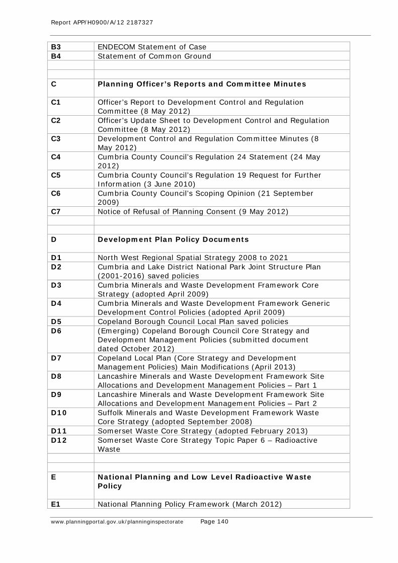
Report APP/H0900/A/12 2187327
www.planningportal.gov.uk/planninginspectorate Page 140
B3 ENDECOM Statement of Case B4 Statement of Common Ground C Planning Officer’s Reports and Committee Minutes
C1 Officer’s Report to Development Control and Regulation
Committee (8 May 2012) C2 Officer’s Update Sheet to Development Control and Regulation
Committee (8 May 2012) C3 Development Control and Regulation Committee Minutes (8
May 2012) C4 Cumbria County Council’s Regulation 24 Statement (24 May
2012) C5 Cumbria County Council’s Regulation 19 Request for Further
Information (3 June 2010) C6 Cumbria County Council’s Scoping Opinion (21 September
2009) C7 Notice of Refusal of Planning Consent (9 May 2012) D Development Plan Policy Documents
D1 North West Regional Spatial Strategy 2008 to 2021 D2 Cumbria and Lake District National Park Joint Structure Plan
(2001-2016) saved policies D3 Cumbria Minerals and Waste Development Framework Core
Strategy (adopted April 2009) D4 Cumbria Minerals and Waste Development Framework Generic
Development Control Policies (adopted April 2009) D5 Copeland Borough Council Local Plan saved policies D6 (Emerging) Copeland Borough Council Core Strategy and
Development Management Policies (submitted document dated October 2012)
D7 Copeland Local Plan (Core Strategy and Development Management Policies) Main Modifications (April 2013)
D8 Lancashire Minerals and Waste Development Framework Site Allocations and Development Management Policies – Part 1
D9 Lancashire Minerals and Waste Development Framework Site Allocations and Development Management Policies – Part 2
D10 Suffolk Minerals and Waste Development Framework Waste Core Strategy (adopted September 2008)
D11 Somerset Waste Core Strategy (adopted February 2013) D12 Somerset Waste Core Strategy Topic Paper 6 – Radioactive
Waste E National Planning and Low Level Radioactive Waste
Policy
E1 National Planning Policy Framework (March 2012)
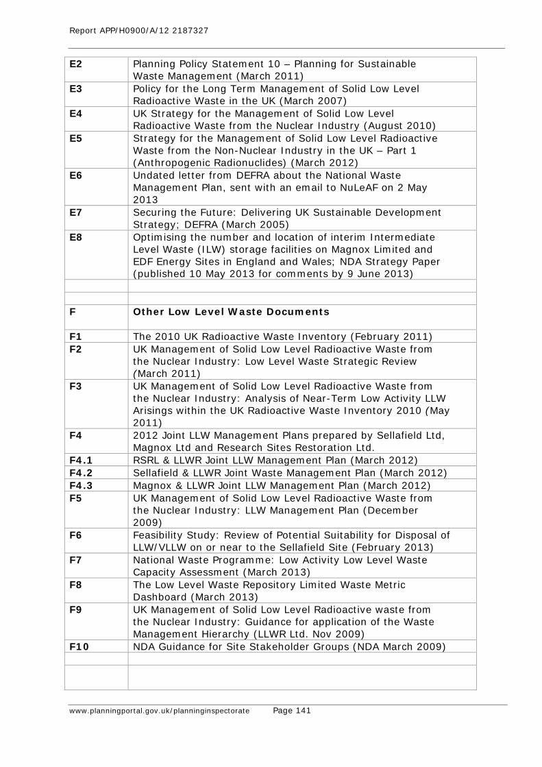
Report APP/H0900/A/12 2187327
www.planningportal.gov.uk/planninginspectorate Page 141
E2 Planning Policy Statement 10 – Planning for Sustainable Waste Management (March 2011)
E3 Policy for the Long Term Management of Solid Low Level Radioactive Waste in the UK (March 2007)
E4 UK Strategy for the Management of Solid Low Level Radioactive Waste from the Nuclear Industry (August 2010)
E5 Strategy for the Management of Solid Low Level Radioactive Waste from the Non-Nuclear Industry in the UK – Part 1 (Anthropogenic Radionuclides) (March 2012)
E6 Undated letter from DEFRA about the National Waste Management Plan, sent with an email to NuLeAF on 2 May 2013
E7 Securing the Future: Delivering UK Sustainable Development Strategy; DEFRA (March 2005)
E8 Optimising the number and location of interim Intermediate Level Waste (ILW) storage facilities on Magnox Limited and EDF Energy Sites in England and Wales; NDA Strategy Paper (published 10 May 2013 for comments by 9 June 2013)
F Other Low Level Waste Documents
F1 The 2010 UK Radioactive Waste Inventory (February 2011) F2 UK Management of Solid Low Level Radioactive Waste from
the Nuclear Industry: Low Level Waste Strategic Review (March 2011)
F3 UK Management of Solid Low Level Radioactive Waste from the Nuclear Industry: Analysis of Near-Term Low Activity LLW Arisings within the UK Radioactive Waste Inventory 2010 (May 2011)
F4 2012 Joint LLW Management Plans prepared by Sellafield Ltd, Magnox Ltd and Research Sites Restoration Ltd.
F4.1 RSRL & LLWR Joint LLW Management Plan (March 2012) F4.2 Sellafield & LLWR Joint Waste Management Plan (March 2012) F4.3 Magnox & LLWR Joint LLW Management Plan (March 2012) F5 UK Management of Solid Low Level Radioactive Waste from
the Nuclear Industry: LLW Management Plan (December 2009)
F6 Feasibility Study: Review of Potential Suitability for Disposal of LLW/VLLW on or near to the Sellafield Site (February 2013)
F7 National Waste Programme: Low Activity Low Level Waste Capacity Assessment (March 2013)
F8 The Low Level Waste Repository Limited Waste Metric Dashboard (March 2013)
F9 UK Management of Solid Low Level Radioactive waste from the Nuclear Industry: Guidance for application of the Waste Management Hierarchy (LLWR Ltd. Nov 2009)
F10 NDA Guidance for Site Stakeholder Groups (NDA March 2009)

Report APP/H0900/A/12 2187327
www.planningportal.gov.uk/planninginspectorate Page 142
G Cumbria Minerals and Waste Development Framework (CMWDF) Examination Documents
G1 CMWDF Site Allocations Policies Text, Maps and Site Assessments (April 2010)
G2 Inspector’s Report on the Examination into the CMWDF Site Allocations Policies and Proposals Map Development Plan Document (December 2010)
G3 CMWDF Repeated Site Allocations Policies and Proposals Map (January 2012)
G4 Inspector’s interim findings paper reference HD44 from the RSAP Examination hearings (May 2012)
G5 Cumbria MWDF CS & GDC policies inspector's report (February 2009)
G6 1.1. Cumbria Minerals and Waste Development Scheme 6th Annual Monitoring Report (December 2010)
G7 1.2. Cumbria MWDF Minerals and Waste Development Scheme (February 2011)
G8 1.3. Cumbria MWDF Site Allocations Policies (adopted January 2011 and subsequently quashed)
H Relevant Planning Appeals
H1 East Northants Resource Management Facility, King’s Cliffe
appeal decision letter dated 24th May 2011 & Inspector’s Report dated 16th February 2011 (PINS ref. APP/K2800/A/10/2126938/NWF)
H2 Ince Marshes Resource Recovery Park, decision letter dated 11th August 2009 & Inspector’s Report dated 3 October 2008 (PINS ref. APP/Z0645/A/07/2059609)
H3 Fairfield Farm, Pica appeal decision dated 20th May 2008 (PINS ref. APP/Z0923/A/07/2056148)
H4 Severnside Energy Recovery Centre, decision letter dated 15th September 2011 & Inspector’s Report dated 18th July 2011 (PINS ref. APP/P0119/A/10/2140199)
H5 Secretary of State for the Environment v Edwards and others [1994] 1 PLR 62
I Habitats Regulations Appraisals and Assessments
I1 Habitats Regulations Appraisal in relation to the SPA Network
(February 2012) I2 Habitats Regulations Assessment in relation to the River Ehen
SAC (April 2012)

Report APP/H0900/A/12 2187327
www.planningportal.gov.uk/planninginspectorate Page 143
J Biodiversity and Ecology Reference Documents J1 UK Biodiversity Action Plan; Priority Habitat Descriptions
(Maddock ed.2008) J2 Cumbria Biodiversity Action Plan; Purple Moor-grass and Rush
Pasture J3 Wildlife Habitat in Cumbria (Nature Conservancy Council) J4 Sandbeds Meadows County Wildlife Site designation (last
review date 21/03/2001) J5 Guidelines for Ecological Impact Assessment in the UK.
(Institute of Ecology & Environmental Management June 2006)
J6 Natural Environment and Rural Communities (NERC) Act 2006; Section 41
K Landscape and Visual Reference Documents K1 Guidelines for Landscape and Visual Impact Assessment (The
Landscape Institute and Institute of Environmental Assessment – 1st ed. 1995 and 2nd ed. 2002)
K2 The Character of England (Countryside Commission 1996): Volume 2 North West – Character Area 7 West Cumbria Coastal Plain
K3 Cumbria Landscape Character Guidance and Toolkit (CCC, March 2011
K4 Cumbria Landscape Classification (Cumbria County Council 1995)
K5 Cumbria Landscape Strategy (Cumbria County Council 1997) K6 Technical Paper 5 Landscape Character (Cumbria County
Council 2003) K7 Landscape Character Assessment - Guidance for England and
Scotland, (The Countryside Agency/Scottish Natural Heritage, 2002).
K8 Visual Representation of Windfarms Good Practice Guidance (Scottish Natural Heritage 2006).
K9 Email to Cumbria County Council dated 21st June 2011 confirming removal of buildings and hardstandings at end of operational phase
K10 Email to Cumbria County Council dated 20 January 2010 with attached letter sent to listed local residents regarding potential for screening
L Cumbria Draft Minerals and Waste Local Plan L1 Draft Cumbria Minerals and Waste Local Plan (February 2013) L2 Draft Cumbria Minerals and Waste Local Plan Sustainability
Appraisal (February 2013) L3 SITA UK consultation response to the Draft Cumbria MWLP
(April 2013)

Report APP/H0900/A/12 2187327
www.planningportal.gov.uk/planninginspectorate Page 144
M Keekle Head Open Cast Documents M1 Open cast planning permission 4/97/9027 dated 15th
September 1998 M2 Section 106 associated with 4/97/9027 dated 15th September
1998 M3 Cumbria CC Development Control & Regulation Committee
Report Paper No.6 (28th August 2003) M4 Enforcement Notice EN08-4001 (against non-compliance with
conditions of planning permission 4/97/9027) dated 20th August 2008, complete with 5 appendices
M5 County Council Local Committee for Copeland Report Paper No.10 (15th September 2008)
M6 Keekle Head Proposed Opencast Coal Site Ecological Survey and Assessment; Jerram, R (1997)
N Other Documents N1 Cumbria Economic Plan 2007 N2 NWRDA consultation response to the Keekle Head application
(11th Feb 2010) N3 Figure 4.8 with scheme features from Figure 4.2A overlain
(May 2013) N4 Cumbria County Council Cabinet Meeting Report Paper no.10
(25th August 2009) N5 FCC Environment’s Lillyhall Landfill pre-application public
exhibition leaflet (February 2013) N6 Augean response to Rule 17 request in DCO application for
ENRMF reference WS010001/ENRMF (14th September 2012) N7 LLWR Site Optimisation and Closure Works application
reference 4/11/9007 – Planning and Design and Access Statement (30th June 2011)
N8 LLWR Site Optimisation and Closure Works application reference 4/11/9007 – ES Appendix B Construction Sequence Final (23rd March 2011)
N9 LLWR Site Optimisation and Closure Works application reference 4/11/9007 – Cumbria CC Reg.22 request for further information (28th November 2011)
N10 Letter dated 20th June 2013 from LLWR Ltd to Mr Evans (CC) N11 Environmental Safety Assessment of the proposal to Reuse
Low Specific Activity material as part of the Final Cap Profile (LLWR Ltd, March 2013)
N12 Letter from Scottish Environment protection Agency dated 2nd May 2013 to Mr Evans CCC (with covering note)
N13 Bundle of 6 OS extracts showing the site at different dates and field patterns, submitted by Mr Mason
N14 Details of windfarms (EDF Energy) submitted by Mr Carter N15 Planning application & planning statement – Modifications to
planning permission 2/93/9033, Lillyhall landfill site N16 LLW Transport Hubs Assessment (draft report) LLWR Ltd,
March 2010.
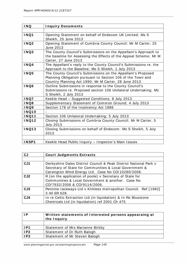
Report APP/H0900/A/12 2187327
www.planningportal.gov.uk/planninginspectorate Page 145
INQ Inquiry Documents INQ1 Opening Statement on behalf of Endecom UK Limited; Ms S
Sheikh, 25 June 2013 INQ2 Opening Statement of Cumbria County Council; Mr M Carter, 25
June 2013 INQ3 The County Council’s Submissions on the Appellant’s Approach to
the baseline for Assessing the Effects of the Appeal Scheme; Mr M Carter, 27 June 2013
INQ4 The Appellant’s reply to the County Council’s Submissions re. the Approach to the Baseline; Ms S Sheikh, 1 July 2013
INQ5 The County Council’s Submissions on the Appellant’s Proposed Planning Obligation pursuant to Section 106 of the Town and Country Planning Act 1990; Mr M Carter, 28 June 2013
INQ6 Outline Submissions in response to the County Council’s Submissions re. Proposed section 106 Unilateral Undertaking; Ms S Sheikh, 2 July 2013
INQ7 Keekle Head – Suggested Conditions; 8 July 2013 INQ8 Supplementary Statement of Common Ground; 4 July 2013 INQ9 Section 178 of the Insolvency Act 1986 INQ10 - INQ11 Section 106 Unilateral Undertaking; 5 July 2013 INQ12 Closing Submissions of Cumbria County Council; Mr M Carter, 5
July 2013 INQ13 Closing Submissions on behalf of Endecom; Ms S Sheikh, 5 July
2013 INSP1 Keekle Head Public Inquiry – Inspector’s Main Issues CJ Court Judgments Extracts CJ1 Derbyshire Dales District Council & Peak District National Park v
Secretary of State for Communities & Local Government & Carsington Wind Energy Ltd. Case No CO/10280/2008.
CJ2 R (on the application of poole) v Secretary of State for Communities & Local Government & another. Case No CO/7632/2006 & CO/9114/2006.
CJ3 Pennine raceways Ltd v Kirklees metropolitan Council. Ref [1982] 3 All ER 628.
CJ4 In re Celtic Extraction Ltd (in liquidation) & In Re Bluestone Chemicals Ltd (in liquidation) ref 2001 Ch 475
IP Written statements of Interested persons appearaing at
the Inquiry IP1 Statement of Mrs Marianne Birkby IP2 Statement of Dr Ruth Balogh IP3 Statement of Mr Steven Balogh

Report APP/H0900/A/12 2187327
www.planningportal.gov.uk/planninginspectorate Page 146
IP4 Statement of Mr Colin Wales PID Post Inquiry Documents PID1 Email from CCC to Planning Inspectorate 12th August 2013,
concerning Permission for ENMRF PID2 Letter from Endecom to the Planning Inspectorate 13th August
2013, concerning Permission for ENMRF
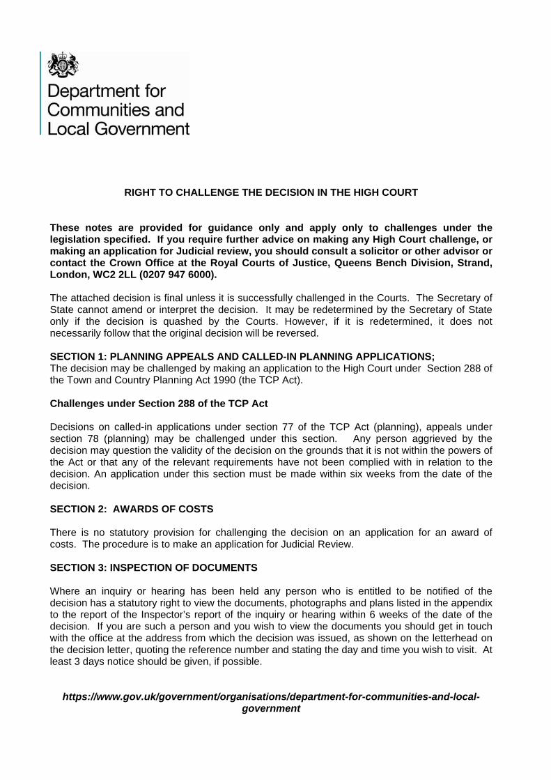
RIGHT TO CHALLENGE THE DECISION IN THE HIGH COURT
These notes are provided for guidance only and apply only to challenges under the legislation specified. If you require further advice on making any High Court challenge, or making an application for Judicial review, you should consult a solicitor or other advisor or contact the Crown Office at the Royal Courts of Justice, Queens Bench Division, Strand, London, WC2 2LL (0207 947 6000). The attached decision is final unless it is successfully challenged in the Courts. The Secretary of State cannot amend or interpret the decision. It may be redetermined by the Secretary of State only if the decision is quashed by the Courts. However, if it is redetermined, it does not necessarily follow that the original decision will be reversed. SECTION 1: PLANNING APPEALS AND CALLED-IN PLANNING APPLICATIONS; The decision may be challenged by making an application to the High Court under Section 288 of the Town and Country Planning Act 1990 (the TCP Act). Challenges under Section 288 of the TCP Act Decisions on called-in applications under section 77 of the TCP Act (planning), appeals under section 78 (planning) may be challenged under this section. Any person aggrieved by the decision may question the validity of the decision on the grounds that it is not within the powers of the Act or that any of the relevant requirements have not been complied with in relation to the decision. An application under this section must be made within six weeks from the date of the decision. SECTION 2: AWARDS OF COSTS There is no statutory provision for challenging the decision on an application for an award of costs. The procedure is to make an application for Judicial Review. SECTION 3: INSPECTION OF DOCUMENTS Where an inquiry or hearing has been held any person who is entitled to be notified of the decision has a statutory right to view the documents, photographs and plans listed in the appendix to the report of the Inspector’s report of the inquiry or hearing within 6 weeks of the date of the decision. If you are such a person and you wish to view the documents you should get in touch with the office at the address from which the decision was issued, as shown on the letterhead on the decision letter, quoting the reference number and stating the day and time you wish to visit. At least 3 days notice should be given, if possible.
https://www.gov.uk/government/organisations/department-for-communities-and-local-government