an evaluation of ecosystem restoration and management ... · an evaluation of ecosystem restoration...
TRANSCRIPT

AN EVALUATION OF ECOSYSTEM
RESTORATION AND
MANAGEMENT OPTIONS
FOR
LEE METCALF NATIONAL WILDLIFE REFUGE
Prepared For:
U.S. FISH AND WILDLIFE SERVICEREGION 6
DENVER, COLORADO
By:
Mickey E. HeitmeyerGreenbrier Wetland Services
Advance, MO
Michael J. ArtmannU.S. Fish and Wildlife ServiceRegion 6 Division of Planning
Denver, CO
Leigh H. FredricksonWetland Management and Education Services, Inc.
Puxico, MO
Greenbrier Wetland Services Report No. 10-02
May 2010

ii
This publication printed on recycled paper by
Mickey E. Heitmeyer, PhDGreenbrier Wetland Services
Route 2, Box 2735Advance, MO 63730
www.GreenbrierWetland.com
Publication No. 10-02
Suggested citation:
Heitmeyer, M. E., M. J. Artmann, L. H. Fredrick-son. 2010. An evaluation of ecosystem restoration and management options for Lee Metcalf National Wildlife Refuge. Prepared for U. S. Fish and Wild-life Service, Region 6, Denver, CO. Greenbrier Wet-land Services Report 10-02. Blue Heron Conserva-tion Design and Printing LLC, Bloomfield, MO.
Photo credits:
Cover photo by Karen Kyle U. S. Fish & Wildlife Service (www.fws.gov/digital media)and Karen Kyle

iii
CONTENTS
EXECUTIVE SUMMARY ..................................................................................... v
INTRODUCTION ................................................................................................ 1
THE HISTORIC LEE METCALF ECOSYSTEM ................................................ 3
GEOLOGY, SOILS, TOPOGRAPHY ........................................................ 3
Geology ............................................................................................ 3
Soils ................................................................................................. 5
Topography and Elevation ................................................................ 9
CLIMATE AND HYDROLOGY ................................................................ 9
LAND COVER AND VEGETATION COMMUNITIES ....................... 14
KEY ANIMAL COMMUNITIES ............................................................. 16
CHANGES TO THELEE METCALF ECOSYSTEM ........................................................................... 19
Settlement and Land Use Changes ............................................................. 19
Hydro-geomorphologic Changes ................................................................ 21
Acquisition and Development of Lee Metcalf NWR .................................. 28
Vegetation Communities ............................................................................ 29
Fish and Wildlife Populations ..................................................................... 35
ECOSYSTEM RESTORATION AND MANAGEMENT OPTIONS .................................................................... 39
A SUMMARY OF CONDITIONS .......................................................... 39
SPECIFIC RECOMMENDATIONS FOR RESTORATION AND MANAGEMENT OPTIONS ............................. 47
Restore the Physical and Hydrological Character of the Bitterroot River System ........................................ 47
ji

iv
Restore Floodplain Topography, Water Regimes, and Water Flow Patterns ....................................... 48
Restore Natural Vegetation Communities ....................................... 48
MONITORING AND EVALUATION ............................................................... 51
Maintaining the Physical/Hydrological Integrity of the Bitterroot River and its Floodplain ..................................... 51
Restoring Natural Regimes and Water Flow Patterns .................................. 51
Long Term Changes in Vegetation and Animal Communities .................... 52
ACKNOWLEDGEMENTS ................................................................................. 53
LITERATURE CITED ........................................................................................ 55
APPENDICES ...................................................................................................... 59
1 CONTENTS, cont’ d.
Kar
en K
yle

v
EXECUTIVE SUMMARY
ee Metcalf National Wildlife Refuge (NWR) is a rela-tively small (ca. 2,800 acre) refuge in the Bitterroot River Valley of southwest Montana. The refuge was
authorized for management of migratory birds and incidental fish and wildlife-orient recreation, protection of natural resources, and conservation of endangered and threatened species. The historic ecosystem in the Bitterroot Valley contained diverse forest, wet meadow, grassland, and wetland communities. This ecosystem now is highly altered and degraded from construction of extensive roads, ditches, levees, dams, and water-control structures in the Bitterroot River floodplain; tile drainage and discharge from surrounding agricultural lands; water diversions and irrigation systems on and adjacent to the refuge, and expansion of invasive plant species. The channel of the Bitterroot River has been altered from levees, bank stabilization, and some channelization. Lee Metcalf NWR also is located in an area of rapid human popu-lation growth and residential development and is extensively used by the public.
In 2009, a Comprehensive Conservation Plan (CCP) was initiated for Lee Metcalf NWR. This CCP process is being facilitated by an evaluation of ecosystem restoration and management options using hydrogeomorphic methodology (HGM). This report provides HGM analyses for Lee Metcalf NWR with the following objectives:
1 CONTENTS, cont’ d.
ji

vi
1. Identify the pre-European ecosystem condition and ecological processes in the Bitterroot River floodplain near Lee Metcalf NWR.
2. Evaluate changes in the Lee Metcalf NWR ecosystem from the Presettlement period with specific reference to alterations in hydrology, vegetation community structure and distribution, and resource availability to key fish and wildlife species.
3. Identify restoration and management options and eco-logical attributes needed to successfully restore specific habitats and conditions within the area.
The Bitterroot River Valley extends about 120 miles from the confluence of the East and West Forks of the Bitterroot River south of Darby to its junction with the Missoula Valley and Clark Fork River five miles south of Missoula. The Valley is a structural trough formed during the late Cretaceous emplacement of the Idaho batholiths and is bounded by the Bitterroot Mountains on the west and the Sapphire Mountains on the east. Four geomorphic surface zones occur on or near Lee Metcalf NWR and include: 1) Holocene floodplain of the Bitterroot Valley, 2) low elevation alluvial fans that extend into the floodplain, 3) high elevation, mostly Quaternary-derived terraces adjacent to the floodplain on the west side of the valley, and 4) high elevation Tertiary-derived outcrop benches/terraces on the east side of the valley.
The Bitterroot River has inherent unstable hydraulic configuration and high channel instability. The river reach immediately upstream from Lee Metcalf NWR has a complex multi-strand channel pattern that is characterized by numerous braided channels that historically spread over a wide area of the valley bottom. The main channel system has widened and straightened since 1937 and bank erosion is common. Chutes and side channels facilitate overbank flooding and complex networks of minor floodplain drainage channels occur throughout the floodplain. Two major tribu-taries to the Bitterroot River (North Burnt Fork Creek and Three Mile Creek) flow through Lee Metcalf NWR.

vii
Nearly 25 soil types are present on or adjacent to Lee Metcalf NWR and the juxtaposition of soils reflects the numerous channel migrations of the Bitterroot River across the floodplain. Most soils on the refuge are shallow, with thin veneers of silt and clay over deeper sand and gravel. Sandy subsoil layers outcrop in many places near the river.
The climate of the Bitterroot Valley is characterized by cool summers, low precipitation, and relatively mild winters. Annual precipitation averages about 13 inches, but is variable related to position in the valley. The growing season is about 103 days. Spring is the wettest period of the year, with about 25% of annual precipitation falling in May and June. Runoff in the Bitterroot River is highest in spring, with about 55% of annual river discharge occurring in May and June following snowmelt and local rainfall. Flows in the Bitterroot River decline throughout summer and remain relatively stable through winter. The river exceeds 1,050 cubic-feet/second (cfs) at a 50% annual recurrence interval and causes some water to back flood into floodplain depressions and drainages. Modest overbank flooding occurs at > 10,000 cfs and a > 50-year recurrence interval. The last major overbank flood event at Lee Metcalf NWR was in 1974.
Historic vegetation in the Bitterroot River floodplain at Lee Metcalf NWR included seven distinct habitat/community types: 1) Riparian/Riverfront-type Forest, 2) floodplain Gallery-type Forest, 3) Persistent Emergent, 4) Wet Meadow Herbaceous, 5) Floodplain and Terrace Grassland, 6) Saline Grassland, and 7) Grassland-Sagebrush. Riverfront Forest contains mainly cottonwood and willow on newly deposited and scoured gravelly-sand and fine sandy loam soils near the active channel of the Bitterroot River. Gallery Forest is dominated by cottonwood and ponderosa pine, has a shrub understory, and is present on higher floodplain elevations with veneers of Chamokane loam soil along natural levees and point bar terraces adjacent to minor floodplain tributaries. Low elevation oxbows, depressions, and off-channel areas historically supported Persistent Emergent wetland vegetation such as cattail. These habitats typically have poorly drained Slocum loam-clay soils. Some sites adjacent to Persistent

viii
Emergent communities contained diverse Wet Meadow vegetation dominated by sedges, rushes, and water tolerant grasses. The majority of higher elevations within the Lee Metcalf NWR floodplain region were covered with grasses and some scattered shrubs. Sites that had occasional surface flooding contained wet Grassland communities with inter-spersed herbaceous plants such as smartweed and sedges, while higher floodplain terraces, slopes, and alluvial fans contained mixed grasses and shrubs such as rabbit brush, sage, needle and thread, and june grass. Certain sites on Lee Metcalf NWR have saline soils that historically supported more salt tolerant grassland species. A composite map of potential historic vegetation communities, based on HGM attributes, is presented.
The Bitterroot River floodplain at Lee Metcalf NWR historically supported a wide diversity of animal species asso-ciated with the interspersed riverine, floodplain, wetland, and grassland habitats. Migratory birds are especially abundant in the region. Resources historically used by animals were seasonally dynamic and annually variable. Most bird species exploited seasonal resources during spring migration and summer; few species overwintered in the area. Many waterbird likely stayed in the Valley during wet summers to breed when floodplain wetlands had more extensive and prolonged water regimes. In contrast, limited numbers of waterbirds probably bred in the region in dry years.
The first European settlement in Montana was established at the present day site of Stevensville, near the Lee Metcalf NWR, in 1841. Early land use of the valley was primarily cattle grazing. Discovery of gold in western Montana in the mid-1950s fueled immigration of settlers to the state and a short lived flurry of gold exploration and mining occurred in the Bitterroot Valley. By the 1870s, the economy of the area was almost solely based on local agricultural crops, cattle production and some timber harvest. The dry climate of the valley created annual variation in the availability of water to support crops, and water rights in the region were quickly appropriated and subsequent adjudication occurred. In the early 1900s, the Bitterroot Valley Irrigation

ix
Company started construction of a major irrigation system including construction of Lake Como, a diversion dam on Rock Creek, many miles of conveyance canal, and associated siphons, distribution ditches, and water-control structures. Drought, insufficient water delivery for orchard crops, and Depression era economics exacerbated water problems in the valley and ultimately curtailed large scale agricultural development in the region in the mid 1900s. The Bureau of Reclamation assumed operation of the Irrigation Company in the early 1930s and has made extensive improvements and repair to the irrigation delivery system to its current condition.
Agricultural and irrigation developments and increasing human populations greatly altered the Bitterroot Valley by the time the Lee Metcalf NWR was established in 1963. Most Riparian and Gallery Forest and floodplain grassland was cut, cleared, and/or converted to alternate land uses by the mid 1900s. Irrigation ditches significantly altered floodplain drainage and hydrology. Numerous roads were built in the region and a rail line and bridge was constructed at the north boundary of Lee Metcalf NWR. By the early 1990s, Ravalli County had the fastest growing population and residential expansion in Montana, which now surrounds the refuge. Irrigation development and changed land uses significantly altered hydrology and channel morphology of the Bitterroot River and caused degradation and loss of wetlands in this ecosystem.
Following acquisition, the U.S. Fish and Wildlife Service began extensive physical developments on floodplain lands at Lee Metcalf NWR. By the late 1980’s, over 1,000 acres had been partly or completely impounded in 14 ponds for managed wetland units. These impoundments have been subsequently managed by diverting irrigation and tile drain water, flows in minor channels and tributaries, and Three Mile Creek water into and through the impoundments. Lee Metcalf NWR has 24 water rights claims and one permit totaling 50,495 acre-feet/year. Since establishment, most wetland impound-ments have been managed to promote waterfowl production by holding water through summer or year round. Otter Pond

x
was stocked with warm-water fish in 1989. Level ditching, siphons, water-control structures, and sediment removal have been constructed in and near impoundments. Over 25 miles of road are present on the refuge. Certain upland areas were converted to warm-season grasses for dense nesting cover for waterfowl and predator exclusion fences were built around some fields. In the 1960s and early 1970s, some fields on the refuge were planted to small grains.
Collectively, the many landscape and hydrological changes in the Bitterroot Valley have dramatically changed the ecosystem at Lee Metcalf NWR, which now has: 1) reduced area of Riparian and Gallery Forest, 2) Increased Persistent Emergent and Open Water habitat, 3) increased Herbaceous Wetland, 4) decreased native Grassland, 5) increased agricultural and tame grass fields, and 6) increased invasive and exotic plant species. These vegetation community changes also have caused changes, and declines, in abundance and distribution of native animal species. Many of the management developments at Lee Metcalf NWR have attempted to convert this semi-arid and inherently dynamic western river floodplain-terrace ecosystem into more of a Northern Great Plains wetland basin system that supported consistent and higher waterfowl production. In essence, management and development of Lee Metcalf NWR since the 1960s have not been consistent with the naturally occurring physical, biotic, and sustaining ecological features of the site.
This report identifies options to restore and manage natural ecosystem processes, functions, and values at Lee Metcalf NWR based on hydrogeomorphic characteristics of the historic and current system. Comprehensive restoration of native communities and sustaining processes will be difficult because of: 1) the small size of the refuge, 2) the insular nature of the refuge that increasingly is surrounded by urban/residential development, 3) highly modified landforms and communities on and adjacent to the refuge, 4) constraints on sustaining the inherently unstable morphology and hydrology of the Bitterroot River, and 5) high public use and competing demands for refuge management and access. Despite these

xi
challenges, future management of Lee Metcalf NWR should seek to:
1. Maintain the physical and hydrological character of the Bitterroot River and its floodplain on Lee Metcalf NWR.
2. Restore the natural topography, water regimes, and physical integrity of surface water flow patterns in and across the Bitterroot River floodplain and adjacent terraces and alluvial fans.
3. Restore and maintain the diversity, composition, distribution, and regenerating mechanisms of native vegetation communities in relationship to topographic landscape position.
Specific recommendations are provided to conduct restoration and management options for each of the above goals and to monitor and evaluate future management in an adaptive management framework.
Karen Kyle

xii
Karen Kyle

Lee Metcalf NWR
O
Figure 1. General location of Lee Metcalf National Wildlife Refuge.
1
Qfao Qfao bTgTbgQfay
TafTbg
Qbf o
TYb Qtay
Qfay
Qat yTaf
Qla
QfayQfao
bTg
Qfay
bTg
bTc
Taf
YTb
Qaf oTaf
Missoula, MT
Hamilton, MT
Lee Metcalf NWR
Legend
INTRODUCTION
Lee Metcalf National Wildlife Refuge (NWR), owned and managed by the U.S. Fish and Wildlife Service (USFWS), is a relatively small (ca. 2,800 acre) refuge in Ravalli County in the Bitterroot Valley of southwest Montana about 20 miles south of Missoula (Fig. 1). The refuge was established in 1963 and was originally named the Ravalli NWR. The name was changed to Lee Metcalf NWR in 1978 in honor of long-time U.S. Senator Lee Metcalf who was instrumental in establishing the refuge and was involved in many other conservation initia-tives. The authorizing purposes for the refuge were: 1) “for use as an inviolate sanctuary, or for any other management purpose, for migratory birds” (Migratory Bird Conservation Act, 16 USC 715d) and 2) “suitable for incidental fish and wildlife-oriented recreational development, the protection of natural resources, and the con-servation of endangered species or threatened species” (16 USC 460k-2; Refuge Recreational Act 16 USC 460k, as amended).
Lee Metcalf NWR borders the Bit-terroot River between the scenic Bitterroot and Sapphire Mountain ranges and is within a rapidly expanding human population area of Montana. This unique location includes a diverse mosaic of western mountain valley ecosystem types and provides many public use opportunities including recreation, education and discovery, and research activities. Currently, intensive agriculture, housing, strip malls, and other urban amenities in the Bitterroot Valley surround the refuge. A golf course is present at the refuge boundary and has a large number of daily visitors. The nearby Bitterroot National Forest is visited by several thousand people each year, and Lee Metcalf NWR has over 140,000 visitors and
2,000 hunters annually. The refuge has an active Friends Group and volunteer program.
The Lee Metcalf NWR ecosystem has been altered by extensive roads, ditches, levees, dams, and water-control structures in the Bitterroot River flood-plain; tile drainage and discharge from surround agricultural lands; water diversions and irrigation systems adjacent to, and within, the refuge; and expansion of invasive plant species. A frontline levee
Figure 1. General location of Lee Metcalf National Wildlife Refuge.
ji

�M. E. Heitmeyer et al.
along the Bitterroot River was constructed in the 1970s after a major flood event in 1974 and a complex network of water-control infrastructure was con-structed for wetland management impoundments after the refuge was established. The refuge does not have senior water rights; but adjudication is an on-going process to be completed in 2015.
Three major irrigation ditches (McElhaney, Warburton, and Alleman Ditches) flow into and through the refuge. Additionally two primary tile drain ditches (Middle and South Drains) that originate on surround private farm lands provide year-round water flow into the refuge. Extensive bank erosion on the Bitterroot River is present in many locations, and in some places levees and other water-control structures in wetland impoundments or “ponds” are in danger of being compromised by this erosion. Extensive areas of the Bitterroot River channel are rip-rapped to control erosion and river channel migration. Part of the river also has been channelized immediately upstream from an old railroad bridge across the Bitterroot River.
Past management of Lee Metcalf NWR primarily has been directed at increasing waterfowl production, especially dabbling ducks. Consequently, a series of wetland impoundments were constructed to provide more annually stable and consistent water levels on the refuge. This more prolonged water regime gradually shifted plant communities to wetter types, including extensive monocultures of cattail in deeper areas. Other intensive waterfowl production management included establishment of dense nesting cover and construction of predator fences to enhance duck nesting success; construction of islands and level-ditch dredge and spoil areas within impound-ments; and compartmentalization of wetland units.
In 2009, the USFWS initiated preparation of a Comprehensive Conservation Plan (CCP) for Lee Metcalf NWR. The CCP process seeks to articulate the management direction for the refuge for at least the next 15 years and it develops goals, objectives, and strategies to define the role of the refuge and its contribution to the overall mission of the National Wildlife Refuge system. At Lee Metcalf NWR, the CCP process is being facilitated by an evaluation of ecosystem restoration and management options using Hydrogeomorphological Methodology (HGM). HGM now is commonly used to evaluate ecosystems on National Wildlife Refuges (e.g., Heitmeyer and Fred-rickson 2005, Heitmeyer et al. 2006, Heitmeyer and Westphall 2007, Heitmeyer et al. 2009) by obtaining and analyzing historic and current information about:
1) geology and geomorphology, 2) soils, 3) topography and elevation, 4) hydrology, 5) plant and animal com-munities, and 6) physical anthropogenic features of refuges and surrounding landscapes. Specifically, HGM analyses for Lee Metcalf NWR: 1) uses the above information to develop appropriate, realistic, and sustainable options for “habitat-based” objectives on the refuge; 2) seeks to emulate natural hydro-logical and vegetation/animal community patterns and dynamics within the Bitterroot River floodplain ecosystem; 3) understands, complements, and at least partly mitigates negative impacts and altera-tions to Lee Metcalf NWR and surrounding lands; 4) incorporates “state-of-the-art” scientific knowledge of ecological processes and requirements of key fish and wildlife species in the region; and 5) identifies important monitoring needs of abiotic and biotic features.
This report provides HGM analyses for Lee Metcalf NWR with the following objectives:
1. Identify the pre-European settlement (hereafter “Presettlement”) ecosystem condition and eco-logical processes in the Bitterroot River flood-plain near Lee Metcalf NWR.
2. Evaluate changes in the Lee Metcalf NWR ecosystem from the Presettlement period with specific reference to alterations in hydrology, vegetation community structure and distri-bution, and resource availability to key fish and wildlife species.
3. Identify restoration and management options and ecological attributes needed to successfully restore specific habitats and conditions within the area.
Bob
Gre
ss U
SF
WS

3
THE HISTORIC LEE METCALF ECOSYSTEM
GEOLOGY, SOILS, TOPOGRAPHY
Geology
The Bitterroot Valley, where the Lee Metcalf NWR is located, is a north-trending basin bounded by the Bitterroot Mountains on the west and the Sapphire Mountains on the east. The origin of these mountains, and the rich montane Bitterroot Valley, date to nearly 90 million years before the present (Hodges and Applegate 1993). The Bitterroot Valley extends about 120 miles from the confluence of the East and West Forks of the Bitterroot River south of Darby to its junction with the Missoula Valley and Clark Fork River five miles south of Missoula. The elevation of the valley floor ranges from about 3,900 feet above mean sea level (amsl) in the south to about 3,200 feet amsl near Missoula. Summit elevations of surrounding mountains range from 6-8,000 feet amsl in the Sapphire Range and exceed 9,500 feet amsl in the Bitterroot Range. Four general geomorphologic zones occur in the Bitterroot Valley and include: 1) the Holocene (geologic timeframe is provided in Appendix A) floodplain of the Bitterroot River, 2) low elevation alluvial fans that extend into the flood-plain, 3) high elevation, mostly Quaternary-derived, terraces adjacent to the floodplain on the west side of the valley, and 4) high elevation Tertiary-derived outcrop benches/terraces on the east side of the valley (Lonn and Sears 1998, 2001). The floodplain contains highly heterogeneous vertical and hori-zontal bands of mostly sandy and gravelly alluvium about 3 miles wide.
The Bitterroot Valley is a structural trough formed during the late Cretaceous emplacement of the Idaho batholiths (Ross 1950, McMurtrey et al. 1972, Hyndman et al. 1975). The Bitterroot Mountains are composed of granitic rocks, metamorphic materials,
and remnants of pre-Cambrian sediments of the Belt series. The Idaho batholiths, predominantly gray quartz monzonite with small amounts of grandodi-orite and anorthite, form the core of the Bitterroot Range. A veneer of gneissic metamorphic material about 2,000 feet thick drapes the range’s eastern front (McMurtrey et al. 1972). The Sapphire Mountains are mostly Belt rocks with localized occurrences of granitic stocks. Outcrops of Belt rock include dark-gray quartzite and argillaceous limestone and limy argillites of the Newland formation.
The unusually straight front of the Bitterroot Range is a zone of large-scale faulting (Langton 1935, Pardee 1950); however, the Bitterroot Valley shows little sign of recent tectonic activity (Hyndman et al. 1975). Undisturbed valley fill indicates that tectonic movement since the early Pliocene has been slight or that the entire valley floor has moved as a single unit. The structural basin of the Bitterroot Valley has accumulated a considerable thickness of Tertiary sediments capped in most places by a layer of Quaternary materials. Surficial geology evidence suggests Tertiary fill in the Bitterroot Valley may be up to 4,000 feet thick in some locations (Lankston 1975). This fill is highly variable in context with mostly Six-Mile gravelly formation and finer-grain Renova formation (Noble et al. 1982, Uthman 1988). Sediment is coarse colluviums near the fronts of mountains with finer-grain alluvial fill deposits that interfinger with floodplain silts and clays. Channel deposits of the ancestral Bitterroot River lie beneath the valley center. Tertiary sediments outcrop only on the high terraces of the east side of the valley. Average thickness of Quaternary sediments is about 40 feet of alluvium over the Tertiary strata. The ends of the high Tertiary terraces on the east and most of the west-side terrace surfaces are capped by early to mid-Pleistocene alluvium, while the low terraces and
ji

�M. E. Heitmeyer et al.
current floodplain are composed of late Pleistocene and Holocene alluvium.
Quaternary alluvium on high terraces in the valley is mostly unconsolidated sediments of fluvial, glaciofluvial, and glaciolacustrine origin. Low terrace alluvium occurs as outwash, or “alluvial fans”, below the mouths of tributaries on both sides of the valley (Lonn and Sears 2001). Floodplain alluvium is mostly well-rounded gravel and sand with a minor amount of silt and clay derived from the edges of the adjacent terraces and fans. Most of Lee Metcalf NWR is mapped as “Qal” alluvial deposits of recently active channels and floodplains (Fig. 2). These deposits are well-rounded, and sorted gravel and sand with a minor amount of silt and clay. Clast lithologies represent rock types of the entire drainage including granitic, volcanic, metamorphic, and sedimentary rocks. Minor amounts of “Qaty” (younger alluvial outwash terrace
and fan complex deposits from the late Pleistocene) occur adjacent to the Bitterroot Valley alluvium on the north end of the Lee Metcalf NWR. These surfaces are late Pleistocene alluvium of the Riverside and Hamilton terraces and rise 10-20 feet above the present floodplain and are approximately 10-30 feet thick. Materials in these terraces are well-rounded and sorted gravel of predominantly granitic, gneissic, and Belt sedimentary origin (Lonn and Sears 2001). “Qafy” surfaces extend along the Bitterroot Valley on both sides of Lee Metcalf NWR. These surfaces are younger (late Pleistocene) alluvial outwash terrace and fan complexes of well-rounded cobbles and boulders in a matrix of sand and gravel deposited in braided-stream environments that formed between and below the dissected remnants of older fans. These surfaces appear to have been at least partly shaped by glacial Lake Missoula that reached a maximum height at
an elevation of 4,200 feet and covered theduyeaSuabocoadeabo
entanbetve
Bitterroot Valley near Lee Metcalf ring the last glacial advance 15-20,000 rs before the present (Weber 1972).
rfaces of these deposits are 5-25 feet ve active channels. Some alluvial fans lesce with younger alluvial terrace
posits; average thickness of fans is ut 40 feet.
The Bitterroot River has an inher-ly unstable hydraulic configuration
d high channel instability, particularly ween the towns of Hamilton and Ste-
nsville (Cartier 1984, Gaeuman 1997). The river reach immediately upstream from Lee Metcalf NWR has a complex multi-strand channel pattern that is characterized by numerous braided, or anastomosing, channels that spread over a wide area of the valley bottom. The zone of non-vegetated gravels associated with main braided channel system has widened and straightened since 1937 (Gaeuman 1997). In addition to this widening, severe bank erosion is common but numerous cut-off chutes counteract some lateral bend dis-placement. Chutes and other avenues of river overflow are encouraged by low river banks and natural levees, which were never highly accreted because of active river movements and a braided river channel configuration. Complex networks of minor channels occur in
Q
Qaty
Qal
Qafy
Geomorphic surface
Qafy
Qal
Qaty
O0 0.25 0.5 1 Miles
Figure 2. Geomorphic surfaces on Lee Metcalf National Wildlife Refuge (from Lonn and Sears 2001). “Qal” – Quaternary alluvial deposits. “Qafy” – Holocene alluvial outwash terraces and fan complexes. “Qaty” – Pleis-tocene alluvium of late Riverside and Hamilton terraces.
aty
Qafo
Figure 2. Geomorphic surfaces on Lee Metcalf National Wildlife Refuge (from Lonn and Sears 2001). “Qal” – Quaternaryalluvial deposits. “Qafy” – Holocene alluvial outwash terraces and fan complexes. “Qaty” – Pleistocene alluvium of late Riversideand Hamilton terraces.
�Ecosystem restoration and management options for Lee Metcalf National Wildlife Refuge
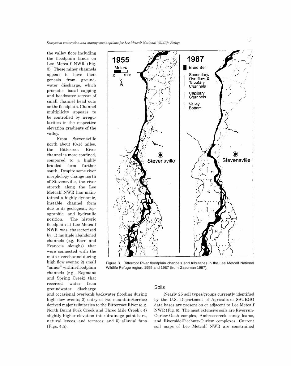
the valley floor including the floodplain lands on Lee Metcalf NWR (Fig. 3). These minor channels appear to have their genesis from ground-water discharge, which promotes basal sapping and headwater retreat of small channel head cuts on the floodplain. Channel multiplicity appears to be controlled by irregu-larities in the respective elevation gradients of the valley.
From Stevensville north about 10-15 miles, the Bitterroot River channel is more confined, compared to a highly braided form further south. Despite some river morphology change north of Stevensville, the river stretch along the Lee Metcalf NWR has main-tained a highly dynamic, instable channel form due to its geological, top-ographic, and hydraulic position. The historic floodplain at Lee Metcalf NWR was characterized by: 1) multiple abandoned channels (e.g. Barn and Francois sloughs) that were connected with the main river channel during high flow events; 2) small “minor” within-floodplain channels (e.g., Rogmans and Spring Creek) that received water from groundwater discharge and occasional overbank backwater flooding during high flow events; 3) entry of two mountain/terrace derived major tributaries to the Bitterroot River (e.g. North Burnt Fork Creek and Three Mile Creek); 4) slightly higher elevation inter-drainage point bars, natural levees, and terraces; and 5) alluvial fans (Figs. 4,5).
SoilsNearly 25 soil types/groups currently identified
by the U.S. Department of Agriculture SSURGO data bases are present on or adjacent to Lee Metcalf NWR (Fig. 6). The most extensive soils are Riverrun-Curlew-Gash complex, Ambrosecreek sandy loams, and Riverside-Tiechute-Curlew complexes. Current soil maps of Lee Metcalf NWR are constrained
Figure 3. Bitterroot River floodplain channels and tributaries in the Lee Metcalf National Wildlife Refuge region, 1955 and 1987 (from Gaeuman 1997).

�M. E. Heitmeyer et al.
1940s Channels/SloughsBarn Slough
N. Burnt Fork Creek
Francois Slough
McPherson Creek
Nickerson
North Island Slough
Oxbow
Rogman's Creek
Spring Creek
Three Mile Creek
O
Figure 4. Aerial photograph of the Lee Metcalf National Wildlife Refuge region in 1940 showing major floodplain drainages and abandoned channels of the Bitterroot River.
Blue Heron Conservation Design and Printing LLC | 2009
Figure 4. Aerial photograph of the Lee Metcalf National Wildlife Refuge region in 1940 showing major floodplain drainagesand abandoned channels of the Bitterroot River.

�Ecosystem restoration and management options for Lee Metcalf National Wildlife Refuge
Figure 5. Location of major alluvial fans along the Bitterroot River Valley (modified from Lonn and Sears 1998).

�M. E. Heitmeyer et al.
Soils
Ambrosecreek sandy loam, 0 to 4 percent slopes
Ambrosecreek sandy loam, 4 to 8 percent slopes
Chereete-Curlew complex, 0 to 45 percent slopes
Curlew-Riverrun complex, 0 to 2 percent slopes
Drygulch coarse sandy loam, 0 to 4 percent slopes
Fredburr fine sandy loam, 0 to 2 percent slopes
Gash-Riverrun complex, 0 to 2 percent slopes
Grayhorse silt loam, 0 to 4 percent slopes
Grayhorse-Owenfort complex, 0 to 2 percent slopes
Hamilton silt loam, 0 to 4 percent slopes
Hamilton-Overwhich complex, 0 to 2 percent slopes
Histic Endoaquolls-Curlew-Water complex, 0 to 2 percent slopes
Holloron loam, 0 to 4 percent slopes
Owenfort complex, 1 to 4 percent slopes
Owenfort very cobbly loam, 1 to 4 percent slopes
Riverrun complex, 0 to 2 percent slopes
Riverrun-Canarway-Fredburr complex, 0 to 2 percent slopes
Riverrun-Curlew complex, 0 to 2 percent slopes
Riverrun-Gash complex, 0 to 2 percent slopes
Riverrun-Gash-Curlew complex, 0 to 2 percent slopes
Riverside-Tiechute-Curlew complex, 0 to 40 percent slopes
Riverwash-Water-Riverrun complex, 0 to 2 percent slopes
Sweathouse, sodic-Fairway complex, 0 to 2 percent slopes
Tiechute-Holloron complex, 0 to 4 percent slopes
Water
O0 0.25 0.5 1 Miles
Figure 6. Soils on Lee Metcalf National Wildlife Refuge (from U.S. Department of Agriculture SSURGO data bases).Figure 6. Soils on Lee Metcalf National Wildlife Refuge (from U.S. Department of Agriculture SSURGO data bases).

�
by numerous water impoundments where no soil type is identified and the impoundment areas are listed as “water.” Consequently, older soil surveys (e.g., Bourne et al. 1959), despite using different soil taxonomy names, are more useful to understand soil types and distribution on the refuge prior to major floodplain developments and impoundment construction and are used in this report to construct HGM matrices of historic distribution of plant communities. The juxtaposition of soils on the NWR is complex, highly interspersed, and reflects the numerous channel migration events across this floodplain, introduction of mixed-erosion sediments from surrounding Quaternary and Tertiary terraces, and alluvial deposition of Bitterroot Valley parent materials. Most soils on the NWR are shallow, with thin veneers of silts and clays overlying deeper sands and gravels. In many places sandy outcrops occur, especially near the Bit-terroot River.
Topography and ElevationElevations on Lee Metcalf NWR
range from about 3,230 on the north end to about 3,260 on the south end of the refuge (Figs. 7, 8). Much topographic heteroge-neity occurs within the refuge related to historic Bitterroot River channel and tributary channel migrations, scouring and natural levee depo-sition along minor floodplain channels, and alluvial deposition. A large portion of the southeast part of the refuge contains higher, more uniform, elevations while north and west parts of the refuge have lower, more diverse, elevations. Alluvial fans are present in many locations along the “Qafy” geomorphic surfaces on the east side of the refuge. A larger “tributary fan” is present where North Burnt Fort Creek enters the Bit-terroot River floodplain and is much larger than the alluvial fans along the floodplain margin that grade into the Sapphire Mountain Range (Fig. 5).
CLIMATE AND HYDROLOGY
The climate of the Bitterroot Valley is charac-terized by cool summers, generally light precipitation,
little wind, and relatively mild winters. Annual pre-cipitation averages about 13 inches but is variable related to position in the valley (Fig. 9). Precipitation increases with elevation along the valley margins and ranges from < 13 inches in the Bitterroot Valley floor to nearly 60 inches near Bitterroot Mountain summits on the west side of the valley. In contrast, pre-cipitation along the crest of the Sapphire Mountains on the eastern margin of the Valley is about 25-35 inches/year. The growing season in the Valley averages about 103 days; the average last occurrence of freezing temperatures is 30 May and average first frost is 10 September. Spring is the wettest period of the year, with about 25% of annual precipitation falling in May and June (Fig. 10). Runoff in the Bit-terroot River is highest in spring, with about 55% of the river’s discharge occurring in May and June following snowmelt and local rainfall (McMurtrey et al. 1972). Natural flows in the Bitterroot River
Ecosystem restoration and management options for Lee Metcalf National Wildlife Refuge
LegendLee Metcalf NWR
O0 0.25 0.5 1 Miles
Figure 7. U.S. Geological Survey 7.5-minute topographic quadrangle map of the Lee Metcalf National Wildlife Refuge region.

10M. E. Heitmeyer et al.
O
Figure 8. Digital elevation (10 m) model of Lee Metcalf National Wildlife Refuge, showing one-foot contour inter-vals.
Figure 8. Digital elevation (10 m) model map of Lee Metcalf National Wildlife Refuge, showing one-foot contour intervals.

11Ecosystem restoration and management options for Lee Metcalf National Wildlife Refuge
Figure 9. Average annual precipitation in Ravalli County, Montana (from Briar and Dutton 2000).

1�M. E. Heitmeyer et al.
Figure 10. Mean annual temperature and precipitation at Stevensville, Montana 1961-1998.
Figure 11. Aerial photograph of flooding on Lee Metcalf National Wildlife Refuge in summer 1974.

13
decline from spring peaks throughout summer and remain relatively stable through winter. On average about 1.772 million acre-feet of water flows into the Bitterroot basin via the Bitterroot River each year. Of this total entry, 52% is from the west, 37% is from the south, and 11% is from the east (Briar and Dutton 2000).
Numerous tributaries enter the Bitterroot Valley from mountain canyons. North Burnt Fork Creek and Three-mile Creek are major tributaries flowing across Lee Metcalf NWR into Francois Slough and North Island Slough, respectively (Fig. 4). Other minor, within flood-plain, drainages that histori-cally crossed Lee Metcalf and ultimately emptied into the Bitterroot River included Spring Creek, Rogmans Creek, and the currently modified McPherson and Nickerson creeks (now called “ditches”). Valley-wide, about four times as many tributaries join the river from the Bitterroot Mountains on the west compared to the drier Sapphire Mountains on the east.
Flow and flood frequency relationships are available for the Bitterroot River near Florence since 1950 (Table 1). For this period of record, the river exceeded 1,050 cubic feet/second (cfs) at a 50% recurrence interval, or every other year frequency. Bankfull discharge at Florence is about 13,000 cfs; some modest backwater flooding on Lee Metcalf NWR occurs at > 10,000 cfs with a > seven-foot stage height (USFWS 1974). This high flooding discharge occurs very infrequently at a > 50-year recurrence interval, yet it causes extensive flooding throughout higher floodplain areas (e.g., Fig. 11). In contrast, spring backwater flooding into connected floodplain sloughs and oxbows occurs regularly, at a 5-10 year recur-rence interval. The Darby gauge station, upstream from Lee Metcalf NWR, has the longest period of record for discharge on the Bitterroot River. Dis-charges on the Bitterroot River at Darby have less influence from irrigation return flow, so this gauge station represents the best location to evaluate rela-tively natural long-term patterns in river flow. Peak
discharge at Darby, dating to the 1940s suggests periodic high discharge (> 10,000 cfs) at about 20-25 year intervals with intervening years of moderate to low flows (Fig. 12). During the period of record, more very low flow (< 4,000 cfs) years (20) occurred than did high flow (> 8,000) years (16). In summary, river gauge data suggest the floodplain at Lee Metcalf was seldom extensively flooded historically (e.g., 1974, Fig. 11), but that some backwater flooding into primary sloughs and tributaries occurred at a > 50% recurrence interval in spring.
Many of the morphological characteristics of “capillary” or “secondary” channels of the Bitterroot River floodplain, including those at Lee Metcalf NWR (such as Three-Mile, Rogmans, McPherson, and Nickerson creeks and Francois Slough) are indicative of an intimate connection with ground-water discharge (Gaeuman 1997). Lack of connec-tivity within secondary channel networks, large upstream and downstream variations in discharge within individual channels, and observed springs along the margins of floodplain terraces indicate a substantial subsurface flow. Many of these channels are probably remnants of formerly large channels (including past abandoned channels of the Bitterroot River) that have filled incompletely, perhaps because of the maintenance of a base groundwater flow. In other cases, groundwater discharge may be actively
Ecosystem restoration and management options for Lee Metcalf National Wildlife Refuge
Figure 12. Peak discharge (cfs) of the Bitterroot River near Darby, Montana 1940-2007.

1�M. E. Heitmeyer et al.
excavating channels that seem to be growing by head cuts.
Alluvial aquifers in the Bitterroot Valley are generally unconfined and interconnected, although the configuration of water-bearing layers in the heterogeneous valley fill is highly variable (Briar and Dutton 2000). Permeability is highest in alluvium of the low Quaternary terraces and flood-plain and hydraulic conductivity of up to 75 feet/day has been calculated in low terrace alluvium. Groundwater circulation is predominantly away from the valley margins toward the Bitterroot River. The basin-fill aquifers are recharged by infiltration of tributary streams into coarse terrace alluvium, subsurface inflow from bedrock, and direct infil-tration of precipitation and snowmelt. High amounts of precipitation on the western side of the valley cause greater recharge there than on the east side of the valley. Groundwater recharge is by seepage
to springs and streams, evapotranspiration, and now by withdrawals from wells. Water in basin-fill aquifers is primarily a calcium bicarbonate type. Median specific conductance is about 250 micro-siemens/centimeter at 25o C and median nitrate concentration is relatively low (0.63 mg/L) within the aquifer. Nitrate concentration in surface waters may reach 6 mg/L (Briar and Dutton 2000).
Table 1. Flow duration record for the Bitterroot River near Florence, Montana, 1950-79 (from Cart-ier 1984).
LAND COVER AND VEGETATION COMMUNITIES
Historic vegetation in the Bitterroot River floodplain near Lee Metcalf NWR included seven distinct habitat/community types: 1) Riparian/Riverfront-type Forest, 2) floodplain “Gallery-type” forest, 3) Persistent Emergent wetland, 4) Wet Meadow Herbaceous, 5) floodplain and terrace Grassland, 6) Saline Grassland, and 7) Grassland-Sagebrush (Table 2). The relatively low precipi-tation in the Bitterroot Valley prohibits the estab-lishment of expansive areas of densely wooded or herbaceous wetland vegetation communities that require larger amounts of water each year. Con-sequently, the distribution of woody or wetland-type species is restricted to areas of greater soil moisture – primarily sites adjacent to the Bit-terroot River and in floodplain drainages/depres-sions (Hansen et al. 1995 and indirect observations in various historical accounts including Leiberg 1899, Browman 1989, Cappious 1939, Clary et al. 2005, Stevensville Historical Society 1971, Chaffin 1971, Popham 1998, Losensky 1993).
Riverfront Forest includes early succession tree species such as cottonwood and willow (Appendix B) that are present on newly deposited and scoured gravelly-sand, sand, and fine sandy-loams near the active channel of the Bitterroot River and in sand-outcrop sites adjacent to flood-plain drainages (Table 2). These sites have high water tables for most of the year and are inundated for short periods during high spring river flows almost annually. Regularly scoured soils provide bare soil sites for seed deposition and subsequent germination and growth of willow and cottonwood (e.g., Cooper et al. 1999).
Gallery Forest at Lee Metcalf NWR is dominated by cottonwood and ponderosa pine and is present on higher floodplain elevations with veneers of Chamokane loams over underlying sands along natural levees and point bar terraces adjacent to
Table 1

1�
minor floodplain tributaries. Gallery Forest areas often have woody shrubs such as alder, hawthorn, dogwood and wood’s rose in the understory and mixed grass species such as bluebunch wheatgrass and Idaho fescue under and between trees and shrubs. Gallery Forests historically were flooded occasionally by overbank or high backwater floods from the Bitterroot River and secondary floodplain channels, but when flooding did occur, it was for short durations during spring. Fire and grazing by
native ungulates probably sustained the savanna nature of these sites and encouraged a mix of grass, shrubs, and overstory trees (Fischer and Bradley 1987, Burkhardt 1996).
Low elevation oxbows, depressions, and tributary off-channel areas contained more permanent water regimes and supported water tolerant wetland veg-etation species dominated by Persistent Emergent species such as cattail. Certain of these low elevation sites with extended water regimes may have been
Ecosystem restoration and management options for Lee Metcalf National Wildlife Refuge
Table 2. Hydrogeomorphic (HGM) matrix of historic distribution of vegetationcommunities/habitat types on Lee Metcalf National Wildlife Refuge. Relationships weredetermined from old aerial photographs, geomorphology maps (Lonn and Sears 2001), soilmaps and survey publications (Eckmann and Harrington 1917, Bourne et al. 1959), U.S.Geological Survey 7.5-minute quadrangle topographic maps, river gauge data from theBitterroot River (from Cartier 1984), various historical accounts of the region (e.g., StevensvilleHistorical Society 1971), botanical relationships (Hansen et al. 1995), and land cover mapsprepared by the U.S. Fish and Wildlife Service.
Habitattype
Geomorphicasurface Soil Type
Floodbfrequency
Riverfront Forest Qal, Qaty Riverside, Riverwash, Chamokanegravelly-sand, sand, fine sand-loam
1YR-I
Gallery Forest Qal Chamokane loam and loamy sand 2-5YR
PersistentEmergent Qal Slocum poorly drained loam 1YR-P
Wet Meadow Qal Slocum deep loams 2-5YR
Grassland Qal, Qafy Corvallis, Hamilton, Grantsdalesilt loam
> 5YR
Grassland-saline Qal Corvallis saline silt loam > 5YR
Grassland-sage Qafy Lone Rock mixed erosionalalluvial fan
> 10YR
a Qal – Quaternary alluvial deposits, Qafy – Quaternary younger alluvial fan and outwashterrace complex, Qaty – late Riverside and Hamilton terraces.b 1YR-I – annually flooded for intermittent periods, primarily during high water periods of theBitterroot River, 2-5YR – surface inundation at a 2-5 year recurrence interval, 1YR-P – annuallyflooded primarily for most of the year, > 5YR – surface inundation at a greater than 5 yearrecurrence interval, > 10YR – surface inundation rare except for lower elevations duringextreme flood events.

1�M. E. Heitmeyer et al.
periodically created, and then abandoned during dry periods, by beaver activity (Kudrey and Schemm 2008). Sites immediately adjacent to Persistent Emergent communities grade into diverse Wet Meadow communities dominated by annual and perennial sedges, rushes, herbaceous species, and water tolerant grasses. Historic Persistent Emergent habitats appear to have had predominantly poorly drained Slocum loams, while historic Wet Meadow areas had deeper, better drained, loam-type soils.
The majority of higher elevations within the Lee Metcalf NWR floodplain region were covered with grasses and some scattered shrubs (Eckmann and Harrington 1917, Cappious 1939, Chaffin 1971, Popham 1998). Sites that had occasional surface flooding contained more wet Grassland commu-nities with interspersed herbaceous plants such as smartweed and sedges while higher floodplain terraces, slopes and alluvial fans included mixed wet- and upland-type grasses and shrubs such as rabbit brush, sage, needle and thread, and june grass. Most floodplain grassland areas have Corvallis, Hamilton, and Grantsdale silt loam and loam soils. Certain sites in the Lee Metcalf NWR region have saline soils that supported more salt tolerant species. Larger alluvial fans, such as near Three Mile Creek, are present on “Qafy” surfaces with Lone Rock mixed erosion soils, and these sites historically had a mixed Grassland-Sagebrush community (e.g., Browman 1989, Clary et al. 2005). A composite model of potential historic vegetation communities, based on HGM attributes (Table 2); present on Lee Metcalf NWR prior to sig-nificant alteration and development beginning in the late 1800s is presented in Fig. 13.
KEY ANIMAL COMMUNITIES
The Bitterroot River floodplain at Lee Metcalf NWR historically supported a wide diversity of ver-tebrate and invertebrate animal species associated with the interspersed riverine, riparian, floodplain wetland, and grassland habitats Appendices C, D). Migratory birds are especially abundant at Lee Metcalf during fall and spring migration. About 267 native species of birds are present in the Bitterroot River watershed and 242 species have been docu-mented at Lee Metcalf NWR (USFWS, unpublished refuge files). Key species groups include grebes, bitterns, herons, egrets, waterfowl, raptors, shore-birds, flycatchers, swallows, chickadees, warblers, wrens, sparrows, and blackbirds. Additionally, many
bird species nest in forest, wetland, and grassland areas; the most common species are dabbling ducks, warblers, flycatchers, swallows, blackbirds, sparrows, wading birds, and raptors. Over 40 mammal species also are present in the region; the most common species are marmots, chipmunks, northern pocket gopher, woodrat, voles, silver-haired bat, red squirrel, striped skunk, mule deer, moose, and elk in upland and riparian areas and muskrat, otter, mink, and raccoon in wetland and riverine areas. At least twelve species of reptiles and amphibians apparently used the area including 6 snakes, 3 turtles, and 3 frogs. Several species of native fish historically were present in the Bitterroot River and many moved into floodplain drainages, oxbows, and wetlands during high flow periods. Native species included bull trout, mountain whitefish, northern pikeminnow, large scale sucker, longnose sucker, redside shiner, and mottled sculpin. The bull trout, a federally listed threatened species, was native to North Burnt Fork Creek.
Resources used by animal species within the Bitterroot River floodplain were seasonally dynamic and also annually variable depending on long-term climate and river flow/flooding patterns. Most bird species exploited seasonal resources during migration and summer in the Lee Metcalf region, but a few species overwintered in the area. Many waterbirds likely stayed in the Bitterroot Valley during wet summers to breed when floodplain wetlands had more extensive and prolonged water regimes. In contrast, limited numbers of species and individuals probably bred in the Valley during dry years. Similarly, wet springs and carryover water to fall likely encouraged larger numbers of waterbirds to stopover in the Valley during fall migration in these years. In average or dry years, however, little wetland habitat would have been available in fall. Cold winter temperatures freeze most wetlands in the floodplain, but the river remains open throughout winter in most years and provides refuge, loafing, and some foraging resources for some species. Amphibian and reptile annual emergence and life cycle events coincide with spring thaw and flooding and the availability of key arthropod and other prey species. Larger mammals move in and out of the floodplain to forage and take advantage of cover during winter and in other seasons when nutritious grassland forage and carnivorous prey are present.

1�Ecosystem restoration and management options for Lee Metcalf National Wildlife Refuge
Figure 13. HGM-derived model map of potential vegetation communities present on Lee Metcalf National Wildlife Refuge prior to European settlement in the mid 1800s (mapped from data in Table 2).
O
Habitat
0 0.25 0.5 1 Miles
Gallery forest
Grassland
Grassland/sagebrush
Persistent emergent
Riverfront forest
Saline grassland
Wet meadow
Figure 13. HGM-derived model map of potential vegetation communities present on Lee Metcalf National Wildlife Refuge priorto European settlement in the mid 1800s (mapped from data in Table 2).
1�M. E. Heitmeyer et al.
Left:Old Bill Williams ca 1839, Rocky Mountain trapper
Below:Salish men, 1903
Wikipedia.org
http://etc.usf.edu/clipart
19
CHANGES TO THELEE METCALF ECOSYSTEM
SETTLEMENT AND LAND USE CHANGES
The Bitterroot Valley was a route used by native people moving from Idaho and eastern Wash-ington/Oregon to the plains of eastern Montana where they hunted buffalo and obtained other seasonal resources. The earliest occupation of the Bitterroot Valley by native people is unknown but apparently dates to nearly 12,000 BP (Ward 1973). The Salish Indian people occupied the area imme-diately prior to European settlement; these people were somewhat nomadic and likely used the area for hunting, fishing, and gathering native plants and for overwintering. The Bitterroot Valley was used by the first European explorers to the western U.S., including Lewis and Clark. Following the Lewis and Clark expedition, fur traders from the Hudson’s Bay Company entered the Bitterroot Valley to secure furs from the Indians, and forts and missions were established. The oldest community in Montana was initially established at the present day site of Stevensville by Catholic missionaries in 1841 (Ste-vensville Historical Society 1971). Father Pierre De Smet came to the Valley at the request of four separate Indian delegations from the Salish tribe to St. Louis in the late 1830s. De Smet and other priests were eventually joined by Father Anthony Ravalli in 1845. Named St. Mary’s Mission, this community kindled additional settlement in the region. St. Mary’s Mission was closed in 1850, and the community was renamed Fort Owen, and then later Stevensville. The primary early use of land by settlers in the Bitterroot Valley was for cattle grazing; by 1841 extensive areas of the valley were grazed and used for winter range as cattle were moved from summer grazing and calving locations in mountain slopes and foothills back into the valley in the fall (Clary et al. 2005).
In the mid 1850s, the discovery of gold in western Montana fueled immigration of settlers to the state and a short flurry of gold exploration and mining occurred in the Bitterroot Valley. Early workers in the gold camps subsisted on wild meat and the impor-tation of produce, meat, and dairy products. At this time some local residents began growing vegetable crops to feed the miners and this demand stimulated the first agricultural development in the Bitterroot Valley. Subsequently, the Bitterroot Valley became the “breadbasket” that nourished Montana’s genesis and Fort Owen was the nucleus of the first European settlement. Gold exploration was short lived in the Bitterroot region, however, and by the 1870s, the economy of the area was almost solely based on local agricultural crops and cattle production. Ravalli County was created in 1893 and by 1914 extensive settlement had occurred in the region. Timber harvest and grazing were the predominant economic uses of the area at that time (Browman et al. 1989, Clary et al. 2005).
The dry climate of the Bitterroot Valley created annual variation in the availability of water to support agricultural crops. As early as 1842, priests at St. Mary’s Mission successfully planted and irrigated crops of wheat, potatoes, and oats (Stevensville His-torical Society 1971), and thus by appropriation, the first water right in Montana was established. A water right on the North Burnt Fork Creek was filed in 1852 by Major John Owen, who used creek water to operate a grist mill and sawmill. Two methods of water appropriation occur in Montana. The first (used by early settlers, miners, and mill operators) applies the “relation back” rule of law. That means that the right is dated to the time when first construction began to build a ditch or means to use the water in a “ben-eficial” (sic) way. The second method involves posting a point of diversion on a creek or other drainage and
ji

�0M. E. Heitmeyer et al.
filing notices in the courthouse. A stream inevitably becomes over-appropriated when many people and industries make demands on it. Over-appropriation usually ends in “quick frozen” or “decreed” action and adjudication of a stream becomes necessary when rights are conflicting. For example, water in North Burnt Fork Creek was adjudicated in 1905.
In the early 1900s, the Bitterroot Valley Irri-gation Company began construction of a major irri-gation system for the Bitterroot Valley (U.S. Bureau of Reclamation 1939, 1982; Stevensville Historical Society 1971). The Irrigation Company developed an extensive irrigation network of water storage and con-veyance facilities along the Bitterroot River and its tributaries including constructing several reservoirs, including Lake Como west of Darby, and a diversion dam on Rock Creek. In 1905 the existing dam at Lake Como was raised 50 feet and by winter 1906, 17 miles of canal were built to convey water from Lake Como north in the Bitterroot Valley. Eventually, a channel was built from Lake Como to the Bitterroot River, at which point it was siphoned under the river bed and into a 24 foot wide canal, capable of carrying water six feet deep. Water was then flumed across several small gulches and Sleeping Child Valley and around the foothills for 75 miles to the Eight Mile country east of Florence. By 1909, 56 miles of canal had been built northward to North Burnt Fork Creek. Sub-sequently about 14,000 acres of cropland were sold and irrigation water was delivered to the acreage. The main Supply Canal originally was constructed to primarily deliver water to apple orchards. The canal, however, was only able to supply about ½ inch of water/acre, which was barely enough to support fruit trees and only about half enough for other crops. The land was bought by local farmers and then re-sold in promotional schemes to eastern families for mainly apple production. Limited water and poor yields collapsed orchard production and by 1918 the “Big Ditch Company” (i.e., the Bitterroot Valley Irri-gation Company) went bankrupt.
In 1920, a reorganized Bitterroot Irrigation District was formed and the newly formed district issued bonds to purchase water rights and to develop water storage/distribution works. Drought condi-tions in the late 1920 and 1930s coupled with the Depression era economics, further exacerbated water problems in the valley and curtailed agricultural expansion in the region during this period (Cappious 1939, Stevensville Historical Society 1971). Following further financial difficulty, in 1930 Congress autho-rized the Bureau of Reclamation to liquidate private
indebtedness and rehabilitate the Bitterroot Irri-gation District (U.S. Bureau of Reclamation 1939). Extensive rehabilitation to the main “Supply Canal” and its distribution system was conducted from 1963 to 1967. Flood damage occurred in 1974 and extensive repairs were made on many structures. Currently the Bitterroot Irrigation District provides water to about 16,665 acres on the east side of the Bitterroot River (U.S. Bureau of Reclamation 1982). The Main Supply Canal for the Bitterroot Irrigation District runs ca. one-mile east of the Lee Metcalf NWR and primary distribution ditches on the refuge include the McElhaney, Warburton, and Alleman ditches (Fig. 14).
The majority of the Bitterroot Valley was unfenced in the early era of settlement from 1850 to 1910. However, in the early 1900s, the “apple boomers” that bought much land in the Valley began fencing most of the area. By the mid 1930s, more than 50,000 sheep and 30,000 cattle were present in the Bitterroot Valley; only about 22% of the valley was harvested cropland (Richey 1998). Generally wet conditions in the late 1940s and early 1950s stimulated agricul-tural production in the Bitterroot Valley and large scale cattle grazing and haying operations, and some small grain farming, expanded in and near the Lee Metcalf NWR area. Most native riparian forest and grassland in the Lee Metcalf NWR region had been cut, cleared, and/or converted to alternate land uses by the mid 1900s (Fig. 15). Two of the larger minor floodplain channels, Nickerson and McPherson creeks (now called ditches), were partly ditched in the mid 1900s and some minor impoundment of low elevation depressions and drainages occurred. By the 1960s, lands that became part of Lee Metcalf NWR were con-trolled by about 13 ownerships that heavily cropped and grazed the area (Fig. 16). Much of the site was irrigated crop and pastureland using the extensive ditch and irrigation diversion system constructed across the floodplain (Fig. 14). These impounded “ponds” probably were created for water sources for livestock. Another interesting development, a golf course, was established on the southwest side of Lee Metcalf in 1933.
Numerous roads have been built in the Bitterroot Valley starting with a stage coach road in 1867 (Ste-vensville Historical Society 1971). This route even-tually became U.S. Highway 93. Other early roads in area were constructed from 1870 to 1900. These roads skirted higher ground and avoided the river, but even-tually bridges were built across the Bitterroot River beginning in the late 1800s. These bridges often

�1
were destroyed by high water levels and floods. The Bitterroot Branch of the Northern Pacific Railroad was constructed from Missoula to Grantsdale in 1889 and soon thereafter was extended to Darby. This rail line was built primarily to transport timber from the slopes of the Bitterroot Mountains and sawmills sprang up all along the west side of the valley. Rail spurs connected mills and eventually logging and mills expanded to the east side of the valley. Trans-porting lumber from the east side of the Valley even-tually led to the construction of rail bridge crossings over the Bitterroot River including the bridge and line at the northern boundary of Lee Metcalf NWR. In 1927 and 1928, the railroad was relocated from south of Florence to the east side of the river
By the late 1970s, farm sizes in the Bitterroot Valley increased greatly, but agricultural economies prevented more extensive small grain farming in the valley and landowners began subdividing holdings for residential development (Richey 1998). By the early 1990s, Ravalli County had the fastest growing population and residential expansion in Montana, expanding from about 25,000 residents in 1990 to > 38,000 in 2007 (U.S. Bureau of the Census, issued annually). Most of the residents of Ravalli County live on the Bitterroot Valley floor within a few miles of the river. Much of the increase in population occurred outside of established towns and became concen-trated in areas where each dwelling or subdivision has its own well and septic systems. Several hundred residential structures now essentially surround Lee Metcalf NWR (Fig. 17).
HYDRO-GEOMORPHOLOGIC CHANGES
The Bitterroot River stretch at Lee Metcalf NWR lies near the geomorphic threshold between a highly braided river channel pattern from Hamilton to Stevensville and a straight or sinuous channel pattern immediately downstream (Fig. 3). Con-sequently, the river channel pattern for the area is metastable and highly sensitive to perturbation (Gaeuman 1997). The combination of irrigation devel-opment and land use changes, mainly in the 1900s, significantly altered hydrology and river channel morphology and movement in the Bitterroot Valley and its floodplains and facilitated degradation and loss of wetlands in this ecosystem (e.g., Kudray and Schemm 2008). The extensive irrigation network of the Bitterroot Irrigation District led to construction of reservoirs, ditches, water diversion structures,
and modified natural drainage routes (Fig. 14, Table 2). Stream channel networks, common in the Bit-terroot Valley near Lee Metcalf NWR, were altered by culvert and bridge crossings, railroad levees and beds, and extensive channelization of tributaries. Many stream channels, including sections of the Bitterroot River, were lined with rip-rap rock and car bodies to slow stream migration and in-channel bank erosion (Fig. 18). In addition to local physical disruptions to topography and hydraulics, the larger-scale entire fluvial system of the Bitterroot River has been altered by historic land use changes. The valleys and lower hill slopes have been grazed and farmed, while the upper valleys and mountains have been partly deforested. Overgrazing was common on many valley terraces and, when coupled with defor-estation in adjacent mountains and slope areas, led to erosion and increased sediment loading in the Bit-terroot River (Briar and Dutton 2000). Subsequently, extensive sedimentation has occurred in drainages
Ecosystem restoration and management options for Lee Metcalf National Wildlife Refuge
Figure 14. Drainage and irrigation ditches and infrastructure and land use on Lee Metcalf National Wildlife Refuge in the early 1960s.

��M. E. Heitmeyer et al.
Figure 15. Sequence of aerial photo-graphs of Lee Metcalf National Wildlife Refuge in a) 1960s, b) 1970s, c) 1983, and d) 2006.
O
A
B

�3Ecosystem restoration and management options for Lee Metcalf National Wildlife Refuge
O
C
D

��M. E. Heitmeyer et al.
and floodplain depressions on Lee Metcalf NWR (Lee Metcalf NWR, unpublished annual narratives).
The channel morphology and discharge of the Bitterroot River also has been affected by land and water use in the valley (Gaeuman 1997). Certain evidence suggests the sediment bed load of the river has increased and now delivers about 300,000 metric tons of sediment to the Clark Fork River each year. During the period of 1936 to 1972, the Bitterroot River underwent significant adjustments in sinuosity and braided character causing a nearly 4% reduction in channel length between Darby and Missoula (Cartier 1984). Other data suggest increased insta-bility, channel migration, and overall widening of the river “braid belt” in the last decade from Hamilton to Stevensville compared to other above and below
reaches of the Bitterroot River (Gaeuman 1997). This instability has caused rapid erosion of river banks on Lee Metcalf NWR (Fig. 19) and increased physical dynamics of sediment and water flow that facilitate rapid lateral channel migration across the Lee Metcalf NWR floodplain. In contrast to the highly active river migration physics from Hamilton to Stevensville, substantial narrowing of the Bit-terroot River occurred near Stevensville and Lee Metcalf NWR after 1937 in part because of artificial control structures. Part of the river has been chan-nelized immediately upstream of rip-rap bank sta-bilization structures near the railroad embankment on the refuge (Fig. 18). This artificial narrowing of the Bitterroot River to control river migration and bank erosion actually has heightened river migration tendencies immediately upstream of structures and currently is threatening to carve new channels across the floodplain at Lee Metcalf NWR (Fig. 19).
Figure 16. Ownership map of lands within the eventual Lee Metcalf National Wildlife Refuge in the late 1950s.
Figure 17. Location of residential structures in the vicinity of Lee Metcalf National Wildlife Refuge (data from Ravalli County, Montana).

��
Aerial photograph maps of a 2.5 mile stretch of the Bit-terroot River on the north end of Lee Metcalf NWR from 1937 to 2009 demonstrate the highly unstable channel location of the river (Fig. 20). Three key points (labeled A, B, and C on the pho-tographs) of river migration are apparent through the time-series of photographs and typical movement of the outer river banks average about 2.5 m/year. During more active periods of river channel bank migration, the rate of erosion is > 10 m/year.The 1955 photograph indicates that the river migrated sig-nificantly to the south and was deemed a threat to the existing railroad bank and trestle. Sub-sequently, actions were taken by the railroad to stop the river migration by placing car bodies (Fig. 18) along the river bank, to act as rip-rap and cut off the river, which created an oxbow that still is present. The most active area of river migration in 2009-2010 is at Point “C.” Between 2004 and 2009, the river migrated about 60 m east, or about 12 m/year. If this rate of river migration continues, then
the river may reach the main road on Lee Metcalf NWR in about 15 years and effectively remove about 10.5 acres of current floodplain land.
The Bitterroot Irrigation District Main Supply Canal continues to transport water to most of the eastern benches in the Bitterroot Valley, including
Ecosystem restoration and management options for Lee Metcalf National Wildlife Refuge
Figure 18. Photograph of car bodies, acting as rip-rap material along the Bitterroot River on the north end of Lee Metcalf National Wildlife Refuge.
Figure 19. Photograph of bank and levee erosion along the Bitterroot River on the west side of Lee Metcalf National Wildlife Refuge.

��M. E. Heitmeyer et al.

��Ecosystem restoration and management options for Lee Metcalf National Wildlife Refuge
Figure 20. Changes in the location of the main channel of the Bitterroot River over a 2.5 km stretch along the north boundary of Lee Metcalf National Wildlife Refuge, 1937 to 2009. Historical photo-graphs were acquired from a variety of sources including the National Archives and Records Admin-istration, U. S. Fish and Wildlife Service files, U.S. Department of Agriculture, Natural Resources Conservation Service, and U.S. Geological Survey. Each time frame is presented at the same scale and extent, and the color of the lines representing the river location for a particular year is maintained throughout the series of maps for ease of comparison.

��M. E. Heitmeyer et al.
those adjacent to Lee Metcalf NWR. The Main Supply Canal facilitates a net transfer of about 75,000 acre-feet/year of water from the west side of the valley to the eastern benches/terraces. During summer, irrigation withdrawals significantly reduce flow in the Bitterroot River and some of its tributaries. Part of the diverted flow eventually drains back into the river system; this irrigation return flow is about 280,000 acre-feet/year in normal precipitation years. Average discharge of the Bitterroot River near Florence is 1,540,000 acre-feet/year, and indicates about 13% current loss of discharge at this point from irrigation use, evapotranspiration and other consumptive uses. Over 10,000 wells now occur in the valley and the extraction of water from these wells, coupled with irrigation diversion, may be affecting groundwater levels, recharge to floodplain wetlands, ground and surface water quality, and anastomosis of the Bitterroot River (e.g., Briar and Dutton 2000).
ACQUISITION AND DEVELOPMENT OF LEE METCALF NWR
Lee Metcalf NWR was authorized/established in 1963. Originally named the Ravalli NWR, the refuge name was changed in 1978 in honor of long-time U.S. Senator Lee Metcalf who grew up in Stevensville and was involved with its establishment and many other conservation initiatives. The primary purpose of the refuge is to provide habitat for migratory birds and federally-listed endangered and threatened species.
The USFWS began physical developments on floodplain lands on Lee Metcalf NWR in 1965-66. By the late 1980s over 1,000 acres had been partly or com-pletely impounded in 14 “ponds” for managed wetland units (Table 3; Figs. 21, 22). These wetland ponds typically were impounded by levees or dams to back water up drainages and depression areas. Currently, the Lee Metcalf NWR impoundments and other naturally flooded depressions and drainage corridors comprise > 20% of all palustrine wetlands present in the Bitterroot Valley (Kudray and Schemm 2008). Dams or weirs that significantly alter direction and amount of surface water flow in natural drainages have been constructed on Three-Mile Creek, Rogmans Creek, Barn Slough, and Francois Slough/North Burnt Fork Creek (Fig. 22). Wetland impoundments have been managed by diverting irrigation and tile drain water, flows in minor channels and tributaries, and Three Mile Creek water into and through the impoundments. Lee Metcalf NWR has 24 water rights claims and one permit totaling 50,495 acre-feet/year (Appendix E, USFWS, unpub-
lished water rights files). Some of these claims were originally based on decreed rights that had been adju-dicated during the early 1900s when landowners (that owned what is now Lee Metcalf NWR) petitioned district courts for adjudications of individual streams. Other claims were based on filed rights made by former land owners. Some claims were submitted for use rights that were vested with Migratory Bird Conservation Com-mission approval for acquisition of the NWR. All NWR water rights are “supplemental”, meaning the water sources are comingled to supply water to the refuge for past desired management of wetland impoundments. Water rights submissions made by the USFWS for the refuge in 1982 stated a need for consumptive volume of 7,386 acre-feet/yr and an additional 10,840 acre-feet for non-consumptive flow through. Consumptive volume is 2,190 acre-feet for natural sub irrigation of 730 acres, 717.5 acre-feet for flood and sprinkler irrigation of fields, 3,349.6 acre-feet for 632 acres of wetland impoundment surface area, and 1,129 acre-feet for timber, brush and grass areas that receive return-flow and runoff. Non-consumptive use is for conveyance, filling, and fresh-ening of impoundments. The refuge also receives up to 2,600 acre-feet/yr, at a diversion rate of 8.57 cfs from the Bitterroot Irrigation District Supply Ditch.
Water that enters, or can be diverted to, Lee Metcalf NWR comes from multiple points of diversion (POD). Certain sources, such as the South and Middle Drain supply private property in addition to the NWR and often the private property has “priority” of use in limited water periods. Tile drain water also enters the refuge from “open” tile drain or irrigation recovery, ditches from surrounding private lands. One specific tile drain originates from the privately owned “Bison Field” and contributes organic contaminants to Ponds 3 and 4 and commonly causes algal blooms in these and other ponds that receive gravity flow water from Ponds 3 and 4. Most water enters managed wetland impoundments from the south end of the refuge and sequentially is routed via gravity flow through Ponds 1 to 10. However, the various sources of water often results in variable amounts and timing of water being available for individual ponds. For example, water origi-nating from the South Drain can be moved via gravity flow into most ponds on the refuge, whereas water from Rogmans Creek can only be used for Ponds 6-13. Spring Creek POD is only siphoned from Pond 10 to Otter Pond, where it then flows to Ponds 12 and 13. Three Mile Creek POD water is available for Ponds 11-13 and the North Slough. Currently, Three Mile Creek contains high sediment loading and is not diverted to ponds, and instead flows to the Bitterroot River.

��
Since establishment, most wetland impoundments have been managed to promote waterfowl production by holding water through summer or year round; and occasionally draining areas for vegetation management using tillage, grazing, and burning (Lee Metcalf NWR, unpublished annual nar-ratives). Otter Pond was stocked with warm-water fish in 1989 to provide prey for nesting osprey and limited public fishing opportunity. Other wetland/hydrological developments included construction of siphons to move water, level-ditching in Ponds 3, 4, 11, and 12; mitigation construction near the Potato Cellar Pond, and sediment removal in Three-Mile Creek (Table 3, Fig. 22). Over 25 miles of roads are present on the refuge and many buildings, trails, and berms also have been constructed on the refuge. Certain upland areas were converted to warm-season grasses for dense nesting cover for waterfowl and predator-exclusion fences were built around some fields (Fig. 23). In the 1960s and early 1970s some higher elevation fields on the refuge were used for small grain production.
In 1971, the refuge contracted the placement of rip-rap material along 1,250 feet of the east bank of the Bit-terroot River west of McPherson Ditch (Lee Metcalf NWR, unpublished annual narratives). This rip-rap subse-quently was eroded and moved by high river flows and by 1984 the rip-rap was no longer present and the bank at this location was moving eastward. Since the mid 2000’s, levees built along the Bitterroot River, including the area where the rip-rap was placed in 1971, have eroded, and been at least partly breached in places as the Bitterroot River is attempting to move laterally (Figs. 19, 20). Also, the Bitterroot River appears to be moving more discharge through the North Slough area immediately north of Otter Pond on the north side of the refuge. These river movements potentially could impact the north Otter Pond levee and cause water movement across other floodplain areas on the refuge that might impact other structures, roads, and the railroad bed.
Table 3. Summary of wetland development/management activities on LeeMetcalf National Wildlife Refuge (from refuge annual narratives and aerialimagery
Refuge authorized by Migratory Bird Conservation Commission on December 10,1963.
First parcel purchased in February 1964, refuge officially established.
Pools 1 thru 4 completed the summer of 1966.
Pool 5 - The mid 1960s photos show the stream channels coming through thepresent pool, but no clear pond area is visible. By June 1970, water controlstructures in place and impoundment completed.
Pools 6, 8, and 10 were constructed sometime between 1967 and 1970 based onthe imagery.
Ponds 11-13 were built between 1970 and 1973. Flood photos from 1974 showimpoundments in place. Pond E, which was a small impoundment on Rogman’sCreek, near pool 11, likely built around the same time frame. Pond E wasultimately expanded by the creation of Otter Pond in 1989.
Ditch Leveling done in Pools 3, 4, 11, 12 in 1990, clearly visible in the 1995photos, but not in 1990.
Otter Pond built in 1989, which expanded the existing pond E to about 65 surfaceareas. 18” PVC siphon brings water over 3-mile bypass to pool 11.
Pair ponds by July 1988 – designs completed, 10 acres, up to 3 feet deep.
Montana Power Company – channel ponds. Mitigation work conducted inSection 2, near Potato Cellar ponds. Originally built in the late 2960s or early1970s, then washed out in floods during mid 1970’s. Dry from the mid 1970s untila rehab project in 1988. About 3 acres in size.
Early 1980s focus on 3-mile creek sedimentation issues. This creek flowed intopool 11 and out through pool 13 to the river. Three sediment ponds constructedin 1984, two supply ditches cleaned out in 1985 (from annual water managementplan 1986/1987 RO). Ultimately, the bypass channel takes 3-mile creek directlyto the river.
Pool levels maintained at high levels for several reasons, cattail control, fisheryfor osprey, and to prevent waterfowl access to lead shot. 1987 – pools 1drawdown entire year, and pool 6 in drawdown in spring, refilled in July for cattailcontrol. At end of july, pool 6 drained again for remainder of year. 1987-1988water management plan RO
Francios Slough – no dikes or structures on it in mid 1960s, North Burnt Forkcreek unimpeded on refuge. By 1970, 3 water control structures constructed.These remain in place today.
Barn Slough area – Evidence that a diversion structure sending water throughthe Mcpherson and Nickerson Ditch was present pre-refuge (see below). Imagefrom mid-1960s.
VEGETATION COMMUNITIES
Collectively, the many landscape and hydro-logical changes in the Bitterroot Valley since the Presettlement period have dramatically altered the physical nature, hydrology, and vegetation commu-nities of the Lee Metcalf NWR. Prior to European settlement, the relatively dry climate of the Valley
Ecosystem restoration and management options for Lee Metcalf National Wildlife Refuge

30M. E. Heitmeyer et al.
Figure 21. Contemporary water, drainage, and water-control features on Lee Metcalf National Wildlife Refuge.

31Ecosystem restoration and management options for Lee Metcalf National Wildlife Refuge
Figure 22. Aerial photographs of wetland pond and management developments on Lee Metcalf National Wildlife Refuge before (1960s and 1970s) and after (2005) construction. (cont’d on next page)

3�M. E. Heitmeyer et al.
Figure 22 (cont’d). Aerial photographs of wetland pond and management developments on Lee Metcalf National Wildlife Refuge before (1960s and 1970s) and after (2005) construction.

33Ecosystem restoration and management options for Lee Metcalf National Wildlife Refuge
Figure 22 (cont’d). Aerial photographs of wetland pond and management developments on Lee Metcalf National Wildlife Refuge before (1960s and 1970s) and after (2005) construction.

3�M. E. Heitmeyer et al.
and the anastomosing nature of the Bitterroot Valley created a heterogeneous mix of communities including Riverfront and Gallery Forest adjacent to the Bitterroot River and floodplain drainages, Per-sistent Emergent wetland communities along flood-plain drainages and fluvial-created depressions, Wet Meadow habitats, and Grassland/Sagebrush communities on higher elevation terraces and alluvial fans (Fig. 13). This community matrix was maintained by:
1) Periodic overbank flooding of the Bitterroot River that inundated much of the floodplain for relatively short periods in spring.
2) Regular backwater flooding of the Bitterroot River up tributaries and floodplain secondary channels into floodplain wetland depressions.
3) Annual spring discharge of water from trib-utaries, sheetwater flow across terraces and alluvial fans, and seep/spring discharge from mountain slopes and terraces.
4) Occasional fire and grazing that recycled nutrients and established germination and regeneration sites for specific plant species
Each of these primary ecological processes at the Lee Metcalf NWR has been systemically altered so that:
1) Water diversions, channel constriction, and river channel modification have reduced overbank flooding and restricted floodplain connectivity. Fewer extensive overbank events now occur, but lateral movement and bank erosion of the Bitterroot River have been accelerated in this river stretch.
2) The above changes have restricted backwater flow from the Bitterroot River into its floodplain and tributaries and floodplain secondary channels have been ditched, diverted, dammed, and impounded.
3) Water flow across the flood-plain has been altered by extraction and diversion of water from drainages prior to reaching the flood-plain. Sheetflow across terraces and
alluvial fans is almost completely eliminated and groundwater aquifers and discharge from seeps/springs are changed, usually by reduction, from Presettlement times.
4) Fire and grazing by native ungulates have been eliminated or greatly reduced in occurrence.
In addition to changes in the primary ecological processes of the Bitterroot Valley ecosystem at Lee Metcalf NWR, the local and regional landforms and vegetation communities have been negatively affected by numerous alterations to topography, drainages, clearing, conversion to various agricul-tural crops or livestock forage, extensive grazing by cattle and sheep, sedimentation, expansion of nonnative plants, and recently urban expansion (e.g., Fig. 17). Vegetation changes at Lee Metcalf are documented in aerial photographs from the 1940s to the present (Figs. 4, 15, 24). Collectively, the system now has:
1) Reduced area of Riparian and Gallery Forest2) Increased Persistent Emergent and Open Water
habitat3) Increased Herbaceous Wetland vegetation4) Decreased native Grassland communities5) Increased agricultural and tame grass fields6) Increased presence of invasive and exotic plant
species
Figure 23. Photograph of a field planted as waterfowl dense nesting cover on Lee Metcalf National Wildlife Refuge.

3�
Invasions of sulphur cinquefoil, Dalmation toadflax, leafy spurge, spotted knapweed, Canada and musk thistle, Hound’s tongue, St. John’s wort, and yellow flag iris are present in many areas on the refuge (Kudray and Schemm 2008, U.S. Fish and Wildlife Service, Lee Metcalf NWR unpublished data). Of 34 currently considered noxious weeds in Montana, 15 species are present on the refuge.
Figure 24. Composite vegetation community model for Lee Metcalf National Wildlife Refuge 1964 compared to 2005.
FISH AND WILDLIFE POPULATIONS
The many ecological and community changes to the Lee Metcalf NWR ecosystem have caused corresponding affects on fish and wildlife populations using the area. Unfortunately, little quanti-tative data are available on animal use of the area during historic times, but correla-tions of species occurrence with specific habitat types can infer relative abundance for at least some groups. Apparently, waterbirds and other wetland associated birds increased in number and seasonal occurrence on Lee Metcalf NWR, at least during the 1970s and 1980s after wetland impoundments were built and managed for more prolonged water regimes during summer and fall (e.g., Hess 1978). Peak numbers of dabbling and diving ducks, shorebirds, and wading birds exceeded 20,000 birds on Lee Metcalf NWR, especially in spring and fall migration during some years in the 1970s and 1980s, but now seldom exceed 5,000 (Lee Metcalf NWR, unpublished annual nar-ratives). Production of ducks on the refuge also reached 10,000 in some years during the 1970s and 1980s, but now annual production typically is < 1,000 ducklings. Other birds associated with more permanently flooded wetlands including osprey and certain passerines also apparently increased after
wetland impoundments were initially built, but now are declining. For example, Osprey production on Lee Metcalf reached a peak of 40 young in 1988, but has declined since (Fig. 25). Concerns about mercury contamination of osprey eggs and young relate to the consumption of warm-water fish stocked in Otter Pond and high mercury levels in other refuge impoundments and regional waters. Mercury con-centration in fish (mainly large-mouth bass) on Lee Metcalf average > 0.1 mg/kg wet weight for 14-22 inch size classes (Fig. 26). Wetland bird species of concern present on the refuge include common loon, Clark’s grebe, white pelican, American bittern, black-crowned night heron, white-faced ibis, trumpeter swan, bald eagle, long-billed curlew, Franklin’s gull,
Ecosystem restoration and management options for Lee Metcalf National Wildlife Refuge

3�M. E. Heitmeyer et al.
Black tern, common tern, Caspian tern, and Forster’s tern (Appendix C).
Limited data suggest declines in animals using floodplain channels and tributaries to the Bitterroot River, Riparian forest, and Grassland/Sagebrush communities over time (e.g., U.S. Fish and Wildlife Service, unpublished NWR inventories, Brandt 2000, USFWS 2005). Reduced area of Riparian Forest habitat causes less foraging, nesting, loafing,
and stopover habitat for numerous passerine birds, raptors, and native resident species. Conversion of native Grassland to pasture, hay land, and agricul-tural crops also has reduced resources for many birds, mammals, and amphibians. Forest and Grassland bird species of concern documented on Lee Metcalf NWR include peregrine falcon, black swift, burrowing owl, Great gray owl, Flammulated owl, Lewis’ wood-pecker, olive-sided flycatcher, Clark’s nutcracker, log-
gerhead shrike, black-and-white warbler LeConte’s sparrow, and bobolink. Further, four mammals, the boreal toad, two dragonflies, and two plants also are listed as species of concern on the refuge. Most large mammals that histor-ically used the Bitterroot Valley floodplain near Lee Metcalf NWR are extirpated or rarely present, including bison, elk, cougar, and grizzly bear.
While the Bitterroot River and its floodplain did not support a large diversity of native fish, many species were highly abundant and widely distributed, especially when overbank and backwater floods occurred. Currently, fish diversity is reduced, comprised mainly of non-native species, and
Figure 25. Number of osprey produced on Lee Metcalf National Wildlife Refuge 1964 to 2007.
Figure 26. Mercury (Hg) concentration in fish from National Wildlife Refuges in Montana, 2005 (U.S. Fish and Wildlife Service, unpublished data).

3�
distribution is restricted to primary channels of the Bitterroot River and man-made impoundments/ponds (Brandt 2000). The native bull trout, that historically was present in North Burnt Fork Creek, now has reduced and restricted abundance largely because of dammed and diverted water flow, sedimentation, and increased water temperature in the creek and the impounded Francois Slough area (Stringer 2009).
Ecosystem restoration and management options for Lee Metcalf National Wildlife Refuge
Karen Kyle
Phi
l Mill
ion,
US
FW
S
3�M. E. Heitmeyer et al.
Karen Kyle
Ron
ald
L. B
ell,
US
FW
S
39
ECOSYSTEM RESTORATION AND MANAGEMENT OPTIONS
A SUMMARY OF CONDITIONS
Information obtained and analyzed during this study were sufficient to conduct a HGM-based evalu-ation of historic and contemporary physical and biotic conditions on Lee Metcalf NWR and the surrounding region. Lee Metcalf NWR is a small refuge situated almost entirely within the recent, and active, flood-plain of the Bitterroot River. The formation of land surfaces, soils, and drainages on and adjacent to the Lee Metcalf NWR floodplain were primarily created by active fluvial dynamics of the Bitterroot River. The historic floodplain system of seasonal patterns of surface water flow and inundation, overbank and backwater flooding of the Bitterroot River, and inter-actions of ground and surface water dictated the types and distribution of floodplain vegetation com-munities. The floodplain at Lee Metcalf NWR is bounded by higher elevation late Pleistocene terraces and alluvial fan complexes that created striking transitions in communities and ecological processes between the terraces and floodplain. Collectively, the complexity of river movements, floodplain drainages, topography, soils, and geomorphic surfaces created a heterogeneous mosaic of vegetation communities on the site ranging from Grassland-Sagebrush habitat on high elevation terraces to Persistent Emergent wetland habitats in low elevation depressions and drainage corridors in the floodplain (Fig. 13).
Apparently, the first major changes to the physical and biotic characteristics of lands now in Lee Metcalf NWR were made in 1871, when Peter Whaley began farming and modifying topography to qualify to receive lands under the Homestead Act. Larger changes to the historic Lee Metcalf NWR ecosystem occurred in the early 1900s when irrigation systems were constructed in the Bitterroot Valley and many lands in the Lee Metcalf NWR region were converted
from Gallery Forest or Grassland to orchards, small grain crop fields, and pature-haylands (Eckmann and Harrington 1917). On specific Lee Metcalf NWR areas, former landowners converted many sites to agricultural uses and began constructing infra-structure to bring Bitterroot Irrigation Water to their properties and to divert and/or partly impound floodplain and regional drainages. Levees and berms were constructed along the Bitterroot River and floodplain drainages to protect low-lying areas from overbank and backwater flooding (Fig. 14). Other alterations included construction of numerous roads, levees, railroad beds and bridges, buildings, and a golf course on site. Parts of the Bitterroot River channel were straightened and sections of river banks have been stabilized with various rip-rap materials. Col-lectively, these ecosystem changes, prior to USFWS acquisition of the site in 1963, greatly disconnected the Bitterroot River from its floodplain and altered the basic hydrological features of the site including water flow pathways; depth, duration, and extent of flooding; and river migration tendencies. Further, native vegetation communities have become altered by decreases in Gallery Forest and native Grassland and increases in introduced grasses, orchards, and various agricultural crops.
After the USFWS acquired Lee Metcalf NWR, additional changes occurred to the Bitterroot River ecosystem. A major alteration to the site was the construction of 14 water impoundments or “ponds” to create more permanent water areas to enhance waterfowl production on the site. These ponds further altered water flow across the Bitterroot River flood-plain, impounded and dammed drainages, drasti-cally altered topographic features of the site, changed water regimes from seasonal flood pulses and spring runoff regimes to more permanent water sites, and caused additional diversion of water in the system. In
ji

�0M. E. Heitmeyer et al.
addition to construction of levees, dikes, and water-control structures for these impoundments, level-ditching and islands were constructed in some sites that caused further disruption of topography and within-impoundment water movement. Some upland grassland and agricultural areas were planted to dense nesting cover and fields were fenced to inhibit mammalian predators from entering the nesting cover fields. Agricultural crops were grown in some areas to increase food availability for some waterfowl species. Additional roads, buildings and complexes, public access facilities, and structures have been constructed on the refuge in the last three decades. Collectively, these post-USFWS acquisition, changes attempted to convert this semi-arid and highly active western river floodplain-terrace ecosystem into more of a Northern Great Plains wetland “basin” system that supported consistent and higher waterfowl pro-duction. In essence, management and development of Lee Metcalf NWR since the 1960s has not been consistent with the naturally occurring physical, biotic, and basic formation and sustaining ecological features of the site.
The information provided in this report identifies the “mismatch” of management on Lee Metcalf NWR to historic conditions and the significant influence of off-site land uses to current and future management and restoration activities. The HGM-based data in this study identify what communities and ecological processes belong on the site, and also identify the many constraints to being able to restore them. The obvious challenge for future restoration and man-agement of Lee Metcalf NWR is to understand what management actions are potentially possible, will be most effective/efficient to restore basic ecological attributes of this ecosystem, and if restored system processes and communities can be sustainable given the many competing and influential physical and biotic changes to the region.
Key summary data and observation obtained in this study are:
1. The Bitterroot River Valley, where Lee Metcalf NWR sets, is a structural trough formed during the late Cretaceous emplacement of the Idaho batholiths and is bounded by the Bitterroot Mountains on the west and the Sapphire Mountains on the east.
2. Four general geomorphologic zones occur in the Bitterroot Valley including: 1) the Holocene floodplain of the Bitterroot River,
2) low elevation alluvial fans that extend into the floodplain, 3) high elevation, mostly Quaternary-derived, terraces adjacent to the floodplain on the west side of the valley, and 4) high-elevation Tertiary-derived terraces adjacent to the floodplain on the east side of the valley.
. At Lee Metcalf NWR, most geomorphic surfaces are “Qal” floodplain alluvium, with minor “Qaty” younger alluvial outwash terrace at the far north end of the refuge, and a large “Qafy” terrace and alluvial fan present on the east side of the refuge and floodplain.
. The Bitterroot River has inherent unstable hydraulic configuration and high channel instability in, and immediately upstream from, the Lee Metcalf NWR area. This unique river stretch reflects the geology and slope form of the Bitterroot Valley at this position and has a complex multi-strand channel pattern that is characterized by numerous braided or anas-tomosing channels that spread laterally over a wide area of the valley floor.
. Numerous abandoned channels, cut-off chutes, and minor or “secondary” channels are present in the Lee Metcalf floodplain; minor channels appear to have their genesis from groundwater discharge from surrounding mountain slopes.
. Nearly 25 soil types/groups are present on or adjacent to Lee Metcalf and reflect the complex geomorphic and topographic configu-ration of the site. Most soils are shallow, with thin veneers of loam and sandy-loam overlying deeper sands and gravel deposited by the historic Bitterroot River.
. Elevations on Lee Metcalf range from about 3,230 feet amsl on the north end of the refuge to about 3,260 feet on the south end. Terraces adjacent to the floodplain rise to 3,300 feet. Much topographic heterogeneity exists within the floodplain related to historic Bitterroot River and tributary channel migrations, flood-plain scouring, and alluvial deposition.
. The climate of the Bitterroot Valley is char-acterized by cool summers, low precipitation in the Valley floor, little wind, and relatively
3
4
5
6
7
8

�1
mild winters. Annual average precipitation at the refuge is about 13 inches and the growing season averages about 103 days.
9. Precipitation is highest in spring, and this water coupled with runoff from snow melt in the region, creates a strong unimodal pulse of discharge in the Bitterroot River in May and June.
10. Overbank flooding of the Bitterroot River that covers much of the Lee Metcalf NWR area is infrequent (> 20-year recurrence interval), but spring backwater flooding into the floodplain occurs regularly (about a 2-5 year recurrence interval).
11. Historic water regimes in the Lee Metcalf NWR region were mostly seasonal “flow-through” inundations, rather than extended flooding regimes.
12. Alluvial aquifers in the Bitterroot Valley are generally unconfined and interconnected and contribute substantial subsurface water inputs to the floodplain at Lee Metcalf.
13. Historic (pre-European settlement) vegetation in the Bitterroot Valley near Lee Metcalf included seven relatively distinct communities/habitat types: 1) Riparian/Riverfront Forest, 2) Gallery Forest, 3) Persistent Emergent, 4) Wet Meadow, 5) Floodplain Grassland, 6) Saline Grassland where saline seeps occurred, and 7) Grassland-Sagebrush communities.
14. HGM-based mapping of potential distri-bution of communities indicates a complex mosaic of habitats based primarily on soil, hydrology, and geomorphic surface charac-teristics (Fig. 13).
15. The Bitterroot River ecosystem at Lee Metcalf NWR supported a wide diversity of animal species associated with the interspersed riverine, riparian/gallery forest, wetland, and grassland habitats. Most species were seasonal visitors utilizing resources provided by spring and early summer pulses of water into the system. During wet years, more prolonged flooding into summer and fall increased the availability of wetland-type habitats and
probably supported more waterbird breeding and fall migration habitat in those years.
16. The Bitterroot Valley was inhabited by native people in the last 12,000 years, European settlement did not occur until the 1800s; St. Mary’s Mission (the current site of Stevens-ville) was the first Anglo-American settlement in Montana, established by catholic priests in 1841.
17. Increased settlement of the Bitterroot Valley occurred in the mid to late 1800s and following a short surge in limited gold exploration, the Lee Metcalf NWR area was used primarily for cattle production and some agricultural cropping.
18. The relatively dry climate in the Bitterroot Valley created annual variation in water availability and therefore variable success in growing agricultural crops; consequently settlers began attempting to divert water from rivers and streams to crop and pasture areas in the late 1800s.
19. Beginning in 1905, the Bitterroot Valley Irri-gation Company began construction on a major water infrastructure project to deliver surface irrigation water to lands on the east side of the Bitterroot Valley. This project included water storage in Lake Como, a diversion dam on Rock Creek, over 70 miles of canals, siphons under the Bitterroot River, and multiple water-control structures and delivery ditches.
20. Irrigation water from the Bitterroot Irri-gation Company was originally planned for orchard development and production on lands now in the Lee Metcalf NWR. In the early 1900s some grassland and Gallery Forest was converted to orchards and former land-owners constructed extensive ditch and water diversion infrastructure in the floodplain and adjacent terraces.
21. Limited water and other economic consider-ations caused this orchard “boom” to collapse and eventually the Bitterroot Irrigation Company went bankrupt in the early 1900s. In 1930, the U.S. Bureau of Reclamation secured past financial liabilities and rehabilitated the
Ecosystem restoration and management options for Lee Metcalf National Wildlife Refuge
��M. E. Heitmeyer et al.
system, now known as the Bitterroot Irrigation District. Subsequent irrigation flows and diver-sions have sustained cattle production and small grain farming in the Bitterroot Valley.
22. A railroad bed and bridge was built across the Bitterroot River and some floodplain areas in the late 1800s. Other rail and road bridges also were built across the river through the mid 1900s.
23. In the 1950s, attempts were made to stabilize the banks of the Bitterroot River with various rip-rap materials and also to straighten and effectively channelize portions of the river. Levees were constructed along the Bitterroot River by landowners in many areas. These channel projects attempted to mitigate or reduce the lateral migration of the Bitterroot River near Lee Metcalf NWR to protect rail and road beds and bridges, urban developments, and agricul-tural fields.
24. By the l970s, extensive agricultural production in the Bitterroot Valley had peaked and land-owners began subdividing holdings for housing developments. Ravalli County had the most rapid population and residential expansion in Montana by the mid 1990s and many lands close to Lee Metcalf NWR now are residential.
25. The combination of irrigation development and land use changes significantly altered the hydrology and river channel morphology and movement in the Bitterroot Valley in the 1900s.
26. Lee Metcalf NWR, containing 2,800 acres, was authorized and established in 1963. Origi-nally named Ravalli NWR, the refuge name was changed in 1978 in honor of long-time U.S. Senator Lee Metcalf.
27. The USFWS began physical developments on the refuge in 1965-66 and by the late 1980s, over 1,000 acres in 14 wetland pools had been partly or completely impounded with levees, dams, and water-control structures.
28. Wetland impoundments have been managed by diverting irrigation drain water, flows in flood-plain channels, and Three Mile Creek into and through the impoundments. Most water enters
the area from ditches and drainages in the south part of the refuge and is moved via gravity flow sequentially through pools.
29. The refuge has 24 water rights claims and one permit for water to manage wetland impound-ments and other areas such as irrigation for agri-cultural fields, etc.
30. Since establishment, most wetland impound-ments on the refuge have been managed to promote waterfowl production by holding water through summer or year round, and occasionally draining areas for vegetation management. Islands and level-ditching were built in some ponds in the 1980s to improve pair seclusion and nesting sites. Otter Pond was stocked with warm-water fish in 1989 to provide prey for nesting osprey and limited public fishing opportunity. This fish stocking has contributed to nonnative fish moving into other refuge impoundments and drainages and also into the Bitterroot River.
31. Collectively, the many landscape and hydro-logical changes at Lee Metcalf NWR have degraded basic ecological processes of the historic ecosystem system and shifted plant communities to: 1) reduced area of Gallery Forest and native grassland and 2) increased area of Persistent Emergent wetlands, agricultural fields, tame grassland, and invasive plant species.
32. Fish and wildlife populations on Lee Metcalf NWR apparently have changed over time coin-cident with changes in vegetation communities and hydrology of the system. Waterbirds and species associated with wetland impound-ments apparently increased in occurrence and abundance at the sites in the first 20+ years after impoundment, but subsequently have declined. Native species of fish and wildlife associated with reduced area and condition of riverine, Riparian and Gallery Forest and Grassland habitats have declined throughout the Bitterroot Valley ecosystem
GENERAL RECOMMENDATIONSFOR RESTORATION ANDMANAGEMENT OPTIONS
This study is an attempt to evaluate restoration and management options that will protect, restore,
�3
and sustain natural ecosystem processes, functions, and values at Lee Metcalf NWR. Lee Metcalf NWR provides key resources to meet annual cycle require-ments of many plant and animal species in the Rocky Mountain region of the western U.S., and is an important area that provides opportunities for outdoor experiences, recreation, and education for large numbers of people. These public uses are important values of the refuge that hopefully can be sustained within the context of more holistic regional landscape- and system-based management. This study does not address where, or if, the many sometimes competing uses of the refuge can be accommodated, but rather this report provides information to support The National Wildlife Refuge System Improvement Act of 1997, which seeks to ensure that the biological integrity, diversity, and environmental health of the (eco)system (in which a refuge sets) are maintained (USFWS 1999,Meretsky et al. 2006). Administrative policy that guides NWR goals includes mandates for: 1) compre-hensive documentation of ecosystem attributes asso-ciated with biodiversity conservation, 2) assessment of each refuge’s importance across landscape scales, and 3) recognition that restoration of historical processes is critical to achieve goals (Mertetsky et al. 2006). Most of the CCP’s completed for NWR’s to date have high-lighted ecological restoration as a primary goal, and choose historic conditions (those prior to substantial human related changes to the landscape) as the benchmark condition (Meretsky et al. 2006). General USFWS policy, under the Improvement Act of 1997, directs managers to assess not only historic condi-tions, but also “opportunities and limitations to main-taining and restoring” such conditions. Furthermore, USFWS guidance documents for NWR management “favor management that restores or mimics natural ecosystem processes or functions to achieve refuge purpose(s)” (USFWS 2001) and to improve biological integrity (USFWS 201:601.FW3).
Given the above USFWS policies and mandates for management of NWR’s, the basis for developing recommendations for Lee Metcalf NWR is the HGM-approach used in this study. The HGM approach objec-tively seeks to understand: 1) how this ecosystem was created, 2) the fundamental processes that historically “drove” and “sustained” the structure and functions of the system and its communities, and 3) what changes have occurred that have caused ecosystem degra-dations and that might be reversed and restored to historic and functional conditions within a “new desired” environment. This HGM approach also evaluates the NWR within the context of appro-
priate regional and continental landscapes, and helps identify its “role” in meeting larger conservation goals and needs at different geographical scales. In many cases, restoration of functional ecosystems on NWR lands can help an individual refuge serve as a “core” of critical, sometimes limiting, resources than can com-plement and encourage restoration and management on adjacent and regional private and public lands.
Generally, comprehensive restoration of native ecosystems and their sustaining ecological processes at Lee Metcalf NWR will be difficult because of: 1) the small size of the refuge, 2) the “insular” nature of the refuge that increasingly is surrounded by urban/resi-dential expansion and development (Fig. 17), 3) highly modified landforms and communities on and adjacent to the refuge, 4) constraints on sustaining the inherent morphology and basic hydrology attributes of the Bit-terroot River, and 5) high public use and competing demands for refuge management and access. Despite these substantial challenges, based on the HGM context of information obtained and analyzed in this study, we believe that future management of Lee Metcalf NWR should seek to restore ecological com-munities and processes to the least degraded state possible, including attempts to:
1. Maintain the physical and hydrological character of the Bitterroot River and its floodplain on Lee Metcalf NWR.
2. Restore the natural topography, water regimes, and physical integrity of surface water flow patterns in and across the Bitterroot River flood-plain and adjacent terraces and alluvial fans.
3. Restore and maintain the diversity, composition, distribution, and regenerating mechanisms of native vegetation communities in relationship to topographic and geomorphic landscape position.
The following general recommendations are suggested to meet these ecosystem restoration and management goals for Lee Metcalf NWR.
1. Maintain the physical and hydrological character of the Bitterroot River and its floodplain on Lee Metcalf NWR.
The Bitterroot River has an inherently unstable hydraulic configuration and high channel instability in the stretch immediately upstream from, and at, the Lee Metcalf NWR. The river in this area has
Ecosystem restoration and management options for Lee Metcalf National Wildlife Refuge

��M. E. Heitmeyer et al.
a complex multi-strand channel patterns that is characterized by numerous braided, anastomosing, channels that spread over a wide area of the Bit-terroot Valley floodplain. Complex networks of minor floodplain drainages and tributaries to the Bitterroot River are present on Lee Metcalf NWR and represent historic drainage patterns from adjacent mountain slopes and from groundwater discharge. Evidence of many historic abandoned channels of the Bitterroot River are evident on Lee Metcalf, some apparently quite recent in origin (Fig. 4).
Since the 1930s, lateral migration of the Bit-terroot River channel has apparently accelerated and the river is actively attempting to cross the floodplain at Lee Metcalf NWR in new pathways, including shifting primary discharge through the North Slough (Fig. 20). Lateral migration of the river has been dis-couraged to date by land interests along the river, including the Lee Metcalf NWR, to protect existing roads, the railroad bed and bridge on the north end of Lee Metcalf NWR, and residential/farm owners. Control of river migration has been attempted by chan-nelization and armoring channel banks with rip rap and other materials. Eventually, more channel sta-bilization will be needed to keep the Bitterroot River channel “in place” because hydraulic dynamics from future high flow events will continue to destabilize the current river channel configuration and destroy or damage existing physical structures. Current river stabilization structures on Lee Metcalf NWR including frontline levees and rip rap placed along the Bitterroot River in the 1970s and 1980s seem contradictory to the physical and hydraulic dynamics and character of the Bitterroot River and may ulti-mately be contributing to potential damage on other stretches or non-refuge lands along the river, both up and downstream from the refuge. Allowing the Bitterroot River to move more freely across the Lee Metcalf NWR floodplain seems desirable where it is possible and not detrimental to structures or interests that the USFWS has no control over. One of these structures is the railroad bridge and rail bed on the north end of the refuge. Unfortunately, this rail bed is located in an area of recently active river movement caused by the geological underlay of the site and the physical configuration of the river where the river has frequently moved and created recent abandoned channels and a braided river/island system (Fig. 27). Even with increasing attempts to stabilize the Bit-terroot River at this point, ultimately this rail bed will be in jeopardy of river damage. Removal or relo-cation of the rail bed is outside of USFWS purview,
but interest groups should be advised and aware of its precarious position and the ultimate consequences of its continued use and maintenance pending future alterations to the Bitterroot River channel and dis-charges. Furthermore, continued maintenance of this rail bed will limit and complicate future ecological restoration actions on Lee Metcalf NWR.
2. Restore the natural topography, water regimes, and physical integrity of surface water flow patterns in and across the Bit-terroot River floodplain.
The diversity and productivity of the Bitterroot Valley ecosystem at and near Lee Metcalf NWR was created and sustained by a diverse floodplain geo-morphic/topographic surface that was seasonally “hydrated” by a strong pulse of water input to the system each spring from Bitterroot River flooding and drainage/seepage from surrounding mountain slopes. Occasional overbank, and more regular backwater, flooding from the Bitterroot River into its floodplain at Lee Metcalf NWR historically helped create and sustain communities and basic ecological functions and values of the site. These flooding processes now are restricted by levees along the river, levees and dams on constructed wetland ponds and impoundments, roads, the railroad bed, and dams or other obstructions on tributary channels. Restoring the capability of the Bitterroot River to overflow its banks, and to back water up tributaries and into other floodplain channels is desirable to restore the floodplain ecosystem at Lee Metcalf NWR. This seasonal “pulsed” flooding regime provided unin-hibited movement of water, nutrients, sediments, and animals between the river and the floodplain and supported critical life cycle events and needs of both plant and animal communities (Junk et al. 1989). Periodic long-term flood events also are important flood plain processes that help maintain community dynamics and productivity (e.g., Whited et al. 2007) For example, overbank flooding deposits silts and nutrients in floodplains that enhance soil devel-opment and productivity. Overbank flooding creates scouring and deposition surfaces critical for germi-nation and regeneration of Gallery Forest species, especially cottonwood. Backwater flooding provides foraging habitat for pre-spawning native river fish and entrainment and development/growth habitat for larval and juvenile fishes. Annual backwater flooding recharges water regimes in depressions and shallow floodplain wetlands that serve as productive

��Ecosystem restoration and management options for Lee Metcalf National Wildlife Refuge
B
Figure 27. Location of the railroad bridge and bed across the Bitterroot River and its floodplain on Lee Metcalf National Wildlife Refuge showing: a) its position relative to current and former river channels and the braided channel-island geomorphology and b) the historical blueprint of the railroad corridor and its crossing of multiple active and abandoned channels of the Bitter-root River.
A

��M. E. Heitmeyer et al.
breeding habitat for amphibians and reptiles, waterbirds, and certain mammals. Subsequent drying of floodplains concentrates aquatic prey for fledgling waterbirds. Collectively, the body of sci-entific evidence suggests that restoring the hydro-logic connectivity between the Bitterroot River and its floodplain at Lee Metcalf is desirable.
Topographic and soil/geomorphology variation created a heterogeneous mosaic of elevations and site-specific hydrology that supported many vegetation communities on Lee Metcalf NWR and provided diverse resources that supported many animal groups. Unfortunately, the topography and flow of water across the Lee Metcalf NWR area has been altered dramatically; initially from land conversion and physical developments and diversion of water for irrigating crop and pastureland and then by construction of water-control infrastructure by the USFWS in an attempt to create more permanent wetland areas (ponds) for breeding waterfowl. Both early 1900s and more recent physical developments on Lee Metcalf NWR have been detrimental to sustaining the natural ecosystem of the area/region, and do not match historic ecosystem structure or function.
Restoration of the physical and biotic diversity and productivity of the Lee Metcalf NWR ecosystem will require at least some restoration of natural topography, especially reconnecting water flow pathways or corridors, in the flood-plain. Restoration of topography and water flow pathways is important to allow water, nutrients, and animals to move through the system in more natural patterns. Additionally, restoring water pathways can improve both flooding and drainage capabilities, more closely emulate natural hydro-periods that sustained native plant communities, and reduce prolonged flooding in ponds and other depressions during the growing season. Resto-ration and emulation of natural water regimes, and floodplain communities, on Lee Metcalf NWR will require a fundamental change in the phi-losophy of water management in wetland impound-ments on the area. Past management of impound-ments has sought to provide more annually pre-dictable, and permanently flooded, water regimes to enhance waterfowl production. Impoundment infrastructure and more frequent and permanent growing season inundation has caused highly altered topography, disconnected natural flow patterns and corridors, conversion of native plant communities wetter types, and general degradation
of historic Bitterroot Valley ecosystem processes. Future water and impoundment (if they are retained) management of Lee Metcalf NWR should seek to manage surface water with seasonal water regimes, driven by spring runoff and Bitterroot River backwater flooding, and by restoring drying periods in late summer and fall in most years.
3. Restore and maintain the diversity, compo-sition, distribution, and regenerating mecha-nisms of native vegetation communities in relationship to topographic and geomorphic landscape position.
The diversity of vegetation communities historically present at Lee Metcalf NWR was distributed along geomorphic surface, soil, topo-graphic, and flood frequency gradients. In this active river migration floodplain setting, the dominant factors determining distribution of vege-tation was soil/geomorphology surfaces and topog-raphy as it was related to the seasonal flooding regime caused by interannual and intraannual dynamics of water flows and levels of the Bitterroot River and its tributaries. Major disturbance factors that sustained communities included seasonal and long-term flooding (Hansen et al. 1995), herbivory (Burkhardt 1996), and fire (Arno 1976, Fischer and Bradley 1987). Many factors have changed the presence, extent, and distribution of habitat types at Lee Metcalf NWR including land clearing and conversion to orchards and agricultural crops, con-struction of extensive irrigation systems, drainage, levee and water-control infrastructure, and altered hydrology and movement capability of the Bit-terroot River. Certain of these land and water changes (e.g., floodplain drainage infrastructure) may be reversed, but others (e.g., residential devel-opments, railroad beds) are not likely to change in the foreseeable future, or are not under the control of the USFWS.
Generally, ecosystem restoration strategies seek to restore elements of the diversity and natural distribution patterns of habitats in a region, where they have been highly altered (e.g. Heitmeyer 2007). This restoration is important to sustain plant and animal communities and to provide ecosystem functions and values such as nutrient flow, carbon sequestration, water filtration, groundwater recharge, flood water storage, etc. Restoration projects at Lee Metcalf NWR should attempt to restore at least some func-

��
tional patches of all native habitat types that were present in the late 1800s (e.g., Porter 2008) and be integrated with Montana’s Comprehensive Fish and Wildlife Conservation Strategy (Montana Fish and Wildlife Comprehensive Conservation Steering Committee 2006). The challenge at Lee Metcalf NWR will be to develop site-specific strategies to restore natural topography, river migration, and seasonal water flow regimes in areas that have had extensive alteration. Basically, restoration works that seek to restore some components and distribution of native plant communities (Knopf et al. 1988) will require “deconstruction” of many past infrastructure developments that may be con-troversial amidst the current expectations, uses, and competing demands of user groups and neigh-boring lands. Certain changes may not be possible (e.g., changing Bitterroot Irrigation District ditch and drain systems) or desirable, however other USFWS controlled changes can be conducted (e.g., removing impoundment levees, islands, and level-ditch spoil/dredge sites). Undoubtedly, some conflicts will occur among user groups, but pri-orities and management ultimately must be based on restoring sustainable communities to the site to meet resource/ecosystem goals.
SPECIFIC RECOMMENDATIONS FOR RESTORATION AND MANAGEMENT OPTIONS
Restore the Physical and Hydrological Character of the Bitterroot River System
As previously stated, the inherently unstable and dynamic physical and hydrological character of the Bitterroot River ecosystem at Lee Metcalf NWR was created by geological and hydrological processes that still exist in their general physical/hydraulic form. The presence of large mountains bounding the Bitterroot Valley that contribute sediment and water to the Bitterroot River and its floodplain exert basic physics to the system that must be understood and accommodated in man-agement of specific sites in the Valley, including Lee Metcalf NWR. Clearly, many changes have occurred to this riverine-floodplain system and many changes may be irreversible or are unlikely to change in the near future (e.g., the Bitterroot Irrigation District infrastructure). Nonetheless, the USFWS has the opportunity to manage Lee
Metcalf NWR in an exemplary way that contributes to the overall sustainability and restoration of the Bitterroot Valley, albeit in a small somewhat isolated scale. The following restoration opportu-nities seem possible:
1. Allow the Bitterroot River to undergo natural anastomosing migration patterns across Lee Metcalf NWR, where possible.
• Remove, or place wide carefully engineered spillways in, main stem levees along the Bit-terroot River. Where old or existing levees have been breached or destroyed, do not rebuild them.
• Remove or do not replace hard points or rip rap along the channel banks of the Bitterroot River on Lee Metcalf NWR properties unless they protect non-USFWS property or structures.
• Do not inhibit tendencies for the Bitterroot River to move primary discharge through the North Island Slough.
• Evaluate removal of levees along the north sides of Otter Pond and Ponds 12 and 13 to allow the Bitterroot River to move into, and seasonally flood, these areas.
2. Reconnect floodplain habitats with the Bit-terroot River to allow natural overbank and backwater flooding into and out of the flood-plain.
• Remove, or construct wide spillways in, levees, berms, dams roads, and ditches that prohibit overbank and backwater flooding from the Bit-terroot River into the floodplain on Lee Metcalf NWR property.
• Allow, or restore, seasonal flows of the Bit-terroot River into and through North Island and Francois sloughs, respectively.
3. Reconnect unimpeded flow from Valley/Mountain channels and tributaries into the Bit-terroot River.
• Remove dams and obstructions in tributary and floodplain channels to allow water to move freely into the Bitterroot River and allow fish
Ecosystem restoration and management options for Lee Metcalf National Wildlife Refuge

��M. E. Heitmeyer et al.
and other aquatic animals to use this flowage corridor.
• Reconnect the North Burnt Fork Creek with flow pathways through Francois Slough and into the Bitterroot River to reduce creek water temperatures, improve water and nutrient flow, and help restore native populations of bull trout.
Restore Floodplain Topography, Water Regimes, and Water Flow Patterns
Restoration of ecological communities and processes at Lee Metcalf NWR will require at least some restoration of natural topography, water flow, and flooding/drainage regimes. Unfortunately, some past infrastructure developments and management of Lee Metcalf NWR lands and water have been con-tradictory, not complementary, to these restoration needs. In general, the Bitterroot River floodplain at Lee Metcalf NWR is semi-arid and water regimes are dominated by early spring flooding and surface water runoff followed by drying through summer and fall to low more stable levels in winter. Superimposed on this strongly seasonal pattern are occasional long-term punctuations (> 20-year recurrences) of more extreme flooding of the Bitterroot River that caused prolonged inundation of the floodplain and its drainages/depressions throughout summer/fall and across a few consecutive years. Past man-agement and development of wetland impoundments on Lee Metcalf NWR have not emulated seasonal or long-term dynamics of flooding or maintained floodplain water flow corridors. A return to more natural dynamics may require significant changes to current landforms and management strategies. Possible changes include:
1. Restore natural topography and reconnect natural water flow patterns and corridors where possible.
• Remove and/or breach spoil material berms and levees along major drainages.
• Improve water flow into and through historic slough and swale channels by removing obstructions, levees, and dams in and across these drainages.
• Restore at least some natural topography in all wetland impoundments, fields, and terraces
and remove islands and level-ditch dredge and spoil sites.
• Evaluate all levees and roads to determine if they are necessary, or are detrimental, to water management on the area. Remove unnec-essary levees and roads and construct spillway breaches in some pond levees to allow water to move among units during high water flow or flood events.
• Do not construct additional wetland impound-ments, roads, levees, or other structures that altered water flow into or across the flood-plain.
• Remove roads, berms, and ditches etc. that disrupt natural “sheetflow” of water across mountain slope alluvial fans into the flood-plain.
2. Manage wetland impoundments/ponds for natural seasonal and long-term water regimes.
• Manage water regimes in all ponds for a more seasonally and annually dynamic water regime that emulates natural increases in distribution and depth in spring, followed by drying in summer and fall.
• Emulate long-term patterns of drier conditions in floodplain wetlands in most years including periodic complete drying in some years and occasional prolonged flooding in a few years.
Restore Natural Vegetation CommunitiesThe native vegetation communities present
on Lee Metcalf NWR provided critical resources to many animal species and populations and con-tributed to the many functions and values of the Bitterroot Valley. Degradation of these native com-munities began in earnest in the early 1900s and subsequent changes in land form, hydrology, and management have continued alterations. Despite these alterations, some restoration of communities is possible by:
1. Restore distribution of plant communities to appropriate sites based on HGM-documented geomorphology, soils, topography, and hydro-logic features identified in Table 2, Fig. 13).

��
• Sustain Riverfront Forest along the margins of the Bitterroot River on newly deposited/scoured coarse material surfaces.
• Sustain and expand Gallery Forest on higher elevation floodplain areas with sandy-loam soils, on natural levees, and other floodplain ridges that have 2-5 year flood recurrence intervals.
• Restrict Persistent Emergent habitats to deeper depressions, poorly drained Slocum muck soils, and more permanent water regimes.
• Sustain Wet Meadow communities adjacent to Persistent Emergent communities with 2-5 year flood frequencies.
• Restore native Grassland in silt loam soils on higher floodplain elevations and on terraces.
• Restore Saline Grassland to terrace areas with saline soils.
• Sustain Grassland-Sagebrush communities on alluvial fans.
2. Improve conditions to increase the distribution and composition of native Grassland in higher floodplain elevations and on terraces/alluvial fans.
• Remove introduced and tame grassland from locations where native Grassland communities historically were present and restore native species where possible.
• Restore intermittent and seasonal water regimes to higher elevation sites and restore patterns of “sheetflow” surface water movement across the sites by removing unnecessary roads, ditches, levees, etc.
• Convert higher elevations of current impounded wetlands back to Grassland, where it was his-torically present, by removing levees and water-control structures, and restoring seasonal water regimes.
• Providing occasional disturbance from fire or grazing to recycle nutrients and regenerate grass and forb species.
3. Restore regenerating mechanisms for Gallery Forest communities on well drained floodplain natural levees and benches.
Gallery Forests in the Bitterroot Valley were sustained by fertile floodplain soils and seasonal inundation for generally short periods at about 2-5 year intervals. Further, occasional disturbance mechanisms provided suitable substrates for regen-erating tree species and shrubs. Cottonwood Gallery Forests in Montana generally are in poor condition if the shrub components are not present, most commonly due to overgrazing (Hansen et al. 1995). Gallery Forest on Lee Metcalf NWR is in better condition (i.e., more shrub component) in the north end of the refuge compared to the middle and south end of the refuge along the Bitterroot River. Regen-erating mechanisms, that need to be reinstated into the management of Lee Metcalf NWR include:
• Occasional large flood events to occur in the floodplain to scour surfaces, deposit sands, and create regeneration sites for cottonwood.
• Occasional fire and perhaps some grazing during dry periods to sustain occurrence of grasses and forbs and to scarify pine cones and permit germination of ponderosa pine (e.g., Fischer and Bradley 1987).
4. Reduce the area of more permanently flooded wetland impoundments and Persistent Emergent vegetation.
• Change water management of impounded areas
that might be maintained, to seasonal water regimes and periodic dry conditions.
• Remove levees, ditches, and water-control structures from all higher elevation areas within the floodplain and on terraces.
• Eliminate the warm-water fishery in Otter Pond.
5. Actively control invasive and exotic plant species.
• Actively control invasive and exotic plant species using appropriate chemical, mechanical, and biological methods.
Ecosystem restoration and management options for Lee Metcalf National Wildlife Refuge

�0M. E. Heitmeyer et al.
Karen Kyle

51
ji
MONITORING AND EVALUATION
Future management of Lee Metcalf NWR will require regular monitoring and directed studies to determine how ecosystem structure and function are changing, regardless of whether restoration options identified in this report are pursued or not. Ultimately, the success in restoring and sustaining communities and ecological functions/values at Lee Metcalf NWR will depend on how well management can support the integrity of the Bitterroot River system and its floodplain and emulate natural water regimes that supported specific habitat types and ecological processes. This report identifies the critical issues related to these management considerations, and acknowledges the difficulty in making certain changes. Furthermore, uncertainty exists about the ability of some management actions to make the desired changes in river integrity, water regimes and flow patterns, and ultimately responses in native veg-etation and animal communities. Whatever changes future management of Lee Metcalf NWR makes, the work should be done in an adaptive management framework where: 1) predictions about community restoration and water issues are made (e.g., conversion of higher elevation floodplain areas to Grassland) relative to specific management actions (e.g., removing levees and changing water management regimes to short duration seasonal flooding) and then 2) follow-up to systematically monitor and evaluate ecosystem responses to the action. Critical issues that need this monitoring are described below.
Maintaining the Physical/Hydrological Integrity of the Bitterroot River and its Floodplain
If actions are taken to allow the Bitterroot River to migrate into and through its floodplain at Lee Metcalf NWR then several ecosystem consequences might be expected including changes in the configu-
ration and path of the Bitterroot River, scouring and deposition of floodplain surfaces, and enhanced con-nectivity and frequency of overbank and backwater flooding into the floodplain. Specific data should be collected on:
• Channel morphology and bank erosion/stabili-zation along the refuge
• Frequency, timing, depth, location, and duration of overbank and backwater flooding of Bitterroot River water into the floodplain
• Effects on non-USFWS structures and lands, including the railroad bed and bridge, private lands areas above and below the refuge, and pond levees and infrastructure on the refuge
Restoring Natural Regimes and Water Flow Patterns
This report recommends many changes to water management and water flow patterns on Lee Metcalf NWR. Most changes involve restoring at least some natural water flow through floodplain drainages and tributaries and seasonally- and annually-dynamic flooding and drying regimes that will reduce the per-manence of surface water on the site. The following data and monitoring programs are needed:
• Document annual water budgets and use for all management ponds including source, delivery mechanism, and extent and duration of flooding. These data also will provide data on how existing water rights are used and main-tained.
• Water movement through and across the refuge, including routing through natural and man-

��M. E. Heitmeyer et al.
made drainages in the floodplain and sheetflow across terraces and alluvial fans.
• The efficiency and effectiveness of all water-control structures.
• Water quality in all drainage and floodplain areas.
Long Term Changes in Vegetation and Animal Communities
One important goal at Lee Metcalf NWR is to restore native plant communities in composition and distribution similar to historic conditions where possible. Certain past developments and changes in hydrology will constrain complete restoration of com-munities in exactly the same position and size as in pre-alteration periods. Nonetheless, general changes in community distribution should occur if the recom-mended changes in water management, topographic
restoration, and annual disturbances are followed. Specific monitoring needs are:
• Distribution and composition of major plant communities in all areas of the refuge.
• Survival, growth, regeneration, and repro-duction of key individual species associated with each community/habitat type.
• Presence and distribution of invasive and exotic species and efficacy of control methods
• Occurrence and abundance of select animal species representing various taxon, guilds, and status. For example, response of bull trout to reestablishing more natural and complete connectivity between the Bitterroot River and Burnt Fork Creek.
Karen Kyle

53
ji
ACKNOWLEDGEMENTS
This HGM evaluation was supported by a grant from the USFWS to Blue Heron Conservation Design and Printing LLC, Contract No. 601818C688. Wayne King of the USFWS helped initiate the project and was the primary administrative support from the Regional Office In Lakewood, CO. He also assisted with field visits, obtained data, and reviewed drafts of the report. Staff at Lee Metcalf including Erin Holmes, Deb Goslin, Bob Danley, and Tom Reed assisted with all field visits and meetings, obtaining
data and information for the report, and reviewed drafts of the report. Laura King of the USFWS provided coordination between the HGM evaluation and the CCP for the refuge. Karen Kyle of Blue Heron Conservation Design and Printing administered the contract for the project and provided assistance with analyses and collation of the data and geographic information, preparation of report drafts and figures, and publication of the final report.
Lee Karney; USFWS

��M. E. Heitmeyer et al.
Kar
en K
yle
Karen Kyle
Lee
Kar
ney
US
FW
S

55
ji
LITERATURE CITED
Arno, S.F. 1976. The historical role of fire on the Bitterroot National Forest. U.S. Department of Agriculture, Forest Service Research Paper INT -187. Intermountain Forest and Range Experiment Station, Ogden, UT.
Bourne, W.C., P. Grammous, G.Doll, C. Pile, W.H. Cardon, R.C. McConnell, A. Pope and W. Bullette. 1959. Soil surveys of Bitterroot Valley Area, Montana. U.S. Department of Agriculture, Soil Conservation Service, Washington, DC.
Brandt, T.M. 2000. Fish diversity, behavior, and micro-habitat use in secondary channels of the Bitterroot River, Montana. M.S. Thesis, University of Montana, Missoula.
Briar, D.W. and D.M. Dutton. 2000. Hydrogeology and aquifer sensitivity of the Bitterroot Valley, Ravalli County, Montana. U.S. Geological Survey Water-Resources Investigations Report 99-4219. Helena, MT.
Browman, L.G. et al. 1989. Some Bitterroot Memories, 1860-1930: a homey account of the Florence Community. Gateway Printing and Litho, Florence, MT.
Burkhardt, J.W. 1996. Herbivory in the Intermountain West: an overview of evolutionary history, his-toric cultural impacts and lessons from the past. Idaho Forest, Wildlife and Range Agricultural Experiment Station, Bulletin 58. University of Idaho, College of Natural Resources, Boise, ID.
Cappious, S.L. 1939. A history of the Bitter Root Valley to 1914. M.A. Thesis, University of Washington.
Cartier, K.D.W. 1984. Sediment, channel morphology, and streamflow characteristics of the Bitterroot River drainage basin, southwestern Montana. M.S. Thesis, University of Montana, Missoula.
Chaffin, G. 1971. The last horizon. Pine Trail Press.
Clary, J., P.B. Hastings, J. O’Neill and R. Winthrop. 2005. First roots: the story of Stevensville, Montana’s oldest community. Stoneydale Press Publishing Company, Stevensville, MT.
Cooper, D.J., D.M. Merritt, D.C. Andersen and R.A. Chimner. 1999. Factors controlling the estab-lishment of Fremont cottonwood seedlings on the Upper Green River, USA. Regulated Rivers: Research and Management 15:419-440.
Eckmann, E.C. and G.L. Harrington. 1917. Soil survey of the Bitterroot Valley Area, Montana. U.S. Department of Agriculture, Bureau of Soils. Washington, DC.
Fischer, W.C. and A.F. Bradley. 1987. Fire ecology of western Montana forest habitat types. U.S. Department of Agriculture Forest Service General Technical Report INT-223. U.S. Forest Service Intermountain Research Station, Ogden, UT.
Gaeuman, D. 1997. Historical channel changes and pro-cesses of the Central Bitterroot River, Ravalli County, Montana. M.S. Thesis, University of Montana, Missoula.
Hansen, P.L., R.D. Pfister, K. Boggs, B.J. Cook, J. Joy and D.K. Hinckley. 1995. Classification and manage-ment of Montana’s riparian and wetland sites. Montana Forest and Conservation Experiment Station, University of Montana Miscellaneous Publication No. 54. Missoula, MT.
Heitmeyer, M.E. 2007. Conserving lacustrine and palus-trine natural communities. Missouri Natural Areas Newsletter 5(1): 3-5.
Heitmeyer, M.E. and L.H. Fredrickson. 2005. An evalu-ation of ecosystem restoration and management options for the Ouray National Wildlife Refuge, Utah. University of Missouri-Columbia, Gaylord Memorial Laboratory Special Publication No. 8. Puxico, MO.
Heitmeyer, M.E., F.A. Nelson and L.H. Fredrickson. 2006. An evaluation of ecosystem restoration and man-agement options for the Duck Creek/Mingo Basin area of southeast Missouri. University of Missouri-Columbia, Gaylord Memorial Laboratory Special Publication No. 12. Puxico, MO.
Heitmeyer, M.E. and K. Westphall. 2007. An evaluation of ecosystem restoration and management options

��M. E. Heitmeyer et al.
for the Calhoun and Gilbert Lake Divisions of Two Rivers National Wildlife Refuge. University of Missouri-Columbia, Gaylord Memorial Laboratory Special Publication No. 13. Puxico, MO.
Heitmeyer, M.E., V.L. Fields, M.J. Artmann and L.H. Fredrickson. 2009. An evaluation of ecosystem res-toration and management options for Benton Lake National Wildlife Refuge. Greenbrier Wetland Services Report 09-01, Blue Heron Conservation Design and Printing LLC, Bloomfield, MO.
Hess, C.J. 1978. Wetland habitat structure of nongame birds of the Ravalli National Wildlife Refuge, Stevensville, Montana. M.S. Thesis, University of Montana, Missoula.
Hodges, K.V. and J.D. Applegate. 1993. Age of Tertiary extension in the Bitterroot metamorphic core com-plex, Montana and Idaho. Geology 21: 161-164.
Hyndman, D.W., J.L. Talbot and R.B. Chase. 1975. Boulder batholiths – a result of emplacement of a block detached from the Idaho batholiths infra-structure. Geology 3: 401-404.
Junk, W.J., P.B. Bayley and R.E. Sparks. 1989. The flood pulse concept in river-floodplain systems. Canadian Special Publication in Fisheries and Aquatic Sciences 106:110-127.
Kudray, G.M. and T. Schemm. 2008. Wetlands of the Bitterroot Valley: change and ecological func-tions. Prepared for the Montana Department of Environmental Quality, Agreement # DEQ #206028. Montana Natural Heritage Program, Helena, MT.
Knopf, F.L., R.R. Johnson, T. Rish, F.B. Samson and R.C. Szaro. 1988. Conservation of riparian ecosystems in the United States. Wilson Bulletin 100:272-284.
Langton, C.M. 1935. Geology of the northeastern part of the Idaho batholiths and adjacent region in Montana. Journal of Geology 43:27-60.
Lankston, R.W. 1975. A geophysical investigation in the Bitterroot Valley, western Montana. Ph.D. Dissertation, University of Montana, Missoula.
Leiberg, J.B. 1899. The Bitterroot Forest Reserve. Extract from the Nineteenth Annual Report of the Survey 1897, Part V Forest Reserves. U.S. Department of the Interior, U.S. Geologic Survey, Washington, DC. Pages 252-282.
Lonn, J.D. and J.W. Sears. 1998. Geologic map of the Bitterroot Valley, Montana. Montana Bureau of Mines and Geology Open File Report 362. Butte, MT.
Lonn, J.D. and J.W. Sears. 2001. Surficial geologic map of the Bitterroot Valley, Montana. Montana Bureau of Mines and Geology Open File Report 441a, 441b, and 441c. Butte, MT.
Losensky, B.J. 1993. Historical vegetation in Region One by climatic area. U.S. Department of Agriculture, Forest Service, Northern Region, Missoula, MT.
McMurtrey, R.G., R.L. Konizeski, M.V. Johnson and J.H. Bartells. 1972. Geology and water resources of the Bitterroot Valley, southwestern Montana, with a section on chemical quality of water, by H.A. Swenson. U.S. Geological Survey Water-Supply Paper 1889.
Meretsky, V.J., R.L. Fischman, J.R. Karr, D.M. Ashe, J.M. Scott, R.F. Noss and R.L. Schroeder. 2006. New directions in conservation for the National Wildlife Refuge System. Bioscience 56:135-143.
Montana Fish and Wildlife Comprehensive Conservation Steering Committee. 2006. Implementation plan-ning process for Montana’s Comprehensive Fish and Wildlife Conservation Strategy. Fwp.mt.gov/specieshabitat/strategy/fullplan.html.
Noble, R.A., R.N. Bergantino, T.W. Patton, B.C. Sholes and D.F.S. Judeykay. 1982. Occurrence and charac-teristics of ground water in Montana – Volume 2, the Rocky Mountain Region. Montana Bureau of Mines and Geology Open File Report 99. Butte, MT.
Pardee, J.T. 1950. Late Cenozoic block faulting in Western Montana. Geological Society of America Bulletin 61:359-406.
Popham, C. 1998. Early days in the sagebrush country. Pictorial Histories Publishing Company, Missoula, MT.
Porter, G. 2008. Grassland restoration efforts at Lee Metcalf National Wildlife Refuge: a three year assessment (2005-2007). Unpublished report prepared for U.S. Fish and Wildlife Service, Lee Metcalf NWR.
Richey, E.D. 1998. Subdividing Eden: land use and change in the Bitterroot Valley 1930-1998. M.S. Thesis, University of Montana, Missoula.
Ross, C.P. 1952. The eastern front of the Bitterroot Range. U.S. Geological Survey Bulletin 974-E: 135-175.
Scott, M.L., G.T. Auble and J.M. Friedman. 1997. Flood dependency of cottonwood establishment along the Missouri River, Montana, USA. Ecological Applications 7:677-690.
Stevensville Historical Society. 1971. Montana genesis: a history of the Stevensville area of the Bitterroot Valley. Mountain Press Publishing Company, Missoula, MT.
Stringer, A. 2009. Effect of constructed wetlands on water temperature in Lower Burnt Fork Creek: implications for native trout populations and pos-sible stream restoration. Unpublished report to Sentinel High School, Missoula, MT.

��
U.S. Bureau of Reclamation. 1939. Bitter Root Irrigation District. U.S. Department of the Interior, Bureau of Reclamation, Hamilton, MT.
U.S. Bureau of Reclamation. 1982. Bitter Root Project, Montana, Ravalli County. U.S. Department of the Interior, Pacific Northwest Region, Bureau of Reclamation.
U.S. Fish and Wildlife Service. 1974. 1974 Flood Report, Ravalli National Wildlife Refuge, Stevensville, MT.
U.S. Fish and Wildlife Service. 1989. Lee Metcalf National Wildlife Refuge Fish Management Plan 1988-89. Technical Assistance Office, Creston Fish and Wildlife Center, Kalispell, MT.
U.S. Fish and Wildlife Service. 1999. Fulfilling the prom-ise: the National Wildlife Refuge System. U.S. Department of the Interior, Fish and Wildlife Service, Washington, DC.
U.S. Fish and Wildlife Service. 2001. Fish and Wildlife Service, Refuge management manual, Part 601, National Wildlife System. U.S. Department of the
Interior, Fish and Wildlife Service, Washington, DC.
U.S. Fish and Wildlife Service. 2005. Clark Fork River recovery unit chapter of the bull trout recovery plan. U.S. Fish and Wildlife Service, Missoula, MT.
Uthman, W. 1988. Hydrogeology of the Hamilton North and Corvallis quadrangles, Bitterroot Valley, southwestern Montana. M.S. Thesis, University of Montana, Missoula.
Ward, L.C. 1973. Prehistory of the Bitterroot Valley. M.A. Thesis, University of Montana, Missoula.
Weber, W.M. 1972. Correlation of Pleistocene glaciations in the Bitterroot Range, Montana, with fluctua-tions of glacial Lake Missoula. Montana Bureau of Mines and Geology Memoir 42.
Whited, , D.C., M.S. Lorang, M.J. Harner, F.R. Hauer, J.S. Kimball and J.A. Stanford. 2007. Climate, hydro-logic disturbance and succession: drivers of flood-plain patterns. Ecology 88:940-953.
Ecosystem restoration and management options for Lee Metcalf National Wildlife Refuge
Gary M. Stolz USFWS

��M. E. Heitmeyer et al.
Karen Kyle
US
FW
S

59
ji
APPENDICES
A - E
Gary Kramer; USFWS

�0M. E. Heitmeyer et al.
Appendix A. North American Glacial Episodes and General Geologic Time Scale.

�1Ecosystem restoration and management options for Lee Metcalf National Wildlife Refuge
Appendix B. Representative plant species distribution among 7 habitats on Lee Metcalf National Wildlife Refuge,Montana. Plants are categorized as native (historic occurrence on site), naturalized (plant from another continent orin some cases status unknown), or invasive (compromises natural system functions and is costly to control). Thestatus of plants from Checklist of Montana Vascular Plants by Scott Mincemoyer (http://mtnhp.org/plant/default.asp).Plants with a ? were not listed. *** indicates species of concern.
Common Name Scientific Name Family Native Naturalized Invasive
Riparian/Riverfront
Rocky Mountain Maple Acer glabrum Aceraceae x
Oregon Grape Berberis repens Berberidaceae x
Thin-leaved Alder Alnus incana Betulaceae x
River Birch Betula occidentalis Betulaceae x
Red-osier Dogwood Cornus stolonifera Cornaceae x
Black Cottonwood Populus trichocarpa Salicaceae ?
Peach-leaf Willow Salix amygdaloides Salicaceae x
Bebb Willow Salix bebbiana Salicaceae x
Sandbar Willow Salix exigua Salicaceae x
Geyer Willow Salix geyeriana Salicaceae x
Whiplash Willow Salix lasiandra Salicaceae x
Mackenzie Willow Salix rigida Salicaceae ?
Floodplain (Gallery) Forest
Brittle Bladder-fern Cystopteris fragilis Polypodiaceae ?
Rocky Mountain Juniper Juniperus scopulorum Pinaceae x
Lodgepole Pine Pinus contorta Pinaceae x
Pinus ponderosa v.Ponderosa Pine Pinaceae x
ponderosa
Pseudotsuga menziesiiDouglas Fir Pinaceae x
v. glauca
Scotch Harebell Campanula rotundifolia Campanulaceae x
Blue Elderberry Sambucus caerulea Caprifoliaceae x
Common Snowberry Symphoricarpos albus Caprifoliaceae x
High-bush Cranberry Viburnum opulus Caprifoliaceae x
White Pyrola Pyrola elliptica Ericaceae ?
Pinedrops Pterospora andromeda Ericaceae ?
Common Current Ribes sativum Grossulariaceae x
Missouri Gooseberry Ribes setosum Grossulariaceae x
Dwarf Mistletoe Arceuthobium ssp. Loranthaceae ?
EpilobiumFireweed Onagraceae x
angustifolium
Miner's Lettuce Montia perfoliata Portulacaceae ?
Tall Meadowrue Thalictrum dasycarpum Ranunculaceae x
Western Meadowrue Thalictrum occidentale Ranunculaceae x
Few-flowered Meadowrue Thalictrum sparsiflorum Ranunculaceae x
Fairy Candelabra Androsace occidentalis Primulaceae x(Cont’d next page)

��M. E. Heitmeyer et al.
Common Name Scientific Name Family Native Naturalized Invasive
Woodland Shooting StarDodecatheonpulchellum
Primulaceae x
Serviceberry Amelanchier alnifolia Rosaceae x
River Hawthorn Crataegus douglasii Rosaceae x
Woods Strawberry Fragaria vesca Rosaceae x
Blueleaf Strawberry Fragaria virginiana Rosaceae x
Large-leaved Avens Geum macrophyllum Rosaceae x
Water Avens Geum rivale Rosaceae x
Prairie Smoke Geum triflorum Rosaceae x
Silverweed Potentilla anserina Rosaceae ?
Silvery Cinquefoil Potentilla argentia Rosaceae x
Biennial Cinquefoil Potentilla biennis Rosaceae x
Sticky Cinquefoil Potentilla glandulosa Rosaceae x
Elmer's CinquefoilPotentilla gracilis v.elmeri
Rosaceae x
Sulfur Cinquefoil Potentilla recta Rosaceae x
Bitter Cherry Prunus emarginata Rosaceae x
ChokecherryPrunus virginiana v.melanocarpa
Rosaceae x
Wood's Rose Rosa woodsii x
Red Raspberry Rubus idaeus Rosaceae x
Lombardy Poplar Populus nigra v. italica Salicaceae x
Quaking Aspen Populus tremuloides Salicaceae x
Nodding Onion Allium cernuum Liliaceae x
Asparagus Asparagus officinalis Liliaceae x
Wild Hyacinth Brodiaea douglasii Liliaceae ?
Starry False Solomon's Seal Smilacina stellata Liliaceae x
Common Death Camas Zigadenus venenosus Liliaceae x
Compact ClubmossSelaginella densa v.densa
Selaginallaceae x
Emergent Wetland
Northern Water-starwortCallitrichehermaphroditica
Callitricheceae x
Different Lvd. Water-starwort
Callitriche heterophylla Callitricheceae x
Pond Water-starwort Callitriche stagnates Callitricheceae x
Common HornwortCeratophyllumdemersum
Ceratophyllaceae x
Beggar-ticks Bidens cernua Asteraceae x
Northern Water Milfoil Myriophyllum sibricum Haloragaceae x
Mare's-tail Hippuris vulgaris Hipparidaceae x
Little Bladderwort Utricularia minor Lentibulariaceae x
Common Bladderwort Utricularia vulgaris Lentibulariaceae x
(Cont’d next page)
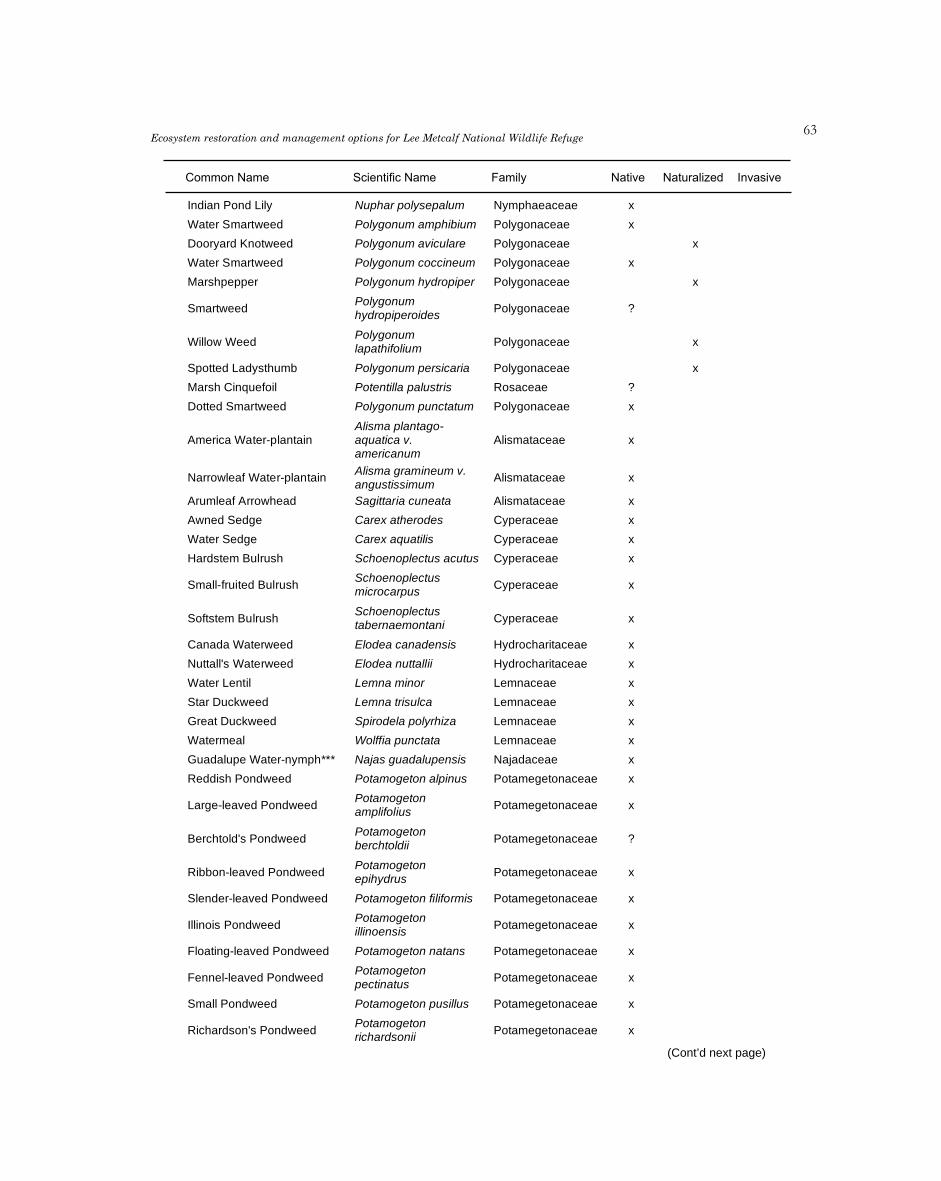
�3Ecosystem restoration and management options for Lee Metcalf National Wildlife Refuge
Common Name Scientific Name Family Native Naturalized Invasive
Indian Pond Lily Nuphar polysepalum Nymphaeaceae x
Water Smartweed Polygonum amphibium Polygonaceae x
Dooryard Knotweed Polygonum aviculare Polygonaceae x
Water Smartweed Polygonum coccineum Polygonaceae x
Marshpepper Polygonum hydropiper Polygonaceae x
PolygonumSmartweed Polygonaceae ?
hydropiperoides
PolygonumWillow Weed Polygonaceae x
lapathifolium
Spotted Ladysthumb Polygonum persicaria Polygonaceae x
Marsh Cinquefoil Potentilla palustris Rosaceae ?
Dotted Smartweed Polygonum punctatum Polygonaceae x
Alisma plantago-America Water-plantain aquatica v. Alismataceae x
americanum
Alisma gramineum v.Narrowleaf Water-plantain Alismataceae x
angustissimum
Arumleaf Arrowhead Sagittaria cuneata Alismataceae x
Awned Sedge Carex atherodes Cyperaceae x
Water Sedge Carex aquatilis Cyperaceae x
Hardstem Bulrush Schoenoplectus acutus Cyperaceae x
SchoenoplectusSmall-fruited Bulrush Cyperaceae x
microcarpus
SchoenoplectusSoftstem Bulrush Cyperaceae x
tabernaemontani
Canada Waterweed Elodea canadensis Hydrocharitaceae x
Nuttall's Waterweed Elodea nuttallii Hydrocharitaceae x
Water Lentil Lemna minor Lemnaceae x
Star Duckweed Lemna trisulca Lemnaceae x
Great Duckweed Spirodela polyrhiza Lemnaceae x
Watermeal Wolffia punctata Lemnaceae x
Guadalupe Water-nymph*** Najas guadalupensis Najadaceae x
Reddish Pondweed Potamogeton alpinus Potamegetonaceae x
PotamogetonLarge-leaved Pondweed Potamegetonaceae x
amplifolius
PotamogetonBerchtold's Pondweed Potamegetonaceae ?
berchtoldii
PotamogetonRibbon-leaved Pondweed Potamegetonaceae x
epihydrus
Slender-leaved Pondweed Potamogeton filiformis Potamegetonaceae x
PotamogetonIllinois Pondweed Potamegetonaceae x
illinoensis
Floating-leaved Pondweed Potamogeton natans Potamegetonaceae x
PotamogetonFennel-leaved Pondweed Potamegetonaceae x
pectinatus
Small Pondweed Potamogeton pusillus Potamegetonaceae x
PotamogetonRichardson's Pondweed Potamegetonaceae x
richardsonii
(Cont’d next page)

��M. E. Heitmeyer et al.
Common Name Scientific Name Family Native Naturalized Invasive
PotamogetonEel-grass Pondweed Potamegetonaceae x
zosteriformis
SparganiumNarrow-leaved Bur-reed Parganiaceae ?
angustifolium
Sparganium emersumSimple Stem Bur-reed Parganiaceae ?
v. multipedunculatum
Common Cat-tail Typha latifolia Typhaceae x
Horned Pondweed Zannichellia palustris Zannichelliaceae x
Pepperwort Marsilea vestita Marsileaceae x
Marchantiaceae Marcantia polymorphia Marchantiaceae ?
Ricciaceae Riccio carpus natans Ricciaceae x
Characeae (Green Algae) Nostoc ssp. Characeae ?
HydrodictnonCharaceae ?
reticulatum
Riccia fluitins Characeae x
Nitella spp Characeae ?
Chara spp Characeae x
Tolypella spp Characeae ?
Wet Meadow
Spurless Jewelweed Impatiens ecalcarata Balsaminaceae ?
Atriplex patula vFat Hen Chenopodiaceae x
hastata
Canada Thistle Cirsium arvense Asteraceae x
Cocklebur Xanthium strumarium Asteraceae x
Lanceleaf Stonecrop Sedum lanceolatum Crassulaceae x
Western Yellowcress Rorippa curvisiliqua Cruciferae ?
Marsh Yellowcress Rorippa islandica Cruciferae x
RorippaWatercress Cruciferae x
nasturtiumaquaticum
v.glabrata
Red Sorrel Rumex acetosella Polygonaceae x
Curly Dock Rumex crispus Polygonaceae x
Seaside Dock Rumex maritimus Polygonaceae ?
Western Dock Rumex occidentalis Polygonaceae x
Willow Dock Rumex salicifolius Polygonaceae x
Ranunculus aquatilis v.Water Buttercup Ranunculaceae x
capillaceus
Yellow Water Buttercup Ranunculus flabellaris Ranunculaceae ?
Western Clematis Clematis ligusticifolia Ranunculaceae x
Sedge Mousetail Myosurus aristatus Ranunculaceae ?
Kidney-leaved Buttercup Ranunculus abortivus Ranunculaceae x
Tall Buttercup Ranunculus acris Ranunculaceae x
Shore Buttercup Ranunculus cymbalaria Ranunculaceae x
Creeping Buttercup Ranunculus flammula Ranunculaceae x
(Cont’d next page)

��Ecosystem restoration and management options for Lee Metcalf National Wildlife Refuge
Common Name Scientific Name Family Native Naturalized Invasive
RanunculusSagebrush Buttercup glaberrimus v. Ranunculaceae x
glaberrimus
Ranunculus gmelinii v.Gmelin's Buttercup Ranunculaceae x
limosus
Long-beaked Water-Ranunculus longirostris Ranunculaceae ?
Buttercup
Macoun's Buttercup Ranunculus macounii Ranunculaceae x
RanunculusBristly Buttercup Ranunculaceae x
pensylvanicus
Creeping Buttercup Ranunculus repens Ranunculaceae x
Celery-leaved Buttercup Ranunculus sceleratus Ranunculaceae x
Stiff-leaf Water Buttercup Ranunculus subriqidus Ranunculaceae ?
Ranunculus uncinatusLittle Buttercup Ranunculaceae x
v. uncinatus
Blue Vervain Verbena hastata Verbenaceae x
Clustered Sedge Carex arcta Cyperaceae x
Slenderbeaked Sedge Carex anthrostachya Cyperaceae x
Golden Sedge Carex aurea Cyperaceae x
Bebb's Sedge Carex bebii Cyperaceae x
Lesser Panicled Sedge Carex diandra Cyperaceae x
Douglas' Sedge Carex douglassii Cyperaceae x
Wooly Sedge Carex lasiocarpa Cyperaceae ?
Kellog's Sedge Carex lenticularis Cyperaceae x
Nebraska Sedge Carex nebrascensis Cyperaceae x
Retrose Sedge Carex retrosa Cyperaceae x
Sawbeaked Sedge Carex stipata Cyperaceae x
Carex utriculata (C.Beaked Sedge Cyperaceae x
rostrata)
Inflated Sedge Carex vesicaria Cyperaceae x
Fox Sedge Carex vulpinoidea Cyperaceae x
Awned Flatsedge Cyperus aristatus Cyperaceae ?
Shining Flatsedge*** Cyperus rivularis Cyperaceae ?
Needle Spike-rush Eleocharis acicularis Cyperaceae x
Delicate Spike-rush Eleocharis bella Cyperaceae x
Common Spike-rush Eleocharis palustris Cyperaceae x
CalamagrostisBluejoint Reedgrass Canadensis v. Poaceae x
canadensis
Foxtail Barley Hordeum jubatum Poaceae x
Reed Canary Grass Phalaris arundinacea Poaceae x
Yellow Flag Iris pseudacorus Iridaceae x
SisyrinchiumBlue-eyed Grass Iridaceae ?
angustifolium
Wire Grass Juncus balticus Juncaceae x
Toad Rush Juncus bufonius Juncaceae x
Soft Rush Juncus effusus Juncaceae x
Dagger-leaf Rush Juncus ensifolius Juncaceae x (Cont’d next page)

��M. E. Heitmeyer et al.
Common Name Scientific Name Family Native Naturalized Invasive
Tuberous Rush Juncus nodosus Juncaceae x
Slender Rush Juncus tenuis v. tenuis Juncaceae x
Torrey's Rush Juncus torrei Juncaceae x
Smooth Rush Luzula hitchcockii Juncaceae x
Common Horsetail Equisetum arvense Equisetaceae x
Water Horsetail Equisetum fluviatile Equisetaceae x
Co. Scouring Rush Equisetum hyemale Equisetaceae x
Smooth Scouring Rush Equisetum laevigatum Equisetaceae x
Marsh Horsetail Equisetum palustre Equisetaceae x
Shady Horsetail Equisetum pratense Equisetaceae x
Water Hemlock Cicuta douglasii Umbelliferae x
Cow-parsnip Heracleum lanatum Umbelliferae x
Mountain Sweet-cicely Osmorhiza chilensis Umbelliferae x
Pastinaca sativa WildWild Parsnip Umbelliferae x
Parsnip
Black Snakeroot Sanicula marilandica Umbelliferae x
Water Parsnip Sium suave Umbelliferae x
Floodplain Grassland
Slender Cryptantha Cryptantha affinis Boraginaceae x
Hound's-tongue Cynoglossum officinale Boraginaceae x
Western Stickseed Lappula redowskii Boraginaceae x
Corn Gromwell Lithospermum arvense Boraginaceae x
Wayside Gromwell Lithospermum ruderale Boraginaceae x
Field Forget-me-not Myosotis arvensis Boraginaceae
Small Flowered Forget-me-Myosotis laxa Boraginaceae x
not
Blue Forget-me-not Myosotis micrantha Boraginaceae x
Common Forget-me-not Myosotis scorpioides Boraginaceae x
Early Forget-me-not Myosotis verna Boraginaceae x
Scouler's Popcorn-flower Plagiobothrys scouleri Boraginaceae x
Blunt Leaved Sandwort Arenaria lateriflora Caryophyllaceae ?
Thyme-leaved Sandwort Arenaria serpyllifolia Caryophyllaceae x
Field Chickweed Cerastium arvense Caryophyllaceae x
Nodding Chickweed Cerastium nutans Caryophyllaceae x
Jagged Chickweed Holosteum umbellatum Caryophyllaceae x
White Champion Lychnis alba Caryophyllaceae ?
Menzies' Silene Silene menziesii Caryophyllaceae x
Red Sandspurry Spergularia rubra Caryophyllaceae x
Long Leaved Starwort Stellaria longifolia Caryophyllaceae x
Lambs Quarter Chenopodium album Chenopodiaceae x
Jerusalem Oak Chenopodium botrys Chenopodiaceae x
ChenopodiumMaple Leaved Goosefoot Chenopodiaceae ?
nybridum
Yarrow Achillea millefolium Asteraceae x(Cont’d next page)

��Ecosystem restoration and management options for Lee Metcalf National Wildlife Refuge
Common Name Scientific Name Family Native Naturalized Invasive
False Dandelion Agoseris glauca Asteraceae x
AnaphalisPearly Everlasting Asteraceae x
margaritacea
Nuttals Pussy-toes Antennaria parviflora Asteraceae x
Rosy Pussy-toes Antennaria microphylla Asteraceae x
Umber Pussy-toes Antennaria umbrinella Asteraceae x
Common Burdock Arctium minus Asteraceae x
Meadow Arnica Arnica chamissonis Asteraceae x
Western Absinthium Artemisia absinthium Asteraceae x
Biennial Sagewort Artemisia biennis Asteraceae x
Artemisia campestris vNorthern Sagewort Asteraceae x
scouleriana
Tarragon Artemisia dracunculus Asteraceae x
Fringed Sagewort Artemisia frigida Asteraceae x
Artemisia ludovicianaWestern Mugwort Asteraceae x
v. latiloba
Artemisia ludovicianaPrairie Sage Asteraceae x
v. ludoviciana
Smooth Aster Aster laevis Asteraceae x
White Prairie Aster Aster pansus Asteraceae ?
Musk Thistle Carduus nutans Asteraceae x
Spotted Knapweed Centaurea maculosa Asteraceae x
ChrysanthemumOxeye Daisy Asteraceae x
leucanthemum
Wavy Leaved Thistle Cirsium undulatum Asteraceae x
Bull Thistle Cirsium vulgare Asteraceae x
Horseweed Conyza canadensis Asteraceae x
Cutleaf Daisy Erigeron compositus Asteraceae x
Spreading Fleabane Erigeron divergens Asteraceae x
Shaggy Fleabane Erigeron pumilus Asteraceae x
Showy Fleabane Erigeron speciosis Asteraceae x
Erigeron strigosus v.Daisy Fleabane Asteraceae x
strigosus
Field Filago Filago arvensis Asteraceae x
Blanket Flower Gaillardia aristata Asteraceae x
Lowland Cudweed Gnaphalium palustre Asteraceae x
Gumweed Grindelia squarrosa Asteraceae x
Sunflower Helianthus annuus Asteraceae x
Nuttals Sunflower Helianthus nuttallii Asteraceae x
Narrow-leaved Hawkweed Hieracium umbellatum Asteraceae x
Poverty Weed Iva xanthifolia Asteraceae x
Prickly Lettuce Lactuca serriola Asteraceae x
MatricariaPineapple Weed Asteraceae x
matricarioides
Nodding Microseris Microseris nutans Asteraceae x
False-agroseris Microseris troximoides Asteraceae ?
Woolly Groundsel Senecio canus Asteraceae x (Cont’d next page)

��M. E. Heitmeyer et al.
Common Name Scientific Name Family Native Naturalized Invasive
Groundsel Senecio indecorus Asteraceae x
Tall Butterweed Senecio serra Asteraceae x
Canada Goldenrod Solidago canadensis Asteraceae x
Late Goldenrod Solidago gigantea Asteraceae x
Missouri Goldenrod Solidago missouriensis Asteraceae x
Western Goldenrod Solidago occidentalis Asteraceae x
Common Sow-thistle Sonchus oleraceus Asteraceae x
Marsh Sow-thistle Sonchus uliginosus Asteraceae ?
Common Tansy Tanacetum vulgare Asteraceae x
Smooth Dandelion Taraxacum laevigatum Asteraceae x
Common Dandelion Taraxacum officinale Asteraceae x
Goatsbeard Tragopogon dubius Asteraceae x
Field Bindweed Convolvulus arvensis Convovulaceae x
Pale Alyssum Alyssum alyssoides Cruciferae x
Desert Alyssum Alyssum desertorum Cruciferae x
Holboell's Rockcress Arabis holboellii Cruciferae x
Nuttall's Rockcress Arabis nuttallii Cruciferae x
Wintercress Barbarea orthoceras Cruciferae x
Field Mustard Brassica campestris Cruciferae x
Black Mustard Brassica nigra Cruciferae x
Hairy False Flax Camelina microcarpa Cruciferae x
Capsella bursa-Shepherd's Purse Cruciferae x
pastoris
CardamineLittle W. Bittercress Cruciferae x
oligosperma
CardaminePennsylvania Bittercress Cruciferae x
pensylvanica
Tansy Mustard Descurainia sophia Cruciferae x
Woods Draba Draba nemorosa Cruciferae x
Whitlow-grass Draba verna Cruciferae x
ErysimumWormseed Mustard Cruciferae x
cheiranthoides
Dame's Rocket Hesperis matronalis Cruciferae x
Field Pepper Grass Lepidium campestre Cruciferae x
Common Pepper Grass Lepidium densiflorum Cruciferae x
Clasping Pepper Grass Lepidium perfoliatum Cruciferae x
Jix Hill Mustard Sisymbrium altissimum Cruciferae x
Tuxmble Mustard Sisymbrium loeselii Cruciferae x
Fanweed Thlaspi arvense Cruciferae x
Teasel Dipsacus sylvestris Dipsacaceae x
Leafy Spurge Euphorbia esula Euphorbiaceae x
EuphorbiaCorrugate-seeded Spurge Euphorbiaceae x
glyptosperma
Thyme-leaf Spurge Euphorbia serpyllifolia Euphorbiaceae x
Crane's Bill Erodium cicutarium Geraniaceae x
Bicknell's Geranium Geranium bicknelli Geraniaceae x(Cont’d next page)

��Ecosystem restoration and management options for Lee Metcalf National Wildlife Refuge
Common Name Scientific Name Family Native Naturalized Invasive
Small Field Geranium Geranium pusillum Geraniaceae x
GeraniumSticky Geranium Geraniaceae x
viscosissimum
Sand Phacelia Phacelia linearis Hydrophyllaceae x
Hypericum formosumWestern St. John's-wort Hypericaceae ?
v. scouleri
Canada St. John's-wort Hypericum majus Hypericaceae ?
Goatweed Hypericum perforatum Hypericaceae x
Hemp Nettle Galeopsis tetrahit Labiatae x
Water Horehound Lycopus americanus Labiatae x
Rough Bugleweed Lycopus asper Labiatae x
Northern Bugleweed Lycopus uniflorus Labiatae x
Field Mint Mentha arvensis Labiatae x
Wild Bergamot Monarda fistulosa Labiatae x
Wild Bergamot Nepeta cataria Labiatae x
Purple Dragonhead Physostegia parviflora Labiatae x
Self-heal Prunella vulgaris Labiatae x
Marsh Skullcap Scutellaria galericulata Labiatae x
Stachys palustris v.Hedge Nettle Labiatae x
pilosa
Astragalus canadensisCanada Milkvetch Leguminosae x
v. mortonii
Weedy Milkvetch Astragalus miser Leguminosae x
Wild Licorice Glycyrrhiza lepidota Leguminosae x
Velvet Lupine Lupinus leucophyllus Leguminosae x
Washington Lupine Lupinus polyphyllus Leguminosae x
Blue-bonnet Lupinus sericeus Leguminosae x
Black Medic Medicago lupulina Leguminosae x
Alfalfa Medicago sativa Leguminosae x
White Sweet-clover Melilotus alba Leguminosae x
Yellow Sweet-clover Melilotus officinalis Leguminosae x
Alsike Clover Trifolium hybridum Leguminosae x
TrifoliumWooly Clover Leguminosae x
microcephalum
Red Clover Trifolium pratense Leguminosae x
White Clover Trifolium repens Leguminosae x
White-tip Clover Trifolium variegatum Leguminosae x
American Vetch Vicia americana Leguminosae x
Common Vetch Vicia sativa Leguminosae x
Slender Vetch Vicia tetrasperma Leguminosae x
Hairy Vetch Vicia villosa Leguminosae x
Hops Humulus lupulus Moraceae ?
Enchanter's Nightshade Circaea alpina Onagraceae x
Swamp Willow-herb Epilobium palustre Onagraceae x
Annual Willow-herb Epilobium paniculatum Onagraceae ?
EpilobiumShrubby Willow-herb Onagraceae x
suffruticosum (Cont’d next page)

�0M. E. Heitmeyer et al.
Common Name Scientific Name Family Native Naturalized Invasive
Watson's Willow-herb Epilobium watsonii Onagraceae ?
Yellow Evening Primrose Oenothera strigosa Onagraceae x
Yellow Wood-sorrel Oxalis corniculata Oxalidaceae x
Ribgrass Plantago lanceolata Plantaginaceae x
Plantago major v.Common Plantain Plantaginaceae x
major
Indian Wheat Plantago patagonica Plantaginaceae x
Narrow-leaved Collomia Collomia linearis Polemoniaceae x
Scarlet Gillia Gilia aggregata Polemoniaceae x
Pink Microsteris Microsteris gracilis Polemoniaceae ?
PolemoniumAnnual polemonium Polemoniaceae x
micranthum
PolemoniumJacob's Ladder pulcherrimum v. Polemoniaceae x
calycinum
Erigonum umbellatumUmbrella Plant Polygonaceae x
v. subalpinum
Knotweed Polygonum achoreum Polygonaceae x
PolygonumIvy Bindweed Polygonaceae x
convolvulus
Polygonum douglasii v.Douglas' Knotweed Polygonaceae x
douglasii
Narrow-leaved MinersMontia linearis Portulacaceae x
Lettuce
Purslane Portulaca oleracea Portulacaceae x
Bitterroot Lewisia rediviva Portulacaceae x
Fringed Loosestrife Lysimachia ciliata Primulaceae x
Tufted Loosestrife Lysimachia thrysiflora Primulaceae x
Smooth Fringecup Lithophragma glabra Saxifragaceae x
LithophragmaSmall-flowered Fringecup Saxifragaceae x
parviflora
Blue-eyed Mary Collinsia parviflora Scrophulariaceae x
Common Hedge-hyssop Gratiola neglacta Scrophulariaceae x
Dalmation Toadflax Linaria dalmatica Scrophulariaceae x
Yellow Toadflax Linaria vulgaris Scrophulariaceae x
Mimulus guttatus v.Monkey Flower Scrophulariaceae x
guttas
Mimulus moschatusMusk Plant Scrophulariaceae x
Musk Plant
Little Penstemon Penstemon procerus Scrophulariaceae x
Common Mullein Verbascum thapsus Scrophulariaceae x
American Speedwell Veronica americana Scrophulariaceae x
Veronica anagallis-Water Speedwell Scrophulariaceae x
aquatica
Chain Speedwell Veronica catenata Scrophulariaceae x
Purslane Speedwell Veronica peregrina Scrophulariaceae x
Veronica serpyllifolia v.Thyme-leaved Speedwell Scrophulariaceae x
serpyllifolia
Vernal Speedwell Veronica verna Scrophulariaceae x (Cont’d next page)

�1Ecosystem restoration and management options for Lee Metcalf National Wildlife Refuge
Common Name Scientific Name Family Native Naturalized Invasive
Henbane Hyoscyamus niger Solanaceae x
Bittersweet Nightshade Solanum dulcamara Solanaceae x
Cut-leaved Nightshade Solanum triflorum Solanaceae x
Cleavers Galium aparine Rubiaceae x
Thinleaf Bedstraw Galium bifolium Rubiaceae x
Northern Bedstraw Galium boreale Rubiaceae x
Small Cleavers Galium trifidum Rubiaceae
Urtica dioica spp.Stinging Nettle Urticaceae ?
gracilis
Viola adunca v.Early Blue Violet Violaceae x
bellidifolia
Marsh Violet Viola palustris Violaceae x
Bog Violet Viola nephrophylla Violaceae x
Goat Grass Aegilops cylindrica Poaceae x
Agropyron canium v.Bearded Wheatgrass Poaceae ?
andinum
Crested Wheatgrass Agropyron cristatum Poaceae x
AgropyronThin Spiked Wheatgrass Poaceae ?
dasystachyum
Intermediate Wheatgrass Agropyron intermedium Poaceae ?
Quack Grass Agropyron repens Poaceae ?
Western Wheatgrass Agropyron smithii Poaceae ?
Bluebunch Wheatgrass Agropyron spicatum Poaceae ?
Redtop Agropyron alba v. alba Poaceae ?
Tickle-grass Agropyron scabra Poaceae ?
Shortawn Foxtail Alopecurus aequalis Poaceae x
Meadow Foxtail Alopecurus partensis Poaceae x
Common Oats Avena sativa Poaceae x
Slough Grass Beckmania syzigachne Poaceae x
Bromus inermis spp.Smooth Brome-grass Poaceae x
Inermus
Soft Brome-grass Bromus mossi Poaceae ?
Cheatgrass Bromus tectorum Poaceae x
CalamagrostisSlim Reedgrass Poaceae ?
neglecta
Brook Grass Catabrosa aquatica Poaceae x
Woodreed Cina latifolia Poaceae x
Orchard Grass Dactylis glomerata Poaceae x
Canada Wildrye Elymus canadensis Poaceae x
Great Basin Wildrye Elymus cinereus Poaceae x
Stinkgrass Eragrostis cilienensis Poaceae x
Tall Fescue Festuca arundinacea Poaceae x
Six Weeks Fescue Festuca octoflora Poaceae ?
Northern Mannagrass Glyceria borealis Poaceae x
Tall Mannagrass Glyceria elata Poaceae x
American Mannagrass Glyceria grandis Poaceae x
Fowl Mannagrass Glyceria striata Poaceae x (Cont’d next page)

��M. E. Heitmeyer et al.
Common Name Scientific Name Family Native Naturalized Invasive
June Grass Koeleria cristata Poaceae x
Perennial Ryegrass Lolium perenne Poaceae x
Indian Ricegrass Oryzopsis hymenoides Poaceae x
Common Witchgrass Panicum capillare Poaceae x
Common Timothy Phleum pratense Poaceae x
Annual Bluegrass Poa annua Poaceae x
Viviparous Bluegrass Poa bulbosa Poaceae x
Canada Bluegrass Poa compressa Poaceae x
Fowl Bluegrass Poa palustris Poaceae x
Kentucky Bluegrass Poa pratensis Poaceae x
Sandbergs Bluegrass Poa sandbergii Poaceae x
Green Bristlegrass Setaria viridis Poaceae x
Sand Dropseed Sporobolis cryptandrus Poaceae x
Squirreltail Sitanion hystrix Poaceae x
Needle and Thread Stipa comata Poaceae x
Green Needlegrass Stipa viridula Poaceae x
Powell's Amaranth Amaranthus powellii Amaranthaceae x
Redroot Amaranth Amaranthus retroflexus Amaranthaceae
Showy Milkweed Asclepias speciosa Asclepiadaceae x
ApocynumSpreading Dogbane Apocynaceae x
androsaemifolium
Clasping Leaved Dogbane Apocynum sibiricum Apocynaceae x
Saline Grassland
Red Belvedere Kochia scoparia Chenopodiaceae x
Poverty Weed Monolepis nuttalliana Chenopodiaceae x
Tumbleweed Amaranthus albus Amaranthaceae x
AmaranthusProstrate Pigweed Amaranthaceae x
graecizans
Grassland/Sagebrush
Brittle Cholla Opuntia fragilis Cactaceae x
Russian Thistle Salsola kali Chenopodiaceae x
ChrysothamnusRabbit-brush Asteraceae x
nauseosus
Common Mallow Malva neglecta Malvaceae x
Cheese Weed Malva parviflora Malvaceae x
Few-flowered Aster Aster modestus Asteraceae ?
Hairy Golden Aster Chrysopsis villosa Asteraceae ?

�3Ecosystem restoration and management options for Lee Metcalf National Wildlife Refuge
Appendix C. Key fish, amphibian, reptile, bird, and mammal species present within 7 habitats on Lee MetcalfNational Wildlife Refuge, Montana. Data for list came from surveys, brochures, annual narratives as well as bioblitzand FWP data. Codes for Other Habitats include SC (stream or tributary channel), SB (stream bank), AF (aerialforager), and MMS (man-made structure). ** indicates Non-native species and *** indicates Species of Concern.
Common Name Scientific Name HabitatsForest Wetland Grassland Other
River- Flood- Emer- Wet Flood- Sage-Saline
front plain gent Meadow plain brushFISH
OncorhynchusRainbow Trout** SC
mykiss
Brown Trout** Salmo trutta x SC
Brook Trout** Salvelinus fontinalis SC
SalvelinusBull Trout*** x SC
confluentus
MountainProsopium williansoni x SC
Whitefish
CatostomusLargescale Sucker x SC
macrocheilus
CatostomusLongnose Sucker x SC
catostomus
Northern Pike Ptychocheilusx SC
Minnow oregonensis
RichardsoniusRedside Shiner SC
balteatus
Largemouth Micropterusx SC
Bass** salmoides
Pumpkinseed** Lepomis gibbosus x SC
Yellow Perch** Perca flavescens x SC
AMPHIBIANSAmerican Lithobates
xBullfrog** catesbeianus
Columbia Spotted Rana luteiventris x x
Frog
Western ToadBufo boreas x x x x
(Boreal)***
Long-toed Ambystomax x x x
Salamander macrodactylum
REPTILESCommon Garter
Thamnophis sirtalis x x x x x xSnake
Terrestrial Garter Thamnophis elegans x x x x x x
Snake
Rubber Boa Charina bottae x x x
Racer Colber constrictor x x x
WesternCrotalus viridis x x x x x
Rattlesnake
Gopher Snake Pituophis catenifer x x x x x x
Painted Turtle Chrysemys picta x
BIRDSGaviiformes
Common Loon*** Gavia immer xPodicipediformes (Cont’d next page)
Page 1 of 10

��M. E. Heitmeyer et al.
Appendix C, cont’d.
Common Name Scientific Name HabitatsForest Wetland Grassland Other
River- Flood- Emer- Wet Flood- Sage-Saline
front plain gent Meadow plain brushRed-necked
Podiceps grisegena xGrebe
Horned Grebe Podiceps auritus x
Eared Grebe Podiceps nigricollis x
Pied-billed Grebe Podylimbus podiceps x
AechmophorusWestern Grebe x
occidentalis
AechmorphorusClark's Grebe*** x
clarkiiPelicaniformes
American White Pelecanusx
Pelican*** erythrorhynchos
Double-crestedPhalacrocorax auritus x
CormorantCiconiformes
AmericanBotaurus lentiginosus x x
Bittern***
Great Blue Ardea herodias x x x x x
Heron***
Great Egret Ardea alba x
Snowy Egret Egretta caerulea x
Cattle Egret Bubulcus ibis x x x x x
Black-crownedNycticorax nycticorax x
Night Heron***
White-faced Ibis Plegadis chihi x x
AnseriformesTrumpeter
Cygnus buccinators xSwan***
Tundra Swan Cygnus columbianus x
Canada Goose Branta canadensis x x x
Greater White-Anser albifrons x x x
fronted Goose
Ross's Goose Chen rossi x x x
Lesser Snow Chen caerulescens x x x
Goose
Wood Duck Aix sponsa x x x
Mallard Anas platyrhunchos x
Gadwall Anas strepera x
Northern Pintail Anas acuta x x x
American Wigeon Anas americana x x
Eurasian Wigeon** Anas penelope x x
Northern Shoveler Anas clypeata x
Cinnamon Teal Anas cyanoptera x
Blue-winged Teal Anas discors x
Green-winged Teal Anas crecca x x
Canvasback Aythya valisineria x
(Cont’d next page)
Appendix C. Key fish, amphibian, reptile, bird, and mammal species present within 7 habitats on Lee MetcalfNational Wildlife Refuge, Montana. Data for list came from surveys, brochures, annual narratives as well as bioblitzand FWP data. Codes for Other Habitats include SC (stream or tributary channel), SB (stream bank), AF (aerialforager), and MMS (man-made structure). ** indicates Non-native species and *** indicates Species of Concern.
Page 2 of 10

��Ecosystem restoration and management options for Lee Metcalf National Wildlife RefugeAppendix C. Key fish, amphibian, reptile, bird, and mammal species present within 7 habitats on Lee Metcalf
National Wildlife Refuge, Montana. Data for list came from surveys, brochures, annual narratives as well as bioblitzand FWP data. Codes for Other Habitats include SC (stream or tributary channel), SB (stream bank), AF (aerialforager), and MMS (man-made structure). ** indicates Non-native species and *** indicates Species of Concern.
Page 3 of 10
Appendix C, cont’d.
Common Name Scientific Name HabitatsForest Wetland Grassland Other
River- Flood- Emer- Wet Flood- Sage-Saline
front plain gent Meadow plain brushRedhead Aythya americana x
Ring-necked Duck Aythya collaris x
Greater Scaup Aythya marila x
Lesser Scaup Aythya affinis x
Surf Scoter Melanitta perspicillata x
Black Scoter Melanitta nigra x
White-wingedMelanitta fusca x
Scoter
CommonBucephala clangula x x x SC
Goldeneye
Barrow'sBucephala islandica x x x SC
Goldeneye
Bufflehead Bucephala albeola x x x SC
Hooded Lophodytesx x x
Merganser cucullatus
CommonMergus merganser x x x
Merganser
Red-BreastedMergus serrator x x x
Merganser
Ruddy Duck Oxyura jamaicensis x
FalconiformesTurkey Vulture Cathartes aura x x x x x x x
Northern Harrier Circus cyaneus x x x x
White-tailed Kite Elanus leucurus x x x
Sharp-shinnedAccipiter striatus x x x
Hawk
Cooper's Hawk Accipiter coperii x x x x x
Northern Goshawk Accipiter gentillis x x x
Swainson's Hawk Buteo swainsoni x x x
Red-tailed Hawk Buteo jamaicensis x x x x x x
Rough-leggedButeo lagopus x x x x
Hawk
Golden Eagle*** Aquilla cyrysaetos x x x x
HaliaeetusBald Eagle*** x x x x
leucocephalus
Osprey Pandion haliaetus x x
Merlin Falco columbarius x x x x
American Kestrel Falco sparverius x x x x x x x
Prairie Falcon Falco mexicanus x x x x x
Gyrfalcon Falco rusticolus x x x x
PeregrineFalco peregrinus x x x x
Falcon***
GalliformesGray Partridge** Perdix perdix x x x
Ring-neckedPhasianus colchicus x x x x x
Pheasant**
(Cont’d next page)

��M. E. Heitmeyer et al.Appendix C. Key fish, amphibian, reptile, bird, and mammal species present within 7 habitats on Lee Metcalf
National Wildlife Refuge, Montana. Data for list came from surveys, brochures, annual narratives as well as bioblitzand FWP data. Codes for Other Habitats include SC (stream or tributary channel), SB (stream bank), AF (aerialforager), and MMS (man-made structure). ** indicates Non-native species and *** indicates Species of Concern.
Page 4 of 10
Appendix C, cont’d.
Common Name Scientific Name HabitatsForest Wetland Grassland Other
River- Flood- Emer- Wet Flood- Sage-Saline
front plain gent Meadow plain brushRuffed Grouse Bonasa umbellus x x
GruiformesAmerican Coot Fulica americana x
Virginia Rail Rallus limicola x
Sora Porzana carolina x x
Sandhill Crane Grus canadensis x x x x x SB
CharadriiformesBlack-bellied
Pluvialis squatarola x x x x SBPlover
American Golden Pluvialis dominica x x x x SB
Plover
Semiplamated Charadriusx x x x SB
Plover semipalmatus
KilldeerCharadriusvociferous
x x SB
RecurvirostraAmerican Avocet x x
americana
HimantopusBlack-necked Stilt x x
mexicanus
Greater Yellowlegs Tringa melanoleuca x
Lesser Yellowlegs Tringa flavipes x
Solitary Sandpiper Tringa solitaria x x
CatoptrohorusWillet x x
semipalmatus
Spotted Sandpiper Actitis macularia x x SB
Whimbrel Numenius phaeopus x
Long-billed Numeniusx x x x
Curlew*** americanus
Marbled Godwit Limosa fedoa x
Sanderling Calidris alba x x SB
Dunlin Calidris alpine x x
PectoralCalidris melanotos x x
Sandpiper
White-rumpedCalidris fuscicollis x
Sandpiper
Baird's Sandpiper Calidris bairdii x
WesternCalidris mauri x
Sandpiper
WesternCalidris mauri x
Sandpiper
SemipalmatedCalidris pusilla x x
Sandpiper
Least Sandpiper Calidris minutilla x x
Stilt Sandpiper Calidris himantopus x x
Long-billed Limnodromusx x
Dowitcher scolopaceus
Short-billedLimnodromus griseus x x
Dowitcher
(Cont’d next page)
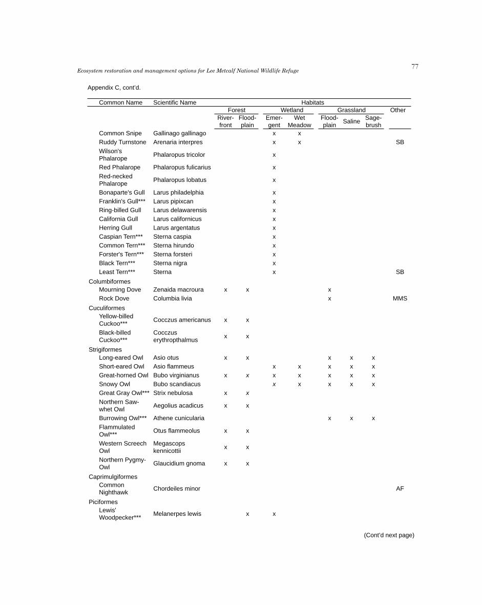
��Ecosystem restoration and management options for Lee Metcalf National Wildlife RefugeAppendix C. Key fish, amphibian, reptile, bird, and mammal species present within 7 habitats on Lee Metcalf
National Wildlife Refuge, Montana. Data for list came from surveys, brochures, annual narratives as well as bioblitzand FWP data. Codes for Other Habitats include SC (stream or tributary channel), SB (stream bank), AF (aerialforager), and MMS (man-made structure). ** indicates Non-native species and *** indicates Species of Concern.
Page 5 of 10
Appendix C, cont’d.
Common Name Scientific Name HabitatsForest Wetland Grassland Other
River- Flood- Emer- Wet Flood- Sage-Saline
front plain gent Meadow plain brushCommon Snipe Gallinago gallinago x x
Ruddy Turnstone Arenaria interpres x x SB
Wilson'sPhalaropus tricolor x
Phalarope
Red Phalarope Phalaropus fulicarius x
Red-neckedPhalaropus lobatus x
Phalarope
Bonaparte's Gull Larus philadelphia x
Franklin's Gull*** Larus pipixcan x
Ring-billed Gull Larus delawarensis x
California Gull Larus californicus x
Herring Gull Larus argentatus x
Caspian Tern*** Sterna caspia x
Common Tern*** Sterna hirundo x
Forster's Tern*** Sterna forsteri x
Black Tern*** Sterna nigra x
Least Tern*** Sterna x SB
ColumbiformesMourning Dove Zenaida macroura x x x
Rock Dove Columbia livia x MMS
CuculiformesYellow-billed
Cocczus americanus x xCuckoo***
Black-billed Cocczusx x
Cuckoo*** erythropthalmus
StrigiformesLong-eared Owl Asio otus x x x x x
Short-eared Owl Asio flammeus x x x x x
Great-horned Owl Bubo virginianus x x x x x x x
Snowy Owl Bubo scandiacus x x x x x
Great Gray Owl*** Strix nebulosa x x
Northern Saw-Aegolius acadicus x x
whet Owl
Burrowing Owl*** Athene cunicularia x x x
FlammulatedOtus flammeolus x x
Owl***
Western Screech Megascopsx x
Owl kennicottii
Northern Pygmy-Glaucidium gnoma x x
Owl
CaprimulgiformesCommon
Chordeiles minor AFNighthawk
PiciformesLewis'
Melanerpes lewis x xWoodpecker***
(Cont’d next page)

��M. E. Heitmeyer et al.Appendix C. Key fish, amphibian, reptile, bird, and mammal species present within 7 habitats on Lee Metcalf
National Wildlife Refuge, Montana. Data for list came from surveys, brochures, annual narratives as well as bioblitzand FWP data. Codes for Other Habitats include SC (stream or tributary channel), SB (stream bank), AF (aerialforager), and MMS (man-made structure). ** indicates Non-native species and *** indicates Species of Concern. Appendix C, cont’d.
Common Name Scientific Name HabitatsForest Wetland Grassland Other
River- Flood- Emer- Wet Flood- Sage-Saline
front plain gent Meadow plain brushRed-naped
Sphyrapicus nuchalis x xSapsucker
DownyPicoides pubescens x x
Woodpecker
Hairy Woodpecker Picoides villosus x x
Northern Flicker Colaptes auratus x x x x
PileatedDryocopus pileatus x x
Woodpecker***
PasseriformesOlive-sided
Contopus cooperi x xFlycatcher
Western Wood-Contopus sordidulus x x
pewee
Cordilleran Empidonaxx x
Flycatcher occidentalis
Willow Flycatcher Empidonax traillii x x x
Least Flycatcher Empidonax minimus x x
Hammond's Empidonaxx x
Flycatcher hammondii
EmpidonaxDusky Flycatcher x x
oberholseri
Say's Phoebe Saynoris saya x x
Eastern Kingbird Tyrannus forficatus x x x x x
Western Kingbird Tyrannus verticalis x x x
Northern Shrike Lanius excubitor x x x
LoggerheadedLanius ludovicianus x x x
Shrike***
Red-eyed Vireo Vireo olivaceus x x
Warbling Vireo Vireo gilvus x x
Plumbeous Vireo Vireo plumbeus x x
Cassin's Vireo Vireo cassinii x x
Steller's Jay Cynaocitta stelleri x x
GymnorhinusPinyon Jay*** x x
cyanocephalus
Clark's Nutcracker Nucifraga columbiana x x
Black-billedPica hudsonia x x
Magpie
Common Raven Corvus corax x x
Horned Lark Eremophila alpestris x x x
Northern Rough-SB
winged
StelgidopteryxSwallow SB
serripennis
Bank Swallow Riparia ripiria
Violet-green Tachycinetax x
Swallow thalassina
Tree Swallow Tachycineta bicolor x x x x
Page 6 of 10(Cont’d next page)

��Ecosystem restoration and management options for Lee Metcalf National Wildlife RefugeAppendix C. Key fish, amphibian, reptile, bird, and mammal species present within 7 habitats on Lee Metcalf
National Wildlife Refuge, Montana. Data for list came from surveys, brochures, annual narratives as well as bioblitzand FWP data. Codes for Other Habitats include SC (stream or tributary channel), SB (stream bank), AF (aerialforager), and MMS (man-made structure). ** indicates Non-native species and *** indicates Species of Concern.
Page 7 of 10
Appendix C, cont’d.
Common Name Scientific Name HabitatsForest Wetland Grassland Other
River- Flood- Emer- Wet Flood- Sage-Saline
front plain gent Meadow plain brushPetrochelidon
Cliff Swallow MMSpyrrhonota
Barn Swallow Hirundo rustica MMS
Black-cappedPoecile atricappila x x
Chickadee
MountainPoecile gambili x x
Chickadee
Red-breastedSitta canadensis x x
Nuthatch
White-breastedSitta carolinensis x x
Nuthatch
Pygmy Nuthatch Sitta pygmaea x x
Brown Creeper*** Certhia americana x x
House Wren Troglodytes aedon x x
TroglodytesWinter Wren*** x x x
troglodytes
Marsh Wren Cistothorus palustris x x
American Dipper Cinclus mexicanus x SB
Golden-crownedRegulus satrapa x x
Kinglet
Rudy-crownedRegulus calendula x x
Kinglet
Townsend'sMyadestes townsendi
Solitaire
Mountain Bluebird Sialia currucoides x x
Western Bluebird Sialia mexicana x x
Varied Thrush Ixoreus naevius x x
American Robin Turdus migratorius x x
Veery*** Catarus fuscescens x x
Swainson's Thrush Catharus ustulatus x x
Hermit Thrush Catharus guttatus x x
DumeteliaGray Catbird x x
carolinensis
OreoscoptesSage Thrasher*** x x x
montanus
European starling Sturnus vulgaris MMS
American pipit Anthus rubescens x x SB
BohemianBombycilla garrulous x x
Waxwing
Cedar Waxwing Bombycilla cedrorum x x
Nashville Warbler Vermivora ruficapilla x x
Orange-crownedVermivora celata x x
Warbler
Yellow Warbler Dendroica petechia x x x x
Yellow-rumpedDendroica coronate x x
Warbler
(Cont’d next page)

�0M. E. Heitmeyer et al.Appendix C. Key fish, amphibian, reptile, bird, and mammal species present within 7 habitats on Lee Metcalf
National Wildlife Refuge, Montana. Data for list came from surveys, brochures, annual narratives as well as bioblitzand FWP data. Codes for Other Habitats include SC (stream or tributary channel), SB (stream bank), AF (aerialforager), and MMS (man-made structure). ** indicates Non-native species and *** indicates Species of Concern.
Page 8 of 10
Appendix C, cont’d.
Common Name Scientific Name HabitatsForest Wetland Grassland Other
River- Flood- Emer- Wet Flood- Sage-Saline
front plain gent Meadow plain brushTownsend's
Dendroica townsendi x xWarbler
Blackpoll Warbler Dendroica striata x x
Black-and-whiteMniotilta varia x x
Warbler
American Redstart Setophaga ruticilla x x
Northern Seiurusx x x
Waterthrush noveboracensis
MacGillivray'sOporornis tolmiei x x
Warbler
CommonGeothlipis trichas x x x
Yellowthroat
Wilson's Warbler Wilsonia pusilla x x
Yellow-breastedIcteria virens x x
Chat
Western Tanager Piranga ludoviciana x x
Black-headed Pheucticusx x
Grosbeak melanocephalus
Lazuli Bunting Passerina amoena x x
Spotted Towhee Pipilo maculates x x
American TreeSpizella arborea x x
Sparrow
Chipping Sparrow Spizella passerine x x
LeConte's Ammodramusx x x x
Sparrow*** leconteii
Savannah Passerculusx x x
Sparrow sandwichensis
Vesper Sparrow Pooecetes gramineus x x x
Harris's Sparrow Zonotrichia querula x x x
White-crowned Zonotrichiax x x x x
Sparrow laucophrys
Fox Sparrow Passerella iliaca x x
Song Sparrow Melospiza melodia x x x x x
Lincoln's Sparrow Melospiza lincolnii x x x
Swamp Sparrow Melospiza georgiana x x
Dark-eyed Junco Junco hyemalis x x
Snow Bunting Plectrophenax nivalis x x x
WesternSturnella neglecta x x x
Meadowlark
Bobolink***Dolichonyxoryzivorus
x x x
Brown-headedMolothrus ater x x
Cowbird
Yellow-headed Xanthocephalusx x
Blackbird santheocephalus
Red-wingedAgelalius phoeniceus x x
Blackbird
(Cont’d next page)

�1Ecosystem restoration and management options for Lee Metcalf National Wildlife RefugeAppendix C. Key fish, amphibian, reptile, bird, and mammal species present within 7 habitats on Lee Metcalf
National Wildlife Refuge, Montana. Data for list came from surveys, brochures, annual narratives as well as bioblitzand FWP data. Codes for Other Habitats include SC (stream or tributary channel), SB (stream bank), AF (aerialforager), and MMS (man-made structure). ** indicates Non-native species and *** indicates Species of Concern.
Page 9 of 10
Appendix C, cont’d.
Common Name Scientific Name HabitatsForest Wetland Grassland Other
River- Flood- Emer- Wet Flood- Sage-Saline
front plain gent Meadow plain brushEuphagus
Brewer's Blackbird x xcyanocephalus
Rusty Blackbird Euphagus carolinus x x
Common Grackle Quiscalus quiscula x x
Bullock's Oriole Icterus bullockii x x
CoccothrausterEvening Grosbeak x x
vespertinus
Pine Grosbeak Pinicoa enucleator x x
CarpodacusHouse Finch x x
mexicanus
Red Crossbill Loxia curvirostra x x
Common Redpoll Careuelis flammea x x
Pine Siskin Carduelis pinus x x
AmericanCarduelis tristis x x
Goldfinch
House Sparrow Passer domesticus MMS
MAMMALS
InsectivoraVagrant Shrew Sorex vagrans x x
CommonSorex cinereus x x
(masked) Shrew
ChiropteraCalifornia Myotis Myotis californicus x x
Western small-Myotis cillolabrum x x
footed Myotis
Western Long-Myotis evotis x x
eared Myotis
Little Brown Bat Myotis lucifugus x x
Fringed Myotis*** Myotis thysanodes x x
Long-leggedMyotis volans x x
Myotis
Townsend's Big- Carynohinusx x
eared Bat*** townsendii
Hoary Bat*** Lasiurus cinereus x x
Big Brown Bat Epsesicus fuscus x x
LasionycterisSilver-haired Bat x x
noctivagans
Rodentia x x
Yellow-belliedMarmota flaviventris x x x x x
Marmot
Yellow-pineTamias amoenus x x
Chipmunk
Eastern Fox Scirus niger x x
Squirrel
(Cont’d next page)

��M. E. Heitmeyer et al.
Appendix C, cont’d.
Karen Kyle
Common Name Scientific NameOther
River-front
Flood-plain
Emer-gent
WetMeadow
Flood-plain
SalineSage-brush
Forest Wetland Grassland
Appendix C. Key fish, amphibian, reptile, bird, and mammal species present within 7 habitats on Lee MetcalfNational Wildlife Refuge, Montana. Data for list came from surveys, brochures, annual narratives as well as bioblitzand FWP data. Codes for Other Habitats include SC (stream or tributary channel), SB (stream bank), AF (aerialforager), and MMS (man-made structure). ** indicates Non-native species and *** indicates Species of Concern.
Habitats
Carnivora x x
Gray Wolf*** Canis lupus x x x x x x
Coyote Canis latrans x x x x x x
Red Fox Vulpes vulpes x x x x
Black Bear Ursus americanus x x x x
Raccoon Procyon lotor x x x x x
Short-tailedWeasel
Mustela frenata x x x x x
Mink Mustela vison x x x x x x
American Badger Taxidea taxus x x x
Striped Skunk Mephitis mephitis x x x x x
Northern River Otter
Lutra canadensis x x
Mountain lion Felis concolor x x
Bobcat Lynx rufus x x
Artiodactyla x x
Elk Cervus elaphus x x x x x x
Mule Deer Odocoileus hemionus x x x x x x
White-tailed DeerOdocoileusvirginianus
x x x x x x
Moose Alces alces x x x x
Page 10 of 10

�3Ecosystem restoration and management options for Lee Metcalf National Wildlife Refuge
Appendix D. Conspicuous Invertebrates of Lee Metcalf National Wildlife Refuge,Montana. ** indicates Non-native species and *** indicates Species of Concern.
Common Name Scientific Name
Class Insecta
EphemeropteraMayfly Baetis tricaudatus
Mayfly Drunella coloradensisMayfly Ephemerella excruciansMayfly Siphlonurus occidentalisMayfly Callibaetis pictusMayfly Rhitrhogena robustaMayfly Ameletus similiorMayfly Sweltsa sppMayfly Serratella tibialis
Mayfly Drunella doddsi
OdonataSpotted spreadwing Lestes congenerEmerald spreadwing Lestes dryasBoreal bluet*** Enallagma borealeMarsh bluet Enallagma ebriumPacific forktail Ischnura cervula
Western forktail Ischnura perparvaWestern red damsel Amphiagrion abbreviatumBlack-tipped darner Aeshna tuberculiferaCanada darner Aeshna canadensisLance-tipped darner Aeshna constrictaPaddle-tailed darner Aeshna palmataShadow darner Aeshna umbrosaBlue-eyed darner Rhionaeschna multicolorCommon green darner Anax junius
Pale snaketail Ophiogomphus severusSinuous snaketail Ophiogomphus occidentisPacific spiketail Cordulegaster dorsalisMountain emerald Somatochlora semicircularisOcellated emerald Somatochlora minorCommon whitetail Plathemis lydiaFour-spotted skimmer Libellula quadrimaculataEight-spotted skimmer Libellula forensis
Twelve-spotted skimmer Libellula pulchellaDot-tailed whiteface Leucorrhinia intactaHudsonian whiteface Leucorrhinia hudsonicaCrimson-ringed whiteface Leucorrhinia glacialisBoreal whiteface*** Leucorrhinia borealisVariegated meadowhawk Sympetrum corruptumRed-veined meadowhawk Sympetrum madidumWhite-faced meadowhawk Sympetrum obtrusum
Cherry-faced meadowhawk Sympetrum internumSaffron-winged meadowhawk Sympetrum costiferumBand-winged meadowhawk Sympetrum semicinctum
PlecopteraStonefly Claassenia sabulosaStonefly Hesperoperla pacificaStonefly Kogotus modestus
Stonefly Isoperla sppStonefly Pteronarcella
(Cont’d next page)

��M. E. Heitmeyer et al.
(Cont’d next page)
Common Name Scientific Name
ColeopteraBlister beetle Epicauta sppTiger beetle Cincidela oregonaLeaf beetle Chrysomelidae latreilleRifle beetle Optioservus quadrimaculatus
Beetle Troposternus latoralisTumbling flower beetle Mordellidae latreilleCarrion beetle Silphidae latreilleGround beetle Pterostichus sppLeaf beetle Systena sppPredaceous diving beetle Platambus sppWeevil Larinus sppWeevil Rhinocyllus conicus
TricopteraCaddisfly Parapsyche almotaCaddisfly Limnephelus sppCaddisfly Hydropsyche californica
LepidopteraTwo-tailed swallowtail Papilio multicaudata
Western tiger swallowtail Papilio rutulusPale swallowtail Papilio eurymedonWestern white Pontia occidentalisCabbage white** Pieris rapaeBecker's white Pontia beckeriiCheckered white Pontia protodiceClouded sulphur Colias philodiceSara orangetip Anthocharis sara
Orange sulfur Colias eurythemeEdith's copper Lycaena edithaPurplish copper Lycaena helloidesBronze copper Lycaena hyllusWestern pine elfin Callophrys eryphonGray hairstreak Strymon melinusMelissa blue Lycaeides melissaSpring azure Celastrina ladonArrowhead blue Glaucopsyche piasus
Great spangled fritillary Speyeria cybeleSilver-bordered fritillary Boloria seleneMormon fritillary Spreyeria mormoniaMylitta crescent Phyciodes mylittaNorthern crescent Phyciodes cocytaField crescent Phyciodes pratensisEdith's checkerspot Euphydryas edithaSatyr anglewing Polygonia satyrus
Oreas anglewing Polyfonia oreasZephyr anglewing Polyfonia zephyrusMourning cloak Nymphalis antiopaMilbert's tortoiseshell Nymphalis milbertiCalifornia tortoiseshell Nymphalis californicaRed admiral Vanessa atalantaWest coast lady Vanessa annabellaPainted lady Vanessa cardui
Lorquin's admiral Limenitis lorquiniViceroy Limenitis archippusCommon wood nymph Cercyonis pegalaSmall wood nymph Cercyonis oetusCommon alpine Eregia eipsoodeaCommon ringlet Coenonympha ampelosPeck's skipper Polites peckiusSandhill skipper Polites sabuleti

��Ecosystem restoration and management options for Lee Metcalf National Wildlife Refuge
Common Name Scientific Name
Long dash Polites mysticCommon branded skipper Hesperua commaWoodland skipper Ochlodes sylvanoidesArtic skipper Carterocephalus palaemonGarita skipperling Oarisma garita
Roadside skipper Amblyscirtes vialisCommon sootywing Pholisora catullusCommon checkered skipper Pyrgus communisIsabella tiger moth Pyrrharctia isabellaCarpenterworm moth Cossoidea sppBig poplar sphinx Pachysphinx occidentalisOne-eyed sphinx Smerinthus cerisyiPolyhemus moth Antheraea polyphemus
Large yellow underwing Noctua pronubaCatocaline moth Catocala spp
DipteraDeerfly Chrysops spp
Class Gastropoda
Snails/SlugsForest disc Discus whitneyiMarsh pondsnail Stagnicola elodesMountain marshsnail Stagnicola montanensisCoeur d'Alene Oregonian Cryptomastix mullaniBrown hive Euconolus fulvusGarlic glass snail** Oxychilus alliarusTwo-ridge ram's-horn snail Helisoma anceps
Big-eared radix** Radix auriculariaMimic lymnaea snail** Pseudosuccinea columellaGlossy pillar Cochilicopa lubricaGrey fieldslug** Derocerus reticulatumIdaho forestsnail Allogona ptychophoraLovely vallonia Vallonia pulchellaMeadow slug** Derocerus laeveQuick gloss Zonitoides arboreusDusky arion** Arion subfuscus
Kar
en K
yle

��M. E. Heitmeyer et al.
Appendix E. Summary of water rights on Lee Metcalf National Wildlife Refuge (unpublished, U. S. Fish and Wildlife Service, Region 6 files.

��Ecosystem restoration and management options for Lee Metcalf National Wildlife Refuge
Appendix E, cont’d.

��M. E. Heitmeyer et al.
NOTES:
ji
