an evaluation of ecosystem restoration and … evaluation of ecosystem restoration and management...
TRANSCRIPT
AN EVALUATION OFECOSYSTEM RESTORATION AND MANAGEMENT OPTIONS
FOR
BENTON LAKE NATIONAL WILDLIFE REFUGE
PREPARED FOR:
U. S. FISH AND WILDLIFE SERVICEREGION 6
DENVER, COLORADO
BY:Mickey E. Heitmeyer
Greenbrier Wetland ServicesAdvance, MO
Vanessa L. FieldsU.S. Fish and Wildlife Service
Benton Lake National Wildlife RefugeGreat Falls, MT
Michael J. ArtmannU.S. Fish and Wildlife ServiceRegion 6 Division of Planning
Denver, CO
Leigh H. FredricksonWetland Management and Education Services, Inc.
Puxico, MO
Greenbrier Wetland Services Report 09-01
DECEMBER 2009
ii
www.GreenbrierWetland.com
Suggested citation:
Heitmeyer, M. E., V. L. Fields, M. J. Artmann, L. H. Fredrickson 2009. An evaluation of ecosystem restoration and management options for Benton Lake National Wildlife Refuge. Prepared for U. S. Fish and Wildlife Service, Region 6, Denver, CO. Greenbrier Wetland Services Publication 09-01. Blue Heron Conservation Design and Printing LLC, Bloomfield, MO.
Photo credits: Mike Artmann, Karen Kyle, Frank NelsonCover photos by Karen Kyle
conse r va t ion de s i gn and p r in t ing LLCHeronBl
ue
Design & Printing by
iii
CONTENTS
EXECUTIVE SUMMARY ..................................................................................... v
INTRODUCTION ................................................................................................ 1
THE HISTORIC BENTON LAKE ECOSYSTEM ............................................... 3GEOLOGY, SOILS, TOPOGRAPHY ....................................................... 3CLIMATE AND HYDROLOGY ............................................................... 6VEGETATION COMMUNITIES ............................................................ 9KEY ANIMAL COMMUNITIES ............................................................ 13
CHANGES TO THE BENTON LAKE ECOSYSTEM ...................................... 19SETTLEMENT AND REGIONAL LANDSCAPE CHANGES ............. 19LAND AND WATER USE CHANGES ON BENTON LAKE NWR .... 23 Acquisition and Development of Benton Lake NWR ..................... 23 Water Management in Benton Lake ............................................... 25 Water Quality, Contaminants, and Botulism .................................. 27 Vegetation Communities ................................................................ 29 Fish and Wildlife Populations ......................................................... 32
ECOSYSTEM RESTORATIONAND MANAGEMENT OPTIONS .................................................................... 35
A SUMMARY OF CONDITIONS ......................................................... 35GENERAL RECOMMENDATIONS FORRESTORATION AND MANAGEMENT OBJECTIVES ...................... 38SPECIFIC RECOMMENDATONS TO MEETECOSYSTEM RESTORATION GOALS ................................................ 42 Protect the Physical Integrity of the Benton Lake Basin and Emulate Natural Hydrological Regimes ................................... 42
iv
Control and Reduce Accumulation of Salts and Contaminants ...... 43 Restore Natural Vegetation Communities ....................................... 44 Providing Key Resources ................................................................ 45
MONITORING AND EVALUATION ............................................................... 47 RESTORING SEASONALLY- AND ANNUALLY-DYNAMIC WATER REGIMES .......................................... 47 SALT AND SELENIUM ACCUMULATION LEVELS ........................... 47 LONG TERM CHANGES IN VEGETATION COMMUNITIES RELATED TO WATER MANAGEMENT ................ 48 ENDEMIC AND INVASIVE SPECIES ................................................... 48
ACKNOWLEDGEMENTS ................................................................................. 49
LITERATURE CITED ........................................................................................ 51
APPENDICES ...................................................................................................... 55
1 CONTENTS, cont’ d.
tman
ne A
rM
ik

v
EXECUTIVE SUMMARY
enton Lake National Wildlife Refuge (NWR) contains 12,383 acres on the western edge of the Northern Great Plains about 12 miles north of Great
Falls, Montana. The dominant feature on the NWR is the 5,600 acre shallow lake bed, known as Benton Lake, created during the last Pleistocene glacial period. This large wetland is hydrologically closed; most natural runoff in the Benton Lake Basin drains to Benton Lake proper and the basin has no natural outlet.
Although established in 1929, Benton Lake NWR was not developed or staffed until the early 1960s. Prior to devel-opment, water levels in Benton Lake historically fluctuated seasonally and annually depending on annual patterns of precipitation and runoff. During wet years Benton Lake contained more extensive surface water area and supported large numbers of breeding and migrating waterbirds, especially dabbling ducks. In contrast, during dry years, less water was present and fewer birds were present. Because of a desire to support more predictable and frequent flooding, and waterbird abundance, during summer, Benton Lake NWR constructed extensive water source, conveyance, and management systems. These developments and other hydrological and topographic alterations on Benton Lake NWR and surrounding lands have gradually altered this ecosystem by increasing concentrations of contaminants, especially selenium; siltation and alteration of the topography of the historic lake bed, altered vegetation communities and increased presence of invasive species;
1 CONTENTS, cont’ d.
vi
periodic outbreaks of botulism; and decreased presence and productivity of waterbirds.
In 2009, the U.S. Fish and Wildlife Service began prepa-ration of a Comprehensive Conservation Plan for Benton Lake NWR. This planning process is being facilitated by a contem-porary evaluation of ecosystem restoration and management options using Hydrogeomorphological Methodology (HGM). This report uses the HGM approach to obtain and use historic and current information about: 1) geology and geomorphology, 2) soils, 3) topography and elevation, 4) hydrology, 5) plant and animal communities, and 6) physical anthropogenic features of NWRs and surrounding landscapes with the following objectives:
1. Identify the pre-European settlement ecosystem condition and ecological processes.
2. Evaluate changes in the Benton Lake ecosystem from the pre-settlement period.
3. Identify restoration and management options and eco-logical attributes needed to successfully restore specific habitats and conditions in the area.
The Benton Lake Basin, including the Benton Lake bed depression, was formed during the last Pleistocene glacial period when ice sheets dammed the ancestral Missouri River and formed glacial Lake Great Falls. Glacial drift associated with this ice sheet was deposited northeast of Benton Lake and created a hydrologically closed basin where most surface water ultimately flowed into Benton Lake and no outlet was present. Gently dipping sedimentary bedrock underlies the Benton Lake deposits; this bedrock is mostly seleniferous marine shale of the Cretaceous Colorado Group. Most geomorphic surfaces at Benton Lake are Quaternary Lake deposits, with secondary alluvium-colluvium deposits at the mouths of Lake Creek (the primary drainage into Benton Lake) and other small tributaries. Quaternary terraces adjoin Benton Lake and high ridges contain older Cretaceous outcrop deposits. Soils at Benton Lake are mostly clays and silt clays
12
12
vii
deposited in lacustrine conditions. Topography at Benton Lake NWR reflects dominant geomorphic surfaces including the relatively flat historic lake bed, alluvial fans, and older terraces and ridges.
The Benton Lake Basin is semiarid with 70-80% of annual precipitation and runoff occurring April to September. Historic water levels in Benton Lake were strongly unimodal, with peaks in early summer followed by gradual declines to low stable levels in fall and winter. In addition to strong seasonal patterns of flooding, Benton Lake had evidence of long recurring 15-20 year patterns of peaks and lows in regional precipitation, runoff, and water levels. Natural water inputs to Benton Lake come primarily (65-70%) from the Lake Creek watershed.Deeper ground water beneath Benton Lake is confined to the aquifer within the Colorado Shale formation, which is poor quality. Historically, low annual precipitation was captured quickly and used by native grassland; little water moved deeply into soil and subsoil layers. Consequently, deposition of salts and elements, including selenium, from Cretaceous formations did not historically accumulate to high levels in Benton Lake.
Historic vegetation communities at Benton Lake ranged from dense emergent wetland species in low elevations to upland grassland on terraces and ridges. The gradation of communities included robust emergent, sedge-rush, seasonal herbaceous, wet grassland, and upland grassland habitat types. A rich diversity of animal species historically used the Benton Lake ecosystem; waterbird abundance and productivity was tied to seasonal and long-term patterns of water levels.
The Benton Lake ecosystem was relatively unchanged from historical condition until the late 1880s, when initial settlement of the area occurred. Early attempts to ditch, drain, and farm the Benton Lake bed were unsuccessful and little conversion of native grassland to agricultural crops in the surrounding area did not occur until the 1920s following development of the Sun River Irrigation Project. Much native grassland was converted to dry-land crop/fallow rotation from
12
12
viii
1930 to 1950 and this farming practice gradually increased the number and severity of saline seeps in the region, and ultimately the discharge of selenium into Benton Lake.
Benton Lake NWR was established in 1929, but little development or management occurred until the early 1960s, when the area was staffed and a major water pumping and conveyance system was constructed to bring irrigation return flow from Muddy Creek 15 miles to Benton Lake. In addition to the pump station and conveyance system, the historic Benton Lake bed was divided into six pools by dikes, levees, and water-control structures to facilitate more predictable and prolonged flooding regimes in summer for breeding waterfowl. Water management on Benton Lake NWR from the early 1960s through the late 1980s typically sought to regularly pump water from Muddy Creek to Benton Lake to extensively flood most wetland pools for prolonged periods; relative amounts pumped from Muddy Creek compared to natural runoff from Lake Creek varied substantially among years related to annual precipitation and runoff.
More permanent water regimes in Benton Lake gradually changed vegetation communities to more water tolerant types, increased selenium accumulation, promoted expansion of invasive plant species, and increased severity and occurrence of avian botulism. Water management at Benton Lake since the early 1990s has reduced pumping during summer and attempted to create more seasonal water regimes, except in Pools 1 and 2, which continue to be managed for permanent flooding and water storage. A model of selenium cycling within Benton Lake pools indicates continued accumulation in Pools 1 and 2 and near saline seeps in Pool 4c unless water regimes are restored to more seasonal patterns in these areas and seeps are reduced. Vegetation communities at Benton Lake also contain increasing amounts of the aggressive introduced creeping foxtail.
Based on the HGM data obtained and analyzed in this report, future management of Benton Lake NWR should seek to:
12
12
ix
1. Maintain the physical integrity of the hydrologically closed Benton Lake Basin and emulate more natural seasonally- and annually-dynamic water regimes within Benton Lake proper.
2. Control and reduce accumulation of salts and contami-nants, especially selenium.
3. Restore and maintain the diversity, composition, distri-bution, and regeneration of historic wetland and upland vegetation communities in relationship to topographic and geomorphic landscape position.
4. Provide functional complexes of resource availability and abundance including seasonal food, cover, reproductive, and refuge resources for key animal species.
Specific recommendations to meet ecosystem restoration goals identified above are provided and include:
• Retain the closed nature of Benton Lake proper and protect watersheds and drainage routes of its tributaries.
• Restore natural topography and reconnect water flow corridors and patterns where possible. This recom-mendation suggests careful evaluation of the need for existing levees, roads, water-control structures and the pool configuration with removal of those not desired for future management.
• Manage Benton Lake water levels (with or without the current or altered pool configuration) for more natural seasonal and annual water regimes.
• Restore natural hydroperiods to Benton Lake proper and balance seasonal and long-term inputs from Muddy Creek pumping vs. natural runoff in the Lake Creek watershed.
• Encourage and participate in conservation programs in regional watersheds to reduce the extent and severity of saline seeps.
12
12

x
12
12
• Evaluate vegetation manipulation techniques for possi-bilities of reducing accumulation of selenium.
• Restore more natural distribution and composition of native plant communities.
• Control expansion of invasive plant species, especially creeping foxtail.
• Provide a rotational complex of wetland habitats and seasonal resources.
• Protect native terrace and upland grasslands.
• Maintain functional seasonal refuges.
Future management of Benton Lake NWR that incor-porates the recommendations of this report can be done in an adaptive management framework where: 1) predictions about community restoration and water quality/quantity are made relative to specific management actions and then; 2) follow-up systematic monitoring and evaluation are implemented to measure ecosystem responses and to suggest future changes or strategies based on the monitoring data. Critical issues that need this monitoring include:
1. Restoring seasonally- and annually-dynamic water regimes.
2. Salt and selenium accumulation levels.
3. Long-term changes in vegetation communities related to changed water management.
4. Endemic and invasive species.

xi
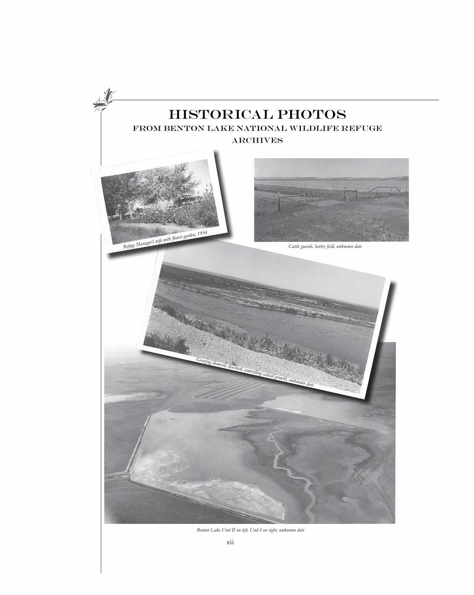
HISTORICAL PHOTOSFROM BENTON LAKE NATIONAL WILDLIFE REFUGE
ARCHIVES
1938
12
12
East side of Benton Lake, 1938
Coulee June 9, 1938 NW side of Benton Lake
Notes about these pics:“On April 14, the coulee in the northwest portion of the Benton Lake Refuge had water in it for a distance of about five miles and a width of about 20 ft. On June 9, this coulee was practically dry, with the exception of small potholes in its deeper portions (top right here). On June 30, just after unusually heavy rains the lake bed itself had some water.”
xii
HISTORICAL PHOTOSFROM BENTON LAKE NATIONAL WILDLIFE REFUGE
ARCHIVES
12
Cattle guards, barley field, unknown date
Benton Lake Unit II on left, Unit I on right, unknown date
Grazing domestic livestock controlling cattail growth, unknown date
Refuge Manager’s wife with flower garden, 1954
�
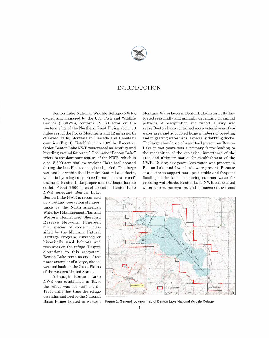
INTRODUCTION
Benton Lake National Wildlife Refuge (NWR), owned and managed by the U.S. Fish and Wildlife Service (USFWS), contains 12,383 acres on the western edge of the Northern Great Plains about 50 miles east of the Rocky Mountains and 12 miles north of Great Falls, Montana in Cascade and Chouteau counties (Fig. 1). Established in 1929 by Executive Order, Benton Lake NWR was created as “a refuge and breeding ground for birds.” The name “Benton Lake” refers to the dominant feature of the NWR, which is a ca. 5,600 acre shallow wetland “lake bed” created during the last Pleistocene glacial period. This large wetland lies within the 146 mile2 Benton Lake Basin, which is hydrologically “closed”; most natural runoff drains to Benton Lake proper and the basin has no outlet. About 6,800 acres of upland on Benton Lake NWR surround Benton Lake. Benton Lake NWR is recognized as a wetland ecosystem of impor-tance by the North American Waterfowl Management Plan and Western Hemisphere Shorebird Reserve Network. Nineteen bird species of concern, clas-sified by the Montana Natural Heritage Program, currently or historically used habitats and resources on the refuge. Despite alterations to this ecosystem, Benton Lake remains one of the finest examples of a large, closed, wetland basin in the Great Plains of the western United States.
Although Benton Lake NWR was established in 1929, the refuge was not staffed until 1961; until that time the refuge was administered by the National Bison Range located in western
Montana. Water levels in Benton Lake historically fluc-tuated seasonally and annually depending on annual patterns of precipitation and runoff. During wet years Benton Lake contained more extensive surface water area and supported large numbers of breeding and migrating waterbirds, especially dabbling ducks. The large abundance of waterfowl present on Benton Lake in wet years was a primary factor leading to the recognition of the ecological importance of the area and ultimate motive for establishment of the NWR. During dry years, less water was present in Benton Lake and fewer birds were present. Because of a desire to support more predictable and frequent flooding of the lake bed during summer water for breeding waterbirds, Benton Lake NWR constructed water source, conveyance, and management systems
O0 0.2 0.4 0.8 1.2 1.6 Miles
Blue Heron Conservation Design and Printing LLC | 2009
Great Falls, MT
78 re
y Riv
wH
iru
S os
U isM
I-15
US Hwy 87-15I
Benton Lake NWR
Figure 1. General location map of Benton Lake National Wildlife Refuge.
Cattle guards, barley field, unknown date
2M. E. Heitmeyer et al..
beginning in the late 1950s and early 1960s. This water “system” included a pump station and pipeline that moved irrigation return flow from Muddy Creek, about 15 miles to the west, to Benton Lake. Water from Muddy Creek was moved about 5 miles through an underground pipeline over a low drainage divide and then discharged into the Lake Creek natural drainage channel where it flowed about 12 miles to its mouth in Benton Lake.
The historic Benton Lake bed was divided into 6 “pools” or water management “units” by dikes/levees, ditches, and water-control structures from 1960 to 1962. Since the early 1960s, management of Benton Lake NWR has focused on managing water and wetland vegetation within Benton Lake, mostly to enhance waterfowl production and migration habitat. Management of uplands also has occurred to sustain native grassland communities, provide nesting cover for waterfowl, and provide forage/cover for native birds and mammals. Over time the refuge developed a series of roads that provide access to refuge lands and also constructed numerous parking lots, building complexes, walk-ways into wetlands, and excavations in wetland pools to create nesting islands, drainage ditches, and deeper open water areas.
The combination of hydrological and topo-graphic alterations on Benton Lake NWR and land use changes in the watershed areas surrounding the refuge have gradually altered this ecosystem and created many management challenges to sustaining historic Benton Lake plant and animal communities. Ecological issues that have developed over time at Benton Lake NWR include increased concentrations of contaminants, especially selenium; siltation and altered topography of the historic lake bed; altered vegetation communities; increased distribution and abundance of invasive species; periodic botulism outbreaks that cause high mortality of waterbirds in some years; and decreased presence and productivity of waterbirds (e.g., Hultman 1991, Nimick 1997, Thompson and Hansen 2002).
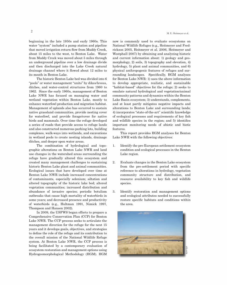
In 2009, the USFWS began efforts to prepare a Comprehensive Conservation Plan (CCP) for Benton Lake NWR. The CCP process seeks to articulate the management direction for the refuge for the next 15 years and it develops goals, objectives, and strategies to define the role of the refuge and its contribution to the overall mission of the National Wildlife Refuge system. At Benton Lake NWR, the CCP process is being facilitated by a contemporary evaluation of ecosystem restoration and management options using Hydrogeomorphological Methodology (HGM). HGM
now is commonly used to evaluate ecosystems on National Wildlife Refuges (e.g., Heitmeyer and Fred-rickson 2005, Heitmeyer et al. 2006, Heitmeyer and Westphall 2007) by obtaining and analyzing historic and current information about: 1) geology and geo-morphology, 2) soils, 3) topography and elevation, 4) hydrology, 5) plant and animal communities, and 6) physical anthropogenic features of refuges and sur-rounding landscapes. Specifically, HGM analyses for Benton Lake NWR: 1) uses the above information to develop appropriate, realistic, and sustainable “habitat-based” objectives for the refuge; 2) seeks to emulate natural hydrological and vegetation/animal community patterns and dynamics within the Benton Lake Basin ecosystem; 3) understands, complements, and at least partly mitigates negative impacts and alterations to Benton Lake and surrounding lands; 4) incorporates “state-of-the-art” scientific knowledge of ecological processes and requirements of key fish and wildlife species in the region; and 5) identifies important monitoring needs of abiotic and biotic features.
This report provides HGM analyses for Benton Lake NWR with the following objectives:
1. Identify the pre-European settlement ecosystem condition and ecological processes in the Benton Lake region.
2. Evaluate changes in the Benton Lake ecosystem from the pre-settlement period with specific reference to alterations in hydrology, vegetation community structure and distribution, and resource availability to key fish and wildlife species.
3. Identify restoration and management options and ecological attributes needed to successfully restore specific habitats and conditions within the area.
elyn
Kera
K
3
THE HISTORIC BENTON LAKE ECOSYSTEM
GEOLOGY, SOILS, TOPOGRAPHY
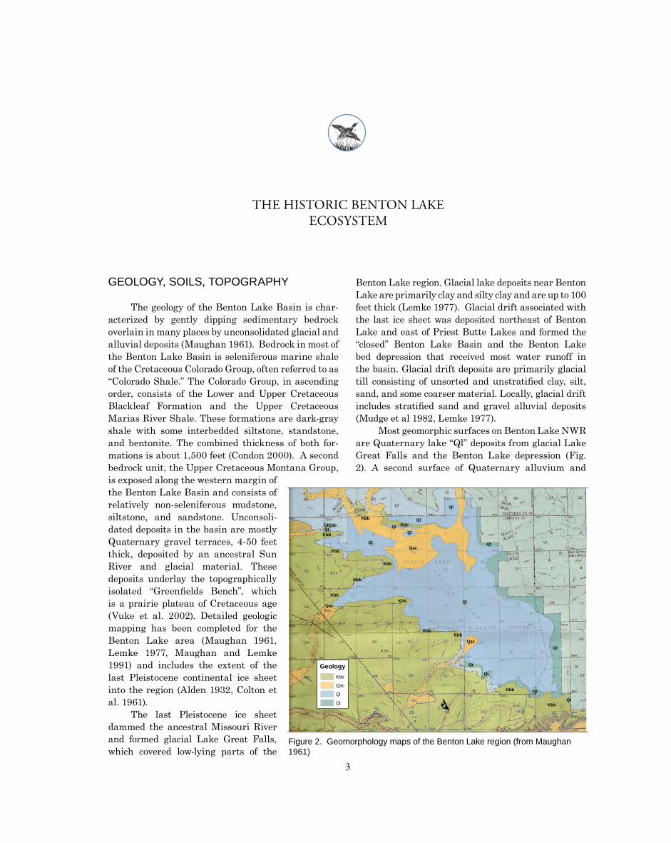
The geology of the Benton Lake Basin is char-acterized by gently dipping sedimentary bedrock overlain in many places by unconsolidated glacial and alluvial deposits (Maughan 1961). Bedrock in most of the Benton Lake Basin is seleniferous marine shale of the Cretaceous Colorado Group, often referred to as “Colorado Shale.” The Colorado Group, in ascending order, consists of the Lower and Upper Cretaceous Blackleaf Formation and the Upper Cretaceous Marias River Shale. These formations are dark-gray shale with some interbedded siltstone, standstone, and bentonite. The combined thickness of both for-mations is about 1,500 feet (Condon 2000). A second bedrock unit, the Upper Cretaceous Montana Group, is exposed along the western margin of the Benton Lake Basin and consists of relatively non-seleniferous mudstone, siltstone, and sandstone. Unconsoli-dated deposits in the basin are mostly Quaternary gravel terraces, 4-50 feet thick, deposited by an ancestral Sun River and glacial material. These deposits underlay the topographically isolated “Greenfields Bench”, which is a prairie plateau of Cretaceous age (Vuke et al. 2002). Detailed geologic mapping has been completed for the Benton Lake area (Maughan 1961, Lemke 1977, Maughan and Lemke 1991) and includes the extent of the last Pleistocene continental ice sheet into the region (Alden 1932, Colton et al. 1961).
The last Pleistocene ice sheet dammed the ancestral Missouri River and formed glacial Lake Great Falls, which covered low-lying parts of the
Benton Lake region. Glacial lake deposits near Benton Lake are primarily clay and silty clay and are up to 100 feet thick (Lemke 1977). Glacial drift associated with the last ice sheet was deposited northeast of Benton Lake and east of Priest Butte Lakes and formed the “closed” Benton Lake Basin and the Benton Lake bed depression that received most water runoff in the basin. Glacial drift deposits are primarily glacial till consisting of unsorted and unstratified clay, silt, sand, and some coarser material. Locally, glacial drift includes stratified sand and gravel alluvial deposits (Mudge et al 1982, Lemke 1977).
Most geomorphic surfaces on Benton Lake NWR are Quaternary lake “Ql” deposits from glacial Lake Great Falls and the Benton Lake depression (Fig. 2). A second surface of Quaternary alluvium and
Ql
Kbb QlQlKbb KbbQlQl QlKbb
Ql QtQac
Kbb
Kbb
Kbb
KbbKbb Ql
Qac
KbbKbb
QacQt
Qt
Qt
Kbb Qt
QtKbb
GeologyKbb
Qac
Ql
Qt O
Figure 2. Geomorphology maps of the Benton Lake region (from Maughan 1961)
�M. E. Heitmeyer et al..
O
Soils
0 0.5 1 2 Miles
Abor-Yawdim clays, 8 to 20 percent slopes
Acel silty clay loam, 0 to 2 percent slopes
Aquepts and Aquolls, saline
Kevin-Hillon clay loams, 8 to 15 percent slopes
Kevin-Scobey complex, 4 to 10 percent slopes
Linnet-Acel silty clay loams, 0 to 2 percent slopes
Linnet-Acel silty clay loams, 2 to 8 percent slopes
Linnet-Marias complex, 0 to 2 percent slopes
Marias silty clay, 0 to 2 percent slopes
Marias silty clay, 2 to 4 percent slopes
Marias silty clay, 4 to 8 percent slopes
Marvan clay, 0 to 4 percent slopes
McKenzie clay
Pendroy clay, 0 to 2 percent slopes
Pendroy clay, 2 to 8 percent slopes
Pendroy clay, 8 to 15 percent slopes
Scobey-Kevin clay loams, 0 to 5 percent slopes
Tanna clay loam, 2 to 8 percent slopes
Thebo clay, 0 to 4 percent slopes
Thebo clay, 4 to 10 percent slopes
Vanda clay
Water
Yawdim-Rentsac-Cabbart complex, 15 to 50 percent slopes
Blue Heron Conservation Design and Printing LLC | 2009
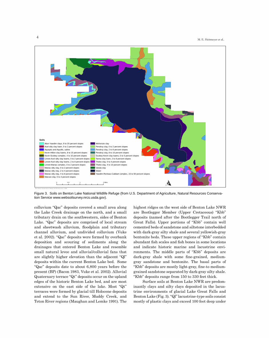
Figure 3. Soils on Benton Lake National Wildlife Refuge (from U.S. Department of Agriculture, Natural Resources Conserva-tion Service www.websoilsurvey.nrcs.usda.gov).
colluvium “Qac” deposits covered a small area along the Lake Creek drainage on the north, and a small tributary drain on the southwestern, sides of Benton Lake. “Qac” deposits are comprised of local stream and sheetwash alluvium, floodplain and tributary channel alluvium, and undivided colluvium (Vuke et al. 2002). “Qac” deposits were formed by overbank deposition and scouring of sediments along the drainages that entered Benton Lake and resemble small natural levee and alluvial/colluvial fans that are slightly higher elevation than the adjacent “Ql” deposits within the current Benton Lake bed. Some “Qac” deposits date to about 6,800 years before the present (BP) (Bacon 1983, Vuke et al. 2002). Alluvial Quaternary terrace “Qt” deposits occur on the upland edges of the historic Benton Lake bed, and are most extensive on the east side of the lake. Most “Qt” terraces were formed by glacial till Holocene deposits and extend to the Sun River, Muddy Creek, and Teton River regions (Maughan and Lemke 1991). The
highest ridges on the west side of Benton Lake NWR are Bootlegger Member (Upper Cretaceous) “Kbb” deposits (named after the Bootlegger Trail north of Great Falls). Upper portions of “Kbb” contain well cemented beds of sandstone and siltstone interbedded with dark-gray silty shale and several yellowish-gray bentonite beds. These upper regions of “Kbb” contain abundant fish scales and fish bones in some locations and indicate historic marine and lacustrine envi-ronments. The middle parts of “Kbb” deposits are dark-gray shale with some fine-grained, medium-gray sandstone and bentonite. The basal parts of “Kbb” deposits are mostly light-gray, fine-to medium-grained sandstone separated by dark-gray silty shale. “Kbb” deposits range from 150 to 330 feet thick.
Surface soils at Benton Lake NWR are predom-inantly clays and silty clays deposited in the lacus-trine environments of glacial Lake Great Falls and Benton Lake (Fig. 3). “Ql” lacustrine-type soils consist mostly of plastic clays and exceed 100 feet deep under

�
LegendRefuge Boundary
Roads
Benton LakeGeneral Elevation Model
High: 3867.9 feet
Detailed Benton Lake topographyFeet
Low : 3470.6 feet
3613.7
3614.8
3615.8
3616.8
3617.3
3617.8
3618.3
3618.8
3619.3
3619.8
3620.3
3620.8
3620.8
3621.3
Figure 4. General elevation map of the Benton Lake region.
parts of Benton Lake. “Qac” soils are mostly silt and sand with minor clay and gravel present in soil stratigraphy. Thickness of “Qac” soils ranges from 10 to 40 feet where they then become intermixed with underlying lacustrine-type deposits. “Qt” terrace-type soils are mostly 10-30 feet thick clay loam types overlying reddish-brown, poorly sorted sand and gravel dominantly of subangular to slabby sandstone and subrounded quartzite, shale, granite, and argillite (Maughan and Lemke 1991). “Kbb” surfaces have interesting, stratified soils indicating various depositions from historic marine environ-ments, Lake Great Falls, and underlying Colorado Shale (Condon 2000).
The topography of Benton Lake NWR reflects the dominant geological surfaces and features of
the region. Within Benton Lake proper, elevation gradients are relatively subtle ranging from about 3,614 feet above mean sea level (amsl) in the lowest depressions in the middle of the historic lake bed to about 3,622 feet amsl on the edge of the lake that defines its “full-pool” water level (Fig. 4). A detailed elevation map of the south part of Benton Lake prepared in the early 2000s indicates several deeper depressions historically were present in the lake bed, and likely reflected glacial scouring when the basin was created. The “Qac” surfaces along Lake Creek and the small tributary on the southwest side of Benton Lake are 2-8 feet higher than Benton Lake surfaces and form the small alluvial fans in these areas. “Qt” terraces range from about 3,622 to 3,700 feet amsl and the “Kbb” ridges on the edge of the
Evaluation of ecosystem restoration and management options for Benton Lake NWR
6M. E. Heitmeyer et al..
Benton Lake Basin rise to about 3,850 feet amsl. In general, the gradual sloping of the historic Lake Great Falls region and the contemporary Benton Lake bed produced a low-gradient topographic and hydrological setting within the closed Benton Lake Basin. This low gradient and closed system produced relatively little scouring and depositional surfaces within the basin, with the small exception of the slightly raised alluvial fan/natural levee along Lake Creek where it entered Benton Lake.
CLIMATE AND HYDROLOGY
Table 1. Mean annual and monthly temperatures and precipitation at Great Falls, Montana (from Clark et al. 1979).
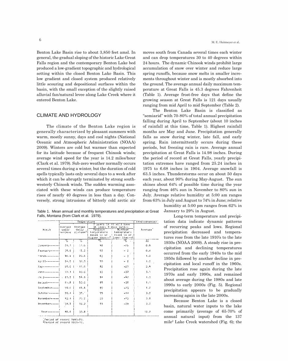
The climate of the Benton Lake region is generally characterized by pleasant summers with warm, mostly sunny, days and cool nights (National Oceanic and Atmospheric Administration (NOAA) 2009). Winters are cold but warmer than expected for its latitude because of frequent Chinook winds; average wind speed for the year is 14.2 miles/hour (Clark et al. 1979). Sub-zero weather normally occurs several times during a winter, but the duration of cold spells typically lasts only several days to a week after which it can be abruptly terminated by strong south-westerly Chinook winds. The sudden warming asso-ciated with these winds can produce temperature rises of nearly 40 degrees in less than a day. Con-versely, strong intrusions of bitterly cold arctic air
moves south from Canada several times each winter and can drop temperatures 30 to 40 degrees within 24 hours. The dynamic Chinook winds prohibit large accumulation of snow over winter and reduce large spring runoffs, because snow melts in smaller incre-ments throughout winter and is mostly absorbed into the ground. The average annual daily maximum tem-perature at Great Falls is 45.3 degrees Fahrenheit (Table 1). Average frost-free days that define the growing season at Great Falls is 121 days usually ranging from mid April to mid September (Table 2).
The Benton Lake Basin is classified as “semiarid” with 70-80% of total annual precipitation falling during April to September (about 10 inches of rainfall at this time, Table 1). Highest rainfall months are May and June. Precipitation generally falls as snow during winter, late fall, and early spring. Rain intermittently occurs during these periods, but freezing rain is rare. Average annual precipitation at Great Falls is 14.98 inches. During the period of record at Great Falls, yearly precipi-tation extremes have ranged from 25.24 inches in 1975 to 6.68 inches in 1904. Average snowfall is 63.5 inches. Thunderstorms occur on about 50 days each year, about 90% during May-August. The sun shines about 64% of possible time during the year ranging from 46% sun in November to 80% sun in July. Average relative humidity at 5:00 am ranges from 63% in July and August to 74% in June; relative
humidity at 5:00 pm ranges from 62% in January to 29% in August.
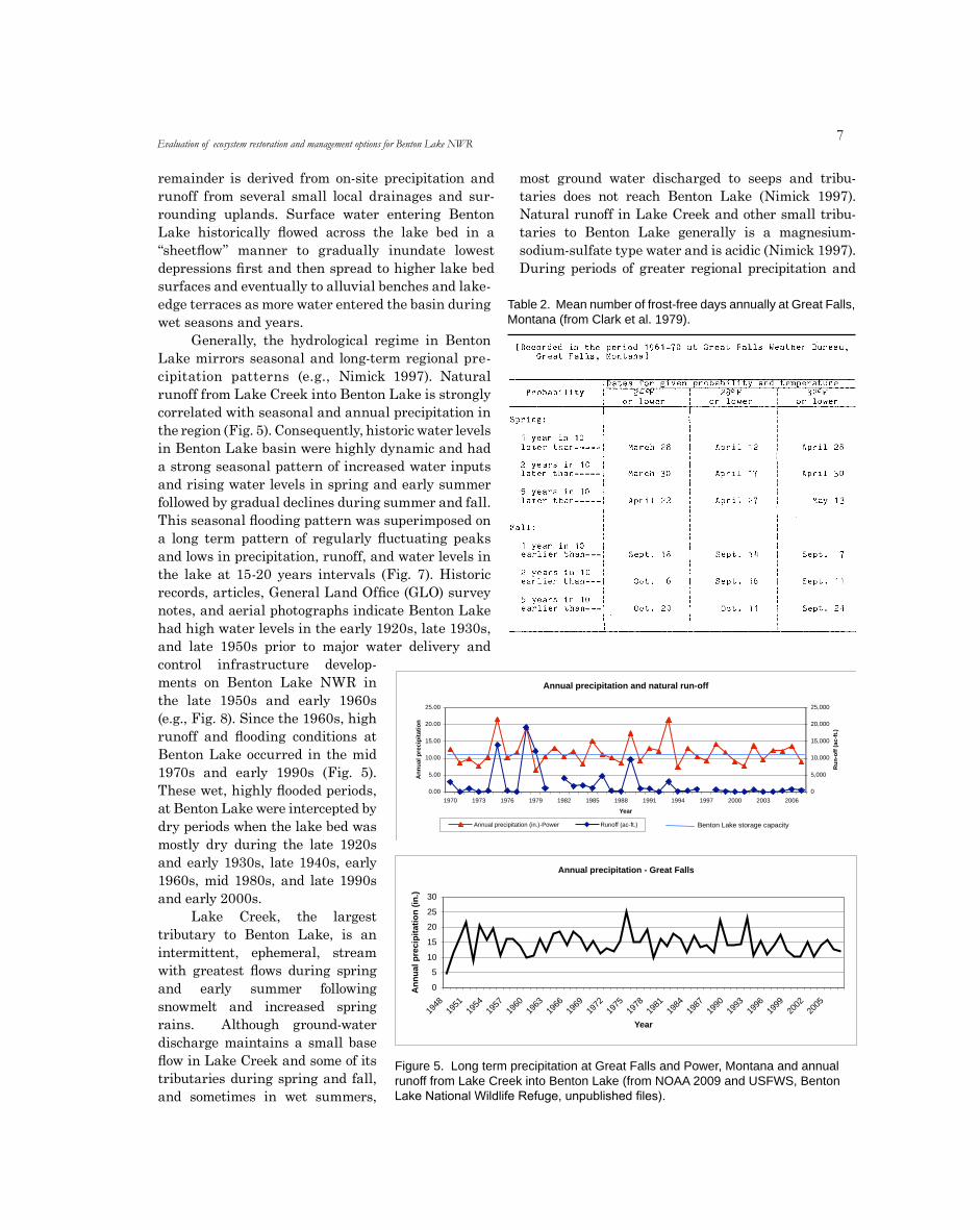
Long-term temperature and precipi-tation data indicate dynamic patterns of recurring peaks and lows. Regional precipitation decreased and tempera-tures rose from the late 1910’s to the late 1930s (NOAA 2009). A steady rise in pre-cipitation and declining temperatures occurred from the early 1940s to the mid 1950s followed by another decline in pre-cipitation and local runoff in the 1960s. Precipitation rose again during the late 1970s and early 1990s, and remained about average during the 1980s and late 1990s to early 2000s (Fig. 5). Regional precipitation appears to be gradually increasing again in the late 2000s.
Because Benton Lake is a closed basin, natural water inputs to the lake come primarily (average of 65-70% of annual natural input) from the 137 mile2 Lake Creek watershed (Fig. 6); the
�
remainder is derived from on-site precipitation and runoff from several small local drainages and sur-rounding uplands. Surface water entering Benton Lake historically flowed across the lake bed in a “sheetflow” manner to gradually inundate lowest depressions first and then spread to higher lake bed surfaces and eventually to alluvial benches and lake-edge terraces as more water entered the basin during wet seasons and years.
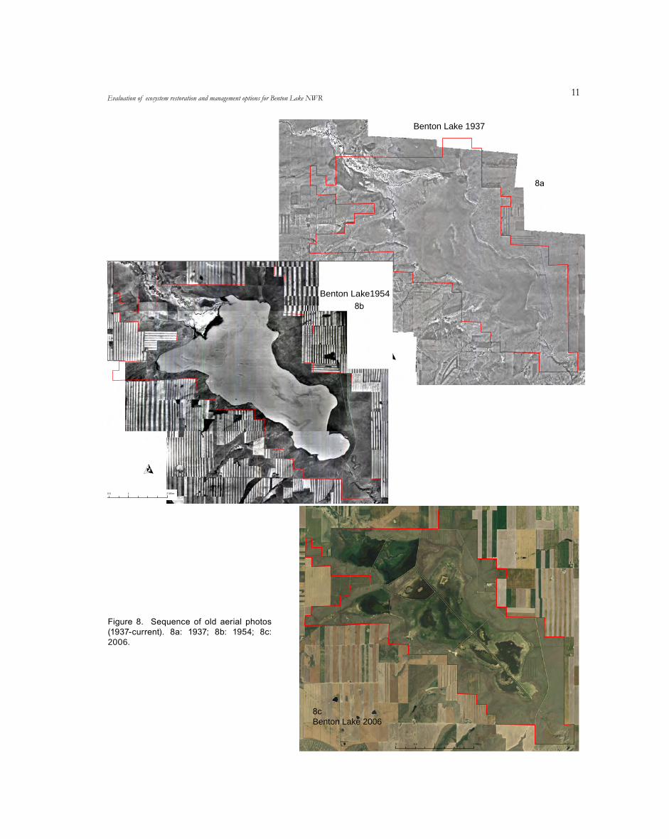
Generally, the hydrological regime in Benton Lake mirrors seasonal and long-term regional pre-cipitation patterns (e.g., Nimick 1997). Natural runoff from Lake Creek into Benton Lake is strongly correlated with seasonal and annual precipitation in the region (Fig. 5). Consequently, historic water levels in Benton Lake basin were highly dynamic and had a strong seasonal pattern of increased water inputs and rising water levels in spring and early summer followed by gradual declines during summer and fall. This seasonal flooding pattern was superimposed on a long term pattern of regularly fluctuating peaks and lows in precipitation, runoff, and water levels in the lake at 15-20 years intervals (Fig. 7). Historic records, articles, General Land Office (GLO) survey notes, and aerial photographs indicate Benton Lake had high water levels in the early 1920s, late 1930s, and late 1950s prior to major water delivery and control infrastructure develop-ments on Benton Lake NWR in the late 1950s and early 1960s (e.g., Fig. 8). Since the 1960s, high runoff and flooding conditions at Benton Lake occurred in the mid 1970s and early 1990s (Fig. 5). These wet, highly flooded periods, at Benton Lake were intercepted by dry periods when the lake bed was mostly dry during the late 1920s and early 1930s, late 1940s, early 1960s, mid 1980s, and late 1990s and early 2000s.
Lake Creek, the largest tributary to Benton Lake, is an intermittent, ephemeral, stream with greatest flows during spring and early summer following snowmelt and increased spring rains. Although ground-water discharge maintains a small base flow in Lake Creek and some of its tributaries during spring and fall, and sometimes in wet summers,
most ground water discharged to seeps and tribu-taries does not reach Benton Lake (Nimick 1997). Natural runoff in Lake Creek and other small tribu-taries to Benton Lake generally is a magnesium-sodium-sulfate type water and is acidic (Nimick 1997). During periods of greater regional precipitation and
Table 2. Mean number of frost-free days annually at Great Falls, Montana (from Clark et al. 1979).
Evaluation of ecosystem restoration and management options for Benton Lake NWR
Figure 5. Long term precipitation at Great Falls and Power, Montana and annual runoff from Lake Creek into Benton Lake (from NOAA 2009 and USFWS, Benton Lake National Wildlife Refuge, unpublished files).
Annual precipitation and natural run-off
25.00 25,000
Ann
ual p
reci
pita
tion 20.00 20,000
15.00 15,000
10.00 10,000
Run
-off
(ac-
ft.)
5.00 5,000
0.00 0
1970 1973 1976 1979 1982 1985 1988 1991 1994 1997 2000 2003 2006
Year
Annual precipitation (in.)-Power Runoff (ac-ft.) Benton Lake storage capacity
Annual precipitation - Great Falls
Ann
ual p
reci
pita
tion
(in.) 30
25
20
15
10
5
0
1948
1951
1954
1957
1960
1963
1966
1969
1972
1975
1978
1981
1984
1987
1990
1993
1996
1999
2002
2005
Year
Annual precipitation - Great Falls
0
5
10
15
20
25
30
1948
1951
1954
1957
1960
1963
1966
1969
1972
1975
1978
1981
1984
1987
1990
1993
1996
1999
2002
2005
Year
Ann
ual p
reci
pita
tion
(in.)
Annual precipitation and natural run-off
0.00
5.00
10.00
15.00
20.00
25.00
1970 1973 1976 1979 1982 1985 1988 1991 1994 1997 2000 2003 2006
Year
Ann
ual p
reci
pita
tion
0
5,000
10,000
15,000
20,000
25,000
Run
-off
(ac-
ft.)
Annual precipitation (in.)-Power Runoff (ac-ft.)

�M. E. Heitmeyer et al..
Hillshade Map ofLake Creek Watershed
O0 1 2 4 Miles
Blue Heron Conservation Design and Printing LLC | 2009
Figure 6. Lake Creek watershed map.
snowmelt runoff, more relatively dilute water flowed in Lake Creek and entered Benton Lake (Fig. 5) and periodically caused very high water levels, e.g. peak levels in 1954 (Fig. 8). Typically, regional precipitation and runoff declined for several years following pre-cipitation peaks, and annual water levels in Benton Lake gradually declined to low levels due to evapo-transpiration, which averages about 40-41 inches/year (U.S. Soil Conservation Service 1970). Surface water remaining in Benton Lake during dry seasons and years was confined to the lowest elevation depressions (e.g., GLO 1920).
The ground water aquifer beneath the Benton Lake Basin is confined mainly to the basal Colorado Shale formation (Nimick 1997, Miller et al. 2002). A number of sandstone beds, which are porous and transmit water freely, occur in this formation. Water quantity in this aquifer is poor quality; chloride con-centrations are low, dissolved-solid concentrations are moderate, pH is basic (8-9), sulfate and bicarbonate are
predominant anions, redox conditions are reducing, and selenium levels are low (Nimick 1997). The poor quality of this deep aquifer discouraged well drilling for water sources in the region and a basin-wide poten-timetric-surface map is not available. Shallow ground water (< 100 feet deep) in the Benton Lake region has different chemical constituents than the deep Colorado Shale aquifer; shallow water typically is acidic with higher levels of calcium, sulfate, chloride and magnesium. The thick lacustrine-type clay surfaces in Benton Lake prohibit water movement, or recharge, from the lake into ground water (Nimick et al. 1996, Nimick 1997). Other ground water in the Benton Lake Basin appears to move slowly to the east and dis-charges to some shallow wetland depressions between Benton Lake and the Missouri River (Nimick 1997).
Historically, the relatively low annual amount of surface precipitation falling on uplands surrounding Benton Lake was typically was captured quickly and used by native grassland; little water moved deeply
9
into soil and subsoil layers. Where water did percolate downward, it subsequently moved slowly into aquifers and occasionally exited slopes as springs or saline seeps. The historically sparse saline seeps in the Benton Lake Basin undoubtedly discharged dissolved solids and elements like selenium into basin streams and drainages into Benton Lake at certain times. Deposition of salts and elements in Benton Lake did not historically accumulate to high levels, however, because of elemental volatilization in water, sediment, and wetland plants during dry periods of the long-term hydrological cycle (Zhang and Moore 1997a). Higher temperatures, higher airflow, drier sediments, and decomposition of wetland plants increase removal rates of selenium. Additionally, selenium volatilization is more efficient in seasonally flooded wetland areas than in permanently flooded wetlands. Eventually, salts and elements in annually dynamic western wetlands, with functional seasonal and long-term hydrology, such as in the historic Benton Lake, reach a dynamic equilibrium where the amount of salts and elements removed by wind erosion and volatil-ization equaled the amount of input and solute accumulation or movement into deeper lakebed sediments from diffusion and advection (Zhang and Moore 1997b).
VEGETATION COMMUNITIES
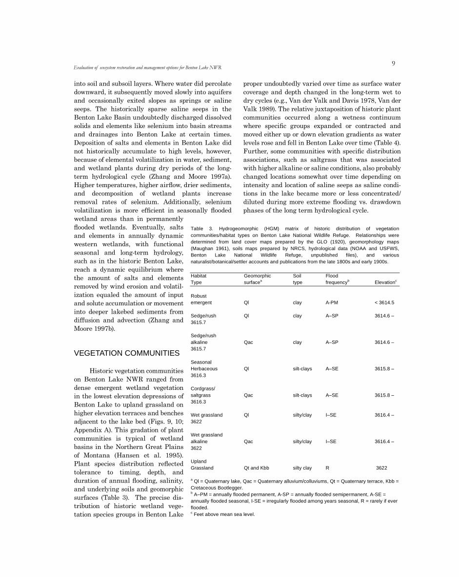
Historic vegetation communities on Benton Lake NWR ranged from dense emergent wetland vegetation in the lowest elevation depressions of Benton Lake to upland grassland on higher elevation terraces and benches adjacent to the lake bed (Figs. 9, 10; Appendix A). This gradation of plant communities is typical of wetland basins in the Northern Great Plains of Montana (Hansen et al. 1995). Plant species distribution reflected tolerance to timing, depth, and duration of annual flooding, salinity, and underlying soils and geomorphic surfaces (Table 3). The precise dis-tribution of historic wetland vege-tation species groups in Benton Lake
proper undoubtedly varied over time as surface water coverage and depth changed in the long-term wet to dry cycles (e.g., Van der Valk and Davis 1978, Van der Valk 1989). The relative juxtaposition of historic plant communities occurred along a wetness continuum where specific groups expanded or contracted and moved either up or down elevation gradients as water levels rose and fell in Benton Lake over time (Table 4). Further, some communities with specific distribution associations, such as saltgrass that was associated with higher alkaline or saline conditions, also probably changed locations somewhat over time depending on intensity and location of saline seeps as saline condi-tions in the lake became more or less concentrated/diluted during more extreme flooding vs. drawdown phases of the long term hydrological cycle.
Evaluation of ecosystem restoration and management options for Benton Lake NWR
Table 3. Hydrogeomorphic (HGM) matrix of historic distribution of vegetationcommunities/habitat types on Benton Lake National Wildlife Refuge. Relationships weredetermined from land cover maps prepared by the GLO (1920), geomorphology maps(Maughan 1961), soils maps prepared by NRCS, hydrological data (NOAA and USFWS,Benton Lake National Wildlife Refuge, unpublished files), and variousnaturalist/botanical/settler accounts and publications from the late 1800s and early 1900s.
HabitatType
Geomorphicasurface
Soiltype
Floodbfrequency cElevation
Robustemergent
Sedge/rush3615.7
Sedge/rushalkaline3615.7
SeasonalHerbaceous3616.3
Cordgrass/saltgrass3616.3
Wet grassland3622
Wet grasslandalkaline3622
UplandGrassland
a Ql = QuaternaCretaceous Boob A–PM = annuannually floodeflooded.c Feet above m
Ql
Ql
Qac
Ql
Qac
Ql
Qac
Qt and Kbb
ry lake, Qac = Quaternarytlegger.
ally flooded permanent, A-d seasonal, I-SE = irregula
ean sea level.
clay
clay
clay
silt-clays
silt-clays
silty/clay
silty/clay
silty clay
alluvium/collu
SP = annuallyrly flooded am
A-PM
A–SP
A–SP
A–SE
A–SE
I–SE
I–SE
R
viums, Qt = Quaternary terrace, Kbb =
flooded semipermaneong years seasonal,
< 3614.5
3614.6 –
3614.6 –
3615.8 –
3615.8 –
3616.4 –
3616.4 –
3622
nt, A-SE =R = rarely if ever
10M. E. Heitmeyer et al..
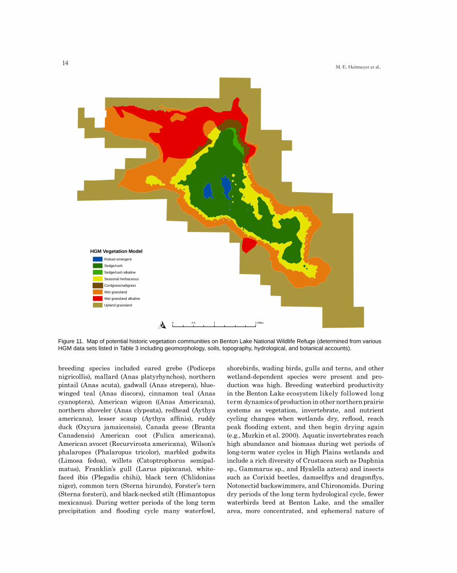
Recognizing the annual variation in flooding regimes and latent chronological and distribution response dynamics of wetland plant species to changing moisture conditions, we developed an HGM matrix of potential vegetation communities related to geomorphologic, soil, elevation, and hydrology conditions historically present at Benton Lake (Table 3). The distribution of these HGM-predicted vegetation communities assumes average long-term flooding and drying periods of 15-20 years with peak highs and lows lasting about 5-6 years. This duration of peaks and lows is based primarily on historic aerial photographs of Benton Lake, espe-cially the sequential basin photographs from 1950, 1951, 1954, 1956, and 1957. This HGM matrix was extrapolated to a historic (i.e., pre-levee and water-control structure construction) spatial resolution using the geographical information data sets on geo-morphology, soils, and elevation (Fig. 11).
Using this HGM matrix (Table 3) and potential historic vegetation map (Fig. 11), about 73 acres of the lowest elevations in Benton Lake (< 3,614.2 feet amsl) contained some surface water throughout most years and supported “open water” aquatic plant com-munities surrounded by concentric bands of robust emergent vegetation including cattail (Typha latifolia and Typha angustifolia) and hardstem bulrush (Scirpus acutus). Soils in these depressions were heavy clays and within the “Ql” geomorphic surface formed by historic lacustrine environments. Water in these
depressions was fresh, with little salt concentration. Historic aerial photo-graphs and survey/naturalist accounts from the Benton Lake region indicate that dense emergent vegetation was present in the deeper depressions at Benton Lake, at least during wet years of the long term flooding cycle, but it is unclear which emergent species were present. We suspect most emergent vegetation was hardstem bulrush, but some cattail probably was present also, based on similar wetland condi-
tions in western Montana (Hansen et al. 1995) and the extensive presence of cattail within Benton Lake at present. The width of this emergent vegetation band varied depending on extent and duration of flooding and chronological position of the long-term hydrological cycle. Submergent aquatic plants such as pondweeds (Potamogeton spp.), naiads (Najas sp.), coontail (Ceratophyllum sp.), wigeon grass (Ruppia sp.), and milfoil (Myriophyllum spp.) were present in the deepest open areas and rich algal blooms occurred in these areas.
Semipermanently flooded sites that were slightly higher elevation (3,614.3 to 3,615.2 feet amsl) adjacent to cattail and bulrush zones contained slightly less permanent water regimes and supported diverse sedge and rush species such as Carex, Sagittaria, and Juncus (Table 3, Fig. 11). These “sedge/rush” communities covered about 1,728 acres and supported diverse herbaceous wetland plants including alkali bulrush (Scirpus maritimus), three-square rush (Scirpus pungens), Nutall’s alkaligrass (Pucci-nellia nuttaliana), beaked sedge (Carex rostrata), Nebraska sedge (Carex nebrascensis), and water smartweed (Polygonum coccineum). Sedge/rush com-munities were almost entirely on “Ql” surfaces and had clay soils, similar to robust emergent commu-nities. The small area (53 acres) of sedges/rush veg-etation on “Qac” may have contained slightly more alkaline species, but this is unclear. The sedge/rush community apparently covered more area within the
Benton Lake bed than other communities and historic accounts of the lake (e.g., GLO 1920) comment on the wide bands and extensive coverage of sedges and rushes. This sedge/rush community may have expanded during wet periods to even higher
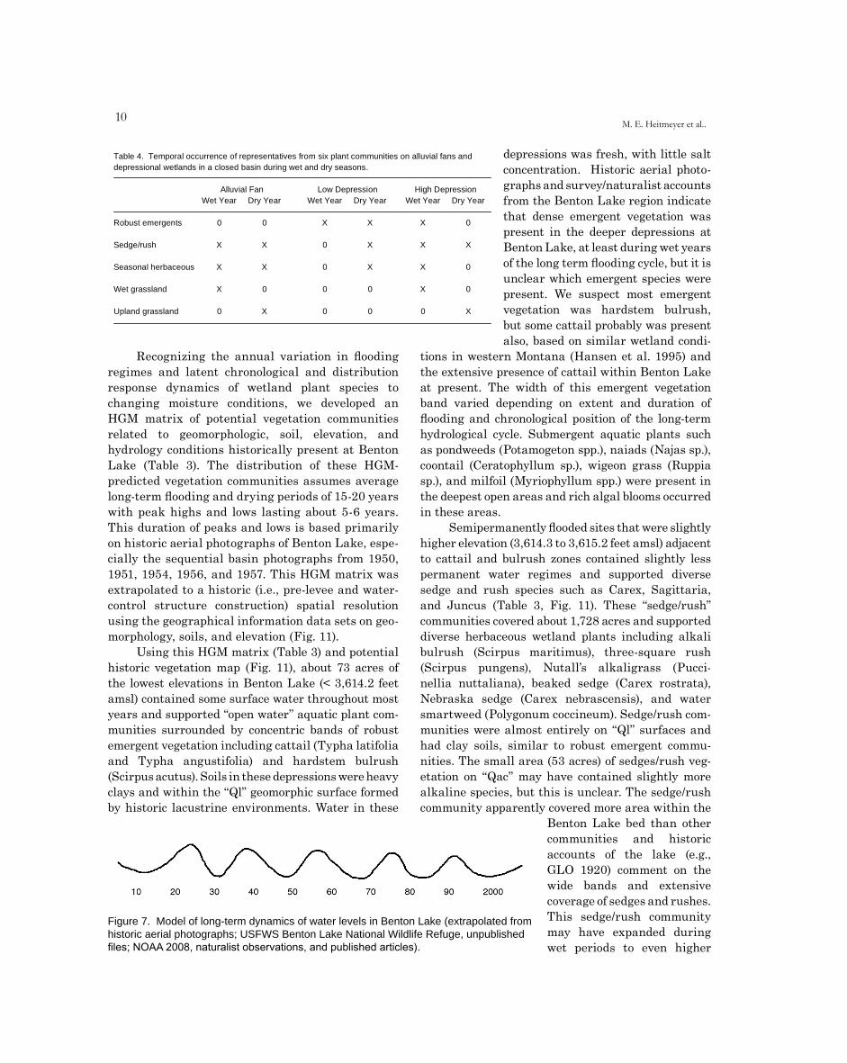
Figure 7. Model of long-term dynamics of water levels in Benton Lake (extrapolated from historic aerial photographs; USFWS Benton Lake National Wildlife Refuge, unpublished files; NOAA 2008, naturalist observations, and published articles).
Table 4. Temporal occurrence of representatives from six plant communities on alluvial fans anddepressional wetlands in a closed basin during wet and dry seasons.
Alluvial Fan Low Depression High DepressionWet Year Dry Year Wet Year Dry Year Wet Year Dry Year
Robust emergents 0 0 X X X 0
Sedge/rush X X 0 X X X
Seasonal herbaceous X X 0 X X 0
Wet grassland X 0 0 0 X 0
Upland grassland 0 X 0 0 0 X
11Evaluation of ecosystem restoration and management options for Benton Lake NWR
Figure 8. Sequence of old aerial photos (1937-current). 8a: 1937; 8b: 1954; 8c: 2006.
Benton Lake 1937
O0 1 20.5 Miles
Blue Heron Conservation Design and Printing LLC | 2009
O
0 1 20.5 Miles
Blue Heron Conservation Design and Printing LLC | 2009
Benton Lake1954
O0 1 20.5 Miles
Blue Heron Conservation Design and Printing LLC | 2009
8a
8b
8cBenton Lake 2006
12M. E. Heitmeyer et al..
elevation edges of Benton Lake and then contracted to lower elevations during extended dry periods. The periodic flooding and drying of these vegetation zones likely caused moderate alkaline soil conditions.
Seasonally flooded areas adjacent to sedge/rush communities (3,615.3 to 3,615.7 feet amsl) contained diverse annual and perennial herbaceous plants and wet prairie/meadow grasses such as spikerush (Ele-ocharis spp.), lambsquarter (Chenopodium album), annual smartweeds (Polygonum spp.), prairie cordgrass (Spartina pectinata), and saltgrass (Dis-tichlis spicata). Most seasonally flooded communities were within “Ql” surfaces (1,040 acres), but 143 acres of “Qac” also supported more distinctive species groups (Fig. 11). For example, prairie cordgrass apparently occurred in temporary and overflow areas along streams and the edges of marsh sites that had silty clay soils, less alkaline conditions, and where seasonal (usually spring) sheetflow of surface water occurred. Eleocharis usually was in relatively narrow bands along yearly flooded stream and tributary sites and the margins of lake communities. In contrast, saltgrass was most common in more saline or alkali
sites including areas where seeps flowed into Benton Lake and in some overflow areas adjacent to Lake Creek.
The highest elevation edges of Benton Lake (3,615.8 to 3,620 feet amsl) typically had short duration seasonal flooding regimes and represented the tran-sition zone from wetland to upland grassland plant communities (Table 3, Fig. 11). These sites included both “Ql” (3,167 acres) and “Qac” (1,216 acres) geo-morphic surfaces and usually had more silty clay soils compared to dense heavy clays within depressions of Benton Lake. Foxtail barley (Hordeum jubatum) was present on the higher annually drawn down margins of the lake basin and in some ephemeral depres-sions. Foxtail barley gradually graded to western wheatgrass (Agropyron smithii) and silver sagebrush (Artemisia cana) on “Qt” alluvial terraces adjacent to the lake. Eventually, these wetland-edge grass communities graded into about 4,802 acres of upland grassland (elevations > 3,620 feet amsl) present on “Qt” and “Kbb” surfaces that supported many native grass species and numerous shrubs and forbs typical of this part of Montana including bluebunch wheat-
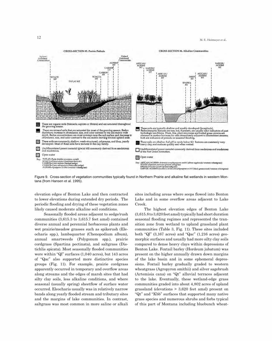
Figure 9. Cross-section of vegetation communities typically found in Northern Prairie and alkaline flat wetlands in western Mon-tana (from Hansen et al. 1995).
13
grass (Agropyron spicatum), green needlegrass (Stipa viridula), and prairie junegrass (Koeleria macrantha).
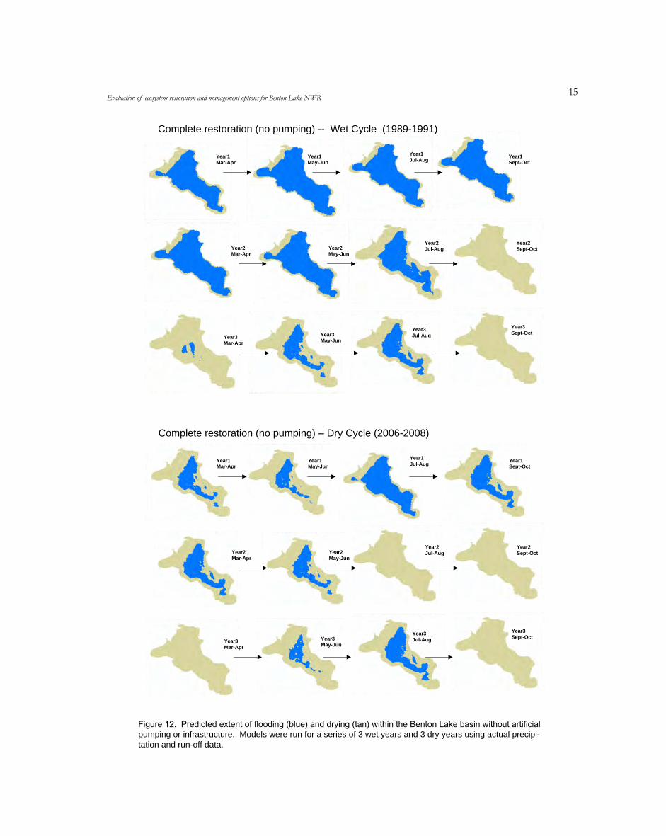
Recently developed models of water coverage in Benton Lake, assuming complete restoration of the hydrology and topography of the lake bed by removal of all levees, water-control structures, and ditches and no pumping of water from Muddy Creek, demonstrate the long-term dynamics of water area and potential effects on vegetation distribution and coverage in the basin (Fig. 12, Nimick and Fields, unpublished data). This “cycle” of increasing water area throughout the lake bed during wet years and gradual drying to very limited water area during dry years is similar to long-term dynamics in other larger Northern Prairie wetland basins and creates dynamic distribution of vegetation communities and animal responses (Weller and Spatcher 1965, Weller and Fredrickson 1974, Van der Valk and Davis 1978, Kantrud et al. 1989). These dynamics suggest historic relative changes in communities and
resources at Benton Lake over time in a recurring long-term pattern (Fig. 13, 14).
KEY ANIMAL COMMUNITIES
A rich diversity of animal species historically used the Benton Lake ecosystem (Appendix B). The relative abundance of species and specific food and cover resources used by animals varied with the long term dynamics of flooding and drying in the system. Over 100 bird species from 12 taxonomic orders have been documented at Benton Lake during various seasons. More birds were present during spring and fall migration than in other seasons; abundance in winter was low because of extensive ice, snow, and cold temperatures.
Many waterbirds historically bred in the Benton Lake area, but species richness, abundance, and production apparently varied related to extent and duration of flooding in the basin. The most common
Evaluation of ecosystem restoration and management options for Benton Lake NWR
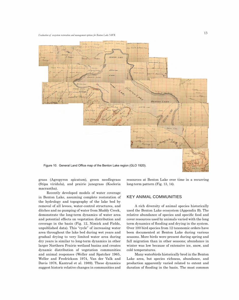
Figure 10. General Land Office map of the Benton Lake region (GLO 1920).
1�M. E. Heitmeyer et al..
breeding species included eared grebe (Podiceps nigricollis), mallard (Anas platyrhynchos), northern pintail (Anas acuta), gadwall (Anas strepera), blue-winged teal (Anas discors), cinnamon teal (Anas cyanoptera), American wigeon ((Anas Americana), northern shoveler (Anas clypeata), redhead (Aythya americana), lesser scaup (Aythya affinis), ruddy duck (Oxyura jamaicensis), Canada geese (Branta Canadensis) American coot (Fulica americana), American avocet (Recurvirosta americana), Wilson’s phalaropes (Phalaropus tricolor), marbled godwits (Limosa fedoa), willets (Catoptrophorus semipal-matus), Franklin’s gull (Larus pipixcans), white-faced ibis (Plegadis chihi), black tern (Chlidonias niger), common tern (Sterna hirundo), Forster’s tern (Sterna forsteri), and black-necked stilt (Himantopus mexicanus). During wetter periods of the long term precipitation and flooding cycle many waterfowl,
shorebirds, wading birds, gulls and terns, and other wetland-dependent species were present and pro-duction was high. Breeding waterbird productivity in the Benton Lake ecosystem likely followed long term dynamics of production in other northern prairie systems as vegetation, invertebrate, and nutrient cycling changes when wetlands dry, reflood, reach peak flooding extent, and then begin drying again (e.g., Murkin et al. 2000). Aquatic invertebrates reach high abundance and biomass during wet periods of long-term water cycles in High Plains wetlands and include a rich diversity of Crustacea such as Daphnia sp., Gammarus sp., and Hyalella azteca) and insects such as Corixid beetles, damselflys and dragonflys, Notonectid backswimmers, and Chironomids. During dry periods of the long term hydrological cycle, fewer waterbirds bred at Benton Lake, and the smaller area, more concentrated, and ephemeral nature of
HGM Vegetation Model
0 0.5 1 2 Miles
Robust emergent
Sedge/rush
Sedge/rush alkaline
Seasonal herbaceous
Cordgrass/saltgrass
Wet grassland
Wet grassland alkaline
Upland grassland
O
Figure 11. Map of potential historic vegetation communities on Benton Lake National Wildlife Refuge (determined from various HGM data sets listed in Table 3 including geomorphology, soils, topography, hydrological, and botanical accounts).
1�Evaluation of ecosystem restoration and management options for Benton Lake NWR
Figure 12. Predicted extent of flooding (blue) and drying (tan) within the Benton Lake basin without artificial pumping or infrastructure. Models were run for a series of 3 wet years and 3 dry years using actual precipi-tation and run-off data.
Year1Mar-Apr
Year1May-Jun
Year1Jul-Aug Year1
Sept-Oct
Year2Mar-Apr
Year2May-Jun
Year2Jul-Aug
Year2Sept-Oct
Year3Mar-Apr
Year3May-Jun
Year3Jul-Aug
Year3Sept-Oct
Complete restoration (no pumping) -- Wet Cycle (1989-1991)
Year1Mar-Apr
Year1May-Jun
Year1Jul-Aug Year1
Sept-Oct
Year2Mar-Apr
Year2May-Jun
Year2Jul-Aug
Year2Sept-Oct
Year3Mar-Apr
Year3May-Jun
Year3Jul-Aug
Year3Sept-Oct
Complete restoration (no pumping) – Dry Cycle (2006-2008)
16M. E. Heitmeyer et al..
13a
JAN FEB MAR APR MAY JUN JUL AUG SEP OCT NOV DEC
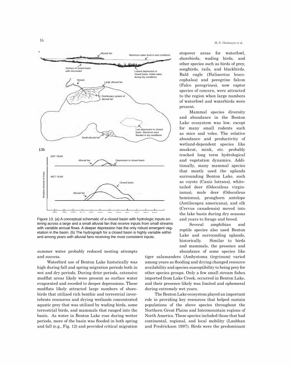
Figure 13. (a) A conceptual schematic of a closed basin with hydrologic inputs en-tering across a large and a small alluvial fan that receive inputs from small streams with variable annual flows. A deeper depression has the only robust emergent veg-etation in the basin. (b) The hydrograph for a closed basin is highly variable within and among years with alluvial fans receiving the most consistent inputs.
14a Alluvial fanMaximum water level in wet conditions
Surface of closed basin with microrelief Lowest depression in
closed basin. Holds water during dry conditions
StreamLarge alluvial fan
Distributary system of alluvial fan
Low depression in closed basin. Maximum area flooded in dry conditions
Small alluvial fan
14b
DRY YEAR
Alluvial fan Depression in closed basin
Am
ount
of I
nput
WET YEAR
Closed basin
Rel
ativ
e
Alluvial fan
13b
Figure 14. (a) A conceptual schematic of a closed basin with hydrologic inputs entering across a large and a small alluvial fan that receive inputs from small streams with variable annual flows. A deeper depression has the only robust emergent vegeta-tion in the basin. (b) The hydrograph for a closed basin is highly variable within and among years with alluvial fans receiving the most consistent inputs.
summer water probably reduced nesting attempts and success.
Waterbird use of Benton Lake historically was high during fall and spring migration periods both in wet and dry periods. During drier periods, extensive mudflat areas likely were present as surface water evaporated and receded to deeper depressions. These mudflats likely attracted large numbers of shore-birds that utilized rich benthic and terrestrial inver-tebrate resources and drying wetlands concentrated aquatic prey that was utilized by wading birds, some terrestrial birds, and mammals that ranged into the basin. As water in Benton Lake rose during wetter periods, more of the basin was flooded in both spring and fall (e.g., Fig. 12) and provided critical migration
stopover areas for waterfowl, shorebirds, wading birds, and other species such as birds of prey, songbirds, rails, and blackbirds. Bald eagle (Haliaeetus leuco-cephalus) and peregrine falcon (Falco peregrines), now raptor species of concern, were attracted to the region when large numbers of waterfowl and waterbirds were present.
Mammal species diversity and abundance in the Benton Lake ecosystem was low, except for many small rodents such as mice and voles. The relative abundance and productivity of wetland-dependent species like muskrat, mink, etc. probably tracked long term hydrological and vegetation dynamics. Addi-tionally, many mammal species that mostly used the uplands surrounding Benton Lake, such as coyote (Canis lutrans), white-tailed deer (Odocoileus virgin-ianus), mule deer (Odocoileus hemionus), pronghorn antelope (Antilocapra americana), and elk (Cervus canadensis) moved into the lake basin during dry seasons and years to forage and breed.
Several amphibian and reptile species also used Benton Lake and surrounding uplands, historically. Similar to birds and mammals, the presence and abundance of some species like
tiger salamanders (Ambystoma tirgrinum) varied among years as flooding and drying changed resource availability and species susceptibility to being prey for other species groups. Only a few small stream fishes imported from Lake Creek, occurred in Benton Lake, and their presence likely was limited and ephemeral during extremely wet years.
The Benton Lake ecosystem played an important role in providing key resources that helped sustain populations of the above species throughout the Northern Great Plains and Intermountain regions of North America. These species included those that had continental, regional, and local mobility (Laubhan and Fredrickson 1997). Birds were the predominant
1�Evaluation of ecosystem restoration and management options for Benton Lake NWR
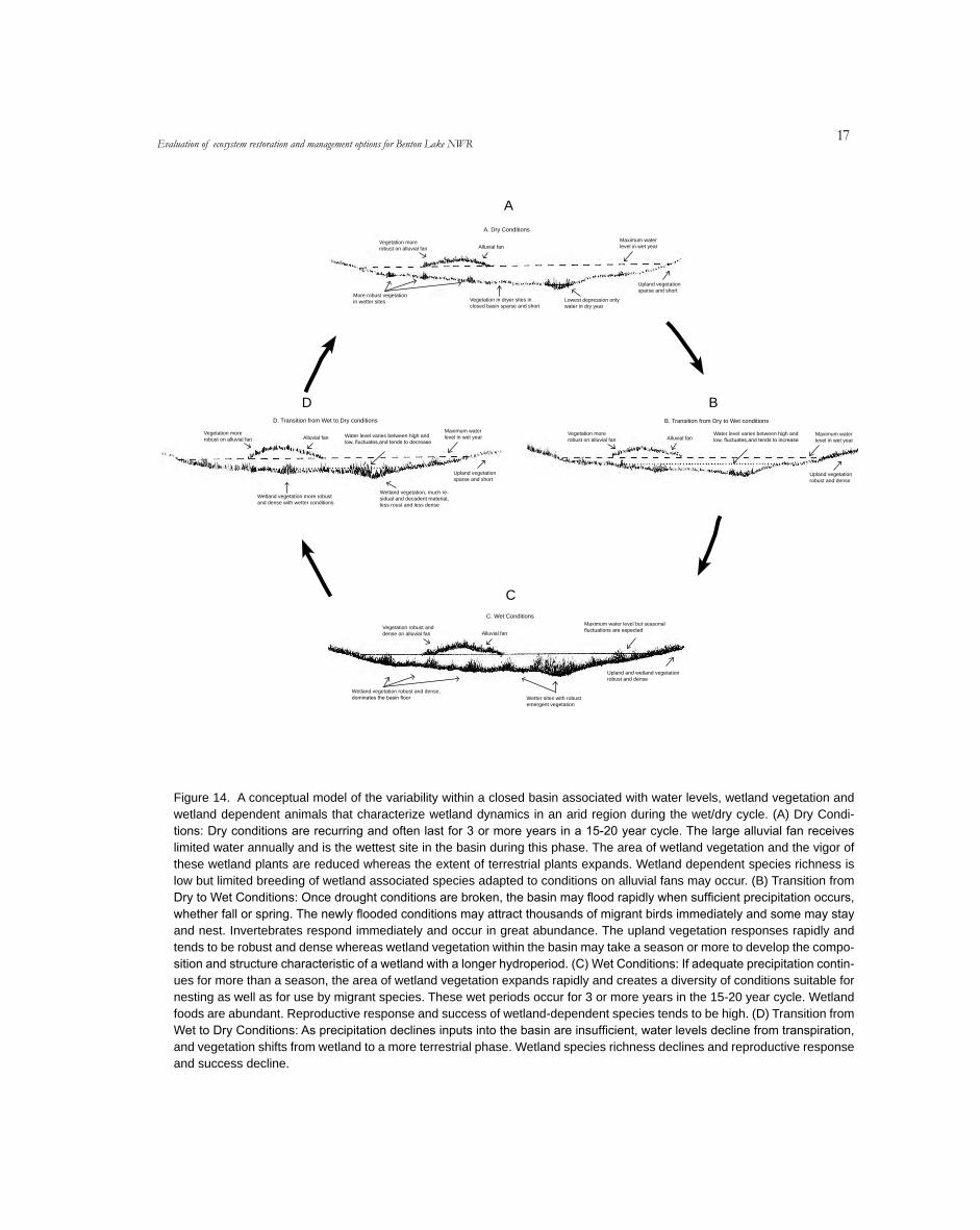
Figure 14. A conceptual model of the variability within a closed basin associated with water levels, wetland vegetation and wetland dependent animals that characterize wetland dynamics in an arid region during the wet/dry cycle. (A) Dry Condi-tions: Dry conditions are recurring and often last for 3 or more years in a 15-20 year cycle. The large alluvial fan receives limited water annually and is the wettest site in the basin during this phase. The area of wetland vegetation and the vigor of these wetland plants are reduced whereas the extent of terrestrial plants expands. Wetland dependent species richness is low but limited breeding of wetland associated species adapted to conditions on alluvial fans may occur. (B) Transition from Dry to Wet Conditions: Once drought conditions are broken, the basin may flood rapidly when sufficient precipitation occurs, whether fall or spring. The newly flooded conditions may attract thousands of migrant birds immediately and some may stay and nest. Invertebrates respond immediately and occur in great abundance. The upland vegetation responses rapidly and tends to be robust and dense whereas wetland vegetation within the basin may take a season or more to develop the compo-sition and structure characteristic of a wetland with a longer hydroperiod. (C) Wet Conditions: If adequate precipitation contin-ues for more than a season, the area of wetland vegetation expands rapidly and creates a diversity of conditions suitable for nesting as well as for use by migrant species. These wet periods occur for 3 or more years in the 15-20 year cycle. Wetland foods are abundant. Reproductive response and success of wetland-dependent species tends to be high. (D) Transition from Wet to Dry Conditions: As precipitation declines inputs into the basin are insufficient, water levels decline from transpiration, and vegetation shifts from wetland to a more terrestrial phase. Wetland species richness declines and reproductive response and success decline.
A. Dry Conditions
Maximum water Vegetation more Alluvial fan level in wet yearrobust on alluvial fan
Upland vegetation sparse and short
More robust vegetation Vegetation in dryer sites in Lowest depression only in wetter sitesclosed basin sparse and short water in dry year
B. Transition from Dry to Wet conditions
Vegetation more Maximum water Alluvial fanrobust on alluvial fan level in wet year
Upland vegetation robust and dense
Water level varies between high and low, fluctuates,and tends to increase
D. Transition from Wet to Dry conditions
Maximum water Vegetation more Alluvial fan level in wet yearrobust on alluvial fan
Upland vegetation sparse and short
Wetland vegetation, much re-Wetland vegetation more robust sidual and decadent material, and dense with wetter conditions less roust and less dense
Water level varies between high and low, fluctuates,and tends to decrease
C. Wet ConditionsMaximum water level but seasonal
Vegetation robust and fluctuations are expecteddense on alluvial fan Alluvial fan
Upland and wetland vegetation robust and dense
Wetland vegetation robust and dense, dominates the basin floor Wetter sites with robust
emergent vegetation
A
D B
C
Figure 15. A conceptual model of the variability within a closed basin associated with water levels, wetland vegetation and wetland dependent animals that characterize wetland dynamics in an arid region during the wet/dry cycle. (A) Dry Conditions: Dry conditions are recurring and often last for 3 or more years in a 15-20 year cycle. The large alluvial fan receives limited water annually and is the wettest site in the basin during this phase. The area of wetland vegetation and the vigor of these wetland plants are reduced whereas the extent of terrestrial plants expands. Wetland dependent species richness is low but limited breeding of wetland associated species adapted to conditions on alluvial fans may occur. (B) Transition from Dry to Wet Condi-tions: Once drought conditions are broken, the basin may flood rapidly when sufficient precipitation occurs, whether fall or spring. The newly flooded conditions may attract thousands of migrant birds immediately and some may stay and nest. Invertebrates respond immediately and occur in great abundance. The upland vegetation responses rapidly and tends to be robust and dense whereas wetland vegetation within the basin may take a season or more to develop the composition and structure characteristic of a wetland with a longer hydroperiod. (C) Wet Conditions: If adequate precipitation continues for more than a season, the area of wetland vegetation expands rapidly and creates a diversity of conditions suitable for nesting as well as for use by migrant spe-cies. These wet periods occur for 3 or more years in the 15-20 year cycle. Wetland foods are abundant. Reproductive response and success of wetland-dependent species tends to be high. (D) Transition from Wet to Dry Conditions: As precipitation declines inputs into the basin are insufficient, water levels decline from transpiration, and vegetation shifts from wetland to a more ter-restrial phase. Wetland species richness declines and reproductive response and success are more problematic.
1�M. E. Heitmeyer et al..
vertebrates with continental mobility and Benton Lake provided varying resources during wet and dry periods that contributed to breeding and migration periods of the annual cycle. Because of its size, many bird populations undoubtedly depended on Benton Lake for specific resources during at least some periods of their life spans. The most common large waterbirds in the Great Plains (e.g., wading birds, waterfowl, etc.) have average life spans (excluding human-caused mortality) of >10 years (Palmer 1978, Bellrose 1980). For these species that occasionally bred at Benton Lake (during wet years), the long-term flooding cycles of peak water and habitat about every 10-15 years offered at least one option for potentially abundant nesting habitat and breeding resources during their life span. For other shorter lived species, the inter-mittent wet or dry state more regularly provided late spring and early summer habitats and resources for migration and breeding, and occasional flooding and regular mudflat conditions for fall migration. For all species with continental mobility, Benton Lake undoubtedly was a critical, albeit annually dynamic, habitat for western populations of many birds, espe-cially waterbirds.
Mammals were the most common vertebrates that exhibited regional mobility in the Benton Lake Basin. Although most mammals in the Northern Great Plains have widespread distributions, indi-vidual animals typically are restricted to much smaller areas. Consequently, portions or even sub-populations of some mammal species in the Western
Great Plains apparently likely were dependent on seasonal resources provided in the Benton Lake ecosystem. Mammals that regularly use or depend on wetland resources required a variety of wetland basins and types within their home range. However, the reduced mobility of this group dictates that the distribution of wetland types must be closer to each other if recolonization is to occur after extended drought or floods. Otter, beaver, mink, and fish are examples of regionally mobile species dependent on aquatic habitats – and, none of these species appar-ently were historically common at Benton Lake. In contrast, more common mammals at Benton Lake were species that ranged into the lake bed during either dry or wet periods, such as ungulates, but generally were supported more by upland habitats and resources.
Species with limited mobility tend to be small and include amphibians, reptiles, and small mammals. Nearly 40 species of herpetofauna in the Northern Great Plains are primarily aquatic or require surface water during some stage of their life cycle (Corn and Peterson 1996). Many species are capable of exploiting seasonally, or periodically, flooded wetlands such as Benton Lake because of behavioral adaptations that enable survival during drought. For example, leopard frogs (Rana blairi) can survive dry periods by migrating short distances or remaining in depres-sions (Grzimek 1974). Undoubtedly, Benton Lake was critical to sustaining populations of many limited mobility species in the region.
Fran
k N
elson
19
CHANGES TO THE BENTON LAKE ECOSYSTEM
SETTLEMENT AND REGIONAL LANDSCAPE CHANGES
The historic landscape in the Benton Lake Basin contained vast expanses of grasslands, undulating topography, a few intermittent streams and wooded “riparian” corridors, and scattered wetland basins, with Benton Lake being the largest. This area was inhabited by Native Americans for at least 10,000 years prior to European assimilation. The Blackfeet, Cheyenne, and Crow tribes lived in the plains region, but had mobile lifestyles and they apparently had rela-tively little influence on the plains landscape, with the exception of occasionally setting fires. A few French trappers apparently visited areas along the nearby Missouri River in the mid to late 1700s, but the area was not explored until 1805 when members of the Lewis and Clark expedition viewed the Great Falls of the Missouri River and Black Eagle Falls. These Lewis and Clark explorers spent about three weeks in the area and recorded in their journals descrip-tions of the falls and surrounding area, which would eventually fuel interest in settlement. Expedition members returned to the area in 1806 and reported large numbers of bison, elk, deer, and antelope in the area along with grizzly bear and mountain lions. After 1807, trappers and fur traders became active in the region; the American Fur Company built Fort Benton on the Missouri River in 1847.
The United States received most of what is now Montana as part of the Louisiana Purchase in the early 1800s; the northwest part of the state was gained by treaty with Great Britain in 1846. In 1862, prospectors found gold in southwest Montana and many settlers moved to the state thereafter. The area around Benton Lake was not a source of gold, however, and only occasional trappers, hunters, and gold seekers occupied the area. Threats of Indian aggression also deterred European settlement in the
region until the 1870s. Consequently, the physical and ecological nature of the Benton Lake Basin remained essentially unchanged from its historic condition until about 1880, when settlers increasingly moved to the Missouri River Valley. Between 1880 and 1890 the population of Montana grew from about 39,000 to nearly 143,000. In 1884, Paris Gibson founded the city of Great Falls at the confluence of the Sun and Missouri Rivers and the city was incorporated in 1888 (Yuill and Yuill 1984). The Mullan Road, a common western pathway built in the early 1860s for pioneers and settlers traveling from Fort Benton by way of Coeur d’ Alene to the Pacific northwest wound around the north end of Benton Lake, which was dry in most years (Cascade County Historical Society 1999). Interestingly, another early road near Benton Lake, running north of Great Falls from the current Highway 87 to Canada, was heavily used to carry bootlegged liquor to Great Falls and other towns further south during the Prohibition Era of the early 1900s. Named “Bootlegger Trail”, it crossed the old Mullan Road and homesteaders along the trail near Benton Lake augmented their income by allowing bootleggers to use their barns to layover during the daytime.
In 1885, the U.S. Government excluded Benton Lake and the area immediately around it from home-steading so that it could be used as a reservoir for irri-gating lands to the east. This plan proved impractical because of the dynamic natural water regimes in the lake. Subsequently, most lands in the area around the lake were deeded from the U.S. Government to settlers from 1900 to 1920. The GLO survey of the Benton Lake region was conducted from 1918 to 1920 and established formal range and township survey designations for land ownership (GLO 1920). Early settlers mostly grazed cattle in the area and used Benton Lake as a water source for livestock (Gieseker et al. 1929). Small areas of grassland on uplands

20M. E. Heitmeyer et al..
and terraces adjacent to Benton Lake were plowed in an attempt to grow small grains, especially wheat and barley. In the early 1920s, several Montana business men planned to “reclaim” Benton Lake for use as cropland and a 1.5 mile ditch long was dug in the south end of the lake bed. This drainage proved unsuccessful because of the closed nature of the basin and the project was abandoned. Likely, the heavy wet clay soils, dense stands of sedges and rushes, and wet periods during spring and early summer deterred this drainage project. Use of the Benton Lake bed by early settlers probably was restricted to free-range grazing by livestock during seasons and years when the lake bed was mostly dry. Most early records indicate that Benton Lake proper was mostly dry except for the deepest interior depressions and that it was rarely completely flooded (GLO 1920; Great Falls Tribune 1929a,b,c; Cascade County Historical Society 1999)
Beginning in the early 1900s, efforts to increase opportunity for small grain farming in the region began with the initiation of the Sun River Recla-mation Project, later known as the Sun River Irri-gation Project. This Sun River project was authorized by the Secretary of the Interior in 1906 and contains over 100,000 acres of potentially irrigated land along
the Sun River and its tributaries west of Benton Lake (Knapton et al. 1988, Fig. 15). The Sun River project contains two major divisions, the Fort Shaw Irrigation Division that borders the Sun River contains about 10,000 acres and the Greenfields Irrigation Division, contains about 83,000 acres. While not in either Irri-gation Division, Benton Lake and some area around it was owned by the Sun River Reclamation Project.
Construction of the Fort Shaw Division began in 1907; the first water was delivered to Division farmlands in 1909 (Knapton et al. 1988). Construction of facilities within the Greenfields Irrigation Division began in 1913 and the first water was delivered to area grain farmers in 1920. The main storage structure, Gibson Reservoir was constructed on the Upper Sun River during 1922-29. Gibson Reservoir has an active storage capacity of about 105,000 acre-feet. Water from Gibson Reservoir is diverted about 3 miles down the Sun River and flows by canal for about 10 miles to Pishkun Reservoir, which is an off-stream storage reservoir with a capacity of about 46,300 acre-feet. From Pishkun Reservoir, water flows through a canal for 18 miles before entering the major distribution facility, Greenfields Main Canal. This Main Canal has an initial capacity of 1,200
Figure 15. Map of the Sun River Irrigation Project.
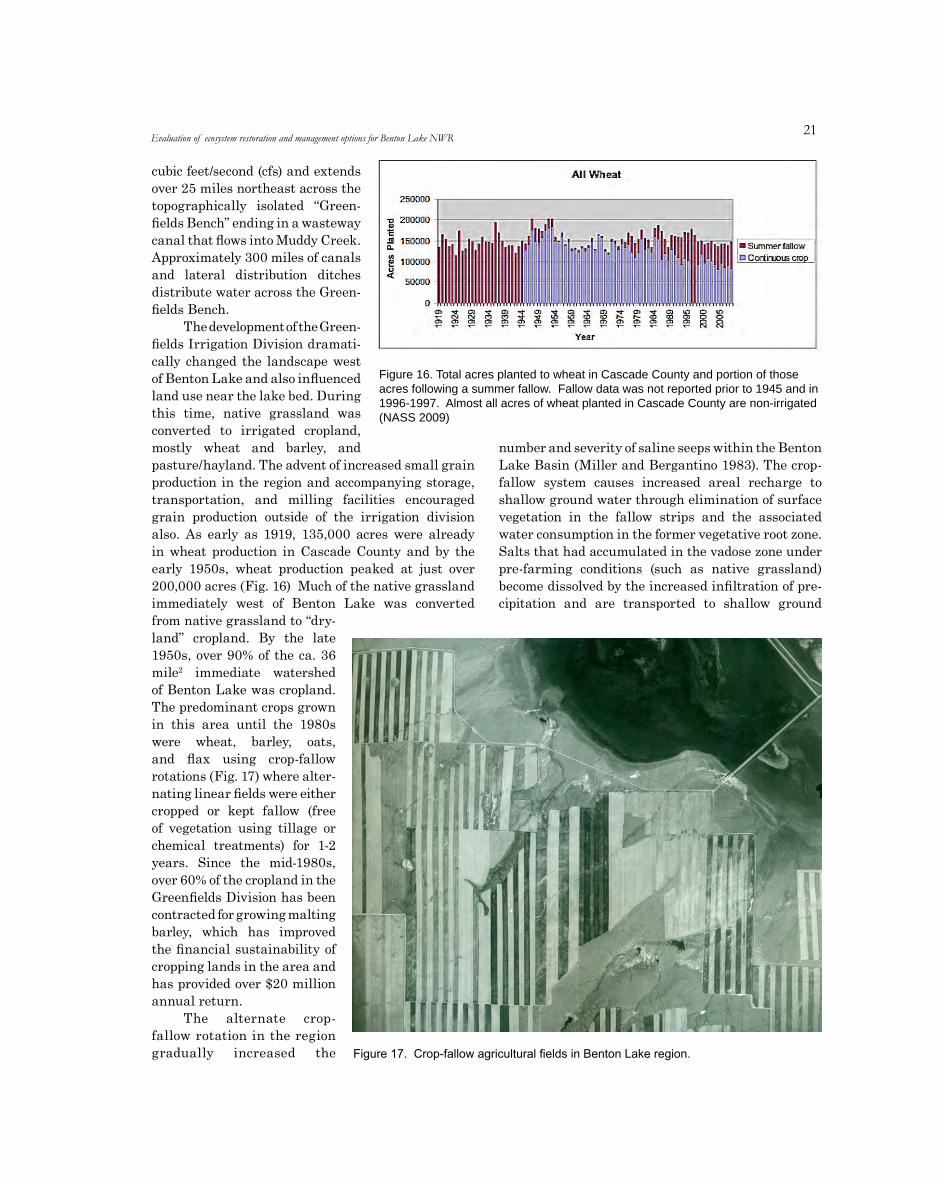
21
cubic feet/second (cfs) and extends over 25 miles northeast across the topographically isolated “Green-fields Bench” ending in a wasteway canal that flows into Muddy Creek. Approximately 300 miles of canals and lateral distribution ditches distribute water across the Green-fields Bench.
The development of the Green-fields Irrigation Division dramati-cally changed the landscape west of Benton Lake and also influenced land use near the lake bed. During this time, native grassland was converted to irrigated cropland, mostly wheat and barley, and pasture/hayland. The advent of increased small grain production in the region and accompanying storage, transportation, and milling facilities encouraged grain production outside of the irrigation division also. As early as 1919, 135,000 acres were already in wheat production in Cascade County and by the early 1950s, wheat production peaked at just over 200,000 acres (Fig. 16) Much of the native grassland immediately west of Benton Lake was converted from native grassland to “dry-land” cropland. By the late 1950s, over 90% of the ca. 36 mile2 immediate watershed of Benton Lake was cropland. The predominant crops grown in this area until the 1980s were wheat, barley, oats, and flax using crop-fallow rotations (Fig. 17) where alter-nating linear fields were either cropped or kept fallow (free of vegetation using tillage or chemical treatments) for 1-2 years. Since the mid-1980s, over 60% of the cropland in the Greenfields Division has been contracted for growing malting barley, which has improved the financial sustainability of cropping lands in the area and has provided over $20 million annual return.
The alternate crop-fallow rotation in the region gradually increased the
number and severity of saline seeps within the Benton Lake Basin (Miller and Bergantino 1983). The crop-fallow system causes increased areal recharge to shallow ground water through elimination of surface vegetation in the fallow strips and the associated water consumption in the former vegetative root zone. Salts that had accumulated in the vadose zone under pre-farming conditions (such as native grassland) become dissolved by the increased infiltration of pre-cipitation and are transported to shallow ground
Evaluation of ecosystem restoration and management options for Benton Lake NWR
Figure 16. Total acres planted to wheat in Cascade County and portion of those acres following a summer fallow. Fallow data was not reported prior to 1945 and in 1996-1997. Almost all acres of wheat planted in Cascade County are non-irrigated (NASS 2009)
Figure 17. Crop-fallow agricultural fields in Benton Lake region.
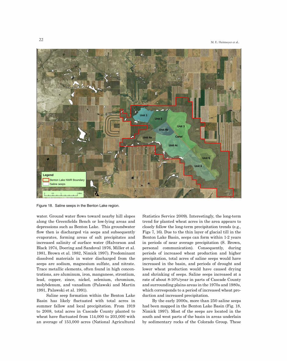
22M. E. Heitmeyer et al..
water. Ground water flows toward nearby hill slopes along the Greenfields Bench or low-lying areas and depressions such as Benton Lake. This groundwater flow then is discharged via seeps and subsequently evaporates, forming areas of salt precipitates and increased salinity of surface water (Halvorson and Black 1974, Doering and Sandoval 1976, Miller et al. 1981, Brown et al. 1982, Nimick 1997). Predominant dissolved materials in water discharged from the seeps are sodium, magnesium sulfate, and nitrate. Trace metallic elements, often found in high concen-trations, are aluminum, iron, manganese, strontium, lead, copper, zince, nickel, selenium, chromium, molybdenum, and vanadium (Palawski and Martin 1991, Palawski et al. 1991).
Saline seep formation within the Benton Lake Basin has likely fluctuated with total acres in summer fallow and local precipitation. From 1919 to 2008, total acres in Cascade County planted to wheat have fluctuated from 114,000 to 203,000 with an average of 153,000 acres (National Agricultural
Statistics Service 2009). Interestingly, the long-term trend for planted wheat acres in the area appears to closely follow the long-term precipitation trends (e.g., Figs 7, 16). Due to the thin layer of glacial till in the Benton Lake Basin, seeps can form within 1-2 years in periods of near average precipitation (S. Brown, personal communication). Consequently, during periods of increased wheat production and higher precipitation, total acres of saline seeps would have increased in the basin, and periods of drought and lower wheat production would have caused drying and shrinking of seeps. Saline seeps increased at a rate of about 8-10%/year in parts of Cascade County and surrounding plains areas in the 1970s and 1980s, which corresponds to a period of increased wheat pro-duction and increased precipitation.
By the early 2000s, more than 250 saline seeps had been mapped in the Benton Lake Basin (Fig. 18, Nimick 1997). Most of the seeps are located in the south and west parts of the basin in areas underlain by sedimentary rocks of the Colorado Group. These
Unit 1Unit 2
Unit 3Unit 4b
Unit 4a Canal
Unit 4c
Unit 5
Unit 6
O0 0.5 1 2 Miles
LegendBenton Lake NWR Boundary
Saline seeps
Figure 18. Saline seeps in the Benton Lake region.Blue Heron Conservation Design and Printing LLC | 2009

23
seeps were identified as areas where surface salts have accumulated and native plant communities have been replaced with salt-tolerant species and the ground generally is saturated most of the year. Most seeps immediately adjacent to Benton Lake do not have measurable discharge except for short periods following snowmelt or when heavy precipitation has recharged local ground water. In contrast, saline seeps associated with crop-fallow agriculture have substantial discharge into the Lake Creek drainage system and have mobilized salts and potential con-taminants such as selenium, which ultimately flows into Benton Lake NWR (Nimick 1997).
The percentage of the annual wheat crop planted following summer fallow has increased since the early 1990s, which could potentially increase saline seep formation (Fig. 16). Conversely, approximately 70,000 acres of cropland have been enrolled in the Conservation Reserve Program (CRP) since 1990. Retired cropland combined with below normal precip-itation in the mid-1990s to mid-2000s, suggest that current saline seeps on the landscape may be less than during previous decades. However, a return to higher precipitation and possible reductions in CRP acreage in the future could quickly lead to an increase in seep formation and severity.
LAND AND WATER USE CHANGES ON BENTON LAKE NWR
Acquisition and Development of Benton Lake NWR
Benton Lake NWR was established by Executive Order of President Herbert Hoover in 1929. The original area of the refuge was 12,234 acres, about 3,000 of which was water area in 1928 (Great Falls Tribune 1929b). Originally owned and managed as part of the Sun River Reclamation Project, and managed by the Bureau of Reclamation of the Department of the Interior, Benton Lake subse-quently became part of the USFWS national wildlife refuge system and was administered by the National Bison Range located in western Montana. Impetus for establishing the refuge came mostly from local sportsmen, especially waterfowl hunters, in the mid 1920s when about 8,000 acres of U.S. Government controlled land in the vicinity of Benton Lake was proposed to be opened for settlement. Sportsmen supported the establishment of Benton Lake NWR even though this designation would potentially
close the lake for waterfowl hunting, because they understood that a refuge would secure habitat and resources that attracted migratory waterfowl to the area and would control excessive disturbance and shooting that usually caused birds to leave the area in fall (Great Falls Tribune 1929a).
Soon after establishment of Benton Lake NWR, sportsmen and elected officials began expressing concern that water levels in Benton Lake were low in most years, which caused lower waterfowl production, fall migration numbers, and hunting opportunity. For example, in 1928 about 3,000 acres of water area were present in Benton Lake during fall, but in 1929 the area had “only a limited amount of water” (Great Falls Tribune 1929c). Among the proposals to assure a water supply for the lake was to take advantage of water not used in the recently developed Fairfield and Power Irrigation districts (part of the Greenfields Irrigation Division). Engineers believed that waste irrigation water could be diverted to Benton Lake by grading a ditch near the town of Power to natural drainage beds that emptied into Benton Lake (Lake Creek). This early proposal was not pursued until 1957 when members of the Cascade County Wildlife Association secured funding to construct major pumping and water delivery structures from Muddy Creek to the refuge.
A pump station, pipeline, and water-control structures were constructed 1958-62 (Fig. 19) to bring irrigation return flow water from Muddy Creek, about 15 miles to the west, to Benton Lake NWR. In 1961, full time USFWS staff were assigned to, and housed on, Benton Lake NWR. The first water pumped to Benton Lake from Muddy Creek occurred in 1962. Water from the Muddy Creek pump station is moved about 5 miles through an underground pipeline over a low drainage divide and then is discharged into the natural Lake Creek channel where it flows for about 12 miles to its mouth in Benton Lake. Pumping from Muddy Creek has corresponded to times of irrigation return flow in the Greenfields Irrigation system and is generally from May until mid-October. Benton Lake NWR has rights for up to 14,600 acre-feet of water from Muddy Creek each year depending on adequate flows in the creek (Palawski and Martin 1991). Water from Muddy Creek is free, but the NWR must pay electrical costs for the three pumps (two 350 horse-power and one 250 horsepower).
The historic Benton Lake bed was divided into 6 wetland management pools (Pool 4 was later subdi-vided into three subunits with interior cross levees) by dikes/levees, ditches, and water-control structures
Evaluation of ecosystem restoration and management options for Benton Lake NWR
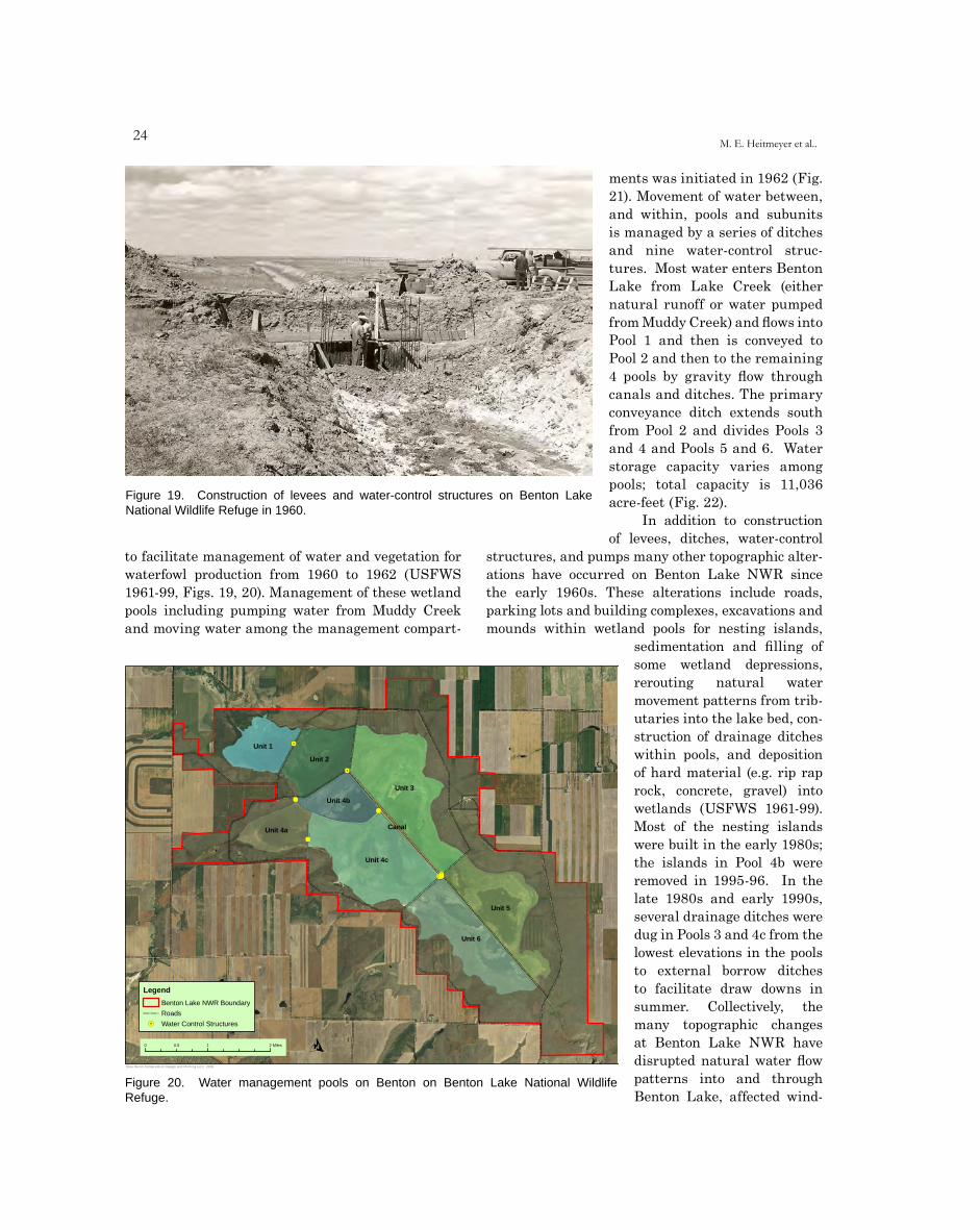
2�M. E. Heitmeyer et al..
Figure 19. Construction of levees and water-control structures on Benton Lake National Wildlife Refuge in 1960.
Unit 1 '4
Unit 2'4
Unit 34' Unit 4b
4'
CanalUnit 4a4'
Unit 4c
'44'4'4'
Unit 5
Unit 6
O0 0.5 1 2 Miles
LegendBenton Lake NWR Boundary
Roads
'4 Water Control Structures
OBlue Heron Conservation Design and Printing LLC | 2009
Figure 20. Water management pools on Benton on Benton Lake National Wildlife Refuge.
to facilitate management of water and vegetation for waterfowl production from 1960 to 1962 (USFWS 1961-99, Figs. 19, 20). Management of these wetland pools including pumping water from Muddy Creek and moving water among the management compart-
ments was initiated in 1962 (Fig. 21). Movement of water between, and within, pools and subunits is managed by a series of ditches and nine water-control struc-tures. Most water enters Benton Lake from Lake Creek (either natural runoff or water pumped from Muddy Creek) and flows into Pool 1 and then is conveyed to Pool 2 and then to the remaining 4 pools by gravity flow through canals and ditches. The primary conveyance ditch extends south from Pool 2 and divides Pools 3 and 4 and Pools 5 and 6. Water storage capacity varies among pools; total capacity is 11,036 acre-feet (Fig. 22).
In addition to construction of levees, ditches, water-control
structures, and pumps many other topographic alter-ations have occurred on Benton Lake NWR since the early 1960s. These alterations include roads, parking lots and building complexes, excavations and mounds within wetland pools for nesting islands,
sedimentation and filling of some wetland depressions, rerouting natural water movement patterns from trib-utaries into the lake bed, con-struction of drainage ditches within pools, and deposition of hard material (e.g. rip rap rock, concrete, gravel) into wetlands (USFWS 1961-99). Most of the nesting islands were built in the early 1980s; the islands in Pool 4b were removed in 1995-96. In the late 1980s and early 1990s, several drainage ditches were dug in Pools 3 and 4c from the lowest elevations in the pools to external borrow ditches to facilitate draw downs in summer. Collectively, the many topographic changes at Benton Lake NWR have disrupted natural water flow patterns into and through Benton Lake, affected wind-
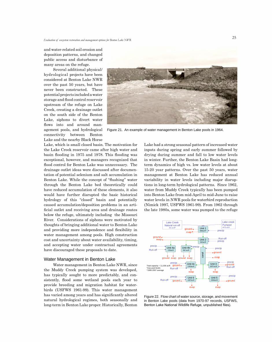
2�
and water-related soil erosion and deposition patterns, and changed public access and disturbance of many areas on the refuge.
Several additional physical/hydrological projects have been considered at Benton Lake NWR over the past 50 years, but have never been constructed. These potential projects included a water storage and flood control reservoir upstream of the refuge on Lake Creek, creating a drainage outlet on the south side of the Benton Lake, siphons to divert water flows into and around man-agement pools, and hydrological connectivity between Benton Lake and the nearby Black Horse Lake, which is small closed basin. The motivation for the Lake Creek reservoir came after high water and basin flooding in 1975 and 1978. This flooding was exceptional, however, and managers recognized that flood control for Benton Lake was unnecessary. The drainage outlet ideas were discussed after documen-tation of potential selenium and salt accumulation in Benton Lake. While the concept of “flushing” water through the Benton Lake bed theoretically could have reduced accumulation of these elements, it also would have further disrupted the basic historical hydrology of this “closed” basin and potentially caused accumulation/deposition problems in an arti-ficial outlet and receiving area and drainage routes below the refuge, ultimately including the Missouri River. Considerations of siphons were motivated by thoughts of bringing additional water to Benton Lake and providing more independence and flexibility in water management among pools. High construction cost and uncertainty about water availability, timing, and accepting water under contractual agreements have discouraged these proposals to date.
Water Management in Benton LakeWater management in Benton Lake NWR, since
the Muddy Creek pumping system was developed, has typically sought to more predictably, and con-sistently, flood some wetland pools each year to provide breeding and migration habitat for water-birds (USFWS 1961-99). This water management has varied among years and has significantly altered natural hydrological regimes, both seasonally and long-term in Benton Lake proper. Historically, Benton
Lake had a strong seasonal pattern of increased water inputs during spring and early summer followed by drying during summer and fall to low water levels in winter. Further, the Benton Lake Basin had long-term dynamics of high vs. low water levels at about 15-20 year patterns. Over the past 50 years, water management at Benton Lake has reduced annual variability in water levels including major disrup-tions in long-term hydrological patterns. Since 1962, water from Muddy Creek typically has been pumped into Benton Lake from mid-April to mid-June to raise water levels in NWR pools for waterbird reproduction (Nimick 1997, USFWS 1961-99). From 1962 through the late 1980s, some water was pumped to the refuge
Figure 21. An example of water management in Benton Lake pools in 1964.
Unit 2942ac/ft
Unit 4c1353ac/ft
Unit 32875 ac/ft
Unit 61957ac/ft
Unit 52084ac/ft
Unit 1898ac/ft*
Unit 4a235ac/ft
Unit 4b692 ac/ft
Lake creekPumped4475 ac/ft
Lake CreekNatural run-off
361 ac/ft^
cana
l
precip
precip
precip
precip
precipRun-off
evapground
groundevap
ground evap ground evap
ground
evap
ground
ground
evap
evap
evap
ground
ground
evap
precip
precip
precip
precip
Total capacity = 11,036 ac/ft*max pool levels^1995-2007 average
Run-off
Run-off
Run-offRun-off
Figure 22. Flow chart of water source, storage, and movement in Benton Lake pools (data from 1970-97 records, USFWS, Benton Lake National Wildlife Refuge, unpublished files).
Evaluation of ecosystem restoration and management options for Benton Lake NWR
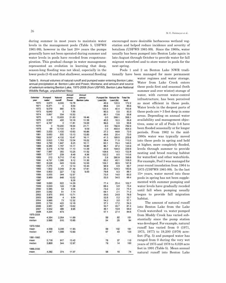
26M. E. Heitmeyer et al..
during summer in most years to maintain water levels in the management pools (Table 5, USFWS 1961-99), however in the last 20+ years the pumps generally have not been operated during summer and water levels in pools have receded from evapotrans-piration. This gradual change in water management represented an evolution in learning that deep, season-long flooding was not ideal, especially in the lower pools (3-6) and that shallower, seasonal flooding
encouraged more desirable herbaceous wetland veg-etation and helped reduce incidence and severity of botulism (USFWS 1961-99). Since the 1960s, water usually has been pumped into Benton Lake again in late-August through October to provide water for fall migrant waterfowl and to store water in pools for the next spring.
Pools 1 and 2 on Benton Lake NWR tradi-tionally have been managed for more permanent
water regimes and water storage. Water from Lake Creek enters these pools first and seasonal (both summer and over winter) storage of water, with current water-control infrastructure, has been perceived as most efficient in these pools. Water levels in the deepest parts of these pools are > 3 feet deep in some areas. Depending on annual water availability and management objec-tives, some or all of Pools 3-6 have been flooded seasonally or for longer periods. From 1962 to the mid-1980s water was typically moved into these pools in spring and held at higher, more completely flooded, levels through summer to provide nesting and brood rearing habitat for waterfowl and other waterbirds. For example, Pool 3 was managed for year-round inundation from 1964 to 1975 (USFWS 1961-99). In the last 15+ years, water moved into these pools in spring has not been supple-mented with summer pumping and water levels have gradually receded until fall when pumping usually began to provide fall migration habitat.
The amount of natural runoff into Benton Lake from the Lake Creek watershed vs. water pumped from Muddy Creek has varied sub-stantially since the pump station was developed. For example, natural runoff has varied from 0 (1971, 1973, 1977) to 19,200 (1978) acre-feet (Fig. 5) and pumped water has ranged from 0 during the very wet years of 1975 and 1978 to 8,028 acre feet in 1991 (Table 5). Mean annual natural runoff into Benton Lake
Table 5. Annual volumes of natural runoff and pumped water entering Benton Lake; annual precipitation at Benton Lake and Power, Montana; and amount and source of selenium entering Benton Lake, 1970-2008 (from USFWS, Benton Lake National Wildlife Refuge, unpublished files).
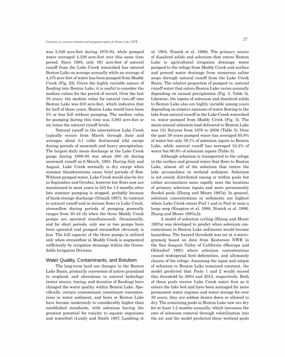
2�
was 3,349 acre-feet during 1970-94, while pumped water averaged 4,339 acre-feet over this same time period. Since 1995, only 361 acre-feet of natural runoff from the Lake Creek watershed has entered Benton Lake on average annually while an average of 4,475 acre-feet of water has been pumped from Muddy Creek (Fig. 22). Given the highly variable nature of flooding into Benton Lake, it is useful to consider the median values for the period of record. Over the last 38 years, the median value for natural run-off into Benton Lake was 610 acre-feet, which indicates that for half of these years, Benton Lake would have been 5% or less full without pumping. The median value for pumping during this time was 3,985 acre-feet or six times the natural runoff levels.
Natural runoff in the intermittent Lake Creek typically occurs from March through June and averages about 0.1 cubic feet/second (cfs) except during periods of snowmelt and heavy precipitation. The largest daily mean discharge at the Lake Creek gauge during 1990-95 was about 300 cfs during snowmelt runoff on 6 March, 1993. During July and August, Lake Creek normally is dry except when summer thunderstorms cause brief periods of flow. Without pumped water, Lake Creek would also be dry in September and October, however low flows now are maintained in most years in fall for 1-2 months after late summer pumping is stopped, probably because of bank-storage discharge (Nimick 1997). In contrast to natural runoff and in-stream flows in Lake Creek, streamflow during periods of pumping generally ranges from 30-42 cfs when the three Muddy Creek pumps are operated simultaneously. Occasionally, and for short periods, only one or two pumps have been operated and pumped streamflow obviously is less. The full capacity of the three pumps is utilized only when streamflow in Muddy Creek is augmented sufficiently by irrigation drainage within the Green-fields Irrigation Division.
Water Quality, Contaminants, and BotulismThe long-term land use changes in the Benton
Lake Basin, primarily conversion of native grassland to cropland, and alterations to natural hydrology (water source, timing, and duration of flooding) have changed the water quality within Benton Lake. Spe-cifically, certain contaminant constituent concentra-tions in water sediment, and biota at Benton Lake have become moderately to considerably higher than established standards, with selenium having the greatest potential for toxicity to aquatic organisms and waterfowl (Lemly and Smith 1987, Lambing et
al. 1994, Nimick et al. 1996). The primary source of dissolved solids and selenium that enters Benton Lake is agricultural irrigation drainage water pumped to the refuge from Muddy Creek and surface and ground water drainage from numerous saline seeps through natural runoff from the Lake Creek Basin. The relative proportion of pumped vs. natural runoff water that enters Benton Lake varies annually depending on annual precipitation (Fig. 5, Table 5). Likewise, the inputs of selenium and dissolved solids to Benton Lake also are highly variable among years depending on relative amounts of water flowing to the lake from natural runoff in the Lake Creek watershed vs. water pumped from Muddy Creek (Fig. 5). The mean annual selenium load delivered to Benton Lake was 151 lbs/year from 1970 to 2008 (Table 5). Over the past 38 years pumped water has averaged 65.8% of water but only 39.1% of selenium inputs to Benton Lake, while natural runoff has averaged 34.2% of water but 60.9% of selenium inputs (Table 5).
Although selenium is transported to the refuge in the surface and ground water that flows to Benton Lake, almost all of the selenium that enters the lake accumulates in wetland sediment. Selenium is not evenly distributed among or within pools but rather accumulates more rapidly near the locations of primary selenium inputs and more permanently flooded pools (Zhang and Moore 1997a). In general, selenium concentrations in sediments are highest where Lake Creek enters Pool 1 and in Pool 4c near a large seep (Knapton et al. 1988, Nimick et al. 1996, Zhang and Moore 1997a,b).
A model of selenium cycling (Zhang and Moore 1997a) was developed to predict when selenium con-centrations in Benton Lake sediments would become hazardous. The hazard threshold was set at 4 micro-grams/g based on data from Kesterson NWR in the San Joaquin Valley of California (Skorupa and Ohlendorf 1991) where selenium concentrations caused widespread bird deformities, and ultimately closure of the refuge. Assuming the input and output of selenium to Benton Lake remained constant, the model predicted that Pools 1 and 2 would exceed this threshold by 2004 and 2012, respectively. Both of these pools receive Lake Creek water first as it enters the lake bed and have been managed for more permanent water regimes and water storage for over 30 years; they are seldom drawn down or allowed to dry. The remaining pools in Benton Lake now are dry for at least 1-2 months annually, which increases the rate of selenium removal through volatilization into the air and the model predicted these wetland pools
Evaluation of ecosystem restoration and management options for Benton Lake NWR
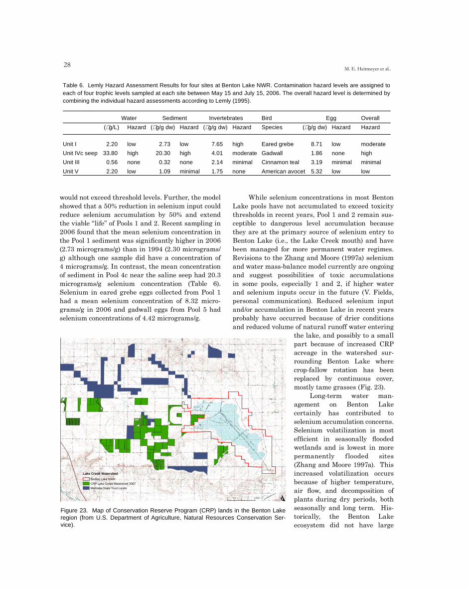
2�M. E. Heitmeyer et al..
Table 6. Lemly Hazard Assessment Results for four sites at Benton Lake NWR. Contamination hazard levels are assigned toeach of four trophic levels sampled at each site between May 15 and July 15, 2006. The overall hazard level is determined bycombining the individual hazard assessments according to Lemly (1995).
Water Sediment Invertebrates Bird Egg Overall
(µg/L) Hazard (µg/g dw) Hazard (µg/g dw) Hazard Species (µg/g dw) Hazard Hazard
Unit I
Unit IVc seep
Unit III
2.20
33.80
0.56
low
high
none
2.73
20.30
0.32
low
high
none
7.65
4.01
2.14
high
moderate
minimal
Eared grebe
Gadwall
Cinnamon teal
8.71
1.86
3.19
low
none
minimal
moderate
high
minimal
Unit V 2.20 low 1.09 minimal 1.75 none American avocet 5.32 low low
would not exceed threshold levels. Further, the model showed that a 50% reduction in selenium input could reduce selenium accumulation by 50% and extend the viable “life” of Pools 1 and 2. Recent sampling in 2006 found that the mean selenium concentration in the Pool 1 sediment was significantly higher in 2006 (2.73 micrograms/g) than in 1994 (2.30 micrograms/g) although one sample did have a concentration of 4 micrograms/g. In contrast, the mean concentration of sediment in Pool 4c near the saline seep had 20.3 micrograms/g selenium concentration (Table 6). Selenium in eared grebe eggs collected from Pool 1 had a mean selenium concentration of 8.32 micro-grams/g in 2006 and gadwall eggs from Pool 5 had selenium concentrations of 4.42 micrograms/g.
While selenium concentrations in most Benton Lake pools have not accumulated to exceed toxicity thresholds in recent years, Pool 1 and 2 remain sus-ceptible to dangerous level accumulation because they are at the primary source of selenium entry to Benton Lake (i.e., the Lake Creek mouth) and have been managed for more permanent water regimes. Revisions to the Zhang and Moore (1997a) selenium and water mass-balance model currently are ongoing and suggest possibilities of toxic accumulations in some pools, especially 1 and 2, if higher water and selenium inputs occur in the future (V. Fields, personal communication). Reduced selenium input and/or accumulation in Benton Lake in recent years probably have occurred because of drier conditions and reduced volume of natural runoff water entering
the lake, and possibly to a small part because of increased CRP acreage in the watershed sur-rounding Benton Lake where crop-fallow rotation has been replaced by continuous cover, mostly tame grasses (Fig. 23).
Long-term water man-agement on Benton Lake certainly has contributed to selenium accumulation concerns. Selenium volatilization is most efficient in seasonally flooded wetlands and is lowest in more permanently flooded sites (Zhang and Moore 1997a). This increased volatilization occurs because of higher temperature, air flow, and decomposition of plants during dry periods, both seasonally and long term. His-torically, the Benton Lake ecosystem did not have large
O
Lake Creek Watershed
0 0.5 1 2 Miles
Benton Lake NWR
CRP Lake Creek Watershed 2007
Montana State Trust Lands
Figure 23. Map of Conservation Reserve Program (CRP) lands in the Benton Lake region (from U.S. Department of Agriculture, Natural Resources Conservation Ser-vice).
Blue Heron Conservation Design and Printing LLC | 2009
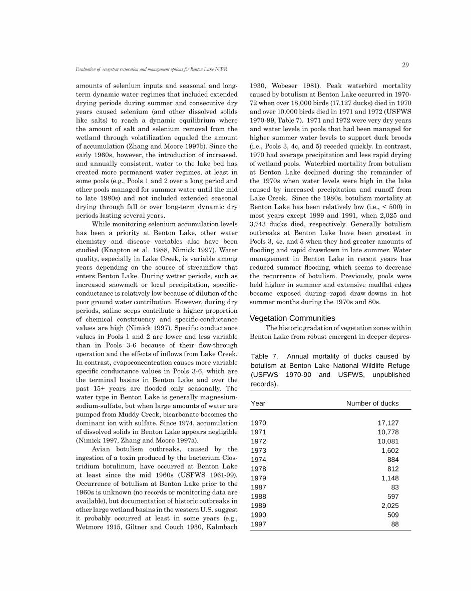
29
amounts of selenium inputs and seasonal and long-term dynamic water regimes that included extended drying periods during summer and consecutive dry years caused selenium (and other dissolved solids like salts) to reach a dynamic equilibrium where the amount of salt and selenium removal from the wetland through volatilization equaled the amount of accumulation (Zhang and Moore 1997b). Since the early 1960s, however, the introduction of increased, and annually consistent, water to the lake bed has created more permanent water regimes, at least in some pools (e.g., Pools 1 and 2 over a long period and other pools managed for summer water until the mid to late 1980s) and not included extended seasonal drying through fall or over long-term dynamic dry periods lasting several years.
While monitoring selenium accumulation levels has been a priority at Benton Lake, other water chemistry and disease variables also have been studied (Knapton et al. 1988, Nimick 1997). Water quality, especially in Lake Creek, is variable among years depending on the source of streamflow that enters Benton Lake. During wetter periods, such as increased snowmelt or local precipitation, specific-conductance is relatively low because of dilution of the poor ground water contribution. However, during dry periods, saline seeps contribute a higher proportion of chemical constituency and specific-conductance values are high (Nimick 1997). Specific conductance values in Pools 1 and 2 are lower and less variable than in Pools 3-6 because of their flow-through operation and the effects of inflows from Lake Creek. In contrast, evapoconcentration causes more variable specific conductance values in Pools 3-6, which are the terminal basins in Benton Lake and over the past 15+ years are flooded only seasonally. The water type in Benton Lake is generally magnesium-sodium-sulfate, but when large amounts of water are pumped from Muddy Creek, bicarbonate becomes the dominant ion with sulfate. Since 1974, accumulation of dissolved solids in Benton Lake appears negligible (Nimick 1997, Zhang and Moore 1997a).
Avian botulism outbreaks, caused by the ingestion of a toxin produced by the bacterium Clos-tridium botulinum, have occurred at Benton Lake at least since the mid 1960s (USFWS 1961-99). Occurrence of botulism at Benton Lake prior to the 1960s is unknown (no records or monitoring data are available), but documentation of historic outbreaks in other large wetland basins in the western U.S. suggest it probably occurred at least in some years (e.g., Wetmore 1915, Giltner and Couch 1930, Kalmbach
1930, Wobeser 1981). Peak waterbird mortality caused by botulism at Benton Lake occurred in 1970-72 when over 18,000 birds (17,127 ducks) died in 1970 and over 10,000 birds died in 1971 and 1972 (USFWS 1970-99, Table 7). 1971 and 1972 were very dry years and water levels in pools that had been managed for higher summer water levels to support duck broods (i.e., Pools 3, 4c, and 5) receded quickly. In contrast, 1970 had average precipitation and less rapid drying of wetland pools. Waterbird mortality from botulism at Benton Lake declined during the remainder of the 1970s when water levels were high in the lake caused by increased precipitation and runoff from Lake Creek. Since the 1980s, botulism mortality at Benton Lake has been relatively low (i.e., < 500) in most years except 1989 and 1991, when 2,025 and 3,743 ducks died, respectively. Generally botulism outbreaks at Benton Lake have been greatest in Pools 3, 4c, and 5 when they had greater amounts of flooding and rapid drawdown in late summer. Water management in Benton Lake in recent years has reduced summer flooding, which seems to decrease the recurrence of botulism. Previously, pools were held higher in summer and extensive mudflat edges became exposed during rapid draw-downs in hot summer months during the 1970s and 80s.
Table 7. Annualbotulism at Benton(USFWS 1970-90records).
mortality of ducks caused byLake National Wildlife Refuge
and USFWS, unpublished
Year Number of ducks
197019711972197319741978197919871988198919901997
17,12710,77810,0811,602
884812
1,14883
5972,025
50988
Vegetation CommunitiesThe historic gradation of vegetation zones within
Benton Lake from robust emergent in deeper depres-
Evaluation of ecosystem restoration and management options for Benton Lake NWR
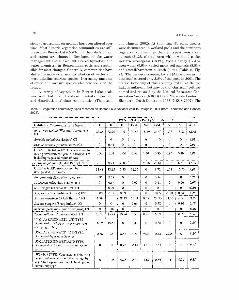
30M. E. Heitmeyer et al..
sions to grasslands on uplands has been altered over time. Most historic vegetation communities are still present on Benton Lake NWR, but their distribution and extent are changed. Developments for water management and subsequent altered hydrology and water chemistry in Benton Lake pools are respon-sible for most changes. Generally, communities have shifted to more extensive distribution of wetter and more alkaline-tolerant species. Increasing amounts of exotic and invasive species also now occur on the refuge.
A survey of vegetation in Benton Lake pools was conducted in 2001 and documented composition and distribution of plant communities (Thompson
and Hansen 2002). At that time 91 plant species were documented in wetland pools and the dominant vegetation communities (habitat types) were alkali bulrush (31.2% of total area within wetland pools), western wheatgrass (18.1%), foxtail barley (17.4%), open water (9.6%), varied moist-soil annuals (8.8%), and cattail/hardstem bulrush (6.6%) (Table 8, Fig. 24). The invasive creeping foxtail (Alopecurus arun-dinaceus) covered only 2.8% of the pools in 2001. The precise taxonomy of this creeping foxtail at Benton Lake is unknown, but may be the “Garrison” cultivar named and released by the Natural Resources Con-servation Service (NRCS) Plant Materials Center in Bismarck, North Dakota in 1963 (NRCS 2007). The
Table 8. Vegetation community types recorded on Benton Lake National Wildlife Refuge in 2001 (from Thompson and Hansen 2002).
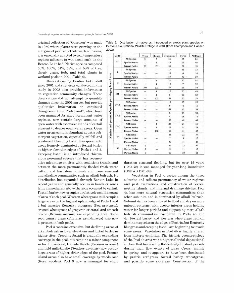
31
original collection of “Garrison” was madein 1950 where plants were growing on themargins of prairie pothole wetland basins;it is especially adapted to cold temperatureregions adjacent to wet areas such as theBenton Lake bed. Native species composed50%, 100%, 54%, 58%, and 58% of tree,shrub, grass, forb, and total plants inwetland pools in 2001 (Table 9).
Observations by Benton Lake staffsince 2001 and site visits conducted in thisstudy in 2008 also provided informationon vegetation community changes. Theseobservations did not attempt to quantifychanges since the 2001 survey, but providequalitative information on continuedchanges over time. Pools 1 and 2, which havebeen managed for more permanent waterregimes, now contain large amounts ofopen water with extensive stands of cattailadjacent to deeper open water areas. Openwater areas contain abundant aquatic sub-mergent vegetation, especially milfoil andpondweed. Creeping foxtail has spread intoareas formerly dominated by foxtail barleyat higher elevation edges of Pools 1 and 2.Creeping foxtail is an introduced rhizom-atous perennial species that has regener-
ative advantage on sites with conditions transitional between the more permanently flooded fresh water cattail and hardstem bulrush and more seasonal and alkaline communities such as alkali bulrush. Its distribution has expanded through Benton Lake in recent years and generally occurs in bands or zones lying immediately above the zone occupied by cattail. Foxtail barley now occupies a relatively small amount of area of each pool. Western wheatgrass still occupies large areas on the highest upland edge of Pools 1 and 2 but invasive Kentucky bluegrass (Poa pratensis), crested wheatgrass (Agropyron cristata) and smooth brome (Bromus inermis) are expanding area. Some reed canary grass (Phalaris arundinacea) also now is present in both pools.
Pool 3 contains extensive, but declining areas of alkali bulrush in lower elevations and foxtail barley in higher sites. Creeping foxtail is gradually expanding coverage in the pool, but remains a minor component so far. In contrast, Canada thistle (Cirsium arvense) and field milk-thistle (Sonchus arvensis) now occupy large areas of higher, drier edges of the pool. Former island areas also have small coverage by woods rose (Rosa woodsii). Pool 3 now is managed for short
duration seasonal flooding, but for over 15 years (1964-78) it was managed for year-long inundation (USFWS 1961-99).
Vegetation in Pool 4 varies among the three subunits and reflects permanency of water regimes and past excavations and construction of levees, nesting islands, and internal drainage ditches. Pool 4a has more natural vegetation communities than other subunits and is dominated by alkali bulrush. Subunit 4a has been allowed to flood and dry on more natural patterns, with deeper interior areas holding water for longer periods and supporting more alkali bulrush communities, compared to Pools 4b and 4c. Foxtail barley and western wheatgrass remain dominant species on the edges of Pool 4a, but Kentucky bluegrass and creeping foxtail are beginning to invade some areas. Vegetation in Pool 4b is highly altered from historic condition. The historic geomorphology of the Pool 4b area was a higher alluvial depositional surface that historically flooded only for short periods during high flow events of Lake Creek, mainly in spring, and it appears to have been dominated by prairie cordgrass, foxtail barley, wheatgrass, and possibly some saltgrass. Construction of the
Evaluation of ecosystem restoration and management options for Benton Lake NWR
Table 9. Distribution of native vs. introduced or exotic plant species on Benton Lake National Wildlife Refuge in 2001 (from Thompson and Hansen 2002).

32M. E. Heitmeyer et al..
internal levee to subdivide Pool 4 and construction of nesting islands and excavations shifted this site to wetter regimes in the 1960s to 1980s. In more recent years Pool 4b has been managed for shorter duration flooding. Common species in Pool 4b are foxtail barley, common orache (Atriplex patula), lambsquarter (Chenopodium album), prickly lettuce (Lactuca serriola), western wheatgrass, and the invasive crested wheatgrass. Little creeping foxtail is present in the subunit, but it may be expanding in coverage. Pool 4c is the largest subunit of Pool 4 and is becoming highly invaded by creeping foxtail. In 2001, the subunit retained a large amount of foxtail barley, western wheatgrass and alkali bulrush (Thompson and Hansen 2002), but each of these species is declining at present. Expansion of creeping foxtail may be increasing because the site appears to have prolonged soil saturation, but not extensive surface flooding. Soil saturation may
be discouraging less water tolerant native grasses and moist-soil-type species. It is uncertain if this saturation is being caused by leakage from the main water distribution canal or seasonal diversion of surface water into the pool.
Pools 5 and 6 historically had several deeper depressions and these deeper sites remain dominated by alkali bulrush with some scattered cattail present. Edges of these pools are now covered mainly by foxtail barley, lambsquarter, strawberry blight (Che-nopodium capitatum), rillscale (Atriplex dioica), and western wheatgrass. Exotic and invasive species are encroaching on the edges of these pools, but not as rapidly as other pools.
Wetland Habitat TypesWestern wheatgrass
Brome
Saltgrass
Creeping spikerush
Foxtail barley
Open water
Kentucky bluegrass
Woods rose
Great bulrush
Alkali bulrush
Three-square bulrush
Prairie cordgrass
Common cattail
Unclassified wetland type; Unclassified
Upland type
O0 0.5 1 2 Miles
Blue Heron Conservation Design and Printing LLC | 2009
Figure 24. Distribution of major vegetation communities on Benton Lake National Wildlife Refuge, 2002 (adapted from Thomp-son and Hansen 2002).
Fish and Wildlife PopulationsLittle quantitative data are available to
determine changes in presence, abundance, and productivity of animal populations at Benton Lake
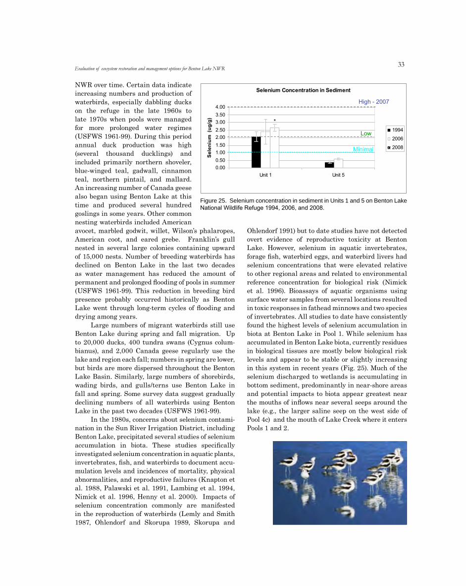
33
NWR over time. Certain data indicate increasing numbers and production of waterbirds, especially dabbling ducks on the refuge in the late 1960s to late 1970s when pools were managed for more prolonged water regimes (USFWS 1961-99). During this period annual duck production was high (several thousand ducklings) and included primarily northern shoveler, blue-winged teal, gadwall, cinnamon teal, northern pintail, and mallard. An increasing number of Canada geese also began using Benton Lake at this time and produced several hundred goslings in some years. Other common nesting waterbirds included American avocet, marbled godwit, willet, Wilson’s phalaropes, American coot, and eared grebe. Franklin’s gull nested in several large colonies containing upward of 15,000 nests. Number of breeding waterbirds has declined on Benton Lake in the last two decades as water management has reduced the amount of permanent and prolonged flooding of pools in summer (USFWS 1961-99). This reduction in breeding bird presence probably occurred historically as Benton Lake went through long-term cycles of flooding and drying among years.
Large numbers of migrant waterbirds still use Benton Lake during spring and fall migration. Up to 20,000 ducks, 400 tundra swans (Cygnus colum-bianus), and 2,000 Canada geese regularly use the lake and region each fall; numbers in spring are lower, but birds are more dispersed throughout the Benton Lake Basin. Similarly, large numbers of shorebirds, wading birds, and gulls/terns use Benton Lake in fall and spring. Some survey data suggest gradually declining numbers of all waterbirds using Benton Lake in the past two decades (USFWS 1961-99).
In the 1980s, concerns about selenium contami-nation in the Sun River Irrigation District, including Benton Lake, precipitated several studies of selenium accumulation in biota. These studies specifically investigated selenium concentration in aquatic plants, invertebrates, fish, and waterbirds to document accu-mulation levels and incidences of mortality, physical abnormalities, and reproductive failures (Knapton et al. 1988, Palawski et al. 1991, Lambing et al. 1994, Nimick et al. 1996, Henny et al. 2000). Impacts of selenium concentration commonly are manifested in the reproduction of waterbirds (Lemly and Smith 1987, Ohlendorf and Skorupa 1989, Skorupa and
Ohlendorf 1991) but to date studies have not detected overt evidence of reproductive toxicity at Benton Lake. However, selenium in aquatic invertebrates, forage fish, waterbird eggs, and waterbird livers had selenium concentrations that were elevated relative to other regional areas and related to environmental reference concentration for biological risk (Nimick et al. 1996). Bioassays of aquatic organisms using surface water samples from several locations resulted in toxic responses in fathead minnows and two species of invertebrates. All studies to date have consistently found the highest levels of selenium accumulation in biota at Benton Lake in Pool 1. While selenium has accumulated in Benton Lake biota, currently residues in biological tissues are mostly below biological risk levels and appear to be stable or slightly increasing in this system in recent years (Fig. 25). Much of the selenium discharged to wetlands is accumulating in bottom sediment, predominantly in near-shore areas and potential impacts to biota appear greatest near the mouths of inflows near several seeps around the lake (e.g., the larger saline seep on the west side of Pool 4c) and the mouth of Lake Creek where it enters Pools 1 and 2.
Evaluation of ecosystem restoration and management options for Benton Lake NWR
Selenium Concentration in Sediment
4.00
3.50
)g/ 3.00
gu( 2.50
m 2.00
uin 1.50
ele 1.00
S
0.50
0.00
Unit 1 Unit 5
1994
2006
2008
Low
Minimal
High - 2007
*
n=13
Figure 25. Selenium concentration in sediment in Units 1 and 5 on Benton Lake National Wildlife Refuge 1994, 2006, and 2008.
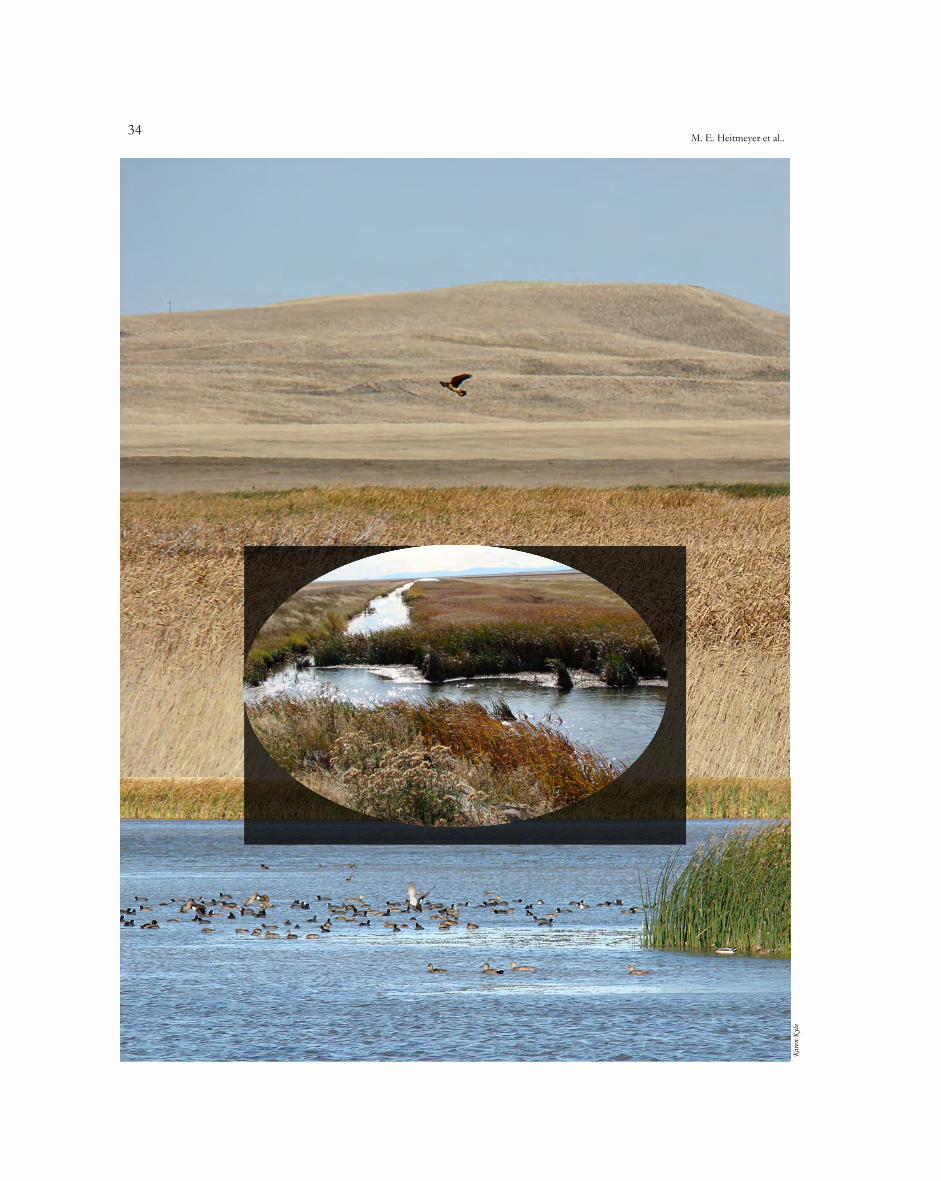
3�M. E. Heitmeyer et al..
elyn
Kera
K
35
ECOSYSTEM RESTORATIONAND MANAGEMENT OPTIONS
A SUMMARY OF CONDITIONS
Information obtained and analyzed during this study were sufficient to conduct a HGM-based eval-uation of historic and current ecological conditions on Benton Lake NWR and the surrounding region. The dominant feature of Benton Lake NWR is the historic Benton Lake bed formed during Pleistocene glacial and post-glacial events. The historic extent of the Benton Lake bed (Fig. 10) is intact, however, the physical integrity of the historic Benton Lake bed is highly altered from infrastructure developments for water management to enhance waterfowl production. These infrastructure developments and water man-agement in Benton Lake since the early 1960s have dramatically changed historic seasonal and long-term water regimes and the associated distribution and extent of native plant communities. These changes in the primary ecological driver of the Benton Lake ecosystem (i.e. seasonally and annually dynamic water regimes within a closed basin) and structural elements of it (topography and plants) have impacted resources used by many animal species. Further, conversion of native grassland to agricultural crop-fallow rotation in much of the immediate watershed of the Benton Lake Basin has degraded quality of regional surface and groundwater and increased the number and severity of saline seeps that periodically flow into Benton Lake. Changes in local ground and surface water quality and runoff to Benton Lake are exacerbated by pumping irrigation return water (large amounts in some dry years) from Muddy Creek, into the Lake Creek channel and ultimately into Benton Lake. These regional land use changes and pumping schedules have caused increased salt and selenium deposition in some parts of Benton Lake.
The information obtained and analyzed in the first two sections of this report are critical pre-
cursors to the next step of this HGM evaluation for Benton Lake NWR, which is to “Identify Potential Approaches to Successfully Manage and Restore Specific Habitats and Conditions.” The obvious challenge for this evaluation is to understand what management actions will be possible and most efficient/effective in restoring basic ecological attri-butes and processes to this unique ecosystem in a sustainable manner.
The key summary data and observations obtained in this study are:
1. The Benton Lake Basin, including the Benton Lake bed depression, were formed during the last Pleistocene glacial period when ice sheets dammed the ancestral Missouri River and formed glacial Lake Great Falls, which covered low-lying parts of this region.
2. Glacial drift associated with this last ice sheet was deposited northeast of Benton Lake and east of Priest Butte Lakes and created a hydro-logically “closed” Benton Lake Basin where most surface waters ultimately flowed into Benton Lake proper and no outlet was present.
3. Gently dipping sedimentary bedrock underlies the unconsolidated glacial, alluvial, and lacus-trine-type deposits at Benton Lake; the bedrock is mostly seleniferous marine shale of the Cre-taceous Colorado Group.
4. Most geomorphologic surfaces at Benton Lake are Quaternary Lake (Ql) deposits. Secondary geomorphic surfaces are Quaternary alluvium-colluvium (Qac) deposits at the mouths of Lake Creek and other small tributaries where they entered Benton Lake; Quaternary terrace (Qt) deposits adjacent to the Benton Lake bed;

36M. E. Heitmeyer et al..
and Upper Cretaceous Bootlegger Member (Kbb) deposits on high ridges adjacent to “Qt” surfaces.
5. Surface soils at Benton Lake are predominantly clays and silty clays deposited in the lacustrine environments of glacial Lake Great Falls and later Benton Lake proper.
6. Topography at Benton Lake NWR reflects dominant geomorphologic surfaces (i.e., rela-tively flat lake bed, alluvial-colluvial fans, terraces, and old Cretaceous ridges). Within Benton Lake proper, elevations range from about 3,614 feet amsl in the lowest depressions to about 3,620 on terraces.
7. The climate of the Benton Lake region is generally characterized by pleasant summers with warm, mostly sunny, days and cool nights characteristic of Northern Great Plains regions where frequent Chinook winds occur. The growing season averages 121 days from mid-April through mid-September.
8. The Benton Lake Basin is semiarid with 70-80% of total annual precipitation (mean of 14.98 inches) occurring April to September. Consequently, rains and snowmelt during spring and summer contribute runoff water to Benton Lake and create a strongly unimodal seasonal peak of water levels in early summer followed by gradual declines, mostly caused by 40-41 inch/year evapotranspiration, to low stable (or dry in some years) water levels in fall and winter.
9. In addition to strong seasonal patterns of flooding, Benton Lake has evidence of long-term 15-20 year recurring patterns of peak lows and highs in regional precipitation, runoff, and therefore water levels are evident at Benton Lake. High water levels (followed by declines to lows) caused by natural runoff have occurred at Benton Lake in the late 1920s, early 1940s, late 1950s, mid 1970, and early 1990s.
10. Natural water inputs to Benton Lake come primarily (65-70%) from the 137 mile2 Lake Creek watershed; the remainder is derived from on-site precipitation and runoff from small local drainages.
11. Deeper ground water beneath the Benton Lake Basin is confined primarily to the aquifer within the Colorado Shale formation and this ground-water is poor quality with low chloride concen-tration, moderate dissolved-solids, basic, and reduction conditions.
12. Shallow ground water in the Benton Lake Basin, in contrast, is acidic with high levels of calcium, sulfate, chloride, and magnesium.
13. Historically, the relatively low amount of annual precipitation in the basin was captured quickly and used by native grassland; little water moved deeply into soil or subsoil layers. Where water did percolate downward, it subse-quently moved slowly and occasionally exited slopes as springs and saline seeps.
14. Deposition of salts and elements such as selenium did not historically accumulate to high levels in Benton Lake because of lower natural inputs from water, low ground water discharge, wind erosion, and elemental volatil-ization in water, sediment, and wetland plants during dry periods of the long-term hydro-logical cycle.
15. Historic vegetation communities at Benton Lake ranged from dense emergent wetland species in low elevations with more permanent water regimes to upland grassland on terraces and ridges. This gradation of communities included: 1) robust emergent, 2) sedge-rush, 3) seasonal herbaceous, 4) wet grassland, and 5) upland grassland habitat types.
16. The distribution of vegetation communities at Benton Lake were related to both geomor-phology and elevation/flood frequency both sea-sonally and long-term; precise community dis-tribution likely varied to some degree during wet vs. dry long-term water and flooding regimes. Sedge-rush communities apparently composed more area of historic Benton Lake than other vegetation associations.
17. A rich diversity of animal species historically used the Benton Lake ecosystem, especially birds. Waterbird use and production of Benton Lake proper varied among years depending on extent and duration of annual flooding.
3�
18. Native people occupied the Benton Lake region since about 10,000 years BP but apparently had little influence on local ecosystems because of their mobile lifestyles, except to occasionally set fires in upland grasslands.
19. European settlers were not common in the area until the mid 1800s and the Benton Lake Basin remained relatively unchanged from historic condition until about 1880.
20. Lands within the Benton Lake Basin were acquired as part of the Louisiana Purchase and were kept in U.S. Government ownership until the early 1900s. Lands in and immedi-ately adjacent to Benton Lake were owned and managed by the Bureau of Reclamation as part of the Sun River Reclamation (late Irrigation) Project with the intent of using it as a water storage reservoir. Dynamic water levels and climate in the region prohibited this use.
21. One early attempt was made to ditch and drain Benton Lake, but the “closed” basin topography and hydrology caused this effort to fail.
22. Conversion of native grassland to agricultural crops in the region began in earnest in the 1920, following development of the Greenfields Irrigation Division of the Sun River Project and accompanying markets and transportation mechanisms for locally-grown grain, mostly wheat. Much of the native grassland adjacent to Benton Lake was converted to “dry-land” crop-fallow rotation from 1930 to 1950.
23. The alternate crop-fallow rotation in the region has gradually increased the number and severity of saline seeps within the Benton Lake Basin; over 250 saline seeps now are mapped. Ground water flows in crop-fallow areas move to nearby hill slopes where it discharges and evaporates, forming areas of salt precipitates, increasing water salinity, and depositing dissolved metallic elements including potential contaminants such as selenium.
24. Benton Lake NWR was established by Executive Order in 1929 but little development or man-agement occurred until the late 1950s and early 1960s; until that time it was administered by the National Bison Range in western Montana.
25. A pump station located on Muddy Creek, about 15 miles east of Benton Lake NWR, and a pipeline were constructed 1958-1962 to bring irrigation return flow water to the refuge to provide an annual available source of water to flood Benton Lake. Water from the Muddy Creek pump station is moved 5 miles through underground pipe and then is discharged into the Lake Creek channel where it flows about 12 miles to its mouth at Benton Lake.
26. In addition to the pump station and pipeline, the historic Benton Lake bed was subdivided during 1960-62 into 6 pools by dikes, levees, ditches, and water-control structures to facilitate man-agement of water and vegetation for waterfowl production. Later, Pool 4 was subdivided into 3 pools (4a-4c). Pumped and natural runoff water in Lake Creek flows into Pools 1 and 2,, which were constructed at the mouth of Lake Creek, and then by gravity flow into other pools. Other physical developments on the refuge have altered natural topography, water flow patterns, and local hydrology.
27. Water management within Benton Lake from the early 1960s through the late 1980s typically sought to regularly pump water to the lake from Muddy Creek and to extensively flood most wetland pools for prolonged periods each year to provide waterbird breeding habitat, brood-rearing areas, and waterfowl fall migration and hunting areas. This management ultimately changed historic hydrological patterns to more prolonged, less dynamic, and more consistent regimes. The relative amounts of water pumped to Benton Lake from Muddy Creek compared to natural runoff from Lake Creek varied substan-tially over years.
28. More permanent water regimes in Benton Lake gradually changed vegetation communities to more water tolerant types, increased salinity and selenium accumulation, promoted expansion of invasive plant species, and increased severity and occurrence of avian botulism outbreaks that killed thousands of waterbirds in some years.
29. Water management at Benton Lake since the early 1990s has reduced pumping during summer and now employs more seasonal water regimes, except in Pools 1 and 2, which continue
Evaluation of ecosystem restoration and management options for Benton Lake NWR
3�M. E. Heitmeyer et al..
to be managed for permanent flooding to store water and provide summer waterbird habitat. Most pools received pumped or natural runoff water in spring, are allowed to dry to varying degrees during summer, and then receive more pumped water in early fall to provide habitat for waterfowl hunting and to store water for the following year.
30. The primary source of dissolved solids and selenium that enters Benton Lake is agricultural irrigation drainage water pumped from Muddy Creek and surface and subsurface ground water flow from numerous saline seeps in the Lake Creek watershed. The mean annual selenium load delivered to Benton Lake was 151 lbs/year from 1970 to 2008, with natural runoff contrib-uting an average of 60.9% of the selenium.
31. A model of selenium cycling within Benton Lake pools was developed (Zhang and Moore 1997a), and is currently being refined, to predict when selenium concentrations in Benton Lake sediments would become hazardous. The 1997 model predicted that more permanent water regimes in Pools 1 and 2 and an area near saline seeps in Pool 4c would exceed toxicity thresholds by 2008 and 2014, respectively. Recent sampling indicates these toxicity threshold levels have not been exceeded, but potential accumulation rates are of concern.
32. Vegetation communities at Benton Lake NWR now contain highly altered communities and expansion of the aggressive introduced creeping foxtail.
33. Documentation of long-term changes in animal populations at Benton Lake NWR is con-strained by lack of, or short tenure, surveys and monitoring. Certain evidence suggests reduced occurrence and productivity of waterbirds, with some potential contamination to toxic levels of selenium.
GENERAL RECOMMENDATIONS FOR RESTORATION AND MANAGEMENT OBJECTIVES
This study is an attempt to evaluate restoration and management options that will protect, restore, and
sustain natural ecosystem processes, functions, and values at Benton Lake NWR rather than to manage for specific plant/animal guilds or species. Benton Lake NWR provides key resources to meet annual cycle requirements of certain trust, priority, and concern species, and these needs will continue to be addressed, but within the context of more holistic regional landscape- and system-based management objectives. The National Wildlife Refuge System Improvement Act of 1997 seeks to ensure that the biological integrity, diversity, and environmental health of the (eco)system (in which a refuge sets) are maintained (USFWS 1999,Meretsky et al. 2006). Administrative policy that guides NWR goals includes mandates for: 1) compre-hensive documentation of ecosystem attributes asso-ciated with biodiversity conservation, 2) assessment of each refuge’s importance across landscape scales, and 3) recognition that restoration of historical processes is critical to achieve goals (Mertetsky et al. 2006). Most of the CCP’s completed for NWR’s to date have high-lighted ecological restoration as a primary goal, and choose historic conditions (those prior to substantial human-related changes to the landscape) as the benchmark condition (Meretsky et al. 2006). General USFWS policy, under the Improvement Act of 1997, directs managers to assess not only historic condi-tions, but also “opportunities and limitations to main-taining and restoring” such conditions. Furthermore, USFWS guidance documents for NWR management “favor management that restores or mimics natural ecosystem processes or functions to achieve refuge purpose(s).” (USFWS 2001)
Given the above USFWS policies and mandates for management of NWR’s, the basis for developing recommendations for Benton Lake NWR, and use in developing the CCP for the refuge, is the HGM-approach used in this study. The HGM approach objectively seeks to understand how this ecosystem was created, the fundamental processes that his-torically “drove” and “sustained” the structure and functions of the system and its communities, and what changes have occurred that have caused deg-radations and that might be reversed and restored to historic and functional conditions within a “new desired” environment. This HGM approach also sets the NWR within the context of appropriate regional and continental landscapes it sets, and identifies its “role” in meeting larger conservation goals and needs at all geographical scales. In many cases, restoration of functional ecosystems on NWR lands helps that refuge serve as a “core” of critical, sometimes limiting, resources than can complement and encourage res-
39
toration and management on adjacent and regional private and public lands.
Based on the HGM context of information obtained and analyzed in this study, we believe that future management of Benton Lake NWR should seek to:
1. Maintain the physical integrity of the hydrologi-cally closed Benton Lake Basin and emulate a more “natural” seasonally- and annually-dynamic water regime within Benton Lake proper.
2. Control and reduce accumulation of salts and con-taminants such as selenium within the Benton Lake system.
3. Restore and maintain the diversity, composition, distribution, and regeneration of wetland and upland vegetation communities on Benton Lake NWR in relationship to topographic and geo-morphic landscape position.
4. Provide functional complexes of resource avail-ability and abundance including seasonal food, cover, reproductive, and refuge resources for endemic animal species.The following general recommendations are
suggested to meet these goals for Benton Lake NWR:
1. Maintainthephysicalintegrityofthehydrologi-cally closed Benton Lake Basin and emulatea more “natural” seasonally- and annually-dynamic water regime within Benton Lakeproper.
The Benton Lake ecosystem developed under, and was adapted to, strong seasonally- and annually-dynamic flooding regimes caused by variable regional precipitation and runoff within the hydro-logically closed Benton Lake Basin. Benton Lake proper received most of the runoff within this basin, primarily through the Lake Creek watershed, and was the terminal repository of water and dissolved or suspended constituents including sediments, salts, and elements. In general, this ecosystem was characterized by spring flooding from regional rain runoff and snowmelt followed by gradual drying to low water conditions in fall and winter. The degree of spring flooding and subsequent summer drying varied among years, with regular peaks and lows of wet and dry periods occurring on about 15-20 year patterns. Historic and current hydrological infor-mation suggests wet, highly flooded, periods typically
lasted 2-3 years; followed by gradual drying to extreme dry periods of 3-5 years, and then gradual return to wet conditions. This undulating pattern of flooding and drying greatly influenced plant commu-nities and evolution of endemic animal populations in this Great Plains ecosystem.
This physical integrity of the Benton Lake bed was sustained because:
a. No outlet to the lake bed was present and the primary tributaries to the lake were not diverted or altered.
b. Native grassland in the watershed filtered and reduced erosion and sediment entry to tribu-taries, thereby reducing sedimentation of the lake bed.
c. Drying of most, and occasionally all, of the lake bed during dry long-term climatic periods pro-hibited accumulation of organic material and contaminants through accelerated decompo-sition of vegetative material, wind erosion of accumulated salts, and volatilization of trace elements including selenium.
d. Seasonal flooding and drying also reduced organic and contaminant accumulation through annual decomposition and wind erosion/volatil-ization
Vegetation and animal communities, nutrient cycling, and energy flow within Benton Lake were sustained because:
a. Seasonal flooding dynamics provided hetero-geneous wet and dry surfaces for germination of diverse wetland plant communities and pro-duction of seasonal resources used by many animals. Most animal groups used Benton Lake only seasonally and their entry to, and exit from, the lake system helped form complex food and energy webs.
b. Long-term flooding and drying cycles within a closed basin conserved and recycled nutrients and energy through periodic “pulses” of energy flow into the system and decomposition/recycling of nutrients and elements.
c. Grasslands on uplands and terraces adjacent to the lake and within the Benton Lake watershed prevented excessive groundwater infiltration
Evaluation of ecosystem restoration and management options for Benton Lake NWR
�0M. E. Heitmeyer et al..
and subsequent solution and transport of salts and trace elements, such as selenium that originates from the underlying Colorado Shale deposits of the region, into seeps that then flowed into tributaries or slope edges of Benton Lake.
Maintaining and restoring the physical and biotic attributes that created the above dynamic hydrological regime within Benton Lake should be a priority to allow natural ecological processes to sustain this ecosystem. Few, if any alterations to the physical and hydrological attributes of the Benton Lake ecosystem occurred until the early 1900s, and unfortunately, most site-specific alter-ations have occurred since the early 1960s when the refuge began intensive development and man-agement. Certain of these alterations may be difficult to reverse, while others are directly under the control of the NWR.
2. Controlandreduceaccumulationofsaltsandcontaminants such as selenium within theBentonLakesystem.
Terminal wetland basins in semiarid envi-ronments of the Northern Great Plains, such as Benton Lake, typically are alkaline, but have equi-librium-dynamic of elements and salts that prevent the system from becoming highly saline and with depauperate vegetation communities. Wetland eco-systems that retain the physical, hydrological, and biotic components that provide system integrity (such as listed under #1 above) are capable of sup-porting more diverse, and productive plant and animal communities. When these Northern Great Plains wetlands become degraded from naturally-occurring historic conditions, either from regional or site-specific alterations, then the balances of salt and elemental inputs vs. outputs becomes altered and accumulation and contamination often occurs.
Since the early 1900s, conversion of native grassland to crop-fallow rotations in the Benton Lake watershed have gradually changed chemical balances within soils and water in the region. The most critical changes have been the increased development of saline seeps in the watershed that developed when ground water infiltration increased greatly in fallow fields and subsequently caused salts and metallic elements, especially selenium, to become dissolved and be transported to seeps. Water discharged from the seeps formed precipi-
tates that accumulated either locally near the seep site or were transported ultimately to Benton Lake through multiple small drainages and Lake Creek. Increased transport and accumulation of salts and elements in Benton Lake was exacerbated when irrigation return water from Muddy Creek also was pumped to the lake after 1962. Devel-opment and management of wetland pools within Benton Lake proper in the early 1960s promoted extended seasonal inundation of many parts of the historic lake bed and effectively removed long-term dynamics of periodic very dry vs. very wet periods. This “dampening” of both seasonal and long term hydrological cycles, with more consistent and prolonged flooded, also caused accumulation of salts and elements within the closed system of Benton Lake, because the dry periods when wind erosion and volatilization occurred were reduced or elimi-nated. Fortunately, most pools on Benton Lake have been managed for more natural water regimes in the last decade or so, however, Pools 1 and 2 continue to be managed for more permanent water regimes and water storage. Modeling of selenium accumulation at Benton Lake has forecast additional accumu-lation (potentially to toxic levels for many biota) if this more permanent water management continues in Pools 1 and 2 and actions to reduce the extent and severity of saline seeps, at least immediately adjacent to Benton Lake, are not pursued.
Obviously, the threats of potential continued, or accelerated, accumulation of salts and selenium in Benton Lake are serious and must be addressed. Lessons from sites of salt and selenium accumu-lation on other NWRs (e.g., Skorupa and Ohlendorf 1991, Seiler et al. 2003) mandate actions to assure that salts and selenium do not accumulate and cross sometimes irreversible toxicity thresholds for water quality, sediment, and vegetation. These actions will require land use and water management changes both on and off Benton Lake NWR.
3. Restore and maintain the diversity, com-position, distribution, and regeneration ofwetland and upland vegetation communitiesonBentonLakeNWRinrelationshiptotopo-graphicandgeomorphiclandscapeposition.
A rich diversity of vegetation communities his-torically was present on Benton Lake NWR and they were distributed along geomorphic surface, topog-raphy, and flood frequency gradients (Fig. 12). In this closed basin, the dominant factor determining
�1
distribution of plant species was topography as it was related to the seasonal flooding regime caused by interannual and intraannual dynamics of water flow into the lake bed and its subsequent surface water retention and recession in this semiarid envi-ronment with high annual evapotranspiration rates. Most historic vegetation communities at Benton Lake still are present, however, the extent, distri-bution, and composition of these communities has changed. Also, native communities are increasingly being replaced by invasive or exotic species. Many factors have changed these communities; the most important influences have been physical and hydro-logical changes to the lake bed and altered water chemistry, especially salt balances. Certain of these changes may be reversible, while others may not be possible or desirable depending on regional land use and on-site NWR management objectives.
Generally, ecosystem restoration and wetland management strategies should seek to restore elements of the diversity and natural distribution patterns of habitats in a region/site where they have been altered. This is a goal of Benton Lake NWR. Such restoration is important to sustain native plant and animal communities and provide critical ecosystem functions and values such as nutrient flow, carbon sequestration, water storage and filtration/volatilization, sediment reduction, groundwater recharge, etc. The challenge for system managers will be to understand what habitat/community types can be restored given the long-term physical and hydrological changes to this system. Additionally, management must consider: 1) whether patch sizes of restored habitats are large enough to be sus-tainable; 2) whether configuration of habitats will create and enhance basic desirable landscape attri-butes such as providing travel and energy corridors, refuge, and seasonal foods; 3) the balance between tolerating short- and long-term natural flooding and dry periods/years vs. desires to provide predictable resources for select animal species or groups (e.g., breeding waterbirds); 4) what management actions will be required to control invasive species and how this control may impact restoration of native com-munities; and 5) what intensity and cost of man-agement (water, manipulation, etc.) will be required to maintain habitats. The primary ecological factor that will control the success of restoring sustainable native habitats at Benton Lake is future water man-agement and the capabilities to manage primarily for seasonal hydroperiods and occasional extended dry conditions in pools.
4. Providefunctionalcomplexesofresourceavail-abilityandabundanceincludingseasonalfood,cover, reproductive, and refuge resources forendemicanimalspecies.
Annual primary and secondary productivity and total community biomass historically were high in the Benton Lake wetland ecosystem primarily because of the diverse vegetation communities that were supported by rich alluvial/lacustrine-type soils and dynamic seasonal pulses of water, nutrients, and energy flow. Upland grasslands adjacent to Benton Lake were critical for the wetland system to function properly because they buffered erosion and movement of sediments, salts, and trace elements into the lake, created continuums of communities and nutrient flow, and provided corridors for animal movement into and out of the basin. Each community type on Benton Lake NWR provided different, yet complementary seasonal resources that ultimately supported large populations of many animals, especially migrant waterbirds. The long-term interannual dynamics of water in Benton Lake proper caused irregular use and abundance of many species with alternating “booms” and “busts” in use and productivity during respective wet and dry periods. Basic adaptations of animals in this highly dynamic system included relative long life span, high mobility or seasonal torpor, seasonal omnivory, and diverse diets within a trophic level (Van der Valk 1989). Historically, many small and large wetland basins were present throughout the western Great Plains and foothills/valleys of adjacent mountain ranges, therefore animals, especially birds, had many options for obtaining resources and repro-ducing within and among years. For example, several small wetland basins in addition to Benton Lake proper were present within or near the Benton Lake Basin including Freezeout Lake, Black Horse Lake, etc. Unfortunately, many regional wetland basins in the Western Great Plains have been destroyed or are no longer functional to provide key resources to certain animals (e.g. Knopf and Samson 1997). This reduction in regional habitat base places greater importance on resources in remaining habitats such as on Benton Lake. A primary management challenge for Benton Lake NWR is to consistently provide key resources without significantly altering, or poten-tially destroying, the capability of that system to be sustainable.
Restoration and management of Benton Lake NWR ultimately must understand what, and where, native resources historically were present and how
Evaluation of ecosystem restoration and management options for Benton Lake NWR
�2M. E. Heitmeyer et al..
the new desired state of habitats can restore or replace them. Collectively, retaining the physical and hydrological integrity of the Benton Lake bed, emulating natural hydroperiods, improving water quality issues, and restoring natural vegetation communities are critical to maintaining long-term sustainable resources, in a pulse-type provision, in this closed basin system. Benton Lake NWR cannot provide highly abundant and diverse resources every year for many consecutive years without compro-mising basic and inherent capabilities of the system to recycle nutrients and energy, remove salts and con-taminants, regenerate native plant communities, and maximize productivity. Understanding and accepting the need for water dynamics in this system is key and will require more regionally- and continentally-comprehensive strategies and planning to protect, restore, and provide essential habitat and resources for animal species using the Western Great Plains.
SPECIFIC RECOMMENDATONS TO MEET ECOSYSTEM RESTORATION GOALS
Protect the Physical Integrity of the Benton Lake Basin and Emulate Natural Hydrological Regimes
1. RetaintheclosednatureofBentonLakeproperandprotectwatershedsanddrainageroutesofitstributaries.
The Benton Lake Basin is a hydrologically closed system with Benton Lake proper being the terminal basin for most water runoff in the region. Physical and biotic features of this system reflect historic creation of the basin and the energy/nutrient dynamics of this system. The fundamental sustain-ability of this system depends on maintaining the balance of natural water, energy, and nutrient inputs vs. exports from evapotranspiration, wind erosion, and animal movements. Attempts to alter the closed nature of the basin, especially Benton Lake proper, run the risk of altering natural constituent balances, basic ecological processes, and endemic plant and animal communities. At various times in the last 100 years, attempts have been made (or at least were suggested) to physically alter this closed system, especially Benton Lake proper, by creating arti-ficial drainage from the lake, inputting more water to the basin and Benton Lake from other basins,
and conversely diverting Benton lake water to other wetlands and basins. Pumping water to Benton Lake from Muddy Creek is the primary outside influence to date.
The following actions seem important to maintain the physical integrity of Benton Lake:
• Retain Benton Lake proper as a closed basin with no additional water delivered to it from non-basin sources and no creation of drainage from the basin.
• Maintain the physical and chemical structure and attributes of tributaries to Benton Lake, especially the Lake Creek watershed.
• Do not divert Benton Lake water to other basins or other wetland depressions within the Benton Lake Basin.
2. Restore natural topography and reconnectnatural water flow corridors and patterns where possible.
Restoration of natural topography, especially reconnecting water flow pathways and types within Benton Lake NWR is important to allow water, nutrients, and animals to move through the system in more natural patterns. Historically, water entered Benton Lake mainly from Lake Creek and then moved across the lake bed in a sheetflow manner, first into deeper depressions and then expanding sequentially onto higher elevations as waters rose from additional inputs. The development of management pools within Benton Lake has greatly disrupted this flow. Ideally, natural water flow patterns, including source, timing, and distribution could be restored at Benton Lake. This is especially desirable at the mouth of Lake Creek.
Important specific restoration items include:
• Restore more natural topography within the Benton Lake bed, including removing arti-ficial islands, filling internal-pool ditches, and restoring natural depressions and drainages.
• Evaluate all levees, roads, and water-control structures to determine if they are necessary, or are detrimental, to desired water management. Priority should be given to removing levees and water-control structures in Pools 1 and 2 where Lake Creek water enters Benton Lake. Remove
�3
unnecessary levees and roads and construct spillway breaches in some pools, if the current pool configuration is retained, to allow water to move among units during high water periods. The freeboard between full pool and top levee elevations should not be greater than one foot for interior pools.
• Do not construct additional levees, roads, or ditches within Benton Lake proper.
• Evaluate and restore the historic Lake Creek channel(s) at its mouth in Pools 1 and 2 and restore at least some capability for sheetwater overflow onto the adjacent “Qac” geomorphic surface.
3. If the “Pool” configuration of Benton Lake is retained, improve water-delivery and controlinfrastructure and manage wetland poolsfor more natural seasonal and annual waterregimes.
The most important factor that will enable resto-ration of the Benton Lake ecosystem will be to change water management to more closely emulate natural hydrological regimes. This means that retained wetland pools within the historic Benton Lake bed should have seasonally- and annually-dynamic water levels. Retained pools should be managed as sea-sonally flooded wetlands where water inputs occur in spring and then surface waters are subsequently allowed to recede from evapotranspiration or perhaps movement into other pools during summer and fall to low sustained levels over winter. Higher elevations in all existing pools were not historically flooded except during very wet years and even in these years the higher elevations apparently were flooded only for short periods in spring and summer. Pools also should be managed for periodic times of more extensive flooding and also more extended drying. The current water-control infrastructure at Benton Lake is capable of gravity flowing water from Pools 1 and 2 into lower pools and some additional inter-pool transfer. However, levees have disrupted the capa-bility of water moving first into low depressions and then expanding to higher elevations. Further, some ditches and levees appear to have seepage, which may be making some parts of some pools (e.g., the southeast part of 4c) saturated for extended periods.
The following water management and water-control infrastructure items should be considered:
• Manage pools for interannually-variable seasonal water regimes.
• Allow lower elevation pools and depressions to become more extensively flooded in some years.
• Allow all pools to have extended (2-4 years) drying periods during each ca. 15 year cycle.
• Rotate flooding and drying regimes among pools so that some pools are either dry or more flooded in most years – this will allow the basin to have complexes of habitats and resources available to priority species in most seasons and years.
• Reduce annual water pumping from Muddy Creek to Benton Lake. In wet years when more runoff from Lake Creek occurs, pumping from Muddy Creek could be greatly curtailed or elim-inated.
• Evaluate all infrastructure to determine effi-ciency in water movement into and among pools and to reduce seepage.
Control and Reduce Accumulation of Salts and Contaminants
1. Restore natural hydroperiods to Benton Lakeproper and balance seasonal and long-terminputsfromMuddyCreekpumpingvs.naturalrunoffintheLakeCreekwatershed.
Accumulation of salts and selenium within water, sediments, and biota of Benton Lake has occurred over time, in part because the natural hydroperiods of the system have been changed to more permanent, and annually consistent, flooding regimes. Management should seek to restore the natural dynamic equilibrium where the amount of selenium and salt removal from the basin through volatilization and wind erosion equals the amount of salt and selenium accumulation in the system. Volatilization and wind erosion are controlled by various environmental factors with high summer temperatures, higher air flow, evapotranspi-ration, natural flooding-drying cycles, exposure of mudflats and wetland soil surfaces, and decom-position of plants increasing the removal rates. Consequently, a key to restoring this equilibrium and reducing accumulation will be restoring
Evaluation of ecosystem restoration and management options for Benton Lake NWR

��M. E. Heitmeyer et al..
more natural hydroperiods, both seasonally and annually.
Strategies and options to achieve this were provided in the previous “Emulating natural water regimes” section and include:
• If the pool configuration is retained, manage pools in an annually rotated manner to provide extended drying periods for all pools in more natural long-term patterns.
• Manage all higher elevations including “Qac” and “Qt” geomorphic surfaces for seasonally flooded regimes.
• Reduce non-basin water inputs to Benton Lake with most delivery occurring for select pools in dry years.
• Develop water-control infrastructure to allow more independence in pool water man-agement.
2. Encourage and participate in conservationprogramsinregionalwatershedstoreducetheextentandseverityofsalineseeps.
The primary source of increased salts and elements, especially selenium, into Benton Lake is the numerous saline seeps within the watershed of the lake. Development and expansion of these seeps has been caused by extensive crop-fallow rotation farming in the region. Efforts to reduce seeps include landscape programs to revegetate fallow areas and/or reduce their extent and frequency of use. Efforts to change some land use in the region should be supported by the USFWS and Benton Lake NWR should encourage and participate in these programs as possible. Specific landscape programs might include:
• Expansion and maintenance of CRP programs within the Benton Lake watershed with native grassland used as the cover crop.
• Possible rest-rotational subsidies to discourage fallowing and with longer-term cycles of pro-duction.
• Conversion of some marginal small-grain cropland or highly erodible sites to native grassland or pasture/hay land (e.g., Brown 1972).
3. Evaluate vegetation manipulation techniquesfor possibilities of reducing accumulation ofselenium.
Certain evidence (Zhang and Moore 1997a,b) suggests that significant amounts of selenium can be removed from the Benton Lake system when wetland plants burn and volatilization increases. Accelerated decomposition of wetland plants occurs during dry periods and naturally occurring fires in the Benton Lake Basin may also have occurred more frequently during those years. Fire is an important ecological process in western Great Plains grass-lands and wetland basins and helps recycle nutrients and energy, facilitates regeneration of diverse native communities, and maintains structure of these eco-systems. Fires in upland grasslands moved into lower elevation wet area of basins and riparian areas during dry periods and provided similar benefits to these sites. Manipulation of wetland plants during dry periods should be evaluated within Benton Lake Pools, including:
• Occasional fires within select pools during dry periods, especially those pools that have become more monotypic, had expansion of invasive, and greater coverage by robust emergent species.
• Mechanical manipulation of dense monotypic or invasive stands of vegetation during dry years, including tillage and mowing.
Restore Natural Vegetation Communities
1. Restore more natural distribution and compo-sitionofcommunities.
Several distinct plant communities occurred within and adjacent to Benton Lake proper. These communities were arrayed primarily along elevation/flooding frequency gradients modified by underlying geomorphologic surfaces and soils. Small areas of robust emergent occurred in the very lowest elevation depressions within the lake bed where surface water was more frequent and prolonged. The most extensive plant communities within Benton Lake were sedge/rush type that covered most of the lower elevations of the lake bed and wet grasslands on the edges of the lake bed. Relatively narrow bands of annual herba-ceous plants, often called moist-soil plants, occurred in seasonally flooded areas in between the sedge/rush and wetland grassland communities. Upland grass-

��
lands occupied extensive terraces and hills adjacent to the lake bed. Most of these communities still are present in Benton Lake, however their distribution and extent is highly altered. For example, more permanent and annually consistent water regimes have favored expansion of robust emergent and reduced wetland grassland zones.
Restoring more natural distribution and extent of communities will require changes in water management recommended above and would help achieve:
• Reduced area of robust emergent communities to the lowest elevations where water regimes will be more prolonged.
• Increased area of sedge/rushes, especially alkali bulrush and Carex species.
• Relatively narrow bands of annual herbaceous species in seasonally drawdown zones.
• Expansion of native wet grassland on the edges of the historic lake bed.
• Reduction of saltgrass to more saline sites.
• Expansion of prairie cordgrass on “Qac” geo-morphic surfaces.
2. Controlexpansionofinvasivespecies,especiallycreepingfoxtail.
Creeping foxtail appears to be rapidly expanding in many wetland pools and may be replacing native species, such as alkali bulrush. Creeping foxtail produces aggressive underground rhizomes, does not go dormant during summer, tolerates a wide range of poorly drained soils, and is well adapted to high moisture conditions (NRCS 2007). It is often found in the hydrological zone adjacent to robust emergent species like cattail and hardstem bulrush and can withstand periodic flooding for up to 2 months. Wetter flooding regimes in the Benton Lake bed probably have contributed to expansion of this species and currently it is thriving where soil saturation, but not surface flooding, is prevalent during summer and fall. Little is known about controlling this species, as it mainly has been promoted as a preferred forage crop for livestock in the Northern Great Plains. Garrison creeping foxtail is often compared to reed canary grass (Phalaris arundinacea), and unfortu-
nately it has similar characteristics of being high aggressive, spreading rapidly and outcompeting native associates, and being difficult to control. The following management may help reduce the presence and expansion of creeping foxtail and other invasive species:
• Return Benton Lake to more natural water regimes, especially extended drying periods both seasonally and annually.
• Disturbance, either mechanical or with fire, during dry periods.
• Chemical applications.
Providing Key Resources
1. Providearotationalcomplexofwetlandhabitatsandseasonalresources.
The Benton Lake ecosystem historically attracted, and supported, a rich diversity and abundance of animals, especially during wet periods of the long-term hydrological cycle. Most animal species exploited seasonally available resources, and were present during seasons and years when key resources were available to meet specific life-cycle requirements. During wet periods, soon after the lake was flooded, breeding and migration waterbird numbers in particular were spectacular and attracted the attention of hunters and naturalists. Historic management of Benton Lake NWR, and many other Northern Great Plains wetlands owned and managed by state and federal agencies, has sought to create habitat conditions that occurred during wetter periods to maximize production of food/cover resources that increased waterbird production. Unfortunately, water management on many areas, including Benton Lake, has attempted to replicate wetter conditions and com-munities annually, or least in most years, and conse-quently has disrupted natural hydrological patterns and basic ecological processes that sustained these systems. Specifically, water management at Benton Lake until the 1990s sought to deeply flood many pools throughout spring, summer, and fall. This alteration to natural hydrological regimes coupled with regional land use changes gradually converted the lake bed to more robust emergent plant commu-nities, increased accumulation of salts and selenium, increased presence of invasive species, reduced abundance and availability of key resources, and ulti-
Evaluation of ecosystem restoration and management options for Benton Lake NWR
�6M. E. Heitmeyer et al..
mately reduced diversity and presence of native plant and animal communities.
Historically, animals, especially waterbirds, using wetlands within the Northern Great Plains had access to many wetlands and habitat types throughout the region. This abundance and wide dis-tribution of wetlands enabled species to withstand dry periods in specific areas because alternate resources usually were present somewhere else. Unfortunately, many wetlands in the region now are destroyed and remaining ones, like Benton Lake, become more critical to support populations, especially those with reduced numbers or specific life-cycle requirements and adaptations. The temptation, therefore, is to try and manage Benton Lake for all species/habitats and to maximize flooded area each year. This temptation has been manifested at Benton Lake by past water management practices. It is important for Benton Lake NWR to continue to provide key resources for endemic animal species and populations, however, management must seek some balance between trying to provide many resources every year vs. sustaining the basic ecological processes, integrity, and produc-tivity of the system. Given this goal, some compromise in management strategy may be possible if:
• Wetland pools can be managed for interan-nually dynamic water regimes that more closely emulate seasonal and long-term dynamics. Pools should go through rotations of wet vs. dry periods among sequential years and all pools and higher elevation area must have extended dry periods within ca. 15 year periods.
• If a pool has been managed for more prolonged flooding within a year, it must be closely monitored to assure that incidence and severity of disease (e.g., botulism) outbreaks and accumulation of salt/selenium levels do not occur.
2. Protectnativeterraceanduplandgrasslands.
Grassland communities on the edges of, and adjacent to, Benton Lake were critical to main-taining ecological processes within the lake and its functions and values. These communities buffered water, sediment, and salt/selenium entry to the lake; provided corridors of movement for many species in and out of the lake bed; and provided complementary resources and habitats, such as nesting or winter refuge sites, for species. Con-
sequently, these grassland communities should be sustained by:
• Maintaining an adequate boundary of grassland around the entire Benton Lake bed and its tributaries.
• Convert any cropland immediately adjacent to the lake to grassland. This may require programs to encourage this conversion on private lands or additional acquisition to secure adequate grassland buffers.
• Manage terrace and upland grassland to sustain native species composition and structure.
3. Maintainfunctionalseasonalrefuges.
A key function of NWRs, including Benton Lake NWR, is the provision of refuge/sanctuary areas that have reduced disturbance and security for animals during specific life-cycle events, such as nesting, over-wintering, and migration. With reduced wetland habitat available in the western Great Plains, options for animals to find refuge are reduced, and areas like Benton Lake become even more important to sustain populations. Man-agement practices that can improve refuge capabil-ities include:
• Controlling public access to specific areas that are important nesting, foraging, hibernacula, or brood rearing habitats during the seasons of importance.
• Managing hunting programs, especially waterfowl hunting, to reduce disturbance tem-porally and spatially. This includes setting aside some areas as inviolate sanctuaries during hunting seasons.
• Providing waterfowl/waterbird refuges in both seasonally-flooded and more prolonged-flooded areas each year if possible; some wetland pools should be permanently set aside as sanctuary to encourage and sustain traditions of use to the region. In some dry years, little flooded area may be present and waterfowl hunting may not be possible on the refuge.
47
MONITORING AND EVALUATION
Many monitoring and evaluation programs and studies have been conducted at Benton Lake NWR in the past two decades and data from these efforts have been important to document changes to the ecosystem and to help design future restoration programs including those identified in this report. Regular monitoring and studies directed toward specific information needs should be continued and expanded at Benton Lake NWR to help determine success or failure of management/restoration actions, provide information on uncertainties about the ecosystem, and ensure institutional memory of man-agement programs.
Ultimately, the success in restoring and sus-taining communities and ecological functions at Benton Lake NWR will depend on how well changes in water management can emulate natural water regimes that supported specific habitat types and how changes in water management and regional land use can control accumulation of salts and selenium in the system. Recommendations in this report address these critical issues and propose restoration of fun-damental ecological processes that drive ecosystem function. Suggestions are made about the intensity of management that will be needed to achieve these goals. Nonetheless, some uncertainty exists about the short- and long-term ecosystem effects of these changes in water, vegetation, and contaminant man-agement. Future management of Benton Lake NWR that incorporates the recommendations of this report can be done in an adaptive management framework where: 1) predictions about community restoration and water quality/quantity are made (e.g., annual accumulation rates of selenium in Pool 1 sediments) relative to specific management actions (e.g., changing Pool 1 water regimes to more seasonally-flooded patterns with extended drying in long-term patterns) and then 2) follow-up systematic moni-toring and evaluation are implemented to measure
ecosystem responses to various management actions and to suggest future changes or strategies based on the monitoring data. Critical issues that need this monitoring are described below.
RESTORING SEASONALLY- AND ANNUALLY-DYNAMIC WATER REGIMES
This report recommends many changes to water management in Benton Lake pools. Most changes involve restoring at least some natural water flow patterns and seasonally- and annually-dynamic flooding and drying regimes. The following data and monitoring programs are needed:
• Continue to document annual water budgets for all management pools including source (pumped vs. natural runoff), delivery mechanisms and routes, and extent and duration of flooding.
• Monitor and model surface water movement across elevations, among pools, through natural flow channels, and measures of time required to flood and drain various pools with current and proposed infrastructure developments and water management schedules.
• Determine the adequacy of all water-control structures.
SALT AND SELENIUM ACCUMULATION LEVELS
Since the mid 1980s, many studies have been conducted to document changes in water quality and quantity by source; accumulation of selenium and other trace elements in sediments and biota; and biogeochemical cycling mechanisms in Benton Lake. Certain studies also attempted to model and forecast future changes of selenium, in particular, given various scenarios of water inputs, water man-
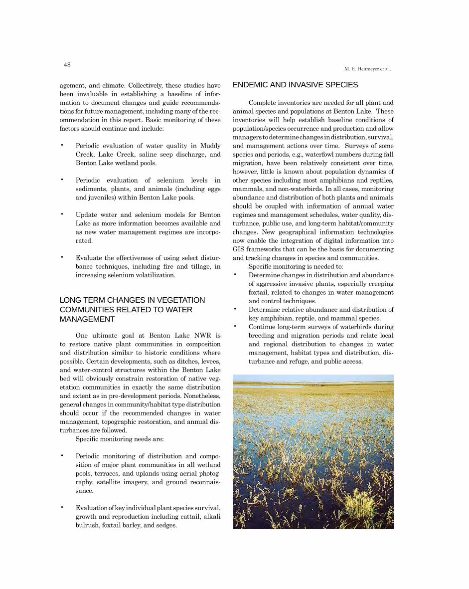
��M. E. Heitmeyer et al..
agement, and climate. Collectively, these studies have been invaluable in establishing a baseline of infor-mation to document changes and guide recommenda-tions for future management, including many of the rec-ommendation in this report. Basic monitoring of these factors should continue and include:
• Periodic evaluation of water quality in Muddy Creek, Lake Creek, saline seep discharge, and Benton Lake wetland pools.
• Periodic evaluation of selenium levels in sediments, plants, and animals (including eggs and juveniles) within Benton Lake pools.
• Update water and selenium models for Benton Lake as more information becomes available and as new water management regimes are incorpo-rated.
• Evaluate the effectiveness of using select distur-bance techniques, including fire and tillage, in increasing selenium volatilization.
LONG TERM CHANGES IN VEGETATION COMMUNITIES RELATED TO WATER MANAGEMENT
One ultimate goal at Benton Lake NWR is to restore native plant communities in composition and distribution similar to historic conditions where possible. Certain developments, such as ditches, levees, and water-control structures within the Benton Lake bed will obviously constrain restoration of native veg-etation communities in exactly the same distribution and extent as in pre-development periods. Nonetheless, general changes in community/habitat type distribution should occur if the recommended changes in water management, topographic restoration, and annual dis-turbances are followed.
Specific monitoring needs are:
• Periodic monitoring of distribution and compo-sition of major plant communities in all wetland pools, terraces, and uplands using aerial photog-raphy, satellite imagery, and ground reconnais-sance.
• Evaluation of key individual plant species survival, growth and reproduction including cattail, alkali bulrush, foxtail barley, and sedges.
ENDEMIC AND INVASIVE SPECIES
Complete inventories are needed for all plant and animal species and populations at Benton Lake. These inventories will help establish baseline conditions of population/species occurrence and production and allow managers to determine changes in distribution, survival, and management actions over time. Surveys of some species and periods, e.g., waterfowl numbers during fall migration, have been relatively consistent over time, however, little is known about population dynamics of other species including most amphibians and reptiles, mammals, and non-waterbirds. In all cases, monitoring abundance and distribution of both plants and animals should be coupled with information of annual water regimes and management schedules, water quality, dis-turbance, public use, and long-term habitat/community changes. New geographical information technologies now enable the integration of digital information into GIS frameworks that can be the basis for documenting and tracking changes in species and communities.
Specific monitoring is needed to:• Determine changes in distribution and abundance
of aggressive invasive plants, especially creeping foxtail, related to changes in water management and control techniques.
• Determine relative abundance and distribution of key amphibian, reptile, and mammal species.
• Continue long-term surveys of waterbirds during breeding and migration periods and relate local and regional distribution to changes in water management, habitat types and distribution, dis-turbance and refuge, and public access.
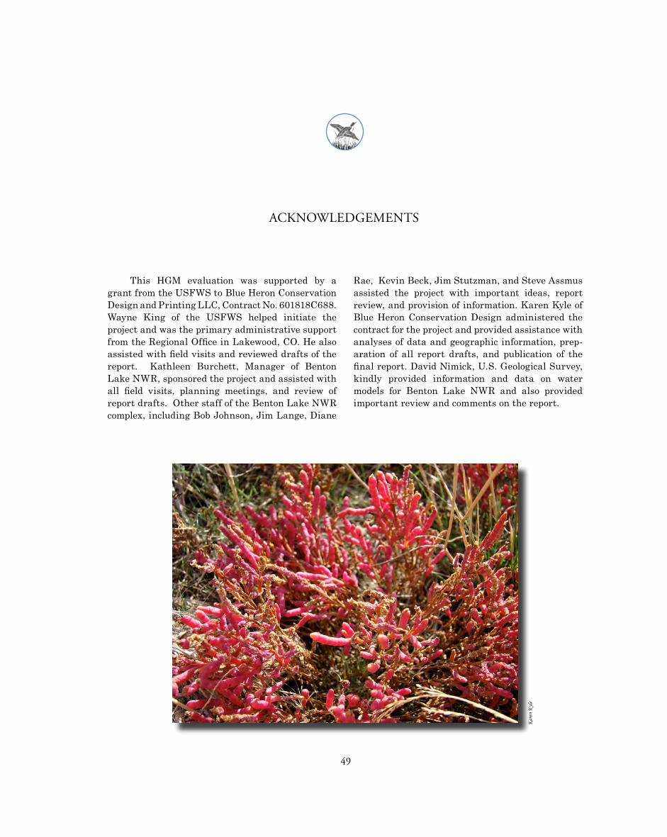
49
ACKNOWLEDGEMENTS
This HGM evaluation was supported by a grant from the USFWS to Blue Heron Conservation Design and Printing LLC, Contract No. 601818C688. Wayne King of the USFWS helped initiate the project and was the primary administrative support from the Regional Office in Lakewood, CO. He also assisted with field visits and reviewed drafts of the report. Kathleen Burchett, Manager of Benton Lake NWR, sponsored the project and assisted with all field visits, planning meetings, and review of report drafts. Other staff of the Benton Lake NWR complex, including Bob Johnson, Jim Lange, Diane
Rae, Kevin Beck, Jim Stutzman, and Steve Assmus assisted the project with important ideas, report review, and provision of information. Karen Kyle of Blue Heron Conservation Design administered the contract for the project and provided assistance with analyses of data and geographic information, prep-aration of all report drafts, and publication of the final report. David Nimick, U.S. Geological Survey, kindly provided information and data on water models for Benton Lake NWR and also provided important review and comments on the report.
elyn
Kera
K
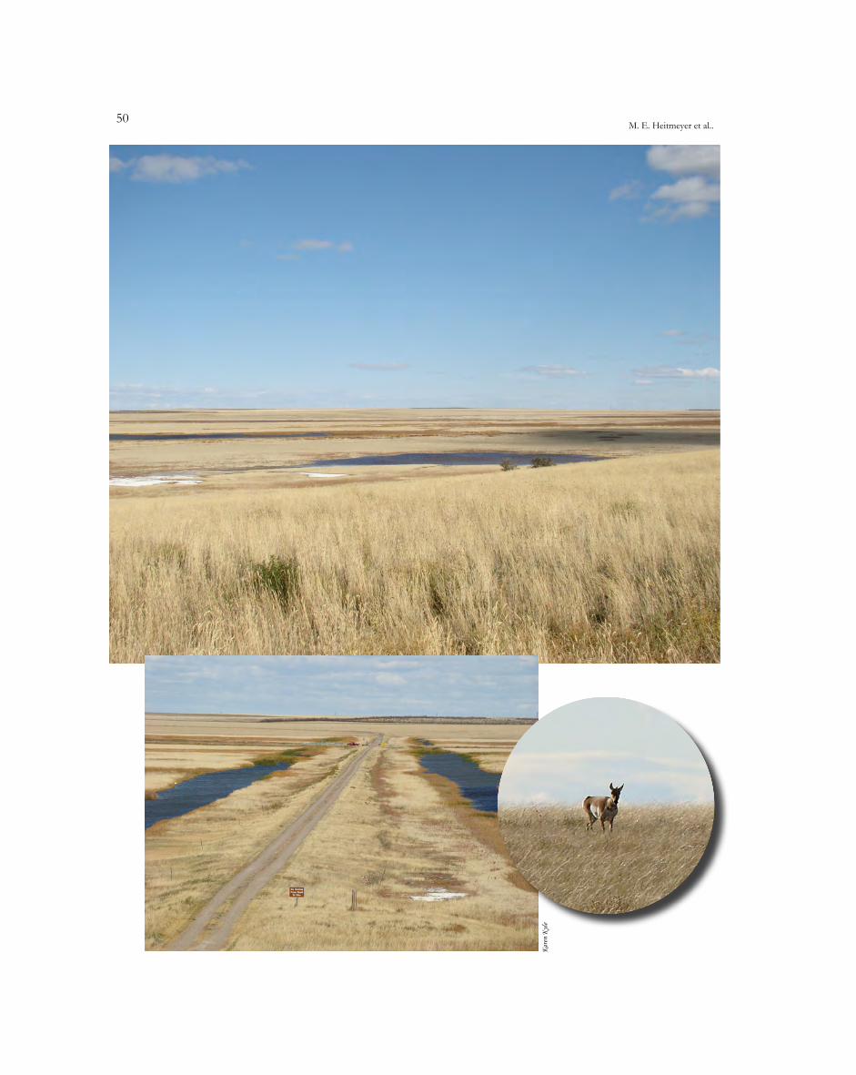
�0M. E. Heitmeyer et al..
elyn
Kera
K
51
LITERATURE CITED
Alden, W.C. 1932. Physiography and glacial geology of eastern Montana and adjacent areas: U.S. Geological Survey Professional Paper 174.
Anonymous 1997. Shorebirds Surveys, Benton Lake National Wildlife Refuge 1971-1997. Refuge Files
Bacon, C.R. 1983. Eruptive history of Mount Mazama and Crater Lake Caldera, Cascade Range, USA. Journal of Volcanology and Geothermal Research 18:57-115.
Bellrose, F.C. 1980. Ducks, geese and swans of North America. 2nd Edition. Stackpole Books, Harrisburg, PA.
Brown, P.L. 1972. Water use and soil water depletion by alfalfa on upland recharge and downslope saline seep areas. Bozeman, Montana Annual Research Report, U.S. Department of Agriculture, Agricultural Research Service.
Brown, P.L., A.D. Halvorson, F.H. Siddoway, H.F. Mayland and M.R. Miller. 1982. Saline-seep diagnosis, control and reclamation. U.S. Department of Agriculture Conservation Research Report No. 30.
Cascade County Historical Society. 1999. The Cascade County Album. Great Falls, Montana.
Clark, C.O., D.H. Farnsworth, F.T. Miller and B.N. Weight. 1979. Soil survey of Cascade County, Montana. U.S. Department of Agriculture, Soil Conservation Service and Montana Agricultural Experiment Stations, Missoula, MT.
Colton, R.B., R.W. Lemke and R.M. Lindvall. 1961. Glacial map of Montana east of the Rocky Mountains. U.S. Geological Survey Miscellaneous Investigation Map I-327.
Condon, S.M. 2000. Stratigraphic framework of Lower and Upper Cretaceous rocks in central and east-ern Montana. U.S. Geological Survey Digital Data Series DDS-57.
Corn, P.S. and C.R. Peterson. 1996. Prairie legacies – amphibians and reptiles. Pages 125-134 in F.B. Samson and F.L. Knopf, editors. Prairie conser-
vation: preserving North America’s most endan-gered ecosystem. Island Press, Covelo, CA.
Doering, E. J. and F.M. Sandoval. 1976. Hydrology of saline seeps in the Northern Great Plains. Transactions of American Society of Agricultural Engineers 19: 856-861.
Fields, V. 2007. Hazard assessment of selenium contami-nation at Benton Lake National Wildlife Refuge. U.S. Fish and Wildlife Service, BNL Biological Report 2-07.
Fields, V., S Dawes, N McMue, and J. Gonser. 2007. Native grassland inventory and Monitoring. Biologists Files Benton Lake National Wildlife Refuge. Internal Report.
Foresman, K. R. 2001. The Wild Mammals of Montana. American Society of Mammalogists, Lawrence, Kansas. Special Publication No. 12. 278pp.
General Land Office. 1920. GLO maps and notes for the Benton Lake, Montana region.
Gieseker, L.F., E.R. Morris, A.T. Strahorn and C.B. Manifold. 1929. Soil survey (reconnaissance) of the Northern Plains of Montana. U.S. Department of Agriculture, Bureau of Chemistry and Soils, Washington, DC.
Gilbert, E., T. Rerreira, and J. O’Hara. 1994. Nocturnal marsh bird surveys. Biologist’s Files Benton Lake National Wildlife Refuge.
Giltner, L.T. and J.F. Couch. 1930. Western duck sickness and botulism. Science 72: 660.
Great Falls Tribune. 1929a. Benton Lake to be set aside for migratory bird refuge. Great Falls, Montana.
Great Falls Tribune. 1929b. Hoover approves proposal for Benton Lake Preserve. Great Falls, Montana.
Great Falls Tribune. 1929c. Water supply big problem of Benton Lake Bird Preserve. Great Falls, Montana.
Grzimek, B. editor. 1974. Grzimek’s animal life encyclo-pedia. Volume 5. Fishes II and amphibian. Van Nostrand Reinhold, New York.
�2M. E. Heitmeyer et al..
Halvorson, A.D. and A.L. Black. 1974. Saline-seep devel-opment in dryland soils of northeastern Montana. Journal of Soil and Water Conservation 29:77-81.
Hansen, P.L., R.D. Pfister, K. Boggs, B.J. Cook, J. Joy and D.K. Hinckley. 1995. Classification and manage-ment of Montana’s riparian and wetland sites. Montana Forest and Conservation Experiment Station, University of Montana Miscellaneous Publication No. 54.
Heitmeyer, M.E. and L.H. Fredrickson. 2005. An evalu-ation of ecosystem restoration and management options for the Ouray National Wildlife Refuge, Utah. University of Missouri-Columbia, Gaylord Memorial Laboratory Special Publication No. 8. Puxico, MO.
Heitmeyer, M.E., F.A. Nelson and L.H. Fredrickson. 2006. An evaluation of ecosystem restoration and man-agement options for the Duck Creek/Mingo Basin area of southeast Missouri. University of Missouri-Columbia, Gaylord Memorial Laboratory Special Publication No. 12. Puxico, MO.
Heitmeyer, M.E. and K. Westphall. 2007. An evaluation of ecosystem restoration and management options for the Calhoun and Gilbert Lake Divisions of Two Rivers National Wildlife Refuge. University of Missouri-Columbia, Gaylord Memorial Laboratory Special Publication No. 13. Puxico, MO.
Henny, C.J., R.A. Grove and V.R. Bentley. 2000. Effects of selenium mercury, and boron on waterbird hatch-ability at Stillwater, Malheur, Seedskadee, Ouray, and Benton Lake National Wildlife Refuges and surrounding vicinities. U.S. Geological Survey National Irrigation Water Quality Program Information Report 5.
Holton, G. D. and H. E. Johnson. 2003. A field guide to Montana Fishes, third edition. Montana Fish, Wildlife and Parks, Helena, MT. 95pp.
Hultman, D. 1991. Calming troubled waters: contami-nants at Benton Lake National Wildlife Refuge, Montana: a plan of action. U.S. Fish and Wildlife Service, Black Eagle, MT.
Kalmbach, E.R. and M.F. Gunderson. 1934. Western duck sickness – a form of botulism. U.S. Department of Agriculture Technical Bulletin No. 411, Washington, DC.
Kantrud, H.A., J.B. Millar and A.G. van der Valk. 1989. Vegetation of wetlands of the prairie pothole region. Pages 132-187 in A.G. van der Valk, editor. Northern Prairie wetlands. Iowa State University Press, Ames, IA.
Kinter, A. and V. L. Fields. 2006. Herptile survey report for Benton Lake NWR. Refuge files, 14pp.
Knapton, J.R., W.E. Jones and J.W. Sutphin. 1988. Reconnaissance investigation of water quality, bottom sediment, and biota associated with irriga-tion drainage in the Sun River area, west-central
Montana, 1986-87. U.S. Geological Survey Water Resources Investigations Report 87-4244.
Knopf, F.L. and F.B. Samson, Editors. 1997. Ecology and conservation of Great Plains vertebrates. Springer, New York.
Lambing, J.H., D.A. Nimick and D.U. Palawski. 1994. Physical, chemical, and biological data for detailed study of the Sun River Irrigation Project, Freezeout Lake Wildlife Management Area, and Benton Lake National Wildlife Refuge, west-central Montana, 1990-92 with selected data for 1987-89. U.S. Geological Survey Open-file Report 94-120.
Laubhan, M.K. and L.H. Fredrickson. 1997. Wetlands of the Great Plains: habitat characteristics and ver-tebrate aggregations. Pages 20-48 in F.L. Knopf and F.B. Samson, editors. Ecology and conserva-tion of Great Plains vertebrates. Springer, New York.
Lemke, R.W. 1977. Geologic map of the Great Falls quad-rangle, Montana. U.S. Geological Survey Geologic Quadrangle Map GQ-1414.
Lemly, A.D. 1995. A protocol for aquatic hazard assessment of selenium. Ecotoxicology and Environmental safety 32: 280-288.
Lemly, A.D. and G.J. Smith. 1987. Aquatic cycling of sele-nium – implications for fish and wildlife. U.S. Fish and Wildlife Service Fish and Wildlife Leaflet 12.
Martin, S. and S. Dawes. 2002. Waterfowl Surveys at Benton Lake National Wildlife Refuge 1988-2002. Biologist’s Files.
Maughan, E.K. 1961. Geologic map of the Vaughn quadrangle, Montana. U.S. Geological Survey Quadrangle Map GQ-135.
Maughan, E.K. and R.W. Lemke. 1991. Geologic map of the Portage quadrangle, Cascade and Choteau Counties, Montana. U.S. Geological Survey Miscellaneous Investigations Map I-2196.
Meretsky, V.J., R.L. Fischman, J.R. Karr, D.M. Ashe, J.M. Scott, R.F. Noss and R.L. Schroeder. 2006. New directions in conservation for the National Wildlife Refuge System. Bioscience 56: 135-143.
Miller, K.J., D.S. Rise and C. McDonald. 2002. Ground-water and surface-water quality, herbicide trans-port, and irrigation practices: Greenfields Bench aquifer, Teton County, Montana. Montana Bureau of Mines and Geology Open-file Report 463.
Miller, M.R., P.L. Brown, J.J. Donovan, R.N. Bergantino, J.L. Sonderegger and F.A. Schmidt. 1981. Saline-seep development and control in the North American Great Plains – hydrological aspects. Montana Bureau of Mines and Geology Open-file Report 81.
�3
Miller, M.R. and R.N. Bergantino. 1983. Distribution of saline seeps in Montana. Montana Bureau of Mines and Geology Hydrogeologic Map 7.
Mudge, M.R., R.L. Earhart, J.W. Whipple and J.E. Harrison. 1982. Geologic and structure map of the Choteau 1o and 2o quadrangle, western Montana. Montana Bureau of Mines and Geology Montana Atlas Series MA 3-A.
Murkin, H.R., A.G. van der Valk and W.R. Clark. 2000. Prairie wetland ecology: the contribution of the Marsh Ecology Research Program. Iowa State University Press, Ames.
National Agricultural Statistics Service. 2009. National agricultural statistics service, Cascade County, Montana. U.S. Department of Agriculture. http://www.nass.usda.gov.
National Oceanic and Atmospheric Administration. 2009. Archival climatic records – Great Falls, MT. http://noaa.gov.
Natural Resources Conservation Service. 2007. Creeping foxtail Plant Guide. U.S. Department of Agriculture Plant Material Program.
Nimick, D.A. 1997. Hydrology and water chemistry of the Benton Lake Basin with emphasis on the fate of dissolved solids at Benton Lake National Wildlife Refuge, west-central Montana. U.S. Geological Survey Water-Resources Investigation Report 97-4100.
Nimick, D.A., J.H. Lambing, D.U. Palawski and J.C. Malloy. 1996. Detailed study of selenium in soil, water, bottom sediment, and biota in the Sun River Irrigation Project, Freezeout Lake Wildlife Management Area, and Benton Lake National Wildlife Refuge, west-central Montana, 1990-92. U.S. Geological Survey Water-Resources Investigation Report 95-4170.
Ohlendorf, H.M. and J.P. Skorupa. 1989. Selenium in relation to wildlife and agricultural drainage water. Pages 314-338 in S.C. Carapella, Jr., ed. Proceedings of the 4th International Symposium on uses of Selenium and Tellurium, Banff, Alberta.
Palawski, D.U. and S.J. Martin. 1991. Benton Lake National Wildlife Refuge contaminant biomoni-toring strategy. U.S. Fish and Wildlife Service, Denver, CO.
Palawski, D.U., W.E. Jones, K.L. DuBois and J.C. Malloy. 1991. Contaminant biomonitoring at the Benton Lake National Wildlife Refuge in 1988. U.S. Fish and Wildlife Service Contaminants Program Report, Helena, MT.
Palmer, R.S., Editor. 1978. Handbook of North American birds, Vol. I. Yale University Press, New Haven, CT.
Seiler, R.L., J.P. Skorupa, D.L. Naftz and B.T. Nolan. 2003. Irrigation-induced contamination of water, sediment, and biota in the western United States – synthesis of data from the National Irrigation Water Quality Program. U.S. Geological Survey Professional Paper 1655.
Skorupa, J.P. and H.M. Ohlendorf. 1991. Contaminants in drainage water and avian risk thresholds. Pages 345-368 in D. Dinar and D. Zilberman, eds. The economics and management of water and drain-age in agriculture. Kluwer Academic Publishers, Boston, MA.
Soil Conservation Service. 1970. A map of evapotranspira-tion for Montana. U.S. Department of Agriculture, Missoula, MT.
Thompson, W.H. and P.L. Hansen. 2002. Vegetation inven-tory, mapping, and functional health assessment of wetlands on the Benton Lake National Wildlife Refuge in Montana. Bitterroot Restoration, Inc., Corvallis, Montana.
U.S. National Oceanic and Atmospheric Administration. 2008. Great Falls, Montana station history. National Weather Service Forecast Office. www.wrh.noaa.gov.
U.S. Fish and Wildlife Service. 1961-1999. Unpublished annual narrative reports, Benton Lake National Wildlife Refuge, Black Eagle and Great Falls, Montana.
U.S. Fish and Wildlife Service. 1970-1990. Unpublished annual disease reports, Benton Lake National Wildlife Refuge, Great Falls, Montana.
U.S. Fish and Wildlife Service. 1999. Fulfilling the prom-ise: the National Wildlife Refuge System. U.S. Department of the Interior, Fish and Wildlife Service, Washington, DC.
U.S. Fish and Wildlife Service. 2001. Fish and Wildlife Service, Refuge management manual, Part 601, National Wildlife Refuge System. U.S. Department of the Interior, Fish and Wildlife Service, Washington, DC.
van der Valk, A.G., editor. 1989. Northern prairie wet-lands. Iowa State University Press, Ames.
van der Valk, A.G. and C.B. Davis. 1978. The role of seed banks in the vegetation dynamics of prairie gla-cial marshes. Ecology 59:322-335.
Vuke, S.M., R.B. Colton and D.S. Fullerton. 2002. Geologic map of the Great Falls North 30’ x 60’ quadrangle, Central Montana. Montana Bureau of Mines and Geology Open-file report MBMG 459.
Yuill, C.D. and E.R. Yuill. 1984. A centennial celebration of Great Falls. Cascade County Historical Society, Great Falls, MT.
Weller, M.W. and L.H. Fredrickson. 1974. Avian ecol-ogy of a managed glacial marsh. Living Bird 12:269-291.
Evaluation of ecosystem restoration and management options for Benton Lake NWR
��M. E. Heitmeyer et al..
Weller, M.W. and C.E. Spatcher. 1965. Role of habitat in the distribution and abundance of marsh birds. Iowa State University Agriculture and Home Economics Experiment Station Special Report No. 43. Ames, IA.
Werner, J. K., B. A. Maxell, P. Hendricks and D. L. Flath. 2004. Amphibians and Reptiles of Montana. Mountain Press Publishing, Missoula, MT. 262pp.
Wetmore, A. 1915. The duck sickness in Utah. U.S. Department of Agriculture Bulletin No. 672.
Wobeser, G.A. 1981. Diseases of wild waterfowl. Plenum Press, New York.
Zhang, Y. and J.N. Moore. 1997a. Biogeochemical cycling of selenium in Benton Lake, Montana. Report prepared for U.S. Fish and Wildlife Service. University of Montana, Missoula.
Zhang, Y. and J.N. Moore. 1997b. Controls on selenium distribution in wetland sediment, Benton Lake, Montana. Journal of Water, Air, and Soil Pollution 97:323-340.
elyn
Kera
K
noslek
Nn
raF

55
APPENDICES
Appendix A. List of plant species for Benton Lake National Wildlife Refuge, Great Falls, Montana.
Category Common Name Scientific Name Family Native Exotic
Robust Emergents Beaked sedge Carex rostrata Cyperaceae x Common cattail Typha latifolia Typhaceae x Lesser cattail Typha angustifolia Typhaceae x Hardstem bulrush Scirpus acutus Cyperaceae x
Sedge/Rush Alkali bulrush Scirpus maritimus Cyperaceae x Common spikerush Eleocharis palustris Cyperaceae x Needle leaf rush Carex eleocharis Cyperaceae x Sharp bulrush Scirpus pungens Cyperaceae x Water knotweed Polygonum amphibium Polygonaceae x Wooly sedge Carex lanuginosa Cyperaceae x
Seasonal HerbaceousAmerican sloughgrass Beckmannia syzigachne Poaceae x
Common orache Atriplex patula Chenopodiaceae x Creeping foxtail Alopecurus arundinaceus Poaceae x Curley dock Rumex crispus Polygonaceae x Foxtail barley Hordeum jabatum Poaceae x Golden dock Rumex maritimus Polygonaceae x Inland saltgrass Distichlis spicata Poaceae x Meadow foxtail Alopecurus pratensis Poaceae x Narrowleaf Cottonwood Populus angustifolia Salicaceae x Prairie cordgrass Spartina pectinata Poaceae x Red glasswort Salicornia rubra Chenopodiaceae x
Reed canarygrass Phalaris arundinacea Poaceae x Sandbar willow Salix exigua Salicaceae x Tufted hairgrass Deschampsia cespitosa Poaceae x Willow dock Rumex salicifolius Polygonaceae x
Wet Grassland Canada thistle Cirisium arvense Asteraceae x Fivehook bassia Bassia hyssopifolia Chenopodiaceae x Lambsquarter Chenopodium album Chenopodiaceae x Marsh aster Aster hesperius Asteraceae x
Poison hemlock Conium maculatum Apiaceae x Poverty weed Iva axillaris Asteraceae x
�6M. E. Heitmeyer et al..
Appendix A. (cont’d)
Category Common Name Scientific Name Family Native Exotic
Rabbitfoot polypogon Polypogon monspeliensis Poaceae x Summer cypress Kochia scoparia Chenopodiaceae x Western wheatgrass Agropyron smithii Poaceae x
Upland Grassland Alfalfa Medicago sativa Fabaceae x
American vetch Vicia americana Fabaceae x Bahia Picradeniopsis oppositifolia Asteraceae x Bearded wheatgrass Agropyron caninum Poaceae x Biscuit Root Lomatium macrocarpum Apiaceae x Bluebunch wheatgrass Agropyron spicatum Poaceae x Blue grama Bouteleloua gracilis Poaceae x Blue spruce Picea pungens Pinaceae x Broom snakeweed Guiterrezia sarothrae Asteraceae x Caragana Caragana arborescens Fabaceae x Cheatgrass Bromus tectorum Poaceae x Clover Trifolium spp. Fabaceae x Clubmoss Salaginella densa Lycopodiaceae x Common plantain Plantago major Poaceae x Common sunflower Helianthus annuus Asteraceae x Common willow-herb Epilobium cilliatum Onagraceae x Crested wheat grass Agropyron cristatum Poaceae x Curlycup gumweed Grindelia squarrosa Asteraceae x Daisy fleabane Erigeron spp. Asteraceae x Dandelion Taraxacum officinale Asteraceae x Elm Ulmus spp. Salicaceae x Field Chickweed Cerastium arvense Capparaceae x Field penny cress Thiaspi arvense Brassicaceae x Field milk-thistle Sonchus arvensis Asteraceae x Fixweed tansymustard Descuraiania sophia Brassicaceae x Fringed sagewort Artemsia frigid Asteraceae x Goatsbeard Traopogon dubius Asteraceae x Golden pea Thermopsis rhombifolia Fabaceae x Green needlegrass Stipa viridula Poaceae x Ground plum milk vetch Astragalus crassicarpus Fabaceae x Hairy goldaster Chrysopsis villosa Asteraceae x Health aster Aster ericoides Asteraceae x Honeysuckle Lonicera maackii Caprifoliaceae x Hood’s phlox Phlox hoodii Polenoniaceae x Intermediate wheatgrass Elytrigia intermedia Poaceae x Japanese brome Bromus japonicas Poaceae x Kentucky bluegrass Poa pratensis Poaceae x Lilac Syrinigia vulgaris L. Oleaceae x Loeselii tumblemustard Sisymbrium loeselii Brassicaceae x Milk vetch Astragalus spp. Fabaceae x Musk thistle Carduus natans Asteraceae x Nuttal’s alkaligrass Puccinellia nuttaliana Poaceae x Nuttal’s sagebrush Atriplex nutallii Chenopodiaceae x Needle and thread Stipa comata Poaceae x Plains coreopsis Coreopsis tinctoria Asteraceae x Poverty weed Iva axillaris Asteraceae x Prairie june grass Koeleria macrantha Poaceae x
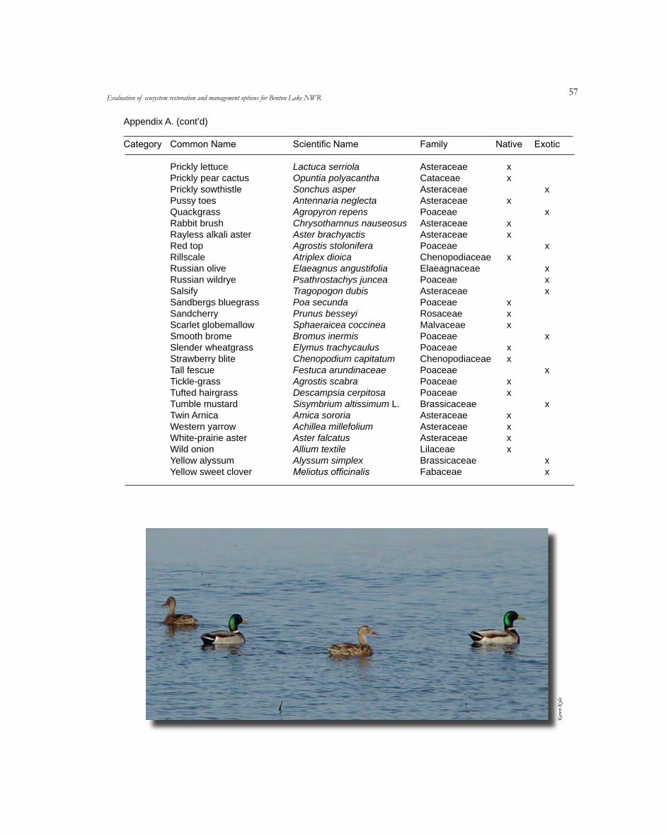
��
Appendix A. (cont’d)
Category Common Name Scientific Name Family Native Exotic
Prickly lettuce Prickly pear cactus Prickly sowthistle Pussy toes Quackgrass Rabbit brush Rayless alkali aster Red top Rillscale Russian olive Russian wildrye Salsify Sandbergs bluegrass Sandcherry Scarlet globemallow Smooth brome Slender wheatgrass Strawberry blite Tall fescue Tickle-grass Tufted hairgrass Tumble mustard Twin Arnica Western yarrow White-prairie aster Wild onion Yellow alyssum Yellow sweet clover
Lactuca serriola Opuntia polyacantha Sonchus asper Antennaria neglecta Agropyron repens Chrysothamnus nauseosus Aster brachyactis Agrostis stolonifera Atriplex dioica Elaeagnus angustifolia Psathrostachys juncea Tragopogon dubis Poa secunda Prunus besseyi Sphaeraicea coccinea Bromus inermis Elymus trachycaulus Chenopodium capitatum Festuca arundinaceae Agrostis scabra Descampsia cerpitosa Sisymbrium altissimum L. Amica sororia Achillea millefolium Aster falcatus Allium textile Alyssum simplex Meliotus officinalis
Asteraceae Cataceae Asteraceae Asteraceae Poaceae Asteraceae Asteraceae Poaceae Chenopodiaceae Elaeagnaceae Poaceae Asteraceae Poaceae Rosaceae Malvaceae Poaceae Poaceae Chenopodiaceae Poaceae Poaceae Poaceae Brassicaceae Asteraceae Asteraceae Asteraceae Lilaceae Brassicaceae Fabaceae
xx x xx x xxx x x xx xxxx
x
x
x
xxx
x
x
x
xx
Evaluation of ecosystem restoration and management options for Benton Lake NWR
elyn
Kera
K
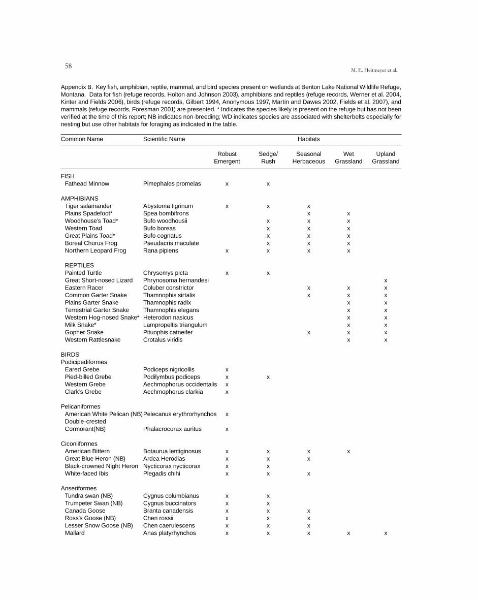
��M. E. Heitmeyer et al..
Appendix B. Key fish, amphibian, reptile, mammal, and bird species present on wetlands at Benton Lake National Wildlife Refuge, Montana. Data for fish (refuge records, Holton and Johnson 2003), amphibians and reptiles (refuge records, Werner et al. 2004, Kinter and Fields 2006), birds (refuge records, Gilbert 1994, Anonymous 1997, Martin and Dawes 2002, Fields et al. 2007), and mammals (refuge records, Foresman 2001) are presented. * Indicates the species likely is present on the refuge but has not been verified at the time of this report; NB indicates non-breeding; WD indicates species are associated with shelterbelts especially for nesting but use other habitats for foraging as indicated in the table.
Common Name Scientific Name Habitats
Robust Emergent
Sedge/ Rush
Seasonal Herbaceous
Wet Grassland
UplandGrassland
FISH Fathead Minnow AMPHIBIANS Tiger salamander Plains Spadefoot* Woodhouse’s Toad* Western Toad Great Plains Toad* Boreal Chorus Frog Northern Leopard Frog
REPTILES Painted Turtle Great Short-nosed Lizard Eastern Racer Common Garter Snake Plains Garter Snake Terrestrial Garter Snake Western Hog-nosed Snake* Milk Snake* Gopher Snake Western Rattlesnake
BIRDSPodicipediformes Eared Grebe Pied-billed Grebe Western Grebe Clark’s Grebe Pelicaniformes American White Pelican (NB) Double-crested Cormorant(NB)
Ciconiiformes American Bittern Great Blue Heron (NB) Black-crowned Night Heron White-faced Ibis Anseriformes Tundra swan (NB) Trumpeter Swan (NB) Canada Goose Ross’s Goose (NB) Lesser Snow Goose (NB) Mallard
Pimephales promelas
Abystoma tigrinum Spea bombifrons Bufo woodhousii Bufo boreas Bufo cognatus Pseudacris maculate Rana pipiens
Chrysemys picta Phrynosoma hernandesi Coluber constrictor Thamnophis sirtalis Thamnophis radix Thamnophis elegans Heterodon nasicus Lampropeltis triangulum Pituophis catneifer Crotalus viridis
Podiceps nigricollis Podilymbus podiceps Aechmophorus occidentalis Aechmophorus clarkia
Pelecanus erythrorhynchos
Phalacrocorax auritus
Botaurua lentiginosus Ardea Herodias Nycticorax nycticorax Plegadis chihi
Cygnus columbianus Cygnus buccinators Branta canadensis Chen rossii Chen caerulescens Anas platyrhynchos
x
x x
x
xx xx
x
x
x x x x
x x x x x x
x
x x x x x x
x
x
x x xx
xxx x x x
xx x x x x x
x x x
x x
x
xxxx
xxxxxx
x x x x x x x x
x
x
xxxxxxxxx
x
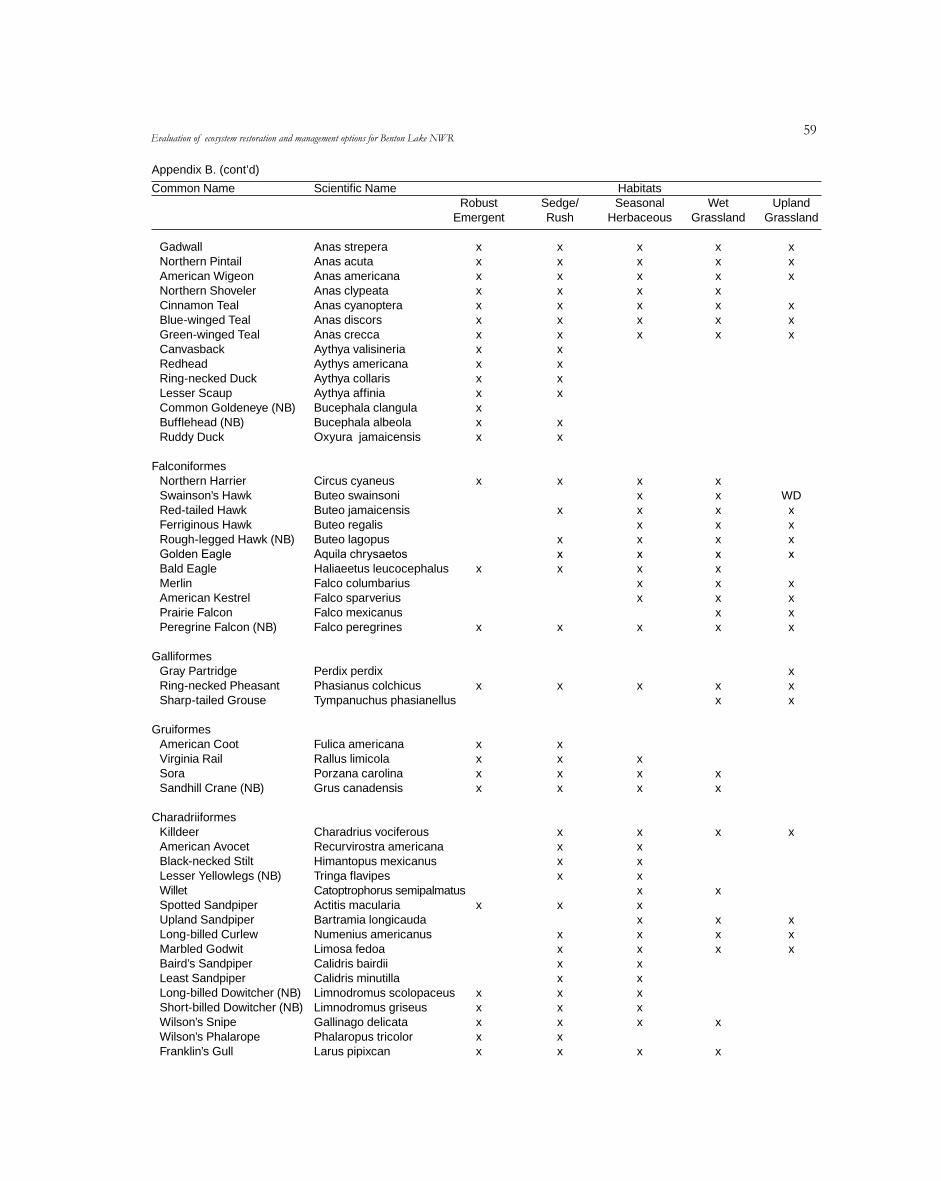
�9Evaluation of ecosystem restoration and management options for Benton Lake NWR
Appendix B. (cont’d)
Common Name Scientific Name Habitats Robust Emergent
Sedge/ Rush
Seasonal Herbaceous
Wet Grassland
UplandGrassland
Gadwall Northern Pintail American Wigeon Northern Shoveler Cinnamon Teal Blue-winged Teal Green-winged Teal Canvasback Redhead Ring-necked Duck Lesser Scaup Common Goldeneye (NB) Bufflehead (NB) Ruddy Duck Falconiformes Northern Harrier Swainson’s Hawk Red-tailed Hawk Ferriginous Hawk Rough-legged Hawk (NB) Golden Eagle Bald Eagle Merlin American Kestrel Prairie Falcon Peregrine Falcon (NB) Galliformes Gray Partridge Ring-necked Pheasant Sharp-tailed Grouse Gruiformes American Coot Virginia Rail Sora Sandhill Crane (NB)
Charadriiformes Killdeer American Avocet Black-necked Stilt Lesser Yellowlegs (NB) Willet Spotted Sandpiper Upland Sandpiper Long-billed Curlew Marbled Godwit Baird’s Sandpiper Least Sandpiper Long-billed Dowitcher (NB) Short-billed Dowitcher (NB) Wilson’s Snipe Wilson’s Phalarope Franklin’s Gull
Anas strepera Anas acuta Anas americana Anas clypeata Anas cyanoptera Anas discors Anas crecca Aythya valisineria Aythys americana Aythya collaris Aythya affinia Bucephala clangula Bucephala albeola Oxyura jamaicensis
Circus cyaneus Buteo swainsoni Buteo jamaicensis Buteo regalis Buteo lagopus Aquila chrysaetos Haliaeetus leucocephalus Falco columbarius Falco sparverius Falco mexicanus Falco peregrines
Perdix perdix Phasianus colchicus Tympanuchus phasianellus
Fulica americana Rallus limicola Porzana carolina Grus canadensis
Charadrius vociferous Recurvirostra americana Himantopus mexicanus Tringa flavipes Catoptrophorus semipalmatus Actitis macularia Bartramia longicauda Numenius americanus Limosa fedoa Calidris bairdii Calidris minutilla Limnodromus scolopaceus Limnodromus griseus Gallinago delicata Phalaropus tricolor Larus pipixcan
x x x x x x x x x x x x x x
x x x
x
x x x x
x x x x x x
x x x x x x x xxxx
xx
x x x x x x
x
xx x x
x x x x x x x x x x x x xx
x x x x x x x
x x x x x x x x x x
x
xx x
x xxxx xx x x xxxxx
x
x x x x x x x
xx x x x x xx x x x
x x
xx
x
x
x x x
x
x
xxx
xxx
WDxxxx
xxxx
xxx
x
xxx
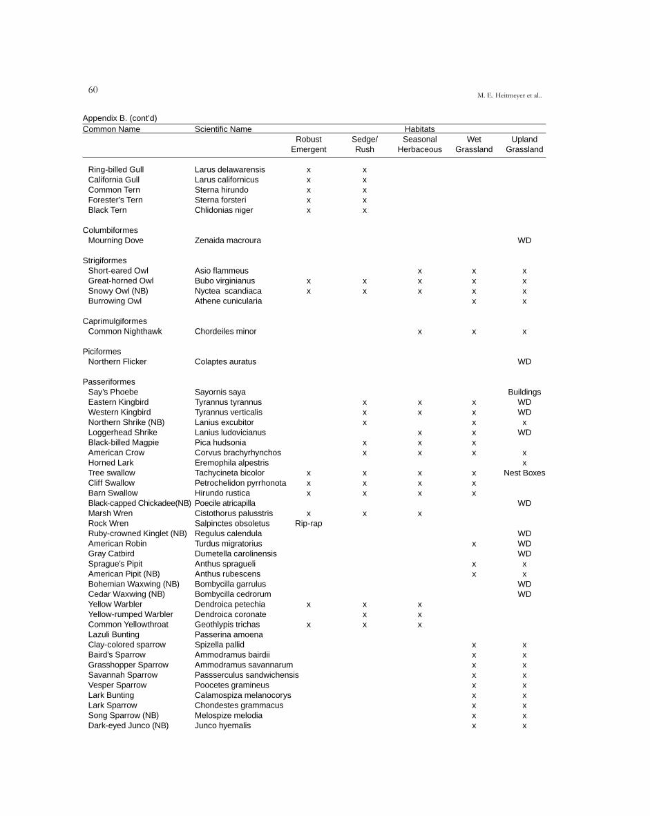
60M. E. Heitmeyer et al..
Appendix B. (cont’d)Common Name Scientific Name Habitats Robust Emergent
Sedge/ Rush
Seasonal Herbaceous
Wet Grassland
UplandGrassland
Ring-billed Gull California Gull Common Tern Forester’s Tern Black Tern Columbiformes Mourning Dove
Strigiformes Short-eared Owl Great-horned Owl Snowy Owl (NB) Burrowing Owl
Caprimulgiformes Common Nighthawk
Piciformes Northern Flicker
Passeriformes Say’s Phoebe Eastern Kingbird Western Kingbird Northern Shrike (NB) Loggerhead Shrike Black-billed Magpie American Crow Horned Lark Tree swallow Cliff Swallow Barn Swallow Black-capped Chickadee(NB) Marsh Wren Rock Wren Ruby-crowned Kinglet (NB) American Robin Gray Catbird Sprague’s Pipit American Pipit (NB) Bohemian Waxwing (NB) Cedar Waxwing (NB) Yellow Warbler Yellow-rumped Warbler Common Yellowthroat Lazuli Bunting Clay-colored sparrow Baird’s Sparrow Grasshopper Sparrow Savannah Sparrow Vesper Sparrow Lark Bunting Lark Sparrow Song Sparrow (NB) Dark-eyed Junco (NB)
Larus delawarensis x Larus californicus x Sterna hirundo x Sterna forsteri x Chlidonias niger x
Zenaida macroura
Asio flammeus Bubo virginianus x Nyctea scandiaca x Athene cunicularia
Chordeiles minor
Colaptes auratus
Sayornis saya Tyrannus tyrannus Tyrannus verticalis Lanius excubitor Lanius ludovicianus Pica hudsonia Corvus brachyrhynchos Eremophila alpestris Tachycineta bicolor x Petrochelidon pyrrhonota x Hirundo rustica x Poecile atricapilla Cistothorus palusstris x Salpinctes obsoletus Rip-rapRegulus calendula Turdus migratorius Dumetella carolinensis Anthus spragueli Anthus rubescens Bombycilla garrulus Bombycilla cedrorum Dendroica petechia x Dendroica coronate Geothlypis trichas x Passerina amoenaSpizella pallid Ammodramus bairdii Ammodramus savannarum Passserculus sandwichensis Poocetes gramineus Calamospiza melanocorys Chondestes grammacus Melospize melodia Junco hyemalis
xxxxx
x x
x x x x x x x x x
x x x
x x x
x
x x x x x x x x x
xxx
x x x x
x
x x x x xx x xx
x x x
x x x x x x x x x
WD
xxxx
x
WD
BuildingsWDWD
xWD
xx
Nest Boxes
WD
WDWDWD
xx
WDWD
x xxxxxxxx
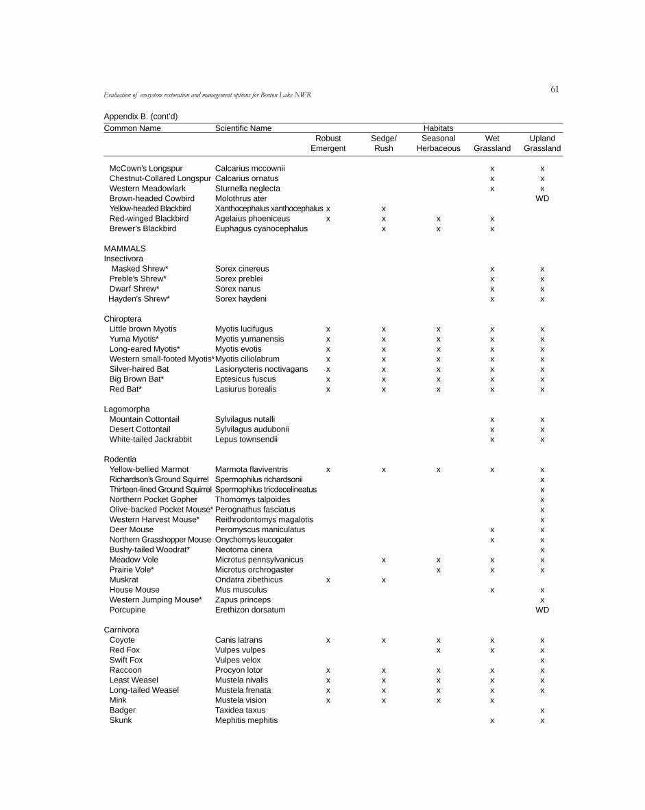
61Evaluation of ecosystem restoration and management options for Benton Lake NWR
Appendix B. (cont’d)
Common Name Scientific Name Habitats Robust Emergent
Sedge/ Rush
Seasonal Herbaceous
Wet Grassland
UplandGrassland
McCown’s Longspur Chestnut-Collared Longspur Western Meadowlark Brown-headed Cowbird Yellow-headed Blackbird Red-winged Blackbird Brewer’s Blackbird MAMMALSInsectivora Masked Shrew* Preble’s Shrew* Dwarf Shrew* Hayden’s Shrew* Chiroptera Little brown Myotis Yuma Myotis* Long-eared Myotis* Western small-footed Myotis* Silver-haired Bat Big Brown Bat* Red Bat*
Lagomorpha Mountain Cottontail Desert Cottontail White-tailed Jackrabbit
Rodentia Yellow-bellied Marmot Richardson’s Ground Squirrel Thirteen-lined Ground Squirrel Northern Pocket Gopher Olive-backed Pocket Mouse* Western Harvest Mouse* Deer Mouse Northern Grasshopper Mouse Bushy-tailed Woodrat* Meadow Vole Prairie Vole* Muskrat House Mouse Western Jumping Mouse* Porcupine
Carnivora Coyote Red Fox Swift Fox Raccoon Least Weasel Long-tailed Weasel Mink Badger Skunk
Calcarius mccownii Calcarius ornatus Sturnella neglecta Molothrus ater Xanthocephalus xanthocephalus Agelaius phoeniceus Euphagus cyanocephalus
Sorex cinereus Sorex preblei Sorex nanus Sorex haydeni
Myotis lucifugus Myotis yumanensis Myotis evotis Myotis ciliolabrum Lasionycteris noctivagans Eptesicus fuscus Lasiurus borealis
Sylvilagus nutalli Sylvilagus audubonii Lepus townsendii
Marmota flaviventris Spermophilus richardsonii Spermophilus tricdecelineatus Thomomys talpoides Perognathus fasciatus Reithrodontomys magalotis Peromyscus maniculatus Onychomys leucogater Neotoma cinera Microtus pennsylvanicus Microtus orchrogaster Ondatra zibethicus Mus musculus Zapus princeps Erethizon dorsatum
Canis latrans Vulpes vulpes Vulpes velox Procyon lotor Mustela nivalis Mustela frenata Mustela vision Taxidea taxus Mephitis mephitis
x x
x x x x x x x
x x
x x x x x
xx x
x x x x x x x
x x x
x x x x x
x x
x x x x x x x
x x x
x x x x x x
x x x
xx
x x x x
x x x x x x x
x x x
x x x x x
x
x x x x x x x
x xx
WD
xxxx
xxxxxx x
xxx
xxxxxxxxxxx
xx
WD
xxxxxx
xx
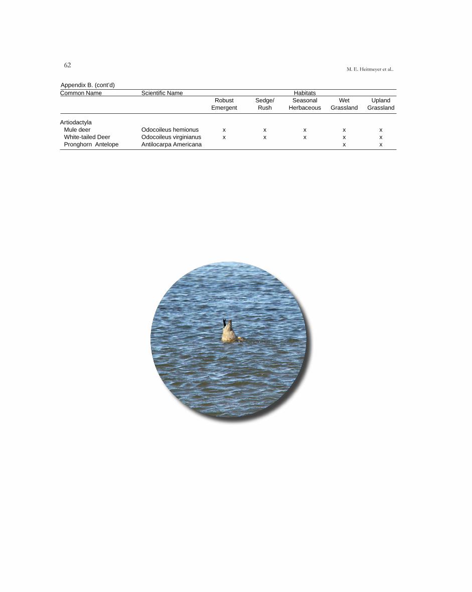
62M. E. Heitmeyer et al..
Appendix B. (cont’d)Common Name Scientific Name Habitats
Robust Emergent
Sedge/ Rush
Seasonal Herbaceous
Wet Grassland
UplandGrassland
Artiodactyla Mule deer Odocoileus hemionus x x x x x White-tailed Deer Pronghorn Antelope
Odocoileus Antilocarpa
virginianus Americana
x
x
x
x x
xx
