airborne geophysical survey of part of anglesey, north wales
TRANSCRIPT
Natural Environment Research Council
Institute of Geological Sciences
Mineral Reconnaissance Programme Report
A report prepared for the Department of Jndustry

This report relates to work carried out by the Institute of Geological
Sciences on behalf of the Department of Industry. The information
contained herein must not be published without reference to the
Director, Institute of Geological Sciences
D. Ostle
Programme Manager
Institute of Geological Sciences
Keywort h,
Nottingham NG12 5GG
No. 27
Airborne geophysical survey of part of Anglesey, North Wales.

I INSTITUTE OF GEOLOGICAL SCIENCES
Natural Environment Research Council
Mineral Reconnaissance Programme
I Report No. 27
I
Airborne geophysical survey of part of Anglesey, North Wales.
I. F. Smith, BSc, MSc
with a contribution on Aeroradiometry by D. C. Cooper, BSc, PhD
0 Crown copyright 7979
London 1979 A report prepared for the Department of Industry

Mineral Reconnaissance Proaramme Retorts The Institute of Geological Sciences was formed by the
1
2
3
4
5
6
7
8
9
10
11
12
13
14
15
16
17
18
19
20
21
22
23
24
25
26
27
The concealed granite roof in south-west Cornwall
around Geochemical and geophysical investigations Garras Mine, near Truro, Cornwall
Molybdenite mineralisation near Lairg, Scotland
in Precambrian rocks
Investigation of copper mineralisation at Vidlin, Shetland
Preliminary mineral reconnaissance of Central Wales
Report shire
on geophysical surveys at Struy, Inverness-
Investigation of tungsten and other mineralisation associated with the Skiddaw Granite near Carrock Mine, Cumbria
Investigation of stratiform sulphide parts of central Perthshire
mineralisation in
Investigation of disseminated copper mineralisation near Kilmelford, Argyllshire, Scotland
Geophysical surveys around Kirkcudbrightshire, Scotland
Talnotry mine,
A study of the space form of the Cornubian granite batholith and its application to detailed gravity surveys in Cornwall
Mineral investigations in the Teign Valley, Devon. Part 1 -6arytes
Investigation of stratiform sulphide mineralisation at McPhun’s Cairn, Argyllshire
Mineral investigations at Woodhall and Longlands in north Cumbria
Investigation of stratiform sulphide mineralisation at Meall Mor, South Knapdale, Argyll
Report on geophysical and geological surveys at Blackmount, Argyllshire
Lead, zinc and copper mineralisation in basal Carboniferous rocks at Westwater, south Scotland
A mineral reconnaissance survey of the Doon-Glenkens area, south-west Scotland
A reconnaissance geochemical drainage survey of the Criffel-Dalbeattie granodiorite complex and its environs
Geophysical field techniques for mineral exploration
A geochemical drainage survey complex and its environs
of the Fleet granitic
Geochemical and geophysical investigations west of Llanrwst, North Wales
north-
Disseminated sulphide mineralisation Achadh, Argyllshire, Scotland
at Garbh
Geophysical investigations along parts of the Dent and Augill Faults
Mineral investigations near Bodmin, Cornwall. Part 1 -Airborne and ground geophysical surveys
Stratabound barium-zinc mineralisation in Dalradian schist near Aberfeldy, Scotland: Preliminary report
Airborne geophysical survey of part of Anglesey, North Wales
incorporation of the Geological Survey of Great Britain and the Geological Museum with Overseas Geological Surveys and is a constituent body of the Natural Environment Research Council
Bibliographical reference Smith, I. F. 1979. Airborne geophysical survey of part of Anglesey, North Wales. Mineral Reconnaissance Programme Rep. inst. Geol. Sci., No. 27
Printed in England for the Institute of Geological Sciences by Ashford Press Ltd

CONTENTS
Summary
INTRODUCTION
General
Objectives
Geology
Equipment, survey and data compilation
Presentation
RESULTS
DESCRIPTION OF THE AEROMAGNETIC SURVEY RESULTS
General
Susceptibilities
Area A
Area B
Area C
Area D
CONCLUSIONS
REFERENCES
Page
1
2
4
4
4
4
6
6
6
7
7
10
10
10
11

ILLUSTRATIONS
Page
Fig. 1 Map of Anglesey of flight lines
showing area surveyed and position 3
Fig. 2 Simplified aeromagnetic map of part of Anglesey. in pocket
Fig. 3
Fig. 4
Map to show correlation elevation on Anglesey.
South-north total field magnetic intensity profi over Carmel Head Thrust with interpreted model.
between EM noise and ground 5
le 8
Fig. 5 A profile across an aeromagnetic anomaly and a possible interpretation after Parker Gay (1963). 9
SUMMARY
An airborne magnetic, electromagnetic and radiometric survey was carried out over part of Anglesey, North Wales. In this report of the survey, an outline of the geology, with brief descriptions of survey techniques, data reduction and presentation are given. General descriptions are presented of four areas of distinct magnetic character, with interpretations of the more prominent anomalies such as those associated with the Carmel Head Thrust, with Tertiary dykes and with various hornfels bodies. Possible extensions of known ultrabasic bodies and areas where other such potentially mineralised bodies may be concealed have been shown, in particular near Llandyfrydog (SH 44 85)and near the coast south of Valley (SH 31 76).
The electromagnetic survey data are not described in detail because radio transmissions caused strong anomalies unrelated to the geology and masked most of the real anomalies. Those anomalies which remained were due largely to man-made objects. Examination of the radiometric traces showed no indication of uranium mineralisation or any other substantial concentration of radioactive elements.

INTRODUCTION
General
The northern and central part of Anglesey, shown in Fig. 1, was surveyed with an airborne magnetometer, an electromagnetic system and a gamma-ray spectrometer. The survey was a preliminary stage of the Department of Industry Mineral Reconnaissance Programme (DIMRP) in North Wales.
Hunting. Geology and Geophysics Ltd. was contracted to fly the survey, which was completed in the autumn of 1972. Data reduction and the presentation of the finished maps of magnetic and electromagnetic data was also the contractor's responsibility.
This report describes the results of this survey and presents interpretations of representative anomalies. These may be compared with the results of the later ground geophysical investigations, which are to be described in a subsequent report.
Objectives
The purpose of the DIMRP is the location of non-ferrous metalliferous ore deposits in the UK. Anglesey was selected for investi- gation largely because of the presence of a belt of mineralisation in the north of the island which includes the former extensive copper mine at Parys Mountain. Following a desk study an airborne survey was proposed over parts of Anglesey to determine whether similar ore deposits might be concealed under the extensive cover of Pleistocene deposits or at depth within the Lower Palaeozoic rocks. The elongate tract of the Pre-Cambrian Coedana granite was also included as a possible source of mineralisation.
Much of the ore at Parys Mountain has been removed by mining but it was considered possible for the remaining veins and concentrated disseminations of ore to have sufficient conductivity in mass to be detected by the electromagnetic induction (EM) method from the air. Other major conductive bodies such as ’ black shales, possibly containing bulk sulphides, also might be identified. Through- out Anglesey intrusive rocks are found which might be possible sources of mineralisation. They could contain magnetic minerals and thus they might be identified using aeromagnetic methods. Further, a gamma-ray spectrometer survey was proposed to provide more comprehensive cover than was possible during the car-borne radiometric survey previously carried out by IGS and to identify radiometric anomalies possibly related to uranium mineralisation. The radiometric results would also help in identifying EM anomalies due to dark shales.
Geology
Greenly (1919) produced a detailed memoir and accompanying map on the geology of of Anglesey which was published by the
2
Geological Survey; this is still the standard work on the area. Only a little of his detail need be given in this report to allow description of the geophysical anomalies.
Much of Anglesey is occupied by a metamorphosed succession of rocks which Greenly named the Mona Complex. Although no Cambrian rocks have been proved to'rest upon it, he assigned a Pre-Cambrian age to the complex because it is significantly more deformed -and he therefore assumed to be older -than the Cambrian rocks which crop out elsewhere in North Wales. He recognised within the complex a Gneissic Group, a Bedded Succession and plutonic intrusions. The whole was isoclinally folded, faulted and metamorphosed.
The Gneissic Group was regarded as the oldest. This group was believed to be over- lain unconformably by the Bedded Succession, a typical geosynclinal succession containing volcanic rocks. Although the Bedded Succession is much deformed and metamorphosed so that the original succession is difficult to reconstruct, Greenly was able to subdivide it into six groups with the Holyhead Quartzite regarded as the youngest rocks and the Fydlyn Group the oldest. The whole sequence was then intruded by granite? basic' and ultrabasic rocks, with the formation of a zone of hornfels around the granite. In the south-east of the island the Bedded Succession was metamorphosed into a variety of schistose rocks which Greenly called the Penmynydd Zone of Metamorphism.
Shackleton (1954) re-interpreted the Pre- Cambrian structure and considered the Bedded Succession to be inverted, the oldest rocks then being the Holyhead Quartzite. The Bedded Succession was then progressively metamorphosed into the Penmynydd Zone, the Gneissic Group and finally mobilised as the intrusive granites.
No Cambrian rocks have been identified with certainty, the oldest dated rocks being Ordovician mudstones and shales of Arenig to Hartfell age, with basal conglomerate and sandstones, followed by Silurian shales of Llandovery age. These Lower Palaeozoic rocks occur, apart from minor outcrops, in a low- lying area in the northern part of Anglesey. The outcrop is truncated to the north by the Carmel Head Thrust where rocks of the Mona Complex overthrust the Lower Palaeozoic rocks. A range of igneous rocks of Palaeozoic age occurs within the Lower Palaeozoic and Mona Complex; they vary in composition from ultrabasic to acid.
Upper Palaeozoic rocks rest unconformably upon the Ordovician and Mona Complex, the oldest being Old Red Sandstone, followed by Carboniferous Limestone, Millstone Grit and Coal Measures.
The whole island is traversed by a number of large Tertiary dolerite dykes.

IRISH SEA
90
2iO km W 40 Go V ru fi
n
.-
6 1;
70
Caernarvon
,6okmN TLn is tie line number
0 I
Fig. 1. Map of Anglesey shwing area suweyed and position Of flight lines

Much of the older geology is obscured by a cover of drift of variable thickness.
Equipment, survey and data compilation
The area flown is shown in Fig. 1. Operational details of the survey are presented in the contractor's report (Hunting Geology and Geophysics Ltd., 1974) in which the Anglesey area is designated Area C/K. IGS staff kept quality control over the operations. Detailed information on airborne survey techniques and data compilation is contained in Burley and others (1978); brief details only are given here.
The equipment used was a Gulf Mk. III fluxgate total field airborne magnetometer, Lockwood LHEM 250 EM system and a Nuclear Enterprises NE8420 gamma ray spectrometer. A 'bird' containing the magnetometer and EM system detectors was towed beneath the helicopter at a nominal ground clearance of 100 ft. (30.5m). The EM equipment operated at 1000 Hz. Position fixing was by photographic identification of fiducial points along flight lines nominally spaced at 1OOm in part of the survey area and 200m elsewhere (see Fig. 1). Tie lines were flown to allow datum corrections to be made.
Presentation
The reduced electromagnetic and magnetic survey data are drawn on transparent plastic sheets at a scale of 1:10,560. Subdued topography from the Ordnance Survey maps was used as a base, with the geophysical information overprinted. The survey area is covered as:
a)
b)
c)
by 19 such maps and the data presented
Contour maps of Total force Magnetic field strength in gammas (nanoTeslas).
Contour maps of In-phase component of the Electromagnetic anomaly in parts per million of the primary field
Plots of ratios In-phase to Out-of- phase components of the Electro- magnetic anomaly.
Electromagnetic survey
Much of the area surveyed is covered by strong anomalies which are subsinusoidal in form; these are stronger in the north-east and over high ground. Much time was spent checking them on the ground but most were not confirmed. It was therefore concluded that many of the anomalies were EM noise. Fig. 3 shows a map with the relationship between EM records with an arbitrary level of noise, the 200 ft. (c. 60 m) contour line and two radio transmitters in the north- east of Anglesey. Noise is seen at lower altitudes nearer to the transmitters and becomes progressively weaker further away. It is considered that the noise results from the 1kHz radio signal interfering with the EM signal to produce beat frequencies, the amplitude of which depends upon the orientation of the EM 'bird' in relation to the trans- mitters, upon the distance of the aircraft from the transmitters and upon having 'line-of-sight' transmission.
The effect of the EM noise is not only to mask any real anomalies where the noise is strong (as at Parys Mountain (SH 44 90), where ground orientation studies proved weak anomalies, possibly due to mineralisation) but also in areas of low noise to confuse the anomaly pattern, so that it is not possible to correlate the ground results with the airborne, This is illustrated near Carmel Head (SH 30 92) where weak EM anomalies were found on the ground (possibly related to a mineralised fracture zone). The weak airborne indications do not correspond in position with the ground anomalies and it is likely that the airborne anomalies are noise, the EM response being too small to be detected in the air.
Inspection of the EM maps in quieter areas (in particular in the south-west) show some anomalies due to power lines (e.g. at SH 370
733), weak anomalies due to buried metal objects (e.g. at Tyntywyn SH 328 757), and, over parts of the airfield at Valley (SH 30 75), strong anomalies probably correlating with metal buildings. A discontinuous line of anomalies follows the main A5 trunk road, presumably caused by man-made objects. In no case was any anomaly found on the map shown to have any clear geological origin. However, during the follow-up on the ground, several anomalies with geological origins were identified in areas masked by the noise. These anomalies are to be described in a subsequent report, together with details of the ground surveys.
Aeroradiometric survey
The contractor provided IGS with the aeroradiometric traces, navigation plots and flight reports. The traces show detector responses for 'total' count (1.0-2.9 KeV), potassium (1.31-1.61 KeV), uranium (1.61-2.3 KeV) and thorium (2.2-2.9 KeV) and an altimeter record. The spectrometer data have not been analysed in detail because low count rates in individual channels resulted in poor counting statistics at the background levels

1 I I 1 1 I 1 1 1 I I 1 1 1 1 I I 1 1 1
d
I I 1 1 130 km w 40 50 60
70
g$ Noisy EM records
,60 km N
0 5
. 200 feet contour 2aQJ
A RIMSO transmitters ., 10 km
1
Fig. 3. m to show corretation between EM misu WKJ gfamd ekvhm on hgbst~y
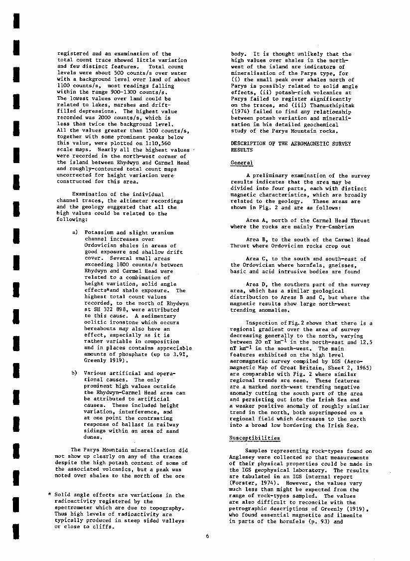
registered and an examination of the total count trace showed little variation and few distinct features. Total count levels were about 500 counts/s over water with a background level over land of about 1100 counts/s, most readings falling within the range 900-1300 counts/s. The lowest values over land could be related to lakes, marshes and drift- filled depressions. The highest value recorded was 2000 counts/s, which is less than twice the background level. All the values greater than 1500 counts/s, together with some prominent peaks below this value, were plotted on 1:10,560 scale maps. Nearly all the highest values were recorded in the north-west corner of the island between Rhydwyn and Carmel Head and roughly-contoured total count maps uncorrected for height variation were constructed for this area.
Examination of the individual channel traces, the altimeter recordings and the geology suggested that all the high values could be related to the following:
4 Potassium and slight uranium channel increases over Ordovician shales in areas of good exposure and shallow drift cover. Several small areas exceeding 1800 counts/s between Rhydwyn and Carmel Head were related to a combination of height variation, solid angle effects*and shale exposure. The highest total count values recorded, to the north of Rhydwyn at SH 322 898, were attributed to this cause. A sedimentary oolitic ironstone which occurs hereabouts may also have an effect, especially as it is rather variable in composition and in places contains appreciable amounts of phosphate (up to 3.9X, Greenly 1919).
b) Various artificial and opera- tional causes. The only prominent high values outside the Rhydwyn-Carmel Head area can be attributed to artificial causes. These included height variation, interference, and at one point the contrasting response of ballast in railway sidings within an area of sand dunes.
The Parys Mountain mineralisation did not show up clearly on any of the traces despite the high potash content of some of the associated volcanics, but a peak was noted over shales to the north of the ore
* Solid angle effects are variations in the radioactivity registered by the spectrometer which are due to topography. Thus high levels of radioactivity are typically produced in steep sided valleys or close to cliffs.
body. It is thought unlikely that the high values over shales in the north- west of the island are indicators of mineralisation of the Parys type, for (i) the small peak over shales north of Parys is possibly related to solid angle effects, (ii) potash-rich volcanics at Parys failed to register significantly on the traces, and (iii) Thanusthipitak (1974) failed to find any relationship between potash variation and minerali- sation in his detailed geochemical study of the Parys Mountain rocks.
DESCRIPTION OF THE AEROMAGNETIC SURVEY RESULTS
General
A preliminary examination of the survey results indicates that the area may be divided into four parts, each with distinct magnetic characteristics, which are broadly related to the geology. These areas are shown in Fig. 2 and are as follows:
Area A, north of the Carmel Head Thrust where the ro cks are mainly Pre-Cambrian
Area B, to the south of the Carmel Thrust where Ordovician rocks crop out
Head
Area C, to the south and south-east of the Ordovician where hornfels, gneisses, basic and acid intrusive bodies are found
Area D, the southern part of the survey area, which has a similar geological distribution to Areas B and C, but where the magnetic results show large north-west trending anomalies.
Inspection ofFig. shows that there is a regional gradient over the area of survey decreasing generally to the north, varying between 20 nT km-l in the north-east and 12.5 nT km-1 in the south-west. The main features exhibited on the high level aeromagnetic survey compiled by IGS (Aero- magnetic Map of Great Britain, Sheet 2, 1965) are comparable with Fig. 2 where similar regional trends are seen. These features are a marked north-west trending negative anomaly cutting the south part of the area and persisting out into the Irish Sea and a weaker positive anomaly of roughly similar trend in the north, both superimposed on a regional field which decreases to the north into a broad low bordering the Irish Sea.
Susceptibilities
Samples representing rock-types found on Anglesey were collected so that measurements of their physical properties could be made in the IGS geophysical laboratory. The results . are tabulated in an IGS internal report (Forster, 1974). However, the values vary much less than might be expected from the range of rock-types sampled. The values are also difficult to reconcile with the petrographic descriptions of Greenly (1919), who found essential magnetite and ilmenite in parts of the hornfels (p. 93) and

a a 1 a a a 1 a 1
describes magnetite as sometimes being in great quantity and ilmenite as the most abundant of the iron ores in the older basic dykes (p. 485), which would suggest that they would be more highly magnetic than was found in the laboratory. Much of the incompatibility may be due to insufficient sampling in a very complex geological situation. There is also very poor correlation between the measured values and the values found from the interpretations, much of which can again be explained by unrepresentative sampling; only the strongest anomalies were interpreted whereas the sampling of rocks was determined by distribution of outcrops. Other factors which will affect the comparison are remanent magnetisation, which has not been taken into account, and weathering out of the magnetic minerals at the surface.
Area A
This area of complex anomalies is separated from the magnetically quiet Area B to the south by a marked positive increase of about 100 nT which corres- ponds to the line of the Carmel Head Thrust. This is a fault of variable hade separating rocks of the Mona Complex from the Ordovician mudstones, shales and sands tones. Within Area A the anomalies are parallel to the general direction of swarms of basic dykes, of presumed pre-Ordovician age, which are found largely in the south and west of the area. Greenly (1919) describes the dykes as being ‘gregarious’, 20-40 ft. (about 7-14m) thick and with vertical hade. It is unlikely that the anomalies due to each dyke would be resolved unless the dykes were large or widely spaced.
Fig. 4 shows a south to north magnetic intensity profile across the thrust, the position of which is indicated by the abrupt change of slope. The sharpest anomalies , possibly due to dyke swarms, are also seen. By ignoring the sharp anomalies a smooth curve may be fitted to the data, which could be due to the computer-produced model shown at the bottom of Fig. 4. The model indicates the hade of the fault plane and suggests that the body causing the anomaly is 0.5 km thick and wedges out northwards in about 8 km, with a susceptibility of 8.7 x low3 SI units. This model may be interpreted in several ways. One interpretation is that the magnetic minerals are contained in the Palaeozoic dykes which cut the Mona Complex but not the Ordovician (Greenly, 1919, p. 512). The interpretation of the fault plane is probably a fair representation of the truncation of the dykes by the thrust down to a depth where uniform susceptibility exists i.e. the Pre-Cambrian floor at about 0.5 km. The dykes are most common near the thrust and less so further north. This could explain the wedge shape of the model. Secondly, the susceptibility may be
due to a uniform distribution of magnetic minerals throughout the Pre-Cambrian. In this case the wedging out to the north is not easily explained in terms of geology, although the thrust plane would still be represented accurately. The apparent wedging out may be due to the contact be- tween a magnetic and a non-magnetic body, combined with a small error in choice of regional field. North from about 1.8 km on Fig. 4, the observed magnetic field becomes smoother as the dykes become less frequent and the Coeden Beds dip under the Amlwch Beds. A possible third inter- pretation therefore suggests that the observed field represents a combination of dykes and magnetic country rock. An exclusive interpretation is not possible, however, in a general description of this nature.
Interpretations of individual dyke anomalies show that they are magnetised inductively with a susceptibility contrast of 2.6 x 10⁻² Sl units and an average ‘maximum depth of burial’ estimate gives a depth of 75 m, i.e. about 40 m below ground level. It is probable that these dykes do actually crop out but that any magnetic mineral has been removed by oxidation or leaching; the depth indicated by the magnetic anomalies re- presents the depth of weathering in these rocks which have been exposed for long periods.
There are a few elongated negative anomalies suggesting dykes with reversed magnetisation, and therefore possibly of Tertiary age, e.g. at SH 360 895, but there is no geological suggestion of their presence in the area.
At SH 365 909 there is an anomaly trending north-east to south-west which appears to be associated with a small altered ultrabasic intrusion and suggests its extension to the north-east to about the village of Llanfechell. At SH 434 915 there is a strong anomaly over a basic body which also extends further than suggested by the outcrop.
Area B
The Ordovician rests with strong unconformity upon the Pre-Cambrian, and in several places inliers of the latter are seen and are the cause of several of the magnetic features in the area. The magnetic contours as a whole reflect the regional trend, the variations from this being slight. The north to south excursions of the contours from a smooth line are probably artificial, being due to ‘herring-boning’ and errors in the extraction of diurnal variation of the earth’s magnetic field.
A strong anomaly at SH 379 854 is caused by a pumping station.

/mothtd magnetic Md . 0
nt
‘awned mgional
~3B6m90 \
0
\
FIG. 4 SOUTH-NORTH TOTAL flELD MAGNETIC INTENSITY PROFILE OVER CARMEi HEAD THRUST WITH INTERPRETED MODEL
mt magnetisation tector
---_.- . . . ..__.. __ .._- ~---I._ ^ .- ._-. .-_ .-. .--- - _- --- ---_ -_. ._ -- .-- .._ _ _ -_ ------ _c_. -... -_ _ __--____- ._ _-_-_ ___-_ -. __.- - -

nT -100
SH 331 762
.
Magnetic information
300m I
-NE
Observed magnetic field strength
Closest fit curve of Parker Gay
Model
200 100 0 100 200m
VA Magnetic body
Fig. 5. A profile across i an aeromagnetic anomaly and a possible interpretation after Parker Gay (1963)

I 1 I I I I I I I 1 I I 1
1 I 1
1
A series of basic/ultrabasic bodies intruded into the Ordovician rocks at SH 44 86 near Llandyfrydog causes a line of anomalies of about 50 nT showing a possible connection between the bodies. A similar situation exists at SH 47 92 where similar intrusions cut the Ordovician rocks and are associated with strong magnetic anomalies; it is suggested that further bodies and connections are hidden within the shales. These features are not clearly shown on the simplified map of Fig. 2 and reference should be made to the original maps.
It is significant that the large copper workings of Parys Mountain have no anomaly of any size associated with them and there- fore similar deposits elsewhere might not be expected to show magnetic anomalies.
Area C
To the south and south-east of the Ordovician outcrop is a tract of country dominated by the Coedana granite, which is surrounded by the Gneissic Group to the north-west, by hornfels to the north-east and south-west and by mica schist elsewhere.
The whole area shows strong anomalies but only rarely is any trend shown. In general, the anomalies are discrete, in random orientation and due to small magnetic bodies often exhibiting remanent magnetisation. Some are probably inclusions of basic material in the granite. The edge of the granite is not well defined but in some places the adjacent rock (often hornfels) shows a strong anomaly e.g. at SH 444 836. This particular feature shows a marked north- east south-west trend and the maximum depth to the top of the causative body is 76 m below ground level. It can be interpreted using the method of Martin (undated) as an inductively magnetised vertical prism of cross-section 500 m by 1000 m with a.. sus eptibility -3
contrast of 7.2 x . . 10 SI units. There are other anomalies associated with the hornfels but except at SH 365 745 in Area D, described below, they do not occur along the granite-hornfels contact and are sub-circular in plan.
Greenly (1919 p. 95) reported the presence of up to 10% Fe in the hornfels, mainly as magnetite. This observation suggests the most probable cause of the magnetic anomalies in this area.
Area D
In Area D a series of parallel north- west to south-east anomalies cut across anomalies with a pattern similar to those in Areas B and C. The descriptions of these areas also apply in general to this area, with the parallel anomalies super- imposed.
Four parallel major features cross the full width of the survey area and two less strong and persistent ones are also seen. All are strongly negative features with accompanying subsidiary positives to the
10
north-east. They have an average amplitude 1 of 500 nT. An interpretation of one such anomaly at SH 331 762 shown in Fig. 5 using Parker Gay's (1963) method indicates a dyke-like body which crops out and has a vertical hade. The body is 100 m wide and is infinitely deep with a susceptibility of 6.5 x 10⁻² SI units in a direction opposite to the present earth's field. These results agree reasonably well with figures given by Greenly for the newer dykes, which he suggested were of Tertiary age. However, he did not observe one corresponding to this anomaly, the area being covered by drift. The major north- west trending feature on the Aeromagnetic Map of Great Britain is probably due to these dykes.
An interpretation of the two- dimensional anomaly at SH 365 745 using the method described by Martin (undated) indicates a vertical sided prism at a depth of 60 m with a width of 270 m and a length of 1500 m. The body is inductively magnetised with a susceptibility of 7.2 x 10'3 SI units This correlates with the hornfels in contact with the Coedana granite.
A complex anomaly around SH 370 770 is probably caused by a body of basic gneiss, although the nearby hornfels could possibly be the origin. Intense anomalies with amplitudes of up to 1500 nT in an area of blown sand at SH 310 760 may be traced north- wards into outcrops of ultrabasic rocks. This suggests an extension of these ultra- basic rocks beneath the area of blown sand.
CONCLUSIONS
The electromagnetic induction survey produced only limited areas of useable data due to severe radio interference which caused strong anomalies. This conclusion was confirmed during later ground investigations when many of the selected anomalies were found not to exist. Other anomalies were shown to be real, although to have man-made origins. No anomalies with a clear geological origin were recognised from the airborne EM results, although anomalies proved during the ground work may be of interest to mineral exploration. Such anomalies e.g. at Carmel Head and at Parys Mountain were not seen on the airborne maps because of noise.
The magnetic survey produced anomalies which have been shown to be related to geological features. Potentially mineralised magnetic bodies concealed at depth have been demonstrated, together with extensions of, and connections between, discrete outcrops, such as in the area around Llandyfrydog (SH 44 85) and Tywyn Trewan (SH 31 76).
There is no evidence from the aeroradio- metric data for any uranium mineralisation in the survey area. This observation supports the conclusion of a car-borne radiometric survey of Anglesey carried out in 1971 (T.K. Ball, pers. comm).
REFERENCES
BURLEY A.J., CORNWELL J.D. AND TOMBS J.M.C. 1978. Geophysical field techniques for mineral exploration. Miner. Reconnaissance Programme Rep. Inst. Geol. Sci. No. 20. FORSTER A. 1974. Density, porosity, magnetic susceptibilities and sonic velocity determinations on selected rock samples from Anglesey. Engineering Geology Unit Geophysics Laboratory. Unpublished report no. 38. Institute of Geological Sciences. GEOLOGICAL SURVEY OF GREAT BRITAIN. 1965. Aeromagnetic map of Great Britain, Sheet 2. First edition. (Chessington, Surrey: Ordnance Survey), GREENLY E. 1919. The geology of Anglesey. Mem. Geol. Surv. G.B. HUNTING GEOLOGY AND GEOPHYSICS LTD. 1974. Operations report on helicopter geophysical surveys in the U.K. 1972-73. MARTIN L. (Undated). Manual of magnetic interpretations. C.A.S.E. Applications. PARKER GAY S. 1963. Standard curves for interpretation of magnetic anomalies over long tabular bodies. Geophysics vol. 28 pp 161-200. SHACKLETON R.M. 1954. The structure and succession of Anglesey and the Lleyn Peninsula. Adv. Sci., vol. 11 pp 106-8. THANUSTHIPITAK T., 1974. "The relation- ship of mineralisation to petrology at Parys Mountain, Anglesey." Ph.D. Thesis, University of Aston in Birmingham.
11
