a railway simulation landscape creation tool chain...
TRANSCRIPT

Institute of Transportation Systems > Aerospace technology for road and railway
A Railway Simulation Landscape Creation Tool Chain Considering OpenStreetMap Geo Data Christian Rahmig, Andreas Richter DLR Institute of Transportation Systems Braunschweig, Germany
SUMO Conference 2014 in Berlin > 15th May 2014 > Slide 1

SUMO Conference 2014 Berlin > 15th May 2014 OSM for Railway Simulation Landscape Creation > Slide 2
Overview
Motivation Railway driver‘s cab simulation RailSET OpenStreetMap (OSM)
Approach Defining OSM Layers The OSM-4-Railway tool chain Excursus: railML infrastructure The SimWorld tool chain Adapting the SimWorld tool chain
Implementation Summary

SUMO Conference 2014 Berlin > 15th May 2014 OSM for Railway Simulation Landscape Creation > Slide 3
Motivation Railway Driver‘s Cab Simulation RailSET*
Purpose: Human Factors analyses for train drivers Requires: realistic 3D model of the railway line to be used for simulation (topology, geometry)
* RailSET = Railway Simulation Environment for Train Drivers and Operators

SUMO Conference 2014 Berlin > 15th May 2014 OSM for Railway Simulation Landscape Creation > Slide 4
Motivation Initial Situation
Simulation in the RailSET laboratory is based on ZUSI

SUMO Conference 2014 Berlin > 15th May 2014 OSM for Railway Simulation Landscape Creation > Slide 5
Motivation Initial Situation
Simulation in the RailSET laboratory is based on ZUSI
Source: www.zusi.de

SUMO Conference 2014 Berlin > 15th May 2014 OSM for Railway Simulation Landscape Creation > Slide 6
Motivation Initial Situation – Problems
The number of lines to be simulated within the RailSET laboratory environment is limited The generation of tracks/lines for simulation is expensive (time, students) Zusi does not consider the combination with existing real geo data, e.g. digital terrain models Currently, it is not possible to model/visualize/simulate arbitrary lines in short term Goal: to model, visualize and simulate arbitrary tracks within the RailSET laboratory environment Task: Concept and implementation of a process chain for simulation-based scenario and landscape generation using existing geo data sources

SUMO Conference 2014 Berlin > 15th May 2014 OSM for Railway Simulation Landscape Creation > Slide 7
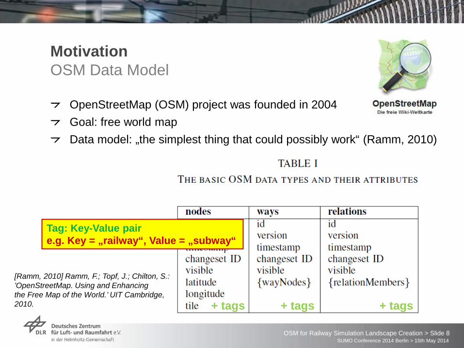
OpenStreetMap (OSM) project was founded in 2004 Goal: free world map
Motivation OpenStreetMap
#users 1.591.275 #GPS points 3.938.715.439 #nodes 2.301.912.824 #ways 228.191.041 #GPX files 14.04.2014 224 Size Planet.osm >400 GB (29 GB compressed)
Sources: • OpenStreetMap stats report run at 2014-04-15 00:00:14 +0000;
http://www.openstreetmap.org/stats/data_stats.html • Planet.osm; http://wiki.openstreetmap.org/wiki/Planet.osm
SUMO Conference 2014 Berlin > 15th May 2014 OSM for Railway Simulation Landscape Creation > Slide 8
OpenStreetMap (OSM) project was founded in 2004 Goal: free world map Data model: „the simplest thing that could possibly work“ (Ramm, 2010)
Motivation OSM Data Model
+ tags + tags + tags
Tag: Key-Value pair e.g. Key = „railway“, Value = „subway“
[Ramm, 2010] Ramm, F.; Topf, J.; Chilton, S.: ’OpenStreetMap. Using and Enhancing the Free Map of the World.’ UIT Cambridge, 2010.

SUMO Conference 2014 Berlin > 15th May 2014 OSM for Railway Simulation Landscape Creation > Slide 9
Motivation OSM Railway Tag
Railway data are not that exactly modelled like roads and streets There are 388 different values for the tag „railway“ [4] [4] OpenStreetMap: „taginfo keys railway“; http://taginfo.openstreetmap.org/keys/?key=railway#values;
last access: 15.04.2014
52.8 %

SUMO Conference 2014 Berlin > 15th May 2014 OSM for Railway Simulation Landscape Creation > Slide 10
Motivation OSM Railway Tag
Railway data are not that exactly modelled like roads and streets There are 388 different values for the tag „railway“ How to use these data e.g. for building a simulation environment?
Map-matching / routing: There is no clear topological and geometrical map representation.

SUMO Conference 2014 Berlin > 15th May 2014 OSM for Railway Simulation Landscape Creation > Slide 11
Approach OSM Layers
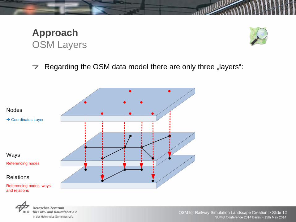
Regarding the OSM data model there are only three „layers“: Nodes Ways Relations
SUMO Conference 2014 Berlin > 15th May 2014 OSM for Railway Simulation Landscape Creation > Slide 12
Approach OSM Layers
Regarding the OSM data model there are only three „layers“:
Ways
Relations
Nodesà Coordinates Layer
Referencing nodes
Referencing nodes, ways and relations

SUMO Conference 2014 Berlin > 15th May 2014 OSM for Railway Simulation Landscape Creation > Slide 13
Ways
Relations
Nodesà Coordinates Layer
Referencing nodes
Referencing nodes, ways and relations
Approach New OSM Layers
We want to define topic-specific layers:
Topology Geometry

SUMO Conference 2014 Berlin > 15th May 2014 OSM for Railway Simulation Landscape Creation > Slide 14
Ways
Relations
Nodesà Coordinates Layer
Referencing nodes
Referencing nodes, ways and relations
Approach New OSM Layers
We want to define topic-specific layers:
New topic-specific tags for the nodes
New topic-specific layers with new tags for the ways and relations
Topology Geometry

SUMO Conference 2014 Berlin > 15th May 2014 OSM for Railway Simulation Landscape Creation > Slide 15
Approach Layer-specific OSM tags

SUMO Conference 2014 Berlin > 15th May 2014 OSM for Railway Simulation Landscape Creation > Slide 16
Approach Layer-specific OSM tags
We define 37 tags for the description of the railway track network as needed by most of the railway geodata applications.

SUMO Conference 2014 Berlin > 15th May 2014 OSM for Railway Simulation Landscape Creation > Slide 17
Topology Verification …extract railway network and verify its topology (node egde model) Railway Data Enhancement …add layer-specific tags to the railway elements in the map
Approach The OSM-4-Railway Tool Chain

SUMO Conference 2014 Berlin > 15th May 2014 OSM for Railway Simulation Landscape Creation > Slide 18
Import (enhanced) railway relevant data from OSM export into geo data base Export railway infrastructure data in exchange format railML version 2.2
Approach The OSM-4-Railway Tool Chain

SUMO Conference 2014 Berlin > 15th May 2014 OSM for Railway Simulation Landscape Creation > Slide 19
Railway Markup Language XML-Schema-based description language Generic data exchange format for better communication between different IT applications in railways railML.org-Initiative
European railways (infrastructure managers and undertakers) Software and consulting companies Research facilities (universities, institutes)
Sub-schemas: Infrastructure Timetable Rollingstock
Excursus railML®
www.railML.org

SUMO Conference 2014 Berlin > 15th May 2014 OSM for Railway Simulation Landscape Creation > Slide 20
Track Topology Track Geometry Track Topography and railway service-relevant data
… Graph with Nodes and Edges
Excursus: railML® What is railML® Infrastructure?

SUMO Conference 2014 Berlin > 15th May 2014 OSM for Railway Simulation Landscape Creation > Slide 21
Excursus: railML® What is railML® Infrastructure?
Track Topology Track Geometry Track Topography and railway service-relevant data
… straight lines, curves, increasing/decreasing slope

SUMO Conference 2014 Berlin > 15th May 2014 OSM for Railway Simulation Landscape Creation > Slide 22
Track Topology Track Geometry Track Topography and railway service-relevant data
… signals, platforms, tunnels, electrification etc.
Pictures: Böhringer, F.: Gleisselektive Ortung von Schienenfahrzeugen mit bordautonomer Sensorik; Dissertation; Karlsruhe, 2008
Excursus: railML® What is railML® Infrastructure?

SUMO Conference 2014 Berlin > 15th May 2014 OSM for Railway Simulation Landscape Creation > Slide 23
Approach SimWorld / Virtual World
Goal of project “Virtual World”:
Source: „Virtual World – Digital Atlas of Multimodal Metropolitan Areas“ by Andreas Richter (WAW 2013)

SUMO Conference 2014 Berlin > 15th May 2014 OSM for Railway Simulation Landscape Creation > Slide 24
database design (central component of integration platform) designing database structure based of scene graph concept and OpenDRIVE design of data interfaces for data import form various sources and for data export for applications using or refining this data
database implementing realising database in PostgreSQL / PostGIS realising the exporters with OpenSceneGraph
concept and prototype about integration and realising (including high grade of automation)
Approach The SimWorld database

SUMO Conference 2014 Berlin > 15th May 2014 OSM for Railway Simulation Landscape Creation > Slide 25
Approach The SimWorld Tool Chain
adding new data sources (from partners) adding new targets (for partners or third party use) full reuse of tool chain possible additional data in driving simulation available
data
data
data
maps
data
description apps
data data
data
importing processing georeferenced data processed data
exporting
3d m
odel
road
net
wor
k
met
a in
form
atio
n
fully automated highly automated partly automated

SUMO Conference 2014 Berlin > 15th May 2014 OSM for Railway Simulation Landscape Creation > Slide 26
Approach Adapting the SimWorld Tool Chain
Use Vires Track Editor to create railway lines for the RailSET simulation The result of the Track Editor is a 3D model of the railway line, which is fused with the 3D landscape model in the Trian3D-Builder software.

SUMO Conference 2014 Berlin > 15th May 2014 OSM for Railway Simulation Landscape Creation > Slide 27
Implementation RailSET Simulation Laboratory Environment
The RailSiTe/RailSET laboratory is being adapted from ZUSI to Vires Vires-based simulations are used already in the Automotive Department of the Institute
Source: www.vires.com

SUMO Conference 2014 Berlin > 15th May 2014 OSM for Railway Simulation Landscape Creation > Slide 28
Implementation OSM-4-Railway tool chain
The railway line from Braunschweig to Gifhorn has been selected for testing the tool chain implementation Additionally, Vires built the railway reference line Braunschweig-Gifhorn within the AIM project for being used in the RailSET laboratory environment à can be used as reference

SUMO Conference 2014 Berlin > 15th May 2014 OSM for Railway Simulation Landscape Creation > Slide 29
Implementation OSM-4-Railway tool chain
Export OSM data

SUMO Conference 2014 Berlin > 15th May 2014 OSM for Railway Simulation Landscape Creation > Slide 30
Implementation OSM-4-Railway tool chain
OSM-4-Railway data verification and enhancement

SUMO Conference 2014 Berlin > 15th May 2014 OSM for Railway Simulation Landscape Creation > Slide 31
Implementation OSM-4-Railway tool chain
Import into simulation scenario editor

SUMO Conference 2014 Berlin > 15th May 2014 OSM for Railway Simulation Landscape Creation > Slide 32
Implementation Vires Track Editor
The resulting railML infrastructure file is imported into the Vires Track Editor Purpose: create a 3D railway line model based on the given topology and geometry.

SUMO Conference 2014 Berlin > 15th May 2014 OSM for Railway Simulation Landscape Creation > Slide 33
Implementation Result

SUMO Conference 2014 Berlin > 15th May 2014 OSM for Railway Simulation Landscape Creation > Slide 34
Summary
The current simulation environment of the railway driver‘s cab laboratory RailSET is not able to include existing geo data from various sources OpenStreetMap provides a free world map and an alternative to conventional geodata sources, which often lack of actuality or availability The OSM data model is very simple defining only three basic data types: nodes, ways and relations; elements are parametrized by arbitrary tags, which are not sufficient for many applications, e.g. routing Layer approach: we defined new topic-specific tags (layers), which enable OSM data usage providing track topology and track geometry; Many of the new tags can be calculated using existing OSM data By adapting the SimWorld tool chain, spatial data from various sources can be fused for building an integrated model of the railway line Future work will focus on the comparison of the OSM-based with the manual railway simulation landscape creation

SUMO Conference 2014 Berlin > 15th May 2014 OSM for Railway Simulation Landscape Creation > Slide 35
Thank you for your attention!
Christian Rahmig
E-mail: [email protected] Phone: +49 531 295 3461
Andreas Richter
E-Mail: [email protected] Phone: +49 531 295 3408
German Aerospace Center Institute of Transportation Systems
Braunschweig, Germany