the landscape character of portbury and surrounding … · the landscape character of portbury and...
TRANSCRIPT

The Landscape Character of Portbury and surrounding area A study by Portbury Parish Council
Distribution Organisation
Peter Bryant National Grid
Graham Quick North Somerset Planning Department
Cllr Peter Cooke Portbury Parish Council (Chairman)
Cllr Nigel Ashton North Somerset County Council
Liam Fox MP House of Commons - North Somerset Constituency
D Longstaff, R Fox, A Leigh, S Bromell, M Phipps
Portbury Parish Council Technical Team
M Cowlard Portbury Parish Council Strategy Team
Record of Revisions
Revision Level Date Issued
1 19th July 2013
2 4th Aug 2013 Map and minor text corrections
3

2
The Landscape Character of Portbury and surrounding area A study by Portbury Parish Council Research carried out between 2010 and 2012 Updated and published in May 2013 Mike Phipps

3
Index
Background & Introduction
1. Geographical Context
2. Landscape Setting
3. Historic background
4. Village evolution
5. Portbury in 2013
6. A Planning Strategy
7. Summary of Key Points
8. Sample Images
9. References
10. Appendices
Background & Introduction
In 2009 Portbury Parish Council began the task of gathering information for the writing of a Parish Plan which would complement the overarching Strategic Local Plan of North Somerset Council. In order to provide a structure for the eventual plan a number of key theme areas were defined to enable reference information to be gathered and considered by the Parish Councillors and villagers. One such theme area was environment and planning. Although it is not considered likely that there will be any large scale proposals for development within the Parish of Portbury in the future, due to the absence of any land that could be designated for building, it was nevertheless felt important to assess the Landscape Character of the village in order to set a baseline from which planning strategy and objectives could be developed. This document records the analysis and assessment of the Landscape Character of Portbury and the surrounding area carried out between 2010 and 2012. The methodology that has been used has been modelled on that found in other studies of villages around the country. From this a planning strategy is developed which will go forward into the work to develop the Parish Plan.

4
1.0 Geographical Context – key points. Portbury sits within the Vales of Severn and Avon, on the edge of the Clapton Moor landscape character area, which itself forms a discreet geographical area of the Gordano Valley 1. The main part of the area lies below 10m Ordnance Datum (AOD), this rises slightly around the periphery and to the East beyond Sheepway.
To the South, Portbury is framed by the remnants of the Tickenham ridge running down through Priors Wood which lies to the West. This terminates in two hill features, Conygar Hill, a possible outpost of Cadbury Camp to the West, and The Mount, both of which provide a natural screening of the village as one approaches from the South. To the North the moorland stretches out to the River Severn, and in the far distance the coastline of South Wales. To the East is the major development of Portbury and Avonmouth Docks.
Portbury lies astride the old Bristol Road that ran both across the Moor, in summer, and around the Moor on the flank of Tickenham Ridge in the winter. The main residential concentration lies on ground that is slightly higher than the valley floor, above what would have been very marshy land to the North approaching Portbury Wharf.
Map 1 - Portbury Area circa 1844 -OS
Portbury and Conygar Hill

5
Typical green valleys around the Gordano Valley
near Portbury
2.0 Landscape Setting – key points Whilst being essentially rural in character, Portbury lies within the “greater Bristol” urban zone which includes the much larger settlement of Portishead nearby. It is one of a small number of villages within the “Gordano Valley” which have all seen relatively little development other than significant urban expansion in the 1960’s. In 2012 Portbury
was
designated as a Green Belt Village, meaning that the village itself falls under the same regulations as the area that surrounds it. Portbury has evolved in the character of a “ribbon” development, typical of many villages in both Somerset and North Somerset. This original aspect is still apparent today,
running from the A369 west into the main village, and then turning north at the Village Green along Station Road, the continuation is cut by the M5 but then follows the road named Sheepway eventually crossing Tarr Bridge, which spans the Portishead to Bristol Railway, reaching the edge of the Parish near to the A369. There are two branches off this main route through Portbury, one to Failand and the other to Clapton-in-Gordano; these still follow alignments established over 200 years ago. Settlement on the road towards Clapton is not contiguous with Portbury, the last key property being the “Lodge” which stands at the entrance to Priors Wood. There is then a stretch of generally open land up to Caswell Cross, where Caswell Hill turns steeply up to join Naish Hill to the South; only a small number of properties are present here including Lower Caswell House (listed). The edge of the Village of Portbury lies further along Caswell lane near to Redding Cottages; most of the properties along this stretch are either farm buildings or relatively new houses and there is no clear physical boundary as the village of Clapton in Gordano is encountered. Towards Failand again the Village boundary is not distinct, the last major properties being Newlyn and the Old Mill, with a newly built mill style building adjacent. There is a scattering of old property along this road named Mill Lane, turning into Portbury Lane, with Oakham Farm and Farmhouse being very prominent. The village ends close to a former quarry opposite “Old Hill”; the road continues to meet the B3128. The beginning of construction, in the 1960’s, of the M5 motorway, running southwards on the westerly fringe of Bristol and then over the Tickenham ridge towards Clevedon, eventually created a division of the village. This formed an artificial barrier between the settled area, now known by the shorthand title of "Sheepway", although this name itself

6
derives from a name given to an unspecific area further to the North adjacent to Portbury Wharf, see Map1. Development in the 1960’s, contemporary with the building of the M5, has seen the village expand with the addition of further side streets off the main through route. Whereas this development was preceded by the demolition of some older properties on the High Street, its alignment was preserved and the Village Green was created at this time. In the 1970’s some development took place on the flanks of Conygar Hill, mimicking to a degree the existence of old cottages which existed in the 1800’s. Since then there has been only limited opportunity to build within the village as small plots within the defined boundary have become available. Portbury is surrounded by an agricultural landscape that is still actively used for livestock or, on higher ground to the South, crops. There is a buffer, albeit a narrow one, to the East between the village and the industrial zone of the docks. The tree screening, planted around the docks some years ago by joint agreement between the Docks Company and the Parish Council, is now well established. This
screening is also much in evidence as one drives down the Portbury Hundred (A369) and greatly moderates the impact of all but the tallest structures on the skyline from street level in the village. It is only when rising to higher ground towards Failand that the impact of the docks is felt, and even then this is well screened by both Conygar Hill and the Mount.
The same tree screening moderates the view of the M5 as it runs nearest to the village. The village is encircled by Green Belt land. Views from the East show Portbury to be relatively discrete, given the low height of development. In views from the South the settlement also remains discrete, the M5 being well screened as it passes closest to residences, rapidly
A view from the East of St Mary’s Church, with the
M5 just visible to the North
Looking North from Caswell Lane, near “the Lodge”
View towards the Church from the East, the M5 visible
as it passes the village
7
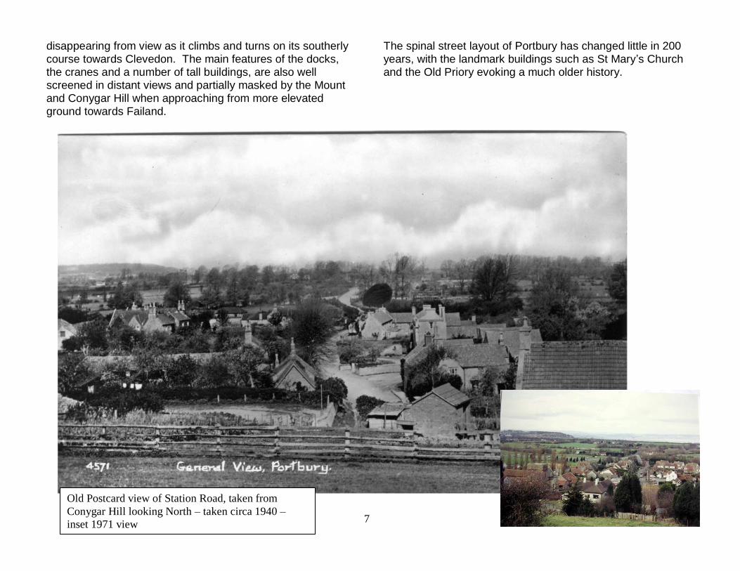
disappearing from view as it climbs and turns on its southerly course towards Clevedon. The main features of the docks, the cranes and a number of tall buildings, are also well screened in distant views and partially masked by the Mount and Conygar Hill when approaching from more elevated ground towards Failand.
The spinal street layout of Portbury has changed little in 200 years, with the landmark buildings such as St Mary’s Church and the Old Priory evoking a much older history.
Old Postcard view of Station Road, taken from
Conygar Hill looking North – taken circa 1940 –
inset 1971 view

8
There are 9 listed buildings in Portbury, with St Mary’s Church being Grade 1. Two monuments within the Church grounds are also listed, as are the stables and coach house in the grounds of the Victorian vicarage (Appendix 1).
3.0 Historic Background There is physical evidence of pre-historic cultures in Portbury. A minor iron age hillfort atop Conygar Hill was a possible outpost of the larger Cadbury Camp to the West. Standing stones are evident both from old maps and physical evidence. One such stone was re-discovered in a field adjacent to the Church in 1986, near to its original recorded location. This stone now stands proudly between the 12th century Church and the 20th century School giving a constant reminder of nearly 3000 years of human settlement activity in the area. Portbury Wharf dates back to Roman times, from where the Romans exported lead and tin from mines on the Mendip Hills. There is physical evidence of Roman and Romano-British settlement in the area from the discovery of a burial site near to the church of Saint Mary the Virgin. In 2004 there was a second excavation at the School site when an extension to the existing buildings was begun. In addition to the remains discovered in 1972 when the School was first built, a significant find of interred Romano-British bodies was discovered, many of which bore battle wounds. It is thought that this site is one of the most important in Somerset dating from the Arthurian period. There is some evidence of Dark Age activity from the presence of a section of the Wansdyke which follows the same alignment as the old “Summer Road” but remaining
The Priory (listed), looking along Caswell
Lane from the High Street

9
straight as it passes Portbury House before reaching the historic sea shore.
Written evidence of Portbury stretches back to Saxon times, the “Hundred” bearing its name in the Domesday Book. The name Portbury is thought to derive from Porberie, in Old English meaning “Fortified place near the harbour.” In the post-conquest era Portbury’s importance waned somewhat although Robert Fitzharding, later the first Earl Berkeley, was awarded the Manor of Portbury by King William I. Until the building of Berkeley Castle, Portbury was the main seat of the Berkeley family and continued to be held in much favour, evidenced by their founding of St Mary the Virgin Church in 1190. The present Norman building was built upon a former Saxon church. The Berkeley family were also instrumental in building a small Augustinian Priory, begun in 1188. This was subservient to the Priory of Bromore in Hampshire, and the handful of monks farmed the rich soils and fished the local streams and pills right up to its dissolution in Henry VIII’s time. What remained of the building was given by the Smyth family to the Diocese of Bath and Wells for use as a village school to replace the original School House nearby. The
priory stayed in use as the School until the building of the current CEVA School in 1972. Descendants of the Berkeley family held the manor until 1784 when it was sold to James Gordon, and inherited by William Abdy. On his death in 1870 the estate was sold to Sir Greville Smyth of Long Ashton, in whose ownership it stayed until the death of Esme Smyth in 1959. Portbury Village sits at the Southerly edge of the mouth of the Gordano Valley, astride the old road connecting Bristol to Portishead. In former times the direct route to Portishead, along what is known as the Sheepway, was impassable during the winter due to the marshy nature of the land and thus a longer route had to be taken, via Clapton in Gordano, along the base of Tickenham Ridge. This “winter route” then crossed the marsh near to North Weston before entering Portishead from the West. Prior to1600, there would perhaps have been more of the settlement close to St Mary’s Church. It is thought that there may have been a severe Severn bore (or Tsunami) in about 1607 which would have both destroyed the primitive housing of the day and convinced the Villagers to move to slightly higher ground on what is now the High Street. In the 1980’s the local Historical Society recorded some long oral traditions, one of which was that boats once tied up at the Church. Whilst no physical evidence of this has ever been found it does suggest that the land near the Church has seen floods over the years. It is also possible that parts of the

10
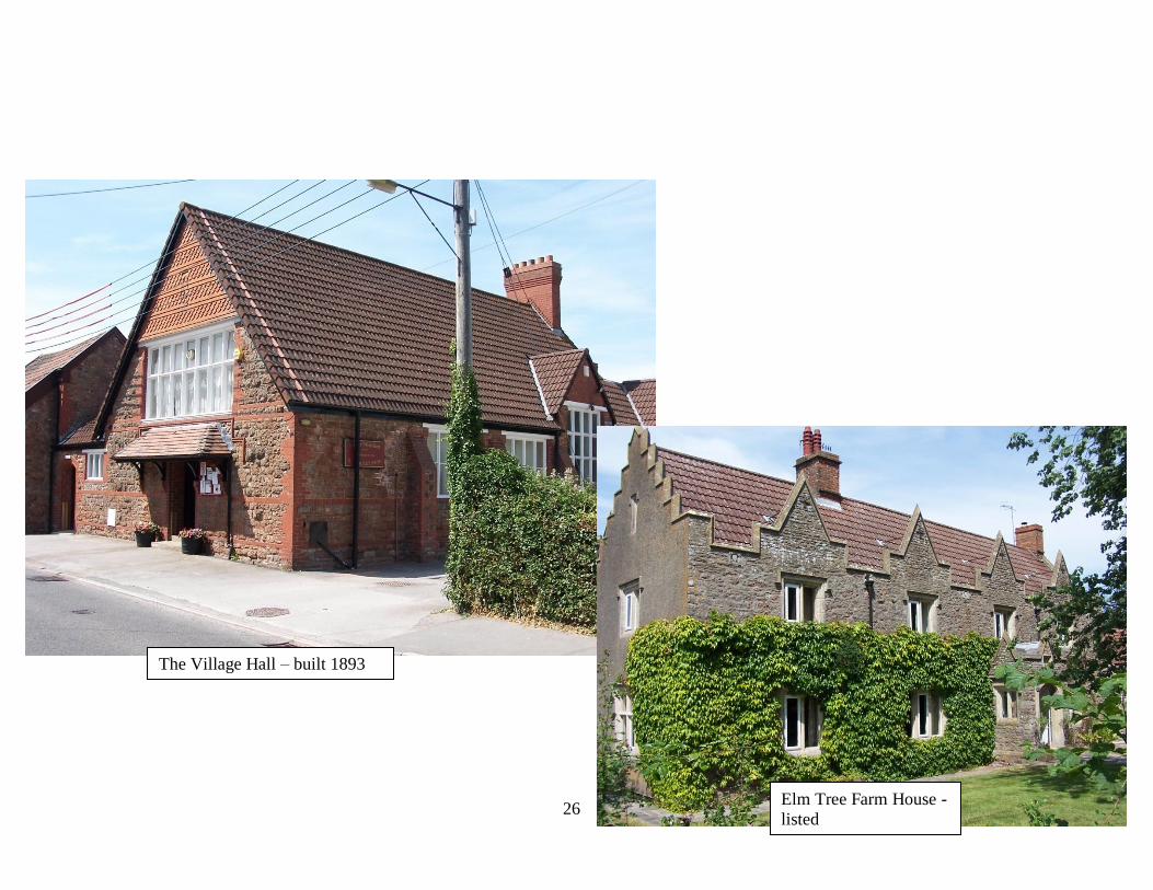
original village were severely damaged during the Civil War, (1642-1651), as there is a record of a major battle for the “Castle” (Manor House?), which is thought to have stood on top Windmill Hill to the South. The plague often caused villagers to move away from former disease ridden areas, but in this case the distance between the current village and the Church is relatively small and this therefore suggests other reasons for the village location today. In 1840 Portbury was described as having “a rustic inn and half a dozen small houses “. The Blue Anchor Inn was in the High Street on a site later to become Portbury Farm. In those days the mill race was an open brook and ran across the road and through the Blue Anchor yard, and is still visibly flowing in number one High Street garden. The inn was kept by a Mr and Mrs Stokes. There is no record of when the Blue Anchor ceased to be the village Inn, but it is possible that it closed because the present village pub, The Priory, opened in 1822 and the Stokes family eventually took over the tenancy there. There was a brew house on the site of the Village Hall and a deep well beneath the Hall floor still provides crystal clear water that is potable to all except young babies. In 1867 the Portishead Branch Railway line was built which had the effect of creating an artificial boundary between what is now called Sheepway and the main village of Portbury, although a road bridge maintained the continuity of the old summer road. In the 1960’s the building of the M5 motorway brought with it the closure of the original summer road to Portishead, a footbridge however still maintains the connection between the residents of Sheepway and the main Village. In 1893 a bequest by a local philanthropist, Colonel Brittan, enabled the building of the Village Hall which sits in a prominent position welcoming people into the Village on the approach from the A369, Bristol to Portishead road.
In 1958 most of the village was “sold” to Newcombe Estates, and a further 700 acres were purchased by the Port of Bristol Authority. Since the 1960’s and 70’s, when much of the current housing development along the High Street and Priory Road was constructed, there has been little additional development within the Village. Any development that has occurred has been carefully managed, mainly on in-fill plots, and through consultation with the Parish Council it has been ensured that the character of the Village has been sustained or improved. In Sheepway there has been more development activity with the creation of Elm Tree Park, on a former Farm site. Here a new complex of housing has been established providing some 50 new park homes on a brown field site, which sits comfortably within the village setting with little effect upon the streetscape view in either direction along the former summer road to Portishead.
In the 1970’s the Royal Portbury Dock, with deepwater lock, began construction, and was completed in 1977. In 1991 the Port, along with Avonmouth docks, passed into the

11
ownership of the Bristol Port Company. This completely changed the fortunes of the Docks and today there is a very successful and extensive industrial complex alongside the main Port. This success has been provided a much needed boost to the local economy, creating much needed jobs and bringing key infrastructure to the area. This success has also brought with it some negative effects, mainly in respect of its effect on the background views, of an industrial nature, from some viewpoints in and around the Village.
A more detailed account of the History of Portbury can be found in the Appendices.

12
4.0 Village Evolution Most of the dwellings and other buildings in Portbury have always been clustered around and along the main road from Bristol to Portishead, with some sitting astride the winter road to Clapton and old tracks up the hill towards Failand. The former priory is the oldest dwelling, much of the 15th Century origins still being evident. A number of pre-1900 buildings still survive today, the oldest, Portbury Priors, dating back to the Tudor period. There are also old cottages dating back to the 1700’s. After 1900 most new building occurred in the Sheepway area with several notable residences having been constructed, still following the established ribbon pattern. Photographic records show several very old and thatched buildings that did not survive the development that occurred in the 1960’s and 70’s, many others have survived until today and are all buildings of notable character, some of which are listed. This gives the village a very varied feel. Small scale residential development has been the predominant feature of the village, which has respected the original alignments of the High Street, Mill Lane and Caswell Lane. Older farm buildings, forming part of the former Priory estate, have been successfully converted into small scale industrial units. The former Wesleyan Chapel, housed formerly in a humble, Brunel, wide gauge railway carriage, is now a private residence near to the footbridge across the M5. The main periods of development in the village have been the 60’s (Priory Road), 70’s (The High Street) and the 00’s (Elm Tree Park). Despite the inevitable uniformity of dwellings created in the 60’s along Priory Road and Priory Walk, at the same time the Village Green was created which
has provided a welcome focal point to the virtual centre of the Village. Priory Road has a gentle curve as it runs from Station Road, and a widening half way along its length gives a surprisingly open feel which is accentuated by the well tended gardens, now matured and well established. In the 70’s further development occurred along the High Street, in two main phases. Again a degree of variety has been achieved even though rows of six or more similar houses have been built. In particular the houses on the High Street built on the flank of Conygar Hill, and overlooking the Green, have been “bookended” so as to provide variety in a row of houses that are a prominent feature in the landscape. In the 2000’s a new Park Home was established on Elm Tree Farm and this has now been developed to within one dwelling of its maximum permitted density of 50 homes. The park is constructed in a figure of eight style, with homes well spaced on the inner and outer rings. The first phase homes are now well established and a surrounding cordon of large, dense trees gives a strong impression of seclusion whilst also screening the development from the old road, Sheepway. Aside from these main developments there have been a small number of plots of land in which new housing, in one’s or two’s, have also been developed and this has provided further diversity in the landscape appearance.
13
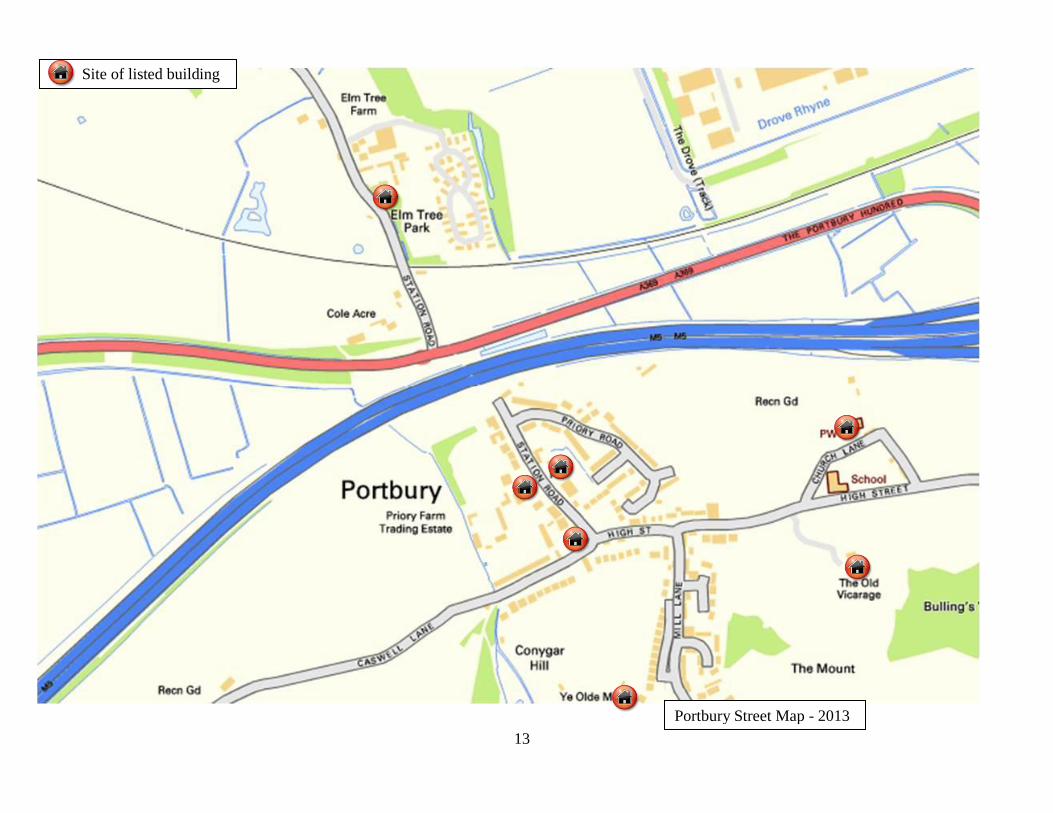
Site of listed building
Portbury Street Map - 2013

14
Portbury Street Map continuation
(towards Tarr Bridge )– 2013

15
5.0 Portbury in 2013 Portbury today remains a quiet, self contained Village comprising some 500 dwellings. There is an active community centred on both the Village Hall and St Mary’s Church and the local hostelry, The Priory, attracts many visitors throughout the year and at all times of day. There are many diverse social activities in the Village, taking place either in the Village Hall or the Church and many visitors are attracted each year to walk in Priors Wood, especially in early May when the bluebell crop is resplendent as it clings to the shady banks of the many subtle valleys that run up towards Charlton Farm and the Downs School near to Lower Failand.
As one walks around the main centre of the Village there is little evidence of the impact of developments such as the M5 motorway or the docks. The street scene is very tranquil, with little through traffic outside the “rush hours”, other than that passing along the winter road to Clapton or turning up Mill Lane towards Failand. At certain points in the Village the backcloth of the docks is more evident, particularly from higher ground of Mill Lane, but this is partly masked on both sides by the Mount and Conygar Hill. The slightly higher ground gives distant views to the North and West of the Welsh Hills with the River Severn in the foreground. Only a short distance up Mill Lane the view changes as the road swings westward and the scene is then completely rural all the way to the Parish boundary at the end of the Sheepway.
Portbury, comprising the area known as Sheepway, is a very popular place to live. It sits just 6 miles distant from the centre of Bristol, with local shops only 2 miles away in the growing town of Portishead. The connection with the M5 motorway is only a short way by car and allows wider connectivity to all parts of the greater Bristol area as well as
The Village Green and war memorial
The centre area of Priory
Road

16
onward connections to the whole motorway network. And yet Portbury is decidedly rural in its character. It is mainly surrounded by fields and beautiful rolling countryside, criss-crossed by an extensive network of footpaths providing both circular and linear walks of a very high quality and amenity. With the cutting of the old Bristol Road the Village has become yet more tranquil, a welcome haven from the bustling City Centre of Bristol and the busy High Street of Portishead. The road layout in Portbury has changed very little in over 300 years, with the only additions being the creation of quiet cul-de-sacs of limited development. Road names have changed, Station Road being aptly adopted in 1867 in place of the unnamed “summer road”. Caswell Lane is now what was the former “winter road” and Mill Lane follows the line of the former road up to Failand passing the still extant Mill building, now a private house. The “Sheepway” is an old name referring perhaps to an old track down to the cattle droves on the ancient Portbury Wharf which can be seen on the 1844 ordnance survey map of the area. Sheepway was never a settlement but the name has stuck and is now used as the road name for the old summer road that still quietly follows its original alignment past the classic ribbon development of houses, passing over the old railway once more before emerging again on the Portbury Hundred Road. The Priory Hotel, built in 1822, is an ever popular attraction. Where once the local hunt would gather, now large numbers of visitors sample the food and drink on offer, some staying longer and talking long or short walks in Priors Wood. Despite its proximity to the nearby docks and the M5 the feel of the Village is distinctly rural. Even at the edges of the Village the landscape views remain rural in all directions,
except for the slice of land at the footbridge over the M5 where the presence of this highway is at its most noticeable. Looking East from Church Lane there is very little to see of the docks.
View from Church Cottage looking towards the Docks
and Junction 19 of the M5

17
Similarly looking West the M5 is barely visible.
At the Eastern end of Caswell Lane in views to the South the M5 is noticeable, but is distant and on lower ground helping to mask its effect. At Caswell Cross the route corridor for 132kV electricity pylons is in evidence as the line runs down off Tickenham Ridge towards Portishead. The lines pass very close to Lower Caswell House and Redding Cottages, but otherwise does not create a major impact.
Passing along Sheepway the road is very quiet and secluded with many bikers using the cycle routes that criss-cross the valley. At Tarr bridge the edge of the corridor through which 132kV electricity pylons run is again encountered, here the pylons affect distant views. However it is not until Shipway Gate Farm is reached that the presence of the pylons is most evident as they are hidden by hillside backgrounds as they run down from Tickenham Ridge, and also lie on lower ground to the West of Tarr Bridge. Shipway Gate farm is most affected as the pylons lie very close to side of this property, though masked somewhat by Tarr Bridge.
View from the Church yard looking West towards
play area and the M5 View from Caswell Land near the Lodge looking
South towards the M5.

18
Shipway Gate Farm
Looking East towards the docks from Sheepway Looking East near to the Thatched Cottage – listed
building – with Holford House in the distance
Looking West from near Shipway Gate Farm, Tarr
Bridge and 132kV pylons in the distance

19
There is a wide variety of architecture on the main routes through the village, punctuated by many buildings of age and character – a few examples are shown here, a fuller
catalogue of buildings is given in the Appendices.
Cottages at the Lower end of Mill Lane – circa 1920 and today

20
Apart from the main landmark buildings of the Church and Priory, there is little impact of buildings upon the skyline. Where taller properties exist, or where they are in elevated positions they nestle into the Hillside landscape.
No 1 Mill Lane – pre 1900 and today A 3 storey block of apartments in Brittan Place set
against the flank of the Mount
The Old Mill set against the flank of Conygar Hill

21
Station Road and the Priory Hotel
(listed) – circa 1922 and today

22
6.0 A Planning Strategy The landscape objectives for the Clapton Marsh area, detailed in the Gordano Valley Landscape Character Appraisal1, mention Portbury specifically and recommend that a sensitive interface between rural and urban areas is promoted. In addition the Character Appraisal recognises that the area retains a remote rural feel, despite the influence of the docks and M5 toward the edges. Portbury along with several other villages, is defined, in the North Somerset Core Strategy 2, as an infill village and is thus covered by “Vision 7” of that strategy. The plan for infill villages and the countryside is that - “ Rural areas will retain and enhance their countryside character where the quality of the natural environment is the prime objective and any new development will be strictly controlled. The infill villages will have maintained or enhanced their individual character, identity and sense of community. Accessibility will be improved to facilities and services not locally available within nearby, larger settlements. The surrounding countryside will have retained its open natural character, its distinctive landscapes protected from inappropriate development, agricultural use supported and valued for its diversity.” Portbury and its surrounding area is acknowledged as being rural in nature, albeit that the Eastern boundary abuts very closely with Portbury and Avonmouth docks. The village, including the settled area known as Sheepway, is a low rise settlement with the majority of buildings being 2 storey houses. Where larger buildings exist these are predominantly landmark buildings with heritage value, e.g.
the Priory and St Mary the Virgin Church. In cases where 20th century building has extended to more than two storeys, these buildings are set against a hillside background and thus are not prominent in the landscape, e.g. Brittan Place. There is a considerable variety of housing in the village and the overall impression is of low density moderate urban grain. Virtually all of the opportunities for in-fill development have been exhausted and thus individual development proposals, such as property extensions, can be considered on their own merit against a very stable baseline in accordance with vision 7. The greatest potential for negative influence on the landscape of the area therefore arises from outside the village, where tall, industrial structures could appear as prominent features on the skyline. In addition to this an increase in light pollution could arise from development at the docks, the M5 or, in more distant views, at Portishead Marina. Overall strategic objectives therefore should be to seek to control development within the village to respect the current low level character of the streetscape, and thus to restrict the height of any new building proposed. Views to the North and East of Portbury are already affected by the Docks and distant views of Avonmouth; the objective here must be to preserve those landscape views that remain generally unaffected by seeking to restrict the development of tall structures close to, but outside the Village, even in distant views. The current overall strategic objectives of the Parish Council for all aspects of the Village are shown in Appendix 2.

23
7.0 Summary of Key Points 7.1 The Village of Portbury including the settlement area known as Sheepway sits within the Clapton Moor landscape
character area and is recognised as possessing a rural character.
7.2 The area is rich in history spanning many centuries, beginning in pre-Roman times, with several heritage assets remaining within the built landscape.
7.3 Development beginning in the 1960’s has followed the original road alignments that have existed since the middle ages. 7.4 Backfill has been sensitively carried out and retained the low level aspect of the existing streetscape. 7.5 The streetscape is very varied, punctuated by heritage assets and noteworthy buildings from the 19th century and before. 7.6 There remains very little opportunity to develop land within the village boundary. 7.7 Development will be governed by the overarching Local Development Framework, Core Structure Plan of North Somerset
Council, vision 7 applies to Portbury. 7.8 Supplementary planning guidance from the North Somerset Landscape Character Assessment (Dec 2005) will also apply
to Portbury.
7.9 Despite the proximity of both the Docks and the M5 these two features are well moderated both by the natural features in the landscape and substantial, mature tree screening.
7.10 The key threat to the protection of the natural environment of Portbury arises from outside the village and with potential
development at the docks which could adversely affect the skyline and the setting of listed buildings. 7.11 Portbury Parish Council should continue with the objective of influencing and controlling development which does not fit
with the existing landscape character.

24
8.0 Sample Images
Portbury Priory

25
Rose Cottage on Sheepway
26
Elm Tree Farm House -
listed
The Village Hall – built 1893

27
The development at Elm Tree Park
Old Cottages on Church Lane

28
References
1. North Somerset Landscape Character Assessment – A supplementary planning document - December 2005
2. North Somerset Adopted Core Strategy – April 2012 (after High Court Judgment March 2013).
3 Storey Buildings in Brittan Place and Mill Lane –
both set into a Hillside Landscape

The Landscape Character of Portbury and surrounding area Appendices Distribution Organisation
Peter Bryant National Grid
Graham Quick North Somerset Planning Department
Cllr Peter Cooke Portbury Parish Council (Chairman)
Cllr Nigel Ashton North Somerset County Council
Liam Fox MP House of Commons - North Somerset Constituency
D Longstaff, R Fox, A Leigh, S Bromell, M Phipps
Portbury Parish Council Technical Team
M Cowlard Portbury Parish Council Strategy Team
Record of Revisions
Revision Level Date Issued
1 4th Aug 2013 Appendices 1 & 2
2
3

Appendix 1 The Strategic Objectives of Portbury Parish Council Published January 2011

Portbury Parish Council
Strategic Objectives of the Parish Plan Introduction The Parish of Portbury began the development of a Parish Plan in 2007 and appointed a team to help develop it in 2009. This team is independent of the Council itself and has consulted widely within the village in order to formulate a questionnaire to take the plan forward. In the early stages of discussion about the plan the Parish Council carried out a number of appraisals of the village to help frame the eventual consultation with residents. This work established a range of strategic objectives which have helped to guide the team formulating the questionnaire. This report outlines those objectives arrived at since 2009 and refers to the other sources of appraisal as appropriate. Overarching Aim We want Portbury to continue to be a desirable place to live for all. People should have the certainty that, having chosen to live in the village, they can be assured that the aspects of living in Portbury that are most valued are protected as far as is possible despite the inevitable changes in the world around us. In order to create a baseline of knowledge to achieve the above the Parish Council has set out a number of strategic objectives below which will help to formulate a Parish Plan. Feedback from residents via a questionnaire will be used to develop a detailed plan.
1. Health and Welfare Portbury does not enjoy the presence of any Health Services within the village, relying on Health Centres and Dental Practices in Portishead and Pill. Hospital based services are available further afield in Bristol and Clevedon. Social Services are located mainly in Nailsea. Strategic aims are for the Parish Council to understand the needs of the population of the village and to assess if these needs are being met. There should be no disadvantage to living in Portbury as a result of needing access to Health and Welfare services.
2. Safety and Security Crime statistics for the Portbury area show a high level of vehicle thefts, in virtually every case occurring at Gordano Services. Portbury village itself

suffers mainly from Crime carried out by people from outside the village. Its connectivity to the M5 being an attraction to those intent upon burglary, which is the main source of problem. Thankfully the level of crime is very low. Strategic Aims are to reduce the already relatively low incidence of Crime in the form of burglary and to support the community in being aware of other forms of “modern” crime such as internet based fraud.
3. Traffic and Transport There has an average of 60 accidents per year on Portbury Lane, connecting the village with the B3130, symptomatic of the high speed at which some people drive through the area. Incidents are happily rare in the village itslef despite the volume of traffic flowing through during rush hours. The village is rather dominated by parked cars at certain times of day, most recently “car clubbers” using the village as a swap over point and parking area. It is evident from speed checks that a number of cars are driven at inappropriate speeds through the village, some of these drivers live in the village. There is only one bus service which runs through the village, other services being available on the Portbury Hundred or on the A369 on Martcombe Road. Strategic Objectives are to control and if possible reduce the various impacts of cars upon street life in the village. Additionally it is important to sustain the current level of bus service and connectivity to other parts of our region.
4. Environment & Planning
A key aspiration is to provide a village environment in which residents of Portbury will be proud and will thus be minded to take care of. We hope that visitors will similarly be impressed by its general appearance and will pass on positive comments to others. To achieve this requires attention to the care of the physical environment and the forgotten corners that can seem uncared for. Our objective is to use Parish resources to supplement those of the statutory authorities in order to add extra features to the village to make is stand out among others. Preliminary landscape and streetscape assessment concludes that the biggest visual effect on the population of Portbury from potential development arises from activities outside the village. Portbury lies in close proximity to both Portbury Docks and the M5 motorway and these features have the potential to create negative effects on the experience of villagers if development does not consider the character of the Village.

There are only a small number of buildings that exceed 2 storeys in height, most of these being both heritage assets and landmark buildings such as the Church and the Priory, both of which are listed. Where other buildings reach 3 storeys these are set against a hillside backdrop, e.g. the “new” and “old” Mill and the apartments on Brittan Place. Strategic objectives are to seek to control development within the village to respect the current low level character of the streetscape, and thus to restrict the height of any new building proposed. Views to the North and East of Portbury are already affected by the Docks and distant views of Avonmouth; the objective here is to preserve those landscape views that remain generally unaffected by seeking to restrict the development of tall structures close to, but outside the Village, even in distant views.
5. Education Education for children up to the age of 11 is provided in the Village by the CEVA School. Thereafter secondary education is provided in either Portishead or Pill. Portbury is endowed with a magnificent asset in the form of the Village Hall and which would provide an excellent venue for a variety of educational offerings. Whereas the Parish Council cannot directly create opportunities for further education it does aspire to create an environment within which this could happen. This will be achieved principally by working very closely with the Village Hall organisation and supporting, in any way it can, potential educational opportunities that may come about by tapping into resources that may be available at North Somerset Council.
6. Leisure & Recreation The Parish Council is the tenant of the playing field that lies close to the School and Church and also takes responsibility for the Village Green. This allows the Council to offer the use of the playing fields to Gordano Rugby Club, for their junior teams, in return for assistance with upkeep of the grass. Strategic objectives are to encourage the use of these facilities by their good upkeep and, where funds allow, their development for a variety of uses.
7. Community Facilities The main Community Facilities that are available to all are the Village Hall and the Church. Other facilities provide important services, such as the
School, but these are separately governed and funded. It is important that the facilities that are dependant mainly upon money raised within the Village are sustainable in the long term. Whereas the Parish Council does not have responsibility for the upkeep of the main Community Facilities it will strategically invest its funds where it will do the most good or where this will help to provide “leverage” to secure other funds, e.g. the National Lottery.
8. Representation and consultation Whereas the Parish Council itself is very busy and involved in the wide variety of issues that potentially affect the Village, there are few people outside the Council itself who desire to play a formal role in support of this work. The strategic objective of the Parish Council is to find out what residents know about the work of the Council and to fill any gaps in knowledge through wider communication using whatever means it finds is appropriate. In doing this the Parish Council aims to get more residents within the Village to be interested in serving as Councillors.
9. Business & Employment The main commercial activity that many people will use with any frequency is the Priory Hotel. This provides a source of employment for many younger people within the Village. Gordano Services and Portbury Docks provide close by employment opportunities that are beneficial to the village community. Another source of employment comes from the small, rented industrial units in Priory Farm Industrial Estate. It has been some years since Portbury Stores closed and there is therefore no longer a post office outlet, the nearest being either at Failand, Pill or Portishead. The strategic objective is to support the businesses that already exist within the village and to provide an environment in which they can expand in synergy with nearby residents. Where new business opportunities arise the Council aims to support them as much as is appropriate whilst also satisfying the other key strategic objectives.
10. The Elderly Portbury mirrors the general trend in all population centres, in that the age profile of its residents is generally increasing, with a large proportion now being retired.

The strategic aim is to endeavour to be able to support an ageing population so that there is no inherent disadvantage to living in Portbury. This will largely be achieved through success in the other objectives which will emerge in the plan, but specific elements may need to be developed with the elderly in mind.
11. Younger People The general trend within the population as a whole is that family sizes are reducing and that married couples start families much later. This will have its effect, over time, on the population mix within Portbury. The strategic objective is to make Portbury an attractive place for a new or growing family to live. This will be achieved largely by the success in other objectives within the emerging plan, but specific elements may need to be developed with younger people in mind.
Portbury Parish Council January 2011

Appendix 2 Listed Buildings in Portbury Extracted from the English Heritage register – June 2013

Listed Buildings in the Village and Parish of Portbury – June 2013
Church of St Mary the Virgin Grade I Church Lane, Portbury, North Somerset Date Listed: 11 October 1961 English Heritage Building ID: 33560
Elm Tree Farmhouse Grade II Sheepway Lane, Portbury, North Somerset Date Listed: 21 October 1982 English Heritage Building ID: 33568
Lower Caswell House Grade II Caswell Lane, Portbury, North Somerset Date Listed: 16 March 1984 English Heritage Building ID: 33572
Monument to Davids and Maynard, in the Churchyard to South of St Mary's Church Grade II Church Lane, Portbury, North Somerset Date Listed: 16 March 1984 English Heritage Building ID: 33561
Monument to the Ballard Family, in the Churchyard and to the South of St Mary's Church Grade II Church Lane, Portbury, North Somerset Date Listed: 16 March 1984 English Heritage Building ID: 33562
Moor Farmhouse Grade II Sheepway Lane, Portbury, North Somerset Date Listed: 16 March 1984 English Heritage Building ID: 33564 (NB – subject to Parish Boundary change this building may now be located in the Town of Portishead)
Portbury Mill Ye Olde Mill Grade II Hillside W, Portbury, North Somerset Date Listed: 16 March 1984 English Heritage Building ID: 33563

Portbury Priors Grade II Station Road, Portbury, North Somerset Date Listed: 13 October 1952 English Heritage Building ID: 33567
Portbury Priory Portbury Priory and Boundary Wall to South East Grade II Caswell Lane, Portbury, North Somerset Date Listed: 13 October 1952 English Heritage Building ID: 33566
Stables and Coachhouse, 5 Yards to Rear of Old Vicarage Grade II High Street, Portbury, North Somerset Date Listed: 16 March 1984 English Heritage Building ID: 33571
The Old Vicarage Grade II High Street, Portbury, North Somerset Date Listed: 16 March 1984 English Heritage Building ID: 33570
The Priory Grade II Station Road, Portbury, North Somerset Date Listed: 13 October 1952 English Heritage Building ID: 33565
The Thatched Cottage Grade II Sheepway Lane, Portbury, North Somerset Date Listed: 27 June 1974 English Heritage Building ID: 33569