9. lowry-stevens cemetery - north buckhead civic association
TRANSCRIPT

33
9. Lowry-Stevens Cemetery

34
This is part of a 1901 map of the Mathieson Estate showing the cemetery’s location on what is now Loridans Drive, a few hundred feet east of GA 400. The cemetery dates form 1882 or earlier (perhaps 1852 – see Garret note on next page).
In June 2011 Nancy Jones and Gordon Certain visited the site, which is now heavily overgrown. One upright unmarked gravestone (left) was found. Others, right, were toppled and covered by vegetation and debris.

35
Historian Franklin Garrett’s notes recorded December 24, 1930

36
Tax plat book 154 showing the “Lowry & Stevens Cemetery” (District 17, LL 42, Square 3, Parcel 30), “cemetery” is shown under owner for 1974 in this plat book (This parcel is also listed as a cemetery in tax book 226, which cover the 1980s.)

37
10. Chastain Amphitheater and Chastain Park From: http://www.nyosports.com/the-park
By far, the most well known Chastain place name is the 268 acre Chastain Park--the largest park in Atlanta, Georgia. The Park consists of several components, perhaps the most prominent of which is Chastain Amphitheater, where many classical and contemporary musical events are held.
The namesake of Chastain Park is Fulton County Commissioner Troy Green Chastain. Troy Chastain was a major force behind the development of parks in Atlanta and especially of North Fulton Park, which in 1946 was renamed Chastain Park in his honor.
Chastain Park Conservancy was formed in 2003 to “To Restore, Enhance, Maintain And Preserve Chastain Park.” Below are excerpts from a history of Chastain Park found at the Park History web page.
Chastain Park is the largest park and one of the most popular parks in the city of Atlanta, used for a variety of recreational and cultural activities. It is the centerpiece of the vision of former County Commissioner Troy Chastain for the development of North Fulton County in the early 1940’s. It was through the efforts of Chastain, his fellow commissioners and local business leaders that the Park was created and it remains very similar to the purpose envisioned more than 50 years ago.
Originally named North Fulton Park, Chastain Park was dedicated to the memory of Troy Green Chastain on September 25, 1946. Chastain was a member of the Fulton County Commission from 1938 to 1942 when the majority of the Park was developed. Chastain Park came under the ownership of the city of Atlanta as part of the 1952 Plan of Improvement, annexing much of North Fulton County into the city limits. From 1946 to 1952, the Park did not change significantly, however, from 1984 to the present, several major changes have occurred prompted by the 1984 Master Plan.
Creek Indians once lived in the floodplain of Nancy Creek and farmed the area, which is now known as the North Fulton Golf Course. Just south of Wieuca Road where the ball fields are located was the site of the Creek Indian Village. Over the years the floodplain in this area has been filled in more than ten feet. The State Archeologist believes remains of an ancient Indian village exists below the fill.
All of the property was originally part of Henry County, which became DeKalb County in 1840. Fulton County acquired the property at the turn of the century. The original parcel was approximately 1000 acres. Fulton County planned to use the property to build a new almshouse for the county poor. In 1909 the County constructed the two almshouses on Wieuca Road. In 1936, the Fulton County Commission changed the name of the facilities to Haven Home. The almshouses remained in use until 1952. The brick structure currently houses Galloway School and the frame building the Chastain Arts and Crafts Center.

38 Chastain Park currently totals 268 acres. The remainder of the original approximate 1000 acres was sold for development in the 1940’s. To encourage residential development in North Fulton, the County Commission decided to provide a major recreation facility on the farmland. Many of the current facilities including the pool, bathhouse, stables, picnic areas and lakes were built under their direction in the 1940’s by the WPA and labor from the prison farm.
Troy Chastain was a major force in developing the Park facilities including the 18-hole North Fulton Golf Course on the farmland south of the Almshouses. In 1948, the course was the site of the National Public Links Golf Tournament; an important occasion since it was the first time the event was held in the South.
Troy and others were determined that the North Fulton Park would be a showplace for recreation facilities. The tennis center was built and at the time said to rival the courts at Jekyll Island in quality and class with a total of 9 courts. The swimming pool is an Olympic-size facility where many swimming meets have been held through the years. In the early years, teams came from as far away as Havana, Cuba to compete.
Troy was interested in building an amphitheater in the Park. The Chastain amphitheater is built in a natural bowl area and its design is similar to the facility in Richmond. The amphitheater opened on June 20, 1944.
The riding stables were built in 1945 to house horses for the polo fields along West Wieuca Road. These stables were built as a result of an ongoing rivalry between differing factions that stabled their horses across Powers Ferry Road. Bridle paths meandered through the Park and surrounding rolling hills.
The center ring was developed as one of the largest and best facilities for horse shows in the state. On these occasions attendees would camp in the Park. An annual event was the Thanksgiving Breakfast and Ride hosted by the Fulton County Commission from the late 1940’s until 1955.
In the late 1990’s, Chastain Horse Park, Ltd. (CHP) was formed to lease, renovate and operate the property. CHP has recently competed a $4 million development of the facility.
Galloway School now occupies the white almshouse. The neo-classical revival building is built in a characteristic horseshoe shape with a center courtyard. Galloway School, a private school offering classes from pre-first kindergarten through the twelfth grade, leased the building and grounds from the County in 1965.
The Fulton County black almshouse was built in 1909. This white frame building is also in the classical revival tradition and features a covered portico around its L-shape layout. The black almshouse continued to operate until 1968, when it was sold to the City of Atlanta. Shortly thereafter, the Chastain Arts Center began operating under the Department of Parks and Recreation. A new pottery wing and additional structural renovations to the roof and porches were made in 1978. Another renovation effort in the late 1980’s created a professional gallery space in the old prisoner/caretaker quarters.
The gym was completed in 1972 and is the only major recent addition to the Park. Facilities include a weight room, gymnasium/basketball court, locker rooms and one handball/racquetball

39 court and office. The building was partially funded by contributions from the Northside Youth Organization (NYO). In 1966, NYO moved to Chastain Park, and by this time, the football program was serving over 700 players and cheerleaders. In the late 1960’s, baseball was added. In 1984 the NYO playfields consisted of two baseball fields, two softball fields, one soccer field and one football field. Press boxes, concession building, restrooms and parking were also a part of the facility.
The bathhouse was constructed in 1942. The 50-yard Olympic pool was built as a competition facility. In 2002, the North American Swim Association (NASA) agreed to lease and operate the pool and its facilities for the community.
The original tennis center building was destroyed by fire and replaced in 1979. The new facility includes equipment sales, locker rooms, restrooms, offices and a small concession area.
The Park essentially was developed as Troy Chastain imagined. The only major additions to the Park since his death are the ball fields in 1952, the gymnasium in 1972 and the PATH system built in 1995 and expanded in 1998.

40
11. Creek Indians
From The North Buckhead Bulletin, October 22, 1983, a publication of the 8th Ward Civic Association, the former name of the North Buckhead Civic Association
Chastain once Indian land This is the first in a continuing series on the history of features on the history of the Eighth Ward. -- the editors
by S. J. Cook
From the dawn of history it seems, the Chattahoochee has been the dividing line between rival interests; on the southwest [sic] side were the Creek Indians, a highly civilized nation of farmers and traders; to the northwest lived the Cherokee, an even more sophisticated nation of fierce warriors and cunning hunters. The Cherokee idea of neighborly behavior was to plunder the grain stores of the Creek settlements, two of which sat on opposite sides of Nancy Creek in what is now Chastain Park. The Creeks responded by marshalling the forces of their empire, which extended across most of the southeastern United States, and would march up the "War Path" to bully the Cherokee into respecting their rights.
Eventually, the War Path became a well-traveled road and the Creek village of Standing Peachtree by the mouth of Peachtree Creek became the Geneva of early America, the parlay ground and trading post for these uneasy neighbors. Indeed, the Creeks became so proficient in the art of appeasement that it proved their undoing in dealing with the white man. In strips and parcels, they traded away their land in exchange for peace, so that by 1821, they had conceded themselves right out of the state of Georgia.
But before the advent of the European invaders, the Creeks had carved from the forest primeval an extensive network of trails. The Peachtree Trail ran west to east from Standing Peachtree along what is now Moores Mill and Paces Ferry Roads. It joined the north-south branch that ran along the current route of Peachtree Rd., at the future heart of Buckhead. To the north, the Peachtree Trail connected with the Sandtown Trail at what is now Five Points. These two major centers of the future city of Atlanta were extablished [sic] long before the first white men arrived.
In The Official History of Fulton County, Walter G. Cooper interviewed Mr. J. S. Heard who had been born "a mile or so north of Sandy Springs" in 1835. Mr. Heard recalled seeing Cherokee Indians during his childhood who waded across the Chattahoochee and crossed the upper corner of North Fulton then crossed back to "their side of the river" at Hightower Road. he remembered their being friendly to small boys. An Indian woman named Nancy ran a village where Vinings is now located. "They had cattle, made cheese and traded with the white people... Nancy's Creek was named for her."
The hordes of eager settlers barely waited for the Creeks to retreat before pressing into Cherokee territory on the north banks of the river. A popular song of the time went like this:

41 "All I ask in this creation Is a pretty little wife and a big plantation Way up yonder in the Cherokee Nation."
Roswell King may well have sung this ditty as he rode north on the future course of Roswell Road to visit the new U. S. Mint in Dehonega and was stunned by the beauty of the bluffs overlooking the Chattahoochee. He wasted no time in organizing a hardy group of friends to form a township and wrest ownership from the less than willing Cherokee.
While the town of Roswell was settling in the north and Decatur was the flourishing county seat in the east, down south the railroads were outpacing the covered wagons. In 1836, the Western & Atlantic Railroads hired Chief Engineer Stephen H. Long to survey the region for a "Terminus" site. He noticed that the granite ridges which were good for laying track all seemed to converge on a relatively unpopulated rise on the Piedmont and marked the future site of Union Station with an iron spike.
In 1838, most of the Cherokee Nation was sent packing by Andrew Jackson on the infamous Trail of Tears, and on Dec. 18, Daniel Johnson sold 203 acres of what would become prime Buckhead real estate to Henry Irby of South Carolina for [a] mere $605. Not long after that, Irby took advantage of his location at a major crossroads and constructed a combination grocery store and barroom to cash in on the passing traffic.
Some time later, a man killed a large buck at a spring a few hundred feet west of Irby's store. The unknown hunter nailed the head of the buck to a tree near the store, and it stayed there for quite a while. The name "Buck Head" became a good-natured slander of Irby's drinking establishment.
More than 100 years later, this same spring posed problems in the construction of the Sears-Roebuck parking lot; 60-70 feet beneath the Sears Auto Center lies the well spring of Buckhead's history. [The three-story Sears store and separate auto center, which stood on the south side of West Paces Ferry west of Peachtree Road is, like much of historic Atlanta, long-gone.]
When the settlement at the crossroads became a thriving town, attempts were made to name it "Irbyville", but the locals would have none of it. Even later attempts to upgrade the neighborhood with fancy names like "Northside Park" and "Atlanta Heights" were resisted more adamently [sic]. A randy buck's head by two kinds of watering holes made a lasting impression which lingers to this day.

42

43

44

45

46

47

48
49

50

51
12. Disco Kroger
LampLight Disco
Live tiger under glass floor

52
13. Eidson Mill
53
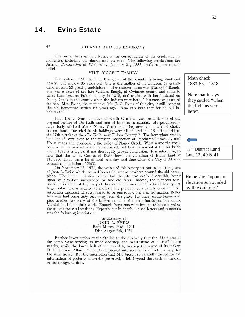
14. Evins Estate
Math check: 1883-65 = 1818. Note that it says they settled “when the Indians were here”.
17th District Land Lots 13, 40 & 41
Home site: “upon an elevation surrounded by fine old trees”.

54
The Evins were apparently the first European land owners in North Buckhead, arriving in 1818 “when the Indians were here”. Their land holdings were huge. Three land lots (at about 205 acres each) total 615 acres, almost a square mile.
55
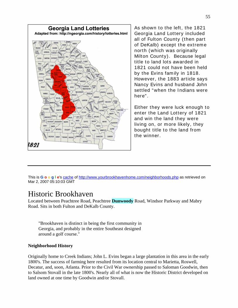
As shown to the left, the 1821 Georgia Land Lottery included all of Fulton County (then part of DeKalb) except the extreme north (which was originally Milton County). Because legal title to land lots awarded in 1821 could not have been held by the Evins family in 1818. However, the 1883 article says Nancy Evins and husband John settled “when the Indians were here”. Either they were luck enough to enter the Land Lottery of 1821 and win the land they were living on, or more likely, they bought title to the land from the winner.
This is G o o g l e's cache of http://www.yourbrookhavenhome.com/neighborhoods.php as retrieved on Mar 2, 2007 05:10:03 GMT
Historic Brookhaven Located between Peachtree Road, Peachtree Dunwoody Road, Windsor Parkway and Mabry Road. Sits in both Fulton and DeKalb County.
"Brookhaven is distinct in being the first community in Georgia, and probably in the entire Southeast designed around a golf course."
Neighborhood History Originally home to Creek Indians; John L. Evins began a large plantation in this area in the early 1800's. The success of farming here resulted from its location central to Marietta, Roswell, Decatur, and, soon, Atlanta. Prior to the Civil War ownership passed to Saloman Goodwin, then to Salsom Stovall in the late 1800's. Nearly all of what is now the Historic District developed on land owned at one time by Goodwin and/or Stovall.

56 Around 1900 prominent Atlantans began building summer cottages in Brookhaven. It was still too far for a daily commute to Atlanta. In 1910 a group of investors from the Mechanical and manufacturers Club purchased the land making up the Country Club property and lots immediately surrounding it for a development called "Brookhaven Estates." The Brookhaven Country Club was incorporated in October of that year. Herbert H. Barker, a golf pro from Garden City, Long Island, was hired to design the course, with nine holes laid out in 1911. (Barker also designed the Druid Hills Country Club's course.) In January 1912 the Brookhaven Country Club opened as Atlanta's second golf course after East Lake (1906). Both the Druid Hills course and the Ansley Golf Club opened the same year as the Brookhaven club, but these were additions to existing neighborhoods developed a number of years earlier. Brookhaven is distinct in being the first community in Georgia, and probably in the entire Southeast, designed around a golf course. Efforts to retain existing trees, particularly pines, set a precedent followed by many of Atlanta's post-World War II housing developments. Atlanta's Capital City Club leased the Brookhaven Country Club in 1913. When the Capital City Club purchased the Brookhaven Club in 1915 the golf course was expanded from nine to 18 holes. The clubhouse dates from 1928. The Brookhaven Estates Company continued to sell lots from around the club through the 1920's. In 1915 there were four houses, by 1928 there were 19 surrounding the club. Development continued when lots along Club Drive and Stovall were offered for sale by Samuel Stovall, Salsom's son. By 1928 eight houses had been built on these lots. Country Club Estates (Winall Down Road, most of Vermont and Stovall, Calvert Lane and part of Narmore) was laid out in 1929. The Carleton Operating Company land (Bellaire Drive) was platted in 1936. Most homes in Country Club Estates and on the Carleton land were built during the Depression and before 1942. Brookhaven's homes include designs by a number of well-known Atlanta architects of this period, including Hal Hentz (36 W. Brookhaven), Neel Reid (983 Stovall), A.F.N. Everett, Cyril B. Smith, W.N.W. Griffin, Pringle and Smith, W. Montgomery Anderson, Henry D. Norris and Edwards and Goodwyne. Preston Stevens desgined the Capital City clubhouse. In March of 1984 Brookhaven resident John R. Brannen submitted a Historic District Information Form on the neighborhood to the Historic Preservation Section of the Georgia Department of Natural Resources. Through Mr. Brannen's and his wife Bettie's efforts the Historic Preservation Section filed for listing Brookhaven in the U.S. National Register of Historic Places in December 1985. The National Park Service named the Brookhaven Historic District on January 14, 1986. History Source 2004 Brookhaven Club Neighborhood Association Neighborhood Directory

57 Originally home to Creek Indians, John L. Evins began a large plantation in the area now known
as Brookhaven in the early 1800’s. The success of farming here resulted from its location central to Marietta, Roswell, Decatur, and, soon, Atlanta. Prior to the Civil War, ownership passed to Solomon Goodwin, then to Salson Stovall in the late 1800’s. Nearly all of what is now the Historic District developed on land owned at one time by Goodwin and/or Stovall.
Around 1900, prominent Atlantans began building summer cottages in Brookhaven (it was still too far for a daily commute to Atlanta). In 1910, a group of investors
from the Mechanical and Manufacturers Club purchased the land making up the Country Club property and lots immediately surrounding it for a development called "Brookhaven Estates." The Brookhaven Country Club was incorporated in October of that year. Herbert H. Barker, a golf pro from Garden City, Long Island, was hired to design the course, with nine holes laid out in 1911. (Barker also designed the Druid Hills Country Club’s course.) In January 1912, the Brookhaven Country Club opened as Atlanta’s second golf course after East Lake (1906).
Both the Druid Hills course and the Ansley Golf Club opened the same year as the Brookhaven Club, but these were additions to existing neighborhoods developed a number of years earlier. Brookhaven is distinct in being the first community in Georgia, and probably in the entire southeast, designed around a golf course. Efforts to retain existing trees, particularly pines, set a precedent followed by many of Atlanta’s post-World War II housing developments.
Atlanta’s Capital City Club leased the Brookhaven Country Club in 1913. When the Capital City Club purchased the Brookhaven Club in 1915, the golf course was expanded from nine to 18 holes. The clubhouse dates from 1928. The Brookhaven Estates Company continued to sell lots around the club through the 1920’s. In 1915 there were four houses; by 1928, there were 19 houses surrounding the club.
Development continued when lots along Club Drive and Stovall were offered for sale by Samuel Stovall, Salsom’s son. By 1928, eight houses had been built on these lots. Country Club Estates (Winall Down Road, most of Vermont and Stovall, Calvert Lane and part of Narmore) was laid out in 1929. The Carleton Operating Company land (Bellaire Drive) was platted in 1936.
Most homes in Country Club Estates and on the Carleton land were built during the Depression and before 1942.
Brookhaven’s homes include designs by a number of well-known Atlanta architects of this period, including Hal Hentz (36 West Brookhaven), Neel Reid (983 Stovall), A.F.N. Everett, Cyril B. Smith, W.N.W. Griffin, Pringle and Smith, W. Montgomery Anderson, Henry D. Norris and Edwards and Goodwyne. Preston Stevens designed the Capital City Clubhouse.
In March of 1984, Brookhaven resident John R. Brannen submitted a Historic District Information Form on the neighborhood to the Historic Preservation Section of the Georgia Department of Natural Resources. Through Mr. Brannen’s and his wife Bettie’s efforts, the Historic Preservation Section filed for listing Brookhaven in the U.S. National Register of Historic Places in December 1985. The National Park Service named the Brookhaven Historic District on January 14, 1986.
Sources:

58 Brooks, Carolyn, National Register Researcher. "National Register of Historic Places Inventory-Nomination Form." December, 1985. On file with the Historic Preservation Section, Georgia Department of Natural Resources and with the National Park Service, U.S. Department of the Interior, Washington, D.C.
Brannen, Mrs. John R. (Bettie). "Brookhaven History." 1991. Published in the "Neighborhood Directory," Brookhaven-Club Neighborhood Association, 1995.
Maddox, Robert F. "History." published in "Governing Board; Constitution and Rules; Membership," Capital City Club, March 1992, p.4.
Winston E. Weinmann
From http://www.historicbrookhaven.org/history.htm
59
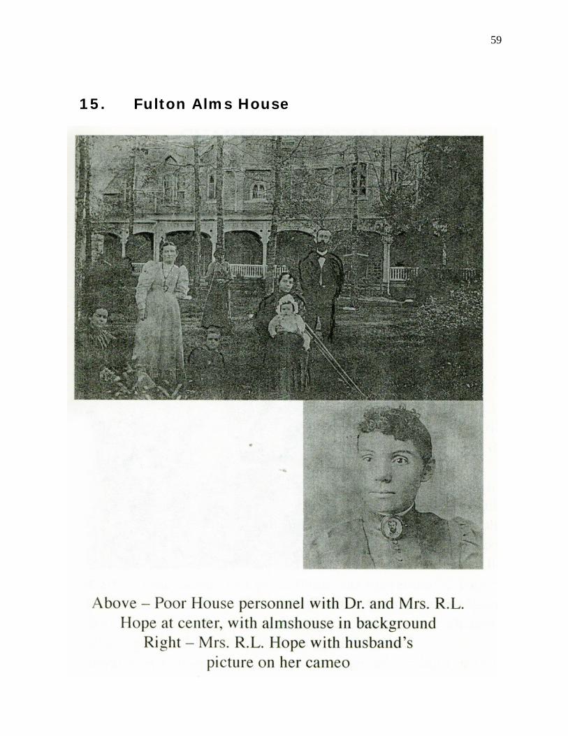
15. Fulton Alms House

60
Map (ca. 1939) showing the Fulton County Alms House property on Piedmont at Ivy Road. (Ivy Road became the Buckhead Loop.)
Alms House area from 1938 photo.

61
Author Henry M Hope is the grandson of RL Hope. He spoke to NBCA’s annual meeting in 2009.

62

63

64
Author Henry M Hope is the grandson of RL Hope. He spoke to NBCA’s annual meeting in 2009.

65

66

67

68

69
70