52. subsidence of the kerguelen plateau: … s. w., jr., schlich, r., et al., 1992 proceedings of...
TRANSCRIPT
Wise, S. W., Jr., Schlich, R., et al., 1992Proceedings of the Ocean Drilling Program, Scientific Results, Vol. 120
52. SUBSIDENCE OF THE KERGUELEN PLATEAU: THE ATLANTIS CONCEPT1
Millard F. Coffin2
ABSTRACT
Ocean Drilling Program Leg 119 and 120 results from the Southern Kerguelen Plateau provide importantconstraints on the subsidence history of this large igneous province. Following emplacement of the plateau at —110Ma, sedimentary facies indicate that portions of the feature remained above sea level or in shallow water for up to40 m.y. I use previously determined age-depth relationships for oceanic lithosphere to determine the level ofemplacement for five sites on the Southern Kerguelen Plateau. If thermal subsidence was the dominant tectonicprocess affecting the Southern Kerguelen Plateau following emplacement, then large portions of the feature wereemplaced and began subsiding far above sea level. This resulted in significant erosion and redeposition of volcanicmaterial mixed with biogenic sediment, and a gradual development of facies from terrestrial through terrigenous toshallow water and pelagic. I propose the "Atlantis" concept for this early evolution of the Kerguelen Plateau andof other large igneous provinces that produced a sedimentary record intermediate between continental and oceanic.
INTRODUCTION
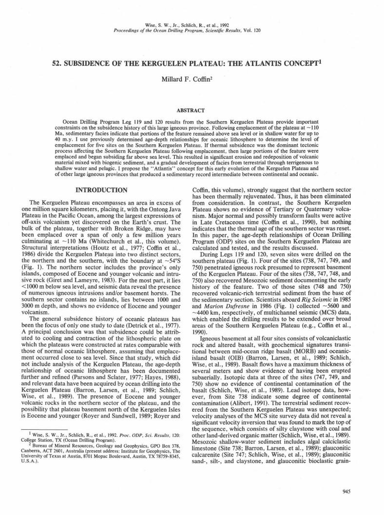
The Kerguelen Plateau encompasses an area in excess ofone million square kilometers, placing it, with the Ontong JavaPlateau in the Pacific Ocean, among the largest expressions ofoff-axis volcanism yet discovered on the Earth's crust. Thebulk of the plateau, together with Broken Ridge, may havebeen emplaced over a span of only a few million yearsculminating at —110 Ma (Whitechurch et al., this volume).Structural interpretations (Houtz et al., 1977; Coffin et al.,1986) divide the Kerguelen Plateau into two distinct sectors,the northern and the southern, with the boundary at —54°S(Fig. 1). The northern sector includes the province's onlyislands, composed of Eocene and younger volcanic and intru-sive rock (Giret and Lameyre, 1983). For the most part, it lies< 1000 m below sea level, and seismic data reveal the presenceof numerous igneous intrusions and/or basement horsts. Thesouthern sector contains no islands, lies between 1000 and3000 m depth, and shows no evidence of Eocene and youngervolcanism.
The general subsidence history of oceanic plateaus hasbeen the focus of only one study to date (Detrick et al., 1977).A principal conclusion was that subsidence could be attrib-uted to cooling and contraction of the lithospheric plate onwhich the plateaus were constructed at rates comparable withthose of normal oceanic lithosphere, assuming that emplace-ment occurred close to sea level. Since that study, which didnot include analysis of the Kerguelen Plateau, the age-depthrelationship of oceanic lithosphere has been documentedfurther and refined (Parsons and Sclater, 1977; Hayes, 1988),and relevant data have been acquired by ocean drilling into theKerguelen Plateau (Barron, Larsen, et al., 1989; Schlich,Wise, et al., 1989). The presence of Eocene and youngervolcanic rocks in the northern sector of the plateau, and thepossibility that plateau basement north of the Kerguelen Islesis Eocene and younger (Royer and Sandwell, 1989; Royer and
1 Wise, S. W., Jr., Schlich, R., et al., 1992. Proc. ODP, Sci. Results, 120:College Station, TX (Ocean Drilling Program).
2 Bureau of Mineral Resources, Geology and Geophysics, GPO Box 378,Canberra, ACT 2601, Australia (present address: Institute for Geophysics, TheUniversity of Texas at Austin, 8701 Mopac Boulevard, Austin, TX 78759-8345,U.S.A.).
Coffin, this volume), strongly suggest that the northern sectorhas been thermally rejuvenated. Thus, it has been eliminatedfrom consideration. In contrast, the Southern KerguelenPlateau shows no evidence of Tertiary or Quaternary volca-nism. Major normal and possibly transform faults were activein Late Cretaceous time (Coffin et al., 1990), but nothingindicates that the thermal age of the southern sector was reset.In this paper, the age-depth relationships of Ocean DrillingProgram (ODP) sites on the Southern Kerguelen Plateau arecalculated and tested, and the results discussed.
During Legs 119 and 120, seven sites were drilled on thesouthern plateau (Fig. 1). Four of the sites (738, 747, 749, and750) penetrated igneous rock presumed to represent basementof the Kerguelen Plateau. Four of the sites (738, 747, 748, and750) also recovered Mesozoic sediment documenting the earlyhistory of the feature. Two of those sites (748 and 750)recovered volcanic-rich terrestrial sediment from the base ofthe sedimentary section. Scientists aboard Rig Seismic in 1985and Marion Dufresne in 1986 (Fig. 1) collected -5600 and-4400 km, respectively, of multichannel seismic (MCS) data,which enabled the drilling results to be extended over broadareas of the Southern Kerguelen Plateau (e.g., Coffin et al.,1990).
Igneous basement at all four sites consists of volcaniclasticrock and altered basalt, with geochemical signatures transi-tional between mid-ocean ridge basalt (MORB) and oceanic-island basalt (OIB) (Barron, Larsen, et al., 1989; Schlich,Wise, et al., 1989). Basalt flows have a maximum thickness ofseveral meters and show evidence of having been eruptedsubaerially. Isotopic data at three of the sites (747, 749, and750) show no evidence of continental contamination of thebasalt (Schlich, Wise, et al., 1989). Lead isotope data, how-ever, from Site 738 indicate some degree of continentalcontamination (Alibert, 1991). The terrestrial sediment recov-ered from the Southern Kerguelen Plateau was unexpected;velocity analyses of the MCS site survey data did not reveal asignificant velocity inversion that was found to mark the top ofthe sequence, which consists of silty claystone with coal andother land-derived organic matter (Schlich, Wise, et al., 1989).Mesozoic shallow-water sediment includes algal calciclasticlimestone (Site 738; Barron, Larsen, et al., 1989); glauconiticcalcarenite (Site 747; Schlich, Wise, et al., 1989); glauconiticsand-, silt-, and claystone, and glauconitic bioclastic grain-
945

M. F. COFFIN
60°E 64βE 68°E 72°E 76°E 80°E 84°E 88°E44°S
48°S
52°S
56°S
60°S
64°S
Figure 1. Leg 119 and 120 sites and nonproprietary multichannel seismic (MCS) lines on the Kerguelen Plateau. Bathymetry (in meters)after Schlich et al. (1987).
946

THE ATLANTIS CONCEPT
stone to wackestone (Site 748; Schlich, Wise, et al., 1989); andcalcareous chalk and limestone (Site 750; Schlich, Wise, et al.,1989).
SUBSIDENCE HISTORY
The procedure for calculating the subsidence history ofoceanic lithosphere has been thoroughly documented (e.g.,Parsons and Sclater, 1977), and the most relevant study for theKerguelen Plateau is that of Hayes (1988), who analyzed datafrom the Southeast Indian Ocean in the rough vicinity of theplateau. The level of emplacement of igneous basement iscalculated by the equation,
in which Do = original depth or elevation of emplacement ofthe crust in meters, Dc = present corrected depth of the crustin meters, C = empirical constant in meters, and age is in m.y.
The value of C was determined to be 290 m for theSoutheast Indian Ocean south of the spreading center between111° and 119°E (Hayes, 1988). This value is close to the globalaverages of 350 (Parsons and Sclater, 1977) and 300 m (Hayes,1988). I note that these averages were determined fromCenozoic age lithosphere; there is no reason to suspect,however, that Mesozoic lithosphere followed different rules ofthermal subsidence.
Although Whitechurch et al. (this volume) conclude thatformation of the Kerguelen Plateau around Site 749 wascomplete by 110 Ma, this is based on only one sample datedby the 40Ar/39Ar technique. Five other samples from Sites747, 748, 749, and 750 dated by the same technique yieldeddates ranging from 80.3 to 164.4 Ma. Seven samples from thefour sites dated by the K-Ar technique yielded ages from75.9 ± 5.9 to 111.5 ± 3.2 Ma. The only other reported date,114 ± 1 Ma, was obtained by the K-Ar method on aplagioclase from a dredged basalt (Leclaire et al., 1987). Nodates have been obtained from Site 738 basalt. More work isclearly needed on dating the cored and dredged basalt, andthe 110 Ma date used in the calculations must be regardedonly as the best estimate.
The value of Dc was obtained by using Crough's equation(1983):
ts (ps-= dw
in which dw = water depth in meters, ts = sediment thicknessin meters, ps = average sediment density in g/cm3 (1.90), pm =upper mantle density in g/cm3 (3.22), and ρw = water densitying/cm3 (1.03).
Detrick et al. (1977) suggested that it is valid to applyage-depth relationships for oceanic lithosphere to oceanicplateaus in the absence of major post-emplacement tectonismthat may have resulted in thermal rejuvenation of the litho-sphere. As previously noted, some post-emplacement defor-mation in the form of normal and transform faulting, andsedimentary basin formation occurred on the Southern Ker-guelen Plateau (Coffin et al., 1990), but evidence is lacking forthermal rejuvenation manifested as volcanism (Coffin et al.,1986). Some question exists as to the crustal nature of thebasalt at Site 738 (Alibert, 1991); studies of continental litho-sphere, however, suggest that its subsidence may be domi-nated by an age-depth relationship similar to that of oceaniclithosphere (Karner et al., 1983). Application of these equa-tions to suitable Southern Kerguelen Plateau ODP sites yieldthe elevations (Z)o) of emplacement shown in Table 1 anddepicted in the age-depth curves in Figure 2. Eustatic changesin sea level have not been considered in this analysis. Igneous
basement was not penetrated at Site 748; Hole 748C bottomedin sediment beneath a lava flow, and the total sedimentthickness was estimated from an interpretation of Rig SeismicMCS data and compressional wave velocities (Schlich, Wise,et al., 1989).
Another approach that could be used to predict emplace-ment elevations of Southern Kerguelen Plateau sites is theplate model (e.g., Parker and Oldenburg, 1973; Davis andLister, 1974; Crough, 1975; Parsons and Sclater, 1977). Platemodel equations, however, contain one variable, the tem-perature at the base of the lithosphere, for which littleagreement exists, especially in the case of large igneousprovinces such as the Kerguelen Plateau (e.g., White andMcKenzie, 1989). Calculations of emplacement elevationsare sensitive to this, and consideration of a plate model isbeyond the scope of this study.
To check emplacement elevations, sediment facies at var-ious sites were examined (Barron, Larsen, et al., 1989;Schlich, Wise, et al., 1989), and it was assumed that the end ofshallow-water sedimentation occurred at a depth of 200 m.Assuming a basement age of —110 Ma, depth to igneousbasement at the end of shelf deposition may be calculated bythe equation:
Dbes = D0 + C (age - age J1/2,
in which Dbes = depth of igneous basement at the end of shelfdeposition in meters, and age^ = age at the end of shelfdeposition in m.y. (using the time scale of Kent and Gradstein,1985).
Depth to seafloor at the end of subaerial and shallow-waterdeposition may be predicted by combining the equations ofHayes (1988) and Crough (1983) as follows:
Dses = A> + C (age - age„) 1/2 - tjps - pjpw - pj,
in which Dses = depth of seafloor at the end of shelf depositionin meters, and tes = sediment thickness at the end of shelfdeposition in meters.
The various equation parameters, and calculated basementand seafloor depths at the end of shelf deposition are shown inTable 2, and calculated subsidence curves for igneous base-ment at the various sites are shown in Figure 2.
At Site 738, the age of the youngest shelf facies sedimentwas inferred to be early Turonian or older (Barron, Larsen, etal., 1989), and the 100 Ma date for the end of shelf depositionis an estimate. The ages for the end of shelf deposition at Sites748 and 750 are regarded as minimum ages because of poorage control in the terrestrial and terrigenous portions of thesedimentary section. The ages could be in error by up to 10m.y. Pelagic sediment dated at —85 and —50 Ma overliesigneous basement at Sites 747 and 749, respectively; no
Table 1. Equation parameters and elevations ofemplacement of Leg 119 and 120 sites.
Site
738747748749750
dw
2252.51695.21290.51069.52030.5
ts
496297
a1135202672
Dc
25511874197511912435
Do
-490-1168-1067-1850-606
Notes: DQ elevations of emplacement. Depths arepositive, and elevations are negative.
aEstimated.
947

M. F. COFFIN
2000
1000
ODP Site
-3000
Age (Ma)
Figure 2. Age-depth curves for igneous basement at Sites 738, 747, 748, 749, and 750.Calculated basement depths for all sites are given for 0 and 110 Ma; for Sites 738,748, and 750 calculated basement depths at the end of shelf deposition are indicated.See Table 2 for the corresponding depths to seafloor at the end of shelf deposition.
terrestrial, terrigenous, or shallow-water marine facies sedi-ment was recovered from either site (Schlich, Wise, et al.,1989).
Given potential errors in dates for basement rocks and forthe end of shelf deposition, and in the C term of the age-depthequation, the predicted seafloor depths, which lie within a fewhundred meters of shelf depths, appear to be reasonable. Theage-depth curves for the five sites (Fig. 2) demonstrate thatslight dating errors may have a significant influence on base-ment, and hence seafloor, depths. Interestingly, the oldestpelagic sediment at Sites 747 and 749 corresponds roughly inage to those predicted for basement descending through200-m water depth (Fig. 2). The long hiatus at Site 749 may beexplained by its remaining above sea level until —70 Ma orperhaps later. Two other lines of evidence support this bysuggesting that significant erosion of basement occurred at thesite. One is compressional wave velocities that are higher thanthose determined from samples from other plateau sites(Schlich, Wise, et al., 1989), suggesting that deeper levels ofigneous crust were penetrated. Another is the presence ofintermediate zeolite facies (Sevigny et al., this volume),indicating higher temperatures and perhaps deeper levels thanthe zeolite facies at Sites 747 and 750. Future subsidencestudies should incorporate isostatic corrections for igneousbasement removed by erosion.
Table 2. Equation parameters, and calculatedbasement and predicted seafloor depths of Leg119 and 120 sites.
Site
738747748749750
Age e ,
a100b ,
K 7 0
b 9c90
Dbes
4279
7679
691
169
4109
52
Dses
4179
5209
659
Notes: Dbes = calculated basement and Dses = pre-dicted seafloor depths.
aEstimated.bHiatus.cMinimum.
CONCLUDING DISCUSSION
Facies analysis of sediment cored during Legs 119 and120 indicates that parts of the Southern Kerguelen Plateauremained near sea level for up to —40 m.y. followingemplacement of the feature. Application of empirical age-depth relationships and sediment correction factors to ODPsites on the Southern Kerguelen Plateau complements faciesinterpretations and suggests that parts of the southernplateau were formed high above sea level. Present-day, butsmaller analogs to the Southern Kerguelen Plateau, namelyIceland, Hawaii, and the Northern Kerguelen Plateau (Ker-guelen Isles and Heard/McDonald islands), all suggest thatsubaerial emplacement and early evolution of such largeigneous provinces may be the rule rather than the exception.Table 3 summarizes subaerial areas and maximum eleva-tions of these provinces, all of which have been volcanicallyactive in Quaternary time.
It is difficult to ascertain what percentage of the SouthernKerguelen Plateau was above sea level at the end of its construc-tional phase; the common angular unconformity between base-ment and overlying sediment, and the widespread distribution ofterrestrial/terrigenous seismic facies on the southern plateau(Coffin et al., 1990), however, suggest that much of its -500,000km2 area was at one time above sea level. Samples obtained fromthe Naturaliste Plateau (Davies, Luyendyk, et al., 1974; Hayes,Frakes, et al., 1975; Coleman et al., 1982), Ninetyeast Ridge(von der Borch, Sclater, et al., 1974; Davies, Luyendyk, et al.,1974; Peirce, Weissel, et al., 1989), Rio Grande Rise (Supko,Perch-Nielsen, et al., 1977), and the Iceland-Faeroe Ridge (Tal-wani, Udinstev, et al., 1976) also show strong evidence ofsubaerial basalt extrusion. Furthermore, at least part of the
Table 3. Subaerial areas and maximum elevations of marinelarge igneous provinces.
Province Subaerial area (km ) Maximum elevation (m)
IcelandHawaiiKerguelenHeard/McDonald
103,82010,4567,215
412
2,1194,1691,8502,745
948

THE ATLANTIS CONCEPT
basaltic seaward-dipping reflector sequences drilled on the V0r-ing Plateau (Talwani, Udinstev, et al., 1976; Eldholm, Thiede,Taylor, et al., 1987,1989) and Rockall Bank (Roberts, Schnitker,et al., 1984) was erupted and eroded subaerially. Thus, manylarge igneous provinces appear to have had an early evolutionsimilar to that of the Southern Kerguelen Plateau.
Following the constructional phase of plateau develop-ment, erosional processes become the dominant factor inaltering plateau morphology if thermal rejuvenation does notkeep the feature high-standing. If the plateau is submarine, erosionof basalt and associated extrusive and intrusive rock is negligible.However, if the plateau is subaerial, erosion can be widespread,significantly altering topography of the feature (e.g., Iceland, Ha-waii, Kerguelen, and Heard/McDonald). The rate of denudation ofany rock is a function of topography and climate. Wood recoveredin basal sediment of the Raggatt Basin suggests a temperate climate(Francis and Coffin, this volume), and average denudation rates intemperate climates vary from 10 to 200 m/m.y., depending ontopographic relief (Saunders and Young, 1983). Evidence fromdrilling on the Southern Kerguelen Plateau suggests that parts of theplateau may have remained subaerial for up to 40 m.y., allowing400-8000 m of erosion. Drilling results do not support the latterfigure, but several hundred to over a thousand meters of basaltcould have been eroded based on compressional wave velocityvalues (Schlich, Wise, et al., 1989) and zeolite facies (Sevigny et al.,this volume). The erosional phase of development was marked bydeposition of terrestrial and terrigenous sediment. After the bulk ofthe plateau subsided below sea level, biogenic shallow-water andpelagic sediment followed.
In conclusion, it appears that many large igneous provincesin the marine realm have experienced a significant portion oftheir development subaerially and in shallow water. Theprogressive development of dominantly terrestrial, then ter-rigenous, and eventually biogenic shallow-water and pelagicfacies sediment in response primarily to thermal subsidence iswhat I coin "Atlantis"-type evolution.
ACKNOWLEDGMENTS
I thank the entire complements of Ocean Drilling ProgramLegs 119 and 120 for obtaining the samples used in this study,and the Bureau of Mineral Resources (Australia) and the Ecoleet Observatoire de Physique du Globe-Strasbourg (France) forproviding site survey data. A very special thanks to Kerry Keltsfor stimulating the ideas presented here, and for providing anidyllic work environment in Kilchberg. I am grateful to JohnPeirce and John Sclater for critical reviews. Published with thepermission of the Director, Bureau of Mineral Resources, Geol-ogy and Geophysics, Canberra, Australia. University of TexasInstitute for Geophysics Contribution No. 857.
REFERENCES
Alibert, C, 1991. Mineralogy and geochemistry of a basalt from Site738: implications for the tectonic history of the southernmost partof the Kerguelen Plateau. In Barron, J., Larsen, B., et al., Proc.ODP, Sci. Results, 119: College Station, TX (Ocean DrillingProgram), 293-298.
Barron, J., Larsen, B., et al., 1989. Proc. ODP, Init. Repts., 119:College Station, TX (Ocean Drilling Program).
Coffin, M. F., Davies, H. L., and Haxby, W. F., 1986. Structure ofthe Kerguelen Plateau province from SEASAT altimetry andseismic reflection data. Nature, 324:134-136.
Coffin, M. F., Munschy, M., Colwell, J. B., Schlich, R., Davies,H. L., and Li, Z. G., 1990. Seismic stratigraphy of the RaggattBasin, Southern Kerguelen Plateau: tectonic and paleoceano-graphic implications. Geol. Soc. Am. Bull., 102:563-579.
Coleman, P. J., Michael, P. J., and Mutter, J. C , 1982. The origin ofthe Naturaliste Plateau, SE Indian Ocean: implications fromdredged basalts. / . Geol. Soc. Australia, 29:457-468.
Crough, S. T., 1975. Thermal model of oceanic lithosphere. Nature,256:388-390.
, 1983. The correction for sediment loading on the seafloor./ . Geophys. Res., 88:6449-6454.
Davies, T. A., Luyendyk, B. P., et al., 1974. Init. Repts. DSDP, 26:Washington (U.S. Govt. Printing Office).
Davis, E. E., and Lister, C.R.B., 1974. Fundamentals of ridge cresttopography. Earth Planet. Sci. Lett., 21:405-413.
Detrick, R. S., Sclater, J. G., and Thiede, J., 1977. The subsidence ofaseismic ridges: Earth Planet. Sci. Lett., 34:185-196.
Eldholm, O., Thiede, J., Taylor, E., et al., 1987. Proc. ODP, Init.Repts., 104: College Station, TX (Ocean Drilling Program).
, 1989. Proc. ODP, Sci. Results, 104: College Station, TX(Ocean Drilling Program).
Giret, A., and Lameyre, J., 1983. A study of Kerguelen plutonism:petrology, geochronology, and geological implications. In Oli-ver, R. L., James, P. R., and Jago, J. B. (Eds.), Antarctic EarthScience: Canberra (Australian Academy of Science), 646-651.
Hayes, D. E., 1988. Age-depth relationships and depth anomalies inthe Southeast Indian Ocean and South Atlantic Ocean. J. Geo-phys. Res., 93:2937-2954.
Hayes, D. E., Frakes, L. A., et al., 1975. Init. Repts. DSDP, 28:Washington (U.S. Govt. Printing Office).
Houtz, R. E., Hayes, D. E., and Markl, R. G., 1977. KerguelenPlateau bathymetry, sediment distribution, and crustal structure.Mar. Geol., 25:95-130.
Karner, G. D., Steckler, M. S., and Thorne, J. A., 1983. Long-termthermo-mechanical properties of the continental lithosphere. Na-ture, 304:250-253.
Kent, D. V., and Gradstein, F. M., 1985. A Cretaceous and Jurassicgeochronology. Geol. Soc. Am. Bull., 96:1419-1427.
Leclaire, L., Bassias, Y., Denis-Clocchiatti, M., Davies, H., Gautier, I.,Gensous, B., Giannesini, P.-J., Patriat, P., Ségoufin, J., Tesson, M.,and Wannesson, J., 1987. Lower Cretaceous basalt and sedimentsfrom the Kerguelen Plateau. Geo-Mar. Lett., 7:169-176.
Parker, R. L., and Oldenburg, D. W., 1973. Thermal model of oceanridges. Nature, 242:137-139.
Parsons, B., and Sclater, J. G., 1977. An analysis of the variation ofocean floor bathymetry and heat flow with age. J. Geophys. Res.,82:803-827.
Peirce, J. W., Weissel, J. K., et al., 1989. Proc. ODP, Init. Repts.,121: College Station, TX (Ocean Drilling Program).
Roberts, D. G., Schnitker, D., et al., 1984. Init. Repts. DSDP, 81:Washington (U.S. Govt. Printing Office).
Royer, J.-Y., and Sandwell, D. T., 1989. Evolution of the easternIndian Ocean since the Late Cretaceous: constraints from GEO-SAT altimetry. J. Geophys. Res., 94:13,755-13,782.
Saunders, I., and Young, A., 1983. Rates of surface processes onslopes, slope retreat, and denudation, Earth Surface ProcessesLandforms, 8:473-501.
Schlanger, S. O., Jackson, E. D., et al., 1976. Init. Repts. DSDP, 33:Washington (U.S. Govt. Printing Office).
Schlich, R., Coffin, M. F., Munschy, M., Stagg, H.M.J., Li, Z. G.,and Revill, K., 1987. Bathymetric Chart of the Kerguelen Plateau.Jointly edited by Bureau of Mineral Resources, Geology andGeophysics, Canberra, Australia; Institut de Physique du Globe,Strasbourg, France; and Terres Australes et AntarctiquesFrançaises, Paris, France.
Schlich, R., Wise, S. W., Jr., et al., 1989. Proc. ODP, Init. Repts.,120: College Station, TX (Ocean Drilling Program).
Supko, P. R., Perch-Nielsen, K., et al., 1977. Init. Repts. DSDP, 39:Washington (U.S. Govt. Printing Office).
Talwani, M., Udinstev, G., et al., 1976. Init. Repts. DSDP, 38:Washington (U.S. Govt. Printing Office),
von der Borch, C , Sclater, J. G., et al., 1974. Init. Repts. DSDP, 22:Washington (U.S. Govt. Printing Office).
White, R., and McKenzie, D., 1989. Magmatism at rift zones: thegeneration of volcanic continental margins and flood basalts. J.Geophys. Res., 94:7685-7729.
Date of initial receipt: 7 September 1990Date of acceptance: 2 February 1991Ms 120B-202
949