5.0 proposed cycling master plan
TRANSCRIPT

City of Hamilton Shifting Gears 2009
May 2010 68
5.0 Proposed Cycling Master Plan This section of the report provides a detailed listing of the proposed cycling routes in the Preferred Cycling Network, summarized by ward. The construction of these routes will augment the existing cycling facilities in the City of Hamilton to create a well-connected, convenient and safe cycling network across the city. Each ward profile contains a map and a table which provide details for each planned cycling route segment in the ward. The maps identify each route segment by the number that describes the route segments initial priority ranking. The corresponding tables include the following details:
Area – describe if the planned cycling route is in the urban or rural area or if it is an Escarpment crossing (EC). Priority Ranking – this numerical value is unique for each planned route. Note that this ranking begins at “1” for both the urban and rural areas, but the rural values also include the letter “r” (eg. “4r”). Street – describes the name of the street / combination of streets that the route is planned to utilize. For multi-use trails, a name to describe the location of the trail is noted. from / to – describes the limits of the planned route. Length – a length in metres is stated for the various segments. Design Concept – for each segment a preferred design for the implementation of the planned cycling route is stated. This concept is subject to change during detailed design. EA Status – the Environmental Assessment (EA) status of the route is stated based on the current understanding of the proposed facility. An A+ designation indicates that no further approval is required. Previous Plans – this column indicates if the proposed project was identified in the Transportation MP (2007), the RTMP (2007) or in the previous Shifting Gears (1999). Note that some projects are proposed in other City of Hamilton planning documents, but this detail is not noted herein. NEC – those planned projects that are within the Niagara Escarpment Commission (NEC) zone of jurisdiction are indicated with a “Y”. Note that this indication includes projects that run along a boundary as well as through NEC jurisdiction.

City of Hamilton Shifting Gears 2009
May 2010 69
Network multi-modal connectivity is planned between the proposed cycling routes indicated and transit routes (HSR and GO Transit), including bicycle racks on buses and bicycle storage facilities at future rapid transit stations.

City of Hamilton Shifting Gears 2009
May 2010 70
5.1 Individual Ward Projects
5.1.1 Ward 1 – Chedoke - Cootes
* Scale unspecified.
48 49 81
12
88 60 65
43
63
3 34
66
208 59
4
23
191 170 135
104
158 196
125
102
190 210 181
38
203
221

City of Hamilton Shifting Gears 2009
May 2010 71
Ward 1 – Chedoke - Cootes
Area*
Priority Ranking (as on map)
Street from toLength
(m)Design Concept **
EA Status
Previous Plans ***
NEC ****
urban 3 MurT CP rail trail over 403 Rifle Range Studholme 2400 MurT 4.0m paved *Reg Y Y
urban 4 King in Westdale Stirling Longwood 150
BL w road diet Paisley to Marion & BL on existing, Cline to Longwood ONLY (150m)
A+ - -
urban 12 Locke Main Aberdeen 1025BL w road diet (Main to Hunter only) A+ Y -
urban 23 Rifle Range/ Westbourne Sanders Main 120 shared on-street - signed A+ Y -
urban 34 Studholme west end Aberdeen 600 BL on existing east of Beddoe A+ Y -
urban 38 Osler Spencer Creek
Main 1500 BL on existing - narrow curb lanes A+ - -
urban 43 Longwood Franklin King 725 BL on existing - eliminate osp A+ - -
urban 48 Herkimer Dundurn MacNab 1520
BL EB on existing (road diet to 1lane west of Locke), reduce osp in Durand
A+ - -
urban 49 Charlton Dundurn Queen 820BL on existing, north side 1way A+ - -
urban 59 Longwood King Main 450BL w road diet - see report A+ Y -
urban 60 York Blvd EB Dundurn Bay 1340 BL on existing - narrow curb lanes A+ Y -
urban 63 Sanders West Park Cootes 650 BL on existing A+ - -
urban 65 York Blvd WB Queen Dundurn 875 BL on existing - narrow curb lanes A+ Y -
urban 66 Frid/Chatham Longwood Dundurn 250 BL w development A+ Y -urban 81 Dundurn Main Aberdeen 1020 BL on existing A+ - -urban 88 Dundurn York King 670 BL w road diet A+ - -
urban 102 Whitney Main Emerson 1500BL on existing, remove osp w attention to commercial area
A+ - -
urban 104 Locke Barton York 800BL on existing - eliminate osp to 1 side only A+ Y -
urban 125 King in Westdale Longwood Macklin 340 BL w road diet - see report A+ Y -
urban 135 Locke King Main 250 BL w road diet - 1 lane NB and 2-way BL A+ Y -
urban 158 Aberdeen Longwood Studholme 260 MurT on south side A+ Y -urban 170 Dundurn King Main 270 BL w reconstruction A+ - -urban 181 Sanders MurT Osler/Main West Park 200 MurT 4.0m pave *Reg - -
urban 190 Emerson Main Whitney 650 shared on-street - signed A+ Y -
urban 191 Hunter/Canada/ Jackson Dundurn Queen 900 shared on-street - signed A+ Y -
urban 196 Longwood Main Aberdeen 700 BL w road diet - see report A+ Y -
urban 208 Main over 403 Macklin Dundurn/Jackson BL - devise 2-way/ MurT A+ - -
urban 210 MurT Beddoe/ Glenside Studholme Dundurn 1600 MurT 4.0m pave & Glenside shared/signed
*Reg Y Y
EC 203 Chedoke MurT Scenic Dundurn 3000MurT pave existing 3.0m gravel *Reg Y Y
EC 221 Dundurn stairs stairs exist - develop retrofrit for bikes *Reg - Y
red text indicates link overlaps another ward* EC = Escarpment Crossing** BL = Bike Lane, MurT = Multi-Use Recreational Trail, PS = Paved Shoulder, osp = on-street parking** w = with, NB = northbound, SB = southbound, EB = eastbound, WB = westbound, osp = on-street parking, TWLTL = two-way left-turn lane*** previously planned in other City documents including the Transportation Master Plan and the Recreational Trails Master Plan**** within Niagara Escarpment Commission (NEC) jurisdiction*Reg - exempt under Regulation 334 rev. Feb 2011

City of Hamilton Shifting Gears 2009
May 2010 72
5.1.2 Ward 2 – Downtown
* Scale unspecified.
48
182
9 108
15 30
143 5
195
20
173
8 111
58
178
72 33
22
64
41
74 78 89
97
16
24
207

City of Hamilton Shifting Gears 2009
May 2010 73
Ward 2 – Downtown
Area*
Priority Ranking (as on map)
Street from toLength
(m)Design Concept **
EA Status
Previous Plans ***
NEC ****
urban 5 Wilson Ferguson Sherman 1900BL w road diet - BL EB on southside, 3 for auto osp north side, off peak
A+ Y -
urban 8 Ferguson Burlington Simcoe 600 Shared on-street - signed A+ Y -
urban 9 Ferguson Young Charlton 200 Shared on-street - signed A+ - Y
urban 15 Wilson James Ferguson 650 BL w 2-way conversion A+ Y -
urban 20 Cannon Ferguson Sherman 1900BL w road diet - BL WB on south side, 3 auto, osp off peak north side
A+ - -
urban 22 Caroline York Markland 1350BL SB on existing - road diet - maintain 24hr parking on east side
A+ Y -
urban 30 Cannon Queen Ferguson 1475BL w road diet - BL WB on south side, 3 auto, osp off peak northside
A+ - -
urban 33 Bay Main Markland 865BL w road diet and reduce osp A+ - -
urban 41 York Blvd EB Bay James 420BL w road diet & planned 2-way conversion A+ Y -
urban 48 Herkimer Dundurn MacNab 1520BL EB on existing (road diet west of Locke), reduce osp in Durand
A+ - -
urban 58 Ferguson Dock Service Rd
Burlington 270BL on existing - narrow curb lanes A+ Y -
urban 60 York Blvd EB Dundurn Bay 1340 BL on existing - narrow curb lanes A+ Y -
urban 64 Bay Strachan Cannon 790BL w road diet - Barton to Cannon A+ - -
urban 72 Charlton Queen Ferguson 1450
BL w road diet - 1 auto WB, osp southside & BL northside west of James (& contra BL on southside MacNab to James); BL and 1 auto each direction James to Ferguson
A+ - Y
urban 74 Wellington Jackson Young 360BL w road diet - parking one side A+ - Y
urban 78 Stinson Wellington Wentworth 850 BL on existing A+ - Y
urban 89 Hunter QueenLiberty (not Wellington)
1700 BL w road diet - 2way BL A+ Y -
urban 97 Young Ferguson Wellington 230 BL on existing A+ - Y
urban 111 Burlington Ferguson Sherman 1880BL w road diet Ferguson to Wellington, excess asphalt to Birch
A+ portion -
urban 143 Bay Cannon Main 625 BL w widening A+ - -urban 173 John Charlton St Josephs 145 BL w widening A+ - Y
urban 178MurT CN rail/Strachan
James Ferguson 660 MurT 4.0m pave A+ Y -
urban 195Liberty/Grove & Jackson
Ferguson Wellington 200 shared on-street - signed A+ - -
EC 16 Jolley Cut St Josephs Concession 1410BL on existing (upbound priority) A+ - Y
EC 24Claremont Access down
Inverness Main 1600 BL on existing A+ - Y
EC 108Claremont Access up
Hunter James stairs 1600 BL w spot widening A+ - Y
EC 182 Claremont to W5th James stairsGateview 620MurT w road diet - shift concrete & widen MurT A+ - Y
EC 207 John St MurT James stairsJohn & Ferguson
420 MurT 4.0m pave A+ - Y
red text indicates link overlaps another ward * EC = Escarpment Crossing ** BL = Bike Lane, MurT = Multi-Use Recreational Trail, PS = Paved Shoulder, w = with, NB = northbound, SB = southbound, EB = eastbound, WB = westbound, osp = on-street parking, TWLTL = two-way left-turn lane *** previously planned in other City documents including the Transportation Master Plan and the Recreational Trails Master Plan **** within Niagara Escarpment Commission (NEC) jurisdiction

City of Hamilton Shifting Gears 2009
May 2010 74
5.1.3 Ward 3 – Hamilton Centre
* Scale unspecified.
223 222
21
36
133
55
211
5 215 20
100
99
111
214

City of Hamilton Shifting Gears 2009
May 2010 75
TBD
Ward 3 – Hamilton Centre
Area*
Priority Ranking (as on map)
Street from toLength
(m)Design Concept **
EA Status
Previous Plans ***
NEC ****
urban 5 Wilson Ferguson Sherman 1900BL w road diet - BL EB on southside, 3 auto, osp northside off peak
A+ Y -
urban 20 Cannon Ferguson Sherman 1900BL w road diet - BL WB on southside, 3 auto, osp off peak northside
A+ - -
urban 21 Gage Industrial Lawrence 2960BL w road diet - parking 1 side A+ Y Y
urban 36Maple Ave/Graham/ Frederick
Gage Park Cannon 630 shared on-street - signed A+ portion -
urban 45 Cannon Gage Kenilworth 1700 BL w road diet - osp 1side, TWLTL if needed A+ Y -
urban 55 Cannon Sherman Gage 880BL w road diet - osp northside OR changeable direction centre lane
A+ Y -
urban 99 Victoria Barton Main 1035BL w road diet - BL NB on eastside, 3 auto, osp westside off peak
A+ - -
urban 100 Victoria Burlington Barton 1025BL w road diet - BL NB on eastside, 3 auto, osp westside off peak
A+ - -
urban 111 Burlington Ferguson Sherman 1880BL w road diet Ferguson to Wellington, excess asphalt to Birch
A+ portion -
urban 133 Burlington/ Industrial Sherman Ottawa 1700 BL w road diet in sections A+ - -
urban 211 MurT in Gage Park Cumberland Maple 590 MurT 6.0m pave *Reg Y Yurban 215 Sherman Cannon/Wilson merge area BL w road diet A+ Y -
EC 222 Wentworth stairs stairs exist - develop retrofrit for bikes
*Reg - Y
EC 223 Henderson lift at Shermanincline lift - separate EA required TBD Y Y
EC 214 MurT Ottawa St to Escarpment Rail Trail 390 MurT 4.0m pave *Reg - Y
red text indicates link overlaps another ward* EC = Escarpment Crossing** BL = Bike Lane, MurT = Multi-Use Recreational Trail, PS = Paved Shoulder, osp = on-street parking** w = with, NB = northbound, SB = southbound, EB = eastbound, WB = westbound, osp = on-street parking, TWLTL = two-way left-turn lane*** previously planned in other City documents including the Transportation Master Plan and the Recreational Trails Master Plan**** within Niagara Escarpment Commission (NEC) jurisdiction*Reg - exempt under Regulation 334 rev. Feb 2011

City of Hamilton Shifting Gears 2009
May 2010 76
5.1.4 Ward 4 – East Hamilton
* Scale unspecified.
1
45
36 172
39
213
37
217
6
121

City of Hamilton Shifting Gears 2009
May 2010 77
Ward 4 – East Hamilton
Area*
Priority Ranking (as on map)
Street from toLength
(m)Design Concept **
EA Status
Previous Plans ***
NEC ****
urban 1MurT in Red Hill Valley & over QEW
waterfront trail Barton MurT 4.0m paved and bridge
*UC Y -
urban 6 Woodward Beach Blvd Melvin 2525 BL w road diet - TWLTL A+ portion -
urban 36Maple Ave/Graham/ Frederick Gage Park Cannon 630 shared on-street - signed A+ portion -
urban 37 MelvinRed Hill Valley MurT
1900
BL w road diet - parking 1 side Parkdale to Woodward, other section BL on existing
A+ Y -
urban 39 Cannon/Britania Kenilworth Walter 840BL w road diet on Cannon, BL on existing on Britania
A+ Y -
urban 45 Cannon Gage Kenilworth 1700 BL w road diet - osp 1s, TWLTL where needed A+ Y -
urban 121 Burlington/ Industrial Ottawa Parkdale 2300 BL w road diet in sections A+ - -
urban 172 MurT Strathearne/ Cochrane Barton Lawrence 1900 MurT 4.0m pave A+ Y -
urban 213MurT Museum of Steam & Tech link Woodward
Red Hill Valley MurT
750 MurT 4.0m pave *Reg Y -
urban 217 Windermere (Burlington) Parkdale Woodward 1000shared on-street - signed - spot improvements A+ - -
red text indicates link overlaps another ward* EC = Escarpment Crossing** BL = Bike Lane, MurT = Multi-Use Recreational Trail, PS = Paved Shoulder, osp = on-street parking** w = with, NB = northbound, SB = southbound, EB = eastbound, WB = westbound, osp = on-street parking, TWLTL = two-way left-turn lane*** previously planned in other City documents including the Transportation Master Plan and the Recreational Trails Master Plan**** within Niagara Escarpment Commission (NEC) jurisdiction*Reg - exempt under Regulation 334 rev. Feb 2011*UC - under construction
Strathhearne/Shelby

City of Hamilton Shifting Gears 2009
May 2010 78
5.1.5 Ward 5 – Red Hill
* Scale unspecified.

City of Hamilton Shifting Gears 2009
May 2010 79
Ward 5 – Red Hill
Area*
Priority Ranking (as on map)
Street from toLength
(m)Design Concept **
EA Status
Previous Plans ***
NEC ****
urban 1MurT in Red Hill Valley & over QEW
waterfront trail Barton MurT 4.0m paved and bridge
*UC Y -
urban 13 Barton RHVP Lake 1610 BL w reconstruction A+ - -urban 19 Barton Brockley Fruitland 3950 BL on existing A+ - -urban 27 King Nash Battlefield 1140 BL w reconstruction A+ Y -urban 35 Beach Blvd under QEW 240 BL w road diet A+ - -
urban 76 Nash Bancroft King 2580BL w road diet - parking 1 side or TWLTL when necessary
A+ - -
urban 85 Delawana Grandville Lake 380 BL on existing A+ - -
urban 94 Gray Frances King 3000 BL w road diet & TWLTL A+ portion -
urban 96 Lake Barton Delawana 450BL w road diet & TWLTL & bits of parking A+ - -
urban 98 Delawana Fairington Grandville 490BL w shortened auxiliary lanes A+ - -
urban 101 Delawana/Kentley Nash Fairington 160 shared on-street - signed A+ - -
urban 114 Greenhill Summercrest King 1200 BL w road diet - parking 1 side, no TWLTL A+ - Y
urban 123 Greenhill Harrisford Summercrest
1940 BL w road diet - parking 1 side, no TWLTL A+ - Y
urban 148 Lake Delawana King 1625 BL w reconstruction A+ - -
urban 174 MurT Strathearne/ Cochrane Lawrence Greenhill 1150 MurT 4.0m pave A+ Y -
urban 180 Mount Albion Lawrence south limit 2000 BL on existing - narrow curb lanes A+ - Y
urban 192 King over RHVP Lawrence Pottruff 500 BL on existing A+ Y -
EC 206 First Rd W MurT Greenhill to Glover Mtn Rd 750 MurT 4.0m pave A+ - Y
red text indicates link overlaps another ward* EC = Escarpment Crossing** BL = Bike Lane, MurT = Multi-Use Recreational Trail, PS = Paved Shoulder, osp = on-street parking** w = with, NB = northbound, SB = southbound, EB = eastbound, WB = westbound, osp = on-street parking, TWLTL = two-way left-turn lane*** previously planned in other City documents including the Transportation Master Plan and the Recreational Trails Master Plan**** within Niagara Escarpment Commission (NEC) jurisdiction*UC - under construction rev. Feb 2011

City of Hamilton Shifting Gears 2009
May 2010 80
5.1.6 Ward 6 – East Mountain
* Scale unspecified.

City of Hamilton Shifting Gears 2009
May 2010 81
Ward 6 – East Mountain
Area*
Priority Ranking (as on map)
Street from toLength
(m)Design Concept **
EA Status
Previous Plans ***
NEC ****
urban 2 Arbour Mud LINC 300MurT 4.0m paved and bridge
*Con Y Y
urban 32 Arbour LINC Stone Church 130 shared on-street - signed A+ Y Y
urban 70 Queensdale Up Sherman Up Ottawa 1560 BL & 1 side parking A+ - -urban 106 Limeridge Up Ottawa Mtn Brow 1430 BL on existing A+ - Yurban 131 Mud Arbour Pritchard 460 BL w widening A+ Y Yurban 137 Nebo Rymal Twenty 1300 BL w widening A+ - -urban 138 Kilbride Up Ottawa Nebo 380 BL w development A+ - -urban 142 Pritchard Stone Church Rymal 1030 BL w development A+ - -urban 150 Upper Ottawa Mohawk Kilbride 3285 BL w widening A+ - -
urban 165 Mountain Brow Up Ottawa Broker 2075MurT 4.0m pave along brow A+ - Y
urban 166 Upper Sherman Macassa Limeridge 2050 BL w reconstruction A+ - -
urban 167 Mountain Brow Broker Arbour 2450MurT 4.0m pave along brow A+ - Y
urban 168 Upper Ottawa Mtn Brow Mohawk 1875 BL w reconstruction A+ - Yurban 194 Karst RHV loop Pritchard Up Mt Albion 700 BL w development A+ Y -urban 199 Rymal Pritchard Trinity Church 300 BL w widening A+ Y -
urban 201 Bendamere/South Bend/ Macassa/Ninth/Broker 8000shared on-street - signed - spot improvements A+ Y -
rural 41r Miles Rymal Haldibrook 10700 PS widen asphalt A+ - -rural 45r Trinity Church Rymal Golf Club 2100 PS widen asphalt A+ - -
red text indicates link overlaps another ward* EC = Escarpment Crossing** BL = Bike Lane, MurT = Multi-Use Recreational Trail, PS = Paved Shoulder, osp = on-street parking** w = with, NB = northbound, SB = southbound, EB = eastbound, WB = westbound, osp = on-street parking, TWLTL = two-way left-turn lane*** previously planned in other City documents including the Transportation Master Plan and the Recreational Trails Master Plan**** within Niagara Escarpment Commission (NEC) jurisdiction*Con - constructed rev. Feb 2011

City of Hamilton Shifting Gears 2009
May 2010 82
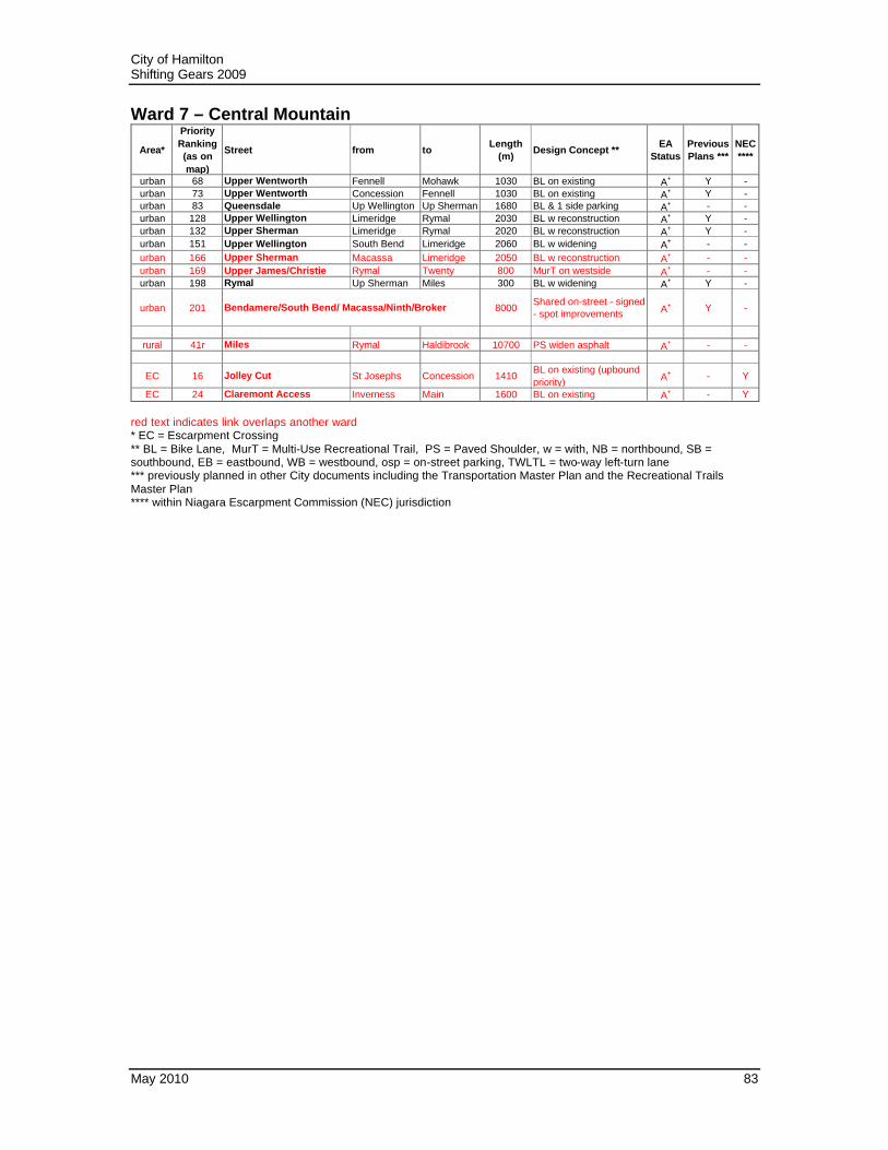
5.1.7 Ward 7 – Central Mountain
* Scale unspecified.
169
24
166
16
201
151
128
73
41r
68
198
83
132
City of Hamilton Shifting Gears 2009
May 2010 83
Ward 7 – Central Mountain
Area*
Priority Ranking (as on map)
Street from toLength
(m)Design Concept **
EA Status
Previous Plans ***
NEC ****
urban 68 Upper Wentworth Fennell Mohawk 1030 BL on existing A+ Y -urban 73 Upper Wentworth Concession Fennell 1030 BL on existing A+ Y -urban 83 Queensdale Up Wellington Up Sherman 1680 BL & 1 side parking A+ - -urban 128 Upper Wellington Limeridge Rymal 2030 BL w reconstruction A+ Y -urban 132 Upper Sherman Limeridge Rymal 2020 BL w reconstruction A+ Y -urban 151 Upper Wellington South Bend Limeridge 2060 BL w widening A+ - -urban 166 Upper Sherman Macassa Limeridge 2050 BL w reconstruction A+ - -urban 169 Upper James/Christie Rymal Twenty 800 MurT on westside A+ - -urban 198 Rymal Up Sherman Miles 300 BL w widening A+ Y -
urban 201 Bendamere/South Bend/ Macassa/Ninth/Broker 8000Shared on-street - signed - spot improvements A+ Y -
rural 41r Miles Rymal Haldibrook 10700 PS widen asphalt A+ - -
EC 16 Jolley Cut St Josephs Concession 1410BL on existing (upbound priority) A+ - Y
EC 24 Claremont Access Inverness Main 1600 BL on existing A+ - Y red text indicates link overlaps another ward * EC = Escarpment Crossing ** BL = Bike Lane, MurT = Multi-Use Recreational Trail, PS = Paved Shoulder, w = with, NB = northbound, SB = southbound, EB = eastbound, WB = westbound, osp = on-street parking, TWLTL = two-way left-turn lane *** previously planned in other City documents including the Transportation Master Plan and the Recreational Trails Master Plan **** within Niagara Escarpment Commission (NEC) jurisdiction

City of Hamilton Shifting Gears 2009
May 2010 84
5.1.8 Ward 8 – West Mountain
* Scale unspecified.
163
52
18
117
87 157
14 115
26
62
136
54 103
77
153
61
201
197
110 169
182

City of Hamilton Shifting Gears 2009
May 2010 85
Ward 8 – West Mountain
Area*
Priority Ranking (as on map)
Street from toLength
(m)Design Concept **
EA Status
Previous Plans ***
NEC ****
urban 14 Mohawk Scenic Up Paradise 1450 BL w reconstruction A+ portion -urban 18 Stone Church Garth Up James 1645 BL w reconstruction A+ Y -urban 26 Scenic Mohawk Chateau 1500 BL on existing asphalt A+ Y Yurban 52 W 5th Stone Church Rymal 1000 BL w reconstruction A+ Y -
urban 54 Scenic Chateau Up Paradise 2270BL on existing - construct sidewalk along brow A+ - Y
urban 61 W 5th Gateview Fennell 530BL w road diet to 4 auto lanes A+ Y Y
urban 62 Scenic Up Paradise Garth 950BL on existing - construct sidewalk along brow A+ - Y
urban 77 Rice/Sanatorium brow to Scenic Mohawk 1000BL w road diet - osp 1side south of Chedmac - see EA for north side
A+ - -
urban 87 Upper Paradise Stone Church Rymal 1070 BL on existing - narrow TWLTL A+ - -
urban 103 W 5th FennellMohawk College Access
325 BL on existing A+ Y -
urban 110 Garth Rymal Twenty 1400 BL on existing A+ - -
urban 115 Rice/Sanatorium Mohawk Wendover 130BL on existing - eliminate osp to 1 side only A+ - -
urban 117 W 5th LINC Stone Church 740 BL w reconstruction A+ Y -
urban 136 W 5thMohawk College Access
Tyrone 1130BL w widening on westside A+ Y -
urban 153 Fennell Garth W 5th 1200 BL w widening A+ - Yurban 157 Garth Stone Church Rymal 1025 BL w reconstruction A+ - -urban 163 Limeridge Garth W5th 1370 BL on existing A+ - -urban 169 Upper James/Christie Rymal Twenty 800 MurT on west side A+ - -urban 197 Rymal Glancaster W5th 2700 BL w widening A+ Y -
urban 201 Bendamere/South Bend/ Macassa/Ninth/Broker 8000Shared on-street - signed - spot improvements A+ Y -
EC 182 Claremont to W5th James stairs Gateview 620MurT w road diet - shift concrete & widen MurT A+ - Y
red text indicates link overlaps another ward * EC = Escarpment Crossing ** BL = Bike Lane, MurT = Multi-Use Recreational Trail, PS = Paved Shoulder, w = with, NB = northbound, SB = southbound, EB = eastbound, WB = westbound, osp = on-street parking, TWLTL = two-way left-turn lane *** previously planned in other City documents including the Transportation Master Plan and the Recreational Trails Master Plan **** within Niagara Escarpment Commission (NEC) jurisdiction

City of Hamilton Shifting Gears 2009
May 2010 86
5.1.9 Ward 9 – Heritage Stoney Creek
194
47
27
94
9r
25 19r
40
105
11
148
71
219
206
209
* Scale unspecified.

City of Hamilton Shifting Gears 2009
May 2010 87
Ward 9 – Heritage Stoney Creek
Area*
Priority Ranking (as on map)
Street from toLength
(m)Design Concept **
EA Status
Previous Plans ***
NEC ****
urban 11 Highland Winterberry First Rd E 3600BL on existing - eliminate osp to 1 side only A+ - -
urban 25First Rd W/Whitedeer/ Terryberry
Glover Mtn Rd/Ridgeview
Rymal/ Bellagio
4075 BL & existing MurT at Highbury A+ portion Y
urban 27 King Nash Battlefield 1140 BL w reconstruction A+ Y -urban 47 Winterberry Old Mud Highland 1130 BL w reconstruction A+ portion -
urban 71 Old Mud Red Hill Valley MurT
Winterberry 400 BL w development A+ - Y
urban 94 Gray Frances King 3000 BL w road diet & TWLTL A+ portion -
urban 105 King Battlefield Gray 1485 BL w widening - New Mtn to Grays A+ Y Y
urban 148 Lake Delawana King 1625 BL w reconstruction A+ - -
urban 194 Karst RHV loop Pritchard Up Mt Albion 700 BL w development A+ Y -
urban 219 Eramose Karst MurT Highland Rymal 1200 MurT 4.0m pave *Reg portion -
rural 9r Ridge Rd Devil Punch Bowl
Niagara border
9910 Multi-Use Trail (MurT) A+ - Y
rural 19r First Rd E Ridge Rd Highland 3750PS w development or reconstruction A+ - Y
rural 40r Green Mtn First Rd W First Rd E 1500 PS widen asphalt A+ - -
EC 206 First Rd W MurT 750 MurT 4.0m pave A+ - Y
EC 209 Mtn Ave MurT Mtn Ave/LakeRidge Rd/ Devil's Punch Bowl
420 MurT 4.0m pave A+ - Y
red text indicates link overlaps another ward* EC = Escarpment Crossing** BL = Bike Lane, MurT = Multi-Use Recreational Trail, PS = Paved Shoulder, osp = on-street parking** w = with, NB = northbound, SB = southbound, EB = eastbound, WB = westbound, osp = on-street parking, TWLTL = two-way left-turn lane*** previously planned in other City documents including the Transportation Master Plan and the Recreational Trails Master Plan**** within Niagara Escarpment Commission (NEC) jurisdiction*Reg - exempt under Regulation 334 rev. Feb 2011
Greenhill to Bruce Trail to Glover Mtn Rd

City of Hamilton Shifting Gears 2009
May 2010 88
5.1.10 Ward 10 – Stoney Creek
* Scale unspecified.
75
9r
53
120
134 126
19
122
94
218
107

City of Hamilton Shifting Gears 2009
May 2010 89
Ward 10 – Stoney Creek
Area*
Priority Ranking (as on map)
Street from toLength
(m)Design Concept **
EA Status
Previous Plans ***
NEC ****
urban 19 Barton Brockley Fruitland 3950 BL on existing A+ - -
urban 53 Fruitland North Service
Hwy 8 2425 BL w development A+ - -
urban 75 Millen Frances Seaman 620 BL on existing A+ Y -urban 94 Gray Frances King 3000 BL w road diet & TWLTL A+ portion -
urban 120 Queenston/Hwy 8 DewittNiagara border 2700 BL w widening A+ Y Y
urban 122 Queenston/Hwy 8 King Dewitt 1370 BL w widening A+ Y Y
urban 126 King Gray Queenston/Hwy 8
1510 BL w widening A+ - Y
urban 134 Dewitt Hwy 8 Dundee 900 BL on existing A+ - Yurban 218 Frances Grays Drake's 100 BL w widening A+ - -
rural 9r Ridge Rd Devil Punch Bowl
Niagara border
9910 Multi-Use Trail (MurT) A+ - Y
EC 107 Dewitt Dundee Ridge 500 BL on existing - narrow lane - 2-way for bikes A+ - Y
red text indicates link overlaps another ward * EC = Escarpment Crossing ** BL = Bike Lane, MurT = Multi-Use Recreational Trail, PS = Paved Shoulder, w = with, NB = northbound, SB = southbound, EB = eastbound, WB = westbound, osp = on-street parking, TWLTL = two-way left-turn lane *** previously planned in other City documents including the Transportation Master Plan and the Recreational Trails Master Plan **** within Niagara Escarpment Commission (NEC) jurisdiction

City of Hamilton Shifting Gears 2009
May 2010 90
5.1.11 Ward 11 – Glanbrook - Rural Upper Stoney Creek - Winona
141
25
147
2r
46r
9r
27r
69
16r
53
152
7r193
91
184
8r
120
130
109
116
205
33r
31r
19r 12r
186
185
149137 113 188
22r
45r
38r
169
41r
110
23r
152
35r
White Church Rd
Hwy 8
Ridge Rd
Binbrook Rd
Twenty Rd
Mile
s R
d Fle
tche
r R
d
Wes
tbro
ok R
d
Upp
er J
ames
St
Highland Rd
141
25
147
2r
46r
9r
27r
69
16r
53
152
7r193
91
184
8r
120
130
109
116
205
33r
31r
19r 12r
186
185
149137 113 188
22r
45r
38r
169
41r
110
23r
152
35r
White Church Rd
Hwy 8
Ridge Rd
Binbrook Rd
Twenty Rd
Mile
s R
d Fle
tche
r R
d
Wes
tbro
ok R
d
Upp
er J
ames
St
Highland Rd
* Scale unspecified.

City of Hamilton Shifting Gears 2009
May 2010 91
Ward 11 – Glanbrook - Rural Upper Stoney Creek - Winona
Area*
Priority Ranking (as on map)
Street from toLength
(m)Design Concept **
EA Status
Previous Plans ***
NEC ****
urban 25First Rd W/ Whitedeer/Terryberry
Glover Mtn Rd/Ridgeview
Rymal/Bellagio
4075 BL & existing MurT at Highbury A+ portion Y
urban 53 Fruitland North Service Hwy 8 2425 BL w development A+ - -urban 69 Barton Fruitland Fifty 5110 BL w development A+ - -urban 91 Binbrook Rd Fletcher Southbrook 2360 BL w development A+ - -urban 109 Fifty South Service Cokers 1600 BL w development A+ - Yurban 110 Garth Rymal Twenty 1400 BL on existing A+ - -urban 113 Pinehill Trinity Church Fletcher 1180 BL w development A+ - -
urban 116 Fifty WatercliffNorth Service 770 BL on existing A+ - -
urban 120 Queenston/Hwy 8 Dewitt Niagara border
2700 BL w widening A+ Y Y
urban 130 Winona Lido/shore Peachtree 1965 BL w development A+ - -urban 137 Nebo Rymal Twenty 1300 BL w widening A+ - -urban 141 Airport airport access Up James 1400 BL w reconstruction A+ - -
urban 147 Upper James Twenty airport/Mt Hope 4050 MurT on west side A+ - -
urban 149 Twenty Glancaster Glover/Trinity Church
8700 BL w widening A+ Y -
urban 152 Regional Rd 56 Cemetery Kirk 1760BL w development, PS/MurT south of Southbrook
A+ - -
urban 169 Upper James/Christie Rymal Twenty 800 MurT on west side A+ - -urban 184 Windwood Bradley Reg Rd 56 700 BL w development A+ - -urban 185 Glover Seacove Hwy 8 1800 BL w development A+ - Yurban 186 Glover access/Seacove/Watercrest 475 BL on existing A+ - -
urban 188 Bellagio Fletcher Terryberry/ Reg Rd 56
2400 BL w development A+ - -
urban 193 Bradley/Fall Fair/ Maggie Johnson 2000 BL w development A+ - -
urban 205 Fifty North Service South Service
650 BL w reconstruction - MTO A+ - -
rural 2r East Townline Mud Highland 1100 Shared on-street - signed A+ - -
rural 7r Binbrook Rd Trinity Church Fletcher 1260 PS widen asphalt A+ - -
rural 8r Binbrook Rd SouthbrookNiagara border 6100 PS widen asphalt A+ - -
rural 9r Ridge Rd Devil Punch Bowl
Niagara border
9910 Multi-Use Trail (MurT) A+ - Y
rural 12r Eighth Rd E Ridge Rd Niagara border
4420 PS w development or reconstruction A+ Y Y
rural 16r Fletcher Rymal Windwood 6230 PS widen asphalt A+ - -
rural 19r First Rd E Ridge Rd Highland 3750 PS w development or reconstruction A+ - Y
rural 22r Westbrook Rymal/Reg Rd 20
York St (Niagara)
11150 PS widen asphalt A+ - -
rural 23r Glancaster Rymal Book 1300 PS widen asphalt A+ Y -
rural 27r White Church Glancaster Trinity Church
10500 PS widen asphalt A+ - -
rural 31r Highland First Rd E Niagara border 9200 PS w reconstruction A+ - -
rural 33r Mud EleventhNiagara border 850 PS widen asphalt A+ - -
rural 38r Golf Club Trinity Church Fletcher 1200 PS widen asphalt A+ - -rural 41r Miles Rymal Haldibrook 10700 PS widen asphalt A+ - -rural 45r Trinity Church Rymal Golf Club 2100 PS widen asphalt A+ - -
rural 46r Upper James Airport/Mt Hope Haldibrook 4900 MurT 4.0m pave A+ - -
EC 35r Fifty Cokers Ridge 1750 PS widen asphalt A+ - Y red text indicates link overlaps another ward * EC = Escarpment Crossing ** BL = Bike Lane, MurT = Multi-Use Recreational Trail, PS = Paved Shoulder, w = with, NB = northbound, SB = southbound, EB = eastbound, WB = westbound, osp = on-street parking, TWLTL = two-way left-turn lane *** previously planned in other City documents including the Transportation Master Plan and the Recreational Trails Master Plan **** within Niagara Escarpment Commission (NEC) jurisdiction

City of Hamilton Shifting Gears 2009
May 2010 92
5.1.12 Ward 12 – Ancaster
202
46
26
189
7
146
79
145
84
144
80
23r
24r
51
42r
10
32r
127
159
183
43r
129
200
67
212
155
187
29
17
92
29r 161
Wilson St/Hwy 2
Book Rd
Jerseyvil
le Rd Garner Rd
Shaver Rd
SouthcoteRd
202
46
26
189
7
146
79
145
84
144
80
23r
24r
51
42r
10
32r
127
159
183
43r
129
200
67
212
155
187
29
17
92
29r 161
Wilson St/Hwy 2
Book Rd
Jerseyvil
le Rd Garner Rd
Shaver Rd
SouthcoteRd
* Scale unspecified.

City of Hamilton Shifting Gears 2009
May 2010 93
Ward 12 – Ancaster
Area*
Priority Ranking (as on map)
Street from toLength
(m)Design Concept **
EA Status
Previous Plans ***
NEC ****
urban 7 Filman Rousseaux 403 overpass 700 shared on-street - signed A+ - Y
urban 10 Wilson Fiddler's Green
Hwy 52 5400 BL w reconstruction A+ Y Y
urban 17 Wilson Rousseaux Halson 850 BL w reconstruction A+ Y Yurban 26 Scenic Mohawk Chateau 1500 BL on existing asphalt A+ Y Y
urban 29 Mohawk Old Mohawk Scenic 380 BL on existing - narrow curb lanes A+ Y Y
urban 46 Golf Links Halson Southcote 1190 BL on existing - narrow curb lanes A+ - -
urban 51 Jerseyville Shaver Wilson 2850 BL w reconstruction A+ - Yurban 67 Fiddler's Green Jerseyville Wilson 250 BL on existing A+ - -urban 79 Kitty Murray full length 2260 BL on existing A+ - -urban 80 Stonehenge full length 2460 BL on existing A+ - -urban 84 Meadowlands full length 1050 BL on existing A+ - -
urban 92 Lovers Lane Sulpher Springs
Jerseyville 900 BL on existing, review ped need A+ Y -
urban 127 Rousseaux/ Mohawk Wilson Filman 1600 BL some widening needed A+ - Y
urban 129 Wilson Hwy 52 Brant border 5300 BL w road diet & TWLTL A+ - -urban 144 Garner Wilson Glancaster 7800 BL w reconstruction A+ Y -urban 145 Fiddler's Green Amberly Garner 680 BL on existing A+ - -urban 146 Shaver Wilson Garner 520 BL on existing A+ - -
urban 155 Golf Links Kitty MurrayStone Church 1290 BL w widening A+ Y -
urban 159 Southcote Golf Links Garner 2100 BL w widening A+ Y -
urban 161 Sulphur Springs Mineral Springs
Lovers Lane 1450 PS widen asphalt A+ Y -
urban 183 Shaver Jerseyville Wilson 1500 BL w development A+ - -urban 187 NcNiven Mohawk Golf Links 620 BL w widening A+ - -urban 189 Cormorant Trinity Shaver 2700 BL w development A+ - -urban 200 Tradewind full length 700 BL w development A+ - -
urban 202 Chedoke MurT Hwy 403 Scenic 1680MurT pave existing 2.0m gravel *Reg Y Y
urban 212 MurT Iroquoia Heights to Old Mohawk 850 MurT 4.0m pave *Reg Y Y
rural 23r Glancaster Rymal Book 1300 PS widen asphalt A+ Y -rural 24r Book Shaver Glancaster 6000 PS widen asphalt A+ - -
rural 29r Mineral Springs BinkleySulphur Springs
2250 PS widen asphalt A+ - Y
rural 32r Carluke Shaver Glancaster 3500 PS widen asphalt A+ - -
rural 42r Shaver Garner Carluke 6000 PS w development or reconstruction A+ - -
rural 43r Sunny Ridge Hwy 403 Wilson 1300 PS widen asphalt A+ - -
red text indicates link overlaps another ward* EC = Escarpment Crossing** BL = Bike Lane, MurT = Multi-Use Recreational Trail, PS = Paved Shoulder, osp = on-street parking** w = with, NB = northbound, SB = southbound, EB = eastbound, WB = westbound, osp = on-street parking, TWLTL = two-way left-turn lane*** previously planned in other City documents including the Transportation Master Plan and the Recreational Trails Master Plan**** within Niagara Escarpment Commission (NEC) jurisdiction*Reg - exempt under Regulation 334 rev. Feb 2011

City of Hamilton Shifting Gears 2009
May 2010 94
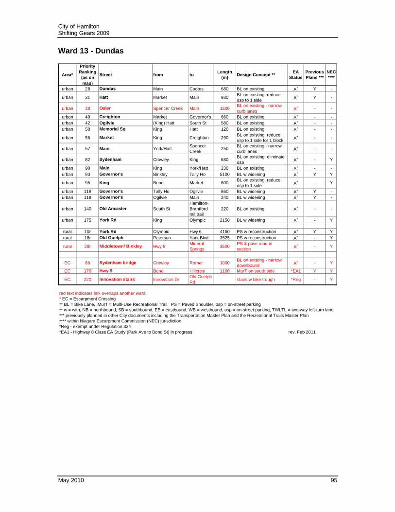
5.1.13 Ward 13 – Dundas
* Scale unspecified.
28r
93
95
10r
40
175
56 42 57
18r
28 38
118 31
82
140 119
90 50
220
176
86
City of Hamilton Shifting Gears 2009
May 2010 95
Ward 13 - Dundas
Area*
Priority Ranking (as on map)
Street from toLength
(m)Design Concept **
EA Status
Previous Plans ***
NEC ****
urban 28 Dundas Main Cootes 680 BL on existing A+ Y -
urban 31 Hatt Market Main 930 BL on existing, reduce osp to 1 side A+ Y -
urban 38 Osler Spencer Creek Main 1500BL on existing - narrow curb lanes A+ - -
urban 40 Creighton Market Governor's 660 BL on existing A+ - -urban 42 Ogilvie (King) Hatt South St 580 BL on existing A+ - -urban 50 Memorial Sq King Hatt 120 BL on existing A+ - -
urban 56 Market King Creighton 290BL on existing, reduce osp to 1 side for 1 block A+ - -
urban 57 Main York/Hatt Spencer Creek
250 BL on existing - narrow curb lanes A+ - -
urban 82 Sydenham Crowley King 680BL on existing, eliminate osp A+ - Y
urban 90 Main King York/Hatt 230 BL on existing A+ - -urban 93 Governor's Binkley Tally Ho 5100 BL w widening A+ Y Y
urban 95 King Bond Market 800 BL on existing, reduce osp to 1 side A+ - Y
urban 118 Governor's Tally Ho Ogilvie 860 BL w widening A+ Y -urban 119 Governor's Ogilvie Main 240 BL w widening A+ Y -
urban 140 Old Ancaster South StHamilton-Brantford rail trail
220 BL on existing A+ - -
urban 175 York Rd King Olympic 2150 BL w widening A+ - Y
rural 10r York Rd Olympic Hwy 6 4150 PS w reconstruction A+ Y Yrural 18r Old Guelph Paterson York Blvd 3525 PS w reconstruction A+ - Y
rural 28r Middletown/ Binkley Hwy 8Mineral Springs 3500
PS & pave road in section A+ - Y
EC 86 Sydenham bridge Crowley Romar 1000BL on existing - narrow downbound A+ - Y
EC 176 Hwy 8 Bond Hillcrest 1100 MurT on south side *EA1 Y Y
EC 220 Innovation stairs Innovation DrOld Guelph Rd stairs w bike trough *Reg - Y
red text indicates link overlaps another ward* EC = Escarpment Crossing** BL = Bike Lane, MurT = Multi-Use Recreational Trail, PS = Paved Shoulder, osp = on-street parking** w = with, NB = northbound, SB = southbound, EB = eastbound, WB = westbound, osp = on-street parking, TWLTL = two-way left-turn lane*** previously planned in other City documents including the Transportation Master Plan and the Recreational Trails Master Plan**** within Niagara Escarpment Commission (NEC) jurisdiction*Reg - exempt under Regulation 334*EA1 - Highway 8 Class EA Study (Park Ave to Bond St) in progress rev. Feb 2011

City of Hamilton Shifting Gears 2009
May 2010 96
5.1.14 Ward 14 – Flamborough - Wentworth
39r
6r
179
28r
29r
183
25r
44r
37r
51
48r
13r14r
15r 20r
162
164
47r
176
Safari Rd
Woodhill
Rd
Jerseyvil
le Rd
Brock Rd
Hwy 8
Hwy 6
Governor’s Rd
39r
6r
179
28r
29r
183
25r
44r
37r
51
48r
13r14r
15r 20r
162
164
47r
176
Safari Rd
Woodhill
Rd
Jerseyvil
le Rd
Brock Rd
Hwy 8
Hwy 6
Governor’s Rd
* Scale unspecified.

City of Hamilton Shifting Gears 2009
May 2010 97
Ward 14 – Flamborough - Wentworth
Area*
Priority Ranking (as on map)
Street from toLength
(m)Design Concept **
EA Status
Previous Plans ***
NEC ****
urban 51 Jerseyville Shaver Wilson 2850 BL w reconstruction A+ - Yurban 162 Hwy 8 Brock Hillcrest 600 BL w reconstruction A+ Y Y
urban 164 Freelton Rd Hwy 6 Brock to Hwy 6
1600 BL w widening A+ - -
urban 179 Hwy 8 Middletown Brock 3800 BL w widening A+ - Yurban 183 Shaver Jerseyville Wilson 1500 BL w development A+ - -
rural 6r Edgewood Safari Hwy 6 900 shared on-street - signed A+ - -
rural 13r Safari Waterloo Region
Edgewood 19700 PS widen asphalt A+ - -
rural 14r Brock Freelton Rd Hwy 5 12600 PS widen asphalt A+ Y -rural 15r Brock Hwy 5 Hwy 8 2120 PS widen asphalt A+ Y Yrural 20r Harvest Brock Sydenham 3280 PS widen asphalt A+ - Y
rural 25r Jerseyville Brant border Paddy Green
10175 PS widen asphalt A+ - Y
rural 28r Middletown/ Binkley Hwy 8 Mineral Springs
3500 PS & pave road in section A+ - Y
rural 29r Mineral Springs Binkley Sulphur Springs
2250 PS widen asphalt A+ - Y
rural 37r Foreman/Kirkwall/Woodhill/Field all 23000 PS widen asphalt A+ - -rural 39r Governor's Woodhill Binkley 7100 PS widen asphalt A+ - Yrural 44r Sunny Ridge Jerseyville Hwy 403 1200 PS widen asphalt A+ - -rural 47r Hwy 6 Edgewood Carlisle Rd 600 MurT 4.0m pave TBD - -
rural 48r Hwy 8 Cambridge Middletown 18000 MurT 4.0m pave TBD - Y
EC 176 Hwy 8 Bond Hillcrest 1100 MurT on S side *EA1 Y Y
red text indicates link overlaps another ward* EC = Escarpment Crossing** BL = Bike Lane, MurT = Multi-Use Recreational Trail, PS = Paved Shoulder, osp = on-street parking** w = with, NB = northbound, SB = southbound, EB = eastbound, WB = westbound, osp = on-street parking, TWLTL = two-way left-turn lane*** previously planned in other City documents including the Transportation Master Plan and the Recreational Trails Master Plan**** within Niagara Escarpment Commission (NEC) jurisdiction*EA1 - Highway 8 Class EA Study (Park Ave to Bond St) in progress rev. Feb 2011

City of Hamilton Shifting Gears 2009
May 2010 98
5.1.15 Ward 15 – East Flamborough - Waterdown
49r
3r
36r
11r
47r
34r44
26r
5r
17r
4r
21r
1r
20r
30r
171
139
112154
216
156
124
160
86
220
204
177
Conc
11E
Centre Rd
Hwy 6
Carlis
le Rd
Conc
6E
Park
side
Dr
Hwy
5
49r
3r
36r
11r
47r
34r44
26r
5r
17r
4r
21r
1r
20r
30r
171
139
112154
216
156
124
160
86
220
204
177
Conc
11E
Centre Rd
Hwy 6
Carlis
le Rd
Conc
6E
Park
side
Dr
Hwy
5
* Scale unspecified.

City of Hamilton Shifting Gears 2009
May 2010 99
Ward 15 – East Flamborough - Waterdown
Area*
Priority Ranking (as on map)
Street from toLength
(m)Design Concept **
EA Status
Previous Plans ***
NEC ****
urban 44 Mountain Brow Rd Mill Arterial A 1200 MurT w development *EA1 - Yurban 112 Hwy 5/Dundas St Hwy 6 Hamilton St 2750 BL on existing A+ - Yurban 124 Mill Parkside Hwy 5 950 BL on existing A+ - Y
urban 139 Hamilton St Centre/MainHwy 5/ Dundas 1000 BL reduce TWLTL A+ - Y
urban 154 Parkside Hwy 6 Robson/ bypass
6010 BL w widening A+ Y Y
urban 156 Hwy 5/Dundas St Hamilton St Burlington border
3290 BL w reconstruction A+ - Y
urban 160 Main Hwy 5Thomson/ Burlington border
1030 BL w widening A+ Y Y
urban 171 Arterial A Hwy 5 Mtn Brow Rd
850 BL w development A+ - Y
urban 216 Waterdown bypass Parkside Hwy 5 900 MurT w development *EA2 - Y
rural 1r Centre Concession 8 E Concession 7 E
1800 PS widen asphalt A+ Y -
rural 3r Centre Carlisle Rd Progreston 775 PS widen asphalt A+ Y -
rural 4r Centre Grinstone RiverConcession 5 E 450 PS widen asphalt A+ Y -
rural 5r Centre Puslinch Townline
Carlisle Rd 9450 PS widen asphalt A+ - -
rural 11r Carlisle Rd Hwy 6 Burlington border
5850 PS widen asphalt A+ - Y
rural 17r Millgrove Hwy 6 Hwy 5 4400 PS widen asphalt A+ - -rural 20r Harvest Brock Sydenham 3280 PS widen asphalt A+ - -
rural 21r Sydenham Hwy 5Sydenham bridge (Romar)
2830 PS widen asphalt A+ - Y
rural 26r Concession 4 W Millgrove Sdrd Hwy 6 1775 PS widen asphalt A+ - -
rural 30r Puslinch Townline (Maddaugh) Victoria
Centre 400 PS widen asphalt A+ - -
rural 34r Concession 6 E Hwy 6 Centre Rd 2750 PS widen asphalt A+ - -rural 36r Concession 11 E Hwy 6 Centre Rd 2600 PS widen asphalt A+ - -rural 47r Hwy 6 Edgewood Carlisle Rd 600 MurT 4.0m pave TBD - -rural 49r Hwy 5/Dundas St Sydenham Hwy 6 3010 PS widen asphalt A+ - Y
EC 86 Sydenham bridge Crowley Romar 1000 BL on existing - narrow downbound A+ - Y
EC 177 Mill St/ Waterdown Rd Hwy 5Burlington border
875 BL w widening A+ - Y
EC 204 Thomson/ Snake Rd Main Burlington border
100 BL w widening A+ - Y
EC 220 Innovation stairs Innovation DrOld Guelph Rd stairs w bike trough *Reg - Y
red text indicates link overlaps another ward* EC = Escarpment Crossing** BL = Bike Lane, MurT = Multi-Use Recreational Trail, PS = Paved Shoulder, osp = on-street parking** w = with, NB = northbound, SB = southbound, EB = eastbound, WB = westbound, osp = on-street parking, TWLTL = two-way left-turn lane*** previously planned in other City documents including the Transportation Master Plan and the Recreational Trails Master Plan**** within Niagara Escarpment Commission (NEC) jurisdiction*Reg - exempt under Regulation 334*EA1 - Waterdown North-South Road Class EA in progress*EA2 - Waterdown East-West Road Class EA in progress rev. Feb 2011