2017 pavement management report - eugene, or
TRANSCRIPT

2017 PAVEMENT MANAGEMENT REPORT An Update on Asphalt Pavement Conditions and Programs (2016 Rating & Inventory Data)
Prepared by: Public Works Maintenance
Surface Technical Team 1820 Roosevelt Blvd.
Eugene, OR 97402

Cover Photos (top left – clockwise): GO BONDS, Trolley Rails in Willamette Street, Fox Hollow
after Enhanced Street Repair Program, Durability Cracking in Concrete

3
EXECUTIVE SUMMARY
The annual Pavement Management Report is produced to update information and data regarding the
City of Eugene’s transportation system including improved streets, unimproved streets and off-
street shared-use paths. This report provides surface descriptions and associated mileage, reviews
current treatment programs and costs, and projects future treatment needs based on several funding
scenarios.
The transportation system is a significant public asset. This asset is typically described in lane miles
and/or centerline miles. Currently, Public Works manages 1356 lane miles (543 centerline miles) of
streets, and approximately 45 centerline miles of off-street shared-use paths within the City limits.
This report includes a breakdown of the street transportation system in terms of pavement type,
level of improvement, and functional classification.
Street (and off-street shared-use paths) conditions data are collected by Public Works Maintenance
staff through on-site inspections. Pavement distress information is collected and a Pavement
Condition Index (PCI) score is generated. Formulas and methodology within MicroPaver helps
establish efficient treatment requirements and identify financial implications of various response
strategies. The Pavement Management System (PMS) also provides a detailed street inventory and
condition trends using street condition data collected since 1987.
The City established a local gas tax in 2003 for a Pavement Preservation Program (PPP) due to the
fact that street repair funding was not at a level to keep pace with rehabilitation needs. In 2007, it
was reported that the anticipated backlog for rehabilitation needs would reach more than $282
million by 2016 (2007 Pavement Management Report). In 2008, a $35.9 million, five-year bond
measure was approved by voters and another five-year bond for $43 million was approved by voters
in 2012. Between these funding sources more than 126 streets in Eugene are identified to be
repaired by 2018. The revenues from the local gas tax and the bond measures have helped reduce
the backlog of street repair projects over the last 13 years. However, the City’s current backlog is
increasing financially due to new construction costs provided by Engineering Division as referenced
in the table on page 13. Based on the 2015 ratings and reported in the 2016 Pavement Management
Report the calculated backlog of repairs on improved asphalt streets was $79 million; as of the end
of 2016 the current backlog has been calculated to be $92 million.
In addition to funding from the current street repair bond ending in 2018 and new rising
constructions costs, other factors have contributed to the current and future backlogs:
Since the beginning of the Pavement Preservation Program 2002, arterial and collector
streets were the primary focus for preservation. Theses streets now are showing signs of
deterioration beyond crack sealing and standard maintenance practices.
According to the Construction Costs Forecast (ODOT, October 2012) costs will continue to
increase at a steadier rate rather than with the volatility of recent years. Changes in costs for
construction materials and labor will affect long-term backlog estimates.
New construction techniques such as in-place recycling (also known as in-place cement
treated base) which strengthens existing roadbed materials for reuse and lowers impacts to
the environment have been successfully used in place of conventional reconstruction
techniques resulting in additional cost savings.

4
EXECUTIVE SUMMARY – (continued)
Even though the backlog figure increases money-wise in 2016, the projected needed treatments for
Arterials and Collectors beyond 2018 remain relatively steady. A significant impact to the
increasing backlog is the declining condition of residential streets. The increase indicates that the
local gas tax alone is insufficient to stabilize the backlog long term. It is also important to note that
the backlog estimate is limited to improved asphalt streets. It does not take into account the repair
needs for concrete streets, unimproved streets, sidewalks, off-street shared-used paths, or other
elements of the transportation system.
The 2017 report uses three funding scenarios to project treatment needs and costs over a 10-year
period. The analyses for all three scenarios use costs updated by Engineering in 2016 and are
adjusted to include a 2% inflation factor. The last two scenarios, preventing the street system from
falling into reconstructs and treating those that are at a reconstruct treatment signify the progress
made because of bond measure funding for the pavement preservation program. Following is a
summary of the analyses:
Based on the projected funding (see table pg. 17), a $200 million backlog is projected in
10 years. Last year the projected backlog was $186 million in 10 years. The current street
repair bond measure will end in 2019 decreasing pavement preservation from an average of
$11.3 million to $3.3 million unless additional funding is approved.
A funding level of $9.2 million annually is needed to prevent arterial and collector streets
from falling into the reconstruct range and eliminate the reconstruct backlog for arterial
and collector streets in 10 years.
A funding level to $14.6 million annually is needed to prevent any street from falling into
the reconstruct range and eliminate the total reconstruct backlog in 10 years. Residential
streets account for approximately 66% (lane miles) of the system and over half of the current
backlog is for the treatment of these streets.

5
SCOPE OF THIS REPORT
This report is made up of four primary sections:
Street Inventory: The street inventory is discussed including improvement status and functional
classification definitions.
Pavement Management System (PMS): A brief history and description of the Pavement
Management System used by the City, the selection process and conversion to MicroPaver
system is discussed. Included in this section are the rating methodology, pavement inspection
frequency, pavement conditions described by the Pavement Condition Index (PCI), specific
distress definitions and the resulting reports.
Pavement Preservation Program (PPP): The Pavement Preservation Program is highlighted in
this report, including Maintenance and Engineering Division roles, treatment types and
estimated unit costs, project prioritization, sustainable construction, current treatment costs,
projected funding, historical and projected funding graphs, unimproved streets, and off-street
shared-use paths.
Projects: This section includes completed and future project lists and maps, including a list and
map of the projects identified in the 2012 bond measure.
EUGENE’S STREET INVENTORY
The City of Eugene has jurisdictional responsibility for many different types and classifications of
transportation facilities. Many factors such as age, development type, traffic loads, use, and future
transportation needs affect the maintenance and rehabilitation planning for the system. The segment
inventory component of the PMS allows a reporting of both centerline miles (intersection to
intersection) and lane miles of each segment of the system. While commonly used in reporting
distance, centerline miles do not relate equally across streets of different widths or different number
of lanes. For this report, comparisons typically are shown both in centerline and 12 foot-wide lane
miles unless otherwise noted.
Improvement Status
For purposes of establishing budget allocations and rehabilitation priorities, and performing
maintenance activities based on established maintenance policies, the City of Eugene divides the
street inventory into two distinct categories:
Improved streets are those which have been fully designed for structural adequacy, have storm
drainage facilities provided which include curbs and gutters, and have either an asphalt concrete
(AC) or a Portland cement concrete (PCC) surface. Typically, these streets were either fully
improved when the area was developed and paid for by the developer, or were improved through a
local improvement district (LID) and paid for in part by the abutting property owners. In some cases
a street may have been fully improved while under state or county jurisdiction and then surrendered
to the City. Improved streets receive the highest level of ongoing maintenance and are eligible for
rehabilitation funding through Eugene's Capital Improvement Program (CIP) and Pavement
Preservation Program (PPP).

6
Unimproved streets are those with soil, gravel, or asphalt mat surfaces that have typically evolved to
their existing state, have not been structurally designed, and have few if any, drainage facilities and
no curbs or gutters. Typically, an unimproved street must be fully improved through a local
improvement district, funded in part by the abutting property owners before a higher level of service
will be provided (see “City of Eugene Street Maintenance Policy and Procedure Manual” for levels of
maintenance service). Unimproved streets receive a low level of ongoing maintenance limited
primarily to emergency pothole patching (three inches or greater in depth) and minimal roadside
ditch maintenance. To address the growing number of potholes on City streets, the City Council
augmented the street repair budget with General Fund allocations for a total of $2.35 million from FY
2009 through FY 2011. Subsequently, Public Works has allocated $200,000 per year from Road Fund
for enhanced street repairs. The Maintenance Division has addressed potholes by either filling
individual potholes or by performing maintenance overlays over entire street segments. During the
past eight years more than 100 unimproved streets, representing more than 31 lane miles, have been
resurfaced as a temporary treatment. In addition, several unimproved streets have been brought up to
full urban street standards through assessment projects, attributable in part to more flexible design
standards.
The following tables categorize Eugene’s Improved and Unimproved Street System in Centerline
Miles and 12-foot Lane Miles by Pavement Type and by Functional Class.
Miles 12' Lane Miles 12' Lane Miles 12' Lane Miles 12' Lane Miles 12' Lane Miles 12' Lane
Miles Miles Miles Miles Miles Miles
13.97 64.39 0.03 0.16 0.51 2.26 0 0 0 0 14.51 66.81
63.19 213.59 2.27 7.51 3.56 11.92 0 0 0 0 69.02 233.02
30.21 92.81 1.15 2.72 3.1 8.38 0 0 0 0 34.46 103.91
23.86 61.83 0.45 1.23 1.58 4.35 0 0 0 0 25.89 67.41
309.6 716.41 1.79 4.89 21.37 54.47 0 0 0 0 332.76 775.77
440.83 1149.03 5.69 16.51 30.12 81.38 0 0 0 0 476.64 1246.92
Miles 12' Lane Miles 12' Lane Miles 12' Lane Miles 12' Lane Miles 12' Lane Miles 12' Lane
Miles Miles Miles Miles Miles Miles
0 0 0 0 0 0 0 0 0 0 0 0
1.69 3.15 0 0 0 0 0 0 0 0 1.69 3.15
3.25 7.34 0 0 0 0 0 0 0 0 3.25 7.34
4.13 8.31 0 0 0 0 0 0 0 0 4.13 8.31
39.1 64.82 4.27 6.45 0.03 0.03 8.95 13 4.69 5.91 57.04 90.21
48.17 83.62 4.27 6.45 0.03 0.03 8.95 13 4.69 5.91 66.11 109.01
Residential
Total
Undeveloped Total
Major Arterial
Minor Arterial
Major Collector
Neighborhood Collector
Total
UNIMPROVED
SYSTEM
Asphalt (ACP)Bituminous Surface
(BST)Concrete (PCC) Gravel
Total
Major Arterial
Minor Arterial
Major Collector
Neighborhood Collector
Residential
IMPROVED
SYSTEM
Asphalt (ACP)Asphalt over
Concrete (APC)Concrete (PCC) Gravel Undeveloped

7
Functional Classifications
The quantity and associated vehicle weight of traffic using streets is a critical factor affecting the rate
at which pavement and roadbeds deteriorate. Eugene divides streets into five categories called
functional classifications (FC), each representing a different volume and type of vehicular usage.
The MicroPaver terminology for functional classification/section rank is identified as follows:
Major Arterial (FC-1) - (A): Major Arterials are usually four or more lanes and generally connect
various parts of the region with one another within the city and with the “outside world”. They serve
as major access routes to regional destinations such as downtowns, universities, airports, and similar
major focal points within the urban area. Major Arterials typically carry an average of more than
20,000 vehicles per day. Major Arterials receive high priority maintenance.
Minor Arterial (FC 2) - (B): Minor Arterials are typically two or three lanes. These streets provide
the next level of urban connectivity below major arterials. In most cases their main role tends to be
serving intra-city mobility. Minor Arterials carry between 7,500 and 20,000 vehicles per day. Minor
Arterials receive priority maintenance.
Major Collector (FC-3) - (C): Major Collectors can be found in residential, commercial, and
industrial areas. They typically carry between 2,500 and 7,500 vehicles per day. Major Collectors
have a higher priority for maintenance than local streets.
Neighborhood Collector (FC-4) - (D): Neighborhood Collectors are found only in residential
neighborhoods and provide a high degree of access to individual properties in a neighborhood. They
typically carry between 1,500 and 2,500 vehicles per day.
Local (FC-5 - (E): Local streets provide access to individual properties along the roadway. They are
narrow, slow-speed, and low-volume service facilities. They typically carry fewer than 1,500 vehicles
per day, and receive low priority maintenance. Local streets are also referred to as Residential streets.
The following graph illustrates both centerline miles and lane miles by improvement type and
functional classes.
0
100
200
300
400
500
600
700
800
900
1000
1100
1200
1300
Major Arterial Minor Arterial Major Colls. Neigh. Colls. Local Total
Improved 12' lane miles 67 233 104 67 776 1247
Unimproved 12' lane miles 0 3 7 8 90 109
Improved centerline miles 15 69 34 26 333 477
Unimproved centerline miles 0 2 3 4 57 66
Mileage by Functional Class - Improved and Unimproved

8
PAVEMENT MANAGEMENT SYSTEM
A Pavement Management System (PMS) performs analysis of collected rating data and reports
on the current and projected conditions of the street system. In addition, it is used to evaluate the
effectiveness of planning and funding priorities, and provides guidance in the decision making
process. The goal of the decision making process is to prevent pavement failures through
judicious maintenance.
City of Eugene implemented MicroPaver in 2013. MicroPaver combines visual field inspection
ratings, compiled under strict criteria, with computer tracking and condition analysis. Beginning
in 2010 the rating methodology was revised to the WDOT’s Extended (WSEXT) method,
collection of deterioration values by area, lineal footage thus keeping the program consistent
with industry standards. This also allowed for smoother transition to MicroPaver with the ability
to migrate three years of rating data with some modifications. With this migrated condition data,
rating the entire asphalt street system the last three years plus construction history we are able to
perform an analysis with rational accuracy to report financial needs and road conditions. There
will be some variation in the outcomes of the analysis due to slight differences in rating and
calculation methodology but overall the data is consistent.
Pavement Inspection Frequency
Two predominant work efforts required to maintain the PMS are updating the street inventory
and performing the annual inspection of surface conditions.
City streets are divided into segments based on their Functional Classification (FC), pavement
type, and geometric design. Segments are the basic unit for evaluating streets and surface
conditions. A segment is defined as a portion of a street with a beginning and ending description.
Changes in geometric features are used as a guide for determining segments. Examples of
geometric differences are surface type, segment width, surface age, and extent of past
rehabilitations.
Field inspections are conducted by pavement raters who walk each individual street segment
evaluating the pavement surface for signs of distress. City arterial and collector streets are
inspected annually; residential streets inspections are completed in a three-year cycle; and off-
street shared-use path inspections are completed in a two-year cycle.
Staff performed inspections on the entire street system using MicroPaver for the first three years
after implementation 2013-2015. Inspection data was evaluated for accuracy with the assistance
from an outside consultant in 2014. It was determined that three years of street inspection
provided an accurate baseline in MicroPaver for analysis. In 2015 staff completed inspections of
shared-use paths. In 2016, staff returned to the standard inspection cycle inspecting arterial and
collector streets plus two residential areas, South Hills and Coburg. Staff managed to inspect all
concrete residential streets as well as alleys.

9
Pavement Condition Index (PCI), Deduct Values, and Distresses
Pavement distresses are dependent on pavement type and are rated by severity and extent.
MicroPaver provides a numerical value calculated internally based on deduct values for the
distresses rated per street segment. MicroPaver defines this value as Pavement Condition Index
(PCI) which will be the term used throughout this report.
A street with a PCI of 100 represents a new or recently rehabilitated street. This PCI value is the
basis used to analyze the surface treatment needs. Distress data are collected using ACER
Tablets and then uploaded to the pavement management software. MicroPaver method rates
severities and all their extents for up to 20 different distresses. As the condition of a streets’
surface begins to deteriorate, the PCI decreases. Asphalt distresses typically observed are
alligatoring, longitudinal and transverse cracks, rutting, and raveling. Distresses in concrete
streets typically observed and rated include cracks per panel, raveling, joint spalling, faulting,
and crack sealing. Descriptions of some common distresses are shown below:
Alligator Cracking: When the asphalt begins to crack in all direction it is called alligator
cracking.
Longitudinal Cracking/Transverse Cracking: These are cracks that run parallel to the
roadway centerline (longitudinal) and perpendicular to the roadway center line
(transverse). These distresses usually divide the piece into different sections and which
are caused by repeated traffic loading. The low-severity cracks are not considered serious
to the overall function and safety of the road. Medium to high-severity cracks are usually
caused by heavy traffic loads and environmental factors and can become very serious
distresses. The picture below shows longitudinal cracking.

10
Rutting: When the traffic of the street becomes heavy for long periods of times the
asphalt begins to sink into the wheel path of the vehicles causing a rut. When there is a
rut it is usually a long length of the road and is 1 to 2 feet wide and there are almost
always two ruts, one for each wheel path of the vehicle. The severity of the rut is rated
on the average rut depth from ¼” – over ¾” in depth.
Joint Spalling: Spalling is the deterioration of the edges of a concrete slab within 2 feet
(0.6m) of the joint. The edges get chipped off concrete slabs causing spalling. Spalling is
caused by heavy traffic loads and environmental factors.
Raveling: The roads, mainly asphalt, over time become worn out and rough not smooth
as when they were first put in, often due to age and the effects of UV rays. Raveling
measures the severity of the roughness and coarseness of the top layer of the street.

11
Faulting: Faulting is the difference in elevation across the slab. One side may be leaning
up more over the other side. Causes are soft foundations, heavy traffic, poor construction,
and environmental damage.
How Pavement Management System Information is Used
The primary purpose of maintaining a PMS is to collect and analyze information relating to
street system condition and deterioration trends. With this vital information Public Works
managers ensure the most cost-effective maintenance or rehabilitation strategies are identified
and performed at the optimum time.
Each year the PMS is used to generate several reports requested by other agencies as well as
statistical data requested within our own agency. The following is a sample of reports produced
with PMS data:
Pavement Preservation Project List
Crack Seal Program
Five-Year Surface List – five-year moratorium for street cutting
ODOT Oregon Mileage Report
City of Eugene Public Infrastructure Table
Annual Insurance Marketing Report
Transportation Service Profile

12
PAVEMENT PRESERVATION PROGRAM
Street preservation and rehabilitation, capital improvements, off-street shared-use path projects,
and maintenance efforts make up Eugene’s Pavement Preservation Program (PPP). Additionally,
the City has budgeted funding for Maintenance Operations to repair portions of the unimproved
street system through the Enhanced Street Repair Program. Both PW Maintenance and PW
Engineering have important roles within the PPP.
PW Maintenance Roles
Maintenance Division Surface Technical team completes the pavement rating, budget and street
life analysis, resulting in a proposed list of projects which is forwarded to Engineering for field
testing and final grouping. Surface Technical staff is responsible for producing this report.
Operations staff is responsible for the preventative maintenance of all City streets (including
concrete streets) and off-street shared-use paths. Preventative maintenance designed to extend
the life of the transportation asset is of highest priority. Fully improved asphalt streets receive the
highest level of maintenance. Maintenance activities are performed to mitigate hazardous
conditions and to extend the useful life of the street. The goal of preventative maintenance is to
prevent a street’s PCI from slipping from preventative maintenance or minor rehabilitation into a
reconstruction category.
PW Engineering Roles
The Engineering Division typically receives projects proposed for preservation from the
Maintenance Division three years in advance of the planned construction. Engineering then
performs field investigations to confirm the need for treatment, and reviews historic data on
construction and maintenance of the streets. Streets are then prioritized for detailed pavement
testing and design recommendations based on the available funding and the assessed condition of
the streets. The pavement testing and design reports identify whether a street needs to be
reconstructed or rehabilitated (overlaid) and the range of treatment options available. If a street is
determined to be a full reconstruct, it is typically deferred until funding is identified and
available, such as street repair bond measures.
The Engineering Division is responsible for capital project management including design,
stakeholder coordination and communication, contract administration, and construction
management. For analysis and reporting of projected backlogs, the Engineering Division has
provided construction costs based on historic and current road projects.

13
Treatment Types and Estimated Costs
For the purpose of reporting projected backlogs the Engineering Division provides construction
costs based on historic and present road projects. Treatments reflected in the backlog analysis are
limited to three types; slurry seal, overlay, and reconstruction and reporting is based on a system
wide approach, not at the project level performed by Engineering. Each functional class has an
estimated unit cost for overlay and reconstruction treatments. For local streets (FC-5) an
additional maintenance option, slurry seal, is considered.
Slurry Seal: The slurry seal option allows for a cost-effective treatment to seal the surface
and restore the skid resistance of local street segments, which do not carry high traffic loads.
This treatment is not used on streets which require strengthening or reconstruction. Typical
slurry seal costs include street cleaning, removal of vegetation, minor base repairs (dig-outs),
sealing of cracks, and application of an emulsified asphalt aggregate mixture to the entire
paved surface. Associated costs include replacement of striping and pavement markings, and
other work needed to return the street to normal operation.
Overlay: Typical overlay rehabilitation costs include milling of existing pavement to a
moderate depth to remove existing cracking and increase strength of the structural section.
Isolated areas of severely distressed pavement are removed and replaced including a new
aggregate base. Associated costs include replacement of striping and pavement markings,
adjustment of manholes, and other work needed to return the street to normal operation.
Reconstruct: Typical street reconstruction costs include removal of the existing pavement
and base structural section and replacement with a new structural section which will meet a
20-year design life. Isolated areas of curb and gutter are replaced where they would not be
suitable to contain new paving or have severe drainage problems.
The following table identifies the estimated costs for the various treatment types including costs
to upgrade curb ramps to comply with The American with Disabilities Act (ADA). The slurry
seal treatment is exempt from ADA requirements.
Treatment – Functional Class
Improved System
Re-Const - FC 5 $505,000 $505,000 $649,000.00
Slurry Seal - FC 5 $19,000 $25,000 $44,000.00
Re-Const - FC 1 & 2 $765,000 $724,000 $892,000.00
Re-Const - FC 3 & 4 $677,000 $679,000 $884,000.00
Overlay - FC 3 & 4 $184,000 $214,000 $311,000.00
Overlay - FC 5 $169,000 $195,000 $255,000.00
12’ Lane Mile Cost
Updated Eng.
2011 cost
Updated Eng.
2016 cost
Overlay - FC 1 & 2 $215,000 $243,000 $336,000.00
Updated Eng.
2006 cost

14
The following graph identifies the trigger points (PCI) for each treatment based on Functional
Class.
Project Prioritization
Selecting streets or street segments for treatment is done through a process involving analysis,
testing, and staff experience. Using the data produced by MicroPaver, and combining this
information with estimated revenues allows staff to approximate backlogs and group potential
street segments for consideration for treatment under the Pavement Preservation Program.
Streets are not prioritized on a “worst first” basis. Public Works’ main objective is to keep street
segments from slipping into the reconstruction category, which typically costs four to five times
more per lane mile than rehabilitation. By rehabilitating (overlaying) a street before it
significantly deteriorates, 15 to 20 years of useful life can be added to a street at a substantial
cost savings over reconstruction. Once a street has deteriorated to the point that it must be
reconstructed, the opportunity for preventive street maintenance (overlay) is lost. For these
reasons, streets that are categorized as overlay projects receive the highest priority for corrective
treatment. If at some point in the future there are additional funds available, or if the majority of
overlay projects have been addressed, reconstruction projects will be scheduled.
A prioritized list of 32 street repair projects to be funded by a local bond measure was approved
by Eugene voters in 2008. The list, approved by City Council, was developed by staff based on
citizen input, information about needed street rehabilitation and reconstruction from the
pavement management system, and equitable geographic distribution of projects throughout the

15
community. Subsequently, a 12 member Street Repair Review Panel (SRRP) was formed to
document the use of the bond proceeds. In 2011, City Council approved the addition of 22 streets
selected in the same manner and recommended by the citizen review panel to be repaired.
In 2012, a second five-year bond measure was approved by Eugene voters with a prioritized list
of 76 street repair projects (Exhibit A) and additional funding to support bicycle and pedestrian
improvement projects. The list was developed using the same criteria as above and approved by
City Council.
Sustainable Construction
Since 2008, Eugene has been in the forefront of sustainable construction and paving practices,
some of which include paving with warm mix asphalt (WMA), using reclaimed asphalt
pavement (RAP), and full depth reclamation (FDR). Production of warm mix asphalt is a “green”
solution for the environment with noticeable reduced energy consumption and greenhouse gas
emissions. Exposure to fuel emissions, fumes, and odors are reduced for asphalt producers,
construction workers and the public. Benefits of paving with WMA are the ability to extend the
paving season in colder weather, longer haul distances, and better road performance. Warm mix
asphalt is identical to conventional hot mix asphalt, except that through a special mixing process
it is produced at a temperature approximately 50 to 100 degrees cooler than conventional hot mix
asphalt. This mixing process for asphalt aids in compaction during paving, assists in preventing
premature aging and slowing the aging process of asphalt. In Eugene, all asphalt producers have
retrofitted their plants to produce warm mix asphalt.
Council set goals in 2011 for waste reduction by requiring that the quantity of materials placed in
landfills be reduced. In addition to using WMA, Public Works conducted two pilot projects
specifying that reclaimed asphalt shingles (RAS) be used as a binder in the asphalt mix, thereby
keeping this material from entering the waste stream. The City continues to use warm mix
asphalt and in-place recycling techniques to improve the quality, environmental footprint, and
cost efficiency of the street bond projects. Key terms in sustainable construction practices:
In-Place Recycling: A process in which a large piece of equipment called a reclaimer
pulverizes and mixes the existing base rock and a portion of subgrade soils with dry cement
and water to create a cement-treated base. This process greatly reduces the use of virgin
materials and trucking that are needed using conventional remove-and-replace construction
techniques.
Full Depth Reclamation: When applicable, partial or full-depth reclamation (FDR) is used as
a cost and time-saving alternative to traditional reconstruction. Associated costs include
replacement of striping and pavement markings, adjustment of manholes, and other work
needed to return the street to normal operation.
Crack Seal: Placing specialized materials into cracks in unique configurations to keep water
and other matter out of the crack and the underlying pavement layers. Crack sealing can be
used for two different reasons in pavement maintenance. One is a treatment to seal the cracks
in order to prevent moisture intrusion into the pavement. The other is preparatory work to
other treatments, such as overlays, and slurry seals.

16
Reclaimed Asphalt Pavement (RAP): The term given to removed and/or reprocessed
pavement materials containing asphalt and aggregates. These materials are generated when
asphalt pavements are removed for reconstruction, resurfacing, or to obtain access to buried
utilities. When properly crushed and screened, RAP consists of high-quality, well-graded
aggregates coated by asphalt cement that can be reused as a substitute for a portion of virgin
materials in asphalt and aggregate base.
Recycled Asphalt Shingles (RAS): A primary reason for the high potential value of recycled
shingles is that they contain ingredients that hot mix asphalt (HMA) producers purchase to
enhance their paving mixtures including asphalt cement (or AC “binder”) and mineral aggregate.
Asphalt shingles also contain a fibrous mat made from organic felt (cellulose) or fiberglass that
can also be valuable as fiber in some asphalt paving mixes.
Current Treatment Costs
This chart provides detail of the current cost for treatment of the entire improved system
excluding concrete streets at the end of the 2016 rating period. The total estimated treatment cost
backlog at the end of 2016 is $92 million up from $79 million reported in 2015.
Major Art Minor Art Coll Neigh. Coll Local Total
Slurry $0 $0 $0 $0 $8,902,000 $8,902,000
Overlay $2,264,000 $5,846,000 $369,000 $1,477,000 $35,149,000 $45,105,000
Reconst $7,834,000 $11,526,000 $8,675,000 $572,000 $9,414,000 $38,021,000
Total $10,098,000 $17,372,000 $9,044,000 $2,049,000 $53,465,000 $92,028,000
$0
$20,000,000
$40,000,000
$60,000,000
$80,000,000
$100,000,000
Treatment Costs By Functional Class 2016 Year End

17
Projected Funding for Pavement Preservation Program FY16 through FY22
From the inception of the Pavement Preservation Program (PPP), Eugene has been faced with
the challenge of securing adequate, sustainable funding for this program. Currently there are
several sources that contribute funding for pavement rehabilitation and reconstruction projects.
The primary source of ongoing revenue is the City’s local motor vehicle fuel tax (“gas tax”),
which is currently levied at 5 cents per gallon. The reimbursement component of Transportation
System Development Charges (SDCs) have historically generated close to $800,000 per year for
PPP projects. In the current economic environment, building permit activity continues to be low,
reducing the level of this funding stream. The cumulative effect of these factors is that PPP
annual revenues, which were once projected at $4.2 million per year, are now projected to level
out at approximately $3.3 million per year
In 2008, voters approved a $35.9 million dollar bond measure dedicated to 32 street preservation
projects and shared-use path rehabilitation work. Based on numerous economic factors
construction bids were significantly less than anticipated allowing 22 streets to be added to the
original 32 streets approved by voters.
In 2012, voters approved a second $43 million bond measure dedicated to 76 street preservation
projects plus $516,000 annually to support bicycle and pedestrian projects. The measure will
generate approximately $8 million annually for FY14 through FY18.
With the funding identified approximately 112 lane miles of City streets and will be repaired. To
date approximately 3 miles of off-street shared-use paths have been repaired.
Projected Funding Sources Pavement Preservation ProjectsFY16 through FY22
Fiscal Year Local Gas Tax SDC Bond Other Total Funding
Note 1 Note 2 Note 3 Note 4
FY16 (actual) $3,050,845 $501,878 $6,934,842 $62,755 $10,550,320
FY17 (est.) $2,880,000 $317,600 $8,290,000 $23,000 $11,510,600
FY18 (est) $3,000,000 $316,300 $8,900,000 $23,000 $12,239,300
FY19 (est) $3,000,000 $316,300 $6,220,000 $23,000 $9,559,300
FY20 (est) $3,000,000 $316,300 $0 $23,000 $3,339,300
FY21 (est) $3,000,000 $316,300 $0 $23,000 $3,339,300
FY22 (est) $3,000,000 $316,300 $0 $23,000 $3,339,300
Notes:
1) Local Motor Vehicle Fuel Tax (gas tax) revenues are assumed at the 5-cent level throughout the forecast period.
2) SDC reimbursement revenue is projected to maintain low level of activity through the forecasted period.
3) November 2008 voters passed a five year bond measure for pavement preservation backlog.
November 2012 voters passed a second five year bond measure starting FY15.
4) "Other" revenue generally includes investment interest, permit fees and other miscellaneous resources.
The estimate year's does not include reimbursements from other agency.

18
Historical and Projected Funding Outcomes
Using the PMS software, an analysis for a 10-year period (2016 through 2026) has been
completed based on the current funding, including the 2012 bond measure. The PMS software
evaluates the deterioration of each segment based on individual PCI ratings. The software then
projects when to apply the necessary treatment at the proper time. When possible, the system
applies a less expensive treatment earlier in the degradation curve to prevent the street from
falling into an overlay or reconstruct range. In the following four graphs this projected
evaluation includes historical data to present a more comprehensive view of the street system.
The graphs show the impact of past and current funding over a 20-year period (2006 to 2026).
Each graph indicates the percentage of streets that fall within a specific treatment range
(reconstruct, overlay and no treatment). Plotting the percentages of streets within a treatment
range over time visually demonstrates the overall condition of streets within that class. This is
useful when deciding how to allocate funds in future years.
Arterial streets have been a major focus of the Pavement Preservation Program since 2002; as a
result the percentage of arterial streets within the reconstruct treatment range steadily declined
and remains stable during the bond periods. This stabilization provided an opportunity for
funding to be allocated towards street preservation and allowing funds to be directed primarily to
the collector system with a small portion dedicated to the residential system. With the local gas
tax the City is able to maintain the Arterial system.

19
Similar to arterial streets, reconstruction and overlay treatment needs have decreased since 2008
as a result of completed and upcoming projects. Analysis indicates a stable collector system with
minimal increase in both overlay and reconstruct treatments. As with the arterial system, once
the bond ends in 2019 it is projected that streets which have previously been treated will begin to
show expected deterioration.

20
Residential (Local) streets make up 62% of the total street system backlog in 10 years. To date
residential streets have not been adequately funded to keep them from deteriorating. The 2012
bond measure identifies approximately 15 centerline miles for repair, less than 5% of the
functional class. The percentage of streets within the overlay treatment range continues to
increase. Looking back, the percentage of residential streets within the no-treatment range has
been dropping and is projected to continue so that by 2026, over 50% of residential streets will
require treatment.

21
This graph of the combined arterial, collector and residential streets reflects the impacts to the
overall street system due to insufficient funding for residential street treatments as well as a
treatment strategy that includes reconstruction and overlay treatment. The percentage of streets
needing “no treatment” declines, while streets requiring a “reconstruct” treatment increases.

22
Concrete Improved Street System
Of the 543 centerline miles of streets 30 centerline miles (81 lane miles) are concrete. In 2015
staff were able to refine concrete street inventory data so condition inspections could be
completed. Unlike asphalt streets, concrete streets require panel counts plus an average width
and length of the panel for the calculation of PCIs. Concrete segments are best evaluated when
defined as a city block. Historical concrete designs for typical city blocks contained 66 panels, 3
columns of panels within a block length, or 33 panels with 2 columns.
Concrete streets like bike paths are built for a life of 50 or more years until complete
reconstruction. Deterioration of concrete streets occur within individual panels with many panels
in a street not requiring repair. Due to these unique factors for concrete streets, analyses which
predict future needs of this system tend to be less accurate then asphalt surfaces. However like
unimproved streets and bike paths we can provide a current condition of this system.
Past repair for these streets were primarily provided by City maintenance crews which consisted
of panel replacements for the worst deteriorated panels. Historical construction data indicate that
60% of concrete streets are over 70 years in age. Based on past maintenance repairs these streets
over time may have had a majority of panels replaced.
With the gas tax and bonds the City has contracted several concrete projects during this funding
period. Approximately 2 miles or 7 lane miles have been repaired, this includes reconstructing
asphalt intersections to a concrete surface for their durability to handle heavy traffic.
0.00%
5.00%
10.00%
15.00%
20.00%
25.00%
Failed Serious Very Poor Poor Fair Satisfactory Good
% Condition of Concrete System by Functional Class 2016
Arterials
Collectors
Locals

23

24
Unimproved Street System
The City’s transportation system consists of 543 centerline miles of improved and unimproved
streets. The unimproved portion of this total includes 52 centerline miles (90 lane miles) of
asphalt and bituminous surface streets. This section of the report is intended to describe the
overall condition of unimproved asphalt streets, potential treatment needs, associated
rehabilitation costs, along with a projected backlog repair cost for addressing this classification
of street. It is important to note that any treatment short of being brought up to full urban street
standards should be considered temporary. The estimated cost to improve this classification to
meet the urban street standards is approximately $60 million. In addition, the following backlog
figure is separate from the improved street backlog figure.
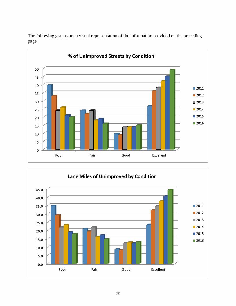
Based on 2016 rating data of the unimproved street system there is a backlog of temporary repair
projects, typically maintenance overlays, totaling an estimated $3.62 million, up from $3.32
million reported in 2015. The increase is due to rising construction costs and deteriorating
conditions. The following charts and graphs indicate that 64 percent of the system falls into a no
treatment category, up from 59 percent reported in 2015, due in large part to recent maintenance
overlay and FDR treatments completed over the past several years. More than 100 unimproved
streets have benefited from full or partial treatment since 2008. Twenty percent of the system
falls into the “poor” category. As funding allows, Public Works Maintenance plans on spending
$200,000 annually to address a portion of these streets.
2016 Unimproved Asphalt Street Condition and Rehabilitation Report
(2016 Rating Data)
PCI Lane Miles
% of System Condition Rehabilitation Cost
Unit Cost/SQFT
*
Treatment **
0-10 1.6 1.80% Poor $312,810 $3.00 FDR
11 20 5.90 6.5% Poor $929,352 $2.50 FDR or
2"HMAC
21-30 10.4 11.5% Poor $984,802 $1.50 1.5"-2" HMAC
31-40 5.0 5.6% Fair $476,535 $1.50 1.5"-2" HMAC
41-50 5.1 5.6% Fair $482,976 $1.50 1.5"-2" HMAC
51-60 1.6 1.8% Fair $151,774 $1.50 1.5"-2" HMAC
61-65 3.1 3.4% Fair $290,289 $1.50 1.5"-2" HMAC
66-70 3.3 3.6% Good $0 $0.00 No Treatment
71-80 3.7 4.1% Good $0 $0.00 No Treatment
81-85 6.1 6.8% Good $0 $0.00 No Treatment
86-90 3.8 4.2% Excellent $0 $0.00 No Treatment
91-100 40.6 45% Excellent $0 $0.00 No Treatment
Total Rehabilitation
$3,628,529
* Unit cost based on recent project costs
** Example treatments. Actual treatment would need further analysis.
90.1 100.00%
25
The following graphs are a visual representation of the information provided on the preceding
page.
0
5
10
15
20
25
30
35
40
45
50
Poor Fair Good Excellent
2011
2012
2013
2014
2015
2016
% of Unimproved Streets by Condition
0.0
5.0
10.0
15.0
20.0
25.0
30.0
35.0
40.0
45.0
Poor Fair Good Excellent
2011
2012
2013
2014
2015
2016
Lane Miles of Unimproved by Condition

26
Off-Street Shared-Use Paths
Shared-use paths are used by a variety of non-motorized users, including pedestrians, cyclists,
skaters, and runners. Shared-use paths are typically wider than an average sidewalk and paved
(asphalt or concrete).
There are approximately 45 miles of shared-use paths within city limits identified by the PWE
Transportation Planning section. In 2015, staff converted 44 miles of shared-used paths and rated
the conditions using MicroPaver. Shared-use path analysis in last years’ report was based on
2011 surveys using the WSEXT rating methodology. With updated information a current
representation of this infrastructure may be shown in the following graphs and charts. An
important note is the increase of shared-use paths in a condition above a 90 PCI, in 2011
approximately 19 miles were in this range and in 2015, 30 miles are in this range.
The City standards for shared-use paths require a concrete structure no less than six inches deep
and 12 feet wide. Paths designed, constructed or reconstructed to current standards are expected
to have a 50 year life.

27
The following graphs show the division of 2015 surface types and widths within the system.
Off-Street Shared-Use Path Surface Type: Off-Street Shared-Use Path Existing Widths:
The following graph shows the path condition in 2015 for the system.
Asphalt36%
Concrete64%
Less Than 12'
35%
12' or Greater
65%
1.003.00
10.00
30.00
0.00
5.00
10.00
15.00
20.00
25.00
30.00
35.00
40.00
45.00
50.00
Miles of Off-Street Shared-Use Paths by Condition(Last rated in 2015)
Poor 0-50 PCI
Fair 51-69 PCI
Good 70-89 PCI
Excellent 90-100 PCI
28
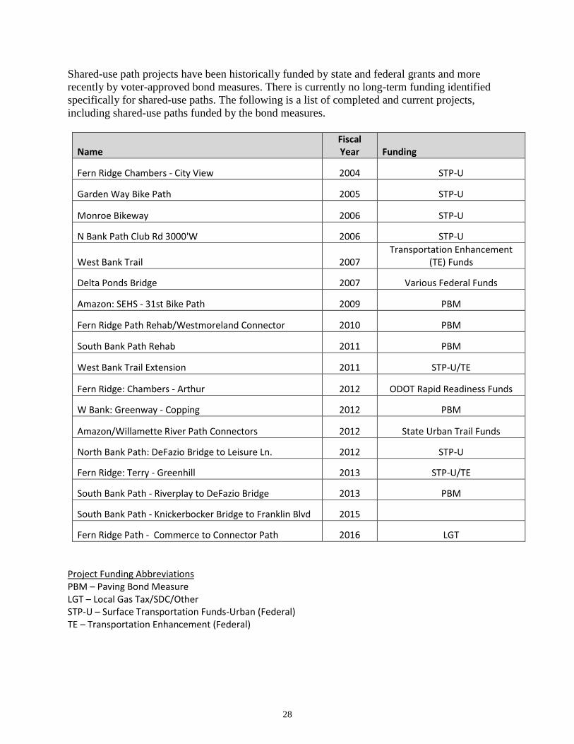
Shared-use path projects have been historically funded by state and federal grants and more
recently by voter-approved bond measures. There is currently no long-term funding identified
specifically for shared-use paths. The following is a list of completed and current projects,
including shared-use paths funded by the bond measures.
Name Fiscal Year Funding
Fern Ridge Chambers - City View 2004 STP-U
Garden Way Bike Path 2005 STP-U
Monroe Bikeway 2006 STP-U
N Bank Path Club Rd 3000'W 2006 STP-U
West Bank Trail 2007 Transportation Enhancement
(TE) Funds
Delta Ponds Bridge 2007 Various Federal Funds
Amazon: SEHS - 31st Bike Path 2009 PBM
Fern Ridge Path Rehab/Westmoreland Connector 2010 PBM
South Bank Path Rehab 2011 PBM
West Bank Trail Extension 2011 STP-U/TE
Fern Ridge: Chambers - Arthur 2012 ODOT Rapid Readiness Funds
W Bank: Greenway - Copping 2012 PBM
Amazon/Willamette River Path Connectors 2012 State Urban Trail Funds
North Bank Path: DeFazio Bridge to Leisure Ln. 2012 STP-U
Fern Ridge: Terry - Greenhill 2013 STP-U/TE
South Bank Path - Riverplay to DeFazio Bridge 2013 PBM
South Bank Path - Knickerbocker Bridge to Franklin Blvd 2015
Fern Ridge Path - Commerce to Connector Path 2016 LGT
Project Funding Abbreviations PBM – Paving Bond Measure LGT – Local Gas Tax/SDC/Other STP-U – Surface Transportation Funds-Urban (Federal) TE – Transportation Enhancement (Federal)

29
Scheduled Street Projects for 2017
2017 Project Name and Limits Lane Miles Funding
1st Ave (Blair to West End) 0.79 PBM
2nd Ave (Blair to Garfield) 1.67 PBM
30th Ave (Overpass @ Spring to Agate) 3.12 PBM
Best Ln (Willakenzie to Kentwood) 0.67 PBM
Calvin St (Western to Harlow) 0.45 PBM
E. Amazon Pkwy (Hilyard to Dillard) 3.10 PBM
Garfield St (Roosevelt to 6th) 2.30 PBM
Ione Ave (Best to Adkins) 0.17 PBM
Jefferson St (8th to 18th) 2.17 PBM
Leigh St (North End to Western) 0.30 PBM
Lydick Wy (Tomahawk to Harlow) 0.37 PBM
Pioneer Ct (Pioneer Pike to North End) 0.18 PBM
Satre St (Bailey to Western) 0.75 PBM
Tomahwak Ln (Harlow to 580’ North) 0.49 PBM
Western Dr (Calvin St to Monroe Middle School) 0.75 PBM
3rd Ave (Washington to Lincoln) 0.48 LGT
19th Ave (Tyler to Jefferson) 1.3 LGT
Cody Ave (Golden Gardens to Blue Heron) 0.29 LGT
Danebo Ave (Jessen Dr to Burnett) 0.45 LGT
Golden Gardens St (Jessen to Barger) 1.34 LGT
Wilshire Ln (Wilshire to Timberline) 1.37 LGT

30
The following map illustrates the Pavement Projects scheduled for 2017.

31
The following map illustrates Pavement Preservation Projects since inception of the program
2002 - 2016.

32
The following map illustrates the Enhanced Street Repair Program 2008-2016.

33

34

35