1.executive summary - wmo.int€¦ · web viewas well, modules have been developed to allow flash...
TRANSCRIPT

Curtis B Barrett, Ray P Canterford, Richard J Young Ver 2.0 MHEWS: FFGS, CIFDP and SWFDP
CONCEPT FOR AN INTEGRATED, EFFICIENT, SUSTAINABLE, AND ADAPTABLE
MHEWS for FFGS, CIFDP AND SWFDP
“Call to Action in a Reformed WMO”
BY
Curtis B. Barrett, Hydrometeorological Advisor, USAID OFDA
Ray P. Canterford, Meteorological Hazards Specialist, Australia
Richard J. Young, Independent Consultant to WMO, UK.
8 March 2019
1Part B Assessment Report World Meteorological Organization 8 March 2019
Acknowledgements: The authors would like to acknowledge the large number of experts from the FFGS, CIFDP and SWFDP implementation teams for sharing their experience and wisdom and the dedication and support of the WMO Secretariat in the Weather and Disaster Risk Reduction and Climate and Water Departments in particular. CB, RC and RY 1/2/19.

Curtis B Barrett, Ray P Canterford, Richard J Young Ver 2.0 MHEWS: FFGS, CIFDP and SWFDP
TABLE OF CONTENTS
1. EXECUTIVE SUMMARY 4
2. PURPOSE AND BACKGROUND TO PART B: CONSOLIDATED APPROACH 6
3. STUDY APPROACH FOR PART B ASSESSMENT: INTEGRATED FFGS, CIFDP AND SWFDP 8
4. INDEPENDENT REVIEW OF CIFDP, SWFDP AND FFGS PROJECTS: OUTCOMES 10
4.1 FLASH FLOOD GUIDANCE SYSTEM (FFGS) 104.1.1 Background 104.1.2 What works 124.1.3 What does not work (optimally) 124.2.4 What is needed? 13
4.2 COASTAL INUNDATION FORECASTING DEMONSTRATION PROJECT (CIFDP) 144.2.1 Background 144.2.2 What works 144.2.3 What does not work (optimally) 154.2.4 What is needed? 16
4.3 SEVERE WEATHER FORECASTING DEMONSTRATION PROJECT (SWFDP) 174.3.1 Background 174.3.2 What works 184.3.3 What does not work (optimally) 194.3.4 What is needed? 19
5. LEGACY TECHNICAL AND SERVICE ISSUES TO BE ADDRESSED 20
6. SYSTEMS AND SERVICES: SIMILARITIES, LEVERAGING AND COMPATIBILITY- MOVING FORWARD TO AN INTEGRATED MHEWS 23
6.1 BACKGROUND 23
6.2 SYSTEM SIMILARITIES 23
6.3 HOW ARE THE SYSTEMS DIFFERENT? 27
6.4 FIRST STEPS IN DEVELOPING A MHEWS- SWFDP-FFG TWINNING 27
6.5 DEVELOPING AN INTEGRATED MHEWS 28
6.6 MANAGING SARFFG, CIFDP AND GFFG PROJECTS - THE CURRENT SITUATION 29
6.7 THE VISION-- ISSUES IN DEVELOPING A MHEWS – THE NOT SO STRAIGHT WAY FORWARD? 30
7. HOW WILL THE PROJECTS AND THEIR INTEGRATION BE SUPPORTED WITHIN THE NEW WMO TRANSFORMATION 31
8. THE FUTURE: SPONSORSHIP, SUSTAINABILITY AND ADAPTABILITY 33
2Part B Assessment Report World Meteorological Organization 8 March 2019

Curtis B Barrett, Ray P Canterford, Richard J Young Ver 2.0 MHEWS: FFGS, CIFDP and SWFDP
9. CONCLUSIONS - THE WAY FORWARD AND CALL TO ACTION 36
APPENDIX A - TERMS OF REFERENCE - PART B 38
APPENDIX B - LIST OF INTERVIEWEES FOR PART B REVIEW 41
APPENDIX C - ACRONYM LIST (WITH WEB LINKS) FOR PART B REPORT 41
10. ATTACHMENT: CONCEPT NOTE 43
A MECHANISM FOR OPERATIONAL MHEWS 43
Implementation of an Integrated Multi-Hazard Early Warning System that incorporates the Functionality of Three Successful WMO Demonstration Projects - FFGS, CIFDP and SWFDP 43
A1 INTRODUCTION 43
A2 BACKGROUND 43
A3 DEVELOPING AN OPERATIONAL MHEWS CONCEPT 44
A4 WHAT IS THE PROPOSED MHEWS? 44
A5 THE NEED AND VISION 45
A6 HOW THE PROPOSED MHEWS CAN BE ACHIEVED 45
A7 BUILDING ON CURRENT SUCCESS 45
A8 MHEWS FUNCTIONALITY 47
A9 THE ROLE OF WMO IN MHEWS: ITS MEMBERS AND CONSTITUENT BODIES. 47
A10 NEXT STEPS AND TIMELINE 49
3Part B Assessment Report World Meteorological Organization 8 March 2019

Curtis B Barrett, Ray P Canterford, Richard J Young Ver 2.0 MHEWS: FFGS, CIFDP and SWFDP
1. EXECUTIVE SUMMARY
The WMO Executive Council at its seventieth session (June 2018) endorsed the recommendation of its Working Group on Disaster Risk Reduction (DRR) to initiate a full independent review of three demonstration projects: Flash Flood Guidance System (FFGS), the Coastal Inundation Forecast Demonstration Project (CIFDP) and the Severe Weather Forecast Demonstration Project (SWFDP). As lead consultants (the authors of this report) who undertook these reviews, we completed the individual assessments in November 2018 and presented the reports to the secretariat and three Commission Presidents (CHy, JCOMM WMO Co-President and the CBS). This completed Part A of the Decision of the Executive Council.
The Terms of Reference of the current study, Part B, required consideration of the three projects and our analyses of them, with the aim of recommending a consolidated approach for efficient and sustainable CIFDP, FFGS and SWFDP.
As a first step in this Part B study we each examined the three independent reports and focussed on “what worked”, “what did not work (optimally)” and “what is needed”. We found the three projects have been very successful in their own right. However, each was unique and we identified various strengths and weaknesses, as well as lessons learnt, from their implementation over the last decade. Major strengths have included the success of warnings for vulnerable communities that resulted from these projects in real time. This is an outstanding recognition for their developers and implementers, often volunteers, over extended periods, over a decade or more.
All the demonstration projects were “end to end (E2E)” and had the attributes of a Multi-Hazard Early Warning System (MHEWS). Each addressed particular natural hazards that were mainly specific to the region or country of concern. A positive and noteworthy outcome of our analysis of the three projects was that there was very little overlap, indicating that each demonstration project was independent in its approach, as well as the hazards it addressed.
We also found that “fragile” funding from sponsors and heavy workloads on secretariat staff made it difficult for volunteer experts and staff to stay engaged over the “long haul”. As all three projects had a basis in an E2E MHEWS, integration into a new MHEWS was felt to be the best option for sustainability that will deliver on warnings from all the natural hazards addressed in the projects, plus the addition of new hazards such as: “tsunami” and “climate change”. However, in order to consider the climate change and seasonal outlook aspects critical for any MHEWS, we found it was necessary to examine, as background, the Climate Risk Early Warning System (CREWS) initiative under Disaster Risk Reduction. This is also in line with the concept of impact-based forecasting and the UN Sendai Framework for DRR.
In order to further ascertain the feasibility of an effective, efficient and sustainable integrated MHEWS for the three projects, we undertook a further analysis to examine the legacy technical and services issues of each of the three projects that still needed to be addressed. For example, one major legacy issue from all the projects was the lack of data and model linkages between hydrological models and the other ocean and weather models (CIFDP).
4Part B Assessment Report World Meteorological Organization 8 March 2019
Curtis B Barrett, Ray P Canterford, Richard J Young Ver 2.0 MHEWS: FFGS, CIFDP and SWFDP
These legacy issues had been identified in Part A, but needed to be brought together to determine the synergies of solutions and where future work should be concentrated. This is explained in Section 5 and forms the basis of our full examination of the concept of an integrated MHEWS in Section 6.
Fundamentally, Section 6 describes our investigation of the similarities across the three projects, where we sought to determine the possibilities of leveraging of one against the other and how this could lead to an integrated MHEWS. The projects were compared in terms of their scope and functionality and also their services and systems compatibility for an end-to-end MHEWS.
We found that there were only two hazards that were common to all systems: heavy precipitation and riverine flooding. As discussed above, this was an excellent outcome. It highlights the real value in integrating the systems rather than just “adding some hazards” from one to the other after choosing the “best” from a technical and user viewpoint. We found that although the hazards were essentially different, they often use very similar data, models, cascading from Global to Regional (not always) to National, communications and software. Even more importantly, their warning products follow very similar dissemination paths, with common users (especially emergency services) for life-saving decisions.
In further examination of the potential for integration, we considered the SWFDP-FFGS Twinning Project in South Africa where the two projects were programmatically and technically “merged” into a new and more extensive MHEWS. It required some individual dedication and management by WMO and has been successful.
Our analysis showed the initial Twinning project could be further developed to actually integrate both systems whereas it was only developed as a single dashboard, with both systems operating “independently” to a certain extent. Ideally, once the integration of these systems is achieved the next step consists of integrating coastal inundation systems to complete the MHEWS.
Fundamental to the vision of developing an integrated MHEWS are the questions around WMO’s role. Is it developer and implementer, or should WMO be the “promoter” while setting technical standards, protocols, best practice and implementation guidelines? The latter would suggest that sponsors would be more comfortable with this approach and, given the WMO guidelines, could work directly with regional specialised centres and NMHSs in the countries in greatest need. We explored this further and set out the arguments in Section 6. In essence, we feel the new reformed WMO has a commission and standing committee structure that would be favourable to such a vision. It would of course result in the new services commission being the “driving force”.
We undertook many interviews at the highest levels of the WMO secretariat and the presidency of WMO and were encouraged by the understanding and support of our investigation and recognition of this “single” point of entry for sponsors and Members requiring advice and guidance. It would need to be an “stand alone” MHEWS Secretariat Office or Department, allowing cross cutting coordination and delivery across relevant departments. This is a decision for the WMO Secretary General. The new MHEWS Secretariat Office should also stay in close contact with the Climate Risk and Early Warning System office, due to the growing impacts of climate change on countries, populations and
5Part B Assessment Report World Meteorological Organization 8 March 2019

Curtis B Barrett, Ray P Canterford, Richard J Young Ver 2.0 MHEWS: FFGS, CIFDP and SWFDP
their warning systems and because of the need for funding to develop MHEWS. At the same time consideration should be given to include tsunami warnings in collaboration with the Intergovernmental Oceanographic Commission (which is also being well represented in the new reformed WMO).
As mentioned above we spent some time investigating where an integrated MHEWS would fit in the new “Member” structure and this is described in detail in Section 7. One of the key obstacles we found in the efficiency of the three projects as they are operated now, and which would be a major hurdle for their integration, was that they are “driven” from three different Technical Commissions and areas of the Secretariat. Section 7 describes how the proposed WMO structure could overcome this deficiency and really strengthen governance and sustainability.
Section 8 explores the major features needed for the future in terms of sponsorship, sustainability and adaptability. We emphasise adaptability because of the possibility, in the future, of incorporating additional hazards into the integrated MHEWS that will be designed using FFGS, CIFDP and SWFDP.
In the report we conclude (Section 9) that, because of their individual successes, and the demand by Member countries to implement these three systems, that they should be integrated into a single MHEWS, but with a major change in management environment. Fundamentally the financial and expert resources are scarce and we believe that the proposed reformed WMO structure provides an ideal platform for an enhanced and sustainable MHEWS in a Disaster Risk Reduction framework. We propose viable options as well as a preferred arrangement of a new high level independent “MHEWS Secretariat Office” reporting directly to the second level of the WMO Secretariat. This is different to the role of the existing MHEWS Division, which necessarily has a limited policy framework. The new MHEWS Secretariat Office would provide the necessary support the proposed new Commission for Observations, Infrastructure and Information Systems (COISS) and the proposed new Commission for Weather, Climate, Water and related Environmental Services and Applications (CSA). Additionally, the new MHEWS Secretariat Office will be a single point of focus that will enhance cooperation across the secretariat and other departments and enable sponsors to come together to achieve improved benefits for vulnerable communities. Ideally it would also be able to coordinate short term “implementation task teams” for new projects that met sponsor demands.
2. PURPOSE AND BACKGROUND TO PART B: CONSOLIDATED APPROACH
As a result of the high humanitarian costs globally from natural disasters, the WMO, through several Commissions: CHy, CBS and JCOMM (which is joint with the Intergovernmental Oceanographic Commission) and a range of experts and Member countries, has coordinated the establishment of three “demonstration” projects over the last decade to minimise the human and infrastructure impact of natural extreme hazards in the areas of flooding, coastal
6Part B Assessment Report World Meteorological Organization 8 March 2019

Curtis B Barrett, Ray P Canterford, Richard J Young Ver 2.0 MHEWS: FFGS, CIFDP and SWFDP
ocean impacts and severe meteorological events. These three demonstration projects are FFGS, CIFDP and SWFDP.
This was a visionary approach by WMO and the project sponsors, as it laid the groundwork for the next decade of operation in an environment of changing climate and increasing vulnerability of communities to several natural hazards.
The WMO Executive Council initiated a full independent review of each of the demonstration projects. The lead consultants on these reviews completed the individual assessment in November 2018 and presented these reports to the secretariat and commission presidents: Part A.
As lead consultants we have been requested to undertake Part B as a team to bring together the projects and our analyses of them with the aim of recommending a consolidated approach for efficient and sustainable CIFDP, FFGS and SWFDP.
We were pleased to report in Part A that, in essence, the three projects have been successful in their own right. However, each was unique and we identified various strengths and weaknesses, as well as lessons learnt, from their implementation over the last decade. One of the major strengths has been the success of warnings for vulnerable communities that were based on these projects in real time. We were able to access some of these events and this was an important positive outcome for each.
The purpose of this Part B study is to evaluate these attributes and determine if the projects can be consolidated in an efficient, sustainable and consistent manner so that the repressed demand by developing countries for similar critical Multi-Hazard Early Warning Systems can be met in the future.
The first commonality of these three projects was that they were all designed as components of an E2E Multi-Hazard Early Warning System (MHEWS). Each addressed particular natural hazards that were mainly independent and specific to the region or country of concern. This is a very good outcome. There was very little overlap. Nonetheless, the common design and operating features, as will be shown in Section 5, promotes an integrated approach in the enhancement and delivery of early warnings, no matter what the hazard.
The second commonality of the three projects is the dependence on somewhat fragile funding from sponsors due to perceived delays and necessity to stay engaged in the “long haul”. The projects in Part A were found to be complex and dependant on a relatively small number of expert volunteers and, while they demonstrated great success, the sustainability was questioned. Therefore, in this Part B we explore the integration and the sustainability of a new MHEWS that will deliver on warnings from all the natural hazards addressed in the projects, plus the addition of new ones such as: tsunami and climate change. Two of us have extensive experience with tsunami end-to-end early warning systems so this is an advantage in examining this hazard’s integration. However, in order to integrate the climate change aspect, it is necessary to examine the Climate Risk Early Warning System (CREWS) initiative under Disaster Risk Reduction. This is also in line with the concept of impact-based forecasting and the UN Sendai Framework for DRR.
The third commonality of the three demonstration projects was the use of the WMO cascading processes for data and models from Global to regional to national and sub-national.
7Part B Assessment Report World Meteorological Organization 8 March 2019

Curtis B Barrett, Ray P Canterford, Richard J Young Ver 2.0 MHEWS: FFGS, CIFDP and SWFDP
Section 5 examines this in detail as to how it can be further enhanced on the integrated End-to-End MHEWS.
However, a fourth and important issue is the non-commonality of the three projects in that they are “driven” from three different commissions and areas of the secretariat. Again, this is discussed further in the following sections. In this Part B study, we also examine sustainability because it was clear from Part A that the status quo should not continue. It was therefore necessary to examine the governance arrangements in the reformed WMO, which is being considered by WMO Congress this year. In doing this we have drawn on many areas of the WMO and Members that have a deep understanding and knowledge of the proposed reformed WMO.
There is a growing interest in the enhancement and delivery of these three early warnings systems by Members not currently included in the demonstration projects. As required under the ToRs of Part B, we have examined the consolidation of the three into a single MHEWS. The ongoing sustainability of the new integrated MHEWS must remove the “demonstration” aspect, have improved governance including establishing a funding mobilisation mechanism and needs to evolve to meet the growing need by countries. We have provided options on the way forward to be considered by WMO and its partners.
3. STUDY APPROACH FOR PART B ASSESSMENT: INTEGRATED FFGS, CIFDP AND SWFDP
This Study, Part B, follows from the results of a previous study, Part A, of three demonstration projects, led independently by the three authors of this report. The Terms of Reference for Part Part B are provided in the Appendix.
In this Part B we have been tasked with the following three objectives:
(i) Examine together the results of our reports and compare common gaps and best practices from Part A;
(ii) Propose Options for addressing the gaps and for implementing best practices in the three demonstration projects; and
(iii) Propose a mechanism to ensure sustainability of FFGS, CIFDP and SWFDP.
In July 2018, the WMO requested the Global Flash Flood Guidance team (Mr Yuri Simonov, Russian Federation, Hydrometeorological Research Centre of the Russian Federation, Mr. Marcelo Uriburu Quirno, Argentina, National Commission of Space Activities of Argentina and Mr. Curtis Barrett, Hydrometeorological Advisor, USAID) as the Flash Flood Guidance System (FFGS) Assessment Team. Mr. Curtis Barrett and Dr Ray Canterford, Meteorological Hazards Specialist (former President WMO CIMO, former Division Head, Hazards, for the Australian Bureau of Meteorology, and former Australian representative to the UNESCO-IOC.) were engaged as the Coastal Inundation Forecast Demonstration Project (CIFDP) Assessment Team and Mr Richard J. Young, independent consultant to WMO (former Chief Meteorologist, UK
8Part B Assessment Report World Meteorological Organization 8 March 2019

Curtis B Barrett, Ray P Canterford, Richard J Young Ver 2.0 MHEWS: FFGS, CIFDP and SWFDP
Met Office) as the Severe Weather Forecast Demonstration Projects (SWFDP) Assessor. These reviews culminated in three separate independent reports for Part A. They provide the main technical background to this Part B report by the authors.
The performance of each of the three projects was assessed using the methodology developed by OECD DAC principles for the Evaluation of Development Assistance (OECD, 1991) based on the following criteria:
● relevance to underline the adequacy between the needs of the target groups and each project’s results;
● effectiveness to compare achievements to objectives;
● efficiency to measure if funding was best suited;
● impact to determine the benefits produced all over each project’s life; and
● sustainability to evaluate how the benefits of the projects will continue.
As will be seen in the following sections of this Part B report, each project was assessed to be successful in meeting its objectives against the OECD DAC principles. Clearly there were strengths, weaknesses and lessons learnt and these are also used as the basis of this follow up Part B assessment against the three objectives listed above.
In undertaking this combined review and following Objective (i) above, we each examined the other authors’ independent reports and discussed the gaps and commonalities in each of the projects. We all noted the extensive decade-long work in each, and the dedication of many volunteers in achieving the outcomes. Indeed, each project had achieved “real time” successful forecasts and warnings that should assist in reducing loss of life from these extremes. We also concluded that all three projects, namely the CIFDP, FFGS and SWFDP projects need to move way from “demonstration” to operations in a sustainable manner. But, there was no clear pathway for this to occur!
To meet the other objectives of Part B, we met several times with WMO Secretariat staff from the Climate and Water Department and the Weather and Disaster Risk Reduction Departments, who had been guiding the projects. Discussions centred around efficiency and sustainability of the projects and if it was feasible for them to be integrated and if so how! Furthermore, there is a governance reform process that WMO is deciding upon at Congress in June this year (2019). This reform process will be clearly critical to attaining the third objective, related to sustainability of each project.
It was clear from our assessments of each other’s reports and the discussion with WMO Secretariat staff that the WMO “oversight” of the projects had been over demanding and beyond what would be considered reasonable for members of the Secretariat. Indeed, the oversight was fragmented across several areas of the Secretariat (through no fault of the staff or the projects). As a consequence, we spent additional time exploring the WMO reforms to assess the best outcomes for sustainability and efficiency, as well as a single point of accountability and facilitation within WMO for the three projects if they were integrated.
9Part B Assessment Report World Meteorological Organization 8 March 2019

Curtis B Barrett, Ray P Canterford, Richard J Young Ver 2.0 MHEWS: FFGS, CIFDP and SWFDP
As part of this approach, we designated a team member to interview the leadership of the WMO Secretariat, including the Assistant Secretary General, the Deputy Secretary General and the Secretary General. This occurred during December 2018 and January 2019. All of the leaders were very generous with their time and open in their views and aspirations for WMO. In particular they were well aware of our review of the demonstration projects and strongly of the view they should continue, albeit in a mainstream form facilitated by WMO (ie not as demonstration projects). We were also able to interview the President of WMO, Mr David Grimes who had overseen much of the reform proposals and Professor Gerhard Adrian, PR for Germany and Chair of the Executive Council Reform Task Force.
The insights of the WMO leadership has been fundamental to our proposals in this report. Also of importance was the discussions with the Chief of the WMO Multi Hazard Early Warning Systems Division. These discussions included the role of CREWS (Climate Risk Early Warning System) in the sustainability and relevance of any integrated warning system.
We also tested our thinking and judgements along the way with the WMO Secretariat to ensure our proposals for integration and sustainability were “sound” and would be achievable, especially in a reformed WMO. In particular we considered and discussed the criticality of donor support and the benefit of having a single “point of entry” into WMO as opposed to the current fragmented entry points, which together with varied management and outcome objectives of the donors, can lead to inefficiencies.
A table of key interviewees and contributors to this study is included at Appendix B .
4. INDEPENDENT REVIEW OF CIFDP, SWFDP and FFGS PROJECTS: OUTCOMES
4.1 FLASH FLOOD GUIDANCE SYSTEM (FFGS)
4.1.1 Background
The prototype FFGS system was first developed and implemented in 2003 in Central America following the devastating Hurricane Mitch. This initial system was funded by USAID Office of Foreign Disaster Assistance (OFDA) and implemented by the National Oceanic and Atmospheric Administration (NOAA) and the Hydrologic Research Center (HRC). The success of the system implementation in Central America was followed by expansion of the system to southeast Asia and Southern Africa the next few years.
Recognising the disastrous impact on lives and properties of affected populations by flash floods, the Fifteenth World Meteorological Congress approved the implementation of a FFGS project with global coverage that had been developed by the WMO CHy jointly with the WMO Commission for Basic Systems (CBS) and in collaboration with the US National Weather Service (US NWS), the US Hydrologic Research Center (HRC) and USAID/OFDA. The implementation of the FFGS with global coverage project (GFFG) was formalized through a
10Part B Assessment Report World Meteorological Organization 8 March 2019

Curtis B Barrett, Ray P Canterford, Richard J Young Ver 2.0 MHEWS: FFGS, CIFDP and SWFDP
Memorandum of Understanding (MoU) which established a cooperative initiative among WMO, USAID/OFDA, NWS and HRC. This MoU came into effect on 25 February 2009, and was extended by mutual agreement for an additional five-year period, and expired on 31 December 2017. A follow-up MOU has now been developed.
Flash flooding historically has been the number one weather related killer. Many if not most developing country National Meteorological and Hydrological services (NMHS’s) did not have the capabilities and tools to forecast flash floods. The FFG system was developed as a diagnostic tool for forecasters to predict the occurrence of flash floods . Flash flood guidance is defined as the amount of rainfall of a given duration over a small basin needed to create minor flooding (bankfull) conditions at the outlet of the basin. When used with meteorological forecasts and nowcasts of same-duration rainfall over these basins, flash flood guidance leads to the estimation of flash flood threat (the amount of rainfall of a given duration in excess of the corresponding flash flood guidance value) for these small basins. This system provides needed integration of meteorology and hydrology in real time and (b) ingestion of local information and expertise for developing reliable warnings. The FFGS programme objectives are:
enhance the capacity of National Meteorological and Hydrological Services (NMHSs) to issue effective flash flood warnings and alerts
enhance collaboration between NMHSs and Emergency Management Agencies foster regional development and collaboration generate flash flood early warning products by using state-of-the-art
hydrometeorological forecasting models provide extensive training, including on line training, to hydrometeorological
forecasters• support the WMO Flood Forecasting Initiative
Figure 4.1 Global and Regional extent of the FFGS.
11Part B Assessment Report World Meteorological Organization 8 March 2019

Curtis B Barrett, Ray P Canterford, Richard J Young Ver 2.0 MHEWS: FFGS, CIFDP and SWFDP
The system has been implemented by the four partners (USAID/OFDA, HRC, WMO and NOAA) on regional and country scales and uses Flash Flood Guidance System as the basis for trained forecasters at National Meteorological and Hydrologic Services to use operationally to develop flash flood watches and warnings. Since 2003, the system has been implemented for 7 regions covering nearly 60 countries (See Figure 4.1).
4.1.2 What works
The recent November, 2018 GFFG Assessment revealed the Program has been successful. The 8-year program has provided developing countries with tools and capabilities that are operational and which are now providing improved warning services not possible before. Continuous funding was provided mostly by OFDA. Management of the program was principally the responsibility by WMO while HRC provided technical implementation of the system and training. This project implementation process has worked well with some improvements needed.
The majority of countries are using the FFGS in their Concept of Operations and providing warnings and flood information to emergency managers needed for critical decision making and actions. In general, the system implementation process and training has been sufficient to provide the forecaster the opportunity to fully utilize the system capabilities. One of the major assets of the system is the full utilization and integration of precipitation information. The country precipitation grid is produced based on satellite rainfall estimates with observed data. If radar data are available, they can be incorporated into the estimation of the gridded rainfall. The successful application of the FFGS is also dependent on the availability of the high-resolution numerical precipitation products for precipitation and temperature.
Performance of the FFGS is adequate given data scarcity and limited available real time information. The system was evaluated as being relevant and effective. The system training procedure was also evaluated as more than adequate considering limitations in forecaster availability and background knowledge. The system in most cases is operated by meteorologists of National Meteorological and Hydrological Services (NMHS) who have limited education and background in hydrological modelling which presents a challenge in training and operational use. One significant improvement noted was increased coordination and interaction between meteorological forecasters, hydrologists and disaster managers. This coordination is critical to the success of flash flood warning services.
Currently the GFFG Partnership is providing the necessary technical support, funding and leadership to assure the sustainability of this vital operational system. The future uncertainty of the system sustainability will be discussed in the next section.
The use of the NOAA NESDIS Hydroestimator providing Satellite Rainfall Estimates (SRE) globally with no latency is the foundation to the GFFS operation and is working well now with plans by NESDIS to improve SRE in the future.
The GFFG program has responded to specialized needs of member countries to provide accurate and timely warnings of the potential occurrence of flash flooding. Effort has been undertaken to improve flash flood modelling and in the presentation of products using as the new Map Server. As well, modules have been developed to allow flash flood forecasting for
12Part B Assessment Report World Meteorological Organization 8 March 2019

Curtis B Barrett, Ray P Canterford, Richard J Young Ver 2.0 MHEWS: FFGS, CIFDP and SWFDP
urban areas, assess the potential for landslides, and riverine forecasting to the sub-seasonal to season horizon. These efforts have significantly improved warning capability for the countries using these modules.
4.1.3 What does not work (optimally)
The GFFG program has definitely improved with time and has accumulated many lessons learnt resulting in improved utilization and system performance. One principle issue, in the system development and improvement, is that new techniques, modules, and operations haven’t been distributed to all the countries that need it because of funding limitations. GFFS improved modules such as Map Server and urban flash flood forecasting were developed over a period of years and countries that implemented the system earlier have not been able to benefit from these later improvements. This again is a funding issue since retro-fitting all available additional modules will take additional funds not available to date.
The biggest concern raised by the GFFG Assessment team is the funding needed to operate and maintain the system in the future. The present 60 countries receive support through HRC with funding provided by USAID/OFDA, but this situation is likely to change in the future. Many countries will need technical and financial support to keep the system operational and up-to-date. This of course is not an issue unique to GFFG but an ongoing issue in hydrometeorological systems in general.
The training program of GFFG has been excellent but training operational meteorological (primarily) forecasters in hydrology is a challenge and vice versa. The main issues for training are the need to train more forecasters, to orient training more to operations, and to reduce costs to deliver such training.
Most developing NMHS offices utilize the FFG System as a primary diagnostic tool to forecast flash flood potential but more advanced NMHS’s want the ability to modify the system themselves through adding additional models or data sources. Currently such activities are limited to the technical developer, HRC. There are many discussions and thoughts as to how the FFG System developed by HRC can become easier to adapt to different tools and data sources (such as other satellites) by others, but this is complex and has significant funding implications.
Although a huge benefit of the GFFG system is the improved coordination between hydrologists, meteorologists and disaster managers, more coordination is needed, especially with the establishment of more impact-based forecast and warning products and services.
4.2.4 What is needed?
Although the GFFG programme has evolved since Resolution 21 (Cg-XV), it remains a demonstration project as are the CIFDP and SWFDP projects. The GFFG in general needs to become more adaptive to the diverse needs and approaches used by NMHS’s. Consensus by many of the countries using FFGS is that the system needs to be able to correct model states by assimilating quasi-real-time remotely sensed data as soil moisture estimates or other data. It seems there is no magic one-model-fits-all approach that is in effect today in operational hydrology. Instead, innovative NMHS’s have devised and optimised models and procedures that seem to work best for the rivers, geomorphology and climatology of their country.
13Part B Assessment Report World Meteorological Organization 8 March 2019

Curtis B Barrett, Ray P Canterford, Richard J Young Ver 2.0 MHEWS: FFGS, CIFDP and SWFDP
Although it is desirable to use different models in different countries and to be able to link different modules depending on what is needed in any given region, this is not possible with the current FFGS and would be expensive to do now. What does need to occur is more emphasis of a Community of Practice and more exploration of adopting an open system approach in the future that can not only be more adaptive to the needs of each country but will likely become more sustainable in the long run. The more technical expertise and support the system can accumulate (beyond a single provider) the more likelihood the system will become more adaptive to new technology and science and the more sustainable the system will be in the long term.
The GFFG supports the E2E forecast and warning process for flash floods, provides a tool for E2E flood forecasting and fits in the framework of a Multi Hazard Early Warning System. In fact, the Southern Africa Twinning Project resulted in the partial integration of the SWFDP with the Southern Africa Region Flash Flood Guidance System (SARFFGS) where a regional forecaster has access to both systems (data and products). This Twinning product-system is arguably the beginning of the development of a MHEWS- for meteorology and hydrology. The next step would be to add the CIFDP to this initial integrated approach.
4.2 COASTAL INUNDATION FORECASTING DEMONSTRATION PROJECT (CIFDP)
4.2.1 Background
The Coastal Inundation Forecasting Demonstration Project (CIFDP) was established in 2009 to facilitate the development of efficient warning systems, to alert coastal communities of imminent coastal flooding for their safety and to support sustainable infrastructure development. Its aims were to:
• Identify and support end-user needs;
• Encourage full engagement of all the stakeholders;
• Transfer technology (soft, hard and intellectual) to the adopting countries;
• Facilitate the development and implementation of warning services; and
• Support coastal risk assessment, vulnerability and risk mapping.
This demonstration project showed that an integrated approach to river flow, storm surge, wave and flood forecasting is the strategy for building improved operational forecasts and warnings capability for coastal inundation. We found most of these attributes in the CIFDP sub-projects, depending of course on the hazards affecting the country or location. Integration of hydrology was either limited or yet to be implemented. Integration of hydrological data and systems into CIFDP is a weakness that needs to be addressed .
Overall the CIFDP has been successfully completed in three of the four sub-projects: Bangladesh, the Caribbean, and recently Indonesia. The fourth, Fiji, is well on its way to completion, having already demonstrated successful forecasts in some areas of the country (see Figure 4.2).
14Part B Assessment Report World Meteorological Organization 8 March 2019

Curtis B Barrett, Ray P Canterford, Richard J Young Ver 2.0 MHEWS: FFGS, CIFDP and SWFDP
4.2.2 What works
The CIFDP is designed as a multi-hazard early warning system (MHEWS) that promotes an integrated approach in the enhancement and delivery of early warnings, no matter what the causes for coastal inundations (currently does not include tsunami). This has shown to be successful to a large degree and is in line with the concept of impact-based forecasting and the UN Sendai Framework for Disaster Risk Reduction (DRR). The successful implementation of three sub-projects effectively shows that integrated coastal inundation forecasting and warnings can be implemented and effectively coordinated by the National Meteorological and Hydrological Services (NMHSs) with support from WMO global and regional specialised centres (similar to the SWFDP but not as comprehensive).
The dedication of a number of volunteer experts supported by the WMO Secretariat has clearly demonstrated the lifesaving capabilities of such a multi-hazard forecasting system that is adapted to the specific hazards and skills of the local staff. Documentation of plans and processes has been outstanding and provides a solid base for other countries to follow.
Another key aspect of “what works” is the execution of identifying national and regional requirements with major stakeholders from the highest levels of government in the countries to national emergency organisations, to sponsors and to the public. Indeed, the process is formalised with official sign off by high level Ministerial representation (including at Prime Minister level in CIFDP Fiji) in association with WMO representation.
Communications between scientists and users (both forecasters and emergency managers) is also enhanced through these demonstration projects. This is shown to be a beneficial effect that may last for a long period. Examples of specific case studies of hazard events has shown that the CIFDP has been of assistance in warnings to prevent loss of life.
The role of the JCOMM, its experts and volunteers has been essential to this success and this has been recognised in the countries where implementation has occurred. Furthermore, this success is apparent in the number of countries requesting implementation of similar multi-hazard warning systems.
It is encouraging that the sub-project NMHS were very focussed and engaged with the project, with much genuine appreciation for the assistance of the international experts, and agencies such as the Environment and Climate Change Canada, NOAA NWS National Hurricane Center (NHC), the Japanese Meteorological Agency, Russia’s Hydromet and New Zealand’s Climate, Freshwater and Ocean Science (NIWA) as well as many other agencies that also contributed. Critical to the success were the major sponsoring countries and agencies such as United States Agency for International Development (USAID), Korean Meteorological Administration (KMA), BMKG and WMO.
4.2.3 What does not work (optimally)
The lack of certainty in external funding support certainly detracted from the project. Fortunately, the main sponsors, USAID and KMA were patient and came to the assistance of the sub-projects when needed. Other agencies in the USA (NHC), New Zealand (NIWA), Australia Bureau of Meteorology (BoM) helped keep the projects on track as well through provision of experts and products.
15Part B Assessment Report World Meteorological Organization 8 March 2019

Curtis B Barrett, Ray P Canterford, Richard J Young Ver 2.0 MHEWS: FFGS, CIFDP and SWFDP
Another issue that did not work optimally was the reliance on a large amount of WMO Secretariat assistance. Interviews with these staff showed a major contribution to planning, coordination and follow up that was beyond what would normally be required by the Secretariat for extra-budgetary projects. It essentially resulted from a lack of project funded management that required the WMO Secretariat to “step in” to achieve the required outcomes but resulted in some possible delays. Any future integration with the other two demonstration projects must be fully funded to substantially reduce this reliance on WMO staff funded by regular budget.
Appropriate and adequate training was a major issue for CIFDP. This included the forecasters and emergency managers (in interpretation of products). Some systems were well supported by training (such as storm surge modelling from the JMA model) whilst others were lacking. Refresher training also needs to be built into ongoing operations and should involve some form of oversight from the WMO training areas.
Limited integration of hydrological data and models through coupling with inundation modelling was, and remains to be, a major concern that needs addressing. This will be considered later in this report.
Also, lack of project planning (or at least patchy) and structure for implementation was a shortcoming but was covered by the experience of the volunteer experts in most of the subprojects. For a sustainable process of implementation, a formal project management approach should be adopted from the start and include milestones that match funding availability. Strategic planning on the other hand was excellent.
4.2.4 What is needed?
Based on the assessment of the CIFDP which is summarised above, there needs to be a strong statement by WMO and recognised by all Members that this demonstration project (as with the other two in this trio of projects) must move to a more formalized standard approach that is based on WMO guidance material and allows a national expert “hands-on” approach. The integration of the three should assist this approach in that there will be parallels in terms of establishment, in funding initiatives, training, cascading of services from global to national and sustainability through regional and “local” ownership of the services by NMHSs. In any new integrated approach there will be technical and scientific issues that need to be held at one side and investigated by experts as a holistic approach. The integration should also contribute to E2E multi-hazard early warning systems as discussed later in this report.
16Part B Assessment Report World Meteorological Organization 8 March 2019
Curtis B Barrett, Ray P Canterford, Richard J Young Ver 2.0 MHEWS: FFGS, CIFDP and SWFDP
Figure 4.2. Global distribution of the four sub-projects of CIFDP.
4.3 SEVERE WEATHER FORECASTING DEMONSTRATION PROJECT (SWFDP)
4.3.1 Background
SWFDP was established by WMO in the mid-2000’s as a demonstration project to improve both the quality and scope of forecasts and warnings across areas of the world where there was a recognised need to accomplish this, mainly in lesser-developed countries, and particularly in those regions especially prone to meteorological hazards and meteorologically-related environmental hazards, e.g. flooding. A key component of SWFDP has been the very successful usage of the Cascading Forecasting Process, whereby information is disseminated from global to regional to national centres in a conceptually-simple, but highly-effective, manner.
In essence the SWFDP is a process whereby scientists from global and regional centers work with severe weather forecasters at the national level to identify services that would assist the national disaster response and risk reduction efforts. The process can be implemented almost immediately by tailoring numerical weather prediction model outputs and other forecasting tools that exist in the most advanced centers, and making them routinely available at the national level. The majority of NMHSs are not able to develop or run the weather forecast models due to lack of capacity and resources. The SWFDP employs a ‘Cascading Forecasting Process’ whereby outputs from forecast systems that are available and free in advanced global centers are cascaded to NMHSs. Figure 3 displays the current and planned regional sub-projects.
17Part B Assessment Report World Meteorological Organization 8 March 2019

Curtis B Barrett, Ray P Canterford, Richard J Young Ver 2.0 MHEWS: FFGS, CIFDP and SWFDP
Figure 4.3. Global coverage of the SWFDP regional sub-projects.
4.3.2 What works
The Cascading Forecasting Process transmits global NWP products from international centres such as UKMO, ECMWF, Melbourne to regional centres such as Pretoria and Wellington. The regional centres then transmit both NWP output and forecast products, including severe weather guidance products, to national centres. The national centres are then able to use the combination of products as a basis for forecasts and warnings to national customers, such as Warnings and Disaster Agencies, and media including national TV.
The system is effective because (1) top-quality global products are produced and shared; (2) NWP products are upgraded from time-to-time when new research and development is incorporated into them, meaning that all recipients have the most-recent and most-accurate material; (3) both Regional and National centres can choose which information they use out of a list of standard products provided. The Cascading Forecasting Process (Figure 4.4) can also be used in the reverse direction, to send information such as actual weather data to National, Regional or International centres as appropriate, although this facility has tended to be rather underused. The success of this system lies in its conceptual simplicity and efficiency, and the fact that it has never required upgrading since its inception.
18Part B Assessment Report World Meteorological Organization 8 March 2019

Curtis B Barrett, Ray P Canterford, Richard J Young Ver 2.0 MHEWS: FFGS, CIFDP and SWFDP
The forecasting of weather, both benign and severe, and the forecasting of the impacts that severe weather and associated environmental effects such as flooding can have, has gradually but recognisably improved over the lifetime of SWFDP. This can be shown both quantitatively and qualitatively – in the latter case by asking SWFDP customers: both the public and the specialist warnings agencies. The improved forecasts are a consequence of being able to use international products in regions where facilities have traditionally not been optimum.
The technical communications between National SWFDP Meteorological and Hydrological Services (NMHSs) and their national Disaster Management Agencies (NDMAs) and/or National Emergency Management Offices (NEMOs) are of fundamental importance, particularly when dangerous weather and/or environmental conditions (e.g. flooding) are expected. While warning information is often available from external sources such as the Internet, warning agencies need to have “an Authoritative Voice” to provide them with detailed information on the expected evolution of the adverse conditions, and this is what SWFDP provides.
4.3.3 What does not work (optimally)
Undoubtedly the key background facilitator of the SWFDP process is its funding. For SWFDP to operate optimally, to successfully evolve, to further consolidate and enhance its facilities and product resolutions, both in space and time, as well as their accuracies, it requires guaranteed funding, such that the necessary current programmes can continue as planned, and new ones can be confidently developed and introduced. The current ‘patchy’ system of funding does not, however, provide this confidence, with the various donor countries and organisations not guaranteed to maintain their financial inputs. It has already been seen that when funding is sparse, elements of the SWFDP suffer, for example significant delays in holding training and workshop events, with associated negative impacts on the quality of output, and staff morale.
Training is an area which has a high importance, but is often an area where resources are removed from when financing is constrained. Operational SWFDP staff need additional training above that of ‘standard’ undergraduates, e.g. in correct interpretation of NWP
19Part B Assessment Report World Meteorological Organization 8 March 2019
Figure 4.4
SWFDP representation of cascading of products and Data.

Curtis B Barrett, Ray P Canterford, Richard J Young Ver 2.0 MHEWS: FFGS, CIFDP and SWFDP
products, particularly with regard to any potential adverse weather conditions likely to impact their areas of interest, and in optimally communicating expected adverse conditions to key customers. While both regional training centres and on-the-job training operate well when held, the provision of these is often in short supply, either for reasons of lack of funding for training, or lack of sufficient staffing to enable training to take place. Working through this problem, it is seen that this once again comes back to a question of overall funding – training and enhanced staffing levels can doubtless both be provided over time, provided the financial backing has been provided and guaranteed first.
Technical communications are another area where improvements would help to provide a higher-quality service. Although the general telecommunication systems for SWFDP readily allows the transmission of data from global to regional centres, the system from regional to national levels is locally poorer, with data often being sent via a dedicated website. Links between regional and national centres, including those for the dedicated websites, are often of less-than-optimum quality, usually due to restricted bandwidth availability. As a consequence of this, national centres are likely to have a restricted set of forecast products available to them, which in turn restricts the scope and quality of forecast information that they can provide to their national customers. Once again, this reverts to a question of funding – improved websites and communication links are desirable and available, provided the necessary funding is available.
4.3.4 What is needed?
Both for SWFDP in its current configuration, and also for an evolving SWFDP, which has already been integrated into FFGS in Sothern Africa (SARFFGS) with the potential to incorporate CIFDP-style products, it is essential that there is dependable funding, such that current services and products can continue without interruption, and future upgrades and enhancements can be planned for without subsequent delays and cancellations due to problems with funding.
With the potential incorporation of FFGS, SWFDP and CIFDP-style products into a single system (MHEWS) -style system, it is readily evident that there needs to be a top-down review (schematic initially; detailed subsequently) of who requires what, and how to optimally provide it. While all three processes currently work well in practice, they potentially could work even better if joined with some degree of linking. Conversely, an ill-judged combining could cause many problems, and as such research is clearly needed to determine the best ways of investigating and testing potential new combinations of services provided.
Consideration should be given to appropriate publicity of a potential SWFDP-FFGS-CIFDP merging if it is decided to proceed with investigations, and approval given by the relevant parties. Such publicity could be used to promote the benefits of such a merger, as well as the scope of the work involved and the likely timescales. Examples could also be used of past occasions where combining output would have been beneficial.
20Part B Assessment Report World Meteorological Organization 8 March 2019

Curtis B Barrett, Ray P Canterford, Richard J Young Ver 2.0 MHEWS: FFGS, CIFDP and SWFDP
5. LEGACY TECHNICAL AND SERVICE ISSUES TO BE ADDRESSED
To beneficially enable legacy technical and service issues to be addressed, it is useful to initially outline what the key (three) issues are currently perceived to be, and this is undertaken below. Following on from these, a discussion of possible paths forward towards the potential integration of the CIFDP, FFGS and SWFDP projects into a MHEWS-centric programme is provided. Note that FFGS morphs into the Global Flash Flood Guidance System (GFFG), while the WMO-linked Associated Programme on Flood Management (APFM) is a key program needed for Integrated Flood Management (IFM) including riverine flood forecasting as well as water resources management, which are major requirements of WMO members. Often the same data used in SWFDP, CIFDP and GFFG are also used in water management and flood forecasting systems that need to be linked.
When investigating the practicalities of incorporating FFGS, SWFDP and CIFDP-products into a single cascading framework, one of the first issues that would need to be decided is where the FFGS and CIFDP products would be produced (e.g. at international, global or national levels/locations), as well as the actual physical locations themselves. To give an indication of the current processes that need to be reviewed and considered, in both FFGS and CIFDP, forecasters use model guidance to produce forecast and warning products. FFGS has regional servers that produce products, but these are only guidance products.
In CIFDP, again the forecaster uses model products, such as storm surge, to generate Flood Inundation products (with GIS application). A prototype integration of GFFG and SWFDP output has already taken place in RAI, and is currently operational. As such, the integration of generated products needs high-priority attention and action to enable these new products to be able to take full advantage of a cascading process between centres. In addition, the physical locations where the interface between (a) the FFGS-CIFDP-SWFDP producer/’interpreter’ and (b) the user of the FFGS-CIFDP-SWFDP output and how that will occur will also need to be determined. This will require decisions to be taken (possibly at Working Group level initially) between the relevant National Agencies
In an ideal world, the high-quality NWP output from RSMCs or nationally run high resolution NWP models, possibly through the SWFDP) would be used to directly drive FFGS and CIFDP programmes. Currently, FFGS operational input uses mesoscale NWP models to achieve the necessary spatial resolution needed for its hydrological forecasting. As well, the FFGS models currently allow five different NWP model inputs. As such, at the current time, interoperability appears difficult, at least in the short-term, because the relevant IT programs would have been written with different input and output requirements, and probably using different programming languages. As such, WMO technical groups (or similar) would be needed to re-write portions of all of the IT programs, so that the new desired outputs and inputs (hopefully, already agreed) could be produced. There would obviously be requirements for this in terms of staff availability and funding, requiring prior agreement.
If approval is given for investigating potential link-ups between CIFDP, FFGS and SWFDP, and if the other requirements (funding, location decisions, programming needs) can all be agreed first, then attention would need to turn to the staff who would operationally deliver such products, and in particular their training requirements. If an assumption is made that all staff dealing with these 3 projects have the necessary basic undergraduate scientific skills, then
21Part B Assessment Report World Meteorological Organization 8 March 2019

Curtis B Barrett, Ray P Canterford, Richard J Young Ver 2.0 MHEWS: FFGS, CIFDP and SWFDP
attention turns to what specific needs they will have, such as specific meteorological, hydrometeorological and hydrological knowledge appropriate for the (new) roles that they will be filling (in an integrated system, discussed in Section 6). The provision of the appropriate training should not be a significant issue, providing suitable training (and financing for this) is available, but would need to be held over a period of time.
If a policy decision is taken to proceed with integration, an initial binary choice would then need to be made. This would be between whether to (a) undertake a complete fundamental and comprehensive ‘belt and braces’ approach to an operational MHEWS system, using formal project planning procedures, whereby the processes devised would effectively start from first principles, and become implemented on a worldwide basis after successful testing, or (b) undertake a trial (or a new ‘project’) first of all to assess feasibilities and practicalities of approach (a).
There are pros and cons to both the comprehensive and trial approaches. The comprehensive approach would be a major step-change in warning provision worldwide. It could become a flagship and highly-effective reformed-WMO programme, provided it had each of (a) guaranteed and sufficient funding, (b) political approval and support at all the necessary levels, and (c) the necessary number of trained staff in post, and appropriate technical facilities (workstation hardware, software and communications). Conversely, insufficient resourcing or facilities, or patchy political support would all impinge negatively on the programme at many points.
A more-conservative approach to a potential full MHEWS integrated operational implementation would be for a more-limited trial (or prototype development) to be undertaken, and to subsequently assess the results obtained to see whether they indicate that a full-scale implementation was a realistic option. As a limited integration (a ‘twinning’) of a FFGS process and a SWFDP process has already occurred (in RA I), it could reasonably be argued that Pretoria would be an appropriate location to undertake a more comprehensive and up-to-date integration of the FFGS and SWFDP processes to include the CIFDP programme as well, to develop towards the first operational MHEWS configuration. A further option would be a prototype development in Fiji, where all three projects are currently being implemented (as at February 2019) or being completed (ie CIFDP). The advantages of a trial approach would include (a) lower costs, (b) less resource requirements, and (c) less adverse publicity if the new configuration did not meet expectations. Disadvantages of the limited approach include (a) less visibility to potential MHEWS users, and (b) delays in the introduction of a MHEWS system on a worldwide basis.
Once the primary drivers for either a worldwide or trial MHEWS have been agreed and accepted, attention turns to the practical, operational aspects of a MHEWS system. In particular, with regard to the hardware and software aspects of the current three projects, should these be fully replaced by a totally-new system, or should elements of the three projects be used, at least initially? Such questions would presumably best be dealt with initially at a combined (development experts from each project) technical workshop for operational policy decisions, with technical expertise subsequently needed, regardless of whichever framework options are chosen. Whenever final decisions and approvals (including funding) have been made regarding which path MHEWS will follow, questions of training for service providers (operational meteorologists, hydrometeorologists and hydrographers) and service users (such as disaster agencies and primary media outlets) will need addressing.
22Part B Assessment Report World Meteorological Organization 8 March 2019

Curtis B Barrett, Ray P Canterford, Richard J Young Ver 2.0 MHEWS: FFGS, CIFDP and SWFDP
Finally, it is beneficial to look in rather more detail at the specific requirements for a new MHEWS system. In view of both the overall size and complexity of the new system, these requirements would be expected to include (1) appropriate project planning procedures; (2) system design and associated architecture requirements, including successful merging with other systems as necessary; and (3) the establishment and subsequent implementation of appropriate procedures and guidelines.
In addition to the essential overall funding requirements, a further essential requirement will be the allocation of responsibility for the technical ownership of the MHEWS system. One possibility at this time is for WMO’s Global Data-Processing and Forecasting System (GDPFS) to assume this technical systems responsibility, but this, and user requirements, would need to be driven in advance by the new Services Commission and its appropriate Standing Committee. Indeed, we propose this as a recommended approach (included in our conclusions, Section 9).
23Part B Assessment Report World Meteorological Organization 8 March 2019

Curtis B Barrett, Ray P Canterford, Richard J Young Ver 2.0 MHEWS: FFGS, CIFDP and SWFDP
6. SYSTEMS AND SERVICES: SIMILARITIES, LEVERAGING AND COMPATIBILITY- MOVING FORWARD TO AN INTEGRATED MHEWS
6.1 BACKGROUND
The SWFDP, CIFDP and GFFG systems were developed independently. Although there are similarities which will be discussed below there are significant differences both in the system structure as well as the project management approach that were applied to develop and operationally implement the systems. Sections 6.2 - 6.3 discuss similarities and differences of the systems developed while 6.4-6.5 describe the way projects were formed and how they were managed. Both the SWFDP and CIFDP were demonstration projects (prototypes) that were established to develop forecasting capabilities that could be applied to developing NMHSs needing Severe Weather and Coastal Flood warning services that previously were not available.
The FFGS had already demonstrated operational value in Central America, Southern Africa and in Turkey and needed development of a systematic approach to expand and implement the system to meet the growing demand of NMHSs.
6.2 SYSTEM SIMILARITIES
When the Assessment Team began comparing the SWFDP, GFFG and CIFDP systems, we discovered there are a lot of surprising similarities in the three very different programs/projects that were developed independently of each other. Although each System was developed separately to predict and warn for specific hazard threats for use in the E2E Early Warning System of NMHSs separately, they use a lot of similar data, models, communications, hardware and software.
However, once they become a warning product they follow similar dissemination paths to many of the same users, where life-saving decisions must be made by those users (primarily disaster management and people at risk, to minimise losses). Table 6.1 compares the various aspects and components of the 3 projects including both scope and functionality. Each system developed needed acquisition of funding, establishing a project team to develop, manage and implement each system, utilised appropriate models, developed best practice guidelines by utilising experts in the field of operational hydrology, meteorology, Oceanography and executed extensive training and capacity building. The three systems are operating either within sub-regions or within a country NMHS.
24Part B Assessment Report World Meteorological Organization 8 March 2019

Curtis B Barrett, Ray P Canterford, Richard J Young Ver 2.0 MHEWS: FFGS, CIFDP and SWFDP
TABLE 6.1 COMPARISON OF FUNCTIONS ACROSS THE DEMONSTRATION PROJECTS AND
ASSESSMENT OF POSSIBLE INTEGRATION INTO SINGLE MHEWS.
Green: Achievable Amber: Requires some effort Red: Complex, critical or considerable effort
FUNCTION FFGS CIFDP SWFDP Integrate?
SCOPE AND FUNCTIONALITY COMPARISON
Target Countries Developing Countries including, LDCs, SIDSs
Purpose Improved forecasts and warnings of severe weather, floods, marine and other natural hazards.
Success of Demonstration Very High Very High Very High
Number of Regions/Countries
7 Regions, 60 Countries
4 Regions, 4
countries8 Regions, 75
countries
Period of development and implementation
10 years 10 years 13 years
Move from Demonstration?
Yes Yes Yes
Donor Funding Issues? Yes Yes Yes Critical
Project Steering Group used?
Yes Yes Yes
Detailed Implementation guidelines available?
Yes Yes Yes
Level of Formal Project Management linked to
finances usedHigh Medium Medium
Cascading Forecasts used Global - Regional -local
Yes Yes Yes
Cascading complexity High Medium Medium
Training of Forecasters High Medium High
Training of Users Very High High High
High overhead for WMO Secretariat?
Yes Yes Yes
Complexity of Operations High High High
Hazards Covered Flash Floods, riverine floods, Landslide
Coastal Flood inundation, riverine floods, storm surge,
Severe Weather, damaging winds,
severe downdrafts
25Part B Assessment Report World Meteorological Organization 8 March 2019

Curtis B Barrett, Ray P Canterford, Richard J Young Ver 2.0 MHEWS: FFGS, CIFDP and SWFDP
Heavy Precipitation.significant wave
swell inundation, tidal issue.
from CB plus hail and lightning. Warnings of significant rainfall (and hence riverine
and flash floods), tropical cyclones
Common Hazards Heavy Precipitation, Riverine floods
Additional Hazards (to be considered)? Tsunami and climate change impact
Ability to adapt to Climate Change? Yes Yes Yes
Functions
Adaptable to integration?Yes Yes Yes
END-TO-END EARLY WARNING
User MandateMulti Member Signed
Agreement to participate
Multi Agency Signed Agreement
(including DMAs)
Multi Agency Signed Agreement
(including DMAs)
Data utilised
Satellite, radar, rain and flood gauges,
forecasts of precipitation and temperature, soil
moisture, snow, air temperature, terrain
GIS, soils etc
Satellite, TRMM, radar, river/rain gauge, sea level gauge networks,
wave rider buoys, tides, SSHA,
Bathymetry, DEM
Satellite, radar (Doppler if available),
rain, forecasts,
Models
Evapotranspiration, Flash Flood Guidance Model, Soil Moisture Model, Snow Model,
Threshold runoff model, mesoscale
atmospheric precip.
JMA-MRI, SLOSH (NHC), Delft-D, some
ensembles, parameterised flood
forecasting, BoM Aust for SSHA, wave
models, including SWAN and boundary
conditions BoM.
Strong reliance on all atmospheric global
models cascading to regional and local
input.
Models missing Hydrodynamic Hydrodynamic -
Country Agency Lead NMHSs NMHSs NMHSs
Warning and Product Dissemination
Products – NMHSsWarnings – possibly
NDMAsNMHSs NMHSs
NMHS the Authoritative Voice? Some Yes Some
E2E Systems - Adaptable to integration? Challenging Yes Yes
26Part B Assessment Report World Meteorological Organization 8 March 2019

Curtis B Barrett, Ray P Canterford, Richard J Young Ver 2.0 MHEWS: FFGS, CIFDP and SWFDP
SWFDP requires a regional centre to provide modelling, data collection and integration and generation of guidance products for national use. The FFGS also predominately uses a Regional Centre concept to make products available to countries, but also has stand-alone systems deployed for some countries. It is likely the CIFDP system will need to follow a similar “formal cascading” structure to the SWFDP in future if used for other countries, as well as for sustainability. This of course will be adopted if an integrated MHEWS is developed.
All three forecast systems are designed and implemented to deliver warnings to users using the linked components of the End to End forecast system. The basic components of the system are: 1) monitoring and collection of hydrometeorological data, 2) meteorological, oceanographic and hydrological forecasting, 3) Warning/forecast product generation, 4) dissemination and communication of the forecasts/warnings to emergency managers and users; and 5) Decisions and resultant actions are then taken by users and population at risk to minimize losses. Each component in this process is critical to reduce the impacts of hydrometeorological extremes and essential in providing the lead time needed for critical decision making. Connectedness is an essential attribute of a successful warning system as well as investment into building capacity of forecasters, user knowledge, and basic component parts.
The SWFDP, CIFDP and GFFG are end–to-end systems that have very fundamental similarities but also each system has uniqueness, partially because each system evolved separately through very different developmental and implementation process, but also as they focus on different processes. All systems need to access real-time hydrometeorological data. The CIFDP system also depends on ocean data such as tide gauge observations and wave height information. Data from these monitoring systems must be collected continuously and rapidly transmitted to the forecast office server. In SWFDP and GFFG, the data are transmitted to the regional centre server for use with model applications and product generation. Products are also communicated to the NMHS. At the Regional Centres for GFFG and SWFDP, models are run and forecast products are made accessible to participating NMHS offices (for CIFDP models are either run remotely by WMO RSMCs and/or at the NMHS also). The cascading framework for the SWFDP is shown in Figure 6.1 below.
Figure 6.1: WMO Cascading Framework that is the basis of the FFGS and SWFDP
27Part B Assessment Report World Meteorological Organization 8 March 2019

Curtis B Barrett, Ray P Canterford, Richard J Young Ver 2.0 MHEWS: FFGS, CIFDP and SWFDP
Once models have been run, then forecasters could use a Concept of Operations (CONOPS) with Standard Operating Procedures (SOP’s) to produce warning products for severe weather, coastal flooding and for flash flooding using the three separate systems. CONOPS and models are very specific for assessing each hazard and are the primary difference or dis-similarity between the systems. Once forecast and warning products have been generated by forecasters, then dissemination procedures are executed that distributes warnings to the various users affected by the hazard threat such as the media and national, regional and local disaster management offices. In general, the three E2E Early Warning Systems for severe weather, coastal flooding and flash flooding are similar except for the models used, data accessed, and their CONOPS.
6.3 HOW ARE THE SYSTEMS DIFFERENT?
The system configuration of each of the three EWS is very different. In the case of the GFFG system, the HRC developed FFGS which is a licensed software system that runs in a regional server or in a server at the NMHS. The system software accesses and processes hydrometeorological data, forecasted precipitation and temperature, runs a hydrological model, and produces various regional and national products that provide guidance to the NMHS forecaster to compose a forecast or warning product.
The system accessing available data from many different data sources such as the hydrometeorological gauging networks, radar, and satellite derived bias-corrected rainfall estimations. It analyses and quality controls data and then executes a lumped hydrological modelling approach for each watershed to produce guidance products to determine the potential for flash flooding for them. This procedure is very different from both the SWFDP and CIFDP. In SWFDP, cascading models are run by global centers and by the Regional Centres where Forecasters produce specialized severe weather prediction guidance products that are then communicated to the NMS’s for use in generating warning products.
The CIFDP utilizes various meteorological data products such as satellite, radar and Tropical storm Surge models run by designated WMO RSMC’s that are then used to define coastal flood inundation when coupled with coastal DEM models. Although all three independent systems use meteorological, oceanographic and hydrological data (CIFDP also uses ocean data such as tide gauge and wave height), where their data sources can vary based on need. As well their data bases are different. The meteorological models are usually different.
6.4 FIRST STEPS IN DEVELOPING A MHEWS- SWFDP-FFG TWINNING
Based on the concept of establishing Regional Centres to provide specialized guidance and products needed by developing NMHS’s to deliver forecast and warning services, WMO engaged in two independently managed projects to establish regional services. The Southern Africa Region Flash Flood Guidance (SARFFG) System was developed with USAID/OFDA, HRC and NOAA as partners, and it has been implemented for 9 southern African countries. The South Africa Weather Service (SAWS) served as the Regional FFG Centre. Several years earlier the SWFDP was launched to develop regional forecast and warning services for severe weather.
Both systems were designed to support end-to-end early warning system (EWS) programs by encompassing the end-to-end EWS elements of 1) observing, detecting and developing hazard
28Part B Assessment Report World Meteorological Organization 8 March 2019
Curtis B Barrett, Ray P Canterford, Richard J Young Ver 2.0 MHEWS: FFGS, CIFDP and SWFDP
forecasts and warnings; 2) assessing the potential risks and integrating risk information in the warning messages; and 3) distributing, rapidly and reliably, understandable warnings to authorities, risk managers and the population at risk, as well as many other users such as the agricultural sector.
It was quickly recognised that by integrating the two systems both programmatically and technically, that the merged Multi Hazard Early Warning System would enhance their capabilities to address the fourth element of an end-to-end EWS – emergency preparedness and response to warnings at all relevant levels (national to local) to minimize the potential impacts of extreme hydrometeorological events. In 2017, a Twinning of the two systems was developed by a WMO project funded by USAID/OFDA, and it involved WMO, HRC and SAWS. This initial combined system allowed the forecaster to execute both systems from a Hazard Monitoring dashboard. Although funds were not available to complete the integration of these two systems, it was the beginning of a Multi-Hazard Early Warning System for the Republic of South Africa (South Africa Multi-Hazard Early Warning System) and is shown in Figure 6.4 below.
6.5 DEVELOPING AN INTEGRATED MHEWS
The Southern Africa Twinning project began the development of a combined Regional Severe Weather and Flash Flood warning MHEWS. It was a critical step needed to better reach the last kilometre for warnings and response actions at the community level, but also began the process of establishing a Regional MHEWS that served many NMHSs that did not have the capacity nor funding to duplicate the modelling and analysis required to produce adequate warnings. This initial Twinning project needs to be further developed to actually integrate both systems’ products and could become the initial MHEWS to which the Coastal Flood Inundation forecasting system could be added. This important step was not actually integrating two systems but rather simplifying use and access of both systems through a single dashboard that the forecaster on duty could accomplish without having to operate each system individually.
29Part B Assessment Report World Meteorological Organization 8 March 2019
Figure 6.4:
The flow of information in the South African MHEWS as an end-to-end early warning system including data sharing, access and modelling (left) and including dissemination (right).

Curtis B Barrett, Ray P Canterford, Richard J Young Ver 2.0 MHEWS: FFGS, CIFDP and SWFDP
The vision of an integrated MHEWS needs to be developed. A concept paper needs to be written to visualize how such a system would function utilizing various sources of data, data bases and models. The high-level functional specifications should be prepared. Once the concept paper is reviewed and vetted, then a prototype project should be established to continue the MHEWS building process. Continuing this process will further develop the vision that not only integrates SWFDP, CIFDP and GFFG but also includes many other early warning hazard forecasting needs such as tsunami, heat and cold waves, riverine flood forecasting, avalanches (note: GFFG has already developed landslide, urban flash flooding, and a riverine module that could be included in the MHEWS integration process). Although the inclusion of tsunami forecasting model outputs into the MHEWS would be a challenge, there still is a vigorous debate whether Tsunami warning should be explicitly included in the MHEWS structure.
6.6 MANAGING SARFFG, CIFDP AND GFFG PROJECTS - THE CURRENT SITUATION
The GFFG Program/Project has been managed through an MoU of the four partners. Within WMO, it is managed by the Hydrology and Water Resources Division. The funding was primarily made available through a Letter of Agreement with USAID/OFDA. A GFFG Steering Committee consisting of HRC, WMO, OFDA and NOAA served as technical management and oversight of GFFG activities. The Division Chief spends considerable time managing the many FFGS projects, as there was no project-funded manager designated for implementation of the FFG Systems. Through a separate LoA, HRC undertakes most activities related to FFGS development and implementation. Other than excessive demands on the Division Chief, this project was managed well and achieved ongoing success.
The CIFDP Program/projects consisted of four separate demonstration projects that were funded differently and managed differently. In each project, technical advice and support was provided by the Project Steering Group (which had difficulty maintaining the constant direction and management needed because they were volunteers with full time jobs) and in addition project management demands, since 2008, were done by the Marine Meteorology and Ocean Affairs Division Scientific Officer (and since 2017, by the Acting Chief, MMOA) at WMO when time became available. The CIFDP projects took very long because there essentially was no dedicated project management capability available and there was difficulty at times securing project funding.
The SWFDP project was managed by a combination of the WMO Chief, Data Processing and Forecasting Systems and PSG. As with CIFDP, lack of dedicated funding and assigned project management slowed down the management of the SWFDP project. Because funding was limited, the work effort was accomplished primarily by the SAWS technical support staff and the project Management team was led by SAWS.
The project management capability as structured now within WMO is fragmented. Projects are formed based on which office and which lead technical director was coordinating the project development. Currently technical projects for the CIFDP, GFFG and SWFDP are being run in three different Divisions and across two Departments in WMO. . More recently, CREWS funded flooding and coastal projects are being run in an additional (third) Department. . Two problems exist that are affecting the establishment of EWS projects within WMO. The first is the lack of acquiring adequate funding to not only accomplish the technical objectives of the
30Part B Assessment Report World Meteorological Organization 8 March 2019

Curtis B Barrett, Ray P Canterford, Richard J Young Ver 2.0 MHEWS: FFGS, CIFDP and SWFDP
project but to properly fund the management of projects and then finally obtaining funds to operate and maintain systems that are developed.
All (CIFDP, GFFG and SWFDP) are in this category of insufficient funding for WMO project management and to sustain projects developed. The irony of this predicament is all “bootstrapped” projects succeeded demonstrating forecast and warning capabilities that are very much needed by developing countries. The question this Assessment team considered is how to utilise lessons learnt from developing the three systems to provide a new environment that can acquire adequate funding to not only implement these three systems in the many countries that need it but also establish a project management office. This project office or function must effectively acquire funds, establish and manage projects, as well as provide technical support for the on-going operation and maintenance of these operational systems. The LDCs and Island States can’t afford and are not able to provide the technical support needed to integrate these three separate systems into a Multi Hazard Early Warning System environment.
6.7 THE VISION-- ISSUES IN DEVELOPING A MHEWS – THE NOT SO STRAIGHT WAY FORWARD?
As the WMO undergoes a restructuring process this year, the challenging question then facing the Organization will be the role in the future towards the development of a MHEWS versus that has been achieved to date? Does WMO need to be the Implementer of Early Warning Systems? To review this role involves working with countries in need of MHEWS, acquiring funds from donors and financial institutions, providing necessary technical leadership and management of projects, coordinating technical development of a MHEWS that meets the forecast and warning requirements of users of NMHSs; coordinating model, system and technical development of systems and implementing these demonstration systems; and finally providing technical (and financial) support to operate and sustain systems that are developed for the countries unable to carry the operational and technical support needed?
Or should WMO be responsible for defining operational best practices by promulgating standards, protocols and guidelines for developers (private sector, academia and government) and NMHSs to assure service delivery to users and disaster managers provide the required quality and credibility based on sound science and technology? Or does WMO want to set the standards and procedures that must be followed by providing advisory and consultative services to donors and finance institutions and implementers (such as NGOs) that do have the funding and project management capability needed to implement existing established prototype systems such as CIFDP, GFFG and SWFDP? The APFM independent assessment called for the adoption of a business model that better aligned WMO’s core abilities within Integrated Flood Management (IFM) and to seek opportunities to implement IFM projects for the benefit of Members. It also recommended the need to develop Guidelines and a pool of experts for developers to conduct the actual implementation of Integrated Flood Management projects.
As consultants now familiar with the details and strengths and weaknesses of the three projects, we have considered the options above and in the following sections suggest the best governance mechanism for the reformed WMO to achieve the right outcomes for an enhanced and sustainable MHEWS.
31Part B Assessment Report World Meteorological Organization 8 March 2019

Curtis B Barrett, Ray P Canterford, Richard J Young Ver 2.0 MHEWS: FFGS, CIFDP and SWFDP
The first step is in identifying and adopting the right governance arrangements that attract sponsors. The next step is in showing that these three early warning systems are capable of being integrated within the MHEWS structure of an NMHS. How can these developed system capabilities be combined in the NMHS operational environment to produce a MHEWS that a forecaster can easily operate and maintain so as to produce timely and accurate warnings? Also, how can the capabilities MHEWS be expanded to include other needed hazard warning functions such as for tsunamis or avalanches? Creating the MHEWS in the future will require development of a conceptual vision and a strategy on how this could best be done. It will require technical experts to work together to develop the vision, detail the system’s functionalities, and the development of this vision into a strategic plan to deliver products and services. This would be assisted by establishing an MHEWS Office or Division in the Secretariat to coordinate these activities.
It will involve more coordination than ever before with various offices and disciplines such as Hydrology, Marine, Oceans and Meteorology. The breadth of coordination expands in to the Disaster Risk Reduction community to better understand multi hazard risks and warning and products needed. New products and tools will need to be developed as was done in the Twinning of SWFDP and SARFFG. It will also involve more intensive coordination and communications with other UN agencies such as IOC, ISDR and OCHA, and other international and local agencies such as International and National Red Cross entities.
7. HOW WILL THE PROJECTS AND THEIR INTEGRATION BE SUPPORTED WITHIN THE NEW WMO TRANSFORMATION
From a background perspective, each of the individual FFGS, CIFDP and SWFDP development projects has generally been accepted as meeting, and often exceeding, the expectations made of it at its individual inceptions.
Additionally, there is a general recognition that an integration of FFGS, CIFDP and SWFDP projects into a sustainable, longer-term multi-hazard programme is desirable, with a cascading system wherever efficient (eg global and/or regional to national) to provide an optimum operational framework for a new Multi-Hazard Early Warning System (MHEWS) structure.
The current reforms and strategic reconfigurations of the WMO structure provide both challenges and opportunities for an anticipated new MHEWS structure. Major challenges include:
(1) the securing of adequate and dependable funding – both for the necessary re-configurations, and for subsequent operational running costs;
(2) the assignation of supporting responsibilities to the appropriate Commissions and Regional Associations of the reformed WMO; and
32Part B Assessment Report World Meteorological Organization 8 March 2019

Curtis B Barrett, Ray P Canterford, Richard J Young Ver 2.0 MHEWS: FFGS, CIFDP and SWFDP
(3) attaining the necessary national and international acceptances and approvals for the proposed new MHEWS-style structures, facilities, and capabilities.
(4) establishing an MHEWS Secretariat Office, possibly funded by extrabudgetary resources, to promulgate and manage MHEWS development and implementation.
Major opportunities include (a) the possibility of a new MHEWS system becoming a ‘flagship’ Programme for the new WMO structure; and (b) the potential to provide warning (and forecast) services in an enhanced and optimum manner, thereby increasing the quality of Disaster Risk Reduction (DRR) output, and hopefully thereby further reducing losses of both lives and property.
The issue of adequate and dependable funding has been flagged in each of the individual FFGS, CIFDP and SWFDP projects as being highly significant in enabling the projects to both operate, and to evolve, satisfactorily. For a MHEWS-style integrated programme, the funding issue assumes even greater significance, given the higher profile (and associated greater requirements) of a combined, and potentially flagship, programme. Possible sources of funding include the World Bank’s Donor Round Table, the Green Climate Fund, the Climate Risk Early Warning System (CREWS) initiative, the Lui Che Woo award, the European Commission (EC), the Global Framework of Climate Services (GFCS), USAID and selected developed-country governments; in most cases, suitable ‘business case’ applications would need to be initially made on behalf of the MHEWS programme.
With both the establishment of a new WMO structure, and the technical complexities associated with the potential combining of three separate projects, come requirements for decisions regarding how these will interact together in a MHEWS-style structure, and how this interaction will be actioned and implemented. To optimally achieve these decisions, it is recommended that strategic plans be prepared for developing (a) the MHEWS programme; (b) the MHEWS system; & (c) a Concept of Operations (CONOPS) outline, similar to that used for twinning GFFS and SWFDP in RAI – see link here. At a strategic/policy level, it is likely that Cg and EC would oversee future MHEWS development and evolution, while the new Infrastructure Commission provides, and supports, an appropriate framework of technical solutions and standards. To oversee all of these developments (including those at Regional level – see the next section), it is recommended that a new MHEWS management steering committee be set up as soon as possible. Membership would ideally include selected members of WMO staff managing or contributing to FFGS, CIFDP and SWFDP, as well as appropriate representatives from HRC, NOAA, OFDA, and other relevant WMO SGs and WGs.
The establishment of a DRR Technical Expert Group, with a wide remit, and whose initial role would be to develop Technical Guidance, and Codes of Practice, on DRR and MHEWS, and which worked closely with, and alongside, a MHEWS management steering committee, could be seen as an optimum way to proceed.
A vision for a greater future role could be envisaged at Regional level, for example under physically- and strategically-restructured and combined RA-RSMC entities under the new WMO structure, with both increased political input and support, and increased operational throughput at those regional locations of MHEWS-style products, although it is accepted that much preparatory work would be required before such a concept could become operational. It could nevertheless be argued that it would be mutually-beneficial to strengthen the links
33Part B Assessment Report World Meteorological Organization 8 March 2019

Curtis B Barrett, Ray P Canterford, Richard J Young Ver 2.0 MHEWS: FFGS, CIFDP and SWFDP
between the current (more-politically-orientated) Regional Associations with the current (operational) RSMCs, and that such a combination – ideally with a new descriptor, such as Regional Specialised Multi-Hazard and Meteorological Centre (RSMMC), or similar – be adopted as a reflection of the new WMO structure and ethos.
The importance of political support for WMO at all levels from global to national remains of paramount importance. As such, a combination of a modern, restructured WMO, and a new and improved method of producing and distributing warnings of weather-related environmental hazards (thereby further reducing associated disaster risks) are likely to be accepted, and indeed welcomed, if they can be shown to be beneficial to international organisations (such as ISDR, OCHA, UNESCO-IOC and WHO), and to national governments and their peoples.
Hence, a new flagship programme such as MHEWS could prove very beneficial in a political context, provided all components of the programme are prepared optimally, and that suitable presentation/PR of the programme was provided at appropriate occasions.
8. THE FUTURE: SPONSORSHIP, SUSTAINABILITY AND ADAPTABILITY
In order to address the future sponsorship, sustainability and adaptability of the three demonstration projects, FFGS, CIFDP and SWFDP. We as consultants assessed them individually and in detail. We consider that they must be integrated and established as one of the highest priorities of WMO through its Members and its Secretariat.
In previous chapters of this report we have examined the commonalities of the three projects and the system design aspects that are necessary for them to operate as a single MHEWS. We believe this is essential. Furthermore, we believe that future climate risk should be an inextricably linked front-end component, or hazard assessment, of the MHEWS.
To ensure that the recommendation for continuation and sustainability is properly addressed in the proposed new WMO structure, we have had wide ranging discussion at all levels of the Secretariat (including the Secretary General) and the President of WMO as well as our own considerations and extensive experience in operating such systems in our own countries and internationally.
The first fundamental aspect to consider is the MHEWS relevance and prominence in the current Strategic Operating Plan. Indeed, as shown in the components of the full plan, the MHEWS is addressed in the overarching priorities, long term goal and strategic objective 1.1 (2020-2023). See Figure 8.1.
The WMO 2030 Vision and the Strategic Operating Plan contains three Overarching Priorities, all of which are addressed by the findings and recommendations of this review of the FFGS, CIFDP and SWFDP for a sustainable and efficient integration into a common end-to-end
34Part B Assessment Report World Meteorological Organization 8 March 2019

Curtis B Barrett, Ray P Canterford, Richard J Young Ver 2.0 MHEWS: FFGS, CIFDP and SWFDP
MHEWS under a DRR framework. We consider that such a model is necessary to meet the WMO stated strategic priorities and objectives for its Members.
The next issue to address for sponsorship (both financial and “ownership”) as well as sustainability, is the location in the proposed reformed WMO structure that will have accountability for oversight of the MHEWS. Currently the three projects have had almost independent accountability by three Technical Commissions and areas of Secretariat support: CHy, JCOMM and CBS. We have assessed this support as being of a very high standard and has indeed contributed to the success of the three projects. However, this has created an enormous workload for all these areas of the Secretariat (and the volunteer experts from CBS, CHy and JCOMM) and this is clearly not sustainable.
Having examined the 2018 Executive Council Recommendations for Congress on the proposed new structure, it is clear that although they are clearly well considered and supported, it is an opportunity to address this high priority MHEWS in three areas of the new structure, from Executive Council having a role in driving importance of MHEWS in accordance with the WMO Strategy, though the Commission for Observation, infrastructure and Information Systems (COIIS) which will be responsible for the networks and modelling systems of the new MHEWS to the Commission for Weather, Climate, Water and related Environmental Services and Applications (CSA) which will develop and oversee guidelines for global, regional and national implementation, as well as dissemination of the information to vulnerable communities. In other words, the MHEWS services structure.
Within the CSA it has been proposed there will be several Standing Committees and that the roles of these Standing Committees will be further refined during and post the upcoming 2019 Congress. We are also aware of the proposed Standing Committee on Public Services and DRR, which has yet to have a full agreed set of ToRs.
Our recommendation therefore is that this Standing Committee for Public Services and DRR MUST have within its TORs a representative Expert Working Group with a mandate to provide the normative standards, guidance and close oversight (with accountability) for the MHEWS in association with a COIIS networks and systems working group (see Figure 8.2).
A single point of accountability within the Secretariat (the MHEWS Secretariat Office referred to earlier) will provide the contact, visibility, ownership, response and engagement with sponsors on behalf of Members and the Commissions and Standing Committee working groups. It will also have responsibility for developing guidance material for Members and linkages to Regional Associations and Regional specialised centres for future implementation of the new MHEWS. The outcomes and guidance from our report will provide a strong background for their work.
35Part B Assessment Report World Meteorological Organization 8 March 2019
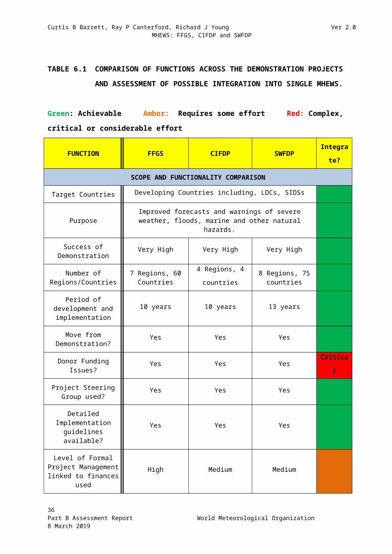
Curtis B Barrett, Ray P Canterford, Richard J Young Ver 2.0 MHEWS: FFGS, CIFDP and SWFDP
WMO Strategic Operating Plan as it relates to the outcomes of this Review and MHEWS
Figure 8.2: Proposed structural establishment of MHEWS in the proposed Reformed WMO. [Also shown with a hatched box, but not part of the new structure, is our proposed “stand alone” MHEWS “project” or Secretariat Office at departmental level (different from existing MHEWS Division), allowing cross cutting coordination and delivery across relevant departments. This will be decided by the Secretary General post 2019 Congress.]
36Part B Assessment Report World Meteorological Organization 8 March 2019
Multi-hazard Early Warning Systems
These systems are one of four Strategic Objectives 2020-2023 in the WMO Strategic Operating Plan and vision for 2030.
Strategic Objective 1.1 highlights national MHEWS and Alert Systems as part of the “Overarching Priority” of enhancing preparedness for and reducing losses from extreme hydrometeorological events.
Figure 8.1 Strategic role of the MHEWS and climate decision making

Curtis B Barrett, Ray P Canterford, Richard J Young Ver 2.0 MHEWS: FFGS, CIFDP and SWFDP
9. CONCLUSIONS - THE WAY FORWARD AND CALL TO ACTION
The importance and success of the three WMO Projects, FFGS, CIFDP and SWFDP, designed to support Disaster Risk Reduction globally has been established. Although these projects evolved separately they each utilised best practices, state of the art technology and science that can now become available to the many countries that need these significant life-saving capabilities. These projects are no longer demonstration projects, they are operational systems that need global implementation. The MAJOR question facing WMO and the Part B Assessment Team is how can these operational systems be optimally implemented to meet the growing demand for severe weather, flash flood, riverine flood, and coastal flood warnings of NMHSs?
The SWFDP, CIFDP and GFFG systems are very similar and in fact follow the basic structure of an End-to-End Multi Hazard Early Warning System. Hydrometeorological and ocean data are accessed in real time; the data are transmitted to a regional centre where data are processed and input to models. The meteorological models commonly cascade from Global to Regional to National, forecasters use Standard Operating Procedures to analyse and construct forecast products and warnings. These warnings and products follow similar dissemination paths to the Disaster Management centres, the media and end users for response actions to minimize losses. Other than similarities in system structure, these individual projects also experienced similar issues in project management, such as dependence on expert volunteers, insufficient allocation of Secretariat resources to manage these demanding projects; but most of all the lack of funding for the projects so they could be managed effectively and meet growing demand. Although the projects have generally successfully received extrabudgetary resources, more administrative and management resources are needed to meet project demands.
Given the success experienced by these projects and the demand by WMO member countries to implement these systems, we strongly recommend these three systems be combined or merged to an integrated MHEWS, but with the project management environment significantly changed. The challenge is that management and expert resources are scarce and the WMO is reorganising itself. Although we are not aware of how the final organisational structure will look like, we have examined the Executive Council proposals to Congress, as well as Secretariat and Member suggestions in order to propose how the MHEWS will be supported in a sustainable manner through the new proposed structure as well as highlighting the need for higher level support with any new Secretariat arrangements. Finally, the greatest limiting factor and unknown is donor funding. From our discussions with several areas of the WMO Secretariat during February 2019, we were encouraged by the high profile and plans that were already being put in place to acquire funding support for such developments as MHEWS.
The integration of the three systems has already begun. The twinning of SWFDP and GFFG in South Africa is the start of developing the needed MHEWS. The CIFDP also needs to be integrated into the MHEWS. The integrating environment must have the forecaster at the
37Part B Assessment Report World Meteorological Organization 8 March 2019

Curtis B Barrett, Ray P Canterford, Richard J Young Ver 2.0 MHEWS: FFGS, CIFDP and SWFDP
NMHS, as the driver of system development, being able to operate three systems as owner to create the needed products and services of the user domain, with emphasis on the disaster management needs. It is unclear to us whether WMO should be the facilitator of the integrated MHEWS or whether WMO should actually lead the development of the system with its partners, which of course will require funding. On balance we believe WMO would have a role in both approaches. In either case, we recommend development of a concept document that provides the vision and strategy of how these three systems can be combined in the short term, resolving existing legacies of the three systems and eventually integrating and expanding the MHEWS to include other hazards (such as tsunami) in the future.
Whichever approach WMO decides to take, it needs to define, as a vital first step, best practices and develop guidelines with its partners (such as ISDR and OCHA) for countries interested in implementing MHEWS at a minimum. If WMO not quickly address this task, the reality is countries will implement MHEWS without such consistent guidance because they need it now and because donors will support their needs. Guidelines will provide the interim technical framework (blueprint) that donors will need to work with the countries to implement hydrometeorological modernization project efforts but utilising best practices. There are options on how WMO could proceed with its members and partners as it develops its leadership role.
In Section 5 we outlined some of the technical features of the three projects and how they may be addressed in an integrated MHEWS. Regarding the allocation of responsibility for the technical ownership of the MHEWS system this should be the role of the WMO’s Global Data-Processing and Forecasting System (GDPFS). This would be coordinated through an Expert Team/Working Group established within the Infrastructure Commission or an inter-commission working group with the Services Commission. Figure 8.2 outlines such an arrangement.
WMO will need to consolidate hydrology, meteorology (severe weather) and marine/ocean resources into a MHEWS critical mass of experts and managers that can implement a new Multi Hazard initiative or Programme. The MHEWS Secretariat Office could then implement the MHEWS Concept and Strategic Initiative outlined in a ROADMAP to support implementation, operation and support of NMHSs. A key component of the new MHEWS Secretariat Office MUST BE Project Management/Administrative support (Figure 8.2) that develops and manages projects with extrabudgetary funds, seeks and coordinates donor support, and follows project management best practices. It may organise short term task teams funded by sponsors for specific implementation projects, but attached to the office for the period of the project.
It seems logical that to be consistent in its approach to develop and implement a MHEWS, that the Public Services and DRR Standing Committee within the new Services Commission (CSA) be designated as part of the WMO reorganisation to provide expert advice to the new MHEWS Secretariat Office on standards, guidelines and projects to consolidate and coordinate the merging of the three systems to a core integrated system to deliver critical DRR services. As this restructuring, integration and re-definition of DRR services unfolds, emphasis on sustainability of services and systems should be a major goal. Both the short term merged system and the long term integrated MHEWS will require innovative approaches to assure maintenance and operation of the critical system is secured.
38Part B Assessment Report World Meteorological Organization 8 March 2019

Curtis B Barrett, Ray P Canterford, Richard J Young Ver 2.0 MHEWS: FFGS, CIFDP and SWFDP
Emerging concepts such as “open systems” and ‘communities of practice’ can encourage participation of the weather, water and climate enterprise consisting of the private sector, academia and governments to work together to build sustainable systems that need to be flexible and adapt to existing country capabilities, but leverage from a very successful development of the three DRR systems, FFGS, CIFDP and SWFDP, now ready for operational implementation.
39Part B Assessment Report World Meteorological Organization 8 March 2019

Curtis B Barrett, Ray P Canterford, Richard J Young Ver 2.0 MHEWS: FFGS, CIFDP and SWFDP
APPENDIX A - TERMS OF REFERENCE - PART B
Consolidated approach for efficient and sustainable CIFDP, FFGS and SWFDP
1. Objective The objectives of this part of the work following the review are to respond to the requirement of the EC WG on DRR related to the development of a consolidated approach to ensure efficient and sustainable CIFDP, FFGS and SWFDP services related to hazardous weather, water and climate.
2. Deliverables Acknowledging the results of the reviews of CIFDP, FFGS and SWFDP in Part A, the reviewers will work together to develop a proposal for a consolidated approach to ensure efficient, effective and sustainable implementation of multi-hazard early warning systems as requested by EC WG on DRR. The recommended consolidated approach will need to be vetted by the Presidents of CBS and CHy and co-President of JCOMM (WMO). 3. Specific Tasks The Reviewers will:
a) Examine together the results of the three Reviews and identify common gaps and best practices
b) Propose options for addressing the gaps and for implementing best practices in all three projects
c) Propose a mechanism to ensure sustainability of CIFDP, FFGS and SWFDP.
40Part B Assessment Report World Meteorological Organization 8 March 2019

Curtis B Barrett, Ray P Canterford, Richard J Young Ver 2.0 MHEWS: FFGS, CIFDP and SWFDP
Timeline (15 days total over 3.5 months)(note that Holidays fall within this period: Dec 24 to Jan 3)
PhaseWeek
1 2 3 4 5 6 7 8 9 10 11 12 13 14Inception ⧫Report drafting ○WMO Sec and Presidents CHy, CBS and co-President JCOMM (WMO) review draft reportConsultants brief WMO, Presidents CHy, CBS and co-President JCOMM (WMO) (15 February 2018)Finalise Report (including review comments)Submit Final report
●
Deliverables: ⧫ Inception report○ Draft report● Final Report
1 December to 31 January - carry out joint review. 1 February - submit to WMO Secretariat1 to 15 February - WMO Secretariat and Presidents (CBS, CHy) and co-President of JCOMM (WMO) to review15 February - Consultants to brief the Presidents of the Technical Commissions (specific Presidents- CBS, CHy and co-President of JCOMM (WMO)) and WMO Secretariat15 February to 8 March - Consultants to finalise report 8 March - Consultants to submit Final Report to WMO8 March to end of March - WMO Secretariat to draft Congress document
41Part B Assessment Report World Meteorological Organization 8 March 2019

Curtis B Barrett, Ray P Canterford, Richard J Young Ver 2.0 MHEWS: FFGS, CIFDP and SWFDP
Required Expertise
Three reviewers are required - one each from Part A (CIFDP, FFGS, and SWFDP). In addition, the following considerations are desirable:
(a) Each reviewer must have already been engaged in the review of their respective Part A (eg CIFDP, FFGS, SWFDP).
(b) In the event that a reviewer from one specific Part A review is unavailable, a person with the following characteristics is desirable:
i. Demonstrated experience in planning, overseeing or implementing efforts to related to the topic area of the respective Part A review.
ii. Experience in assignments conducting evaluations possibly of a similar nature;
iii. Knowledge of international organizations and working in disaster risk reduction related to hydrometeorological hazard warning systems;
iv. Ability to independently and without bias conduct the review.
Estimated Time Allocation
The 3 Reviewers for Part B will be engaged over the full assessment period for Part B of approximately 3.5 months, noting that the end of year holidays fall within this time. It is estimated that approximately 15 person-days per reviewer will be required to complete the assignment.
The 3 reviewers will decide as a team on how best to most effectively and efficiently allocate their time and focus their expertise and skills to fulfil the Terms of Reference of Part B.
42Part B Assessment Report World Meteorological Organization 8 March 2019

Curtis B Barrett, Ray P Canterford, Richard J Young Ver 2.0 MHEWS: FFGS, CIFDP and SWFDP
APPENDIX B - List of interviewees for Part B Review
Prof Dr Gerhard Adrian German Permanent Representative (& President-candidate), WMO
Mr David Grimes President, WMO
Dr Sarah Grimes Acting Chief, Marine Meteorology & Ocean Affairs Division, Weather and Disaster Risk Reduction Services, WMO
Mr Abdoulaye Harou Chief, Data Processing and Forecasting, Secretariat, WMO
Mr Cyrille Honoré Chief, Multi Hazard Early Warning Systems, WMO
Mr Ata Hussain Scientific Officer (Projects Co-ordination), Secretariat, WMO
Dr Elena Manaenkova Deputy Secretary-General, WMO
Dr Paul Pilon Chief, Hydrological Forecasting and Water Resources Division, WMO
Prof Petteri Taalas Secretary-General, WMO
Dr Wenjian Zhang Assistant Secretary-General, WMO
APPENDIX C - ACRONYM LIST (WITH WEB LINKS) FOR PART B REPORT
APFM Associated Programme on Flood Management (WMO-GWP)BKMG Meteorology, Climatology and Geophysical Agency (Indonesia)BoM Bureau of Meteorology (Australia) CB Cumulonimbus cloudCBS Commission for Basic Systems CHy Commission for Hydrology CIFDP Coastal Inundation Forecasting Demonstration ProjectCOIIS Commission for Observation, Infrastructure and Information SystemsCONOPS Concept of OperationsCREWS Climate Risk Early Warning SystemCSA Commission for Weather, Climate, Water and Related Environmental Services
and Applications (APSCOM)DAC Development Assistance Committee (OECD)DEM Digital Elevation ModelDMA Disaster Management AgencyDRR Disaster Risk ReductionE2E End-to-endEC (1) European Community
43Part B Assessment Report World Meteorological Organization 8 March 2019

Curtis B Barrett, Ray P Canterford, Richard J Young Ver 2.0 MHEWS: FFGS, CIFDP and SWFDP
EC (2) Executive CouncilECMWF European Centre for Medium-range Weather ForecastsEWS Early Warning SystemFFG Flash Flood Guidance: see FFGSFFGS Flash Flood Guidance SystemGDPFS Global Data-Processing and Forecasting SystemGFCS Global Framework of Climate ServicesGFFG Global coverage Flash Flood Guidance projectGIS Graphic Information SystemGWP Global Water PartnershipHRC Hydrologic Research CentreIOC Intergovernmental Oceanographic Commission (UNESCO)ISDR (United Nations) International Strategy for Disaster ReductionJCOMM Joint (WMO-IOC) Technical Commission for Oceanography and Marine
MeteorologyJMA Japanese Meteorological AgencyKMA Korean Meteorological AdministrationLDC Least Developed CountryMHEWS Multi-hazard Early Warning SystemMoU Memorandum of UnderstandingNDMA National Disaster Management AgencyNEMO National Emergency Management OfficeNESDIS National Environmental Satellite, Data and Information Service (NOAA)NHC National Hurricane CentreNIWA National Institute of Water and Atmospheric Research (New Zealand)NMHS National Meteorological and Hydrological ServiceNMS National Meteorological ServiceNOAA National Oceanic and Atmospheric AdministrationNWS National Weather ServiceOCHA (United Nations) Office for the Co-ordination of Humanitarian AffairsOECD Organisation for Economic Co-operation and Development OFDA Office of U.S. Foreign Disaster AssistanceRA Regional AssociationRAI Regional Association 1 (Africa)RSMC Regional Specialised Meteorological CentresRSMMC Regional Specialised Multi-hazard and Meteorological Centre (proposed in this
document)SARFFG Southern Africa Region Flash Flood GuidanceSAWS South African Weather ServiceSG Steering GroupSMC Specialised Meteorological Centres (WMO)SOP Standard Operating ProcedureSRE Satellite rainfall estimatesSSHA Sea Service Height AnomalySWAN Simulating Waves Nearshore SWFDP Severe Weather Forecasting Demonstration ProjectSWWS Severe Weather Warning SystemTOR Terms of ReferenceTRMM Tropical Rainfall Measuring MissionUKMO United Kingdom Met OfficeUNESCO United Nations Educational, Scientific and Cultural OrganisationUSAID United States Agency for International DevelopmentWG Working GroupWMO World Meteorological Organisation
44Part B Assessment Report World Meteorological Organization 8 March 2019

Curtis B Barrett, Ray P Canterford, Richard J Young Ver 2.0 MHEWS: FFGS, CIFDP and SWFDP
10. ATTACHMENT: CONCEPT NOTEA MECHANISM FOR OPERATIONAL MHEWS
Implementation of an Integrated Multi-Hazard Early Warning System that incorporates the Functionality of Three Successful WMO Demonstration Projects - FFGS, CIFDP and SWFDP
A1 INTRODUCTION
This Concept Note is based on the extensive review by Barrett, Canterford and Young for Part B – “Concept for an Integrated, Efficient, Sustainability and Adaptive MHEWS for FFGS, CIFDP and SWFDP”. It is included in that review as an Attachment, but should therefore be read in conjunction with the full report for key background arguments and findings.
Part A, the independent technical reviews of FFGS, CIFDP and SWFDP, were completed by the authors in November 2018. These three independent Reports formed the basis for the analysis in Part B.
The full Part B Report was considered by key senior WMO Secretariat officers and presidents of Technical Commissions (CBS, CHy and JCOMM), as well as the President of WMO, who were stakeholders in the outcome of the review, in February 2019.
As a result, the stakeholders suggested that the reviewers build on the outcomes of Part B to produce this Concept Note for the development of a mechanism for an Operational MHEWS that would briefly describe the vision and process needed for achieving the integration of the three projects and for enabling implementation of an operational MHEWS. This concept note is therefore intended as a high-level overview of the vision to produce a MHEWS based on FFGS, CIFDP and SWFDP, recognising much more detailed strategic planning effort is needed, for a robust sustainable operational and interoperable system environment, to be applied to a wide range of hydrometeorological capabilities and capacities.
A2 BACKGROUND
With both a growing requirement from WMO Members for improved DRR capabilities, and an imminent major reorganisation of the WMO structure, Resolution 16 (EC-70) requested the president of CHy to coordinate, with the presidents of CBS and JCOMM, the independent technical reviews of CIFDP, FFGS and SWFDP (Part A), including the development of a consolidated approach (Part B) to ensure efficient sustainable services related to hazardous weather, climate and water.
The Part B report, including this Concept Note will be presented to Congress in 2019 by the president of CHy in association with the presidents of CBS and JCOMM. The need to develop this Concept Note evolved from discussions of the combined Part B report at a February 15th WMO briefing meeting which will be explained further in the next section.
The ToRs for the Part B included a specific task to propose a mechanism to ensure sustainability of CIFDP, FFGS and SWFDP. This Concept Note addresses that task through a proposed MHEWS.
45Part B Assessment Report World Meteorological Organization 8 March 2019

Curtis B Barrett, Ray P Canterford, Richard J Young Ver 2.0 MHEWS: FFGS, CIFDP and SWFDP
A3 DEVELOPING AN OPERATIONAL MHEWS CONCEPT
The development of some MHEWS for particular hazards has been in existence for well over two decades. However, this Concept Note addresses the mechanism for enabling the implementation of an MHEWS, based on the exhaustive analysis (described in detail in the body of the main report1) of three major WMO demonstration projects that can now be considered as successful for future implementation in other countries and regions. A key to this implementation is the interoperability of the systems, which will also allow other hazards to be integrated in the future.
This Concept Note describes how a multi hazard system can, and should, be developed to cover numerous meteorological, hydrological and oceanic hazards from the global to the regional to the national and the local scale (including catchments). It is especially important for vulnerable countries and regions adversely affected by the growing number and impacts of these multi-hazards on their communities.
The individual CIFDP, FFGS and SWFDP Reports (Part A) were presented to the Secretariat in November 2018, and the combined (Part B) CIFDP-FFGS-SWFDP Report was presented to a meeting of members of the WMO Secretariat, including the WMO President, the president of CHy and Deputy Secretary-General, in Geneva on 15th February 2019. The main conclusion of the Part B Assessment by the consultants was the recommendation that the three systems be integrated into a Multi Hazard Early Warning System (MHEWS) programme capable of integrating other hazards with time. Part B recommends it be implemented through advocacy and facilitation within the WMO structure, preferably within the new proposed reform being considered by Congress (2019). The Secretariat supported the thrust of the report’s analysis and recommendations.
A4 WHAT IS THE PROPOSED MHEWS?
According to ISDR, Multi-hazard early warning systems address several hazards and/or impacts of similar or different type in contexts where hazardous events may occur alone, simultaneously, cascading or cumulative over time, and taking into account the potential interrelated effects. A multi-hazard early warning system with the ability to warn of one or more hazards increases the efficiency and consistency of warnings through coordinated and compatible mechanisms and capacities, involving multiple disciplines for updated and accurate hazards identification and monitoring for multiple hazards.
In the context of the NMHS, a MHEWS is a hazard warning system that is part of the end to end Early Warning and response system. It is an appropriate combination of hardware, software and telecoms systems that will accept the input of a variety of data types (e.g. current weather observations, satellite data, radar data, rainfall rates and accumulations), optimally utilise meteorological and hydrological forecast programmes, and produce output that highlights when forecast conditions are likely to lead to the need for a warning to be issued resulting in appropriate emergency actions to reduce potential losses. The initial MHEWS proposed here is the combination of the Global Flash Flood Guidance System, the Coastal Inundation Forecast Demonstration Project system and the Severe Weather Forecast Demonstration Project system. It will thus provide a forecast and warning guidance system to NMHS forecasters (principal users of the System) for Flash Floods, Storm Surge and Coastal Flooding and the occurrence of Severe Weather such as high winds, tornadoes, hail and heavy rain. It is envisioned that the initial MHEWS will be expanded in the future to include other hazards such as tsunamis, riverine flooding and seasonal and/or climate change impacts.
1 Part B – “Concept for an Integrated, Efficient, Sustainability and Adaptive MHEWS for FFGS, CIFDP and SWFDP” by Barrett, Canterford and Young, 2019.
46Part B Assessment Report World Meteorological Organization 8 March 2019

Curtis B Barrett, Ray P Canterford, Richard J Young Ver 2.0 MHEWS: FFGS, CIFDP and SWFDP
A5 THE NEED AND VISION
The urgent need for improving the quality and reliability of early warning functions has been recognised by a majority of WMO Members to reduce as far as possible the risk of loss of life and property resulting from severe environmental events. In this regard, enabling a MHEWS would be of significant benefit to WMO Members. Indeed, global target (g) of the Sendai Framework is to “substantially increase the availability of and access to multi-hazard early warning systems and disaster risk information and assessments to the people by 2030”.
The need to develop a forecast system environment that can take advantage of new predictive science and models, increases in data volumes and operate on a single platform rather than proliferating the forecasting environment with many different forecasting systems (as is now the case) and computer hardware and software that are impossible to operate independently, never mind maintain. The immediate need is to combine or integrate CIFDP, FFGS and SWFDP into a single sustainable system environment that can be implemented by NMHSs as soon as practical.
A6 HOW THE PROPOSED MHEWS CAN BE ACHIEVED
Creating an enabling environment to allow system development - Vital First steps
There is an urgent requirement to uplift and add to MHEWS standards and guidelines that are fully endorsed by WMO. The current Part B study provides a sound basis (since it includes three successful end-to-end EWS) for the development of these normative standards and there is no reason why they cannot be developed quickly. This is in recognition that many countries may choose their own development paths for implementing MHEWS. This would be a major disrupter as new systems may not be compatible with the developed WMO standards and principles, and this could lead to unsustainable and negative outcomes. It will be essential and a high priority for the WMO technical commission to develop a framework of best practices guidelines, standards and protocols that will guide various efforts by developers and partners in the operational implementation of MHEWS’s. WMO should continue to engage in partnerships with donors and organizations such as the World Bank, NGOs, academia and the private sector to define the design, architecture and principles of operation needed to assure MHEWS will meet performance standards. It is important that there be good coordination and collaboration amongst the MHEWS team of partners.
A7 BUILDING ON CURRENT SUCCESS
The process of combining these three systems has already been initiated. The SARFFG-SWFDP Twinning project (2015-2017) in South Africa resulted in combining the Southern Africa Region Flash Flood Guidance System with the SWFDP system so the South African Weather Service (SAWS) forecaster could use one computer to visualise output from both systems. Although the two systems were not integrated they were merged to the point that data could be shared and a computer desk top would allow the forecaster multiple system access to issue warnings. An integral part of building the MHEWS is reaching the last KM. The Twinning project assembled Disaster Managers from southern African countries and collectively designed new products that would meet Disaster Management Decision support requirements. The design was based on the principle of allowing forecasters to see the genesis of the flood exceedances, to enhance warning development, thereby better meeting user requirements.
This process needs to be replicated as the MHEWS development and implementation process needs to stress and enable interoperability of systems. Indeed, this project is the beginning of the process of establishing a multi hazard operating environment. The next steps in the integration process would be to combine the two into one system and add the Coastal System functionality. The objective would be to create a systems environment that would allow linking data, models and analysis tools to guide
47Part B Assessment Report World Meteorological Organization 8 March 2019

Curtis B Barrett, Ray P Canterford, Richard J Young Ver 2.0 MHEWS: FFGS, CIFDP and SWFDP
warning development, with this initiative eventually evolving this initial capability into a Multi Hazard Forecasting System that could later be expanded to include other hazards. Figure 1 presents the proposed model, which would incorporate the three demonstration projects into a single MHEWS.
FIGURE 1 INTEGRATION OF MHEWS INTO NMHS OPERATIONS
In the short term these three systems can be combined and implemented as an initial version of the long-term goal of multi hazard integrated system. The long-term goal of course is to develop a truly integrated system that utilizes all available data, models and tools that can be used and operated by an LDC NMHS and or by a fully developed NMHS. Flexibility and adaptability of the MHEWS to what the existing NMHS data and models that are being used is desirable. This may not be practical but needs to be explored.
To ensure commonality of approach, the MHEWS would be a core component of WMO with regard to standards, while Regional Associations (RA’s) would have an important and enhanced role, with greater responsibility for ensuring implementation in their regions in support of their Members (refer to Part B report for further detail).
To be successful, the MHEWS must be sustainable, where sustainability is defined in terms of on-going and reliable end-to-end (E2E) support in (at least) each of the areas of political support, funding, and technological maintenance. The anticipated gradual increases in capabilities over the next decade or so, i.e. during the 2020s, also need to be factored into the scoping.
As there are widely-differing levels of each of requirements, facilities, capacities and capabilities between individual WMO members, it is anticipated that, in addition to the requirement for sustainability, there will also be a requirement for scalability. This latter requirement could potentially be met with a ‘core’ MHEWS minimum capability for all WMO members, with additional ‘layers’ for
48Part B Assessment Report World Meteorological Organization 8 March 2019

Curtis B Barrett, Ray P Canterford, Richard J Young Ver 2.0 MHEWS: FFGS, CIFDP and SWFDP
meeting specific needs, e.g. landlocked countries will not need oceanographic facilities, whereas coastal countries will.
A8 MHEWS FUNCTIONALITY
As part of the process of MHEWS development, there needs to be both a comprehensive assessment of needs, incorporating suitable gap analysis, and a detailed Concept of Operations (CONOPS). The key role of the Global Data Processing Forecasting Systems (GDPFS), and its interface with MHEWS, will both need to be reviewed, including aspects such as the ‘look and feel’ (ergonomics) of both the DRR MHEWS architecture itself, and its proposed outputs.
The principles to which MHEWS functionality should correspond include a ‘plug and play’ concept (i.e. the base system should operate in the same manner in every country that it is installed in), and a ‘freely available’ (at point of use) concept for all countries that wish for a DRR MHEWS facility. To enable both the ‘plug and play’ and ‘freely available’ principles, there needs to be a third principle: that of standardisation, i.e. a ‘core’ system with interoperable and modular programming– it would clearly not be practicable to design individualised requirements for, say, 150 countries that required their own detailed specifications. But if possible, the system functionality would be more valuable if it could adapt to preferred models and techniques used by the NMHS. For example, FFGS can accept up to five different QPF inputs that will depend on the forecasters’ preference so FFGS is not restricted to specific model input.
Three further core aspects need to be re-visited at this time: (1) technical; (2) operability; and (3) sustainability. Regarding the technical aspects, decisions will be required in the short-term on precisely how the optimum MHEWS system is built, how the Commissions will support this, and where the appropriate experts are sourced from. For the operability aspects, a design maximising both usability and capabilities is recommended, with the establishment of details of operability and support (technical, management, etc.) also required. With regard to sustainability, the twin main drivers will be funding and political support. It is likely that both of these will be achievable, especially given evidence of the capabilities and benefits of an enhanced MHEWS system.
A factor that the team believes needs to be considered in the development and implementation of MHEWS is the current GAP in NMHSs to deliver flood forecasts and warnings to users. Nearly 60 percent WMO member countries do not have capacity to deliver basic flood and flash flood warnings to users. The design and building of the MHEWS must consider this gap in developing an interoperable environment that can function adequately in low capacity situations yet deliver acceptable multi- hazard forecast and warning products using limited data and fit-for-purpose modelling.
The role and commitment of GDPFS in the long-term implementation of a standardized MHEWS is recognised by the MHEWS Assessment team. It is expected that the GDPFS system, as it moves to seamless GDPFS capability, will have the major role in providing the integrating environment for the MHEWS in the next decade.
A9 THE ROLE OF WMO IN MHEWS: ITS MEMBERS AND CONSTITUENT BODIES.
49Part B Assessment Report World Meteorological Organization 8 March 2019

Curtis B Barrett, Ray P Canterford, Richard J Young Ver 2.0 MHEWS: FFGS, CIFDP and SWFDP
In order for the proposed MHEWS that incorporates FFGS, CIFDP and SWFDP to be successfully implemented, there is a specific role for all Members, WMO Technical Commissions, Working Groups, Regional Associations, World Meteorological Centres and Regional Specialised Meteorological Centres2, as well as NMHSs within the “WMO for the 21 st Century - Proposed Structure”, which is designed to be “responsive and fit-for-purpose”. There is also a need to strengthen partnerships with international, national and regional associations and bodies, including sponsors. In defining the specific roles for MHEWS, the main report, Part B – “Concept for an Integrated, Efficient, Sustainability and Adaptive MHEWS for FFGS, CIFDP and SWFDP” demonstrates that the cascading of models and data from global to regional to national (and below) is critically important for implementation and sustainability.
The new Commission for Observations, infrastructure and Information Systems (COIIS) will be responsible for the networks and modelling systems of the new MHEWS. Within this new Technical Commission, the role of the GDPFS is essential for setting the standards and processes for cascading of relevant data and products to Regional Specialized Centres or directly to NMHSs. The GDPFS should be considered the “technical home” of the new MHEWS. It should provide oversight of the standards and processes for the technical aspects of the MHEWS such as product and data flows and cascading where appropriate.
From a user and services perspective, the MHEWS must be driven and overseen by the Commission for Weather, Climate, Water and related Environmental Services and Applications (CSA) as well as the relevant Regional Associations, which should, in the “responsive and fit-for-purpose” new WMO, ensure standards for, and guidance on, dissemination of the information to users in their regions.
The WMO Secretariat Role
No matter which model Congress decides for the policy and implementation aspects of MHEWS (see reference 1 to Part B report for options) there needs to be a single “MHEWS Secretariat Office” within the Secretariat that will provide the support necessary for facilitating MHEWS and/or arranging “sponsor supported” implementations in specific countries or regions. It is considered that this office should be at a departmental level as it must be cross cutting. The final arrangement will of course be considered and determined by the Secretary General.
An Enabling Framework
It is necessary to document the participants in the MHEWS development, the expectations of each of these, and their various interconnections. Primary participants are expected to include NMHSs, RAs, NGOs, Donors, DMAs, UN Agencies such as ISDR and OCHA, the private sector (Weather Enterprise) and WMO (an EC Working Group on DRR, new Technical Commissions, GDPFS and the proposed Public Services and DRR Standing Committee, as well as the Secretariat). Within WMO the proposed Public Services and DRR Standing Committee should take the lead to develop a strategic plan (working with the WMO Strategic Planning Committee, the new Infrastructure Commission, the new Service Commission and the Secretariat) on development of an initial MHEWS capability.
It will be necessary to undertake a standardised approach of implementing MHEWS such as beginning by establishing a comprehensive risk analysis (including profiling) of the proposed MHEWS development process, with the results of this analysis made available to, and understood by, all of the
2 GDPFS is organized as a three-level system consisting of World Meteorological Centres (WMCs), Regional Specialized Meteorological Centres (RSMCs) and National Meteorological Centres (NMCs), which carry out GDPFS functions at the global, regional and national levels, respectively. Within RSMCs, there are centres with geographical specialization, centres with activity specialization, Global Producing Centres for long-range Forecasts (GPCs) and Global Climate Centres (GCCs).
50Part B Assessment Report World Meteorological Organization 8 March 2019

Curtis B Barrett, Ray P Canterford, Richard J Young Ver 2.0 MHEWS: FFGS, CIFDP and SWFDP
participants. In particular, the requirement for sustainable funding needs to be understood as a major component of the risk analysis, with possible requirements for financial support at RA level.
It will also be necessary to undertake a detailed gap analysis of the complete MHEWS framework, including funding, so that any gaps (such as countries that are particularly vulnerable to disasters, but which are unable to contribute financially) are readily identified, with associated prescriptive actions taken.
Finally, it will be necessary for documented examples of the benefits of MHEWS output to be produced, and publicised, to confirm its role in saving lives, and also to improve resilience for communities from adverse environmental events.
A10 NEXT STEPS AND TIMELINE
Since there is a likelihood that some countries will independently proceed to develop their own MHEWS, it is important that WMO (and its Members) establish a framework of standard protocols, best practices, and interoperability guidelines (manuals) to assure systems that are implemented will meet acceptable operational performance standards. A “Community of Practice” would be important in this environment to assist in common policy and system developments.
Firstly, it is essential for WMO to take this leadership in the development of the MHEWS environment by providing technical guidance in the short term and by coordinating with partners a design of an integrated MHEWS that can be developed through cooperation of academia, the private sector, government and NGOs. Establishing an architecture and design criteria will help assure uniformity and standardisation of MHEWS to assure a wide range of NMHSs can achieve the needed multi hazard forecast and warning capability.
Secondly, an incremental development of current systems’ approach (FFGS, CIFDP and SWFDP) is preferable to a brand new MHEWS development from first principles. Subsequent to development of the “vital first steps” of normative standards and principles discussed above, a prototype MHEWS programme can be initially established by further development of the RAI SWFDP/FFGS twinning project, including the incorporation of the CIFDP component.
Particular locations may be designated as most suitable for early MHEWS trials, with Pretoria, Fiji and Indonesia currently seen as possible candidates, although relevant criteria will need to be specified to ensure optimum location choices are made to maximise future benefits for all.
Prototype MHEWS developments would be anticipated to occur in the shorter-term, nominally within 12 months of approval being given by Congress for development to proceed and necessary funding to be obtained. In the longer-term, i.e. up to a decade or so ahead, given a combination of (1) continuing political support at both RA and national levels; (2) evidence of the continuing benefits of MHEWS outputs; and (3) continuing technical and ICT improvements, it is anticipated that further development will lead to optimum MHEWS facilities becoming available in most – if not all – WMO member states that require such systems.
51Part B Assessment Report World Meteorological Organization 8 March 2019