110301 vs 3 intrep 2 main text-rk - european external ... · web viewthe expert groups thoroughly...
TRANSCRIPT

1
An EU funded project managed by
Implemented by GFA Consulting Group GmbH / BVVG / DLG
The European Union’s IPA Program for Kosovo
FURTHER SUPPORT TO LAND USE
Project Number 2010/230-489
Project Completion Report (Draft)
Reporting Period: 23.02.2010 – 22.02.2012
iThe content of this publication is the sole responsibility of Rutger Kuiper /
GFA Consulting Group / BVVG / DLG and can in no way be takento reflect the views of the European Union
KosovoFurther Support to Land UseProject Number 2010/230-489
PROJECT COMPLETION REPORT (Draft)
Authors: Rutger Kuiper, Neda Nordin
Reporting Period: 23.02.2010 – 22.02.2012
Address
GFA Consulting Group GmbH
Eulenkrugstraße 82D-22359 Hamburg
Germany
Phone: +49 (40) 6 03 06 – 175Fax: +49 (40) 6 03 06 – 179E-Mail: [email protected]
Your contact persons within
GFA Consulting Group GmbH are
Rutger Kuiper (Team Leader)
Conrad Hoyos (Project Director)

FORM 1.2 REPORT COVER PAGE
Project Title: Further Support to Land UseProject Number: 2010/230-489Country: Kosovo1
Contract dates: 23.02.2010 until 22.02.2012
Contracting Authority: European Commission Liaison Office
Counterpart:
Name: Ministry of Agriculture, Forestry and Rural Development (MAFRD),Organisation: Rural Development Department (RD Department)Address: Nena Tereze, Prishtinë/Priština, KosovaTel. number: +381-(0)38 211 129Fax number: +381-(0)38-211 885E-mail: [email protected]: Rural Development Dept./ Project Coordination Office
Contractor:
Project Office (FSLU): Head office (GFA):Address : Sejdi Kryeziu 20/3 Eulenkrugstr 82
Pejton, D 22359 HamburgPrishtinë/Priština, Kosovo Germany
Tel. number : +381 38 225 286 +49 (40) 603 06 170Fax number : - +49 (40) 603 06 179E-mail : [email protected] [email protected]
Contact person: Rutger Kuiper Conrad HoyosTeam Leader Project Director GFA
Signatures : _____________________ ______________________
Date of report: 22.02.2012
Reporting period: 23 February 2010 – 22 February 2012
Author of report: Rutger Kuiper, Neda Nordin
EC M&E team ________________ _________________ _____________
(name) (signature) (date)
Project Manager ________________ _________________ _____________ (name) (signature) (date)
1 Under UNSCR 1244/99

An EU funded project managed by Implemented by:the European Commission Liaison Office
Table of Contents
EXECUTIVE SUMMARY 1
PROJECT SYNOPSIS 7
1 INTRODUCTION 9
2 BACKGROUND 102.1 Governmental Policies 10
2.2 Features of the Land Use Sector 102.2.1 Institutions involved 102.2.2 Legal Framework 11
2.3 Beneficiaries and parties involved 12
2.4 Problems to be addressed 13
2.5 Cross-cutting issues addressed 14
2.6 Other Interventions 14
3 INTERVENTION 163.1 Overall objectives 16
3.2 Project purpose 16
3.3 Results 16
3.4 Activities 173.4.1 C1: Legal Assistance 173.4.2 C2: Land Regulation 193.4.3 C3: Spatial Planning and Environment Protection 213.4.4 C4: Land Lease and Land Valuation 253.4.5 C5-1: Land Parcel Identification System (LPIS) 263.4.6 C5-2: Pollution of Agricultural Land 283.4.7 C6: Coordination and Communication between Stakeholders 30
3.5 Activities for mainstreaming cross-cutting issues 32
3.6 Major workshops and study tours 32
4 ASSUMPTIONS 354.1 Assumptions at different level 35
4.2 Risks and flexibility 35
5 IMPLEMENTATION 385.1 Physical and non-physical means 38
5.2 Organisation and implementation procedures 39
5.3 Timetable 40
5.4 Cost and finance plan 41
5.5 Special conditions/accompanying measures taken by the Government 42
5.6 Reporting 43

An EU funded project managed by Implemented by:the European Commission Liaison Office
6 FACTORS ENSURING SUSTAINABILITY 466.1 Policy support 46
6.2 Appropriate technology 46
6.3 Effective mainstreaming of cross-cutting issues 47
6.4 Institutional and management capacity (public and private) 47
6.5 Legislation 49
6.6 Economic and financial analysis 49
7 MONITORING AND EVALUATION 507.1 Definition of indicators 50
7.2 Reviews/evaluation 50
8 CONCLUSIONS AND PROPOSALS 518.1 Set up of the project 51
8.2 Governance and legislation 51
8.3 Land Regulation 52
8.4 Rural Spatial Planning 53
8.5 sLPIS 54
8.6 Land Valuation 55
8.7 Pollution of Agricultural Land 56
Annexes
Annex 1: Logical Framework
Annex 2: Working Days Experts per 22-02-2012 (Project Completion)
Annex 3: Resources utilization report 1 and 2
Annex 4: Resources utilization summary
Annex 5: Overview of outputs and their status
Annex 6: Result Performance Plan
Annex 7: Workshops and Training

An EU funded project managed by Implemented by:the European Commission Liaison Office
List of Tables
Table 1: Components and results 16
Table 2: C.1 Legal Assistance. Expected outputs as related to activities 18
Table 3: C.2, Land Regulation. Expected outputs as related to activities 20
Table 4: C.3 Spatial Planning and Environmental Protection. Expected outputsas related to activities 24
Table 5: C.4, Land Valuation. Expected outputs as related to activities 26
Table 6: C.5-1, Land Parcel Identification System (LPIS). Expected outputsas related to activities 28
Table 7: C.5-2, Pollution of agricultural land. Expected outputs as relatedto activities 30
Table 8: C.6, Communication and coordination. Expected outputs as related to activities 31
Table 9: EULUP Study Tours 33
Table 10: Major EULUP Workshops 33
Table 11: Initial assumptions and remarks 35
Table 12: Summary of expert working days 38
Table 13: Roles and responsibilities of project staff 39
Table 14: Use of Incidental Budget until 22 January 2012 and the expected total use of Incidental Budget 42
Table 15: General project reports issued 43
Table 16: Technical Reports 44
Table 17: Training Reports 45

An EU funded project managed by Implemented by:the European Commission Liaison Office
L I S T O F A B B R E V I A T I O N S
AI Administrative instructions
ALS Agricultural Land Suitability
ALUP Agricultural Land Utilisation Project
AMPK Agricultural Master Plan for Kosovo
ARDP Agricultural Rural Development Plan
BVVG Bodenverwertungs- und verwaltungs GmbH
BRSP Basis for Rural Spatial Planning
CAP Common Agricultural Policy of EU
CEO Chief Executive Officer
CZ Cadastral Zone
CZP Construction Zoning Plan
DLG Dienst Landelijk Gebied (= Netherlands Government Service for Land and Water Management)
EAP Environmental Action Plan
EBV Estimated Biodiversity Value
ECLO European Commission Liaison Office
EIA Environmental Impact Assessment
ELS Environmental Land Sensitivity
EPAP European Partnership Action Plan
EU European Union
EULUP acronym for “Further Support to Land Use” Project
FADN Farm Accountancy Data Network
FAO Food and Agriculture Organisation
FSLU Further Support to Land Use project
GDB Geographical Data Base
GIS Geographic Information System
GoK Government of Kosovo
GPS Global Positioning System
GWS Groundwater Sensitivity
GWR Groundwater Risk

An EU funded project managed by Implemented by:the European Commission Liaison Office
Hydromet Institute of Hydrometeorology
IACS Integrated Agricultural Control System
ICMM Independent Commission of Mines and Minerals
ILS Integrated Land Suitability
IPRR Immovable Property Rights Register
IntRep Interim Report
IR Inception Report
ISO International Organisation for Standardization
ISP Institute of Spatial Planning
JLTE Junior Long Term Expert
JSTE Junior Short term Expert
KCA Kosovo Cadastre Agency
KE Key Expert
KCB Kosovo Consolidated Budget
KCC Kosovo Chamber of Commerce
KEPA Kosovo Environmental Protection Agency
KIA Kosovo Institute of Agriculture
KIHM Kosovo Institute for Hydro Meteorology
KPA Kosovo Property Agency
KTA Kosovo Trust Agency (predecessor of PAK)
KIRP Kosovo Irrigation Rehabilitation Project
LCS Land Suitability Classification
LoAL Law on Agricultural Land
LoEP Law on Environmental Protection
LoEIP Law on Expropriation of Immovable Property
LoLR Law on Land Regulation
LoSP Law on Spatial Planning
LPIS Land Parcel Identification System
LRIS Land Resources Information System
LTE Long-term expert
LUP Land Use Plan
LUIP Land Use Intensity Plan

An EU funded project managed by Implemented by:the European Commission Liaison Office
MAFRD Ministry of Agriculture, Forestry and Rural Development
MCO Municipal Cadastral Office
MDP Municipal Development Plan
MEF Ministry of Economy and Finance
MEM Ministry of Energy and Mining
MESP Ministry of Environment & Spatial Planning
MIT Ministry of Trade and Industry
MoLG Ministry of Local Governance
MoH Ministry of Health
MoM Minutes of Meeting
MoU Memorandum of Understanding
MT&I Ministry of Trade and Industry
NGO Non-governmental Organisation
NSDI National Spatial Data Infrastructure
NSLC National Strategy for Land Regulation
oLUP Optimised Land Use Plan
PAK Kosovo Privatisation Agency
PCE Project Completion Event
PCR Project Completion Report
PCU Project Coordination Unit
PSC Project Steering Committee
PU Paying Unit of MAFRD
QR Quarterly Report
rEAP Rural Environmental Action Plan
RLMP Rural Land Management Planning
SDA Swiss Development Agency
SES Soil Erosion Sensitivity
SER Soil Erosion Risk
SOE Socially Owned Enterprise
SSTE Senior Short-term Expert
TA Technical Assistance
TL Team Leader

An EU funded project managed by Implemented by:the European Commission Liaison Office
ToR Terms of Reference
ULR Unfinished Land Regulation
UNDP United Nations Development Program
UNMIK UN Mission in Kosovo
VLR Voluntary Land Regulation
WB World Bank
WD Working Day
WGLandVal Inter-Ministerial Working Group on Land Valuation
WGPol Working Group on Pollution Control of Agricultural Land

E X E C U T I V E S U M M A R YThis project Completion Report (PCR) presents the final results achieved of the Further Support to Land Use - EULUP, funded and supported by the EU through its European Commission Liaison Office (ECLO), implemented by the MAFRD and supported by the consortium GFA Consulting Group, BVVG from Germany, and DLG from the Netherlands. The report covers the whole project period from 23 February 2010 to 22 February 2012.
The overall goal of the project is to contribute to sustainable increase of productivity and land use through land reform and rural planning. Two purposes are formulated: 1. To facilitate land reform through measures of land consolidation, land market and land valuation; and 2. To improve building control and environmental protection by sound planning policies and practices.
In the long term the impacts of the project shall lay a strong legal and methodological basis for the improved implementation of the agricultural land use planning and management as stipulated in the EU rural development policies. EULUP aimed to achieve these goals and purposes by the implementation of six project components. These comprise the following:
C.1 Legal assistance C.2 Land consolidation C.3 Spatial planning and environmental protection C.4 Land lease and valuation C.5 Land register, data base and inventory of polluted agricultural lands. For practical
reasons, C.5 has been split up into two sub-components: C.5-1 Land register and GIS (LPIS) C.5-2 Agricultural land pollution and GIS data base
C.6 Coordination and communication
EULUP follows the earlier ALUP (Agricultural Land Utilisation Project, 2006-2008), during which a first stimulus was given to tackle agricultural land issues. The current project proceeded on that course, and tried to bring into practical application a number of concepts and recommendations of ALUP, and included new issues as well (LPIS, pollution). Since the completion of ALUP progress has been made in Kosovo’s rural areas, but problems are still persisting.
Problems on land use in Kosovo are manifold, and their addressing is urgent. In Kosovo rural areas are characterized as small-scale subsistence agriculture, lack of rural planning, uncontrolled construction, land fragmentation, unfinished Land Regulation, locked land market, outdated cadastral registration and pollution of agricultural land.
Cooperation with other projects and related foreign institutions was always pursued. Closest were the EU Twinning Project on Agriculture and Rural Development, and with the EU projects “Farmer Register” Project and the “Animal Identification Project”. But also irregular contacts were kept with the EU “Support to ICMM” project. In the context of Spatial Planning, regular and fruitful contacts existed with UN-Habitat and UNDP.
The project was guided and supervised by the Steering Committee (SC). This body had a very interdisciplinary character, well reflecting the nature of the project. Its meetings were chaired by the ECLO Task Manager and co-chaired by (officially) Permanent Secretary (PS) MAFRD, in practice he delegated this task to the Director Dept. of RD.
The C1 - Legal Assistance was both directed at the MAFRD, the MESP and also at the MoF. Two major legal issues were addressed, i.e. the Law on Land Regulation (LoLR) and the Administrative Instructions on Municipal Development Planning. In addition, the awareness campaign on rural spatial planning was implemented during the last stage of the project.
1An EU funded project managed by Implemented by:the European Commission Liaison Office
However, a few more matters have been added during the project. These included the preparation of the A.I. on Spatial Planning Data to the Law on Spatial Planning (LoSP), the assistance to the MAFRD Working Group on ALS and the ministerial Administrative Order on new Agricultural Land Suitability, and the arrangements on data sharing between MAFRD and MESP.
The draft LoLR was reviewed, redrafted and brought into consistency with the official MAFRD policy of voluntariness in land regulation, including special chapter how to deal with Unfinished Land Regulation (ULR). Six of the 8 A.I. to the law were prepared together with the MAFRD Legal Working Group, while the remaining two will be made by MAFRD itself. The Parliamentary Commission of Agriculture was assisted in its processing of the LoLR.
The development of the new rural spatial planning model and its major data base (see C.3), was followed by the re-drafting of the A.I. on Municipal Development Planning (MDP) to the LoSP. In addition, EULUP prepared a proposal for a ministerial Administrative Order (AO) on ALS for formal adoption. Legal WG is formed at MAFRD to discuss this draft A.O.
Although not foreseen in the EULUP ToR, a media campaign on rural spatial planning and construction zoning was prepared. Main focus is on construction control, as it will be foreseen in the new and/or updated MDP’s by allocated detailed construction zones in municipalities.
Training was given by the SSTE 1-1 and the JSTE 1-1 in various workshops. Notable are the workshops delivered in 5 regions in the final stage of the project on newly developed legislation.
The expected project outputs plus additional outputs have all been realized.
In C.2, Land regulation, the first issue was the completion of the Strategy by adding an Action Plan 2010-2020. The Action Plan was approved in mid 2010 and added to the Strategy. The Strategy is based on voluntary participation in land regulation.
The land regulation program is initiated by MAFRD and fully financed by the KCB, and is not an ECLO program. The role of EULUP was entirely advisory to the MAFRD and not leading. The programme includes Unfinished Land Regulation (ULR) and Voluntary Land Regulation (VLR).
In 2010 no new program on ULR was initiated because the 2009 programme was still to be implemented. This was completed at the end of 2010. In 2011 MAFRD tendered an ULR program that was deviating from the Action Plan: only one was selected: Gjakovë/Ðakovica, where all 13 Cadastral Zones (CZ) were included, instead of maximum 4 CZ per municipality as foreseen in the Action Plan. These included very complex ones that would necessarily require further study before tender.
Due to MAFRD internal procurement problems, this tendering was only completed at the end of December 2011. The problematic ULR’s of Prizren and Rahovec/Orahovac could be completed.
EULUP gave information to interested municipalities and villages. The planned MAFRD awareness campaign (to be financed by KCB funds) did not materialize due to procurement problems. In January 2011 the first request for VLR was received by the MAFRD (village of Pozheran, Viti/Vitina), and approved in June 2011. The second request, Bradash (Podujevë/Podujevo) is not yet approved. The geodetic work in Pozheran could not be contracted out so far. Plans are now to tender Pozheran and Bradash simultaneously in early 2012.
EULUP has supported MAFRD in procedures and tender procedures continuously, and drafted ToR and specifications. It also tried to encourage progress.
The Land Regulation Office, foreseen in the Strategy and included in the IR as an absolute precondition for success in the C.2, was not formed, notwithstanding continuous encouragement by EULUP. It may be concluded on basis of the experiences in 2010 and 2011 (and before) that the management of the programme by MAFRD is indeed too weak for successful implementation of the program.
2An EU funded project managed by Implemented by:the European Commission Liaison Office

An economic study was done to the economic viability of small scale voluntary land regulation. The villages of Pozheran and Bradash were taken as objects of study, and the outcome was most promising.
The outputs have been only partly achieved. The LRO has not been installed. The 5 pending ULR have been completed, of which 4 are now registered. Two VLR are in their starting phase and only one ULR instead of 3 has been started.
In C3 – Rural Spatial Planning and Environment Protection a comprehensive approach was applied to develop a country-wide system of rural spatial planning that would comply with EU policies and serve as a basis not only for development of Municipal Development Plans, but also for forming information-based national policies in Kosovo. Introduction of RLMP plans into the Kosovo spatial planning system should provide a quick, robust, but reliable, solution to regulate irreversible changes in land use that threaten Kosovo competitiveness.
The “Basis for Rural Spatial Planning” (BRSP) uses simple models designed to cope with meagre, generally low quality input data that are available for Kosovo. The main feature of BRSP is that it integrates land physical properties in the spatial planning and decision-making. BRSP consist of two parts: I. - Land Assessment, II. – Rural Land Management Planning. ‘Land Assessment’ itself consists of land suitability assessment for agriculture and the assessment of land environmental sensitivity.
Numerous conceptual models have been developed and implemented in GIS for the whole country. The most important ones are: Agricultural Land Suitability (ALS), as a new classification has been developed and approved by the inter-institutional working group, the Land Use Intensity Plan (LUIP) and the Construction Zoning Plan (CZP). Separate Technical Reports describe structure, data, use and limitations of all models and maps.
Based on the BRSP structure the nation-wide GIS database for land and environment has been developed. Overall, about 14 new GIS data sets were created. It was the first time that full GIS datasets on environment and land management are created for all Kosovo.
The project also paid special attention to the fact that all planning system and data are well understood, accepted and - later - practiced. Ample trainings have been implemented to ministerial and municipal staff, the new legislation drafted, collaboration between institutions strengthened, ensuring GIS data share and management.
In C.4, Land Valuation the Ministry of Finance (MoF) requested the project to assist the Inter-Ministerial Working Group on Land Valuation in the preparation of new A.I. on Land Valuation to the Law on Expropriation of Immovable Property (LoEIP). The project agreed. ECLO approved and in order to make this possible, also approved the cancellation of the land lease component as envisaged in the Inception Report.
Land valuation base maps were prepared for seven pilot municipalities and, in addition, a scoring model to fine-tune the valuation of specific parcels. The establishment of the value of land in Kosovo is no simple matter. No reliable market prices are available in Kosovo, (i) because in the past sales prices were often agreed verbally only, (ii) because transactions are preferred to be kept below € 10.000 in order to skip the legal requirement to transfer by bank if exceeding this amount and (iii) because there is hardly a distinction between prices of agricultural land and building plots, since in general authorities cannot control building and prices of land are speculative as a result. So, reliable comparison prices must be found out unofficially via market parties and municipal staff. Maximum and minimum prices were established per Cadastral Zone (CZ) and valuation base maps prepared. The prices can be further fine-tuned by the scoring model, introducing land suitability, access, irrigation and other important parameters.
The preparation of an Action Plan for the licensing of Kosovo valuation experts was requested by the PS MoF during the Inception Period. The Action Plan decides for a tailor-made Kosovo approach in land valuation, still in concert with EU standards.
3An EU funded project managed by Implemented by:the European Commission Liaison Office

The Kosovo Chamber of Commerce is preferred by both MoF and EULUP to lead and control the procedures connected with the training and licensing
Assistance was given in preparing the A.I. on land valuation and damage compensation to the LoEIP. Counterpart was the MoF Dept. of Property Taxation, The draft A.I. have now been submitted to MoF for approval and signature by the Minister. Training was done in the form of workshops. Target groups were the ministries and the pilot municipalities. All expected outputs have been completed.
In C.5-1 sLPIS, the key success factor was the decision to use free and well tested sLPIS software, which the project adapted to the country specifics and needs. The developed GIS prototype sLPIS software is Web-based, uses Linux platform and the Open Source PostgreSQL database structure.
The software and processes were thoroughly tested in the pilot area and in 3 co-pilot municipalities. GIS functionalities allow parcels’ digitisation through Internet in the whole country, as all orthophotos have been obtained by MAFRD. Access to the sLPIS system is ensured through the password protected connection, and is managed by municipalities that, in turn, have received numerous trainings and EULUP support. The software is supported by ‘User Manual’ and ‘IT Guideline’.
Since November 2011 the MAFRD PU, with a close support of EULUP, has utilized sLPIS for the management of winter wheat applications at a national scale. This proves that sLPIS software is an efficient tool easy to use for managing national direct payments; it can be used until the full scale IACS/LPIS system is later established.
The prepared sLPIS Master Plan includes a clear and realistic strategy for LPIS implementation in Kosovo and a comprehensive description of the necessary steps to be implemented by the MAFRD in order to later establish a LPIS fully harmonised with the EU regulations 72/2009 and 1122/2009.
In principle, the major achievement of this component is that MFRD PU is now fully prepared and capable in carrying out sLPIS data collection independently without further support, having all technical and legal conditions satisfactorily established.
C.5-2 - Pollution of Agricultural Land comprised a reconnaissance survey for possible pollution of agricultural land in Kosovo, aiming to arrive at a general overview of prevailing pollution in agricultural land. The requirements, as indicated in the project ToR, included collecting and analysing 4000 samples, however this proved to be beyond financial possibilities. Instead, 1,000 samples were taken and processed in two stages: (i). bio-assay testing is done of all 1,000 samples, (ii) full chemical analysis carried out for selected 100 most suspected soil samples. The sampling and bio-testing and the chemical analysis were contracted out to two laboratories (Agrovet, Kosovo and LAG, Germany) with ISO 12075 accreditations. Based on assessment of likely pollution risks, the sampling design took into account an area of 25 % of selected agricultural area in Kosovo and sample design comprised a 1x 1 km grid.
At the start of the survey, a two-day workshop was held at KIA in Pejë/Peć to ensure quality and uniform sampling procedures. KIA was continuously involved in the survey, both in the sampling as in the subsequent bio-testing. On basis of the results of the biotests, 123 samples were selected to undergo full chemical analysis. Data collected have been included in a GIS database, designed by the project. The database is handed over to KEPA at the end of the project.
Conclusions are not unexpected, but need follow up. Main conclusions are that (i) high concentrations of heavy metals (Arsenic, Chromium, Nickel, Lead and Cadmium are found at locations (ii) Organic pollutants are of not a concern as yet. Given the wide (1x1 km) sampling grid, no interpolation between the sampling locations is allowed. It must be understood that the results are valid for the sampling point only, and the current results do not include a directive which lands on local level must be earmarked as contaminated.
4An EU funded project managed by Implemented by:the European Commission Liaison Office

With the completion of the pollution survey report, all outputs have been completed.
C.6 – Coordination and communication between stakeholders has been weak for a long time, but is now improving gradually. Examples are the improving coordination between MAFRD and MESP and the re-introduction of the inter-ministerial Committee for Land Administration, which had three meetings during the project period, starting fall of 2010. Both formal and informal ways of stimulation of cooperation were pursued. The first – and perhaps the most effective – is the mutual working together of officials of various governmental institutions and/or municipalities in interdisciplinary activities..The inter-ministerial Committee for Land Administration was revived and plays now an important role in the coordination of issues related to land administration and land use.Regular directors’ meeting between MAFRD and MESP was proposed in the framework of rural spatial planning. One meeting was held. It would be good to institutionalize such a contact point. The various inter-disciplinary groups (WG LandVal, JTG on GIS, Legal WGs of MAFRD and MESP) contributed to better coordination, communication in specific technical issues. Further, the major workshops organised (project Launch, Mid Term Workshop, Completion Event and other), were at least partly meant to bring people together and to promote networking and institutional collaboration.
EULUP organized four international study tours. Subjects were LPIS (Croatia), land regulation (the Netherlands), spatial planning and construction zoning (Germany) and land valuation (Germany). Further, workshops and trainings were held in large variety.
The EULUP has used a variety of methods and actions to secure results’ sustainability as related to the following important factors: (i) increasing the interests and understanding of beneficiary institutions, (ii) ensuring that the outputs are put into legislation, (iii) creating relevant administrative and management procedures and structures (iv) establishing collaboration and communication of related institutions (v) securing further financing.These factors materialise in support to central government policy-making and priority setting in all components of the EULUP. It also appears in legislation and particularly in the maintenance of the Rule of Law. The improvement of institutional and management capacity has been pursued in all components as well, as a pre-condition without which sustainability cannot be achieved.
The project has received two review and evaluation missions during its time-span. Both missions reported favourable, although particularly the second mission had some remarks. These have been incorporated by the project.
Conclusions and proposals are included in Chapter 8 of this report. Below, they follow in summary.
On set-up of the project- Although as a start the broad set-up of EULUP is logical in the context of the many issues
to be addressed simultaneously, a more in-depth approach is now needed. Follow-up projects should be more focused on specific issues.
- Rural land use is a complex issue, and not all problems can be solved in two years. Not even in 4 years, if including the ALUP efforts as well. So, EULUP deserves a follow-up.
On Government and Legislation - It is seen that legal staff of different ministries increasingly operates in mutual coordination.
This reflects the quality of legislation produced, which becomes increasingly integrated. Still, there is room for improvement in the still lengthy process of approval.
- It is the highest time that pollution control will be given the attention it deserves. Food safety and economic implications in the form of export of agricultural produce justifies that.
- The essential weak point remains the implementation and enforcement of the legislation once it is promulgated. Not for nothing, rule of law is the central focus of the EULEX mission. This statement certainly also applies to land use and land ownership. As long as
5An EU funded project managed by Implemented by:the European Commission Liaison Office

imposing law cannot be achieved and selected people enjoy virtual impunity, no progress will be made in better control over land and land use.
On Land Regulation
- The success of the large program on land regulation is not ensured under the current organizational set-up, where the MAFRD Dept. of RD is charged with all executive responsibilities for planning and implementation
- It is advised to install the Land Regulation Office (LRO). The LRO would be subordinate to MAFRD and charged with all design, management and supervision of the land regulation programme and the implementation of the individual projects. Only by outsourcing, it is possible to attract the necessary top Kosovo professionals, able to lead the programme.
- The adherence to the approved Action Plan to the Strategy 2010-2020 is recommended. This must be the basis for the implementation of the yearly land regulation program.
- Capacity of the MCO’s is limited. Therefore, implementation through smaller ULR projects is recommended, the yearly programme being spread out over various municipalities instead of one very large one in one municipality
Rural Spatial Planning- The developed GIS national database is suited to support long-term national agricultural,
environmental and rural development policies and to help producing a sustainable land-use structure in municipalities.
- The issue of data sharing needs to be solved and the NSDI structure and rules need to be created.
- The low quality of the soil map is problematic, and a new one should be prepared. - The implementation of the construction zoning planning in a well organised and fast way is
of the utmost importance to Kosovo.
sLPIS- The current simplified LPIS is suited for current use in Kosovo. The system is able to
implement all main functions, but is not burdened with complicated control mechanisms.- There is a high need to set clear objectives and responsibilities by the MAFRD PU in
collaboration with the municipalities.- The extensive sLIPS Master Plan provides the technical, legal, data requirements, and time
schedule how to proceed.
Land Valuation- There is a clear need for a group of trained valuers in Kosovo, who are able and licensed to
carry out land valuation and damage compensation assessments in Kosovo. The route to achieve this has been outlined.
- Land valuation in Kosovo is problematic and will remain to be so until construction zoning is practiced and implemented.
- The base valuation maps produced for 7 municipalities give minimum and maximum prices, acquired by market sources and municipal staff. Official records are unreliable and cannot be used. The base map values can be refined by the land valuation scoring model produced. This system can only be applied by experienced land valuers.
Pollution of Agricultural Land- The results of the survey indicate significant pollution of top-soils with heavy metals in
certain regions and for that reason a swift follow up of the investigations is recommended, comprising further and more detailed investigations
- Measures to be taken immediately comprise a reconnaissance sampling programme on food products, monitoring of acid rain and detailed investigation on cadmium in Mitrovicë/Mitrovica.
6An EU funded project managed by Implemented by:the European Commission Liaison Office
- Urgent projects would include further and detailed soil investigations, identification of sources of heavy metals, ISO accreditation of scientific and commercial parties, and combat unchecked change of land use into building land, particularly industrial.
7An EU funded project managed by Implemented by:the European Commission Liaison Office
P R O J E C T S Y N O P S I S
Project Title Further Support to Land Use
Project Number
2010/230-489
Country Kosovo
Overall Objective
The overall objective is to contribute to sustainable increase of productivity and the utilization of agricultural land through measures of land reform and rural planning
Project Purposes
The specific purposes of the project as presented by the Project ToR are to:
1. Facilitate land reform through land regulation and the development of a land market, initially through leasing arrangements based on sound and accepted land valuation principles and techniques;
2. Improve building and development control through sound spatial planning policies and practices and in support of environmental protection.
Planned Results
(for indicators see log frame Annex 1)
R.1 Legislation for rural land management is better harmonized to facilitate effective land use, land market and land regulation.
R.2 Land regulation processes and practices introduced and on-going
R.3 Rural land spatial planning standards are better defined and in position to control illegal construction and environment protection.
R.4 Land valuation system for rural areas is developed in support for transparent land market.
R.5 Land Register (Land Parcel Identification System, LPIS) system is prepared and tested.
R.6 An inventory database of polluted agricultural land is available within MAFRD and MESP.
R.7 Cooperation and communication channels on rural land planning, land regulation and environment protection issues are established and formalized.
R.8 Institutional capacities and new structures developed to carry out tasks for land regulation, valuation, land planning and management.
Beneficiaries/Target Group
The ultimate beneficiaries of the project are the farmers, who will have an increased support and protection by an improved system of land administration and management, and by improved production conditions.
The direct beneficiaries are the MAFRD (main implementing authority), the MESP and the municipalities included in the project.
Additional interested institutions are the Ministry of Economy and Finance (MEF), the Institute of Spatial Planning (ISP), the Kosovo Privatisation Agency (PAK), the Kosovo Property Agency (PKA), the Kosovo Cadastral Agency (KCA) and private institutions and groups, such as the Kosovo land valuation association, farmers associations and the private consultancy sector in Kosovo.
Mainstreamin Gender equality
8An EU funded project managed by Implemented by:the European Commission Liaison Office

g on cross-cutting issues
Gender equality will be pursued where relevant. In particular, this will be an issue in land registration and land regulation, ensuring that women-operators are treated equally and just.
Minorities participation
Minority inclusion in the program will be a constant and essential element in project implementation, particularly in security of land property of present as well as absentee land owners.
Environmental dimension
Environment protection and sustainable land use and management cannot be separated, and in all the project’s actions the environmental consideration will be a deciding criterion. Some of the project components are even fully or partly dedicated to environmental protection.
Counterpart Ministry of Agriculture, Forestry and Rural Development (MAFRD). Department of Rural Development
Project value 1,495,180.00 EUR
Project Timing
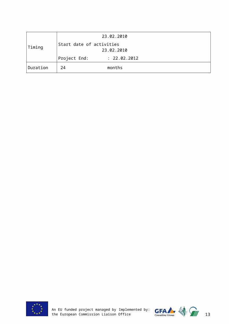
Project starting date : 23.02.2010
Start date of activities : 23.02.2010
Project End: : 22.02.2012
Duration 24 months
9An EU funded project managed by Implemented by:the European Commission Liaison Office

1 I N T R O D U C T I O N
This Project Completion Report (PCR) presents the achievements and the results of the ”Further Support to Land Use - EULUP” , project number 2010/230-489, funded by the EU and implemented by the European Commission Liaison Office (ECLO) in Prishtinë/ Priština. The reporting period covers the full project period from 23 February 2010 to 22 February 2012. In the report, frequent reference is made to the EULUP Inception Report (IR), approved on 19 May 2010.
The principal implementing agency of the project is the Ministry of Agriculture, Forestry and Rural Development (MAFRD). Other beneficiary Institutions are the Ministry of Environment and Spatial Planning (MESP), the Institute of Spatial Planning (ISP), the Kosovo Cadastre Agency (KCA) and the Kosovo Property Agency (KPA).
The project is supported by the consortium GFA Consulting Group GmbH, Germany (leading partner), the Bodenverwertungs– und –verwaltungs GmbH (BVVG), Germany, and the Government Service for Land and Water Management (DLG), the Netherlands.
In this report, the technical activities are summarized in order to make the report readable independently from the Progress Reports (i.e. the Interim and Quarterly Reports), as these Progress Reports are not repeated. Instead, it was tried to give the report a slightly more reflective character, discussing lessons learned, conclusions and recommendations. For detailed technical information, reference is made to the Progress Reports and the Technical and Training Reports. Complete lists of these reports are included in this PCR.
The lay-out of the PCR is in accordance with the requirements of ECLO. Four main parts can be distinguished:
General (Chapter 1 Introduction and 2 Background)
Actions (Chapter 3 , Interventions and 4 Assumptions)
Arrangements (Chapter 5, Implementation)
Reflection (Chapter 6, Sustainability, 7 Monitoring and 8 Conclusions).
10An EU funded project managed by Implemented by:the European Commission Liaison Office

2 B A C K G R O U N D
2 . 1 G o v e r n m e n t a l P o l i c i e s
Basis for the Kosovo Government policy is its course to the accession to the EU. For that reason, the departure point of policy development for its agri-rural sector is the EU Common Agricultural Policy (CAP) of the EU Rural Development Strategy for 2007-2013 and its 4 axis, particularly axis 1 (competitiveness) and axis 2 (environment and sustainable land use). Kosovo is a potential candidate country of the EU and eligible to assistance by the EU in accordance to the components 1 and 2 of the IPA instruments.
Kosovo has entered into a Partnership with the EU and operates in accordance with the Action Plan that is discussed and updated on a yearly basis in joint sessions with the EC. Short and medium term priorities are established. Their aims are the improvement of the competitiveness of agriculture, the improvement of planning and management of agricultural and forest lands, the harmonisation with the acquis communautaire and bringing Kosovo closer to EU best practices.
The Mid-Term Expenditure Framework (MTEF) is directing medium-term policy in Kosovo and is the basis for priority setting and budgeting
Linked with the MTEF and guideline for agricultural policy and development planning in Kosovo, is the Agriculture and Rural Development Plan (ARDP) 2007-2013, issued in 2007 and updated in 2009 (ARDP 2009-2013). The MAFRD will renew this plan in 2012 with the assistance of the Twinning Project, to be commenced in early 2012. The ARDP identifies 8 measures of high or very high priority, of which the measure 2 (restructuring physical potential in the agri-rural sector) is the most relevant for the context of the current report. In addition, Annex 2 of the ARDP gives the outline for rural land management policy.
The conception of the EULUP project is based on the ARDP 2009-2013, but also on the outcomes of the “Agricultural Land Use Project – ALUP”, which was carried out between 2006 and 2008 and had the purpose to stimulate sustainable land use for agriculture in Kosovo.
Focusing on land reform and land use policies, the Governmment of Kosovo has formulated the following action spearheads of the MAFRD.
- Approximation of land use legislation in accordance with the acquis communautaire,
- Protection of agricultural land against indiscriminate construction,
- Rehabilitation and improved management of irrigation systems,
- Land regulation, particularly the solution of the problems with unfinished land regulation,
- Grants and subsidy allocation for agricultural farms.
2 . 2 F e a t u r e s o f t h e L a n d U s e S e c t o r
2 . 2 . 1 I n s t i t u t i o n s i n v o l v e d
Institutions involved in the rural land use are the following:
The Ministry of Agriculture, Forestry and Rural Development (MAFRD). The MAFRD is in charge of agricultural production in Kosovo, and as such takes responsibility for the protection of agricultural land.
11An EU funded project managed by Implemented by:the European Commission Liaison Office
The Ministry of Environment and Spatial Planning (MESP). The MESP is responsible for spatial planning, including the planning in rural areas. Division of responsibilities between MESP and MESP is not overly clear and particularly in the fields of protection of agricultural land and the management of agricultural water systems sometimes competence issues arise.
The Ministry of Local Governance (MoLG). The MoLG is coordinating the activities and communication of municipalities, and as such indirectly is involved in land use structure management through coordination of the MDPs implementation by municipalities.
The Ministry of Finance (MoF). The MoF, through its Department of Property Taxation, is responsible for taxation of immovable properties, including agricultural land. In addition, the Department is leading in the legislation and implementation procedures of expropriation and damage compensation.
The Ministry of Public Administration (MoPA). This Ministry has an indirect influence on land use issues, because it is in charge of correct governance procedures, including those of the municipalities.
The Institute of Spatial Planning (ISP). The ISP is a part of the MESP, and responsible for the national spatial plan, to which all municipal MDP’s are subordinate.
The Kosovo Cadastral Agency (KCA) is responsible for the graphic and textual registration of land ownership and the quality control on this registration. The Municipal Cadastral Offices (MCO’s) are responsible for the day-to-day cadastral works, and are reporting not to KCA, but to the Municipality and indirectly to the Ministry of Public Registration. This constellation is not ideal and may change in due time.
The Kosovo Environmental Protection Agency (KEPA). Part of the MESP, the KEPA is responsible for the formulation of environmental protection policy formulation and implementation
The Kosovo Institute of Agriculture (KIA, in Pejë/Peć). KIA is an Institute of MAFRD and is responsible for soil fertility protection. KIA has an ambition to widen its scope, a.o. in the direction of soil pollution surveys.
The Municipalities. Municipalities are responsible for preparation and for the implementation of the Municipal Development Plans, and where needed, the enforcement of the laws land use and land use planning. They carry main and direct responsibility for land management in Kosovo.
2 . 2 . 2 L e g a l F r a m e w o r k
The two most important laws in the context of rural land use are the Law on Spatial Planning (LoSP, under competence of the MESP) and the Law on Agricultural Lands (LoAL, under competence of the MAFRD). These two laws overlap in the field of rural land use both affecting the important problem of the protection of agricultural land against deterioration, particularly by uncontrolled building. The clarification and where needed the revision, has been done by both Ministries, assisted by EULUP project during 2011.
The LoAL of 2006 prescribes the procedures of Land Regulation on the basis of voluntary land regulation. The contents of the Law is adequate for voluntary land regulation (VLR), but less suited for the solution of the Unfinished Land Regulations (ULR), a problematic heritage form the 1980ies of which the solution is a first priority of the MAFRD. The completion of these ULR was so far still covered by the old 1987 law. The MAFRD has now introduced a new law regulation, which is expected to be approved early 2012. The law is based on voluntary land regulation, but also addresses explicitly the unfinished land regulations. In addition, the MAFRD considered the subject of land regulation sufficiently important for separate law.
12An EU funded project managed by Implemented by:the European Commission Liaison Office
Other legislation of importance for rural land use are (i) the Law on Cadastre, which is in the process of renewal (ii) the Law on Environmental Protection (iii) the Law on Construction (iv) the Water Law, (v) the Law on Expropriation of Immovable Property and (vi) the Law on Immovable Property Right Register.
The Law on Illegal Construction, available in various draft forms since years, is still pending. The subject is politically sensitive, but is urgently needed to clarify the status of the major problem of illegal or unsanctioned construction.
The Law on Irrigation is of importance since it must regulate the responsibilities in one of the most important resources for agricultural production. In 2010 the new Law on Irrigation, long pending, has been promulgated.
2 . 3 B e n e f i c i a r i e s a n d p a r t i e s i n v o l v e d
The main counterpart and beneficiary of the EULUP is the MAFRD, in particular the Department of Rural Development, the Legal Department, the Policy Department, the GIS Section and the Payment Unit (PU). In addition, close cooperation was realized with the Kosovo Institute of Agriculture (KIA), in particular in the context of the project component 5-2, Pollution of Agricultural Land. Further, regular relations were maintained with the Permanent Secretary, the Advisers to the Minister and with the Minister himself, albeit less frequent.
The second official counterpart, but by no means less important, is the MESP. Particular cooperation existed with the Institute of Spatial Planning (ISP), the Department Spatial Planning and the Legal Section. Further, regular consultations were held with the Kosovo Institute of Environmental Protection (KEPA) and the Institute of Hydrometeorology (Hydromet).
In addition, good cooperation was achieved between the project and the Ministry of Finance (MoF). The contact point was the Department of Property Taxation and focused on the Component 4 Land Valuation.
Already mentioned above, close cooperation was achieved with the ISP, which operates under the responsibility of the MESP. ISP was actively involved in the Component 3, Rural Spatial Planning. The ISP has prepared the Spatial Plan of Kosovo and several other spatial plans of national importance. This major component was implemented jointly with ISP, and the ISP is designated to take over and apply the results of this component after the end of the project.
A particular line was maintained with seven pilot municipalities, of which Suharekë/Suva Reka was the main pilot municipality. With this municipality, the concept of rural spatial planning system has been developed and tested. Also the Land Parcel Identification System (LPIS) and Land Valuation activities were piloted in this main municipality. The six so-called co-pilot municipalities (Pejë/Peć, Graçanicë/Gračanica, Prishtina/Priština, Istog/Istok, Kaçanik/Kačanik and Viti/Vitina) were assisted in the application of the developed technologies and plans in their own municipalities.
Not a beneficiary, but certainly a party involved, is ECLO. Although the relation of the project with ECLO is obviously quite different from those with the beneficiaries, content-matter discussions were frequent and fruitful. The support given by ECLO exceeded by far what a contractor normally can expect, and this is appreciated.
13An EU funded project managed by Implemented by:the European Commission Liaison Office
2 . 4 P r o b l e m s t o b e a d d r e s s e d
Problems in agriculture are manifold and only the land use related problems are indicated here.
Small-scale subsistence agriculture
Agriculture is small in scale, land ownership and land tenure is small and very fragmented. Subsistence farming dominates and economically viable agriculture is still a far cry from viable production. It is stated government policy to transfer the current subsistence agriculture into family-based economically viable production. This will require a variety of simultaneous developments, including land market development, effective delineation of agricultural land and control building, job opportunities outside agriculture, availability of long-term low-interest credit, resolving cadastral ambiguity and others.
Lack of rural planning
Rural land use is not well regulated and does not receive the required attention. About 80% of municipalities already have or are in the process of MDP development, however due to lack of data on land properties, these plans treat rural areas inadequately if to compare to urban areas. Also, because no standards exist for planning and data collection and maintenance, each municipality has its own approach and consistency is very much lacking. The availability of data is most problematic, and no adequate agricultural land suitability system was available.
So, municipalities so far had no adequate instruments to plan and control the use of rural land, and combined with the weak implementation of land use policy in accordance with the current legislation, this leads to a continued loss of agricultural land, mainly to construction. Such uncontrolled and widely spread urbanisation, in most cases even illegal, is the biggest threat to the competitiveness of Kosovo agricultural sector, as basically no good land will remain in economically viable sizes.
Land fragmentation
Land fragmentation in agriculture in Kosovo is extreme. The average farm size is about 2.5 ha, spread out over 8 parcels. Eighty percent of the farms have less than 4 ha of agricultural land at their disposal (ownership of lease). Only ca 0.5 % of all farms is larger than 10 ha. In addition, division of farms by inheritance is still common. This often results in further reducing farm size or in shared ownership of farms among several family members, complicating decision making. The policy of the ex-KTA and now PAK to sell off land-based SOE’s as a whole or in large portions of land, did nothing to increase farm size of entrepreneurial young farmers and improve economic viability of family based farming. This must be considered a missed chance.
Unfinished Land Regulation
The phenomenon of the Unfinished Land Regulations (ULR) is a heritage from the 1980ies when land consolidation was carried out in 8 municipalities on a large scale, supported by the World Bank. The projects – often accompanied by the construction of new subsurface irrigation systems - were abandoned due to lack of funding at various stages of completion. The solution if these land regulations is very complex, since never any cadastral registration was done. The relatively “simple” ones are the ones which were completed (inclusive physical parcel transfer) with the exception of the cadastral registration, and where the land owners are adhering to the new parcelation. The complex ones are the projects where parcel transfer was only partly done or where landowners returned to their old parcels.
The ULR’s are often situated on the best agricultural land. The owners have no title deeds, and the information on the ULR is often not anymore available. The solution is urgent, since with passing of time the collective memory is fading and the number of conflicts are likely to increase.
14An EU funded project managed by Implemented by:the European Commission Liaison Office

Locked land market.
An immediate consequence of the lack of rural land management is that the land market does not function well, because land prices are speculative and not based on the destination of land. For that reason, the purchase of land for agriculture purposes tends to be unaffordable. In addition, the official data on prices of selling and buying are so unreliable that they are useless.
There are also other causes for the locked land market. These are the low profitability of agriculture, making the demand for land for agriculture very low, and the unavailability of low-interest long-term credit to finance the purchase of agricultural land. In addition
Cadastral registration
Although briskly addressed by the Kosovo Cadastral Agency since March 2010, the registration of land ownership in Kosovo is outdated. Moreover, many data have been lost during the war, either destroyed or taken to Belgrade and are still kept there.
Notwithstanding promising progress, still the situation exists that Cadastral Registration, both graphic and textual, is unreliable and/or outdated in many places.
Pollution of Agricultural Land
The expectation exists but is unconfirmed that Kosovo rural areas are polluted at places by pollutants either from local origin or transported from polluted sites elsewhere and deposited locally. Investigations have been done earlier on hotspots, but no consistent reconnaissance was yet done in agricultural land. Suspected zones are flood plains and fallout areas of airborne pollutants (power plants).
2 . 5 C r o s s - c u t t i n g i s s u e s a d d r e s s e d
The project has tried to use each opportunity to raise awareness on issues related to good governance, human rights, gender, minorities and environmental sustainability. The character of the project was that no specific actions were taken in the fields of gender, good governance and human rights
Cross-cutting issues encountered comprised mainly the environmental sustainability of the applied interventions, as this issue was most relevant and important for the project objectives. These aspects are integrated across all project components in both decision-making and procedure development. Law development has always taken into account these interests, and similarly so in spatial planning and land consolidation proposed policies and actions.
2 . 6 O t h e r I n t e r v e n t i o n s
UN Habitat carried out a programme on spatial planning in several municipalities. However, this was not directed at rural areas but its character was mainly urban. Close and cordial coordination took place, ascertaining that no duplication took place.
The EU Twinning Project “Preparation for implementation and management of agricultural and rural development policy in Kosovo” advised the MAFRD on a variety of subjects, among which the most relevant for EULUP was the (non-technical) advice on the development of land-use-related data bases. Approximately simultaneously three related databases were developed on Farmer Register by the EU Farmer Register Project, on animal identification by the EU Animal Registration Project and the Land Parcel Identification System – LPIS by the EULUP.
15An EU funded project managed by Implemented by:the European Commission Liaison Office

Data and documentation available
Data and information used came from various sources. Quality was sometimes good, and sometimes not, from time to time creating the need to carry out extensive additional investigations or – as often in the case of mapping and GIS data - significant repairs.
The most important documents and other information extensively used were as follows:
The documentation of the ALUP project, including the Progress Reports, the Project Completion Report and its Technical Reports. This was logical since EULUP was a follow-up of ALUP (2006-2008), and the issues addressed in ALUP were mostly continued in EULUP.
A basic document for the current project is the MAFRD Agricultural and Rural development Plan (ARDP 2009-2013), revised in 2009 and expressing the policies of MAFRD on agriculture, including land use.
Particularly for the spatial planning and LPIS components, extensive use was made of the aerial photography, digital terrain models and (electronic) maps of KCA. MAFRD now possess all ortho-photos of 2009.
The Independent Commission of Minerals and Mines has made available the GIS formats Soil Map and Mineral Resources Management Plan under certain conditions. These data have been particularly used in C3 to device the municipal-level construction zoning plans.
16An EU funded project managed by Implemented by:the European Commission Liaison Office
3 I N T E R V E N T I O N
3 . 1 O v e r a l l o b j e c t i v e s
The overall objective of the project as formulated in the ECLO approved Inception Report - “to contribute to sustainable increase of productivity and the utilization of agricultural land through measures of land reform and rural planning”.
3 . 2 P r o j e c t p u r p o s e
The specific purposes of the project as presented by the Project ToR are:
1. to facilitate land reform through land consolidation and the development of a land market, initially through leasing arrangements based on sound and accepted land valuation principles and techniques;
2. to improve building and development control through sound spatial planning policies and practices and in support of environmental protection.
The results and the activities undertaken are all in the context of above two interrelated purposes.
3 . 3 R e s u l t s
The ToR of the project describe the results to be achieved (§ 2.3, Results to be achieved) and distinguish also components to be addressed (§ 4.2, specific activities). These “Results” and “Components” do not coincide 1 to 1 and might give way to ambiguity. For that reason, it was proposed in the Technical Proposal and introduced in the approved Inception Report to speak about Components only.
The categorization as introduced in the Inception Report - and used ever since - is given in table 1, first column. Relation with the ToR is given in Column 2 and 3.
Table 1: Components and results
Project Component Component (§ 4.2 ToR) Result/output (§ 2.3 ToR)C.1 Legal Assistance to
MAFRD1. Legal assistance to
MAFRD 4. LoAL and the draft Law on LC
harmonized with related laws. Administrative Instructions drafted as required
C.2 Land Regulation 2. Land Consolidation 1. National Strategy on LC approved2. LCO and LCC’s installed and
operational3. Change of ownership and change of
use is registered in the Cadastre at KCA and the Land Register at MAFRD
C.3 Spatial Planning and Environmental Protection
3. Spatial Planning and Environmental Protection
9. Rural land management plans, Environmental Action Plans and Land use plans are prepared
8. Compatibility of data bases is ensured.C.4. Land Valuation 4. Land leasing / valuation 5. Land classification and valuation
17An EU funded project managed by Implemented by:the European Commission Liaison Office

Project Component Component (§ 4.2 ToR) Result/output (§ 2.3 ToR)system is developed and in place
C.5. Land Register, inventory of polluted areas and Geographic Information Systems (GIS)
5. Land Register, inventory of polluted areas and Geographic Information Systems (GIS)
C.5.1 Land Parcel Identification system (LPIS)
7. Land register data base is prepared for pilot areas
C.5.2 Agricultural Land Pollution and GIS Database.
6. Inventory data base on pollution of agricultural land is available
8. Compatibility of data bases is ensured.C.6 Coordination and
communication among stakeholders
6. Coordination and co-operation among stakeholders
10. Coordination and cooperation among stakeholders
Training is included in the separate Components.
7. Training 11. Training, Workshops and Study visits
The following remarks may be made.
Ad. C.4 Land Valuation. Following a request of the Ministry of Finance, ECLO approved the proposal of EULUP to assist the MoF in the preparation of the A.I. on Land Valuation to the Law on Expropriation of Immovable Property. To make this possible, the Land Leasing was cancelled from the project. See further paragraph 3.4.4
Ad. C.5.1 LPIS. During the inception phase, discussions were held among MAFRD, ECLO and EULUP how exactly to interpret the requirement of a “Land Register”. The consensus was clearly that a Land Parcel Identification System (LPIS) was required for Kosovo.
Ad C.2 Land Regulation. Change of ownership is registered in the Cadastre, i.e. the Municipal Cadastral Offices (MCO) and via the MCO at the KCA. This information is not registered in the MAFRD.
3 . 4 A c t i v i t i e s
3 . 4 . 1 C 1 : L e g a l A s s i s t a n c eThe Component 1 legal assistance was both directed to the MAFRD, the MESP and also to the MoF. Assistance to the MoF is discussed under Component 4. As anticipated in the Inception Report, two major legal issues were to be addressed, i.e. the Law on Land Regulation and the Administrative instructions on Municipal Development Planning. In addition, the awareness campaign on rural spatial planning was implemented during that last stage of the project.
However, a few more matters have been added in the course of the project. These included the preparation of the A.I. on Spatial Planning Data to the LoSP, and the assistance to the MAFRD Working Group on ALS and the ministerial Administrative Order on new Agricultural Land Suitability, and the MOU arrangements on data sharing between MAFRD, MESP and MoLG.
The LoLR was ready in draft at the beginning of the project. On the request of ECLO comments were given on the Law. The main comment was that the Law was in conflict with the LoAL and the draft Strategy on LR, both based on the principle of voluntariness of LR and thus in conflict with the draft LoLR. The original draft was based on the majority-driven land regulation, adopting
18An EU funded project managed by Implemented by:the European Commission Liaison Office

compulsory participation if a majority of 70 % of the owners was in favour. Following discussions and decision-making internal MAFRD and supported by EULUP, the MAFRD policy was reconfirmed that land regulation should in principle be voluntary. The MAFRD Legal Working Group and the EULUP lawyers have redrafted the Law, and prepared 6 of the 8 Administrative Instructions. The draft is currently under approval by the Assembly. Approval is expected soon.
The development of the new rural spatial planning model and its major database (see C.3), was followed by the re-drafting of the A.I. on Municipal Development Planning (MDP) to the Law on Spatial Planning (LoSP). PS MESP installed a Legal Working Group for this purpose. In addition, also the A.I. on the Spatial Database, also to the LoSP, were developed. None of the drafted and in legal WGs discussed A.I. was approved yet, although required by the Law.
An essential foundation of the new rural spatial planning model is the Agricultural Land Suitability (ALS) classification. The classification in force was found unsuitable (see § 3.4.3) and the new ALS was developed. The inter-institutional WG endorsed the new ALS and recommended its approval. MAFRD Working Group was established by the PS for this purpose, and currently discusses the ALS ministerial Administrative Order, drafted by EULUP.
Although not foreseen in the EULUP ToR, a media campaign on rural spatial planning and construction zoning was prepared. Main focus is on construction control on good agricultural land, that will be legally regulated in the new and/or updated MDP’s by allocated detailed construction zones in municipalities. The awareness campaign emphasizes the need of protection of rural areas and its functions, of which the most important one is agriculture, and it informs on the changes of legislation to allow better enforcement. It is expected that the campaign will contribute to both acceptance by citizens and enforcement of the new legislation.
The awareness campaign was prepared parallel to the completion of the A.I. For that reason, the condition was set that airing the campaign will only be done, once the new A.I. are signed by the Minister, or at least accepted fully by all ministerial staff involved.
The Parliamentary Commission of Agriculture was assisted in its processing of the Law on Land Regulation.
Training was given by SSTE 1-1 and JSTE 1-1 in workshops, sometimes explicitly but most of the times inherently by jointly drafting the legislation and commenting of results. In October to November 5 regional Workshops were given, during which all municipalities have been invited. Subjects of the trainings were the Law on Agricultural Land (LoAL), the LoLR, and the new A.I. on MDP under the LoSP.
Table 2: C.1 Legal Assistance. Expected outputs as related to activities
Expected output as in Inception Report
Status completion
Comments, changes
1.1. Proposal for revision or reorganizing of the LoLR
completed LoLR is expected to be approved by Assembly on short notice.
1.2. Proposal for revision or reorganizing of the A.I. for LoLC
completed 6 of 8 A.I. were prepared in draft. The remaining 2 will be done by Legal WG MAFRD
1.3. Training programme designed and implemented
completed Training programme was incorporated in the legal drafting of laws and A.I.
1.4. A.I. of the LoSP and the LoAL adjusted to the harmonized procedures on municipal planning and protection of agricultural land
completed Inventory of inconsistencies done (EULUP TechRep 5). Draft new A.I. on MDP prepared. In addition, the draft A.I. on National Spatial Database and draft A.O. on ALS prepared
1.5. A public awareness campaign is designed and implemented
On-going Preparation is on-going. Airing still to be discussed, depending on approval of the A.I. on MDP
1.6. Regional municipality workshop on LoLR and legislation on MDP is carried
completed Five workshops were carried out in Pejë/Peć, Gjilan/Gnjilane , Prishtina/Priština, Prizren and
19An EU funded project managed by Implemented by:the European Commission Liaison Office

out Mitrovicë/Mitrovica
3 . 4 . 2 C 2 : L a n d R e g u l a t i o n
Although not included in the Inception Report, an early and important issue was the completion of the Strategy on Land Regulation (20010-2020). The Strategy itself was based on the draft prepared during the ALUP project and adapted by MAFRD afterwards. Missing was still a concrete Action Plan for the next 10 years. This was prepared and submitted to MAFRD. The final version was adapted by MAFRD in accordance to its requirements. The Action Plan was approved in mid 2010 and added to the Strategy. The Strategy is based on voluntary participation in Land Regulation.
The Land Regulation programme is initiated by MAFRD and fully financed by the KCB, and not an ECLO program. The role of the consultant is, therefore, slightly different than in the other project components which are initiated by the project and partly or fully financed by ECLO. The role is advisory to the MAFRD, without mandate and not leading.
The programme established in the Action Plan comprises Unfinished Land Regulation (ULR) and Voluntary Land Regulation (VLR). Land Regulation for farm adjustments due to large infrastructural works (Highway) are not yet considered by MAFRD.
In 2010 no new programme on ULR was initiated because the 2009 programme was still to be implemented. This was completed at the end of 2010. In 2011, MAFRD tendered an ULR programme that was deviating from the Action Plan: instead of 3 Municipalities, only one was selected: Gjakovë/Ðakovica, and instead of maximum 4 Cadastral Zones (CZ) per municipality, 13 were selected, including the very complex ones that will necessarily require further study before tender.
Due to internal procurement MAFRD problems, this tender for the Implementing Company was only granted at the end of December 2011. As a result, this programme must be implemented in 2012. EULUP doubt whether the selected company has the capacity and experience to implement this work successfully.
The VLR programme started in reality in early 2011 only. An extensive programme of information to interested municipalities and villages was initiated by the project. The planned awareness MAFRD campaign (to be financed by KCB funds) to broadcast the possibility of MAFRD subsidized VLR and supported by EULUP did not materialize due to procurement problems. In January 2011 the first request for VLR was received by the MAFRD (village of Pozheran, Viti/Vitina), and approved in June 2011. Bradash (Podujevë/Podujevo) was requested in early October and not yet approved. The geodetic work in Pozheran could not be contracted out and the works are pending.
EULUP has been continuously supporting MAFRD in processes and tender procedures, and drafted ToR and specifications. The starting work in Pozherean was completed to the point of the requirement of the need of a geodetic company. Plans are now to tender Pozheran and Bradash simultaneously in early 2012.
At the end of 2011 the problematic ULR’s of Prizren and Rahovec/Orahovac – pending since 2008 due to the fact that the work was accepted by MAFRD, but not by the MCO’s of both municipalities – could finally be completed to the point that the decisions by the then Land Regulation Commissions (LRC) are registered.
20
Unfinished land regulations (ULR) Land regulations carried out between 1983 and 1989, but left unfinished in various stages of incompletion. The area comprises about 25.000 ha, divided over 8 municipalities. The projects are large in scale. Participation of owners can be made compulsory by the Minister.
Voluntary land regulations (VLR) Land regulations newly to be developed, and to be carried out on the land owners’ initiative and based exclusively on voluntary participation of landowners. Participation by land owners is voluntary. Scale of the projects is ranging from 20 to 50 ha., but the scale may be increased with increasing experience.
An EU funded project managed by Implemented by:the European Commission Liaison Office
The Land Regulation Office, foreseen in the Strategy and included in the IR as an absolute precondition for success in the C.2 was not formed, notwithstanding continuous encouragement by EULUP. It may be concluded on basis of the experiences in 2010 and 2011 that the management of the program by MAFRD is indeed too weak for successful implementation of the programme. The issue was a point of constant attention and concern, and was discussed regularly with the MAFRD’s decision-making officers.
Registration of land ownership in the framework of land regulation proved to be less problematic than foreseen during the Inception Report. JSTE 1-1 has investigated the matter and TL repeatedly discussed about this issue with KCA, MCO’s and other involved parties. The decisions of the LRC can be registered by the MCO, only if there is a situation of inheritance, the Municipal Court has to be involved.
In addition to the IR, an economic study was done to the economic viability of small-scale voluntary land regulation. The villages of Pozheran and Bradash were taken as objects of study, and the outcome was promising. Internal rates varied between 2 and 12 %, with an exceptional high value if in Pozheran the flood problems are tackled simultaneously. Data availability proved to be a major problem, and sometimes necessitated to work with professional estimates by subject matter specialists. Also interviews with villagers gave good information. The results are given in Technical Report 21)
Since no support is available in 2012 to the officers of MAFRD– who in the absence of the planned LRO are charged with all implementation of land regulation – a TAIEX request will be prepared for such assistance.
Table 3: C.2, Land Regulation. Expected outputs as related to activities
Expected output as in Inception Report Status completion
Comments, changes
2.1. Advice on legal action to take and – if needed- propose adaptations to the Strategy
Completed
2.2.1. A draft land reform strategy for the MAFRD is outlined
Not yet done To be drafted at the very end of the project, i.e. end of February.
2.2.2. Action plan for land regulation implementation with time schedule and budget is completed
Completed Action Plan was prepared, submitted to MAFRD and adapted in accordance to MAFRD preferences and approved. Updated in early 2012.
2.2.3. Agreed procedure of land registration in the framework of land regulation. If unachievable, recommendations on the legal actions to be taken
Not successful.
Procedures remain unclear to the consultants, but in discussions on this issue (KCA, Municipal Courts, MCO’s), it is repeatedly ensured that the registration is no problem at all.
2.3. Installation of LRO and LRC’s; Financing of land regulation in 2011 and 2012
LRO not installed
Financing for 2011-13 is ensured. LRO is not installed. This issue was pursued to the end, but its realization is a MAFRD decision and outside the mandate of the EULUP. Considered non-achievable.
2.4.1. All five ongoing unfinished land regulation (ULR) projects will be completed and 3 others will have been commenced
Partly completed
The 5 ongoing ULR projects were completed (Gjakovë/Ðakovica, Prizren, Rahovec/Orahovac, Vushtrri/Vučitrn, Obiliq/Obilić Second Gjakovë/Ðakovica ULR project was started. Only one, due to the change of plans by MAFRD as compared to the Action Plan.
2.4.2. Two new voluntary land regulations (VLR) are agreed upon and under implementation.
Partly completed
Two VLR started, but still in starting phase.
2.5. Trainings and workshops and study visit carried out
Completed Training workshops organized on policy and implementation, training of LRC’s and info meetings for prospective villages.
21An EU funded project managed by Implemented by:the European Commission Liaison Office

3 . 4 . 3 C 3 : S p a t i a l P l a n n i n g a n d E n v i r o n m e n t P r o t e c t i o n
Robust rural land management planning is crucial if Kosovo is to achieve a sustainable and competitive agricultural sector. The project took a comprehensive approach to develop a country-wide system of rural spatial planning that would comply with EU policies and serve as a basis not only for development of Municipal Development Plans, but also for forming information-based national policies in Kosovo. Though the IR required developing a database just for 1 pilot municipality and train 6 co-pilots, the project took initiative to develop the database for the whole country in order to reach sustainable impact.
In Kosovo there is no centralized data collection system, and research data are highly fragmented, while the quality of GIS data varies. In an attempt to resolve the issue of poor data quality and quantity project experts have developed conceptual models based on scientific knowledge, EU experiences and available datasets covering all Kosovo. The models serve as proxy assessments replacing field or research data. The accuracy of the maps depends largely on the quality of available input data.
The overall planning system called Basis for Rural Spatial Planning (BRSP) has been developed and presented below. The main feature of BRSP is that it integrates land physical properties in the spatial planning and decision-making. BRSP consist of two parts: I. - Land Assessment, II. – Rural Land Management Planning. ‘Land Assessment’ itself consists of land suitability assessment for agriculture and the assessment of land environmental sensitivity.
At the I BRSP part, land quality in Kosovo has been assessed by developing a national system of Agricultural Land Suitability (ALS) as currently used land ‘cadastre classes’ do not meet modern planning needs. The expert groups thoroughly analysed existing soil, climate and terrain data in Kosovo, examined other land suitability classifications in the region and elsewhere, and finally developed a country-specific ALS classification that suits best the country needs, data availability and is compatible with FAO methods.
The detrimental effects of mechanised arable cultivation on the environment have been considered by implementing Environmental Land Sensitivity (ELS) assessment. ELS looks at environmental degradation associated with agricultural activities such as groundwater pollution, soils erosion and biodiversity value. Again, models development involved numerous data analysis, synthesis and verification. By linking ALS and ELS an Integrated Land Suitability (ILS) is derived that provides a powerful tool for land use planning and zoning in rural areas.
At the II BRSP part, the planning system of Rural Land Management (RLMP) is developed. RLMP provides a practical framework that fosters improved land use structure that encourages land to be managed in an integrated and sustainable way. RLMP has been divided into four stages, all of which rely on data of the completed land assessments.
Stage 1 - Optimised Land Use Plan (oLUP) identifies the optimum land use across Kosovo ensuring the most efficient use of land resources for economic and environmental purposes. About 12% of land use must be converted into other land use type.
Stage 2 - Land Use Intensity Plan (LUIP) builds on the oLUP by recommending the intensity of land use within an integrated land management approach. Conceptual model identifies 5 distinct types of land management: 3 for agricultural land and 2 for forest/semi-natural areas.
Stage 3 - Rural Environmental Action Plan (rEAP) provides 13 land management guidelines to safeguard the environment and minimise negative impact of agriculture or forestry on water, biodiversity and soil resources.
Stage 4 - Construction Zoning Plan (CZP) at Municipality and Village level brings together all previous data to suggest draft urban development strategy for a Municipality and then to establish construction zoning boundaries for each expanding settlement.
22An EU funded project managed by Implemented by:the European Commission Liaison Office

CZP is of utmost interest for Kosovo if to safeguard the remaining good quality land and prospects of competitive agriculture. It is also important for minimising development costs as more concentrated urbanisation eases the burden of public financing needed for infrastructure.
Separate Technical Reports have been prepared for all of the assessment and planning models describing their structure, data, use and limitations. All these technical reports are then combined into one user-friendly document ‘Guidelines for Rural Spatial Planning’. The principal advantages of BRSP to be implemented in all Kosovo are that this framework is:
based on existing available data for the whole of Kosovo (usage at scale 1:50,000); implemented in GIS, therefore easily applied and updated with new information; a consistent and reliable system that allows comparisons between municipalities; easy to use and ready for use by municipality planners now.
Based on the BRSP structure the nation-wide GIS database for land and environment has been developed. Overall, about 14 new GIS data sets were created as outputs of the EULUP created spatial planning models, and in addition some 35 input GIS data layers were collected, transformed into Kosova reference system, properly processed and stored in a single GIS Database. All data is supplied with Metadata (description of the data) and with relevant documentation: The GIS Technical Documentation along with detailed User Manuals. Two identical copies of database will be delivered to MAFRD and MESP/ISP. In fact, the GIS tasks took substantial efforts, resources and time within the project. It was the first time that full GIS datasets on environment and land management are created for all Kosovo. The system validity has been tested in the main pilot municipality – Suhareke. The local staff was very helpful and active in the whole process.
Along with creation of the planning system and database, the project implemented other activities that would ensure the understanding, acceptance and practical usability of the BRSP and database. In principle, every step of the creation of the planning system has been consulted with local experts and beneficiaries. The project implemented various trainings. The advanced GIS trainings were held once a month on average for GIS Joint Technical Group (5 institutions), and a basic GIS course has been organized for the municipal and ministry staff (16 persons) at the AUK. Two GIS specialists (1 ISP and 1 MAFRD) received a customised advanced GIS training at GISDATA, Skopje. Besides, four GIS specialists (ISP and MAFRD) were additionally consulted and trained in person at EULUP premises. Effective study visit on SP in Germany realised, where 7 government officials participated. Training and consultations of co-pilot municipalities were concentrated at the end of the project. Other municipalities and international organisations active in SP were also informed though workshops and round-table meetings.
23An EU funded project managed by Implemented by:the European Commission Liaison Office

BASIS for RURAL SPATIAL PLANNING - BRSPNational GIS Spatial Database
Land Assessments
(1+2) Integrated Land Suitability - ILS
1. Agricultural Land Suitability - ALSSoil ClimateTerrain
2. Environmental Land Sensitivity - ELS
Soil Erosion Sensitivity -SESGroundwater Sensitivity -GWSEstimated Biodiversity Value - EBV
4. Construction Zoning Plan – CZP
Municipality level Village level
Rural Land Management Planning
Indicating areas where land use should be changed
Recommending land use intensity zones for agriculture and forestry
1. Optimised Land Use Plan - oLUP
2. Land Use Intensity Plan - LUIP
3. Rural Environmental Action Plan - rEAP
Recommending agricultural practices for preserving environment
Indicating type of settlements’ growth and restricted areas for construction in a municipality Indicating construction border and main functional zones in a village
2323

An EU funded project managed by Implemented by:the European Commission Liaison Office 24
EULUP facilitated the national government to adopt the relevant legislation in order to secure national database use. The official inter-institutional Working Group (WG) on Agricultural Land Suitability (ALS WG) analyzed ALS in six meetings and finally endorsed its national usage. Currently, the established Legal ALS WG is working out the final version of Administrative Order, as drafted by EULUP experts, legalizing ALS usage nationally.
MAFRD-MESP WG on Spatial Planning has been established and had a meeting to discuss the EULUP developed models and their introduction into the national legislation. As an outcome the Legal WG was established at MESP that worked out the final versions of two new Administrative Instructions on MDP and on Spatial Database, as drafted by EULUP.
EULUP initiated collaboration of MAFRD and MESP and drafted the MOU that would note procedures on GIS data share and updates between these Ministries. The Commission of Mineral and Mines (ICMM) has been approached for GIS data, and for the first time the data has been given at no cost to MAFRD, based on the mutual MOU, again, as drafted by EULUP. However, in the near future the Kosovo government should solve the issue of free data share between governmental institutions that are supposed to be used for public purpose. This would ensure faster development of Kosovo at much lower cost.
The implementation of BRSP in Kosovo can be very beneficial for forming national agriculture and environment protection policies that are in compliance with EU regulations, as they cover all Kosovo. Coupled with statistical and economic data the RLMP plans can serve as initial data for correctly adopting EU legislation in Kosovo, in particular – the new CAP, which after fundamental reform will focus entirely on environmental and climate change objectives.
Table 4: C.3 Spatial Planning and Environmental Protection. Expected outputs as related to activities
Expected output as in the IR Status Changes/comments3.1. GIS Technical Joint Group installed
and trainings provided CompletedActive JTG members (ISP and MAFRD) can provide consultations on SP database to municipalities
3.2. Pilot municipalities are selected Completed 7 municipalities, based on motivation and GIS knowledge
3.3. Refined land suitability classification (ALS) data analysis, collection, approbation Completed
New ALS classification prepared. GIS data and maps cover all territory of Kosovo. Inter-institutional WG on ALS endorsed new ALS.Legal WG works on ALS legalization
3.4. Spatial planning GIS models created (GWS, GWR, SES, SER, EBV, ELS, ILS, oLUP, LUIP, rEAP, CZP)
3.4.1. User (GIS) documentation prepared
Completed
Completed
All models adapted to all Kosovo available data.Structure of models tested on GIS data for Suhareke municipality Over 100 pg.
3.5. Trainings, assistance and consultations provided to co-pilots Completed
Main trainings on BRSP held in all co-pilots as well as regions and ministries. GIS trainings held for co-pilots
3.6. Data harvesting, geoprocessing and mapping for main municipality Completed Data and maps cover whole Kosovo: 14 new GIS
data layers + 35 processes input GIS layers
3.7. EAP for main pilot municipality Completed EAP is integrated into RLMP system (rEAP), and prepared for all territory of Kosovo.
3.8. Development of regulations drafts, methodologies and guidelines:
3.8.1. Community awareness booklet on illegal construction
3.8.2. Guideline for Rural Land Spatial
Not completedUnder preparation
Two new A.I., 1 A.O., 2 MOUs
As legal changes are not yet introduced, it is makes no sense to prepare the booklet yet
2424

An EU funded project managed by Implemented by:the European Commission Liaison Office 25
Expected output as in the IR Status Changes/commentsPlanning and Construction Zoning
3.8.3. Technical Guideline on MDP’s GIS structure for the rural component
Completed
3 . 4 . 4 C 4 : L a n d L e a s e a n d L a n d V a l u a t i o n
In the project ToR and thus also the Inception Report, the land market component comprised two main components: land valuation and land lease. With ECLO agreement, the land lease component was dropped in the course of the project in exchange of an additional activity in the land valuation program, i.e. assistance to the Ministry of Finance (MoF) headed Inter-Ministerial Working Group on Land Valuation (WG LandVal). MoF, MESP, MAFRD and the Ministry of Trade and Industry (MTI), supplemented by the Kosovo Chamber of Commerce (KCC) are the members.
This assistance was requested from EULUP by the MoF and MAFRD and on the proposal of EULUP approved by ECLO. The land lease component was cancelled on the justification that this component was worked out in ALUP, and since formal leasing is still very limited in Kosovo and not much had changed in the years since ALUP, this activity was not seen as very useful, both by MAFRD as well as EULUP.
Incorporating this change, the program comprised three main components, all in the field of land valuation.
1. The preparation of land valuation base maps of the seven pilot municipalities and the addition of a scoring model to finetune the valuation of specific parcels.
The establishment of the land value in Kosovo is not a simple matter. In principle, this must be based on the A.I. on determination of Market Value and Valuation Standards (2003/1). These rules cannot be enforced because no reliable market prices are available in Kosovo. There are three main reasons for this. First, sales prices used to be verbally agreed, sometimes long time ago. Second, sales transactions exceeding € 10.000 must be transferred by bank. This is often avoided by keeping the officially declared prices lower than this amount. Third, there is hardly distinction between agricultural land prices and construction land prices. Despite the fact that many (now 16) municipalities have a Municipal Development Plan (MDP), control of building cannot be achieved and land prices are speculative.
So, reliable comparison prices cannot be obtained via official registration but must be found out unofficially via market parties, particularly real estate brokers and lawyers active in this trade and municipal staff (MCO staff and the Property Tax Manager and his staff).
The valuation base maps were produced by such informal ways, interviewing market parties and municipal staff. As good as possible, maximum and minimum prices were established per Cadastral Zone (CZ). The maximum price referred to land that might be used for construction and has good infrastructural conditions, and the lower price referred to areas less suitable for construction. These prices can be further finetuned by the scoring model, introducing land suitability, access, irrigation and other important economic parameters.
The model must be applied by an expert land valuer who can judge and adapt the criteria if it is not clear which of the two prices should be adopted, and who is able to judge the quality of outcome of the assessment. Technical report 20 – Valuation Report - delivers a more comprehensive discussion of the technique.
It must be understood that the valuation model does not employ criteria that lead to values that are made to be in accordance with government policies, but it is meant to arrive at prices that are realistic.
2525

An EU funded project managed by Implemented by:the European Commission Liaison Office 26
2. The preparation of an Action Plan for the licensing of Kosovo valuation experts.
This activity was explicitly requested by the Permanent Secretary MoF during the Inception Period and the question had its origin in the on-going land valuation for the new Motorway under construction. The Action Plan was prepared in cooperation with the WG LandVal and suggests a tailor-made Kosovo approach, as contrary to the EU-certification approach and the Tegova approach. The Kosovo approach is in concert with EU standards. It is less strict than the complex and difficult to acquire EU standard certification, but for the current needs in Kosovo this method is preferred.
The Kosovo Chamber of Commerce is preferred both by MoF and EULUP to lead and control the licensing procedure. Apart from the licensing approach, the Action Plan works out the certification procedure, defines the institutions involved, identifies bodies to be created (Supervisory Board and Examination Committee), discusses work flow and time schedule and outlines vocational training programs. Finally, the notion of quality control and public appointment is discussed, to be awarded for restricted periods and to be renewed regularly. The Action Plan is included in Technical Report nr 19.
3. The assistance in preparing the A.I. on land valuation and damage compensation to the Law on Expropriation and Immovable Property (LoEIP).
The A.I. were made in concert with the MoF dept. of Property Taxation, the UNDP CBEI international lawyer assigned to the MoF and the Swedish TAIEX cadastral expert assigned to MoF. Role of EULUP was the deliverance of the methodology of valuation and damage compensation. The development started in March 2011 and ended in September. The draft A.I. has now been submitted to MoF for approval and signature by the Minister.
Training was done in the form of workshops. Different target groups were the ministries and the pilot municipalities.
Table 5: C.4, Land Valuation. Expected outputs as related to activities
Expected output as in Inception Report Status completion
Comments, changes
4.1. Working group on land valuation is revived
completed The original ALUP Working Group was not revived; instead the Inter-Ministerial Working Group on Land Valuation was supported.
4.2. Pilot municipalities are selected and the valuation methods are updated
completed Pilot municipalities are the same as those adopted in C.3, Rural Spatial Planning
4.3. Zoning map for main pilot region completed Land zoning base maps prepared for Suharekë/Suva Reka, main pilot municipality
4.4. Valuation report completed Technical report 19
4.5. Zoning maps on land value for co-pilot municipalities
completed Land Zoning maps prepared for the 6 co-pilot municipalities
4.6. 25-40 persons trained (from IR) completed Ca 30 people trained, from ministries (mainly MOF and MAFRD) and the pilot municipalities.
4.7. Updated leasing contracts cancelled See first § 3.4.4
4.8 Contribution to A.I. for LoEIP delivered completed
3 . 4 . 5 C 5 - 1 : L a n d P a r c e l I d e n t i f i c a t i o n S y s t e m ( L P I S )
During the Inception period, in consultation with beneficiaries, it has become clear that by “Land Registry” the Land Parcel Identification System (LPIS) has been meant. LPIS is one of the elements of the Integrated Administration and Control System (IACS). IACS is the
2626

An EU funded project managed by Implemented by:the European Commission Liaison Office 27
key tool to control the agricultural subsidies provided by the Common Agricultural Policy (CAP) of the EU.
The full IACS based LPIS system is too early and too complex for Kosovo, thus the project has suggested development of a ‘simplified’ LPIS – sLPIS. The main condition of such a software was that it should be able to implement main LPIS functions, but without complicated control mechanism attached. The project managed to obtain LPIS software free of charge that is used in Romania (IPA Online). The software has been successfully adapted, translated, installed on the local server at EULUP office. The ‘LPIS software User Manual’ was prepared and shared.
Beyond the IR planned outputs, the developed GIS prototype sLPIS software is Web based, which allows accessing the sLPIS through internet from any location provided that internet connection is good enough. The software is Linux based and the architecture of the application is based on open standards and open source software including Apache Webserver, Mapbender, Mapserver, TinyOWS, PostgreSQL, PostGIS and many more.
The prototype software and data model have been tested in Studencian cadastral area of Suhareke municipality. With assistance of municipal staff the parcel data of 66 farmers have been digitized and the numerical data entered in sLPIS. An overall data entry processes has been monitored and evaluated, and some software and process improvements implemented.
The server for holding sLPIS data has been purchased by MAFRD and placed at the premises of MAFRD PU. The server is capable of supporting 400 concurrent users at once, those is suitable for national data collection. The server shall be also used for holding all spatial data as developed by EULUP, as well as suitable to hold Farm Register data, if it is Linux based. The training on IT system administration was provided to appointed MAFRD IT administrator, and the IT Administration Guideline developed and shared.
As the main activities of this component were already completed, the project further focused on overall understanding, training and practicing sLPIS by MAFRD and municipal staff, this way creating preconditions for the sustainable use of the system.
In October 2010 the LPIS study visit has been carried out in Croatia. Participants were very satisfied with the organization and the knowledge received, which triggered their more active interest for LPIS implementation in Kosovo. The information on regional and local LPIS activities was useful for acknowledging the complexity of resources and skills needed to run the system.
Numerous trainings were implemented for three focus groups: agriculture specialists of co-pilot municipalities, MAFRD regional officers, and MAFRD PU staff. They have been trained on using GPS devices, sLPIS software, data collection system and work with farmers, digitizing parcels, entering numerical data, collected data monitoring, processing, and reporting.
In order to enhance practical skills in using sLPIS, the project encouraged MAFRD PU to extend the data collection in the co-pilot municipalities. The PU and municipal staff were further supported on sLPIS data collection mainly in 3 co-pilots (Suhareke, Istog and Kaqanic) by facilitating process, solving issues, couching and advising. In total 330 farmers (1,370Ha) entered their parcel data in sLPIS in those municipalities.
After the start of the Farmers Registry project, the EULUP took initiative on harmonizing both projects’ software, forms and processes. Close collaboration took place in ensuring the coherence between these main agricultural registries.
EULUP project’s suggested text regarding use of sLPIS software has been adopted in the Administrative Instruction (A.I.) related to national subsidies in 2011. This legally allowed sLPIS to be used in application process for national areas based subsidies.
2727

An EU funded project managed by Implemented by:the European Commission Liaison Office 28
With EULUP technical support MAFRD has purchased remaining ortho-photos in time, and fulfilled all technical conditions for sLPIS nation-wide data collection in the winter wheat application process that started in November 2011. EULUP closely assisted MAFRD PU in providing training to all 37 municipalities on sLPIS software and process, and helped with trouble shooting and data monitoring. sLPIS software was supplemented with a special sub-model of winter wheat application, which allowed farmers to fill in the application and submit it on-line via municipality, as well as get the printed copy. In total 9,072 farmers’ data covering 38,894 ha have been entered in sLPIS from all municipalities by mid-January 2012.
This proves that sLPIS software is efficient and an easy to use tool for managing national direct payments by the PU and can be used until the full scale LPIS system is established. sLPIS inevitably will supplement the on-spot controls, and this way will minimize the workload of MESP PU in managing the process.
Finally, the sLPIS Master Plan has been elaborated and presented to MAFRD and 18 municipalities during the workshop in October 2011. The Plan includes a clear and realistic strategy for LPIS implementation in Kosovo and a comprehensive description of the necessary steps to be implemented by the MAFRD in order to establish a Land Parcel Identification System fully harmonised with the EU regulations 72/2009 and 1122/2009. The implementation of LPIS is divided and explained in two different phases:
I. Kosovo as a potential Candidate Country,
II. Kosovo as Candidate Country to the EU.
The Master Plan provides all technical, legal and data requirements, a clear time schedule and explanations on further sLPIS usage and update. It can serve as main document for preparing next sLPIS/IACS related projects in Kosovo.
Table 6: C.5-1, Land Parcel Identification System (LPIS). Expected outputs as related to activities
Expected output as in the IR Status Changes/comments5-1.1. Overview of legal and institutional
background and data5-1.1.1. Technical group including MAFRD
PU staff established and operational
Completed
Best technological option chosen, with in-house sLPIS management, which ensures efficiency, ownership and capacity building.
5-1.2. Provision of requirements for LPIS. A prototype GIS model developed Completed
Moreover, the model is Web-based.Server for holding sLPIS purchased and operational.
5-1.3. Trainings and supervision of MAFRD PU and municipal staff held Completed
Study tour in Croatia implemented. Also all (37) municipalities and Reg. Officers trained.
5-1.4. sLPIS tested in a small pilot area Completed
Also, sLPIS tested in 7 co-pilots. sLPIS data of winter wheat applicants (2011) is collected in all (37) municipalities. EULUP closely assisted MAFRD PU.
5-1.5. Master Plan for the full implementation of sLPIS elaborated Completed Plan includes a clear and realistic strategy for
LPIS implementation in Kosovo at two stages.
3 . 4 . 6 C 5 - 2 : P o l l u t i o n o f A g r i c u l t u r a l L a n d
Component 5-2 comprised a reconnaissance survey for possible pollution of agricultural land in Kosovo. Surveys have been carried out in industrial and mining hotspots all over Kosovo, but none so far in agricultural land that is not in the immediate surroundings of polluting sources. This despite the often voiced expectation that such pollution would be there due to spreading of pollution by water and air to larger areas. This was reason
2828
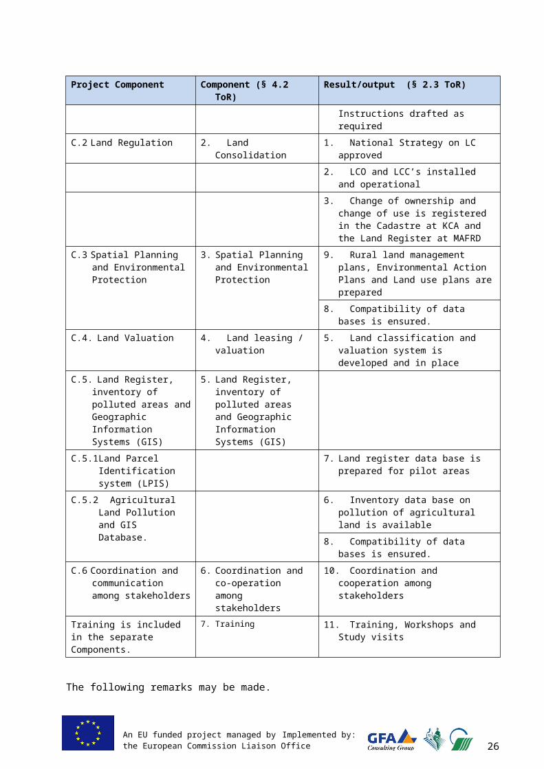
An EU funded project managed by Implemented by:the European Commission Liaison Office 29
enough to include this component in the ToR of EULUP, and arrive at a general overview of prevailing pollution in agricultural land.
The requirements, as indicated in the project ToR, included collecting and analysing 4,000 samples in the framework of this survey. This proved to be beyond financial possibilities of the project, and in coordination with ECLO, the decision was taken to take 1,000 samples and process them in two stages: 1. Bio-assay testing is done of all 1,000 samples, 2. Full chemical analysis carried out for selected 100 most suspicious soil samples.
At first, soil sampling, bio-assay testing and chemical analysis services were outsourced. Requests for bids were prepared with specifications requiring the works to be implemented according to EU standards (ISO 12075). None of the offers did fully adhere to the requirements, so the assignment was split up and allocated to two laboratories. Soil sampling and bio-test were awarded to Agrovet Laboratory in Fushe Kosovë/Kosovo Polje, and the chemical analysis was awarded to Lausitzer Analytik GmbH (LAG), Germany.
The design of the sampling took into account the necessity to provide for a representative sampling covering the important agricultural areas of Kosovo. It was decided that one sample of the top soil (upper 30 cm) per square kilometre should be taken from about 25% of the agricultural land Based on the information that mining activities and distribution of pollutants through the rivers are the major effects, a strictly statistical sampling 1x1 km was avoided. Instead, the sampling grid was intensified along the rivers and around/downstream of important mining areas. At the same time, the sampling grid was made wider in areas without these important risk factors.
SSTE 5-2 and the CEO of LAG delivered a two-day workshop on sampling at KIA premises in Pejë/Peć, to increase knowledge on ISO sampling requirements and to make certain that all sampling teams would apply exactly the same procedures in sampling and registration. Kosovo Institute of Agriculture (KIA) was continuously involved in the survey, both in the sampling as in the subsequent bio-testing, desiring to acquire additional knowledge and in the end to become certified as well. SSTE prepared manuals on sampling and on bio-testing, EULUP technical reports 6 and 7. Sampling was started in April and completed in the end of May 2011.
Bio-testing was implemented in summer 2011 in the laboratory of Agrovet, where suitable arrangements were created to carry out these tests in accordance to ISO standards. KIA was involved in this careful and sensitive work, as well as several students of the Agricultural Faculty. Two batches of 500 tests each were carried out, both with a growing period of two weeks and with 30 seeds per container. Germination, necrosis (death of plant) and chlorosis (insufficient chlorophyll causing yellowing) and bio-mass after harvest were measured of all tests, forming parameters for performance.
SSTE 5-2 jointly with Director Agrovet selected on the basis of performance ranking the samples to be chemically analysed, increasing the number from 100 to 123. Agrovet reported by means of an Interim Report the data collected, concerning both sampling and bio-testing. The analyses by LAG were completed half October 2011 and reported to EULUP, following the phase of data interpretation followed.
Report “Pollution Survey of Agricultural Land – A Reconnaissance Survey” was completed at the end of January 2011. Also Agrovet produced its Final Report, which presented all data and results, including the results of the chemical analysis by LAG.
The data collected have been included in a GIS database, designed by the project. As KEPA did not have any similar GIS
2929
A bio-assay test - or bio-test - is a plant toxicity test, during which a chosen species (such as Brassica Sedativum, very sensitive to soil pollution), is grown in a small container filled with soil of the sample to be tested, under very strict laboratory conditions set by ISO11269-2:2005 “Determination of the effects of pollutants on soil flora”
An EU funded project managed by Implemented by:the European Commission Liaison Office 30
database, the design was created in accordance to EULUP’s best judgment. The database is easy to use and to expand. The database is handed over to KEPA at the end of the project.
Conclusions – as laid down in the Report No 23 – are not unexpected, but alarming. Main conclusions are that (i) high concentrations of heavy metals (Arsenic, Chromium, Nickel, Lead and Cadmium are found at locations (ii) Organic pollutants (such as AOX - pesticides and PAH - burning of organic compounds) are of not a concern as yet. There is a reason to proceed immediately with further investigations in view of health risks. Conclusions and recommendations are further discussed in Chapter 9.
In order to confirm the results, additional 10 samples have been taken in locations that were already sampled earlier and analysed by LAG. This was done by another German Laboratory (AKS). Purpose was to check the results. The results were confirmed.
The current reconnaissance survey has resulted in an overview of the situation in Kosovo, not in detailed knowledge. The answer to the questions whether there is a pollution problem and approximately where and – if affirmative – what must be further actions, have now been answered. Given the wide (1x1 km) sampling grid, no interpolation between the sampling locations is allowed. It must be understood that the results are valid for the sampling point only, and the current results do not include a directive which lands on local level must be earmarked as contaminated.
Table 7: C.5-2, Pollution of agricultural land. Expected outputs as related to activities
Expected output as in Inception Report Status completion
Comments, changes
5-2.1. Soil sampling completed Completed
5-2.2. Pollution GIS model is developed and the database is filled out
Completed
5-2.3.1. Pollution presence estimated (soil toxicity tests)
Completed
5-2.3.2. Chemical screening completed for suspected soils
Completed 123 samples by LAG Laboratory and 10 by control samples AKS (added to confirm results)
5-2.4. Trainings held for MAFRD staff and others
Completed Trainings comprised large commencement workshop and extensive on-the-job training to governmental and private enterprise staff.
5-2.5. National/ regional database and map on pollution in agricultural lands prepared and overview of the pollution of agricultural lands is obtained
Completed Database available in KEPA per 22-2-2012 and Pollution Survey report 23 available
3 . 4 . 7 C 6 : C o o r d i n a t i o n a n d C o m m u n i c a t i o n b e t w e e n S t a k e h o l d e r s
Land is a basic resource that holds the sharp interest of a large number of institutions and private parties. In such a multidisciplinary subject as land management, the coordination and cooperation among the players is a must, otherwise anarchy reigns. Coordination and cooperation has been weak for a long time, but is seen to improve gradually, with time. Examples are the ever improving coordination between MAFRD and MESP and the re-introduction of the inter-ministerial Committee for Land Administration, which had three meetings during the project period, starting fall of 2010.
Parties involved in land management are a.o. the MESP, MAFRD, MoF and the MoPA. Further, all municipalities play a controlling role in the management of land, both rural and urban. And finally, a variety of other institutions and agencies are involved in many aspects of land use and land management, including but not limited to KCA, ISP, KIA, KEPA, KPA, PAK, ICMM, Institute of Hydrometeorology.
3030

An EU funded project managed by Implemented by:the European Commission Liaison Office 31
As already indicated in the IR, the coordination and communication is not an activity in itself, it comes as a necessary action in the context of the parent activities, and as such, is serving the other project components.
Both formal and informal ways of stimulation of cooperation were pursued. The first – and perhaps the most effective – is the mutual working together of officials of various governmental institutions and/or municipalities. In a multi-disciplinary project as EULUP, in which integration of actions is a necessity, this went almost automatically. It seals professional relations and gives them a personal touch. It further increases the understanding of the other parties’ interests and proprieties. The second, was the organizing numerous workshops and stimulation of coordination meetings between institutions.
A few issues may be mentioned here explicitly. The first is the good role the Project Steering Committee (SC) proving to be a good medium of communication among various institutions.
As mentioned already, the inter-ministerial Committee for Land Administration was revived and plays now an important role in the coordination of issues related to land administration and land use. Its extent has been increased, including KCA (chair), MESP, including the ISP, KEPA, Hydromet, MAFRD, MoPA, MoF, KPA and PAK. Also international partners took part, including World Bank, UNDP, UNHABITAT, SDA, ECLO, GIZ and others. EULUP closely collaborated with other on-going EU projects such as EUFARM, Animal Register, Twinning project on Forestry, Twinning project on Agriculture, Twinning project on Environment. The inter-ministerial Working Group on Pollution of Agricultural Land could not be revived. Interest appeared to be low, and given the time and effort required to keep this working group going, it was considered more fruitful to spend time and energy on other purposes.
A Directors’ meeting between MAFRD and MESP was proposed in the framework of rural spatial planning. Although very useful, only one meeting was conducted. Such meetings are only to be held if something significant crops up, but it would be good to institutionalize such a contact point. Whether or not this will happen, it must be said that the coordination between MAFRD and MESP has improved significantly during the project period. It would be condescending to consider this as a merit of EULUP, but undoubtedly the project has given its contribution here.
The various inter-disciplinary groups (WG LandVal, JTG on GIS, Legal WGs of MAFRD and MESP) contributed to better coordination, communication in specific technical issues. Further, the major workshops organised (project Launch, Mid Term Workshop, Completion Event and other), were at least partly meant to bring people together and to promote networking and institutional collaboration.
Table 8: C.6, Communication and coordination. Expected outputs as related to activitiesExpected output as in Inception Report Status
completionComments, changes
6.1. The SC is installed and functioning Completed
6.2. Land use issues are addressed in a more coordinated way than presently
completed Difficult to measure
6.3. Rural pollution issues are addressed in a multidisciplinary way
completed Pollution survey is completed, but the interdisciplinary approach is still in its infancy.
6.4. Improved coordination between MAFRD and MESP
completed Although also difficult to measure, there is no doubt about the improvement of the coordination between MAFRD and MESP
6.6.1. Mid-term workshop Completed
6.6.2. Completion workshop Still to come
3131

An EU funded project managed by Implemented by:the European Commission Liaison Office 32
3 . 5 A c t i v i t i e s f o r m a i n s t r e a m i n g c r o s s -c u t t i n g i s s u e s
Sustainable agriculture and environment protection have been a main leading concern in the EULUP. Although environmental notions are not yet fully developed and environmental interest are often still secondary to economic considerations, this should become a leading principle in the planning and implementing developments in rural areas.
Recently, the Law on Strategic Environmental Assessment came into force in 2010. As a part of component 3 – an Environmental Land Sensitivity Assessment Plan is included as a separate step in the BRSP, and is integrated in Rural Land management Plan, including the construction zoning plans. Such rural planning system will ensure that Kosovo land use management adhere principles of sustainable development in the future and balances human and nature needs.
The pollution survey is in itself a cross-cutting matter, as it is essential for all rural land use. Pollution of lands is eventually a health issue, but also may affect agriculture, local businesses and rural employment.
Minorities’ rights are a key issue in Kosovo, and the planning and decision-making have always considered implications in this regard. One of the pilot municipalities was Graçanicë/Gračanica, a Serbian majority municipality. The selection of this municipality was done for the purpose to better include and inform Serbian minority in land use planning activities. Graçanicë/Gračanica was actively interested and well present in all events and activities organized by the EULUP. However, Serbian minority farmers did not use the possibility to attend information meetings on voluntary land regulation (VLR) as organized by EULUP.
Gender issues are not immediately a core issue in a land use program, and were not addressed as a separate activity. However, it is known that the protection of woman’s rights in the context of land ownership is not always guaranteed in Kosovo. It was planned to address this matter in the context of small scale voluntary land regulations, but the two VLR, as now requested, are still in an early stage of implementation. The very large scale unfinished and urgent unfinished land regulations are considered less suitable for addressing gender subjects.
3 . 6 M a j o r w o r k s h o p s a n d s t u d y t o u r s
EULUP has organized a variety of workshops, trainings, meetings and study tours during its time span of implementation. The study tours and the major workshops are indicated in the below tables. A complete overview of all trainings, meetings and workshops were indicated in the Annexes “Summary of Meetings Held” of each Interim Report and Quarterly Report.
Study Tours The project ToR was flexible in regard to the organization of Study Tours. The Inception Report planned 3 to 4 study tours, depending on interests and available budget. Four study tours were eventually organized. Subjects were LPIS, Land Regulation, Spatial Planning and Land Valuation. EULUP preferred short and small study tours, enabling focusing on the interests of the concerned professional disciplines of homogeneous target groups.
The study tours are discussed in more detail in the Training Reports (refer to Table 16b ), and a summary is given in Table 9 below.
3232
An EU funded project managed by Implemented by:the European Commission Liaison Office 33
Table 9: EULUP Study Tours
Destination Period Topic Major subjects Nr of Participants
Hannover, Germany
10-05 //11-05-2010
Rural Land Management
- Rural spatial planning- Demography and spatial panning- Regional development
1 (Director ISP)
Zagreb , Croatia
2-10 // 8-10-2010
LPIS - LPIS at central and local level- Institutional structure - Process of design and
implementation of LPIS- Tasks and role of Payment
Agency
8 (MAFRD staff)
Groningen, The Netherlands
17-4 // 22-4-2011
Land Regulation
- Voluntary Land Regulation- Land Regulation Commissions- Land Banking and Cadastre- Institutional arrangements and
legislation
7 (MAFRD, Municipalities and KCA)
Lower Saxony, Germany
16-10 // 21-10 2011
Spatial Planning and Construction Zoning
- Processes and practices of rural spatial planning
- Construction zoning and building permits
- Allocation of land for urban development
- Protection of Agricultural land
7 (ISP, MESP, MAFRD, Mun. of Pejë/Peć
Berlin, Germany
20-11 // 24-11-2011
Land Valuation
- Legal and institutional aspects of land valuation
- Training and licensing of land valuers
- Technical aspects of land valuation
5 (MoF, MAFRD, KCC)
Workshops
A large number and a wide variety of workshops and trainings were conducted. Most were dedicated to the Component 3 and 5.1. This is understandable because it concerns here newly introduced technologies, and repeated explanations and discussions are needed to make them work. The GIS trainings that were given in the framework of C.3 were essential as well, because the application of the Rural Planning model and the use of the large database developed, require skill in the use of GIS.
In Annex 8, all trainings and workshops are listed in chronological order. In Table 10, a few important workshops are mentioned
Table 10: Major EULUP Workshops
Name Date Purpose Major subjects Part.
Project Launch 26-5-10 Introduction of EULUP Presentation of the programme of EULUP
79
Concepts of LPIS
28-5-10 Introducing the concept of LPIS
Process of data registering in LPIS database
18
Round table meeting on spatial planning
2-12-10 Harmonise approaches to rural spatial planning in Kosovo
Planning process and data availability. Presentation EULUP approach
26
Sampling workshop
3/4-3-11 Uniform sampling procedures in pollution
ISO, best practices in EU, sampling procedures, practical training
26
3333

An EU funded project managed by Implemented by:the European Commission Liaison Office 34
Name Date Purpose Major subjects Part.
survey
Mid-Term Workshop
24-3-11 Review of achievements and planning 2nd project year
Presentations on all components, discussions per component in small groups on how to proceed
64
Construction Zoning
25-8-11 Decide on structure of Construction Zoning model
Construction zoning on municipal level and on village level. First proposals by EULUP
28
Final WS LPIS 27-9-11 Presenting results LPIS structure and further actions. 52
Basis for Rural Spatial Planning
29-9-11 Basis for Rural SP models Workshop for all municipalities, national and international stakeholders. Detailed explanations and discussions
38
7 workshops on Rural Spatial Planning
Nov-Dec2011
Detail explanation of developed system of Rural SP models and data
Workshops delivered to mayors, heads and specialists of related departments of all co-pilots
Total 106
5 Regional Workshops on Legislation and rural SP
27-10-11, 10-11-11,18-11-11, 25-11-11, 16-12-11
Explanation and discussion with municipalities of new legislation and rural SP
Law on Agricultural Land, Law on Land regulation, A.I. on MDP and data management to the Law on Spatial Planning, methodology rural spatial planning and construction zoning
Total 88
Project Completion Workshop
8-2-12 Final workshop at project completion
Presentation and discussion results EULUP
?
3434
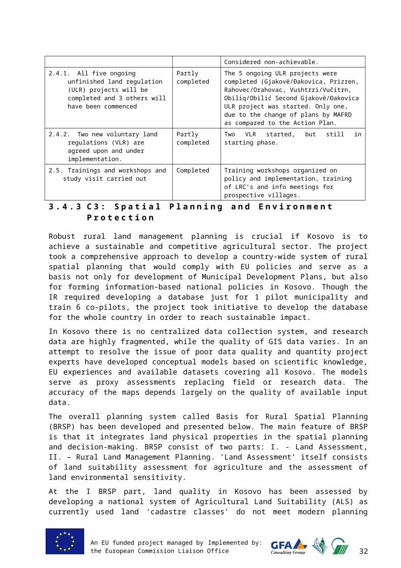
An EU funded project managed by Implemented by:the European Commission Liaison Office 35
4 A S S U M P T I O N S
4 . 1 A s s u m p t i o n s a t d i f f e r e n t l e v e l
At the project start, several assumptions have been noted down in the Inception Report on project implementation. These assumptions were basically the same as those voiced in the project ToR. Table 11 below recapitulates.
The more detailed assumptions and how far these assumptions were fulfilled or not, is worked out in the updated logical framework, given in Annex 1
Table 11: Initial assumptions and remarks
Assumption RemarksCritical assumptionsThe Government maintains its support to land reform The project was well supported in its activities by
Government.
Political will is present in both MESP and MAFRD to coordinate rural planning and management issues
Political will certainly existed between MAFRD and MESP to coordinate. EULUP took up an active role to stimulate and orchestrate this coordination
General assumptions of high importanceSufficient capacity of the relevant institutions, especially MAFRD and MESP, to address and timely revise several legal issues simultaneously,
Capacity is limited, but observing careful planning and thoughtful spacing of activities in time, this assumption was fulfilled.
Project stakeholders collaborate efficiently and timely, Some support by the project was needed from time to time and from subject to subject.
Agreement is reached among ministries on proposed concepts and procedures on land regulation and rural land planning,
Agreements were reached on rural land planning, between MESP, MAFRD and project but less so between MAFRD and project on how to conduct land regulation
The National Strategy on LC is approved by MAFRD, The strategy was approved after addition of an Action Plan, but the Strategy was not followed as expected.
The Paying Unit at the MAFRD is functional and fully engaged in the project,
Generally speaking, the PU was up to its tasks, be it that strong and continued support by EULUP was required.
Municipalities are interested and actively participating in the project activities by allocating their staff to the project activities as related to GIS tasks, data gathering, land valuation and RLMP development
Municipalities have few staff and many tasks, and are always occupied. Still, although varying from the one to the other, the contribution of the pilot municipalities was satisfactory.
Additional AssumptionThe LR Office is installed as indicated in the National Strategy on land regulation
This elementary requirement for the land regulation component was not fulfilled
4 . 2 R i s k s a n d f l e x i b i l i t y
In the Inception Report a list of possible risks was identified, however most of these risks did not materialize. On the other hand, risks that were not perceived, did turn up. The following categories of risks were foreseen in the IR:
- Human resources are insufficient in number and/or capability,- Legislation cannot keep pace with the project progress,- Institutional requirements cannot be realised, - Cadastral photo’s and data are unavailable or of insufficient quality or
unaffordable, - Discontinuation off high priority for land regulation and/or reduction of funding,- Problems with registration of ownership.
3535

An EU funded project managed by Implemented by:the European Commission Liaison Office 36
Risks perceived by the ToR are covering the same subjects, and were phrased as follows:- Qualified human input by MAFRD is not available for strategy development in land
reform and for undertaking land regulation in pilot areas,- Lack of qualified staff at central and local level,- Insufficient national financing.
The above risks were indeed encountered in varying degrees. Mostly - but not always - they could be averted by careful monitoring of progress and bringing them to the attention of leading officials, if need be repeatedly.
Human resources are insufficient in number and/or capability.
Policy of government is to reduce staff and salary conditions are not attractive, initiating competent governmental staff to look for employment elsewhere. These two factors lead to a continuous struggle to implement all tasks that government institutions are charged with.
The problem is aggravated by a certain reluctance to outsource management and policy implementation tasks, leading to a situation that too few people have to spread attention over too many tasks, or that available staff must carry out tasks for which they are not trained.
This risk was real and indeed materialized, for example, the EULUP intensively trained GIS specialist has left ISP.
Legislation cannot keep pace with the project progress
The reason that this risk was mentioned was based on experience that legislative staff of the ministries involved in the project is notably overloaded with work. In retrospect the experience in this project is that this problem could be averted by careful and timely planning and also because of the good and serious attitude of the lawyers of both MAFRD and MESP.
Institutional requirements cannot be realized
Coordination between governmental bodies was present but at times very slow. This was particularly felt in data acquisition and in data sharing arrangements. Further, once delivered, the data were often not up to standards
To the opinion of the consultants, the management of the land regulation program was not up to standards. This major and very complex program needs the guidance of experts with a mandate from the MAFRD, and is thought a good example for the need of outsourcing of tasks by a governmental institution to private experts.
Procurement by the MAFRD was slow, to the extent that the MAFRD co-financing budget could not be fully utilized and certain planned activities needed to be postponed or even cancelled.
Cadastral photo’s and data are unavailable or of insufficient quality or unaffordable
As compared to earlier years, the pricing of aerial photography was adjusted, and prices meet European standards and there was no problem in acquisition. However, DTM data was overpriced and included substantial mistakes in formatting, which required huge additional input of EULUP experts to make them usable.
Discontinuation off high priority for land regulation and/or reduction of funding I
Land regulation is mentioned as a high priority of MAFRD in the medium-term Expenditure Framework list of MAFRD, which is also shown by the approved MAFRD Strategy on Land Regulation 2010-2020. Funding is ensured, at least until 2013. Land regulation is a priority, but it did not become clear whether this is a formal or a felt priority.
3636

An EU funded project managed by Implemented by:the European Commission Liaison Office 37
Problems with registration of ownership
Particularly lack of clarity of the procedure of land registration was seen as a major risk in the start of the project. This appeared not to be so.
The pending problems with registration of unfinished land regulation (ULR) are a consequence the lack of capacity of the MCO’s to cope with the huge amount of work that comes with major ULR works. For that reason, the sequence of work through the years was planned such in the Action Plan of the Strategy, that registration work for each MCO would be implementable, by implementing not more than 3 or highest 4 Cadastral Zones each year. In practice, this was not adhered to by MAFRD for unknown reasons.
3737

An EU funded project managed by Implemented by:the European Commission Liaison Office 38
5 I M P L E M E N T A T I O N
5 . 1 P h y s i c a l a n d n o n - p h y s i c a l m e a n s
Due to its large number of staff and experts, the project could not be housed in the MAFRD and therefore rented an office in Pejton area, Prishtina/Priština. All necessary office furniture and computers were purchased by the project itself. Also means of transportation were arranged and financed by the project.
Due to the planned large GIS supported rural spatial planning operations, seven packages ESRI single-source ArcGIS packages were purchased, including 1 programme ArcEditor,1 Extension Spatial Analyst and 6 ArcView programmes. This was financed by the MAFRD co-financing budget. Three ArcView programmes were handed out to pilot municipalities in need of such software, i.e. Kaçanik/Kačanik, Graçanicë/Gračanica, and Istog/Istok. One ArcView with Spatial Analyst was handed to ISP, and the ArcEditor and one ArcView were kept at EULUP for development purposes. These programmes will be handed over to MAFRD and ISP in mutual agreement.
Aerial photographs for Suharekë/Suva Reka and Istog/Istok and Digital Terrain Models for the 7 pilot municipalities needed for the development of the rural spatial plan modelling were purchased from KCA in 2010 through the MAFRD C0-financing budget. Later the MAFRD acquired 2009 aerial photography fully covering Kosovo in order to apply the LPIS system for the whole of Kosovo for the registration of applicants for winter wheat subsidy.
Human resources of the project included five categories of personnel.- The two Key Experts (TL and KE2) with altogether 820 working days (WD).- The two Junior Long-term Experts (JLTE), comprising national experts with 640 WD. - Senior Short-term Experts (SSTE), comprising international experts with 363 working
days.- Junior Short-term Experts JSTE), comprising mostly national experts, with 630 WD. - Office staff, comprising an office manager, a translator, an interpreter and a driver.
These staff are full time
Experts are contracted and charged to EU on the basis of daily fees. The office staff was assigned full time, salaried and not separately charged to EU.
In the Inception Report, the number of available WD for SSTE and was 330 and for JLTE 620. With side letter 38 dd 6 September 2011, ECLO approved the project’s request to approve a limited transfer of Incidental budget to additional WD for experts. The request was arguing that the number of working days available in the project was insufficient to cover all work additional to the original expectations in project ToR and Inception Report, while at the same time the Incidental Budget cannot be fully utilized in the framework of the project.
Table 12 shows a summary of the expert working days utilised over the project period. A full overview is given in Annex 2, with all experts’ names and their disciplines at certain stage in the project.
Table 12: Summary of expert working days
Reporting Period Dates TL & KE 2 JLTE SSTE JSTE
Interim Report 1 23-02-10 // 22-08-10 210 57 51 26Interim Report 2 23-11-10 // 22-2-11 211 229 87 153Interim report 3 23-02-11 // 22-08-11 195 201 130 186Quarterly report 3¹ 23-08-11 // 22-11-11 112 99 70 152
3838
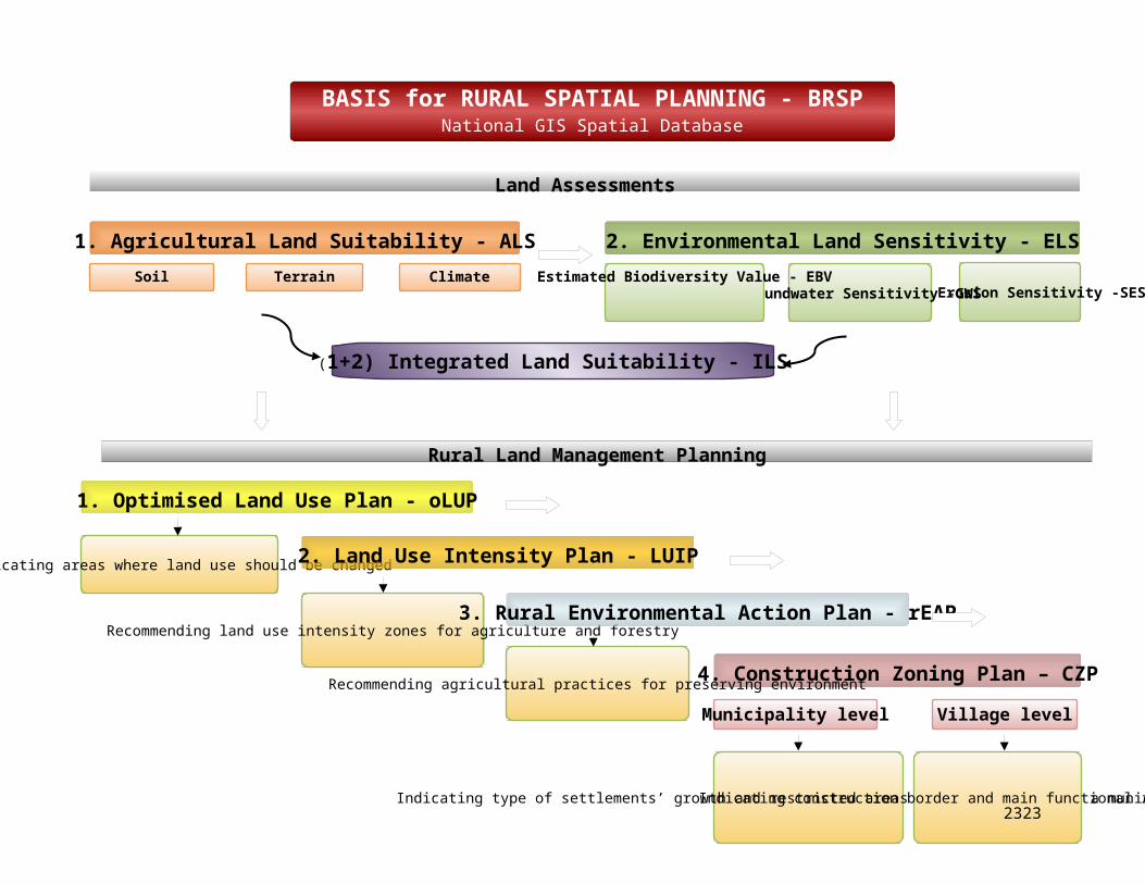
An EU funded project managed by Implemented by:the European Commission Liaison Office 39
Reporting Period Dates TL & KE 2 JLTE SSTE JSTE
Quarterly Report 4² 23-11-11 // 22-02-12 92 54 25 113SUM 23-02-10 // 22-02-12 820 640 363 630¹ To be replaced after actual completion of project² Expected and to be replaced after completion of project
5 . 2 O r g a n i s a t i o n a n d i m p l e m e n t a t i o n p r o c e d u r e s
Roles and responsibilitiesIn order to distinguish clearly among responsibilities within the project and to avoid overlaps and gaps, the roles and responsibilities were defined as indicated is table 13 below.
Table 13: Roles and responsibilities of project staff
Project Component Responsible full time staff
Main subject-matter SSTE
Responsible Kosovo expert
Main Counterpart
Project management and overall responsibility
Rutger Kuiper, team leader
n.a. Alush Sadikaj Hysni Thaqi, MAFRD, Director Dept. of RD
Office management Alush Sadikaj n.a. Alush Sadikaj n.a.
C.1 Legal assistance Rutger Kuiper, TL Henk Leenen, SSTE 1-1
Selvete Dibrani, JSTE 1-1
Shefki Zeqiri, MAFRD, Director Legal Dept.
C.2 Land Regulation Rutger Kuiper, TL n.a. Afrim Frrokaj, JLTE 5-1
Idriz Gashi, MAFRD, Chief Land Use
C.3 Spatial Planning and environmental Protection
Neda Nordin, KE2
Benjamin Ducke, SSTE 3-2 and Robert Palmer, SSTE 3-3
Elfete Krasniqi, JLTE 2-1
Luan Nushi, MESP, Director ISP
C.4 Land Valuation Rutger Kuiper, TL Rainer Fischer, SSTE 4-2
Skender Kaciu, JSTE 4-2
Agron Thaqi (MoF), Ddy Director Prop. Taxation
C.5-1 LPIS Neda Nordin, KE2
Dieter Goertz, SSTE 5-1
Afrim Frrokaj, JLTE 5-1
Agim Nuha, MAFRD, Chief Payment Unit
C.5-2 Pollution of Agricultural land
Rutger Kuiper, TL Wolfgang Spyra, SSTE 5-2
Mesud Kuka JSTE 3-4
None
Care was taken that always one of two key experts was available, except during the week between Christmas and New Year, during closure of the office. During absence of one of the key experts, the other took charge of all tasks of the other Key Expert. During absence of the office manager, responsibility was taken over by the project’s translator Luljeta Zeqiri.
Steering CommitteeThe Project Steering Committee (SC) met every three months, the agenda mainly but not exclusively being the contents of the most recent Interim or Quarterly Report. The SC is composed as follows at the date of project completion.
3939
An EU funded project managed by Implemented by:the European Commission Liaison Office 40
Mr. Arton Osmani, Chairperson, Acting Task Manager Agriculture & Environment, ECLOMr. Kapllan Halimi, Co-chairperson, Permanent Secretary, MAFRDMr. Hysni Thaqi, Director Dept. of Rural Development, MAFRDMrs. Shqipe Dema, Director Policy Dept. MAFRDMr. Shefki Zeqiri, Director Legal Dept., MAFRD Mr. Luan Nushi, Director ISPMr. Agim Radoniqi, Director Dept. of Spatial Planning, MESPMr. Xhevat Azemi, Dy Director KPAMrs Fetija Muriqi, Chief of GIS Section, MAFRDMr. Idriz Gashi, Chief of Land Use Section, MAFRDProf. Murat Meha, Chief Executive Officer, KCAMr. Kasim Bytyqi, Acting Head Dept. of Agriculture, PAKMr. Bedri Berisha, Director Agriculture, Mun. of Suharekë/Suva Reka Mr. Agron Thaqi, Dy Director Property Tax, MoFMr. Raswan Ghitescu, Team Leader Farmer Register ProjectMr. Rutger Kuiper, Team Leader EULUPMrs. Neda Nordin, Key Expert 2 EULUP Mr. Conrad Hoyos, Consortium Project Director, GFA
Several members have taken their resignation during the course of the project, in all cases due to change of position. It concerns here Mrs Iva Stamenova, Chairperson, Task manager Agriculture and Environment - ECLO; Mr. Shaban Dreshaj - MAFRD, Mr. Veton Hajdini - PAK, Mr. Hamit Basholli - KCA; Mr. Rudolf Moser, CTA Twinning Project
5 . 3 T i m e t a b l e
The plans of activities and time schedules have been included in each Interim Report and Quarterly Report, starting with the Inception Report. Each Report contained two schedules: the overall working schedule, displaying the entire project period and the schedule for the next period. The timing in the overall schedule was adapted in accordance with general progress and changed planning, but the description of activities was kept as much as possible unchanged in order to keep it comparable with the original activity schedule in the Inception Report.
Figure 1 in a general way displays the activities as they have been implemented during the project period. It may be noted that the component 5-2, pollution survey took off rather late, and the planning to complete the sampling survey before the winter 2010-2011 could not be realized: the survey started only on early 2011. The Component 5-1 LPIS was completed earlier than anticipated and in consultation with MAFRD and ECLO, this programme was extended and applied to the whole of Kosovo for subsidy application for winter wheat. In Component 2, land regulation, progress was disappointing and an element was added to the EULUP programme, aiming to significantly improve the overall long term management of the MAFRD land regulation program.
4040

An EU funded project managed by Implemented by:the European Commission Liaison Office 41
Figure 1 Global time schedule EULUP activities as implemented
5 . 4 C o s t a n d f i n a n c e p l a n
The Incidental Budget (IB) allocated by the ToR and included without modifications in the Inception Report was € 250.000,-. Also, the planned (preliminary) allocation of IB was indicated. In addition to the allocated IB, MAFRD had made available a co-financing budget provided by the Kosovo Consolidated Budget (KCB). This amount was €93,223 in 2010 and € 100,000 in 2011.
Particularly in 2010 there was some switching of expenditures in between the two budgets as the easiest way to avoid various administrative inhibitions or troubles, inherent to the use either fund.
The idea to have both funds contributing to a certain expense proved to be very complicated and was abandoned. This was the case with the financing of the pollution survey. The full survey expense has been shouldered by the IB and as a compensation the purchase of ESRI ArcGIS software was done through the IPA co-financing budget.
The original Incidental Budget of 250,000.- was decreased as per Side Letter No. 38, nr D(2011) IS/ao/01869 dd 6 September 2011 with an amount of € 37,086.00, facilitating the funding of 33 SSTE and 20 JLTE working days.
4141

An EU funded project managed by Implemented by:the European Commission Liaison Office 42
Table 14 presents the Incidental Budget and the expenditures that have been done until the date of 22 January 2012 and the approved expenditures until 22 February 2012. In the final version of this Project Completion Report, to be issued after the closure of the project, this table will be updated.
Table 14: Use of Incidental Budget until 22 January 2012 and the expected total use of Incidental Budget
Nr Items Estimated amount
Inception Report (€)
Expenditures
IntRep 1
IntRep 2
IntRep 3
QRep 3
Per 22-1-12
Approved expenses
Sums
1 Pollution Survey and Analysis
80,000 35,720 39,742 75,462
2 Remote sensing, maps and data¹
20,000 0
3 Licenses Software GIS¹
30,000 0
4 Study Trips 40,000 14,256 14,079 17,234 8,349 53,918
5 Visit SDI conf. Skopje
2,000 1,475 1,475
6 Advanced GIS training abroad
12,000 8,368 8,368
7 Publication MaterialVisibility
20,000 1.110 10,957 12,067
8 Awareness Campaign legislation rural lands
16,000 1,745 17,719 19,464
9 Local trainings, workshops, related travel and per diems
20,000 2,609 4,507 6,314 4,353 3.254 2.906 23.943
10 Starters Courses GIS for Municipal officers¹
5,000 0
11 Adaptation LPIS software
0 12,000 5,000 17,000
12 Unallocated 5,000
SUMS € 250,000 2,609 32,238 57,223 29,955 53,090 36,582 211,697
¹ Amounts covered by the MAFRD co-financing budget
5 . 5 S p e c i a l c o n d i t i o n s / a c c o m p a n y i n g m e a s u r e s t a k e n b y t h e G o v e r n m e n t
As discussed under paragraph 5.4 above, MAFRD has made available a co-financing budget from KCB funds to be used in the EULUP. That contribution was most welcome. Once the decision on the expenditure was taken, the project tuned to planning and the decision-making, counting on the successful procurement by MAFRD. The project took the natural position that the co-financing budget is a MAFRD budget, i.e. the spending is to be decided and also to be implemented by, and under responsibility of MAFRD.
4242

An EU funded project managed by Implemented by:the European Commission Liaison Office 43
The project was ready to support the MAFRD procurement procedures on a daily basis. However, this appeared to be not an easy task, and a lot of time of the key experts and the JLTE’s has been invested, preparing specifications, suggesting solutions for procurement problems, monitoring, assisting and encouraging the procurement process on a daily basis.
Certain acquisitions were indeed realised, but other acquisitions proved impossible to be achieved. Among these were the planned awareness campaign on land regulation and the compensation of overtime for licensed officers in the MCO’s, charged with the registration in IPRR of very large quantities of cases due to the ULR completions.
The procurement procedures the MAFRD must follow are cumbersome – an often heard explanation for the very slow pace of procurement – and this is understood. However, the main problem is the internal coordination and management of these processes within the Government. If these could be streamlined, the contribution of the MAFRD would have been more useful.
The land regulation programme of the MAFRD is autonomous as compared to EU and EULUP interventions. That is to say, MAFRD has declared land regulation a priority and the long-term working schedule was worked out in the Strategy and Action Plan on Land Regulation 2010-2020. Its expenses are entirely borne by the Government.
Due to this condition, the position of the consultant’s team was somewhat different than in the other project’s component, namely advisory only and without a mandate. This has influenced the planned results of the Component 2 in the consultant’s project programme.
5 . 6 R e p o r t i n g
The Project issued general project reports as indicated in table 15. All Interim and Quarterly reports contain more than one volume. Volume 1 is the main text and related annexes, whereas Volume 2 comprises the Mission Reports and the Technical and Training Papers issued during the past 3 months.
Table 15: General project reports issued
Name Period covered Date of issueInception Report 23-02-2010 // 22-02-2012 19 May 2010Interim Report I 23-02-2010 // 22-08-2010 29 August 2010Quarterly Report 1 23-08-2010 // 22-11-2010 29 November 2010Interim Report 2 23-08-2010 // 22-02-2011 29 February 2011Quarterly Report 2 23-02-2011 // 22-05-2011 29 May 2011Interim Report 3 23-02-2011 // 23-08-2011 29 August 2011Quarterly Report 3 23-08-2011 // 22-11-2011 29 November 2011Quarterly Report 4 23-11-2011 // 22-02-2012 Still to be issuedCompletion Report 23-02-2010 // 22-02-2012 22 January 2012 (Draft)
EULUP Technical and Training ReportsThe EULUP Technical Reports and Training Reports issued during the time span of EULUP, are listed in Table 16 below. All reports have been translated into Albanian and Serbian, and most have been published as annexes to the Interim Reports and the Quarterly Reports. Some manuals and guidelines, which are strictly speaking not Technical Reports, are included in the table 16a as well in order to have one single complete lists of all publications issued in the project.
Table 16: Technical Reports¹
4343

An EU funded project managed by Implemented by:the European Commission Liaison Office 44
Rep.No
Author Technical Expert
Title Date of issue
Location
1 Luan Nushi Director ISP Report on the Land Management Symposium, Hannover (10-11 May 2010
May 2010 Interim Report 1, Annex 13
2 Ton Verhagen, Afrim Frrokaj, Rutger Kuiper
SSTE 2-1, JSTE 5-2, TL
Action Plan for Land Regulation
Aug 2010 Interim Report 1, Annex 13
3 Robert Palmer, Neda Nordin
SSTE 3-3, KE2
Agricultural Land Suitability Classification (ALS)
Dec 2010 Interim Report 2, Annex 13.1
4 Dieter Goertz SSTE 5-1 Program on the simplified sLPIS in Kosovo Part 1 (Basic Concept)
Jan 2011 Quarterly Report 2, Annex 13.2
5 Selvete Dibrani, with Vjosa Vela (MESP) and Isah Rudaku (MAFRD)
JSTE 1-1 Harmonisation of the Law on Agricultural Land and the Law on Spatial Planning
Feb 2011 Interim Report 2, Annex 13.3
6 Wolfgang Spyra SSTE 5-2 Soil Sampling Guide Mar 2011 Quarterly Report 2, Annex 10.3.
7 Wolfgang Spyra SSTE 5-2 Bio-assay testing guide May 2011 Interim Report 3, Annex 13.1, in Mission Report 5
8 Neda Nordin Robert Palmer,
KE2SSTE 3-3,
Environmental Land Sensitivity Assessment (ELS)
Nov 2011 PENDING
9 Robert Palmer, Neda Nordin
SSTE 3-3, KE2
Optimised Land Use plan and Land Use Intensity Plan (oLUP & LUIP)
Nov 2011 Quarterly Report 3, Annex 13.1 (Vol II-b)
10 Robert Palmer, Neda Nordin
SSTE 3-3, KE2
Rural Environmental Action Plan (rEAP)
Nov 2011 PENDING
11 Dieter Goertz SSTE 5-1 Program on sLPIS in Kosovo, part 2 (Extension of Pilot Activities of sLPIS)
Dec 2010 Interim Report 2, Annex 13.2,
12 Dieter Goertz SSTE 5-1 Application Process for Winter Wheat Payments Using sLPIS
Oct 2011 Quarterly Report 3, , Annex 13.2 (Vol II-b)
13 Dieter Goertz SSTE 5-1 LPIS Master Plan Nov 2011 PENDING14 Harald
FinkemeyerNeda NordinIsmail Bafjari
SSTE 3-4 KE2JSTE 3-5
Construction Zoning Plan (CZP)
Dec 2011 PENDING
15 Harald FinkemeyerNeda NordinIsmail Bafjari
SSTE 3-4 KE2JSTE 3-5
Guideline to Practical Implementation of the Construction Zoning Plan (CZP)
Dec 2011 PENDING
16 Ben Ducke SSTE 3-1 GIS Technical Documentation
Nov 2011 Quarterly report 3. Annex 13.3 (Vol. II-b)
17 Neda Nordin KE2 Guideline on Rural Spatial Planning
Dec 2011 PENDING
18 cancelled19 Rainer Fischer SSTE 4-2 Valuation and
Compensation for Expropriation
Feb 2012 READY. Quarterly Report 4, Annex ....
20 Rainer Fischer SSTE 4-2 Action Plan on Certification and Licensing of Valuers in Kosovo
Nov 2011 Quarterly Report 3, Annex 13.4 (Vol. II-b)
4444
An EU funded project managed by Implemented by:the European Commission Liaison Office 45
Rep.No
Author Technical Expert
Title Date of issue
Location
21 Madalina Bisog JSTE 2-5 Cost benefit Analysis of Voluntary Land Regulation
Nov 2011 Quarterly Report 3, Annex 13.5 (Vol II-b)
22 Michael Wagner SSTE 3-1 GIS Data available in Kosovo per June 2010
June 2010
Interim Report 1, Annex 12.3, Mission report 1, annex 7
23 Wolfgang Spyra SSTE 5-2 Pollution of Agricultural Land, a reconnaissance
Jan. 2012 PENDING
Table 17: Training Reports¹
Rep. No
Author Technical Expert
Title Date of issue
Remarks
1 Neda Nordin KE 2 Report on Study Tour on LPIS to Croatia
Oct 2010 Quarterly Report 1, Annex 8
2 Afrim Frrokaj, Rutger Kuiper
JLTE 5-1, TL
Report on Workshop on Land Regulation dd 21-1-2011
Jan 2011 Interim Report 2, Annex 14.1
3 Rutger Kuiper (ed.)
TL EULUP Mid Term Workshop
May 2011
Quarterly Report 2, Annex 6
4 Alush Sadikaj, Rutger Kuiper (ed.)
Office Manager
Report Study Tour on Land Regulation
Apr 2011 Quarterly Report 2, Annex 8
5 StatGIS Service contract
CORINE Land Cover Development for Suhareke Municipality
Feb 2011 Quarterly Report 3, Annex 14.1 (Vol. II-b)
6 Afrim Frrokaj JLTE 5-1, sLPIS User Manual Dec 2010 Quarterly Report 3,Annex 14.2 (Vol. II-b)
7 Boris Leukart Service contract
sLPIS Administration Guideline
Oct 2011 Quarterly Report 3Annex 14.3 (Vol. II-b)
8 Boris Leukart Service contract
sLPIS Mobile -User Manual Oct 2011 Quarterly Report 3,Annex 14.4 (Vol. II-b)
9 Neda Nordin KE2 Report on Study Tour on SP and CZP in Germany
Nov 2011 Quarterly Report 3, Annex 7
10 Skender Kaciu JSTE 4-1 Report Study Tour on Land Valuation
Jan. 2012
PENDING Quarterly Report 4, Annex ....
11 Selvete Dibrani, Rutger Kuiper
JSTE 1-1, TL
Five Regional Workshops on Legislation and Rural Spatial Planning
Dec. 2011
READY Quarterly Report 4 Annex ....
12 Skender Kaciu JSTE 4-1 Report on Study Tour on Land Valuation to Berlin
Jan. 2012
PENDING
¹ : To be completed after closure of the project
4545

An EU funded project managed by Implemented by:the European Commission Liaison Office 46
6 F A C T O R S E N S U R I N G S U S T A I N A B I L I T Y
The EULUP has used a variety of methods and actions to secure results’ sustainability as related to mentioned important factors:
- Increasing the interests and understanding of beneficiary institutions, - Ensuring that the outputs are put into legislation,- Creating relevant administrative and management procedures and structures,- Establishing collaboration and communication of related institutions,- Securing further financing.
6 . 1 P o l i c y s u p p o r t
The ultimate purpose of a TA project as EULLUP is to help to strengthen standing government policy, and assist in the formulation in new policies. In fact, this was a major element of all components of the project. Vice versa, the results of the project are only sustainable if there is a strong drive in Government to apply these results into practice.
Particularly the Components 3 (Spatial Planning and Environmental Protection), 5-1 (LPIS) and 2 (Land Regulation) are contributing to current government policy, while the components 4 (Land Valuation) and 5-2 (Pollution of Agricultural Land) aim to stimulate policy development and make them more practical.
Sustainability of the results and technologies that EULUP delivered, can only be ensured if results have been achieved jointly with the beneficiaries, guaranteeing understanding and acceptance of the created outputs. Since many of these developments and techniques are new to the beneficiaries, this requires training, visibility and consultation, apart from participatory development of outputs
EULUP involved main beneficiaries and any other potentially related institution into trainings. It constantly pursued consultation and exposure of the results through personal meetings, through participating in events of other institutions and through collaboration of projects. EULUP shared information through project website and emails, and gave personal one-to-one assistance to MAFRD, ISP, KCA and MESP counterpart officials, as well as all co-pilot municipalities, and international organisations.
The land regulation programme is stated as a standing MAFRD policy and priority. It is implemented and financed by the KCB and the consultants are advisers to the program. This relationship ensures decision-making by MAFRD and continuous coordination between the consultants and MAFRD.
In addition, policy support involves frequent and often unscheduled assistance to Government in a variety of subjects. This includes the assistance to strategy development (whether or not in the ToR), assist in the preparation of documents, participate in coordination bodies (e.g. the inter-ministerial Committee on Land Administration) and comment (sometimes unasked for) on decision-making.
6 . 2 A p p r o p r i a t e t e c h n o l o g y
As success of some of the project components heavily depended on the employed technology, the utilization of most suitable technology was a key issue, ensuring sustainability of the project results. The technology criteria that were listed in the IR were maintained throughout the project, which were cost-efficiency, applicability by the beneficiary, and compatibility with existing technology and methods already in use in the country. In every component it was important to find a right balance of selected technologies: on one hand - they must be modern and ensure long usability in a fast
4646

An EU funded project managed by Implemented by:the European Commission Liaison Office 47
changing word of technologies, on the other hand – they must be of appropriate complexity and suiting the capacities of the beneficiaries.
The success of the C 3 component is directly related on the chosen GIS technology. Having in mind that most of governmental institutions in Kosovo are using the ESRI product – ArcGIS, after analysis it has been decided to base the spatial planning work and the database on this software. The other important criteria for choosing ArcGIS were that its maintenance and updates are well supported under guaranteed conditions, and that quite some local GIS specialists were already accustomed with this technology. A very important aspect was utilization of Spatial Planning application of the ArcGIS. At the beginning the experts of the project tried to suggest using the Open Source GIS software (free), but such suggestion was not supported by beneficiaries due to above mentioned reasons.
In the C 5-1 component, on a contrary, the Open Source technology was not only very welcomed, but in principle – the only money-wise viable option in such a complex and financially stringent project. A decision to use free and well tested sLPIS software that was adapted to the country specifics and needs was the key success factor in this component. Supportive documents (User Manual and IT Guideline) along with intensive trainings and practicing the sLPIS at work ensured that the technology is well understood and sustainably used.
Other project components did not heavily depend on using technologies, but in any occasion, the consideration was taken to ensure the best quality and reliable results, i.e. compliance with ISO standards for soil sampling, bio-assay testing and chemical analysis in the C 5-2 component.
6 . 3 E f f e c t i v e m a i n s t r e a m i n g o f c r o s s -c u t t i n g i s s u e s
The major cross cutting issue that is and keeps on hampering a real sustainable progress in Kosovo is the establishment and maintenance of the rule of law. This is the major weak point of the Kosovo and this is the field in which urgently progress must be made. The role of the EULEX is exactly in this field and that is not for nothing. The opinion that “we have enough laws in Kosovo, we now need investments” often heard, without the person expressing such opinion realizing that he/she is absolutely off the mark.
Land and land ownership are big business and associated with big money. Kosovo has not yet managed to impose the law over the offending powerful. As long as this cannot be achieved and certain people enjoy virtual impunity, no progress will be made in achieving better control over land and land use.
If Rule of Law cannot be realized, uncontrolled building, illegal occupation, deterioration of nature reserves, pollution of agricultural land will prevail, and the governments’ efforts to upgrade the agriculture in Kosovo from the current ailing subsistence production into sound family based commercial production are bound to fail.
6 . 4 I n s t i t u t i o n a l a n d m a n a g e m e n t c a p a c i t y ( p u b l i c a n d p r i v a t e )
Cooperation and CoordinationNational institutions need to closer collaborate in many aspects in order to reach a sustainable and faster development of Kosovo.
As related to EULUP outputs, it is important that the rules and procedures of GIS spatial data management and sharing of data are established in Kosovo. Thus EULUP initiated meetings with Permanent Secretaries of MAFRD and MESP to start discussion on how
4747

An EU funded project managed by Implemented by:the European Commission Liaison Office 48
collaboration of the relevant institutions, including KCA and ISP, could be established in this area.
EULUP also initiated informal Working Group of MESP and MAFRD at the level of Department Directors in the field of spatial planning to increase the understanding of EULUP spatial models and maps, and to establish closer communication channels between the ministries, as both of them are dealing with land use and land management.
The main partners in the MAFRD land regulation programme are the MAFRD itself, the KCA and the Municipalities. The relations between MAFRD and the KCA have been considerably improved during the past two years, and cooperation is excellent right now. The KCA very clearly supports the MAFRD in its programme, which is a laudable development.
Management and administrative procedures and structuresEstablishment of relevant management and administrative procedures and structures is an essential important factor for success and sustainability of results of any project. EULUP has tried to contribute to this need in the following fields.
Within the Component 3 EULUP provided Guidelines for RLMP and CZP development, which will describe the procedures to be followed by the municipalities in the framework of creation or update of MDP’s. The Guidelines on Construction Zoning also provide analysis of existing administrative and enforcement bottlenecks and suggestion for ameliorative actions in terms of administrative management within municipalities.
Within the Component 5-1, EULUP staff has assisted MAFRD PU in creating administrative procedures in national implementation of the parcel data collection through establishing formal MoU with the municipalities and providing needed training at the first stage (later, the Government must endorse a National Programme on IACS/LPIS which would foresee a required budget for municipalities to implement LPIS data collection on behalf of MAFRD).
The installation of a small professional unit with sufficient mandate in the MAFRD to manage and direct the land regulation programme is considered essential for the implementation of the current ambitious and complex land regulation program. This so-called Land Regulation Office (LRO) was not installed, but is considered decisive for the success or failure of the program. The project produced a policy working paper on the subject and has pursued this issue continuously. The non-establishment is feared to have a negative effect on the sustainability on the quality and sustainability of this important effort of MAFRD.
The requirement of Kosovar licensed valuers has become an issue with the expropriations necessary for the national highway. The project produced an action plan how to arrange for the training and licensing of such professionals. It is imperative that consensus is reached within the involved institutions – with the MoF as most important player - how licensing and control of a professional category of independent land valuers will be achieved, in view of the Law on Expropriation article 21.
The results of Component 5-2, the Pollution Survey, are expected to be well and safely located with the KEPA/Hydromet Institute. However, being a more or less isolated component, its use and further extension depends on Kosovo’s interests to follow up. Given the results of this firsts step in assessing the matter in Kosovo, further action by Government is a necessity.
Private SectorProjects are usually oriented at the increase of capacity and expertise of the public sector. Obviously, this is a necessary action, also in Kosovo. However, it was found in the course of the project that the private sector needs support as well. The private sector is eventually the group which is in practice implementing projects and works. In the EULUP’s
4848
An EU funded project managed by Implemented by:the European Commission Liaison Office 49
spatial planning actions, the ITC, the land consolidation, the pollution survey, the project staff concluded that performance of the private sector is still insufficient and needs improvement. It would certainly help enhance sustainability of interventions if local contractors would be allowed to benefit as well from the expertise brought in by the international projects. Not only unofficially - as is already the case – but also formally.
6 . 5 L e g i s l a t i o n
The ultimate level of securing sustainability is putting the main outputs into the national legislation. However, it is not always possible to achieve this in a relatively short period of the project duration, particularly if the creation of outputs is a long and complex process as is the case of the EULUP project. EULUP has done strong efforts to ensure that main outputs – such as ALS classification, RLMP and CZP structure, sLPIS data collection processes – are put into relevant laws and their Administrative Instructions by drafting legal documents (A.I.s, MoU, A.O ), informing high level government officials and assisting medium level officials to carry necessary actions.
The project has vigorously supported the MESP in the development of two new Administrative Instructions for the Law on Spatial Planning on Municipal Development Planning and on Spatial Data Management. The MAFRD was supported with the drafting of an Administrative Order, legalising the new ALS. The AI regarding sLPIS software usage in the agricultural subsidies management process of 2012 has been drafted by EULUP and is already approved by MAFRD. EULUP had put substantial support to legal WGs of both Ministries in discussing and correcting the A.I.s, and urged Ministers to approve them. However approval of the legislation is beyond the mandate of the project.
Essential for the ongoing MAFRD land regulation programme that land regulation is founded on unequivocal legislation and its continuity is ensured through a multi-year implementation program. The project has provided substantial support to the development of the new Law on Land Regulation and its AI, ensuring consistency between MAFRD stated policies and legislation. Further, the Strategy on LR and its Action Plan were completed and approved
The construction of the national highway has put land valuation for expropriation purposes high on the agenda. The project assisted in laying down the land valuation methodology developed by the project in the AI of the LoEIP, thereby ensuring the institutional position of the project result.
6 . 6 E c o n o m i c a n d f i n a n c i a l a n a l y s i s
Several of the interventions proposed by the EULUP at the end of its time span are requiring considerable investments in time and money. This is so with further investigation and mitigating measures on land pollution, but also with the implementation of better rural spatial planning and construction zoning. The same is true for the solution of the problems with the unfinished land regulations (ULR) from the 1980ies. These interventions have one thing in common. Whatever the expenses are, there is no other option than to proceed with these actions in order to solve these pressing problems. In other words: doing nothing is no option.
The situation is different with Voluntary Land Regulation (VLR), because MAFRD is in the position to decide whether to launch the project or not. EULUP has done an assessment of the viability of VLR, taking the two requested projects for analysis. Internal Rate of Returns (IRR) under different assumptions are always positive, ranging between 2 and 12 % or even higher, if other measures are taken simultaneously, such as flood protection. See also chapter 3.4.2. The conclusion is that VLR can be a very good investment, although this must be evaluated case by case.
4949

An EU funded project managed by Implemented by:the European Commission Liaison Office 50
7 M O N I T O R I N G A N D E V A L U A T I O N
7 . 1 D e f i n i t i o n o f i n d i c a t o r s
The indicators to be used as references for project performance, have been identified in the original Logical Framework as developed in the Inception Report. These indicators are displayed in the Logical Framework, in Annex 1.
This Logical Framework has been kept unchanged during the project in order to be able to check developments and conditions against the situation and plans at the point of departure of the project. However, in the course of the project, with every new Interim or Quarterly Report, updates were added to the Logical Framework, which distinguish clearly from the original text. This is also done in this Completion Report, so the main text of the Logical Framework is the same as in the Inception Report, but comments and additions are added in Italic.
The indicators and sources of verifications are included in the Logical Framework and not repeated here.Chapter 3.3, table 1, gives the relations between the projects’ the Components as defined by the ToR, the Results/Outputs as defined by the ToR and the 7 Components as defined on the basis of the ToR in the Inception Report and applied ever since. Annex 6 gives the overview of the EULUP’s expected results and the actual outcome of the project.
7 . 2 R e v i e w s / e v a l u a t i o n
EULUP received twice an external monitoring mission.
The first monitoring mission took place between 24 and 27 August 2010, relatively early in the project. The mission had an extensive discussion with the EULUP TL and visited several close counterparts, a.o. Mr. Hysni Thaqi, MAFRD Director of Rural Development, Mr. Idriz Gashi, MAFRD Chief of Land Use, Mr. Luan Nushi, Director ISP and Mr. Murat Meha, CEO of KCA.
The report on this first monitoring mission was not made available to the project. However, it was understood that the mission reported favourable.
The visit of the second monitoring mission took place from 13 to 15 April 2011. The project made a visiting schedule for the mission. Unfortunately four crucial counterparts to the Project were out of the country, including Mr. Kapllan Halimi, Permanent Secretary MAFRD, Mrs. Shqipe Dema, the Director Policy Dept, MAFRD , Mr. Hysni Thaqi, Director RD, MAFRD and Mr. Murat Meha, CEO KCA. The mission met with Mr Shefki Zeqiri,, Director Legal Dept. MAFRD, Mr. Idriz Gashi, Chief Land Use MAFRD and Mr. Luan Nushi, Director ISP.
The mission concluded that the project progresses well, and the quality is good. This being so, no results are yet seen in the components 2, 3 and 5-2. However, the report observes already positive impacts, mainly in legislation, LPIS, in the capability of implementing land regulation, and in the creation of a solid knowledge base in the issues addressed. Potential sustainability is seen positively, including in rural spatial planning and LPIS. The project is well owned by the counterpart institutions and the municipalities. The non-establishment of the LRO is seen as a threat to sustainability.
The mission recommends improving further the Logical Framework, and make better visible the progress towards the outputs. The mission also stressed to pay full attention to the sustainability of the efforts undertaken. In addition, the mission stressed to proceed rapidly with several technical on-going actions, inclusive pollution survey, model-building in spatial planning and awareness in land regulation. Finally, the mission emphasizes the need for coordination between EULUP, Farmer register Project and Animal Identification Project concerning compatibility of databases.
5050
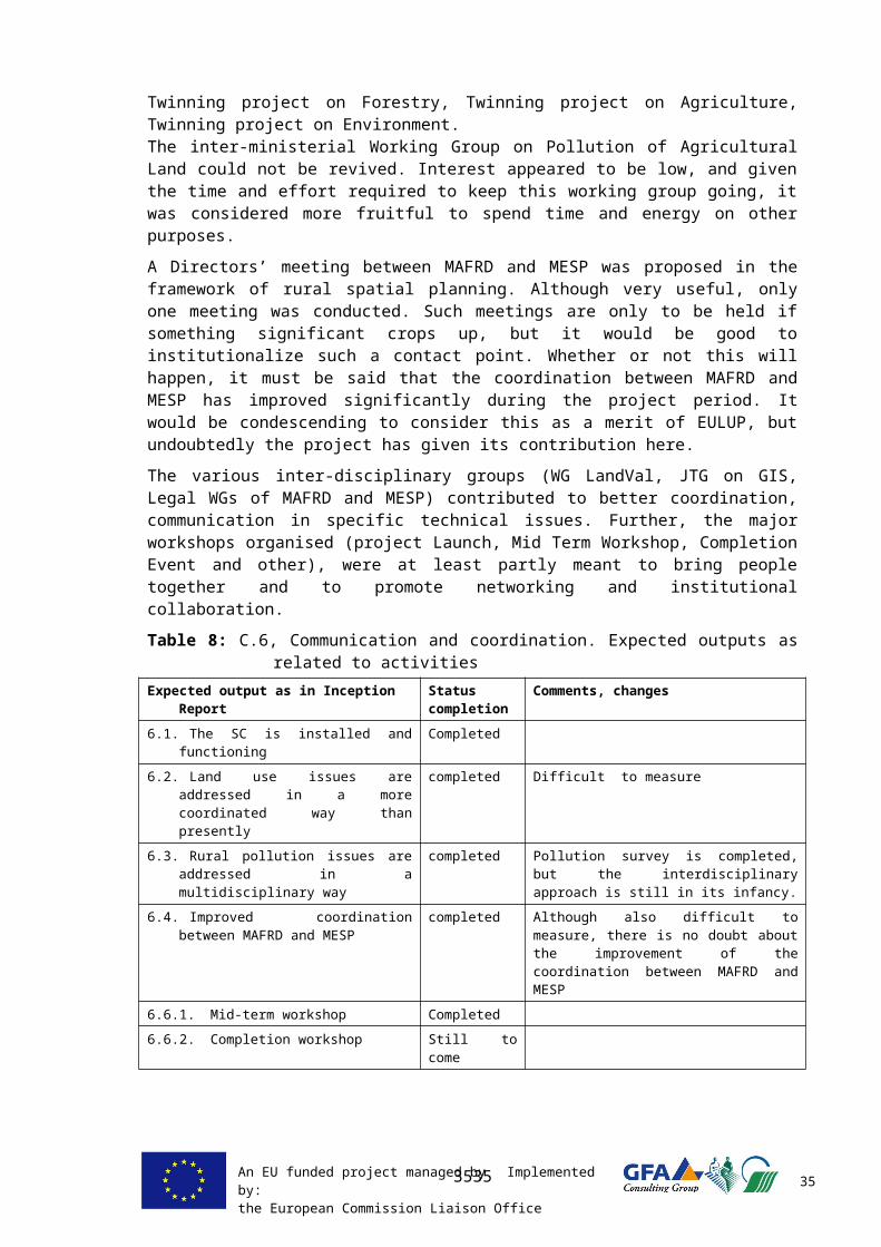
An EU funded project managed by Implemented by:the European Commission Liaison Office 51
8 C O N C L U S I O N S A N D P R O P O S A L SThe current chapter comprises conclusions, recommendations and lessons learned. The below comments are to some extend personal and come from all EULUP professionals. Although the observations below are voiced by EULUP staff, they usually have been discussed expensively with the relevant Kosovo officials.
8 . 1 S e t u p o f t h e p r o j e c t
The purpose and objectives of EULUP were very wide. This makes sense, because issues in agricultural land use are land use are usually very interrelated, and the broad approach allows to address these interconnected matters simultaneously. On the other hand, this approach includes the risk of inability to go into sufficient detail. Indeed, the resources of the project were limited in terms of IB funding and working days, as is the 2 year timeframe.
Where it was perhaps a good idea to set up the first efforts in land use improvement (ALUP and EULUP) broadly and to address a variety of issues in land use at the same time, the opinion is that for future efforts, it would be better to concentrate and address issues in a more comprehensible way. This is a general opinion, also shared by the MAFRD.
In the current project the inherent decision was taken to make available relative large resources to rural spatial planning and construction zoning, because this persisting problem remains unsolved. This anticipation on a more focused project set up in future pays out, since one of the results of the project is a solid methodology for rural spatial planning, with also the related legislation revised. On the basis of this result, the next project has already been proposed by MAFRD to ECLO, concentrating on implementation of this methodology and on establishing control mechanisms to protect good agricultural land.
Another example of the need for more concentrated efforts (projects) is the result of the Component 5-2 (pollution). The reconnaissance survey fitted in the EULUP program, but a follow up is now required. This follow up must be large, complex and specific and must not be mixed with unrelated issues.
8 . 2 G o v e r n a n c e a n d l e g i s l a t i o n
As already stated in Chapter 7, notwithstanding the availability of legislation, the rule of law is not well observed in Kosovo. This is particular the case in land use and land ownership. Land represents a valuable asset, and the failure so far to implement the rule of law at least one of the controlling constraints in land development in the broadest sense, if not the largest.
Kosovo has received strong support in drafting of legislation from external sources. Legislation was often supported or even produced by short-term consultants, who were not always very well acquainted with Kosovo conditions and were too shortly here to acquire adequate insight in legal needs, and rely on the legislation that is the standard in their own countries. This has led to a patchwork of legislation that shows overlaps and gaps, and of which the related laws do not always take each other in consideration, or even outright contradict
Speaking in the context of rural land use, it can be seen that with time the drafting of legislation is more and more done and better controlled by the Kosovo legislative staff of the ministries and institutions. In addition, the coordination among these institutions has seen considerable improvement during the last few years. This will contribute to better legislation, and this is a welcome development. However, the legislation as drafted by
5151

An EU funded project managed by Implemented by:the European Commission Liaison Office 52
projects, in this case – EULUP, must be faster approved, if accepted, and implemented in a coordinated way.
Still, much depends from the assistance by foreign legal specialists. It would be recommendable to contract permanent legal experts that return regularly and get acquainted with local conditions. Expectedly, this would help in improved and more consistent legislation.
It is highest time that pollution control will be given the attention it deserves. Food safety and economic implications in the form of export of agricultural produce, justifies that. Results of the pollution survey suggest that an environmental legislation should also address the pollution of agricultural land. This should not be arranged through the Law on Agricultural Land (LOAL). Soil pollution and contamination (including investigation and remediation issues), apart from pollution caused by agricultural cultivation itself, should be addressed solely in environmental legislation. That means that monitoring of agricultural land should be integrated in an overall approach to environmental monitoring under environmental legislation. Also, investigation and remediation of polluted areas should be addressed under environmental legislation. For that purpose, the legislation on environmental protection should be amended.
8 . 3 L a n d R e g u l a t i o n
The land regulation program is initiated, funded and implemented by the MAFRD. The EULUP was an adviser to the programme, and unreservedly leaved the decision-making to MAFRD, also in case these decisions were different than the EULUP would advise. Having acknowledged this relationship, and in view of the disappointing progress, a few remarks can be made to improve the progress of this program.
Management of land regulation The success of the large program on land regulation is not ensured under the current organizational set-up, where the MAFRD Dept. of RD is charged with all executive responsibilities for planning and implementation. The Department has neither the manpower nor the technical background to carry out such complex and intensive work, and currently this is only partly compensated by the contracting of a supervisory company
One critical recommendation by the projects ALUP and IS MAFRD and now also by EULUP is to outsource the management of the land consolidation programme and the daily technical and organizational management of the individual projects. The ruling principle is that MAFRD is responsible for the land regulation programme, but does not involve in detailed management of the programme and the individual projects.
For this reason, advised to install a Land Regulation Office. The LRO is designed to be subordinate to the MAFRD and working under the direction and supervision of MAFRD Dept. of Rural Development. It’s prospected experts and staff are not civil servants but recruited by temporary contracts from the free market, financed by the MAFRD LR program budget, not by the MAFRD staff budgets.
Only by outsourcing, it is possible to attract Kosovar professionals who have the education and experience required to absorb the new concepts of land regulation and translate them into independent action. In fact, the sustainable land regulation as laid down in the Strategy could well fail without solid and very competent outsourced guidance.
Implementation of Land RegulationPlanning
It is recommended that adherence to the approved Action Plan to the Strategy 2010-2020 must be the basis for the implementation of the yearly land regulation programme. If there are good reasons, it makes sense to deviate from this program, but only if there are
5252

An EU funded project managed by Implemented by:the European Commission Liaison Office 53
indeed good and objective reasons. Ad-hoc and arbitrary deviations from the Action Plan are to be avoided
Complexity
The very high complexity of the ULR is obvious and it is needed to keep tight and expert control on the implementation of the ULR program. Also VLR must not be underestimated: it is not easier than ULR and requires extensive technical, legal and communication input as well. If must be ensured that such input can be made available, otherwise it would be more realistic to discontinue or at least to scale down the current (very ambitious) land regulation program.
Municipal Cadastral Offices (MCO)
A severe constraint is the capacity of the MCO’s to register the decisions of the land regulation commissions, particularly in the large scale ULR. This is an essential problem, since if registration fails, the current programme of completing the ULR fails as well.
For this reason, implementation through smaller ULR project is recommended, spread out over various municipalities instead of one very large one in one municipality. Further, the input of flexible licensed staff is proposed that can be allocated at municipalities temporarily having to deal with large registrations.
Priorities
The urgency of the solution of the ULR is generally acknowledged in Kosovo government, no doubt more so than VLR. Perhaps it is good to emphasize that it is the VLR that addresses the viability of commercial agriculture and thus is of crucial importance to Kosovo agriculture development in the mid and long term. Consequently, the consultants think that the voluntary land regulation program should have at least as much priority as the unfinished land regulation. It may be added that interest among land owners is certainly there and the economic viability is promising.
Awareness campaign
The MAFRD awareness campaign was planned but could not be realized, although funding (KCB) was available. This was due to internal organizational and procurement problems. Particularly for VLR, such an awareness campaign is essential to inform land owners about the possibility of VLR. However, if public notification is done for land regulation, this means that the MAFRD must be ready to respond and make its promises true. For that reason, processing and management capacity must be available as well as implementation.
It is proposed to assess the priority of the land regulation as compared to other ministerial programs and concerns, and to either reduce or reconfirm its priority. If priority is reconfirmed, then the focus of the MAFRD on this program needs to be increased.
8 . 4 R u r a l S p a t i a l P l a n n i n g
Agriculture is and will remain a vital part of the Kosovo economy, and the protection of good quality land, which is a major objective of this RLMP framework, is required now, not in 2 or 5 years time. The implementation of these plans into the Kosovo spatial planning system should provide a quick, robust, but reliable, solution to regulate irreversible changes in land use that threaten Kosovo competitiveness.
The developed GIS National Database can support long-term national rural development policies and help in producing a sustainable land-use structure in municipalities. It uses simple models designed to cope with meagre, generally low quality input data that are available for Kosovo. The over-riding advantages of implementing BRSP system in Kosovo are that it is:
ready for use and implementation now;
5353
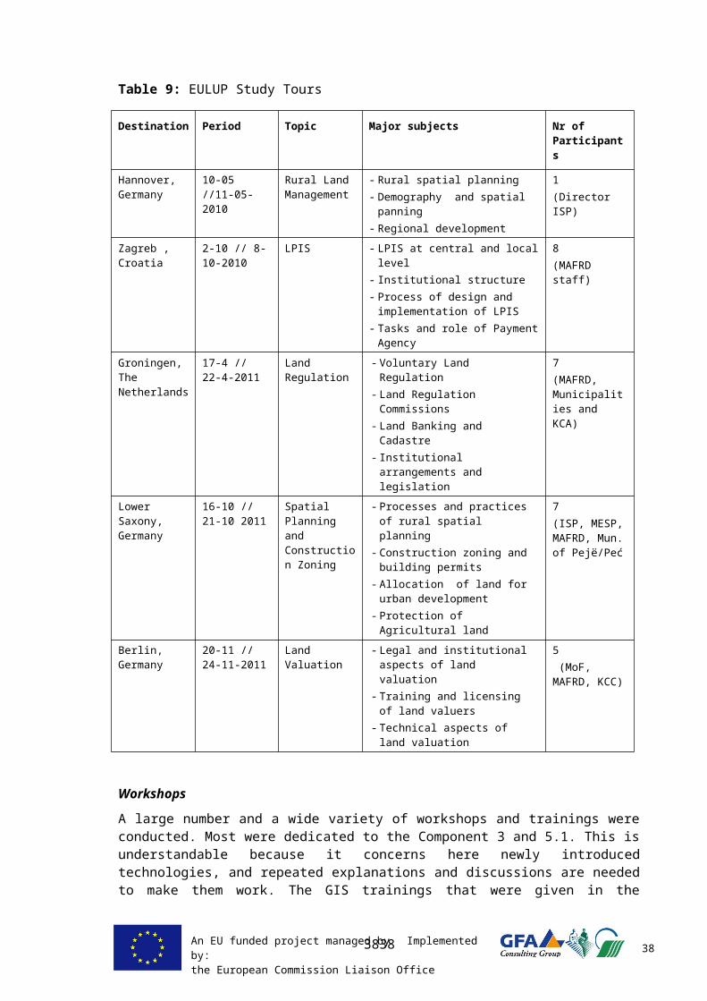
An EU funded project managed by Implemented by:the European Commission Liaison Office 54
based on a simple and clear methodology that is well described; consistent and reliable system that will allow comparisons between municipalities; usable from the national scale right up to the scale required for a municipality
planning; implemented in GIS, thus easy to apply and update with newer data; usable for developing other applications and policies.
Later on, the produced GIS data when skilfully combined with other EULUP or socio-economic data, can assist agricultural and environmental policies. These could include a variety of EU and internationally required strategies and plans, for example:
Environmental policies Prioritising field research, environment protection measures and their
financing River Basins Plans National Sustainable Development Strategy Climate Change Strategy and Adaptation Plans NATURA 2000 – prioritising areas for biodiversity protection
Agricultural policies Indicating, prioritising and locating ARDP agro-environmental measures Land consolidation programme and projects Planning new irrigated areas and rehabilitating existing ones Planning bio-energy plantations or agro-forestry Defining Less Favoured Areas and High Nature Value Farmland Areas.
However, first of all, the Kosovo government shall solve the issue of data sharing and organise the NSDI structure and rules. Another important obstacle is data quality, particularly of soil cover, which is the primary basis for all agricultural applications. In both cases Kosovo may approach relevant donors for necessary funding.
The implementation of the CZP in all municipalities in a well organised and fast way is of utmost importance for Kosovo. The approval of relevant legislation, as drafted by EULUP jointly with the ministries, will be instrumental in support this process. The currently active projects and international programmes shall be approached to provide needed technical support to municipalities, or the EU FWC facility should be urgently exploited.
8 . 5 s L P I S
As full IACS-based LPIS system is too early and too complex for Kosovo at the current stage, the project developed a ‘simplified’ LPIS – sLPIS, the system which is able to implement main LPIS functions, but without complicated control mechanism attached. From the point of technical, legal and capacity conditions, sLPIS is now fully ready to be used at the national level for the management of area based subsidies for farmers.
The software and processes were thoroughly tested in the pilot area and in 3 co-pilot municipalities, and since November 2011 the MAFRD PU, with a close support of EULUP, has utilized sLPIS for the management of winter wheat applications. This proves that sLPIS software is efficient and easy usable tool for managing national direct payments and can be used until the full scale LPIS system is established.
The extensive sLPIS Master Plan provide all technical, legal and data requirements, a clear time schedule and explanations on further sLPIS usage and update. It can serve as main document for preparing next sLPIS/IACS related projects in Kosovo.
5454

An EU funded project managed by Implemented by:the European Commission Liaison Office 55
Most valuable results achieved within the LPIS component: Fully functioning Web-based GIS application with digitisation of agricultural
parcels is now possible on a national scale; The viewing of the ortho-images and simple GIS functionalities are now available
through Internet for anybody who has the password. sLPIS can be used for the electronic preparation of area-related direct payments; The staff members of the PU are trained and able to use sLPIS without further
support The troubleshooting of LPIS system is supported by the project ITC expert until
02.2013.
Further, it is important to note that the implementation of a full IACS/LPIS system is only useful in the context of EU accession. Its implementation in Kosovo today is not useful especially since it is expected, that the EU policy and the control system will change in the next years. Thus it is advisable to rather concentrate MAFRD efforts in effective sLPIS utilization as supplemented by well structured and sound administrative work. The collection of the parcel information using sLPIS and the corresponding data will be of high value for the full IACS/LPIS implementation once this is needed. A transformation of gathered data to another system can be done without any technical problem.
There is a high need to set clear objectives and responsibilities by the MAFRD PU in close co-operation with the municipalities. Without a target setting, support and supervision it is difficult to achieve results. A crucial issue for the nation-wide extension is the support provided by the municipalities, especially for mobilizing the farmers. If this support is not sufficient, it might be considered to strengthen the capacities of the PU instead, although the municipalities are much nearer to the farmers.
8 . 6 L a n d V a l u a t i o n
There is a clear need for a professional group of Kosovo property valuers who are able and licensed to carry out land valuation and damage compensation assessments. So far, this work was mainly done - or perhaps only guided - by foreign experts with rather large fee requirements. The application of the tailor made Kosovo” approach is recommended to start the vocational training and licensing as proposed in the EULUP Technical Report 20.
Land Valuation in Kosovo is difficult, because there is no real distinction between land prices for building plots and agricultural parcels. In principle every meter square is potentially building location, and thus subject to speculation prices. This is a consequence of the inability of authorities to set and maintain rules on building and non-building areas.
A second constraint is the rule that transactions with a value of more than € 10,000 must be arranged by bank. This leads to a wide spread practice of paper contracts with transactions below this amount, whereas the actual – verbally agreed - amounts may be manifold.
For these reasons, the data on land valuation are informal, and approximate at best, and both the land valuation base maps, (including the scoring model) and the new Administrative Instructions on Land Valuation, must be considered a useful first step, to be adapted as better information becomes available.
5555

An EU funded project managed by Implemented by:the European Commission Liaison Office 56
8 . 7 P o l l u t i o n o f A g r i c u l t u r a l L a n d
The purpose of the reconnaissance survey on pollution of agricultural land has been to establish whether there is a problem with pollution in agricultural land outside the known mining and industrial hotspots, and what should be the further cause of action. The results of the survey indicate significant pollution of top-soils with heavy metals in certain regions and for that reason a swift follow up of the investigations is recommended, comprising further and more detailed investigations. The recommendations are given in the EULUP Pollution Report 23, and include immediate measures and urgent projects. The importance of quick further action is evident and is found in health concerns and economic interests.
It must be emphasized that the current results originate from a very widely spaced grid (varying, but on average 1 x 1 km). Although this is sufficient for the purpose of the survey, it is certainly not enough to decide whether certain localities are polluted or not. With such a wide grid, the results only represent the location of the sample taking itself and do not qualify or disqualify areas in between.
Measures to be taken immediately include:- Initiate a reconnaissance sampling programme of food products- Monitoring of the pH of precipitation, indicating increased mobility of heavy metals in
the soil has to be counted with- Investigation of the Cadmium in the Mitrovicë/Mitrovica area. Cadmium is one of the
heavy metals most hazardous to health.Urgent projects would include:
- Continue investigations, but now on a far more detailed scale. Purpose is to identify pollution on local scale and to plan and undertake steps for remediation or containment or protective measures.
- Indentify sources for pollution by cadmium, chromium, nickel, lead, zinc and arsenic- Accreditation of scientific and commercial parties to obtain ISO accreditation for all
investigations and analysis that must become standards in Kosovo.- Control the current unchecked change of use of agricultural land into building areas,
particularly industrial but also residential.
5656