10.4 impacts on onshore environmental receptors -...
TRANSCRIPT

Azeri Chirag Gunashli Full Field Development Phase 1 Project Environmental & Socio-economic Impact Assessment
Chapter 10 - Environmental Impact Assessment Chapter 10/69 February 2002
10.4 Impacts on onshore environmental receptors This section presents a discussion on potential impacts to onshore environmental receptors that would occur as a result of routine and planned non-routine Phase 1 project activities. The onshore environment includes, as described in the Environmental Description (Chapter 6), coastal habitat and inland (semi-desert) habitat. The following sections are presented: • impacts on the onshore atmosphere; • impacts on the physical coastline (i.e. shoreline configurations); • impacts on groundwater and groundwater aquifers; • impacts on hydrological systems and flows; • impacts on subsurface geology; • impacts on topography and landscape; • impacts on coastal habitat, flora and fauna; • impacts on inland habitat, flora and fauna; and • impacts of project decommissioning. All potential impacts are discussed whether significant or otherwise to ensure that all Phase 1 offshore activities have been appropriately assessed. Greater emphasis has been given to the activities that have been assessed to potentially result in more significant impacts. 10.4.1 Impacts on the onshore atmosphere Emissions to the onshore atmosphere resulting from the Phase 1 project would result from the following activities: • assembly of the offshore facilities at the SPS fabrication yard; • terminal early civil engineering work programme and construction;terminal operations;
and • pipeline installation operations in the nearshore and onshore between the landfall and
terminal. The fate and effect of gaseous species emitted during these activities have been discussed in Section 10.3.1.1 and the project activities are described in the Project Description (Chapter 5) along with the estimated emission quantities from these activities. 10.4.1.1 Offshore facility assembly and terminal construction activities The assembly of the offshore facilities will take place at the SPS yard some 14 km to the north of the terminal site where terminal construction operations (including early civil works) would be undertaken. Atmospheric emissions generated during these assembly and construction activities would result from combustion sources from equipment such as diesel generators, cranes and other diesel driven equipment as well as from excavators, trucks and vehicles at both sites. An increase in vehicle traffic carrying equipment, materials and the workforce to and from each site would also result in an increase in combustion emissions to the atmosphere in the area. Additional combustion emissions would be generated from diesel driven equipment and vehicles during the construction of the Phase 1 30” pipeline landfall and onshore pipeline installation activities. Impact significance Estimated quantities of emissions to the atmosphere resulting from activities associated with platform assembly at SPS, terminal construction activities at Sangachal and pipeline installation in the nearshore and onshore were found to be low. While they could result in an

Azeri Chirag Gunashli Full Field Development Phase 1 Project Environmental & Socio-economic Impact Assessment
Chapter 10/70 Chapter 10 - Environmental Impact Assessment February 2002
increase in the ambient air concentrations of emitted species near to the source of the emissions, they would rapidly disperse. Further, the temporal and spatial distribution of the emission would be such that they would be unlikely to lead to any significant degradation of local air quality and hence no impact to human health would be expected. The impact significance associated with these emission is therefore, considered to be “low” as follows: Likelihood of occurrence = 5 - certain to occur Consequence = 1 - impact largely not discernible on a local scale Significance = 5 – low 10.4.1.2 Terminal operations There are a number of sources of emissions to the atmosphere resulting from operations at the oil processing terminal. The principal sources would include: • power generation turbines; • process heaters; • flaring; and • fugitive emissions. The estimated total emission quantities by species from each of the activities over the life of the project are illustrated in Figure 10.13a and 10.13b. Figure 10.13a Estimated total emission quantities by species (excluding CO2) from
routine and planned non-routine operations at the terminal (tonnes)
0
500
1,000
1,500
2,000
2,500
3,000
3,500
4,000
4,500
5,000
2005 2007 2009 2011 2013 2015 2017 2019 2021 2023
NMVOC
CH4
SOx
NOx
CO
NMVOC: non-methane volatile organic compounds.

Azeri Chirag Gunashli Full Field Development Phase 1 Project Environmental & Socio-economic Impact Assessment
Chapter 10 - Environmental Impact Assessment Chapter 10/71 February 2002
Figure 10.13b Estimated total CO2 emission quantities from routine and planned non-routine operations at the terminal (tonnes)
0
100,000
200,000
300,000
400,000
500,000
600,000
700,000
800,000
900,000
2005 2007 2009 2011 2013 2015 2017 2019 2021 2023
The principle contributors to the total emissions are the power generation gas turbines and the process heaters both of which are fuelled by the fuel gas transferred to the terminal from the offshore installations. Fuel gas requirements are based on the predicted production levels from the development. The gas turbines would have dual fuel capability; that is, diesel could be used as a back-up fuel in the event of the loss of gas. An emergency back-up stand-alone diesel generator would also be provided at the terminal. Routine flaring at the terminal would be limited to the conventional pilot lights at two flares resulting in a total amount of gas routinely flared at the terminal of only 4 MMscf per year. Routine flaring has been reduced by the decision to install a flare gas recovery system at the terminal that will collect the low volume gas leakage from the process valves and seals for return to the process. Nitrogen, an inert gas, would be used as the terminal flare purge gas. Periods of flaring would however occur at times of plant unavailability. The plant design availability target for the facilities is 95% but in the early days of commissioning and start up of the terminal and offshore facilities plant availability has been estimated to be 70% in year 1 and 82% in year two following installation of the C&WP offshore. Flaring during these periods would occur at the offshore facilities as far as possible but flaring events at the terminal would also be necessary. Estimated flaring volumes anticipated at the terminal are shown in Figure 10.14.

Azeri Chirag Gunashli Full Field Development Phase 1 Project Environmental & Socio-economic Impact Assessment
Chapter 10/72 Chapter 10 - Environmental Impact Assessment February 2002
Figure 10.14 Estimated planned non-routine flaring volumes at the terminal
0
500
1,000
1,500
2,000
2,500
3,000
3,500
2005 2007 2009 2011 2013 2015 2017 2019 2021 2023
Non-routine flaring quantities, although significant, would be expected to be short-lived. The majority of flaring of gas would be likely to occur in the early days of each year following the installation of the facilities. Emissions shown in Figures 10.13a and 10.13b above include these anticipated non-routine flaring events. The flaring events represent a significant contribution to the overall emissions from the terminal operations. Flaring would also occur if at any time SOCAR were unable to receive gas at the terminal boundary. A gas protocol has been signed between AIOC and SOCAR that provides the necessary assurance that the gas deliveries to SOCAR will be properly received and utilised. Under the terms of this agreement SOCAR will have provided appropriate facilities to take the gas available and hence, any inability to receive gas should minimised. Flaring should subsequently, also be limited. Fugitive losses of volatile organic compounds from plant equipment connections and terminal storage tanks represent a relatively minor source of emissions and would be largely controlled by minimisation through appropriate specifications for valves, flanges and seals. Primary and secondary seals with low loss fittings will be installed on the oil storage tanks resulting in reduced fugitive emissions at the site. There have been a number of key design decisions incorporated into the Phase 1 design in order to reduce the emissions from the project. These have been described in Project Description (Chapter 5) and have been summarised in the Mitigation Management and Monitoring chapter (Chapter 14, Section 14.2.1.6). The power generation emission and flare stack heights would ensure maximum dispersion of the principle emissions from the terminal over a wide area. An initial air dispersion modelling exercise was conducted using ADMS (Atmospheric Dispersion Modelling System) in 2001 to determine whether or not the emissions generated from operations at the terminal would result in impacts on nearby sensitive receptors. At the time of the modelling study, project definition had not been finalised, stack heights used were conservative at 20 m. The results of this modelling and the methods used are included in the Technical Appendix (Appendix 3) and are summarised below. The modelling study was completed to assess the potential effects during:

Azeri Chirag Gunashli Full Field Development Phase 1 Project Environmental & Socio-economic Impact Assessment
Chapter 10 - Environmental Impact Assessment Chapter 10/73 February 2002
• normal operations for combined EOP, ACG Phase 1 and Shah Deniz Stage 1 facilities; • normal operations including gas turbines; • for operational upsets of EOP and Phase 1 combined; and • for operational upset of Shah Deniz facilities on their own. In addition, emissions from the potential future sulphur treatment facilities at the Phase 1 terminal were included. It should be noted that modelling conducted in 2001 did not include the predicted operational scenarios of 30% Phase 1 gas injection plant unavailability in year 1 when associated gas will be flared, 18% down-time in year 2 and 5% down-time in year 3 and onwards as this aspect of the project’s base case had not been fully defined at the time of modelling. Similarly, modelling was not undertaken for flaring during commissioning of onshore facilities nor of the combined operations of EOP, ACG FFD and Shah Deniz FFD. Nevertheless, the results of the study provide a useful insight into the fate of emissions to the atmosphere during periods of high-level activity. . The process releases to the atmosphere that have the greatest potential to impact on human health include oxides of nitrogen (NOx), sulphur dioxide (SO2), carbon monoxide (CO) and volatile organic compounds (VOC). NOx emitted from the combustion sources comprises a mixture of nitric oxide (NO) and the more toxic nitrogen dioxide (NO2). NO is partially converted to NO2 by oxidation in the presence of ozone in the atmosphere. The majority of NOx emissions would be in the form of NO. The atmospheric dispersion study concentrated on NO2 due to its greater potential to result in adverse health effects. The model results for NO2 concentrations was therefore, conservative and leads to higher predicted concentrations for the scenarios modelled. SO2 in the atmosphere can also result in adverse effects on human health. SO2 emissions would principally result from hydrogen sulphide (H2S) in the hydrocarbon stream. Although H2S was detected in small quantities in some earlier appraisal wells drilled in the ACG field, it is not known whether it will occur in Phase 1 fluids and if it does, at what concentration. The results from testing of product from the initial well drilled will define H2S levels in the hydrocarbon stream and if required, H2S scrubbing and sulphur recovery systems will be added to the terminal facilities. The modelling has assumed a worst-case emission of SO2. CO is toxic to humans at high concentrations. The VOC emitted will be predominantly alkanes (propane, butane etc), although the VOC can also contain a small proportion of suspected carcinogenic compounds. International standards and guidelines for NO2, SO2 and CO are presented in Table 10.20. There are no current standards for VOC emissions.

Azeri Chirag Gunashli Full Field Development Phase 1 Project Environmental & Socio-economic Impact Assessment
Chapter 10/74 Chapter 10 - Environmental Impact Assessment February 2002
Table 10.20 International standards and guidelines for air quality
Air Quality Objectives Pollutant Concentration
µgm-3 Averaging period International Standard or
Guideline 200 1 hour mean (99.8%ile) WHO1, EU2, UK3 Nitrogen Dioxide 40 Annual mean WHO, EU, UK
350 1 hour mean (99.7%ile) EU, UK 125 24 hour mean (99.2%ile) WHO, EU, UK
Sulphur Dioxide
50 Annual mean WHO Carbon Monoxide 10,000 Rolling 8 hour average WHO, UK
Notes: 1. WHO – World Health Organisation, ‘Guidelines for Air Quality’, 2000 2. EU – Council of the European Communities, Council Directive on Air Quality Standards for Nitrogen Dioxide (85/203/EEC), Council of the European Communities, Council Directive Amending Directive 80/779/EEC on Air Quality Limit Values and Guide Values for Sulphur Dioxide and Suspended Particulates (89/427/EEC), Official Journal of the European Communities, 1989 3. UK - The Air Quality Strategy for England, Scotland, Wales and Northern Ireland, Department of the Environment, Transport and the Regions, The Stationary Office, 2000 99.8%ile = standard not to be exceeded more than 18 times per year. 99.9%ile = standard not to be exceeded more than 21 times per year. 99.7%ile = standard not to be exceeded more than 24 times per year. 99.2%ile = standard not to be exceeded more than 3 times per year. The atmospheric dispersion study modelled the maximum ground level concentrations attributable to the emissions. Modelled ground level concentrations were combined with background concentrations of each species in order to assess cumulative air quality at receptor locations. Results for the terminal operation, during worst-case operational conditions are presented in Tables 10.21 through Table 10.24. Table 10.21 NO2 emissions for routine operations and worst-case flaring
Receptor AQS µgm-3
Background µgm-3
NOx µgm-3
PEC µgm-3
PEC/AQS %
Maximum hourly average Phase 1 terminal 200 6 971 (97)2 1031 (103)2 51.51 (51.5)2
Sangachal Town 200 8 44 (45) 52 (53) 26 (26.5) Nearest Landfall 200 4 3.5 (5.5) 7.5 (9.5) 3.75 (4.8) Shah Deniz terminal
200 6 135 (NM) 141 (NM) 70.5 (NM)
Zilhoy Island 200 4 2.5 (4.5) 6.5 (8.5) 3.25 (4.3) Maximum Value 200 6 138 (146) 144 (152) 72 (76)
Annual Average Phase 1 terminal 40 3 3 (3) 6 (6) 15 (15) Sangachal Town 40 4 <1 (<1) 4 (4) 10.5 (10.5) Nearest Landfall 40 2 <1 (<1) 2 (2) 5.1 (5.1) Shah Deniz terminal
40 3 3 (NM) 6 (NM) 15 (NM)
Zilhoy island 40 2 <1 (<1) 2 (2) 5.1 (5.1) Maximum value 40 3 10 (10) 13 (13) 32.5 (32.5)
1 Flaring from Phase 1 and EOP. 2Flaring from Shah Deniz. AQS: Air Quality Standard. PEC: Predicted Emission Contribution. NM: Not modelled.

Azeri Chirag Gunashli Full Field Development Phase 1 Project Environmental & Socio-economic Impact Assessment
Chapter 10 - Environmental Impact Assessment Chapter 10/75 February 2002
Table 10.22 SO2 emissions for routine operations and worst-case flaring1
Receptor AQS
µgm-3 Background
µgm-3 SO2
µgm-3 PEC µgm-3
PEC/AQS %
Maximum hourly average Terminal 350 30 306 336 96 Sangachal Town 350 12 38 50 14 Nearest Landfall 350 12 3 15 4.3 Shah Deniz site 350 30 205 235 67 Zilhoy Island 350 12 2 14 4 Maximum Value 350 30 1,040 1,070 305
Annual Average Terminal 50 15 9 24 48 Sangachal Town 50 6 <1 6 12.6 Nearest Landfall 50 6 <1 6 12 Shah Deniz site 50 15 17 32 64 Zilhoy Island 50 6 <1 6 12 Maximum Value 50 15 42 57 114
1All Sources Table 10.23 CO emissions for routine operation and worst-case flaring1
Receptor AQS
µgm-3 Background
µgm-3 CO
µgm-3 PEC/AQS
% Rolling 8 hour average
Terminal 10,000 N/A 395 3.95 Sangachal Town 10,000 N/A 214 2.14 Nearest Landfall 10,000 N/A 46 0.5 Shah Deniz site 10,000 N/A 296 3 Zilhoy island 10,000 N/A 35 0.35 Maximum Value 10,000 N/A 1170 11.7
1All Sources Table 10.24 VOC emissions for routine operation and worst-case flaring1
Receptor AQS µgm-3
Background µgm-3
VOC µgm-3
PEC/AQS %
Annual Average Terminal N/A N/A 42 - Sangachal Town N/A N/A 2 - Nearest Landfall N/A N/A <1 - Shah Deniz site N/A N/A 17 - Zilhoy island N/A N/A 0.4 - Maximum Value N/A N/A 1170 -
1All Sources The results of the 2001 dispersion modelling show that the emissions would be well dispersed and predicted hourly and annual average concentrations of each species modelled are all well within internationally recognised air quality standards. Short-term assessment criteria and predicted maximum values (15 minute mean) for SO2 are however, exceeded at locations approximately 250 m from the source of emissions (i.e. terminal site). There are no specific sensitive receptors within this distance from the terminal. It should be noted that SO2 levels are based on a worst-case assumption and further modelling of this species will be carried out once the H2S content of the reservoir fluids has been defined (i.e. following the template well drilling programme).

Azeri Chirag Gunashli Full Field Development Phase 1 Project Environmental & Socio-economic Impact Assessment
Chapter 10/76 Chapter 10 - Environmental Impact Assessment February 2002
Outside the terminal boundary hourly average concentrations of NO2 and SO2, under worst-case operating conditions, range from 3.25% and 26% of the AQS. The predicted level of NO2 were: • 44 µgm-3 at Sangachal town during flaring periods at the Phase 1 and EOP terminal; and • 45 µgm-3 at Sangachal town during periods of flaring at the Shah Deniz terminal being
26% of the AQS. Concentrations of CO and VOCs were predicted to be negligible. Further air dispersion modelling was conducted in January 2002 using revised ACG project data as the project became better defined and more accurate meteorological information was used. This modelling is ongoing but to date has concentrated on emissions of NOX based on the emissions estimates calculated for routine and planned non-routine operations at the terminal. In this model the flare stack height used was 35 m. The values obtained for NOx at nearby receptors are provided in Table 10.25 for selected years of the operations. The following operations have been assumed for each year modelled. 2002 – EOP terminal operations (current case). 2005 – year 1 of Phase 1 and EOP terminal operations. 2006 – year 2 of Phase 1, EOP and year 1 of Shah Deniz Gas Export Stage 1 terminal operations. 2007 – year 3 of Phase 1, EOP, year 1 of Phase 2 and Shah Deniz Gas Export Stage 1 terminal operations. 2010 – Phase 1 peak production, EOP, Phase 2 and Shah Deniz Gas Export Stage 1 terminal operations. Table 10.25 NOx concentrations at receptors nearby the terminal location (µgm-3
99.8%ile 1 hour mean)
NOX Concentration 2002 2005 2006 2007 2010
Sangachal Town 32 58 58 40 30
Railway Barrier 45 63 65 40 40
Stone Mine 15 44 40 35 29
West Hill Herders 41 77 80 50 48
Cheyildag 32 66 70 60 45
Garadag Cement Works 23 44 40 35 29
Cement Camp 51 73 75 50 48
Maximum Concentration 96 - 135 124 106
The model confirms that NOx emissions would be well dispersed and predicted hourly concentrations are all well within internationally recognised air quality standards at nearby receptors.

Azeri Chirag Gunashli Full Field Development Phase 1 Project Environmental & Socio-economic Impact Assessment
Chapter 10 - Environmental Impact Assessment Chapter 10/77 February 2002
Impact significance Estimated quantities of atmospheric emissions from terminal operation are considerable, especially during flaring. As such, there could be an increase in the ambient air concentrations of emitted species near to the source of the emissions. Based on the results of the atmospheric dispersion modelling studies carried out however, emissions would be expected to rapidly disperse and hence would be unlikely to lead to any significant degradation of local air quality. Impacts on human health would not therefore, be expected. The impact significance associated with the emissions of potentially polluting species were therefore, considered to be “low” as follows: Likelihood of occurrence = 5 - certain to occur Consequence = 1 - impact largely not discernible on a local scale Significance = 5 – low Onshore terminal operations would also result in considerable amounts of CO2 being released to the atmosphere and these would be in addition to the Phase 1 offshore emissions of this substance. The CO2 contribution from these operations is considered to be appreciable and a significant contribution to global greenhouse gases and hence considered to be of “high” significance as follows: Likelihood of occurrence = 5 - certain to occur Consequence = 2 – concern over greenhouse gas contribution Significance = 10 – high CO2 emissions from the Phase 1 project are further discussed in the Transboundary Impacts chapter (Chapter 13). 10.4.1.3 Dust The surface soils in the vicinity of the proposed work site consist of predominantly clays and silts and as such are very made up of fine particles (Chapter 6). Any activity that leads to the disturbance of surface soil could increase the atmospheric dust levels. The occurrence and significance of dust generated by project activities is difficult to estimate and depends upon meteorological and ground conditions at the time and location of the activities. It is considered that dust would primarily be an issue during the terminal construction. Airborne dust can be associated with a human health impact if generated in sufficient amount. The UK Health and Safety Executive (HSE) has developed new technical guidance in the Methods for Determining Hazardous Substances (MDHS). This guidance gives Time Weighted Average (TWA) Maximum Exposure Limits (MEL) for hazardous substances. The TWA for dusts (respirable) is 4mg/m3 and for dusts (total inhalable) is 10 mg/m3. Impact significance Dust suppression measures, such as watering-down work areas would be implemented to minimise any adverse effects on construction workers. In the context, the impact significance of dust emissions on the atmosphere and nearby human receptors is considered to be “low” as follows: Likelihood of activities occurring = 5 - certain to occur Consequence = 1- impact largely not discernable on a local scale Impacts significance ranking = 5 - low

Azeri Chirag Gunashli Full Field Development Phase 1 Project Environmental & Socio-economic Impact Assessment
Chapter 10/78 Chapter 10 - Environmental Impact Assessment February 2002
Baseline surveys conducted for this ESIA did not identify contaminated soils within the proposed terminal construction area (Chapter 6) but knowledge of the site as gained during the soil and groundwater studies conducted during the ESIA programme indicated that dust levels can be extreme and do make working conditions difficult. Airborne dust may at times therefore, represent a nuisance to construction workers. It should be noted, however that the study site was not watered-down during the soil and groundwater survey activities. Third party human receptors are some distance removed from the proposed works area and are therefore, not considered to be at risk as any dust particles liberated would settle before reaching these receptors. 10.4.2 Impacts on the (physical) coastline The coastline of Sangachal Bay would be directly and indirectly impacted as a result of the following project activities: • construction of a finger-pier (jetty) to enable nearshore trench excavation for the 30” oil
pipeline; and • construction of the pipeline landfall (i.e. pipeline shoreline crossing). 10.4.2.1 Construction of the finger-pier As noted in Section 10.3.3.2, the finger-pier required for nearshore pipeline installation works would be approximately 10 m wide at its base and up to 300 m long. It would most likely be a rock groyne structure. The project’s base case is for the pier to be removed after pipeline installation has been completed. Physical alteration to the coastline in the north of Sangachal Bay is evident following the construction of a similar jetty structure in 1997 which was required to enable the nearshore installation of the EOP 24” subsea pipeline. As discussed in the Environment Description (Chapter 6) sediment accretion is apparent on the north-eastern side of the EOP jetty and to a lesser extent, on the north-eastern side the EOP terminal sewage outfall pipeline. Erosion is apparent on the south-western side of both structures. Earthworks presumably associated with the installation of the facilities have also changed the shoreline in the north of the Bay by extending the land further into the sea and by changing the beach profile. Impact significance The impact assessment on the physical coastline resulting from construction of a finger-pier for the Phase 1 30” pipeline was considered to be of “high” significance as discussed below. Impacts would be two-fold as follows: • direct alteration of the physical coastline at the point the finger-pier was constructed; and • indirect alteration of the coastline near and potentially removed from the finger-pier
location due to changed hydrodynamic conditions. Construction of a finger-pier for installation of the Phase 1 30” subsea pipeline would result in direct physical disturbance and alteration of the coastline as occurred with the installation of the jetty for installation of the EOP subsea pipeline. The nature and extent of the change would be dependent on the construction methods used for installation of the rock groyne structure. It could be expected however, that the beach profile in the immediate vicinity of the works would be changed and that coastal dune structures could also be impacted. Assuming an appropriate level of control of the movement of construction equipment, the area of impact should be limited. It is considered that there would be an opportunity to restore the coastline following removal of the finger-pier structure.

Azeri Chirag Gunashli Full Field Development Phase 1 Project Environmental & Socio-economic Impact Assessment
Chapter 10 - Environmental Impact Assessment Chapter 10/79 February 2002
It is a well documented fact that jetty structures in the coastal environment can change local hydrodynamic conditions and sediment transport regimes and hence coastline configuration. Resultant effects can include deposition and erosion of the coastline close to and in areas removed from the facility. The significance of any change that was incurred in the medium to long-term is difficult to predict but is primarily dependent on the magnitude of the change in hydrodynamic conditions and largely dependent on how long the structure was in place. As discussed in Section 10.3.3.2 above, the hydrodynamic regime in Sangachal Bay is considered to be dynamic and complex. Importantly, it has been determined by two separate studies that observed current strengths are capable of mobilising and transporting sediment. Observations made during the 2001 investigations for this impact assessment concluded that erosion of the coastline near to the existing EOP jetty is likely to be attributable to that structure. The finger-pier to be constructed as part of Phase 1 subsea pipeline installation activities would be a much larger structure than that built for the EOP pipeline. Given the distance that it would extend into the Bay (i.e. up to 300 m) it can confidently be expected to change local hydrodynamic conditions. Exactly what the results of this change would be, in terms of effects on the physical coastline, is difficult to predict without quantitative sediment dynamics modelling. Certainly however, coastal erosion would constitute a negative impact especially if it occurred in sensitive areas where coastal wetlands (i.e. wadis and marshes) occur or where anthropogenic structures (e.g. roads) are to close the shoreline and hence at risk and as such is considered as being of high significance as follows: Likelihood of activities occurring = 5 - certain to occur Consequence = 2- local scale impact Impacts significance ranking = 10 - high Given that the finger-pier is to be removed following pipeline installation, it can be confidently assumed that natural processes would return to their former state of equilibrium. Any adverse change to coastline configuration that had occurred while the facility was in place may however require human intervention in the form of pro-active coastline rehabilitation. 10.4.2.2 Construction of pipeline landfall The pipeline would be trenched within the coastal zone and earthworks associated with this activity would result in some impacts to the area. Impact significance Impacts on the physical coastline associated with construction of the pipeline landfall are considered to be of “low” significance as follows: Likelihood of activities occurring = 5 - certain to occur Consequence = 1- impact largely not discernable on a local scale Impacts significance ranking = 5 - low The primary impact of construction of the pipeline landfall would be loss of coastal habitat and subsequent impacts on the fauna that inhabits the area. These issues are discussed in Section 10.4.8 below. The spatial extent of the physical coastline that would be impacted by construction of the pipeline landfall would be quite small and the activity would be short-term with no permanent

Azeri Chirag Gunashli Full Field Development Phase 1 Project Environmental & Socio-economic Impact Assessment
Chapter 10/80 Chapter 10 - Environmental Impact Assessment February 2002
above ground structures being installed. Construction of the finger-pier, as discussed above, would be likely to result in more significant impacts on the physical coastline. 10.4.3 Impacts on soils Soils would be directly impacted as a result of the following project activities: • installation of the onshore section of the 30” pipeline from the landfall to the terminal; • terminal early civil engineering work programme and construction; and • SPS yard upgrade activities. 10.4.3.1 Pipeline installation onshore The proposed onshore pipeline corridor land-take area is approximately 200 m wide for FFD. The pipeline would be trenched to a depth of 1 m from top of pipe (TOP) and would be expected to be approximately 3 m wide. Excavation of the trench and associated pipe-laying activities would however, require that a width of approximately 25 m along the pipeline corridor be utilised. The distance from the pipeline landfall to the terminal site is approximately 1.7 km. The area impacted would therefore, be approximately 4 ha. It should be noted that all the top-soils removed during the excavation of the onshore pipeline trench would be stock piled and would be replaced once the pipeline has been installed. Impact significance The installation activities associated with the installation of the 30” pipeline would result in direct disturbance of soil. Impacts would include destruction of the soil profile within the trench footprint and soil compaction is the immediate vicinity as a result of vehicle and plant operations. Such impacts could potentially affect the soil permeability and hence the ability of the area to absorb surface run-off. Conversely, disturbed soil can be more susceptible to erosion. As the total area that would be affected by the activities would be limited and as the area affected would be rehabilitated following earthworks, the impact significance of this activity on soil is considered to be “low” as follows: Likelihood of activities occurring = 5 - certain to occur Consequence = 1- impact largely not discernable on a local scale Impacts significance ranking = 5 - low 10.4.3.2 Terminal construction The main impacts on soils resulting from the terminal construction programme would occur during the early civil engineering works programme which would prepare the site for the terminal construction phase. It should also be noted that the early civil engineering works programme would prepare the terminal site for the Phase 1 terminal expansion, the Shah Deniz gas processing terminal and BTC pumping station. Areas that would ultimately be developed for the ACG and Shah Deniz projects would also be utilised during the early civil engineering works programme for materials and equipment lay-down and storage. The early civil engineering work programme (Project Description; Chapter 5) would include the excavation of top and subsurface soil as part of the construction of the drainage channel and the removal of top- and sub-soil in the area of the Phase 1 terminal, the Shah Deniz gas terminal and the BTC pump station. In addition, new roads, a construction camp for the

Azeri Chirag Gunashli Full Field Development Phase 1 Project Environmental & Socio-economic Impact Assessment
Chapter 10 - Environmental Impact Assessment Chapter 10/81 February 2002
terminal construction workforce and a number of retention ponds for the wastewater treatment at the terminal would be constructed. Although removed soils would be stockpiled for later use in bund wall construction and land levelling and/or site rehabilitation works, it would be permanently lost from its point of origin. Impact significance Early civil engineering work would result in impacts on soil in the following areas: • construction of the drainage channel: 27.5 ha • the clearing, grading and levelling in the area in which the terminal(s)
are to be constructed (Phase 1, Shah Deniz and BTC) 112.3 ha
• main new access roads: 7.5 ha • construction camp: 13 ha • retention ponds: 10 ha In total, the construction programme would therefore result in direct impacts on soil over an area in excess of 170 ha. It should be noted that soil in areas additional to this would be indirectly impacted as a result of vehicle movements and soil stockpiling. Most of the area to be levelled lies within the existing EOP land-take area and has previously been impacted as a result of earthmoving activities undertaken for that terminal construction project. In a local context soil loss is considered to constitute an impact of “high” significance due to the fact that habitat in the impacted area would also be lost as follows: Likelihood of activities occurring = 5 - certain to occur Consequence = 2- local scale impact Impacts significance ranking = 10 - high Impacts on terrestrial habitats are discussed in Section 10.4.9 below. In a regional context, impacts associated with the soil loss are considered to be less significant as the total area affected represents only a small percentage of the surrounding (similar) terrain and habitat. 10.4.3.3 SPS yard upgrade Prior to the construction of the offshore facilities the selected fabrication yard (i.e. SPS) would require a number of upgrades some of which would include ground levelling and laying of aggregates. The scope of facility upgrade works is yet to be finalised but would be limited to the existing yard area. Impact significance As works at the SPS yard would be primarily in regards to refurbishing and upgrading existing facilities, the impact significance of SPS yard upgrade on soil is considered to be “low” as follows: Likelihood of activities occurring = 5 - certain to occur Consequence = 1- impact largely not discernable on a local scale Impacts significance ranking = 5 - low

Azeri Chirag Gunashli Full Field Development Phase 1 Project Environmental & Socio-economic Impact Assessment
Chapter 10/82 Chapter 10 - Environmental Impact Assessment February 2002
10.4.4 Impacts on groundwater and aquifers The following project activities have the potential to impact groundwater and aquifers: • installation of the onshore section of the 30” pipeline from the landfall to the terminal; • terminal construction; and • upgrade activities at the SPS yard. 10.4.4.1 Onshore pipeline installation Onshore pipeline installation would include the excavation of a trench from the shoreline to the terminal site and as such may result in disturbance of groundwater and/or groundwater aquifers. An intrusive subsurface investigation undertaken at the terminal site (Chapter 6) in May 2001 found that the groundwater in the vicinity of the proposed terminal development site was only present in one of the six boreholes drilled to a depth of 15 m beneath the surface. The water was found at a depth of approximately 9 m and was perched and discontinuous. Impact significance As excavation of the trench for the onshore section of the 30” pipeline would only be to a depth of approximately 2 m, it is not anticipated that any significant groundwater resources would be impacted. The impact significance of pipeline landfall construction on groundwater is therefore, considered to be “low” as follows: Likelihood of activities occurring = 5 - certain to occur Consequence = 1- impact largely not discernable on a local scale Impacts significance ranking = 5 - low 10.4.4.2 Terminal construction Terminal construction activities that would potentially interfere with subsurface hydrogeological conditions would include construction of the drainage channel, which would be constructed to a maximum of 2 m depth and the laying of foundations and underground services, such as power cables, sewage and drainage pipework. In this instance, the potential exists for perched groundwater to be intercepted. Impact significance As described groundwater was only encountered at a depth of 9 m below the surface during intrusive investigations completed for this impact assessment. Underground works for the terminal would not occur at this depth and given the depth of occurrence, the limited extent and apparent lack of any aquifer-based discernable flow, impacts as a result of terminal construction activities on groundwater resources are considered to be of “low” significance as follows: Likelihood of activities occurring = 5 - certain to occur Consequence = 1- impact largely not discernable on a local scale Impacts significance ranking = 5 - low

Azeri Chirag Gunashli Full Field Development Phase 1 Project Environmental & Socio-economic Impact Assessment
Chapter 10 - Environmental Impact Assessment Chapter 10/83 February 2002
10.4.4.3 SPS yard upgrade SPS yard upgrade works would primarily include refurbishment of existing facilities. In the event that new facilities are constructed, there would be a potential to intercept groundwater resources. Impact significance Given the nature of proposed yard upgrade activities and the limited area over which they would occur, impacts on groundwater resources are also considered to be of “low” significance as follows: Likelihood of activities occurring = 5 - certain to occur Consequence = 1- impact largely not discernable on a local scale Impacts significance ranking = 5 - low 10.4.5 Impacts on hydrological systems and flows The proposed terminal site and surrounding area is, for the majority of the year, very dry. There are a number of drainage lines and ephemeral creeks that cross or are near to the site. Water flow in these hydrological systems occurs after significant rain events and in some instances can be substantial, although short-lived. Following rain events, standing water can be observed in small depressions. The following activities would result in potential disturbance to these hydrological systems and to the flow regime within the area: • installation of the onshore section of the 30” pipeline from the landfall to the terminal;
and • terminal construction activities and operations (including the early civil engineering
work programme). 10.4.5.1 Installation of the onshore section of the 30” pipeline Installation of the onshore section of the 30” pipeline would result in disturbances to hydrological systems and to the flow regime within these systems although as the pipeline trench would be back-filled following pipeline installation, the effects are likely to only be short-term. In the longer term, the physical presence of the pipeline underground is not considered to represent a major obstruction to surface or near-surface water flow. Impact significance Impacts on hydrological systems and flows associated with installation of the onshore section of the 30” pipeline would be localised and small scale and therefore, would be of “low” significance as follows: Likelihood of activities occurring = 5 - certain to occur Consequence = 1- impact largely not discernable on a local scale Impacts significance ranking = 5 - low

Azeri Chirag Gunashli Full Field Development Phase 1 Project Environmental & Socio-economic Impact Assessment
Chapter 10/84 Chapter 10 - Environmental Impact Assessment February 2002
10.4.5.2 Terminal construction activities and operations (including the early civil engineering work programme)
The terminal flood protection drainage channel and bund wall to be constructed around the terminal (Section 5) would have the potential to alter the physical layout of the hydrological system within the footprint of the terminal area. Similarly, grading of the terminal site and construction of the site access road and associated box culverts would also have the potential to change the layout of the existing hydrological system. Surface ‘hardening’ within the terminal footprint would also contribute to the a changed hydrological regime as surface run-off from the terminal site would be diverted and collected for treatment prior to release to the surrounding terrain and natural waterways. Impact significance In terms of altering existing hydrological flow patterns, the drainage channel would have the most significant effect in that the feature would be likely to at least partially divert surface waters away from existing wadis and marsh areas that lie between the south-eastern boundary of the terminal site and the shoreline. It may however, increase the flow of water (after rain events) into marsh areas in and near to the mouth of the Sangachal River to the south-southwest of the terminal site and to the ephemeral creeks east-southeast of the site. The abundance of wetland vegetation in wadis and marsh areas is dependent on the amount of water that enters them. A reduction in the amount of water would be paralleled with a reduction in vegetation abundance. This in turn may incur a reduction in the abundance of faunal species that inhabit the wetland areas or use them for grazing and may also result in increased erosion of the areas as they dry out. Conversely, an increase may result in an increase in vegetation and potentially fauna. The drainage channel has been designed to protect the terminal site from flooding during periods of high rainfall. At present, rainwater runoff from the hills to the north of the terminal site is channelled towards the terminal location, the speed of which is assisted by the lack of absorbance of the compacted clays in the area. The size of the channel has been designed to allow the rate of water flow from the drainage channel outlets to be limited such that erosional scouring of the ground is unlikely. Without detailed data on the ecology of wetlands, on seasonal and annual water flow in and through the coastal wetlands near to the proposed terminal site, or on the volumes of water that would be affected by construction of the terminal it is difficult to predict what the significance of a changed hydrological regime impact would be. Given this uncertainty, these impacts are considered to be of “high” significance as follows: Likelihood of activities occurring = 5 - certain to occur Consequence = 2- local scale impact Impacts significance ranking = 10 - high 10.4.6 Impacts on subsurface geology The two project activities that have the potential to impact on subsurface geology are: • terminal construction (foundations); and • produced water injection at Lokbatan.

Azeri Chirag Gunashli Full Field Development Phase 1 Project Environmental & Socio-economic Impact Assessment
Chapter 10 - Environmental Impact Assessment Chapter 10/85 February 2002
10.4.6.1 Terminal construction The drainage channel, terminal and access roads would not physically impact on subsurface geological structures. Further, the area that would be covered by these features is not know to host any economic reserves even though historically, oil and gas production has occurred in the nearby area (EOP EIA, 1996). The fact that the area would be permanently sterilised (i.e. not be available for exploitation by other users) as a result of development of a terminal facility on the site therefore, does not constitute an impact. Interactions with subsurface geological structures and rock units would however, result from the construction of foundations for the terminal’s infrastructure. Impact significance Impacts resulting from terminal foundation construction would be localised and small scale and therefore, the significance of these impacts is considered to be “low” as follows: Likelihood of activities occurring = 5 - certain to occur Consequence = 1- impact largely not discernable on a local scale Impacts significance ranking = 5 - low 10.4.6.2 Produced water re-injection The base case for the Phase 1 project for the disposal of produced water is injection via dedicated deep injection wells onshore into the aquifer at the Lokbatan oilfield, some 20 km to the north of the terminal site. Produced water is not expected to be generated until later in ACG field development but when produced, would be separated from the hydrocarbon stream at the terminal. Once separated, it would be transported, most likely by pipeline, to Lokbatan for disposal by injection. Predicted rates for produced water generation are presented in the Project Description (Chapter 5). At peak Phase 1 oil production, the produced water generated at the terminal from the oil stabilisation process is anticipated to be approximately 19,000 bwpd with a cumulative disposal for the life of the project of up to 61 million barrels. The main concerns associated with produced water injection are: • impacting on the producing Lokbatan oilfield to the north of the proposed injection site; • inducing seismic events (e.g. fault slippage) in the subsurface geological structures; and • impacts on any groundwater resources. Impact significance Under current estimates produced water injection onshore would not be required until 2007 and additional work will be undertaken to identify the exact location of the preferred injection sites within the south-eastern sector of the Lokbatan field. The potential environmental impacts can therefore, only be assessed in a generic sense based on the existing understanding of the proposed injection site.
Produced water injection modelling Due to the relatively low permeability of the host rock and the need to inject produced water at quite high rates, injector wells would need to be hydraulically fractured to enhance their capacity to accept large volumes of produced water under high pressure. Without a detailed understanding of the deep hydrogeology of the south-eastern sector of the Lokbatan field, it is not possible to accurately quantify the direction or velocity of migration of produced water away from the injector wells. It is considered however, that long-term migration of the injected water would in general be controlled by the regional hydraulic gradient.

Azeri Chirag Gunashli Full Field Development Phase 1 Project Environmental & Socio-economic Impact Assessment
Chapter 10/86 Chapter 10 - Environmental Impact Assessment February 2002
On a regional scale, hydraulic gradient is controlled by recharge from surface, surface topography and elevation, geological structure (i.e. geological dip of formations and the hydraulic role of faults) and subsurface hydrogeological properties. In addition to these generic factors the local hydraulic gradient in the Lokbatan field is controlled by the degree of pressure depletion that is present within the sandstones as a consequence of oil production to the north of the field. The degree of pressure depletion at the proposed site is related to: • the volume of production; • the relative location of the production wells to the injection wells both in terms of their
horizon and distance; and • the presence of major faults that can hydraulically isolate or compartmentalise major
areas of ground from the impacts of oil and gas production at Lokbatan. If the boundary faults to the north of the south-eastern sector act as a hydraulic barrier, then their presence would both isolate the Lokbatan field from the injection process and also impact on the distribution of pressure induced in the host rock by the injection process. Conceptually it is thought that induced produced water flow would be down dip and away from the injector wells in a southerly direction (i.e. away from the northern producing sector of the Lokbatan field). Over time, pressure would gradually reduce and the produced water would mix with the host waters of the sandstones present at depth. At present it is not possible to predict the speed of the migration away from the injection zone or the exact geometry of the injected plume either during or after the injection process. Injection simulations have confirmed potential issues of fault damage and the significance that sealing faults can have on the distribution of injection pressure away from the injection well. The presence of a sealing fault would disturb the uniform distribution of pressure, significantly increasing the pressure surcharge on the down-dip side and almost entirely isolating the aquifer on the up-dip side. The study confirmed earlier conceptual understanding of the role of sealing faults; the presence of an up-dip hydraulic barrier would induce additional migration of injected fluid to deeper horizons under the sea. Based on the present understanding, the absence of producing wells and deep freshwater resources confirms that the long-term environmental consequences of produced water injection into the south-east limb of the Lokhbatan field would not result in a major environmental impact in terms of groundwater contamination. Based on the results of preliminary modelling of produced water injection at Lokbatan, it is concluded that the impacts on subsurface geology associated are of “low” significance as follows: Likelihood of activities occurring = 5 - certain to occur Consequence = 1- impact largely not discernable on a local scale Impacts significance ranking = 5 – low

Azeri Chirag Gunashli Full Field Development Phase 1 Project Environmental & Socio-economic Impact Assessment
Chapter 10 - Environmental Impact Assessment Chapter 10/87 February 2002
10.4.7 Impacts on topography and landscape 10.4.7.1 Construction of terminal The proposed terminal site is situated on a coastal plain at a height ranging between approximately 7 m and 20 m. The surrounding terrain is generally flat to undulating with very few elevated features within the terminal footprint. Prominent hills exist to the northwest and north of the site. Given the fact that a terminal already exists on the site, the proposed additional facilities would result in an incremental change to the visual impact of the terminal on the surrounding landscape. In order to assess the cumulative visual impact of the proposed expansion to the terminal a series of typical viewpoints were identified in the area surrounding the terminal site. Visual simulations were then prepared to create images of the terminal that show what the terminal would look like after the expansion works are completed. These visual simulations provide the basis for assessing the likely visual impact of the proposed terminal expansion. Existing EOP terminal The existing EOP terminal is situated within a broad valley defined by hills to the north, west and southwest. The Caspian Sea coast is located approximately 1.7 km to the southeast of the site. Views of the existing terminal from public roads are generally limited to a section of the main Baku to Astara coastal road between the settlements of Umid and Sangachal and the section of road running northwest to the Cheylidag (Umbaku) settlement. Parts of the existing terminal are also visible from a small herding settlements located to the north and northeast of the site. The most visually prominent elements of the existing terminal are the storage tanks and the large building located in the north-east corner of the terminal. The symmetrical shape and white colour of these elements contrast with the backdrop of natural hill slopes and ridges. The visual prominence of the tanks and building is significantly reduced when they are viewed with the visible surface in shadow. If the visible surface is in full sunlight however, the contrast with the background is maximised. Views of the existing terminal from the main coastal road are generally limited to the top portions of the tanks due to the flat landform and the slightly lower elevation of the road relative to the terminal. Due to the higher elevation of areas to the southwest and northeast of the terminal site, views from those locations generally include a larger proportion of the tanks and other elements at ground level. The visibility of the terminal from those locations is however, significantly reduced due to the longer distance of the views and the atmospheric effects, particularly the effect of dust. Proposed Phase 1 terminal expansion Information about the extent of the proposed expansion of the terminal was provided to the ESIA team in a series of layout plans and drawings. In addition, a series of views of the three-dimensional computer model of the existing and proposed FFD terminal facilities were provided in electronic format.

Azeri Chirag Gunashli Full Field Development Phase 1 Project Environmental & Socio-economic Impact Assessment
Chapter 10/88 Chapter 10 - Environmental Impact Assessment February 2002
The proposed new facilities would be located to the north and west of the existing terminal and would be constructed on a series of earth terraces extending up the slope above the existing terminal. The most visually prominent components of the proposed terminal expansion would be the storage tanks and flare stacks. The proposed new storage tanks are substantially larger than the existing tanks. Visual simulations In order to show what the expanded terminal would look like, a series of visual simulations were prepared. The simulations were based on the views from five (5) view point that were selected on the basis of being representative of a series of viewing situations within the surrounding landscape. The viewpoints are illustrated in Figure 10.15 and summarised in Table 10.26. Figure 10.15 Location of viewpoints

Azeri Chirag Gunashli Full Field Development Phase 1 Project Environmental & Socio-economic Impact Assessment
Chapter 10 - Environmental Impact Assessment Chapter 10/89 February 2002
Table 10.26 Viewpoint summary
View Point Approximate Distance From FFD Terminal (km)
Description
99 4 View from public road running northwest from the settlement of Cheylidag (Umbaku). Elevation similar to the terminal. Powerlines and poles visually prominent in foreground
102 2.5 View from northwest corner of Sangachal Town with background of prominent hills. Slightly lower elevation than terminal site. Powerlines and poles visually prominent in mid-distance
105 1.5 View from coastal road with background of hills. Slightly lower elevation than terminal site. Powerlines and poles in mid-distance
106 2 View from Umid IDP Camp area on westrn side of coastal road with powerlines visually prominent in mid-distance. Background of hills in distance. Similar elevation as terminal site.
109 3.5 View from area in front of village looking downslope to terminal site. Background of hills in distance. Higher elevation than terminal site.
Preparation of the visual simulations involved the following process: • Photographs were taken from each of the five (5) view points looking towards the
terminal site. • The photographs were digitised to allow them to be edited using the Adobe Photoshop
program. • Images of the 3-D (three-dimensional) model as it would appear when viewed from each
of the five viewpoints were provided in electronic format. • The 3-D model images for each of the five (5) view points were then merged with the
digitised photo from each view point using the existing tanks to align the 3-D model image with the photo image.
• The surfaces of the tanks and other components of the terminal in the 3-D model images of each of the five viewpoints were rendered using PhotoShop to make them appear similar to the existing tanks and other elements of the terminal.
• Photographic images were prepared for each of the five view points that show the existing view as well as the simulation of the view after the proposed expansion of the terminal is completed. These images are presented on the following pages.
The results of the visual simulations are summarised below.
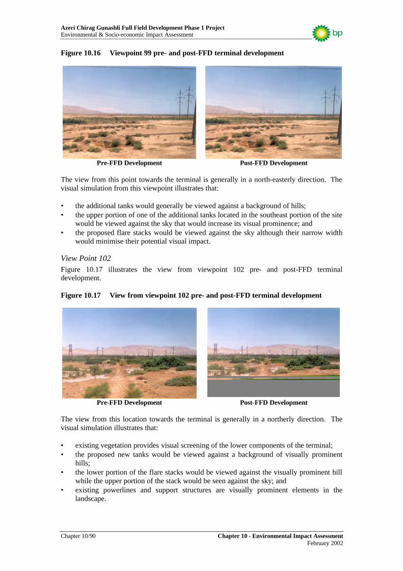
View Point 99 Figure 10.16 illustrates the view from viewpoint 99 pre- and post FFD terminal development.
Azeri Chirag Gunashli Full Field Development Phase 1 Project Environmental & Socio-economic Impact Assessment
Chapter 10/90 Chapter 10 - Environmental Impact Assessment February 2002
Figure 10.16 Viewpoint 99 pre- and post-FFD terminal development
Pre-FFD Development Post-FFD Development
The view from this point towards the terminal is generally in a north-easterly direction. The visual simulation from this viewpoint illustrates that: • the additional tanks would generally be viewed against a background of hills; • the upper portion of one of the additional tanks located in the southeast portion of the site
would be viewed against the sky that would increase its visual prominence; and • the proposed flare stacks would be viewed against the sky although their narrow width
would minimise their potential visual impact.
View Point 102 Figure 10.17 illustrates the view from viewpoint 102 pre- and post-FFD terminal development. Figure 10.17 View from viewpoint 102 pre- and post-FFD terminal development
Pre-FFD Development Post-FFD Development
The view from this location towards the terminal is generally in a northerly direction. The visual simulation illustrates that: • existing vegetation provides visual screening of the lower components of the terminal; • the proposed new tanks would be viewed against a background of visually prominent
hills; • the lower portion of the flare stacks would be viewed against the visually prominent hill
while the upper portion of the stack would be seen against the sky; and • existing powerlines and support structures are visually prominent elements in the
landscape.

Azeri Chirag Gunashli Full Field Development Phase 1 Project Environmental & Socio-economic Impact Assessment
Chapter 10 - Environmental Impact Assessment Chapter 10/91 February 2002
View Point 105 Figure 10.18 illustrates the view from viewpoint 105 pre- and post FFD terminal development. Figure 10.18 View from viewpoint 102 pre- and post-FFD terminal development
Pre-FFD Development Post-FFD Development
From this viewpoint, the visual simulation illustrates that: • existing view from the coastal road towards the site includes visually prominent
powerlines and poles in the mid-distance, and tanks viewed against hills in the distance; • the proposed additional tanks would be seen against a background of distant hills; and • the flare stacks would generally be viewed against the sky with only the lower portion
seen against a backdrop of distant hills.
View Point 106 Figure 10.19 illustrates the view from viewpoint 106 pre- and post FFD terminal development. Figure 10.19 View from viewpoint 106 pre- and post-FFD terminal development
Pre-FFD Development Post-FFD Development

Azeri Chirag Gunashli Full Field Development Phase 1 Project Environmental & Socio-economic Impact Assessment
Chapter 10/92 Chapter 10 - Environmental Impact Assessment February 2002
From this viewpoint, the visual simulation illustrates that: • the current view from the coastal road includes visually prominent powerlines and poles
in the mid-distance and the existing tanks beyond with a background of distance hills; • the proposed additional tanks would be viewed against a background of distant hills; and • a major portion of the flare stacks would be viewed against the sky.
View Point 109 Figure10.20 illustrates the view from viewpoint 109 pre- and post-FFD terminal development. Figure 10.20 View from viewpoint 109 pre- and post-FFD terminal development
Pre-FFD Development Post-FFD Development
From this viewpoint, the visual simulation illustrates that: • the existing terminal facilities are visible in the distance with a background of hills; • the proposed tanks would be visually more prominent than the existing tanks but they
would also be seen against a background of distant hills; and • the lower half of the proposed flare stacks would be viewed against a background of
distant hills while the upper half would be seen against the sky. The visibility of the expanded terminal would depend on the distance of the viewer from the terminal and the screening effect of the landform, vegetation and development located between the viewer and the terminal. Based on the above criteria the potential visual impacts of the proposed terminal expansion from the five viewpoints have been listed in order of significance from highest to lowest in Table 10.26. Table 10.26 Ranking of visual impact at viewpoints
View Point Number Potential Visual Impact 105 102 106 109 99
Highest (5)
Lowest It should be noted that the terminal would probably be more conspicuous at night as it would be the only significant source of artificial lighting in the area and the prominence of the facility at night is likely to appreciable. The significance of this impact is difficult to quantify as intrusiveness of light pollution is very subjective. What can be said is that lighting would

Azeri Chirag Gunashli Full Field Development Phase 1 Project Environmental & Socio-economic Impact Assessment
Chapter 10 - Environmental Impact Assessment Chapter 10/93 February 2002
be directional into the facility and would only be at levels that ensured operational safety; that is, the project design would minimise as far as is practicable, light pollution. Impact Significance Visual simulations concluded that the impact of the terminal facilities on topography and landscape was of “low” significance as follows: Likelihood of activities = 5 - certain to occur Consequence = 1- impact largely not discernable on a local scale Impacts significance ranking = 5 - low 10.4.8 Impacts on coastal habitat, flora and fauna Coastal habitat, flora and fauna would be impacted as a result of construction of the pipeline landfall and pipeline onshore section between the landfall and the terminal. Construction activities would include: • onshore work site preparation; • onshore (coastal) site preparation for pipeline beach-haul; • pipeline landfall and onshore trench construction; and • pipe-laying. It should be noted that pipeline landfall construction and associated activities would also impact terrestrial habitat as approximately 75% of the pipeline corridor lies within the central south survey sector which has been characterised as inland habitat in the Environmental Description (Chapter 6). Impacts on terrestrial habitat and specific floral and faunal species are discussed in section 10.4.9. Impact significance The impact assessment on biological resources has been completed using gathered available literature and the results of the May/June 2001 field survey conducted with the assistance of local and international experts (Chapter 6 and technical Appendix 10). It was noted that much of the available scientific literature regarding the ecology in the Sangachal region was dated and concerns a larger geographic region than that specifically of concern to this assessment. The surveys conducted in 2001 were designed to begin to address the gaps in the available literature and also to focus on the region in which the Phase 1 constructionand operational activities are proposed. Further data gathering over different seasons will be conducted to add to this baseline information. When using existing and available literature in the development of the baseline characterisation, some interpretative analysis had to be applied. Individual floral and faunal species may be impacted differently. For this reason, comment regarding potential impacts to specific species is made wherever available data supports such an approach. Particular attention is given to those species included in any of the following documents:
• 1996 IUCN Red List of Threatened Animals; • 1997 IUCN Red List of Threatened Plant Species; and • 1987 Azerbaijan Red Book. It is generally accepted that the designations in both the national listing and international listings are in need of revision. This is likely to occur within the next decade or so. Although many listed species have been encountered during past and recent surveys undertaken as part

Azeri Chirag Gunashli Full Field Development Phase 1 Project Environmental & Socio-economic Impact Assessment
Chapter 10/94 Chapter 10 - Environmental Impact Assessment February 2002
of various assessments, their distributions and population sizes are subject to broad interpretation, a limiting factor when assigning significance levels to potential impacts arising from the Phase 1 project. For the purpose of this assessment, qualitative estimates err on the conservative side or to worst-case scenarios.
Impacts on coastal habitat Sections of the Sangachal Bay coastline and particularly those in the south-east where it is proposed to construct the pipeline landfall and onshore trench host wetland habitat that is biologically productive and that performs critical ecological functions within the broader ecosystem. Ecotones, boundary or transition zones between different coastal floristic communities and between coastal habitat and slightly inland habitat (Chapter 6) are also important in this regard. Construction of the pipeline landfall and the onshore section of the pipeline trench would result in disturbance of approximately 2 ha of coastal habitat including coastal wetlands. In addition, the corridor would traverse the coastal-inland habitat ecotone. As this coastal habitat is important in the local ecosystem, its loss is considered to be of “high “ significance. Impacts on coastal habitat would take three forms as follows: • habitat loss; • habitat degradation; and • habitat fragmentation. Loss of habitat can result in an area’s inability to sustain the quantity and diversity of biological resources previously supported. The severity of impact varies for different species and is generally dependent on the availability of alternative resources near to the impacted area. Loss of species diversity on a regional level generally does not occur until a significant fraction of the habitat has been lost but once species begin to be lost from an ecosystem, their ongoing decline is typically rapid. Habitat degradation results in a net decrease in associated biological resources that in turn, lowers the carrying capacity of an ecosystem. This typically results in a parallel decline in various populations of dependent flora and fauna species. Degradation also compromises a habitat’s ability to buffer against and sustain more extreme environmental fluctuations and phenomena. Once in a more vulnerable state, habitats become increasingly more susceptible to indirect impacts. The ultimate consequence of habitat fragmentation is change to species composition, often observable as species diversity reduction, within the habitat. Resultant composition/diversity is largely determined by remnant habitat ‘patch’ size. Habitat fragmentation also creates more habitat ‘edges’ thereby, exposing the ‘internal’ habitat to an increased level of external influences. This phenomena has particular implications for resident fauna as discussed below. Site preparation works, pipeline landfall and trench construction and pipeline installation in the coastal area would result in the direct loss of coastal habitat and would be likely to contribute to habitat degradation and fragmentation. General vehicle movement associated with the works would also contribute to habitat degradation through the generation of dust. The habitat that would be impacted by these activities is already in a degraded state as a result of past anthropogenic activity and additional impact would further undermine the area’s ability to support the biological diversity it presently does and its ability to continue to perform its ecological function. It should also be noted that once habitat is disturbed, opportunistic plant and animal species are likely to take advantage of the more sparsely distributed resources. This ‘invasion’

Azeri Chirag Gunashli Full Field Development Phase 1 Project Environmental & Socio-economic Impact Assessment
Chapter 10 - Environmental Impact Assessment Chapter 10/95 February 2002
hinders the re-establishment of formerly resident populations of flora and fauna thereby causing a shift in the constituent species and community structure of the habitat. Often, the new regime is biologically impoverished in comparison to what was previously present.
Impacts on specific coastal flora species Impacts on the constituent flora species of the four main observed botanic communities would vary in significance due to the different times necessary for each community to rehabilitate to pre-impact levels and due to their current rarity. Table 10.27 below list the communities identified during the May/June 2001 survey and their normal restoration time listed as percent ground cover reclaimed over time. Table 10.27 Coastal floral communities natural recovery rates
Percentage Ground Cover Recovery1 Community Soil type 1 2 3 4 5 6 7 8 9 10
Thickets Wet coastal sand 10-20
30- 40
100
Littoral ecotone
Clay/argillaceous sand mixture
10-15
20-30
30-40
40-50
50-60
60-70
70-80
90-100
100 100
Reed beds Clay/argillaceous sand mixture/wet
60-70
100
Coastal slightly inland
Clay/argillaceous sand mixture
10-15
20-30
30-40
50 60 70 80 90 100 100
Source: Dr. V. Hajiyev, Azerbaijan Academy of Sciences. Tables 10.28 through Table 10.31 present breakdowns of each coastal botanic community with recovery time in years for each constituent species. Those with low numbers would be the first to recolonise and those with larger numbers would recolonise later. Relative percentage of each species can be inferred through the order in which they are presented in each table with the first species rating highest on the Domin Scale of Cover Abundance (Environmental Description, Chapter 6) and the last, the lowest. Note that species with the same rating are in no particular order. It should be noted that the time frames presented below represent normal re-vegetation times in the absence of any further anthropogenic effects. “E” in the restoration in “Recovery Time in Years” column indicates the species to be either an ephemeral or ephemeroid species. Ephemeral species restore within one year or growing season (i.e. usually one to two months) and live for the same period of time (i.e. the individual does not necessarily grow the following season). Ephemeroids also restore relatively quickly (e.g. one year) but are perennial (i.e. individuals grow season after season). For both types of plants, re-vegetation requires a viable seed source. Table 10.28 Thickets (Argusicum siberica) species recovery times
Species Recovery Time in Years Argusa siberica 2
Source: Dr. V. Hajiyev, Azerbaijan Academy of Sciences.
1 Natural variation in re-vegetation time is implied where the “Recovery Time in Years” is a range.

Azeri Chirag Gunashli Full Field Development Phase 1 Project Environmental & Socio-economic Impact Assessment
Chapter 10/96 Chapter 10 - Environmental Impact Assessment February 2002
Table 10.29 Littoral ecotone species recovery times
Species Recovery Time in Years Junus acutus 2
Tamarix meyeri 8-10 Phagmites australis 2
Argusa siberica 2 Alhagi pseodalhagi 1-2
Poa bulbosa E Medicago minima E Cynodon dactylon E Astragalus species E Allium rubellum E
Source: Dr. V. Hajiyev, Azerbaijan Academy of Sciences. E - an ephemeral or ephemeroid species. Table 10.30 Reed bed recovery times
Species Recovery Time in Years Phagmites australis 2
Source: Dr. V. Hajiyev, Azerbaijan Academy of Sciences. Table 10.31 Slightly inland coastal semi-desert recovery times
Species Recovery Time in Years Alhagi pseudalhagi 1-2
Argusia siberica 1-2 Suaeda dendroides 8-10 Salsola denproides 10-12 Bromus japonicus E Medicago minima E Adonis australis E
Poa bulbosa E Source: Dr. V. Hajiyev, Azerbaijan Academy of Sciences. E - an ephemeral or ephemeroid species. Of the three rare and endemic plant species identified during the May/June 2001 survey, two were encountered in and preferentially inhabit coastal areas namely, Astragalus bacuensis and Calligonum bacuensis. Direct habitat loss may result in a decrease in these species’ local population numbers. The impacts on coastal flora species associated with the pipeline construction activities are considered to be of “high significance due to the direct habitat loss and long recovery times as follows: Likelihood of activities = 5 - certain to occur Consequence = 2- local scale impact Impacts significance ranking = 10 - high Lichen species were identified during the 2001 survey activities. Only a few examples growing on shrub-bark substrate, were identified in the southeast coastal sector. Loss of coastal habitat would not significantly impact on lichens.

Azeri Chirag Gunashli Full Field Development Phase 1 Project Environmental & Socio-economic Impact Assessment
Chapter 10 - Environmental Impact Assessment Chapter 10/97 February 2002
Impact on coastal fauna Impacts on coastal fauna are twofold as follows: • direct mortality as a result of project activities; and • indirect impact as a result of loss, degradation and fragmentation of habitat. Habitat loss, degradation and fragmentation would potentially result in the alteration of faunal species’: • population distribution; • migration rates between populations; and • local population size. The species that would be mostly affected by impacts on habitat are those with large home ranges such as wolves and some birds of prey. These species can be lost from areas following construction programmes that result in only small remaining habitat fragments in the area. In the case of potentially newly formed habitat patches and particularly in respect areas that include dense tamarisk stands, nesting birds would be most significantly effected as nest visibility would increase as a direct result of the decrease in habitat patch size. Predation by foxes, jackals, corvids (i.e. birds from the largely omnivorous Corvine family with includes magpies and hooded crows) and some birds of prey would be likely to increase for breeding birds’ whose nests may be further exposed as a result of habitat fragmentation. Associated with impacts on habitat and in particular habitat fragmentation, is the level of persistence of wildlife “corridors”; that is, areas connecting various remnant habitat patches. Wildlife corridors allow fauna to move between areas and any loss to these results in a reduction in opportunity for the populations to interact with one another. In the longer term, reduced population interaction would result in adverse effects on a population’s genetic diversity. Impacts on specific faunal species that were observed in the area and specifically those recorded as present in the coastal survey sector habitats are discussed in the following sections.
Mammals Bats may use the coastal area for hunting and particularly reed-beds and water inlets that are rich in insects, a primary food source for bats. Any loss to these habitats may therefore, indirectly impact bats. No roosting structures were identified within the area that would be directly impacted as a result of pipeline landfall construction and as there is similar coastal habitat nearby that would be accessible to resident bats, the impact of the pipeline landfall construction is likely to be short term and of low significance. Hares that presently use the pipeline corridor area for feeding and nesting would be likely to move to adjacent land of comparable habitat once pipeline construction activities commenced. There is a risk of mortality however, to leverets if they are within the impact area and the mother does not move them. An increase in predation and hence mortality could also result from displacement of individuals into off-site areas. As the hare is common to the area and as the females are reflex ovulators (i.e. essentially can become pregnant any time they couple), impacts on this species resulting from pipeline landfall and onshore trench construction and associated works are considered to be short term and of “negligible” significance.

Azeri Chirag Gunashli Full Field Development Phase 1 Project Environmental & Socio-economic Impact Assessment
Chapter 10/98 Chapter 10 - Environmental Impact Assessment February 2002
Potential impacts on the four rodent species known to inhabit the coastal sectors are considered of “negligible” in significance. While these species are not reflex ovulators, they can breed year-round. Wolves do not rely on the coastal area to any great extent for either hunting or rearing young. Considering the limited geographical extent of potential coastal habitat loss (i.e. approximately 2 ha) and the large home range of this carnivore species, impacts are considered to be “negligible”. Golden Jackals would lose hunting/foraging ground wherever coastal habitat is lost, especially if within their home range2. Due to the Jackal’s omnivorous nature, this species would be expected to find suitable prey and/or carrion elsewhere on the coast or inland if project activities disturb existing hunting and feeding grounds. The impact of loss of habitat would therefore, be of low significance. The Red Fox would be most significantly impacted of the three carnivorous species as a result of pipeline landfall and trench construction and associated works. This species would also lose hunting/foraging ground wherever coastal habitat is lost. In addition, Foxes use the coastal area and especially the south-east, for nesting and rearing young where they burrow in soft coastal sand or use small caves found along the coastline. Home ranges of loosely defined family groups vary in size depending on the quality of the habitat but on average, extend between 5 and 20 km2. Coastal habitat in the vicinity of the proposed pipeline corridor is considered to be a favourable habitat for Foxes due to the abundance of rodents, lagomorphs and insects that make up the bulk of the species diet. While adult Foxes would probably modify their home range slightly and move to adjacent favourable habitat, pups that were unable to fend for themselves (i.e. from April to early June) could suffer direct mortality if nests are within the area in which project activities would be undertaken. The Red Fox would be directly displaced as a result of habitat loss and would lose frequently used coastline wildlife corridors as a result of pipeline landfall construction. On a local scale (i.e. the Sangachal area), impacts on this species are considered to be “high”. Regionally, impacts would be of “low” significance.
Herpetofauna All amphibian and reptile species observed during the May/June 2001 survey would be impacted on a local scale as a result of coastal habitat loss due to pipeline construction and installation works and associated activities. The coastal area, including wetlands and coastal semi-desert (slightly inland) areas, are used for3: • hunting (year round barring hibernation periods); • breeding (April to June); • egg incubation/pregnancy (June to August); and • hibernation (November to February). Individuals of the various species could suffer direct mortality if excavation and heavy equipment movement destroys underground borrows. Increased mortality could also result from increased predation and pressure resulting from displacement into off-site areas. Marsh frogs and turtle species would be moderately impacted if permanent or ephemeral wetlands (i.e. favoured habitat) were to be lost as a result of trenching and other site works.
2 Families hold hunting territories of 2 to 3 km2 3 Note that the dates cited are species’ averages across months.

Azeri Chirag Gunashli Full Field Development Phase 1 Project Environmental & Socio-economic Impact Assessment
Chapter 10 - Environmental Impact Assessment Chapter 10/99 February 2002
Of high significance among the identified herpetofauna species would be impacts on the Spur-thighed Tortoise due to: • its red-listed status both nationally and internationally; • its dependence on the project area for:
− nesting; − breeding (April-June); − egg-laying (June-August); and
• its low dispersal rate. Spur-thighed Tortoises that occupy the project area are at risk of being injured or killed as a result of pipeline construction and installation activities that could destroy burrows potentially crushing or entombing individuals. Tortoises may also be injured or killed as a result of vehicle movement within the project area. Tortoise occupying areas adjacent to the project area or that have home ranges that overlap the project area would similarly be at risk if they wandered onto active project areas.
Coastal birds Coastal birds would be affected by any direct habitat loss in the coastal area. Overall, the bird groups that could potentially be impacted are: • migrants passing through; • over-wintering species; and/or • breeding populations. In the event that habitat was lost, migrants and over-wintering species would be likely to make use of other similar coastal areas for necessary resources. Depending on species’ degree of site fidelity, they may return to disturbed areas once project activities have ceased and re-vegetation has begun. Little is known however, about the quantity and quality of alternative coastal habitat and therefore, the significance of any displacements and particularly those relating to changes in population sizes over time, is difficult to predict. Direct habitat loss has the most severe and immediate effect for breeding populations, particularly if land clearance and other construction activities result in nest destruction and loss (mortality) of a season’s clutch of eggs or fledglings unable to escape to adjacent areas with similar resources. Increased mortality would result in indirect mortality from increased predation and pressure resulting from displacement into off-site areas. Different species breeding within areas of direct habitat loss would be affected to varying extents, depending on the amount of associated resources utilised. For most passerines (e.g. warblers, wheatears and wagtails) the area over which feeding can be expected to have taken place would be relatively small and confined to the area in which they were recorded as nesting. For these species impacts would therefore, be more significant. For other species (e.g. corvids (magpies, ravens, crows and choughs), terns and birds of prey (raptors)), foraging may take place a considerable distance from an actual nest site and over areas away from the nesting locality. The impacts resulting from habitat loss would therefore, be less significant. Table 10.32 identifies bird breeding colonies as recorded during the 2001 survey that could be directly affected by construction activities in the coastal area.

Azeri Chirag Gunashli Full Field Development Phase 1 Project Environmental & Socio-economic Impact Assessment
Chapter 10/100 Chapter 10 - Environmental Impact Assessment February 2002
Table 10.32 Location of important bird colonies in the survey area
Species Area Northing Easting Estimated No. Pairs Collared Pratincole SE coast 40.16742 49.47095 5
Common Tern NE coast 40.18939 49.50476 6-8 Little Tern NE coast 40.18939 49.50476 7
While impacts on some coastal fauna resulting from construction of the pipeline landfall, onshore trench and associated works are considered to be of “negligible” to “low” significance, impacts on a few species are considered to be “high”. Overall therefore, impact significance is considered “high” as follows: Likelihood of activities = 5 - certain to occur Consequence = 2- local scale impact Impacts significance ranking = 10 - high 10.4.9 Impacts on terrestrial habitat, flora and fauna Construction of the terminal and pipeline onshore section would impact on terrestrial habitats, flora and fauna. Construction activities associated with construction of the pipeline onshore section have been identified above. Terminal construction activities (including the civil engineering work programme) would include: • ground clearance and grading in the area of terminal expansion; • excavation of drainage channel/bunding; • construction of a bund wall and security dyke; • construction of perimeter fencing and lighting; • construction of access road, box culverts and new railway crossing; and • construction of new oil processing facilities adjacent to the existing EOP terminal. Impact significance
Terrestrial habitat In excess of 170 ha of land would be directly impacted as a result of construction of the terminal. It should be noted that this includes the land clearance and levelling required to prepare the site for the construction of the Shah Deniz terminal within the terminal land-take area. Semi-arid regions are generally underestimated in terms of their ecological value. Locally in the Sangachal area, semi-desert habitats form an integral part of the ecological landscape and have been observed to support a notable diversity of fauna despite the fact that habitat degradation has occurred in the area as a result of industry infrastructure development (e.g. pipelines; power-lines and easements), grazing and natural phenomenon (e.g. 1999 mud flows into the central sector plains). The result of these events is a semi-desert zone with 20-40% less cover abundance than would be expected in semi-desert areas that have not been subjected to environmental impacts (pers. comm. Hajiyev, Dr. V.; June 7, 2001). The ecological effects of habitat loss, degradation and fragmentation have been discussed in Section 10.4.8 above in relation to coastal habitat loss. The same principles are relevant to inland habitat loss. Inland habitat as described in the Environment Description (Chapter 6) includes: • semi-desert with desert elements in the central north and central south sectors;

Azeri Chirag Gunashli Full Field Development Phase 1 Project Environmental & Socio-economic Impact Assessment
Chapter 10 - Environmental Impact Assessment Chapter 10/101 February 2002
• tamarisk stands concentrated in the central south sector; and • marshy meadow in the central south sector. These communities would be lost from and would not be able to recover within the footprint of the terminal, access road, drainage channel, bund wall, workers’ camp site and sewage pond (i.e. an area of in excess of 170 ha for Phase 1 and Shah Deniz terminals combined) as these features would be permanent. They would not however, be lost from the proposed 302 ha “no development zone” in the land acquisition areawhich in fact may, as a result of this area becoming a controlled zone (i.e. no future development permitted) improve in quality over time, a positive environmental outcome of the development. The total area of loss of each semi-desert habitat cannot be readily calculated with present habitat mapping data as the May/June 2001 survey focused on percent ground cover of specific species within each identified biotope (Chapter 6) rather than total aerial extent of each habitat. The percent ground cover provides a benchmark against which the future health of the habitats can be monitored. In addition to habitat loss, habitat degradation may occur as a result of the following: • creation of wind blown soil (dust); • use of “TerraZyme” in compacting the new access road surface, and • increased soil erosion resulting in increased sediment loads in ephemeral creeks and
marshes. Dust can accumulate on the leaves and stems of plants thus reducing their ability to photosynthesise and grow. In semi-arid areas, plants are typically well adjusted to hot and dusty conditions (e.g. have thin or small leaves thus reducing potential for moisture loss). Being endemic to semi-arid conditions, the flora species found in the survey area are, to a level, dust and heat tolerant. Increased levels of dust may however, cause additional stress although this is hard to quantify. Minimisation of dust levels in the terminal construction area would be achieved by watering-down earthwork areas during the terminal engineering and construction activities. “TerraZyme” would be used in the water-down mixtures to help bind loose soils on the new access road and other areas that may require it. Given the typically windy conditions in the Sangachal area, it can be expected that fugitive emissions of this water-down mixture could be wind blown onto adjacent areas and any plants that grow there. The effect of “TerraZyme” on plants is not known but given the chemical nature of the additive (i.e. organic, multi-enzyme catalyser), it is assumed that minor ‘burning’ of leaves and stems may occur. This indirect impact would be mitigated by, as far as possible, using the product during lower wind conditions and by spraying the water close to the ground. Uncontrolled soil erosion can lead to the increased turbidity levels in nearby waterways. Increased turbidity can have a number of resultant effects including reduction of aquatic flora growth rates and the impedance of physiological functions in aquatic and/or amphibious fauna. At critical levels of turbidity, aquatic ecosystems can cease functioning with resident fauna species moving on to more viable habitat or in the worst-case, dying. The proposed terminal construction activities would include works in areas where ephemeral creeks and marshes occur (May/June 2001 survey). Project activities may disturb soils which may be introduced to waterways and/or wetlands via surface run-off or by being wind blown. Wetland ecosystems are natural filters and hence it could be reasonably expected that they would be able to sustain a small increase in the turbidity levels if they are not already at their tolerance threshold. Controls (e.g. sediment traps) would be implemented in appropriate

Azeri Chirag Gunashli Full Field Development Phase 1 Project Environmental & Socio-economic Impact Assessment
Chapter 10/102 Chapter 10 - Environmental Impact Assessment February 2002
places, to minimise the opportunity for eroded soils to be introduced into waterways and wetlands nearby to the terminal construction site. In summary, the direct loss of inland habitats through land clearance and other terminal expansion activities is considered significant due to the potential presence of a threatened species (see below). Other contributing impacts include loss and further degradation of a biotope that is already under pressure from anthropogenic activities and that is progressively disappearing from the Azerbaijani landscape.
Impacts on specific inland flora species Semi-desert habitats in the area in which the terminal would be constructed support a number of floristic communities as follows: • low perennial bushes such as wormwood, Artemisia fragrans and saltwort species
Salsola dendroides and S. nodulosa the former of which constitutes an important fodder species for livestock that are grazed in the area;
• ephemeral species (e.g. Medicago, Plantago and Poa spp); • tamarisk stands (Tamarix meyeri); and • marshes. Table 10.33 below lists the three prevailing semi-desert botanic communities identified during May/June 2001 the survey and their normal restoration time listed in percent ground cover reclaimed over time. Tables 10.34 through 10.37 present a breakdown of each community with recovery time in years for each constitute species. Table 10.33 Inland floral communities natural recovery rates
Percentage Recovery to Pre-project Level4 Community Soil type 1 2 3 4 5 6 7 8 9 10 11 12
Salsoletum nodulosae + Suaeda dendroides association
Argillaceous saline
0 0 5-10
10-20
20-30
30-40
40-50
50-60
60-70
80-90
90-100
90-100
Artemisietum fragrans + Salsoletum nodulosae association
Argillaceous saline
0 0 5-10
10-20
20-30
30-40
40-50
50-60
60-70
80-90
90-100
90-100
Tamarisk thickets
Relatively moist Argillaceous soil
10-30
30-50
50-55
60-65
65-70
70-75
75-80
80-85
85-90
90-95
95-100
95-100
Marsh/meadow Argillaceous saline
10-30
30-40
45-55
60-65
65-70
70-75
75-80
80-85
85-90
90-95
95-100
95-100
Source: Dr. V. Hajiyev, Azerbaijan Academy of Sciences.
4 Natural variation in re-vegetation time is implied where the “Recovery Time in Years” is a range.

Azeri Chirag Gunashli Full Field Development Phase 1 Project Environmental & Socio-economic Impact Assessment
Chapter 10 - Environmental Impact Assessment Chapter 10/103 February 2002
Table 10.34 Salsoletum nodulosae + Suaeda dendroides association recovery time
Species Recovery Time in Years Salsola nodulosa 10-12 Salsola ericoides 12-14
Holosnemum strobilacaum 8-10-12 Bromus japonicus E
Catabrosella humilis E Allium rubellum E
Sideritis Montana E Torularia contortu pliceta E
Anabasis aphylla E Nepeta sp. E
Puccinellia bulbosa E Jurinea elegans E
Source: Dr. V. Hajiyev, Azerbaijan Academy of Sciences. E - an ephemeral or ephemeroid species. Table 10.35 Artemisietum fragrans + Salsoletum nodulosae association recovery time
Species Recovery Time in Years Artemisia fragrans 10-12 Salsola nodulosa 10-12 Salsola ericoides 10-12
Catabrosella humile E Filago arvense E
Medicaco minima E Medicogo orbicelaris E
Plantago minuta E Agropyrum orientale E
Veronika amoena E Trigonella manspeliaca E
Allium rubellum E Poa bulbosa E Erodium sp. E
Brachypodium sp E Source: Dr. V. Hajiyev, Azerbaijan Academy of Sciences. E - an ephemeral or ephemeroid species. Table 10.36 Tamarisk thickets recovery time
Species Recovery Time in Years Tamarix meyeri 10-12
Alhagi pseudalhagi 1-2 Allium rubellum E Cardus albidus E
Afremisia canasica 10-12 Rhamnus pallasii 8-10
Lepidium resicarium E Source: Dr. V. Hajiyev, Azerbaijan Academy of Sciences. E - an ephemeral or ephemeroid species.

Azeri Chirag Gunashli Full Field Development Phase 1 Project Environmental & Socio-economic Impact Assessment
Chapter 10/104 Chapter 10 - Environmental Impact Assessment February 2002
Table 10.37 Meadow community recovery time
Species Recovery Time in Years Salsola nodulosa 10-12
Artenisia phrangrans 10-12 Catabrosella humilis 10-12
Salsola ericoides 10-12 Alhagi pseudoalhagi 1-2
Filago arvenisis E Trogopason sp. E
Verinika amoena E Comphorosma lessingii E
Source: Dr. V. Hajiyev, Azerbaijan Academy of Sciences. E - an ephemeral or ephemeroid species. Seeds of Sharp-edged Darling Iris (Iris acutiloba) a species listed in both the Azerbaijan Red Book and IUCN Red List of Rare and Threatened Plants were found during the May/June 2001 survey within the semi-desert survey area. As this species usually blooms from March to April, it was not observed in flower during the survey. While no firm statement can be made regarding either the distribution or abundance of the species within the proposed development area, the presence of seed indicates that viable habitat occurs within the semi-desert areas or at least near to them. Adverse effect on any red-listed species is considered to be of “high” significance as follows: Likelihood of activities occurring = 5 - certain to occur Consequence = 2- local scale impact Impacts significance ranking = 10 - high
Impacts on terrestrial fauna As with coastal fauna, impacts on terrestrial fauna are twofold as follows: • direct mortality as a result of project activities; and • indirect impact as a result of loss, degradation and fragmentation of habitat. The May/June 2001 survey demonstrated that semi-desert habitats within the proposed terminal site host a number and variety of faunal species including amphibians, reptiles and mammals (Environmental Description (Chapter 6)). The clearing of land for terminal expansion and associated works would further fragment existing habitats and wildlife corridors and hence would disconnect previously connected areas with a resultant restriction of movement of some fauna species.
Mammals Impacts on bats that inhabit inland area would be the same as those that inhabit coastal areas; that is, “low”. Loss of habitat where insect diversity and abundance is high may however represent loss of feeding grounds Impacts on hares have been discussed above in relation to loss of habitat in the coastal area. Although a greater amount of habitat loss would result from terminal expansion, the impact significance on this species is nonetheless considered to be “low”. The Long-eared Desert Hedgehog would be directly impacted (mortality) where nests occur in the construction areas or where individuals are in the path of machinery. Indirect impacts may also result from habitat loss where displacement into off-site areas results in increased

Azeri Chirag Gunashli Full Field Development Phase 1 Project Environmental & Socio-economic Impact Assessment
Chapter 10 - Environmental Impact Assessment Chapter 10/105 February 2002
predation. Adults may avoid this threat but juveniles would be unlikely to be able to. As this species can forage as far as 9 km each night in search of food and due to its extreme resilience to food and water deprivation, impacts other than those associated with destruction of nests and direct mortality of individuals are considered short-term and of “low” significance. Impacts on the four rodent species known to reside in the semi-desert area would include loss of habitat and foraging ground and potentially, direct mortality from entombment in the area of land clearance and excavation. This loss of individuals may be significant in the short-term as they constitute important prey species for a number of the other resident fauna. As these species are numerous in this landscape and are prolific breeders, it is unlikely that a local population decrease would have any discernable effects after construction activities ceased. Wolves have stationary and nomadic periods, the former in spring and summer and latter in autumn and winter. Although some wolves exist year-round in the project area (resident information), the majority come in winter following the herds of grazing ungulates (e.g. sheep). Wolves would be likely to lose some local foraging ground as a result of terminal expansion and pipeline landfall construction. As the area lost is small in comparison to the typical range a pack (i.e. up to 1,300 ha) the impacts associated with habitat loss are considered negligible. It is considered that Wolves are not at risk from direct mortality as a result of vehicle and equipment movement. Impacts to the Golden Jackal resulting from inland habitat loss would be of “negligible” significance. Red Foxes may use the larger tamarisk stands in the central plains for nesting and rearing young. While impacts associated with terminal expansion and pipeline landfall construction would be most significant for this carnivorous species, overall, it is considered that impact would be of “low” significance. It should be noted that during the 1996 zoological survey for the EOP environmental impact assessment, an individual of the Marbled Polecat (Vormela peregusna) was observed. This species is listed in the Azerbaijan Red Book of Threatened Animals. The species was however not observed during the May/June 2001 survey as completed for this environmental impact assessment.
Herpetofauna Semi-desert populations of herptofauna are more sparsely distributed than in coastal areas. Impacts on these species are discussed above and would generally be the same in semi-desert areas. For the semi-desert herpetofauna populations, the small lizard species Eremias arguta and E. velox would be most affected as a result of land clearance. These species is however, common to the region and hence overall, impacts are considered to be of “low” significance. The Spur-thighed Tortoise stands to be significantly impacted as a result of terminal construction and associated activities. Impact ‘pathways’ are described above in relation to this species in coastal habitats. Given the red-listed status of this species, the impact significance is considered to be “high”.

Azeri Chirag Gunashli Full Field Development Phase 1 Project Environmental & Socio-economic Impact Assessment
Chapter 10/106 Chapter 10 - Environmental Impact Assessment February 2002
Terrestrial Birds Terrestrial bird species could be affected by direct habitat loss resulting from project activities. Potentially impacted species comprise breeding populations and occasional migratory raptors that use the central plains for hunting ground. Impacts on these migratory species are discussed above and would be the same in semi-desert areas as in coastal areas. One bird breeding colony was identified during the May/June 2001 survey namely, the European Bee-eater. The species was identified in the central south survey sector and it is estimated that six breeding pairs were present. This species could be directly affected by terminal and pipeline construction activities. Of note during the May/June 2001 survey was the discovery of Syke’s Warblers breeding in the damp scrubland to the south of the EOP terminal access road. This species had not previously been recorded as breeding anywhere in Azerbaijan, although it was known as a scarce passage migrant through the Caspian lowlands. The area in which it was recorded could be impacted as a result of pipeline landfall onshore trench construction. It is possible however, that this species is in fact present in most similar damp scrubby habitats along the Caspian coast and therefore, impacts associated with this small amount of habitat loss are considered to be of “low” significance. A significant issue associated with direct habitat loss in the semi-desert area is the presence of the Black-bellied Sandgrouse (Pterocles orientalis) and Lesser Kestrel (Falco naumanni) both were observed during the May/June 2001 survey and these species are listed in the Azerbaijan Red Book and IUCN Red List of Threatened Animals, respectively. The Black-bellied Sandgrouse is a member of the order Pterocliformes of which all members are found only in Africa and Eurasia. Members of this order are unique in that they share aspects with both pigeons and waders. One special feature of Sandgrouse is their long flights to water holes in desert and semi-desert country where they drink and during breeding times, wet their belly feathers to carry water to the chicks. Direct habitat loss and general disturbance resulting from project activities are the two main issues of concern for this species. It is envisaged that if during breeding season or subsequent incubation and rearing times, pairs of birds might forgo successful breeding or leave their eggs or nestlings if these were located close to an area that was disturbed by project activities. For the next breeding season, it is likely these pairs would move to less disturbed areas for successful parenthood although data are not available concerning their nesting site preference ‘commitment’. Impact to this species has been assigned a “high” significance due to the fact that it is red-listed. Although no breeding colonies of lesser kestrels were identified during the recent May/June 2001 survey, if colonies were to exist in the area, they would most likely reside in some of the larger ravines in the western plains, in the north hills or in the denser tamarisk stands found in the project area. Loss of foraging ground constitutes a significant impact for this species due to its internationally listed status. Overall, the impacts associated with the terminal engineering and construction activities on terrestrial fauna are considered to be of “high” significance due to the presence of red-listed species as follows: Likelihood of activities = 5 - certain to occur Consequence = 2- local scale impact Impacts significance ranking = 10 - high

Azeri Chirag Gunashli Full Field Development Phase 1 Project Environmental & Socio-economic Impact Assessment
Chapter 10 - Environmental Impact Assessment Chapter 10/107 February 2002
Other impacts on terrestrial flora and fauna Flora and fauna may be indirectly impacted by a range of activities other than those resulting from habitat loss and potential direct mortality during terminal and pipeline construction. Such activities include: • vehicle, equipment and plant operation that creates noise emissions; • atmospheric emissions; • night lighting of facilities;and • a general increase in anthropogenic activity in the vicinity of the terminal facility. Overall the the impact significance of other activities coastal and terrestrial flora and fauna is considered to be “low” as follows: Likelihood of activities occurring = 5 - certain to occur. Consequence = 1- impact largely not discernable on a local scale. Impacts significance ranking = 5 - low. Specific potential interactions are discussed below.
Noise Vehicle, machinery and aircraft (e.g. helicopter) noise can interfere with animal communication essential for social interaction including reproduction, as: • many diurnal species, including the majority of bird species, as well as large carnivores
such as wolves and jackals use sound in advertising displays and dominance interactions; • many nocturnal species use sound in detecting prey (e.g. bats), predators, or conspecifics
(other members of their species); and • many nocturnal animals use sound for communication. In addition, hares and rodents may listen for foot-thumping or ‘drumming’ frequencies as a sign of neighboring conspecifics, of the presence of different species, or for particular conspecific information regarding: • response to predators, often times a variable warning system to alert their kin to the
degree of danger present; and • ward off both competitors and predators. Noise-sensitive species would be expected to avoid both the construction and operational areas but would be expected to return when noise-generating operations are discontinued. Similarly, species intolerant of surface disturbance and human activities would also be expected to avoid disturbing construction and operation activities until the emissions ceased. Due to the historic activities at/near the terminal, species that currently inhabit the area are accustomed to a disturbed environment and should be habituated to human and mechanical activity. Noise is not therefore, considered a significant impact. Helicopter operations could also result in collision of helicopters with flying birds. Birds would be at greatest risk during dusk and dawn when they are moving (airborne) to roost and to go on daily foraging expeditions, respectively. Seasonally, the impacts would be greatest during migration periods (i.e. March to April and September to August) and the over-wintering period (October to mid-March). As helicopter operations would primarily be during daylight hours and as the total number of flights per day associated with construction

Azeri Chirag Gunashli Full Field Development Phase 1 Project Environmental & Socio-economic Impact Assessment
Chapter 10/108 Chapter 10 - Environmental Impact Assessment February 2002
activities and/or facility operations would not be large, collisions with birds is considered an unlikely event and therefore, this impact is considered to be of “low” significance.
Atmospheric emissions Emissions to the atmosphere during the various construction and operational activities such as NOx and SOX can undergo chemical transformation in the atmosphere and become dissolved in precipitation to form acid rain. An ecosystem’s susceptibility to acidification is determined by the alkalinity or acid neutralizing capacity of its soils and waters. The soils in the project area tend to be slightly to very saline. The buildup of sulphates and nitrates in soils can result in delayed acidification of coastal and inland ephemeral surface waters once saturation is reached. In essence, the water is no longer able to neutralise incoming acids and subsequently pH levels drop. The effects of decreasing pH on aquatic invertebrates are well documented. Insect taxa differ in their response to acidity. Mayflies (Ephemeroptera), known to inhabit the project area, are quite sensitive. Recently there has been a great deal of concern expressed regarding the documentation of worldwide declines in amphibian populations and acid deposition has been hypothesised as a possible cause. In addition to affecting individual animals or populations directly, air pollutants also affect wildlife indirectly by causing changes in the ecosystem. Vegetation affords cover for protection from predators and weather, provides breeding and nesting habitat and serves as a food source. Any change in vegetation could therefore, indirectly affect animal populations. Herbivores or partial herbivores are ultimately affected when they are faced with a decrease in the quantity or quality of their food supply. Although birds are not directly affected by water acidification, they can be indirectly affected by changes in the quantity and quality of their food resources for example fish eating birds encounter a decreased food supply when pH levels fall to a point where fish reproduction ceases. The same can be true for waterfowl that feed on invertebrates. It should be emphasized that while emissions from construction and operation activities have been shown to be considerable, due to these emissions being readily dispersed, the overall impact of NOx and SOx on flora and fauna in the vicinity of the terminal is considered to be negligible.
Lighting Night lighting at the terminal site would be likely to attract insects. This in turn may draw predatory species to the area. While this would not have any discernable effect on construction or operational activities, any increase in the number of predatory species in an area of intense anthropogenic activity may lead to mortality of a greater number of individuals.
Anthropogenic activity Some wildlife species might come under increased pressure from opportunistic predators (i.e. crows, jackals and red foxes) attracted to the project area by increased water availability, refuse or noise. In addition, during the life of the project the movements of some wildlife through the project area would be restricted as a result of the general level of human presence and activity. Because of the substantial open space surrounding the project area, these effects are not considered to be significant.

Azeri Chirag Gunashli Full Field Development Phase 1 Project Environmental & Socio-economic Impact Assessment
Chapter 10 - Environmental Impact Assessment Chapter 10/109 February 2002
Collective disturbance would increase stress levels for all fauna species. High stress levels can have a number of behavioral effects on animal species with the most serious being those that decrease the chance for survival and reproductive success. Behavioral effects that might decrease chances of surviving and reproducing include retreat from favorable habitat near noise/activity sources and reduction of time spent feeding with resulting energy depletion. Ultimately serious effects such as decreased reproductive success of mammals, herpetofauna and birds have the potential to occur through: • interference during pairing/coupling period; • unsuccessful pregnancy; • mammals - increase in spontaneous abortions and fetal re-absorbtion; • birds and majority of herpetofauna - non-laying or non-fertilisation of eggs; • less resources adjacent to nesting/clutch area result in net decrease of food to/for young
animals resulting in lower survival rate. For birds, potentially greater amounts of sibling rivalry with result of less surviving chicks;
• nest abandonment by parents for those species which lend this type of parental care; and • increased predation due to greater numbers of predators attracted to Project activities. Over the life of the project, additional injuries and mortality to wildlife could result from direct impacts from motor vehicles in the project area. The terminal construction and operations activities will include transport management planning that will limit the movement of all vehicles during the activities to designated areas in order to minimise any impacts due to vehicle movement.