watershed spatial discretization for the analysis … · watershed spatial discretization for the...
TRANSCRIPT

BCG - Boletim de Ciências Geodésicas - On-Line version, ISSN 1982-2170
http://dx.doi.org/10.1590/S1982-21702017000100007
Bol. Ciênc. Geod., sec. Artigos, Curitiba, v. 23, no1, p.101 - 114, jan - mar, 2017.
Article
WATERSHED SPATIAL DISCRETIZATION FOR THE ANALYSIS OF
LAND USE CHANGE IN COASTAL REGIONS
Discretização espacial da bacia hidrográfica para análise da mudança do uso de
solo em regiões costeiras
Vassiliki Terezinha Galvão Boulomytis 1
Antonio Carlos Zuffo 1
Tiago Zenker Gireli 1
1 Department of Water Resources, School of Civil Engineering, Architecture and Urban Design - FEC, University of Campinas - UNICAMP, Campinas, São Paulo, Brazil. Email: [email protected]; [email protected]; [email protected].
Abstract:
In this study, we present a methodology to discretize a non-assessed basin based on terrain
analysis using the SRTM digital elevation model (DEM) and a high resolution surface model
(DSM) with a drainage network semi-automatic extraction process. The Juqueriquerê River
Basin was used for the case study, which has the most representative non-urbanized plains of the
northern coastline of São Paulo State, Brazil. The low-lying region is featured by elevations
close to the sea level, mild slopes, and shallow water tables. It is also influenced by tidal
variation and orographic rains. Therefore, frequent flooding occurs, even in vegetated areas. Two
conflicting land use scenarios, proposed by the City Master Plan (CMP) of Caraguatatuba and
the Ecological-Economical Zoning (EEZ), were compared to analyze the flood vulnerability
increase and geotechnical risk caused by the urbanization process. The drainage extraction
techniques showed better results on high resolution DSM for low-lying regions than the SRTM
DEM and determined with accuracy the locations of flood potentiality in the plains. The
watershed spatial discretization allowed us to show the effects of the two different land use
approaches, considering the flood vulnerability and geotechnical risk of each sub-basin.
Keywords: Digital terrain models; Hydro processing; Urbanization; Flood vulnerability; Land
use.
Resumo:
Neste estudo, apresentamos uma metodologia para discretizar uma bacia não monitorada baseada
na análise do terreno, usando o modelo digital de elevação (DEM) SRTM e o digital de
superfície (DSM) de alta resolução em um processo de extração de redes de drenagem semi-
automático. A bacia do rio Juqueriquerê foi usada como estudo de caso, que possui as planícies
não urbanizadas mais representativas do litoral norte do estado de São Paulo, Brasil. A região de
baixa altitude é caracterizada por elevações próximas ao nível do mar, declividades suaves e
lençóis freáticos rasos. A região é também influenciada pela variação das marés e chuvas
orográficas. Por isso, inundações freqüentes acontecem, mesmo em áreas vegetadas. Dois
cenários conflitantes no uso de solo, propostos pelo Plano Diretor Municipal de Caraguatatuba

Boulomytis, V.T. et al 102
Bol. Ciênc. Geod., sec. Artigos, Curitiba, v. 23, no1, p.101 - 114, jan - mar, 2017.
(CMP) e pelo Zoneamento Econômico Ecológico (EEZ), foram comparados para analisar o
aumento de vulnerabilidade às inundações e risco geotécnico devido ao processo de urbanização.
As técnicas de extração de drenagem mostraram resultados melhores nos DSM de alta resolução
para regiões de baixas altitudes do que o DEM SRTM e determinaram com acurácia a
localização de potencialidade às inundações nas planícies. A discretização espacial da bacia nos
possibilitou mostrar os efeitos das duas diferentes propostas de uso do solo, considerando a
vulnerabilidade às inundações e o risco geotécnico de cada sub-bacia.
Palavras-chave: Modelos digitais de terreno; Processamento hidrológico; Urbanização;
Vulnerabilidade às inundações; Uso de solo.
1. Introduction
Geographical and climatic features result in regions prone to flooding, such as high water tables,
coastlines with orographic precipitation, and extensive lowlands with large perennial rivers
(Dutta, 2011; Song et al., 2014). Floods occur when river flow overtops natural and artificial
banks, spreading water over the surrounding plains (Aggarwal et al., 2014). On coastal cities,
watersheds with these features are frequently urbanized. Approximately 20% of the world
population lives within 30 km of coastal areas and are the most affected by frequent floods
(Cohen et al., 1997).
In order to evaluate the flood vulnerability of a basin, it is necessary to understand its spatial
distribution. Song et al. (2014) described this as the first step before analyzing the alluvial and
hydrological effects of river and estuarine systems. In the absence of a sub-basin discharge
monitoring, it becomes more efficient and realistic to estimate the basin hydrological parameters
if the spatial distribution is consistent. Therefore, watershed spatial distribution is a basic
requirement to implement hydrological models, which are essential in water resources
management and sustainable development of a region during the urbanization process.
Remote sensing techniques have been widely employed for watershed discretization.
Corresponding methods are based on visual interpretation, using satellite images and digital
elevation models (DEM) (Frazier and Page, 2000; Ribeiro and Ferreira, 2014;Tarboton, 2003).
Automatic drainage extraction methods generate good results when associated with Geographic
Information Systems (GIS) (Fernández, 2011; Hogg and Todd, 2007; Ribeiro and Ferreira,
2014). However, on mild slopes and diffuse flow areas, the combination of these methods might
present less realistic representations (Fuller et al., 2006; Oksanena and Sarjakoskia, 2005).
Therefore, imagery interpretation and field observations are helpful techniques to analyze
complex data.
In this study, the spatial distribution of a non-assessed watershed was conducted by terrain
analysis and decision making processes. Digital elevation models (DEM), Digital Surface
Models (DSM), elevation maps, high-resolution imagery, and field collected data were used as
support tools to define all sub-basins.
The discretization of Juqueriquerê River basin, located in the northern coastline of São Paulo,
Brazil, was established because although floods occur regularly, the watershed is not monitored
and hydrological historical data are unavailable. Previous studies have been performed to assist
the gas and petrol investments in the region (Pre-salt Program - Brazilian petrol and gas
103 Watershed spatial...
Bol. Ciênc. Geod., sec. Artigos, Curitiba, v. 23, no1, p.101 - 114, jan - mar, 2017.
exploration program in the pre-salt layer). However, the discharge data of some specific outflows
have been extrapolated from other regions without spatializing the watershed, preventing
analysis of each sub-basin contribution. While the City Master Plan of Caraguatatuba
Municipality (CMP) (Caraguatatuba, 2011) considers Juqueriquerê River basin a potential area
for petrol and gas logistic infrastructure development, the Ecological-Economical Zoning (EEZ)
(São Paulo, 2005) emphasizes its natural aptitude for agribusiness, in addition to reinforcing its
importance as a transition zone between Serra do Mar State Park and the urbanized region on the
coastline.
The primary purpose of this study was to use the spatial distribution of the watershed to analyze
the effects of the urbanization process on the flood vulnerability and geotechnical risk of each
sub-basin, by comparing the CMP and EEZ proposals for future land use scenarios.
2. Materials and Methods
2.1 Study Area
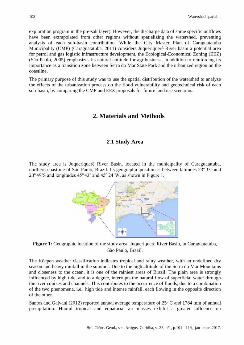
The study area is Juqueriquerê River Basin, located in the municipality of Caraguatatuba,
northern coastline of São Paulo, Brazil. Its geographic position is between latitudes 23o 33’ and
23o 49’S and longitudes 45o 43’ and 45o 24’W, as shown in Figure 1.
Figure 1: Geographic location of the study area: Juqueriquerê River Basin, in Caraguatatuba,
São Paulo, Brazil.
The Köepen weather classification indicates tropical and rainy weather, with an undefined dry
season and heavy rainfall in the summer. Due to the high altitude of the Serra do Mar Mountains
and closeness to the ocean, it is one of the rainiest areas of Brazil. The plain area is strongly
influenced by high tide, and to a degree, interrupts the natural flow of superficial water through
the river courses and channels. This contributes to the occurrence of floods, due to a combination
of the two phenomena, i.e., high tide and intense rainfall, each flowing in the opposite direction
of the other.
Santos and Galvani (2012) reported annual average temperature of 25o C and 1784 mm of annual
precipitation. Humid tropical and equatorial air masses exhibit a greater influence on
Boulomytis, V.T. et al 104
Bol. Ciênc. Geod., sec. Artigos, Curitiba, v. 23, no1, p.101 - 114, jan - mar, 2017.
Caraguatatuba. The tropical air masses support medium to high temperatures, with very high
specific humidity due to ocean evaporation. However, equatorial air masses characterize extreme
dry air temperatures if produced on the continent, or humid if the air was originated on the ocean
(Santos and Galvani, 2012). When air reaches the hill slopes, it also experiences a higher amount
of orographic precipitation.
Juqueriquerê River Basin comprises the major non-urbanized plains of the region. It also exhibits
the largest area and length among the 34 basins: 419.36 km² by 135.25 km, respectively.
According to São Paulo (2011), the basin’s reference discharge is the most representative among
the basins, corresponding to 2,79 m³/s. It is also the only basin in the 7th Strahler order, with a
minimum 3rd order restriction to flood and inundations (Souza, 2005). Thus, the morphometric
susceptibility of the basin indicates its natural probability for flood occurrence (Souza, 2005).
2.2 Historical Land Use Contextualization
About 23% of Juqueriquerê River Basin is composed of plains, which has already been
anthropized. At the beginning of the last century, the region was known for wood extraction and
agriculture. However, the entire area was destroyed by the debris-flow catastrophe of 1967.
Detachment sites occurred at different heights, but primarily slopes near mountain crests. In the
downstream area, a concentration of mud and sediments were deposited, brought from the upper
fast moving flows.
Following the catastrophe, the plains has been used for agribusiness in general, mining, and gas
exploration. Particularly, at the Claro River downstream area, the number of agricultural farms is
the most representative in the region (Caraguatatuba, 2012). The remaining plains included in the
watershed is located on a farm called Serramar, historically known as Fazenda dos Ingleses.
Along the entire northern coastline of São Paulo, a 3,278ha area supports livestock, and 3,000ha
area located in the Municipality of Caraguatatuba (Caraguatatuba, 2012).
Investments of the Pre-Salt Program, the Sao Sebastião Port expansion, and real-estate
speculations have intensively modified the land use in this area. A gas treatment plant (UTGCA)
was installed at Serramar Farm in 2010. UTGCA is approximately 6 km away from the main
road between Caraguatatuba and São Sebastião, which is entirely surrounded by urban areas.
2.3 Data Collection
Initially, for the methodological approach to the study, a cartographic base was built in GIS
ILWIS v.3.31 Academic (Koolhoven et al., 2007) and SPRING v. 5.1.8 (Câmara et al., 1996).
Data were processed in the Universal Transverse Mercator (UTM), zone 23S, and South
American Datum 1969 (SAD 69).
In the study area, impressive spatial variability exists in topography, from the Serra do Mar
Mountains to the plains along the coastline. Therefore, the watershed discretization methodology
105 Watershed spatial...
Bol. Ciênc. Geod., sec. Artigos, Curitiba, v. 23, no1, p.101 - 114, jan - mar, 2017.
was carried out by dividing the area into two parts: mountainous and plains areas. For each part,
the following steps were developed: (1) plains area delimitation; (2) determination of each sub-
basin outflow; (3) automatic extraction of the mountainous area drainage; (4) automatic drainage
extraction of the plains area in the low-lying region; and (5) border line correction using vector-
editing techniques.
The plains area delimitation was based on visual interpretation of the high-resolution image
GeoEye (Feb 02/2010) (Caraguatatuba, 2010), with permission of the Planning and Development
Secretariat of Caraguatatuba. The spatial resolution was 0.41m (panchromatic) and 1.65m
(multispectral), which was resampled to 0.50m. An information plan was drawn using GIS
SPRING v. 5.1.8 (Câmara et al., 1996), where the entire plains area was covered with a buffer of
2 km and the objective of improving edge detection. This area was separated from the sea to
minimize computer processing, which is a relevant concern during DEM analyses. In addition,
the use of the methodology does not confuse sea level with the low-lying basin regions during
the automatic drainage extraction procedure.
Each sub-basin outflow determination required verification of specific conditions and map
construction with the location of all reference points by the use of vector-editing techniques. The
established conditions were as follows: (1) the existence of fluviometric gauges; (2) the
occurrence of a single cross section or water course for the sub-basin outflow; (3) topography
modification (mountainous or plains area); (4) area edge in urbanization processes, consistent
with the CMP (Caraguatatuba, 2011); and (5) area border line under the influence of tidal flow.
The mountainous area extraction process used the DEM developed by the Shuttle Radar
Topography Mission (SRTM) (NGA and NASA, 2014). This product has a spatial resolution of
90m and 5m vertical accuracy in low altitude areas (Gradella et al., 2011). Despite the fact the
model’s quality is high for flat areas in low lying regions, errors in a scale higher than 5m might
occur, making its use unreliable (Liu, 2008; Passini and Jacobsen, 2007).
A digital surface model (DSM) granted by São Paulo (2013) was employed for the automatic
extraction of sub-basins in the plains area. It features a regular 5m spatial resolution and a
vertical accuracy of 1m. This model was chosen because the elevation of low lying estuarine
areas, i.e., predominantly lower than 5 m, could not be detected using the SRTM DEM (NGA
and NASA, 2014).
A DSM is a terrain surface with the addition of object elevations, including trees and buildings.
For the use of a DSM in mountainous vegetated areas, tree height must be deducted to depict the
DEM ground surface. A DSM was analyzed in São Sebastião Municipality (an adjacent region of
the study area) and altimetry results were very good, with less than 2m differences in elevation,
except for a single point sampled, with a 2.58m difference (Cruz et al., 2011). The DSM
generation was conducted by reconstructing the solid surface with finite elements via selection of
the best regions of stereo pairs (with an average 45 cm resolution), including automatic error
filtering. The visual and geometric model quality was evaluated by recording sample points in
1m resolution orthophotos (São Paulo, 2013).
In the study area, the plains area is predominantly composed of grasslands, making it well suited
to represent the terrain model altimetry using a DSM.
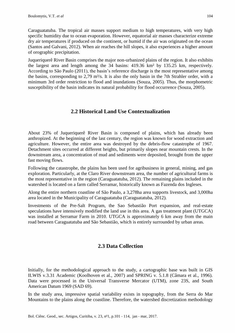
2.4 Data Processing
The watershed discretization was performed using GIS ILWIS 3.31 Academic (Koolhoven et al.,
2007). The flowchart with all developed procedures is presented in Figure 2.
Boulomytis, V.T. et al 106
Bol. Ciênc. Geod., sec. Artigos, Curitiba, v. 23, no1, p.101 - 114, jan - mar, 2017.
Figure 2: Automatic extraction process used for the watershed spatial distribution.
In the beginning of the process, the sinks could not be removed when its pixels were improperly
defined beside an unidentified value or at the map’s edge. Therefore, it was essential to use
buffers around the DEM to avoid this type of occurrence. In the study area, a 2km buffer was
drawn around the watershed borderline. The model was subsequently improved using the DEM
Surface Reconditioning System (Hellweger, 1997), which established original drainage lines on
the model (Martz and Garbrecht, 1998; Callow et al., 2007). Buffer distances were also
designated along the watercourses, in addition to decreases in the river channel, which could be
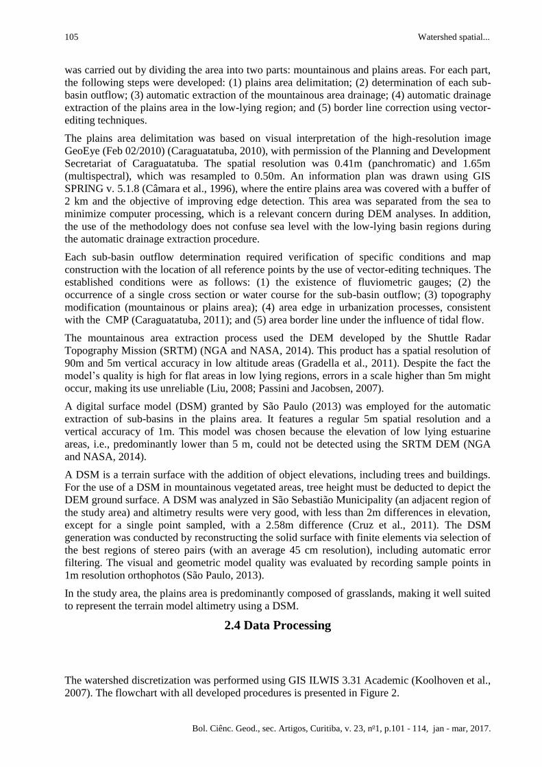
smooth or sharp, shown in Figure 3.
Figure 3: Parameters adopted for the DEM optimization: (a) buffer distance; smooth and sharp
drop; (b) buffer distance and smooth drop; (c) sharp drop. Source: Koolhoven et al., 2007.
The buffer distance was automatically disregarded in the sharp drop sections. For the plains
region of the study area, the adopted parameters were as follows: buffer distance = 10 m; sharp
drop = 0 m; smooth drop =2 m. These parameters were based on visually observed conditions
verified while sailing the main river courses for bathymetry purposes, on 15 December 2012 and
1 May 2013. In the mountainous areas, we adopted the parameters as follows: buffer distance = 0
m; sharp drop = 5 m; smooth drop = 0 m.

107 Watershed spatial...
Bol. Ciênc. Geod., sec. Artigos, Curitiba, v. 23, no1, p.101 - 114, jan - mar, 2017.
The original drainage map (São Paulo, 2010) was imported to GIS SPRING v. 5.1.8 (Câmara et
al., 1996), where the geographic correction and vector editing were completed to update the data
based on the GeoEye high-resolution image (Caraguatatuba, 2010).
Figure 4 shows he flow direction procedure used to determine the closest neighbor pixel where
water from a pixel would flow.
Figure 4: (a) Steepest slope operation: detection of the highest value pixel; (b) Lowest slope
operation: detection of the lowest value pixel. Source: Adapted from Koolhoven et al., 2007.
This operation is calculated for every single pixel from a 3x3 cellblock, systematically
comparing each pixel value to the 8 pixel values around it. The process is operated using the
Steepest or Lowest slope functions, to detect the pixel with the respective highest or lowest
value.
The flow accumulation step determined the pixel number, which naturally contributed to river
downstream water flow. The step is applied as an input parameter at the drainage extraction
procedure, generating a map with two attributes, true or false, depending on the existence of
drainage segments. Another input parameter for this operation is the minimum pixel number,
which might be added to the pixel responsible for upstream drainage (stream threshold). The
value used in this study was 10 pixels. Flow direction and accumulation methodology followed
Moore et al. (1991). For the drainage network ordering process, we estimated a length of 100 m
based on field survey observations. The final catchment extraction and merge operations were
performed using pre-defined outflow points, based on the water course distribution, easily
accessible and suitable to measure with flow meters (Song et al., 2014).
3. Results and Discussion
The SRTM DEM (NGA and NASA, 2014) was used to hydro process the mountainous areas and
reasonable results were generated. However, for low-lying regions, the DSM (São Paulo, 2013)
produced more suitable results. The SRTM DEM (NGA and NASA, 2014) was used to process
Boulomytis, V.T. et al 108
Bol. Ciênc. Geod., sec. Artigos, Curitiba, v. 23, no1, p.101 - 114, jan - mar, 2017.
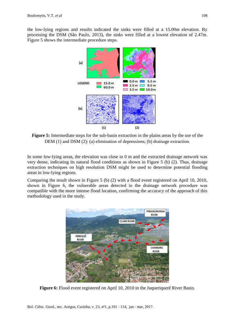
the low-lying regions and results indicated the sinks were filled at a 15.00m elevation. By
processing the DSM (São Paulo, 2013), the sinks were filled at a lowest elevation of 2.47m.
Figure 5 shows the intermediate procedure steps.
Figure 5: Intermediate steps for the sub-basin extraction in the plains areas by the use of the
DEM (1) and DSM (2): (a) elimination of depressions; (b) drainage extraction.
In some low-lying areas, the elevation was close to 0 m and the extracted drainage network was
very dense, indicating its natural flood conditions as shown in Figure 5 (b) (2). Thus, drainage
extraction techniques on high resolution DSM might be used to determine potential flooding
areas in low-lying regions.
Comparing the result shown in Figure 5 (b) (2) with a flood event registered on April 10, 2010,
shown in Figure 6, the vulnerable areas detected in the drainage network procedure was
compatible with the more intense flood location, confirming the accuracy of the approach of this
methodology used in the study.
Figure 6: Flood event registered on April 10, 2010 in the Juqueriquerê River Basin.
109 Watershed spatial...
Bol. Ciênc. Geod., sec. Artigos, Curitiba, v. 23, no1, p.101 - 114, jan - mar, 2017.
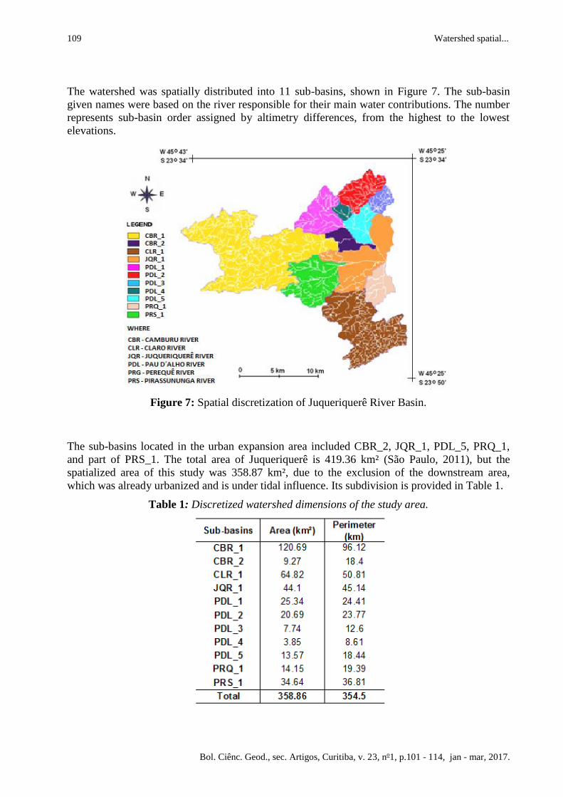
The watershed was spatially distributed into 11 sub-basins, shown in Figure 7. The sub-basin
given names were based on the river responsible for their main water contributions. The number
represents sub-basin order assigned by altimetry differences, from the highest to the lowest
elevations.
Figure 7: Spatial discretization of Juqueriquerê River Basin.
The sub-basins located in the urban expansion area included CBR_2, JQR_1, PDL_5, PRQ_1,
and part of PRS_1. The total area of Juqueriquerê is 419.36 km² (São Paulo, 2011), but the
spatialized area of this study was 358.87 km², due to the exclusion of the downstream area,
which was already urbanized and is under tidal influence. Its subdivision is provided in Table 1.
Table 1: Discretized watershed dimensions of the study area.
Boulomytis, V.T. et al 110
Bol. Ciênc. Geod., sec. Artigos, Curitiba, v. 23, no1, p.101 - 114, jan - mar, 2017.
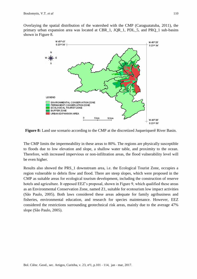
Overlaying the spatial distribution of the watershed with the CMP (Caraguatatuba, 2011), the
primary urban expansion area was located at CBR_1, JQR_1, PDL_5, and PRQ_1 sub-basins
shown in Figure 8.
Figure 8: Land use scenario according to the CMP at the discretized Juqueriquerê River Basin.
The CMP limits the impermeability in these areas to 80%. The regions are physically susceptible
to floods due to low elevation and slope, a shallow water table, and proximity to the ocean.
Therefore, with increased impervious or non-infiltration areas, the flood vulnerability level will
be even higher.
Results also showed the PRS_1 downstream area, i.e. the Ecological Tourist Zone, occupies a
region vulnerable to debris flow and flood. There are steep slopes, which were proposed in the
CMP as suitable areas for ecological tourism development, including the construction of reserve
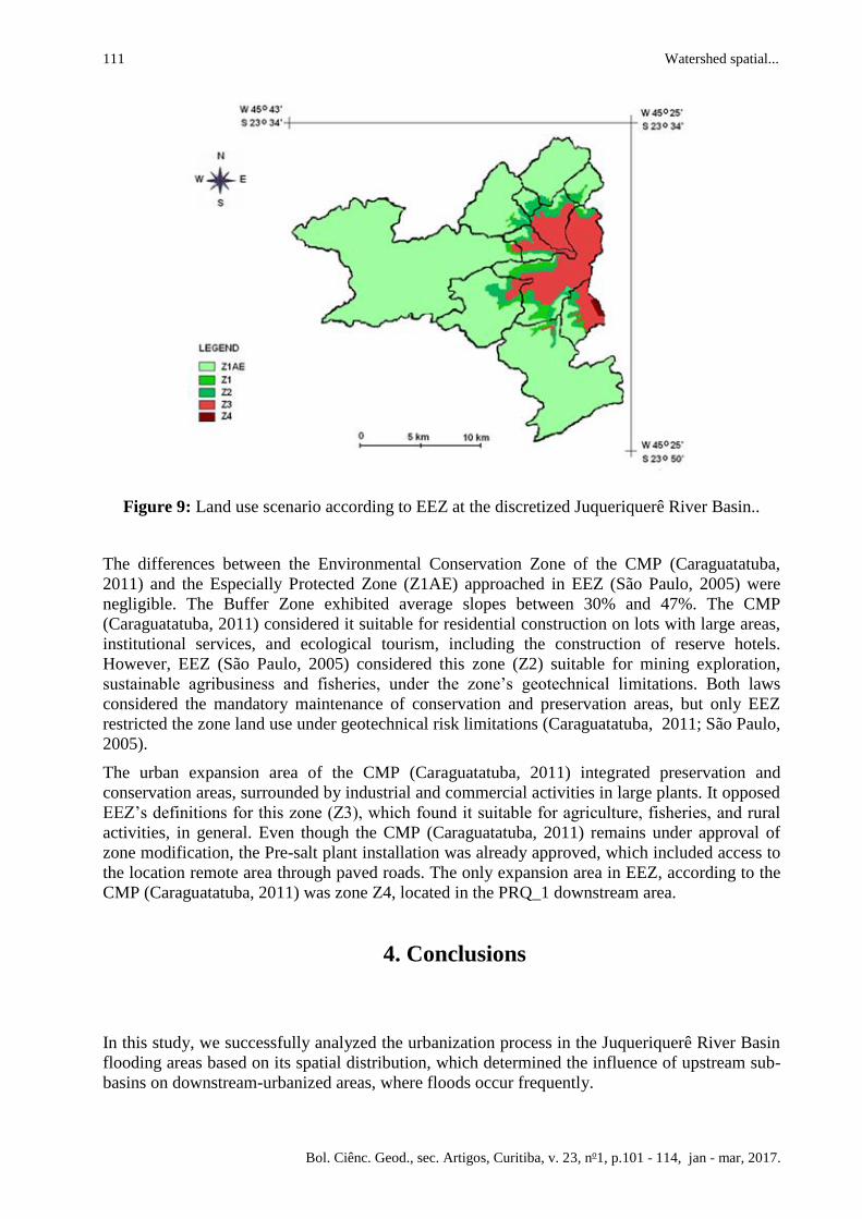
hotels and agriculture. It opposed EEZ’s proposal, shown in Figure 9, which qualified these areas
as an Environmental Conservation Zone, named Z1, suitable for ecotourism low impact activities
(São Paulo, 2005). Both laws considered these areas adequate for family agribusiness and
fisheries, environmental education, and research for species maintenance. However, EEZ
considered the restrictions surrounding geotechnical risk areas, mainly due to the average 47%
slope (São Paulo, 2005).
111 Watershed spatial...
Bol. Ciênc. Geod., sec. Artigos, Curitiba, v. 23, no1, p.101 - 114, jan - mar, 2017.
Figure 9: Land use scenario according to EEZ at the discretized Juqueriquerê River Basin..
The differences between the Environmental Conservation Zone of the CMP (Caraguatatuba,
2011) and the Especially Protected Zone (Z1AE) approached in EEZ (São Paulo, 2005) were
negligible. The Buffer Zone exhibited average slopes between 30% and 47%. The CMP
(Caraguatatuba, 2011) considered it suitable for residential construction on lots with large areas,
institutional services, and ecological tourism, including the construction of reserve hotels.
However, EEZ (São Paulo, 2005) considered this zone (Z2) suitable for mining exploration,
sustainable agribusiness and fisheries, under the zone’s geotechnical limitations. Both laws
considered the mandatory maintenance of conservation and preservation areas, but only EEZ
restricted the zone land use under geotechnical risk limitations (Caraguatatuba, 2011; São Paulo,
2005).
The urban expansion area of the CMP (Caraguatatuba, 2011) integrated preservation and
conservation areas, surrounded by industrial and commercial activities in large plants. It opposed
EEZ’s definitions for this zone (Z3), which found it suitable for agriculture, fisheries, and rural
activities, in general. Even though the CMP (Caraguatatuba, 2011) remains under approval of
zone modification, the Pre-salt plant installation was already approved, which included access to
the location remote area through paved roads. The only expansion area in EEZ, according to the
CMP (Caraguatatuba, 2011) was zone Z4, located in the PRQ_1 downstream area.
4. Conclusions
In this study, we successfully analyzed the urbanization process in the Juqueriquerê River Basin
flooding areas based on its spatial distribution, which determined the influence of upstream sub-
basins on downstream-urbanized areas, where floods occur frequently.
Boulomytis, V.T. et al 112
Bol. Ciênc. Geod., sec. Artigos, Curitiba, v. 23, no1, p.101 - 114, jan - mar, 2017.
In the watershed discretization process, pre-established biotic and abiotic environmental
conditions to adopt and locate reference points were mandatory to provide a realistic approach
for the analysis.
The DSM (São Paulo, 2013) with high resolution data was crucial to employ the automatic DEM
hydro processing procedure to fill sinks in low lying regions, with a mild slope and close to sea
level. The use of the SRTM DEM (NGA and NASA, 2014) would generate non-realistic results
with a minimum 15m elevation instead of 2.47m, which was the elevation obtained by the DSM
processing.
The drainage extraction result indicated the natural susceptibility to floods in the CLR_1,
PRQ_1, JQR_1 and PRS_1 downstream area sub-basins. This result was consistent with the most
flooded regions of the 10 April 2010 event.
Finally, every zone considered in the CMP (Caraguatatuba, 2011) and in EEZ (São Paulo, 2005)
can be analyzed and compared in the discretized sub-basins. In future studies, assessment of the
most vulnerable areas might be performed considering the effects of hydrodynamic distribution,
based on sub-basin location, land use type, and area specificity.
ACKNOWLEDGEMENT
We gratefully acknowledge the National Council for the Improvement of Higher Education
(CAPES) for financially supporting this study; the City Hall of Caraguatatuba for providing
Geoeye high-resolution satellite imagery; and EMPLASA for granting the high resolution DSM.
REFERENCES
Aggarwal, A., Rafiquea, F., and Ahmedb, S. "Urban flood hazard mapping using change
detection on wetness transformed images."Hydrological Sciences Journal, just-accepted (2014).
doi: 10.1080/02626667.2014.952638.
Callow, J. N., Van Niel, K. P., and Boggs, G. S. "How does modifying a DEM to reflect known
hydrology affect subsequent terrain analysis?"Journal of Hydrology 332.1 (2007): 30-39.
Câmara, G., Souza, R. C. M., Freitas, U. M., and Garrido, J. "SPRING: Integrating remote
sensing and GIS by object-oriented data modelling."Computers & Graphics 20.3 (1996): 395-
403.
Caraguatatuba. "Geoeye high resolution satellite imagery with scenes of Juqueriquere River
Basin, acquired on February 22, 2010." Caraguatatuba: FUNCATE, 2010. DVD.
Caraguatatuba. "Law No. 42 of the City Council of November 24, 2011 establishing a
framework for the City Master Plan of Caraguatatuba." 2011 (in Portuguese).
Caraguatatuba. "Municipal Decree No. 01 of the City Council of January 03, 2012, establishing a
framework for the Pluriannual Plan of Rural and Fishery Sustainable Development of
Caraguatatuba." 2012 (in Portuguese).
Cohen, J. E., Small, C., Mellinger, A., Gallup, J., Sachs, J., Vitousek, P. M., and Mooney, H. A.
"Estimates of coastal populations."Science 278 (1997): 1209.
113 Watershed spatial...
Bol. Ciênc. Geod., sec. Artigos, Curitiba, v. 23, no1, p.101 - 114, jan - mar, 2017.
Cruz, C. B. M., de Barros, R. S., Cardoso, P. V., Reis, R. B., do Rosário, L. S., dos Santos
Barbosa, S., Rabaco, L. M. L., Lourenço, and J. S. de Q., "Avaliação da exatidão
planialtimétrica dos modelos digitais de superfície (MDS) e do terreno (MDT) obtidos através do
LIDAR." Paper presented at the XV Simpósio Brasileiro de Sensoriamento Remoto, Curitiba,
Paraná, Brazil, April 30 - May 05, 2011 (in Portuguese).
Dutta, D. "An integrated tool for assessment of flood vulnerability of coastal cities to sea-level
rise and potential socio-economic impacts: a case study in Bangkok, Thailand."Hydrological
Sciences Journal 56. 5 (2011): 805-823.
Fernández, D. C. J. "Automatic drainage network extraction using digital elevation models."MSc
diss., Instituto Nacional de Pesquisas Espaciais, 2011 (in Portuguese).
Frazier, P. S., and Kenneth J. P. "Water body detection and delineation with Landsat TM
data."Photogrammetric Engineering and Remote Sensing 66. 12 (2000): 1461-1468.
Fuller, L. M., Morgan, T. R. and Aichele, S S. "Wetland delineation with IKONOS high-
resolution satellite imagery, Fort Custer Training Center, Battle Creek, Michigan, 2005." No.
2006-5051, 2006.
Gradella, F. S. , Zani, H. , Silva, A. , Kuerten, S. , Coradini, F., and Sakamoto, A. Y.
"Geomorphology and deposition events in Nhecolandia Pantanal wetland."Geografia 36 (2011):
107-117.
Hellweger, F., "AGREE - Digital Elevation Model (DEM) Surface Reconditioning System."
Austin: University of Texas, 1997. Accessed December 20, 2014.
http://www.ce.utexas.edu/prof/maidment/gishydro/ferdi/research/agree/agree.html.
Hogg, A. R., and Todd, K. W. "Automated discrimination of upland and wetland using terrain
derivatives."Canadian Journal of Remote Sensing 33 (2007): S68-S83.
Koolhoven, W., Hendrikse, J., Nieuwenhuis, W., Retsios, B., Schouwenburg, M., Wang, L.,
Budde, P., Raymond, N. "Integrated Land and Water Information System (ILWIS) Open."
Enschede: ITC, University of Twente , Netherlands, 2007. Accessed October 10, 2014. http:
//www.itc.nl/ilwis/downloads/ilwis33.asp
Liu, Y. "An evaluation on the data quality of SRTM DEM at the alpine and plateau area, north-
western of China."The Internafional Archives of the Photogrammetry, Remote Sensing and
Spafial Informafion Sciences (2008): 1123-1128.
Martz, L. W., and Garbrecht, J. "The treatment of flat areas and depressions in automated
drainage analysis of raster digital elevation models."Hydrological processes 12.6 (1998): 843-
855.
Moore, I. D., Grayson, R. B., and Ladson, A. R. "Digital terrain modelling: a review of
hydrological, geomorphological, and biological applications."Hydrological processes 5.1 (1991):
3-30.
National Geospatial Intelligence Agency (NGA), National Aeronautics and Space
Administration (NASA). "The Shuttle Radar Topography Mission (SRTM) Digital Elevation
Model (DEM) - São Paulo ." São Paulo: EMBRAPA, SF-23-Y-D, 2014. DVD.
Oksanen, J., and Sarjakoski, T. "Error propagation analysis of DEM‐based drainage basin
delineation."International Journal of Remote Sensing 26.14 (2005): 3085-3102.
Passini, R., and Karsten, J. "Accuracy analysis of SRTM height models." Paper presented at the
2007 American Society for Photogrammetry and Remote Sensing Annual Conference, Tampa,
FL, USA, May 7-11, 2007.
Boulomytis, V.T. et al 114
Bol. Ciênc. Geod., sec. Artigos, Curitiba, v. 23, no1, p.101 - 114, jan - mar, 2017.
Ribeiro, H. J., and Ferrreira, N. C. " Comparative Analysis of Hydrologic Networks generated
from Hydrologically Correct Surfaces."Boletim de Ciências Geodésicas 20.4 (2014): 784-805 (in
Portuguese).
Santos, D. D. dos, Galvani, E. " Caracterização sazonal das precipitações no município de
Caraguatatuba-SP, entre os anos de 1943 a 2004."Geonorte 1, no. 5 (2012): 1196-1203.
São Paulo. São Paulo Environmental Secretariat. "State Decree No. 49.215 of 07 December 2004
establishing a framework for the Ecological-Economic Zoning in the Northern Coastline of São
Paulo State." São Paulo: SMA/CPLEA, 2005 (in Portuguese).
São Paulo. Water Resources Management Secretariat. The Northern Coastline of São Paulo
Basin Committee (CBH-LN). "Drainage map of Juqueriquere River Basin (shapefile)."
Caraguatatuba: CBH-LN, 2010. DVD.
São Paulo. Water Resources Management Secretariat. The Northern Coastline of São Paulo
Basin Committee (CBH-LN). "The Water Resources Situation of the northern coastline of São
Paulo". Tecnhical Report. Caraguatatuba: CBH-LN, 2011 (in Portuguese).
São Paulo. Metropolitan Planning Company of São Paulo (EMPLASA). "Digital Surface Model
(DSM) of Juqueriquerê River Basin." São Paulo: EMPLASA, No. 0973, 2013. DVD.
Song, S., Schmalz, B., and Fohrer, N. "Simulation and comparison of stream power in-channel
and on the floodplain in a German lowland area."Journal of Hydrology and Hydromechanics 62,
no.2 (2014): 133-144.
Souza, C. R. de G. "Suscetibilidade morfométrica de bacias de drenagem ao desenvolvimento de
inundações em áreas costeiras."Revista Brasileira de Geomorfologia 6, no. 1 (2005): 45-61 (in
Portuguese).
Tarboton, D. G. "Terrain analysis using digital elevation models in hydrology." Paper presented
at the 23rd ESRI International User Conference, San Diego, California, USA, July 7-11 , 2003.
Recebido em 02 de dezembro de 2015.
Aceito em 16 de junho de 2016.