watershed evaluation of beneficial management practices managament practices/webs_report_200… ·...
TRANSCRIPT

Watershed Evaluation of Beneficial Management Practices
WEBsTowards Enhanced Agricultural
Landscape Planning
Four-Year Review (2004/5 - 2007/8)

For a print copy of this publication or to request an alternate format, please contact:
Departmental Publications Service Tel.: 613-773-1444 Fax: 613-773-1498 E-mail: [email protected]
Electronic version available at www.agr.gc.ca/webs
This publication may be reproduced without permission provided the source is fully acknowledged.
© Her Majesty the Queen in Right of Canada, 2010
Library and Archives Canada Cataloguing in Publication
Main entry under title: Watershed Evaluation of Beneficial Management Practices (WEBs) : Towards Enhanced Agricultural Landscape Planning - Four-Year Review (2004/5 - 2007/8).
Issued also in French under title: Évaluation des pratiques de gestion bénéfiques à l’échelle des bassins hydrographiques (EPBH) : pour une planification améliorée du paysage agricole - examen quadriennal (2004/5 - 2007/8).
Includes bibliographical references.
Catalogue No. A22-500/1-2009E ISBN 978-1-100-13640-0 AAFC No. 10077E
1. Watershed Evaluation of Beneficial management practices. 2. Farm management--Environmental aspects--Canada. 3. Sustainable agriculture--Economic aspects--Canada. 4. Stream conservation--Canada. 5. Watershed hydrology--Canada. 6. Agriculture--Environmental aspects--Canada. 7. Watershed hydrology--Canada--Computer simulation. I. Stuart, Valerie II. Canada. Agriculture and Agri-Food Canada III. Ducks Unlimited Canada
HD1696 C3 W84 2010 333.73’160971 C2010-980039-7
This report can be cited as followsStuart, V., D.B. Harker, T. Scott, and R.L. Clearwater (eds). 2010. Watershed Evaluation of Beneficial Management Practices (WEBs) : Towards Enhanced Agricultural Landscape Planning - Four-Year Review (2004/5 - 2007/8). Agriculture and Agri-Food Canada, Ottawa, Ont.
Each chapter can be cited as follows[Name(s) of chapter author(s)]. 2010. [Chapter heading]. Pages [...] - [...] in Stuart, V., D.B. Harker, T. Scott, and R.L. Clearwater (eds). 2010. Watershed Evaluation of Beneficial Management Practices (WEBs) : Towards Enhanced Agricultural Landscape Planning - Four-Year Review (2004/5 - 2007/8). Agriculture and Agri-Food Canada, Ottawa, Ont.

Watershed Evaluation of Beneficial Management Practices
WEBsTowards Enhanced Agricultural
Landscape Planning
Four-Year Review (2004/5 - 2007/8)
Agriculture and Agri-Food Canada 2010

i
Message from the Deputy MinisterAgriculture is the foundation of Canada’s economy, ensuring food security for Canadians and supporting our economy with $21.7 billion dollars a year in exports. Agriculture is also one of Canada’s largest land uses, with over 60 million hectares under cultivation or in use as rangeland. Farmers understand their responsibilities as stewards of the environment, and seek to continuously improve their practices to enhance the environment for all Canadians.
As Deputy Minister of Agriculture and Agri-Food Canada (AAFC), I am pleased to present this report: Watershed Evaluation of Beneficial Management Practices: Towards Enhanced Agricultural Landscape Planning.
Part of AAFC’s commitment to agri-environmental sustainability is being realized through research into the performance of beneficial management practices (BMPs) designed to enhance the environment through responsible agricultural practices. The Watershed Evaluation of Beneficial Management Practices (WEBs) project was established as a federally-funded initiative in 2004, in order to better understand how BMPs can improve water quality and other aspects of the environment, while improving the bottom lines for producers.
This report summarizes the first four years of WEBs progress and achievements from April 2004 to March 2008. It provides insights into conducting watershed-scale experiments, how BMPs interact with each other and with landscape variables, and it summarizes many of the preliminary findings in terms of their environmental, economic and policy context.
The Agri-Environmental Services Branch of AAFC, and its predecessor, the Prairie Farm Rehabilitation Administration, have been providing farmers and the agricultural industry with leading-edge information and client-focused services for almost 75 years. We will continue to seek innovative agri-environmental solutions at the landscape scale through projects such as WEBs, which will help us to better serve Canadian farmers while preserving and enhancing Canada’s environment for future generations of Canadians.
John Knubley Deputy Minister Agriculture and Agri-Food Canada

ii
AcknowledgementsThis report summarizes the progress and findings of the first four years (2004/5 - 2007/8) of the Watershed Evaluation of Beneficial Management Practices (WEBs) project. The WEBs project management team would like to thank the following people for their contribution to this report and for the hard work they do on a daily basis to make this project a success.
WEBs Watershed Leads (from West to East): • Klaas Broersma - Salmon River Watershed, British Columbia• Jim Miller - Lower Little Bow River Watershed, Alberta• Jim Yarotski - South Tobacco Creek Watershed, Manitoba• David Lapen - South Nation Watershed, Ontario• Eric van Bochove - Bras d’Henri and Fourchette Watersheds, Quebec• Lien Chow - Black Brook Watershed, New Brunswick• Dale Hebb - Thomas Brook Watershed, Nova Scotia
Chairs of the WEBs sub-committees:• Economics (Co-chairs: Carlyle Ross, Merle Boyle and Mohammad Khakbazan, AAFC)• Hydrologic Modelling (Co-chairs: Jim Yarotski and David Lapen, AAFC)• Integrated Modelling (Chair: Shane Gabor, Ducks Unlimited Canada) • Communications (Chair: Valerie Stuart, AAFC)
The many producers in each WEBs watershed deserve a special thank you. Their willingness to work with WEBs researchers has been a major factor in making this project possible. Recognition is also due to the many partners (see Chapter 1) for their hard work and commitment to the project. And a special acknowledgement goes to Ducks Unlimited Canada, whose funding contributions and technical insight have greatly enhanced this project.
Sincere thanks go to Laurie Baker for his summary report of the WEBs economics studies, Brian Abrahamson for his summary report of the WEBs modelling studies, and Buzz Crooks of Beaverbrook Communications who prepared the sidebar testimonials from WEBs partners and participating producers. Thanks as well to the many partners and colleagues who reviewed an early draft of this report. Their contributions and suggestions helped to organize and clarify the report’s content.
Report compiled by:Valerie Stuart, WEBs Communications and Reporting Lead Lucy Clearwater, WEBs Assistant Brook Harker, WEBs Project Manager Terrie Scott, WEBs Assistant Manager
For further information contact [email protected] or visit the WEBs website at www.agr.gc.ca/webs.

iii
Prologue WEBs project management is pleased to present this report, comprising a four-year review of activities and findings under the Agricultural Policy Framework (APF).
To date, three WEBs annual reports have been released. This report encompasses the entire project, from its inception in April 2004, up to the end of March 2008. It covers each of the seven WEBs watershed sites, and is a compilation of research findings from the project’s biophysical, economics, hydrologic modelling, and integrated modelling components.
For more detailed information on the technical aspects of WEBs, please refer to the following companion documents (available in print or electronic format):• WEBs Technical Summary #1: Biophysical Component (2004/5 - 2007/8)• WEBs Technical Summary #2: Economics Component (2004/5 - 2007/8) • WEBs Technical Summary #3: Hydrologic and Integrated Modelling Components
(2004/5 - 2007/8)
To request these Technical Summaries, please email [email protected].
Additional project information can be found at www.agr.gc.ca/webs.

iv
Executive SummaryThe Watershed Evaluation of Beneficial Management Practices (WEBs) project was initiated in April 2004 to assess the environmental and economic performance of selected agricultural beneficial management practices (BMPs) at seven small watersheds across Canada. Under the Agricultural Policy Framework (APF), Agriculture and Agri-Food Canada (AAFC) has been the main funding agency, with Ducks Unlimited Canada as a key funding partner. Over 40 other federal, provincial, municipal, academic and non-governmental organizations are also partners in the project. This report is a summary of the project’s first four years (April 2004 – March 2008).
The need to validate the performance of selected BMPs in a watershed setting was a primary reason for initiating WEBs—with informing future policy and programming decision making as a desired end result. The costs and environmental benefits of BMPs have seldom been measured beyond small plot and field experiments. Few of these practices have been evaluated at the watershed scale where the combined effects of soils, topography and land use may significantly alter anticipated results.
WEBs has contributed improved knowledge regarding the value of agricultural BMPs. It is one of the first studies in Canada to assess both the environmental and economic performance of BMPs at a watershed scale. Innovative, interdisciplinary research at the seven WEBs watershed sites is bringing us a step closer to achieving improved water quality in agricultural landscapes. WEBs also maintains a close working relationship with the Conservation Effects Assessment Project (CEAP) of the United States Department of Agriculture (USDA), providing a partnership for the exchange of information and lessons learned between projects having similar objectives.
BMP evaluation strategyEach of the WEBs watershed studies includes the following components: biophysical evaluations to measure the impact of BMPs on environmental factors such as water quality; economic assessments to examine the costs and benefits of implementing BMPs; and hydrologic modelling of landscape interactions and their relationship with BMPs in order to scale up results to the next-level watershed, to work towards providing a regional perspective on larger watershed issues. At two of the WEBs watershed sites integrated modelling pilot studies are underway to combine biophysical, economic and hydrologic considerations into a decision-support tool for long-term watershed planning.
WEBs has applied a suite of BMPs at each of its seven watershed sites (approximately 300–2,500 hectares in size). These BMPs were selected to match the unique conditions of each watershed and as a result, the suite of BMPs from one site does not directly correspond to that of another. WEBs is not meant to be a comparison of individual BMP effects across a wide range of landscape and watershed conditions. This would be a very different experiment, beyond the scope of WEBs.

v
WEBs is primarily focused on water quality, which is often a reflection of other environmental impacts such as soil and air quality and biodiversity. However, in many cases, additional environmental parameters such as soil or riparian health or the composition of aquatic invertebrates are being examined.
Where available, field data collected from within the WEBs watersheds were used in the economics and modelling studies. In other cases, literature values were initially used, to be augmented with field data when it became available. The incorporation of additional field data will complement literature values, and will strengthen the level of confidence in model outputs and overall conclusions from WEBs.
Initial four-year findingsAll seven WEBs sites have reported specific scientific findings and many useful and interesting outcomes have been observed. Individual sites vary in their ability to report results because the time required to establish initial monitoring regimes, collect baseline data, implement BMPs, and launch associated studies has been different for each location. As a result, some sites have only two to three years of post-BMP data and most have no more than two years of economics and modelling results. Because these experiments are conducted at the watershed scale where long-term data are required to account for spatial and temporal variability, it is still early to be drawing firm conclusions. Nevertheless, WEBs has accomplished much towards better understanding the environmental and economic performance of its implemented BMPs.
WEBs has made significant progress towards understanding the performance of specific BMPs within the watersheds where they were tested. This provides a foundation from which to further understand the broader applicability of these BMPs within a specific regional context. WEBs has also gained valuable insights into the challenges
involved in unravelling the on-farm and off-farm economics of BMP adoption. And progress has been made in validating hydrologic models using results from field-tested BMPs. This provides a scientifically-sound basis for broader application of these models to other BMPs and landscape conditions, and will eventually lead to wider ecosystem comparisons. And WEBs has successfully begun to integrate biophysical and economic findings to permit the interpretation and application of WEBs results for broader planning purposes. While much remains to be done, the initial steps are promising.
Biophysical results More than half of the BMP tests conducted in WEBs (13 out of 22) have shown the clear potential to reduce contaminant loading to surface waters. Although in many cases, the degree of this effectiveness has yet to be quantified. Some findings are mixed, wherein certain water quality parameters are improving while others remain inconclusive or may even be negative. Improvements to one parameter may come at the expense of degradation to another. In some cases, while BMP effects were uncertain for water quality, they were positive for other environmental indicators such as riparian health or aquatic invertebrate populations. Much has been learned within WEBs about the interaction of landscape processes and BMP effect. While the contribution that individual BMPs make to edge-of-field or in-stream loadings is often evident, the cumulative effect of multiple BMPs on water quality can be difficult to detect downstream at the watershed outlet. Conversely, in some watersheds having a complex mixture of small fields and small landscape parcel sizes, the watershed outlet may be the only point at which BMP effect can be detected—and that only as a cumulative response.
Economic resultsThe WEBs economics component has assessed the on-farm costs of BMP
vi
application and begun to evaluate the potential on-farm and off-farm benefits of applying the selected BMPs. WEBs economists used a variety of economic models and tools best suited to the unique circumstances of each watershed. Most of the BMPs studied have high implementation and/or maintenance costs. About 75 percent of the BMPs have some on-farm revenue potential, whereby limited monetary benefits (such as marginally-increased yields or cattle weight gain) may partially offset the cost of BMP implementation. Nevertheless, thus far, the net change to farm income has been generally negative. One clear exception is the controlled tile drainage BMP in the South Nation Watershed where corn and soybean yield increases will pay for BMP installation costs within three or four years. Additional BMPs may yet prove to be viable on-farm, but these have yet to be identified. Many of the BMPs studied may have off-farm (public) benefits and a limited number of public benefit studies have been initiated under WEBs. As results from WEBs biophysical monitoring become increasingly available, site economists will integrate these data to improve confidence in their methods and results.
Hydrologic modelling resultsHydrologic modelling at the WEBs project sites complements the biophysical and economic assessments. This activity involves the use of enhanced computer models to increase understanding of background conditions and watershed processes, while facilitating the scaling-up of information on BMP impacts to the next-level watershed to provide a regional perspective on larger watershed issues. The Soil and Water Assessment Tool (SWAT) is the primary hydrologic model used in most WEBs watersheds. Model calibration was initiated for most watersheds—often using literature review values for initial input data. Some modelling components were modified to better suit Canadian climatic conditions and to accommodate specific BMPs. Most projections suggest a long-term reduction
in sediment and nutrient loading, but these results require further evaluation using WEBs field data. Further work is required to obtain consistent results at the sub-watershed level.
Integrated modelling resultsTwo integrated modelling pilot projects are underway at the South Tobacco Creek (MB) and the Bras d’Henri (QC) watershed sites. Extensive hydrologic assessments were conducted on these two sites in order to model the water quality benefits of applied BMPs. Because economic data were more readily available at these sites, economic assessments were generally more detailed than in the other WEBs watersheds. Economic models were used to estimate costs for specific BMPs and combinations of BMPs, at the farm and watershed level. A farm behaviour model and/or farm surveys were used to develop scenarios for BMP adoption. Significant progress has been made towards incorporating hydrologic, on-farm economic and other factors into these integrated models. A prototype platform has been largely completed for each of the pilot watersheds. The interface that allows the exchange of information between the hydrologic and economic models has been partially completed and will be a valuable tool for researchers and conservation managers. WEBs biophysical and economic data will be incorporated into these integrated models.
Research, policy and programming implicationsThrough providing enhanced knowledge regarding the environmental and economic performance of BMPs, WEBs is demonstrating its applicability to policy and program development. However, WEBs has only just begun to explore what its findings might mean to research, policy and programming interests. It is essential that dialogue amongst these interest groups continue in order to maximize the relevance of WEBs results.

vii
Incentives and comparisonsOnly one BMP studied in WEBs (controlled tile drainage) has thus far clearly proven to be economically viable at the farm level. This BMP also appears to provide off-farm (public) benefits. Partly on the strength of this WEBs research, the local conservation group and the provincial government have included this practice as a BMP eligible for limited cost sharing—thereby clarifying that information regarding on-farm and off-farm effects is relevant and valued towards achieving policy and programming objectives.
It is understood that additional BMPs will likely prove to be economically viable, but their on-farm or off-farm benefits have yet to be quantified within WEBs. In the absence of such evidence, BMPs that cannot demonstrate on-farm economic or at least environmental viability, seem unlikely to be implemented or sustained without financial or regulatory incentive. Those BMPs providing largely off-farm benefits will probably need similar encouragement.
Although WEBs was not designed to compare BMP effects across differing watershed conditions, some BMPs have been applied within more than one watershed and comparisons are bound to be made. A preliminary assessment of possible multi-site results has been undertaken in relation to selected BMP findings. While biophysical and/or economic results for these BMPs were sometimes similar across watersheds, findings were by no means uniform.
Watershed signals and conceptsDespite it being too early to draw watershed-scale conclusions, a number of additional research, policy and programming signals are evident from WEBs. These can be illustrated in specific examples from each of the seven watersheds. Such concepts relate to: the need to clarify assumed versus proven BMP benefit; isolating the impact and applicability of local versus
regional effects; capitalizing on the value of historic data sets; and the value of coupling biophysical and economic findings. Also included are: the need to better quantify underlying watershed processes; the uncertainty behind applying short-term findings; interpretation issues underlying the complexity of small field/small landscape parcel interactions; and the challenges associated with attempting to scale up results to larger watershed levels.
Targeting and scaling-upThe policy and programming applicability of WEBs research will be further enhanced by linking what is known about the environmental performance of BMPs to producers’ on-farm economic and non-economic motivations. An opportunity exists to use WEBs experience to date in order to design and invoke a pre-screening mechanism by which to identify those BMPs which are most likely to have a significant on-farm benefit versus those having primarily an off-farm benefit—and to focus investigative resources towards quantifying probable effects. As well, the targeting

viii
of certain BMPs to specific areas of a watershed to achieve desired water quality results may well prove cost effective from a programming perspective.
Efforts will continue towards scaling up biophysical, economic and modelling conclusions to the sub-watershed or watershed level. This may be done through expanded biophysical, economic and hydrologic analysis, and through further integrating these research components.
Other key achievements WEBs is a multidisciplinary project, comprised of experts in agricultural, biophysical and watershed research; economics; hydrology; and modelling. WEBs has fostered productive partnerships with many agencies and departments. The collaboration of individuals with the diversity of skills resulting from these partnerships is one of the project’s greatest strengths.
WEBs continues to distribute a wide range of communications products to inform others about its findings. These products include: multiple presentations at workshops and conferences; an increasing number of published papers in peer-reviewed journals; newspaper and magazine articles;
watershed pamphlets and fact sheets; an up-to-date website; and annual reports. In addition, WEBs hosts watershed tours and holds an Annual Technical Workshop—all to provide a greater understanding of the concepts and factors underlying BMP performance.
Next stepsBecause the necessary infrastructure and partnerships are in place, WEBs is well-positioned to continue innovative long-term watershed research across Canada. More time is needed for adequate data collection and analysis. The ongoing research will strengthen initial findings while the addition of new sites will address landscape and data gaps.
Plans for the next phase of WEBs include:• building on current WEBs successes
by continuing the current monitoring regime, while incorporating modifications and enhancements
• strengthening the national network of watershed-scale laboratories by adding new sites to address identified landscape gaps
• responding to emerging watershed-specific problems through an innovative studies component that complements longer-term WEBs objectives
WEBs will continue to demonstrate that a collaborative initiative can accomplish much more than a single discipline. As the study continues under Growing Forward, it will lead to a greater understanding of BMPs and landscape processes. This will ultimately result in improved water quality and more effective agri-environmental stewardship. Meeting these goals will strengthen Canada’s reputation as a leader in sustainable agriculture while contributing to a better quality of life for all.

ix
Table of ContentsMessage from the Deputy Minister i
Acknowledgements ii
Prologue iii
Executive Summary iv
Chapter 1: Background 1
Chapter 2: Biophysical Component 15
Chapter 3: Economics Component 27
Chapter 4: Hydrologic Modelling Component 39
Chapter 5: Integrated Modelling Component 49
Chapter 6: Conclusions 57
Appendix 1: Watershed Summaries 67
1.1 Salmon River Watershed, British Columbia 70
1.2 Lower Little Bow River Watershed, Alberta 76
1.3 South Tobacco Creek/Steppler Watershed, Manitoba 84
1.4 South Nation Watershed, Ontario 92
1.5 Bras d’Henri and Fourchette Watersheds, Quebec 99
1.6 Black Brook Watershed, New Brunswick 108
1.7 Thomas Brook Watershed, Nova Scotia 115
Appendix 2: WEBs Communications Activities 123
2.1 Presentations/Discussions 125
2.2 Peer-Reviewed Journal Articles 126
2.3 Newspaper, Magazine, and Online Articles 127
2.4 Fact Sheets, News Releases, Brochures 128
2.5 Workshops/Meetings 129
2.6 Reports 130
Appendix 3: Glossary and List of Acronyms 131
Glossary 132
List of Acronyms 138

TablesTable 1: WEBs BMPs implemented by watershed (2004/5 - 2007/8) 5
Table 2: WEBs partners by watershed (2004/5 – 2007/8) 8
Table 3: Summary of WEBs communications activities (2004/5 - 2007/8) 11
Table 4: WEBs biophysical findings by watershed and BMP (2004/5 - 2007/8) 21
Table 5: WEBs on-farm economic research methods (2006/7 - 2007/8) 30
Table 6: WEBs economic findings by watershed and BMP (2006/7 - 2007/8) 32
Table 7: Hydrologic model use within WEBs watersheds (2006/7 - 2007/8) 44
Table 8: Summary of WEBs Salmon River Watershed results (2004/5 - 2007/8) 74
Table 9: Summary of WEBs Lower Little Bow Watershed results (2004/5 - 2007/8) 82
Table 10: Summary of WEBs South Tobacco Creek Watershed results (2004/5 - 2007/8) 90
Table 11: Summary of WEBs South Nation Watershed results (2004/5 - 2007/8) 97
Table 12: Summary of WEBs Bras d’Henri and Fourchette Watershed results (2004/5 - 2007/8) 106
Table 13: Summary of WEBs Black Brook Watershed results (2004/5 - 2007/8) 113
Table 14: Summary of WEBs Thomas Brook Watershed results (2004/5 - 2007/8) 120
Table 15: Selected WEBs-related meetings and presentations (2004/5 - 2007/8) 125
Table 16: WEBs peer-reviewed journal articles (2007/8) 126
Table 17: Various WEBs media publications (2004/5 - 2007/8) 127
Table 18: WEBs communications products (2004/5 - 2007/8) 128
Table 19: WEBs workshops and meetings (2004/5 - 2007/8) 129
Table 20: WEBs reports (2003/4 - 2007/8) 130
FiguresFigure 1: WEBs project site location map (2004/5 - 2007/8) 3
Figure 2: WEBs committees 9
Figure 3: WEBs modelling process 42
Figure 4: Potential applications of WEBs modelling results 47
Figure 5: Framework for integrated economic-hydrologic modelling (Yang et al. 2007) 51
Figure 6: Salmon River Watershed location map 70
Figure 7: Lower Little Bow River Watershed location map 76
Figure 8: South Tobacco Creek/Steppler Watershed location map 84
Figure 9: South Nation Watershed location map 92
Figure 10: Bras d’Henri and Fourchette Watersheds location map 99
Figure 11: Black Brook Watershed location map 108
Figure 12: Thomas Brook Watershed location map 115

CHAPTER 1
BackgroundContributing authors: Valerie Stuart, Terrie Scott, Lucy Clearwater (AAFC)

1
IntroductionThe objective of sustainable agriculture is to maintain high agricultural productivity while preserving environmental quality. To that end, the Watershed Evaluation of Beneficial Management Practices (WEBs) project was initiated to assess the environmental and economic performance of selected agricultural beneficial management practices (BMPs) at a small watershed scale. Led by Agriculture and Agri-Food Canada (AAFC), with Ducks Unlimited Canada as a major partner, WEBs innovative interdisciplinary research has been directed towards developing improved decision-support tools at the farm and landscape levels and potentially at the regional level.
Specific sub-objectives of WEBs are to:• determine the environmental effects
and economic costs and benefits of implementing selected BMPs (individual and cumulative effects)
• better understand and communicate how BMP and ecosystem interactions impact water quality at the small watershed scale
• develop integrated economic and hydrologic models to help evaluate BMP effectiveness in other watersheds
• foster productive national and international partnerships and collaboration with other agencies and disciplines
The need to validate the performance of selected BMPs in a watershed setting was a primary reason for initiating the WEBs project. For many years, agri-environmental programs have promoted BMPs and generally treated them as proven practices. However, their costs and environmental benefits have seldom been measured beyond small, controlled plot and field experiments. Few BMPs have been evaluated at the watershed scale, where the combined effects of soils, topography, land cover and land use may significantly
alter results. WEBs studies are conducted on working farms where operational realities were taken into consideration when the BMP experiments were designed and conducted.
Economic research and analyses are conducted in WEBs in order to provide producers with credible estimates of the on-farm costs and benefits of BMPs so that they can make informed choices about BMP adoption. Knowledge of the on-farm and societal costs and benefits of BMP adoption, plus a greater understanding of producer attitudes and impediments to adoption, will help policy makers to foster the adoption of effective BMPs.
The integration of hydrologic and economic modelling in WEBs will allow the information gathered on BMPs to be extended to next-level watersheds, assisting in regional-level policy development and evaluation.
While BMPs have been widely promoted as proven practices, few have been evaluated at the watershed scale, where the combined effects of soils, topography, land cover and land use may significantly alter results.
CHAPTER 1 Background
2
WEBs aims to support the agriculture industry in Canada by contributing to the knowledge base regarding BMPs. WEBs studies will lead to a greater understanding of landscape function and interaction within the seven watersheds being studied, thus bringing us a step closer to achieving improved water quality and a clearer picture of the value of BMPs for agriculture and the environment. WEBs findings will help to develop tools for use by producers and other land-use managers and will assist the government in developing policies and programs that encourage and support the implementation of effective BMPs.
Methods and findings from this study will be applicable to larger watersheds and will help contribute to a better quality of life for Canadians.
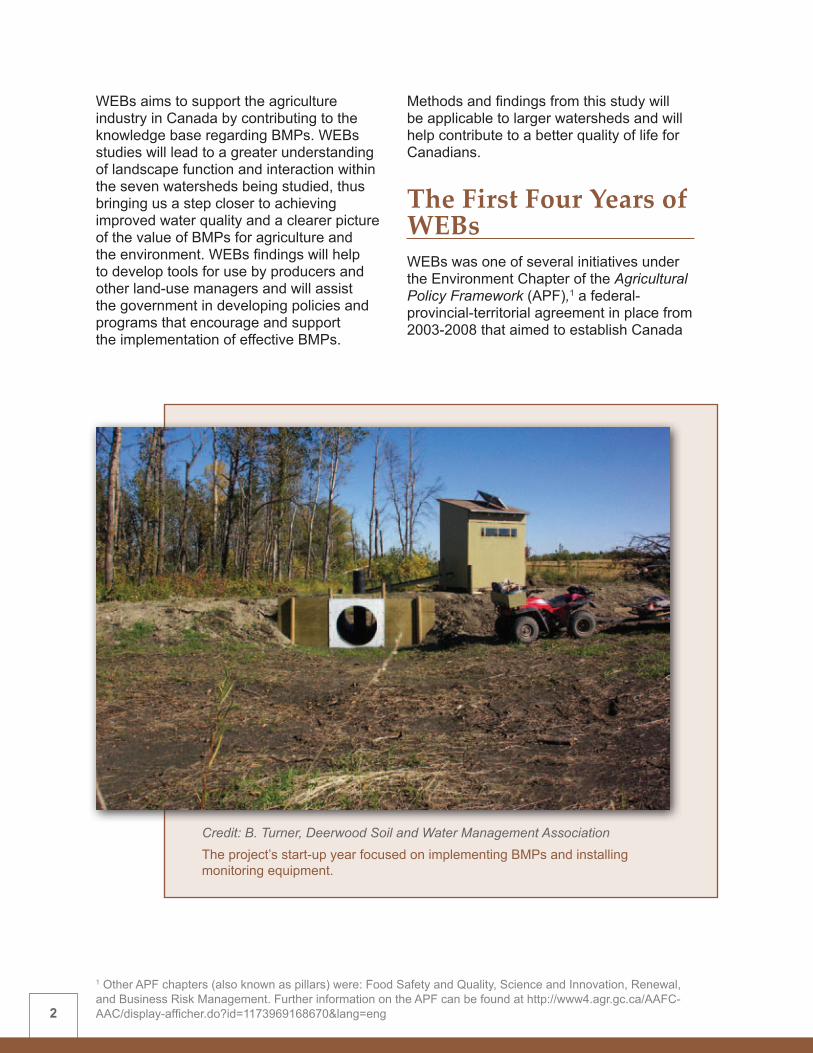
The First Four Years of WEBs WEBs was one of several initiatives under the Environment Chapter of the Agricultural Policy Framework (APF),1 a federal-provincial-territorial agreement in place from 2003-2008 that aimed to establish Canada
Credit: B. Turner, Deerwood Soil and Water Management AssociationThe project’s start-up year focused on implementing BMPs and installing monitoring equipment.
1 Other APF chapters (also known as pillars) were: Food Safety and Quality, Science and Innovation, Renewal, and Business Risk Management. Further information on the APF can be found at http://www4.agr.gc.ca/AAFC-AAC/display-afficher.do?id=1173969168670&lang=eng
3
as the world leader in food safety and quality, innovation, and environmentally-responsible food production. Environment Chapter priorities included: health of air, water and soil; and the interaction between biodiversity and agriculture. The focus of the Environment Chapter was the use and advancement of voluntary approaches to support environmentally-sustainable agriculture.
WEBs was conceived in 2003 to support AAFC’s commitment to the environment and to strengthen its understanding about BMP performance in order to better inform producers and policy makers.
In December 2003, after extensive internal committee discussion, concept proposal revision, and internal and external review, a call for proposals was issued within AAFC for watershed-scale BMP studies which would become part of the WEBs project. An advisory group evaluated and ranked the
proposals using site selection criteria that addressed the following aspects: • size, location and all-weather access of
the small watershed study site and its encompassing, larger watershed
• ongoing research collaboration and the availability of long-term flow and water quality data
• agricultural intensity and land use in the watershed, and the quantity and regularity of runoff
• local farmer and watershed interest and support
• capacity to assess BMP effect
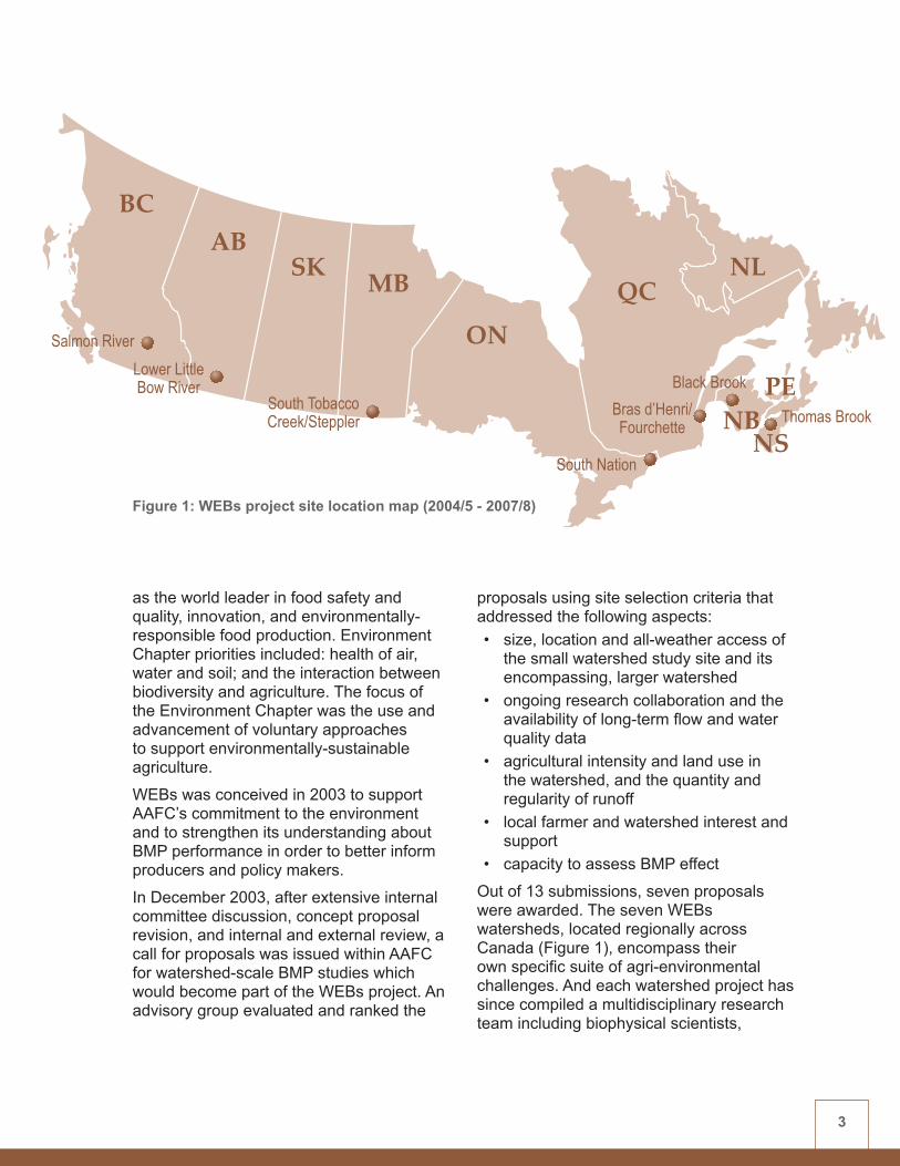
Out of 13 submissions, seven proposals were awarded. The seven WEBs watersheds, located regionally across Canada (Figure 1), encompass their own specific suite of agri-environmental challenges. And each watershed project has since compiled a multidisciplinary research team including biophysical scientists,
BCAB
SK MB
ON
NLQC
NBNS
PE
Salmon RiverLower LittleBow River
South TobaccoCreek/Steppler
South Nation
Bras d’Henri/Fourchette
Black Brook
Thomas Brook
Figure 1: WEBs project site location map (2004/5 - 2007/8)

4 2 April 1, 2004-March 31, 2005 as per the Government of Canada’s fiscal year.
hydrologists and economists from within AAFC and from universities and other organizations.
During the project’s start-up year (2004/5)2, emphasis was on planning and designing biophysical experiments to assess the environmental effectiveness of BMPs. Monitoring equipment was purchased and installed, and additional baseline pre-BMP data were collected. Partnerships were established with watershed groups and universities to conduct BMP implementation, watershed monitoring and water quality analysis. For sites where extensive pre-BMP baseline data already existed, BMPs were implemented in this first year. For others, implementation was delayed in order to collect the pre-BMP data required for effective post-BMP analysis.
During 2005/6, additional BMPs were implemented, monitoring continued and project designs were modified to strengthen and enhance experiments. Once all sites were up and running, the economic, hydrologic and integrated modelling components were initiated and partnerships were established to conduct work in these areas.
By the third year (2006/7), most BMPs were fully implemented, monitoring of the various water quality parameters was underway, and economic and modelling components were being applied. Contribution agreements were established for economics, modelling and additional BMP work, and a site economist and site modeller were selected for each watershed. WEBs project committees were struck for the economics and modelling components.
During the final fiscal year of the project under its APF mandate (2007/8), two to three years of biophysical information had been collected for each of the BMPs in the study sites. Economic assessments had been initiated and hydrologic models were under development within each WEBs watershed.
BMP Evaluation StrategyFor the purposes of this study, BMPs are defined as science-based farming activities designed to help reduce potential impacts on water quality—such as sediment and nutrient runoff into water bodies—and other related environmental parameters.
WEBs has applied a suite of BMPs at the seven sites (Table 1) and is studying their environmental and economic impact at the small watershed scale (approximately 300–2,500 hectares). The selection of BMPs for investigation in WEBs was specifically tailored to the unique conditions of each watershed. As a result, each site employs a suite of BMPs which may not correspond to management practices found in other WEBs watersheds.
All but one of the BMPs investigated were on the list of those nationally endorsed by AAFC and the national BMP Working Group. The controlled tile drainage BMP was included in WEBs to address a pressing local concern, and in recognition of the fact that the mix of approved BMPs will change over time.
Each of the seven WEBs watershed sites across Canada includes the following components:• Biophysical evaluations measure the
impact of individual BMPs, or a suite of BMPs, on environmental factors such as water quality at a watershed scale.
• Economic assessments determine the costs and potential on-farm benefits and explore the possible off-farm benefits of implementing BMPs.
• Hydrologic modelling contributes to a better understanding of landscape interactions within watersheds and how BMPs can affect and be affected by these interactions. Hydrologic modelling can also allow information on BMP impacts to be scaled up to the next-level watershed, which may provide a regional perspective on larger watershed issues.

5
Table 1: WEBs BMPs implemented by watershed (2004/5 - 2007/8)
WEBs BMPs Salmon River
Lower Little Bow River
South Tobacco Creek/
Steppler
South Nation
Bras d’Henri and
Fourchette
Black Brook
Thomas Brook
Rip
aria
n
Cattle exclusion fencing (and off-stream watering)
ü ü ü ü
Off-stream watering without fencing
ü
Grazed versus mechanical harvesting
ü
In-field
Manure management ü ü üZero versus conventional tillage
ü
Crop rotation üPerennial cover ü üReduced herbicide use ü
Run
off
Diversion terraces and grassed waterways
ü
Storm water diversion (farmyard runoff)
ü
Holding pond (cattle containment runoff)
ü
Small reservoirs üBuffer strips ü üSuite of surface runoff control measures
ü
Dra
inag
e
Controlled tile drainage ü
* It is important to note that comparing the effect of individual BMPs across multiple watersheds and/or the assessment of any one BMP under a wide range of different watershed conditions is beyond the initial scope of WEBs.
WEBs is not designed as a test of BMP effect across differing watershed conditions*

6
At two of the project sites, integrated modelling combines hydrologic, economic and other considerations into a decision-support tool for long-term watershed planning.
WEBs is primarily focused on water quality, which is often a reflection of other environmental impacts such as soil quality, air quality and biodiversity. However, in many cases, additional environmental parameters such as soil or riparian health or the composition of aquatic invertebrates are being examined.
The history of conditions and trends at each of the seven WEBs sites is generally well understood due to past activities and data collection by local watershed associations or multi-agency teams. Ideally, these sites
will continue as long-term benchmark locations for monitoring and evaluating watershed health.
Project Resources AAFC’s Greencover Canada Program primarily funded the first four years of WEBs. Cash contributions under the APF totalled $6.51 million. AAFC also provided approximately $5.6 million of in-kind staff and laboratory resources to the project.
Ducks Unlimited Canada, AAFC’s major funding partner in the project, contributed $1.25 million. Other partner organizations contributed another $3 million of in-kind (staff time, equipment) and cash contributions to WEBs.
The primary focus in WEBs has been on water quality, although other environmental parameters—such as riparian health—have also been considered at many sites.
7
3 For further information on NAESI, see http://www.ec.gc.ca/envirozine/default.asp?lang=En&n=906B369D-1 or http://www.ec.gc.ca/publications/index.cfm?screen=PubDetail&PubID=944&lang=e 4 For further information on NAHARP, see http://www4.agr.gc.ca/AAFC-AAC/display-afficher.do?id=1181580464260&lang=eng 5 For further information on MST, see Microbial Source Tracking in Aquatic Ecosystems: The State of the Science and an Assessment of Needs http://www.ec.gc.ca/inre-nwri/default.asp?lang=En&n=D575CDF5-1
Base funding plus partner cash and in-kind contributions brought the project’s total value over the APF period to more than $16 million.
Multi-Agency and International CollaborationWEBs is a multidisciplinary project, comprised of experts in agricultural, biophysical and watershed research; economics; hydrology; and modelling. Expertise comes from over 40 organizations including universities and colleges, conservation groups and other non-governmental organizations, provincial and municipal government departments, and AAFC and other federal departments. Some of these organizations work in more than one WEBs site.
Table 2 shows the WEBs partners by watershed—indicating those having a Contribution Agreement with AAFC, as well as other collaborators. The collaboration of individuals representing the diversity of skills resulting from these partnerships is one of the project’s greatest strengths.
Within individual watersheds, research collaboration is encouraged, so long as it complements overall WEBs project objectives. The following programs and initiatives are examples of WEBs national and international collaborative work during the past four years:
• Environment Canada: National Agri-Environmental Standards Initiative (NAESI)3 – Under the NAESI water theme, pathogen studies took place within the Lower Little Bow River, South Nation, and Bras d’Henri Watersheds. Water sampling for nutrients and sediment also occurred in the South
Tobacco Creek, South Nation and Black Brook Watersheds. Under the NAESI pesticides theme, water sampling was conducted within the Salmon River, South Nation and Bras d’Henri Watersheds.
• AAFC: National Agri-Environmental Health Analysis and Reporting Program (NAHARP)4 – WEBs and NAHARP have worked together at refining their respective integrated modelling and economic valuation approaches. Discussions continue on the potential for using the highly instrumented WEBs watershed sites to assist in validating NAHARP’s agri-environmental indicators.
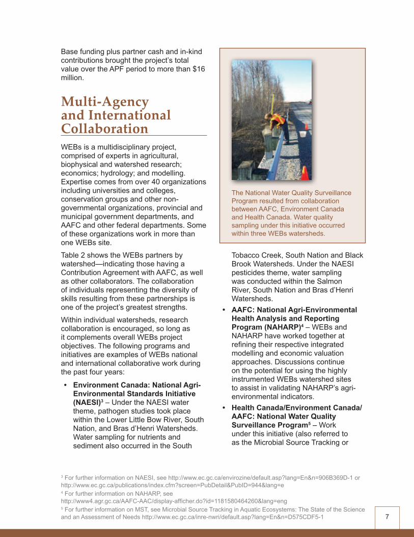
• Health Canada/Environment Canada/AAFC: National Water Quality Surveillance Program5 – Work under this initiative (also referred to as the Microbial Source Tracking or
The National Water Quality Surveillance Program resulted from collaboration between AAFC, Environment Canada and Health Canada. Water quality sampling under this initiative occurred within three WEBs watersheds.

8
Table 2: WEBs partners by watershed (2004/5 – 2007/8)WEBs
WatershedPartners having a Contribution
Agreement with AAFC Other Partners
Salmon River • University of Victoria (water quality analysis and modelling)
• Salmon River Watershed Roundtable (BMPs)
• Environment Canada • British Columbia Ministry of Agriculture and
Lands• British Columbia Ministry of Environment• Okanagan College (Salmon Arm Campus)• British Columbia Cattlemen’s Association
Lower Little Bow River
• County of Lethbridge (BMPs) • Environment Canada• Fisheries and Oceans Canada • Health Canada• Public Health Agency of Canada• Alberta Agriculture and Food • University of Alberta
South Tobacco Creek /Steppler
• Deerwood Soil and Water Management Association (BMPs)
• University of Guelph (hydrologic and integrated modelling)
• University of Alberta (farm behaviour modelling)
• Environment Canada • Fisheries and Oceans Canada • Manitoba Water Stewardship• Manitoba Agriculture, Food and Rural
Initiatives• University of Manitoba
South Nation • South Nation Conservation Authority (BMPs)
• Environment Canada • Health Canada• Public Health Agency of Canada• Ontario Ministry of Agriculture, Food and
Rural Affairs• University of Ottawa• French National Institute for Agricultural
Research (l’Institut national de la recherche agronomique – INRA)
• Université de Bourgogne (University of Burgundy), France
• University of Calgary• University of Alberta• Swedish University of Agricultural Sciences• Agri-Drain USA
Bras d’Henri and Fourchette
• Research and Development Institute for the Agri-Environment (l’Institut de recherche et de développement en agroenvironnement - IRDA) (BMPs)
• Club de fertilisation de la Beauce (CFB) (BMPs)
• McGill University (economics)• Université Laval (economics) • Institut national de la recherche
scientifique (INRS) (hydrologic and integrated modelling)
• Environment Canada• Geological Survey of Canada (Natural
Resources Canada)• Canadian Space Agency • Ministère de l’Agriculture, des Pêcheries et de
l’Alimentation Québec (MAPAQ)• Ministère du Développement durable, de
l’Environnement et des Parcs Québec (MDDEP)
Black Brook • University of New Brunswick (water sample analysis)
• Eastern Canada Soil and Water Conservation Centre (BMPs)
• Fisheries and Oceans Canada • New Brunswick Department of Agriculture
and Aquaculture • New Brunswick Department of Environment• U.S. Department of Agriculture (USDA)• Potatoes New Brunswick
Thomas Brook • Nova Scotia Agricultural College (BMPs)
• Nova Scotia Federation of Agriculture (producer liaison)
• Geological Survey of Canada (Natural Resources Canada)
• Nova Scotia Department of Agriculture• Dalhousie University• Applied Geomatics Research Group of the
Centre of Geographic Sciences

9
MST study), occurred within three encompassing watersheds (Black Brook, South Nation, and Alberta’s Oldman River Watershed) which include the smaller WEBs study sites. The MST findings helped to clarify the potential effect on water quality of reducing microbial loading from agricultural sources—such as the need to manage cattle in riparian areas.
• USDA: Conservation Effects Assessment Project (CEAP)6 – CEAP has a number of objectives similar to WEBs. Developed independently, the differences in approaches are seen by both AAFC and the USDA as complementary. The two projects collaborate by sharing approaches and findings.
Management StructureWEBs operates under the day-to-day direction of a Project Manager and project management staff. A WEBs Management
Committee periodically provides high-level management and decision-making direction, and includes membership from within and outside of AAFC. The National Technical Committee, including all Watershed Leads, sub-committee chairs and others interested in WEBs, meets monthly to discuss progress and issues regarding the project’s ongoing operation. The National Steering Committee, a subset of the National Technical Committee, meets as required to make and document critical project decisions. At each watershed site, a Local Steering Committee, under the direction of the local Watershed Lead, provides project insight, expertise and direction. (See Figure 2)
WEBs committees and sub-committees draw upon a wide pool of AAFC and partner resources, meeting regularly to oversee the ongoing function and work planning direction of the project.
Management Committee
National Steering Committee
National Technical Committee
WEBs Project Manager
Watershed Leads
Local Steering Committees
On-farm Economics Hydrologic Modelling Integrated Modelling Communications
S U B - C O M M I T T E E S
Figure 2: WEBs committees
6 For further information on CEAP, see http://www.nrcs.usda.gov/TECHNICAL/NRI/ceap/

10
Data Management A metadata approach was used to track, manage and share information on the data collected within WEBs. Metadata is data about data—a means of describing the data that have been collected and analyzed without compromising data security and confidentiality.
Publicizing the availability of project metadata informs others of the research conducted in a particular location and by a specific discipline. Benefits include avoiding duplication in data collection, promoting collaborative opportunities in research, and providing data collection guidelines to WEBs watershed projects.
Further information on the WEBs metadata collection is available in the WEBs Technical Summary #2: Economics Component (2004/5 - 2007/8). To request this document, please email [email protected].
CommunicationsThe WEBs communications goals are:• to keep AAFC staff, the scientific
community and other federal and provincial departments apprised of the initiative
• to inform local producers and watershed groups about WEBs and its findings
• to keep Canadians and international contacts aware that AAFC, through WEBs, is studying the environmental and economic impact of BMPs
A range of communications techniques and products have been used to inform those within and outside of WEBs about project progress and findings. Table 3 gives some examples of communications products to date. A more comprehensive list is found in Appendix 2. For further information on WEBs publications and presentations, see www.agr.gc.ca/webs.
Watershed tours and other extension activities are an integral part of the WEBs communications approach.

11
Table 3: Summary of WEBs communications activities* (2004/5 - 2007/8)
Workshops and Conferences
WEBs researchers have presented their findings at some 80 workshops, conferences or meetings hosted by organizations such as:• Canadian Water Resource Association • Environment Monitoring and Assessment Network • Soil and Water Conservation Society • Canadian Agricultural Economics Society • USDA CEAP
Peer-Reviewed Journals
WEBs-related research findings are increasingly being published in such journals as:• Journal of Soil and Water Conservation• Canadian Journal of Soil Science• Applied and Environmental Microbiology• Hydrology and Earth System Sciences
External Media Media articles on specific WEBs projects have appeared in publications such as:• Winnipeg Free Press• Ducks Unlimited Conservator• Western Producer• Farm Focus of Atlantic Canada• Agri-News.com
WEBs Publications A wide range of WEBs-specific publications and tools include:• Factsheets – providing project overview and site-specific details• Watershed pamphlets – describing BMPs and research methods at each watershed• Website – background project and site-specific information, partner links and listing
of publications• Annual and interim project reports – to consolidate and disseminate findings to
stakeholders and interested parties
*See Appendix 2 for a more comprehensive list of these products and activities.
In addition, WEBs watersheds host numerous tours throughout the year for various interested groups and an Annual WEBs Watershed Tour is held at a different site each summer or fall. An Annual Technical Workshop at the end of each fiscal year gives WEBs researchers, their partners and other interested parties, the opportunity to discuss project progress, issues and plans.
Operational Lessons Learned WEBs is an innovative approach to BMP evaluation, being one of the first projects of its kind in Canada to study the environmental and economic impact of BMPs at a watershed scale. Hence, the first phase of WEBs (2004/5 - 2007/8) has overcome several challenges while revealing learning opportunities that will inform future phases of the project.

12
These challenges and opportunities relate to: • Timely resource access –assembling
appropriate staffing and process protocols, and getting funding agreements and arrangements in place to avoid project delays
• Partnership agreements –developing close partnerships with individual producers, watershed groups, research agencies, and between individual researchers
• Realistic expectations –clarifying that, although the WEBs project may be ambitious, it cannot hope to address all the questions related to BMP effectiveness
• Avoiding duplication –keeping abreast of other initiatives and studies, and understanding how they relate to WEBs,
given the increasing interest in BMP and watershed research
Initial FindingsWEBs has made significant progress towards understanding the interactions of specific BMPs within the watersheds where they were tested. This provides a foundation from which to further understand the broader applicability of these BMPs within a specific regional context. WEBs has also gained valuable insights into the on-farm and off-farm economics of BMP adoption. Progress has been made in validating hydrologic models with results from field-tested BMPs. This provides a scientifically-sound basis for broader application of these models to other BMPs and landscape conditions, and will eventually lead to wider
Additional time is required to continue collecting and analyzing data on existing sites to strengthen initial findings.
13
Key WEBs AchievementsA key accomplishment of WEBs has been the formation of a network of agriculture-focused, watershed-scale laboratories across Canada—available for both current and future research. Other significant achievements include:• Research at a watershed scale – WEBs is escalating the research of agricultural
management practices within the landscape, as opposed to focusing on traditional small plot experiments in a controlled environment.
• Environmental and economic analysis – WEBs is integrating both the environmental and economic analysis of BMP effectiveness.
• Community of practice – WEBs brings together a wide range of experts from various government, academic, watershed and producer groups.
• Leveraged resources – WEBs continues to secure significant additional project resources by providing a platform for partnerships, thus creating an increased capacity for high-quality applied research.
• USDA liaison – WEBs works closely with the United States Department of Agriculture’s (USDA) Conservation Effects Assessment Project (CEAP) to exchange watershed insights and technical expertise towards achieving mutual objectives.
ecosystem comparisons. And WEBs has successfully begun to integrate biophysical and economic findings to permit the interpretation and application of WEBs results for broader planning purposes. While much remains to be done, the initial steps are promising.
The Future of WEBs The WEBs sites initiated in spring 2004 have completed five years of research (four years under the APF and one year of continuity funding) prior to the launch of Growing Forward in 2009. However, five years of research by no means equates to five years of BMP results as, in many cases, time was first required to establish monitoring regimes, collect baseline data, implement the BMPs, develop and adapt analytical methods, and launch associated studies. Consequently, several sites have only two to three years of post-BMP data at the end of the initial phase of WEBs.
In order for WEBs to provide more reliable scientific answers to land management questions, additional time is clearly required to continue collecting data on existing sites and to better link monitoring results to watershed hydrology and economic analyses. Further WEBs research will strengthen initial findings, and the possible addition of new watershed sites will extend the assessment of BMPs to include different landscape, soil and climatic conditions. WEBs is well-positioned to continue innovative long-term watershed research because it has created the necessary infrastructure, data sets and partnerships across Canada.
Communication products resulting from WEBs research will give producers, policy makers and the general public a greater understanding of the factors driving BMP performance. These products will help to inform decisions regarding the application of the most suitable BMPs in particular landscapes.

14
Although funding for the first four years of WEBs ended in March 2008, research on the original seven watershed sites continued throughout the 2008/9 fiscal year. Funding to continue with and expand upon WEBs to 2013 has been approved under AAFC’s Growing Forward policy framework.
Plans for the next phase of WEBs include:• building on current WEBs successes
by continuing the current monitoring regime, while incorporating modifications and enhancements
• strengthening the national network of watershed-scale laboratories by adding new sites to address identified landscape gaps
• responding to emerging watershed-specific problems through an innovative studies component that complements longer-term WEBs objectives. Salmon River Watershed, BC

CHAPTER 2
Biophysical ComponentContributing authors: WEBs Watershed Leads - Klaas Broersma (Salmon River), Jim Miller (Lower Little Bow River), Jim Yarotski (South Tobacco Creek), David Lapen (South Nation), Eric van Bochove (Bras d’Henri/Fourchette), Lien Chow (Black Brook), and Dale Hebb (Thomas Brook)

17
Introduction In the WEBs biophysical component, researchers measured the impact of individual BMPs or a suite (combination) of BMPs on water quality and other environmental parameters at a relatively small watershed scale (approximately 300-2,500 hectares). WEBs watersheds are nested within a next-level watershed (approximately 2,000-5,000 hectares), where landscape variables should be sufficiently understood to facilitate scaling-up.
The BMPs studied in WEBs were designed to address local watershed challenges and to reflect the intensity of agricultural production and the land-use practices in the area. WEBs studies were never meant to compare individual BMP effects under a wide range of landscape conditions, neither within nor across watersheds. This would be a very different type of experiment, involving a level of testing intensity for individual BMPs that is beyond the scope of WEBs. For example, an evaluation into the effectiveness of riparian buffer strips as a BMP must take into account the variability that can exist in terms of
buffer composition, width, maturity and effectiveness of implementation. Also, the nature of the adjacent field (soil texture, side slope, cultivation practices, and crop grown) and the climate, topography and landscape features of the area need to be considered as these factors can greatly affect BMP performance.
Studies were designed with in-field assessments intended to yield scientifically-valid and publishable results.
SummaryWEBs biophysical researchers used various scientific methods to measure the impact of BMPs on water quality and other environmental parameters. Standard scientific comparisons included historic benchmarking, paired watersheds, and edge-of-field testing.
More than half of the BMP tests conducted show the potential to reduce contaminant loading to surface waters. But in many cases, the degree of this effectiveness has yet to be quantified. Some findings are mixed—certain environmental parameters are improving while others remain inconclusive or may even be negative. And improvements to one parameter may come at the expense of degradation to another.
Although the edge-of-field contribution that individual BMPs make is often evident, the cumulative effect of multiple BMPs can be difficult to see downstream. Much has been learned about the impact of landscape interactions and processes on BMP performance. WEBs was not designed to directly compare initial BMP effect across differing watersheds, but a few preliminary comparisons have been made. Further discussion on WEBs biophysical results can be found in the Individual Watershed Summaries of Appendix 1.
CHAPTER 2 Biophysical Component

18
WEBs sites were selected for their involvement in watershed studies where streamflow and/or water quality data were already being monitored and other hydrologic and economic data were collected prior to WEBs. Data collected before and during WEBs were used to investigate and validate BMP effects and to understand the watershed relationships underlying the performance of BMPs. Certain WEBs sites were able to access enough of these field data to calibrate and validate hydrologic models and to determine economic costs and benefits of the BMPs being studied. The use of current and future field data will complement literature values and will strengthen the conclusions and the level of confidence in model outputs and overall results.
Study ApproachBiophysical evaluations on WEBs project sites were conducted using various scientific methods to determine the impact of BMPs on water quality and other environmental variables. Studies were designed with
in-field assessments intended to yield scientifically-valid and publishable results.
AAFC conducted a literature review of watershed-scale BMP assessments prior to the start-up of WEBs. This was intended to help researchers conduct innovative research using the most advanced techniques. The USDA’s extensive BMP bibliography, prepared for the CEAP project, also contributed to the understanding of effective BMP design and implementation.
Environmental effectWEBs validation activities used surface water quality as a primary environmental indicator, because it is often a reflection of other environmental impacts (i.e., soil quality, air quality, biodiversity). Water quality was assessed using a minimum set of standard chemical and physical parameters that included: pH, temperature, dissolved oxygen, suspended and dissolved solids, various forms of nitrogen (N) and phosphorus (P), and bacteria (E. coli).
At some sites, sources of contaminants in water, and the movement of contaminants between the field and the stream, were studied. For example, fecal source identification was conducted at the South Nation Watershed in an attempt to determine the most effective BMPs for reducing microbial contamination. And in the Lower Little Bow River Watershed, soil samples were collected to investigate the possible leaching of nutrients through root zones en-route to the river.
Groundwater quality was examined at some WEBs sites to assist in evaluating BMP effect. For example, small-diameter wells were installed in the Salmon River Watershed to facilitate groundwater quality monitoring. And in the Thomas Brook Watershed, groundwater wells were sampled to assess the contribution of groundwater nitrates to stream-water contamination.
Small-diameter wells were installed in the Salmon River Watershed to monitor groundwater quality.

19
At several WEBs sites, evaluations were conducted on an expanded set of environmental parameters. The addition of these measurements increased the chances of detecting environmental change. Some examples include: • riparian health assessment from the
headwaters to the watershed outlet (Thomas Brook)
• annual soil sampling from both grazed and cattle-excluded pastures (Lower Little Bow River Watershed)
• greenhouse gas sampling (South Nation and Thomas Brook Watersheds)
• bio-monitoring to determine if aquatic invertebrates were being negatively impacted by land-use activities such as agriculture (Salmon River Watershed)
• pesticide monitoring (Black Brook Watershed)
Testing results in the fieldBMP impacts were evaluated by comparing a treated scenario against a non-treated scenario. There are several standard scientific methods of doing so and the following experimental designs were used to help quantify cause and effect in WEBs watersheds.
Historic benchmarking (before versus after)WEBs study sites are located in areas with long-term background data on conditions and trends at the sub-watershed level. Since this monitoring was done prior to the implementation of BMPs, it established a baseline, or historic benchmark, against which the performance of the BMPs can be compared. The longer the historic trends and relevant water quality parameters
In some cases, BMPs have shown no apparent impact on water quality, but have improved riparian health.

20
have been tested, the more robust the comparison will be. For example, in the Black Brook Watershed, several years of historical data sets on soil and surface water quality were compared with data collected after BMP implementation.
Upstream versus downstreamTo assess change, monitoring stations were positioned upstream and downstream from where a BMP was implemented. For example, the South Nation Watershed established cattle exclusion fencing upstream from a mid-point in the monitored small stream and allowed unrestricted cattle access below it. Water quality samples taken from both reaches were compared, and their differences were analyzed.
Paired watersheds (control versus treatment)Some WEBs sites applied a paired, or twin, watershed approach, using two relatively similar watersheds. One watershed was treated differently than the control watershed, and water quality results were
compared. For example, in the South Tobacco Creek project, paired watersheds were used to compare runoff, nutrient and sediment loading from a zero-tilled field with an adjacent conventionally-tilled field.
Edge-of-fieldEdge-of-field testing on BMP sites within a watershed involves evaluations at a progressively increasing scale (i.e., edge-of-field, sub-watershed and watershed outlet); or tests such as the effect of riparian buffer width on nutrient loading. The procedure involves a gradient design: either moving progressively farther from the point of treatment (BMP) or progressively increasing the level of treatment (e.g., width of riparian strips). For example, the Lower Little Bow River project evaluated the performance of a planted buffer at the base of a cultivated agricultural field, using a combination of vegetation types and buffer widths to mitigate the effects of runoff.
Sampling frequencyUsing standard design and instrumentation protocols, sampling occurred at WEBs sites at a sufficient frequency to track water quality changes. For example, in the Bras d’Henri and Fourchette Watersheds, water quality was monitored at micro-watershed outlets by using automated sampling devices. Water samples were drawn hourly from the outlet stream. Single samples were collected every two days, and composite (combined) samples were analyzed every four days for various forms of N, P, and other nutrients. In all watersheds, runoff monitoring intensity increased during hydrologic events such as snowmelt or rainfall.
Watershed outletAt all WEBs watershed sites, water quality samples were taken at the watershed outlet to identify any cumulative impacts of BMP implementation. The paired watershed design at the South
Tobacco Creek Watershed allows for a clearer indication of BMP effect.

21
Biophysical Findings The design and implementation of a BMP, and the circumstances against which it is evaluated (e.g., soils, slope, climate, tillage and cropping practices), can vary considerably from one watershed to another. Hence, WEBs was not meant to initially identify the effect of a BMP beyond
its local application. Initial findings can therefore only be interpreted as a test of BMP effect within a certain watershed.
Given that limitation, a summary of WEBs preliminary biophysical findings and their BMP effect is shown in Table 4. For more detailed biophysical findings from each watershed, see Appendix 1.
Table 4: WEBsbiophysicalfindingsbywatershedandBMP(2004/5-2007/8)
Watershed BMP Biophysical Findings Length of post-BMP Study
Salmon River Cattle exclusion fencing (and off-stream watering)
• No significant reduction in nutrient loading in the stream
• Significant reduction in fine sediment and E. coli loading in the stream
• Fencing positively affected vegetative cover within the riparian area
• Land-use intensification significantly affects aquatic and riparian health throughout the watershed
• 4 years• Fencing installed in
2004 on the upstream reach of each of the three farms
• Downstream fencing and off-stream watering added in 2006 to each farm
Lower Little Bow River
Streambank fencing with a cattle crossing (and off-stream watering)
• BMP did not improve the majority of water quality variables in the river
• Improved health of the riparian corridor
• Cattle-excluded pasture acted as a riparian buffer
• 4 years • Fencing installed in
2001; study began in 2004
Off-stream watering without fencing
• BMP did not improve the majority of water quality variables in the river
• Improved health of the riparian corridor
• Some nutrient enrichment of soil and leaching adjacent to off-stream watering troughs
• 3 years• Pre-BMP water quality
monitoring began in 2004
• Off-stream watering system activated in 2005
Conversion to perennial cover (alfalfa)
• No observed improvement in the water quality of surface runoff
• 2-3 years of forage (after barley, under-seeded to alfalfa)
• Conversion in 2005 for first field, 2006 for second field
Manure management • Reduction in dissolved P loadings to surface water
• No reduction in particulate or total P loadings to surface water
• 3 years• Study began in 2005
Buffer strips • Generally no observed water quality benefit
• In extreme rainfall events, a six-metre wide buffer may reduce sediment and N loss from fertilized cropland
• 3 years• Buffers installed in 2005

22
Watershed BMP Biophysical Findings Length of post-BMP Study
South Tobacco Creek/ Steppler
Conversion to perennial cover (grass/alfalfa mix)
• Concentration of N and P in runoff from both cropped and forage fields exceeded water quality guidelines
• Trend towards decreased runoff and dissolved N loadings from forage fields to the stream
• 2 years• Baseline monitoring
began in 2004; forage crop established in 2006
Riparian harvesting (grazed versus mechanical)
• Trend towards reduced N and P loadings from mechanically-harvested hayland to the stream
• 2 years• Baseline monitoring
began in 2004• Riparian management
changes were made in 2006
Holding pond (cattle containment runoff)
• Significant reduction in sediment and nutrient loadings to the stream
• 2 years• Installed in fall 2005
Small reservoirs • Significant reduction of downstream nutrient and sediment loading in the stream
• Significant reduction of downstream spring and summer flood peaks
• 9-18 years• Post-reservoir runoff
monitoring initiated in 1990
• Water sampling and analysis began in 1999
Zero (conservation) tillage versus conventional tillage
Zero tillage resulted in:• Significant reduction of sediment
and N loading to the stream • Significant increase of dissolved P
concentrations to the stream• No significant difference in total
field runoff
• 11 years (5-years pre-BMP)
• Study initiated in 1993; BMP implemented in 1997
South Nation Controlled tile drainage • Trend towards improved surface water quality between the control and test sub-watersheds
• Significant reductions of ammonium, nitrate and P loading in the stream
• Up to 3 years• Control structures
installed starting in 2005
Cattle exclusion fencing (and off-stream watering)
• Significant reductions of nutrient and bacteria loads in the stream
• Improved riparian vegetation, wildlife habitat, and stream morphology
• 4 years• Study initiated in 2004
Bras d’Henri and Fourchette
Surface runoff control • Fourchette - improved water quality
• Bras d’Henri – results to date are inconclusive
• 5 years - Fourchette BMPs installed in 2003
• 1 year - Bras d’Henri BMPs installed in spring 2007
Crop rotation (increasing the percent area of hay versus corn)
• Farm scale - reduction of nutrient loading to the stream
• Watershed scale – continuing to assess impact
• 4 years• BMP implemented prior
to 2004
Hog slurry management • Consistently reduced N and fecal coliform loading to the stream
• Reduced N and P losses in surface runoff in some years
• Increased residual P in soil• Apparent odour reduction during
spreading
• 3 years• BMP implemented in
2005

23
Watershed BMP Biophysical Findings Length of post-BMP Study
Bras d’Henri and Fourchette (continued)
Reduced herbicide use • AAFC-based decision-support system deemed inappropriate
• Other techniques require more time to adjust and realize effect
• 1-3 years• Decision-support
system implemented in 2005; other methods in 2007
Black Brook Diversion terraces and grassed waterways
• Significant reduction of surface runoff, sediment and particle-bound contaminants
• Soluble nutrient loading often increased within the stream
• Ineffective at reducing in-stream pollutant loadings from unusually high-intensity rainfall events
• 7-16 years• BMPs installed starting
in 1992• Improvements made
during WEBs• Water quality monitoring
began in 1992 with some gaps
Grassed riparian buffer zones
• May reduce runoff and sediment, depending on topographic characteristics of contributing fields or overland flow characteristics
• Nutrient loadings to the stream are inconclusive to date
• Ineffective at reducing loadings to the stream from high-intensity rainfall events
• 3 years• BMP implemented in
2005
Thomas Brook
Nutrient management plans
• No impact on stream water quality due to watershed complexity and limited application of the BMP
• 3 years• BMP implemented in
2005
Cattle exclusion fencing (and off-stream watering)
• Minimal impact on stream water quality, likely due to short length of stream reach fenced and low cattle numbers
• 3 years• BMP implemented in
2005
Storm water diversion (farmyard runoff)
• Significant reduction to in-stream P and E. coli concentrations
• 3 years• BMP implemented in
December 2004
Conclusions All WEBs sites are fully operational, with biophysical data being collected for all of the BMPs under study. Nevertheless, some WEBs sites have required the first year or two in order to establish effective monitoring regimes, collect baseline data, and to implement the BMPs. Consequently, several sites have only two or three years of post-BMP biophysical data at the end of the first phase of WEBs. And because these experiments are being conducted at the watershed scale, where long-term findings are needed to account for spatial and temporal variability,
it is early to begin drawing firm conclusions. The following generalized conclusions are, nonetheless, apparent:
Clear environmental effectCertain BMPs have shown clear positive trends in relation to water quality and/or other environmental indicators. For example, more than half of the BMP tests conducted in WEBs (13 out of 22) have shown the potential to reduce contaminant loading to surface waters. However, in many cases, the degree of this effectiveness has yet to be quantified. Key positive examples
24
are studies in the South Nation Watershed, where the controlled tile drainage BMP has significantly reduced nutrient loads in receiving surface water. As well, the nearby cattle exclusion fencing BMP has achieved significant reductions in nutrient and bacteria loads in the stream, while improving riparian vegetation, wildlife habitat, and stream morphology.
Mixed findings and tradeoffsSome findings are mixed—certain water quality parameters are improving while others remain inconclusive or may even be negative. As well, improvements to one parameter may even come at the expense of degradation to another. Few changes have no tradeoffs. Positive findings on one front will not necessarily yield positive findings on all fronts. For example, while the use of diversion terraces appears to have reduced surface runoff in the Black Brook Watershed, increased percolation within terraced soils may have contributed excess
nutrients to local groundwater, as indicated through increasing nutrient concentrations within the adjacent stream’s baseflow. In the South Tobacco Creek Watershed, although zero tillage was found to significantly reduce concentrations of N and sediment loading to the stream, an increase in the loss of total P (particularly dissolved P) from the field was observed. This is possibly a result of the stratification of P at the soil surface in connection with the leaching of P from crop residues. Further investigation is required.
Water chemistry versus other indicatorsIn other cases, BMP results were inconclusive for water chemistry but positive for other environmental indicators. In the Salmon River Watershed, for example, cattle exclusion fencing achieved no significant reduction in stream nutrient loads, but did result in a significant reduction in fine sediment and E. coli stream loads, and positively affected vegetative cover within the fenced-off riparian area.
Edge-of-field versus watershed findingsWhile the contribution that individual BMPs make to edge-of-field or in-stream loadings are often evident, the cumulative effect of multiple BMPs on water quality is often difficult to detect downstream at the watershed outlet. This may be because of the short length of study to date or because the size of the receiving stream renders potential changes in water quality difficult to determine. Cumulative impacts are harder to detect in larger streams and rivers not only because of this dilution of effect, but also because varying input sources upstream of the WEBs watersheds might mask or overwhelm the effects of the implemented BMPs. It is for these reasons that WEBs employs a nested design, whereby BMPs are measured at both the edge-of-field and micro-watershed scales.
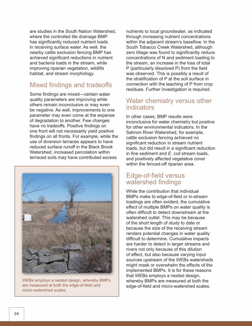
WEBs employs a nested design, whereby BMPs are measured at both the edge-of-field and micro-watershed scales.

25
In some sites, impacts both at the edge-of-field and watershed outlet are evident. An example of this is with the controlled tile drainage BMP in the South Nation Watershed. Extensive producer cooperation has led to wide-scale adoption, such that over 95 percent of the control watershed now has control drainage structures. The water quality impact of this BMP is clearly evident at the micro-watershed outlet. In the case of the Fourchette Watershed in Quebec, where surface runoff control measures have been in place since 2001, the cumulative effect of these practices are just now becoming measurable at the watershed outlet. On the other hand, impacts from more recently implemented surface runoff control BMPs within the nearby Bras d’Henri Watershed are still only detectable at the edge-of-field level. Researchers anticipate similar findings at the watershed outlet, reinforcing the need for long-term monitoring.
Landscape interactionsMuch has been learned about the occurrence of unique landscape interactions and processes within these studies. For example, at the outset of WEBs, two micro-watersheds were selected within the Bras d’Henri Watershed for a paired watershed study. These watersheds were chosen after a comparison of available hydrology, soils and land-use information. A very detailed soil survey was later conducted through WEBs and determined that these ‘twin’ watersheds were actually very different. The higher proportion of coarse-textured soils in the intervention (BMP-altered) watershed made it far more prone to N leaching than the control watershed. Yet the dominance of podzols (having a high P-sorption capacity) in the intervention watershed led to much lower P concentrations at the outlet than expected. These factors both helped to explain the otherwise confusing performance of the implemented BMPs. Far from being a negative finding, this has allowed researchers to better interpret water quality results, and has led to new research
Detailed soil mapping within the Bras d’Henri Watershed revealed that the ‘twin watersheds’ had very different soil types than previously supposed; a factor which helped explain the BMP results.
Intervention watershed Control watershed

26
and scientific publications on relationships between soil variability, BMP performance, and probable impacts on stream water quality.
Cross-watershed comparisonsDespite the fact that WEBs was deliberately not designed to compare BMP effect across differing watershed conditions, there are some BMPs that have been applied within more than one WEBs watershed and comparisons are bound to be made. Hence, below is a preliminary indication of what further study might reveal regarding multi-site effects:• Cattle exclusion/streambank fencing
(4 sites) – Findings in four cross-Canada WEBs watersheds generally point to improved riparian health, although effects on water quality were often unclear and by no means uniform across watersheds. Differing water quality effects may be related more to the size of the stream or relative cattle numbers, whereas the recovery of fenced riparian areas could be relatively independent of these factors.
• Conversion to perennial cover (3 sites) – Water quality findings in two Prairie watersheds are short-term, with only two to three years of data from which to draw any conclusions. Time may be required for converted fields (annual cereals to alfalfa/forage production) to reach equilibrium and demonstrate BMP effect. In the Bras d’Henri Watershed, the four-year effect of having converted fields from corn to hayland resulted in a farm-scale reduction in nutrient loadings to the stream; yet net watershed effect remains unclear.
• Manure/nutrient management studies (3 sites) – Two of these studies (Lower Little Bow River and Bras d’Henri) resulted in decreased loadings to the stream for some nutrient components while accompanied by an increase in residual soil P. Within the Thomas
Brook Watershed, the sporadic on-farm adoption of provincial nutrient plan guidelines (assessed just once every three years) made it very challenging to detect any impacts on water quality at the outlet. Consequently, significant changes are proposed for this BMP in future.
• Buffer strips (2 sites) – Buffer strips were tested in two watersheds for three years each. In the Lower Little Bow River Watershed, water quality benefits during normal runoff events adjacent to pastureland were not evident, but for extreme runoff events adjacent to cultivated land, a six-metre wide buffer might reduce sediment and N loadings. Conversely, in the Black Brook Watershed, although potential nutrient loading reductions from adjacent potato land also remain unclear, buffers were found to be ineffective during extreme runoff events.
Further study is required to learn more about the water quality impacts of all of these BMPs. Such knowledge will benefit future work, both within and beyond the scope of WEBs.
Next Steps Significant progress has been made in the WEBs biophysical studies to date and several key findings have resulted from the innovative research conducted on the watershed sites. However, more time is required to collect additional biophysical data to strengthen these findings and to contribute to economic and hydrologic modelling. WEBs work will continue on the seven existing sites under the Growing Forward policy framework. As well, the addition of new watershed sites will broaden the scope of study to enable the assessment of BMP effects and watershed influences under a wider range of landscape, soil and climatic conditions.

CHAPTER 3
Economics ComponentContributing authors: WEBs Economics Co-Chairs –Carlyle Ross, Merle Boyle and Mohammad Khakbazan (AAFC); WEBs Site Economists - Terry Peterson (Salmon River), Carlyle Ross and Elwin Smith (Lower Little Bow River), Mohammad Khakbazan (South Tobacco Creek), Philippe Crabbé (South Nation), Paul Thomassin and Bruno Larue (Bras d’Henri/Fourchette), Jérôme Damboise (Black Brook), Emmanuel Yiridoe (Thomas Brook); and Laurie Baker (consultant)

29
Introduction The primary goal of the WEBs economics component was to assess the on-farm economic costs and to begin the assessment of potential on-farm and off-farm benefits of applying the selected BMPs. To assess the effects of BMPs on the farm enterprise, economists used economic models and other tools best suited to the unique circumstances of each WEBs site. The socio-economic factors that might affect producers’ decisions to adopt BMPs were also examined as part of the farm behaviour component (see Chapter 5).
RationaleAs a result of society’s increasing interest in the environment, agriculture is often associated with having a negative impact on water quality and other environmental factors. But improvements in water quality resulting from the application of agricultural BMPs often provide off-farm benefits such as enhanced water quality for domestic consumption, recreation and healthier aquatic ecosystems.
The success of stewardship initiatives designed to minimize agriculture’s impact on water quality depends on the willingness of producers to adopt BMPs and on producer capacity to finance the investment. The
Economic analyses conducted in WEBs will provide producers with credible estimates of the on-farm costs and benefits of BMPs so they can make informed choices about implementing them.
SummaryWEBs economists have estimated the on-farm costs of implementing BMPs and have begun to assess potential on-farm and off-farm benefits. These economic assessments centred mainly on BMP cost determinations and producer surveys. The varied analytical approaches used reflect the diversity of factors affecting each watershed. These approaches include econometric analysis, whole-farm analysis, financial models, optimization models and others.
Although WEBs economic studies were not initiated until two years into the project, several key findings have resulted. The majority of the 22 BMP tests conducted showed high implementation and/or maintenance costs, with little likelihood of net on-farm financial benefit. Nevertheless, in about 75 percent of cases, limited benefits may partially offset the cost of implementing the BMPs. Additional BMPs may prove to be economically viable, but their on-farm benefits have yet to be quantified. It is still too early to tell whether they will provide significant off-farm public benefits.
Further discussion related to WEBs economics results can be found in the watershed-specific sections of Appendix 1. Work on the economics-related farm behaviour model is reported in Chapter 5.
CHAPTER 3 Economics Component

30
costs of water quality BMPs may exceed their on-farm benefits, such as a potential increase in cattle production capacity. As a consequence, farmers may react by employing agricultural practices that benefit the farm but that negatively impact water quality, rather than voluntarily adopting expensive BMPs.
Economic research and analysis can provide producers with credible estimates of the on-farm costs and benefits of BMPs so they can make informed choices about implementing them. Similarly, this knowledge will help determine the extent of financial, regulatory or other incentive required when voluntary adoption does not appear to be advantageous. Knowledge of the on-farm and societal costs and benefits of BMP adoption, plus a greater understanding of producer attitudes and impediments to adoption, will help governments to develop policies or programs that encourage the adoption of BMPs.
Study ApproachNine on-farm economics studies were conducted in the seven WEBs watersheds—the Alberta and Quebec sites each had two studies. The economic assessments to date have mainly concerned BMP cost assessment and producer surveys. Their intent is to help determine on-farm costs and returns and to develop representative farm models (typical farm sizes and types) for each watershed.
The analytical approach taken by each of these studies varied to reflect the diversity of factors affecting each study area. These factors include: ecological and agronomic diversity of the watersheds; producer willingness to participate; the BMPs being studied; and variations in available data, survey approaches, and the researchers’ methodological preferences (Table 5). The methods used in each of the WEBs watersheds are described in more detail in Appendix 1.
Table 5: WEBs on-farm economic research methods (2006/7 - 2007/8)
Watershed Analytical Approach
Salmon River Financial models
Lower Little Bow River Stochastic and dynamic farm-level models
Non-linear programming
South Tobacco Creek/Steppler Enterprise farm budgets and econometric analysis
South Nation Enterprise farm budgets
Bras d’Henri and Fourchette Econometric analysis
Optimization model
Black Brook Whole-farm analysis
Thomas Brook Optimization model

31
The analytical approaches used by WEBs economists to estimate costs and returns and, where possible, the net benefits of BMP adoption, are: • Econometric analysis of the decisions
concerning the likelihood that farmers might or might not adopt BMPs. This approach estimates crop yield and cost functions, plus statistical inferences about the significance of variables affecting a farmer’s willingness to adopt a BMP.
• Enterprise farm budgets help determine net income at the enterprise level, i.e., the level sufficient to assess the BMP rather than the whole farm. This analytical tool can be used in conjunction with investment values for the enterprise farm to generate rates of return for BMP investments.
• Financial models generate financial statements such as balance sheets, income statements or cash flow statements for farm businesses. These can be used to determine whether the BMP in question can add to the farmer’s cash flow, net income and equity.
• Non-linear programming is a mathematical technique to determine the level of BMP implementation which produces the highest net farm income subject to constraints such as available farm resources.
• Optimization models encompass several mathematical techniques, such as non-linear programming, to determine the best allocation of farm resources. These models can be used on an inter-regional basis.
• Stochastic and dynamic models extend optimization models and can produce simulations on changes in cash-flows, farm resources, probabilities, time horizons, and decision making.
• Whole-farm analysis assesses the impact of BMP adoption on the total farm income and financial performance. Sometimes cash flow from the farm enterprise cannot recoup the
investment, but cash flow from the whole farm can absorb the investment.
In some watersheds, the BMP assessments were conducted on a single farm unit. In others, the site economists developed a series of ‘representative’ farm types and sizes to reflect typical farms in the watershed.
The economic results of those BMPs studied in more than one watershed cannot necessarily be compared across watersheds due to differences in watershed conditions and economic research methods.
Within the two WEBs sites in Manitoba and Quebec, economists worked with the biophysical scientists and hydrologic modellers towards developing an integrated modelling framework. Further information on the WEBs integrated modelling component is found in Chapter 5.
Analytical challengesSince the WEBs economic studies were not initiated until two years into the project, the economic analyses are not as definitive as they would be with a longer period of study. As well, because actual site-specific economic data were not yet available for many of the watersheds, site economists often had to obtain initial data from published sources. Consequently, results may be based on model-derived estimates rather than on site-specific values. Hence, many of the WEBs economic findings must be considered preliminary and will benefit from ongoing input of field data.
All of the WEBs economics studies estimated cost information related to the adoption and/or maintenance of BMPs. However, on-farm (private) or off-farm (public) benefits of BMPs are not yet adequately assessed within most watersheds because much of the biophysical analysis was and is still underway. Therefore, a complete benefit-cost analysis has yet to be completed.

32
Table 6: WEBseconomicfindingsbywatershedandBMP(2006/7-2007/8)
Watershed BMP ECONOMIC FINDINGS*
Salmon River Cattle exclusion fencing (and off-stream watering)
• Very costly to install• Short-term benefits to the landowner appear
to be limited
Lower Little Bow River
Streambank fencing with a cattle crossing (and off-stream watering)
• Very costly to install• Short-term benefits to the landowner appear
to be limited
Off-stream watering without fencing • Slight reduction in farm cash flow• Potential uncalculated on-farm benefits (cattle
distribution) might off-set costs
Conversion to perennial cover (alfalfa)
• Slight reduction in farm cash flow
Manure management • Reduction in net income due to manure transportation costs and reduced-nutrient yield losses
• Costs dependent on N:P ratio of manure application
Buffer strips • Grass buffer resulted in slight reduction in cash flow
• Buffer of shrubs and trees costly to implement and maintain
• Costs will vary with buffer width and desired level of environmental protection
South Tobacco Creek
Conversion to perennial cover (grass/alfalfa mix)
• Increased income due to lower input costs• Have not yet assessed potential livestock
income and costs
Riparian harvesting (grazed versus mechanical)
• High fencing capital costs• Loss of farmland, due to buffer needs
(livestock not assessed)
Holding pond (cattle containment runoff)
• High initial capital investment• Direct and indirect benefits have yet to be
determined
Small reservoirs • High initial capital investment• Public benefits have yet to be valued
Economic FindingsTable 6 below highlights findings from the economic analysis of individual BMPs in WEBs watersheds during the project’s first
phase. For most BMPs, only on-farm costs have been assessed. To view these findings in the context of the biophysical results, see the individual watershed summaries in Appendix 1.

33
Watershed BMP ECONOMIC FINDINGS*
South Tobacco Creek (continued)
Zero (conservation) tillage versus conventional tillage
• High initial investment for zero tillage equipment
• Returns from zero tillage are limited and crop dependent
• Economic returns improve as tillage frequency decreases
South Nation Controlled tile drainage • Profitable due to increased corn and soybean yields
• Control structure could pay for itself in three or four years
Cattle exclusion fencing (and off-stream watering)
• Page wire fencing very costly• Installation and maintenance cost of watering
system is low• Short-term benefits to the landowner appear
to be limited
Bras d’Henri and Fourchette
Surface runoff control • Adoption likely increases costs, though proportionately smaller for larger crop-producing farms
• Land stabilization and yield increase may result
• Adoption is positively influenced by age, education, farm size and other factors
Crop rotation (increasing the percent area of hay versus corn)
• Costly, with average short-term costs increasing as more hay is included and corn acreage is reduced in the cropping rotation
• Adoption is positively influenced by age, education, farm size and negatively influenced by the price of labour
Hog slurry management • Costly, though less so for large crop-producing farms, while more costly for livestock farms
• Reduced need for mineral fertilizer is anticipated
• Women or land owners residing on the farm more likely to adopt this BMP
Reduced herbicide use • Costly (in terms of yield loss), average costs increase at an accelerated rate as pesticide use is reduced
• Larger farms more likely to adopt this BMP
Black Brook Diversion terraces and grassed waterways
• Costly to implement and maintain• Short-term yield impacts inconclusive
Grassed riparian buffer zones • Costly to implement• No clear short-term benefits to landowners

34
Watershed BMP ECONOMIC FINDINGS*
Thomas Brook Nutrient management plans • Costly in terms of yield loss• Farm losses increase as fertilizer rates
decrease• Difficult finding markets for new crops
recommended for rotations
Cattle exclusion fencing (and off-stream watering)
• Costly to install and maintain • Loss of pasture land, but potential for
improved milk production
Storm water diversion (farmyard runoff)
• Costly to install• No short-term financial benefit to the
landowner
*Economic findings are based on one to two years of study.
Controlled tile drainage structures have provided clear economic returns to the producer.
ConclusionsThe focus of the WEBs economics component was to determine the impacts of BMP implementation on the farm operation. This was completed for all BMPs, though economists often had access to limited economic and other data. As data collection continues in WEBs, economic findings will be improved. And, for the BMPs which show an apparent off-farm environmental
effect (such as downstream water quality improvement), assessments of off-farm benefit will be increasingly conducted in WEBs. For now, the following generalized conclusions are apparent:
High implementation costsBased on initial, short-term economic findings, many of the BMPs evaluated appear to have high implementation and/or maintenance costs, with little likelihood of on-farm financial benefit. The great majority of the 22 BMP tests conducted under WEBs had significant cost implications to the landowner, thus affecting farm profitability. For example, cattle exclusion fencing, off-stream livestock watering, and the construction of earth work structures (e.g., holding ponds, diversion terraces) cause farmers to incur large, up-front costs. Other BMPs such as manure management, crop rotations, and reduced herbicide use also have annual cost implications. Under such circumstances, many farms might be expected to suffer financially if they were to adopt these BMPs. And based on the limited results to date from the WEBs biophysical studies, it is still too early to tell whether these BMPs will provide significant long-term, off-farm public benefits. Where public benefits are documented, this should
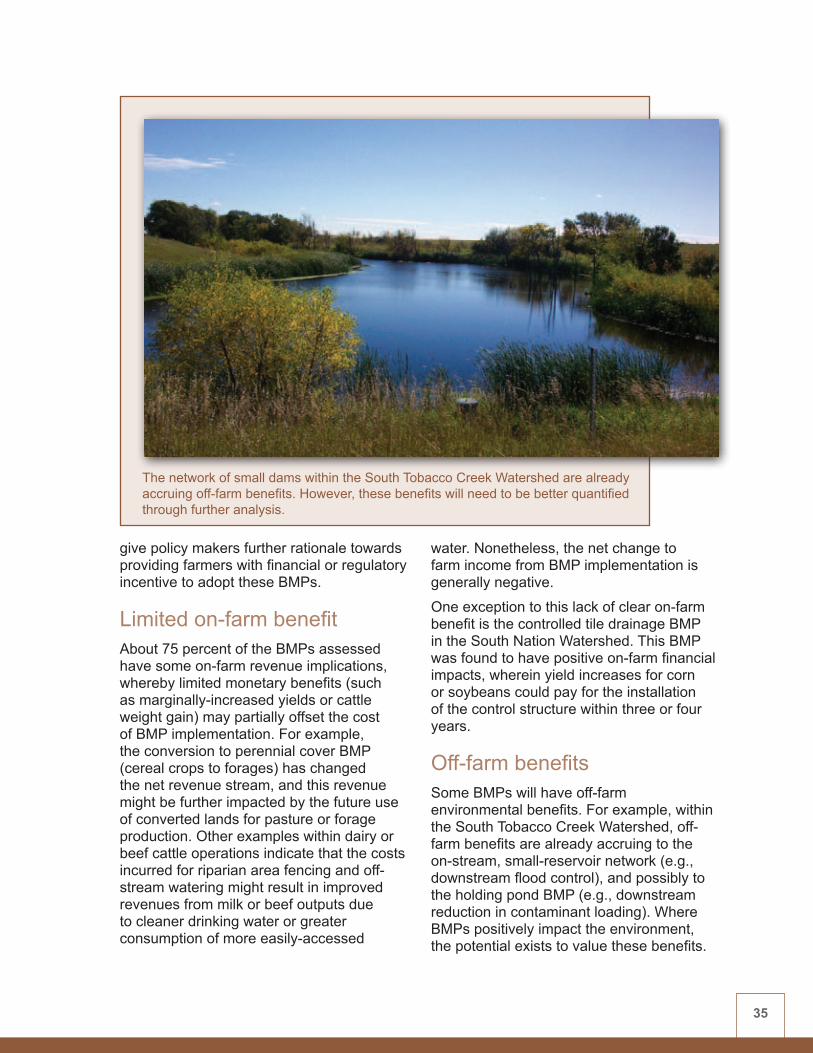
35
give policy makers further rationale towards providing farmers with financial or regulatory incentive to adopt these BMPs.
Limited on-farm benefitAbout 75 percent of the BMPs assessed have some on-farm revenue implications, whereby limited monetary benefits (such as marginally-increased yields or cattle weight gain) may partially offset the cost of BMP implementation. For example, the conversion to perennial cover BMP (cereal crops to forages) has changed the net revenue stream, and this revenue might be further impacted by the future use of converted lands for pasture or forage production. Other examples within dairy or beef cattle operations indicate that the costs incurred for riparian area fencing and off-stream watering might result in improved revenues from milk or beef outputs due to cleaner drinking water or greater consumption of more easily-accessed
water. Nonetheless, the net change to farm income from BMP implementation is generally negative.
One exception to this lack of clear on-farm benefit is the controlled tile drainage BMP in the South Nation Watershed. This BMP was found to have positive on-farm financial impacts, wherein yield increases for corn or soybeans could pay for the installation of the control structure within three or four years.
Off-farm benefitsSome BMPs will have off-farm environmental benefits. For example, within the South Tobacco Creek Watershed, off-farm benefits are already accruing to the on-stream, small-reservoir network (e.g., downstream flood control), and possibly to the holding pond BMP (e.g., downstream reduction in contaminant loading). Where BMPs positively impact the environment, the potential exists to value these benefits.
The network of small dams within the South Tobacco Creek Watershed are already accruing off-farm benefits. However, these benefits will need to be better quantified through further analysis.

36
More analysis is required to quantify and value these potential benefits.
A limited number of off-farm (public) benefit studies have already been initiated under WEBs. One survey assessed farm attitudes and motivations to BMP implementation in the Bras d’Henri Watershed. Despite the fact that the majority of the BMPs have not been shown to positively affect on-farm net revenues, many farmers still appear to have the propensity to adopt certain practices—
because of visual or other positive changes they have witnessed (e.g., improved riparian vegetation or reduced manure odour).
Other economic modelling studies were initiated to predict the combination of BMPs that might provide the least expensive solution to a desired environmental improvement at the watershed outlet.
These studies at the South Tobacco Creek and Bras d’Henri Watersheds linked the economic costs of implementation to farmer motivations and an assumed environmental performance of each BMP. It was shown, for example, that it may be advantageous within a programming and cost-efficiency context, to target certain BMPs to specific areas of the watershed in order to achieve desired water quality results at the watershed outlet.
In other WEBs watersheds, additional BMPs are likely to be economically viable, but their associated on-farm or off-farm benefits have yet to be quantified. In the absence of such evidence, BMPs that cannot demonstrate on-farm economic or at least environmental viability, seem unlikely to be implemented or sustained without financial or regulatory
Increased cattle weight gain and/or milk yields may partially offset the costs of exclusion fencing and off-stream watering.

37
incentive. BMPs providing largely off-farm benefits will probably need similar encouragement.
Cross-watershed comparisonsAgain, despite the fact that WEBs was deliberately not designed to compare BMP effect across differing watershed conditions, there are some BMPs that have been applied within more than one WEBs watershed and economic comparisons are bound to be made. Hence, below is a preliminary indication of what further economic study might reveal regarding multi-site effects:• Cattle exclusion/streambank fencing
(4 sites) – Economic findings in four cross-Canada WEBs watersheds (Salmon River, Lower Little Bow River, South Nation, Thomas Brook) indicate this BMP is very expensive to install (e.g., $6000 per kilometre in BC) and that limited short-term benefits appear to accrue to the landowner. These benefits might include improved cattle weight gains (beef) or improved milk production (dairy) due to better quality and increased consumption of off-stream drinking water. There might also be slight improvements to cattle foot health and a decrease in cattle accidents and mortality due to drowning.
• Conversion to perennial cover (3 sites) – Economic findings in two Prairie watersheds range from: a slight reduction in cash flow (Lower Little Bow River); to providing increased income due to lower input costs in South Tobacco Creek (exclusive of possible cattle production benefits). In the intensively-farmed Bras d’Henri Watershed, this BMP was very costly to implement, with average short-term costs increasing as hayland was substituted for corn acreage in the cropping rotation. According to farmer survey results in the region, adoption of this BMP will be positively influenced
by age, education and farm size, while negatively influenced by the price of labour.
• Manure/nutrient management studies (3 sites) – This BMP was applied in three very different scenarios across Canada, though with similar economic impacts in each watershed. A reduction in net income occurred in a cattle manure study at the Lower Little Bow River Watershed. Reduced income was due to a combination of higher manure transportation costs and concurrent yield losses associated with lower nutrient availability. In the Bras d’Henri Watershed, the improved hog slurry application was costly to the farmer—though less so for larger crop-producing farms, while relatively more costly for livestock farms. Women or land owners residing on the farm were found more likely to adopt this BMP. The effect of improved total nutrient management planning (animal and chemical sources) in Thomas Brook Watershed (Nova Scotia) proved costly in terms of predicted yield loss. Farm
Supplying an off-stream cattle water supply can be very costly to producers.
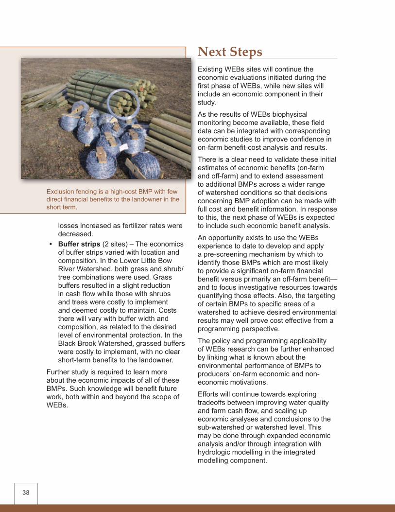
38
losses increased as fertilizer rates were decreased.
• Buffer strips (2 sites) – The economics of buffer strips varied with location and composition. In the Lower Little Bow River Watershed, both grass and shrub/tree combinations were used. Grass buffers resulted in a slight reduction in cash flow while those with shrubs and trees were costly to implement and deemed costly to maintain. Costs there will vary with buffer width and composition, as related to the desired level of environmental protection. In the Black Brook Watershed, grassed buffers were costly to implement, with no clear short-term benefits to the landowner.
Further study is required to learn more about the economic impacts of all of these BMPs. Such knowledge will benefit future work, both within and beyond the scope of WEBs.
Next Steps Existing WEBs sites will continue the economic evaluations initiated during the first phase of WEBs, while new sites will include an economic component in their study.
As the results of WEBs biophysical monitoring become available, these field data can be integrated with corresponding economic studies to improve confidence in on-farm benefit-cost analysis and results.
There is a clear need to validate these initial estimates of economic benefits (on-farm and off-farm) and to extend assessment to additional BMPs across a wider range of watershed conditions so that decisions concerning BMP adoption can be made with full cost and benefit information. In response to this, the next phase of WEBs is expected to include such economic benefit analysis.
An opportunity exists to use the WEBs experience to date to develop and apply a pre-screening mechanism by which to identify those BMPs which are most likely to provide a significant on-farm financial benefit versus primarily an off-farm benefit—and to focus investigative resources towards quantifying those effects. Also, the targeting of certain BMPs to specific areas of a watershed to achieve desired environmental results may well prove cost effective from a programming perspective.
The policy and programming applicability of WEBs research can be further enhanced by linking what is known about the environmental performance of BMPs to producers’ on-farm economic and non-economic motivations.
Efforts will continue towards exploring tradeoffs between improving water quality and farm cash flow, and scaling up economic analyses and conclusions to the sub-watershed or watershed level. This may be done through expanded economic analysis and/or through integration with hydrologic modelling in the integrated modelling component.
Exclusion fencing is a high-cost BMP with few direct financial benefits to the landowner in the short term.

CHAPTER 4
Hydrologic Modelling ComponentContributing authors: WEBs Hydrologic Modelling Co-Chairs – Jim Yarotski and David Lapen (AAFC); WEBs Site Hydrologic Modellers - Zhanxue (John) Zhu (Salmon River), Michel Rahbeh (Lower Little Bow River), Wanhong Yang and Yongbo Liu (South Tobacco Creek), Alain N. Rousseau and Stéphane Savary (Bras d’Henri/Fourchette), Fanrui Meng (Black Brook), Rob Jamieson (Thomas Brook); and Brian Abrahamson (consultant)

41
IntroductionHydrologic modelling at each WEBs project site complements the biophysical assessment of BMPs. Together they help to generate enhanced computer models to increase understanding of background conditions and watershed processes. These models might also allow information on BMP impacts to be scaled up to the next-level watershed to provide a regional perspective on larger watershed issues.
The WEBs hydrologic modelling objectives are: • to simulate watershed hydrology and
water quality under existing conditions using an accepted hydrologic model
• to employ a calibrated-validated version of the model for evaluating BMP effectiveness at reducing negative impacts of agricultural runoff from the test and larger-scale watersheds
Credit: R. Jamieson and K. Garroway, Dalhousie UniversityData layers are used to classify watersheds into hydrologic response units (HRUs)—representing areas of similar hydrologic characteristics.
SummaryHydrologic models were used in WEBs to simulate watershed hydrology and water quality and to evaluate BMP effectiveness. They help to increase understanding of background conditions and watershed processes and allow for scaling-up to provide a regional perspective on larger watershed issues. To this end, most WEBs modellers used the Soil and Water Assessment Tool (SWAT). The Bras d’Henri Watershed employed a SWAT-like derivative and the South Nation project used a one-dimensional soil-water model. Models were modified to better suit local conditions and to accommodate specific BMPs.
Most modelling findings suggest a reduction in sediment and nutrient loading resulting from BMP implementation. However, the short (two-year) length of the initial study and the limited amount of site-specific post-BMP biophysical and economic data necessitated the use of literature values in many model simulations. Hence, findings are considered preliminary. Results will be enhanced as model improvements are made and more site-specific data becomes available.
Watershed-specific information on hydrologic modelling within individual WEBs watershed sites is found in Appendix 1. Specific information on the WEBs integrated modelling component is presented in Chapter 5.
CHAPTER 4 Hydrologic Modelling Component

42
Model Enhancements
Data Enhancement Sub-models
Watershed Configuration
Step 1Prepare
Input Data
Step 2Hydrologic Calibration
and Validation
Step 3Sedimentation
Calibration
Step 5BMP
Assessments
Step 4Nutrient
Calibration
Hydrologic modelling conceptsA hydrologic model is computer software that simulates a watershed’s runoff response to precipitation. It does this by representing the watershed through an interconnected system of hydrologic components that reflect the general properties and movement of water in the watershed. In other words, hydrologic models are simplified, conceptual representations of the essential components of the hydrologic cycle.
The hydrologic models used in WEBs calculate continuous simulations of the hydrology, sediment and agro-chemical movement and water quality in the watershed. Information on climate, soil properties, topography, vegetation and land-management practices are the main inputs. WEBs researchers have enhanced their models as required by adding modules that more accurately depict specific physical processes.
Study ApproachModellers in five of the seven WEBs watersheds used the Soil and Water Assessment Tool (SWAT). The U.S. Department of Agriculture’s Agricultural Research Service has been developing hydrologic models for over 30 years. SWAT is a well-supported model that simulates hydrologic and water quality processes at the watershed scale. Some SWAT components were modified to better suit Canadian climatic conditions and to accommodate specific BMPs.
The Bras d’Henri Watershed project in Quebec employed the GIBSI model (Gestion Intégrée par Bassin Versant à l’aide d’un Système Informatisé), an integrated economic-hydrologic modelling system having a SWAT-like hydrologic modelling component. The South Nation Watershed project used a one-dimensional, soil-water model to predict groundwater recharge and tile loading.
Figure 3 demonstrates the watershed modelling process used in WEBs.
Credit: B. AbrahamsonFigure 3: WEBs modelling process

43
Step 1: Data enhancement and watershed configuration Initially, input data were prepared by selecting the time period for modelling, converting existing records to formats that could be used by the model, selecting representative precipitation data, and defining the watershed configuration using a digital elevation model. A geographic information system (GIS) was used to help interpret drainage boundaries, drainage patterns and to delineate geographic units for hydrologic analysis. Watersheds were divided into sub-watersheds, reaches and hydrologic units that represented areas of similar hydrologic characteristics—based on land use, soil type and topography (slope).
Steps 2-4: Hydrology, sediment and water quality calibration and validationCalibration is an adjustment of a model’s parameters in order to optimize the agreement between observed data and the data projected by the model. Validation is the comparison of model results with an independent data set (without further model adjustment).
Calibration and validation of the hydrologic model were initiated at most sites in order to predict surface runoff and sediment and nutrient exports at the watershed outlet, as well as at intermediate points within the watershed. The validated model could then be used to evaluate BMP effect.
The hydrology of the watershed is calibrated first. The main inputs are precipitation, temperature and the flow parameters that define hydrologic processes. These include the amount and rate of runoff, snowmelt, infiltration, discharge to groundwater, and other processes.
The next step is to model sediment processes. Adjustments are made to parameters affecting sedimentation—namely erosion from the land surface,
erosion from within the stream channel, and transport processes.
The final step is to model net water quality. Within the WEBs project, this generally refers to sediment and nutrient loading. At some sites, water quality modelling also included bacteria and pesticide transport.
Step 5: BMP assessment Once calibrated and validated, the model can be used to estimate the impacts of BMPs on the quality of surface water at the watershed outlet and, in some instances, at intermediate points within the watershed.
Effective evaluation of BMPs depends on the model’s ability to simulate physical and chemical processes within the watershed, and its capacity to describe how the BMPs alter those processes. Information used to assess BMPs is derived from field data or experiments and/or by adjusting the parameters within the model.
Hydrologic Modelling FindingsIn WEBs, hydrologic models are intended to take biophysical information on BMPs from the micro-watershed and edge-of-field scales and extend this to the larger watershed scale. Where available, modellers used biophysical BMP data collected from within the WEBs micro-watersheds and from within the encompassing watersheds to validate the models. In most cases, these BMP data were not available when the models were being tested, so literature values or simplified models were used. The complexity and validity of the individual models varied among the seven WEBs watersheds, depending on agronomic practices, climate, land use, topography, soils and other watershed characteristics.
Model calibration was initiated for most of the WEBs watersheds. At three of the

44
Table 7: Hydrologic model use within WEBs watersheds (2006/7 - 2007/8)
Watershed Main Model(s) Extent/Area
Model Calibration and Validation Completed BMP
Assessments Conducted*
ModelModificationand Development
Hydrology Sediment Nutrients
Salmon River
SWAT in
conjunction
with a Bacterial
Water Quality
Model
1,500-km2
Salmon River
Watershed
Yes
No
Parti
ally
Yes
A model that simulates bacteria transfers from livestock sources to streams was developed.
Lower Little Bow River
SWAT
26-km2
Lower Little
Bow River
Watershed Pa
rtial
ly
No
No
No
An irrigation component was incorporated into SWAT.
South Tobacco Creek
SWAT
74-km2 South
Tobacco
Creek
Watershed
Yes
Yes
Yes
Yes
BMP-specific modules were developed in SWAT or in conjunction with other models.
South Nation
one-
dimensional
soil-water flow
models
two micro-
watersheds
2.3 km2 and
4.8 km2
No
No
No
Parti
ally
The DeNitrification and DeComposition (DNDC) and MACRO models were modified to predict the impact of the controlled tile drainage BMP.
Bras d’Henri GIBSI
742-km2
Beaurivage
Watershed
which
includes
the 167-km2
Bras d’Henri
Watershed
Yes
Yes
Yes
Yes
The GIBSI package includes a GIS, a relational database management system, a hydrologic model, separate models for the transport and fate of contaminants, and modules for defining management scenarios and conducting environmental benefit/ BMP cost analysis.

45
Watershed Main Model(s) Extent/Area
Model Calibration and Validation Completed BMP
Assessments Conducted*
ModelModificationand Development
Hydrology Sediment Nutrients
Black Brook SWAT
14.5- km2
Black Brook
Watershed
Yes
Yes
Parti
ally
Yes
An event-based grassed buffer zone and grassed waterway model was developed.
Thomas Brook SWAT
7.6- km2
Thomas
Brook
WatershedD
aily
cal
ibra
-tion
No
Yes
Yes
BMP effects were investigated by adjusting the parameters within SWAT. Various model development approaches may be pursued in the future to incorporate various processes into the modelling framework.
*While in most cases BMP assessments were based on literature information, some studies were able to use field data.
sites (South Tobacco Creek, Bras d’Henri/Beaurivage, and Black Brook), models were calibrated to predict all three components—watershed hydrology, and sediment and nutrient export. BMP effects were evaluated for all watersheds, except the Lower Little Bow River Watershed where it will be done during the next phase of WEBs. Many modifications or additions to the main models were required to successfully model the specific BMPs. These changes are described in more detail in Appendix 1. Scaling-up of BMP effects from the field to the encompassing watershed was also carried out in some watersheds.
Table 7 summarizes the status of the hydrologic modelling component within each of the WEBs watersheds.
Analytical challengesSince the WEBs hydrologic modelling studies were not initiated until two years into the project, the hydrologic analyses are not as definitive as they would be with a longer period of study. As well, because actual site-specific biophysical data for individual BMPs were not yet available for most of the watersheds, site hydrologists often had to initially use data from published sources. Consequently, results are generally based on model-derived estimates rather than on site-specific values. These hydrologic findings must be considered preliminary and will benefit from ongoing input of field data.
As well, a number of deficiencies were revealed in WEBs hydrologic modelling relating to missing or inadequate data and a lack of capacity within the model to

46
address site-specific conditions. These issues are not unanticipated and, for the most part, such deficiencies are expected to be remedied with additional time and resources.
Data needsLack of local biophysical and agronomic data has been a common problem in WEBs, resulting in a less than optimum calibration for many models. In several of the WEBs watersheds, models were calibrated based on only a few years of field data. Since more time is needed to address flow and climate variability issues, confidence in the resulting modelling scenarios and extrapolations to date (spatially and temporally) is limited.
Modelling capacity Deficiencies in the capacity of models to address local conditions were identified in a number of WEBs studies, by comparing modelled to observed (collected) values. The models accommodated non-structural BMPs quite well, but SWAT was not able to adequately model the effect of structural BMPs, such as diversion terraces, which required the development of independent models. Modelling of riparian areas and grass buffer strips was also inadequate in SWAT and required improvements.
Four watersheds revealed SWAT deficiencies when attempting to model flow and water quality during winter and spring snowmelt periods.
At some WEBs watershed sites, the calibration of models to effectively assess BMP performance at a small watershed level proved challenging. Results were better at the larger watershed scale.
ConclusionsHydrologic modelling in WEBs has shown promise in calibrating and validating the hydrologic models, to begin modelling the effects of BMPs, and to scale up findings to higher-level watersheds. Overall, SWAT and GIBSI showed good potential for simulating watershed hydrology, sediment and nutrient transport in order to assess the impacts of BMPs in agricultural watersheds. Most modelling findings suggest a reduction in sediment and nutrient loading resulting from BMP implementation.
In many cases, BMP results are largely based on literature-derived information rather than collected data. Modelling results will be enhanced as model improvements are made and biophysical data collected from the studied fields are used in the simulations.
SWAT was better able to model non-structural BMPs—such as nutrient management plans—than structural BMPs such as diversion terraces or riparian buffers, which required the development of individual models.

47
Guidelines developed for the USDA’s CEAP project were used for evaluating the quality of hydrologic model calibrations and validations. By these criteria, many of the WEBs modelling studies exhibited ‘good’ to ‘very good’ results for predicting flows, and acceptable results for predicting sediment and nutrient transport. However, most models require additional work to investigate their seasonal and long-term performance.
Further work is required to provide more consistent results at the sub-watershed level and to incorporate actual field values into model calibration and simulations. Confidence in the model-extrapolation of BMP evaluations will increase as the quality of the models and associated input data increases. Overall, modelling results require more thorough evaluation before they can be considered acceptable for use in BMP design, selection and evaluation, or in policy and program decision making.
Next StepsThe future of hydrologic modelling in WEBs will include further calibration, validation and modifications. BMP assessment will be initiated or will continue in all WEBs watersheds. Modellers will begin to extrapolate their findings to higher-level watersheds and, in some cases, inclusion of economic parameters may occur.
A number of possible modelling end uses exist in simulating watershed processes for a variety of land-use practices and soil and landscape factors, based on varied climatic conditions (Figure 4). Models could also be applied to other watersheds having similar hydrologic and cropping conditions.
WEBs modellers will benefit from the experience gained during the first phase of the project and from other non-WEBs modelling activities towards further developing the models. Some collaborative
Extrapolation of Results
Integration of Environmental and Economic Modelling
Calibrated/ ValidatedWatershed Model
Other TimePeriods
Range of Flow Regimes
OtherWatersheds
• Economic Benefits• Test/Select BMPs• Program Design
Change in Land Use
Figure 4: Potential applications of WEBs modelling results

48
opportunities for WEBs modellers might include developing:• a snowmelt routine suitable for colder
climates (being tested within the Thomas Brook, Black Brook, South Tobacco Creek, and Salmon River watersheds)
• a tile drainage routine that would suit SWAT, GIBSI and/or other modelling systems (Bras d’Henri, Thomas Brook, South Nation watersheds)
• models to measure the effectiveness of BMPs such as grassed buffers, or to measure the effectiveness of natural riparian areas
WEBs modellers have adapted SWAT to better suit Canadian conditions.

CHAPTER 5
Integrated Modelling ComponentContributing authors: WEBs Integrated Modelling Chair – Shane Gabor (Ducks Unlimited Canada); WEBs Site Integrated Modellers - Wanhong Yang, Yongbo Liu and Peter Boxall (South Tobacco Creek), Alain N. Rousseau and Stéphane Savary (Bras d’Henri/Fourchette); and Brian Abrahamson (consultant)

51
7 Figure 5: Yang, W., A. Rousseau et P.C. Boxall. (2007). An integrated economic-hydrologic modeling framework for the watershed evaluation of beneficial management practices, Journal of Soil and Water Conservation, 62 (6): 423-432
IntroductionThe goal of the WEBs integrated modelling component is to incorporate hydrologic, economic, and farm behavioural considerations into a decision framework to assess the combined environmental and economic effects of BMP implementation.
Integrated modelling can help extrapolate the combined water quality and economic impacts (costs and benefits) of implementing individual BMPs or suites (combinations) of BMPs at various locations
and intensities of concentration throughout a watershed. This method is needed to better understand and predict the costs, benefits and environmental impacts of applying BMPs over increasingly large areas and for longer time periods. This includes predicting where in the landscape a BMP is likely to have the greatest effect. Integrated models can help policy and program decision makers identify effective financial or regulatory incentives to encourage producers to adopt BMPs. The framework for integrated modelling in WEBs is depicted in Figure 5.
Watershed Hydrologic Model(Water Quality Benefits)
Integrated Economic-Hydrologic
Modelling
On-Farm Economic Model(Economic Costs)
Farmer Behavior Model(BMP Adoption Scenarios)
Environmental Benefit/BMP Cost Analysis
Figure 5: Framework7 for integrated economic-hydrologic modelling (Yang et al. 2007)
SummaryIntegrated modelling is occurring as pilot projects at two WEBs watersheds—South Tobacco Creek in Manitoba and Bras d’Henri (and the encompassing Beaurivage Watershed) in Quebec. Integrated modelling incorporates a variety of factors into a decision framework to assess the combined, long-term environmental and economic effects of BMP implementation.
Extensive hydrologic and economic assessments were conducted at the two pilot sites to provide data for the integrated models. The economic studies were initially conducted at field scale, then rolled up to a larger, representative farm level. Economic models estimated costs for specific BMPs and combinations of BMPs, at the farm and watershed level. A farm behaviour model or farm survey approach was used to develop scenarios for BMP adoption.
Significant progress has been made towards incorporating hydrologic, economic and farm behavioural factors into a decision-support tool for watershed planning. A prototype integrated modelling component has been developed for South Tobacco Creek. Modelling efforts at Bras d’Henri have increased understanding of the likely impact of BMPs at the farm and watershed level. Next steps include inputting further site-specific field data and incorporating the economic models.
CHAPTER 5 Integrated Modelling Component

52
Study Approach
Pilot projectsTwo integrated modelling pilot projects are underway within WEBs watershed sites—the South Tobacco Creek Watershed in Manitoba and the Bras d’Henri Watershed (and its encompassing Beaurivage Watershed) in Quebec. These sites were selected for their data availability, to allow for a diversity of modelling approaches, and in recognition of the hazard of relying on only one pilot site to differentiate findings. The two pilots have made significant progress towards meeting the goals of integrated modelling. Still, additional work to develop an effective planning tool is required in both pilot projects and is planned for the next phase of WEBs.
Extensive hydrologic assessments were conducted on the two pilot sites in
order to model the water quality benefits of the applied BMPs. The pilot sites have a somewhat longer-term history of data collection and modelling at the encompassing watershed scale.
Economic assessments were generally more detailed within the integrated modelling pilot sites because economic data were more readily available there than on the other WEBs watersheds. These studies were initially conducted at field scale, then rolled up to a larger, representative farm level. Economic models were used to estimate costs for specific BMPs and combinations of BMPs, at the farm and watershed level.
Within the integrated modelling system, either a farm behaviour model or farm surveys were used to develop scenarios for BMP adoption. These scenarios, in conjunction with the hydrologic and economics models, can potentially:• integrate the costs and benefits of BMP
adoption at the farm level• define the merit of current and possible
future policy incentive approaches• estimate adoption levels under financial
and policy scenarios• estimate water quality changes relating
to predicted adoption levels under various policies and BMP scenarios
How is integration done?Data exchange between the environmental and economic models requires that they have similar temporal and spatial scales. Temporal scales are easily assimilated, as data from the environmental models’ daily scale can be aggregated to produce the annual data required by the economic model. Spatial integration is more difficult to achieve because the environmental models work at the scale of a hydrologic unit, such as a sub-watershed, which follows natural boundaries, while economic models work at the farm level as defined by surveyed farm boundaries or political boundaries such as a township, crop district or province.
The integrated modelling software for the South Tobacco Creek Watershed can display environmental effects and economic impacts on a map to assist in decision making.

53
The WEBs integrated modellers have devised methods to incorporate spatial scale. In the South Tobacco Creek project, a software interface was developed to convert hydrologic data at the scale of the Hydrologic Response Unit (HRU) to the field or farm scales used by the socio-economic models. In the Bras d’Henri/Beaurivage project, the basic spatial unit, the Relatively Homogeneous Hydrologic Unit (RHHU), was adjusted to approximate the size of farms in the region.
Integrated Modelling Progress
South Tobacco Creek pilot, ManitobaModelling at the South Tobacco Creek Watershed was conducted at two scales—the 300-hectare Steppler micro-watershed and the encompassing 7,500-hectare
South Tobacco Creek Watershed. A team of researchers at the University of Guelph carried out the hydrologic and integrated modelling. A team at AAFC’s Brandon Research Centre in Manitoba led the economic evaluations. And researchers at the University of Alberta directed a farm behaviour modelling study.
On the hydrologic side, the integrated modelling system for the South Tobacco Creek project uses SWAT to simulate the water quality impacts of BMPs. And the economic costs for a specific BMP, or a combination of BMPs, are estimated using an on-farm economic model. Together with input from these two models, the farm behaviour model can then generate BMP scenarios—combinations of possible BMP mixes and adoption incentives.
At present, scenarios related to farm management or land-use changes resulting from the implementation of a BMP or group of BMPs can be run in the hydrologic model. The resulting environmental effects,
in conjunction with economic impacts, can then be jointly displayed on a map to assist in decision making. The modular design of the integration platform will allow for scenario development from either an environmental or an economic perspective, once these modules have been completed.
Farm behaviour componentThe farm behaviour modelling study recognized that farm payment programs often used to encourage land owners to change their land management practices frequently award fixed payments for individual BMPs, regardless of the costs or benefits of implementing them. Because governments lack information about the true costs of BMPs, the actual costs of delivering conservation programs may be greater than necessary wherein low-cost providers are paid more than necessary. On the other hand, high-cost BMPs which are more effective at reducing pollution for the watershed might not be implemented at all because the cost-share program is insufficient to encourage adoption.
Within the South Tobacco Creek Watershed, the farm behaviour modelling study tested reverse auctions as a means of getting farmers to bid on the right to supply BMPs (i.e., contracts) while at the same time supporting government conservation objectives. In the auction process, the final contracted product is determined based on the bids submitted. Reverse auctions are a way for farmers to reveal the true costs of implementing BMPs, thereby ensuring that water quality objectives are achieved at a minimum cost to the government.
Reverse auctions were tested in WEBs as a possible means of, for example, reducing P loadings into the South Tobacco Creek. Farm-level response to auctions for implementing three BMPs (holding ponds, conversion to perennial cover, and zero tillage) was tested using university students as farmer surrogates, based on actual cost data from the watershed. Student panels, using hypothetical farms and income

54
streams from farming activities with and without BMPs, participated in sealed-bid auctions for contracts to install BMPs on their farmland. If their bid won, they received a small cash award in relation to the payment format of the auction. Two final payment formats were tested to evaluate their impacts on costs and adoption rates. Payments were awarded either uniformly (everyone got the highest secret bid) or were discriminatory (each got their own, highest bid).
Three bid selection criteria were also compared: maximum environmental benefit, maximum available coverage, or maximum producer participation. According to these preliminary WEBs experiments, the bid criteria that centres on maximum environmental benefit performs the best in terms of overall theoretical pollution abatement. The maximum
participation strategy was not deemed to be a cost-effective strategy for abating pollution in this watershed. The maximum coverage approach was considered a reasonable strategy for auction design when performance-based information is unavailable.
Modelling progressThe conceptual design and prototype of the integrated model for the South Tobacco Creek Watershed has been completed. SWAT has been calibrated and validated for the watershed using 1991-2004 data sets. Some sub-modules allowing for a better understanding of BMP and hydrologic modelling interactions were developed.
The interface that facilitates the exchange of information between the hydrologic and economic models can simulate BMP scenarios. Information is entered
An integrated modelling approach is needed to better understand and predict the costs, benefits and environmental impacts of applying BMPs over increasingly large areas and longer time periods.

55
into the model that reflects a change in management practices within each of the land parcels or farms to be affected. This interface has only been partially completed—pending the integration of the economic and farm behaviour component modules.
Bras d’Henri/Beaurivage pilot, QuebecThe Bras d’Henri and Beaurivage Watersheds are part of the Chaudière River Basin which has been modelled extensively over the last 15 years. In WEBs, modelling was conducted at the 167-square-kilometre Bras d’Henri Watershed and the encompassing 742-square-kilometre Beaurivage Watershed scale. In this study, which builds upon the previous studies, the Bras d’Henri was first modelled as a separate sub-basin and then modelled as part of the Beaurivage Watershed.
A team of researchers at the Institut national de la recherche scientifique (INRS) carried out the hydrologic and integrated modelling. Two teams conducted the economic modelling; one from McGill University focused on watershed-level analysis, and researchers from Université Laval focused on a survey of farmers’ willingness to adopt BMPs.
The integrated modelling system used within the Bras d’Henri/Beaurivage pilot project is the GIBSI model. The GIBSI modelling package includes a GIS, a relational database management system, a hydrologic model and separate models for the transport and fate of sediment, nutrients, pesticides and pathogens (fecal coliform). It also contains modules for defining management scenarios and conducting environmental benefit/BMP cost analysis. GIBSI’s graphical interface aids data management and the development of BMP scenarios.
GIBSI modelling within WEBs was a refinement of previous studies in that the basic spatial unit, the RHHUs, were
reduced in size, thus improving the model’s resolution. The RHHUs now correspond more closely to the average farm size within the watershed, thus facilitating the integration of the hydrologic and economic models by ensuring they are both operating at a farm scale.
GIBSI is being used to predict the quantity and quality of runoff to assess BMP impact. And when coupled with the economic models, GIBSI can be used for benefit-cost analysis of BMP implementation. This integration involves adding layers of GIS information (i.e., digital elevation, stream network, soil types, and land cover), editing existing databases, and updating input files for the various models.
Modelling progressThe biophysical results used in the prototype GIBSI model were largely based on literature values or simplified models, rather than from field data. However, modelling efforts have made it possible to better characterize hydrological processes and to advance understanding of sediment, nutrient, pesticide and pathogen transport processes in soils and rivers. Modelling results provided an improved understanding
Credit: A.N. Rousseau, INRSGIBSI’s graphical interface aids data management and the development of BMP scenarios.

56
of the likely impact of BMPs on water quality at a watershed scale. Models were also used to examine BMP scenarios at the farm level and for all farms within the Bras d’Henri Watershed.
These model-derived biophysical data were transferred into the economic models. It should be noted that these have not yet been calibrated with field data to determine the actual BMP effect, nor have they been integrated into GIBSI.
ConclusionsSignificant progress has been made within the WEBs integrated modelling component towards incorporating hydrologic, on-farm economic and farm behavioural factors into a decision-support framework for assessing the combined environmental and economic effects of BMP implementation.
Within the South Tobacco Creek pilot project, the conceptual design and prototype of the integrated model has been completed. SWAT has been calibrated and validated for the watershed. Some model refinements have been developed. The interface that facilitates the exchange of information between the hydrologic and economic models has been partially completed because the modules for the economic component have yet to be fully integrated into the system. Once completed, the interface should provide a valuable tool for both researchers and conservation managers.
Also at South Tobacco Creek, farm behaviour research looked at reverse auction methods to assess the costs of reducing pollutant loadings using BMPs. Preliminary results indicated that bid criteria centred on maximum environmental benefit performs the best in terms of overall pollution abatement.
Within the Bras d’Henri/Beaurivage pilot project, GIBSI modelling efforts have characterized hydrological processes, transport mechanisms, and the likely
impact of BMPs on water quality. Model-derived biophysical data were transferred into available economic models, but these have not yet been calibrated to field measurements nor have they yet been integrated into GIBSI. In the future, field data will be included in the integrated model and the GIBSI database will be adapted to incorporate the economic models.
Next StepsBoth pilot projects have plans to further develop and refine their models and accompanying modules and to use field data.
South Tobacco CreekA prototype integrated modelling component was developed for South Tobacco Creek such that field data can now be input into the model. The next steps in model refinement will include incorporating current findings and future results from the on-farm economic models and the farm behaviour model, and enhancing and developing additional interface modules as required.
Bras d’Henri/BeaurivageIn the next phase of WEBs, field data will be included in the integrated model for the Bras d’Henri and Beaurivage Watersheds. The GIBSI database will need to be adapted to meet the specific requirements of the economic models in order to complete the integrated modelling system. This includes incorporating updated data on the valuation of environmental goods and services, and completing the analysis of environmental benefits and on-farm costs within the watersheds.

CHAPTER 6
Conclusions

59
Findings OverallAll seven WEBs sites have reported specific scientific findings, and many interesting and useful outcomes have been observed.
For a number of reasons, individual sites vary considerably in their ability to report results. These reasons include the time required to establish initial monitoring regimes, collect baseline data, implement BMPs, and launch associated studies. As a result, some sites have only two to three years of post-BMP data and most have no more than two years of economics and modelling findings. Also, because these experiments are conducted at the watershed scale where long-term data are required to account for spatial and temporal variability, it is still early to be drawing conclusions.
Nevertheless, much has been accomplished towards better understanding the environmental and economic performance of the BMPs studied in WEBs:• Significant progress has been made
towards understanding the performance of specific BMPs within the watersheds where they were tested. This has provided a foundation from which to better understand the applicability of these BMPs within a regional context.
• WEBs has also gained valuable insights into the challenges involved in deciphering the on-farm and off-farm economics of BMP adoption.
• Progress has been made in validating hydrologic models using results from field-tested BMPs. This provides a scientifically-sound basis for broader application of these models to other BMPs and landscape conditions, and will eventually lead to wider ecosystem comparisons.
• WEBs has successfully begun to integrate biophysical and economic findings in order to permit the interpretation and application of WEBs results for broader planning purposes.
While much remains to be done, these initial steps are promising.
Component Findings
BiophysicalMore than half of the BMP tests conducted in WEBs (13 out of 22) have shown the potential to reduce contaminant loading to surface waters, although in many cases the degree of this effectiveness has yet to be quantified. One key example occurs within the South Nation Watershed, where the controlled tile drainage BMP has significantly reduced nutrient loads in surface waters.
Some findings are mixed, wherein certain water quality parameters are improving while others remain inconclusive or may be negative. Improvements to one parameter may come at the expense of degradation to another. Positive findings on one front will not necessarily yield positive findings on all fronts. The zero tillage study in the South Tobacco Creek Watershed is an example of mixed BMP results. Zero tillage
Salmon River Watershed, BC
CHAPTER 6 Conclusions

60
in this watershed was found to reduce N and sediment loading while significantly increasing the concentration of dissolved P in runoff.
In some cases, while BMP effects were uncertain for specific water quality parameters, they were positive for other environmental indicators such as riparian health or aquatic invertebrate populations. In the Salmon River Watershed, for example, while cattle exclusion fencing achieved no significant reduction in stream nutrient loads, it did result in a significant reduction in fine sediment and E. coli stream loads, and there was an increase in vegetative cover within the fenced-off riparian area.
While the contribution that individual BMPs make to edge-of-field or in-stream loadings are often evident, the cumulative
effect of multiple BMPs on water quality is often difficult to detect downstream at the watershed outlet. This may be because of the short length of study to date or because the size of the receiving stream renders potential changes in water quality difficult to determine. Conversely, in some watersheds having a complex mixture of small fields and small landscape parcel sizes, the watershed outlet may be the only point at which BMP effect can be detected—and that effect may only be evident as a cumulative watershed response.
Much has been learned about the interaction of landscape processes and BMP effect within these studies. For example, an improved understanding of soil types within the ‘twin’ micro-watersheds of the Bras d’Henri Watershed has helped to explain the otherwise confusing performance of the implemented BMPs. This clarification has allowed researchers to better interpret water quality results and has led to scientific publications on related effects. This knowledge will also benefit future BMP evaluations, both within and beyond the scope of WEBs.
EconomicsThe primary goal of the WEBs economics component during the project’s first phase was to assess the on-farm economic costs and to begin the assessment of the potential on-farm and off-farm benefits of applying the selected BMPs. To assess the effects of BMPs on the farm enterprise, economists used economic models and other tools best suited to the unique circumstances of each WEBs site.
Based on initial, short-term economic findings, most of the 22 BMP tests conducted in WEBs showed significant implementation and/or annual maintenance costs to the landowner. Coupled with little likelihood of on-farm financial benefit, farm profitability would be negatively affected by adopting these BMPs. Credit: C. Bossé, Club de Fertilisation de
la BeauceBras d’Henri Watershed, QC

61
About 75 percent of the BMPs assessed have some on-farm revenue implications, whereby limited monetary benefits (such as marginally-increased yields or cattle weight gain) may partially offset the cost of BMP implementation. Nevertheless, the net change to farm income is generally negative. One exception to this lack of clear on-farm benefit is the controlled tile drainage BMP in the South Nation Watershed. This was found to have positive on-farm financial impacts, wherein yield increases for corn or soybeans could pay for the installation of the control structure within three or four years.
Some BMPs will have off-farm environmental benefits. For example, within the South Tobacco Creek Watershed, off-farm benefits are already accruing to the on-stream, small-reservoir network (e.g., downstream flood control), and possibly to the holding pond BMP (e.g., downstream reduction in contaminant loading). A limited number of off-farm (public) benefit studies have been initiated under WEBs. These studies attempt to predict the combination of BMPs that provide the least expensive solution to a desired environmental outcome, but more analysis is required to quantify effects.
WEBs economic studies will continue to build upon the evaluations already underway. As further economic data are collected and compiled, additional BMP benefits (both on-farm and off-farm) will be quantified. Now that the results of WEBs biophysical monitoring are becoming available, WEBs site economists can integrate these data into their analysis to improve confidence in their methods and results.
Hydrologic modellingModel calibration was initiated for most of the WEBs watersheds, with modifications or additions required to model the water quality effects of BMPs—often using literature review values for input data. While most projections suggest a long-term reduction in
sediment and nutrient loading, these results require a thorough evaluation to make them acceptable for use in either BMP evaluation and selection or policy and program decision making.
Hydrologic models within WEBs will be continuously refined and validated to enable application of biophysical information gathered at the micro-watershed level to the encompassing watershed scale. In most cases, literature review values were initially used as input variables because site-specific BMP and other biophysical and economic values only recently became available. The complexity and apparent validity of the models used within WEBs varies amongst watersheds, depending on the agronomic practices, climate, land use, topography, soils and other landscape characteristics present. The adaptations made to models under WEBs in order to effectively represent these landscape characteristics has led to the creation of regionally-specific software that will have relevance in other Canadian and international studies.
Further work is needed to obtain more consistent results at the sub-watershed level and to incorporate field data values into model calibration and simulations. Further BMP assessment in all WEBs watersheds will allow modellers to extrapolate their findings to larger watersheds and, in some cases, permit integration of data with economic models.
Integrated modellingSignificant progress in integrated modelling has been made in two pilot studies (South Tobacco Creek, MB and Bras d’Henri, QC) towards incorporating hydrologic, on-farm economic and other factors into a decision-support framework. A prototype platform has been largely completed for the two pilot watersheds.
The interface that allows the exchange of information between the hydrologic and economic models has been partially

62
completed. Currently, the model requires considerable expertise to operate, but it should eventually be a valuable tool for researchers and conservation managers. Soon, biophysical and economic data will be incorporated into the integrated model pilots, and databases will be adapted to allow better incorporation of economic models. Findings from the farm behaviour research at the South Tobacco Creek project regarding reverse auction methods for inducing producers to adopt BMPs will be incorporated into SWAT.
Work on integrated modelling will continue within the pilot watersheds.
Research, Policy and Programming ImplicationsWEBs has only just begun to explore what its findings might mean to research, policy and programming interests. It is imperative that cross-disciplinary dialogue continue to occur amongst these three interests in order to extract maximum relevance from current WEBs results.
WEBs is already demonstrating its multidisciplinary research capacity in the field of watershed-scale research. And through its contribution to knowledge regarding the environmental and economic performance of BMPs, WEBs is demonstrating its applicability to policy and program development in the following ways:
Promoting and paying for BMPsOnly one BMP studied in WEBs (controlled tile drainage) has thus far clearly proven to be economically viable at the farm level. This BMP also appears to provide off-farm (public) benefits. On the strength of this WEBs research, South Nation Conservation Authority has included controlled tile drainage as a BMP eligible for limited cost sharing in its Clean Water Program. And the
Ontario government has added the practice to its list of approved BMPs—thereby clarifying that information regarding on-farm and off-farm effects is relevant and valued towards achieving policy and programming objectives.
Most of the BMPs studied incurred high implementation and/or maintenance costs to the producer, and therefore many farms might incur some financial loss from adopting specific BMPs if they don’t receive financial incentive for doing so. Additional BMPs are likely to be economically viable, but their on-farm or off-farm benefits have yet to be quantified within WEBs. In the absence of such evidence, BMPs that cannot demonstrate on-farm economic or at least environmental viability, seem unlikely to be implemented or sustained without financial or regulatory incentive. BMPs providing largely off-farm benefits will likely need similar encouragement.
Targeting BMPs to areas where they would have the greatest effect, as determined through integrated modelling, may help achieve desired water quality results at a lower cost.
Cross-watershed comparisonsAlthough WEBs was not designed to compare BMP effect across differing watershed conditions, some BMPs have been applied within more than one watershed and comparisons are bound to be made. Hence, a preliminary assessment of possible multi-site effects has been undertaken in relation to initial biophysical and economic findings:• Cattleexclusion/streambankfencing
(4 sites) – Biophysical findings at four cross-Canada sites generally point to improved riparian health, although effects on water quality are often unclear and by no means uniform across watersheds. Economic findings indicate this BMP is very expensive to install and few if any short-term benefits appear to accrue to the landowner.

63
• Conversiontoperennialcover (3 sites) – Water quality findings in two Prairie watersheds are uncertain, with only two to three years of data from which to draw conclusions. Economic findings there are mixed. In the intensively-farmed Bras d’Henri Watershed, converting corn to hayland created farm-scale reductions in nutrient loadings to the stream, yet was very costly to implement.
• Manure/nutrientmanagement (3 sites) – This BMP was applied in three very different scenarios across Canada, though with similar economic impacts in each watershed. At two of the sites there was a decrease in nutrient loadings to the stream for some parameters, with an increase in residual soil P. A third site was unable to determine nutrient effect. A reduction in net income is projected for all three watersheds.
• Bufferstrips (2 sites) – Short-term buffer strip tests were conducted at two watersheds, yielding mixed results. In the Lower Little Bow Watershed, water quality benefits during normal runoff events adjacent to pastureland were not evident, but for extreme runoff events adjacent to cultivated land, a six-metre wide buffer might reduce sediment and N loadings. In the Black Brook Watershed, buffering capacity arising from normal runoff adjacent to potato land remains unclear, and buffers were ineffective at reducing loading during extreme runoff events. Economic impact varied with buffer composition (grass versus shrubs/trees) and location, and ranged from causing a slight reduction in cash flow to being very costly to implement, with no clear short-term benefits to the landowner.
Lower Little Bow River Watershed, AB

64
Specific watershed signalsWhile it is still too early to make watershed-scale conclusions, there are some further research, policy and programming signals arising out of WEBs. Examples drawn from each of the seven WEBs watersheds illustrate the range of these signals: • Assumedversusprovenbenefit
(Salmon River Watershed) Should government continue to promote cattle exclusion fencing within this watershed? This practice is expensive, with minimal apparent benefits accruing to the landowner in the short term. While this BMP may benefit riparian vegetation and stream health, financial or regulatory incentive will likely be required to see its wide-spread adoption.
• Localversusregionaleffects (Lower Little Bow River Watershed) In this dry, irrigated area where surface runoff is an infrequent event, it has been difficult to quantify the effect of BMPs on surface water quality. And since favourable BMP findings from other watersheds may not seem relevant
to landowners here, implementation of specific BMPs may be difficult to promote.
• Valueofhistoricdatasets (South Tobacco Creek Watershed) Where long-term data sets are available (pre and post-BMP), the impact of implemented BMPs is more readily evident. Given the 15-20 years of land-use and water quality data recorded in this watershed, and where BMPs such as small, on-stream reservoirs and zero tillage have long been in place, biophysical impacts are easier to assess. On the other hand, because economic data sets were not simultaneously collected, economic findings are problematic. Collection of both sets of information is essential for quantifying total BMP effect.
• Couplingbiophysicalandeconomicfindings (South Nation Watershed)The controlled tile drainage BMP is an ideal example of how the coupling of on-site biophysical findings with local economic data has clearly confirmed BMP impact on both water quality and on-farm economics. With a little publicity, this is one BMP whose adoption seems likely.
• Understandingwatershedprocesses (Bras d’Henri/Fourchette Watershed) In addition to individual BMP findings, this watershed study has documented how specific landscape factors like soil type, snowmelt runoff, or nutrient movement may affect the performance of BMPs. Any one of these factors might overwhelm the contribution of an otherwise useful BMP.
• Hazardinshort-termfindings (Black Brook Watershed) In any project there is a temptation to rush to conclusions. Near Grand Falls, NB, potatoes are grown on steeply rolling, highly erodible soils. A combination-BMP of diversion terraces and grassed waterways has significantly reduced soil erosion losses. But will these practices also increase potato
65
yield and farm income over the long term? After three years of investigation, potato yield increased during one year when conditions were dry, but not during the two wetter years. Time is required to obtain representative results.
• Parcelsizeandconfoundingvariables (Thomas Brook Watershed)In terms of water quality, it is generally best to test for both individual BMP effect within the watershed and for cumulative impact at the watershed outlet. However field verification methods that work for one watershed may not work in another. This is especially true where field parcels are very small, the crop mix might vary greatly (from cereals to forages to cash crops), and the watershed is interlaced with sub-streams and riparian areas. In such cases, a watershed outlet measurement may be the only practical method of measuring BMP effect.
• Thechallengetoscaling-upfindings (all WEBs watersheds) Considerable progress has been made on establishing processes and calibrating the models required for quantifying BMP effect at the small watershed scale. Most of these models still need validation based on local-to-regional field data. The scaling-up of results requires further development. Much remains to be done and the challenges ahead must not be minimized.
Economics and biophysical integrationThe policy and programming applicability of WEBs research can be further enhanced by linking what is known about the environmental performance of BMPs to producers’ on-farm economic and non-economic motivations.
In addition, an opportunity exists to use the WEBs experience to date to invoke a pre-screening mechanism by which to identify
those BMPs most likely to have a significant on-farm financial benefit versus a primarily off-farm benefit—and to focus investigative resources towards clarifying these effects. Where such benefit is probable, WEBs research should focus on quantifying it. And where BMPs are likely to have an off-farm environmental benefit, the focus needs to shift to quantifying off-farm (public) benefit.
Other Key AchievementsDuring its first four years, WEBs has fostered productive partnerships with multiple agencies and departments. The collaboration of individuals with the diversity of skills resulting from these partnerships is one of the project’s greatest strengths. And by providing such a platform for partnerships, WEBs has leveraged significant additional project resources, creating an increased capacity for high-quality applied research.
WEBs also maintains a close working relationship with the USDA’s CEAP project. The two projects have similar objectives and share approaches and findings.
WEBs continues to distribute a range of communications products to inform those within and outside of the project about its findings. These include: over 80 presentations at technical workshops and conferences; increasing numbers of published scientific papers in peer-reviewed journals; newspaper and magazine articles; a series of individual watershed pamphlets and fact sheets; an up-to-date website; and annual reports. In addition, individual watersheds host multiple tours throughout the year and WEBs generally sponsors an Annual WEBs Watershed Tour and holds an Annual Technical Workshop. These products and activities give producers, policy makers and the general public a greater understanding of BMP considerations and the factors driving their performance.

66
Next Steps Because the necessary infrastructure and partnerships are in place, WEBs is well-positioned to continue innovative long-term watershed research across Canada. More time is needed for adequate data collection and to link findings with analyses. The ongoing research will strengthen initial findings while the addition of proposed new sites will address landscape and data gaps
Efforts will continue towards scaling up biophysical, economic and modelling conclusions to the sub-watershed or watershed level. This may be done through expanded biophysical, economic and hydrologic analysis, and through further integrating these research components.
Plans for the next phase of WEBs include:• building on current WEBs successes
by continuing the current monitoring regime, while incorporating modifications and enhancements
• strengthening the national network of watershed-scale laboratories by
adding new sites to address identified landscape gaps
• responding to emerging watershed-specific problems through an innovative studies component that complements longer-term WEBs objectives
WEBs will continue to demonstrate that a collaborative initiative can accomplish much more than a single discipline. As the study continues under Growing Forward, it should lead to a greater understanding of BMPs and landscape processes. This will ultimately result in improved water quality and more effective agri-environmental stewardship. Meeting these goals will strengthen Canada’s reputation as a leader in sustainable agriculture while contributing to a better quality of life for Canadians.

Appendix 1
Individual Watershed Summaries

69
Watershed SummariesThis appendix contains more detailed information on the work and findings of the biophysical, economics and hydrologic modelling components within each of the seven WEBs watersheds during the first phase ((2004/5 - 2007/8)). Each watershed section includes a summary of:• background information on the
watershed, its agricultural landscape, and water quality issues
• the BMPs studied and what was learned about their performance
• other biophysical studies • the economic analysis conducted and
what was learned about the costs and benefits of BMPs
• the hydrologic modelling conducted
Technical information on the three components in each of the seven WEBs watersheds is available in companion documents to this report (in print or electronic format):
• WEBs Technical Summary #1: Biophysical Component ((2004/5 - 2007/8))
• WEBs Technical Summary #2: Economics Component ((2004/5 - 2007/8))
• WEBs Technical Summary #3: Hydrologic and Integrated Modelling Components ((2004/5 - 2007/8))
The watershed sections in this appendix are based on the individual four-year reports submitted by each of the Watershed Leads, Site Economists, and Site Modellers. These watershed summaries are presented from west to east across Canada. Please note that, owing to the brief period of data collection at most WEBs watersheds, the information in these summaries is based on initial study and locally-focused peer review. Hence, these findings should be considered preliminary and may change with further study and formal peer-review.
Appendix 1 Table of Contents1.1 Salmon River Watershed, British Columbia 70
1.2 Lower Little Bow River Watershed, Alberta 76
1.3 South Tobacco Creek/Steppler Watershed, Manitoba 84
1.4 South Nation Watershed, Ontario 92
1.5 Bras d’Henri and Fourchette Watersheds, Quebec 99
1.6 Black Brook Watershed, New Brunswick 108
1.7 Thomas Brook Watershed, Nova Scotia 115

70
1.1
Salmon River Watershed, British ColumbiaWatershed Lead: Klaas Broersma (AAFC) Site Economist: Terry Peterson (contractor) Site Hydrologic Modeller: Zhanxue (John) Zhu (University of Victoria)
Figure 6: Salmon River Watershed location map

71
Background and IssuesThe 1,500 square-kilometre Salmon River Watershed (Figure 6), in south central British Columbia, is a prime salmon spawning stream, located in an area with severe water deficits during the summer and early fall. Agriculture, forestry and urban development have increasingly impacted the river over the last 100 years. Ranching and dairy (with its accompanying forage crop production) comprise the largest agricultural use of the watershed’s valley bottom.
Beef cattle from the watershed normally graze in the forested upland range from late spring to early fall. These cattle spend the winter adjacent to the river, where they are fed and where calving takes place. Uncontrolled trampling and fecal contamination can negatively affect riparian areas and water quality.
Water quality concerns in the Salmon River Watershed include sediment loading, fecal bacteria, and nutrients such as N and P. Contamination occurs through surface runoff, groundwater seepage, streambank erosion, in-stream sedimentation, and from direct cattle access to the river. Other concerns include low summer and fall water flows and high summer water temperatures.
The WEBs study area comprises three beef farms located along the Salmon River with streambank lengths ranging from 710-1600 metres and total area of approximately 150 hectares.
Biophysical Component The biophysical component of the study is focused on evaluating the environmental effect of the following combination of BMPs on water quality:• Cattle exclusion fencing (and off-stream
watering)
As these two BMPs were installed together, they were evaluated for their collective impact on water quality, rather than separately.
BMP Description and ResultsRiparian fencing was installed at all three farm sites to restrict cattle access to the river. For the first two years of the WEBs study, a portion of each farm was fenced upstream from an established midpoint along the river’s reach, while the downstream portion was left accessible to cattle. Eventually, all farms were fully fenced and off-stream watering was provided. The water quality parameters tested included nutrients, sediment and bacteria (E. coli and fecal coliform).
The cattle exclusion fencing significantly reduced E. coli and fine sediment contamination of the river water and had a positive impact on riparian vegetation and aquatic invertebrate health. However, findings indicate that the cow-calf industry
Uncontrolled trampling and fecal contamination can negatively affect riparian areas and water quality.

72
is not solely responsible for increasing soil N, P or carbon levels in this watershed. Monitoring of these parameters has been unable to show improvements to water quality from cattle exclusion fencing.
Additional Biophysical StudiesSince it was expected that water quality change might be difficult to detect, particularly in the short term, several study methods were employed. These methods quantified the effect of BMPs on water quality and other biophysical parameters, and increased knowledge of the effect of watershed relationships on BMP performance. These studies include:
• Riparian vegetation – Vegetation along the edge of the stream was monitored over a three-year period. Comparisons were made between riparian areas both with and without cattle exclusion fencing. Results showed that exclusion fencing increases vegetation in riparian areas. In those areas where exclusion fencing had been there longer, there
was a significant reduction in bare soil and an increase in vegetation cover.
• Soil nutrients – The levels of various nutrients, owing to a variety of crops and farming operations, were studied in more than 80 fields throughout the Salmon River Watershed to provide baseline data for modelling. Results showed that most fields adjacent to the river were naturally low in N and P. Hence, they were an unlikely source for leaching nutrients into the river.
• Bacterial source tracking – Tracking fecal sources impacting the water system in the Salmon River Watershed revealed that wildlife with a large avian component contribute more bacterial contamination to the watershed than domestic livestock which contribute relatively little.
• Benthic macroinvertebrate – Biomonitoring of benthic macroinvertebrates was conducted at 21 sites along the Salmon River. This involved sampling more than 28 variables to determine the impact of agriculture and the mitigating effect of BMPs on aquatic ecosystem health. Heavy agricultural land use was shown to have a significant negative impact on aquatic invertebrate communities whereas healthy riparian buffer zones were found to mitigate the negative effect.
Economics Component A consensus research approach was used with selected area ranchers to estimate financial information for a typical ranch. This information was input into a financial model to generate financial statements for a representative ranching business for the region. Modelled results indicated that most ranches were losing money even before BMP adoption was considered. The BMPs investigated in this study are costly ($8,000-$9,000 per kilometre for fencing and $6,000
Vegetation along the edge of the stream was monitored over a three-year period.
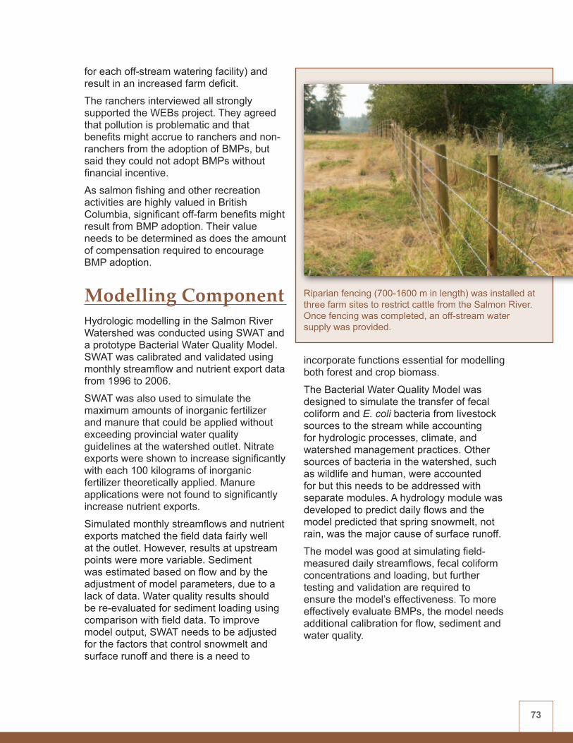
73
for each off-stream watering facility) and result in an increased farm deficit.
The ranchers interviewed all strongly supported the WEBs project. They agreed that pollution is problematic and that benefits might accrue to ranchers and non-ranchers from the adoption of BMPs, but said they could not adopt BMPs without financial incentive.
As salmon fishing and other recreation activities are highly valued in British Columbia, significant off-farm benefits might result from BMP adoption. Their value needs to be determined as does the amount of compensation required to encourage BMP adoption.
Modelling Component Hydrologic modelling in the Salmon River Watershed was conducted using SWAT and a prototype Bacterial Water Quality Model. SWAT was calibrated and validated using monthly streamflow and nutrient export data from 1996 to 2006.
SWAT was also used to simulate the maximum amounts of inorganic fertilizer and manure that could be applied without exceeding provincial water quality guidelines at the watershed outlet. Nitrate exports were shown to increase significantly with each 100 kilograms of inorganic fertilizer theoretically applied. Manure applications were not found to significantly increase nutrient exports.
Simulated monthly streamflows and nutrient exports matched the field data fairly well at the outlet. However, results at upstream points were more variable. Sediment was estimated based on flow and by the adjustment of model parameters, due to a lack of data. Water quality results should be re-evaluated for sediment loading using comparison with field data. To improve model output, SWAT needs to be adjusted for the factors that control snowmelt and surface runoff and there is a need to
incorporate functions essential for modelling both forest and crop biomass.
The Bacterial Water Quality Model was designed to simulate the transfer of fecal coliform and E. coli bacteria from livestock sources to the stream while accounting for hydrologic processes, climate, and watershed management practices. Other sources of bacteria in the watershed, such as wildlife and human, were accounted for but this needs to be addressed with separate modules. A hydrology module was developed to predict daily flows and the model predicted that spring snowmelt, not rain, was the major cause of surface runoff.
The model was good at simulating field-measured daily streamflows, fecal coliform concentrations and loading, but further testing and validation are required to ensure the model’s effectiveness. To more effectively evaluate BMPs, the model needs additional calibration for flow, sediment and water quality.
Riparian fencing (700-1600 m in length) was installed at three farm sites to restrict cattle from the Salmon River. Once fencing was completed, an off-stream water supply was provided.

74
Results Summary TableA summary of the biophysical, economic and modelling results for this watershed are found in Table 8.
ConclusionsThe Salmon River Watershed WEBs project has made significant progress towards a better understanding of the environmental and economic performance of restricted cattle access and off-stream watering, within the watershed’s conditions. These BMPs were shown to significantly improve riparian vegetation while reducing fine-particle sediment and bacterial loading. Water quality nutrient loadings could not be detected under this BMP. Overall findings suggest that fencing and off-stream watering can mitigate cattle impacts on salmon streams.
The economic analysis found fencing and off-stream watering to be too expensive for a struggling ranching industry to bear
without sufficient financial or regulatory incentive.
Hydrologic modelling was initiated successfully for the Salmon River Watershed, using field data from the WEBs study. The models performed well but improvements are expected with the addition of flow, chemistry, bacteria, weather and other field data in the next phase of the project.
Additional data collection and analysis are required in order to gain more confidence in initial findings for all components of the project.
Acknowledgements Additional contributors to this study include: Asit Mazumder and Leon Gaber (University of Victoria), Bruce Roddan (AAFC), Erin Vieira (Fraser Basin Council), Jamie Felhauer and Mike Wallis (Salmon River Watershed Roundtable), Cindy Meays and others (British Columbia Ministry of Environment), the British Columbia Ministry of Agriculture, other members of the Salmon River WEBs Steering Committee, and participating students and producers.
Table 8: Summary of WEBs Salmon River Watershed results (2004/5 - 2007/8)
BMP BIOPHYSICAL FINDINGS
ECONOMIC FINDINGS
HYDROLOGIC MODELLING
Cattle exclusion fencing (and off-stream watering)
• No significant reduction in nutrient loading in the stream
• Significant reduction in fine sediment and E. coli loading in the stream
• Fencing positively affected vegetative cover within the riparian area
• Land-use intensification significantly affects aquatic and riparian health throughout the watershed
• Very costly to install
• Short-term benefits to the landowner appear to be limited
• Financial or regulatory incentive likely required to encourage adoption
• SWAT and a prototype Bacterial Water Quality Model were used to model streamflow and water quality parameters.
• Further testing and validation are required to ensure the models’ effectiveness.
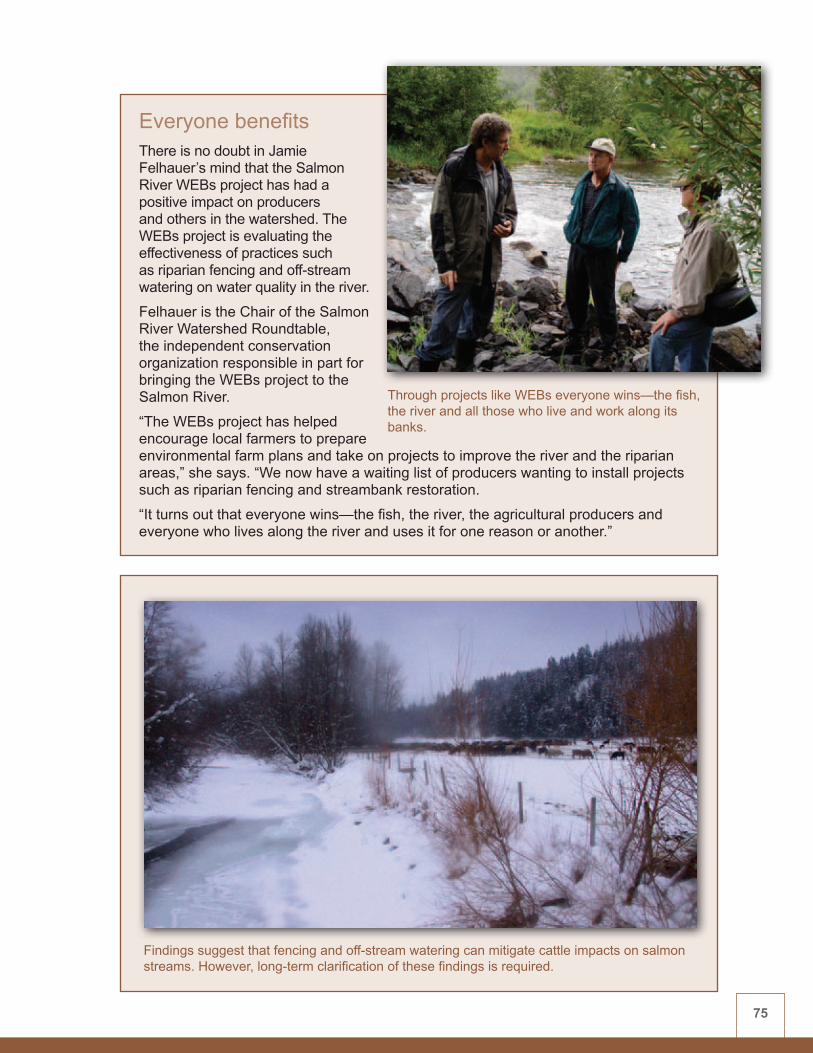
75
Everyone benefits There is no doubt in Jamie Felhauer’s mind that the Salmon River WEBs project has had a positive impact on producers and others in the watershed. The WEBs project is evaluating the effectiveness of practices such as riparian fencing and off-stream watering on water quality in the river.
Felhauer is the Chair of the Salmon River Watershed Roundtable, the independent conservation organization responsible in part for bringing the WEBs project to the Salmon River.
“The WEBs project has helped encourage local farmers to prepare environmental farm plans and take on projects to improve the river and the riparian areas,” she says. “We now have a waiting list of producers wanting to install projects such as riparian fencing and streambank restoration.
“It turns out that everyone wins—the fish, the river, the agricultural producers and everyone who lives along the river and uses it for one reason or another.”
Through projects like WEBs everyone wins—the fish, the river and all those who live and work along its banks.
Findings suggest that fencing and off-stream watering can mitigate cattle impacts on salmon streams. However, long-term clarification of these findings is required.

76
Figure 7: Lower Little Bow River Watershed location map
1.2
Lower Little Bow River Watershed, AlbertaWatershed Lead: Jim Miller (AAFC) Site Economists: Carlyle Ross and Elwin Smith (AAFC) Site Hydrologic Modeller: Michel Rahbeh (University of Alberta)

77
Background and IssuesThe 2,565-hectare Lower Little Bow River Watershed (Figure 7) is located within the larger Oldman River Basin, about 35 kilometres northeast of Lethbridge, in southern Alberta. The watershed is unique because flow in the river is controlled by on-stream irrigation reservoirs and because the local climate is dominated by strong chinook winds. Land use in the encompassing, larger watershed is a mixture of irrigated crops, dryland crops, and cattle grazing on native rangeland.
Since 1999, the Lower Little Bow River Watershed has been studied as part of the Oldman River Basin Water Quality Initiative. Results from this and other studies indicate that nutrients from manure and fertilizers, and bacteria from manure may be affecting water quality in the river. The major water quality contaminants are bacteria, P and, to a lesser extent, N.
Biophysical Component The biophysical component of the study is focused on evaluating the environmental effect of the following five BMPs on water quality:• streambank fencing with a cattle
crossing• off-stream watering without fencing• conversion to perennial cover (alfalfa)• manure management• buffer strips
BMP Description and Results
Streambank fencing with a cattle crossingAn 800-metre reach on either side of the river was fenced to restrict cattle access to the riparian area, leaving one cattle crossing, in order to reduce direct defecation and streambank erosion caused by cattle. Water troughs were installed to provide drinking water for cattle away from the stream. Water quality was monitored both upstream and downstream of the fenced area. A portable apparatus that simulates rainfall (rainfall simulator) was used to generate runoff for this and the four other BMPs tested.
Streambank fencing did not improve the majority of water quality variables in the river. Yet rangeland health and the health of the riparian corridor—a more sensitive indicator than river water quality—was
The dry climate and sandy soils of the Lower Little Bow River Watershed typically generate sporadic runoff. Researchers used a rainfall simulator to collect regular samples.

78
improved. And a cattle-excluded pasture adjacent to the river acted as a riparian buffer by reducing runoff and filtering certain contaminants.
Off-stream watering without fencingOff-stream watering without fencing was studied to determine if water quality problems caused by livestock grazing could be minimized without the expense and maintenance requirements of exclusion fencing. River water quality was evaluated upstream and downstream of the river reach with off-stream watering.
This BMP did not improve the majority of water quality variables in the river. Yet, despite the lack of fencing, the health of the riparian corridor was slightly improved, though the improvement was not as dramatic as with the streambank fencing BMP.
Conversion to perennial cover (alfalfa)Runoff quantity and quality in two fields with a barley (annual crop) and alfalfa (perennial cover) crop rotation were measured to determine whether conversion to perennial cover reduced runoff quantity and contaminants in runoff.
Conversion to alfalfa did not improve runoff water quality. However, many agronomic and environmental factors may have contributed to these results. For example, there is greater surface residue under barley than under alfalfa. As well, unexpected seeding of winter triticale in the barley stubble in one field may have prevented significant water quality improvements. Other environmental factors such as year, time of rainfall simulations, and canopy cover may have also been contributing factors.
Cattle behaviour and fecal pat distribution were monitored before and after implementing the off-stream watering without fencing BMP.

79
Manure managementA field study was conducted to evaluate a P-based manure application system. Previously, manure was applied based on the N requirement of crops. This resulted in P being applied at a rate that allowed accumulation in the soil. This BMP evaluation compared three treatments of manure application based on the annual N uptake of crop, the annual P uptake of crop, and P crop uptake requirements for three years.
Water quality findings were mixed for this BMP. Dissolved P loadings were significantly reduced by manure management but particulate P and total P were not.
Buffer stripsThe effect of planting a vegetative riparian buffer on surface water quality from natural field runoff and rainfall simulations was evaluated. Buffer combinations consisted of: native grass, tame grass and alfalfa, barley (control), and a mixed grass-shrub buffer. Experiments were conducted on three buffer widths (three, six, and nine metres).
Due to minimal sheet runoff (from snowmelt or rainfall) within the Lower Little Bow River basin, results confirmed that buffer strips are generally not required. However, during extreme rainfall events, results indicate that a six-metre buffer may reduce sediment and N loss from fertilized cropland.
Additional Biophysical Studies Since it was expected that water quality change might be difficult to detect, particularly in the short term, several study methods were employed. These methods quantified the effect of BMPs on water quality and other biophysical parameters, and increased knowledge of the effect
of watershed relationships on BMP performance. These studies include:• Riparian health assessment – Six
vegetation factors and five soil and hydrology factors were used to assess riparian health before and after BMP implementation. The riparian area was then classified into one of three categories: healthy, healthy but with problems, and unhealthy. Streambank fencing was found to improve riparian health.
• Rangeland health assessment – Rangeland health was assessed within the grazed (unfenced) and cattle-excluded (fenced) riparian pastures. Streambank fencing that excludes cattle from riparian pastures was found to improve rangeland health.
• Cattle behaviour – Cattle behaviour was observed and fecal pat numbers were measured along the river, both
Rangeland assessments conducted within the WEBs Lower Little Bow River Watershed concluded that pasture health improved after cattle were fenced out.
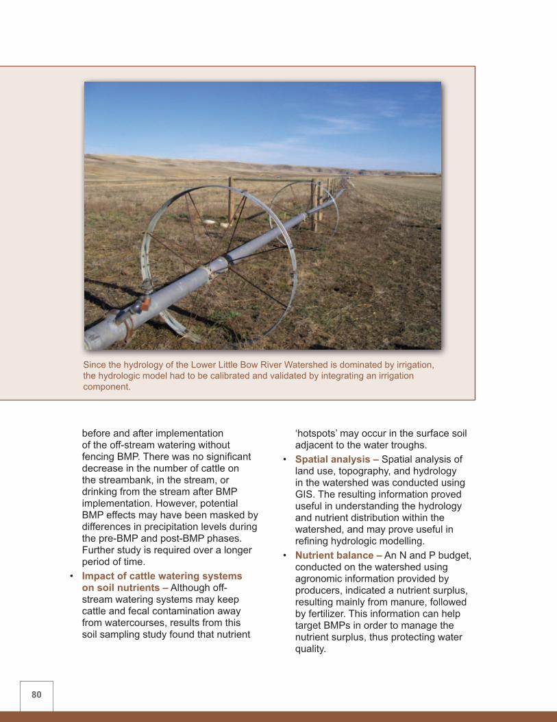
80
before and after implementation of the off-stream watering without fencing BMP. There was no significant decrease in the number of cattle on the streambank, in the stream, or drinking from the stream after BMP implementation. However, potential BMP effects may have been masked by differences in precipitation levels during the pre-BMP and post-BMP phases. Further study is required over a longer period of time.
• Impact of cattle watering systems on soil nutrients – Although off-stream watering systems may keep cattle and fecal contamination away from watercourses, results from this soil sampling study found that nutrient
‘hotspots’ may occur in the surface soil adjacent to the water troughs.
• Spatial analysis – Spatial analysis of land use, topography, and hydrology in the watershed was conducted using GIS. The resulting information proved useful in understanding the hydrology and nutrient distribution within the watershed, and may prove useful in refining hydrologic modelling.
• Nutrient balance – An N and P budget, conducted on the watershed using agronomic information provided by producers, indicated a nutrient surplus, resulting mainly from manure, followed by fertilizer. This information can help target BMPs in order to manage the nutrient surplus, thus protecting water quality.
Since the hydrology of the Lower Little Bow River Watershed is dominated by irrigation, the hydrologic model had to be calibrated and validated by integrating an irrigation component.

81
Economics ComponentA representative cow-calf model and representative feedlot were developed based on typical farms for the region. These benchmark operations were profitable before BMP adoption. Models were used to assess the costs of all but the manure management BMP. The cow-calf farm model indicated that implementation of these BMPs could significantly reduce farm cash flow, depending upon the relative level of water quality protection provided by, for example, varying riparian buffer width.
In the case of off-stream watering and buffer strips, considerable financial incentive would likely be required to encourage adoption. Off-stream watering without fencing is less costly and, with potential on-farm benefits such as increased calf productivity or improved pasture utilization, might require little added incentive to encourage adoption. Conversion from barley cropping to perennial cover (alfalfa) resulted in a slight reduction in farm cash flow and minimal financial or regulatory incentive would likely be required to encourage adoption of this practice.
A non-linear programming model of manure transportation and crop production looked at the costs of applying manure based on crop N requirements, P requirements, and three times the P rate applied every third year. Applying manure targeted to meet crop P requirements was found to be much costlier in terms of transportation costs and crop yield responses. However, applying manure at triple the P rate every third year reduced costs somewhat.
Modelling ComponentHydrologic modelling in the Lower Little Bow River Watershed was conducted using SWAT to simulate outflow from the watershed and to incorporate irrigation from
internal and external sources. Since half of the watershed is irrigated, the model had to be calibrated and validated by integrating an irrigation component. This complicated the modelling process in the short term but will make the model more accurate and realistic for future BMP simulation.
Although data were unavailable to accurately model existing irrigation practices, the model was initially calibrated for three broad-based scenarios:• no irrigation• unlimited irrigation• fixed irrigation
There was a good match between model-predicted outflows and those derived from the recorded flows, but further fine-tuning may be required to more accurately represent the actual physical conditions in the watershed. While modelling results from the first two years of study are promising, additional years of study are needed to account for seasonal and annual variation in climate and flow. With continued monitoring, re-calibration using more accurate data on the source, amount and timing of irrigation, should provide better results.
Sediment and nutrient loadings were not calibrated nor have BMPs yet been evaluated through hydrologic modelling in the watershed. Modelling of irrigation, manure, and fertilizer BMPs is planned for the next phase of WEBs.
Results Summary TableA summary of the biophysical, economic and modelling results for this watershed are found in Table 9.

82
Table 9: Summary of WEBs Lower Little Bow Watershed results (2004/5 - 2007/8)
BMP BIOPHYSICAL FINDINGS
ECONOMIC FINDINGS
HYDROLOGIC MODELLING
Streambank fencing with a cattle crossing (and off-stream watering)
• BMP did not improve the majority of water quality variables in the river
• Improved health of the riparian corridor
• Cattle-excluded pasture acted as a riparian buffer
• Very costly to install
• Short-term benefits to the landowner appear to be limited
• Financial or regulatory incentive likely required to encourage adoption
• SWAT was used to simulate outflow from the watershed and to incorporate irrigation scenarios.
• Sediment and nutrient loadings were not calibrated nor have BMPs yet been evaluated.
• Modelling results are promising and will benefit from forthcoming field data.
Off-stream watering without fencing
• BMP did not improve the majority of water quality variables in the river
• Improved health of the riparian corridor
• Some nutrient enrichment of soil and leaching adjacent to off-stream watering troughs
• Slight reduction in farm cash flow
• Potential uncalculated on-farm benefits (cattle distribution) might off-set costs
• Minimal financial or other incentive likely required to encourage adoption
Conversion to perennial cover (alfalfa)
• No observed improvement in the water quality of surface runoff
• Slight reduction in farm cash flow
• Minimal financial or other incentive likely required to encourage adoption
Manure management • Reduction in dissolved P loadings to surface water
• No reduction in particulate or total P loadings to surface water
• Reduction in net income due to manure transportation costs and reduced-nutrient yield losses
• Costs dependent on N:P ratio of manure application
• Financial or regulatory incentive likely required to encourage adoption
Buffer strips • Generally no observed water quality benefit
• In extreme rainfall events, a six-metre wide buffer may reduce sediment and N loss from fertilized cropland
• Grass buffer resulted in slight reduction in cash flow
• Buffer of shrubs and trees costly to implement and maintain
• Costs will vary with buffer width and desired level of environmental protection
• Financial or regulatory incentive likely required to encourage adoption

83
Conclusions The Lower Little Bow River Watershed WEBs project employed numerous study methods to address the challenges of BMP research at watershed scale. Clear findings on water quality impacts of the BMPs were elusive in many cases, but that is the nature of short-term watershed-scale research. Much was learned about watershed processes in general.
Many factors may have complicated the water quality findings for these BMPs, such as lack of natural runoff, the regulated nature of the Lower Little Bow River, irrigation return flows into the river, contamination of the river by wildlife or other groundwater sources, or the limited number of years of post-BMP evaluation. Riparian health was found to be a more sensitive indicator than river water quality for evaluating cattle exclusion fencing and off-stream watering.
Economic analysis found that all of the BMPs would likely require financial incentive to encourage adoption—although for the off-stream watering without fencing and conversion to perennial cover BMPs, the
level of incentive required may not be as high as for the others due to potential on-farm benefits or lower implementation costs.
Hydrologic modelling was successfully initiated for the project. The model performed well but improvements are expected with the addition of field data in the next phase of the project.
Additional data collection and analysis are required in order to gain more confidence in initial findings for all components of the project.
Acknowledgements Additional contributors to this study include: Tony Curtis, Dennis Lastuka, Murray Lewis and Walter Willms (AAFC); Andrea Kalischuk, Barry Olson and Janelle Villeneuve (Alberta Agriculture and Rural Development); Dwayne Rogness (County of Lethbridge); Kim Schmitt (Ducks Unlimited Canada); Shane Petry (Fisheries and Oceans Canada); David Chanasyk (University of Alberta); other members of the Lower Little Bow River WEBs Steering Committee, and participating students and producers.
It’s the neighbourly thing to do As far as the Turin Hutterian Brethren Colony is concerned, improving water quality in the Lower Little Bow River is just the neighbourly thing to do.
“We felt it was important to do our part to improve water quality in the river,” says a spokesperson for the Colony, “not just for our benefit, but also for the benefit of everyone downstream.”
The Colony is just one of many producers who rely on the Lower Little Bow River to provide water for their livestock and other needs on the farm. Through the Lower Little Bow River WEBs project, the Colony has installed an off-stream watering system for cattle, fenced off a portion of the riparian area along the river and has converted some cropland to perennial cover, all to reduce nutrient loading in the river.
Credit: D. Rogness, County of Lethbridge

84
Figure 8: South Tobacco Creek/Steppler Watershed location map
1.3
South Tobacco Creek/Steppler Watershed, ManitobaWatershed Lead: Jim Yarotski (AAFC) Site Economist: Mohammad Khakbazan (AAFC) Site Hydrologic and Integrated Modeller: Wanhong Yang (University of Guelph)

858 Lake Winnipeg Action Plan (2003) http://www.gov.mb.ca/waterstewardship/water_quality/lake_winnipeg/action_plan.html
Background and Issues The 206-hectare Steppler micro-watershed is located within the 7,600-hectare South Tobacco Creek Watershed (Figure 8) southwest of Winnipeg, Manitoba, near the town of Miami. The Steppler study is unique because it is contained within a single farming operation. Land use within the larger South Tobacco Creek Watershed is agricultural, with 71 percent of the land under annual crop production. Wheat and canola are the two dominant crops in the area with noticeable increases in oats, canola, and forage production in recent years.
The South Tobacco Creek drains into the Morris River and eventually into the Red River, which then flows north into Lake Winnipeg. Nutrient loading from small watersheds such as South Tobacco Creek can potentially contribute to cumulative nutrient loads in the larger downstream Red River and Lake Winnipeg ecosystems.
The Government of Manitoba has committed8 to reducing the amount of N and P entering Lake Winnipeg to pre-1970s levels. Much of this reduction must come from non-point sources upstream in the watershed.
Effective BMP validation may have a significant impact on where and how efforts to reduce this loading should be focused. Hence, the selection of BMPs for this study was based on their suitability within the local landscape and on whether producers would be likely to accept and adopt them.
The watershed has been the focus of scientific studies for more than 15 years, resulting in a valuable set of baseline agronomic and environmental data.
Biophysical Component The biophysical component of the study is focused on evaluating the environmental effect of the following five BMPs on water quality:• Conversion to perennial cover (grass/
alfalfa mix) • Riparian harvesting (grazed versus
mechanical)• Holding pond (cattle containment runoff) • Small reservoirs • Zero (conservation) tillage versus
conventional tillage
BMP Description and Results
Conversion to perennial cover (grass/alfalfa mix)The impact on water quantity and quality from converting cultivated land to forage was assessed using a twin watershed approach for two pairs of sub-watersheds. Two fields were left in annual cultivation and two fields were converted to forage.
While assessment of this BMP is incomplete due to insufficient data, a trend towards decreased runoff and dissolved N from forage fields has been noted. Nevertheless, the concentration of N and P in runoff from the forage, as well as the cropped fields, remained above water quality guidelines for the protection of aquatic ecosystems.
Riparian harvesting (grazed versus mechanical)Runoff and nutrient loading from differently managed riparian areas of two sub-watersheds was compared. One riparian area had a rotational grazing plan, with the cattle kept out of the sub-watershed after mid-August. The other, having no cattle
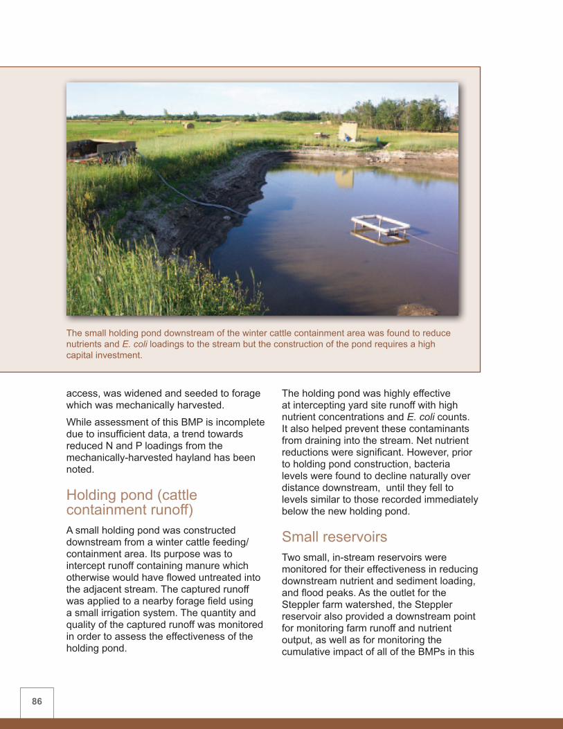
86
access, was widened and seeded to forage which was mechanically harvested.
While assessment of this BMP is incomplete due to insufficient data, a trend towards reduced N and P loadings from the mechanically-harvested hayland has been noted.
Holding pond (cattle containment runoff)A small holding pond was constructed downstream from a winter cattle feeding/containment area. Its purpose was to intercept runoff containing manure which otherwise would have flowed untreated into the adjacent stream. The captured runoff was applied to a nearby forage field using a small irrigation system. The quantity and quality of the captured runoff was monitored in order to assess the effectiveness of the holding pond.
The holding pond was highly effective at intercepting yard site runoff with high nutrient concentrations and E. coli counts. It also helped prevent these contaminants from draining into the stream. Net nutrient reductions were significant. However, prior to holding pond construction, bacteria levels were found to decline naturally over distance downstream, until they fell to levels similar to those recorded immediately below the new holding pond.
Small reservoirsTwo small, in-stream reservoirs were monitored for their effectiveness in reducing downstream nutrient and sediment loading, and flood peaks. As the outlet for the Steppler farm watershed, the Steppler reservoir also provided a downstream point for monitoring farm runoff and nutrient output, as well as for monitoring the cumulative impact of all of the BMPs in this
The small holding pond downstream of the winter cattle containment area was found to reduce nutrients and E. coli loadings to the stream but the construction of the pond requires a high capital investment.
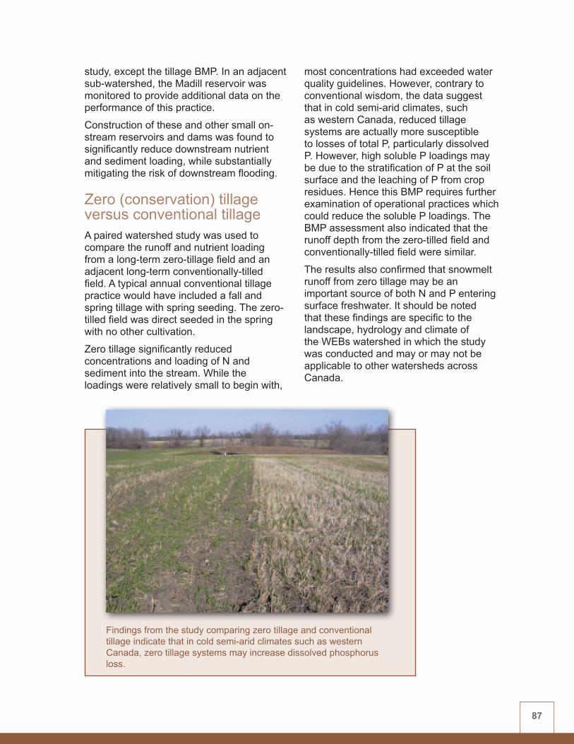
87
study, except the tillage BMP. In an adjacent sub-watershed, the Madill reservoir was monitored to provide additional data on the performance of this practice.
Construction of these and other small on-stream reservoirs and dams was found to significantly reduce downstream nutrient and sediment loading, while substantially mitigating the risk of downstream flooding.
Zero (conservation) tillage versus conventional tillage A paired watershed study was used to compare the runoff and nutrient loading from a long-term zero-tillage field and an adjacent long-term conventionally-tilled field. A typical annual conventional tillage practice would have included a fall and spring tillage with spring seeding. The zero-tilled field was direct seeded in the spring with no other cultivation.
Zero tillage significantly reduced concentrations and loading of N and sediment into the stream. While the loadings were relatively small to begin with,
most concentrations had exceeded water quality guidelines. However, contrary to conventional wisdom, the data suggest that in cold semi-arid climates, such as western Canada, reduced tillage systems are actually more susceptible to losses of total P, particularly dissolved P. However, high soluble P loadings may be due to the stratification of P at the soil surface and the leaching of P from crop residues. Hence this BMP requires further examination of operational practices which could reduce the soluble P loadings. The BMP assessment also indicated that the runoff depth from the zero-tilled field and conventionally-tilled field were similar.
The results also confirmed that snowmelt runoff from zero tillage may be an important source of both N and P entering surface freshwater. It should be noted that these findings are specific to the landscape, hydrology and climate of the WEBs watershed in which the study was conducted and may or may not be applicable to other watersheds across Canada.
Findings from the study comparing zero tillage and conventional tillage indicate that in cold semi-arid climates such as western Canada, zero tillage systems may increase dissolved phosphorus loss.
88
Specific Biophysical MethodsIt was expected that water quality change might be difficult to quantify for some BMPs, particularly in the short term. To better assess the BMP impact, it was important to understand the nutrient cycle and the processes that may contribute nutrients to the runoff. Various sampling and analytical methods were employed to quantify the effect of BMPs on water quality and to better understand the effect of watershed relationships on BMP performance. These methods, in addition to runoff sampling and monitoring, have enhanced project findings and include:• Residue sampling – Residue sampling
was carried out on several fields to assess the potential impact it may have on runoff after undergoing a freeze-thaw process. Results confirmed that freeze-thaw cycles during prairie winters and springs could favour the release of soluble P from plant residues. This soluble P can remain on the soil surface, leach into the soil column or be picked up by the surface runoff. This may lead to substantial nutrient loadings to runoff from practices such as zero tillage.
• Soil sampling – Soil sampling was carried out on the various fields to track changes in the fertility levels resulting from the introduction of BMPs. The zero-tilled field showed increases in the dissolved P levels.
• Snow sampling – Snow sampling and surveys were carried out for several fields. The results indicate that less than 10 percent of the nutrient loading found in the runoff can be attributed to snow.
• Climate data – A limited amount of enhanced climate data (including rainfall and air temperature at five-minute intervals) were collected. This information helped improve understanding of the hydrologic cycle and its impact on the nutrient runoff.
Economics ComponentEnterprise farm budgets and yield and cost functions were developed for the South Tobacco Creek Watershed in order to conduct an economic analysis of the five BMPs. Financial information from 35 farms (354 fields) was scaled up to the level of three representative farms (200, 400, and 800 hectares).
It is apparent that the BMPs investigated will likely require financial or regulatory incentive to encourage their adoption. Converting annual crops to forage has increased net income due to lower input costs. But this is an initial analysis that has not yet accounted for livestock income and its associated costs, nor the potential cost of using highly productive soils to grow forages. Where riparian areas were grazed by cattle versus mechanical harvesting, the high cost of fencing and the loss of farmland for buffer strips are both impediments to BMP adoption. As well, holding pond construction requires high initial capital investment and the downstream benefits need to be further quantified. On the other hand, benefits from small dam construction should generate enough value to make the network of small dams on the South Tobacco Creek economically viable.
For the zero versus conventional tillage BMP, data on tillage practices in the watershed dating back to 1998 were reviewed in order to derive net income and yield information for the two practices. Results were inconclusive at the field level, yet when scaled up to the farm level, net revenues for cereal crops were increased under zero tillage whereas canola yields were higher under conventional tillage. On average, zero tillage produced only slightly better economic return over the conventional tillage system. Farmers in the watershed prefer conventional tillage due to the increased machinery investment required for zero tillage, which they felt was not warranted.

89
Modelling ComponentModellers in the South Tobacco Creek Watershed input long-term agronomic and environmental data into SWAT to model flow, sediment and nutrient processes. Data from monitoring stations in the Steppler sub-watershed were used to evaluate the effects of the BMPs. This is one of the few modelling studies in WEBs that has been able to use local field data, rather than simulated data, to evaluate BMPs. BMP-specific modules were developed in SWAT or in conjunction with other models.
SWAT simulated streamflow, sediment and nutrient loads at the watershed outlet. The results of model calibration and validation demonstrate that SWAT can represent the hydrologic processes in the South Tobacco Creek Watershed and can reproduce the flow and pollutant loading at both the sub-basin and watershed levels. Modelling results at the South Tobacco
Creek Watershed outlet were very good, but results for the upstream sub-watersheds need improvement. The assessment of BMPs appears to be good at the larger watershed scale but needs improvement at the sub-watershed scale. Further modelling work is planned for the next phase of WEBs.
The South Tobacco Creek Watershed was one of two WEBs project sites where integrated hydrologic-economic modelling occurred. The socio-economic factors that might affect producers’ decisions to adopt BMPs were also examined. These studies are described in more detail in Chapter 5.
Results Summary TableA summary of the biophysical, economic and modelling results for this watershed are found in Table 10.
The Steppler reservoir was one of two small dams monitored for their effectiveness in reducing downstream nutrient and sediment loading.

90
Table 10: Summary of WEBs South Tobacco Creek Watershed results (2004/5 - 2007/8)
BMP BIOPHYSICAL FINDINGS ECONOMIC FINDINGS HYDROLOGIC
MODELLING
Conversion to perennial cover (grass/alfalfa mix)
• Concentration of N and P in runoff from both cropped and forage fields exceeded water quality guidelines
• Trend towards decreased runoff and dissolved N loadings from forage fields to the stream
• Increased income due to lower input costs
• Have not yet assessed potential livestock income and costs
• Financial or regulatory incentive may be required to encourage conversion on highly productive soils
• Local agronomic and environmental data were input into SWAT to model flow, sediment and nutrient processes and to evaluate BMP effects.
• Modelling results at the South Tobacco Creek Watershed outlet were very good but results for upstream sub-watersheds need improvement.
Riparian harvesting (grazed versus mechanical)
• Trend towards reduced N and P loadings from mechanically-harvested hayland to the stream
• High fencing capital costs
• Loss of farmland, due to buffer needs (livestock not assessed)
• Financial or regulatory incentive likely required to encourage adoption
Holding pond (cattle containment runoff)
• Significant reduction (10-27%) in sediment and nutrient loadings to the stream
• High initial capital investment
• Direct and indirect benefits have yet to be determined
• Financial or regulatory incentive likely required to encourage adoption
Small reservoirs • Significant reduction (10-17%) of downstream nutrient loading in the stream
• Significant reduction (72%) of downstream sediment loading in the stream
• Significant reduction (30-40%) of downstream spring and summer flood peaks
• High initial capital investment
• Public benefits have yet to be valued
• Financial or regulatory incentive likely required to encourage adoption
Zero (conservation) tillage versus conventional tillage
Zero tillage resulted in:
• Significant reduction of sediment (65%) and N loading (68%) to the stream
• Significant increase (12%) of dissolved P concentrations to the stream
• No significant difference in total field runoff
• High initial investment for zero tillage equipment
• Returns from zero tillage are limited and crop dependent
• Economic returns improve as tillage frequency decreases
• Financial or regulatory incentive likely required to encourage adoption of zero tillage

91
ConclusionsThe South Tobacco Creek/Steppler Watershed WEBs project has contributed valuable knowledge regarding environmental and economic performance of the BMPs in the watershed. While the biophysical assessment is incomplete for most of the BMPs due to insufficient data collection, preliminary results from several BMPs point to water quality improvements.
Economic analysis in the South Tobacco Creek Watershed found all but one of the BMPs to be costly and all of them likely require financial or regulatory incentive to encourage producers to adopt them.
Hydrologic modelling was successfully initiated in the watershed and benefitted from local long-term agronomic and environmental data, rather than a reliance on literature-derived or model-simulated values. The South Tobacco Creek Watershed was one of two WEBs watersheds where an integrated hydrologic-
economic modelling pilot project was conducted (see Chapter 5).
Additional data collection and analysis are required in order to gain more confidence in initial findings for all components of the project.
Acknowledgements Additional contributors to this study include: Jane Elliott (Environment Canada); Don Flaten, David Lobb and Kevin Tiessen (University of Manitoba); David Green (Manitoba Water Stewardship); Yongbo Liu (University of Guelph); Bill Turner (Deerwood Soil and Water Conservation Association); Dale Timmerman and Cliff Hamilton (AAFC); Mike Stainton (Fisheries and Oceans Canada); Dana Hill and Marla Riekman (Manitoba Agriculture, Food and Rural Initiatives); Pascal Badiou (Ducks Unlimited Canada); and participating students and producers.
Phosphorus comes from the landscapeDale Steppler does not claim to be an explorer. But he has certainly made a discovery.
“Agriculture has been fingered as the culprit for contributing phosphorus to the environment,” says Steppler, whose farm comprises the entire South Tobacco Creek/Steppler WEBs project. “But it turns out that is not the complete story.
“Dissolved phosphorus is released from dead plant material in cropland, ditches, woodlots and wetlands, and enters the water that way. It comes from the entire landscape, not just farmland.”
Steppler feels that revelations through WEBs about the sources and movement of phosphorus are a great discovery, as far as farmers go.
“If that’s all we learn from this project, it will be worth it!”
Credit: B. Turner, Deerwood Soil and Water Management Association Producers Dale and Caroline Steppler.
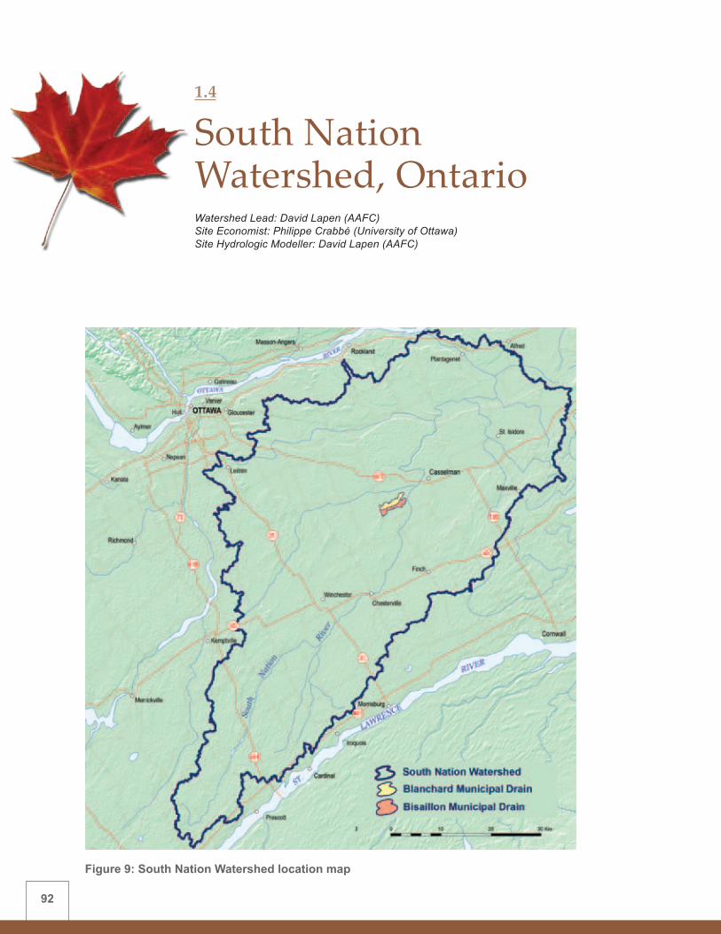
92
Figure 9: South Nation Watershed location map
1.4
South Nation Watershed, OntarioWatershed Lead: David Lapen (AAFC) Site Economist: Philippe Crabbé (University of Ottawa) Site Hydrologic Modeller: David Lapen (AAFC)

93
Background and IssuesEastern Ontario’s South Nation River drains approximately 3,900-square-kilometres of land from its headwaters just north of the St. Lawrence River near the city of Brockville, northward to where it joins the Ottawa River near the community of Plantagenet. The South Nation Watershed (Figure 9) is a highly productive agricultural region. Approximately 60 percent of the watershed is farmed—with a mix of livestock and cash crop production, mostly on flat, tile-drained fields.
Nutrient and bacterial contamination of the South Nation River and its tributaries has been linked to agricultural activities.
Within the South Nation Watershed, two adjacent paired micro-watersheds (the 480-hectare Blanchard and the 230-hectare Bisaillon municipal drains) were employed to evaluate the effectiveness of two BMPs. These micro-watersheds feature the kind of agricultural-based activities typically found throughout Eastern Ontario.
Biophysical Component The biophysical component of the study is focused on evaluating the environmental effect of the following two BMPs on water quality:• Controlled tile drainage• Cattle exclusion fencing (and off-stream
watering)
BMP Description and Results
Controlled tile drainageMost fields in Eastern Ontario have tile drainage, which is a network of perforated pipes installed below ground that drain
groundwater to prevent the soil from being too wet for crop growth. Controlled tile drainage features structures that block the outlet pipes, thus keeping the groundwater and its nutrients in the field to benefit crop growth, while preventing excess nutrients from flowing into adjacent watercourses.
In early spring, the control structures on the tile outlets are left open to permit free drainage and allow for improved soil aeration until after field operations (i.e., planting), or until after crops are adequately established. The control structures within the ‘test’ watershed are then closed to restrict drainage. The effects of controlled drainage are studied primarily through assessment of N balances, crop performance, and soil/groundwater hydrology. The impact on surface water quality is monitored both at the edge-of-field (tile outlet) as well as along the stream, including the micro-watershed outlet. The Blanchard drain served as a BMP test watershed, while the Bisaillon served as a control watershed.
The effects of controlled tile drainage were monitored on eight different fields. This BMP was found to significantly reduce the loss of ammonium, nitrate and P from tile drain outlets during the growing season. Ammonium, nitrate, and total P loads for corn fields under controlled tile drainage were reduced on average by 50, 62, and 66 percent, relative to conventionally drained fields under similar cropping management (2005-07). N uptake by corn under controlled tile drainage increased significantly relative to uncontrolled tile drainage. As well, total growing season groundwater nitrate and ammonium loss from controlled tile drainage fields were only around 10 percent of those from uncontrolled fields. Identification of the impact of the tile drainage BMP on micro-watershed water quality will require several more years of study.

94
Cattle exclusion fencing (and off-stream watering)A pasture within the Blanchard watershed was sub-divided into an ‘above-and-below’ (upstream versus downstream) watershed fencing design. For the ‘above’ treatment, pastured livestock were excluded from the stream using fencing, whereas for the downstream or ‘below’ treatment, livestock had unrestricted access to the stream. The fencing created a minimum three-metre buffer strip between the stream and adjacent pasture areas. Pasturing density for both treatments were 2.5 head per hectare (a density common in the region). Measurements included stream input and output water quality, and other microbiological and nutrient indicators for each site. Additional methods were used to verify fecal sources.
Most of the time, cattle exclusion significantly reduced loads in the upstream, treated portion of the study for all N, P, and microorganisms (except fecal coliforms), relative to those associated with the downstream, unrestricted cattle pasture. However, the results were not always consistent, depending on streamflow. In addition to reducing upstream loads, there was a documented improvement in the health of riparian vegetation, associated wildlife habitat, and stream morphology. Research will continue in order to strengthen confidence in the findings.
Additional Biophysical StudiesSince it was expected that water quality change might be difficult to detect, particularly in the short term, several study methods were employed. These methods quantified the effect of BMPs on water quality and other biophysical parameters, and increased knowledge of the effect of watershed relationships on BMP performance. These studies include:
• Greenhouse gases – Measurement of greenhouse gas emissions found that most of the time there was no significant difference in nitrous oxide emissions among fields under controlled and conventional tile drainage.
• Remote sensing – Satellite remote sensing and field yield information generally indicated statistically higher and more spatially-uniform vegetation indices. These indices were associated with corn and soybean under controlled tile drainage, relative to conventional tile drainage. Modest yield improvements within the watershed were also identified.
• Nitrogen isotopic signatures – Isotopic signatures were examined to evaluate N recycling in fields with controlled or uncontrolled tile drainage. N was found to reside longer in the groundwater in controlled tile drainage fields indicating that the BMP reduced nitrate export to surface waters.
• NMAN (Nutrient Management Program) – NMAN is a decision-support tool that predicts nutrient generation and determines land base requirements for agronomic use of nutrients. A ‘Phosphorus Index’ identifies minimum recommended separation distances from watercourses and a ‘Nitrogen Index’ identifies risk factors of N movement to groundwater. This tool was found to be helpful in predicting where best to minimize nutrient usage in the watershed.
• Microbial source tracking – Using microbial source tracking, livestock were identified as the primary source of E. coli in surface waters in the watershed, while parasites were often associated with wildlife. On average, the highest nutrient and bacteria loads came from upstream of both pasturing treatments, suggesting that fecal loading due to upstream manure application may be more important than those loadings induced by light pasturing operations.

95
Economics Component The South Nation economic analysis used enterprise farm budgets and provincial budgets to assess the pre-BMP financial position of farmers in the study area and the on-farm costs of BMP implementation. These tools determined whether the farming operation could bear the cost of implementing the BMPs. A survey of local landowners was conducted to obtain on-farm financial information.
The South Nation economics study was one of the few WEBs projects that found positive economic benefits accruing from adoption of a BMP. Modest yield increases over the limited time span of the study (2005-08)
averaged six percent for corn and four percent for soybeans. In most years, yield increases due to controlled tile drainage were more than enough to cover the installation and operating costs of control structures, indicating that these costs would be fully recovered in three or four years.
On the other hand, cattle exclusion fencing was costly to install and maintain (ranging from $9-$25/metre, depending on the type of fencing). Mixed farms in the region have low financial returns and, although dairy farms may be more profitable, these often do not perceive the need to exclude cattle from riparian areas. Thus, financial or regulatory incentive would likely be required to encourage adoption of this BMP.
Cattle exclusion fencing was generally found to reduce loads of N, P and micro-organisms compared to the unrestricted cattle pasture.

96
Modelling ComponentHydrologic modelling was conducted in the South Nation Watershed using one-dimensional (1-D) soil-water flow models. These models characterized tile flow processes and tile drainage management impact on those processes, and modelled tile drain pesticide loads and concentrations. This approach was taken in view of the high percentage of tile-drained land in the area, and the propensity for drainage waters to move vertically through the soil rather than drain the surface of local fields. The 1-D models were evaluated for their ability to predict the impact of controlled tile drainage under a variety of weather, soil, and crop management scenarios.
Input data included weather, land management, and soil physical properties. Modifications were also made to incorporate
the controlled tile drainage BMP and to account for the behaviour of pesticides during rapid flow conditions.
Tests were conducted in Sweden, where the model was developed, using one of the modified models on a test Swedish data set. Modelled scenarios were run on conventional drainage, year-long controlled tile drainage, and controlled tile drainage during the growing season only. The same model, using Swedish data, was also applied to Ontario.
Model simulations demonstrated the impact of the controlled tile drainage BMP on drain flow and pesticide concentrations. One notable result was a rapid decline of drain flow after a rain event. This information contributed to a greater understanding of the performance of the BMP. Further model development is planned for the next phase of WEBs.
The cattle exclusion fencing BMP has not been modelled.
Results Summary TableA summary of the biophysical, economic and modelling results for this watershed are found in Table 11.
ConclusionsControlled tile drainage shows both environmental and economic benefits. This is significant in an area where tile drainage is a common practice. Consequently, it should take very little incentive (perhaps only technology transfer) to induce local landowners to incorporate the practice. On the strength of the WEBs research, South Nation Conservation Authority has recently included controlled tile drainage as a BMP eligible for cost sharing in its Clean Water Program. And the Ontario government has added the practice to its list of approved
Yield increases due to controlled tile drainage were more than enough to cover the installation and operating costs of the control structures. As this BMP shows both environmental and economic benefits, it should require very little incentive to encourage adoption by local landowners.

97
Table 11: Summary of WEBs South Nation Watershed results (2004/5 - 2007/8)
BMP BIOPHYSICAL FINDINGS ECONOMIC FINDINGS HYDROLOGIC
MODELLING
Controlled tile drainage
• Trend towards improved surface water quality between the control and test sub-watersheds
• Significant reductions of ammonium, nitrate and P loading in the stream
• Profitable due to increased corn and soybean yields
• Control structure could pay for itself in three or four years
• A one-dimensional soil-water flow model characterized tile flow processes and their impact on such things as pesticide content.
• The model was evaluated for a variety of weather, soil, and crop management scenarios.
• The modified model fostered greater understanding of the performance of this BMP.
• The cattle exclusion fencing BMP was not modelled.
Cattle exclusion fencing (and off-stream watering)
• Significant reductions of nutrient and bacteria loads in the stream were generally observed for restricted pasture, relative to unrestricted pasture which was located downstream of restricted pasture
• Improved riparian vegetation growth, wildlife habitat, and stream morphology
• Page wire fencing very costly
• Installation and maintenance cost of watering system is low
• Short-term benefits to the landowner appear to be limited
• Mixed farms in the region have low financial returns, and dairy farms do not see the need for cattle restriction
• Financial or regulatory incentive likely required to encourage adoption
The tile drainage underlying much of the WEBs project site in the South Nation Watershed empties into a series of ditches and municipal surface drains.

98
A win-win situation Easy on the environment, easy on the pocketbook. That’s what research in the South Nation WEBs project is proving when it comes to the practice of controlled tile drainage.
“The agronomic benefits of managing tile drainage are immediately apparent,” says Mark Sunohara, South Nation project manager. “Controlling the water table has reduced nutrient loading of surface waters while at the same time, increasing yields in corn and soybean crops.
“The water level control structures are easy to install and relatively inexpensive,” he says. “So, the yield increases, over just a few years, even though they are modest, have translated into a payback period for retrofitting the system.”
When environmental solutions contribute to on-farm profits, it’s a win-win situation for everyone. And at the end of the day, that’s an objective worth working towards.
South Nation Conservation’s Mark Sunohara operates a soil moisture meter.
BMPs—further clarifying that such findings are relevant and valued.
The cattle exclusion fencing BMP generally showed significant reduction of nutrient and bacteria loading in the upstream, treated portion of the study. It also improved or increased riparian habitat. However, this BMP is expensive and may require financial or regulatory incentive to ensure its adoption. Research will continue into the water quality and other environmental impacts of this BMP.
Hydrologic modelling of the controlled tile drainage BMP was initiated in the watershed and will continue in the next phase of WEBs.
Additional data collection and analysis are required in order to gain more confidence in initial findings for all components of the project.
Acknowledgements Additional contributors to this study include: Mark Sunohara (South Nation Conservation Authority), Ed Topp and Harvey Clark (AAFC), Marie-Pier Martin (University of Ottawa), other members of the South Nation WEBs Steering Committee, and participating students and producers.

99
Figure 10: Bras d’Henri and Fourchette Watersheds location map
1.5
Bras d’Henri and Fourchette Watersheds, QuebecWatershed Lead: Eric van Bochove (AAFC) Fourchette Watershed Lead: Aubert Michaud (IRDA) Site Economists: Paul Thomassin (McGill University) and Bruno Larue (Université Laval) Site Hydrologic and Integrated Modeller: Alain N. Rousseau (INRS)

100
Background and IssuesThis study comprises two sets of twin micro-watersheds (approximately 300 hectares each); one pair in the Bras d’Henri Watershed and the second pair in the Fourchette Watershed (Figure 10). Each set has an intervention micro-watershed, where BMPs were implemented, and a control micro-watershed, where no WEBs BMPs were implemented.
The Bras d’Henri River, which drains a 167-square-kilometre area, originates in the foothills of the Appalachian Mountains and flows through the fertile St Lawrence Lowlands in the Beaurivage sub-watershed of the Chaudière River. This sub-watershed supports one of the highest concentrations of livestock production in Quebec, and nearly two-thirds of the area is cultivated.
The Fourchette feeder is part of the Le Bras Watershed (drainage area 222 square kilometres), a tributary of the Etchemin River. Water quality within the Etchemin
River Watershed ranks as the second poorest in Quebec in terms of its P load.
The Bras d’Henri and Fourchette Watersheds are a rich source of existing data on water quality, soil quality and agricultural management practices. The selection of the Bras d’Henri intervention and control micro-watersheds was based on a comparison of hydrological and geophysical parameters, including topography, land use and pedology.
The Fourchette twin watersheds study, administered by the Research and Development Institute for the Agri-Environment (l’Institut de recherche et de développement en agroenvironnement - IRDA), has been underway since 2001. Since it was an established watershed study, with a very similar mandate to that of the Bras d’Henri WEBs project, the two studies were linked under the WEBs umbrella. AAFC manages the Bras d’Henri project and IRDA continues to manage the Fourchette project.
The Bras d’Henri Watershed is situated in one of the most intensively-farmed regions in Quebec.

101
Biophysical Component The biophysical component of the study is focused on evaluating the environmental effect of the following four BMPs on water quality:• Surface runoff control• Crop rotation• Hog slurry management• Reduced herbicide use
BMP Description and Results
Surface runoff controlA number of erosion and surface runoff measures were implemented to reduce sediment and contaminant transport from agricultural soils to ditches and streams. These included riparian buffer strips, side slope reduction of stream and ditch banks, stabilizing tile drain outlets, and establishing grassed waterways and filter trenches.
This suite of BMPs was found to improve overall water quality in the Fourchette Watershed. However, since BMPs were established in the Bras d’Henri Watershed more recently, long-term evaluation is required to determine their impact on water quality.
Crop rotationLong-term corn rotations can have negative impacts on water quality due to soil erosion and compaction. Including perennials in the crop rotation minimized the effect of nutrient loading at the farm scale. However, it proved difficult to assess the crop rotation impact at the small watershed scale. This is because local producers develop crop rotation strategies to encompass their entire farming operation, which is often larger than project watershed boundaries.
Hog slurry managementIn high-density hog operations, N losses from manure to the atmosphere and from runoff can be excessive. In order to reduce these losses, hog manure slurry was applied to forage and corn crops with a spreader equipped with trailing pipes or hoses, shortly followed by shallow cultivation. Slurry was also applied to post-emergent crops, to optimize P and N uptake and further reduce the risk of water and air pollution.
This BMP was found to consistently reduce N and fecal coliform contamination of the stream. It was also found to reduce N and P losses from surface runoff in some years. However, residual soil P was increased by this practice. The mixed results for this BMP indicate the need to better address nutrient reduction at the source, using such techniques as precision animal feeding or slurry tank management to separate nutrient phases.
While not quantified, odour reduction was a noted by-product of manure spreading with trailing hoses. This BMP has yet to be adapted to a wide range of soil and slope conditions.
Reduced herbicide useThe reduced herbicide use BMP targeted corn and soybean crops. Weed control in these wide-spaced row crops is intensive and herbicide use is widespread. Several approaches were investigated. The first approach consisted of testing an AAFC-developed herbicide reduction decision-support system. Other approaches included sprayer calibration, mechanical versus chemical weed control, and reducing herbicide application rates on specific fields. As well, weed surveys coupled with a new web tool (developed by the provincial government) allowed for a recommended herbicide application package projected at having a lower environmental impact.

102
After two years of testing, it became evident that the AAFC-based decision-support system was not appropriate to the study area due to high weed pressure on the crops. Consequently, this approach was abandoned for this study. Other techniques, such as sprayer calibration, reducing herbicide application rates, and the use of less toxic herbicides were implemented in 2007 and require more study time to measure their effect. Since the transition to mechanical weeding requires a major change in producer operations, this BMP also could not be implemented in such a short time. Participating producers are considering this option for the future.
Additional Biophysical StudiesSince it was expected that water quality change might be more difficult to detect for some BMPs than others, particularly in the short term, several study methods were employed. These methods quantified the effect of BMPs on water quality and other biophysical parameters, and increased knowledge of the effect of watershed relationships on BMP performance. These studies include:• Site soil characterization – Four
existing soil surveys (1:50 000 to 1:63 360 scale) were used to identify the twin micro-watersheds for the WEBs Bras d’Henri study and to help identify and implement appropriate BMPs. However, when more detailed soil surveys (1:20 000 scale) were conducted after the BMPs had been implemented, they revealed far greater differences in soil characteristics and agronomic potential between the micro-watersheds than was initially evident. This new information better explains how site soil conditions and their impact on nutrient transport to streams can influence effective BMP implementation and BMP performance.
• Snowmelt effects characterization – Both watersheds were also studied to characterize how snow cover interacts with frozen soils and areas at risk for soil erosion during snowmelt. Results demonstrated that the timing of nutrient and sediment transport was related to seasonal climate and hydrology and that snowmelt was a significant contributor to nutrient loading. BMPs mainly target nutrient losses during the crop season, but suites of BMPs should be structured to be effective during the most critical hydrological periods (snowmelt runoff) of the year.
• National Agri-Environmental Standards Initiative (NAESI) – This joint Environment Canada-AAFC initiative developed surface water quality standards for agricultural watersheds. NAESI used the water quality monitoring stations in the Bras d’Henri Watershed to help develop standards for waterborne pathogens and pesticides.
• National Agri-environmental Health Analysis and Reporting Program (NAHARP) – NAHARP’s goal is to develop a set of national indicators relating to sustainable agriculture. Within the Bras d’Henri WEBs site, water samples were collected bi-weekly and during precipitation events in order to define baseline conditions for pathogens and other variables in agricultural watersheds. These data contributed to the evaluation of potential indicators of microbial pathogens.
Economics Component Results of two economic studies conducted within the Bras d’Henri Watershed will help policy developers determine incentives that might encourage producers to implement BMPs.
One study, by the Université Laval team, who used an econometric analysis, looked at farm characteristics that might

103
influence farmers to adopt selected BMPs. It was found that larger farms were more likely to adopt BMPs. Therefore, if water quality impacts correlate with large farm size, water quality may show significant improvement even though the number of farmers adopting the BMP is low. A demographic breakdown indicates that older producers are more likely to implement buffer strips, crop rotations and solid manure management. Women, educated producers and those who reside on the farm were more likely to adopt solid and liquid manure management practices. Members of environmental clubs were also more likely to adopt herbicide controls and solid manure management.
In terms of farm production, the Laval team used a cost function approach to look at the relationship of ‘good’ outputs (i.e., crops and livestock) to ‘bad’ outputs (i.e., water quality degradation). Using simulated agro-chemical runoff values generated by the GIBSI model to represent bad outputs, results suggest that they are costly to
reduce. Larger crop-producing farms tend to face lower pollution abatement costs while the opposite was found for larger livestock farms.
The McGill University team worked at both the farm and watershed scales, using an ’inter-regional’ economic optimization model developed from environmental loading coefficients estimated by the GIBSI model. The model was applied to 65 farms in the Bras d’Henri Watershed to estimate the amount of pollutants the farms and the watershed produced, the maximum possible reduction of pollution, and the associated costs at the farm and watershed scales. The model assumed that producers would use the least costly combination of BMPs to reduce pollution.
McGill’s model indicates that it is more economically efficient to abate pollution at the watershed scale than at the farm scale and suggests that compensation might be more cost-effectively delivered if it addressed the watershed as a
The hog slurry management BMP uses spreaders adapted with trailing hoses in order to reduce N losses to the atmosphere.
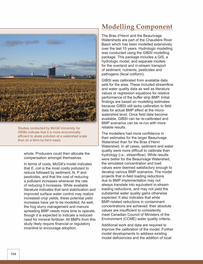
104
whole. Producers could then allocate the compensation amongst themselves.
In terms of costs, McGill’s model indicates that E. coli is the most costly pollutant to reduce followed by sediment, N, P and pesticides, and that the cost of reducing a pollutant increases whenever the rate of reducing it increases. While available literature indicates that land stabilization and improved surface water control may realize increased crop yields, these potential yield increases have yet to be modelled. As well, the hog slurry management and manure spreading BMP needs more time to operate, though it is expected to indicate a reduced need for mineral fertilizer. All BMPs from this study likely require financial or regulatory incentive to encourage adoption.
Modelling ComponentThe Bras d’Henri and the Beaurivage Watersheds are part of the Chaudière River Basin which has been modelled extensively over the last 15 years. Hydrologic modelling was conducted using the GIBSI modelling package. This package includes a GIS, a hydrologic model, and separate models for the overland and in-stream transport of sediment, nutrients, pesticides and pathogens (fecal coliform).
GIBSI was calibrated from available data sets for the area. These included streamflow and water quality data as well as literature values or regression equations for relative performance of the buffer strip BMP. Initial findings are based on modelling estimates because GIBSI still lacks calibration to field data for actual BMP effect at the micro-watershed level. Once field data become available, GIBSI can be re-calibrated and BMP scenarios can be re-run with more reliable results.
The modellers had more confidence in their estimates for the larger Beaurivage Watershed than for the Bras d’Henri Watershed. In all cases, sediment and water quality were more difficult to calibrate than hydrology (i.e., streamflow). While results were better for the Beaurivage Watershed, the simulated concentration and load values were deemed satisfactory enough to develop various BMP scenarios. The model projects that in-field loading reductions due to BMP implementation may not always translate into equivalent in-stream loading reductions, and may not yield the substantial water quality gains otherwise expected. It also indicates that while BMP-related reductions in contaminant concentrations are achieved, their absolute values are insufficient to consistently meet Canadian Council of Ministers of the Environment (CCME) water quality criteria.
Additional work and data are required to improve the calibration of the model. Further model developments to address existing model deficiencies and the addition of local
Studies conducted by McGill University for WEBs indicate that it is more economically efficient to abate pollution at a watershed scale than on a farm-by-farm basis.

105
field data are planned for the next phase of WEBs.
The Bras d’Henri Watershed is one of two WEBs project sites where integrated hydrologic-economic modelling occurs. This is described in more detail in Chapter 5.
Results Summary TableA summary of the biophysical, economic and modelling results for this watershed are found in Table 12.
ConclusionsThis study confirmed that pedology, hydrology and seasonal climate can significantly influence in-stream water quality parameters in both the Bras d’Henri and the Fourchette basins. The BMP evaluation phase found significant improvement of water quality parameters in the already-established Fourchette Watershed. Similar improvements are anticipated within the Bras d’Henri Watershed during future evaluations.
Economic analysis found that all of the BMPs would likely require financial or regulatory incentive to encourage adoption—although the surface runoff control BMP likely has the additional on-farm benefits of land stabilization and increased yields.
Hydrologic modelling was successfully initiated for the project. The models have performed well but further calibration is required and improvements can be expected with the addition of field data in the next phase of the project. The Bras d’Henri Watershed is one of two WEBs watersheds using an integrated hydrologic-economic model. The project demonstrates that outputs from the hydrologic modelling exercise can be used effectively as inputs to economic modelling studies.
Additional data collection and analysis are required in order to gain more confidence
in initial findings for all components of the project.
Acknowledgements Additional contributors to this study include: Georges Thériault, Michel Nolin, Nadia Goussard, Martin Chantigny, Roger Lalande, Claudel Lemieux, Marie-Josée Simard, Allan Cessna, Jonathan Bailey, Jean-Thomas Denault, Julie Corriveau, Farida Dechmi, Beata Novotna, Mario Deschênes, Isabelle Perron and Geneviève Bégin (AAFC); Marielle Laferrière, Mathieu Gourdes Vachon and Catherine Bossé (CFB); Jacques Desjardins (IRDA); Donald Lemelin, Armand Gagnon and Émilie Beaudoin (MAPAQ); Martine Savard and Daniel Paradis (Natural Resources Canada); Martin-Pierre Lavigne and Sébastien Tremblay (INRS); Laurie Baker (McGill University, L.B. Consulting); Sebastien Rivest (McGill University); Pascal Ghazalian (Université Laval); other members of the Bras d’Henri/Fourchette WEBs Steering Committee, and participating students and producers.
Surface runoff control measures such as rock-lined waterways (above) and buffer strips, were found to improve water quality in the Fourchette Watershed.

106
Table 12: Summary of WEBs Bras d’Henri and Fourchette Watershed results (2004/5 - 2007/8)
BMP BIOPHYSICAL FINDINGS ECONOMIC FINDINGS HYDROLOGIC
MODELLING
Surface runoff control
• Fourchette – improved water quality
• Bras d’Henri – results to date are inconclusive
• Adoption likely increases costs, though proportionately smaller for larger crop-producing farms
• Land stabilization and yield increase may result
• Financial or regulatory incentive likely required to encourage adoption
• Adoption is positively influenced by age, education, farm size and other factors
• The GIBSI model was calibrated using literature values or regression equations for relative BMP performance (namely buffer strips).
• Once field data become available, GIBSI can be re-calibrated and BMP scenarios can be re-run for more reliable results.
• The modellers had greater confidence in results for the larger Beaurivage Watershed than the Bras d’Henri Watershed.
• The modelling exercise indicated that predicted in-field loading reductions due to BMP implementation may not always translate into equivalent in-stream loading reductions. Although BMP-related reductions in contaminant concentrations are achieved, their absolute values are not sufficient to consistently meet CCME water quality criteria.
Crop rotation (increasing the percent area of hay versus corn)
• Farm scale - reduction of nutrient loading to the stream
• Watershed scale – continuing to assess impact
• Costly, with average short-term costs increasing as more hay is included and corn acreage is reduced in the cropping rotation
• Financial or regulatory incentive likely required to encourage adoption
• Adoption is positively influenced by age, education, farm size and negatively influenced by the price of labour
Hog slurry management
• Consistently reduced N and fecal coliform loading to the stream
• Reduced N and P losses in surface runoff in some years
• Increased residual P in soil
• Apparent odour reduction during spreading
• Costly, though less so for large crop-producing farms, while more costly for livestock farms
• Reduced need for mineral fertilizer is anticipated
• Financial or regulatory incentive likely required to encourage adoption
• Women or land owners residing on the farm more likely to adopt this BMP
Reduced herbicide use
• AAFC-based decision-support system deemed inappropriate
• Other techniques require more time to adjust and realize effect
• Costly (in terms of yield loss), average costs increase at an accelerated rate as pesticide use is reduced
• Financial or regulatory incentive likely required to encourage adoption
• Larger farms more likely to adopt this BMP

107
WEBs benefits science community To suggest that the Bras d’Henri WEBs project only benefits the agricultural community is simply not true. Alain N. Rousseau, a professor with the Institut national de la recherche scientifique, Centre Eau, Terre et Environnement (INRS-ETE), claims that science has also been a winner.
“AAFC has given us a fantastic opportunity to further develop and refine our hydrologic model while training people in modelling. It is an innovative hydrologic-economic modelling framework developed with collaborators at University of Guelph and University of Alberta,” says Rousseau. “That is something you don’t always have time to do in conventional research contract projects where there are time constraints.”
The INRS-ETE has played a leading role in developing a hydrologic model to evaluate the impact of different BMP scenarios in the Bras d’Henri and Beaurivage Watersheds.
“With our colleagues at Université Laval and McGill University, we have been able to generate various scenarios through the model to assess the environmental and on-farm economic impacts of various beneficial management practices,” he says. “The information will be used to demonstrate economic and environmental trade-offs, both at the farm level and on a watershed scale.”

108
Figure 11: Black Brook Watershed location map
1.6
Black Brook Watershed, New BrunswickWatershed Lead: Lien Chow (AAFC) Site Economist: Jérôme Damboise (Eastern Canada Soil and Water Conservation Centre) Site Hydrologic Modeller: Fanrui Meng (University of New Brunswick)

109
Background and IssuesThe 1,450-hectare Black Brook Watershed (Figure 11) is located north of Grand Falls, New Brunswick, in the province’s potato belt. It is part of the 380-square-kilometre Little River Watershed. Topography is rolling, with slopes generally ranging from two to nine percent, but with some slope segments in excess of 15 percent.
Agricultural land within the Black Brook Watershed constitutes approximately 65 percent of the land base, with the remainder either forested or under urban and residential development. The major crop is potato in rotation with grain and hay for forage. Half of the agricultural land is annually under potato production.
Since the region is characterized by rolling topography and high precipitation, there are concerns about the environmental impacts of intensive agricultural practices. Soil erosion may contribute excessive amounts of sediment and nutrients to the region’s surface waters where appropriate soil and water conservation practices have not been implemented.
Biophysical Component The biophysical component of the study is focused on evaluating the environmental effect of the following two BMPs on water quality:• Diversion terraces and grassed
waterways• Grassed riparian buffer zones
BMP Description and Results
Diversion terraces and grassed waterwaysDiversion terraces and grassed waterways are part of a systems approach to reducing soil erosion and water losses from steeply sloping land. Diversion terraces break up long field slopes into a series of shorter ones. Each terrace intercepts runoff from the area within it and diverts it into a grassed waterway.
Grassed waterways are permanently vegetated channels designed to move surface water across farmland, thereby reducing erosion. The waterways are typically constructed in natural depressions in the field where water would normally collect and flow. The grass in the channel slows the water flow, filters sediment in
The region’s rolling topography and high precipitation increase the possibility of a major soil erosion event. Soil erosion can contribute excessive amounts of sediment and nutrients to surface water.

110
runoff, and protects the channel from erosion.
Two sub-watersheds within the Black Brook Watershed, with a combined area of 300 hectares, were selected for the study. A system of diversion terraces and grassed waterways was installed during the six-year period preceding this study. During WEBs, improvements were made to these systems.
In most cases, this BMP has significantly reduced surface runoff, sediment and particle-bound contaminants such as phosphate. However, diversion terraces and grassed waterways often increased soluble nutrient (N and P) loading. Sediment loading and discharge varies considerably from year to year depending on the amount, intensity and temporal distribution of precipitation. This BMP was ineffective at reducing pollutant loadings from high volume rainfall events, especially when the systems were newly constructed.
Grassed riparian buffer zonesGrassed riparian buffer zones were established in a sub-watershed where little conservation work had previously occurred. These bordered either side of an upgraded grassed channel and newly established grassed waterways. Buffer effectiveness
in reducing sediment and nutrients from entering drainage channel waters was evaluated through monitoring at the edge-of-field and sub-basin levels.
This BMP performed like the diversion terraces and grassed waterways in reducing runoff and sediment, but results for nutrients were inconclusive. Again, depending upon the amount, intensity and temporal distribution of precipitation, the degree of reduction in discharge and sediment loading varies considerably from year to year.
Similarly, grassed riparian buffer zones were ineffective at reducing loadings from high-intensity rainfall events. However, when sited below contoured cultivation with a reasonable slope length, such buffers received very little runoff. This demonstrates the merit of varying the mix, perhaps even eliminating a particular BMP, as part of an integrated approach to addressing soil erosion.
Additional Biophysical StudiesSince it was expected that water quality change might be difficult to detect, particularly in the short term, several study methods were employed. These methods quantified the effect of BMPs on water quality and other biophysical parameters, and increased knowledge of the effect of watershed relationships on BMP performance. These studies include:• Forest versus agricultural impacts on
surface water quality – To determine the relative contribution of forestry and various agricultural intensities to water yield and water quality problems, three sub-watersheds in the Little River Watershed were instrumented. These were the agriculture-dominated Black Brook Watershed and two forestry-dominated watersheds, all with similar soil types. Each was monitored for discharge and water was sampled for suspended sediment
Automatic sampling stations help keep track of periodic runoff events.

111
and chemical analysis. Results indicate that water yield decreases and suspended sediment and agro-chemical yield increases with an increase of agricultural intensity. Results also suggest that a forest-dominant watershed may have less environmental pollution potential than an agriculture-dominated watershed. However, these findings may be complicated by the fact that these watersheds differ in size and thus may have different hydrologic responses.
• Pesticide residues – Jointly with Environment Canada, water samples at various locations were analyzed to determine the presence, concentration and potential risks associated with pesticides in surface water in areas dominated by intensive potato production. The information gained would help develop pesticide mitigation BMPs. During the growing season, weekly sampling determined that no pesticides exceeded the water quality guidelines for aquatic life during baseflow periods. However, samples collected during and immediately after major rainfall events showed that concentrations of selected pesticides were much higher during peak flow. These concentrations exceeded guidelines until the concentration began decreasing as rainfall increased. Diversion terraces and grassed waterways were found to decrease the concentration of any given pesticide by almost half compared to a sampling site without this conservation system.
• National Agri-Environmental Standards Initiative (NAESI) – This joint Environment Canada-AAFC initiative developed surface water quality standards for agricultural watersheds. NAESI used the data collected at monitoring stations in the Black Brook Watershed to develop standards pertaining to nutrients and suspended and deposited sediment.
• Microbial source tracking – Jointly with Health Canada, a number of sites in the Black Brook Watershed were selected for the national Microbial Source Tracking study. High counts of coliforms, E. coli and other bacteria were found in many samples, especially during peak flow periods. These high counts may be attributed to a nearby sewage lagoon and/or wildlife activity.
Economics ComponentThe Black Brook economic analysis assessed the level of individual BMP adoption and studied the on-farm costs and benefits of the specific BMPs. Historic soil management and agronomic data dating from 1988 were analyzed to identify soil and crop management changes and BMP adoption by potato producers within the watershed. The percentage of farms with established diversion terraces and grassed waterways increased from seven percent in 1988 to 57 percent in 2005, mainly due to government-funded programs. Constraints to adopting these BMPs elsewhere in the watershed are both financial and physical (e.g., field size, topography).
A potato yield and quality survey was conducted during the 2006-2008 crop years to assess the potential increase to on-farm income resulting from the establishment of soil conservation structures such as diversion terraces and grassed waterways. These BMPs were expected to increase potato yield and quality by reducing runoff and conserving soil moisture for the crop. However, their impact on potato yield was inconclusive owing to varying weather conditions during the three years of the study.
Moisture distribution during the 2006 and 2008 growing seasons was exceptional for potato production, yet there was minimal soil erosion. Therefore, there was no significant difference in potato yield between fields with and without BMPs. The 2007

112
survey was limited to one field with BMPs and one without. This was a drier year, and there were significant yield increases in the BMP field. But surveys conducted over a number of years are required to fairly assess the BMP impact on potato yields in different climate scenarios. Therefore, a study of long-term climate records will be conducted in the next phase of WEBs.
The installation costs of the diversion terraces and grassed waterways were estimated based on the maximum allowable costs under provincial guidelines. The costs of maintenance and loss of efficiency were derived and adapted to New Brunswick conditions from an economic study done in Prince Edward Island. These BMPs are costly to implement and maintain and significant yield increases would be required to offset their expense. The grassed riparian buffers were also costly to install. Financial or regulatory incentive would likely be required to encourage adoption and annual maintenance of both BMPs.
Modelling ComponentHydrologic modelling of the BMPs in this study was conducted using SWAT, in conjunction with other BMP-specific modules.
There was good calibration of hydrology, sediment and nutrients using data from the period prior to BMP implementation. The model was then validated using post-BMP data. During calibration for the pre-BMP period, predicted monthly flows closely matched observed flows. The model slightly under-predicted sediment yield in early summer and over-predicted in late summer.
Water quality modelling results were mixed, showing better performance for predicting P loadings than N loadings. The calibrated model assessed BMP impact on sediment yield. Results confirmed that observed sediment yield reduction during the post-BMP period was caused by BMP implementation rather than by year-to-year fluctuations of weather patterns.
Based on model assessment, a sediment reduction of 60 percent at the watershed level could be achieved with diversion terraces alone. As well, the average annual sediment yield decreased exponentially as more areas were protected. The model also found that costs of reducing sediment increased exponentially as the proportion of protected areas increased.
An event-based grassed buffer zone and grassed waterway model was developed and tested using buffer zone widths varying from 15 to 35 metres. The simulation indicated that the efficacy of grassed buffer zones increased as widths increased, depending on storm intensity.
Results Summary TableA summary of the biophysical, economic and modelling results for this watershed are found in Table 13.
When used in conjunction with diversion terraces within the Black Brook Watershed, grassed waterways significantly reduced surface runoff, sediment and particle-bound contaminant loading to surface waters.

113
Table 13: Summary of WEBs Black Brook Watershed results (2004/5 - 2007/8)
BMP BIOPHYSICAL FINDINGS
ECONOMIC FINDINGS
HYDROLOGIC MODELLING
Diversion terraces and grassed waterways
• Significant reduction of surface runoff, sediment and particle-bound contaminants
• Soluble nutrient loading often increased within the stream
• Ineffective at reducing in-stream pollutant loadings from unusually high-intensity rainfall events
• Costly to implement and maintain
• Short-term yield impacts inconclusive
• Financial or regulatory incentive likely required to encourage adoption
• SWAT did well at validating hydrology, sediment and nutrient loads
• Field data used in model calibration and validation
• Model can be used for cost-effective analyses
Grassed riparian buffer zones
• May reduce runoff and sediment, depending on topographic characteristics of contributing fields or overland flow characteristics
• Nutrient loadings to the stream are inconclusive to date
• Ineffective at reducing loadings to the stream from high-intensity rainfall events
• Costly to implement
• No clear short-term benefits to landowners
• Financial or regulatory incentive likely required to encourage adoption
• An event-based grassed buffer zone and waterway model was developed and tested
ConclusionsThe Black Brook WEBs project benefited from several years of pre-WEBs data used in the biophysical, economics and hydrologic modelling studies. Results from this project revealed that the greatest impact on mitigating soil erosion comes from applying BMPs in combination.
It was found that diversion terraces and grassed waterways and/or grassed riparian buffer zones may reduce surface runoff and sediment loading. However, results for soluble nutrients are BMP-dependent. All of the BMPs investigated were ineffective at reducing soluble nutrient loadings caused by high-intensity rainfall events. The main
objective of the terraces and grassed waterways is to reduce soil loss by reducing the rate and amount of runoff.
Economic analysis found that both BMPs would likely require financial or regulatory incentive to encourage adoption. Further study is required to clarify changes in potato yield and quality resulting from the BMPs.
Hydrologic modelling was successfully initiated for the project. The models performed well using field data.
Additional data collection and analysis are required in order to gain more confidence in initial findings for all components of the project.

114
Acknowledgements Additional contributors to this study include: Herb Rees (AAFC), Glenn Benoy (AAFC/Environment Canada), Jean-Louis
Daigle (Eastern Canada Soil and Water Conservation Centre), other members of the Black Brook WEBs Steering Committee, and participating students and producers.
Soil and water benefits There is no doubt in Lionel Poitras’ mind that conserving the soil on his New Brunswick potato farm is critical to his well-being and his community.
“The soil provides us with our livelihood,” says Poitras, a producer/cooperator in the Black Brook WEBs project. “We have to keep the soil in its place so we can continue to be a viable and sustainable farm operation.”
Putting his words into action, Poitras has constructed 660 metres of diversion terraces and 750 metres of grassed and rock-lined waterways on his land in the Black Brook Watershed to slow runoff and reduce soil erosion. And the effort is paying off. The area once had serious soil erosion problems, but thanks to the efforts of producers like Poitras, that is becoming a thing of the past.
“Everyone’s a winner,” says Poitras. “We keep our soil, and the water quality in the stream has improved so that it can benefit every citizen and the whole rural community.”
Credit: JL Daigle, Eastern Canada Soil and Water Conservation CentreBlack Brook producer Lionel Poitras gives a presentation at the Quebec-New Brunswick WEBs and Technical Exchange Workshop in March 2008.
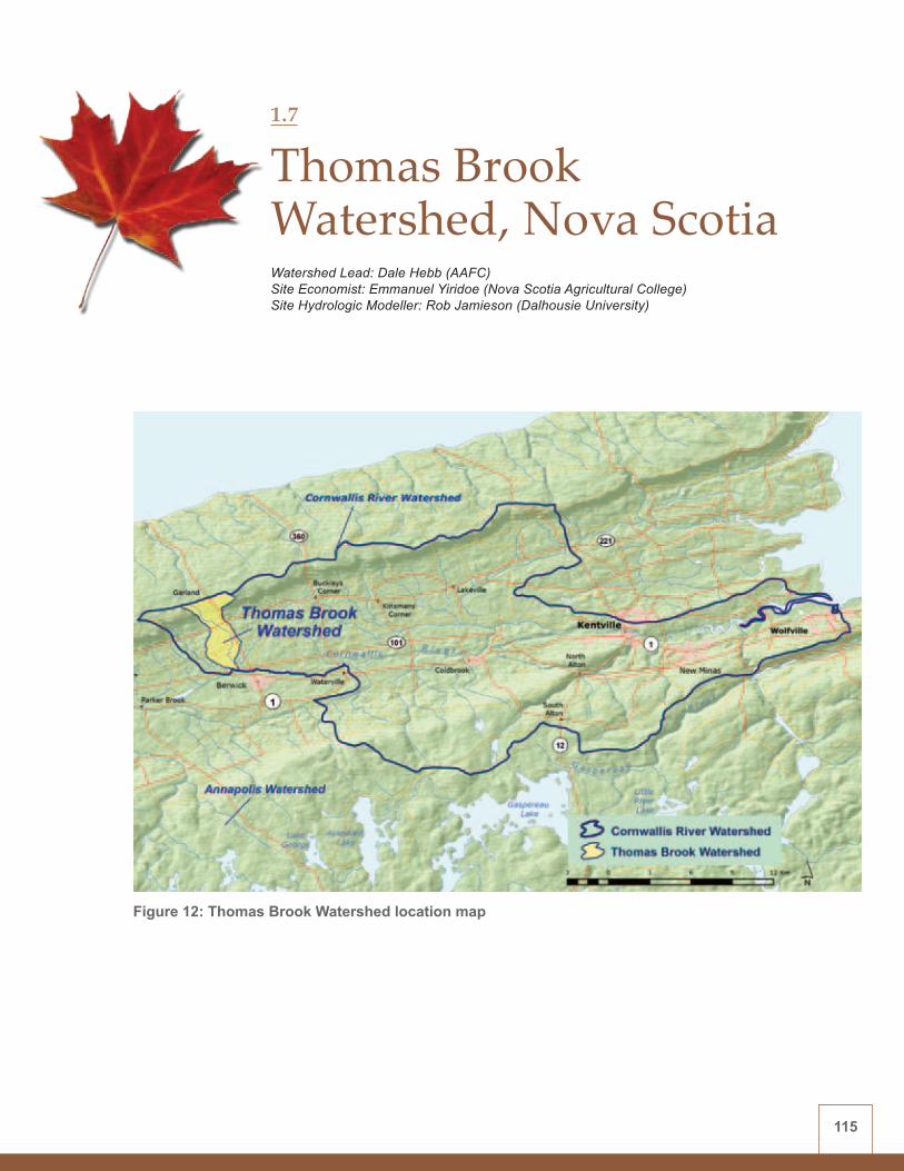
115
Figure 12: Thomas Brook Watershed location map
1.7
Thomas Brook Watershed, Nova ScotiaWatershed Lead: Dale Hebb (AAFC) Site Economist: Emmanuel Yiridoe (Nova Scotia Agricultural College) Site Hydrologic Modeller: Rob Jamieson (Dalhousie University)
116
Background and IssuesThe 760-hectare Thomas Brook Watershed (Figure 12) is typical of the Annapolis Valley of Nova Scotia. The watershed consists of small mixed land-use parcels including agriculture, forestry and rural residential. The watershed’s 128 individual fields range from marginal pasture to intensive horticultural fruit and vegetable crops.
Concentrations of several water quality parameters (nutrient, sediment, E. coli) in the Thomas Brook routinely exceed guidelines for various uses (e.g., drinking water, irrigation). The watershed’s mixed land-use characteristics present challenges for identifying contaminant sources and the impacts of specific BMPs. Water samples collected from headwater sources upstream of intensive land-use activities at times possess background levels of contamination that are above recommended levels.
Considering the level of water-quality impairment and the significant agricultural land use within the watershed, the use of BMPs is considered crucial for water quality improvements. Improved understanding of the larger-scale impact of agriculture in a mixed ecosystem has become an underlying goal of the Thomas Brook project.
The Thomas Brook WEBs project was instrumental in the creation of a watershed stakeholder group made up of interested area residents. The Cornwallis Headwaters Society, established in 2007, supports watershed research and conservation activities.
Biophysical Component The biophysical component of the study is focused on evaluating the environmental effect of the following three BMPs on water quality:• Nutrient management plans
• Cattle exclusion fencing (and off-stream watering)
• Storm water diversion (farmyard runoff management)
The BMPs are evaluated at eight different water quality monitoring sites within the watershed—some of which are immediately downstream of the implemented BMPs. One sampling point is located upstream near the top of the watershed, for a controlled comparison, and one is located at the watershed outlet to measure the cumulative effect of all BMPs. Water quality is monitored for nutrients, sediment and E. coli.
BMP Description and Results
Nutrient management plansNutrient management plans, based on a three-year cropping cycle, were prepared for commercial-scale (non-hobby) farms in the watershed, with the goal of managing nutrient applications of N and P, thus reducing excess nutrient leaching. However, due to seasonal variability in soil nutrient content and annual agronomic changes, these three-year plans did not necessarily match the actual cropping and nutrient requirements in any given year.
Farmers in the watershed have not reported major changes in production practices as a result of nutrient management planning. Combined with the complexity of the watershed, this limited application of nutrient management planning has had no observable impact on stream water quality and the nature and structure of the BMP is under active reconsideration.
Future work on this BMP will involve annual soil sampling and cropping/fertilization recommendations. This will facilitate tracking of soil nutrient trends, which may help determine the effectiveness of nutrient management planning.
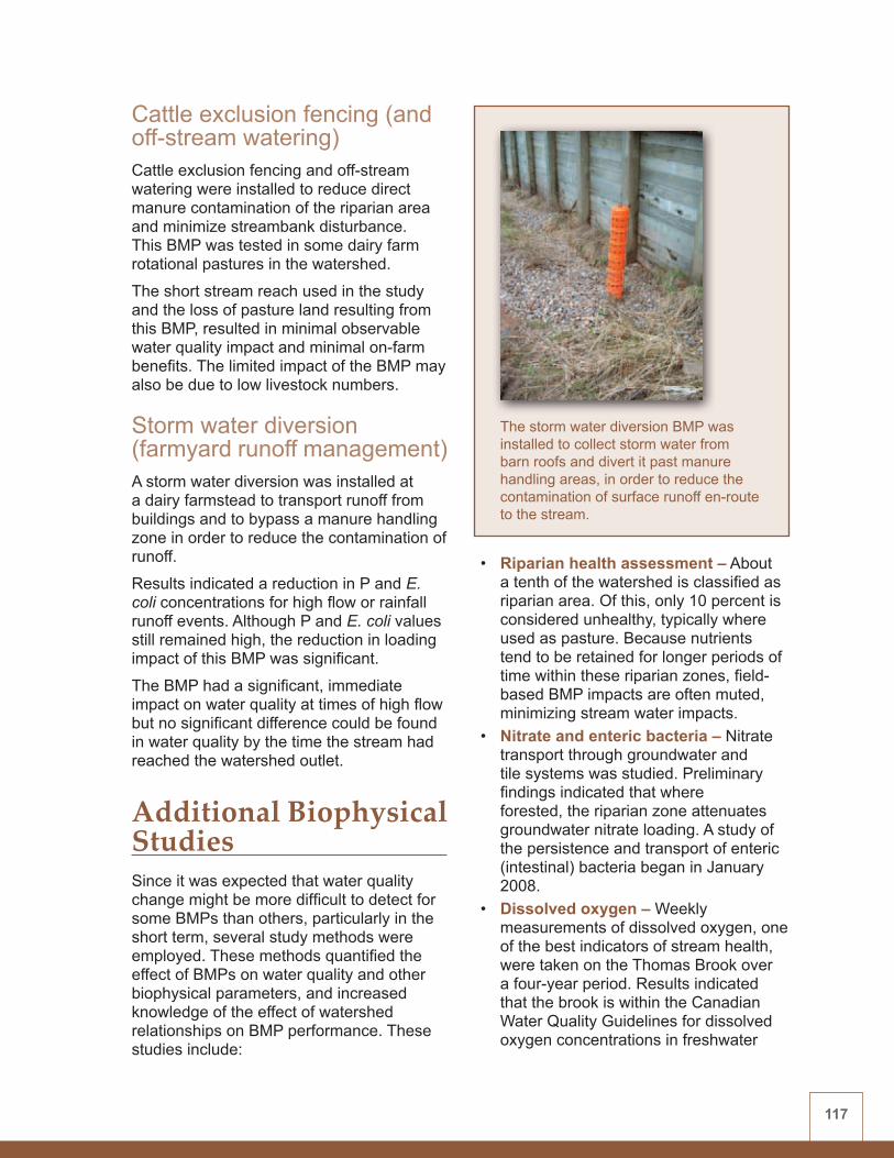
117
Cattle exclusion fencing (and off-stream watering)Cattle exclusion fencing and off-stream watering were installed to reduce direct manure contamination of the riparian area and minimize streambank disturbance. This BMP was tested in some dairy farm rotational pastures in the watershed.
The short stream reach used in the study and the loss of pasture land resulting from this BMP, resulted in minimal observable water quality impact and minimal on-farm benefits. The limited impact of the BMP may also be due to low livestock numbers.
Storm water diversion (farmyard runoff management) A storm water diversion was installed at a dairy farmstead to transport runoff from buildings and to bypass a manure handling zone in order to reduce the contamination of runoff.
Results indicated a reduction in P and E. coli concentrations for high flow or rainfall runoff events. Although P and E. coli values still remained high, the reduction in loading impact of this BMP was significant.
The BMP had a significant, immediate impact on water quality at times of high flow but no significant difference could be found in water quality by the time the stream had reached the watershed outlet.
Additional Biophysical StudiesSince it was expected that water quality change might be more difficult to detect for some BMPs than others, particularly in the short term, several study methods were employed. These methods quantified the effect of BMPs on water quality and other biophysical parameters, and increased knowledge of the effect of watershed relationships on BMP performance. These studies include:
• Riparian health assessment – About a tenth of the watershed is classified as riparian area. Of this, only 10 percent is considered unhealthy, typically where used as pasture. Because nutrients tend to be retained for longer periods of time within these riparian zones, field-based BMP impacts are often muted, minimizing stream water impacts.
• Nitrate and enteric bacteria – Nitrate transport through groundwater and tile systems was studied. Preliminary findings indicated that where forested, the riparian zone attenuates groundwater nitrate loading. A study of the persistence and transport of enteric (intestinal) bacteria began in January 2008.
• Dissolved oxygen – Weekly measurements of dissolved oxygen, one of the best indicators of stream health, were taken on the Thomas Brook over a four-year period. Results indicated that the brook is within the Canadian Water Quality Guidelines for dissolved oxygen concentrations in freshwater
The storm water diversion BMP was installed to collect storm water from barn roofs and divert it past manure handling areas, in order to reduce the contamination of surface runoff en-route to the stream.

118
systems. The brook’s turbulent hydrology facilitates aeration, enabling it to better mitigate the effects of incoming pollution, thus maintaining a healthy aquatic habitat.
• Benthic invertebrates – Benthic invertebrate sampling was conducted as a way of assessing the health of aquatic life, an indicator of water quality. Water quality at the monitoring station immediately downstream from where the storm water diversion BMP was implemented was found to be ‘fair’ to ’very good’ and remaining steady or even improving over time. Water quality at a monitoring station farther downstream was found to be ‘fair’ to ‘fairly poor’ yet still remaining steady or improving over time.
Economics Component Data on the economics of the BMPs and on the factors affecting BMP adoption were collected and used in the development of an optimization model for a representative farm. This was used in conjunction with preliminary hydrologic model simulations to predict the impact of BMP implementation on the farm’s gross margin. Primary data and cost data estimated from sources such as provincial databases were used in the development of modelling scenarios to evaluate BMP impacts.
Results indicated that all of the BMPs reduced gross margin, suggesting that financial or regulatory incentive would be required to encourage producers to adopt them. However, since increased milk yield
Preliminary economic analysis within the Thomas Brook Watershed suggests that the costs of installing cattle exclusion fencing and off-stream watering might be partially offset by an increase in milk yield gained from access to cleaner drinking water.

119
may be gained from cleaner drinking water, the cattle exclusion fencing BMP could minimize the gross margin reduction by a moderate amount.
The model simulation of the nutrient management planning BMP predicted that applying 90 percent of recommended N fertilizer rates to crops reduced nitrate pollution by 20 percent and did not significantly affect gross margin. However, as fertilizer rates decrease, so do farm returns.
Farmers in the watershed reported difficulty finding markets for certain cereal crops that had been recommended for inclusion in nutrient management rotation systems. The inability to market these crops, along with lower crop yields from reduced fertilizer application rates, can hamper widespread adoption of the nutrient management BMP.
Modelling ComponentHydrologic modelling was conducted in the Thomas Brook Watershed using SWAT, and soil, land-use and other data were converted to compatible formats. The model was calibrated for local conditions using flow and sediment data derived from water quality monitoring. SWAT was calibrated to predict daily flows, erosion and sediment transport, and water quality at the watershed outlet.
The model was not validated because the calibration used a period of study of less than two years. Consequently, results should be considered preliminary. Precipitation, temperature, tile drainage and fertilizer application data were also lacking. Accurate calibration and validation of the model requires additional data and study time to produce reliable results.
The watershed’s mixed land-use characteristics present challenges for identifying contaminant sources and the impacts of specific BMPs.

120
The calibrated model was able to represent the hydrologic response of the watershed but the model’s effectiveness was limited by a lack of local climate data and by SWAT’s inability to capture the timing and magnitude of snowmelt events.
BMP effects were investigated by adjusting SWAT’s internal parameters and preliminary simulation results were consistent with expectations. The BMPs were found to have very little impact on flow. Buffer strips reduced sediment transport, but sediment effects remained relatively unchanged for the other BMPs.
SWAT is currently limited in its ability to simulate sediment transport, to represent forested riparian zones, and to account for tile drainage. These processes may be included in the next phase of WEBs. Re-
calibrating and validating the model with additional data is also planned.
Results Summary TableA summary of the biophysical, economic and modelling results for this watershed is found in Table 14.
ConclusionsDue to the complexities of this watershed, the impact of the BMPs on water quality is not yet apparent at its outlet. Targeted BMPs had significant impact on nearby water quality, but there was no significant impact on the overall system. It is likely that
Table 14: Summary of WEBs Thomas Brook Watershed results (2004/5 - 2007/8)
BMP BIOPHYSICAL FINDINGS
ECONOMIC FINDINGS
HYDROLOGIC MODELLING
Nutrient management plans
• No impact on stream water quality due to watershed complexity and limited application of BMP
• Costly in terms of yield loss
• Farm losses increase as fertilizer rates decrease
• Difficult finding markets for new crops recommended for rotations
• The model was calibrated using water quality monitoring data, but not yet validated due to short-term data set.
• Additional data are required in order to secure more reliable results.
• Projected BMP effects were limited, but consistent with expectations.
Cattle exclusion fencing (and off-stream watering)
• Minimal impact on stream water quality, likely due to short length of stream reach fenced and low cattle numbers
• Costly to install and maintain
• Loss of pasture land, but potential for improved milk production
• Financial or regulatory incentive likely required to encourage adoption
Storm water diversion (farmyard runoff)
• Significant reduction to in-stream P and E. coli concentrations
• Costly to install
• No short-term financial benefit to the landowner
• Financial or regulatory incentive likely required to encourage adoption

121
Local watershed groups The Cornwallis Headwaters Society (CHS) provides scientists and researchers on the Thomas Brook WEBs project with a crucial element to the study—a connection to the people.
“We are a link between researchers and local farmers, and between the various researchers,” says Angie Garnett, Project Coordinator for CHS. “Scientists come to us with research proposals, then I approach the farmers, describe what will be done and coordinate the work between them.”
Created in 2007, the CHS provides a project relationship with local landowners that is necessary for success. Because the WEBs project partners recognized the need for a local watershed group to work with, they helped spearhead formation of the CHS.
“This has helped researchers work more closely with producers to tailor management practices to individual farms based on their unique environment,” says Garnett.
Cornwallis Headwaters Society Project Coordinator Angie Garnett enters coordinates into a global positioning system at the Thomas Brook Watershed.

122
the BMPs investigated were not aggressive enough to change the water quality of such a diverse ecosystem in the short term. More time is needed to determine their effect.
Economic analysis found that all three BMPs resulted in net costs to farmers and would likely require financial or regulatory incentive to encourage their adoption. Further study is required to quantify potential on-farm benefits that may result from these BMPs.
Hydrologic modelling for the project was successfully initiated using local water quality monitoring data. The model performed well but improvements are expected with the addition of field data in the next phase of the project.
As a multidisciplinary study, the Thomas Brook WEBs project has sparked other water
and environmental research in the region. It has even been a catalyst for the formation of a local watershed association.
Additional data collection and analysis are required in order to gain more confidence in initial findings for all components of the project.
Acknowledgements Additional contributors to this study include: Katherine Benedict and Victor Afari-Sefa (Nova Scotia Agricultural College), Rob Gordon (University of Guelph, formerly of Nova Scotia Agricultural College), other members of the Thomas Brook WEBs Steering Committee, and participating students and producers.

Appendix 2
WEBs Communications Activities

Table of Contents Appendix 2 2.1 Presentations/Discussions 125
2.2 Peer-Reviewed Journal Articles 126
2.3 Newspaper, Magazine, and Online Articles 127
2.4 Fact Sheets, News Releases, Brochures 128
2.5 Workshops/Meetings 129
2.6 Reports 130

125
2.1 Presentations/Discussions WEBs informs a diverse audience including scientists, government decision makers, producers and the general public about the project’s progress, methods and findings.
Since its inception in April 2004, WEBs researchers have participated in more than 80 technical conferences and meetings, both nationally and internationally, as indicated in the following selected examples.
Table 15: Selected WEBs-related meetings and presentations (2004/5 - 2007/8)
Meeting/Conference/Presentation Location Date
WEBsProjectOverview
2004 Canadian Water Resources AssociationEnvironment Canada/NAESI WorkshopAmerican Society of AgronomyEnvironment Monitoring and Assessment Network
Montreal, QCHalifax, NSSeattle, WAQuebec City, QC
Jul. 2004Sep. 2004Nov. 2004Dec. 2004
2005 CEAP Literature Review SynthesisAlberta Soil Science WorkshopCanada/US/Mexico Tri-Lateral DiscussionsInternational Water Association – Diffuse PollutionSoil and Water Conservation SocietyInternational Institute for Sustainable DevelopmentNational Environmental Farm Planning Practitioners Workshop
Lincoln, NB Calgary, ABOttawa, ONJohannesburg, S. AfricaRochester, NYWinnipeg, MBMontreal, QC
Jan. 2005 Feb. 2005Mar. 2005Jul. 2005Aug. 2005Sep. 2005Oct. 2005
2006 Ecological Goods and Services WorkshopCEAP Annual Technical MeetingAAFC Landscape ModellingManaging Ag LandscapesNova Scotia Federation of Agriculture (NSFA)Ontario Ministry of Agriculture, Food and Rural Affairs
Winnipeg, MBAmes, IOCalgary, ABKansas City, MOTruro, NSGuelph, ON
Feb. 2006May 2006Jun. 2006Oct. 2006Nov. 2006Dec. 2006
OverviewandPreliminaryFindings
2007 St. John’s River WorkshopDrainage Management Task ForceMinister Strahl, Minister BairdManitoba Riparian Health CouncilCanadian Agricultural Economics SocietySouth Nation Clean Water CommissionAtlantic Agricultural Science WorkshopManitoba Conservation Districts Association
Fredericton, NBRaleigh-Durham, NCOttawa, ONWinnipeg, MBPortland, ORBerwick, ONTruro, NSBrandon, MB
Jan. 2007Apr. 2007May 2007Jun. 2007Jul. 2007Oct. 2007Nov. 2007Dec. 2007

126
2.2 Peer-Reviewed Journal Articles Near the end of the first phase of the project, WEBs researchers and partners were beginning to have sufficient information to publish peer-reviewed journal articles on their methods and findings. The list below contains articles published before March 31, 2008. Articles published since that date will be listed in a future report.
Table 16: WEBs peer-reviewed journal articles (2007/8)
Publication (2007) Title
Applied and Environmental Microbiology 73 (12): 3945-3957; N.J. Ruecker, Braithwaite, S.L. and 8 others
Tracking host sources of Cryptosporidium spp. in raw water for improved health risk assessment
Transactions, American Society of Agricultural and Biological Engineers 50(5): 1549- 63; Y.B. Liu, Yang, W. and Wang, X.
GIS-based Integration of SWAT and REMM for Estimating Water Quality Benefits of Riparian Buffers in Agricultural Watersheds
Journal of Microbial Methods 69 (3): 480-488; I.U.H. Khan, Gannon, V., Kent, R, Koning W, Lapen D.R. and 7 others.
Development of a rapid quantitative PCR assay for direct detection and quantification of culturable and non-culturable E. coli from ag watersheds
Managing Agricultural Landscapes for Environmental Quality, Soil and Water Conservation Society, Ankeny, IA, p. 3-16; P. Groffman, Capel P. and 2 others.
Ecosystem Services in Agricultural Landscapes; special symposium paper.
Canadian Journal of Soil Science 87 (4):383-398; H.W. Rees, T. L. Chow and E. G. Gregorich.
Spatial and temporal trends in soil properties and crop yield at a site under intensive up-and-down slope potato production in north-western New Brunswick.
Applied and Environmental Microbiology 73 (17): 5401-5410; E. Lyautey, Lapen, D.R., Wilkes, G., McCleary, K and 9 others.
Distribution and characteristics of Listeria monocytogenes isolates from surface waters of the South Nation River Watershed, Ontario, Canada.
Canadian Journal of Microbiology 53(10):1158-1167; E. Lyautey, Hartmann, A., Pagotto, F., Tyler, K, Lapen, D.R. and 8 others.
Characteristics and frequency of detection of fecal Lysteria monocytogenes shed by livestock, wildlife, and humans.
Hydrology and Earth System Sciences, 11:1785-1795; R. Quilbé, and A. N. Rousseau.
GIBSI: An integrated modelling system for watershed management – Sample applications and current developments.
Canadian Journal of Soil Science 87(5): 565-577; T.L. Chow, Rees, H.W. and 3 others.
Effect of coarse fragment content on soil physical properties, soil erosion and potato production.
Journal of Soil and Water Conservation, 62 (6): 423-432; W. Yang, A. Rousseau, and P.C. Boxall.
An integrated economic-hydrologic modeling framework for the watershed evaluation of beneficial management practices.

127
2.3 Newspaper, Magazine, and Online ArticlesMedia across the country have reported on local WEBs projects in newspapers and magazines, in print and online formats. Below are examples of these articles.
Table 17: Various WEBs media publications (2004/5 - 2007/8)
Publication Article/Watershed Date
2005
Winnipeg Free Press Farmers Helping Improve Water Quality – South Tobacco Creek
Jan. 2005
AgriNews Interactive Don’t Throw the Baby Out With Your Tile Drainage Water – South Nation
May 2005
Ducks Unlimited Conservator WEBs Sites to Monitor Water Quality – WEBs National Project
Fall 2005
Green Matters (Alberta Environmentally Sustainable Agriculture Council)
Assessing BMPs for Effectiveness and Economics – Lower Little Bow River
Winter 2005
2006
Canadian Water Network Student Newsletter
WEBs, and not the Spider Kind – Thomas Brook
Mar. 2006
Ducks Unlimited Conservator Quebec farm study aimed at improving water quality – Bras d’Henri/Fourchette
Spring 2006
Meristem Land & Science Research to help Alberta cattlemen protect water quality, and Beef production’s new waterworld – Lower Little Bow River
Jul. 2006
The Victoria Star (also La Cataracte)
BeneficialManagementPractices has positive effects in Black Brook Watershed
Aug. 2006
NAHARP Newsletter No. 8 WEBs Project to Assist NAHARP Evaluations – WEBs National Project
Fall 2006
2007
Western Producer Special Report – Tobacco Creek Basin Jun. 2007
Eastern Ontario AgriNews Collaboration key in three water and soil quality projects – South Nation Jul. 2007
Novanewsnow.com Watching the water: Small brook has big role to play in watershed work – Thomas Brook Aug. 2007
Farm Focus of Atlantic Canada Thomas Brook Watershed: Nova Scotia’s outdoor water laboratory Oct. 2007
2008
Drainage Contractor Watershed Evaluation ofBeneficialManagementPractices – South Nation
2008 edition
Crops BMP auction being developed – South Tobacco Creek
Mar. 2008
Ducks Unlimited Canada Conservator WEBs study tour draws diverse group – Bras d’Henri /Fourchette
Spring 2008

128
2.4 Fact Sheets, News Releases, BrochuresA series of fact sheets were produced for the overall project and for each of the seven watershed sites. News releases and other information products, including a website, followed. Detailed technical pamphlets have since been produced for each of the seven watersheds.
Table 18: WEBs communications products (2004/5 - 2007/8)
Description Purpose/Content Date
WEBs project fact sheets Project background and overview document for each of the seven WEBs watersheds
Oct. 2004summer 2005Revised Oct. 2007
National news release “National Ag Study – Evaluating Best Land Practices for Water Quality” Jul. 2005
Watershed news releases Series of seven local news releases Fall 2005Revised Feb. 2006
WEBs Update Widely-distributed periodic e-mail update series to various interested parties Ongoing
Posters and displays For use at conferences, meetings, etc. Ongoing
Website Project and individual site details Fall/Winter 2005 Revised Fall 2006
Watershed pamphlets 8-page colour pamphlets describing each of the seven WEBs watershed projects Jan. 2008

129
2.5 Workshops/MeetingsIn addition to regularly scheduled conference calls, project participants often meet for in-person meetings. Annual Watershed Tours offer local partners, WEBs researchers and decision makers the opportunity to interact in a landscape setting. The WEBs Annual Technical Meeting encourages researchers to share their successes and challenges with a wider audience.
Table 19: WEBs workshops and meetings (2004/5 - 2007/8)
Description Frequency Date
Local steering committee meetings and tours
Regularly throughout the year 2005/6 -2007/8
Economics workshop At least annually 2004/5 -2007/8
Hydrologic modelling workshop At least annually 2004/5 -2007/8
Integrated modelling workshop At least annually 2004/5 -2007/8
Annual Watershed Tours Generally late summer/fall 2005, 2006, 2007
Annual Technical Meetings Generally at the end of each fiscal year 2005 - 2008
130
2.6 ReportsWEBs researchers report their methods and findings at the end of each fiscal year and a WEBs summary report is distributed to stakeholders and other interested parties. WEBs also maintains an archive of other project documents and reports as indicated below.
Table 20: WEBs reports (2003/4 - 2007/8)
Title Purpose/Distribution Date
Project inception document Circulated for review prior to project start Dec. 2003
WEBs project charter Ongoing overview of WEBs goals, project structure, governance, etc.
Sep. 2004
Annual watershed reports Submitted to Ducks Unlimited Canada as part of their agreement with AAFC
Mar. 31Annually
WEBs interim review Review of objectives, progress and anticipated results
Dec. 2006
WEBs GrowingForwardconcept paper
Outlined milestones and goals for the next (Growing Forward) phase of WEBs
Mar. 2008
WEBs annual reports Shared project information and progress with a wide range of interested parties
2004/5 - 2006/7
For more information, please visit the WEBs website at www.agr.gc.ca/webs or email WEBs at [email protected].

Appendix 3
Glossary and List of Acronyms

132
GlossaryTerm Definition
Agronomic data Information collected on land-use and cropping practices.
Auto-sampler A water sampler that can be programmed to operate on a set schedule and during rainfall events and peak flow periods.
Aquatic invertebrate Aquatic animals without an internal skeletal structure such as insects, mollusks, and crayfish. See benthic macroinvertebrates.
Ammonia A compound of nitrogen and hydrogen (NH3).
Baseflow Flow rate for a particular stream at a time of year when there is no rainfall or snowmelt.
Benchmark An initial context for evaluating environmental conditions derived from reference (baseline) conditions, regional survey data, or published information.
Beneficialmanagementpractices (BMPs)
Methods designed to sustain production while minimizing or preventing environmental risks and negative effects on the environment.
Benthic macro-invertebrate
Small invertebrates (animals without a backbone) that live on or in bottom substrates of aquatic ecosystems during all or part of their life cycle.
Biophysical evaluation An evaluation of the environmental effect of BMPs in terms of water chemistry, biological impacts and physical impacts.
Buffer strip/zone Strip or buffer of land between cultivated areas and natural habitat to limit the effects of farming on that habitat.
Calibration An adjustment of a model’s parameters in order to optimize the agreement between observed data and the modelled data.
Composite sample Comprised of two or more equally-sized portions of water, mixed together to provide a representative sample.
Concentration The amount of the material dissolved in a unit volume of a solution.
Conservation tillage Any tillage or planting system designed to minimize or reduce the loss of soil and water. Operationally, a system that leaves 30 percent or more crop residue on the soil surface.
Contaminant A substance that will render water unfit for its intended use.
Continuous cropping Practice of growing crops every season with no fallow years or growing the same crop on the same land year after year.
Contour cultivation Cultivation on the contour of the land, rather than up-and-down slope, to reduce soil erosion, protect soil fertility and use water more efficiently.
Contribution agreement A written agreement between AAFC and a partner agency receiving a monetary payment in exchange for performance of specified conditions. Describes the obligations of each party and the terms and conditions for payment..
Control watershed A watershed where no BMPs have been implemented. Used to make comparisons against the intervention/experimental watershed. See paired (twin)watershed.

133
Term Definition
Controlled tile drainage A system of strategically-placed control devices installed at tile drain headers to adjust water table height.
Conventional tillage Tillage operations normally performed in preparing a seedbed, usually leaving less than 30 percent crop residue cover on the soil surface.
Cover crop Secondary crop grown after harvest or between rows of the primary crop to provide a protective soil cover that will minimize soil erosion and leaching of nutrients.
Decision-support tool A knowledge or information system or database that uses analytical methods to help decision makers select appropriate solutions.
Direct seeding Any method of planting and fertilizing done with no prior tillage to prepare the soil.
Discharge An all-inclusive outflow term, describing a variety of flows such as from a pipe to a stream or from a stream to a lake or ocean, usually expressed in cubic feet per second.
Dissolved oxygen A measure of the amount of oxygen available for biochemical activity in a water body. An indicator of the quality of that water.
Drainage Procedure carried out to improve the productivity of agricultural land by enhancing the removal of excess water from the soil by means of ditches, drainage wells and sub-surface tiles.
E.coli One of the most common coliform bacteria types. Its detection is evidence of fecal pollution. Sometimes pathogenic, E. coli contamination of food can result can result in serious illness.
Edge-of-fieldtesting Sampling conducted at a field scale in order to capture individual BMP effect. Used in conjunction with watershed outlet sampling to determine overall BMP impact and effectiveness.
Enteric bacteria Bacteria that normally reside in the guts of many animals, including humans. One of the best-known members of the family is E. coli.
Environmental parameters A variable, measurable determinant of the health of a system. Water quality parameters include temperature, pH, and bacteria and nutrient concentrations.
Eutrophication The process by which a body of water acquires a high concentration of plant nutrients, especially nitrates and phosphates.
Farm behaviour economics
A study that examines the reasons why producers do or do not adopt certain practices—including BMPs.
Fate Where in the environment a contaminant will end up.
Fecal coliform Bacterial organisms associated with the digestive tract. A commonly-used indicator of pathogen presence.
Flow The quantitative rate of water discharged from a source, or passing by a given point, expressed as volume per unit of time.
Forage Plant material eaten by grazing livestock.
Geographic information system (GIS)
A computerized system that integrates hardware, software, and data for capturing, managing, analyzing, and displaying all forms of geographically-referenced information.

134
Term Definition
Grab sample A single sample or measurement taken at a specific time or over as short a period as feasible.
Grassed waterway Grassed strip of land that serves as a channel for surface runoff, designed to filter sediment and slow the flow of the runoff, thereby controlling erosion.
Greenhouse gas A gas that contributes to the greenhouse effect by absorbing infrared radiation.
Gross margin Gross income divided by net sales, expressed as a percentage. Gross margins reveal how much a farm earns taking into consideration the costs that it incurs for production.
Groundwater Water beneath the ground surface, the upper surface of which forms the water table.
Headwaters The source and upper reaches of a stream or river.
Holding pond A small basin or pond designed to hold sediment-laden or contaminated water until it can be treated to meet water quality standards or be used in some other way.
Hydrologic model Computer software designed to simulate a watershed’s runoff response to precipitation.
Hydrologic Response Unit (HRU)
Homogeneous units within a watershed model, delineated on the basis of characteristics such as slope, elevation, vegetation or soil type, and distribution of precipitation. Also known as Relatively Homogenous Hydrologic Units (RHHU).
Hydrology The study of, or relating to, the distribution, properties, and effects of water on the Earth’s surface, in the soil and underlying rocks, and in the atmosphere.
Indicator species Species closely correlated with a particular environmental condition or habitat type such that its presence or absence can be used to indicate environmental conditions.
Input Something put into, or added to, a farming system, such as energy, pesticides, or nutrients.
Integrated model In WEBs, a hydrologic model that has been coupled with an economic model in order to predict the combined hydrologic-economic impact of a BMP.
Intensive livestock operations
Large-scale livestock production carried out on a relatively small land base.
Intervention watershed Also referred to as the experimental watershed. The location where BMPs are implemented. Results can be compared to those from the control watershed. See paired (twin) watershed.
Isotopes Atoms of the same element having different numbers of neutrons.
Isotopic signature The relative abundance of isotopes of a given element in a particular sample.
Leaching The process by which soluble materials in the soil, such as nutrients or pesticides are dissolved and washed into lower soil layers and carried away by water.
Load/loading Total quantity of a substance that is carried or received by a water body over a specified period. See nutrient loading.
Macroinvertebrate Invertebrate large enough to be seen without magnification.
Metadata Data about data. A means of describing the data that has been collected without compromising data security and confidentiality.

135
Term Definition
Microbial Source Tracking (MST)
The science of matching microbes from a polluted site with an animal source to suggest the origin of fecal pollution.
Micro-watershed For the purposes of WEBs, a small sub-watershed between approximately 300 and 2,500 hectares.
Nitrate A water-soluble compound containing nitrogen which, when not used by plants, can leach through the soil and into the groundwater.
Nitrogen A nutrient essential to plant growth, available in a number of different forms, including ammonia, nitrate and nitrite, as well as in gaseous forms. See total nitrogen.
Non-point source Pollution that originates from diffuse (non-point) sources over a relatively large area.
Nutrient A substance, element or compound necessary for the growth, development and reproduction of plants and animals. Includes nitrogen (N) and phosphorus (P).
Nutrient budget A comparison of overall nutrient inputs to outputs in a farm system. Can help identify production or environmental issues arising from nutrient excesses or deficits.
Nutrient export The directed movement of nutrients out of a given field or watershed. Can take place though crops being harvested or by other processes such as soil erosion or leaching.
Nutrient loading Total quantity of a nutrient carried or received by a water body over a specified period of time. Expressed usually as mass per unit area per unit time.
Nutrient management plan A farm plan that evaluates all sources of crop nutrients and allocates them to crops for maximum economic benefit and minimum environmental risk.
Off-stream water A supply of water available to livestock as an alternative to direct access to a water body.
Paired (twin) watershed An experimental design whereby two similar watersheds are separated into a control watershed and intervention watershed. Comparisons are made between the two sites.
Particulate Consisting of many small un-dissolved individual particles.
Pathogen Generally a microorganism causing, or capable of causing, disease or death.
Pedology The scientific study of soils, including their origins, characteristics, and uses.
Percolation The movement of water through the sub-surface soil layers, usually continuing downward to the groundwater or water table.
Perennial cover Also referred to as permanent cover or forages. A soil conservation measure primarily targeted towards keeping erosion-prone soils under pasture or forage production.
pH A quantitative expression for the amount of acidity or alkalinity of a solution.
Phosphorus Key nutrient essential for plant growth. Available in soluble and in particulate form. Overabundance of phosphorus (P) can contribute to eutrophication. See total phosphorus.
Precipitation Any form of rain or snow that falls from the atmosphere to the ground.
Reach A length of stream with relatively homogenous characteristics.

136
Term Definition
Relational database A database that groups data using common attributes found in the data set. Links common attributes stored in different tables.
Remote sensing Using sensors on airplanes or satellites to collect data in the form of images that can be manipulated and analyzed.
Residual nitrogen The amount of nitrogen in soil beyond the needs of crops or their ability to absorb it.
Riparian area Land immediately bordering a watercourse or water body.
Riparian health assessment
An assessment of the health of a riparian area. Typically includes vegetation and streambank health.
Runoff The part of precipitation and snowmelt that reaches streams by flowing over or through the shallow ground surface runoff without penetrating the soil.
Scaling-up The application of a model in a larger area, typically the next-level watershed.
Sedimentation Deposition of soil particles in surface waters.
Stratification The building up of soil or geologic layers.
Stream morphology The form of the stream channel (the shape, depth, pattern, and location), the form of its valley, and how they change over time.
Sub-surface drainage Underground movement of water away from an area. Referring to natural or artificial systems.
Sub-watershed A smaller watershed that is part of a larger watershed.
Summer fallow Land that is not cropped for at least one year but is managed by cultivating or spraying for weeds.
Suspended sediment Soil particles held in suspension in water.
Sustainable agriculture Farming that maintains the land’s productive capacity, long-term health, and the farm’s profitability.
Terrace Step-like surface topography that breaks the continuity of a slope. A device for controlling soil erosion.
Tile drainage System of underground perforated pipes that carry excess soil water to an outlet ditch or stream.
Total dissolved solids The amount of dissolved substances, such as salts or minerals, in water remaining after evaporating the water and weighing the residue.
Total nitrogen All forms of nitrogen including organic, ammonia, nitrate, and nitrite.
Total phosphorus The sum of phosphorus (P) dissolved in the water, plus particulate P, including organic P, algal and bacterial P and P sorbed to suspended solids.
Total suspended solids Also referred to as non-filterable residue, a measure of the suspended solids in waste water, effluent, or water bodies.
137
Term Definition
Transport mechanisms The methods by which nutrients move from one place to another.
Validation The comparison of model results with an independent data set (without further adjustment).
Watershed A geographic area of land from which precipitation drains to a specific body of water, such as a stream, river, pond, lake, wetland, or ocean. Large watersheds contain many smaller sub-watersheds. Also referred to as a drainage basin.
Zero tillage Procedure by which a crop is planted directly into the soil using a special planter, with no tillage after harvest. Also referred to as no-till.

138
List of Acronyms
1-D One-dimensional
AAFC Agriculture and Agri-Food Canada
AB Alberta
APF Agricultural Policy Framework
BC British Columbia
BMP Beneficial management practice
CCME Canadian Council of Ministers of the Environment
CEAP Conservation Effects Assessment Project
CFB Club de fertilisation de la Beauce
DNDC DeNitrification and DeComposition model
GIBSI Gestion Intégrée par Bassin Versant à l’aide d’un Système Informatisé
GIS Geographic information system
HRU Hydrologic Response Unit
INRS Institut national de la recherche scientifique
IRDA Research and Development Institute for the Agri-Environment /Institut de recherche et de développement en agroenvironnement
MAPAQ Ministère de l’Agriculture, des Pêcheries et de l’Alimentation Québec (Quebec Department of Agriculture, Fisheries and Agri-Food)
MDDEP Ministère du Développement durable, de l’Environnement et des Parcs Québec (Quebec Department of Sustainable Development, the Environment and Parks)
MB Manitoba
MST Microbial source tracking
N Nitrogen
NAESI National Agri-Environmental Standards Initiative
NAHARP National Agri-Environmental Health Analysis and Reporting Program
NB New Brunswick
NS Nova Scotia
ON Ontario
P Phosphorus
PFRA Prairie Farm Rehabilitation Administration
QC Quebec
RHHU Relatively Homogeneous Hydrologic Unit
SK Saskatchewan
SWAT Soil and Water Assessment Tool
U.S. United States
USDA United States Department of Agriculture
WEBs Watershed Evaluation of Beneficial Management Practices

139
Notes_________________________________________________________________________
_________________________________________________________________________
_________________________________________________________________________
_________________________________________________________________________
_________________________________________________________________________
_________________________________________________________________________
_________________________________________________________________________
_________________________________________________________________________
_________________________________________________________________________
_________________________________________________________________________
_________________________________________________________________________
_________________________________________________________________________
_________________________________________________________________________
_________________________________________________________________________
_________________________________________________________________________
_________________________________________________________________________
_________________________________________________________________________
_________________________________________________________________________
_________________________________________________________________________
_________________________________________________________________________
_________________________________________________________________________
_________________________________________________________________________
_________________________________________________________________________
_________________________________________________________________________
_________________________________________________________________________
_________________________________________________________________________
_________________________________________________________________________
_________________________________________________________________________
_________________________________________________________________________
_________________________________________________________________________
_________________________________________________________________________

140
Notes_________________________________________________________________________
_________________________________________________________________________
_________________________________________________________________________
_________________________________________________________________________
_________________________________________________________________________
_________________________________________________________________________
_________________________________________________________________________
_________________________________________________________________________
_________________________________________________________________________
_________________________________________________________________________
_________________________________________________________________________
_________________________________________________________________________
_________________________________________________________________________
_________________________________________________________________________
_________________________________________________________________________
_________________________________________________________________________
_________________________________________________________________________
_________________________________________________________________________
_________________________________________________________________________
_________________________________________________________________________
_________________________________________________________________________
_________________________________________________________________________
_________________________________________________________________________
_________________________________________________________________________
_________________________________________________________________________
_________________________________________________________________________
_________________________________________________________________________
_________________________________________________________________________
_________________________________________________________________________
_________________________________________________________________________
_________________________________________________________________________

141
Notes_________________________________________________________________________
_________________________________________________________________________
_________________________________________________________________________
_________________________________________________________________________
_________________________________________________________________________
_________________________________________________________________________
_________________________________________________________________________
_________________________________________________________________________
_________________________________________________________________________
_________________________________________________________________________
_________________________________________________________________________
_________________________________________________________________________
_________________________________________________________________________
_________________________________________________________________________
_________________________________________________________________________
_________________________________________________________________________
_________________________________________________________________________
_________________________________________________________________________
_________________________________________________________________________
_________________________________________________________________________
_________________________________________________________________________
_________________________________________________________________________
_________________________________________________________________________
_________________________________________________________________________
_________________________________________________________________________
_________________________________________________________________________
_________________________________________________________________________
_________________________________________________________________________
_________________________________________________________________________
_________________________________________________________________________
_________________________________________________________________________

142
Notes_________________________________________________________________________
_________________________________________________________________________
_________________________________________________________________________
_________________________________________________________________________
_________________________________________________________________________
_________________________________________________________________________
_________________________________________________________________________
_________________________________________________________________________
_________________________________________________________________________
_________________________________________________________________________
_________________________________________________________________________
_________________________________________________________________________
_________________________________________________________________________
_________________________________________________________________________
_________________________________________________________________________
_________________________________________________________________________
_________________________________________________________________________
_________________________________________________________________________
_________________________________________________________________________
_________________________________________________________________________
_________________________________________________________________________
_________________________________________________________________________
_________________________________________________________________________
_________________________________________________________________________
_________________________________________________________________________
_________________________________________________________________________
_________________________________________________________________________
_________________________________________________________________________
_________________________________________________________________________
_________________________________________________________________________
_________________________________________________________________________