beneficial management practices for riparian zones · 1 beneficial management practices for...
TRANSCRIPT

RIPARIAN ZONESIN ATLANTIC CANADA
BENEFICIAL MANAGEMENT PRACTICES FOR

A C K N O W L E D G E M E N T S
The following organizations have provided funding for this project:Agriculture and Agri-Food Canada’s Greencover Canada Program and Island Nature Trust
Island Nature Trust wishes to thank the following members of the steering committee for their contributions to this project:
The Best Management Practices for Riparian Zones in Atlantic Canada Steering Committee;Brenda Penak, Bedeque Bay Environmental Management Association, Prince Edward IslandBrent Stanley, The Kennebecasis Watershed Restoration Committee, New BrunswickChris Pharo, Agriculture and Agri-Food Canada, Prince Edward IslandDan MacDonald, Agriculture and Agri-Food Canada, ManitobaDean Toole, Natural Resources Canada, New BrunswickDerrick Fritz, The Friends of the Cornwallis River Society, Nova ScotiaHazen Scarth, Department of Natural Resources (Land Resource Stewardship Division), Newfoundland and LabradorHeather Russel, Chignecto Agro Conservation Club, New BrunswickIan Bell, Department of Natural Resources (Agrifoods Branch), Newfoundland and LabradorKathryn Collette, Department of Natural Resources, New BrunswickLevi Cliche, Clean Annapolis River Project, Nova ScotiaMartin Goebel, Department of Environment and Conservation, Newfoundland and LabradorReg Newell, Nova Scotia Department of Natural ResourcesRob Sharkie, Trout River Environmental Committee, Prince Edward IslandSarah Sabean, The Friends of the Cornwallis River Society, Nova ScotiaSean Dolter, Western Newfoundland Model ForestTara Crandlemere, Nova Scotia Department of Agriculture and Fisheries, Nova ScotiaTom Byers, Department of Agriculture and Aquaculture, New Brunswick
Island Nature Trust wishes to thank the following groups for the development of Riparian Zone Demonstration Sites:
Bedeque Bay Environmental Management Association, Prince Edward IslandTrout River Environmental Committee, Prince Edward IslandChignecto Agro Conservation Club, New BrunswickThe Kennebecasis Watershed Restoration Committee, New BrunswickThe Friends of the Cornwallis River Society, Nova ScotiaClean Annapolis River Project, Nova Scotia
Principal Author, Paige Harris, expresses her appreciation to the following for their contributions and comments:
Tanya Dykens, Kings County Agri-Conservation Club, New BrunswickTyler Wright, Prince Edward Island Department of Agriculture, Fisheries and AquacultureRon Dehaan, Prince Edward Island Department of Agriculture, Fisheries and AquacultureKate Westphal, Graphic Detail Inc.
Cover Photo: Ron Garnett - AirScapes.ca
Illustration on page 4 by Todd Dupuis provided by Bedeque Bay Environmental Management Association.
Illustrations on pages 5 and 14 provided with permission by Ontario Ministry of Agriculture and Food.
This document is available on CD and on the Island Nature Trust website: www.islandnaturetrust.ca.

1
B E N E F I C I A L M A N A G E M E N T P R A C T I C E S F O R R I P A R I A N Z O N E S I N A T L A N T I C C A N A D A
his manual has been developed to help farmers and landowners in Atlantic Canada become
more aware of the important roles riparian zones play in the agricultural landscape.
The focus of this manual is on beneficial management practices for riparian zone management
in agricultural landscapes in Atlantic Canada. These very important areas contain extremely
complex systems with many ecological functions. Although there is much yet to be learned
about the natural processes within riparian zones this manual will concentrate on those
management practices that have been successful within these systems.
This manual can be used to assist in the development of Environmental Farm Plans in
Atlantic Canada.
T
Ben Hoteling
2
B E N E F I C I A L M A N A G E M E N T P R A C T I C E S F O R R I P A R I A N Z O N E S I N A T L A N T I C C A N A D A
Introduction ........................................................................................................................................................1 What is a Riparian Zone? .........................................................................................................................4Riparian Zone Functions ..................................................................................................................................6 Water Quality Protection ..........................................................................................................................6 Energy Conservation .................................................................................................................................9 Wildlife Habitat ........................................................................................................................................10 Economic and Aesthetic Benefits. ........................................................................................................11Riparian Zones and Agriculture ..................................................................................................................12 Soil and Crop Management for Riparian Health ..............................................................................12 Nutrient Management ............................................................................................................................14 Livestock ....................................................................................................................................................15Develop a Riparian Zone Management Plan ..........................................................................................16 Assessing the Riparian Zone .................................................................................................................16 Checklist: Assessing the Riparian Zone ..............................................................................................17 Management Options for Riparian Zone Health ..............................................................................18 Width ..........................................................................................................................................................18 Fencing Livestock for Exclusion ...........................................................................................................19 Alternate Water Sources for Livestock ...............................................................................................19 Crossings ...................................................................................................................................................19 Canada’s Fisheries Act ............................................................................................................................20 Bank Stabilization ....................................................................................................................................22 Preparing the Site for Tree and Shrub Planting ...............................................................................22 Tree and Shrub Selection ......................................................................................................................23 Planting ......................................................................................................................................................32 Planting Bare Root Stock ..................................................................................................................32 Planting Container Stock ..................................................................................................................32 Transplanting ......................................................................................................................................33 Maintenance .............................................................................................................................................33 Existing Riparian Zones ..........................................................................................................................33Appendix A ......................................................................................................................................................34 Provincial Legislation/Guidelines for Buffer Zones .........................................................................34 Prince Edward Island .........................................................................................................................34 Nova Scotia .........................................................................................................................................35 New Brunswick ...................................................................................................................................36 Newfoundland and Labrador ..........................................................................................................37 Glossary .....................................................................................................................................................38 Contact Information ................................................................................................................................40 Provincial Riparian Zone Demonstration Sites .................................................................................42 Reference Material and Further Reading ...........................................................................................43 Agricultural Reference Material ...........................................................................................................44 Online Resources .....................................................................................................................................45 Financial Assistance ................................................................................................................................46 Checklist: Assessing the Riparian Zone ..............................................................................................47ta
ble
of c
onte
nts

3
B E N E F I C I A L M A N A G E M E N T P R A C T I C E S F O R R I P A R I A N Z O N E S I N A T L A N T I C C A N A D A
Figure 1 Riparian Cross Section ................................................................................................................4Figure 2 Natural Riparian Zone ................................................................................................................5Figure 3 Degraded Riparian Zone ............................................................................................................5Figure 4 Managed Riparian Zone with Beneficial Management Practices .....................................5Figure 5 Riparian Zone Soil Profile ..........................................................................................................9
Table 1 Riparian Zones and Water Quality, Temperature, Water Storage and Bank Stabilization ........................................................................................................................7Table 2 Riparian Zones and Wildlife Habitat ....................................................................................10Table 3 Beneficial Management Practices for Soil Conservation .................................................12Table 4 Riparian Zone Width Ranges Based on Function ..............................................................18Table 5 Contact Information for Watercourse Alteration Permit Application ............................21Table 6 Criteria for Tree and Shrub Planting ....................................................................................23Table 7 Suggested Plants for Streambanks (First 10 meters): Wet Areas with Full Sunlight ..................................................................................................24Table 8 Suggested Plants for Streambanks (First 10 meters): Wet Areas with Partial Shade ................................................................................................26Table 9 Suggested Plants for Upper Streambank: Dry Areas with Full Sunlight ......................27Table 10 Suggested Plants for Upper Streambank: Dry Areas with Partial Shade .....................30
list o
f fig
ures
and
tabl
es
4
B E N E F I C I A L M A N A G E M E N T P R A C T I C E S F O R R I P A R I A N Z O N E S I N A T L A N T I C C A N A D A
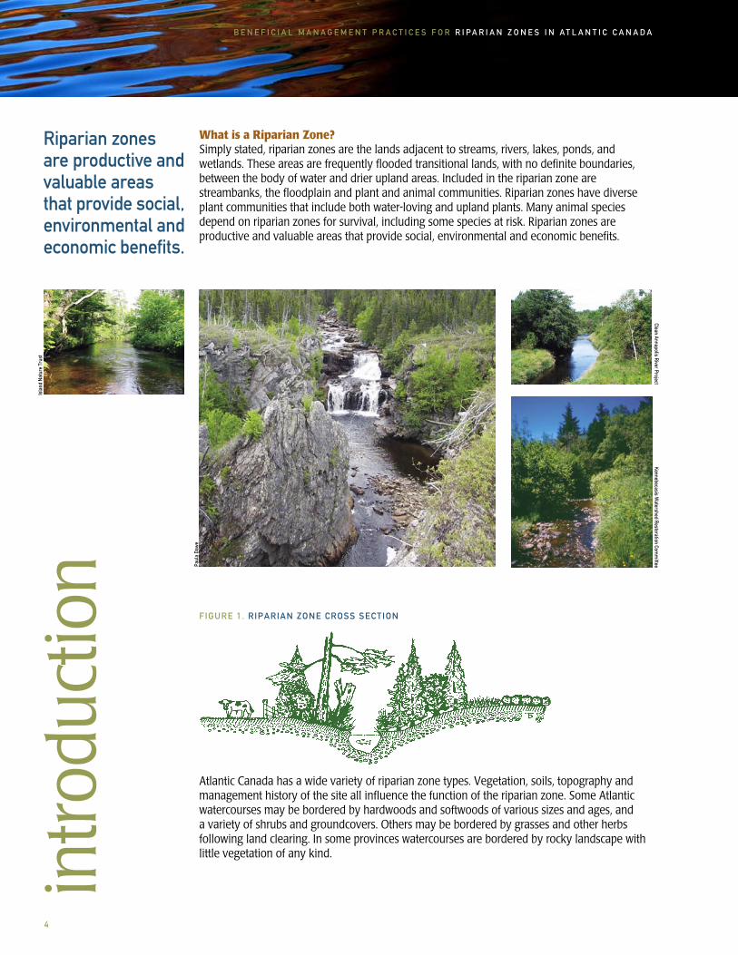
What is a Riparian Zone?Simply stated, riparian zones are the lands adjacent to streams, rivers, lakes, ponds, and wetlands. These areas are frequently flooded transitional lands, with no definite boundaries, between the body of water and drier upland areas. Included in the riparian zone are streambanks, the floodplain and plant and animal communities. Riparian zones have diverse plant communities that include both water-loving and upland plants. Many animal species depend on riparian zones for survival, including some species at risk. Riparian zones are productive and valuable areas that provide social, environmental and economic benefits.
intro
duct
ion
FIGURE 1. RIPARIAN ZONE CROSS SECTION
Riparian zones are productive and valuable areas that provide social, environmental and economic benefits.
Kennebecasis Watershed Restoration Com
mittee
Clean Annapolis River Project
Atlantic Canada has a wide variety of riparian zone types. Vegetation, soils, topography and management history of the site all influence the function of the riparian zone. Some Atlantic watercourses may be bordered by hardwoods and softwoods of various sizes and ages, and a variety of shrubs and groundcovers. Others may be bordered by grasses and other herbs following land clearing. In some provinces watercourses are bordered by rocky landscape with little vegetation of any kind.
Isla
nd N
atur
e Tr
ust
Paul
a Da
we
5
B E N E F I C I A L M A N A G E M E N T P R A C T I C E S F O R R I P A R I A N Z O N E S I N A T L A N T I C C A N A D A
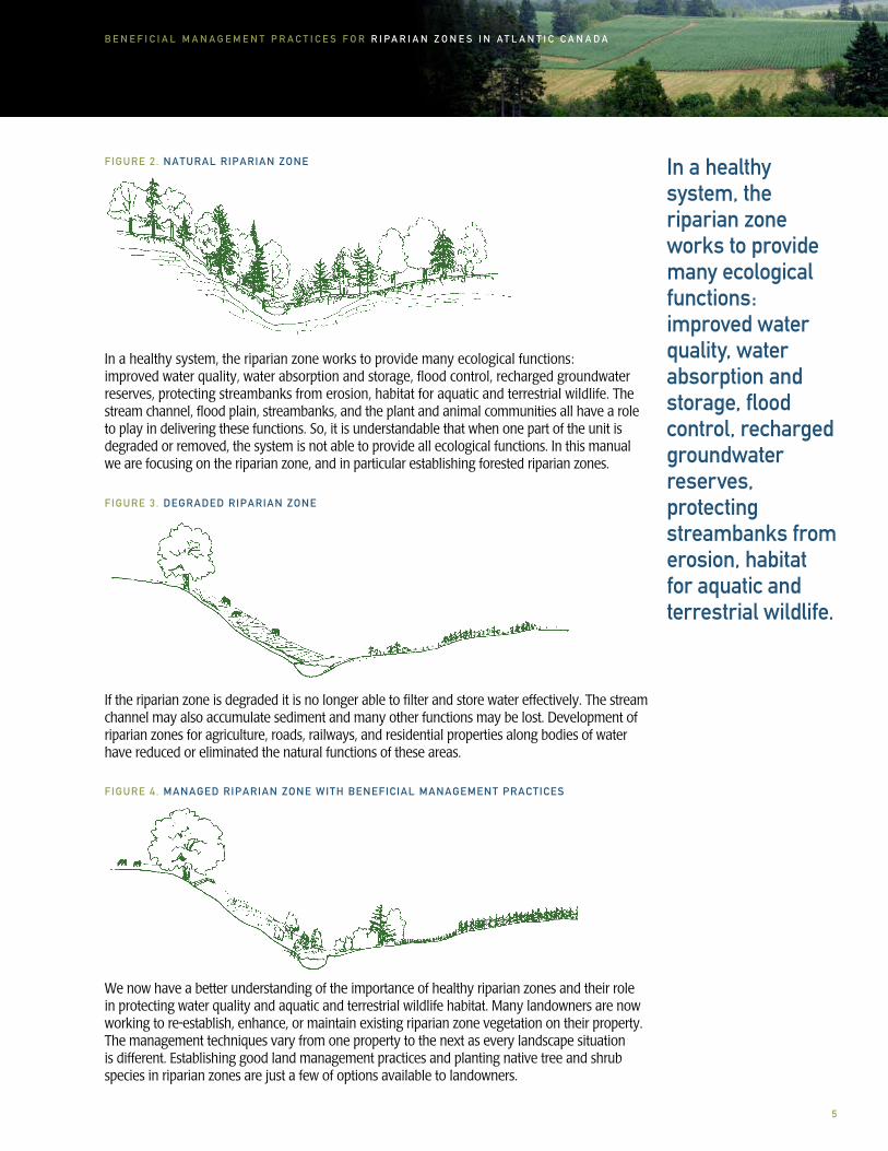
In a healthy system, the riparian zone works to provide many ecological functions: improved water quality, water absorption and storage, flood control, recharged groundwater reserves, protecting streambanks from erosion, habitat for aquatic and terrestrial wildlife.
If the riparian zone is degraded it is no longer able to filter and store water effectively. The stream channel may also accumulate sediment and many other functions may be lost. Development of riparian zones for agriculture, roads, railways, and residential properties along bodies of water have reduced or eliminated the natural functions of these areas.
FIGURE 3. DEGRADED RIPARIAN ZONE
In a healthy system, the riparian zone works to provide many ecological functions:improved water quality, water absorption and storage, flood control, recharged groundwater reserves, protecting streambanks from erosion, habitat for aquatic and terrestrial wildlife. The stream channel, flood plain, streambanks, and the plant and animal communities all have a role to play in delivering these functions. So, it is understandable that when one part of the unit is degraded or removed, the system is not able to provide all ecological functions. In this manual we are focusing on the riparian zone, and in particular establishing forested riparian zones.
FIGURE 2. NATURAL RIPARIAN ZONE
We now have a better understanding of the importance of healthy riparian zones and their role in protecting water quality and aquatic and terrestrial wildlife habitat. Many landowners are now working to re-establish, enhance, or maintain existing riparian zone vegetation on their property. The management techniques vary from one property to the next as every landscape situation is different. Establishing good land management practices and planting native tree and shrub species in riparian zones are just a few of options available to landowners.
FIGURE 4. MANAGED RIPARIAN ZONE WITH BENEFICIAL MANAGEMENT PRACTICES

6
B E N E F I C I A L M A N A G E M E N T P R A C T I C E S F O R R I P A R I A N Z O N E S I N A T L A N T I C C A N A D A
Riparian Zones:
• improve water quality by filtering sediment, nutrients, pesticide and other pollutants from surface runoff
• provide shade and reduce stream water temperature for fish and other aquatic organisms
• store water and decrease flood severity
• protect streambanks from erosion
• may act as hedgerows or shelterbelts and help to conserve energy, retain moisture in adjacent fields, increase snow deposits and provide shelter
• sequester carbon
• provide habitat for wildlife
• provide economic and aesthetic benefits
Water Quality ProtectionThe causes of reduced water quality in Atlantic Canada are many, including: runoff from agriculture, road construction, land development, industrial pollution, and domestic use. There are a variety of steps that we can take to protect and improve water quality. Incorporating good land use practices can have a positive impact on both surface water and groundwater quality.
ripar
ian
zone
func
tions
There are a variety of steps that we can take to protect and improve water quality. Incorporating good land use practices can have a positive impact on both surface water and groundwater quality.Cl
ean
Anna
polis
Riv
er P
roje
ct

7
B E N E F I C I A L M A N A G E M E N T P R A C T I C E S F O R R I P A R I A N Z O N E S I N A T L A N T I C C A N A D A
Process
Riparian Zones as a Natural Filter
Separation
Filtration
Adsorption
Absorption
Transformation
Riparian Zones and Water Temperature
Reduced Water Temperature
Description
• creates a buffer between bodies of water and agricultural practices
• riparian zones help minimize nonpoint source pollution impacts to surface waters by trapping sediments, and aid in filtering out harmful chemicals, bacteria, and nutrients
• riparian zone vegetation (such as grasses, tree stems and shrubs) creates surface friction, slows surface water runoff allowing suspended material to be filtered out as the water flows through the vegetation
• riparian zone vegetation serves as a sediment trap by reducing the amount of sediment entering the water body
• silt, soil, nutrients and other pollutants are trapped and stick to soil particles or plant leaves or stems in the riparian zone
• roots of riparian zone vegetation take up nutrients, salts, metals, pesticides and pathogens
• some nutrients, metals and salts can be directly absorbed by plant stems and leaves
• organic and inorganic compounds can be converted into less harmful compounds
• certain harmful bacteria can be destroyed by exposure to extreme temperatures, sunlight, or dry conditions
• water temperatures will increase (sometimes reaching 24-30 C) during the summer months due to lack of shade from overhanging branches when land is cleared to the stream edge
• if stabilizing root systems are lost this can cause the watercourse channel to become wider and shallower. A wide shallow stream is at a higher risk of temperature increase than a narrow deep stream
• dissolved oxygen levels decrease in warm water, creating stress for fish and all aquatic life. In warmer water, animals’ oxygen needs increase while available oxygen decreases.
Examples
• livestock fenced out of riparian zones and streams
• riparian zone tree and shrub plantings to reduce contaminants entering stream
• grasses and non-woody plants are effective in creating friction in the riparian zone
• trees and shrubs can create friction as number and size of species increases and as the width of the wooded riparian zone increases
• phosphates and ammonium can stick to clay particles in riparian zone soil
• nitrates in runoff can be taken up by riparian vegetation roots, the higher the organic matter in the soil the better the absorption
• plants use nutrients in surface water runoff for growth
• agricultural chemicals can be converted to less toxic compounds, for example glyphosate (Roundup) can be converted to carbon dioxide (CO2) and water (H20)
• riparian plant canopies, especially forest canopies, reduce the amount of sunlight reaching the water’s surface
• wide zones with tall trees will provide much better shade than narrow zones growing in grasses
• careful management of riparian zone vegetation will help maintain lower water temperatures therefore improving survival, growth and reproductive success for fish and other aquatic life
TABLE 1. VEGETATED RIPARIAN ZONES AND WATER QUALITY, TEMPERATURE, WATER STORAGE AND BANK STABILIZATION

8
B E N E F I C I A L M A N A G E M E N T P R A C T I C E S F O R R I P A R I A N Z O N E S I N A T L A N T I C C A N A D A
Process
Riparian Zones and Water Storage
Water Storage
Riparian Zones and Bank Stabilization
Bank Stabilization
Description
• water-holding capacity of soil increases with increased organic material in the soil due to extensive root systems of riparian vegetation
• roots improve soil porosity; the ability of the soil to absorb water, allowing more surface water runoff to soak into the soil
• replenishing groundwater reserves and lowering flood intensity.
• root systems of riparian zone vegetation and organic matter bind the soil, and help to keep it in place
• stems and leaves of the riparian vegetation will increase surface roughness and slow surface runoff, reduce the impact of heavy rain, decrease streambank erosion and minimize channel movement
• protect crossing structures for livestock and machinery by providing a stable base
Examples
• a healthy riparian zone will release discharging groundwater to the surface slowly throughout the year
• the vegetated riparian zone acts like a sponge to hold water, reducing peak flow levels in streams helping to maintain a more constant water level
• groundwater is recharged
• deep-rooted trees and shrubs are especially important in bank stabilization
• a diverse riparian zone forested with a mix of native trees, and the associated understory of shrubs and herbaceous plants (including grasses, sedges and rushes) is very useful
• reduced amount of solid material entering the stream, therefore supporting aquatic habitats
• regardless of the type of vegetation, a vegetated riparian zone will be more stable than a non-vegetated riparian zone
By incorporating forested riparian zones and establishing beneficial management practices for soil, water and crops, surface runoff is intercepted, slowed, and allowed to percolate into the ground, recharging groundwater.
Rosanne MacFarlane

9
B E N E F I C I A L M A N A G E M E N T P R A C T I C E S F O R R I P A R I A N Z O N E S I N A T L A N T I C C A N A D A
Energy ConservationRiparian zones may perform some similar roles to hedgerows and windbreaks in terms of energy conservation. Each can help slow wind speed and therefore lower home heating bills in the winter. Not only can they help save money, they may also decrease fossil fuel use for heating homes. However, this depends on factors such as distance from buildings, species composition and wind porosity. Decreased wind can mean increased snow loads which may be a negative factor for buildings and yards.
Sediment is soil that has eroded from the land by surface water runoff. Sedimentation is very damaging to stream habitat.
A degraded riparian zone can have less vegetation to intercept runoff and decreased infiltration rates due to compacted soil from livestock and vehicle traffic and lower levels of organic matter in the soil.
A forested riparian zone will also provide wind protection for crops, retain heat and moisture in the soil, and provides protection for soils from wind erosion. However, increased snow load may be beneficial to some crops and detrimental to others.
Riparian zones may perform some similar roles to hedgerows and windbreaks in terms of energy conservation. Each can help slow wind speed and therefore lower home heating bills in the winter. Not only can they help save money, they may also decrease fossil fuel use for heating homes.
Frie
nds
of th
e Co
rnw
allis
Riv
er S
ocie
ty
Rosanne MacFarlane
The soil in an established riparian zone is porous due to the complex root systems and organic matter. This allows surface water to infiltrate more easily than compact soil with low organic matter.
FIGURE 5. RIPARIAN ZONE SOIL PROFILE

1 0
B E N E F I C I A L M A N A G E M E N T P R A C T I C E S F O R R I P A R I A N Z O N E S I N A T L A N T I C C A N A D A
Wildlife HabitatWildlife species living in streams and riparian zones are very dependent on the zone for their food and habitat requirements.
Many types of wildlife depend on the diverse and productive plant species, complex structure, and availability of water of a well established forested riparian zone.
Clean Water • healthy riparian zones help to improve water quality for animals to drink, swim, feed in, and reproduce • water is also available in the shallow pools outside the channel, both permanent and temporary, common to many riparian areas
• important for reptiles, amphibians and invertebrates such as earthworms, grasshoppers and spiders
Cover • riparian vegetation provides shelter on land for birds, mammals, amphibians, and insects, as well as in-stream cover for fish and aquatic insects
• overhanging vegetation, undercut streambanks, leafy and woody debris, tree limbs, stones, and cobble provide cover for wildlife
• snags (dead or dying trees) are extremely valuable to birds, mammals, reptiles, amphibians, and insects for nesting, roosting and feeding
Shade • riparian vegetation helps to keep stream water cool for fish and aquatic life • vegetation also reduces water loss from evaporation • many invertebrates and amphibians cannot survive in full sun
Food • native vegetation provides seeds, nuts, fruits, foliage, and winter browse for birds and mammals • plant debris, such as leaves, branches and buds falling into the watercourse provide food for fish and other aquatic life
• trees and shrubs provide homes for insect life that later feed fish and birds
Function Description
TABLE 2. RIPARIAN ZONES AND AQUATIC AND TERRESTRIAL WILDLIFE HABITAT
Page 10 Photos: Beth Hoar
1 1
B E N E F I C I A L M A N A G E M E N T P R A C T I C E S F O R R I P A R I A N Z O N E S I N A T L A N T I C C A N A D A
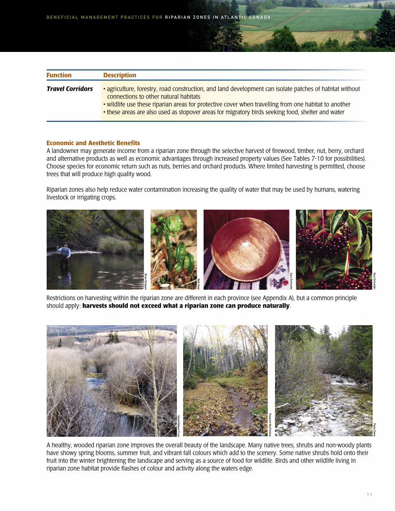
Travel Corridors • agriculture, forestry, road construction, and land development can isolate patches of habitat without connections to other natural habitats
• wildlife use these riparian areas for protective cover when travelling from one habitat to another • these areas are also used as stopover areas for migratory birds seeking food, shelter and water
Economic and Aesthetic BenefitsA landowner may generate income from a riparian zone through the selective harvest of firewood, timber, nut, berry, orchard and alternative products as well as economic advantages through increased property values (See Tables 7-10 for possibilities). Choose species for economic return such as nuts, berries and orchard products. Where limited harvesting is permitted, choose trees that will produce high quality wood.
Riparian zones also help reduce water contamination increasing the quality of water that may be used by humans, watering livestock or irrigating crops.
Restrictions on harvesting within the riparian zone are different in each province (see Appendix A), but a common principle should apply: harvests should not exceed what a riparian zone can produce naturally.
A healthy, wooded riparian zone improves the overall beauty of the landscape. Many native trees, shrubs and non-woody plants have showy spring blooms, summer fruit, and vibrant fall colours which add to the scenery. Some native shrubs hold onto their fruit into the winter brightening the landscape and serving as a source of food for wildlife. Birds and other wildlife living in riparian zone habitat provide flashes of colour and activity along the waters edge.
Function Description
Beth Hoar
Gary Schneider
Gary Schneider
Brian Simpson
Paula Dawe
Rosanne MacFarlane
Island Nature Trust

1 2
B E N E F I C I A L M A N A G E M E N T P R A C T I C E S F O R R I P A R I A N Z O N E S I N A T L A N T I C C A N A D A
Soil and Crop Management for Riparian Zone HealthAgricultural production can be compatible with riparian zone conservation. Developing an Environmental Farm Action Plan, and incorporating good soil, crop and water management practices on the farm will help to reduce the amounts of silt and associated pollutants entering a body of water. Adopting these practices will not only improve soil structure and crop productivity, but will help to improve streambank stability, maintain cool water temperatures and improve wildlife habitat and biodiversity on the farm. Non-cropped habitats occurring adjacent to cropped land play a significant role in the conservation of beneficial predatory insects and pollinators.
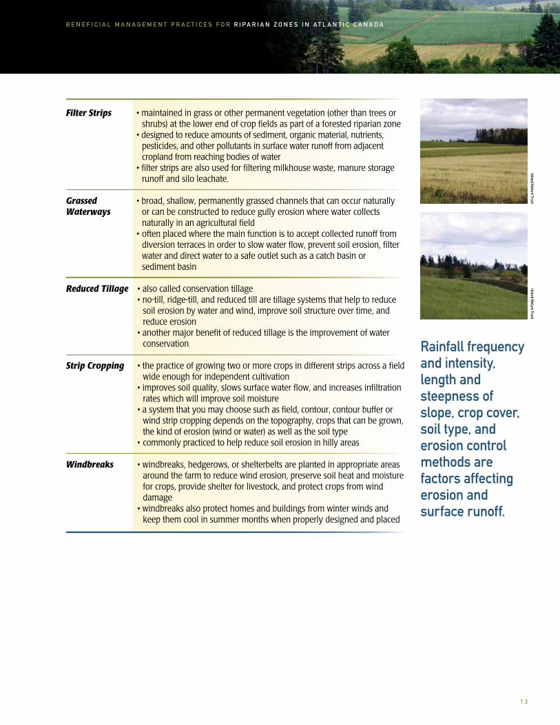
Soil ConservationSoil conservation practices will help keep soil on the land by protecting soil from the eroding forces of rainfall, melting snow, and wind. Rainfall frequency and intensity, length and steepness of slope, crop cover, soil type, and erosion control methods are factors affecting erosion and surface runoff.
For readers wanting information beyond the brief descriptions provided in this section, please refer to a wide variety of materials available on these subjects (page 44).
TABLE 3. BENEFICIAL MANAGEMENT PRACTICES FOR SOIL CONSERVATION
Beneficial Management Practices for Soil Conservation Include but are not Limited to:
Buffer Zones • a natural or managed strip of vegetation adjacent to natural areas such as bodies of water planted in trees, shrubs, or grasses to protect those natural areas from adjacent and surrounding land use activities
Cover Crops • cover crops (i.e. summer green manure crop, living mulch, catch crop, forage crop and winter cover crop) maintain and improve soil structure, increase organic matter in the soil, reduce soil erosion, help control pests and diseases, and use excess nutrients that might otherwise enter ground and surface water
Crop Rotation • crops such as forage, cereal and row crops are alternated to improve soil structure, add organic matter, manage pests, reduce soil erosion and nutrient losses, and increase yield
• the root systems of forage and cereal crops will improve soil structure and increase organic matter in the soil
• for example, in corn or vegetable production forages may be kept in rotation for several years in order to break weed/pest cycles and build soil organic matter
ripar
ian
zone
s an
d ag
ricul
ture
1 3
B E N E F I C I A L M A N A G E M E N T P R A C T I C E S F O R R I P A R I A N Z O N E S I N A T L A N T I C C A N A D A
Filter Strips • maintained in grass or other permanent vegetation (other than trees or shrubs) at the lower end of crop fields as part of a forested riparian zone
• designed to reduce amounts of sediment, organic material, nutrients, pesticides, and other pollutants in surface water runoff from adjacent
cropland from reaching bodies of water • filter strips are also used for filtering milkhouse waste, manure storage
runoff and silo leachate.
Grassed • broad, shallow, permanently grassed channels that can occur naturally or can be constructed to reduce gully erosion where water collects naturally in an agricultural field
• often placed where the main function is to accept collected runoff from diversion terraces in order to slow water flow, prevent soil erosion, filter water and direct water to a safe outlet such as a catch basin or
sediment basin
Reduced Tillage • also called conservation tillage • no-till, ridge-till, and reduced till are tillage systems that help to reduce
soil erosion by water and wind, improve soil structure over time, and reduce erosion
• another major benefit of reduced tillage is the improvement of water conservation
Strip Cropping • the practice of growing two or more crops in different strips across a field wide enough for independent cultivation
• improves soil quality, slows surface water flow, and increases infiltration rates which will improve soil moisture
• a system that you may choose such as field, contour, contour buffer or wind strip cropping depends on the topography, crops that can be grown, the kind of erosion (wind or water) as well as the soil type
• commonly practiced to help reduce soil erosion in hilly areas
Windbreaks • windbreaks, hedgerows, or shelterbelts are planted in appropriate areas around the farm to reduce wind erosion, preserve soil heat and moisture for crops, provide shelter for livestock, and protect crops from wind damage
• windbreaks also protect homes and buildings from winter winds and keep them cool in summer months when properly designed and placed
Rainfall frequency and intensity, length and steepness of slope, crop cover, soil type, and erosion control methods are factors affecting erosion and surface runoff.
Waterways
Island Nature Trust
Island Nature Trust
1 4
B E N E F I C I A L M A N A G E M E N T P R A C T I C E S F O R R I P A R I A N Z O N E S I N A T L A N T I C C A N A D A
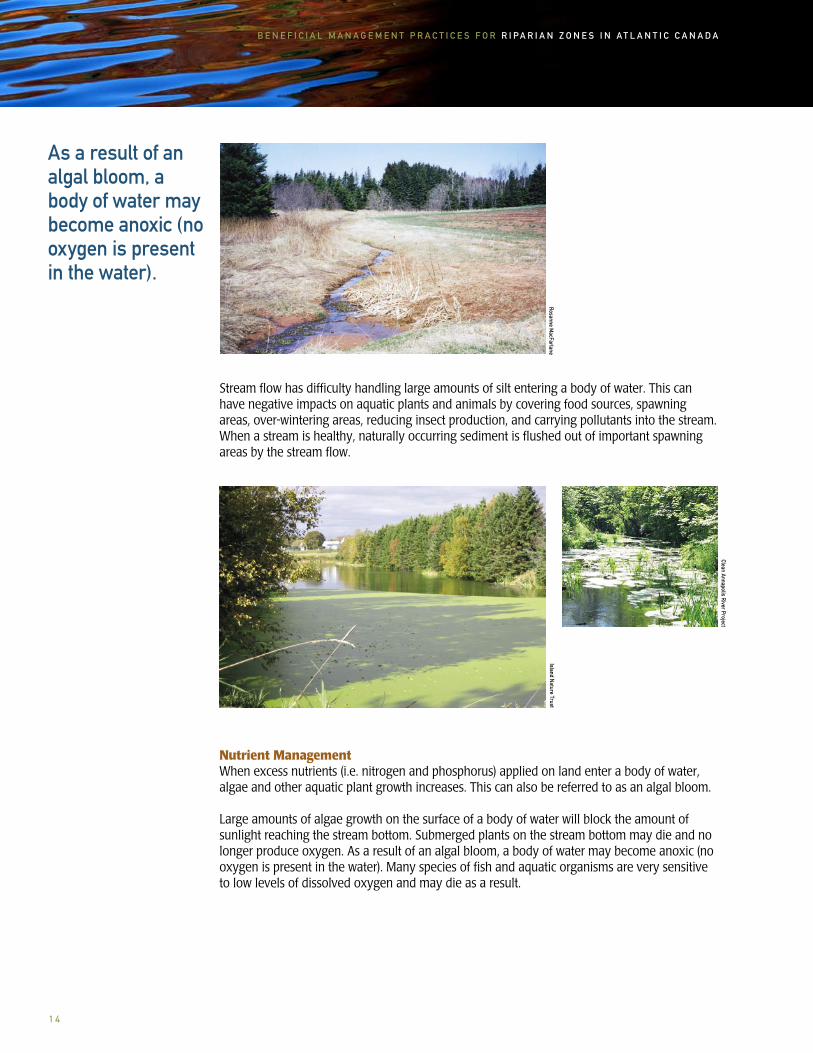
Stream flow has difficulty handling large amounts of silt entering a body of water. This can have negative impacts on aquatic plants and animals by covering food sources, spawning areas, over-wintering areas, reducing insect production, and carrying pollutants into the stream. When a stream is healthy, naturally occurring sediment is flushed out of important spawning areas by the stream flow.
Nutrient ManagementWhen excess nutrients (i.e. nitrogen and phosphorus) applied on land enter a body of water, algae and other aquatic plant growth increases. This can also be referred to as an algal bloom.
Large amounts of algae growth on the surface of a body of water will block the amount of sunlight reaching the stream bottom. Submerged plants on the stream bottom may die and no longer produce oxygen. As a result of an algal bloom, a body of water may become anoxic (no oxygen is present in the water). Many species of fish and aquatic organisms are very sensitive to low levels of dissolved oxygen and may die as a result.
As a result of an algal bloom, a body of water may become anoxic (no oxygen is present in the water).
Clean Annapolis River Project
Rosanne MacFarlane
Island Nature Trust

1 5
B E N E F I C I A L M A N A G E M E N T P R A C T I C E S F O R R I P A R I A N Z O N E S I N A T L A N T I C C A N A D A
LivestockIn Atlantic Canada livestock have traditionally had unrestricted access to bodies of water. We now realize the many negative impacts to livestock and the riparian zone.
Riparian zones typically support rich vegetation, provide easy access to water, and can provide shade and shelter, making these areas a popular grazing and resting area for livestock. Even limited access or grazing in the sensitive riparian zone can be harmful. When livestock are allowed access to streams they graze riparian zone vegetation, trample and damage streambanks, add nutrients (manure and urine) to the body of water and degrade fish habitat. This access also causes soil compaction and reduces the ability of the riparian zone to absorb and store water.
Frie
nds
of th
e Co
rnw
allis
Riv
er S
ocie
ty
When livestock are allowed access to streams they graze riparian zone vegetation, trample and damage streambanks, add nutrients (manure and urine) to the body of water and degrade fish habitat.
Frie
nds
of th
e Co
rnw
allis
Riv
er S
ocie
ty

1 6
B E N E F I C I A L M A N A G E M E N T P R A C T I C E S F O R R I P A R I A N Z O N E S I N A T L A N T I C C A N A D A
Assessing the Riparian ZoneNow that we know the many benefits of riparian zones we can think about riparian zone condition, design, vegetation, and establishment. Developing a management plan is a good first step to practices riparian zone stewardship. Taking the time to prepare a management plan on paper will allow you to make adjustments and ensure your desired goals are met before investing too much time and money. Take some time to walk through the riparian zone on your property. What is the condition of the riparian zone? Are your soil and water management practices conserving and promoting riparian zone health? Ask yourself what you appreciate most about the riparian zone. Are there natural areas or special features that you would like to preserve?
Define objectivesTaking time to ask yourself these questions will help you realize your objectives and reasons for managing the riparian zone. Although the values, goals and objectives will be different for each farmer, some of the common reasons for managing riparian zones are:
• to improve farm health and productivity• to improve and maintain surface and groundwater quality• to improve and/or provide fish and wildlife habitat• to provide economic opportunities such as berries, maple syrup, timber and/or fuel wood production • to provide tourism and recreation opportunities such as canoeing, fishing, bird watching and hiking
When assessing riparian zone condition, keep your objectives in mind. Take along a camera, measuring tape, plant identification books and an air photo of your property. These tools, along with your own eyes, will be very helpful in determining areas in need of management. Whenever possible, have a look at the riparian zone on both sides of the stream channel. Take note of the type of plants that you see. Examine the condition of the streambanks.
When assessing riparian zone condition, keep your objectives in mind. Take along a camera, measuring tape, plant identification books, and an air photo of your property. These tools, along with your own eyes, will be very helpful in determining areas in need of management.
deve
lop
a rip
aria
n zo
ne m
anag
emen
t pla
n
1 7
B E N E F I C I A L M A N A G E M E N T P R A C T I C E S F O R R I P A R I A N Z O N E S I N A T L A N T I C C A N A D A
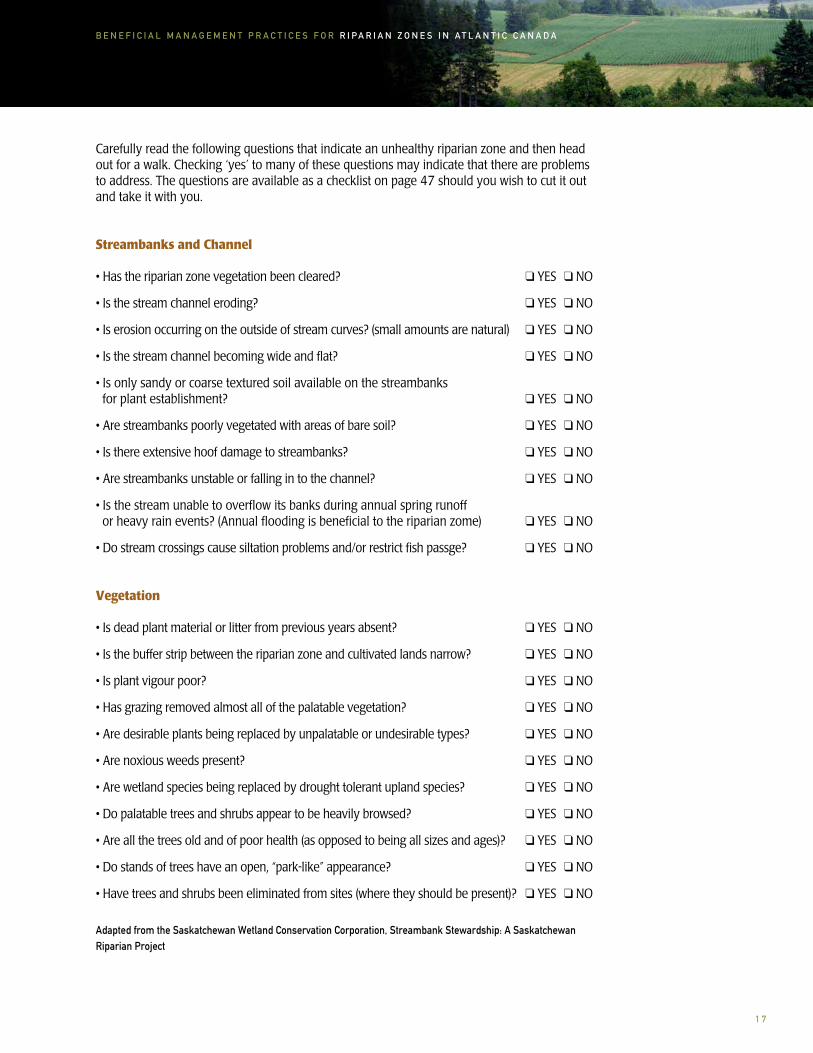
Carefully read the following questions that indicate an unhealthy riparian zone and then head out for a walk. Checking ‘yes’ to many of these questions may indicate that there are problems to address. The questions are available as a checklist on page 47 should you wish to cut it out and take it with you.
Streambanks and Channel
• Has the riparian zone vegetation been cleared? ❑ YES ❑ NO
• Is the stream channel eroding? ❑ YES ❑ NO
• Is erosion occurring on the outside of stream curves? (small amounts are natural) ❑ YES ❑ NO
• Is the stream channel becoming wide and flat? ❑ YES ❑ NO
• Is only sandy or coarse textured soil available on the streambanks for plant establishment? ❑ YES ❑ NO
• Are streambanks poorly vegetated with areas of bare soil? ❑ YES ❑ NO
• Is there extensive hoof damage to streambanks? ❑ YES ❑ NO
• Are streambanks unstable or falling in to the channel? ❑ YES ❑ NO
• Is the stream unable to overflow its banks during annual spring runoff or heavy rain events? (Annual flooding is beneficial to the riparian zome) ❑ YES ❑ NO
• Do stream crossings cause siltation problems and/or restrict fish passge? ❑ YES ❑ NO
Vegetation
• Is dead plant material or litter from previous years absent? ❑ YES ❑ NO
• Is the buffer strip between the riparian zone and cultivated lands narrow? ❑ YES ❑ NO
• Is plant vigour poor? ❑ YES ❑ NO
• Has grazing removed almost all of the palatable vegetation? ❑ YES ❑ NO
• Are desirable plants being replaced by unpalatable or undesirable types? ❑ YES ❑ NO
• Are noxious weeds present? ❑ YES ❑ NO
• Are wetland species being replaced by drought tolerant upland species? ❑ YES ❑ NO
• Do palatable trees and shrubs appear to be heavily browsed? ❑ YES ❑ NO
• Are all the trees old and of poor health (as opposed to being all sizes and ages)? ❑ YES ❑ NO
• Do stands of trees have an open, “park-like” appearance? ❑ YES ❑ NO
• Have trees and shrubs been eliminated from sites (where they should be present)? ❑ YES ❑ NO
Adapted from the Saskatchewan Wetland Conservation Corporation, Streambank Stewardship: A Saskatchewan Riparian Project

1 8
B E N E F I C I A L M A N A G E M E N T P R A C T I C E S F O R R I P A R I A N Z O N E S I N A T L A N T I C C A N A D A
If you have checked ‘yes’ to many of the items on the checklist try to determine the problem causes. Are livestock accessing the riparian zone? Are livestock drinking directly from the stream? Are fields being cropped too close to the stream edge? Upland management can have a major impact on the health of your riparian zone. Including an assessment of surrounding areas may indicate problems originating adjacent to the stream. Adjoining pastures and cultivated fields can be the source of surface water runoff, and associated sediments and pollutants flowing into streams and rivers. Determining the causes of the problems will allow you to solve the management problems.
Management Options for Riparian Zone HealthConserving riparian zone health involves the use of beneficial management practices for soil, water and vegetation. The objective of these practices is to minimize the sources of damage to the riparian zone and maintain healthy riparian zone vegetation.
Increasing riparian zone width, fencing livestock out of riparian zones, providing alternate watering systems, implementing soil conservation practices, installing properly constructed stream crossings, stabilizing streambanks and planting trees and shrubs all take money, time and expertise to implement and maintain. Keep in mind that it may take several years to meet all of your objectives so concentrate on the most effective management practices first.
WidthAgricultural land that is cultivated close to or to the stream edge reduces riparian zone vegetation and reduces the ability to filter and trap sediment, pesticides and other pollutants, which affects water quality. Habitat for aquatic and terrestrial wildlife is also lost and streambanks can be more susceptible to erosion. The wider the vegetated riparian zone the more effective the zone is at filtering sediment and pollutants, providing habitat, and water storage. The width of a natural riparian zone will vary depending on site conditions.
Plan your riparian zone and decide on the desired width (see Appendix A for Provincial Regulation and Legislation). When measuring, take the distance from the top of the streambank to the edge of a field. Where the stream meanders, take three measurements and use the average. This measurement should be done on both sides of the body of water.
The following table provides a range of widths for riparian zone design based on function. This information is based on land adjacent to the riparian zone consisting of bare soil with a slope of less than 10 percent.
TABLE 4. RIPARIAN ZONE WIDTH RANGES BASED ON FUNCTION
Function Width
Bank Stability 5+ meters (16+ feet)
Sediment Removal 10-30 meters (33-98 feet)
Soil-Bound Nutrients 10-30 meters (33-98 feet)
Soluble Nutrients 15-50 meters (50-164 feet)
Aquatic Habitat 15-30 meters (50-98 feet)
Terrestrial Wildlife Habitat 10-300 meters (33-984 feet)
Adapted from Ontario’s Ministry of Agriculture and Food, Best Management Practices: Buffer Strips
Keep in mind that it may take several years to meet all of your objectives so concentrate on the most effective management practices first.

1 9
B E N E F I C I A L M A N A G E M E N T P R A C T I C E S F O R R I P A R I A N Z O N E S I N A T L A N T I C C A N A D A
Fencing Livestock for ExclusionFencing livestock out of riparian zones will permit riparian zone vegetation, streambanks and streambed to recover.
There are many benefits for farmers to fence livestock out of riparian zones:
• cleaner drinking water for livestock • reduced risk of disease and infections in livestock• improved performance and weight gain in livestock• stabilized streambanks• minimized stream channel movement• reduced amount of harmful bacteria in water• reduced nutrient loading and algae blooms• improved fish habitat• decreased downstream sedimentation
Alternate Water Sources for LivestockProviding an alternate water source away from the riparian zone and body of water will help to reduce the amount of time livestock spend in and around water. A producer will need to consider livestock needs, geographic conditions and topography in order to choose an alternate watering system. The water source may be a well, body of water, or constructed wetland. Nose pumps, gravity flow systems, windmills, solar powered and electric pumps are a few of the options available.
CrossingsProperly constructed crossings should be installed in areas where livestock or farm machinery must cross a body of water. Crossings, such as bridges and culverts, must be professionally designed to prevent: sedimentation of the body of water during construction, erosion to streambanks, debris and ice jams, and damage to fish habitat. The design must allow for fish migration to and from spawning, rearing, feeding and wintering areas. Proper location, peak flow, and impact to the environment must be considered in crossing design.
Watercourse alteration permits are required in all for Atlantic Provinces when installing watercourse crossings or when working in close proximity to watercourses or wetlands (see Table 5).
Concentrated flow will cut channels through the riparian zone reducing effectiveness for filtering sediment and increasing erosion in the riparian area.
Streambank erosion is reduced when livestock are fenced out of the riparian zone, and when crossings are built for livestock and machinery crossing.
Chignecto Agro-Conservation Club
PEI Soil and Crop Improvem
ent AssociationRuth
Stu
rtz
Providing an alternate water source away from the riparian zone and body of water will help to reduce the amount of time livestock spend in and around water.

2 0
B E N E F I C I A L M A N A G E M E N T P R A C T I C E S F O R R I P A R I A N Z O N E S I N A T L A N T I C C A N A D A
Canada’s Fisheries ActIt is important to ensure compliance with Canada’s Fisheries Act. To better understand the Act subsections, these terms are defined as follows:
Deposit- any discharging, spraying, releasing, spilling, leaking, seeping, pouring, emitting, emptying, throwing, dumping or placing (ref. Ss34 (1)(e))
Deleterious substance- as applicable to livestock or cash crop operation, means any substance that, if added to any water would degrade or alter or form part of a process of degradation or alteration of the quality of that water so that it is rendered or is likely to be rendered deleterious to fish or fish habitat or to the use by man or fish that frequent that water (ref. Ss34(1)(a))
Water frequented by fish- means Canadian fisheries, which essentially is water, which at some time has fish in it (ref. Ss34(1)(e))
Fish habitat- spawning grounds and nursery, rearing, food supply and migration areas on which fish depend directly or indirectly to carry out their live processes (ref. Ss34 (1)(e))
Subsection 35(1) of the Fisheries Act states that “no person shall carry on any work or undertakings that results in the harmful alteration, disruption, or destruction of fish habitat”. Subsection 35(2) states (2) No person contravenes subsection (1) by causing the alteration, disruption or destruction of fish habitat by any means or under any conditions authorized by the Minister or under regulations made by the Governor in Council under this Act.
Subsection 36(3) of the Fisheries Act states that “no person shall deposit or permit the deposit of a deleterious substance of any type in water frequented by fish or in any place under any conditions where the deleterious substance or any other deleterious substance that results from the deposit of the deleterious substance may enter any such water”.
Providing salt/mineral, water, and/or feed in the pasture out of the riparian zone has shown to be effective in reducing the amount of time livestock spend in the riparian zone or body of water.
In order to improve conditions, producers are working with many different government and non-government groups to fence livestock out of streams and riparian zones, install stable fording sites, install alternate water sources, and plant native tree and shrub species.
Clea
n An
napo
lis R
iver
Pro
ject
PEI S
oil a
nd C
rop
Impr
ovem
ent A
ssoc
iatio
n

2 1
B E N E F I C I A L M A N A G E M E N T P R A C T I C E S F O R R I P A R I A N Z O N E S I N A T L A N T I C C A N A D A
TABLE 5. CONTACT INFORMATION FOR WATERCOURSE ALTERATION PERMIT APPLICATION
Province Contact Information
Prince Edward Island Watercourse/Wetland Alteration Water Resources Division Department of Fisheries, Aquaculture & Environment PO Box 2000 Charlottetown, PE C1A 7N8 Phone: 902-368-5000 Fax : 902-368-5830
New Brunswick Watercourse and Wetland Alteration Program 20 McGloin Street PO Box 6000 Fredericton, NB E3A 5T8 Phone: 506-457-4850 Fax: 506-453-6862
Nova Scotia Nova Scotia Environment and Labour (Head Office Terminal Road Building) 5151 Terminal Road, 5th Floor Halifax, NS B3J 2T8 Phone: 902-424-5300 Fax: 902-424-0503
Newfoundland and Labrador Water Resources Management Division Department of Environment and Conservation Confederation Building, 4th Floor West Block PO Box 8700 St. John’s, NL A1B 4J6 Phone: 709-729-2563 Fax: 709-729-0320

2 2
B E N E F I C I A L M A N A G E M E N T P R A C T I C E S F O R R I P A R I A N Z O N E S I N A T L A N T I C C A N A D A
Bank StabilizationStreambanks will begin to recover and stabilize when beneficial management practices are used in and adjacent to riparian zones. In a healthy riparian zone floodwaters will come out over streambanks and spread over the floodplain. This will slow down fast flowing floodwaters. When water slows down, sediment suspended in the floodwater will settle out and help build up streambanks. Streambanks will continue to be built up over time and a narrower, deeper stream channel will be created as a result.
However, streambanks may be severely degraded and require more intensive restoration techniques. If this is the case a professional should be contacted for advice on construction, habitat issues, and permits (See page 40). Restoration techniques for streambanks may include the use of living and dead plant material, or hard structures such as rock or wood. When properly placed and constructed along streambanks these structures will hold soil, slow water, and filter contaminants.
Preparing the Site for Tree and Shrub PlantingIf you determine that tree and shrub planting is required, the site will need to be prepared.
Take into consideration the desired benefits that you want to achieve on your farm, for example: filtering and retaining sediment, nutrients, pesticides and bacteria, reducing streambank erosion, improving fish and wildlife habitat, and increasing diversity.
Based on these decisions:
• the area should be cleared of any garbage• measure the width of the riparian zone to be planted or fenced and determine the number of trees and shrubs to be planted• choose trees and shrubs suited to the region and the desired function of the riparian zone (see Tables 7-10). Planting only native species is best for wildlife• remove competing vegetation from each planting site• keep exposed soil to a minimum• follow planting procedures on pages 32 and 33
The wider the vegetated riparian zone the more effective the zone is at filtering sediment and pollutants, providing habitat, and water storage.

2 3
B E N E F I C I A L M A N A G E M E N T P R A C T I C E S F O R R I P A R I A N Z O N E S I N A T L A N T I C C A N A D A
Tree and Shrub SelectionNative trees and shrubs capable of developing deep roots and large trunks are important species for riparian zone enhancement.
Native tree and shrub species should be planted in riparian zones as they are best suited to the local conditions, and best support native wildlife. Non-native and invasive species should be avoided.
When choosing what species to plant, keep in mind:
TABLE 6. CRITERIA FOR TREE AND SHRUB PLANTING
Climate • plant trees and shrubs suited to your region
Soil Drainage • increase survival and growth rates by planting trees and shrubs in their preferred conditions
Flood Tolerance • when planting in the floodplain ensure trees and shrubs tolerate flooding
Shade Tolerance • some trees grow well in full or partial shade, others prefer full sun
Growth Rate • plant fast growing trees where shading is important
Wildlife Value • choose trees and shrubs well suited to providing habitat for wildlife
Economic Value • where limited harvesting is permitted, choose trees and shrubs that will produce high quality wood, nuts, berries, and orchard products
In areas where riparian zone vegetation has been degraded or removed, tree and shrub planting will help decrease streambank erosion. The roots of the vegetation will help bind the soil and hold it in place.
Sean Hill
Native tree and shrub species should be planted in riparian zones as they are best suited to the local conditions, and best support native wildlife.

2 4
B E N E F I C I A L M A N A G E M E N T P R A C T I C E S F O R R I P A R I A N Z O N E S I N A T L A N T I C C A N A D A
The following tables (adapted from Macphail Woods Ecological Forestry Project’s publications: Native Shrubs and More Native Trees and Shrubs) include a diverse list of softwood, hardwood and shrub species.
TABLE 7. SUGGESTED PLANTS FOR STREAMBANKS (FIRST 10 METERS)
Black Spruce
Eastern White Cedar
Black Ash
American Elm
Picea mariana
Thuja occidentalis
Fraxinus nigra
Ulmus americanum
PEI, NB, NS, NL
PEI, NS, NB excluding southern NB
PEI, NB, NS, west coast of NL
PEI, NB, NS
• black spruce gum has been used to make healing salves
• beverages can be made from the needles and twigs (spruce beer)
• used for riparian zone restoration• the rot resistant wood is used for
fence posts, shingles, blanket chests, saunas and boat building
• basket making, streambank and wetland restoration
• tolerates flooding• grows well in rich riparian zones• excellent, fast growing shade tree that
has been used for furniture, casket, and basket making
Plant Scientific Name Province Uses for Wildlife Other Uses
• seeds are eaten by many small mammals and birds
• browsed by moose and snowshoe hare
• provides cover for wildlife and nesting area for birds
• seeds are a preferred food for birds, deer and small mammals
• provides cover for birds
• seeds provide food for many species of birds such as red-winged blackbird, evening grosbeak and pine grosbeak
Single-aged softwood species, such as white spruce, limit the amount of light reaching the forest floor. As a result, very few understory species such as shrubs and herbaceous plants are able to grow which decreases the effectiveness of the riparian zone for slowing and filtering surface water runoff.
A mixture of tree species and ages is recommended to allow for the development of understory species.
Wet Areas with Full Sunlight
Island Nature Trust
Island Nature Trust

2 5
B E N E F I C I A L M A N A G E M E N T P R A C T I C E S F O R R I P A R I A N Z O N E S I N A T L A N T I C C A N A D A
Plant Scientific Name Province Uses for Wildlife Other Uses
Wild Raisin (Witherod)
Red-osier Dogwood
Winterberry
Large-toothed Aspen
Eastern Larch (Tamarack) (also called Juniper in Nfld.)
Red Maple
White Ash
Willow
Viburnum nudum var. cassinoides
Cornus sericea ssp. sericea
Ilex verticillata
Populus grandidentata
Larix laricina
Acer rubrum
Fraxinus americana
Salix sp.
PEI, NB, NS. NL
PEI, NB, NS, NL
PEI, NB, NS, NL
PEI, NB, NS
PEI, NB, NS, NL
PEI, NB, NS, NL
PEI, NB, NS
PEI, NB, NS, NL
• berries provide food for ruffed grouse snowshoe hare, red squirrel, chipmunk and many species of birds
• this native shrub also provides cover for many species of wildlife
• provides food (berries, and browse) and cover for
songbirds, snowshoe hare, red squirrel, chipmunks
raccoon and beaver
• berries are a source of food for many birds and mammals
• leaves and buds provide food for ruffed grouse
• aspen suckers are browsed by moose and white-tailed deer
• a preferred food for beaver
• provides nesting habitat for many species of birds
• porcupine eat the inner bark• snowshoe hare browse
seedlings
• twigs, buds and seeds are food for birds and mammals
• seeds provide food for many species of birds such as red-winged blackbird, evening grosbeak and pine grosbeak
• provides food, cover and nesting areas
• shade tolerant • used in understory plantings to increase diversity • salt tolerant, suitable for planting along coasts• traditional uses include baskets and eel traps
• fast growing in sunny, moist areas and flood tolerant with spreading roots• dense foliage provides shading • used for basket making and decorative
purposes in the floral industry
• useful for increasing biodiversity
• very durable• used for fence posts• wood is hard and light
• tolerates flooding• wood is rot resistant
• tolerates wet soils and flooding• used for furniture making, cabinets and many other products• can be used for syrup production
• useful for areas in need of diversification• the wood is very valuable and is used to
make handles for tools, baseball bats, hockey sticks, tennis rackets,
canoe paddles and many other products
• excellent for stabilizing streambanks and can tolerate light shading
• can be used to make willow furniture, baskets and other crafts
• fast growing and spreads quickly
2 6
B E N E F I C I A L M A N A G E M E N T P R A C T I C E S F O R R I P A R I A N Z O N E S I N A T L A N T I C C A N A D A
Plant Scientific Name Province Uses for Wildlife Other Uses
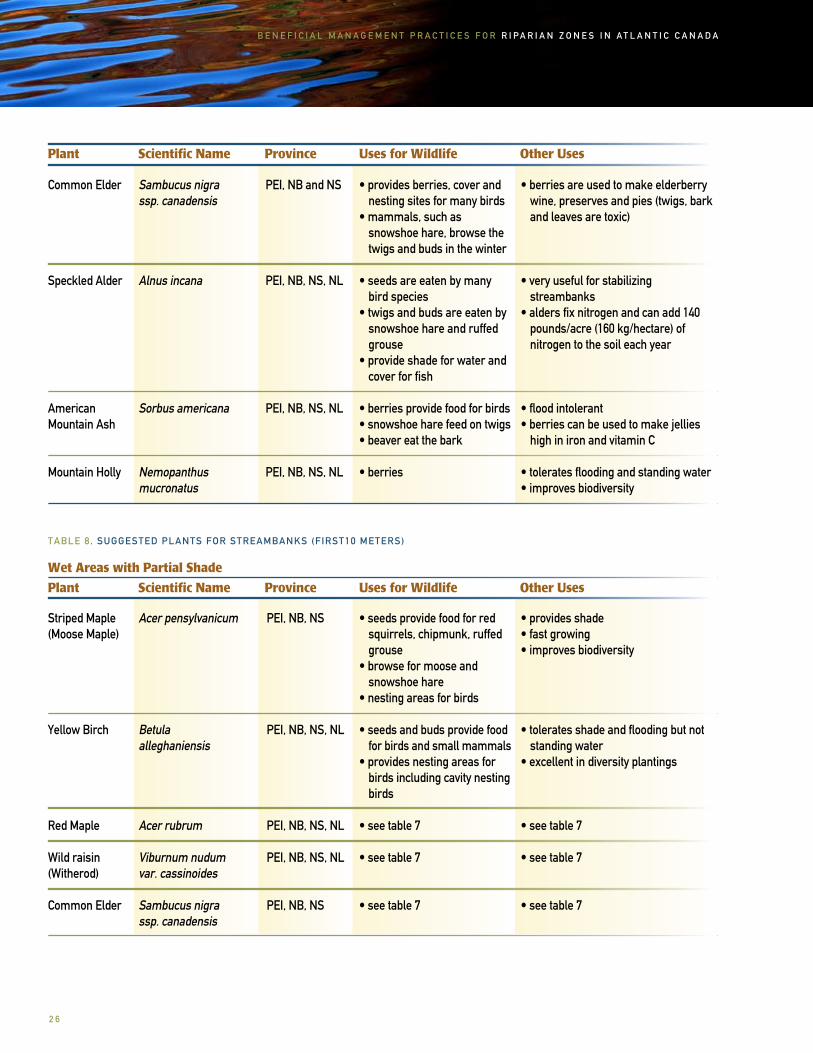
Common Elder
Speckled Alder
American Mountain Ash
Mountain Holly
Sambucus nigra ssp. canadensis
Alnus incana
Sorbus americana
Nemopanthus mucronatus
PEI, NB and NS
PEI, NB, NS, NL
PEI, NB, NS, NL
PEI, NB, NS, NL
• provides berries, cover and nesting sites for many birds
• mammals, such as snowshoe hare, browse the
twigs and buds in the winter
• seeds are eaten by many bird species
• twigs and buds are eaten by snowshoe hare and ruffed grouse
• provide shade for water and cover for fish
• berries provide food for birds• snowshoe hare feed on twigs• beaver eat the bark
• berries
• berries are used to make elderberry wine, preserves and pies (twigs, bark and leaves are toxic)
• very useful for stabilizing streambanks
• alders fix nitrogen and can add 140 pounds/acre (160 kg/hectare) of nitrogen to the soil each year
• flood intolerant• berries can be used to make jellies
high in iron and vitamin C
• tolerates flooding and standing water• improves biodiversity
TABLE 8. SUGGESTED PLANTS FOR STREAMBANKS (FIRST10 METERS)
Plant Scientific Name Province Uses for Wildlife Other Uses
Striped Maple (Moose Maple)
Yellow Birch
Red Maple
Wild raisin(Witherod)
Common Elder
Acer pensylvanicum
Betula alleghaniensis
Acer rubrum
Viburnum nudum var. cassinoides
Sambucus nigra ssp. canadensis
PEI, NB, NS
PEI, NB, NS, NL
PEI, NB, NS, NL
PEI, NB, NS, NL
PEI, NB, NS
• seeds provide food for red squirrels, chipmunk, ruffed grouse
• browse for moose and snowshoe hare• nesting areas for birds
• seeds and buds provide food for birds and small mammals
• provides nesting areas for birds including cavity nesting birds
• see table 7
• see table 7
• see table 7
• provides shade• fast growing• improves biodiversity
• tolerates shade and flooding but not standing water
• excellent in diversity plantings
• see table 7
• see table 7
• see table 7
Wet Areas with Partial Shade

2 7
B E N E F I C I A L M A N A G E M E N T P R A C T I C E S F O R R I P A R I A N Z O N E S I N A T L A N T I C C A N A D A
Plant Scientific Name Province Uses for Wildlife Other Uses
Eastern White Cedar
Mountain Maple
Iron Wood(also known as Hop-Hornbeam)
Mountain Holly
Beaked Hazelnut
Winterberry
Thuja occidentalis
Acer spicatum
Ostrya virginiana
Nemopanthus mucronatus
Corylus cornuta
Ilex verticillata
PEI, NS, NB excluding south-ern NB
PEI, NB, NS, NL
PEI (rare), NB, NS (Annapolis County to Cape Breton)
PEI, NB, NS, NL
PEI, NB, NS, NL
PEI, NB, NS, NL
• seeds are a preferred food for birds, deer and small mammals
• provides cover for birds• deer will gather under cedar
cover in winter
• buds, catkins and seeds provide food for birds and mammals
• berries
• protein-rich nuts are a favourite for red squirrels
and chipmunks, ruffed grouse and many other birds
• buds, catkins and young shoots provide food for grouse,
American woodcock and snowshoe hare in winter and spring
• berries are a source of food for many birds and mammals
• used for riparian zone restoration• the rot resistant wood is used for
fence posts, shingles, blanket chests, saunas and boat building
• shade-tolerant and can be used for underplantings
• as implied by the name the wood is very hard and heavy and in the past was used to make small milled products
• tolerates standing water, salt spray and full sun
• tolerates shade and can be used as an excellent understory plant along streambanks
• nuts were more commonly eaten by humans in the past, but are delicacies in some areas
• useful for increasing biodiversity
TABLE 9. SUGGESTED PLANTS FOR UPPER STREAMBANK
Plant Scientific Name Province Uses for Wildlife Other Uses White Spruce
Balsam Fir
Picea glauca
Abies balsamea
PEI, NB, NS, NL
PEI, NB, NS, NL
• provides cover for moose, snowshoe hare
• provides food for grouse and red squirrels
• food for moose and red squirrel
• cover for white-tailed deer, moose, snowshoe hare, songbirds, bear and grouse
• used for lumber, musical instruments, containers and other
woodworking products
• shade tolerant• used for Christmas trees, wreaths and arrangements
Dry Areas with Full Sunlight
2 8
B E N E F I C I A L M A N A G E M E N T P R A C T I C E S F O R R I P A R I A N Z O N E S I N A T L A N T I C C A N A D A
Plant Scientific Name Province Uses for Wildlife Other Uses
White Birch
Grey Birch
White Ash
Balsam Poplar
Pin Cherry
Choke Cherry
Red-berried Elder
Hawthorn
American Mountain Ash
Speckled Alder
Sweetfern
Betula papyrifera
Betula populifolia
Fraxinus americana
Populus balsamifera
Prunus pensylvanica
Prunus virginiana
Sambucus racemosa
Crataegus sp.
Sorbus americana
Alnus incana
Comptonia peregrina
• seeds and buds provide food for birds and small mammals
• provides nesting areas for birds including cavity nesting birds
• seeds and buds provide food for birds and small mammals
• provides nesting areas for birds including cavity nesting birds
• see table 7
• nesting birds and many species of wildlife use these small trees for food
• fruit is eaten by many birds and small mammals
• twigs and buds are eaten by fox, snowshoe hare, skunk, and chipmunk
• berries are a source of food for many birds and mammals
• provides cover and browse
• provides berries, twigs and buds, especially late in the winter
• the thorns provide protection and nesting space for small birds
• see table 7
• see table 7
PEI, NB, NS, NL
PEI, NB, NS
PEI, NB, NS
PEI, NB, NS, NL
PEI, NB, NS, NL
PEI, NB, northern NS, NL
PEI, NB, NS, NL
PEI, NB, NS, NL (rare)
PEI, NB, NS, NL
PEI, NB, NS, NL
PEI, southeastern NB, NS
• useful when restoring degraded sites
• useful when restoring degraded sites
• see table 7
• an excellent shade tree
• leaves are poisonous to cattle and humans, do not plant in areas where
cattle will access• berries are edible and can be used to
make preserves
• provide shade for new seedlings• leaves are poisonous to cattle and humans, do not plant in areas where
cattle will access
• an excellent wildlife shrub • not tolerant to salt spray
• long thorns may be harmful to livestock and humans when planted
along pasture or walking trails• not tolerant to salt spray• may act as an alternate host for the apple maggot so this shrub should not
be planted near apple orchards
• see table 7
• see table 7
• sweetfern leaves can be used to make tea• young fruit were eaten by humans in
the past • has been used as a treatment for the
rash caused by poison ivy

2 9
B E N E F I C I A L M A N A G E M E N T P R A C T I C E S F O R R I P A R I A N Z O N E S I N A T L A N T I C C A N A D A
Plant Scientific Name Province Uses for Wildlife Other Uses
Northern Bayberry
Jack Pine
Red Pine
Apple
Red Oak
Trembling Aspen
Butternut
Highbush Cranberry
Serviceberry(Shadbush, Wild Pear, Saskatoon Berry)
Common Elder
Staghorn Sumac
Myrica pensylvanica
Pinus banksiana
Pinus resinosa
Malus sp.
Quercus rubra
Populus tremuloides
Juglans cinerea
Viburnum opulusvar. americanum
Amelanchier sp.
Sambucus nigraspp. canadensis
Rhus typhina
PEI, NB, NS, NL (rare)
PEI, NB, NS
PEI, NB, NS, central NL
PEI, southern NB, NS
PEI, NB, NS
PEI, NB, NS, NL
PEI, NB (St. John and southwestern Miramichi River valleys)
PEI, NB, NS
PEI, NB, NS, NL
PEI, southern NB, NS
PEI, NB, NS
• berries provide food for birds
• provides food and shelter for birds and mammals
• provides food, cover and nesting sites for many species
of mammals and birds
• although not native, provides food and cover for many birds and mammals such as ruffed grouse, snowshoe hare, foxes, porcupines, deer, songbirds and woodcock
• acorns provide food for red squirrels
• provides habitat for many species of wildlife including snowshoe hare, black bear, ruffed grouse, woodcock, and songbirds
• nuts are eaten by red squirrel, chipmunk, blue jays,
songbirds and other small mammals
• fruit is eaten by many species and is a preferred food for ruffed grouse and
cedar waxwing
• provides cover and nesting sites for birds
• berries are eaten by many birds and mammals
• buds and twigs are eaten by snowshoe hare and red fox
• see table 7
• berries are eaten by many birds
• bayberry is used to scent candles, soaps and other crafts
• leaves and berries may be used in soup
• red pine forests are beautiful areas for hiking and camping
• fruit can be used to make preserves, sauces and pies
• the wood surface does not splinter so it can be used to make playground equipment, benches and other items.
• also used for posts and rails
• benefit from light shading• nuts may be harvested and eaten• wood is used for furniture making
and decorative woodwork
• in the past these berries have been used with other berries to make preserves and baked goods
• berries can be used to make preserves, pies, and wine
• see table 7
• roots are shallow and spreading making this plant very useful
for streamside plantings to help streambank stabilization

3 0
B E N E F I C I A L M A N A G E M E N T P R A C T I C E S F O R R I P A R I A N Z O N E S I N A T L A N T I C C A N A D A
Plant Scientific Name Province Uses for Wildlife Other Uses
Wild Rose
Wild Raisin (Witherod)
Mountain Alder
Rosa sp.
Viburnum nudum var. cassinoides
Alnus crispa
PEI, NB, NS, NL
PEI, NB, NS, NL
PEI, NB, NS, NL
• rose hips provide food for many species of birds
• wild rose thickets provide cover for birds
• see table 7
• browsed by deer and moose, snowshoe hare, beaver and muskrat
• birds feed on seeds and buds
• rose hips are a natural source of vitamin C, can be used to make jellies and teas
• see table 7
TABLE 10. SUGGESTED PLANTS FOR UPPER STREAMBANK
Plant Scientific Name Province Uses for Wildlife Other Uses
Dry Areas with Partial Shade
Eastern Hemlock
Red Spruce
Sugar Maple
American Beech
Red Oak (plant in light shade)
Canada Yew(Ground Hemlock)
Tsuga canadensis
Picea rubens
Acer saccharum
Fagus grandifolia
Quercus rubra
Taxus canadensis
PEI, NB, southwestern NS
PEI, NB (rare in northern counties), NS
PEI, NB, NS
PEI, NB, NS
PE, NB (rare in northern counties), NS
PEI, NB, NS, NL
• many birds and small mammals feed on eastern hemlock seeds
• raccoons use these large trees for dens
• provides food and cover for many species of birds and mammals
• provides food, cover and nesting sites for many birds and small mammals
• young plants are browsed by snowshoe hare
• fallen beech nuts provide food for wildlife
• see table 9
• provides cover for wildlife• snowshoe hare feed on buds,
branches and needles
• shade tolerant, useful in underplantings
• do not plant in areas of heavy shade• often used for building log homes
• wood is used to make furniture and musical instruments
• the sap is collected to make maple syrup and other maple products
• nuts can be collected and eaten• wood has many uses such as furniture, veneer, baskets and plywood
• see table 9
• paclitaxel is extracted from this plant, a compound used to treat different types of cancers
• this is a slow growing shrub• needles and other parts of this plant
are extremely poisonous

3 1
B E N E F I C I A L M A N A G E M E N T P R A C T I C E S F O R R I P A R I A N Z O N E S I N A T L A N T I C C A N A D A
Plant Scientific Name Province Uses for Wildlife Other Uses
Beaked Hazelnut
Wild Raisin(Witherod)
Hobblebush
White Pine
Balsam Fir
Striped Maple
Yellow Birch
White Ash (plant in light shade)
American Fly Honeysuckle
Highbush Cranberry
Witch Hazel
Alternate-leaf Dogwood
Corylus cornuta
Viburnum nudumvar. cassinoides
Viburnum lantanoides
Pinus strobus
Abies balsamea
Acer pensylvanicum
Betula alleghaniensis
Fraxinus americana
Lonicera canadensis
Viburnum opulusvar. americanum
Hamamelis virginiana
Cornus alternifolia
PEI, NB, NS, NL
PEI, NB, NS, NL
PEI, NB, NS, NL
PEI, NB, NS, NL
PEI, NB, NS, NL
PEI, NB, NS
PEI, NB, NS, not common in NL
PEI, NB (southern), NS
PEI, NB, NS
PEI, NB, NS, NL
PEI, NB (southwest), NS
PEI, NB, NS, and NL
• see table 8
• see table 7
• provides berries for ruffed grouse and other birds
• provides food and cover for birds, snowshoe hare, deer, beaver, porcupine and many other mammals
• see table 9
• see table 8
• see table 8
• see table 7
• see table 9
• seeds are eaten by red squirrels and ruffed grouse
• cover for wildlife
• berries are eaten by many species of birds and small mammals
• buds are eaten by ruffed grouse
• also provides cover and nesting areas for birds
• see table 8
• see table 7
• used for Christmas trees, and also for furniture and other woodworking specialty items
• see table 9
• see table 8
• see table 8
• see table 7
• improves diversity
• see table 9
• improves diversity in the riparian zone• witch hazel has been traditionally used for its healing properties
• improves diversity
3 2
B E N E F I C I A L M A N A G E M E N T P R A C T I C E S F O R R I P A R I A N Z O N E S I N A T L A N T I C C A N A D A
PlantingThere are a number of options available for obtaining native plants for planting in the riparian zone. Bare root or container stock may be purchased at a local nursery. Transplanting from the wild is more labour intensive. While it is often expensive to buy trees from a nursery, there are programs for farmers that will cover some of the costs of planting (see page 46).
Species, such as alder and willow, will grow quickly when restoring badly eroded streambanks. Once these shrubs establish themselves and have enough growth to provide shade to the stream channel you can underplant with longer-lived species, suited to site conditions, such as yellow birch and sugar maple.
The following instructions for tree and shrub planting have been adapted from Macphail Woods Ecological Forestry Project’s publications: Native Shrubs and More Native Trees and Shrubs:
Planting Bare Root Stock
• plant in the spring before new growth begins• keep roots from drying out• soak roots in buckets of water for the night before planting• prune any damaged roots or branches• dig a wide hole about 12 inches deep for every 8 inches of root growth to allow for lateral growth• form a mound of soil at the bottom of the hole• place the tree or shrub in the hole and spread the roots over the mound• plant at the same depth as it was in the nursery or in the wild• fill in the hole and pack soil down to remove any air pockets• water generously• mulch the plants with leaves, grass clippings, wood chips, landscaping fabric or sea weed, keeping the mulch 3-4 inches from the stem to avoid rodent damage in winter
Planting Container Stock
• plant throughout the growing season, but increase survival rates by planting in spring and fall, especially during wet periods• water plants well the day before planting• remove the plant from the container, be careful not to damage the stem• separate some roots away from the root ball to help with new growth• dig a wide hole at least 2-3 times the container width, and about 8 inches deep for every 12 inches of root growth• put some topsoil or compost at the bottom of the hole• make sure to plant at the same soil depth as the container• fill the hole with soil and pack down well to remove air pockets
Species, such as alder and willow, will grow quickly when restoring badly eroded streambanks. Once these shrubs establish themselves and have enough growth to provide shade to the stream channel you can underplant with longer-lived species, suited to site conditions, such as yellow birch and sugar maple.
3 3
B E N E F I C I A L M A N A G E M E N T P R A C T I C E S F O R R I P A R I A N Z O N E S I N A T L A N T I C C A N A D A
TransplantingCare must be taken when transplanting from the wild. The plant itself and surrounding plants can be damaged, but if you follow these steps you should be successful:
• ask permission from the landowner before acquiring trees and shrubs• transplant from forest roads, fields, and roadside ditches• transplant in the spring before the new growth has started, dig a wide hole to remove the tree and keep the roots and soil as intact as possible• dig the plants (preferably under 2’ tall) after a rain, and keep them moist until planting• prune all damaged branches and roots• prune taller transplants, such as willow and alder, to 1-2’, this will encourage root development• plant the trees and shrubs in the proper growing conditions• plant transplants at the same depth as they were growing• water the trees and shrubs well, and mulch with straw, landscaping fabric, wood shavings, sea weed, leaves, or grass cuttings
MaintenanceOnce you have made changes in and around your riparian zone monitoring and management of the riparian zone is important. Are your goals and objectives being met based on the changes you have made on your farm to improve riparian zone health? Re-read and answer the questions in the checklist (page 17). Are you able to start answering ‘no’ to many of the questions?
Water availability in riparian zones will allow vegetation to recover rather quickly when management practices improve in and around riparian zones. You may start to see improvements in vegetation growth within a few months. Vegetation is responsible for many of the major functions occurring within the riparian zone so you will start to see improvements in: streambank stability, channel stability, water quality, wildlife habitat, and flood control.
Continue to take pictures of the changes you see in the riparian area in the coming years. Before-and-after pictures are a great way to document the benefits of improved management practices.
Existing Riparian ZonesIn some areas along the body of water on your property there may be already existing riparian zone vegetation that has been left out of crop production. These areas may need little, if any, enhancement, and may benefit from simply being left alone and undisturbed.
Newly planted trees may be browsed by wildlife (for example mice, snowshoe hare or white tailed deer). Protective tree guards can be useful in some situations to prevent rodent girdling. Use mulch such as: straw, wood shavings or landscape fabric to keep weeds down and conserve moisture.
Bedeque Bay Environmental M
anagement Association
Isla
nd N
atur
e Tr
ust

3 4
B E N E F I C I A L M A N A G E M E N T P R A C T I C E S F O R R I P A R I A N Z O N E S I N A T L A N T I C C A N A D A
Provincial Legislation/Guidelines for Buffer Zones
PRINCE EDWARD ISLAND
Provincial legislation on Prince Edward Island requires riparian buffer zones on all watercourses and wetlands. On PEI a watercourse is any stream, river, estuary, intermittent stream, or spring that has a distinct sediment bed and banks and is connected to a larger permanent system, or has a continuous 72-hour flow between July 1 to October 31 in any year. On PEI, buffer zones are not required along the coastline or on land-locked ponds (ponds that do not access the ocean).
Buffer Zone Width Requirement-Crop Production
• 10 meter minimum/grassed buffer zone can be used as a headland• where the slope of the land 50 meters beyond the 10 meter buffer zone is greater than 5%, the buffer zone must be either 20 meters wide or a conservation zone must be created within this 50 meters where no fall tillage is allowed and winter cover must be established after the harvest of a row crop• row crops that are grown up and down the slope within 200 meters of a watercourse or designated wetland must drain onto a grassed headland• forage crops may be grown in the buffer zone and renewed once every 5 years using spring tillage and under-seeding with a cereal• forage must not be renewed in a year when row crops are grown adjacent to the buffer zone
Buffer Zone Requirements-Intensive Livestock Operations
• 20 meters where slope is 9% or less • 30 meters where slope is greater than 9% • new intensive livestock operations must be constructed at least 90 meters away from a watercourse or designated wetland. • forage crops may be grown in these buffer zones and renewed once every 5 years with spring tillage and under-seeded with a cereal• livestock waste must not be discharged into any watercourse or designated wetland• livestock waste must be held in water-tight containers• artificial wetlands may be constructed to reduce contaminants in runoff from intensive livestock operations
Buffer Zone Requirement-Forestry
• 20 meters on forested slopes of 9% or less• 30 meters on forested slopes greater than 9%• heavy machinery is not allowed within 10 meters of a watercourse except for the construction of access roads and their maintenance (a wtaercourse alteration permit is required for access road construction) - these access roads must not have ditches or road run-outs within 15 meters of a watercourse• soil may not be exposed within the forested riparian zone except for tree planting• forested riparian zones must remain forested and are not to be used for agriculture or any other land use
appe
ndix
a

3 5
B E N E F I C I A L M A N A G E M E N T P R A C T I C E S F O R R I P A R I A N Z O N E S I N A T L A N T I C C A N A D A
Selective HarvestingThe PEI Environmental Protection Act states that “within a forested riparian zone no person shall cut or remove, within a ten-year period, more than one-third of the live trees in each of the following two categories, having a stem diameter, measured at or less than 20 centimetres above ground level, of
(a) between 10 and 30 centimetres, or(b) 30 centimetres or greater
Patch cuts up to 0.2 hectares in size are allowed within the forested riparian zone as long as 0.1 hectare is left uncut between each patch to create edge habitat. Edge habitat provides diverse habitat and food for many terrestrial animals. Selectively harvesting in these ways will create an uneven-aged stand that is more diverse structurally and biologically. Every person who cuts or removes trees within a forested riparian zone shall ensure that the trees are cut or removed by means of a selection harvest”.
NOVA SCOTIA
Forest Sustainability Regulations Buffer Zone Requirement
• 20 meter buffer zone on all watercourses represented on a 1:50,000 NTS map (includes all lakes and ponds, saltwater bodies, marshes with permanent water openings, and streams/ rivers that are wider than 50 cm)• when land slope exceeds 20%, for every 2% increase beyond 20% 1 meter must be added to the special management zone (SMZ) width and may increase to the SMZ maximum of 60 meters • machinery is not allowed within 5 meters of the watercourse where streams are less than 50 cm wide• small trees and shrubs must be left along the streambank• no sediment is permitted to enter the waterway
As a part of Nova Scotia’s forest management plan forest clumps must be left within a cut area of 3 hectares or more.
• one forest clump should be left for each hectare of forest harvested• each forest clump must have at least 30 trees• one clump must be no more than 20 meters away from a SMZ and beyond this clump each should be no further than 200 meters apart. This will help to provide connectivity within the fragments, maintain some wildlife habitat and improve regeneration of the harvest block The preservation of mature trees within the forest clumps will provide a seed source for seed dispersal for the surrounding area• no more than 40% of the timber can be harvested in the buffer zone• at least 20 m2/ha of basal area must be left in the riparian zone (the basal area is the surface area of the cross section of standing tree trunks measured at 1.3 meters from the ground)• canopy opening can be no larger than 15 meters within the buffer zone • machinery is not allowed within 7 meters of a watercourse and there must be minimal disturbance to small trees and shrubs • Snags (dead or dying trees) must not be harvested in the buffer zone
Snags are a source of insects for woodpeckers and nuthatches. Birds can be very important in controlling insect pests.
Beth Hoar
3 6
B E N E F I C I A L M A N A G E M E N T P R A C T I C E S F O R R I P A R I A N Z O N E S I N A T L A N T I C C A N A D A
NEW BRUNSWICK As defined by the New Brunswick Department of Environment “a watercourse is the full width and length, including the bed, banks, sides and shoreline, or any part of a river, creek, stream, spring, brook, lake, pond, reservoir, canal, ditch, or other natural or artificial channel, open to the atmosphere, the primary function of which is to convey or contain water whether the flow is continuous or not”.
As defined by the New Brunswick Department of Environment “a watercourse alteration is any temporary or permanent change made at, near or to a watercourse or to water flow in a watercourse and includes:
• any change made to existing structures in a watercourse including repairs, modifications or removal, whether the water flow in the watercourse is altered or not,• the operation of machinery on the bed of the watercourse other than at a recognized fording place,• any deposit or removal of sand, gravel, rock, topsoil or other material into or from a watercourse or within 30 meters of the bank of a watercourse,• disturbance of the ground within 30 meters of the bank of a watercourse except grazing by
animals; the tilling, ploughing, seeding, and harrowing of land; the harvesting of vegetables, flowers, grains, and ornamental shrubs; and any other agricultural activity prescribed by regulation that occurs more than five meters from the bank of a watercourse, any removal of vegetation from the bed or bank of a watercourse, any removal of trees within 30 meters of the bank of a watercourse”.
Watercourse and Wetland Alteration Permit may be required before working within 30 meters of a watercourse or wetland. Some of these activities include, but are not limited to: tree re-moval, disturbing ground, operating heavy machinery and construction of bridges. For detailed information about working around watercourses and obtaining an alteration permit contact the New Brunswick Department of Environment Watercourse and Wetland Alteration Regulation permit program.
Tree and Brush removal
• enough vegetation must be maintained along the banks of a watercourse to provide shade and bank stability• material is not allowed to be removed from or deposited within the watercourse • trees may not be felled into or across a watercourse• where alders occur along a watercourse no cutting is permitted• erodible soil must not be exposed when harvesting within 30 meters of a watercourse • no debris from tree harvest is allowed to enter a watercourse • no sediment or bare ground should be exposed within 30 meters of a watercourse
Selective Harvesting
• only 30% of merchantable trees may be removed from the 30 meter buffer zone• tree harvest must be evenly distributed within the buffer zone• harvesting is only allowed in the same area once in 10 years• harvesting within 15 meters of the watercourse edge must be done manually without the use of heavy equipment
3 7
B E N E F I C I A L M A N A G E M E N T P R A C T I C E S F O R R I P A R I A N Z O N E S I N A T L A N T I C C A N A D A
Bridge and Culvert Construction
• a Watercourse and Wetland Alteration Permit is required for the construction and repair of bridges, culverts and fording sites
Water Intake Structures
• a Watercourse and Wetland Alteration Permit is required for the installation of a water intake structure to ensure aquatic habitat, fish passage, water quality, and streambed and stream banks are protected
A number of agricultural activities do not require a permit as long as standards are agreed upon and approved by the New Brunswick Department of Agriculture including:
• the installation of drainage tile for agricultural land• construction of an agricultural drainage ditch as long as there is no danger of pollution as a result of construction and operation of the ditch and as long as the ditch doesn’t break the watercourse bank
Topsoil RemovalNew Brunswick’s Topsoil Preservation Act requires a permit for the removal of topsoil from a site or parcel of land. For more detailed information contact the New Brunswick Department of Environment.
In New Brunswick the legislated Watercourse Setback Designation Order under the New Brunswick Clean Water Act was created to protect surface water used for public drinking water supplies in 30 municipal watersheds. A 75 metre setback is established on streams, lakes, ponds or wetlands from which water is drawn. This also includes the tributaries supplying these water bodies. Agriculture, forestry and other land use activities are controlled within this 75 meter setback to prevent point (discharge pipes) and non-point source pollution (surface water runoff). Types of activities allowed within the 75 meter setback can be found outlined in the Watercourse Setback Designation Order.
NEWFOUNDLAND AND LABRADOR
• crown land reserve of 15 meters along all water represented on a 1:50,000 NTS topographic map• buffer zone is measured from the high water mark and is required to be forested• 15 meter buffer zone requirement on all watercourses larger than 1 meter wide not represented on a 1:50,000 NTS topographic map• when the slope of the land exceeds 30% the width of the buffer zone is required to be 15 meters plus 1.5 times the slope (%)• depending on the land use or practices (including pesticide use, pesticide storage, or maintenance buildings) occurring adjacent to the watercourse the buffer zone width requirement could be as wide as 400 meters
Selective HarvestingHarvesting of trees, shrubs, and plants is not permitted within forested riparian zones in Newfoundland and Labrador. Crown Land issued to farmers will often have these reserves along streams and rivers surveyed out of the lease.

3 8
B E N E F I C I A L M A N A G E M E N T P R A C T I C E S F O R R I P A R I A N Z O N E S I N A T L A N T I C C A N A D A
Animal Unit- as defined in the Atlantic Canada Nutrient Management Study Guide, a measurement of livestock based on the equivalent of a mature cow (about 454kg live weight); roughly one cow, one horse, one mule, five sheep, five swine or six goats
Beneficial Management Practice (BMP)- a practical, voluntary, economically affordable procedure or action used or taken to prevent or reduce impacts from a particular land use on the environment without sacrificing productivity of that land use. Although a BMP is a powerful tool for protecting the environment, it cannot be expected to fully solve impacts on water quality, soil erosion, air pollution, etc. However, a BMP is the first step in reducing impacts on the environment
Biodiversity- the variety and variablility within and among living organisms and their relationship with each other and with their physical environment. It includes diversity within species (genetic diversity), between species (species diversity) and of ecosystems (ecosystem diversity)
Body of Water- a surface or subterranean source of fresh or salt water, whether that source usually contains liquid or frozen water or not, and includes water above the bed of the sea, a river, stream, brook, creek, watercourse, lake, pond, spring, lagoon, ravine, gully, canal, wetland and other flowing or standing water and the land occupied by that body of water
Buffer Zone- a managed strip of vegetation adjacent to natural areas that is planted in trees, shrubs, or grasses to protect natural areas, such as watercourses, from adjacent and surrounding land use activities
Carbon Sequestration- removal of carbon gas from the atmosphere; lowers greenhouse gases
Concentrated Flow- convergent surface runoff flow can pick up and carry pollutants to watercourses and if left unmanaged, concentrated flow can lead to gully erosion Erosion- a process in which solids (soil, rock, or other particles) are worn away, or displaced, by wind or water
Fish Habitat- areas required directly or indirectly by fish to carry out their life processes such as spawning, rearing, feeding and migration
Floodplain- land adjacent to the stream channel on both sides that is covered with water when the stream overflows the streambank and is built up by sediments from the stream bed and surface runoff
Greenhouse Gas- gasses contributing to the greenhouse effect such as water vapour, carbon dioxide, methane, and ozone
Intensive Livestock Operation- animals housed in a confined living area and the density of animals per acre is greater than seven animal units
Non-point Source Pollution- occurs when surface water runoff picks up contaminants such as silt, agricultural pesticides, oil and road salt. The source of non-point pollution is hard to determine as opposed to point source pollution which comes from a specific source like sewage treatment or industrial waste.
Porous- the ability of soil to absorb water or to allow water to flow throughglos
sary

3 9
B E N E F I C I A L M A N A G E M E N T P R A C T I C E S F O R R I P A R I A N Z O N E S I N A T L A N T I C C A N A D A
Riparian Zone- land adjacent to streams, rivers, lakes, ponds, and wetlands; transitional lands, with no definite boundaries, between the body of water and more upland areas; includes the streambanks, the floodplain and plant and animal communities
Sediment- solid fragments of organic or inorganic material (e.g. soil, rock) that can be carried by wind, water or ice and can be deposited at the bottom of a water body
Sedimentation- the settling of suspended fragments as a solid layer at the bottom of a water body
Stream- a watercourse with defined channel and banks containing water from surface flow or groundwater at least 50 percent of the year; may be perennial or intermittent
Streambank- channel margins that confine water during normal water levels
Surface Runoff- water from rain, snowmelt or other sources that is not absorbed and runs overland eventually reaching a water body

4 0
B E N E F I C I A L M A N A G E M E N T P R A C T I C E S F O R R I P A R I A N Z O N E S I N A T L A N T I C C A N A D A
Prince Edward Island
Island Nature TrustPO Box 265Charlottetown, PE C1A 7K4Phone: (902) [email protected]
Bedeque Bay Environmental Management Association (BBEMA)PO Box 8310Emerald, PE C0B 1M0Phone: (902) 886-3211www.bbema.ca
Macphail Woods Ecological Forestry ProjectRR#3 Belfast, PE C0A 1A0Phone: (902) 651-2575 www.macphailwoods.org
Department of Environment, Energy and Forestry, and Department of Agriculture, Fisheries and AquaculturePO Box 2000Charlottetown, PE C1A 7N8Phone: (902) 368-5000www.gov.pe.ca
PEI Soil and Crop Improve-ment AssociationPO Box 21012Charlottetown, PE C1A 9H6 Phone: (902) 887-2535
PEI Model Forest Network Partnership Ltd.PO Box 2000Beech Grove RoadCharlottetown, PE C1A 7N8Phone:(902) 368-4803
Trout River Environmental Committee Inc.PO Box 34Hunter River, PE C0A 1N0Phone: (902) 886-3390Fax: (902) 886-2090Email: [email protected]
ntac
t inf
orm
atio
nNew Brunswick
The Kennebecasis Watershed Restoration Committee140 Main St. Suite 12Sussex, NB E4E 3E6Email: [email protected]
Chignecto Agro Conservation Club 19 Duffy Rd.Lower Coverdale, NB E1J 1S2Phone: (506) 386-2829 Fax: (506) 387-5111Email: [email protected]
Department of Environment Marysville Place20 McGloin StreetFredericton, NB E3A 5T8Phone: (506) 453-2690
Department of Agricultureand AquacultureAgricultural Research Station (Experimental Farm)850 Lincoln RoadFredericton, NB E3B 9H8Tel.: (506) 453-2666Fax: (506) 453-7170
Environment Committee of the Agriculture Alliance of New Brunswick1115 Regent Street, Suite 206Fredericton, NB E3B 3Z2Tel.: (506) 452-8101Fax: (506) 452-1085
Nova Scotia
Clean Annapolis River Project (CARP)PO Box 395Annapolis Royal, NS B0S 1A0Toll Free: (888) 547-4344Phone: (902) 532-7533Fax: (902) 532-3038Email: [email protected]
Friends of the Cornwallis River Society87 Cornwallis St.Kentville, NS B4N 2E5Phone: (902) 585-1792Email: [email protected]
Department of Agriculture and Fisheries, Resource Stewardship DivisionPO Box 550Truro, NS B2N 5E3Phone: (902) 893-6600
Department of Natural ResourcesWildlife DivisionProvincial Building136 Exhibition StreetKentville, NS B4N 4E5Phone: (902) 679-6091Fax: (902) 679-6176
Department of Agriculture and Fisheries, Inland Fisheries DivisionPO Box 700Pictou, NS B0K 1H0Phone: (902) 485-5056Fax: (902) 485-4014

4 1
B E N E F I C I A L M A N A G E M E N T P R A C T I C E S F O R R I P A R I A N Z O N E S I N A T L A N T I C C A N A D A
Newfoundland andLabrador
Department of Natural Resources, Agrifoods Branch, Land Resource Stewardship DivisionPO Box 2006Cornerbrook, NL A2H 6J8Phone (709) 637-2081
Department of Environment and Conservation, Water Re-source Management Division4th Floor Confederation Building WPO Box 8700St. John’s, NL A1B 4J6 Phone: (709) 729-2563 www.gov.nl.ca/env/water
Newfoundland Dairyman’s AssociationPO Box 340 Goulds, NL A0A 2K0Phone: (709) 368-8022 Fax: (709) 368-4730
Newfoundland and Labrador Federation of AgriculturePO Box 1045 Mount Pearl, NL A1N 3C9 Phone: (709) 747-4874

4 2
B E N E F I C I A L M A N A G E M E N T P R A C T I C E S F O R R I P A R I A N Z O N E S I N A T L A N T I C C A N A D A
Prince Edward Island
Bedeque Bay Environmental Management Association (BBEMA)PO Box 8310Emerald, PE C0B 1M0Phone: (902) 886-3211www.bbema.ca
Demonstration site includes:
• riparian zone tree and shrub planting• weed control for trees and shrubs: red plastic, black landscape fabric, bark mulch, green plastic• filter strip• beneficial management practices for soil and crops
Trout River Environmental Committee Inc. (TREC) PO Box 34Hunter River, PE C0A 1N0Phone: (902) 886-3390Fax: (902) 886-2096Email: [email protected]
Demonstration site one includes:
• riparian zone tree and shrub planting• livestock fenced out of riparian zone and body of water• alternate water source for livestock
Demonstration site two includes:
• riparian zone tree and shrub planting
prov
inci
al ri
paria
n zo
ne d
emon
stra
tion
sites
Nova Scotia
Clean Annapolis River Project (CARP)PO Box 395Annapolis Royal, NS B0S 1AOToll Free: (888) 547-4344Phone: (902) 532-7533Fax: (902) 532-3038Email: [email protected]
Demonstration site one includes:
• livestock fenced out of riparian zone• alternate water source for livestock• beneficial management practices for soil and crops
Demonstration site two includes:
• livestock fenced out of riparian zone• alternate water source for livestock
Friends of the Cornwallis River Society (FCRS)87 Cornwallis St.Kentville, NS B4N 2E5Phone: (902) 585-1792Email: [email protected]
Demonstration site includes:
• livestock fenced out of stream• two constructed ponds• two alternate water sources for livestock -one wind mill -one solar power• livestock crossings• two properly constructed crossings for livestock -one portable bridge -one fixed bridge
New Brunswick
The Kennebecasis Watershed Restoration Committee (KWRC)140 Main St., Suite 12Sussex, NB E4E 3E6Email: [email protected]
Demonstration site includes:
• livestock fencing for cattle, sheep and horses• alternate water source for livestock• riparian zone tree planting
Chignecto Agro Conservation Club19 Duffy Rd. Lower Coverdale, NB E1J 1S2Phone: (506) 386-2829Fax: (506) 387-5111Email: [email protected]
Demonstration site includes:
• riparian zone tree and shrub planting• weed control for trees and shrubs: plastic mulch • constructed wetland• alternate water source for livestock: windmill and troughs
As a part of this project, riparian demonstration sites were developed on six farms in Atlantic Canada. These sites were designed to demonstrate management practices discussed in this manual. For more information or directions to a riparian zone demonstration site near you contact:

4 3
B E N E F I C I A L M A N A G E M E N T P R A C T I C E S F O R R I P A R I A N Z O N E S I N A T L A N T I C C A N A D A
Atlantic Environmental Farm Plan. 2003. Atlantic Farmers Council. Moncton, New Brunswick.
Best Management Practices: Buffer Strips. 2004. Agriculture and Agri-Food Canada and Ontario Ministry of Agriculture and Food.
Riparian Forest Buffers: Functions and Design for Protection and Enhancement of Water Resources. United States Department of Agriculture, Forest Resources Management Northeastern Area, State and Private Forestry, and Forest Resources Management
Native Shrubs of Prince Edward Island. 1994. Gary Schneider, Environmental Coalition of Prince Edward Island, Charlottetown, PEI
More Native Trees and Shrubs of Prince Edward Island. 1995. Gary Schneider, Environmental Coalition of Prince Edward Island, Charlottetown, PEI
Native Trees and Shrubs of Newfoundland and Labrador. 1989. A. Glen Ryan. Government of Newfoundland and Labrador, Parks Division.
Riparian Areas: Functions and Strategies for Management. 2002. Committee on Riparian Zone Functioning and Strategies for Management et al.
Flora of New Brunswick (Second Edition). 2000. Harold R. Hinds. University of New Brunswick, Fredericton, NB.
Wildlife and Woodlands: What you can do. 1991. Gary Schneider, Environmental Coalition of Prince Edward Island, Charlottetown, PEI
Medicinal and Poisonous Plants on Prince Edward Island. 1979. Department of Agriculture and Forestry Branch. Charlottetown, PEI
Hedgerows…can help (1989). Ian MacQuarrie, Institute of Island Studies. Charlottetown, PEI
Riparian Areas: A User’s Guide to Health. 2003. L. Fitch and N. Ambrose. Lethbridge, Alberta: Cows and Fish Program.
Prince Edward Island Forest Wildlife Manual. Dan McAskill. Department of Agriculture, Fisheries and Forestry.
Environmental Regulations Handbook for Nova Scotia Agriculture, Second Edition. 2004. Nova Scotia Department of Agriculture and Fisheries.
A Technical Manual for Small Stream Improvement and Enhancement in Newfoundland and Labrador. 1989. Inshore Fisheries Development Agreement.
Plant Production Factsheet: Vegetated Buffer Strips Adjacent to Water Courses. 1999. Government of Newfoundland and Labrador, Agrifoods Branch.
Streambank Stewardship: A Saskatchewan Riparian Project. 1998. Dennis Huel.Saskatchewan Watershed Authority. Regina, SK.
Agricultural Composting Basics. 2005. Hugh Martin. Organic Crop Production Program Lead. Ontario Ministry of Agricultural Food, Food and Rural Affairs. re
fere
nce
mat
eria
l and
fu
rthe
r rea
ding
4 4
B E N E F I C I A L M A N A G E M E N T P R A C T I C E S F O R R I P A R I A N Z O N E S I N A T L A N T I C C A N A D A
Prince Edward Island
Department of Agriculture, Fisheries and AquaculturePhone: (902) 368-4000 www.gov.pe.ca/af/agweb/index.3?number=68965&lang=E Information is available on the following:
• Beneficial Management Practices• Buffer Zones• Climate Change• Crop Rotation Act• Composting• Environmental Farm Plans• Manure Management• Nutrient Management• Integrated Pest Management• Pesticide Management • Soil Conservation and Water Conservation (includes Beneficial Management Practices: Soil Conservation for Potato Production)• Soil Management
Hardcopies of thisinformation are available through the Agricultural Infor-mation Desk at 368-4145 or toll free at 1-866-peifarm.
agric
ultu
ral r
efer
ence
m
ater
ial
Nova Scotia
Nova Scotia Federation of AgriculturePhone: (902) 893-2293 www.nsfa-fane.ca
Information is available on the following:
• The Nova Scotia Environmental Farm Plan • Agriculture and Climate Change• Nutrient Management Planning
Department of Agriculture, Fisheries and AquaculturePhone: (902) 424-4560 http://www.gov.ns.ca/nsaf/rir/weeds/Information is available on the following:
• Integrated Pest Management- Weeds
New Brunswick
Department of Agriculture and AquaculturePhone: (506) 453-2666www.gnb.ca/0173/01730002-e.asp
Information is available on the following:
• Grassed Waterways• Streambank Protection• Terraces• Soil Erosion• Water and Sediment Control • Basins• Livestock Watering Systems for Pasture• Conservation Tillage
Newfoundland and Labrador
Department of Natural Resources, Agrifoods BranchPhone: (709) 729-6758 www.nr.gov.nl.ca/agric/soil_land/envseries/
Information is available on the following:
• Guidelines describing management systems and practices about pollution reduction, for:
- Horticulture Producers - Livestock Producers - Poultry Producers

4 5
B E N E F I C I A L M A N A G E M E N T P R A C T I C E S F O R R I P A R I A N Z O N E S I N A T L A N T I C C A N A D A
Riparian Buffer Zones: Vital to Healthy Rivers and Streams. 2002. Addison County Regional Planning Commission and Middlebury River Watershed Partnership. http://207.136.225.66/Downloads/Other/Riparian.pdf
American River: http://www.americanrivers.org/site/PageServer
Riparian Buffer Management Riparian Buffer Systems:http://www.riparianbuffers.umd.edu/fact.htmlhttp://www.riparianbuffers.umd.edu/slide.html
Environment Canada Atlantic Region: http://www.atl.ec.gc.ca/
Wisconsin Department of Natural Resourceshttp://www.dnr.state.wi.us/org/land/forestry/Usesof/bmp/bmpRMZ.htm
Streamway Corridors: The Importance of Riparian Buffer Zones http://serendip.brynmawr.edu/biology/b103/f00/web2/hayesconroyj2.html#6
Agriculture and Agri-Food CanadaPrairie Farm Rehabilitation Administration (PFRA)Managing Livestock in the Riparian Zonehttp://www.agr.gc.ca/pfra/land/gft14.htm
North American Native Fishes AssociationOur Rivers: So Much More Than Waterhttp://www.nanfa.org/education/carillio/riparian.htm
WetKit Agriculture: www.wetkit.net/modules/3
Hinterland Who’s Who: www.hww.ca
Natural Resources CanadaAtlantic Forestry Centerhttp://www.atl.cfs.nrcan.gc.ca
The Natural History of the Northwoods: http://www.rook.org/earl/bwca/nature/index.html
Memorial University of NewfoundlandBotanical Garden: The Origin of Newfoundland’s Florahttp://www.mun.ca/botgarden/plant_bio/
Forest Management Manual for New Brunswick Crown LandForest Management Branchhttp://www.gnb.ca/0078/reports/Interim_Forest_Management_Manual-e.pdf#page
Overview of Cover Crops and Green ManuresAppropriate Technology for Rural Areashttp://attra.ncat.org/attra-pub/PDF/covercrop.pdf
onlin
e re
sour
ces

4 6
B E N E F I C I A L M A N A G E M E N T P R A C T I C E S F O R R I P A R I A N Z O N E S I N A T L A N T I C C A N A D A
Prince Edward Island
Canada-Prince Edward Island Agriculture Stewardship Program440 University AvenueCharlottetown, PE C1A 4N6Contact Patsy Reardon at: Phone: (902) 892-0340
Department of Environment, Energy and ForestryHedgerow and Buffer Zone Planting ProgramUpton RoadPO Box 2000Charlottetown, PE C1A 7N8Phone: (902) 368-4700
finan
cial
ass
ista
nce
Nova Scotia
Programs and Risk Management DivisionFarm Investment FundNova Scotia Department of Agriculture and FisheriesPO Box 550176 College RoadTruro, NS B2N 5E3Phone: (902)893-6510 Toll Free: 1-866-844-4276Fax: (902)893-7579
New Brunswick
Department of Agricultureand AquacultureAgricultural Research Station (Experimental Farm)850 Lincoln RoadFredericton, NB E3B 9H8Phone: (506) 453-2666Fax: (506) 453-7170Agricultural Policy Framework www.gnb.ca/0180/APF-CSA/index-E.asp
Newfoundland andLabrador
Department of Natural Resources, Agrifoods BranchPO Box 2006Fortis BuildingCornerbrook, NL A2H 6J8Phone: (709) 637-2077Agricultural Policy Framework: www.nr.gov.nl.ca/agric/apf/pdf/apf-guide-2005-06.pdf

4 7
B E N E F I C I A L M A N A G E M E N T P R A C T I C E S F O R R I P A R I A N Z O N E S I N A T L A N T I C C A N A D A
Streambanks and Channel
• Has the riparian zone vegetation been cleared? ❑ YES ❑ NO
• Is the stream channel eroding? ❑ YES ❑ NO
• Is erosion occurring on the outside of stream curves? (small amounts are natural) ❑ YES ❑ NO
• Is the stream channel becoming wide and flat? ❑ YES ❑ NO
• Is only sandy or coarse textured soil available on the streambanks for plant establishment? ❑ YES ❑ NO
• Are streambanks poorly vegetated with areas of bare soil? ❑ YES ❑ NO
• Is there extensive hoof damage to streambanks? ❑ YES ❑ NO
• Are streambanks unstable or falling in to the channel? ❑ YES ❑ NO
• Is the stream unable to overflow its banks during annual spring runoff or heavy rain events? (Annual flooding is beneficial to the riparian zome) ❑ YES ❑ NO
• Do stream crossings cause siltation problems and/or restrict fish passge? ❑ YES ❑ NO
Vegetation
• Is dead plant material or litter from previous years absent? ❑ YES ❑ NO
• Is the buffer strip between the riparian zone and cultivated lands narrow? ❑ YES ❑ NO
• Is plant vigour poor? ❑ YES ❑ NO
• Has grazing removed almost all of the palatable vegetation? ❑ YES ❑ NO
• Are desirable plants being replaced by unpalatable or undesirable types? ❑ YES ❑ NO
• Are noxious weeds present? ❑ YES ❑ NO
• Are wetland species being replaced by drought tolerant upland species? ❑ YES ❑ NO
• Do palatable trees and shrubs appear to be heavily browsed? ❑ YES ❑ NO
• Are all the trees old and of poor health (as opposed to being all sizes and ages)? ❑ YES ❑ NO
• Do stands of trees have an open, “park-like” appearance? ❑ YES ❑ NO
• Have trees and shrubs been eliminated from sites (where they should be present)? ❑ YES ❑ NO
Adapted from the Saskatchewan Wetland Conservation Corporation, Streambank Stewardship: A Saskatchewan Riparian Project
If you have checked ‘yes’ to many of the items on the checklist you may have some problems to address. Choose some areas of concern and take some pictures. Once you have made some changes on your farm these pictures will be valuable before-and-after examples of management on your farm.as
sess
ing
the
ripar
ian
zone


