beneficial use changes for the mojave river watershed and other … · 2019-07-24 · beneficial...
TRANSCRIPT

DRAFT
TECHNICAL STAFF REPORT/ENVIRONMENTAL DOCUMENT FOR
PROPOSED AMENDMENTS TO THE WATER QUALITY CONTROL PLAN
FOR THE LAHONTAN REGION
Beneficial Use changes for the Mojave River watershed and other minor revisions
California Regional Water Quality Control Board, Lahontan Region
2501 Lake Tahoe Boulevard
South Lake Tahoe, CA 96150
(530) 542-5400
http://www.waterboards.ca.gov/lahontan
February 2019
Contact Person:
Jennifer Watts, Ph.D., Environmental Scientist Telephone: (530) 542-5491 Email: [email protected]

Mojave River Basin Plan Amendment
2

Mojave River Basin Plan Amendment
3
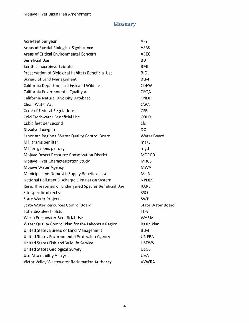
Table of Contents Glossary ................................................................................................................................................................... 4
Section 1 - Introduction........................................................................................................................................... 5
Section 2 - Statement of Necessity for the Basin Plan Amendment ....................................................................... 6
Scope of Proposed Basin Plan Amendment ........................................................................................................ 7
Section 3 - Regulatory Overview ........................................................................................................................... 10
Section 4 - US EPA Guidance for Removal of a Beneficial Use .............................................................................. 13
Section 5 - Characterization of the Mojave River Watershed ............................................................................... 14
Mojave River Surface Water and Groundwater Hydrology .............................................................................. 16
Groundwater Hydrology ................................................................................................................................... 21
Climate Change Assessment ............................................................................................................................. 23
Discharges of Treated Wastewater to the Mojave River .................................................................................. 23
Water Quality .................................................................................................................................................... 25
Physical Habitat ................................................................................................................................................. 32
Biological Community Setting ........................................................................................................................... 34
Section 6 - Use Attainability Analysis for COLD Beneficial Use ............................................................................. 36
Use Attainability Analysis Conclusions .............................................................................................................. 42
Section 7 - Antidegradation .................................................................................................................................. 42
Section 8 - Additional Considerations ................................................................................................................... 44
Section 9 - Summary of Proposed Changes to the Basin Plan .............................................................................. 44
Locations Recommended for COLD De-designation ......................................................................................... 44
Locations Recommended for BIOL BU Designation .......................................................................................... 45
Locations Recommended for RARE Designation ............................................................................................... 46
Clarifying Language for Mojave River Water Quality Objectives ...................................................................... 46
Minor Edits to Chapter 4: Implementation ....................................................................................................... 46
Works Cited ........................................................................................................................................................... 47
Mojave River Basin Plan Amendment
4
Glossary
Acre-feet per year AFY Areas of Special Biological Significance ASBS Areas of Critical Environmental Concern ACEC Beneficial Use BU Benthic macroinvertebrate BMI Preservation of Biological Habitats Beneficial Use BIOL Bureau of Land Management BLM California Department of Fish and Wildlife CDFW California Environmental Quality Act CEQA California Natural Diversity Database CNDD Clean Water Act CWA Code of Federal Regulations CFR Cold Freshwater Beneficial Use COLD Cubic feet per second cfs Dissolved oxygen DO Lahontan Regional Water Quality Control Board Water Board Milligrams per liter mg/L Million gallons per day mgd Mojave Desert Resource Conservation District MDRCD Mojave River Characterization Study MRCS Mojave Water Agency MWA Municipal and Domestic Supply Beneficial Use MUN National Pollutant Discharge Elimination System NPDES Rare, Threatened or Endangered Species Beneficial Use RARE Site specific objective SSO State Water Project SWP State Water Resources Control Board State Water Board Total dissolved solids TDS Warm Freshwater Beneficial Use WARM Water Quality Control Plan for the Lahontan Region Basin Plan United States Bureau of Land Management BLM United States Environmental Protection Agency US EPA United States Fish and Wildlife Service USFWS United States Geological Survey USGS Use Attainability Analysis UAA Victor Valley Wastewater Reclamation Authority VVWRA

Mojave River Basin Plan Amendment
5
Section 1 - Introduction The Mojave River, and the desert riparian habitat that is present along the river corridor, are critical resources in the Mojave Desert. Over-utilization of the groundwater resources in the Mojave River watershed has increased the scarcity of surface water flows along the Mojave River and reduced the number of locations where it occurs due to the interconnected nature of groundwater and surface water in this area. The Mojave River itself is considered a subterranean stream, which means that it can be characterized as a body of groundwater flowing through known and definite channels. Both the mainstem Mojave River, and its two primary tributaries Deep Creek and the West Fork Mojave River, have valuable habitat areas that sustain a wide range of aquatic and terrestrial wildlife and plant species. This includes many special status species, as shown in the table in Appendix 1 that identifies special status plants and animals observed in the Mojave River area. The proposed project seeks to recognize the value of the desert riparian habitat that exists within the Mojave River watershed by adding new beneficial use designations for certain locations along the Mojave River and its tributaries in the Water Quality Control Plan for the Lahontan Region (Basin Plan).
The proposed Basin Plan amendment would designate the Preservation of Biological Habitats of Special Significance (BIOL) and Rare, Threatened, or Endangered Species (RARE) beneficial uses to three locations along the Mojave River and to Deep Creek and the West Fork Mojave River. It also would de-designate the Cold Freshwater Habitat (COLD) beneficial use for the Mojave River below the Lower Narrows to the river’s terminus at Soda Lake, and add some clarifying language to Chapters 3 and 4 of the Basin Plan. The proposal to add the BIOL and RARE beneficial use designations (see definitions in Table 1 below) to the Mojave River and its primary tributaries stems from the importance of aquatic and riparian habitat in the Mojave Desert ecosystem and the need to protect it. Both the BIOL and RARE beneficial use designations depend on input from other public agencies to determine their appropriateness for a given water body. BIOL is designated for places where state or federal land or wildlife management agencies have already designated for special habitat protections. The RARE designation is meant to protect locations where special status species that are protected under state or federal endangered species laws are known to occur. The de-designation of the COLD freshwater habitat beneficial use from a portion of the Mojave River downstream of the Lower Narrows is proposed because habitat and climatic conditions in this segment of the river do not support cold-water species.
This staff report provides the justification and background information to support the proposed changes to the beneficial uses for the Mojave River, and includes the required Use Attainability Analysis and Substitute Environmental Documentation (SED). It includes an overview of the regulatory setting describing the requirements for adopting a Basin Plan amendment, followed by a summary of the hydrology, water quality, physical habitat, and biological community of the Mojave River watershed, including the tributaries of Deep Creek and the West Fork Mojave River (WF Mojave River). The Use Attainability Analysis required for removing a beneficial use is then presented, followed by a summary of the specific changes that are proposed for the Basin Plan. A draft marked-up version of the changed sections of the Basin Plan is also included as Appendix 2.
The CEQA Checklist that is used to identify any potentially significant environment impacts related to the proposed Basin Plan amendment is provided in Appendix 3. Water Board staff have not identified any potentially significant impacts that would result from adopting the proposed Basin Plan amendment.

Mojave River Basin Plan Amendment
6
Section 2 - Statement of Necessity for the Basin Plan Amendment The Water Board has long recognized the importance of protecting riparian habitat along the Mojave River, as indicated by previous Triennial Review lists that included items related to the Mojave River. The current 2018 Triennial Review List contains a project that addresses multiple tasks related to the Mojave River that were on previous Triennial Review Lists. The changes to the beneficial use designations for the Mojave River in this proposed amendment is one of the tasks on the Triennial Review list. Staff research and analysis led to recommendations to revise the beneficial uses assigned to the Mojave River and its tributaries for the locations shown in Figure 1. Additionally, the proposed amendment includes clarifying language in Chapter 3 regarding the application of Basin Plan water quality objectives for specific reaches of the Mojave River and some additions to Chapter 4 to acknowledge that a portion of the Mojave River is eligible for federal Wild and Scenic designation and to highlight the importance of protecting desert riparian habitat when planning for offroad vehicle activity.
Figure 1. Map showing locations where changes to the beneficial uses apply for the Mojave River watershed, except for the locations associated with the Mojave fringe-toed lizard Area of Critical Environmental Concern, which are shown in Figure 5.
Addition of BIOL and RARE: Water Board staff recommended adding the BIOL and RARE designations to specific locations where perennial flow typically exists or has existed in the Mojave River and in Deep Creek.

Mojave River Basin Plan Amendment
7
These locations provide important water sources for plant and animal species in the high desert and valuable riparian habitat for both migratory and endemic species, including several special status species. The proposed amendment includes designation of BIOL and RARE for three reaches of the Mojave River, and for Deep Creek and the West Fork Mojave River, both tributary to the Mojave River. Additionally, designation of the BIOL beneficial use is proposed for the Mojave River within the Mojave fringe-toed lizard Area of Critical Environmental Concern (ACEC), as shown in Figure 5. Note that this ACEC is discontinuous because it only applies to federal lands managed by the Bureau of Land Management in this area.
Additionally, the proposed amendment adds the Mojave River to Chapter 4, Table 4.9-1, which lists the rivers in the Lahontan Region that are eligible for federal Wild and Scenic designation. The Bureau of Land Management has made this designation for the Mojave River in Afton Canyon. Language will also be added to Chapter 4, Section 4.11 (Recreation) that highlights measures to protect desert riparian habitat when planning routes for off-highway vehicle use in desert areas throughout the Lahontan Region.
Removal of COLD: The Victor Valley Wastewater Reclamation Authority (VVWRA) requested during the 2015 Triennial Review process that Water Board staff consider de-designating the Cold Freshwater Habitat (COLD) for a portion of the Mojave River near the VVWRA wastewater treatment facility’s discharge point (Figure 3). The segment where the COLD will be de-designated begins one mile downstream from the National Trails Highway (Route 66) bridge to the terminus of the Mojave River at Soda Lake. VVWRA’s concerns relate to whether its wastewater treatment facility can meet the stringent water temperature objectives for COLD (i.e., no change in ambient water temperature). Currently, the entire Mojave River including the Upper, Middle, and Lower Hydrologic Units, are designated in the Basin Plan for both the COLD and Warm Freshwater Habitat (WARM) beneficial uses. As described in more detail below, the Basin Plan does not identify temperature thresholds or provide other guidance to distinguish between cold and warm freshwater habitats. The available information regarding conditions in the Mojave River indicates that species sensitive to changes in water temperature are unlikely to inhabit the Mojave River. To the contrary, species that live in or near the Mojave River must tolerate wide seasonal changes in water temperature, including high water temperatures for which cold water species are not adapted. Investigation into the biological community along the Mojave River indicates there are no obligate cold-water species in this area. This Staff Report provides the technical justification and the required Use Attainability Analysis (UAA) to support removing the COLD from the Mojave River from downstream of the Lower Narrows to the river’s terminus at Soda Lake.
Clarification of Applicable Site-specific Water Quality Objectives: Ambiguity exists regarding how to apply certain site-specific water quality objectives to the Mojave River. The proposed amendment adds clarifying language to Chapter 3 (Water Quality Objectives) of the Basin Plan to resolve this ambiguity. No new water quality objectives are proposed for adoption as part of the amendment.
Scope of Proposed Basin Plan Amendment The proposed amendment includes adding new BIOL and RARE designations to several locations along the Mojave River, and to Deep Creek and the West Fork Mojave River, both tributaries to the Mojave River. These locations are depicted in Figures 2-5, below. The proposed amendment also includes de-designating COLD from the Mojave River downstream of the Lower Narrows to its terminus at Soda Lake. The amendment makes changes to Table 2-1 in Chapter 2 of the Basin Plan for the Mojave Hydrologic Unit to depict the segments of the Mojave River where the BIOL and RARE designations and COLD de-designation are proposed. No other changes will be made to the beneficial use assignments in the Basin Plan. The proposed de-designation of

Mojave River Basin Plan Amendment
8
COLD for a portion of the Mojave River will change the applicability of some existing water quality objectives (e.g., dissolved oxygen, water temperature, and ammonia) for the Mojave River. The application of these water quality objectives vary depending upon whether habitat is designated as COLD or WARM such that the de-designation of COLD will cause only the water quality objectives associated with the WARM designation to apply to that portion of the Mojave River.
Additionally, language will be added to Chapter 4 (Implementation) to highlight recommendations related to reducing the impacts of Off-Highway Vehicle on sensitive desert riparian habitat in the Mojave River watershed designated for BIOL and RARE. The amendment will also add the Mojave River at Afton Canyon to Table 4.9-1 as eligible for federal Wild and Scenic River designation. The footnote “a” in Chapter 3, Table 3-20 will be revised to clarify the application of site specific objectives for the Mojave River. Appendix 2 is a marked-up copy of those sections of the Basin Plan that will be revised upon adoption of the proposed amendment.
Figure 2 Map showing locations where changes to the beneficial uses apply for Deep Creek and the West Fork Mojave River.

Mojave River Basin Plan Amendment
9
Figure 3. Map showing the changes to the beneficial uses that apply for the Bear Valley Road to Helendale section of the Mojave River.
Figure 4. Map showing the changes to the beneficial uses that apply for the lower section of the Mojave River.

Mojave River Basin Plan Amendment
10
Figure 5 Locations along the Mojave River within the Mojave fringed-toe lizard Area of Critical Environmental Concern that are proposed for designation with the BIOL beneficial use.
Section 3 - Regulatory Overview The California Regional Water Quality Control Board, Lahontan Region (Water Board) is the primary California state agency responsible for setting and enforcing water quality standards in the Lahontan Region, which includes the Mojave River watershed. Water quality standards and control measures for surface waters and groundwaters of the Lahontan Region are identified in the Basin Plan (Lahontan Regional Water Quality Control Board, 2016). Amendments to the Basin Plan, including amendments adopting new or revising existing water quality standards for surface waters, are subject to a public process with multiple opportunities for public comment. Basin Plan amendments become effective after adoption by the Water Board and State Water Resources Control Board (State Water Board), approval by the California Office of Administrative Law, and, if appropriate, approval by the U.S. Environmental Protection Agency, Region IX (US EPA).
Water quality standards generally consist of three components: designated uses for each water body or segment, water quality criteria to protect the designated uses, and an antidegradation policy. (40 C.F.R. § 131.6; 40 C.F.R. §131.13). In general, “uses” refer to what a water body is or potentially may be used for (40 C.F.R. § 131.3(f)), with examples as diverse as use as wildlife and riparian habitat, use of water for industrial production, agricultural supply, or use for recreation due to activities such as fishing and swimming in water

Mojave River Basin Plan Amendment
11
bodies. (40 C.F.R. 131.10(a).) Most, if not all, water bodies have multiple uses. “Existing uses” are “those uses actually attained in the water body on or after November 28, 1975, whether or not they are included in the water quality standards.” (40 C.F.R. § 131.3(e).) “‘Designated uses’ are those uses specified in water quality standards for each water body or segment whether or not they are being attained.” (40 C.F.R. § 131(f).) “Water quality criteria” are “expressed as constituent concentrations, levels, or narrative statements, representing a quality of water that supports a particular use.” (40 C.F.R. § 131.3(b).) The Federal Antidegradation policy provides three levels (tiers) of water quality protection to maintain and protect existing water uses, high quality waters, and outstanding national resource waters. (40 C.F.R. § 131.12.).
California law defines “designated uses” and “water quality criteria,” respectively, as “beneficial uses” and “water quality objectives.” (Wat. Code, § 13050, subds. (f), (h).). Chapter 2 of the Basin Plan identifies the designated Beneficial Uses assigned to specific water bodies in the Lahontan Region. Chapter 3 of the Basin Plan identifies the water quality objectives that apply to waters of the State within the Lahontan Region.
Regional Water Boards are required to establish water quality control plans for all areas within their regions (Wat. Code, §13240), and those water quality control plans must designate or establish, in part, beneficial uses within the areas governed by that plan. (Wat. Code § 13050, subd. (j)).
The Basin Plan defines the water quality standards for the Mojave River and its headwater tributaries (i.e., Deep Creek and the West Fork Mojave River), which include the designated beneficial uses and the water quality objectives that protect those beneficial uses. Table 1, below, lists the applicable beneficial uses (and their definitions) that are designated for specific segments of the Mojave River and for Deep Creek and the West Fork Mojave River (adapted from Chapter 2, Table 2-1 in the Basin Plan). More details on both regionally applicable and site-specific water quality objectives are found in the Water Quality section of this staff report.
Table 1 – Designated Beneficial Uses for Specific Portions of the Mojave Hydrologic Area
Beneficial Use Definition Waterbodies Municipal and Domestic Supply (MUN)
Beneficial uses of waters used for community, military, or individual water supply systems including, but not limited to, drinking water supply.
All segments of the Mojave Hydrologic Area (i.e., Upper, Middle, and Lower Mojave River) including Deep Creek, West Fork Mojave River, and minor surface waters and wetlands.
Agricultural Supply (AGR)
Beneficial uses of waters used for farming, horticulture, or ranching, including, but not limited to, irrigation, stock watering, and support of vegetation for range grazing.
All segments of the Mojave Hydrologic Area (i.e., Upper, Middle, and Lower Mojave River) including Deep Creek, West Fork Mojave River, and minor surface waters and wetlands.
Groundwater Recharge (GWR)
Beneficial uses of waters used for natural or artificial recharge of ground water for purposes of future extraction, maintenance of water quality, or halting of saltwater intrusion into freshwater aquifers.
All segments of the Mojave Hydrologic Area (i.e., Upper, Middle, and Lower Mojave River) including Deep Creek, West Fork Mojave River, and minor surface waters and wetlands.
Freshwater Replenishment (FRSH)
Beneficial uses of waters used for natural or artificial maintenance of surface water quantity or quality (e.g., salinity).
Minor wetlands in the Upper, Middle Mojave, and Lower Mojave Hydrologic Areas.
Hydropower Generation (POW)
Beneficial uses of waters used for hydroelectric power generation.
Minor surface waters in the Middle Mojave Hydrologic Area.
Water Contact Recreation (REC-1)
Beneficial uses of waters used for recreational activities involving body contact with water where ingestion of water is reasonably possible. These uses include, but are not limited to, swimming, wading, water-skiing, skin and scuba diving, surfing, white water activities, fishing, and use of natural hot springs.
All segments of the Mojave Hydrologic Area (i.e., Upper, Middle, and Lower Mojave River) including minor surface waters and wetlands.

Mojave River Basin Plan Amendment
12
Beneficial Use Definition Waterbodies Noncontact Water Recreation (REC-2)
Beneficial uses of waters used for recreational activities involving proximity to water, but not normally involving body contact with water where ingestion of water is reasonably possible. These uses include, but are not limited to, picnicking, sunbathing, hiking, beach-combing, camping, boating, tidepool and marine life study, hunting, sightseeing, and aesthetic enjoyment in conjunction with the above activities.
All segments of the Mojave Hydrologic Area (i.e., Upper, Middle, and Lower Mojave River) including minor surface waters and wetlands.
Commercial and Sport Fishing (COMM)
Beneficial uses of waters used for commercial or recreational collection of fish or other organisms including, but not limited to, uses involving organisms intended for human consumption.
Mainstem Mojave River in the Upper, Middle, and Lower Hydrologic Areas, Deep Creek, and West Fork Mojave River.
Warm Freshwater Habitat (WARM)
Beneficial uses of waters that support warm water ecosystems including, but not limited to, preservation and enhancement of aquatic habitats, vegetation, fish, and wildlife, including invertebrates.
All segments of the Mojave Hydrologic Area (i.e., Upper, Middle, and Lower Mojave River) including minor surface waters and wetlands.
Cold Freshwater Habitat (COLD)
Beneficial uses of waters that support cold water ecosystems including, but not limited to, preservation and enhancement of aquatic habitats, vegetation, fish, and wildlife, including invertebrates.
All segments of the Mojave Hydrologic Area (i.e., Upper, Middle, and Lower Mojave River) including minor surface waters and wetland.
Wildlife Habitat (WILD) Beneficial uses of waters that support wildlife habitats including, but not limited to, the preservation and enhancement of vegetation and prey species used by wildlife, such as waterfowl.
All segments of the Mojave Hydrologic Area (i.e., Upper, Middle, and Lower Mojave River) including minor surface waters and wetlands.
Rare, Threatened, or Endangered Species (RARE)
Beneficial uses of waters that support habitat necessary for the survival and successful maintenance of plant or animal species established under state and/or federal law as rare, threatened or endangered.
Wetlands at the Lower Narrows on the Mojave River in the Upper Mojave Hydrologic Area and all minor wetlands in the Middle and Lower Mojave Hydrologic Areas.
Migration of Aquatic Organisms (MIGR)
Beneficial uses of waters that support habitats necessary for migration, acclimatization between fresh and salt water, or temporary activities by aquatic organisms, such as anadromous fish.
Wetlands at the Lower Narrows on the Mojave River in the Upper Mojave Hydrologic Area.
Water Quality Enhancement (WQE)
Beneficial uses of waters that support natural enhancement or improvement of water quality in or downstream of a water body including, but not limited to, erosion control, filtration and purification of naturally occurring water pollutants, streambank stabilization, maintenance of channel integrity, and siltation control.
Turner Springs (just west of the Lower Narrows), Lower Slough (east of the Upper Narrows), the wetlands at the Lower Narrows, all minor wetlands in the Upper Mojave Hydrologic Region, and all minor wetlands in the Middle and Lower Mojave Hydrologic Areas.
Flood Peak Attenuation/Flood Water Storage (FLD)
Beneficial uses of riparian wetlands in flood plain areas and other wetlands that receive natural surface drainage and buffer its passage to receiving waters.
Turner Springs (just west of the Lower Narrows), Lower Slough (east of the Upper Narrows), the wetlands at the Lower Narrows, all minor wetlands in the Upper Mojave Hydrologic Region, and all minor wetlands in the Middle and Lower Mojave Hydrologic Areas.
Preservation of Biological Habitats of Special Significance (BIOL)
Beneficial uses of waters that support designated areas or habitats, such as established refuges, parks, sanctuaries, ecological reserves, and Areas of Special Biological Significance, where the preservation and enhancement of natural resources requires special protection.
Zzyzx Springs
Mojave River Basin Plan Amendment
13
Section 4 - US EPA Guidance for Removal of a Beneficial Use The Water Board may remove a designated use if the use is not an “existing” use and it can be demonstrated that achieving the use is not feasible because of a least one of six factors described in the Code of Federal Regulations, title 40, section 131.10(g). An existing use is defined as those uses attained in the water body on or after November 28, 1975, even if that use has not been designated in the Basin Plan. The factors defined in 40 CFR Section 131.10(g) are the following:
1) Naturally occurring pollutant concentrations prevent the attainment of the use. 2) Natural, ephemeral, intermittent, or low flow conditions or water levels prevent the attainment of the
use, unless these conditions may be compensated for by the discharge of sufficient volume of effluent discharges without violating state water conservation requirements to enable uses to be met.
3) Human-caused conditions or sources of pollution prevent the attainment of the use and cannot be remedied or would cause more environmental damage to correct than to leave in place.
4) Dams, diversions, or other types of hydrologic modifications preclude the attainment of the use, and it is not feasible to restore the water body to its original condition or to operate such modification in a way that would result in the attainment of the use.
5) Physical conditions related to the natural features of the water body, such as the lack of a proper substrate, cover, flow, depth, pools, riffles, and the like, unless these conditions may be compensated, unrelated to water quality preclude attainment of aquatic life protection uses.
6) Controls more stringent than those required by Sections 301(b) and 306 of the Clean Water Act would result in substantial and widespread economic and social impact.
US EPA guidance (US EPA 2012) describes the steps involved to determine whether a beneficial use that is currently designated for a specific water body can be removed. The steps rely on addressing the following questions:
1) Is the use an existing use? • If so, it cannot be removed unless a use requiring more stringent criteria is added.
2) Is the use specified in CWA section 101(a)(2) (i.e., a fishable/swimmable use)? • If so, a UAA is required. • If not, the State must submit documentation justifying how their consideration of the use and
value of water for those uses listed in 40 C.F.R. § 131.10(a) (public water supplies, protection and propagation of fish, shellfish and wildlife, recreation in an on the water, agricultural, industrial, and other purposes including navigation) appropriately supports the State’s action. This can be satisfied through a UAA.
3) Is the use attainable? • If so, the use cannot be removed.
4) Are any of the factors in 40 CFR Section 131.10(g) shown above met? • If not, the use cannot be removed.
Beneficial uses that address the protection and propagation of fish, shellfish and wildlife, and provide for recreation in and on the water (i.e., the so called fishable/swimmable goal of the CWA Section 101(a)(2)) require consideration distinct from uses not specified in section 101(a) of the CWA. A UAA, supported by at least one of the factors in 40 CFR Section 131.10(g), must be prepared for situations where one of these uses is being removed. In the current case, the proposed Basin Plan amendment addresses the fishable goal
Mojave River Basin Plan Amendment
14
(“protection and propagation of fish, shellfish, and wildlife”) as it pertains to Cold Freshwater Habitat. Since the Basin Plan amendment proposes removal of a beneficial use associated with the fishable goal, a UAA is required.
Additional guidance on the potential removal of beneficial uses is provided in Chapter 2 of the Basin Plan, which states that many of the uses designated as existing uses are documented by biological data, although some are not. Chapter 2 further states:
If there is substantial evidence to remove a designated beneficial use designation from a specific water body, the Regional Board will consider adoption of a Basin Plan amendment to remove a designated beneficial use. However, there are many beneficial uses which are not intended to apply to the entire length of a stream or to a surface water during certain temporal conditions. The beneficial use designations that may be considered for temporary or site-specific designations are: IND, PRO, GWR, FRSH, NAV, POW, WARM, COLD, SAL, MIGR, SPWN and WQE. For these situations, Regional Board staff, to make a recommendation to the Regional Board, will rely on site-specific documentation which may include: water quality data, field data or professional opinions (from Regional Board staff or other state and federal agencies, also universities), and other evidence collected by a discharger. The most sensitive existing or probable future use will be protected, however uses that did not exist, do not exist and will not exist in the foreseeable future will not be required to be protected.
In the sections that follow, information and data are provided to characterize the physical features, water quality and biological community composition of the Mojave River, including for the portion of the river downstream of the Lower Narrows where removal of COLD is proposed. A formal UAA that corresponds with US EPA guidance is presented in Section 5 of this staff report. This information is then summarized and conclusions are provided to support the proposed Basin Plan amendment to remove COLD from a portion of the Mojave River.
Section 5 - Characterization of the Mojave River Watershed The mainstem of the Mojave River originates on the northern slope of the San Bernardino Mountains and flows north and then northeast into the Mojave Desert where it eventually terminates at Soda Lake near Baker, 110 miles downstream of its origin near Hesperia (Figure 1). Large sections of the river have intermittent flows and do not typically exhibit surface flow except during extreme storm events. The main stem forms just upstream of the Mojave Forks Dam (located south of Hesperia) at the confluence of Deep Creek, a perennial stream, and the West Fork Mojave River, which is typically an ephemeral stream that at times is augmented by State Water Project releases from Silverwood Lake. Deep Creek originates southeast of the dam with its headwaters located in the San Bernardino Mountains at around 7,500 feet in elevation. The Mojave Forks Dam (at approximately 3,000 feet in elevation) is a flood control structure with an ungated outlet that is designed to attenuate stormwater flows from the mountainous upper watershed, but does not store water. At the Lower Narrows USGS stream flow gage located just north of Victorville approximately 18 miles downstream of the Mojave Forks Dam, the Mojave River watershed has a drainage area of approximately 513 square miles, while at Afton Canyon, located near the bottom of the watershed east of Barstow, the drainage area is approximately 1,600 square miles, excluding internal surface drainage (Lines, 1995).

Mojave River Basin Plan Amendment
15
The Mojave River corridor had long been an active trade route prior to European settlement that connected native tribes from coastal southern California to tribes living along the Mojave River and to those located further east in the Colorado River watershed (Lyman, 2010). The primary Native American group that settled along the Mojave River, known as the Spanish-derived name Vanyumé, was a desert clan of the Serrano tribe. These Serrano people occupied village sites along the Mojave River east of Barstow and near Victorville and Hesperia as late as the early to mid-1800’s in some locations. Other more mobile tribal groups were also observed in the Mojave River region by Spanish missionaries that first arrived in the area in 1776, including the Mojaves who inhabited the lower Colorado River region and were known to travel through the area. Gradually, the native inhabitants of the area were either killed, displaced, or relocated to the Spanish missions to the south. Consequently, the Serrano people of this area that were relocated to the missions and who fled the area became incorporated into a few different California Native American tribes. There are currently no known tribal organizations located in the Mojave River watershed; however, the San Manuel Band of Mission Indians, whose present-day reservation is in Highland, CA on the southern slope of the San Bernardino mountains, includes the Mojave River watershed in its ancestral tribal territory. The San Manuel Band of Mission Indians is composed of tribal members that descend from the Serrano clans of the San Bernardino mountains. The Morongo Band of Mission Indians and the Serrano Nation of Mission Indians also contain tribal members with Serrano ancestry.
European travel and trade along the Old Spanish Trail, which passed through the Mojave River area, increased over time. After the discovery of gold in northern California, an influx of pioneers and gold-seekers traveled west, some of whom were Mormon missionaries that began prospecting for gold along the Mojave River near Oro Grande (Lyman, 2010). While intentions to establish a Mormon colony along the Mojave River never came to pass, eventually settlement in the Victor Valley occurred beginning in 1858 with the establishment of a way station along the bank of the Mojave River (Lyman, 2010). Agriculture development increased over time in the area primarily along the Mojave River corridor that was maintained through exploitation of the groundwater resources in the floodplain aquifer. Eventually, the primary land use in the Mojave watershed began to shift from agriculture to urban development beginning in the 1950’s. However, an increase in dairy production occurred in the 1980’s as dairies previously established in the Chino area south of the San Bernardino mountains relocated to the Mojave River area due to increased urbanization in southern California.
The Mojave River floodplain corridor passes through several population centers that include Hesperia, Apple Valley, Victorville, and Helendale, all of which have seen considerable population growth in recent years. The river then heads northeast through Barstow, and then easterly through relatively uninhabited terrain to its endpoint near Soda Lake, a dry lake that rarely has surface water present. Land use in the upper portion of the watershed is characterized by residential and urban development, while further downstream near Helendale and east of Barstow, agricultural activities are more common. There is also a military installation located along the Mojave River east of Barstow, the Marine Corps Logistics Base. Population in the entire watershed was approximately 390,000 in 2010, with most of the inhabitants located in the more urbanized upper portion in what is known as the Alto sub-basin. The Mojave River groundwater basin is divided into five sub-basins, with the three located along the river known as Alto, Centro and Baja, as shown in the map in Figure 6. Population in the entire watershed is expected to continue to increase with estimates for growth of about 1.6 percent per year, which leads to a projected population of about 550,000 in 2030 (Mojave Water Agency, 2016).

Mojave River Basin Plan Amendment
16
Figure 6. Map depicting Mojave groundwater basin sub-areas identified as the Alto, Centro and Baja sub-basins.
Mojave River Surface Water and Groundwater Hydrology Precipitation falling both as rain and snow in the higher elevations of the San Bernardino mountains above the Mojave Forks Dam is the main source of the flow in the Mojave River. Mean annual precipitation at the higher elevations is about 42 inches per year in the mountains, while in the lower portions of the watershed, mean annual precipitation is approximately six (6) inches at Victorville and four (4) inches at Barstow (Lines, 1995). An important feature of the Mojave River is that it is hydrologically connected with the floodplain groundwater aquifer, as shown in Figure 6 (Stamos C. M., 2002), such that conditions in one affect the other. The floodplain aquifer consists primarily of unconsolidated gravel, sand, and silt deposited by the Mojave River during the Holocene and Pleistocene (Lines, 1995) and it is located on top of the wider and deeper regional aquifer depicted in Figure 7. Much of the water originating in the headwaters infiltrates through the permeable streambed into the floodplain aquifer. Consequently, the Mojave River has large sections characterized by sub-surface flow where surface flow is uncommon and intermittent. Groundwater pumping in the watershed has lowered groundwater elevations and reduced the spatial extent of perennial surface flow in the Mojave River. More details regarding the Mojave groundwater basin are presented, below.

Mojave River Basin Plan Amendment
17
Figure 7 Conceptualized geologic section of the aquifer system in the Mojave River ground-water basin, southern California reproduced from Stamos, Martin and Predmore, 2002.
Geological features along the Mojave River corridor determine the locations where perennial surface water exists. For example, in most places, the floodplain aquifer is about 150 to 250 feet thick; however, at the Upper Narrows, it is only about 50 feet thick. Bedrock at the Upper Narrows underlies the floodplain aquifer and forces water to the surface (Lines, 1995), leading to an isolated segment where perennial surface flow exists. A similar feature causes water to rise to the surface in Afton Canyon in the lower portion of the watershed. Additionally, the presence of earthquake faults that intersect the river corridor at several locations downstream of the Narrows impedes subsurface flow and forces water upwards, which leads to higher water table elevations upstream of the faults compared to downstream. This occurs near Helendale and along a portion of the Mojave River east of Barstow, where surface flow was common in the past, but no longer occurs.
In general, the surface water hydrology of the Mojave River exhibits wide variability marked by episodic high-flow events and low base flow levels. Only during very large storm events does surface flow extend continuously throughout the 110-mile length of the Mojave River from the headwaters above the Mojave Forks Dam to the river’s terminus at Soda Lake, which is typically a dry lake basin. Such high stream flow events created by large storms occurred most recently in 2010 and previously in 1965, 1969, 1978, 1983, 1993, and 2005. Average daily surface flow data for USGS gage locations at Deep Creek and the West Fork Mojave upstream of the Mojave Forks Dam and along the main stem Mojave River at the Lower Narrows, Barstow, and at Afton Canyon are provided in Figure 6- Figure 9. The flow data is presented on a log scale to better depict base flow conditions along with the episodic high flow events. Breaks where data points are not connected indicate periods of zero flow. A summary of flow statistics from the USGS gage data is provided in Table 2. Note that the period of record shown in Table 2 covers the entire record and includes periods when flow records are incomplete. The annual mean flow values are based on USGS Water Data Reports for Water Year

Mojave River Basin Plan Amendment
18
2018. The graphs in Figures 8-11 showing the flow data may depict a shorter time period than the period of record to show the period for which good quality stream flow data is available.
Table 2 – Flow statistics for Mojave River watershed USGS gage data
Location
Max Daily Peak Flow (cfs)
Min Daily Flow (cfs)
Annual Mean Flow (cfs)
Period of Record
Deep Creek 46,600 (Mar 1938) 0 (July 1961) 68.3 (1905-2018) 1905-current
West Fork Mojave River 11,700 (Jan 2005) 0 (Many years) 35.3 (1975-2018) 1975-current
Mojave River at Lower Narrows 70,600 (Mar 1938) 0 (Sept 1995) 59.0 (1971-2018) 1931-current
Mojave River at Barstow 64,300 (Mar 1938) 0 (Many years) 17.1 (1972-2018) 1931 - current
Mojave River at Afton Canyon 18,000 (Jan 1969) 0 (Many years) 4.78 (1972-2013) 1930 - current
The surface flow in Deep Creek above Mojave Forks Dam (Figure 8) exhibits a repeating pattern of high flow and low flow periods, a pattern that is not as evident in the flow record for the West Fork Mojave River (Figure 9), which in contrast to Deep Creek, has periods when flows drop to zero. The maximum mean daily flow in Deep Creek for the 1974-2017 period was 11,100 cubic feet per second (cfs), which occurred in both 1978 and 1993. The maximum mean daily flow for the West Fork Mojave River shown in Figure 7 was 11,700 cfs in January 2005. Stream flow in the West Fork Mojave River below Silverwood Reservoir includes both natural flow that enters the reservoir from upstream and is subsequently released and State Water Project (SWP) water releases that are managed by the Mojave Water Agency for groundwater recharge. The State Water Project East Branch Aqueduct carries water from the west through Antelope Valley and eventually to Silverwood Reservoir via the Mojave Siphon Powerplant. While a portion of this water is used in the Mojave River watershed to recharge groundwater, most of the State Water Project water in Silverwood Reservoir continues south through the San Bernardino Tunnel to Lake Perris for use in San Bernardino and Riverside counties.
Flow data from 1962-2017 for the main stem Mojave River at the Lower Narrows and at Bartow are presented in Figure 10 and Figure 11 shows surface flows in Afton Canyon at the downstream end of the watershed. Base flows for the Mojave River at the Lower Narrows occur year-round, though there has been a notable decrease over time in the daily average flow, as depicted in Figure 10. While the median daily average flow for the entire 1962-2017 period is calculated to be 16.4 cfs, the median flow from 1962-1984 is 28 cfs and only 10 cfs for the 1985-2017 period. The decrease in flow reflects increased groundwater use associated with urban development in the upper portion of the Mojave River watershed. The maximum daily mean flow at the Lower Narrows over the 1962-2017 period was 21,000 cfs in 1969, which is prior to the 1974 completion of the Mojave Forks Dam. The highest recorded instantaneous peak flow at the Lower Narrows occurred in March 1938 and was estimated at 70,600 cfs. There is typically no surface flow at the Barstow gage, so the median flow is 0 as calculated for the 1962-2017 period, but flows do occur on rare occasions and are associated with large storm events. The maximum daily mean flow at Barstow over the 1962-2017 period was 16,300 cfs in 2005, while the highest recorded daily mean flow was 18,100 cfs in March 1938. Perennial surface flow occurs in Afton Canyon, as shown in Figure 11, though at a typically low rate such that the calculated median flow for the 1962-2017 period is only 0.4 cfs, with a maximum daily mean flow of 10,000 cfs in 1993. Downstream of

Mojave River Basin Plan Amendment
19
Afton Canyon, the Mojave River again returns to subsurface flow for the rest of its trajectory to Soda Lake, where surface water may occasionally be present on the typically dry lake during and after large storm events.
Summarizing the status of surface water hydrology in the Mojave River, at present only three locations exhibit perennial surface flows, which are: 1) the approximately 7-mile reach between the Upper Narrows and the Lower Narrows, 2) the effluent dominated 6-7 mile reach downstream of VVWRA’s discharge below, and 3) the approximately 4-mile segment in Afton Canyon. In the past, surface water east of Barstow upstream of the fault was more common in the past, as was surface water at Camp Cady, a CDFW-designated wildlife area east of Barstow. Due to depletion of the groundwater resources in the Baja sub-basin in the lower portion of the Mojave River watershed, no surface water flow has been present at Camp Cady since the early 1990’s (California Department of Fish and Wildlife, 2004).
Figure 8 Surface flow (cfs) at Deep Creek immediately upstream of the Mojave Forks Dam from 1974-2017.

Mojave River Basin Plan Amendment
20
Figure 9. Surface flow (cfs) at the West Fork Mojave River immediately upstream of the Mojave Forks Dam from 1974-2017.
Figure 10. Comparison of daily average flow in cubic feet per second between the Mojave River at the Lower Narrows (shown in blue) and at Barstow (shown in red).

Mojave River Basin Plan Amendment
21
Figure 7. Daily average flow in cubic feet per second for Afton Canyon.
Groundwater Hydrology In contrast to surface flow, downgradient water movement in the floodplain aquifer along the Mojave River is much slower and is affected in some locations by faults that can limit the movement of water at those fault boundaries. Estimates for horizontal water flow, described as transmissivity, within the floodplain aquifer are between 1,000 to 60,000 square feet per day (Stamos, Martin, & Nishikawa, 2001). Investigators also evaluated water flows in the Mojave River watershed using a particle-tracking simulation model that shows that a particle originating in the West Fork Mojave River takes 2,000 years to reach the Lower Narrows (Stamos, Martin, & Nishikawa, 2001). An important factor to consider concerning the Mojave River watershed and the associated groundwater basins is the role of large storm events for recharging the groundwater. For example, a study of the Centro groundwater sub-basin showed that most of the groundwater recharge to that area resulted from only three large storm events between 1993 and 2010 and amounted to 54,000 acre-feet (Todd Engineers and Kennedy/Jenks Consultants, 2013).
Groundwater pumping primarily from the floodplain aquifer along the Mojave River increased dramatically over the last century, which has led to a decline in groundwater elevations throughout the Mojave Basin. In 1930, groundwater pumping from the floodplain aquifer was estimated to be approximately 40,000 acre-feet per year (AFY), which increased to a peak water production rate of approximately 240,000 AFY in 1989 for both the floodplain and regional aquifers combined (Todd Engineers and Kennedy/Jenks Consultants, 2013). At that time, about 120,000 AFY was estimated as originating from the floodplain aquifer (Lines, 1995). To put this in context, an acre-foot is equal to the volume of water that covers one acre to a depth of one foot and is equivalent to 325,851 gallons. One acre-foot is often considered to be the amount of water used by 2-3 households for one year. Because of increased groundwater pumping, groundwater elevations have declined by as much as 90 feet in some locations in the Mojave River Basin (Todd Engineers and Kennedy/Jenks

Mojave River Basin Plan Amendment
22
Consultants, 2013), and some reaches of the Mojave River that previously had perennial surface flow now flow only during large storm run-off events.
Declining groundwater levels and concerns about sustainability of the water supply eventually led to legal action in 1990 by the City of Barstow who alleged that increased groundwater use in the upper Mojave Basin threatened the natural recharge to the downstream groundwater basin utilized by the City. Subsequent legal actions by other parties eventually led to negotiations among water users to seek an equitable solution that resulted in an agreement in 1993. Additional litigation eventually led to a California Supreme Court Stipulated Judgement in 2000 that affirmed the original agreement, with some additional provisions for a small group of water users that allowed them to retain their historic groundwater rights. The Stipulated Judgement forms the legal basis for the Mojave Basin Adjudication
The Mojave Basin Adjudication uses what is known as a physical solution to address the overdraft of the Mojave groundwater basin that relies on specific requirements for each of the five distinct but hydrologically interrelated "Subareas". It requires the maintenance of average annual flows (both surface and sub-surface flow) between groundwater basin subareas (based on 1930-1990 data) and provides for a gradual reduction in water production over time according to the state of the sub-basins. The Mojave Water Agency (MWA), which manages groundwater in the watershed and is the primary wholesale water supplier, serves as the Watermaster in charge of enforcing the adjudication. Depending upon conditions in the individual sub-basins, water producers in each basin may be subject to a gradual ramp down of their annually-assigned Free Production Allowance (FPA), which is the amount of groundwater a producer can pump in that year. While water users can exceed their annual water production allowance, they are required to acquire or otherwise pay for replacement water if they do not have any carryover from a previous year. The process of determining the need for a ramp down and assigning the FPA is overseen by the Court, with technical assistance from the Watermaster. The initial water production rights assigned to individual users are based on water usage that occurred between 1986-1990.
The most recent water production data reported by the Watermaster for 2016-2017 is 119,304 AFY for all Mojave sub-basins combined1. While the Mojave Basin Adjudication has led to improved groundwater levels in the upper portion of the watershed in the Alto sub-basin and transition zone between Alto and Centro sub-basins, groundwater resources in the Baja sub-basin continue to be in an overdraft condition. Though over-pumping is largely to blame for the over-draft, changes in habitat conditions, flood control projects and other factors have also reduced the ability for storm flows to recharge the aquifer in the Baja sub-basin, except during extreme weather events.
Imported water supplies purchased by MWA from the State Water Project (SWP) provide an additional water source within the Mojave River Basin without which the region would experience a chronic water supply deficit. The water is released from Silverwood Reservoir on the West Fork Mojave River. MWA has a contract to receive up to 85,800 AFY of SWP water (Mojave Water Agency, 2016); however, it has generally not requested the total contract amount. Actual water deliveries vary each year depending upon hydrological conditions both locally and in the northern portion of the state. Since 2001, MWA’s average annual water delivery of SWP water is about 17,000 AFY, though a small portion of this water is used in the Morongo
1 Annual reports of the Mojave Basin Area Watermaster can be found at http://www.mojavewater.org/annual_report.html .

Mojave River Basin Plan Amendment
23
groundwater basin. The SWP water is used to recharge groundwater supplies via a network of pipelines and designated recharge sites constructed by MWA.
As part of the adjudication, CDFW prioritized two specific portions of the Mojave River for habitat restoration and established targets for groundwater levels at those locations that, if not met, trigger additional actions by parties to the adjudication to improve habitat conditions. The two locations are the 23-mile reach of the Mojave River starting approximately from Bear Valley Road (located upstream of the Upper Narrows) to Helendale and a four-mile reach at Camp Cady. The groundwater level target for the Camp Cady Wildlife Area has not been attained thus far despite the significant reduction in pumping that has been imposed in the Baja sub-basin due to the adjudication. Discussion of the biological resources and CDFW restoration strategy is presented below in the section on the biological setting. Note that these two segments of the river are where designation with BIOL and RARE is proposed as part of the Basin Plan amendment.
Climate Change Assessment Climate change will likely impact Mojave River hydrology in the future. The U.S. Bureau of Reclamation completed a Mojave River Watershed Climate Change Assessment in 2013 which examined potential future changes to surface water flows and flood frequency due to gradual changes in climate (U.S. Bureau of Reclamation, 2013). Based on a compilation of results from various climate change models, median projections (i.e., the median within the uncertainty envelope of the model results) suggest slightly increased annual run-off volumes in the near term (i.e., 2020’s) compared to the 1990’s baseline surface hydrology observed at the Deep Creek, West Fork Mojave River, and Mojave River at the Lower Narrows flow gages. Further into the future, median annual run-off projected at these locations is expected to decline by about 12-13 percent by the 2050’s and 14-20 percent by the 2070’s from the 1990’s baseline. The flood frequency analysis projected a slight trend toward increased flood frequency at the Mojave Forks Dam, while the opposite trend was observed for the Lower Narrows. In addition, the climate assessment predicts that Sierra Nevada snowpack will be reduced by 25-40 percent by mid-century compared to the historical average, which may reduce the availability of imported SWP water to the Mojave River watershed. Hydrology along the Mojave River has been greatly impacted by groundwater pumping that has increased over the last 80 years, but which now appears to have leveled off due to the restrictions imposed on water producers by the Mojave Basin Adjudication discussed below.
Discharges of Treated Wastewater to the Mojave River The discharge of treated wastewater from VVWRA’s wastewater treatment facility provides an important influx of surface water flow to the Mojave River. The water discharged by VVWRA originates from groundwater pumped in the Alto sub-basin that might otherwise have flowed downgradient through the floodplain aquifer. VVWRA’s discharge provides a substantial volume of the water that flows between the Alto and Centro groundwater sub-basins. Table 3 shows a comparison between VVWRA’s average daily and monthly discharge volume (based on data from its NPDES permit-required monitoring reports) with flows measured upstream at the USGS gage at the Lower Narrows for 2014-2016. The average daily discharge to the Mojave River is similar in volume to the average daily flow volume measured at the Lower Narrows, though greater variation is apparent in the daily discharge at the Lower Narrows compared to VVWRA’s discharge.

Mojave River Basin Plan Amendment
24
Table 3: Comparison between VVWRA daily discharge and flow rates at the Lower Narrows for 2014-2016.
2014-2016 Lower Narrows Gage VVWRA Discharge
Volume (mgd) Flow Rate (cfs) Volume (mgd) Flow Rate (cfs) Average Daily Discharge 5.19 8.03 5.54 8.43 Maximum Monthly Average of Daily Discharge 17.5 27.07 9.27 14.35
Minimum Monthly Average of Daily Discharge 0.95 1.47 3.33 5.15
The proposed amendment removes COLD for the Mojave River beginning downstream of the Lower Narrows (and just upstream from VVWRA’s discharge point) and extending to the river’s terminus at Soda Lake. There is no surface flow continuity in this part of the Mojave River, since perennial flow at the Lower Narrows becomes subsurface about three miles upstream of VVWRA’s discharge. According to Mojave Water Agency staff, historically perennial flows in the Mojave River downstream of VVWRA were common in the past; however, since there are no flow gages in this area, there are no records that show the magnitude of flows that may have existed before VVWRA began discharges to the Mojave River in 1981. Surface flows downstream from VVWRA’s discharge point typically end about 4-8 miles downstream, depending on hydrologic conditions, at which point, Mojave River flow becomes subsurface. Currently, perennial surface flow in the Mojave River is not present again until approximately 65 river miles downstream in Afton Canyon. Essentially, VVWRA’s discharge creates an effluent-dominated perennial reach that interacts to varying degrees with water in the floodplain aquifer.
VVWRA recently developed regional water reclamation facilities to produce recycled water for irrigation that are designed to intercept some of the wastewater flow that would otherwise go to the existing treatment plant. Prior to their construction, the California Department of Fish and Wildlife (CDFW) raised objections to a possible reduction in discharge to the Mojave River. In response, CDFW and VVWRA executed a Memorandum of Understanding (MOU) in 2003 that dictates VVWRA’s obligations regarding its annual discharge volume. The MOU requires that VVWRA discharge not less than 9,000 AFY or an average of 24.7 acre-feet per day, which is equivalent to a daily average of 7.95 million gallons per day (mgd) or 12.3 cubic feet per second (cfs). The required volume includes both discharge to the Mojave River and the discharge to the percolation ponds at the treatment facility, since this water also ends up in the river. The MOU is intended to provide, in combination with the flow volume measured at the Lower Narrows gage, a total of 15,000 AFY to the Transition Zone, which is located near the boundary between the Alto and Centro sub-basins (see map in Figure 6). This MOU is intended to aid in implementing the requirements of the Mojave Basin Adjudication (which is discussed below) by assuring that sufficient water flows from the Alto sub-basin to the Centro sub-basin in keeping with the Stipulated Judgement. VVWRA is not required to discharge more than needed to achieve this total annual volume. Other provisions of the MOU provide year-to-year flexibility for VVWRA to meet the required discharge rates.
The CDFW Mojave River Hatchery located upstream of the Upper Narrows also discharges treated effluent to the floodplain aquifer that originates from water pumped near the hatchery. Practically, all the water pumped at the hatchery is released as treated effluent that eventually ends up back in the floodplain aquifer after it is used in the raceways. The discharge is released into an artificially created wetland habitat located just to the

Mojave River Basin Plan Amendment
25
east of the discharge point and adjacent to the Mojave River channel. After passing through this wetland area, the discharged water eventually percolates into the Mojave River streambed and doesn’t create surface flow conditions in the river channel. An additional portion of the total effluent produced by the hatchery is released into ponds at a nearby golf course and is used for irrigation. Some of this water eventually flows to Spring Valley Lake, from which it may be discharged to the Mojave River or it continues to Horseshoe Lake at Mojave Narrows Regional Park, where overflow from the lake enters a channel that also leads to the river.
Water Quality As population has increased in the Mojave River watershed, human activity has impacted groundwater quality in some locations due to non-point discharges to the flood plain aquifer from residential septic systems, dairy facilities and agricultural activity. Industrial activity and military facilities near Barstow have also led to contamination of the Mojave River floodplain aquifer. Overdraft of the floodplain aquifer also affects groundwater quality since it can reduce dilution capacity and may lead to additional degradation when recharge of the aquifer occurs via the recirculation of poorer quality ground water. This is because deeper wells are often needed as groundwater levels decline which can produce water originating from older, deeper sediments that is more mineralized (United States Geological Survey, 1997). Additionally, older, poorer quality groundwater rises closer to the surface at certain locations along the Mojave River immediately upstream of faults, such as near Helendale, where high Total Dissolved Solids (TDS) concentrations are found in groundwater upstream of the Helendale fault. While the impact of the faults on water quality is a natural phenomenon, depletion of the groundwater aquifer and the associated decrease in dilution likely exacerbates this effect.
The Basin Plan contains water quality objectives that apply region-wide and site-specific objectives (SSOs) that only apply at specific locations. Additionally, there are both numerical objectives, which define the criteria for specific water quality constituents, and narrative objectives, which are often applied by utilizing available guidance or other information to identify appropriate numerical criteria. The SSOs for locations along the Mojave River and upstream of Mojave Forks Dam for Deep Creek and the West Fork Mojave River are shown below in Table 4, which combines the water quality objectives found in Tables 3-20 and 3-21 of the Basin Plan. Many of these objectives were developed during the effort to produce the first version of Basin Plan in the 1970’s, while others were added in the early 1980’s. The nitrate and TDS standards for the Mojave River were developed to protect drinking water and to guard against degradation associated with dairies that were relocating to the area in the early 1980’s. In general, the SSOs shown in Table 4 are more stringent than the current drinking water standards and were developed based on water quality data available at the time. They also tend to be more stringent than suggested criteria for aquatic life protection.
The site-specific objective of 312mg/L for total dissolved solids and the site-specific objective of 5 mg/L for nitrate as nitrate apply to Mojave River from the Lower Narrows (Station 2) upstream to Forks Dam. All other site-specific objectives identified in Table 3-20 apply to the reaches of the Mojave River that flow underground in a confined channel. It should be noted that footnote “a” does not accurately depict the hydrologic conditions at the Lower Narrows since due to the geological setting, surface water flow occurs at this location under all flow conditions, not just high flow conditions. This inaccuracy will be corrected with the revisions to the footnotes for Table 3-20 that are included in the proposed amendment.

Mojave River Basin Plan Amendment
26
Table 4: Site-Specific Water Quality Objectives for selected locations in the Mojave River Watershed from Table 3-20 and 3-21 in the Basin Plan. Water Quality Objectives from Table 3-20 are shown in Bold.
Location Water Quality Objective (mg/L)1
Chloride Sulfate Fluoride Boron Nitrate Total Dissolved Solids West Fork Mojave Riverb 8.4
13.0 34.0 53.0
0.26 0.40
0.02 0.05 6 (as NO3) 245
Deep Creek at Mojave Forks Dam
10.6 16.0
31.3 55.0
1.66 2.60
0.10 0.19
0.6 (as N) 2.0 (as N)
184 265
Mojave River at Mojave Forks Dam
55 100
35 100
1.5 2.5
0.2 0.3
Mojave River at Lower Narrows (Surface Water)
75 100
40 100
0.2 1.5
0.2 0.3
a5 (as NO3) a312
Mojave River at Barstowb 6 (as NO3) 445 Mojave River upstream of Waterman Faultb
11 (as NO3)
560
Mojave River upstream of Calico-Newberry Faultb
4 (as NO3) 340
Mojave River upstream of Camp Cady Ranch Buildingb
1 (as NO3) 300
1When two numbers are listed, the first is the annual average and the second is the 90th percentile value. Single numbers represent daily maximum values. a Objectives for reaches of the Mojave River which normally flow underground, but under high flow conditions will surface. b Objectives for reaches of the Mojave River which flow underground in a confined channel. Water quality data for the Mojave River are available from a variety of sources that include data collected by VVWRA, USGS, and through the Water Board’s Surface Water Ambient Monitoring Program (SWAMP). There was also a coordinated stakeholder effort in 1999 to collect surface and groundwater quality data along the Mojave River to assess compliance with Basin Plan water quality objectives. The monitoring results focused primarily on groundwater quality; however, a small number of surface water samples were also collected at the Lower Narrows as part of this effort. In general, water quality in the Mojave River supports the beneficial uses designated for the river, and more specifically, the reach downstream of the Lower Narrows meets applicable water quality criteria for aquatic life. However, some segments of the Mojave River are listed on the CWA Section 303(d) list of impaired waters due to exceedances of the SSOs that includes the reach between the Upper and Lower Narrows, which is listed as impaired for sulfate, fluoride and TDS, and the reach from the Mojave Forks Dam to the Upper Narrows, which is listed for fluoride. It has been suggested that the fluoride impairments are due to natural sources associated with granitic bedrock features in the watershed (URS Corporation, 2003).
Water temperature is an important factor for aquatic life and the only comprehensive data set for water temperature along the Mojave River is for the USGS gage at the Lower Narrows. Continuous water temperature data has been collected there since late 2005, though data were also collected intermittently beginning in 1962. Figure 12 shows maximum and minimum water temperatures for the Mojave River at the Lower Narrows from 2005-2017, which illustrates the wide range in temperature variability throughout the year. Daily maximum water temperatures regularly exceed 25⁰C (77 ⁰F) during the summer, sometimes reaching almost 35⁰C (95⁰F), and drop to minimum temperatures between 0 – 5⁰C (32 to 41⁰F) during the winter months.

Mojave River Basin Plan Amendment
27
Figure 12 Daily maximum and minimum water temperature data for the Mojave River at the Lower Narrows.
The USGS gage at the Lower Narrows is also where routine water quality sampling for other constituents has consistently occurred, with more recent data also available for the Upper Narrows. These data include minerals, nutrients, TDS, and grab samples measurements for parameters such as dissolved oxygen and pH. Figure 13 shows Dissolved Oxygen (DO) concentrations indicating that over the last fifteen years, occasional excursions below the 4.0 mg/L minimum DO objective for COLD and the 3.0 mg/L minimum DO objective for WARM have occurred at both the Upper and Lower Narrows. Ammonia concentrations at the Lower Narrows (data not shown) have been close to or slightly above the reporting limit of 0.02 mg/L as N since 2005, while data collected from 1979-1982 (the earliest period available) were in the range of 0.2-1.1 mg/L as N. Figure 14 shows nitrate data, depicted as mg/L NO3 to allow comparison to the Basin Plan water quality objective at the Lower Narrows of 5 mg/L, indicating a trend towards lower concentrations in the post-2005 period, with values at the Lower Narrows generally meeting the water quality objective in recent years. In contrast, TDS data shown in Figure 15 indicates higher concentrations in recent years compared to data collected before 1996, with many exceedances of the 312 mg/L TDS objective for the Lower Narrows. The available data for sulfate and fluoride shown in Figures 16 and 17 illustrate that even in the earliest data collected in the 1960s and 1970s, the annual average SSOs for both sulfate and fluoride (40 mg/L and 0.2 mg/L, respectively) were often exceeded. In fact, the annual average objective for fluoride was almost never achieved based on the USGS data presented here. Water quality data for metals (not shown) do not indicate water quality problems for these constituents at the Lower Narrows, with values typically below the hardness-based aquatic life criteria calculated using a minimum hardness of 60 mg/L as calcium carbonate.

Mojave River Basin Plan Amendment
28
Figure 8 Dissolved oxygen (DO) concentrations for the Mojave River at the Upper and Lower Narrows. The water quality objective for COLD is a daily minimum DO concentration of 4 mg/L and for WARM it is 3 mg/L.
Figure 94. Nitrate concentrations as mg/L NO3 for the Mojave River at the Upper and Lower Narrows. The water quality objective for nitrate at the Lower Narrows is a maximum of 5 mg/L Nitrate as NO3.

Mojave River Basin Plan Amendment
29
Figure 15. Total Dissolved Solids (TDS) concentrations as mg/L for the Mojave River at the Upper and Lower Narrows. The water quality objective for TDS at the Lower Narrows is a maximum value of 312 mg/L.
Figure 16 Sulfate concentrations as mg/L for the Mojave River at the Upper and Lower Narrows. The water quality objective for sulfate at the Lower Narrows is 40 mg/L as an annual average and a 90th percentile value of 100 mg/L.

Mojave River Basin Plan Amendment
30
Figure 17. Fluoride concentrations as mg/L for the Mojave River at the Upper and Lower Narrows. The water quality objective for fluoride at the Lower Narrows is a 0.2 mg/L annual average and a 90th percentile value of 1.5 mg/L.
VVWRA regularly collects receiving water quality data in the Mojave River above and below its discharge site on a quarterly basis and conducts more extensive water quality analysis of its effluent discharge for compliance with its NPDES permit. VVWRA reported in their 2018 Report of Waste Discharge that organic chemical constituents were non-detect in VVWRA’s effluent discharge to the Mojave River. As VVWRA reported in their quarterly monitoring reports, for the inorganic constituents that are present in their discharge (e.g., iron, manganese, and zinc), the concentrations are below both the WARM and COLD freshwater habitat and municipal and domestic supply (MUN) water quality criteria. VVWRA’s monitoring requirements also include aquatic toxicity testing, the results of which indicate that the effluent discharged to the Mojave River is not causing or contributing to toxicity.
Receiving water monitoring results from 2012-2017 for water temperature and DO at the Lower Narrows RW-1 monitoring site upstream of VVWRA and the RW-2 downstream monitoring site, located about 1.75 miles below the discharge point, are shown in Figure 18. Based on this limited data set, VVWRA’s discharge appears to reduce water temperature during the summer and slightly increase water temperature in the winter, however the ability to make comparisons between these two locations is complicated because flow at the upstream sites goes underground before reaching VVWRA’s discharge point. Additional water quality data is available from a two-year study titled the Mojave River Characterization Study (MRCS) conducted by VVWRA between 2007 and 2009 to characterize water quality and habitat conditions at seven sites along the Mojave River over a fifteen-mile reach between the Upper Narrows and Helendale (Larry Walker Associates, 2010). Nitrate data from both the permit-required receiving water monitoring and from the two-year study are shown in Figure 19, which indicates that nitrate concentrations downstream of VVWRA’s discharge are substantially higher than the values measured at the Lower Narrows. Additionally, a substantial decrease in nitrate concentration is evident downstream at the Helendale site compared to the RW-2 monitoring site,

Mojave River Basin Plan Amendment
31
which is likely due to nitrate uptake by the abundant riparian vegetation present in this section of the Mojave River.
Figure 18. Dissolved oxygen (as mg/L) and water temperature (°C) from quarterly monitoring at VVWRA’s upstream and downstream receiving water stations between 2012 and 2017. The DO objective is a minimum of 4.0 mg.L for COLD and 3.0 mg/L for WARM.
Figure 10. Nitrate (as mg/L NO3) concentrations for the Mojave River at VVWRA’s upstream and downstream receiving water monitoring stations and at Helendale collected monthly from 2007-2009. The site-specific nitrate objective for the Lower Narrows is 5 mg/L as NO3.

Mojave River Basin Plan Amendment
32
The MRCS included monthly water quality sampling for ammonia, copper, zinc, Total Kjeldahl Nitrogen, bacteria, TDS, hardness, conductivity, sulfate, sodium, chloride, DO, pH, turbidity, temperature, flow, and disinfection byproducts. Due to differences in the time of day that samples were collected, it is difficult to make meaningful comparisons among the sampling locations for DO and temperature. While the data showed that water quality generally met applicable standards, there were multiple occasions at the Lower Narrows when the minimum DO standard for COLD of 4 mg/L was not met, probably because of high water temperatures and low flow conditions. On January 8, 2008, the aquatic life criteria for copper and zinc was exceeded at several sites. The authors suggest this was likely due to a large storm event that led to a reduction in the ambient hardness value by about 90 percent throughout the study area. This exceptionally low hardness value was then used to calculate the copper and zinc criteria, which resulted in very low criteria for both these constituents. Data from this study also showed that drinking water standards for conductivity and TDS for MUN were occasionally exceeded downstream of VVWRA’s discharge point. There were also higher fecal coliform and E. coli concentrations at the downstream sites compared to the upstream sites, however since VVWRA’s effluent is non-detect for bacteria, their discharge is not the cause of the observed bacteria concentrations. Wildlife, including birds that frequent the riparian habitat in the area, and domestic animals are possible sources of bacteria at these sites.
There is less water quality data available for both Deep Creek and for the West Fork Mojave River. As explained in the section on Surface Water Hydrology, the lower section of the West Fork Mojave River originates at Silverwood Reservoir, which receives water from the State Water Project via the East Branch of the California Aqueduct. Consequently, water quality in the West Fork Mojave reflects the water that comes from the Sacramento and San Joaquin Rivers at those times that releases are made at Silverwood Reservoir. Historical water quality data from the 1960’s indicates good water quality conditions for Deep Creek. Considering that Deep Creek is the principal perennial tributary forming the mainstem of the Mojave River, water quality in the river downstream, which as described above is considered good quality based on the available data, has generally reflected the water quality in Deep Creek.
Physical Habitat In general, habitat quality along the Mojave River depends on the presence of surface water or shallow groundwater, which allows for the growth of riparian vegetation. Most of the river corridor is typically dry, though in some currently dry locations, surface water was present in the past, but is no longer there due to declining groundwater levels. Another factor that degrades habitat is illegal off-road vehicle use in the Mojave River stream bed. This activity damages vegetation and degrades the stream banks which may lead to increased erosion and sediment transport during high flow events. (California Department of Fish and Wildlife, 2015). Additionally, flood control maintenance activities, such as vegetation removal and grading or sediment removal, can disturb habitat in the river corridor. Structures in or near the Mojave River streambed such as walls or rip rap, railroad and road crossings and urban development can alter the natural hydrology and sediment transport processes. The establishment of invasive non-native plant species, discussed in more detail in the biological community section, also adversely impacts habitat and lowers groundwater levels.
With respect to habitat for aquatic species, clearly the extent of available habitat is limited due to the unique hydrology of the Mojave River where perennial surface water exists only at a few locations. Habitat assessments have been conducted at a few locations as part of a limited number of aquatic bioassessment studies. Aquatic assessment studies have occurred along the Mojave River upstream and downstream of Hwy 18, sampled in 2013 and 2010, respectively, and a site near the Lower Narrows that was sampled in 2015 as

Mojave River Basin Plan Amendment
33
part of the monitoring required for the NPDES storm water permit. The most thorough habitat assessment in terms of number of study sites was conducted as part of VVWRA’s MRCS effort in April 2008 and 2009 when habitat conditions were assessed at seven sites along a fifteen-mile reach between the Upper Narrows and Helendale along with monthly surveys of resident aquatic life and macroinvertebrate sampling (discussed below in the Biological Community section). The SWAMP Aquatic Bioassessment Protocol for Wadeable Streams (Ode, 2007) was utilized to characterize habitat quality primarily for benthic macroinvertebrates (BMIs). This approach relies on the fact that not only are BMIs an important part of the trophic structure as a food source for other species, they are also sensitive to changes in water quality and environmental conditions.
Qualitative habitat characteristics assessed for each site include epifaunal substrate/cover (i.e., submerged logs, undercut banks, cobble, etc.) and sediment deposition, which were then used to calculate habitat scores that reflect overall habitat quality. Additional observations include assessment of habitat complexity, riparian vegetation, human influence, and channel alteration. Quantitative measurements included particle size distribution, presence or absence of coarse particulate matter, canopy cover, gradient and sinuosity. In general, the segment of the Mojave River examined for this study is characterized as low gradient with the stream bed composed of fine gravel and sand, which is the common condition observed throughout the length of the river. Qualitative assessment of the overall conditions at the seven study sites revealed improvements between the 2008 and 2009 sampling events, as several sites designated as suboptimal or marginal in 2008 scored as optimal in 2009. Factors that reduced habitat quality in 2008 include sediment deposition, which may have been due to a large channel-altering storm that occurred three months prior to the 2008 sampling event, and lack of epifaunal substrate.
Physical habitat assessment was also conducted in 2015 at the Lower Narrows as part of the baseline data collection by the Mojave River Watershed Group for its Small Municipal Separate Storm Sewer System General Permit. The assessment was conducted in August 2015 at a site along the Mojave River near the Lower Narrows. Approximately one month prior to the sampling event, a rainstorm in July caused a spike in streamflow from about 1 cfs to nearly 60 cfs measured at the Lower Narrows USGS gage that receded quickly to the typical low baseflow condition. Overall, the habitat conditions observed during the assessment were like those described above with predominately sandy substrate and very little streambed complexity, while the bank conditions showed vulnerability to erosion along about 74 percent of the sampled reach.
Habitat conditions in Deep Creek, the primary perennial tributary to the Mojave River, are very different than for the low gradient mainstem Mojave River. As described on the San Bernardino National Forest website, Deep Creek originates at approximately 6,200 feet and then drops about 3,000 feet in its 22-mile course before flowing into the West Fork Mojave River. Deep Creek in the higher elevations is characterized as a remote high gradient stream with deep pools and boulder strewn reaches. It provides habitat essential for rainbow trout and is recognized as a Wild Trout Stream by CDFW. It also supports a healthy riparian corridor with conifers and willows growing along the creek, together with sycamore, cottonwood, cactus, and other vegetation. The West Fork Mojave River downstream of Silverwood Reservoir is a low gradient ephemeral stream that has augmented flows associated with releases of State Water Project water from the reservoir. Despite its ephemeral nature, the West Fork Mojave River has enough wetted habitat available to maintain a population of the southwest pond turtle, a species of special concern for CDFW.

Mojave River Basin Plan Amendment
34
Biological Community Setting The few locations where perennial surface water exists along the Mojave River support extensive riparian habitat (and to a lesser extent, wetland habitat), in sharp contrast to the rest of the river corridor which is typically dry and largely devoid of vegetation. However, even where surface water is absent, there are locations where water is close enough to the surface to support vegetation in the flood plain. Where surface water exists, it provides a valuable resource for both aquatic and terrestrial species in an otherwise dry environment. Consequently, surface water habitat along the Mojave River attracts many wildlife species, including several that are either state or federally-listed as threatened or endangered and many that are considered sensitive species by CDFW. Based on a review of CDFW’s California Natural Diversity Database (CNDD), the highest diversity of sensitive species is observed (or has historically been observed) in the Victorville area, which may perhaps be an artifact due to the accessibility of that area to human observers compared to more remote locations downstream. Appendix 1 presents a table that identifies the special status species that occur along the Mojave River from the headwaters to the terminus at Soda Lake based on CDFW’s CNDD. This table was compiled by identifying the quadrangles along the Mojave River, thus the species are presented based on the quadrangle where they have occurred. However, the CNDD may not represent the most comprehensive list of species found in the downstream areas, as evidenced by a recent compilation of bird species observed in Afton Canyon which identified more special status bird species than are shown in the CNDD (Egan, 2016).
One of the most significant changes to the biological community along the river is the establishment of invasive plant species. Tamarisk (also known as salt cedar) and arundo are non-native invasive plants established at many locations along the Mojave River that compete for water resources with native vegetation. Tamarisk is extremely drought-tolerant and has great reproductive capacity, providing it a competitive advantage over native riparian species such as cottonwoods and willows. It also possesses salt glands capable of excreting salt from its leaves that suppresses the germination of native vegetation (Lovich J. E., 1998). Tamarisk roots can reach deeper for water than native plant species, which can cause a localized drop in groundwater levels. Removal of these non-native plant species is a management priority for the Mojave Water Agency, CDFW and BLM, in part because reducing their abundance can help restore water levels and improve surface flows at some locations. The Mojave Desert Resource Conservation District (MDRCD) has removed about 2,000 acres of invasive tamarisk, arundo, and Russian olive starting from south of the Mojave Forks Dam to just east of the Marine Corps Logistics Base near Barstow. The Mojave Water Agency is currently funding an effort by the MDRCD to maintain the treated areas by re-treating them to prevent the formation of new sprouts. Retreatment involves a combination of physical removal followed by topical herbicide treatment (when native plants are nearby), and foliar herbicide application for tamarisks that are not close to native plants. Removal of invasive vegetation in the river corridor reduces evapotranspiration and can help to restore water levels in some locations. A U.S. Bureau of Reclamation study estimated the reduction in water use associated with invasive vegetation removal in the Mojave River corridor between 2007 and 2010 to be about 800 acre-feet (U.S. Bureau of Reclamation, 2011).
The only fish species native to the Mojave River watershed, the Mohave tui chub (Siphateles bicolor mohavensis, also known as Gila bicolor mohavensis), was extirpated from its natural habitat in the 1960’s before being listed as a state fully protected species and as federally endangered. This species originally evolved in the interconnected Pleistocene lakes and rivers in the region, and later became isolated in the Mojave River drainage as the climate became more arid during the Holocene. The historic distribution of
Mojave River Basin Plan Amendment
35
Mohave tui chub also included lower Deep Creek above the current location of the Mojave Forks Dam. Its preferred habitat is low flow, slough-like areas and deep pools within the river and it is adapted to the alkaline water quality characteristic of the area and can tolerate DO concentrations less than 1 mg/L (U.S. Fish and Wildlife Service, 1984). Mohave tui chub are not strong swimmers and may not be able to survive large flood events. During an extremely large flood event in 1938, it is estimated that 90 percent of the Mohave tui chub population in the Mojave River were displaced during the flood and it is possible that the species may not have been able to recover from that event.
Other factors that led to the loss of the Mohave tui chub include competition and hybridization with the Arroyo Chub (Gila orcuttii), which was introduced into the Mojave River in the 1930’s, and the introduction of predatory fish species such as bass, catfish, and trout fish species. Additionally, habitat alteration and large flood events are also to blame. Mohave tui chub now exist only in refuge populations, including in ponds at Camp Cady and at Zzyzx near Soda Lake. Another population exists at China Lake Naval Air Weapons Station, where it was introduced in 1971, and currently inhabits channels and seeps originally constructed to drain wastewater from the City of Ridgecrest. While the United States Fish and Wildlife Service (USFWS) recovery plan describes the intent to reintroduce the Mohave tui chub to the Mojave River (U.S. Fish and Wildlife Service, 1984), and an Environmental Assessment was produced in 2011 to examine the impacts of such actions, staff research was unable to confirm that implementation of a reintroduction strategy is currently planned.
Since extirpation of the Mohave tui chub from the Mojave River, additional introduced aquatic species have become established in the river. As part of the MRCS, focused aquatic life sampling occurred upstream and downstream of VVWRA’s discharge in April 2008 and 2009, which involved electrofishing to collect and identify fish and other aquatic species at seven sites. Additionally, two years of monthly field observations took place from 2007 to 2009 to survey the occurrence of both aquatic life and other wildlife at the seven sites. Despite the limited flow that occurs at virtually all the study sites, they all contained at least two or more fish species, some of which are non-native to California. The most common fish were mosquito fish (Gambusia affinis), present at all seven sites, and hitch (Lavinia exilicauda) present at all the sites except one. Three Spine Sticklebacks (Gasterosteus aculeatus) were abundant at the upper two sites near the Upper Narrows, while Yellow Bullhead (Ameiurus natalis) were more common downstream of VVWRA’s discharge. Both hitch and Three Spine Stickleback are native to California but not to the Mojave River watershed, as are Arroyo Chub, which were only observed at the Upper Narrows site in both 2008 and 2009. No physical abnormalities, external parasites, or lesions were observed for any of the fish collected during the surveys. Observations of non-fish species during these two sampling events included Red Swamp Crayfish, Bullfrog tadpoles, and Tree frog tadpoles.
The monthly field surveys conducted as part of VVWRA’s study involved observations and not necessarily the identification of the fish or wildlife encountered at the sites. During the monthly visits, fish were observed throughout the year at most of the sites, except at the downstream site at Helendale, where surface flow was not always present. A wide variety of terrestrial species utilized habitat in or near the water in the Mojave River, including many different birds such as song birds, hummingbirds, finches, ducks, egrets and blue herons. Mammals included coyotes, rabbits, deer, beavers and rodents, and a variety of terrestrial and aquatic insects were observed including dragonflies (both the aquatic life stage and the adult insect), butterflies, damselflies, mayflies, bees, flies, and other unidentified insects. Another source of information regarding wildlife near the

Mojave River Basin Plan Amendment
36
Mojave River is the California Watchable Wildlife website2, which lists about 340 different animal species that have been observed at the Mojave Narrows Regional Park, located upstream of the Upper Narrows. While most of the species in the list are birds, there were also bobcats, raccoons, moles, gophers, various bat species, amphibians such as salamanders and toads, rodents, and lizards and snakes.
A wide variety of both resident and migratory birds utilize the valuable riparian habitat present along the Mojave River including several special status species. The Mojave River between Bear Valley Rd. and Helendale and a portion of Deep Creek upstream of the Mojave Forks Dam are designated by USFWS as critical habitat for the endangered Southwestern Willow Flycatcher. The Audubon Society considers the Mojave River to be an “Important Bird Area” and lists several rare species observed in the area around Victorville (i.e., the Narrows reach) that include Least Bell’s Vireo and Bendire’s Thrasher3. In the lower section of the watershed east of Barstow in Afton Canyon, surface water attracts a wide variety of birds to the area as documented in a 2016 report that includes a comprehensive list of 130 bird species observed in the area around Afton Canyon and near Camp Cady, of which 23 are special status species (Egan, 2016). In addition to birds, habitat in or near the Mojave River floodplain in the lower watershed is utilized by other sensitive species including the Mojave desert tortoise, Mojave fringe-toed lizard, southwestern pond turtle, and desert bighorn sheep.
The population of southwestern pond turtles (Actinemys pallida), a CDFW species of special concern, that inhabits the Mojave River watershed is thought to be a relict population that may have thrived during wetter periods in the past but that now has become scarce due to the drier climate of modern times (Lovich and Meyer, 2002). This species had been present in the past at the Camp Cady Wildlife Area, but recent surveys have not been successful in locating them there, with the last observation made in 2014. However, southwestern pond turtles have been observed in the West Fork Mojave River downstream of Silverwood Reservoir and appear to be reproducing based on research by USGS biologists (Lovitch, J. USGS, personal communication). This species is more commonly found west of the Sierra Nevada and south of the Transverse Range throughout the length of California.
Section 6 - Use Attainability Analysis for COLD Beneficial Use The proposed de-designation of COLD from portions of the Mojave River involves a use that is associated with the fishable/swimmable CWA goals, consequently a UAA is required for this action. A UAA is defined in 40 CFR Section 131.3 as a structured scientific assessment of the factors affecting the attainment of a use which may include physical, chemical, biological, and economic factors as described in 40 CFR Section 131.10(g). The UAA provided here corresponds with US EPA and State Water Board guidance (State Water Board, 2005, US EPA 2012) and is intended to show that COLD is not an existing use in the Mojave River downstream of the Lower Narrows, nor has it existed since November 18, 1975. Additionally, COLD is not attainable due to several of the 40 CFR Section 131.10(g) factors, among which are the following:
1) Naturally occurring pollutant concentrations prevent the attainment of the use. 2) Natural, ephemeral, intermittent, or low flow conditions or water levels prevent the attainment of the
use, unless these conditions may be compensated for by the discharge of sufficient volume of effluent discharges without violating state water conservation requirements to enable uses to be met.
2 http://www.cawatchablewildlife.org/index.php 3 https://www.audubon.org/important-bird-areas/mojave-river

Mojave River Basin Plan Amendment
37
5) Physical conditions related to the natural features of the water body, such as the lack of a proper substrate, cover, flow, depth, pools, riffles, and the like, unless these conditions may be compensated, unrelated to water quality preclude attainment of aquatic life protection uses.
The Mojave River downstream of the Lower Narrows exhibits naturally occurring high water temperatures that are not protective of COLD, as per Factor 1. Factor 2 applies to most of the Mojave River since surface water is only present in isolated locations and low flow conditions where water is present are common throughout the year. While effluent discharge does provide additional flow in one section of the river, that discharge eventually percolates into the streambed downstream of the discharge point and does not create conditions that are protective of COLD. Lastly, Factor 5 is applicable to the portion of the Mojave River being considered for removal of COLD due to physical constraints that limit available habitat for cold water aquatic species even in those locations where water is present. The substrate in the river is primarily sandy without much available cover or appreciable habitat complexity. Further discussion of these factors and how they apply to the Mojave River is provided below. At issue is whether COLD is an existing use in the segment of the Mojave River beginning approximately one mile downstream of the National Trails Highway (Route 66) below the Lower Narrows to the terminus of the river at Soda Lake. Information Used
A use attainability analysis includes an assessment of the factors that affect attainment of the use including the physical, chemical, biological factors described in section 131.10(g). The physical, chemical, and biological factors affecting the attainment of a use are evaluated through a water body survey and assessment. The evaluation contained in this Staff Report was prepared to answer the following questions:
1. What are the physical, chemical, and biological attributes of the water body and the surrounding watershed relevant to the use under consideration for removal?
2. What are the aquatic uses currently being achieved in the water body? 3. Is water quality sufficient to protect the beneficial use under consideration for removal being
attained? 4. What are the causes of any impairment of the aquatic uses? 5. Can the condition be compensated for with effluent discharges without violating water conservation
requirements? 6. What are the aquatic uses(s) that can be attained based on the physical, chemical, and biological
characteristics of the water body? 7. Are there feasible options that could result in attainability of a given use?
Various sources of information are used in this assessment to determine whether it is appropriate to remove COLD from a portion of the Mojave River. Victor Valley Wastewater Reclamation Authority (VVWRA) characterized the Mojave River both upstream and downstream of the Lower Narrows as part of its Mojave River Characterization Study (MRCS) completed in 2010. This study assessed water quality, biological resources and the status of the beneficial uses in the Mojave River upstream and downstream of VVWRA’s wastewater treatment facility located downstream of the Lower Narrows. The facility’s discharge, combined with the existing water flow in the floodplain aquifer along the Mojave River channel, creates an augmented perennial flow segment that extends between five to eight miles downstream of the discharge point,

Mojave River Basin Plan Amendment
38
depending on hydrologic conditions and typically becomes subsurface before it reaches Helendale, except during and after large storm events.
Data collection and field observations for the MRCS occurred between August 2007 and July 2009 and included monthly water quality sampling, two fish sampling efforts, two aquatic bioassessments and monthly field observations related to the status of the beneficial uses assigned to the Mojave River in the Basin Plan. Additional information regarding conditions in the Mojave River include USGS flow and water quality data collected at the Lower Narrows gage, ongoing receiving water and effluent monitoring required of VVWRA as part of its NPDES permit and monitoring required for the municipal storm water permit that is conducted jointly by the local municipalities and San Bernardino County. Information regarding biological resources and habitat conditions along the Mojave River at the downstream locations (i.e., Camp Cady Wildlife Area and Afton Canyon) is available from CDFW, which manages Camp Cady, and the federal Bureau of Land Management, which manages Afton Canyon.
Note that there are only two places along the segment of the Mojave River where COLD is proposed for removal where perennial surface water currently occurs, which are: 1) the reach below VVWRA’s facility downstream to near Helendale, and 2) the four-mile segment in Afton Canyon located east of Barstow. This assessment will proceed by addressing the questions listed above.
1. What are the physical, chemical, and biological attributes of the water body and the surrounding watershed relevant to the use under consideration for removal?
A comprehensive description of the hydrology, water quality, physical habitat and biological community for the entire Mojave River from the Mojave Forks Dam downstream to Afton Canyon is presented in earlier sections of this staff report. Information from the earlier sections is summarized here and addresses specific habitat features that are relevant to COLD. Hydrology is particularly important in a hot desert climate since low flows can lead to high water temperatures that are not conducive to cold water species. The hydrology data presented in Figure 9 show that low flow conditions (e.g., < 2 cfs) are a common occurrence at the Lower Narrows and can occur during all seasons of the year. Surface water at the Lower Narrows percolates into the stream bed before it reaches VVWRA, thus no flow continuity exists between the Lower Narrows and VVWRA except during large storm events. Limited data are available to describe flow conditions downstream of VVWRA’s discharge point, as there is no continuous flow gage in that segment of the Mojave River. Flow measurements collected during VVWRA’s 2007-2009 MRCS effort showed that at the downstream monitoring station approximately 1.75 miles below the discharge point, surface flows were generally higher than at the Lower Narrows and did not drop below 5 cfs (based on monthly instantaneous flow measurements) during the two-year study. Flows at the Lower Narrows during the same period dropped to nearly 1 cfs in both 2008 and 2009. Eventually, effluent discharged from VVWRA percolates into the riverbed before it reaches Helendale. Further downstream, the next continuous flow gage along the Mojave River is located approximately 20 miles away at Barstow where the data record shows that surface flow is rare and only present during short periods of time in response to major storm events (Figure 10). As would be expected under the low flow conditions that are common along the Mojave River, water temperature exhibits wide seasonal extremes that reflect the influence of air temperatures that vary between monthly averages of about 45 °F in the winter and 80 °F in the

Mojave River Basin Plan Amendment
39
summer. Moreover, the intermittent nature of the Mojave River that is characterized by isolated surface water segments prevents the movement of aquatic species to locations with more favorable conditions. Physical habitat quality varies along the Mojave River; in part due to the lack of surface water at most locations except for the stretch of river immediately downstream of VVWRA and at Afton Canyon, approximately 65 miles downstream. Much of the river bed is composed of porous sediment and fine-grained material with few boulders or cobble substrates. At some locations where water is present, evidence of sediment deposition due to episodic storm flow events is apparent. In the reach downstream of VVWRA, sandy substrate and silt and clay are common with no large boulders, gravel or coarse substrate while in some slow-moving portions of the river, large quantities of coarse particulate organic material are present. The biological community that utilizes habitat along the Mojave River is characterized by desert-adapted species that includes some special status species. The area near Victorville has the highest number of protected species observed along the river, based on the records maintained by the CDFW, many of which are bird species. Appendix 1 presents a table that identifies the special status species that occur along the Mojave River from the upstream tributaries to the river’s terminus at Soda Lake based on CDFW’s CNDD. Aquatic species in the Mojave River are mostly introduced non-natives as the only fish native to the river (Mohave tui chub) was extirpated from the river in the 1960’s. The fish species observed in the Mojave River downstream of VVWRA’s discharge point are generally considered to be warm water species. These include mosquito fish that, while tolerant of cold water, prefer temperatures of 25-30⁰C, Threespine stickleback, that prefer temperatures around 23-24°C, and yellow bullhead and hitch, which are both particularly heat tolerant. Downstream of VVWRA and at Afton Canyon where surface water exists, abundant riparian vegetation is present that is generally composed of a mixture of native vegetation, such as cottonwood (Populous fremontii), black willow (Salix gooddingii), and mesquite (Prosopis glandulosa) with grasses, aquatic macrophytes and filamentous algae in some locations. As discussed on Page X above, the non-native invasive tamarisk (Tamarix ramosissima) and the giant reed (Arundo donax) are also well established along the Mojave River at these locations and there has been considerable effort to reduce their number and distribution. Tamarisk can outcompete native plants for available water and lead to a lowering of local water levels. It is also prolific and can reproduce both through seed production and vegetatively. Its ability to excrete salt from special leaf glands is another trait that allows it to outcompete other plant species due to increased soil salinity that can suppress the germination of native vegetation (Lovich, 1998).
2. What are the aquatic uses currently being achieved in the water body? The only aquatic life beneficial use that is achieved in the Mojave River downstream of the Lower Narrows is WARM. The physical conditions in this segment of the river, that are marked by mostly subsurface water flow with only two locations where surface water exists, are not conducive to other aquatic life uses. There is no connectivity between the two locations where surface water exists, so there no possibility for migration of aquatic organisms to occur. As discussed in response to Question 3 below, COLD is not being achieved either.
3. Is water quality sufficient to protect the BU under consideration for removal being attained?
Mojave River Basin Plan Amendment
40
The Basin Plan does not provide guidance regarding the water temperatures needed for protection of COLD or any threshold temperature to distinguish between COLD and WARM freshwater habitat. The State Water Board’s Water Quality Control Plan for Control of Temperature in the Coastal and Interstate Waters, and Enclosed Bays and Estuaries of California (Thermal Plan) defines Cold Interstate Waters as streams and lakes that have a range of temperatures generally suitable for trout and salmon. This definition does not apply to intrastate waters, but if it did, it would suggest that the Mojave River is not suitable as cold freshwater habitat due to seasonally high water temperatures.
The USGS water temperature data collected at the Lower Narrows shown above in Figure 12 shows the wide temperature variation that occurs annually in the Mojave River. While winter water temperatures are protective of COLD, summer water temperatures can reach extremely high values (e.g., > 30°C or 86°F) that are not likely to be tolerated by cold water species. There are also instances at the Lower Narrows of low DO conditions that fall below the 4.0 mg/L objective for COLD freshwater habitat, as shown in Figure 13. Note that the Lower Narrows is located upstream from the segment of the Mojave River where removal of COLD is proposed. Consequently, naturally high water temperatures and low DO are the primary water quality concerns that limit the applicability of COLD for Mojave River. Based on a variety of sources of water quality data, there is no indication that chemical contaminants or inorganic constituents lead to water quality impairments that affect either COLD or WARM freshwater habitat. Ammonia concentrations in the Mojave River downstream of VVWRA are typically non-detect. There are relatively few data available for organic pollutants for the Mojave River, however results for a suite of pesticides sampled as part of the municipal stormwater general permit baseline receiving water monitoring report were all non-detect.
4. What are the causes of any impairment of the aquatic uses?
The COLD freshwater aquatic use is not supported in the Mojave River downstream of the Lower Narrows because high water temperatures occur naturally due to high ambient air temperatures associated with the arid desert climate. High water temperatures may also be exacerbated by the reduction in surface flow that has occurred due to groundwater pumping within the Mojave River watershed. Stream flow data for the Mojave River at the Lower Narrows depicted in Figure 10 above show a marked decrease beginning in the late 1980’s in the flows observed during the dry season. Whereas prior to the late 1980s summer flows typically remained at or slightly below 10 cfs, during the last three decades, seasonal low flows often drop to 2 cfs or below. Unfortunately, there is large gap in the available water temperature data between 1980 and 2005 for the Lower Narrows, which makes it is difficult to document long-term trends in Mojave River water temperature. There are also no other continuously-recorded water temperature data available for the Mojave River except for at the Lower Narrows.
An important factor that likely has already affected water temperatures in the Mojave River and that may further reduce its suitability for cold water species in the future is the observed increase in air temperatures associated with climate change. Figure 20 below depicts monthly average air temperature for January, July and August together with annual average air temperature near Victorville for the 1939-2017 time-period. The linear trend lines associated with the data highlight the gradual increase in air temperature that has occurred over this time-period. In general, high water temperature, low flow conditions and high air temperatures are the primary drivers that reduce the suitability of the Mojave River for cold water aquatic species. Additionally, most of the Mojave River does not have surface water present except for rare high flow events associated with large storms.

Mojave River Basin Plan Amendment
41
Figure 20. Selected monthly average and annual average air temperature at Victorville and associated trend lines for the period 1939-2017.
5. Can the condition be compensated for with effluent discharges without violating water conservation requirements?
The effluent discharge from VVWRA’s facility already provides additional water that is essential for maintaining the riparian habitat along the Mojave River. It is unlikely that any more effluent volume will be discharged at the VVWRA facility considering that regional treatments plants have been built near Apple Valley and Hesperia to facilitate the use of recycled water. Moreover, it is unlikely that increased discharge would remedy the high water temperatures that occur in the Mojave River due to the natural climatic factors discussed above.
6. What are the aquatic uses(s) that can be attained based on the physical, chemical, and biological
characteristics of the water body?
The WARM beneficial use is designated for the entire length of the Mojave River. The Mojave River downstream of the Lower Narrows provides suitable habitat for WARM at two locations, the reach downstream of VVWRA, and at Afton Canyon, which are both stretches of the river where perennial water is present. The habitat conditions in the river support aquatic species only in those isolated segments of the river where perennial surface water exists. Much of the Mojave River along the floodplain corridor flows subsurface, therefore those sections of the river do not typically provide any habitat for aquatic species expect during high flow events.
7. Are there feasible options that could result in attainability of a given use?
There are no feasible options that would lead to habitat characteristics along the Mojave River that support cold water species and that allow attainability of COLD. Implementation of technically-based effluent limitations and reasonable best management practices for nonpoint source control would not lead to

Mojave River Basin Plan Amendment
42
attainment of COLD in the Mojave River. Wastewater effluent and nonpoint source discharges to the Mojave River are not the reason that COLD cannot be attained. The CWA section 131.10(g) factors that prevent the attainment of COLD are factors 1 (naturally occurring high water temperatures), 2 (ephemeral, low flow or intermittent flow conditions) and 5 (physical conditions related to natural features of the water body), which are described above in the discussion of the physical conditions in the area. As such, the Mojave River downstream of the Lower Narrows does not support COLD beneficial use and future conditions are also not expected to support COLD.
Use Attainability Analysis Conclusions US EPA guidance (US EPA 2012) describes the steps involved to determine whether a beneficial use that is currently designated for a specific water body can be removed. Removal of COLD from portions of the Mojave River involves removal of a use associated with the fishable/swimmable CWA goals, therefore a UAA is required. This UAA examined the physical, chemical, biological and economic factors described in 40 CFR Section 131.10(g) and concluded that three of the six factors are relevant to whether COLD is achievable in the Mojave River downstream of the Lower Narrows. Naturally high water temperatures coupled with periods of low flow create poor habitat conditions that are not adequate for cold water species. These phenomena are generally natural; however anthropogenic factors like increased groundwater pumping have led to reduced flow, or no flow in some locations, such as at Camp Cady, where it occurred historically.
There are no feasible options that would lead to attainment of COLD in the Mojave River. Factors that prevent attainment of the use, such as high air and water temperatures and low habitat suitability are not able to be changed. There is no expectation that more surface water habitat will be created along the Mojave River corridor, especially in the Baja sub-basin where groundwater levels are not improving. While the Mojave Basin Adjudication is intended to restore groundwater levels, it has proven difficult in the lower watershed. There is also no expectation that conditions will change to allow attainment of COLD in the future, especially considering the likely impacts that climate change will have on air and water temperature. Moreover, investigation and consultation with wildlife and land management agencies have not identified species that are present in or near the Mojave River that require COLD freshwater conditions as part of their life cycle. Based on the information examined here, the UAA concludes that COLD is not currently being attained and cannot be attained in the future, therefore it is appropriate to de-designate this use from the Mojave River from downstream of the Lower Narrows to the terminus of the river at Soda Lake.
Section 7 - Antidegradation This project must comply with the requirements of the“Statement of Policy with Respect to Maintaining High Quality of Waters in California”(state Antidegradation Policy) (State Water Board Resolution No. 68-16) and federal antidegradation regulations at Code of Federal Regulations, title 40, section 131.12. Under the state Antidegradation Policy, whenever the existing quality of the waters of the state (which includes both surface water and groundwater) is better than the quality established by adopted policies or plans, those high-quality waters should be maintained unless it can be demonstrated that any change in water quality will (1) be consistent with the maximum benefit to the people of the state, (2) not unreasonably affect present and anticipated beneficial uses of such water, and (3) not result in water quality less than that prescribed in applicable water quality control policies or plans. Further, any activity that results in a discharge to high quality waters must use the best practicable treatment or control necessary to avoid a pollution or nuisance and to

Mojave River Basin Plan Amendment
43
maintain the highest water quality consistent with the maximum benefit to the people of the state (State Water Board Resolution No. 68-16).
The federal Antidegradation Policy is incorporated into the state policy and applies to surface water, regardless of the quality of the water. (40 C.F.R. § 131.12.). Under the federal policy, “existing instream water uses and the level of water quality necessary to protect the existing uses shall be maintained and protected.” (40 C.F.R. § 131.12(a)(1).) In addition, where the quality of waters exceeds levels necessary to support the protection and propagation of fish, shellfish, and wildlife and recreation in and on the water, that quality of water must be maintained and protected unless the state finds that (1) allowing lower quality is necessary to accommodate important economic or social development in the area in which the waters are located; (2) water quality is adequate to protect existing beneficial uses fully; and (3) the highest statutory and regulatory requirements for all new and existing point sources and all cost-effective and reasonable best management practices for nonpoint source control are achieved. (40 C.F.R. § 131.12(a)(2).)
The Basin Plan amendment designating two beneficial uses described in this Staff Report will not result in a lowering of water quality in waters currently having high quality. The Basin Plan amendment proposes to designate two beneficial uses for specific locations on the Mojave River and for its two main tributaries, Deep Creek and the West Fork Mojave River. The designation of the BIOL and RARE beneficial uses to these locations would not create less stringent protection for existing instream water uses, in part because these designations are meant to protect biological communities and the habitat they rely on. Adding these new designations will not conflict with the protection of other existing beneficial uses in the Mojave River and its tributaries, Deep Creek and the West Fork Mojave River.
While unlikely, removing the COLD beneficial use designation from the Mojave River downstream of the Lower Narrows, as described previously, could result in a lowering of the water quality in that section of the Mojave River. The water quality objectives for dissolved oxygen and ammonia differ for the protection of COLD and WARM beneficial uses. Ammonia criteria are calculated based on equations that differ depending upon whether they are meant to protect COLD or WARM, with criteria for COLD generally being slightly lower than those for WARM. The Basin Plan also contains Dissolved Oxygen (DO) objectives and the daily minimum DO objective for WARM is 3 mg/L, while the daily minimum objective for COLD is 4 mg/L. De-designating the COLD beneficial use for a portion of the Mojave River will cause the ammonia water quality objective for WARM and the DO water quality objective for WARM to only apply in that portion of the Mojave River, with the ammonia water quality objective for COLD and the DO water quality objective for COLD no longer applicable.
VVWRA is one of two facilities that have point source discharge into the Mojave River, the other being the Mojave River Fish Hatchery located upstream of the Lower Narrows. At the time of permit renewal, an antidegradation analysis and anti-backsliding analysis would be conducted prior to any change in effluent limitations. It is unlikely that the de-designation of COLD would result in a lowering of water quality. Ammonia concentrations in the Mojave River are generally not detectable, based on the receiving water monitoring conducted by VVWRA and other available water quality data. DO concentrations in the Mojave River are also not likely to be impacted by a change in the applicable DO objective, since ambient air and water temperature are the primary factors that determine DO concentrations in the river. Available water quality data provided in Section X of this staff report indicate that low DO concentrations do occur at times downstream of VVWRA’s discharge point, but they also show the same tendency upstream at the Lower Narrows.

Mojave River Basin Plan Amendment
44
If limited degradation were to occur due to adoption of the basin plan amendment, this change would be of the maximum benefit of the people because it would allow continued economic development, and continued treatment of wastewater. Removal of COLD for the Mojave River segment would not unreasonably affect present and anticipated beneficial uses of such water. As discussed in more detail in the Use Attainability Analysis section, cold water species are not present in the Mojave River downstream of the Lower Narrows. COLD is not an existing use for that segment, and therefore, the level of water quality necessary to protect the existing beneficial uses will continue to be maintained and protected.
Therefore, the Basin Plan amendment described in this Staff Report is consistent with the antidegradation policy.
Section 8 - Additional Considerations California Water Code Section 13241
California Water Code Section 13241 includes a list of factors that must be considered by Water Boards when establishing water quality objectives. Section 13241 does not apply to Basin Planning projects that do not establish or revise water quality objectives. The proposed Basin Plan amendment does not establish new water quality objectives or revise existing ones; consequently, a discussion of the Section 13241 factors is not required.
Peer Review
Health and Safety Code section 57004, subdivision (d) states, in relevant part:
“No board, department, or office within the agency shall take any action to adopt the final version of a rule unless [the Board] submits the scientific portions of the proposed rule, along with a statement of the scientific findings, conclusions, and assumptions on which the scientific portions of the proposed rule are based and the supporting scientific data, studies, and other appropriate materials, to the external scientific peer review entity for its evaluation.”
The proposed Basin Plan Amendment modifies beneficial uses designated for the Mojave River but it does not establish or create new water quality objectives. As such it does not rely on new scientific findings or new analyses, and therefore does not require external peer review.
Section 9 - Summary of Proposed Changes to the Basin Plan This section summarizes the changes that would be made to the Basin Plan because of the proposed amendment.
Locations Recommended for COLD De-designation COLD will be removed in Table X of Chapter 2 that shows the beneficial use designations for the Lahontan Region. The X for the COLD column will be removed from the Mojave River for the segment that begins one mile downstream of Route 66 and extends the river’s terminus at Soda Lake as shown in Appendix 2 in the updated strikeout/underline table.

Mojave River Basin Plan Amendment
45
Locations Recommended for BIOL BU Designation Water Board staff in a memo dated 2014 recommended adding the BIOL designation to locations where perennial surface flow typically exists in the Mojave River watershed to highlight and protect the important habitat provided by the river. The suggested locations included Deep Creek, the primary tributary to the Mojave River upstream of the Mojave Forks Dam, and the Mojave River from Bear Valley Road to Helendale (which includes the Upper Narrows to Lower Narrows reach), downstream of Waterman Fault (which includes Camp Cady, a CDFW Wildlife Refuge) and in Afton Canyon. In addition, portions of the Mojave River that pass through the Mojave fringed-toed lizard ACEC are proposed for BIOL designation. BIOL, identified as the Preservation of Biological Habitats of Special Significance, is defined as uses of waters that support designated areas or habitats, such as established refuges, parks, sanctuaries, ecological reserves, and Areas of Special Biological Significance (ASBS), where the preservation and enhancement of natural resources requires special protection. The discussion in Section 5 above regarding the biological community and its utilization of habitat in or near the Mojave River highlights the abundance of wildlife that exists in the areas adjacent to the river. The protection of habitat, especially the riparian habitat, along the Mojave River corridor is especially critical due to the rarity of surface water in the Mojave Desert.
There are several factors that support the proposal to designate BIOL to the locations described below. In general, the locations proposed for the BIOL BU have special state or federal designations that highlight their important biological resources and habitat features. Although Camp Cady Wildlife Area does not have surface water present, efforts to restore water levels through groundwater pumping restrictions associated with the Mojave Basin Adjudication could eventually lead to a restoration of surface water flow there.
• Afton Canyon located along the lower Mojave River is designated as an Area of Critical Environmental Concern (ACEC) by the US Bureau of Land Management (BLM) and is also located in the Mojave Trails National Monument. BLM describes ACECs as “areas where special management attention is needed to protect and prevent irreparable damage to important historic, cultural, and scenic values, fish, or wildlife resources, or other natural systems or processes; or to protect human life and safety from natural hazards”. Abundant riparian vegetation exists in Afton Canyon, as it is one of two locations along the Mojave River where water naturally rises to the surface and is present for about three miles, though flows may cease during drought conditions.
• The Mojave fringed-toed lizard, a CDFW species of special concern, has an ACEC designated by BLM for habitat that provides the correct type of sediment for this animal. The ACEC includes segments of the Mojave River, which are proposed for BIOL designation due to BLM’s designation.
• Camp Cady Wildlife Area, located east of Barstow and upstream from Afton Canyon, was acquired by CDFW to preserve desert riparian habitat and was designated as a wildlife area in 1980. It is a location where perennial flows existed prior to groundwater development in the area. Camp Cady is comprised of 1,870 acres and provides habitat for birds and reptiles. A refuge population of the federally and state endangered Mohave tui chub exists in a pond adjacent to the Mojave River.
• Deep Creek upstream of the Mojave Forks Dam is the primary perennial tributary to the mainstem Mojave River, and is designated as a Wild Trout Stream for the portion of the creek between Green Valley Creek and the confluence with Willow Creek.
• As part of the Mojave Groundwater Adjudication, CDFW identified two locations along the Mojave River that required special consideration for the protection of public trust resources. These are the reach
Mojave River Basin Plan Amendment
46
downstream of the Mojave Forks Dam from Bear Valley Road to Helendale (which includes both the Narrows reach and the perennial reach downstream of VVWRA’s discharge point) and Camp Cady.
• The West Fork Mojave River provides important habitat for a population of southwest pond turtles that are rare in the Mojave River watershed. They are currently being studied by USGS biologists that expect to tag some individuals for tracking studies.
Locations Recommended for RARE Designation The locations recommended for designation with RARE are the same as those described above for BIOL, except for the locations along the Mojave River within the Mojave fringe-toed lizard Area of Critical Environmental Concern, for which RARE is not proposed for designation because the Mojave fringe-toed lizard is not listed as either state or federally endangered or threatened. As shown in the table in Appendix 1, which lists the special status species observed along the Mojave River, many rare and special status species rely on water and habitat provided by the river. In the arid desert environment characteristic of the region, the habitat sustained by the water supplied by the Mojave River is an essential ecosystem feature that requires protection for the well-being of the plants and wildlife.
Clarifying Language for Mojave River Water Quality Objectives As discussed previously, the Mojave River has unique characteristics where surface water flow is present in portions of the river while in other locations, water flow occurs below ground. It is unclear how or whether the site-specific objectives for nitrate and TDS for the Mojave River at Barstow contained in Table 3-20 of the Basin Plan, which apply to flow underground in a confined channel, should be applied to the surface water segment downstream of VVWRA’s discharge. Clarity in the application of the water quality objectives is particularly important for the development of appropriate effluent limitations for VVWRA’s facility. Consequently, new language is needed in the Basin Plan that clarifies the application of water quality objectives to spatially intermittent or discontinuous water bodies like the Mojave River where much of the flow in the river occurs underground.
Table 3-20 will be revised in Chapter 3 (Water Quality Objectives) to clarify the application of site specific water quality objectives for surface water along the Mojave River. Proposed language can be found in Appendix 2.
Minor Edits to Chapter 4: Implementation The proposed Basin Plan amendment also includes adding the Afton Canyon segment of the Mojave River to Table 4.9-1, which lists the rivers in the Lahontan Region that are eligible for federal designation as Wild and Scenic Rivers Language will also be added to Chapter 4 that highlights the importance of preventing Off-highway Vehicle use in sensitive desert riparian habitat throughout the Lahontan Region (p. 4.11-8). Proposed changes to the Basin Plan can be found in Appendix 2.

Mojave River Basin Plan Amendment
47
Works Cited California Department of Fish and Wildlife. (2004). Habitat Water Supply Management Plan for the Adjudicated
Area of the Mojave River Basin, San Bernardino County, California.
California Department of Fish and Wildlife. (2015). California State Wildlife Action Plan, 2015 Update: A Conservation Legacy for Californians. Sacramento, CA.
D.Woo, D. H. (2004). Report on a Workshop to Revisit the Mohave Tui Chub Recovery Plan and a Management Action Plan.
Egan, T. (2016). Afton Canyon, Mojave Trails National Monument: A Brief History and Compiled Avain Species Records.
Kennedy/Jenks Consultants and Todd Groundwater . (2015). Mojave Salt and Nutrient Management Plan. Apple Valley, CA: Mojave Water Agency.
Lahontan Regional Water Quality Control Board. (2016). Water Quality Control Plan for the Lahontan Region.
Larry Walker Associates, I. (2010). Mojave River Characterization Study: Water Quality and Aquatic Life Characterization Report. Larry WalkerAssociates, Inc.
Lines, G. (1995). Groundwater and Surface Water Relations along the Mojave River, Southern California. USGS Water Resources Investigation Report 95-4189.
Lovich, J. a. (2002). The western pond turtle (Clemmys marmorata) in the Mojave River, California, USA: highly adapted survivor or tenuous relict? Journal of Zoology, 537-545.
Lovich, J. E. (1998). Saltcedar Invasion in Desert Wetlands of the Southwestern United States: Ecological and Political Implications. In S. E. Majumdar, Ecology of Wetlands and Associated Systems (pp. 447-467). Pennsylvania Academy of Science.
Lyman, E. L. (2010). History of the Victor Valley. Victorville, CA: Mojave Historical Society.
Mojave Water Agency. (2016). 2015 Urban Water Management Plan. Apple Valley, CA.
Ode, P. (2007). Standard operating procedures for collection benthic macroinvertebrate samples and associated physical and chemical data for ambient bioassessments in California. California State Water Resources Control Board Surface Water Ambient Montiroing Program.
Stamos, C., Martin, P., & Nishikawa, T. a. (2001). Simulation of groundwater flow in the Mojave River Basin, California. Sacramento: United States Geological Survey.
Todd Engineers and Kennedy/Jenks Consultants. (2013). Conceptual Hydrogeologic Model and Assessment of WAter Supply and Demand for the Centro and Baja Subareas. Apple Valley: Mojave Water Agency.
U.S. Bureau of Reclamation. (2011). Evapotranspiration Water Use Analysis of Saltcedar and Other Vegetation in the Mojave River Floodplain, 2007 and 2010.

Mojave River Basin Plan Amendment
48
U.S. Bureau of Reclamation. (2013). Mojave River Watershed Climate Change Assessment. Denver, CO: Technical Memorandum No. 86-68210-2013-04.
U.S. Environmental Protection Agency. (2012). Water Quality Standards Handbook.
U.S. Fish and Wildlife Service. (1984). Recovery Plan for the Mohave Tui Chub (Gila bicolor mohavensis). Portland, Oregon.
United States Geological Survey. (1997). Geohyrdology and Water Quality of Marine Corps Logistics Base, Nebo and Yermo Annexes, near Barstow, California. Sacramento, CA: Water-Resources Investigations Report 96-4301.
URS Corporation. (2003). Mojave River Transition Zone Recharge Project: Phase I Transition Zone Hydrogeology. Apple Valley, CA: Mojave Water Agency.