vol. ix part ii the gypsum of michigan and the plaster
TRANSCRIPT

Volume IX, Part II – Page 1 of 119
GEOLOGICAL SURVEY OF MICHIGAN ALFRED C. LANE, STATE GEOLOGIST
VOL. IX PART II
THE GYPSUM OF
MICHIGAN AND THE PLASTER INDUSTRY
BY G. P. GRIMSLEY
ACCOMPANIED BY TWENTY-NINE PLATES
PUBLISHED BY AUTHORITY OF THE LAWS OF MICHIGAN
UNDER THE DIRECTION OF THE BOARD OF GEOLOGICAL SURVEY
LANSING
ROBERT SMITH PRINTING CO., STATE PRINTERS AND BINDERS 1904
Entered, according to Act of Congress in the year 1904, by GOVERNOR A. T. BLISS
for the State of Michigan, in the Office of the Librarian of Congress, Washington, D. C.
TABLE OF CONTENTS.
Prefatory, General ........................................................... 4 CHAPTER I. ...................................................................... 5
INTRODUCTION. ............................................................... 5 Sec. 1. Mineralogical Properties of Gypsum. .........5
Solubility of Gypsum.....................................................6 2. Early History........................................................6 3. Consolidation of Gypsum Companies. ...............7 4. Brief Summary of the Report. .............................8
CHAPTER II. ..................................................................... 9 GYPSUM IN OTHER COUNTRIES AND STATES..................... 9
1. Gypsum in England.............................................9 2. Australia. .........................................10 3. India. ...............................................10 4. Tasmania. .......................................11 5. Canada. ..........................................11 6. Cyprus.............................................11 7. France.............................................12
Methods of Calcining,. ................................................12 Improved Types of Kilns .............................................13
8. Germany. ........................................14 Mode of Calcining.......................................................14
9. Switzerland. ....................................15 10. Sweden...........................................15 11. Italy. ................................................15
GYPSUM IN THE UNITED STATES. ....................................15 § 12. General Remarks. .......................................15 13. New York. .......................................................15
Fayetteville, ................................................................15 Cayuga Plaster Co. ....................................................16 Wheatland Land Plaster Co.. .....................................16 Oakfield Gypsum Deposits.........................................16
14. Ohio. ...............................................................16 15. Pennsylvania. .................................................17 16. Virginia............................................................17 17. Iowa. ...............................................................17 18. Kansas............................................................18 19. Arkansas......................................................... 18 20. Oklahoma. ......................................................18 21. Texas..............................................................19 22. Colorado. ........................................................19 23. Wyoming.........................................................20 24. Nevada. ..........................................................20
Lovelock Deposit........................................................21 25. California. .......................................................21 26. Other Districts.................................................22
SECONDARY GYPSUM DEPOSITS.....................................22 27. Earthy Gypsum, Distribution of....................... 22 28. In Kansas........................................................22 29. In Oklahoma and Indian Territory................... 22 30. In Texas..........................................................23 31. In Wyoming.....................................................23 32. Microscopical Examination of Gypsum Earth. 23 33. Chemistry of Gypsum Earth. .......................... 23 34. Origin of the Gypsum Earth Deposit............... 24
Spring Theory of Origin. .............................................24 CHAPTER III....................................................................25
HISTORY OF THE GYPSUM INDUSTRY. ..............................25 1. Early Reports of Michigan Gypsum.................. 25 2. History of the Grand Rapids District, South of the River. .....................................................................25 3. History of the Grand Rapids District, North of the River. .....................................................................27 4. History of the Grandville District. ......................28 5. History of the Alabaster Deposits. .................... 29
CHAPTER IV. ..................................................................30 GEOLOGY AND TOPOGRAPHY OF MICHIGAN SERIES GYPSUM ........................................................................30
1. Geological Section............................................30 2. Geological History of the Michigan Basin......... 31 3. Michigan Group of Rocks. ................................32 4. Glacial Geology of the Grand Rapids area. ..... 32 5. Topography of the Grand Rapids area............. 33 6. The Alabaster Area, by W. M. Gregory. ........... 34 7. Paleozoic, Geological Formations of, by W. M. Gregory..................................................................37 8. Huron County, L. ..............................................42
CHAPTER V. ...................................................................43 GYPSUM DEPOSITS OF ST. IGNACE. ................................43
1. Historical. .......................................................... 43 2. St. Ignace Wells................................................ 44 3. Rabbit’s Back....................................................44 4. St. Martin’s Island, etc. .....................................44
CHAPTER VI. ..................................................................45

Volume IX, Part II – Page 2 of 119
A STUDY OF WELL BORINGS. ......................................... 45 1. Preliminary. .......................................................45 2. Carboniferous (Grand Rapids Group) Gypsum..................................................................45 3. Well Records Near Grand Rapids. ...................48 4. Drilling by the Pittsburg Plate Glass Company.50 5. Gypsum in the Wells Reaching the Silurian. ....51 6. Conclusion. .......................................................51 7. Total Quantity of Available Gypsum in Michigan.................................................................51
CHAPTER VII.................................................................. 52 MICHIGAN MINES AND MILLS. ......................................... 52
1. Grand Rapids District........................................52 The Alabastine Company. ..........................................52 The Alabastine Mill. ....................................................53 The Godfrey Mine and Mill. ........................................54 The Powers Mine and Mill. .........................................55 Grand Rapids Plaster Company Mines and Mills. .....56 The English Mill and Mine. .........................................56
2. Grandville Area. ................................................57 The Durr Mine and Mill ...............................................57 The White Mill.............................................................58
3. Alabaster...........................................................58 Other Gypsum Deposits in the Alabaster District. ......59
CHAPTER VIII................................................................. 60 TECHNOLOGY OF GYPSUM AND THE GYPSUM PLASTERS. 60
1. General Process of Manufacture. .....................60 2. Crushing of the Rock. .......................................60 3. Calcining. ..........................................................62 4. Cummer Rotary Calciner. .................................64 5. Progress in Technology ....................................66 6. Use of Retarders,..............................................67 7. The Set of Plaster. ............................................68
Lavoisier Theory.........................................................68 Landrin Theory. ..........................................................69 Chatelier Theory.........................................................69 Grimsley Theory. ........................................................69
CHAPTER IX................................................................... 71 CHEMISTRY OF GYPSUM AND GYPSUM PLASTERS. .......... 71
1. Composition. .....................................................71 2. Payen's Experiments. .......................................72 3. Chatelier’s Experiments....................................72 4. Chemistry of Foreign Gypsum. .........................73 5. Canadian Gypsum. .......................73 6. United States Gypsum..................73
Ohio,...........................................................................73 Florida, .......................................................................74 Iowa,...........................................................................74 Kansas,. .....................................................................74 Kansas Gypsum Earth,...............................................74 Oklahoma, Indian Territory, Texas Gypsum Earth,. ...74 Colorado and Wyoming, .............................................74 California. ...................................................................74
7. Chemistry of Michigan Gypsum........................75 Method of Sampling. ..................................................75 Method of Analysis. ....................................................75
Michigan Gypsum Analyses ...................................75 Western Michigan...................................................76 Alabaster. ...............................................................77 St. Ignace. ..............................................................77
Anhydrite Analyses. ...................................................78 8. Chemistry of the Finished Plasters. ..................78
Plaster of Paris in France.......................................78 Ohio Plaster, ..............................................................78 Wyoming Plaster,. ......................................................78 Kansas Cement Plaster. ............................................79 Texas and Oklahoma Plaster .....................................79 Michigan Plaster.........................................................79
CHAPTER X. ...................................................................81 PHYSICAL EXAMINATION OF GYPSUM WALL PLASTER.......81
1. Introduction.......................................................81 2. Fineness. ..........................................................81 3. Weight. .............................................................81 4. Gauging of Plaster............................................81 5. Time of Setting. ................................................82 6. Tensile Strength. ..............................................83
Appliances. ................................................................83 Mixing.........................................................................83 Breaking. ....................................................................83 Tables. .......................................................................84 Discussion of Results.................................................85 Tests on Old Plasters.................................................86 Some Low Tests. .......................................................86
7. Comparison of Physical Tests with Chemical Analyses. ............................................................... 86 8. Compression Tests...........................................87 9. Absorption Tests and Effect on Strength.......... 88 10. Tensile Strength of Gypsum Plasters and Lime Plasters..................................................................88 11. Adhesion Tests...............................................89 12. Specific Gravity...............................................89 13. Influence of Sand on Plaster. .........................90
CHAPTER XI. ..................................................................90 ORIGIN OF GYPSUM........................................................90
1. Deposition by Action of Sulphur Springs and Volcanic Agencies. ................................................ 90 2. Hunt's Chemical Theory. .................................. 91 3. Deposition of Gypsum Through Action of Pyrites on Lime Carbonate. ...............................................91 4. Gypsum Deposited in Rivers............................91 5. Secretion by Animals........................................92 6. Gypsum Formed from Anhydrite. ..................... 92 7. Gypsum Deposited from Sea Water................. 92 8. Mediterranean Sea. ..........................................93 9. Michigan Carboniferous Salt Sea..................... 93 10. Caspian Sea. ..................................................93 11. Michigan Caspian Sea.................................... 94 12. Vein Deposition. .............................................95
CHAPTER XII. .................................................................95 GYPSUM AS A FERTILIZER. ..............................................95
1. Early Experiments. ........................................... 95 2. Early Use in America. .......................................97
Grece’s American Observations.................................97 Ruffin's Experiments. .................................................97 Harris' Experiments. ...................................................97
3. Theory of DeCandolle and Chaptal. ................. 98 4. Gypsum as Direct Plant Food. .........................98 5. Retention of Ammonia by Gypsum...................98
Stockhardt’s Theory. ..................................................98 6. Van Wormer's Experiments.............................. 99 8. Davy's Theory................................................... 99 9. Recent Theory of Storer. ................................100 10. Experiments in Kansas................................. 100
Volume IX, Part II – Page 3 of 119
CHAPTER XIII............................................................... 101 THE USES OF GYPSUM................................................. 101
§ 1. Uncalcined Gypsum.....................................101 Terra Alba,................................................................101 Manufacture of Crayons, ..........................................101 Hardening of Gypsum Blocks, ..................................101 Use in Portland Cement. ..........................................102
2. Calcined Gypsum............................................103 3. Wall Plaster.....................................................103
Gypstone. .................................................................105 4. Manufacture of Hardened Plasters. ................106 5. Gypsum Paints................................................107 6. Selenitic Lime..................................................107 7. Alabastine. ......................................................107 8. Lieno. ..............................................................108 9. Trippolite. ........................................................108 10. Pottery Moulds. .............................................108 11. Plate Glass Polishing....................................108 12. Plaster Relief Work. ......................................109 13. Manufacture of Floor Blocks. ........................109 14. Gypsum as a Basis for Portland Cement, with Sulphuric Acid as a By-Product. ..........................110
APPENDIX A.................................................................... 111 Statistics of Gypsum.................................................. 111
APPENDIX B.................................................................... 114 Bibliography on Localities and General Properties of Gypsum. .................................................................... 114
ILLUSTRATIONS
FIGURES. 1. Form of Gypsum Crystal......................................................5 2. Common form of Gypsum Crystal .......................................5 3. Twinned Gypsum Crystal ....................................................5 4. Twinned Gypsum Crystal, with rounded edges ...................5 5. (a) Common Type of French Gypsum Kiln
(b) Dumesnil Gypsum Kiln Used in France....................13 6. German Plaster Kiln ..........................................................14 7. Geological Section of Wyoming Gypsum Deposits]20 8. Cross-section of the Lower Michigan Basin.......................30 9. Correlation of Rocks Miss. Valley and Michigan................31 10. Geological Section of Huron county ................................42 11. (a) Section Alabastine Quarry ........................................52 11. (b) Section Alabastine Quarry Showing Uses.................52 [12. Section of Godfrey Quarry..............................................54 13. Section at Taylor Brick Yard ............................................54 14. Section at Powers Shaft Nine..........................................55 15. Section Grand Rapids Plaster Co. Mine ..........................55 16. Section Durr Mine............................................................55 17. Day’s Lightning Plaster Mixer ..........................................56 18. Jaw Crusher for Grinding Gypsum ..................................60 19. Gypsum Disintegrator. (Closed) .....................................60 20. Gypsum Disintegrator. (Open)........................................60 21. Sturtevant Emery Mill ......................................................61 22. Sturtevant Emery Mill Stone ............................................61 23. Day Fiber Picker ..............................................................62 24. Ehrsam Calcining Kettle ..................................................62 25. General Plan of Plaster Mill .............................................62
26. Four Flue Gypsum Calcining Kettle.................................63 27. Cummer Continuous Calcining Kettle. (Sectional view) .64 28. Cummer Continuous Calcining Kettle. (Outer view) .......64 29. Cummer Continuous Calcining Kettle. (End elevation....65 30. Broughton Plaster Mixer..................................................66 31. Uncalcined Gypsum Earth x 500.....................................69 32. Calcined Gypsum Earth ½ Hour After Water Was Added to
it x 600 ...........................................................................70 33. Gypsum Crystallized from Solution in Water after Standing
Three Days x 500...........................................................70 34. Uncalcined Ground Gypsum in Water, after Standing
Three Days x 500...........................................................70 35. Calcined Gypsum Earth from Central Kansas x 500 .......71 36, 37, 38, 39. Various Forms of Cement Briquette and Clip 83 40. Fairbanks Cement Testing Maching................................84 41. Chart of Tensile Strengths of Gypsum Plasters ..............85 42. Testing Apparatus ...........................................................90 43. Lime Stone Altered in Part to Gypsum. (From Dana).....91 44. Metal Lath Used in Plaster Work...................................104 45. Gypsum Floor Blocks ....................................................109 46. Gypsum Boards ............................................................109 47. Gypsum Statistics .........................................................111 48. Gypsum Statistics .........................................................112 49. Gypsum Statistics .........................................................112
PLATES. I. Early Plaster Men in Michigan..............................................4 II. A. Plaster Creek and Alabastine Mill
B. Mining Gypsum............................................................8 III. Map of Grand Rapids Area...............................................12 IV. Map of Alabaster Area .....................................................16 V. Alabastine Gypsum Quarry near Grand Rapids................20 VI. Alabastine Mill at Grand Rapids.......................................28 VII. Alabaster Gypsum Quarry, showing boulder clay ..........32 VIII. Alabaster Gypsum Quarry, showing gypsum ledge .......36 X. A. Car coming out of Mine
B. Mushrooms in Gypsum Mines ...................................43 XI. Mules in Gypsum Mines ..................................................47 XII. A. Durr Gypsum Mill at Grandville
B. Gypsum Quarry of Durr Mill at Grandville ..................50 XIII. Old Red Gypsum Mill at Grandville................................54 XIV. White Gypsum Mill at Grandville, as seen from quarry..59 XV. Grand Rapids Plaster Co. Gypsum Mine, entrance to....62 XVI. Map of Michigan Showing Location of Wells .................65 XVII. Map of Land Controlled by the Pittsburg Plate Glass Co.
at Grand Rapids .............................................................69 XVIII. Buhr Stone Mills Grinding Gypsum; Grand Rapids
Plaster Co. .....................................................................73 XIX. Top of Gypsum Kettles in Mill of Grand Rapids Plaster
Co., at Grand Rapids .....................................................77 XX. Mill (No. 1.) of the Grand Rapids Plaster Co. .................80 XXI. Sketch Map of the St. Ignace Area................................84 XXII. A. Old Lime Kilns on slope of Rabbit’s Back
B. Rabbit’s Back Ridge, St. Ignace ..............................88 XXIII. Cement Plaster Mill and Gypsum Earth Deposit of Acme
Cement Plaster Co., Kansas ..........................................95 XXIV. Plan of Modern Gypsum Mill erected in Kansas .........99 XXV. Alabastine Wall Tints .................................................103 XXVI. Chicago Plant of the Alabaster Company ................. 107 XXVII. Lieno Wall Decorations (U. S. Gypsum Co.) ............111 XXVIII. Lieno Wall Decorations (U. S. Gypsum Co.) ..........114 XXIX. Index Map of the U. S. with Gypsum Fields located..119

Volume IX, Part II – Page 4 of 119
[I. Early Plaster Men in Michigan.]
OFFICE OF THE STATE GEOLOGICAL SURVEY, LANSING, MICH., July 26, 1903.
To the Honorable, the Board of Geological Survey of Michigan:
HON. A. T. BLISS, Governor and President of the Board. HON. L. L. WRIGHT, President of the Board of Education. HON. DELOS FALL, Superintendent of Public Instruction and Secretary of the Board.
GENTLEMEN:—Herewith I transmit as Part II, the concluding part of Vol. IX, a report containing the results of examinations and tests by G. P. Grimsley, of the gypsum resources of the State so far as they are at present developed. It also includes especial notes by W. M. Gregory on the alabaster area and some account of the general state of the industry, which Mr. Grimsley wishes to include at no extra expense to us.
With great respect, I am, your obedient servant, ALFRED C. LANE, State Geologist.
ERRATA.
Page 23, line 7, refer to Plate XXIX instead XIII.
Pages 47, 50, and index, Mr. Church's initials are M. V., not M. B.
Page 76, line 16, read Pinconning for Bay City. Also, the Detroit and Mackinac R. R. is thus spelled with a terminal c, while the division of the M. C. R. R. is spelled Mackinaw.
PREFATORY. The writer of the following report was first interested in the study of gypsum and hard wall plasters, when he became a member of the University Geological Survey of Kansas in 1806. Three years were spent in a careful study of the Kansas deposits and of the methods of manufacture of wall plasters. This study was carried on in the field, library, and laboratory. The results of this work were published in Volume V of the Kansas Survey reports.
Since that time the gypsum deposits in Oklahoma, California, and Ohio have been investigated; and in the laboratory many experiments have been tried on calcining and mixing various materials with gypsum, and in physical tests on the plasters and mixtures.
In the summer of 1902, on the invitation of Mr. Alfred C. Lane, State Geologist of Michigan, I spent nearly two months in the field on a study of Michigan gypsum. This work has been followed by careful chemical and physical tests and by a search of American and European literature for additional information.
In collecting the accounts of the gypsum industry from abroad and from this country, I wish to express my obligation to the scientists who have so kindly sent me data and references. These persons are mentioned by name in the chapters devoted to these subjects.

Volume IX, Part II – Page 5 of 119
In my Michigan work I wish to express my appreciation of the favors extended to me by the State Geologist, Mr. Lane, who has placed in my hands, records, books, and notes, relating to the subject in hand, and who has in other ways aided me in this investigation.
I am indebted to Mr. Frank Leverett for the account of glacial geology of the Grand Rapids area, and to the report of Mr. W. M. Gregory for the geology of the Alabaster district. I am especially indebted to the officers of the various gypsum companies who have extended to me every courtesy and have cheerfully furnished me with desired information about their mines and mills. Without this co-operation this report, would have been of little value.
The officers of the U. S. Gypsum Company have placed in my hands samples of their products for physical and chemical examination, and have furnished me with information about the development and history of the Michigan gypsum industry before and since the time they secured so large a control. Most of the localities studied are reached by the Pere Marquette railroad, and I wish to return my thanks to Mr. S. T. Crapo, General Manager, for favors extended to me in this work.
Many of the men prominent in the early history of the gypsum industry in Michigan, have passed away and others have advanced in age. The effort was made to secure and record the information about the early history as nearly first hand as possible. In a short time this would have been impossible, and some of these men have died since this work was started.
It is hoped that this volume may be of some service to the gypsum development in this State, and Michigan is to be congratulated on the history and development of this plaster industry. It will continue to develop in the future.
Topeka, Kansas, June, 1903.
CHAPTER I.
INTRODUCTION.
§ 1. Mineralogical Properties of Gypsum. Gypsum is a mineral composed of sulphate of lime and water, with the chemical formula CaSO4 + 2H2O. It is one of the softest minerals in the old Mohs’ scale of hardness it stands number 2 in the scale of 10. It has a specific gravity of 2.32, i. e. weighs about 2,320 ounces to the cubic foot.
The specific gravity of gypsum is shown in comparison with limestone, cement, etc., in the following table taken from Mr. Wilder's report:1
I have no data on specific gravity of the set plaster, but I believe it will be nearly the same as the gypsum rock. I tried to determine the expansion in setting or the relation of dry plaster to the set plaster, in volume. I could detect no expansion by direct measurement and by filling a thin glass bottle with mixed plaster and permitting it to set in this case the bottle was not broken or cracked. I could not run in a colored liquid around the plaster so apparently it did not shrink.2
Gypsum crystallizes in the monoclinic crystal system in the form of plates or prisms with pyramidal terminations. The relative lengths of the crystal axes are represented by the formula 0.6891:1:0.4156, while the angle of the inclined axis to the vertical is 81° 5’. Twin or united crystals, as shown in Figure 3, are very common, where the crystals are twinned on the orthopinacoidal face. 1lowa Geol. Survey. Vol. XII, p. 139; 1901. 2But see Chapter XI, §6.
[1. Form of Gypsum Crystal]
[2. Common form of Gypsum Crystal] [3. Twinned Gypsum Crystal]
[4. Twinned Gypsum Crystal, with rounded edges]
The typical forms of the crystals are shown in Figures 1 and 2. The cleavage is almost perfect on the face b, which explains the plate-like characters of gypsum found in the rocks. Cleavage very often takes place on the face n cutting across the first cleavage. The faces of the twin crystals are sometimes rounded as shown in Figure 4. This is especially characteristic of the many crystals near Mont-martre near Paris, so such crystals are sometimes called Mont-martre twins. Perfect gypsum crystals are rather rare in Michigan rocks.
Mr. A. M. Apted of Grand Rapids has an extensive collection of Michigan gypsum crystals at his house. "White flint seams" stand in relief on weathering. The flakes of selenite sometimes cover as much as one inch on the gypsum. The veins of salt are about one-fourth inch thick. He has a fine specimen of calcite crystal with gypsum from Hope, Kansas. This gypsum is very hard

Volume IX, Part II – Page 6 of 119
and fine grained. The Deadwood gypsum is fine grained. The Fort Dodge gypsum is coarse and has marked characteristic brown and white lead. The Sandusky gypsum is fine grained and flinty. Some specimens show a red gypsum with white combs of gypsum crystals between, but there is a fine gypsum crystal standing alone with a peculiar kink showing the flexibility of the same.
There are two types of crystals; one prismatic m, b, with oblique termination as illustrated, and others with nearly square ends, and this face nearly perpendicular to the prism (e) has a much duller lustre. There is one specimen of gypsum with geode cavities of crystals in the middle but this is said to be rare. From Syracuse, N. Y. we have red gypsum crystals.
Solubility of Gypsum.
Gypsum is only slightly soluble in water, as shown in the following table of Marignac:1
The maximum solubility is found at 88° C. or 100° F., and then only one part of gypsum dissolves in 368 parts of water, while about 40 parts of common salt will dissolve in 100 parts of water at a temeprature of 60° F. 1Annales de Chimie, Paris, 5th series, vol. 1, pp. 274 to 281, quoted by Chatard, Seventh Annual U. S. Geol. Survey, and verified by the writer.
§ 2. Early History. Gypsum has been used in various ways from very early times. On account of the soft lustre given to the light as it is passed through the transparent plates of gypsum, the ancient people were reminded of the light from the moon, and so named this variety of gypsum selenite from a Greek word σελήνη — the moon. Selenite was regarded by these people as the most delicate variety of alabaster and was used by the wealthy in their palaces as windows.
The walls of the old temple of Fortuna Seia1 were constructed of stone supposed to be compact gypsum and "the interior though without windows was rendered sufficiently light by rays transmitted through its semi-pellucid walls."
At Florence the gypsum of Volterra was made into vases in which lamps were placed, throwing a soft light over the room. In Arabia the building of Arsoffa Emii, supposed to be an old monastery, is constructed of gypsum, "and when the sun shines on it, the walls give such a lustre that they dazzle the eyes, but the softness of the stone and redness of the mortar have conspired to make it a very ruinous pile at present, though of no great antiquity; the stone having split and mouldered away in
the wall and the foundation has failed in many places." (Rees in 1814.)
The writings of Theophrastus and Pliny show that the Greeks were familiar with the uses of plaster, made by calcining the gypsum stone, in making casts. They state that the first plaster casts were made by Lysistratus of Sicyon, who was a brother of the famous sculptor Lysippus. He made first a cast in plaster from the object and from this obtained a second one in wax. Rhaecas and Theodoras of Samos worked by the same method, but the art appears to have attracted very little attention and was soon neglected and in course of time forgotten. It was revived by Verocchio (1422-1488) and others, when the method of casting in plaster proved of great service in obtaining copies of the specimens of ancient sculpture which were then discovered.
The compact variety of gypsum, or alabaster, is frequently referred to in ancient writings; though this word is so often used to describe the stalactitic carbonate of lime, that it is not possible to tell from the meagre descriptions whether the alabaster mentioned is the sulphate or carbonate of lime.
The derivation of the word is a much disputed question. According to some writers it is derived from two Greek words, α = without, and λάβαι = handles, referring to a box without handles made from this material and used to hold perfume. This derivation is said to be inconsistent with the rules of formation of the Greek language, and the derivation was probably given long after the word itself was coined. A similar derivation, more consistent with the Greek rules, gives an origin based on physical character, from α, = not and λαμ βάνω (Latin Capio) = to take, so named because the rock is smooth and slippery and difficult to handle. Another writer gives an Arabic origin, from al batstratron, meaning a white stone. A derivation which seems more probable connects the word with the town Alabastron, in Egypt, where in early times there was a manufactory of urns, vases, and other ornaments made from the gypsum stone found in the mountains near by.
The alabaster used in these early days came mainly from Syria and upper Egypt. The statues and basso relievos of the mausoleum of the Connêtable de Lesdiguières, of the cathedral of Gap, were made of alabaster taken from Boscadon near Embrun, in the High Alps. The Encyclopedia Perthensis, written in 1816, states that:
"There is a church in Florence still illuminated, instead of by panes of glass, by slabs of alabaster near fifteen feet high each of which forms a single window through which light is conveyed."
Gypsum rock was not very thoroughly examined or investigated until the last century. Chambers' Dictionary of Arts and Sciences in 1753 gives the following summary of the knowledge concerning this mineral down to that time:

Volume IX, Part II – Page 7 of 119
"Gypsum in natural history, the name of a class of minerals, the characters of which are these: They are composed of small flat particles irregularly arranged, and giving the whole mass something of the appearance of the softer marbles; they are bright, glassy, and in a small degree transparent; not flexible nor elastic, nor giving fire with steel, nor fermenting with or dissoluble in acid menstruum, and calcine very readily in the fire. Of this class of bodies there are two orders. The first order is of gypsums which are of a firm, compact texture and considerably hard. The second, of those which are of a lax or loose texture and are accordingly soft and crumbly." 1Rees' Cyclopedia of Arts, Sciences, and Literature: 1814.
§ 3. Consolidation of Gypsum Companies. The gypsum industry has shown a marked increase in recent years in the United States. In 1902 the total production was 816,478 tons, with a value of $2,089,341 according to the U. S. Geological Survey. Michigan holds first rank among the states in the total amount of gypsum quarried, and probably first rank in value at the present time.
Consolidation seems to be the order of the age, and the gypsum industry has proved no exception to the rule. When it was announced in 1901 that a two million dollar trust was being organized to control the gypsum industry, many people for the first time began to wonder what the gypsum industry really was; but very little serious consideration was given to the announcement of consolidation.
On February 1st, 1902, the United States Gypsum Company was incorporated with Mr. B. W. McCausland, president; O. B. English, vice president; Emil Durr, treasurer; with a capitalization of $7,500,000. These men were already well known plaster men in Michigan. Mr. McCausland had been president of the Alabaster company, Mr. Durr was associated with the Grandville mill, Mr. English had built a new and modern mill at Grand Rapids.
This company soon obtained control of eighteen plaster mills, thirteen mixing plants, and three chemical mills distributed as follows: Three mills in Michigan, two mills and two mixing plants in Ohio, one mixing plant in Pennsylvania, two mills and two mixing plants in New York, one mixing plant in Indiana, one mill and two mixing plants with two chemical mills in Illinois, two mixing plants in Wisconsin, two mixing plants and one chemical mill in Minnesota, six plaster mills in Iowa, one mixing plant and a retarder factory in Nebraska, three plaster mills in Kansas, and one mill in Oklahoma. This company has its main offices in Chicago and branch offices in eight other leading cities.
In the historical sketch which follows, the attempt has been made to show the development of the plaster industry in the State, from the time of the early crude mills in the 60's designed for the manufacture of land
plaster so highly valued by the farmers of that time, to the present mills equipped with modern machinery and to the present mines equipped in some cases with electrical appliances for convenient and rapid handling of the rock.
There has been progress in the Michigan plaster industry though it has been slow, especially in the earlier mills. There are few places where so many experiments have been tried for improving the methods of manufacture of gypsum plasters, as have been performed in this State in the past years. Many of these early experiments proved to be failures, but out of the failures came suggestions which have proved valuable. From the records, Michigan seems to have been the first place where continuous calciners were constructed, but these early attempts proved to be failures; and therefore it is difficult to convince a Michigan plaster man that such continuous kilns of the present time represent improvements. In Michigan the plaster calcining kettle was developed in its present form, though the first design came from New York. In this State we find further attempts to improve the plan of the kettle by adding more flues, 40 in one type, but the use of these kettles with numerous flues has been confined mainly to one plant.
The manufacture of prepared sanded plasters is said to have started in Michigan, but other states now give a larger production. The largest gypsum quarry in the country is seen at Alabaster, Michigan, and there are few quarries that equal this one in facilities for work and in the purity of the rock.
The first plaster combination in this country was formed in Michigan by the Michigan plaster men and was known as the Michigan and Ohio Plaster Association. The largest combination of plaster interests was started by Michigan plaster men and is known as the United States Gypsum Company.
The invention of gypsum wall paint which made the finished wall a work of art, and which has attracted favorable attention in all parts of this country and abroad, was made by Mr. M. V. Church of Grand Rapids and named Alabastine.
Michigan has been one of the pioneer states in the American gypsum industry, and to-day it is one of the foremost states in a well developed gypsum industry. It is fitting then that a monograph on this subject describing not only the local deposits and local history, but also the industry as a whole in the United States and in the foreign countries, should be issued by the State Survey of Michigan.

Volume IX, Part II – Page 8 of 119
§ 4. Brief Summary of the Report. The distribution of gypsum throughout the world is described in the next chapter and the methods of manufacture in foreign countries are given in brief form, and a similar discussion of the distribution of gypsum in the United States is given, including the interesting secondary deposits of gypsum earth found in the southwest. A theory of origin is given.
The third chapter gives a historical resumé of the development of the gypsum industry in Michigan from the year 1827 to the present, and shows the gradual development of the industry through the experimental work of the pioneer plaster men of the State.
In chapter four, the geology and topography of the Michigan Lower Carboniferous gypsum deposits are taken up in detail. The deposits correspond to the Osage (Augusta) of the Mississippi valley. This formation outcrops around the border of the interior coal basin of Michigan, but it is covered over much of the area by the drift. The geology and topography of the drift are described in a paper by Mr. Frank Leverett.
Chapter five gives a brief account of the St. Ignace gypsum deposits on the Upper Peninsula, which are not of commercial importance at the present time. They differ from the other Michigan deposits in being of the uppermost Silurian or Salina age.
Chapter six is devoted to the study of records of wells drilled in the State, which shows the distribution of the Michigan Group below the surface. In this chapter an attempt is made to estimate the quantity of available gypsum in Michigan, giving 138,000,000 tons, which at the present rate of production in the United States would supply the whole country for over 170 years. See Appendix A.
A description of the Michigan mines and mills is given in the seventh chapter. There are seven mills now in operation, and two abandoned for the present, and one, the Powers mill, which was in operation when this report was first started, but was burned in the spring of 1903.
In the Grand Rapids area the gypsum is found in two layers, an upper six foot ledge, and the lower twelve foot which is the one now worked at the quarries. The rock is mined in open quarry, in hillside slope entries, and by shafts. At Alabaster the gypsum ledge runs from 18 to 22 feet in thickness. The Michigan mills are usually frame buildings, well constructed, and arranged so as to facilitate the rapid handling of the product, and they can produce a thousand tons of plaster a day if worked at their capacity.
The process of manufacture is described in the eighth chapter, and is practically the same at all the mills. It consists of crushing the rock in jaw crushers, buhr stones, arid emery mills, and calcining in 8 or 10 foot vertical iron kettles. The products made are land plaster, dental plaster, plaster of Paris, retarded wall plaster, and Alabastine wall paint.
[II. A. Plaster Creek and Alabastine Mill
B. Mining Gypsum]
This chapter includes a discussion of retarders, giving their composition and effects on the plaster, which are not injurious when good retarders are used in small quantities. The set of plaster is shown to be due to the formation of a crystal network, and the different theories advanced to explain the causes of the set of plaster are given.
Chapter nine gives analyses of gypsum from the different parts of the United States and the world, and discusses especially the chemical composition of Michigan gypsum which contains 94.7 to 98.3 per cent of lime sulphate plus water, or gypsum, leaving but a small per cent of impurities. The analyses of finished plaster are also given showing the changes resulting from calcination.
The tenth chapter deals with a rather new phase of gypsum examination, and one often neglected in a discussion of gypsum, that of the physical examination of gypsum plasters. The chapter devotes special attention to the tensile, compression, and adhesion tests

Volume IX, Part II – Page 9 of 119
of the plasters. The work is based on a large series of tests extending over a period of two years, and should be of practical value to the gypsum companies of the State and of interest to all users of, and workers in, gypsum products.
In the eleventh chapter the various theories of origin of gypsum are discussed and the conclusion reached that the Michigan gypsum is a deposit through evaporation of an enclosed basin formed as a gulf in the old Osage sea and finally cut off from that gulf. The conditions then present are regarded as analogous to the present Caspian Sea.
The twelfth chapter treats of gypsum as a fertilizer and should be of interest to the farmers of the State, as it includes a summary of experiences and theories collected from various sources over the world. This is a much disputed subject and the conclusions reached are rather against the value of gypsum as a fertilizer under ordinary circumstances.
In chapter thirteen the uses of calcined and uncalcined gypsum are enumerated and described. The variety of uses of gypsum is somewhat a matter of surprise to persons who have an acquaintance with but a few of them.
Appendix A consists of a series of tables of statistics of gypsum production in the world and in the United States. It is seen from these tables that Michigan has produced since the beginning of the industry 2,587,656 tons of gypsum with a value of $9,528,805, one-half of this amount was used as land plaster and one-half was calcined. The greatest production was in 1902 when 240,227 tons were mined of which 69 per cent was calcined. Michigan has held for some years first rank among the states of the Union in the production of gypsum.
Appendix B gives references including a bibliography of all the works so far found by the writer which treat in any way of gypsum. Most of these works were consulted in the preparation of this volume.
CHAPTER II.
GENERAL DISTRIBUTION OF GYPSUM.
§ 1. England. The principal deposits of gypsum of commercial importance in England1 are near Fauld in Staffordshire, Chellaston in Derbyshire, Kingstone-on-Soar, and Newark in Nottinghamshire, Carlisle in Cumberland, Kirkby Thore in Westmoreland, and Netherfield in Sussex. In addition gypsum is found near Watchet in Somersetshire, near Penarth in South Wales, at Swanage, near Alston in Cumberland, at Shotover Hill in Oxfordshire, and in Cheshire.
The rock occurs in nodules and in lenticular and irregular masses up to fifteen feet in thickness, but as a rule not in regular beds of large extent. In age the principal deposits of British gypsum occur in Keuper. marls (Trias), but in Cumberland and Westmoreland the mineral occurs at a lower horizon in the Red Beds (Permian). The Sussex gypsum is found in Purbeck strata (Jurassic).
The gypsum in the Purbeck strata in Sussex was discovered in making the Sub-Wealden boring which was commenced in 1872. The gypsum in the Triassic formations has been worked for many generations.
The purest British gypsum is a snow white granular or crystalline rock. It is usually colored by oxide of iron producing brown irregular veins and markings. Some of the gypsum occurs in nodules of pink color. The origin of the gypsum in England is generally ascribed to precipitation from inland bodies of salt water. 1The writer is indebted to Prof. John W. Judd and Mr. Budler of London for most of the information concerning the gypsum of England.
Uses.
The purest crystalline gypsum known as alabaster is largely worked in England as an ornamental stone, especially for interior ecclesiastical work, and for inlaid panels in halls and on staircases. It is ground to flour and calcined into plaster of Paris, and then is used for ceilings, walls, mouldings, and is a principal constituent in many patent plasters and artificial marbles. It is used to a limited extent in paper and glass manufacture, and also in the preparation of certain pigments and pharmaceutical products. The largest gypsum mine in England was the Chellaston plaster mine in Derbyshire, but in 1890 the production ceased. The largest plaster mill in England is the Yale of Belvoir and Newark-oil-Trent Plaster Company mill at Newark-on-Trent.
The amount of gypsum quarried in 1900 in England was as follows:

Volume IX, Part II – Page 10 of 119
§ 2. Australia.1 Gypsum occurs in layers in the Rolling Downs formation (Lower Cretaceous) in Western Queensland in conjunction with conglomerates, sandstones, shales, and gypseous marls. As a rule these beds are thin and the gypsum is generally massive in structure and is milky white in color. It is found sometimes crystallized as selenite.
Gypsum also occurs in the Desert Sandstone formation (Upper Cretaceous) where it occurs as layers in sandstone and generally with fibrous structure. It is often observed in close proximity to the opal deposits of this formation. Gypsum has been found in small quantities in a few other localities in Queensland. 1The information in this section was obtained through Wm. H. Rands, Government Gologist for Queensland.
§ 3. India.2 In India, gypsum of economic importance is of rare occurrence. A small supply comes from southern India. In several of the outside regions it occurs in inexhaustible quantity but often difficult to reach, so that most of the gypsum used is imported.
Madras: Trichinopoli District.—According to Mr. H. Blanford3 this mineral is abundant in many parts of the Cretaceous rocks of this district. It is generally somewhat impure, occurring in concretionary masses and plates. It would answer when made into plaster of Paris for taking moulds, but not for casts where whiteness is required. It seldom occurs in sufficient quantity to be worth collecting, though plates of pure selenite are obtainable. It is most abundant in the Utatur beds, especially in the belemnite clays to the east of Utatur, and in the unfossiliferous clay to the northeast of Maravuttur.
Chingleput District.—In the clayey estuarine beds to the north of Madras,4 concretionary masses of gypsum and crystals of selenite occur, but not in any abundance. According to Mr. Foote, supplies for making plaster of Paris for use in the Schools of Art at Madras have, however, been obtained from this source. 2The following is Mr. Ball's account of the deposits of India furnished to the writer by Dr. J. Le Griesbach, Director of the Geological Survey of India. 3Memoirs Geol. Survey of India, Vol. IV, p. 214. 4 “ “ “ “ “ Vol. X, p. 132.
Nellore District.—In the eastern coastal districts of which Nellore is one, crystals of greater purity than those found near Madras are said to occur. It is considered by Mr. Foote1 that they might be collected in the neighborhood of the canal and forwarded to Madras, where the consumption is increasing.
Bombay District.—Gypsum in the form of selenite is found in small quantities in the marine deposits about Bombay and in Kattywar, and it is stated to occur in
parts of the Deccan in connection with deposits of salt. But the principal sources of gypsum in this Presidency were situated in Glitch, and Sind.
Cutch.—The following is Mr. Wayne's2 account of the distribution of gypsum in Cutch: Large quantities occur in shales belonging to the Jurassic, Sub-Nummulitic and Tertiary groups; the most highly gypsiferous being those of the Sub-Nummulitic band. The mineral is generally translucent; and clean blocks, several inches in diameter, may be found weathered out on the surface of the ground.
Although much of it might be obtained without any great trouble, it does not appear to be utilized except to a slight extent by goldsmiths, who are said to use it in a powdered state for polishing their wares.
Sind.—Several writers on the geology of Sind allude to the occurrence of gypsum. According to Mr. W. T. Blanford3 it is found in some abundance near the top of the Gaj beds of the Kirthar range; the beds of it are not ^infrequently three or four feet thick. Two such beds of different degrees of purity are exposed in the section of the banks of the Gaj river, and similar beds occur not infrequently further in the north.
Dr. Buist4 has called attention to the fact that in Sind the art of making plaster of Paris was known to the natives, and that it was employed in casting lattices and open work screens for the top of doors, etc., where a free circulation of air was desirable; the dryness of the climate in Sind protects it from injury on exposure.
Baluchistan.—It is probable that in the continuation of the Sind beds northwards into Baluchistan similar beds of gypsum will be found to exist. That it actually does exist is known, but details are not yet available. 1Memoirs Geol. Survey of India, Vol. XVI. p. 104. 2 “ ” ” ” ” Vol. IX. p. 90 3 “ “ “ “ “ Vol. XVII, p. 195. 4Trans. Bomb. Geol Soc'y. (1852), Vol. X, p. 229.
Afghanistan.—New Kandahar gypsum is obtained from lenticular masses and veins in the Gaj formation and in the post-Pliocene gravels. Capt. Hutton states that the plaster is largely used in the buildings of that section. It was first discovered in the time of Ahmed Shah, who considered it so valuable that he caused public prayers and thanksgivings to be offered up, and celebrated the event with feasting and the distribution of charity.
Punjab.—Gypsum is found in Kalabagn and in the Khasor range, but it is not at the present time utilized. Both here and also at Mari and Sardi, quartz prisms with pyramidal terminations are found in great abundance in the gypsum and they go by the name of Mari diamonds.
Kohat District.—In this district gypsum is very abundant. It might be obtained by open quarrying in any quantity, but it is not worked. The crops, especially the wheat, which are raised on the soil resting on the gypsum at

Volume IX, Part II – Page 11 of 119
Spina are said to be finer than those in any other part of the country.
Salt Range.—In those portions of these districts which include the salt range, gypsum occurs in enormous quantities associated with the salt marls of the Silurian or the Pre-Silurian age. Some of the most compact varieties near Sardi are manufactured into plates and small ornamental articles.
Spiti.—Very considerable deposits of gypsum are found in the Spiti valley. The origin is traced to the ordinary chemical reaction between iron pyrites and carbonate of lime.
North-West Provinces.—In this district, gypsum in lumps and veins is found in the rocks of Tertiary age and older rocks. In origin, this gypsum is secondary and it is used to some extent for interior decoration.
In the Kamaun and Garhwal districts gypsum is found in considerable amount and is used for plaster in a number of places.
§ 4. Tasmania.1 Gypsum does not occur in Tasmania in deposits of economic importance. It occurs in lumps and veins in Tertiary clays near Launceston, also in benches in serpentine rock associated with talc at Trial Harbor. It also occurs in Permo-Carboniferous limestone, but none of these occurrences are of any economic importance. 1Note furnished the writer by W H. Twelvetrees, Government Geologist at Launceston.
§ 5. Canada.2 In the Salina formation of the Upper Silurian in Canada occur extensive beds of gypsum, which are not continuous for long distances, but appear as detached dome like masses sometimes one-fourth of a mile long. The gypsum is interstratified with dolomite, and is often separated by beds of it. The workable beds are seen on the Grand River twelve or fourteen miles above its mouth and are traced to the town of Paris. On the left bank of the river near the town of Cayuga is a large deposit of gypsum covering about 60 acres.
Gypsum is also found in this same area near York, in Indiana, and Mt. Healy, where the ledge is three and one-half feet thick. The gypsum at York is seven feet thick but separated into several layers, the thickest of which is two feet. The gypsum is traced from here two miles to Seneca and it is found twenty miles north near Brantford.
Near Paris there are two beds of gypsum nine feet in all. The gypsum formation outcrop extends from the Niagara river to the Saugeen on Lake Huron, a distance of 150 miles, but most of the mines are within a distance of 35 miles on the Grand river extending from Cayuga to Paris.
Large deposits of gypsum are found on the Magdalen Islands in strata of Carboniferous age and are shipped into Canada.
In Nova Scotia the gypsum beds vary from a few inches to a hundred feet in thickness and are found in the Lower Carboniferous formation, possibly nearly equivalent to the Lower Grand Rapids or Michigan series of Michigan. The chief localities where the mineral is worked are, Windsor, Cheverie, Maitland, Walton, Hantsport, Wallace, Mabou, Antigonish, Lennox, St. Ann's, and Big Harbor. Gypsum is shipped in the crude state to the United States mainly from the Windsor district and some from Cape Breton.
Gypsum is found in large amount in New Brunswick. It is quarried at the Albert mines, where the rock is 60 feet thick, and it is calcined at the large works at Hillsborough.
Gypsum occurs in northern Manitoba in two beds, 22 and 10 feet thick, and northwest along the Mackenzie river; also, in the Salmon river, in British Columbia.
In 1902 the Canadian production of gypsum was 332,045 tons. 2Geology of Canada, 1863, pp. 347, 762. Minerals of Nova Scotia, Gilpin, 1901, pp. 55-57, The Mineral Wealth of Canada, Wilmott, 1897, pp. 105-111.
§ 6. Cyprus.1 Gypsum deposits are found in many parts of the Island of Cyprus, but the deposits worked are near Larnaca on the east and Limasol on the west coasts. The stone at Larnaca is said to be the best, and there are large deposits at both places. The stone appears on the surface for miles around these two places, and it is quarried by the natives and hauled in carts to the factories. There are two factories at Limasol which have been in operation for the past five years, and one factory at Larnaca erected about fifteen years ago. These mills cannot supply the demand for the plaster. About 200 tons are sent annually to Turkey and 7,000 tons to Egypt.
The plaster kilns are built of fire-proof stone in the form of a small room eight or ten feet square, with arches made of the stone two or three feet high, and on these arches the gypsum blocks are placed and a fire of brush wood is built under the arches. After burning the stone is crushed in mills which have been brought from England and France and operated by steam power.
The plaster is of three grades according to the fineness of the grinding. The color of the plaster is gray and not white. It is used for plaster of Paris and for building purposes. 1Information furnished by Dr. W. M. Moore of Larnaca, Cyprus.

Volume IX, Part II – Page 12 of 119
§ 7. France.1 The French gypsum in the neighborhood of Paris has given the name to the calcined product the world over, so that at the present time plaster of Paris is a world product as well as a French one. As the Paris region is apparently the home of this industry, it may be of especial interest to examine the geology and the methods of working of the gypsum deposits of that region.
The gypsum quarries are located at Mont-martre, Pantin, Belleville, Sannois, and Enghien, in the Tertiary deposits of the Paris basin made famous by the paleontological studies of Guvier.
The varieties of this gypsum are designated as,
There are three main strata of gypsum in the Paris basin. The lowest is composed of beds of gypsum with a large proportion of selenite, in this mass there are five beds with a total thickness of seven feet seven inches. This stratum is seldom worked because it makes a poorer quality of plaster and is difficult to mine.
The second and third strata are separated by beds of mar] and are about five feet in thickness, but vary in different parts of the basin. At Mont-martre the second stratum is 33 feet and has eight workable beds. One of these beds at Belleville called the "big vein" (le gros banc) is often used for artistic plasters.
The thickness of the gypsum series at Mont-martre is 160 feet, and at Sannois it is nearly 180 feet, at Enghien it is about 100 feet. A section near Paris shows the following order of rock strata:2
8. First layer of gypsum or principal mass of gypsum.
7. Marl.
6. Marl with kidneys of gypsum.
5. Second layer of gypsum with marl (containing shells of Cerithus).
4. Yellow marl (with shells of Lucina inornata).
3. Third layer of gypsum.
2. Marl (with fossils of Pholadomya ludensis).
1. Fourth mass of gypsum.
The first layer of gypsum is the most constant, most extensive, and usually the thickest (reaches 65 feet at Mont-martre) in the Paris area. It marks the horizon of mammalian fossils described by Cuvier and it is characterized by a prismatic parting which has given the name of the tall pillars (hauts piliers).
The Paris gypsum is remarkable for its high percentage of lime carbonate amounting to 10 and 12 per cent. Many have ascribed the high quality of French plaster to the presence of this material, and it has given support to
a theory of peculiar origin of the gypsum, namely, that the gypsum is due "purely to a fresh water deposit produced by a river whose waters are highly charged with lime sulphate, somewhat like the La Frame Salso in Sicily described by Lyell" (Burnell). According to Lapparent, the origin is lacustrine and the gypsum was formed in lagoons or sheets of water near the shore of the ocean, and represents a direct precipitation of gypsum and not a transformation of any beds of lime.
The gypsum is quarried in open cuts, by shafts, and by driving galleries into the hillside. The last is the most common method and is followed at the Mont-martre, Triel and Belleville quarries. 1For sources of this information see under France in Bibliographic list. 2Lapparent, Geologic, p. 1463.
[III. Map of Grand Rapids Area]
Method of Calcining Gypsum in France.
There is a marked contrast in the methods of burning gypsum in France and in the United States. Most of the American rock is calcined in kettles by direct heat, and even where rotary cylindrical kilns are used, the heat is direct. The French plaster manufacturers have invented a variety of kilns and methods which are held in high favor by the companies using them.
One of the common types of kilns is described as a much simpler arrangement than the American kettle and would seem to represent a more crude method. A series of arches (see Figure 5a) are constructed out of gypsum blocks and supported on piers of the same material. These arches are about one foot eight inches wide and

Volume IX, Part II – Page 13 of 119
two feet four inches high. On these are placed large blocks of gypsum then smaller and smaller blocks, until the kiln is filled to a height of about 13 feet. The whole kiln is covered by a shed roof, and spaces are left between the blocks to give a draft. The arches are filled with wood and a hot fire maintained until the lower blocks begin to glow red hot, which requires about 10 hours, then a slow fire is kept for 10 to 12 hours. The lower rock over the arches is overburned and the upper rock is underburned, but a mixture of the whole gives a fairly uniform plaster. Such a kiln holds 70 to 75 tons of rock and the plaster is removed in from two to three days, and requires 1,200 fagots of wood which formerly cost twelve to fifteen cents per hundred. These fagots now cost 40 cents a hundred, and many kilns now use part coal in the form of briquettes.
In the province of Saône and Loire, coal is used for calcining and it requires about 1,120 kilogrammes of coal to calcine 25,000 kilogrammes of plaster. In the manufacture of land plaster the gypsum is often burned in lime kilns to render the rock friable and easily broken.
Improved Types of Kilns in France.
The kiln described above is said to be used more commonly than any other, but a number of plaster works are now using improved kilns where the heat is usually indirect. The Brisson kiln used at Pantin is analogous to a gas furnace in construction. It has eight retorts, each holding two hectoliters of gypsum, heated by a single fire, attended by a single workman, and yielding a very white plaster. The plaster made in the rough kilns described above is usually gray in color, and it was formerly considered by plasterers in France that gray plasters were always superior in quality to white, so for a long time any process making a white plaster was looked upon with suspicion.
Kiln of Ramdohr.
In the continuous kiln of Ramdohr, there are a series of retorts placed in vertical rows opening above. These retorts are oval in section and made of separate pieces united with cement collars. The retort is heated by direct fire in the upper two-thirds of its length, and the lower third measuring one metre serves to partially cool the plaster. The removal of the finished plaster is effected by the aid of three conical valves below moved by a crank and pinion. One man can handle a battery of seven to nine retorts. Each retort calcines in twenty-four hours six charges of six hectoliters, or 36 hectoliters, and consumes 600 kilogrammes of lignite or 200 kilogrammes of coal. (One hectolitre = 150 kilogrammes, or 330 pounds.)
Continuous Gypsum Kiln of Hanctin.
This method differs from all those so far described in that the gypsum is pulverized before the calcining. The furnace is composed of a tubular bundle lightly inclined, all bound together and moved by a shaft with a moderate rotation. The flame circles around these tubes and the gypsum in descending slowly comes under the
influence of the heat. The powdered gypsum is thrown into a hopper over each tube. By regulating the length of the tubes, and the inclination, a uniform calcination is said to be secured. In some of the Paris plants the heat for calcination of the gypsum is secured by forming gas in a generator and conducting this to the center of the gypsum furnace.
Calcining Plaster by Vapor of Superheated Water.
In this system of Violette, there is a generator or heater for water vapor connected with a serpentine metal coil. The gypsum rock is placed in a double receptacle in a wall of masonry. It is oval in form with two openings opposite each other which can be hermetically sealed and which serve to charge and discharge the plaster. A thermometer is used to determine the temperature of the entering vapor.
The vapor formed in the generator circulates in the serpentine coil and heated to the proper temperature enters the first receptacle, reaching all parts of the rock and calcines it gradually and equally. The vapor then passes into the second receptacle and acts upon the rock, and then escapes into the air carrying all the moisture of the gypsum, on account of the high temperature of the vapor. The process depends upon the principle that superheated water will absorb water.
M. Tested Beauregard has modified this system and injects upon a hot surface in a specially constructed kettle, a thread of water which is changed to vapor. This vapor is then heated in a powerful heating retort to as elevated a temperature as required for calcination, which is regulated in a constant manner. These methods have certain theoretical advantages and certain practical difficulties. The apparatus used is simple in construction and small volume's of water are used. The quality and beauty of the finished product are of the best. On the other hand it is difficult to keep the temperature at 200° C., as usually required and there is a tendency of the vapor to drop in temperature and to condense in the midst of the material to be dried.
[5. (a) Common Type of French Gypsum Kiln
(b) Dumesnil Gypsum Kiln Used in France]

Volume IX, Part II – Page 14 of 119
Dumesnil Kiln.
Another variety of kiln held in high favor in France is the Dumesnil kiln shown in Figure 5b. This has a central fire pit (G) with a fire chamber (B) above, which is connected with radiating flues (EE) constructed of the larger fragments of the gypsum rock. Above these flues the stone is arranged in layers containing smaller and still smaller fragments toward the top. In the arch (L) forming the top of the kiln are flues (AAN) controlled by dampers. The gypsum is charged through the opening at C and removed through a door at the side. Coal is used as fuel and is added at H. The ash pit is located at I. The kiln is 20 feet in diameter and 13 feet in height to the top of the arch. It will hold (35 cubic metres) 1,200 cubic feet and it is burned in twelve hours with a fire of fagots and a little less with coal. The method is said to be economical, and the plaster is uniform in quality.
§ 8. Germany. Harts Mountains District.1
In the southern part of the Hartz, gypsum is found near the top of the Zechstein formation (Permian) from Osterode, Sterna, and Sachsa on the west to Mohrungen and Obersdorf near Sangerhausen on the east; a distance of six miles. In places it forms mountains as Katzenstein near Ostrode, Kohnstein at Ilfeld.
The rock is almost compact, white in color, or in places colored slightly gray through the presence of bituminous matter. It has been formed through anhydrite altered by inflowing water.
The gypsum industry centers at Ellrich, Walkenried, and Osterode, also in Tettenborn, Niedersachsweisen. At Sangerhausen, some 16,500 double wagon loads of gypsum are worked annually. In Thuringia near the Hartz, gypsum layers in the Bunter sandstein of the Trias are worked at Frankenhausen; and in the Keuper of the Trias at Walschleben, Elsleben, and Gispeileben north of Erfurt. 1Die Gypsindustrie im Harz, M. Gary, Thonindustrie, 1899, Vol. XXIII, pp. 1079-1082
Mode of Calcining.
The gypsum is ground on mill stones, each a set of three of 600 mm. (23.4 inches) diameter. The middle stone revolves while the other two remain stationary. It takes from five to six H. P. and grinds about 1,200 kilogrammes (2,640 pounds) per day. The plaster is calcined in iron kettles set in masonry and the material is kept in motion by revolving stirrers. (See Figure 6.) At Osterode one mill uses a round iron vessel as a muffle kiln for burning the plaster.
In Ellrich and Walkenried some double shaft ovens four metres (13 feet) high and one and one-half metres (nearly 5 feet) in diameter are used. The fuel and gypsum are placed in these shafts in alternate layers and covered with a shed roof. As soon as the plaster is
completely calcined it is drawn out below and more material added to the top.
For 100 years the Hartz gypsum plasters have been used in cellar walls, gates, etc., the plaster mixed with small river pebbles, and some of these arches with ten metres (32 feet) span are still solid.
Other German Localities.
Gypsum is found near Frienwalde and Muskau, at Sperenberg, Luneberg, Seegeberg in Holstein, Rudersdorf near Berlin, in Lowenberg in Silesia, and in the northern border of the Thuringian forest as at Rheinhardtsbrunnen.
In some of the primitive mills the rock is broken in stamp mills. The stamps are made of maple or oak with an iron shoe at the bottom giving a length of 2.825 metres (9.1 feet). These fall in a trough of wood with an iron grate bottom. It is ground finer in a roller machine in which heavy rollers move over a pan somewhat like an American dry-pan brick machine. These rolls make 50 revolutions per minute and are 314 mm. (1.25 feet) in diameter and 260 mm. (10 inches) in breadth. In some mills a jaw crusher is used not very unlike the type used in the Michigan mills, and the fine grinding is then accomplished by means of mill stones. These are about 40 inches in diameter and make 120 to 130 revolutions per minute. They require four H. P. for grinding plaster and five or six H. P. for the unburned gypsum.
[6. German Plaster Kiln]
Gypsum1 is found in the Triassic formations of the district of Trêves in the upper valley of the Moselle near the province of Luxemburg. In this region gypsum is found in the Muschelkalk rocks (Trias) near the villages of Igel, Wasserbillig, Oberbillig, and Tenimels, and the stratum is nine metres (20 feet) thick.
At Welschbillig the gypsum near Oik is six metres thick and in the same formation of the Muschejkalk are the gypsum layers of Wallendorf in the eastern part of

Volume IX, Part II – Page 15 of 119
Prussia, 15 metres (about 49 feet) thick. In Westphalia at the Godensdorf the gypsum is four or five metres thick, and at Minden it is three metres (9.7 feet), all of these being in the Muschelkalk. In a number of places gypsum is found in thin seams and layers in the Bunter sandstein of the Triassic formation.
A most excellent account of the process of the manufacture and uses of the gypsum in Germany has recently appeared, and it was written by Prof. Wilder of Iowa in Volume XII of the Iowa Geological reports. Mr. Wilder personally visited the mines and mills. According to this writer the German gypsum industry centers especially in the Hartz mountains near the village of Ellrich, in Thuringia near Possench and Krolpa, and at various towns on the Rhine near the mouth of the Neckar. The three varieties of calcined plaster sold in Germany are: "stuck" gypsum used in plastering walls and for building-blocks or boards and for ornaments and imitation marble; "estrich" gypsum burned at a temperature of 500° C. and used for making a very hard plaster used especially for floors; "porcelain” gypsum used for porcelain ware moulds. 1From information kindly furnished by Dr. O. Follman, Coblentz.
§ 9. Switzerland.1 The gypsum of Switzerland is mainly in the Triassic formations. It is found in abundance in the Trias of the Jura and of the Rhine border, also in the Alps. Small deposits occur in the Purbeck (Upper Jura) of the Jura mountain region, and veins of fibrous gypsum are found in the Lower Miocene.
The gypsum varies in thickness in different localities and it is usually white or gray in color. It represents a deposition from concentrated sea water. The chief localities for these gypsum deposits are in the anticlinal valleys of the Bernese and Argovian Jura, Villenne parish of Ollon, in Bex, in the Valois, Cherret, and several other places. There are extensive plaster quarries near Ponterliers. 1Information furnished by Prof. E. Chuard of Lausanne.
§ 10. Sweden. According to Dr. Henrik Santesson, gypsum occurs in Sweden in very small quantity in a few places, but it is of no economic importance. The plaster and gypsum used in that country are imported.
§ 11. Italy. It has been difficult to collect information concerning the gypsum deposits of Italy. Alabaster is worked at a number of places, the purest is that of the Val di Marmolago near Castellina, 35 miles from Leghorn, and it is very popular for the manufacture of ornaments. A white wax like variety comes from Volterra and a granitic variety comes from Carrara.
GYPSUM IN THE UNITED STATES.
§ 12. General Remarks. Gypsum deposits are found in most of the states and territories of this country (see map, PI. XIII), and are worked in many of them. The industry is small even in some of these areas where the supply is almost unlimited. Sparsely settled districts have small demand for gypsum products, and a number of the largest deposits are located at a distance from the railroads.
The industry is well established in a number of states and it is being started in others. A brief review of some of these districts will now be given. It was hoped that this review would be more nearly complete, but many of the companies refused to give any information about their work or the deposits.
§ 13. New York. The facts given for New York state are taken mainly from the reports of the State Museum especially by Merrill, Clarke, and Parsons. The gypsum deposits of the state occur in the Salina or higher formations of the Upper Silurian period and occur in regular beds which show that the gypsum was originally deposited from water. Mr. Clarke states in his report that no evidence of gypsum is found east of Madison county, and that toward this eastern limit the gypsum is of a darker and more earthy type, probably due to the presence of carbonaceous matter. The dark variety lies nearer the surface, while the winter gypsum at the west is generally heavily capped with rock and has less thickness than the other.
Fayetteville.
The quarries at Fayetteville are located about two miles southwest of the village and there are five companies engaged in the work. The Severance quarry has been worked for over 60 years, and it shows the greatest thickness found in the state, 60 feet, and consists of 8 layers 18 inches to 30 feet thick, and the gypsum is overlain by shaley rock. The amount of lime sulphate is greatest in its crystalline layers and least in the brown layers. It runs from 80 to 90 per cent of lime sulphate.
The rock is mined by stripping off the surface shaley layers. Three beds are distinguished in this quarry of which the upper is 30 feet thick and lighter in color. The product is sold to local mills and hauled one and one-half miles to the Erie canal where it is shipped to outside points. The quarry covers three acres and it is estimated to cost twenty-five to thirty cents a ton for mining. The average output is 5,000 tons a year.
Adjoining the Severance quarry are the quarries of the National Wall Plaster Company, where the gypsum is present with the same character as at the other quarry. The area is about five acres and the mill of this company uses the Cummer process of rotary calciners described under the chapter on technology.

Volume IX, Part II – Page 16 of 119
East of these quarries there is a fifteen acre tract of gypsum owned by the Adamant Wall Plaster Company. This tract was abandoned for a number of years. Smaller quarries are found in the same section.
Cayuga Plaster Company.
The largest quarries in the state belong to the Cayuga Plaster Co., of Union Springs, four miles west of Cayuga. The original gypsum area was about one mile square on the east shore of Cayuga lake and was opened in 1828. The output is about 10,000 tons of plaster and 5,000 tons of rock gypsum annually.
The gypsum is covered with earth and underlain by limestone. The color of the rock is gray with plates of selenite more or less intermingled. The rock has a maximum thickness of 40 feet with an average of 8 feet of top rock and 8 feet of bottom rock. The gypsum runs about 80.8 per cent lime sulphate. The other quarries in this section are small and have been worked from time to time.
Wheatland Land Plaster Company.
The Wheatland quarry is located about three and one-half miles from Caledonia, and the gypsum occurs in three layers, the middle one being the best. The deposit is six feet thick and is worked through a tunnel. The rock is used at the mill near at hand, with a capacity of 40 tons a day. A mile east at Garbuttsville is the mine and the mill of the Lycoming Calcining Company. The rock at this mine is worked through a tunnel 200 feet long and the mill has a capacity of 60 tons in ten hours.
[IV. Map of Alabaster Area]
Oakfield Gypsum Deposits.
At Oakfield in Genessee county, there are three companies working the gypsum deposits. The United States Gypsum Co. has the largest mill and operates two mines about 40 feet deep, reaching the gypsum rock which is four feet thick. They ship annually 15,000 tons of rock to the Pittsburg plate glass factories and calcine about 10,000 tons. The gypsum at these mines is of high degree of purity and snow white. Eighty feet below
the first bed of gypsum is a second, ten feet thick, not worked. The other companies have five mines, and all use the kettle process of calcining.
The farthest west gypsum worked in New York state is in these Oakfield mines. Drilling, however, shows that under Buffalo at a depth of 50 feet there is a deposit of over 25 feet of white gypsum. Attempts were made a number of years ago by the Buffalo Cement Co. to mine this layer by sinking a shaft, but the inflow of water stopped the work and it was abandoned.
Twelve companies are engaged in working the gypsum quarries in New York state.
§ 14. Ohio. The Ohio gypsum area was visited by the writer in the summer of 1902 and the following notes obtained which were supplemented by reference to the reports of the Ohio Survey. Gypsum is quarried in this state at the single locality near Gypsum station, Ottawa county in the northern part of the state, ten miles west of Sandusky.
The Fletcher mill is equipped with two ten foot kettles and the rock from the quarry is dried in a rotary drier with a daily capacity of 110 tons requiring one-half ton of coke a day. The mill is connected with the mine by an incline track. The gypsum was formerly mined by stripping, but now it is mined through a double entry mine which runs into the hill about 400 feet. A section of the mine shows 16 feet of clay then three feet of shale above the gypsum which runs from five to seven feet thick and rests on four feet of limestone, below which is another stratum of gypsum four feet thick not worked in the mine. The mill was built in 1898 and is now owned by the United States Gypsum Co. and has a daily capacity of 100 tons. A new company has constructed a shaft one-fourth of a mile east of this quarry and expect to build a mill this summer.
The oldest mill in this state is a couple of miles west of the Fletcher mill and was first built in 1872 by Marsh & Co. though this company was organized in 1846 when they built a mill at Sandusky which was supplied with rock from this locality near Gypsum. In 1885 the plant was doubled in capacity and again doubled in 1890 and now has a daily capacity of 200 tons.
The Marsh quarry was worked for many years in open pit by stripping off the cover, but since 1890 they have secured the gypsum through a tunnel into the hill. They have now constructed a shaft on a new tract to the west of the mill, 46 feet deep, and the stone is hauled from this mine to the mill on an overhead track. The mines are to be worked with electric drills and the rock brought to the surface by an electric hoist.
The gypsum is covered with 24 feet of soil and shale which rests on a three foot gypsum ledge separated from the eight foot vein by one foot of blue limestone. The floor of the quarry is a calcareous shale one foot thick resting on a layer of impure gypsum for or five feet thick. The rock from the quarry is dried in a rotary drier

Volume IX, Part II – Page 17 of 119
33 feet long and 6 feet in diameter and is crushed in a large Champion crusher. There are four eight-foot Butter worth and Lowe calcining kettles. The fine grinding is accomplished by six ordinary buhr mills and the rock flour is reground for certain purposes in a twenty-four inch emery mill. The rock is stored in long sheds with a capacity of 12,000 tons. The rock is white in color and over 96 per cent pure.
The geological age of the deposits is Upper Silurian, Salina, or Lower Helderberg of Orton, a formation with maximum thickness of 700 feet. The gypsum occurs through it at various places, and the mineral is found in most of the deep wells drilled in northern and central Ohio. The gypsum beds, according to Orton, are not even and horizontal, but are found in waves and rolls, whose summits rise five to eight feet above the general level. The main plaster beds are about twelve feet thick and would yield about 50,000 tons to the acre.
No fossils are found in the formation, and Orton regards the origin of the gypsum, as due to a deposit from a shallow, land locked and contracting sea during this period. The shallowness of this sea is shown by the sun cracks and wave marks that are well shown in these rocks. The annual production of gypsum in Ohio is over 51,000 tons.
§ 15. Pennsylvania.1 In Pennsylvania gypsum occurs in the Lower Helderberg in the seams intermingled with mud veins and the whole series lies just below a drab impure limestone. The origin has been regarded as due to an alteration of the limestone to gypsum through the agency of sulphur spring water, but it occurs at the same point in the geologic column as that of Ohio. The deposits are not of economic importance. 1Geol. Survey of Perm., Summary Final report, Vol. II, pp. 913-915.
§ 16. Virginia.2 The important gypsum deposits in Virginia are found in the southwestern part of the state in the valley of the North Fork of the Holston river in Smyth and Washington counties. The deposits have probably been formed through the evaporation of an enclosed sea basin and they are of Lower Carboniferous age. The rocks are faulted, and the gypsum deposits are found north of the main fault known as the Saltville fault.
The gypsum deposits in Holston Valley area commence three miles west of Chatham Hill where about 300 tons a year are quarried. At Saltville there are several quarries where the gypsum is ground for land plaster or shipped to Glade Springs where it was used in the manufacture of Keene's cement until 1902.
The largest mines are located southeast of Saltville at Plasterco and belong to the Buena Vista Plaster Co. The gypsum stratum is 30 feet thick and dips northwest at an angle of 50 degrees and has been mined to a
depth of 280 feet. About 11,000 tons of rock are annually quarried. The gypsum is covered by twelve feet of blue clay and soil, and the salt formation is found at a depth of 200 feet.
These eastern and central United States deposits belong to the earlier part of the Paleozoic era of geological time. In the western part of the country the deposits of gypsum belong to the closing part of the Paleozoic and to the Mesozoic time. 2Eckel, Salt and Gypsum Deposits of Southwestern Virginia, U. S. Geol. Survey, Bull. 213, pp. 406-461: 1903. Stevenson, The Salt and Gypsum Deposits of the Holston Valley, Virginia, Proc. Amer, Philos. Soc. Vol. XXII, pp. 154-161: 1884. Boyd, Resources of Southwest Virginia, pp. 104-108: 1881.
§ 17. Iowa.1 The gypsum deposits of commercial value in Iowa are found in Webster county in the north central portion of the state, in the vicinity of Fort Dodge. The area underlain by gypsum is given by Wilder, as 60 to 75 square miles with at least 40 square miles available for working. The gypsum area is cut in two by the Des Moines river and large quantities of the gypsum have been removed through erosion. It is estimated that the total amount of gypsum removed up to the present time by mining is about twenty-five acres.
These gypsum deposits were first described by Owen in 1852 and later by Worthen and others. The first mill was erected in 1872 near Fort Dodge, and in 1878 the manufacture of hard wall plaster was commenced. Other mills were erected later and now seven gypsum mills are located in this area with a total capacity of 600 tons of plaster a day.
The gypsum rests on the St. Louis limestone or on the Coal Measure shales. Except near the streams the deposit is covered with drift. The gypsum is regularly stratified in heavy layers ranging from six inches to two feet and separated by thin layers of clay. In thickness the deposit varies from ten to thirty feet. The lower three feet of the series are usually rejected as impure, but the amount of such impurity is not great. The rock is crystalline throughout and its upper surface is quite irregular through water erosion. In composition the rock runs 99 per cent pure in the upper layers.
The gypsum is overlain by red shales conformably, and both lie unconformably on the Coal Measures. The shales are without fossils. The age is given as Permian and the deposit was formed probably in an inland sea connected with the open ocean similar to the Mediterranean sea of the present time.
In the earlier days of the gypsum industry of Iowa, the gypsum was obtained by stripping off the drift cover, one to twenty feet thick, and then quarrying out the rock. At the present time it is obtained by drifting into the deposit along streams or by shafts. Two or three feet are left for a roof and the entries are about nine feet high. The rock is calcined in kettles holding eight or ten tons each.

Volume IX, Part II – Page 18 of 119
1Iowa Geological Survey, Volumes III, XII.
§ 18. Kansas.1 The Kansas gypsum deposits of economic importance form a belt trending northeast to southwest across the state. The belt of exposed rock varies in width from five miles at the north to twenty-five miles in the central part, and 140 miles near the southern line, with a length of 230 miles.
This area is naturally divided into three districts, from which the important centers of manufacture are named: the northern or Blue Rapids area in Marshall county; the central of Gypsum City area, in Dickinson and Saline counties; and the southern or Medicine Lodge area, in Barber and Comanche counties.
All of these deposits are found in the Permian, the central deposits are at the base of the Upper Permian, and the southern deposits are at the top of the Upper Permian, in the Red Beds.
Gypsum of economic importance is found in two forms in Kansas, rock and gypsum earth. The rock is quarried especially in the northern and southern areas. It has a compact or sugary texture breaking with irregular fracture, and usually white in color or slightly mottled through the presence of clay impurities. The rock in the northern area is eight and one-half to nine feet thick resting on a limestone floor and covered by shales. It is mined through tunnels driven into the hill, though formerly obtained by stripping.
In the central area two companies are mining the gypsum rock through vertical shafts eighty feet deep which reach a 14 to 16 foot stratum. In the southern or Medicine Lodge area, the gypsum reaches its greatest thickness. It here caps the red clay and shale hills as a white rock layer protecting the underlying softer rock and gives a very picturesque topography in the Gypsum Hills country which continues southward into Oklahoma. The base of the hills is a massive red sandstone and above this are 200 feet or more of red shales, clays and some sandstone. At the top is a gypsum layer three to forty feet in thickness.
The gypsum earth deposits are found especially in the central area and were the first deposits of this kind worked in the United States. They are described in another chapter.
At the present time there are three gypsum mills in the northern area which are working the rock. In the central area there are four mills, two using the rock and one using the gypsum earth and one using both rock and earth. In the southern area there are two rock mills. Very little Kansas gypsum is ground for fertilizer, but most is calcined into plaster of Paris or cement wall plaster. The method of manufacture in these mills is practically the same as used in Michigan and the plaster is calcined in kettles. Of the nine mills, four are owned by the United States Gypsum Co., two by the American Cement Plaster Co., and three by separate companies.
1University Geological Survey, Vol. V.
§ 19. Arkansas.1 (Plate XXIX, location 11.) At Plaster Bluffs on Little Missouri river in Pike county, and at many other points along the southern boundary of the Trinity formation, there are beds of gypsum and gypsiferous marls of all degrees of purity and excellence, from pure saccharoidal gypsum to that containing from 10 to 20 per cent of gypsum in quantities practically inexhaustible.
The gypsum occurs in strata six inches to six feet in thickness with seams of satin spar, 10 feet in all overlain by 15 feet of gypsiferous sands and marls and 50 feet of Quaternary gravels. The gypsum rests on a sandy lime stratum one foot thick, and below this comes sands, shales, and marls. The gypsum is suitable for the manufacture of plaster of Paris, and the impure gypsiferous marls might be used for fertilizer. At the present time no use is made of this material. 1Arkansas Geological Survey. Vol. 1, pp. 119, 241, 257: 1888.
§ 20. Oklahoma. (Plate XXIX, location 15.) The extensive gypsum deposits of Oklahoma are of Permian age and they are grouped by Gould in his report published by the Oklahoma Survey under four general regions:
1. The Kay county region in the central part of Kay county.
2. The main line of the Gypsum Hills extending from Canadian county northwest through Kingfisher, Blaine, Woods, and Woodward counties to the Kansas line.
3. The second Gypsum Hills extending along a line parallel with the main range and from 50 to 75 miles further southwest, from the Keechi Hills in southeastern Caddo county, northwest through Washita, Custer, and Dewey counties into Woodward and Day counties.
4. The Greer county region occupying the greater part of western Greer county as well as the extreme southeastern corner of Roger Mills county.
In the first region are small deposits of gypsum earth and one plaster mill is located there. In the second, which is the same as the Medicine Lodge Hills in Kansas, the gypsum ledges aggregate 60 to 90 feet in thickness.
In this area is the Okarche mill using secondary gypsum and it is the oldest gypsum mill in the territory. The features of topography and relations of the gypsum to the red shales and clays are the same as in the southern Kansas area.
The third area is to the west of the main line of the Gypsum Hills and at a higher geological level. The formations in this range of hills extend from Woodward county to Comanche and run nearly parallel to the range of hills forming the second area, and 25 to 50 miles west. The gypsum in these hills is not usually found in

Volume IX, Part II – Page 19 of 119
continuous ledges. A single ledge will in a short distance appear in several ledges. Gypsum ledges run a short distance and then disappear.
Instead of the gypsum capping ledges and making steep hills as in the preceding area, it appears on the surface in the form of rounded knolls or mounds. The width of the gypsum outcrops east and west varies from a few miles to thirty. The thickness runs from 1.0 to 50 feet, and the rock is about 93 per cent pure.
In the fourth or Greer county area, the gypsum seems to be at about the same geological level as in the third area. In Greer and Roger Mills counties, there are five well marked gypsum ledges. Along the north fork of the Red River in Roger Mills county, the bluff runs for 10 miles, 150 to 200 feet high, and is composed of red clay with four ledges of massive white gypsum, which will reach a total thickness of 70 feet.
There are extensive deposits of gypsum in Greer county which appear in ledges in ravines in the northern part of the county, but the gypsum appears at the surface in very few places in the level country of the southern part of this county. Mr. Gould has estimated the area of gypsum in this region to be 650 square miles with a thickness of 35, to 50 feet. He further estimates the quantity of gypsum in Oklahoma to be 125,800,000,000 tons.
There are four gypsum mills in operation in Oklahoma. The Ruby Stucco Plaster Co. mill is located in north central Blaine county four miles west of Ferguson. The hill near the mill shows three ledges of gypsum with a thickness of 35 feet. The mill was erected in 1901 and has a daily capacity of 150 tons.
The American Cement Plaster Co. mill is located at Watonga in Blaine county and the rock is hauled three miles by rail to the mill which has a daily capacity of 75 tons.
The Okarche mill near Okarche uses the secondary gypsum earth. The Blackwell Cement Co. mill is near Peckham in Kay county and was built in 1899, and has a daily capacity of 100 tons made from the gypsum earth.
§ 21. Texas. (Plate XXIX, location 16.) The first account of the gypsum deposits in Texas is probably to be found in Marcy's Red River Report of 18521 in which he states that near the source of that river the waters had a peculiar taste, received in flowing for 100 miles over a gypsum formation, which he described as follows:
"I have traced this gypsum belt from the Canadian river in a southwest direction to near the Rio Grande in New Mexico. It is about fifty miles wide on the Canadian, and is embraced within the 99° and 100° meridians of west longitude. Wherever I have met with this gypsum I have observed all the varieties from common plaster of Paris to pure selenite. I regard this gypsum belt as a very prominent and striking feature in the geology of the
country. From its uniformity and extent, I do not think there is a more perfect and beautiful formation of the kind known. I have myself traced it about 350 miles, and it probably extends much farther . . . The only deposits known to me as more extensive are those in South America, described by Darwin in his geology of South America. Very probably the ancient igneous agency in the Wichita mountains, and along a line southerly to the Rio Grande may have been concerned with the production of the gypseous deposit of the same region." 1Pages 52, 91, 172, 173.
In Texas, Dumble1 reports valuable gypsum deposits in the lower Comanche series of Burnet county. In the Permian the beds are numerous and often of considerable thickness. The clay is traversed in every direction by seams of fibrous gypsum, varying in thickness from paper like seams to 10 feet, while the compact gypsum reaches 25 feet.
The valuable deposits of northern and western Texas, Bumble believes were deposited in an arm of the sea cut off from the old Permian ocean. The rock is used for plaster of Paris, wall plaster, and fertilizer. The fertility of the river valleys is regarded as due in part to the fact that the rivers have their sources in the gypsum beds.
The plaster industry of Texas at the present time centers in the region around Quanah in the northern part of the state. Both rock and earth are found here, but the earth deposits are the ones usually worked. The first company to locate in this area was the Acme Cement Plaster Co., of St. Louis. They have eight eight-foot kettles producing about 300 tons of plaster daily and manufacture all grades of plaster, including plaster of Paris, wall plaster, and Keene's cement. They use earth and rock in their work. The American Cement Plaster Co., of Kansas, also has a mill in this section which is using the gypsum earth. The earth deposits near Quanah are said to cover nearly a thousand acres. 1First Annual Report, pp. 123, 188, 193: Second Report, pp. 455, 456, 700.
§ 22. Colorado.2 The important gypsum producing center in Colorado is in Laramie county where there is one mill located five miles west of Loveland. The gypsum stratum is found in a valley of erosion one-half mile wide in the midst of mountain folds of Jura-Trias age, and the basin is hollowed out of an anticlinal fold. The main quarry shows a gypsum face 250 feet long, 28 feet high at the center, and sloping to 7 feet at the edges. The gypsum is compact, gray in color, over 99 per cent pure, and is found in two beds, one over the other, having a dip of 15 degrees to the north. The cover is not over 18 feet, and the gypsum rests on a variegated chocolate limestone.
The deposit is owned and worked by the Consolidated Plaster Co. Their mill has a capacity of 40 tons in 10 hours and uses six ton kettles. They manufacture plaster of Paris, dental plaster, and cement wall plaster.

Volume IX, Part II – Page 20 of 119
2Lakes in Mines and Minerals. Vol. 20, p. 227; 1899. Lee in Stone, Vol. 21, July, 1900.
§ 23. Wyoming.1 (Plate XXIX, location 17.) There are a number of gypsum deposits in Wyoming, varying in composition from pure crystal to earth gypsum. At Red Buttes plaster of Paris and wall plaster of fine quality have been made since 1889. The Consolidated Company has been engaged in the work at this place since 1897.
[7. Geological Section of Wyoming Gypsum Deposits]
A second locality of plaster manufacture is near Laramie, where a deposit of 180 acres of secondary gypsum is worked by the Standard Cement Plaster Co., now owned by the Acme Cement Plaster Co., of St. Louis. This plant was erected in 1896.
The gypsum in Wyoming occurs in the "Red Beds" of the Triassic formation. The thickest stratum is near the bottom of the formation above the sandstone and limestone of the Permian and Carboniferous. (See Figure 7.)
The Red Buttes gypsum is in the same formation and the gypsum outcrop may be found at a number of places along the eastern side of the Laramie Plains within a half mile of the limestone and sandstone exposures which form the western slope of the Laramie Mountains.
The sand and lime have washed down from these exposures and are mixed with disintegrated gypsum and deposited in depressions of the plains forming numerous beds of gypsum earth.
The Laramie secondary gypsum has an average, depth of 9 feet, 7 feet of this is pure gypsite resting on a five inch red layer and below this is a foot or more of white gypsum earth resting on gravel and red clay. This gypsum earth used in the manufacture of plaster is very fine in texture and is scraped up and calcined in five ton kettles in about three hours. The earth has a small proportion of soda in it which is thought to make a stronger plaster. 1Slosson in Agricultural College Report for 1900. Knight in personal letter.
§ 24. Nevada.1 (Plate XXIX, locations 25 and 26.) In northwestern Nevada there are two localities where gypsum is found in large quantities. One is in the Virginia, and the other in the Humboldt range of mountains.
The Virginia range runs north and south some eight to sixteen miles east of the California-Nevada boundary. It is composed throughout the greater part of its extent of Cenozoic volcanics. South of Virginia City the older rocks of the "Bed rock" series are exposed. This series consists mainly of granitoid rocks with disconnected included masses of older strata much metamorphosed. In one of these areas of metamorphic rocks, six and one-half miles south of Virginia City on the Virginia and Truckee railroad is a mass of gypsum which lies in a thick bed almost vertical, and is finely granular, white in color. The roof and floor are formed of light colored limestone. The greatest width or thickness of the gypsum along the surface is about 450 feet, the south side is abruptly cut off by diorite rock.
[V. Alabastine Gypsum Quarry near Grand Rapids]
The gypsum mass runs north for 200 yards with its maximum thickness, then it narrows down and is continued north for half a mile in disconnected lenses. The gypsum through erosion now rests in a depression and much of it has been washed down an eastward ravine where it is mixed with earth forming gypsiferous alluvial deposits.
The rock is removed from cuts on the west side and hauled to Empire on the Carson river, where it is calcined. The rock contains over 90 per cent gypsum, with a considerable amount of lime carbonate.
In origin, the gypsum is thought to be an original part of the stratigraphic series of limestones and quartzites, and formed by precipitation from saline water. All the evidence at hand seems to be opposed to an origin of gypsum through the alteration of the limestone.
In age the gypsum belongs to the series of older rocks that were intruded and folded at the time of the post-Jurassic upheaval of the mountains and is unconformable below the Tertiary lavas. The gypsum is either Triassic or Jurassic and probably the former. 1From notes furnished by Dr. Louderbach of the University of Nevada.

Volume IX, Part II – Page 21 of 119
Lovelock Deposit. (Loc. 25.)
The Humboldt mountains form a range about the middle part of northwestern Nevada, 80 to 90 miles east of the California-Nevada boundary. In the southern or Humboldt Lake group of these mountains is found the Lovelock gypsum deposit. The rocks of this range are divided into the Bed rock and the Superadjacent series. The former consists of Trias and Jurassic sediments somewhat metamorphosed, folded, and faulted. These are overlaid unconformably by the Superadjacent series made up of Cenozoic volcanics.
The gypsum deposit lies on the west flank of the northern part of the Humboldt Lake range interstratified in the sedimentary series, some six miles northeast of the town of Lovelock on the Central Pacific railroad. The deposit is mainly a grayish white granular mass of rock and quite free from foreign substances.
The gypsum rock forms the axis of an anticline and is exposed for some three-quarter's of a mile, pitching below the surface to the north and south. Further north it is brought to the surface again by faulting in the form of a low syncline. The two branches of its exposed surface can be traced to the Humboldt valley, one-half mile along one exposure, and one mile along the other. The roof is a granular white limestone followed by a black limestone which is fractured and intersected by numerous veinlets of calcite. The floor is a white limestone, and layers of limestone occur through the mass.
The deposit of gypsum is a stratum of the Bed rock series, and all evidence seems to show it is an original deposit from some arm of the sea and is probably middle Triassic in age. Chemically the rock contains 95 to 98 per cent of gypsum.
The gypsum was opened in quarry some years ago and then abandoned on account of the expense of transportation. Recently a company has been organized to develop the Lovelock gypsum and ship it into California.
§ 25. California.1 (Plate XXIX, locations 28, 29, 30.) The grinding of gypsum rock into land plaster for fertilizing purposes has been carried on at a number of places in California, where deposits of varying thickness and quality have been opened. In 1892, and for some years afterward, land plaster was made at Coalinga from a ten foot stratum and the plaster was used to a considerable extent in the rich fruit belt at Tulare and Fresno counties. In various parts of Los Angeles, Riverside and Santa Barbara counties, gypsum deposits in Tertiary clays have been used for land plaster.
The manufacture of plaster of Paris in the state in the past seems, in many cases, to have resulted in failure of the companies engaged in the work, partly on account of the selection of the poor quality of rock, and partly on account of the lack of skilled calciners. While there are
large deposits of gypsum rock found at numerous places north and south, through the Sierra Nevada and Coast Range mountains, most of the material so far tested seems to be too impure for plaster of Paris, making a dark plaster.
The pioneer in the plaster of Paris industry in California was Mr. John Lucas, who came to the state in 1865, after a number of years experience as calciner for the Phoenix Plaster Co. of New York City, one of the leading old time companies. Mr. Lucas experimented with various deposits of gypsum and finally selected a deposit near San Luis Obispo, the rock from which was brought to San Francisco and burned in an ordinary gypsum kettle into the so called Golden Gate plaster of Paris. The business was continued by his sons until about a year ago, when the mill was burned. Of late years the gypsum rock was shipped from San Marcos Island in the Gulf of California, nearly 1,500 miles away. This island is 7 miles long and 3 miles wide, with 280 feet of gypsum exposed over a large portion of it. The rock is a cream white in color, compact, of a high degree of purity and makes an excellent plaster.
Gypsum cement plaster is made near Los Angeles at Palmdale, 62 miles from Los Angeles, where the Alpine Plaster Co. has been engaged in this line of work for 15 years. The company owns a deposit of 240 acres, which has been worked to a depth of 10 and 20 feet and averages 95 per cent gypsum. The finished plaster is faster setting than eastern plasters, reaching its set in 45 minutes. Another company known as the Fire Pulp Plaster Co., of Los Angeles, is engaged in the manufacture of a special kind of wall plaster made by mixing plaster of Paris with clay and asbestos fibre, so as to combine fire proof qualities, slow set, and durability. The company is now constructing their own calcining plant.
On account of the mild climate in California, gypsum plasters can be used for outside work as well as on interior walls. Some of the earlier attempts at the manufacture of hard plasters proved to be failures. Such failures have retarded the introduction of these plasters in the State, and there has been a strong prejudice in favor of ordinary lime plasters. The larger buildings are now plastered with hard plasters, and this industry is attracting much attention from eastern plaster men. The manufacture of hard gypsum plasters will without doubt be a very important industry in California in the next few years. 1This account was prepared by the writer for the Eng. & Min. Journal and published in Vol. 71, No. 23, June 8, 1901.

Volume IX, Part II – Page 22 of 119
§ 26. Other Districts. Gypsum deposits are found in several other states and territories in the western part of the United States. The Oregon Plaster Co. operated a small gypsum mill near Huntington, Oregon, for a number of years, and it is reported that the plant has recently been sold to the United States Gypsum Co. (Location 24.)
In Utah deposits are described at a number of places to the south and south-west of Salt Lake. The Nephi Plaster and Manufacturing Co. operated a mill at Nephi. In New Mexico the gypsum is said to occur in very large areas, and both rock and gypsum earth are found. A mill is in operation near the southern part of the territory.
In the Black Hills of South Dakota the Sturgis Plaster and Stucco Co. have operated a small mill, and Mr. Powers of Grand Rapids, Michigan, built a small mill in this same region. (Location 31.)
SECONDARY GYPSUM DEPOSITS—(GYPSITE).
§ 27. Earthy Gypsum, Distribution of. In the State of Michigan, gypsum is found only in the rock form, and no deposits of earthy gypsum of economic importance are known to exist. Such deposits have been described in Europe: in Germany under the name of Gypserde, Himmels' mehl; in Sweden, as Himmels mjol; in Russia, Gipsowaya muka. These deposits are loose, dust like particles of yellow or gray color, and are found in Saxony near Neustadt, in Bohemia near Frarikenhausen, also in Norway, and near Paris. Its origin in these regions is ascribed to the solution of gypsum in water, and it is more abundant in wet than in dry seasons. At Frankenhausen it was observed on the top of a gypsum mountain, as a superficial stratum of about one and a half feet thickness, unconsolidated, and still containing water. Its main use in these areas is a fertilizer and as white-wash.
In the United States gypsum earth is found and worked at a number of localities west of the Mississippi river. The plaster made from such material is darker in color than that made from the gypsum rock, but it is held in high favor by the plasterers in those sections, and by many it is regarded as more desirable.
Deposits of gypsum earth are now worked in Kansas, Oklahoma, Texas, and Wyoming. The material is locally called "stucco," "gypsum earth," and "gypsite." It is a granular earth found often in low swampy ground, dark colored in place, but on drying it assumes a light ash-gray color. It is soft, incoherent, so that it is readily shoveled into cars, and it is ready for calcining with less labor and expense than is required in working the solid rock.
§ 28. Kansas. The first deposits of this earth were worked in Kansas, where the material was discovered in the spring of 1873 near Gypsum City in the central part of the state. In 1889 the Saline County Plaster Co. was organized and built a mill to calcine this material. The property was afterwards sold to the Acme Cement Plaster Co., which soon became prominent in developing this and other deposits in the southwest. The Gypsum City mill furnished 7,000 tons of plaster made from gypsum earth for the World's Fair buildings at Chicago. The deposit covers an area of 12 acres, and lies close to the surface with little or no cover, and it is in a small creek valley. The maximum thickness of the earth is 17 feet with an average of 8 feet. Strong springs break through the deposit on the east side, and the top of the earth is 20 feet above the water in the creek. Rock gypsum is found in borings 20 feet below the top of the earth, but there is no trace of gypsum rock above.
The Agatite earth deposit near Dillon and 14 miles east of the last locality covered 40 acres in a swampy area near another small creek. Its greatest thickness is 18 feet and the earth is covered to a slight depth with soil. Gypsum rock outcrops at the same level a quarter of a mile away. This deposit has been abandoned, and the mill moved to Texas.
Another deposit is worked to the south of Dillon varying in depth from 2 to 8 feet, and gypsum rock is found above and below it. Near the bottom of this gypsum earth, in this deposit and another further south, recent shells and bones have been found. Seven miles south of the Agatite deposit another area was worked for a number of years and was similar in its characters to the other deposits of this area. An area of about 60 acres of gypsum earth was discovered and worked in north central Kansas at Longford in Clay county, and in south central part of the state at Burns and Mulvane two deposits were opened.
The Kansas gypsum earth deposits are found in low swampy ground associated with water. They have a limited surface extent and depth. At the present time only three mills are calcining this material, and one of these uses rock gypsum with the earth.
§ 29. Oklahoma and Indian Territory. The deposits of gypsum earth as well as gypsum rock are wide spread in Oklahoma and they have attracted much attention. The various new lines of railroad have disclosed their presence and have given the opportunity for their development. While the deposits are large, the amount of manufactured product is small at the present time.
A small mill was in operation for a number of years at Marlow, Indian Territory, but the deposit of earth at this point was small and the mill has been abandoned.
At Okarche, Oklahoma, the Oklahoma Cement Plaster Co. has the oldest mill in the Territory. It is a two kettled

Volume IX, Part II – Page 23 of 119
frame mill with a capacity v of 80 tons of plaster a day, sold under the name of O. K. They began their work on a three-acre gray earth deposit which was three feet in thickness resting on three feet of red earth. The company owns a number of these small deposits within a few miles of the mill. One and one-half miles west of the mill are two deposits, 13 and 40 acres in extent, and of a variable thickness.
Chemical analysis shows the gray earth to be much purer than the red earth below.
Ten miles west of Okarche on the north bank of the Canadian river, are extensive deposits of gypsum earth distributed over an area of 200 acres ranging in depth from 6 to 20 feet.
The only other mill in Oklahoma using gypsum earth is the Kay county mill owned by the Blackwell Cement Co. It is a two kettle mill with a capacity of 100 tons a day.
§ 30. Texas (location 16 and 33). In the northern part of Texas, near Quanah and Acme on the Denver and Fort Worth railroad, are very extensive deposits of gypsum earth reported as the largest in the United States. These are now worked by the Acme Cement Plaster Co., and by the American Cement Plaster Co.
§ 31. Wyoming.1 One of the members of the company which developed the Dillon, Kansas gypsum earth deposit, discovered similar deposits near Laramie, Wyoming, and in 1896 organized the Laramie Cement Plaster Co., which erected a 150 ton mill (location 17).
The gypsum earth has an average depth of 9 feet, 7 of which are worked. The deposits are found in depressions in the Triassic sandstone. These rocks outcrop for a distance of over 50 miles along the west flank of the Laramie mountains and the gypsum deposits are known to exist for over one-half of this distance.
According to Prof. Knight, the gypsum earth has come from beds of gypsum, limestone, and sandstone, that lie higher up along the slope of the mountains. The composition of the earth is shown by the following analysis:
110th Annual Report of University of Wyoming, pp. 1-18: 1900. Also letter to writer from Prof. Wilbur Knight.
§ 32. Microscopical Examination of Gypsum Earth. Under the microscope the gypsum earth shows considerable uniformity in character, as shown in Figure 31. The earth is seen to consist of a mass of small, angular gypsum crystals of varying size. Perfect crystals are found, but most of the crystals have the terminations somewhat rounded by solution. They are not transported crystals, but they have clearly crystallized in place. Mingled with the gypsum crystals are often small quartz crystals. A considerable amount of poorly crystallized calcite is present, and also traces of organic material.
§ 33. Chemistry of Gypsum Earth. South of Dillon, Kansas, at the works of the Etna Cement Plaster Co. the rock and gypsum earth are both found and show the following composition:
A comparison of these analyses shows that the earthy variety contains more impurities, as silica, iron, and alumina, and lime carbonate, and a lower percentage of calcium sulphate, than the rock gypsum.
In the Medicine Lodge Valley in Kansas, the rock gypsum 10 to 20 feet in thickness is covered near Springvale by a deposit of red gypsum earth. Between the two, is a porous, fibrous, brittle, white gypsum, evidently due to the alteration of the white compact rock below. Samples of these were collected and analyzed for the writer at the University of Kansas, under the direction of Prof. E. H. S. Bailey.

Volume IX, Part II – Page 24 of 119
The leaching action has removed much of the lime carbonate and evidently part of the magnesia carbonate. The analysis of the earth shows it to be a clay in which the gypsum has been deposited and would perhaps be defined as a gypsiferous clay or shale.
These deposits of gypsum earth generally show higher percentages of the soluble constituents than the rock variety, and a lower percentage of lime sulphate. They are usually higher in silica and insoluble matter.
§ 34. Origin of the Gypsum Earth Deposits. Gypsum in a form resembling satin spar and in an earthy form is deposited at the present time in dry weather to the extent of nearly one-half inch in a few days by the evaporation of running water along channels near these places. Where the gypsum water of the springs in these deposits is evaporated there remains a crust of gray earthy gypsum resembling very closely the gypsum earth. In Oklahoma I have found stalactites hanging from under a ledge of this earth and clearly formed by precipitation from water, also crusts of the earth in wavy form on the surface of the earth deposit and even on the surface of rock gypsum. By a laboratory experiment with an artifical spring, I have secured material as a deposit from the evaporated water similar to these earths. In this spring arrangement, I placed layers of limestone crushed, clay, and ground gypsum rock and allowed the water to rise from below through the mass. This water flowed into a basin and evaporated slowly in the heat of the room.
A study of the analyses already given shows that the amounts of silica, alumina, and lime carbonate, in the earth deposits are higher than in the rock, which would be expected in a secondary deposit formed in a swamp. The amount of sulphate of lime is lower, so that the earth is not as pure as the rock. The impurity of the earth makes it set more slowly, and so requires less retarder to be added.
The microscopical crystals in this earth are angular and many of them perfect. No masses of gypsum rock are found in the earth, and no fragments of other stone or sand in any amount. The material is quite uniform in size and chemical composition through the whole deposit. If the material was washed from gypsum rocks of higher levels, as some have maintained, some fragments of gypsum and other rock would certainly be found in some of these deposits.
Spring Theory of Origin.
This theory of origin was first published by the writer in the Kansas report on gypsum. The gypsum earth, then, must have been deposited in these places from solution. If from solution in surface streams, considerable sand and silt would have been carried in, and the chemical composition would vary in different parts of the mass. Further as in most of these areas, no gypsum is over the earth, the streams would have to bring the gypsum from long distances. Some sand, clay, lime carbonate, and
organic material are shown by chemical analyses and by the microscope, and these may be due to surface agencies. The water circulating through or near the underlying gypsum rock dissolved a portion of the rock and carried it upward in the springs to the surface of the swamp, where the material was precipitated through evaporation aided by the action of organic matter of the decaying vegetation.
A crust of gypsum would thus be formed and would increase in thickness until all the underlying rock was removed. Now, in some of these deposits borings detect no gypsum below the deposits, but it is found in wells outside at a level below the earth. In such places probably all the gypsum rock adjacent to the gypsum earth area has been removed by solution. Again by building up the swamp floor to a certain height, the rise of the gypsum water springs may have been checked so as to hinder the earth formation. Whatever the cause, the gypsum earth deposit is not now forming over the entire area in any appreciable amount.
The uneven thickness of the deposits, some varying from three to eight feet within the main part of the deposit, shows that the conditions were more favorable at certain points than at others. Possibly these thicker portions were nearer the outlet of stronger springs.
The deposits were formed in a comparatively short period of time. The presence of modern fresh water shells shows that the deposits are recent, formed long after the rock gypsum in the same region.

Volume IX, Part II – Page 25 of 119
CHAPTER III.
HISTORY OF THE MICHIGAN GYPSUM INDUSTRY.
§ 1. Early Reports. In 1825 a mission was started near the present site of the city of Grand Rapids by Rev. Mr. Slater, on the west bank of the river known by the Indians as the Wushtenong (the further district) and called by the whites the Grand river.
In 1827, when General Cass was Governor of the northern territory, an Indian trapper brought to the Slater mission a piece of soft white rock which proved to be gypsum. It had been found near the mouth of Plaster creek, where the existence of such rock was known to the fur traders, but this specimen seemed to be without value, and it was not worked for 14 years after this date.
In 1838, Dr. Douglass Houghton,1 the State Geologist, was called to Grand Rapids to select a location for a salt well, and in his report described the plaster beds as follows:
"Near Grand Rapids, in Kent county, a bed of gypsum occurs apparently of considerable extent. It is embraced in a gypseous marl, and overlays the limestone before noticed as occurring in this neighborhood. Although the gypsum is only seen upon the surface at two or three points, and the beds have never been opened, I am satisfied, after a somewhat cursory examination, that it exists, covered with a few feet of soil over a considerable district of country, and that it cannot fail to prove a subject of much value to the agricultural interests of this and adjoining parts of the State.
"The gypsum is of the fibrous variety, nearly free from earthy matter, and it is well adapted to nearly all the uses to which this valuable mineral is applied. The bed is distinctly stratified, the layers varying from 12 to 15 inches in thickness, and they are separated from each other by argillaceous matter and earthy gypsum.
"Plaster is also known to exist at several other points in our State, but sufficient examinations have riot yet been made to throw any light upon the probable extent of the beds." 1Report of State Geologist, p. 11; 1838.
As far as can be determined from the old records, Mr. James Clark was the first man to calcine Michigan gypsum. This man. described as an energetic, enterprising, upright man, came from New Jersey as a member of the fourteenth white family to Grand Rapids in 1834 and followed his trade as a plasterer. In building a house for that famous early trader of this region, Louis Campau, he wished to add some ornamental stucco mouldings which were to be placed in the gables and around some circular windows. Mr. Clark had heard of the Plaster creek gypsum and secured some of it, which
he broke into small pieces with a hammer and had it ground in an old Indian corn mill and then burned the material in a cauldron kettle. On the first attempt at constructing the ornaments the stucco dropped to the ground, but a second attempt was successful and the mouldings remained until the house was destroyed by fire in 1850.
The first inside mouldings and center piece ornaments of plaster were made in a house on the corner of Bronson and Ottawa streets in Grand Rapids by Philip Stewart. In 1845 Daniel Prindle, a man well remembered for his good work and blunt manner of speech, commenced in a small way the manufacture of plaster flower pots and other utensils. Mr. Prindle's work soon changed to the manufacture and setting of inside ornamental work, and in the house of Mr. Rumsey, built 45 years ago, some beautiful pieces of his work still stand firm and fresh.
Plate I gives photographs of some of these pioneers in the industry.
From 1837 to 1841 the gypsum rock was brought from Plaster creek and ground on a small scale in corn mills. The ledge was six inches to eight feet in thickness, and is now seen to be the upper stratum of the Grand Rapids gypsum.
In 1840 Dr. Houghton1 again called public attention to these deposits, and pointed out the importance of their development in the following words:
"Closely connected with the iron ores of our State in importance, is the subject of calcareous manures. Our citizens are already annually importing from the neighboring states, large quantities of plaster, and this import must have a rapid increase unless means be taken to open the stores which are found within our own State. There is no point now known where gypsum can so readily be obtained, and where it is at the same time so advantageously situated for distribution over the surrounding country, as at the Rapids of the Grand river. Here is an extensive deposit of this important mineral, which in quality is not exceeded by any in our Union, yet thus far it has been entirely neglected. This should not be, for the time has now arrived when it is required for use, and no contingency should be allowed to arise that will cause it any longer to lie dormant." 1Report of State Geologist for 1840.
§ 2. History of the Grand Rapids District South of the River. In the next year, 1841, the first mill was erected for working the gypsum deposits, by Warren Granger and Daniel Ball near the place where Plaster creek crosses the Grandville road. The land was owned by Mr. Degarmo Jones of Detroit, who had secured 80 acres of this land before 1838, and these men paid Jones rent in plaster delivered by water at Detroit. The mill was equipped with crude grinding apparatus and one run of stone operated by water power from the creek, and with a two barrel cauldron kettle with thick bottom. Under Mr.

Volume IX, Part II – Page 26 of 119
Rumsey's management, the next year, three cauldron kettles were set in an arch and fired with dry wood. The plaster was stirred by means of a stick with a spud at one end and was removed by shovelling out to one side after the first settling. The manufacture of calcined plaster was a very small part of the work, as most of the rock was ground for land plaster. For this purpose the stone was broken with a hammer and passed through an Indian mill or crusher and ground between mill stones. The land plaster was shipped down the river and around the lakes to Detroit, and from there sold to the neighboring territory. In order to call attention of the farmers of the vicinity to their work, Granger and Ball had posted, in conspicuous places, the following advertisement:
PLASTER! PLASTER! The subscribers have now completed their Plaster Mill on Plaster Creek, two miles south of this place which is now in operation. They respectfully inform the public that they have on hand at the mill or at either of their stores at Ionia or this place a constant supply. As the quality of the Grand Rapids Plaster is not equalled by any in the United States, they hope to receive a share of patronage as the price is less than it can be obtained for at any place in Michigan. Wheat, Pork, and most kinds of produce received in payment. Granger & Ball Grand Rapids, December 21, 1841.
The first week after the posting of this notice, 40 tons of plaster were sold at the mill at $4.00 per ton. In 1843, Ball sold his interest in the lease to Henry R. Williams, who was the first mayor of Grand Rapids. Mr. Williams started out in the winter with loads of plaster in a sleigh and traded it to the farmers for corn, and kept up this work until the farmers became familiar with use of plaster and soon the demand was beyond the supply and the price reached $5.50 a ton at the mill. In the winter of 1848-9 the mill was running night and day without equalling the demand, so that some teams coming 100 miles were forced to return without a load. In 1852, 60 tons of plaster were hauled every day south by teams, and that year the property passed into the hands of E. B. Morgan & Co., and later was bought by N. L. Avery & Co., the company including Sarell Wood and Benj. B. Church. They changed the water course and moved the mill across the road. This firm dissolved partnership in December, 1857, and was succeeded by Sarell Wood & Co., the company now including Barney Burton, who soon withdrew, and Chas. A. Todd and Abel Thompson took his place.
In 1860, Freeman Godfrey built a mill near the mouth of Planter creek, three-quarters of a mile from the old mill described, and began the business of mining, manufacturing, and selling plaster. Mr. Godfrey was born in Vermont, September 5th, 1825. He became a railroad contractor in 1845, and, in December, 1856, came to Grand Rapids on the construction work of the Detroit and Milwaukee railroad, which was completed in 1858. He died in Grand Rapids in 1897.
In 1862 he took his brother Silas into partnership under the name of F. Godfrey and Brother. At this time Mr. Godfrey attempted to improve the method of calcining plaster by using two sets of three cylinders for calcining, one placed above the other in each set, all enclosed in brick work with one fire under all. The plaster was carried by means of a fixed screw on the inside of the cylinders from the upper one out to the end and dropped into a hopper and down into the middle cylinder, and out of the opposite end into the hopper of the lower cylinder, and then out of this over a screen into the cooler. He had tried two cylinders, one above the other, and in both groups of two and of six, the cylinders were slowly revolved by the aid of friction rolls on the outside.
In his first attempt with the two cylinders, the lower one was supported on rolls at one end and the other end was driven by a shaft which also operated the upper cylinder. He next changed the arrangement and belted the two together, but the resistance was so great that the belt would slip and the upper cylinder was not turned regularly. In both designs of these cylinders the plaster was not evenly calcined.
The screen used was of perforated metal and the plaster passing through this fell into a double hopper, into the outer part of which water was forced by a plunger pump and came out of the top hot. Mr. Godfrey made his cylinders out of some old boilers which were about three feet in diameter and 16 to 18 feet long. It took three-quarters of an hour for the plaster to pass through the three cylinders. The imperfectly calcined plaster was finally sold to a New York guano works for $1.10 a barrel.
After this somewhat discouraging experience, Mr. Godfrey visited the New York mills, but found the owners very non-communicative about methods of calcining, but a foreman was found who was persuaded to permit Mr. Godfrey to look at the kettles in use at that place. He was able to keep in mind the plan of the kettles, and on his return home had the cylinders removed and built a couple of two flue kettles, and in this way introduced this method into Michigan in 1871. These kettles were made in Grand Rapids, and Mr. Lucas came later from New York, to teach the men how to calcine by this new method. This Mr. Lucas then departed for California and started the gypsum industry in that state at San Francisco. The early kettles had the bottom set in a cast iron ring and cemented with salt ashes and vinegar cement. At first the ring and bottom were cast in one piece and the shell was necessarily removed in order to repair any break in the bottom. Godfrey then tried a half-inch steel bottom, made in sections, riveted together, but this only lasted about two weeks. Section bottoms are held in favor-to-day in some places, and this was probably the first attempt in this direction. The bottom was placed four feet above the grate, but at the present time the distance has been increased to seven feet.
The cracker used at this mill has been followed in plan from that time in all the mills of the State and further west. It was modeled after the old corn cob cracker. In

Volume IX, Part II – Page 27 of 119
addition to this manufacture of calcined plaster, a more important branch of the work was the manufacture of land plaster. The sales amounted to nearly $500 a day in this line alone, for a considerable period of time.
In 1865 the Godfreys formed a partnership with Amos Kathbone and Geo. H. White, and bought the property of Sarell Wood & Co. for $33,000, changing the name of the old mill company to that of Geo. H. White & Co., and kept the other mill, near the mouth of the creek, under the name of The Florence Mills, owned by F. Godfrey & Co. The two firms were apparently in competition with each other.
Mr. Geo. H. White was a lumber merchant and manufacturer, who was born in Dresden, N. Y., Sept. 9th, 1822, and came to Grand Rapids in 1842. He worked in the store of Amos Rathbone, and in 1865 entered the plaster business. He died September 10th, 1888.
In 1860, Mr. James Rumsey, who had been connected with the management of the old mill, retired from the business and was running a saw mill on a little branch of Plaster creek. His location was one convenient for farmers coming from the south over the Plankville road and from the southwest over the Grandville road. This situation led the plaster company, in 1863, to enter into a contract with him to add plaster grinding machinery to his saw mill and to grind land plaster at a fixed price per ton and which was to be sold at $5.00 a ton. This contract, renewed by the new company, was in force to June 30th, 1873, and over 5,000 tons were sold in this way.
By 1873 the railroads had entered Grand Rapids and the wagon traffic in gypsum over dirt roads had become of little importance. Godfrey and Brother had built docks on Grand river near their works, and large amounts of plaster were shipped by water. The cost of making land plaster in 1865 was 96 cents per ton, of which half represented the cost of quarrying, and half the cost at the mill. In 1873 the cost was $1.25 a ton, and the cost of calcined plaster was $1.46 to $1.80 a ton. The following table will give an idea of the growth of the land plaster industry at Grand Rapids:
In 1875 the Michigan and Ohio Plaster Association was formed, with Mr. Billiard as President, and later with Mr. Godfrey in that office. The combination included Godfrey and Brother, Geo. H. White & Co., Grand Rapids Plaster Co., Taylor and McReynolds, Grandville Plaster Co., Grand River Plaster Co., Smith, Bullard & Co., Marsh & Co. of Sandusky, Ringland, Vincent & Meservey of Fort Dodge, Iowa. The association was a selling combination only and paid the companies for the land plaster $2.25 a ton, and agreed to sell a certain amount for each company and to proportion the balance
of the sales among the companies. The profits to be distributed among the companies in proportion to their output. The association was broken up a few years after, and in the 80's was reorganized and lasted to about 1898.
All was not smooth sailing with the new company of Geo. H. White & Co., and, on July 29th, 1876, Mr. Godfrey went into court for a dissolution of partnership and for the appointment of a receiver of the property, and the case of F. Godfrey & Brother vs. Geo. H. White & Co. lasted in its various windings for twelve years. In September, 1876, under the direction of the receiver, a new quarry was opened near the present Alabastine mill, as the old appeared to be giving out. In 1879 the land of the company, consisting of 425 acres, was divided among the members of the company by the order of the court and the partnership dissolved. The old mill and the adjoining land came into the possession of the Rathbones, and the new firm of A. D. Rathbone and Peck Brothers was organized. The Godfreys kept their land and mill.
Near the quarry which had been opened by the receiver, the Seeley Brothers built a new mill about 1883, which was operated by Mr. M. B. Church, who had invented the Alabastine wall finish. When Church left the company, the Seeleys sold the mill to the Rathbones, who still own and operate the two plants.
§ 3. History of the Grand Rapids District North of the River. In 1843 Mr. R. E. Butterworth, a cultivated English gentleman, settled on a farm two miles southwest of Grand Rapids and discovered gypsum in plowing a field. Becoming interested he sought for rock in place and discovered it in the neighboring hillside. In 1849 he opened the stratum and built a small water power mill near the crossroads and ground the rock for land plaster. In 1853 he put down a shaft and carried on his manufacture until 1856, when he sold the business to A. Hovey & Co., including Wm. Hovey and James W. Converse of Boston, receiving for his interests $35,000. Mr. Butterworth then built the machine shops in town and manufactured various kinds of machinery and castings, and made a special feature of gypsum machinery. This foundry is now operated under the name of Butterworth & Lowe, and is prominent in this line of machinery.
Wm. Hovey was born in Concord, Mass., Dec. 3rd, 1812, and followed the trade of a carpenter and joiner. He came to Grand Rapids in 1856 and entered the piaster business. He was general manager and treasurer of the Grand Rapids Plaster Co. to the time of his death, November 21st, 1881.
In 1856, Hovey & Co. built a new mill, known as the Eagle mill, and mined 2,000 tons of rock the first year. In 1860 they incorporated as the Grand Rapids Plaster Co., including Wm. Hovey, Jas. W. Converse, Francis K. Fisher, of Boston, and Charles H. Steward, of New York.
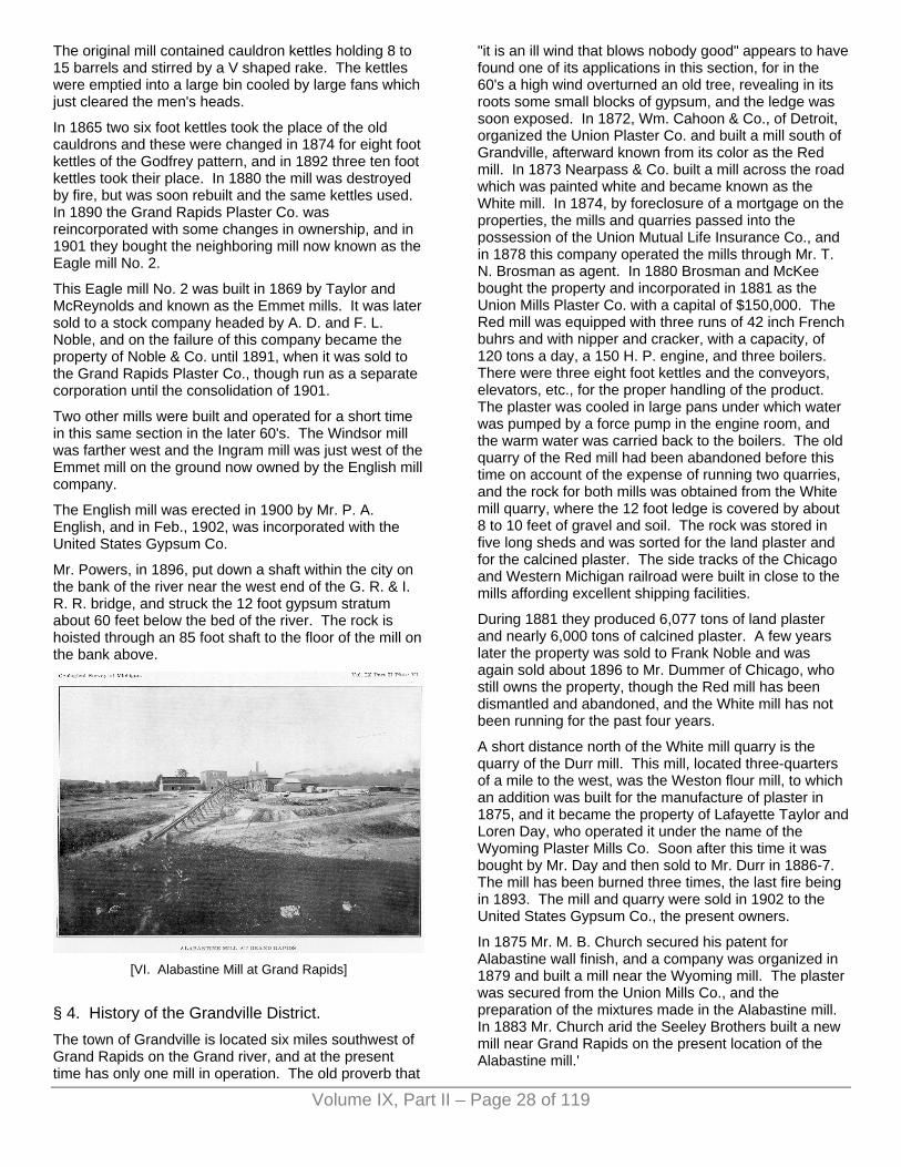
Volume IX, Part II – Page 28 of 119
The original mill contained cauldron kettles holding 8 to 15 barrels and stirred by a V shaped rake. The kettles were emptied into a large bin cooled by large fans which just cleared the men's heads.
In 1865 two six foot kettles took the place of the old cauldrons and these were changed in 1874 for eight foot kettles of the Godfrey pattern, and in 1892 three ten foot kettles took their place. In 1880 the mill was destroyed by fire, but was soon rebuilt and the same kettles used. In 1890 the Grand Rapids Plaster Co. was reincorporated with some changes in ownership, and in 1901 they bought the neighboring mill now known as the Eagle mill No. 2.
This Eagle mill No. 2 was built in 1869 by Taylor and McReynolds and known as the Emmet mills. It was later sold to a stock company headed by A. D. and F. L. Noble, and on the failure of this company became the property of Noble & Co. until 1891, when it was sold to the Grand Rapids Plaster Co., though run as a separate corporation until the consolidation of 1901.
Two other mills were built and operated for a short time in this same section in the later 60's. The Windsor mill was farther west and the Ingram mill was just west of the Emmet mill on the ground now owned by the English mill company.
The English mill was erected in 1900 by Mr. P. A. English, and in Feb., 1902, was incorporated with the United States Gypsum Co.
Mr. Powers, in 1896, put down a shaft within the city on the bank of the river near the west end of the G. R. & I. R. R. bridge, and struck the 12 foot gypsum stratum about 60 feet below the bed of the river. The rock is hoisted through an 85 foot shaft to the floor of the mill on the bank above.
[VI. Alabastine Mill at Grand Rapids]
§ 4. History of the Grandville District. The town of Grandville is located six miles southwest of Grand Rapids on the Grand river, and at the present time has only one mill in operation. The old proverb that
"it is an ill wind that blows nobody good" appears to have found one of its applications in this section, for in the 60's a high wind overturned an old tree, revealing in its roots some small blocks of gypsum, and the ledge was soon exposed. In 1872, Wm. Cahoon & Co., of Detroit, organized the Union Plaster Co. and built a mill south of Grandville, afterward known from its color as the Red mill. In 1873 Nearpass & Co. built a mill across the road which was painted white and became known as the White mill. In 1874, by foreclosure of a mortgage on the properties, the mills and quarries passed into the possession of the Union Mutual Life Insurance Co., and in 1878 this company operated the mills through Mr. T. N. Brosman as agent. In 1880 Brosman and McKee bought the property and incorporated in 1881 as the Union Mills Plaster Co. with a capital of $150,000. The Red mill was equipped with three runs of 42 inch French buhrs and with nipper and cracker, with a capacity, of 120 tons a day, a 150 H. P. engine, and three boilers. There were three eight foot kettles and the conveyors, elevators, etc., for the proper handling of the product. The plaster was cooled in large pans under which water was pumped by a force pump in the engine room, and the warm water was carried back to the boilers. The old quarry of the Red mill had been abandoned before this time on account of the expense of running two quarries, and the rock for both mills was obtained from the White mill quarry, where the 12 foot ledge is covered by about 8 to 10 feet of gravel and soil. The rock was stored in five long sheds and was sorted for the land plaster and for the calcined plaster. The side tracks of the Chicago and Western Michigan railroad were built in close to the mills affording excellent shipping facilities.
During 1881 they produced 6,077 tons of land plaster and nearly 6,000 tons of calcined plaster. A few years later the property was sold to Frank Noble and was again sold about 1896 to Mr. Dummer of Chicago, who still owns the property, though the Red mill has been dismantled and abandoned, and the White mill has not been running for the past four years.
A short distance north of the White mill quarry is the quarry of the Durr mill. This mill, located three-quarters of a mile to the west, was the Weston flour mill, to which an addition was built for the manufacture of plaster in 1875, and it became the property of Lafayette Taylor and Loren Day, who operated it under the name of the Wyoming Plaster Mills Co. Soon after this time it was bought by Mr. Day and then sold to Mr. Durr in 1886-7. The mill has been burned three times, the last fire being in 1893. The mill and quarry were sold in 1902 to the United States Gypsum Co., the present owners.
In 1875 Mr. M. B. Church secured his patent for Alabastine wall finish, and a company was organized in 1879 and built a mill near the Wyoming mill. The plaster was secured from the Union Mills Co., and the preparation of the mixtures made in the Alabastine mill. In 1883 Mr. Church arid the Seeley Brothers built a new mill near Grand Rapids on the present location of the Alabastine mill.'

Volume IX, Part II – Page 29 of 119
§ 5. History of the Alabaster Deposit. Bela Hubbard, describes1 a geological expedition in 1887 to this region in company with Dr. Houghton, and in his notes mentions the discovery of gypsum at the mouth of the au Gres river.
"In the interests of the scientific object of our tour, I will here observe that near the Au Gres river we discovered, beneath the clear water of the bay, a bed of gypsum. Subsequently an outcrop of this mineral was found on the neighboring land, and has long been quarried with profit."
The plaster beds near Alabaster were first discovered by early Indian traders who noticed the outcrop in the waters of the Saginaw Bay. In 1841, on the completion of the first government survey of this district, Mr. Wm. McDonald, an Indian trader in the employ of the American Fur Co., made an entry a mile in extent along the shore. He later sold a portion of his interest to James Fraser, Harvey Williams and Alfred Hartshorn, who explored the beach but found nothing except gravel and sand. Others later sought for the gypsum in the sink holes of the region, for they failed to recognize the fact that these places owed their formation to the loss of gypsum through solution.
In the later 50's Wm. S. Patrick carried the mail through this section from Alpena to Bay City by dog train. An old squatter, who had taken possession of some land near the present Alabaster quarry, one day showed a piece of the gypsum rock to Patrick, who took it to Bay City and showed it to Mr. Geo. B. Smith. Mr. Smith's father, B. F. Smith, owned a quarry near Sandusky and a gypsum mill in the city of Detroit. Patrick, on his return, bought the land, paying for it two dogs and $10, and he in turn sold it to Mr. Smith, who opened the first quarry in 1862. On the death of Mr. Smith, Mr. A. F. Billiard, B. F. Bullard, and the estate of G. B. Smith formed the company of Smith, Bullard & Co, and in 1876 the name was changed to Smith and Bullard, who sold to B. F. Smith, who in turn sold a part interest to W. A. Avery and T. G. McCausland, operating under the name of B. F. Smith & Co. This company was reorganized in 1891 as the Western Plaster Works and changed to the Alabaster Co. in 1898. It is now known as the Alabaster plant of the United States Gypsum Co. In 1891 fire destroyed all the property and the mill was rebuilt in 1892, and another mill was built at South Chicago to supply the World's Fair trade.
In the early days of the Alabaster quarry development, small mills for the manufacture of land plaster at Winona, West Bay City, and Monroe were supplied with the Alabaster rock.
The first apparatus used for calcining was a system of revolving cylinders which proved unsatisfactory, and these were soon replaced by kettles. The fuel used for the purpose of calcining was wood until 1898. when the railroad switch was built and coal replaced the wood.
In 1870 Mr. Chas. Whittemore, a lumberman of Tawas City, opened a second gypsum quarry about three miles south of the Alabaster quarry near the water of the bay, and made land plaster for the farmers of that region, but on account of trouble with water abandoned the work a year or so afterward.
At the present time the Alabaster Co. has established a hotel, post-office, and some 40 dwelling houses for the workmen, forming a very comfortable town located six miles from Tawas City and 42 miles from the mouth of Saginaw river, fronting the Saginaw Bay. They own about 200 acres of land and have built a two story warehouse and 600 foot pier for loading the sailing vessels, and the town is connected by switch with the Detroit and Mackinac railroad, which connects with the Pere Marquette at Bay City. 1A Michigan Geological Expedition, a paper read before the Historical Society of Detroit and published in Michigan Pioneer and Historical Collections, Vol. III. p. 199. Memorials of a Half Century, p. 86
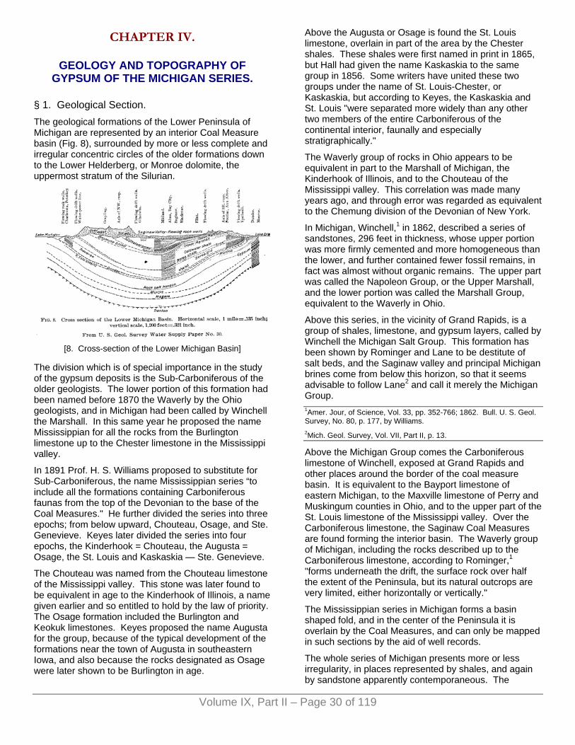
Volume IX, Part II – Page 30 of 119
CHAPTER IV.
GEOLOGY AND TOPOGRAPHY OF GYPSUM OF THE MICHIGAN SERIES.
§ 1. Geological Section. The geological formations of the Lower Peninsula of Michigan are represented by an interior Coal Measure basin (Fig. 8), surrounded by more or less complete and irregular concentric circles of the older formations down to the Lower Helderberg, or Monroe dolomite, the uppermost stratum of the Silurian.
[8. Cross-section of the Lower Michigan Basin]
The division which is of special importance in the study of the gypsum deposits is the Sub-Carboniferous of the older geologists. The lower portion of this formation had been named before 1870 the Waverly by the Ohio geologists, and in Michigan had been called by Winchell the Marshall. In this same year he proposed the name Mississippian for all the rocks from the Burlington limestone up to the Chester limestone in the Mississippi valley.
In 1891 Prof. H. S. Williams proposed to substitute for Sub-Carboniferous, the name Mississippian series “to include all the formations containing Carboniferous faunas from the top of the Devonian to the base of the Coal Measures." He further divided the series into three epochs; from below upward, Chouteau, Osage, and Ste. Genevieve. Keyes later divided the series into four epochs, the Kinderhook = Chouteau, the Augusta = Osage, the St. Louis and Kaskaskia — Ste. Genevieve.
The Chouteau was named from the Chouteau limestone of the Mississippi valley. This stone was later found to be equivalent in age to the Kinderhook of Illinois, a name given earlier and so entitled to hold by the law of priority. The Osage formation included the Burlington and Keokuk limestones. Keyes proposed the name Augusta for the group, because of the typical development of the formations near the town of Augusta in southeastern Iowa, and also because the rocks designated as Osage were later shown to be Burlington in age.
Above the Augusta or Osage is found the St. Louis limestone, overlain in part of the area by the Chester shales. These shales were first named in print in 1865, but Hall had given the name Kaskaskia to the same group in 1856. Some writers have united these two groups under the name of St. Louis-Chester, or Kaskaskia, but according to Keyes, the Kaskaskia and St. Louis "were separated more widely than any other two members of the entire Carboniferous of the continental interior, faunally and especially stratigraphically."
The Waverly group of rocks in Ohio appears to be equivalent in part to the Marshall of Michigan, the Kinderhook of Illinois, and to the Chouteau of the Mississippi valley. This correlation was made many years ago, and through error was regarded as equivalent to the Chemung division of the Devonian of New York.
In Michigan, Winchell,1 in 1862, described a series of sandstones, 296 feet in thickness, whose upper portion was more firmly cemented and more homogeneous than the lower, and further contained fewer fossil remains, in fact was almost without organic remains. The upper part was called the Napoleon Group, or the Upper Marshall, and the lower portion was called the Marshall Group, equivalent to the Waverly in Ohio.
Above this series, in the vicinity of Grand Rapids, is a group of shales, limestone, and gypsum layers, called by Winchell the Michigan Salt Group. This formation has been shown by Rominger and Lane to be destitute of salt beds, and the Saginaw valley and principal Michigan brines come from below this horizon, so that it seems advisable to follow Lane2 and call it merely the Michigan Group. 1Amer. Jour, of Science, Vol. 33, pp. 352-766; 1862. Bull. U. S. Geol. Survey, No. 80, p. 177, by Williams. 2Mich. Geol. Survey, Vol. VII, Part II, p. 13.
Above the Michigan Group comes the Carboniferous limestone of Winchell, exposed at Grand Rapids and other places around the border of the coal measure basin. It is equivalent to the Bayport limestone of eastern Michigan, to the Maxville limestone of Perry and Muskingum counties in Ohio, and to the upper part of the St. Louis limestone of the Mississippi valley. Over the Carboniferous limestone, the Saginaw Coal Measures are found forming the interior basin. The Waverly group of Michigan, including the rocks described up to the Carboniferous limestone, according to Rominger,1 "forms underneath the drift, the surface rock over half the extent of the Peninsula, but its natural outcrops are very limited, either horizontally or vertically."
The Mississippian series in Michigan forms a basin shaped fold, and in the center of the Peninsula it is overlain by the Coal Measures, and can only be mapped in such sections by the aid of well records.
The whole series of Michigan presents more or less irregularity, in places represented by shales, and again by sandstone apparently contemporaneous. The

Volume IX, Part II – Page 31 of 119
Michigan group in places is cut out entirely on the border of the Coal Measures, and again the Bayport limestone is present and the lower gypsum beds are gone. This limestone at Grand Rapids is about 50 feet thick and rests on the gypsum formation.
In the interpretation of the geological history revealed by these rocks and their relations, the writer wishes to acknowledge his indebtedness to the various papers of Weller, Lane, and Keyes. 1Mich. Geol. Survey, Vol. III, Part I, p. 69.
§ 2. Geological History of the Michigan Basin. At the opening of the Carboniferous period, Lower Michigan, Ohio, and a large part of Pennsylvania, were covered by a gulf which opened to the northwest across Illinois and Minnesota. In the earlier part of the Mississippian epoch, the land was sinking around this gulf, especially to the south and southwest, and in this sinking area were deposited the sediments of the Kinderhook stage, forming limestones, sandstones, and shales, mainly shallow water deposits irregular in extent, varying in fossil contents, so that the same series of rocks has been given a variety of names by geologists. These names are often used in local geology, but now are known to be contemporaneous, and they are included under the name of Kinderhook.
By the close of this division of time, the large gulf extended south into Arkansas and Tennessee and west to the Rocky Mountains, and opened northwest across the Dakotas.
For a long period of time the salt water gulf remained stable and quiet supporting a rich fauna of corals and crinoids which have formed the Burlington and Keokuk limestones known throughout the world on account of the variety and perfection of their crinoid and brachiopod fossils. These limestones and other formations, related in time, have now been grouped under the name of Osage or Augusta.
The following sketch (Fig. 9) by Lane,1 modified from Keyes' section, will show the relations of the rocks of the Mississippi valley to those of Michigan.
[9. Correlation of Rocks Miss. Valley and Michigan]
While there were many local and minor variations in the physical conditions, and therefore in the life characters in this gulf, there was a greater and more important contrast in these characters between the eastern and western portions, separated by the Cincinnati island. These have been named by Weller2 the eastern or Waverly province, and the western or Osage province.
In the Kinderhook gulf, the faunas were intermingled to a very considerable extent; but in the Osage age, the clear waters of the Osage gulf supported a fauna which could not flourish in the sediment laden waters of the Waverly province.
The land to the northeast of this Carboniferous gulf was above sea level, the drainage system of that highland carried a large quantity of mud and sand sediment into the Waverly gulf, forming the conglomerates, sandstones, and shales of that area. The Cincinnati island afforded a partial barrier to the drifting of the sediment into the clearer Osage waters beyond.
At the close of the calm Osage age came a series of uplifts and depressions, whose effects are seen in the Mississippi valley and at the east. The St. Louis limestone was formed in waters extending 200 miles further north than those of the Osage, and this northward extension was followed by a retreat of 400 miles to the south. 1Mich. Geol. Survey, Vol. VII. Part II, p. 15, and Vol. VIII, Fig. 2. 2Journal of Geology, Vol. VI, p 308.
In the eastern part of the Waverly gulf, the changes began earlier than in the Osage gulf, and the coast line, according to Lane1 receded westward from western New York and central Pennsylvania, until a large part of Ohio and Indiana were out of water by the end of the Marshall or Waverly age. This left the Michigan basin enclosed between the mass of land at the northeast, and probably also at the northwest, and the low land over northern Ohio and southern Michigan.2
On the south side of this low land were deposited the sediments forming the coarse sandstones and conglomerates of the Logan group laid down irregularly in Ohio with an average thickness of 200 feet. To the north side were deposited the sediments forming the rocks of the Michigan group, shales, limestones, and beds of gypsum.
The Mississippi extension of the St. Louis is represented in Michigan by the Bayport limestone, in Ohio by the Maxville, which comes above the Michigan Group. This group would correspond in time with the Burlington and Keokuk, or the Osage (Augusta) of the Mississippi valley. The thickness of the group in Michigan is 232 feet (Lane, Vol. VII, Part II, p. 16), the Augusta in Iowa is 230 feet, the Logan in Ohio 200 feet. 1Michigan Geological Survey, Vol. VII, Part II, p. 15. 2The extension of the Cincinnati island above mentioned.

Volume IX, Part II – Page 32 of 119
§ 3. Michigan Group. The Carboniferous, Bayport, or St. Louis, limestone in Michigan is also called by Lane the Upper Grand Rapids series, and the Michigan group is known as the Lower Grand Rapids.
At Grand Rapids, the typical locality for the section, the lower series outcrops to the south of the city as a group of shales, thin bedded limestones, and gypsum layers; while the upper series outcrops along the river in the city nearly to its north limits.3 A number of quarries have been opened in the bed of the river, and, according to Rominger, the contact could be seen at the foot of the Rapids in the earlier history of the city. This limestone is about 50 feet thick, and the continuation of the section downward is given in the chapter on well records.
The only localities in Michigan where gypsum is found in this formation near the surface, are in the vicinity of Grand Rapids and at the east near Alabaster. The formation, however, is found in a belt of varying width bordering the coal basin, and throughout the most of the area it is more or less concealed by the overlying drift. 3See Whittemore Proc. Mich. Acad. of Sciences. Also Strong. Proc. Kent Sci. Inst. No. 3.
[VII. Alabaster Gypsum Quarry, showing boulder clay]
§ 4. Glacial Geology of the Grand Rapids Area. Mr. Frank Leverett has made careful studies on the glacial geology of the area around Grand Rapids, and a condensed account of this geology was prepared by Mr. Leverett and published in a report on the Grand Rapids flora, by Miss Emma Cole.4 Mr. Leverett has kindly sent me a copy of this part of the report, which is as follows:
"The features are somewhat intricate, but they fall in naturally with the view that there was a conjunction of two lobes in this vicinity. When the ice extended nearly to the southern border of Michigan, the junction between the Saginaw and Lake Michigan lobes was in a great belt of gravel that is traversed by the Grand Rapids & Indiana E. K. south from Kalamazoo, and the point of the
reentrant angle was in the great ridges southeast of Gun Lake.
"From this position the ice melted back until the point of the reentrant angle between the ice lobes was at the Bias Hills, a few miles south of Grand Rapids, and there a halt of some length occurred. The gravel tract between Dias Hills and Gun Lake was formed at that time.
"The ice then melted back sufficiently to bring the reentrant angle up to the bend of Grand River at Plainneld, and again halted. At that time the Lake Michigan lobe formed the ridges and hills that lie on the west side of the Grand River from Rockford to Jenison, and its margin continued southward past Jamestown. The Saginaw lobe at the same time covered the region immediately east of Grand Rapids, its margin being in the eastern edge of the city; and it built up the rolling country around Reed's Lake, and its continuation in the districts to the north and south. Meantime the water found its escape southward over the site of Grand Rapids, and on through the gravelly lowlands that lead past Carlisle to the Black Ash Swamp, and thence to the pine plains of western Allegan County, where it entered Lake Chicago, a lake that then filled the south end of the Lake Michigan Basin and discharged southwest past Chicago to the Illinois and Mississippi rivers.
"In melting back from this position, the ice next made a stand near Cedar Springs, and built up the prominent ridges northeast of that village. From these ridges the margin of the Saginaw lobe passed east of south near Nagle Lake to Grand River below Lowell, and thence on past Alto, while the margin of the Lake Michigan lobe passed southwest near Sparta and Englishville and formed the western part of the great belt of rolling land west of Grand Rapids.
"At length, after several halts that need not be enumerated here, the Saginaw lobe had melted so far back that its front was on the slope towards Saginaw Bay. A lake then formed in front of it, known as Lake Saginaw, which discharged down Maple river to Grand River at Lyons, and thence on past Grand Rapids into Lake Chicago. The channel divided near Jenison, one branch turning down the present river to enter Lake Chicago near Lamont, while the other led southwest past Hudsonville to enter the lake at Zeeland. Great gravelly deltas were formed by each branch of the old outlet at the places where they entered the lake. Much of Allendale Township, Ottawa County, is in the delta of the north branch, while Zeeland stands on the delta of the south branch. As these gravelly deposits are now 60 to 70 feet above Lake Michigan, it is certain that the level of Lake Chicago was about that height above the present lake. Later it dropped to lower levels, and the outlet of Lake Saginaw along Grand River valley become correspondingly deepened.
"The variations in the drift material gave rise to several classes of soil ranging from heavy clay through loamy clay, clayey loam, sand and gravel, up to coarse cobble.

Volume IX, Part II – Page 33 of 119
It is usual, however, to find in gravelly places a sufficient amount of fine earthy material to afford a suitable matrix for plant roots.
"Perhaps the coarsest deposit within the Grand Rapids district is that in the old lake outlet. Between the city and Grandville the current of water removed the fine material to such a degree that the soil is very stony. In the western part of Grand Rapids and for some miles above the city large numbers of boulders were present in this outlet before the residents made use of them in building. The soil among the boulders was, however, not too coarse for plants to thrive. This same lake outlet carries also some of the most extensive swampy tracts in the district; the Zeeland swamp southwest of Hudsonville, the Cedar swamp west of Jenison, and the Burton Avenue swamp southwest of south Grand Rapids, being illustrations. But this swampy condition is due to subsequent plant growth in the part of the channel having exceptionally flat bottoms, rather than to any deposit made by the outlet. It is found that sand and gravel deposited by the lake outlet underlie all the swamps at a depth of only a few feet.
"The strip of gravelly sand which extends from the bend of Grand River near Plainfield southward along the east side of Grand River through Grand Rapids and to Carlisle, being in the line of a stream of water, carries but a small amount of clayey or fine material, and is less productive than the heavier soils on the borders of this old stream course. In the immediate vicinity of Grand Rapids it has the further disadvantage of being situated on the border of a deep valley into which the waters drain rapidly after a rain. The lightness of the soil is shown in the character of the vegetation, it being a strip of 'oak openings.’ In this old stream course, the extensive Black Ash Swamp has been developed; but, as in the lake outlet, this is due to subsequent plant growth, and sand may be found by probing to the depth of a few feet.
"The grade of soil next finer than the gravelly sand of the old stream courses is the sand found on the bluffs of the Grand and Thornapple rivers above the bend at Plainfield and on the border of several tributaries of Grand River, both above and below Grand Rapids. These sandy deposits have apparently in some cases been drifted beyond the limits of the streams that contributed them, being very irregular and patchy.
"The greater part of the Grand Rapids district lies on the uplands that were feebly or imperfectly acted upon by currents of water during the melting of the ice sheet.
"As a consequence, the soils contain a large amount of fine material together with the coarse stones of the drift. The proportion of fine material determines whether it is a heavy clay, a porous clay, or a loamy soil, and this proportion often varies greatly within the limits of a small field. In these uplands there are numerous basins formed by the irregular heaping of the drift, aided perhaps by the unequal settling of the drift material. These, because of imperfect drainage, usually contain
either lakes or swamps. The basins are especially numerous in Grand Rapids Township, from Reed's Lake northward, but are not rare in any part of the uplands of this district." 4See also paper by B. E. Livingston, in Ann. Report for 1901.
§ 5. Topography of the Grand Rapids Area.1 The Grand Rapids area in Kent county is drained by the Grand river which rises in the southern part of the State in Jackson Co., and flows northwest past Lansing, turning west near Ionia, making a horseshoe bend to the north near Grand Rapids and, flowing south through that city, turns southeast to Grandville, where it takes its northwest course again, emptying into Lake Michigan at Grand Haven. Its length is over 275 miles, including windings.
The Grand river flows from the north through Grand Rapids in a series of rapids which terminate below the center of the city near the Fulton street bridge. The river falls less than one-half foot in a distance of one mile from north of the city limits to Coldbrook street and in the next mile the fall is 12 feet, and from the lower part of the city to Lake Michigan, a distance of 50 miles, the fall is only 5.8 feet.
The river flows in a very straight channel, 600 to 900 feet in width cut in the valley, which is one mile to one and one-fourth miles wide. The banks on either side of the valley form bluffs 150 feet in height. Near the city the river is close to the east bluffs, but towards Grandville the valley broadens to the south.
The bluffs are gravel ridges cut by erosion into elongated or rounded hills. One of these extends through the city, east of the river, from Coldbrook avenue near the north end of the city, to Fulton street, a distance of one and one-fourth miles. A second ridge, really a continuation of the first one, extends from south of Fulton street to the south end of the city. The ridges are composed of gravel and boulders of varying size, with occasional boulders of limestone and gypsum. The river plain is composed of sand and silt.
To the south of the city the drainage is carried into the river by Plaster Creek, which rises in the southern part of Kent county and flows north for eight miles and then northwest for about ten miles. Near Grandville the area to the south is drained by Buck Creek, which rises in the vicinity of the head waters of Plaster Creek and flows northwest ten miles. These two streams are small, but they formerly furnished water power for the gypsum and flour mills near their mouths. The towns in the gypsum area are Grand Rapids, a city of 100,000 people. With its numerous mills and furniture factories; and Grandville, a town of a few hundred people. The area is traversed by the Pere Marquette R. R., which passes through Grand Rapids and through Grandville to Holland and Chicago. The Grand Rapids mills are also reached by the Grand Rapids and Indiana, and the Lake Shore and Michigan Southern railroads. The Detroit &

Volume IX, Part II – Page 34 of 119
Milwaukee branch of the Grand Trunk system also crosses the area. 1See map published in Annual Report for 1901.
§ 6. The Alabaster Area, by W. M. Gregory. 1. The Size of Area.
The area under consideration (Plate IV) is located on Saginaw Bay on the northeastern side of the Lower Peninsula of Michigan, comprising parts of the counties of Arenac, Ogemaw, and Iosco. The size of the area is some 40 by 30 miles, and comprises some 600 square miles. The geological formations here exposed extend from the Coal Measures to the Coldwater shales. The former State geologists Rominger and Winchell accomplished the most work, which was confined principally to the outcrops along the Lake Huron shore. Some of the outcrops of the interior which have not been described before will here be treated.
2. General Topography. Highest and Lowest Land.
The highest land of this area is in the northwest, the contour map showing a general slope from the northwest to the bay. The greatest elevation (850 A. T.) is at Turner's Corners, southwest of Maple Ridge, and other points which have considerable elevation, are Maple Ridge, which is on the crest of the Saginaw moraine and has an elevation of 803 A. T., and Pinnacle Hill, which is the highest point south of the Rifle river, and has an elevation of 765 A. T.
The lowlands are found bordering the lake shore and extending up the river valleys. Some of these lands include large marshy "prairies,” such as are found at the mouth of Rifle river and along the lake shore near Pine river and Saganing.
3. Glacial Geology.
The surface forms of the region are due to glacial action, in fact the predominating character of the surface topography outside of the lake formations was determined by the great ice sheets, which recently, in a geological sense, covered this country. These forces were not always destructive, but frequently constructive. The old rock surfaces which existed before the time of the ice cap have been smoothed off and the old valleys filled with glacial till. Distinct traces of some of these old valleys are found some four miles west of Alabaster, running north and south. Here wells are often drilled through the drift some 150 feet before reaching the rock.
Where the end of the ice sheet stood for a long time large mounds of assorted till were made on top of the rock. These mounds were continuous along the ends of the glacier and now stand up as high ridges or moraines. The crests of some of these moraines are seen in the region of Sterling, Prescott, and Taft. The drift is nowhere over 150 feet in thickness, its average depth is from 25 to 40 feet.
The moraines which are now present are moraines of retreat, the earlier ones being scrubbed out by advance of ice; the height of these moraines is never over 100 feet above the general surface of the country and some of them may be traced continuously across the country. One of the most prominent of the moraines of this region starts in the southwest near Moore's Junction and passes across to Sterling, Summit, Prescott, and Taft, and has been called by Taylor, the Port Huron-Saginaw moraine. This is the highest moraine on the map, Plate IV, and marks the position of the Huron ice lobe during one of the periods of retreating glaciation.
The one which starts at Harrisville and Alcona is traced southward to a point north of Tawas Lake down to the Vines P. O. and, curving slightly to the southeast, to a large spur midway between Tawas City and Alabaster, where it drops off sharply, may be traced as a water laid moraine from this place to Au Gres, where it passes into Lake Huron. The Alcona moraine in the region of Alcona is very marked in its morainic character, being very rolling and irregular in outline; as it is traced to the south it becomes more subdued, exhibiting its water laid character. The bedding at Seven Mile Hill on the Au Sable and Northwestern R. R. shows clearly that the ice once stood at the eastern edge and that the drainage was to the west, forming the Au Sable overwash plains which are traced as far south as Moore's Junction, always being found as sand beds just west of this clay ridge. This moraine is believed to exhibit one of the characters which is peculiar to moraines passing from surface forms to water laid forms. It was formed after the Saginaw-Port Huron moraine and a string of lakes exist between the halt of the two moraines.
The interesting feature which always accompanies the moraines in this region is the overwash plains, or as they are more popularly called the sand plains. These are very familiar to the residents of the district as being regions which absorb water very rapidly and contain no soil which is adapted to cultivation, and grow a familiar plant society characterized by jack pine, sweet fern, and scrub oak. As has been before stated, these plains were formed when the ice stood on the different moraines and are the products of drainage along the western edge of the ice. In some places, such as Iosco county, north of Tawas City, there is quite a deep trench between the place where the ice stood and the plain; this is believed to be an excellent example of "fosse." The sand plains in the region of Pinnacle Hill were formed as a delta in some stage of the glacial Lake Warren, those in the region of Alger being formed in an earlier stage of the lake called Saginaw by Taylor. These sand plains comprise all the northwestern parts of Iosco county and almost wholly the entire northwestern section of Arenac county.
The conditions which were present during the retreat of the glaciers were such that at the south and west was higher land, and the ice as it stood on the moraines often extended across to higher land in the south, so that in front of the lobes was a lower region than that of the
Volume IX, Part II – Page 35 of 119
surrounding surface, which filled with water from the melting and retreating glacier, and thus glacial lakes were formed. The beds and beaches of these old lakes form a very conspicuous feature of the topography of this area. That these lakes persisted for a long time is clearly certain from the extent of their beach lines and their development and many lake histories have been recorded and perserved by these fossil beaches. The highest beach of this region is that of old Lake Saginaw. It was into this lake that the early drainage of the Au Sable river was directed by the western edge of the ice. The next lake which left two distinct beaches was Lake Warren. The first beach was the Upper Forest,1 usually formed at 775 A. T. This beach is very distinctly shown in the region of Sterling, and is found again as a beach of water worn gravels east of Maple Ridge, is present north and east of Whittemore, and is believed to be bordering on Bissonette, Tp. 24 N., R. 7 E., Sec. 11. The lower one is well developed, and marks a slight fall in the level of Lake Warren, and is traced from Sterling across to Emery Junction and the edge of the sand plains northward to Seven Mile Bill. It is believed that while the lake stood at this level and at the place preceding, that the delta which comprises the region of Pinnacle Bill in Arenac county, was formed. The Grassmere1 beach is not distinct in the northwest but seems to appear in the vicinity of Deep river on the Michigan Central R. R., having an elevation of 655 feet A. T. It is made out rather indistinctly at the edge of the old or Pinnacle Bill delta, and it appears again west of Turner, in a well marked ridge, and it is traced to the northeast to a point south of Emery Junction, where it extends directly east on top of the well marked lobe of the Alcona moraine, and nearly reaches Lake Huron, having an elevation of 650 A. T. Thence turning north, going west of Tawas City and also of Tawas Lake, it is believed to pass along the foot of Seven Mile Hill. The Algonquin Beach is the best marked of all these beaches and has been traced almost continuously across this region. It is first found in the southeastern part of Arenac county, west of the D. & M. R. R., having an elevation of 605 A. T., and being well developed in this region. This is traced east to Pine river in a series of beaches, which are some 15 to 20 feet above the level of Lake Huron and have in front of them smooth till plains. This is something exceptional in the way of beach structure and may be explained on the supposition of the formation of these beach ridges by means of push ice in old Lake Algonquin. On going north the beach becomes indistinct in the region of Au Gres swamp, but is found appearing again clearly at Alabaster, with an elevation of 605 feet A. T. It is traced along the front of the Alcona moraine a way, and then disappears, being cut away, until it reaches Tawas City, where the beach is found and a well developed bar which formed in front of the beach and eventually became the beach by the cutting off of the water in the rear. This little episode in the history of the Algonquin beach and the formation of the Jake back of Tawas City and the subsequent drainage of this lake is very clearly shown in the region called the “glen." The next beach below the Algonquin is the Nipissing and is in
places, in the southern part of Arenac county, not over 10 feet above the level of Lake Huron. Its chief features are destroyed in many places by erosion, or wind action accentuates its normal development. In the upper part of Iosco county the beach is 15 to 20 feet above lake level and is, if exposed to the wind, sure to be changed into ridges which are slowly traveling the shore. Such dunes are shown at the old Hale mill and also at the Tawas Beach Park resort. Some of these dunes show what might be termed wind ripple action, being blown into little ridges, which are exactly similar to ripple marks formed in shallow water. A few of these dunes travel quite rapidly, and in some of these places trees have been known to survive passage of sand over them. 1The correlation of these beaches is with the Huron county report, Vol. VIII. At the date of publication Messrs Leverett and Taylor are engaged in revising this, and changes may be involved in the names. L.
4. Additional Relief Forms.
Most of the forms which are a conspicuous part of the topography are due entirely to glacial action, and as erosion has had but a small opportunity to work over these forms, the prevailing relief is one of youth—maturity in land form development being reached only along the river bottoms and lake shores, but erosive action has been enough in some places to accomplish a considerable cutting away of the old lake beaches. The inland lakes are as yet but little filled and the swamps are largely the result of the immaturity of the drainage system. The Au Gres swamp is an excellent type of this development.
One of the features of the old rock topography, the only remnant of this form which has an influence on the present surface features, is the limestone ridge which extends from Point Au Gres west to Duck Lake, from thence north and west to the Griffin quarry and the Tyler outcrop, becoming lost underneath the drift of the northwest. This ridge stands up because of the hardness and the lithological character of its composing members, which are a hard dolomitic limestone and hard calcareous sandstone.
5. Recent Shore Forms.
Between the lake level and the Nippissing beach is a strip of land which is due entirely to recent lake formations and some of these are within recent historic times. The general shore structures of the eastern edge of this area show the direction of the adjustment of the beach to the lake currents by the smooth curves convex to the present in the outline of the shore, both in the larger features and the smaller ones (?). The most interesting place where these recent formations have been more rapidly built, is at Tawas Point. The places in the "bight" of Tawas Bay show how the building at this point is gradually weakening the building effects of the waves on the shore.
One of the familiar features along shore is that of sand dunes; in many places arranged by storm waves and wind action into lenticular dunes with the longer axes

Volume IX, Part II – Page 36 of 119
northeast and southwest. These are often cut into several smaller ones, later by wind action or perhaps the entire top blown off, forming a dune which resembles a crater of an old volcano.
The Tawas river and other rivers of this section have a tendency to build deltas where the force of the river currents is less than that of the lake currents. This has taken place at the mouth of Tawas river. The building takes place in the summer and in the spring and fall. The current of the Au Sable is much stronger than the prevailing lake currents and the sediments are carried some two miles down the shore, where, according to Capt. Small of the Tawas U. S. Life Saving Station, there is a large shallow area, some one-half mile off shore, and this is being converted into an island. The Rifle river has built a large delta at its mouth, some five miles square in area, and the Au Gres river has a current which is so sluggish that a channel to the Saginaw Bay is kept open with difficulty, and a long area of land in front of the river mouth is slowly forming into the river delta.
[VIII. Alabaster Gypsum Quarry, showing gypsum ledge]
6. Sink Holes.
Some of the forms which are very limited in extent, but constitute a peculiar feature of the surface, are known as sink holes, and have been formed in the limestone or in the gypsum by the dissolving action of the water forming large circular pits, 10 to 15 feet across and 9 to 10 feet deep. Such structures are found below Alabaster in Iosco county, also west of the D. & M. R. R. near the Dryer place, and at Glendon dam on the east side of the river; these structures, while not an important topographic form, are believed to be important in the drainage of the region in which they are found and are the best developed at Alabaster of any of the regions in which the structures occur.
7. The Drainage.
The drainage of this region is largely determined by the character of the country, as the rain fall of the sand plains passes quickly to the water table, which is on the underlying clay whose depths from the surface averages near 15 feet, while the water falling on the clay flats is almost all held on the clay surface until removed by the surface drainage. The sand plains give rise to a large number of springs at their edges or in the regions where they are cut by the rivers. All the creeks of this region which are important feeders of the larger rivers can be traced directly to their origin on the edge of the sand plains. The springs at Pinnacle Hill on Rifle River are an example of springs formed by a river cutting down to the under clay of the said plain, and there are several such springs found along the Au Sable river. Along the Au Gres river are many of these springs, which appear between the sand and the under clay. The entire drainage of the eastern half of this area is very irregular and discordant. The shortest and most natural route for the water to take to the lake, is effectively blocked by the Alcona moraine, and the water falling quite near to the lake is carried away some distance to the Au Gres river, where it slowly passes through the Au Gres swamps and out to the lake. In the spring swampy lands along the Au Gres slowly fill with water, which renders useless for a long period during the early spring a large tract of land which would otherwise be excellent for cultivation. Attempts have been made to remedy this by clearing out the outlet of Duck Lake and by building drains to carry the water directly into the Au Gres river, as the drain east of Twining and also the "Bum" drain east of Turner. This condition in the region of Alabaster is possibly to be corrected by a pretty example of stream capture, as there are many small stream creeks "gnawing" back from Lake Huron into the lake side of this moraine, and in the spring when the water is high in the Au Gres basin, a small part of it comes over the divide in these creeks. One of the largest of these spring creeks is situated midway between Tawas City and Alabaster, and has cut a deep ravine into the moraine here and in front has built a fine alluvial fan or "freshet" delta.
8. Rifle River.
The Rifle river is a good example of the typical streams of this section, it having had in former glacial time an abundant supply of water which brought a large amount of gravel. The river had to aggrade its course because of increased supply of material and as the volume of water became deficient by the retreating of the glacier, the slope of the old river was not steep enough and thus the stream was compelled to grade its course, cutting deep into the deposits of sand and clay gravel. The lowest beds of the formations exposed in the river banks are solid lake deposited clays, which were formed when the lake stood at a higher level and the river had its entrance to the early glacial lakes farther to the north, and then as the shore of the lake was lowered, on top of the clay was deposited a series of overwash deposits, which vary from 15 to 20 feet in thickness and are

Volume IX, Part II – Page 37 of 119
almost wholly composed of fine white sand. It may be explained that the absence of a deposit of coarse gravels on top of the clay may mean that the lake fell rapidly, giving no time for the deposition by continued action of other shore deposits, than fine sand, not giving an opportunity for the working out of the heavy boulders and pebbles. The river shows, in many places, a succession of terraces cut in the old gravels and in places there are cusps on the spurs. Where the river flows across the moraines the boulders are sorted out and left in the river bed, forming riffles or slight rapids.
The flood plain of this river is not well developed above Omer, but well enough developed so that it sweeps around the ends of some of the spurs and possibly may be classed as a "scroll pattern flood plain.” Below Omer the river has many ox-bow cut-offs and a great extension of the flood plains. It has no branches of any size from the south and is fed by spring creeks from a clay country from the north and rises in the region of Rose City and Lupton. At the West Branch bridge, it cuts through an exposure of some 20 feet of Marshall sandstone; below this exposure some two miles there is a formation of limestone and sandy shale which belongs to the Maxville rocks. At a lumber dam, northwest of Pinnacle Hill, there is an exposure of bed rock which may be classed with the Michigan group. Following down some two miles are excellent exposures of fire clay and black shale, exposing a pocket of the coal series of Michigan. The outcrop at Omer is the fine white sandstone which is believed to be the base of the Michigan coal series. This formation is exposed in several other places, from this point down the river to the mouth.
§ 7. The Paleozoic Geological Formations of the Alabaster Area. In this area are excellent exposures of the Michigan coal series, the Maxville limestone, Michigan series, Upper Marshall or Napoleon and Coldwater or Cuyahoga shales. The outcrops are rare, but all of the formations are represented with the exception of the Coldwater shales. The best outcrops are those of the Maxville limestone and the Michigan series. Much of the knowledge of the rocks is based upon the records of the salt wells which were drilled years ago to supply brine for salt manufacture, which was carried on in connection with numerous saw mills, which furnished abundant fuel. In only a few towns are the old salt blocks utilized at the present time. Many regions have shallow flowing wells and by a combination of these two sets of well records and an examination of the outcrops, fairly accurate data concerning the surface and depth of glacial drift and the stratigraphy of the old rock have been obtained.
The Coldwater shale is reached by some of these deeper wells on the northeastern border, possibly at East Tawas, and certainly at Au Sable. After considerable careful examination it is still an unsettled question concerning the brine of the East Tawas wells, but it seems quite probable that it comes off the top of
the Coldwater shales as when this is reached under cover it is quite salty.
The next formation lying above the Coldwater shales is the Lower Marshall, which is easily recognized by its abundance of red rock, called paint rock by the drillers. This is found in the lower wells at 120 to 800 feet, and in its lower part it alternates with beds of blue shale, with the red rock growing gradually thinner at the bottom of the formation with a corresponding increase in the blue shale beds, and at 700 feet an abundance of brine in a gray sand rock has been found in the East Tawas wells.
At East Tawas the Napoleon or Upper Marshall is represented by some 20 to 40 feet of white sandstone and is the first formation reached. Wherever this formation is drilled into in the county southeast of Tawas an abundant supply of water is yielded, while the lower formation yields a water which is saltier. The flowing wells which are found at Turner, Alabaster, Au Gres, Twining, Omer, Standish, and Pinconning all have wells in this formation. These wells do not pass through any red rock at all, and so it seems that water must come from the Upper Marshall or Napoleon. On Rifle river it has its only outcrop, not a well exposed one, which exists near the West Branch bridge.
The Lower Grand Rapids group or Michigan series is well known to the well drillers because of the prevalence of seams of gypsum alternating with limestone layers and shaly sandstones. The water of the gypsum beds is always very strongly mineralized and unfit for use. The Alabaster quarry, Iosco county, is in this formation, as are the outcrops at Plaster Bluff, Cramer's Creek, Turner, Twining, West Branch and Glendon dam. The gypsum is not uniform in thickness, and in places is interstratified with many stones of hard cherty limestone, and in other regions, as at Turner at the small shaft sunk by Mr. Hand, the seams are brownish dolomitic limestone.
ALABASTER.
The most extensive exposure of the Michigan series is at Alabaster^ four miles south of Traverse City, in Iosco county, in the quarry of the North American Plaster Co. A bed of gypsum with an average thickness of 23 feet is covered with a stiff brown boulder clay, free from pebbles, 10 to 12 feet in depth. This one bed,—in reality, two beds, are present as in early working of the quarry a layer of hard fossiliferous limestone and a small layer of shale were between the two beds, which have entirely disappeared in the recent working. The bed has been worked back from its original outcrop on the shore of Lake Huron, nearly a thousand feet, and the face of the bed now exposed is more than a quarter of a mile in length. See Plates VII, VIII and IX.
For convenience in hauling away the rock as it is blasted from the face of the bed, the quarry is being worked in the shape of a huge horseshoe, with the face of the bed on the outside of the bow. The material stripped from the top by steam shovel is carried by tram cars to the center of the bow, making a huge dump which has

Volume IX, Part II – Page 38 of 119
somewhat interfered with the drainage of the quarry, but offers the least expensive method of disposal of this material.
The top of the bed exposed by the removal of this heavy brown clay is very even, showing a slight dip to the southwest and many small ravines, due to the solvent action of percolatory waters, which generally come through the sandy streaks in the clay.
The gypsum is removed from the surface by blasting, the charges are distributed in steam drilled holes, along the bed, and large masses thrown down to the floor of the quarry, and is here broken by handwork into sizes convenient for the crushers or for shipping by boat.
The dark colored, impure gypsum with a large percentage of clay is utilized for land plaster. A variety which is streaked like castile soap, with irregular seams of clay, is shipped to eastern markets, where it is made into Mexican onyx. The purest gypsum is ground, heated and converted into familiar plaster of Paris. Many of the patent hard finish wall plasters and fancy kalsomines have the calcined gypsum as their chief ingredient: The familiar "stucco" material is the calcined gypsum mixed with size or glue. The larger part of the staff material used for the World's Fair buildings and the Pan-American, came from this quarry.
A 90-foot shaft was sunk several years ago by the North American Plaster Co. to determine the condition of the lower beds of their deposit. The underlying rock of the quarry is a bluish gray sandstone, alternating with seams of hard cherty limestone and brownish sandstone. At different depths several small beds of gypsum occur, the largest one nearly 5 feet thick, and at 85 feet depth. At 90 feet a strong flow of water occurred, which stopped further work, and it is quite probable that this represents the bottom of the Michigan series.
In the gypsum bed no trace of organic life has been found, but in the early working of the quarry, before the two beds were found blending into one, they were separated by a small layer of shale and limestone from which some fossils were reported by Winchell.
In the report upon the geology of the lower peninsula of Michigan (Geological Survey of Michigan, Vol. Ill, Pages 105-107) by Dr. Rominger, the bed of gypsum then exposed was only 15 feet in thickness with a few additional feet of shale and flagstones. The recent active quarrying has exposed the present gypsum bed of 23 feet, overlain by 15 feet of drift.
The fossils found by Dr. Rominger were in the middle beds of flagstones and the shells (which have now entirely disappeared) named in the order of their abundance he called: Myalina, Allorisma, Aviculopecten, Edmondia, Retzia gibbosoa and Spirifera speciosa.
CRANNER’S CREEK.
On Cranner Creek, which is a branch of the Au Gres river in 21 N, R 5 E., in Sec. 20, just west of the junction of this creek with Johnson creek, is a deposit of a very light rose-colored gypsum in its bed, being exposed in a few places for 200 feet along the creek's bottom and the low water of late summer months, showing large holes where the rock has been washed away when exposed to water action. The gypsum is covered by a bluish gray shale with occasional seams of arenaceous limestone. This is a place where some careful exploration of the high clay bluffs might reveal a bed of sufficient quality and quantity for working.
A short distance below the junction of these creeks, at an old abandoned lumber dam, the drift has been moved and shows, at low water, the upper layer brownish limestone of 1 foot in thickness, underlain by a 6-inch bed of pink-tinted gypsum, and some 8 inches of blue shale which rests upon a bed of white gypsum, whose exposure is not enough to determine its character. This seems to indicate that the workable bed of gypsum is below the bed of the creek rather than in the high clay hills which form its valley.
GLENDON DAM.
In Sec. 28, T. 22 N., R. 6 E., 1-8 of a mile above the old Glendon dam on the east bank of the Au Gres river, is a cut which exposes the following sections:— One foot clay, 4½ feet gypsum, top layers very pink; 3 in. roughly foliated limestone and sandy limestone interstratified; 2 feet of yellow shale; 3 feet of bluish gray arenaceous shale.
This is the only outcrop in this region in which the pink color of the rock is pronounced, and may be due to the fact that this was near an old stream flowing into the basin when the gypsum was being deposited and thus bringing some of the iron salts resulting from decomposition of rock into the water. The color is very uniform and regular, without any indication of being formed by infiltration after gypsum was deposited.
From the sink holes in the vicinity, and the fact that gypsum occurs in the outcrop, a company was organized several years ago and many tests were made by driling, but the results were not satisfactory and failed to show at any place a bed of over 5 feet and the gypsum was-pronounced valueless for commercial working and was considered a collection of big boulders rather than an actual outcrop, but the presence of the blue shale in the river bed some distance below and above the outcrop is sufficient to establish this as an outcrop. Careful searching has yielded no fossils.
On the Au Gres river, in Sec. 27, T. 22 N., B. 5 E., the river bottom in the southeast corner of the section is covered with a blue, grayish arenaceous shale, which is so closely associated with the gypsum deposits of this region. Northwest, a quarter of a mile from the southwest corner of this section, a three foot bed of gypsum occurs in bank of the Au Gres river. This is

Volume IX, Part II – Page 39 of 119
covered by two feet of sandy limestone and underlain by the blackish shales.
Following the Au Gres river through the sections of the southeastern part of the above township, small beds of arenaceous shales are found. A number of sink holes in Sec. 36, outcrops in sections 24 and 12, are reported but have not been found.
At Whittemore, in Sec. 10, T. 21 N., R. 5 E., is a well which penetrated several beds of gypsum at 50 feet and 170 feet. North of Whittemore, at Mr. Armstrong's house, beds of gypsum of 5 and 7 feet thickness were passed at 90 feet and 130 feet in drilling for a flowing well.
WEST OF TWINING.
In the S. W. ¼ of the S. E. ¼ of Sec. 23 of T. 20 N., R. 5 E. (Mason) of Arenac county, an attempt has been made to find the thickness and depth of the gypsum bed. This place is due west of Twining 1¼ miles, and has an elevation of 648 to 652 A. T. Several small test pits were sunk to the rock, which was found on the average at about 8 feet covering of drift material, largely boulder clay.
One of these pits, on the authority of Mr. Nelson, who assisted in making the tests, has the following strata, a record which, from well records in this vicinity, seems to be fairly accurate:—
8 feet of clay; 3 feet of gray sandstone mixed with small strata of gypsum; 5 feet of gypsum (?), white; 2 feet of gray sandstone mixed with gypsum, rests on 19 (1?) feet pure gypsum. (Very doubtful but not impossible.)
From an examination of the material thrown out of the pits, somewhat different conclusions might be drawn. The amounts of brownish sandstone and gray limestone are about equal. The brown sandstone being found on top with a few streaks of a very hard non-fossiliferous limestone. The gypsum which has been taken out contains much clay and resembles the poorer grade called land plaster at the quarry of the North American Plaster Co. at Alabaster.
The gypsum exists in two forms, one of dark mud-colored lumps which, on breaking open, show inside small irregular masses of pure, white, uncrystallized gypsum, as if after deposition of the material water action had disturbed the water material and brought in much silt which has formed a complete covering for the gypsum. Some iron pyrites were observed in a large number of specimens embedded in the gypsum and running in seams through it. This occurrence of iron pyrites with gypsum has not been observed before in any of the other deposits examined.
A bluish argillaceous shale has been taken out in a large quantity and closely resembles bluish shale from
Alabaster and Au Gres river. It is believed that this pit represents the top of the gypsum beds in this region.
At Twining, in drilling the flowing well of William Lilleberger, a vein of gypsum was found at 25 feet, but its thickness has not been carefully observed. In Mr. Barr's well, on Sec. 25, which is south 1½ miles, a 10 foot vein of this same rock was encountered at 20 feet, and the water of several wells in the near vicinity is very bitter, giving with Ba Cl2 solution a strong precipitate of Ba SO4, which indicates the presence of gypsum in the water. Mr. Barr states that the mineral comes to the surface 40 rods west of his house, but this outcrop has not been found. There is no question but that a bed of gypsum of fair thickness underlies the region of Twining, Turner and Turtle. Its value for working can be deterimned only by careful work with a drill.
KEYSTONE DAM.
The formation which is exposed above the Michigan series is that of the Maxville limestone which usually in this area forms a slight bluff on the southern slope of the outcropping gypsum and in particular in the region of Omer, Au Gres, and if followed to the northwest, on Cranner and Johnson creeks. The relations aid in following the boundaries of these two formations.
The bed of Johnson creek in Keystone dam, in Sec. 30, of 21 N., R. 5 E., is some 8 feet higher than the top of the exposure in Cranner creek, and although some of the intervening beds have not been found, the Keystone dam formation corresponds so slosely in lithological character and in fossils to the beds of Harmon City that its position in regard to the gypsum must be similar.
At the Keystone dam some 800 sq. ft. of rock is exposed. The beds dip only slightly to the S. W. and is traversed by few joints, and the beds are cut nearly 10 feet deep, for a distance of 500 feet by the creek which was formerly dammed at this place. The following description applies to this formation:
2 feet. This is the top layer and is a slight gray, brittle, slightly arenaceous limestone with a conchoidal fracture. Small druses containing crystals of calcite are scattered abundantly through the bed. Fossils, especially Allorisma, are quite numerous. Greenish stem-like bodies of irregular shape occur similar to some of the branching forms of bryozoa. The lower part of this layer is filled with flint nodules in shape and size like those of Harmon City, but are more cherty and of a darker color than those from the Lake Huron locality.
3 feet of dark brittle limestone filled with irregular lime concretions which are found in the Omer quarry. These concretions, when broken open, show excellent specimens of calcite.
1 foot of dark gray arenaceous sandstone or some branching forms of the lower forms, effervescing with weak acid and containing remains of some stems.
4 feet. Beds of gray color, hard and compact and calcareous in upper part, very brittle in the lower part,