vgs 3.2 manual.pdf · vgs vegetation/gis data system user guide vgs version 3.2 may 2013
TRANSCRIPT

VGS
Vegetation/GIS Data System
User Guide
VGS Version 3.2
May 2013

VGS - Vegetation/GIS Data System VGS - Vegetation/GIS Data System
- 2 -
VGS - Vegetation/GIS Data System
Introduction
Installation

Table of Contents VGS - Vegetation/GIS Data System
- 3 -
Table of Contents VGS - Vegetation/GIS Data System ................................................................................................ 1 Table of ContentsIntroduction ........................................................................................................ 3 Introduction ................................................................................................................................ 4
About VGS ................................................................................... Error! Bookmark not defined. Terms of Use ............................................................................................................................ 5 System Requirements ............................................................................................................... 5
Installation .................................................................................................................................. 7 Prerequisites ............................................................................................................................ 7 Installation Instructions ............................................................................................................. 7
User Guide .................................................................................................................................. 9 Using a Tablet PC ...................................................................................................................... 9
Sites ......................................................................................................................................... 11 Sites - What are they? ............................................................................................................. 11
Organizing Sites ......................................................................................................................... 12 Managing Folders .................................................................................................................... 16 Managing Sites ....................................................................................................................... 19 Site Information Form ............................................................................................................. 21
Data Forms and Studies .............................................................................................................. 26 Generating New Data Forms ..................................................................................................... 26 Using Data Forms ................................................................................................................... 29 Species Lookup ....................................................................................................................... 33
Recording Data .......................................................................................................................... 36 Frequency .............................................................................................................................. 36 Point Ground Cover ................................................................................................................. 38 Dry-Weight-Rank .................................................................................................................... 40 Fetch ..................................................................................................................................... 42 Point-Intercept ....................................................................................................................... 43 Cover-Class Estimation ............................................................................................................ 45
Generic Input Panels .................................................................................................................. 48 Species/Category Input ........................................................................................................... 48 Numeric Class Input ................................................................................................................ 49 Numeric Input ........................................................................................................................ 49
Reporting .................................................................................................................................. 51 Exporting Data ....................................................................................................................... 51 Backing Up Your Data .............................................................................................................. 52
Setup and Administration ............................................................................................................ 53 Data Form Defaults ................................................................................................................. 53 Managing Data Input Lists ....................................................................................................... 53 Categorical Lists ..................................................................................................................... 59
FAQ - Frequently Asked Questions ................................................................................................ 60 When will this help file/manual be completed? ............................................................................ 60

Introduction VGS - Vegetation/GIS Data System
- 4 -
Introduction
Welcome to VGS
____________________________________
VGS
Vegetation/GIS Data System
© 2007-2013 All rights reserved.
Developed by
Arizona Cooperative Rangeland Monitoring Program
A cooperative effort between
University of Arizona Cooperative Extension, USDA Forest Service and USDI Bureau of Land Management
For more information contact:
Arizona Cooperative Rangeland Monitoring Program
School of Natural Resources and the Environment
University of Arizona
PO Box 210043
Tucson, AZ 85721
435-688-3357 [email protected]
__________________________________________
Issued in furtherance of Cooperative Extension work, acts of May 8 and June 30 1914, in cooperation
with the U.S. Department of Agriculture, James A. Christenson, Director, Cooperative Extension, College
of Agriculture & Life Sciences, The University of Arizona. The University of Arizona is an equal
opportunity, affirmative action institution. The University does not discriminate on the basis of race,
color, religion, sex, national origin, age, disability, veteran status, or sexual orientation in its programs
and activities.
Terms of Use
System Requirements

Introduction VGS - Vegetation/GIS Data System
- 5 -
Terms of Use
End User License Agreement
VGS software is provided as-is with no warranty, actual or implied. Use of this software is at your own
risk. The University of Arizona and developers of this software are not responsible for any and all
liabilities, loss of data, damages, losses, costs and expenses (including reasonable attorneys' fees)
arising from or related to any claim, action, proceeding or allegation that arises or results, either directly
or indirectly, from the use of this software. This includes the use of any summary routines, analysis
algorithms or reports included in the software. The user accepts full responsibility for any and all conclusions or decisions based on data recorded and/or summarized using this software.
VGS software may not be reverse-engineered, or de-compiled in any manner.
The following actions may not be taken without the express consent of University of Arizona Cooperative Extension:
VGS software or any components thereof may not be modified and may not be included as part of
any other software.
Documentation, either electronic or hard-copy, provided with VGS software may be copied, but
the documentation or any portion thereof may not be published or included in any other
documents.
VGS software or any documentation provided therewith may not be posted for on-line distribution or download.
System Requirements

Introduction VGS - Vegetation/GIS Data System
- 6 -

Installation VGS - Vegetation/GIS Data System
- 7 -
Installation
Prerequisites
Installation Instructions
Prerequisites
The following are prerequisites required by the VGS software Version 3.2. All are installed by the VGS
installation program if not already available on the target computer. Contact us if you need information
regarding the licenses under which these prerequisites are distributed.
Microsoft .NET Framework Version 4.0
Microsoft SQL Server
1. Compact Edition 3.5 SP1+, OR 2. 2008 Express or Server Editions (or later)
Installation Instructions
Installation places shortcuts to the VGS executable on the desktop and on the Windows Start Menu.
The default install location is C:\Program Files\VGS, but can be changed during installation.
1. Installation must be performed under an administrative user account.
2. Locate the root directory for the installation source files for the VGS software and run VGS vx.x
Setup.exe.
3. Accept any user agreements (EULA) that appear. Depending on which prerequisites are installed,
you may be asked to reboot before continuing. Installation will continue automatically following
the reboot.
4. Accept the default installation path or change to the desired path when requested.
5. If the computer on which VGS is installed has a restrictive security environment, attempt to run
VGS after installation is complete. If the message "Unable to load database" appears, then there
may be issues with access permissions that must be resolved:
o The VGS folder where the software is installed must have read/execute permissions.
o The folder where the VGS database is located must have read/write/modify privileges. The
location of this folder depends on the operating system. In general, the default locations
for the data are as follows:
Older versions of VGS: C:\Program Files\VGS\Data
Windows XP: C:\Documents and Settings\All Users\Application Data\VGSData Windows 7/8: C:\ProgramData\VGSData

Installation VGS - Vegetation/GIS Data System
- 8 -
o SQL Server Express requires write permissions on certain registry keys. If access to the
registry is restricted, set permissions at the root level for MS SQL Server nodes to allow
write/modify access for any users using the software. (Specific keys involved and under
what circumstances are yet to be identified). o All VGS folders and files must allow full-control access.

User Guide VGS - Vegetation/GIS Data System
- 9 -
User Guide
Using a tablet PC
Sites
Data Forms and Studies
Reporting
Exporting Data
Backing Up Your Data
Using a Tablet PC
VGS can be used from any computer with a Windows operating system. However, the software is most
commonly used on tablet PC computers. Here are some tips for using VGS on a tablet PC.
In general, using a stylus with VGS is more accurate and preferable to touch.
For best visibility in sunlight:
o Set the desktop background to a plain, light color. Especially avoid a busy pattern or photo
for the background.
o Use a theme with light colors. The "Windows Classic" theme is a good choice
o The appearance of the on-screen keyboard on a Windows tablet PC is determined by the
desktop theme, so make sure the chosen theme provides the keyboard with a light-colored
background as well.
o Setting the tablet screen as bright as possible is helpful in direct sunlight, but be aware that screen brightness affects battery life.
Enlarge the on-screen keyboard to a favored size using the stylus or a mouse. You can
experiment with other keyboard settings by clicking the "Options" key.
Periodically follow the instructions for your tablet to "calibrate" the stylus. Calibrating the stylus
helps keep the screen pointer aligned with the stylus. Calibration may also be necessary when
changing users, especially between right and left-handed users.
When using a stylus, watch the screen pointer, not the end of the stylus pointer. The position of
the screen pointer determines where a mouse-click will occur.
Turn the sound on for the tablet. VGS uses sound to indicate selections and steps during
sampling. This can be helpful to the recorder to know that a stylus or touch selection was
received. It can also be helpful to the observer by making them aware when the recorder is ready
to receive more information (such as knowing when the recorder has navigated to the next
quadrat or point). Also, depending on the options selected, the on-screen keyboard uses sound
for key-clicks.
Do not tip the stylus too much on its side, else Windows may not recognize a tap or selection.

User Guide VGS - Vegetation/GIS Data System
- 10 -
Although the risk of losing a stylus is increased, remove stylus tethers that may come with your
tablet. A tethered stylus is usually more cumbersome to use. Tying a brightly colored ribbon or
applying a bright piece of tape to your stylus will prevent losing it in the grass if it is dropped.
Always have an extra stylus available in case the stylus is lost or quits working (though the latter
is rare).
A right-click mouse action is generated on a Windows tablet by pressing and holding the stylus
down. As soon as the circular graphic appears around the stylus screen location, releasing the
stylus will bring up the right-click menu if applicable. Many styluses have a button on the side
which, when pressed and held while clicking, will also trigger a right-click.
VGS saves data on every navigation between quadrats or points and at each data entry step
where sampling navigation does not apply. This minimizes the opportunity for data loss should a
battery become exhausted or should the tablet crash while collecting data in the field.
Always back up the VGS database before leaving the field or even before moving between
locations.
Consider keeping all your backups rather than overwriting older backups. It is a common
occurrence for a species or other information to be changed after returning to the office and then
to later realize the change shouldn't have been made. Depending on the type of data and
circumstances, sometimes the only way to recover from erroneous decisions is to go back to the
original field data.
When working from a vehicle, always charge the tablet when moving between sites or when
breaking for lunch.
Always carry plenty of batteries.

Sites VGS - Vegetation/GIS Data System
- 11 -
Sites
Sites - What are they?
Organizing Sites
Site Information Form
Sites - What are they?
Everything in VGS revolves around "sites". In the abstract sense, a site is the container where data from
studies are stored. In practice, a site is usually a location or spot on the ground. A particular location or
site can represent a piece of landscape of any size, but all data from any and all studies associated with
that location are stored with the site. When deciding what a site represents, separate out any differences
in treatment or management into separate sites. For example, if vegetation sampling will be conducted
on adjacent burned and unburned areas, a site should be created for the burned area and a separate site
for the unburned area. An exclosure should be a different site than areas outside the exclosure. The
reason for making these distinctions is so that when monitoring data are analyzed for trend or changes
over time, data from locations treated differently will not be merged or compared inappropriately.
Another way to look at it - only data sampled from the same piece of ground (the same site) should be
stored in a particular VGS site.

Organizing Sites VGS - Vegetation/GIS Data System
- 12 -
Organizing Sites
Sites are organized in VGS in much the same way as files are organized on a computer in Microsoft
Windows. The VGS interface for organizing and locating sites is very similar to Windows File Explorer
with all sites placed within a hierarchical structure of folders. The main difference is that when you copy
and paste sites to various folders in VGS, you are duplicating references to the same site or piece of
ground rather than physically duplicating the location as you would a file in Windows Explorer. Like the
site it represents, a site in VGS can only occur once. However, it may be referenced in any number of
ways. Think of a site like a single book in a library. There is only one book, but you can locate the book
by author, title or subject references. Likewise, you may reference a site by land ownership, soil type,
ecological site or any other classification scheme you can come up with.
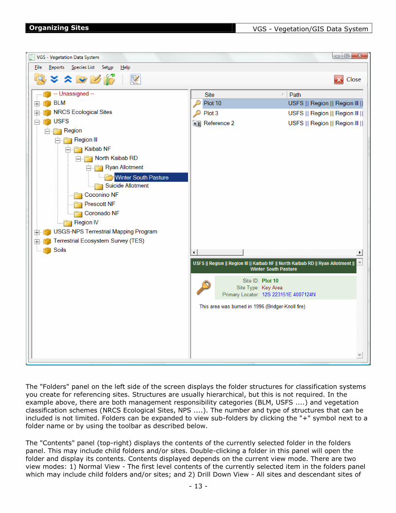
The application interface consists of three main panels - Folders, Sites and Site Summary
Organizing Sites VGS - Vegetation/GIS Data System
- 13 -
The "Folders" panel on the left side of the screen displays the folder structures for classification systems
you create for referencing sites. Structures are usually hierarchical, but this is not required. In the
example above, there are both management responsibility categories (BLM, USFS ....) and vegetation
classification schemes (NRCS Ecological Sites, NPS ....). The number and type of structures that can be
included is not limited. Folders can be expanded to view sub-folders by clicking the "+" symbol next to a folder name or by using the toolbar as described below.
The "Contents" panel (top-right) displays the contents of the currently selected folder in the folders
panel. This may include child folders and/or sites. Double-clicking a folder in this panel will open the
folder and display its contents. Contents displayed depends on the current view mode. There are two
view modes: 1) Normal View - The first level contents of the currently selected item in the folders panel
which may include child folders and/or sites; and 2) Drill Down View - All sites and descendant sites of

Organizing Sites VGS - Vegetation/GIS Data System
- 14 -
the currently selected item in the folders panel. Use the toolbar button as described below to toggle between view modes.
The "Summary" panel (bottom-right) displays a brief summary description of the currently selected item (either folder or site) in the contents panel.
The relative size of the three panels may be adjusted by clicking and dragging the dividers between
panels.
The Main Toolbar
The main toolbar provides for common actions. Some actions would normally be done with a mouse, but
because they are sometimes more difficult to do in the field using a stylus, buttons have been provided
as an alternative way to accomplish the tasks. Hovering over a toolbar button with the mouse or an
active stylus will bring up the name or function of each button in the toolbar. The function of each button is described below.
Show all descendant sites
Toggles between showing only sites in the selected folder and showing all sites contained in the folder as
well as all sites in all sub-folders.
Expand All
Expands or opens all folders in all structures to their deepest levels.
Collapse All
Collapses or closes all folders in all structures to their root levels.
Expand (Collapse) Selected Folder
In the diagram above, this button expands the currently selected folder one level. This is the same as
clicking on the "+" symbol for a folder, but it is sometimes easier when using a stylus. However, if the
folder selected is already expanded, this button displays an up-arrow instead of the down-arrow as
displayed above and clicking on the button will collapse the selected folder. This button functions only on the folder currently selected in the folders panel.

Organizing Sites VGS - Vegetation/GIS Data System
- 15 -
Open Selected Folder/Site
Clicking this button expands/opens the currently selected folder or site. It operates on the primary
selected item in either the folder panel or the contents panel. This is the same as either double-clicking
on a folder or site, or right-clicking a folder or site and choosing "Open...", but it is sometimes easier when using a stylus.
Edit Schema
Clicking this button places the main VGS window into edit mode allowing the user to make changes to the schema of folders and to add or delete sites. See Folders and Managing Sites for details.
Show All Descendant Sites
Clicking this button toggles the current display mode for the contents panel. The two display modes are:
1. Normal Mode - Displays the contents of the folder selected in the folders panel. It may include
both folders and sites depending on the schema and the level of the selected folder. This is like
the behavior of Windows Explorer.
2. Drill-Down Mode - Displays all sites contained in the currently selected folder in the folders panel
plus all sites in any folder that is a descendant of the selected folder. Only sites are displayed.
This mode allows one to see all sites that fall within a particular folder regardless of the its level.
For example, sites might be contained within folders that identify the pasture within which they
fall. The pasture folders might be children of an allotment folder. Drill-down mode allows one to
select the allotment folder and see all sites within the allotment without having to drill on down to
individual pastures.
Edit Metadata
This button functions for folders only, in either the folder or contents panels. It opens a dialog for entering information about a particular folder:

Organizing Sites VGS - Vegetation/GIS Data System
- 16 -
Using this dialog you may enter a description about the item the folder represents and an item ID
number (such as an allotment ID number). Also, a list of contacts pertaining to the item may be created.
For example, if the folder represents a grazing allotment, contacts might include the range management
specialist (RMS) responsible for the allotment and the permittee currently grazing the allotment. In this
example, a history is maintained regarding permittees on the allotment. The same could be done for the
RMS. This dialog and the kinds of metadata allowed may be expanded in the future as needs and
requests arise.
Managing Folders
Folders are managed using either the folders panel on the left-hand side of the main VGS window, or the
contents panel on the upper right-hand side of the main window. Before adding or editing folders, you
must click on the "Edit schema" button in the main toolbar. This step is required so that accidental
editing cannot occur during normal use of the software.
Edit Schema Button (See Organizing Sites)
Clicking the Edit Schema button displays the Edit Toolbar:

Organizing Sites VGS - Vegetation/GIS Data System
- 17 -
The Undo/Cancel button cancels all pending changes not yet saved.
The Save button saves all pending changes and stops edit mode.
The remaining buttons in the edit toolbar may be used to assist with edit functions as explained below.
Folder Edit Functions
Add Root Folder
To add a top-level folder to the folder panel at the root level (represented by a box) do one of the following:
1. In the folder panel, right-click anywhere on empty space below existing folders and choose "Add
new root folder" from the drop-down menu.
2. Make sure no items are selected in the folders panel (this will be the case when first entering edit mode) and click on the "New Folder" button in the toolbar.
When a new folder is added, the default name is highlighted for immediate editing.
Add Child Folder
To add a folder as a child of any node in a hierarchical tree, do one of the following:
1. In either the folder panel or the contents panel, right-click on the desired parent folder and
choose "New folder" from the drop-down menu.
2. In either the folder panel or the contents panel, select the desired parent folder by clicking on it.
Then click on the "New Folder" button in the toolbar.
3. Select the parent folder in the folders panel on the left side of the screen by clicking on it. Then in
the contents panel on the right-hand side of the screen, right-click on the empty space below the
listed sites and folders and choose "New Folder" from the drop-down menu.
When a new folder is added, the default name is highlighted for immediate editing.
Edit Folder Name
To edit folder names after the folder already exists, do one of the following:
1. Right-click on the folder to be changed and choose "Rename" from the drop-down menu.

Organizing Sites VGS - Vegetation/GIS Data System
- 18 -
2. Select the folder to be changed by clicking on it, pause (so next click not interpreted as a double-click) and then click the folder again.
Duplicate Folder
To duplicate a folder, copy and paste the folder using any combination of the following:
1.
o Right-click on the folder to be copied and choose "Copy" from the drop-down menu, or
o Select the folder to be copied by clicking on it, then click on the "Copy" button in the
toolbar.
2.
o Right-click on the parent folder of the location for the new folder and choose "Paste" from
the drop-down menu, or
o Select the parent folder where the folder is to be copied and then click the "Paste" button in the toolbar.
Move Folder
To move a folder, do one of the following:
Cut and Paste
1.
o Right-click on the folder to be copied and choose "Cut" from the drop-down menu, or
o Select the folder to be moved by clicking on it, then click on the "Cut" button in the
toolbar.
2.
o Right-click on the folder that will contain the duplicate site reference and choose "Paste"
from the drop-down menu, or
o Select the folder where the site is to be copied (either in the folders panel or the contents
panel) by clicking on it and then click the "Paste" button in the toolbar, or
o In the folders panel, select the folder where the site is to be copied, then right-click
anywhere in the blank space below items in the contents folder and choose "Paste" from
the drop-down menu, or
o In the folders panel, select the folder where the site is to be copied, then click anywhere in
the blank space below items in the contents folder, then click on the "Paste" button in the toolbar.
Drag and Drop
1. Click and hold on the site to be moved, then drag and drop it on the folder (in either the folders
panel or the contents panel) that is to hold the reference to the site. The target folder must be visible, otherwise use the cut and paste approach described above.

Organizing Sites VGS - Vegetation/GIS Data System
- 19 -
Delete Folder
To delete a folder, in either the folders panel or the contents panel
1. Right-click the folder to be deleted and choose "Delete" from the drop-down menu. 2. Select the folder to be deleted by clicking on it and then click the "Delete" button in the toolbar.
NOTE: Deleting a folder also deletes all child folders. However, any sites contained within those folders
are not deleted, but rather are moved to the "Unassigned" container. The "Unassigned" container cannot be deleted. Sites can only be permanently deleted as described in the Managing Sites section.
Managing Sites
Sites are managed using the contents panel on the upper right-hand side of the main VGS window.
Before adding or editing sites, you must click on the "Edit schema" button in the toolbar. This step is
required so that accidental editing cannot occur during normal use of the software.
Edit Schema Button (See Organizing Sites)
Clicking the Edit Schema button displays the Edit Toolbar:
The Undo/Cancel button cancels all pending changes not yet saved.
The Save button saves all pending changes and stops edit mode.
The remaining buttons in the edit toolbar may be used to assist with edit functions as explained below.
Site Edit Functions
Add Site
To create a new site, do one of the following:
1. In either the folders panel or the contents panel, right-click on the parent folder in which the new
site is to be contained, then choose "New Site" from the drop-down menu.

Organizing Sites VGS - Vegetation/GIS Data System
- 20 -
2. In either the folders panel or the contents panel, select the parent folder in which the new site is to be contained by clicking on it. Then click the "New Site" button on the toolbar.
Edit Site Name
To edit site names, do one of the following:
1. Right-click on the site to be changed and choose "Rename" from the drop-down menu.
2. Select the site to be changed by clicking on it, pause (so next click not interpreted as a double-click) and then click the folder again.
Duplicate Site Reference
To duplicate a site reference (remember, you are copying references to the site - not creating a duplicate site), copy and paste the site using any combination of the following:
Copy & Paste
1.
o Right-click on the site to be copied and choose "Copy" from the drop-down menu, or
o Select the site to be copied by clicking on it, then click on the "Copy" button in the toolbar.
2.
o Right-click on the folder that will contain the duplicate site reference and choose "Paste"
from the drop-down menu, or
o Select the folder where the site is to be copied (either in the folders panel or the contents
panel) by clicking on it and then click the "Paste" button in the toolbar, or
o In the folders panel, select the folder where the site is to be copied, then right-click
anywhere in the blank space below items in the contents folder and choose "Paste" from
the drop-down menu, or
o In the folders panel, select the folder where the site is to be copied, then click anywhere in
the blank space below items in the contents folder, then click on the "Paste" button in the
toolbar.
Move Site
To move a site, do one of the following:
Cut and Paste
1.
o Right-click on the site to be moved and choose "Cut" from the drop-down menu, or
o Select the site to be moved by clicking on it, then click on the "Cut" button in the toolbar.
2.
o Right-click on the folder that will contain the duplicate site reference and choose "Paste"
from the drop-down menu, or
o Select the folder where the site is to be copied (either in the folders panel or the contents
panel) by clicking on it and then click the "Paste" button in the toolbar, or

Organizing Sites VGS - Vegetation/GIS Data System
- 21 -
o In the folders panel, select the folder where the site is to be copied, then right-click
anywhere in the blank space below items in the contents folder and choose "Paste" from
the drop-down menu, or
o In the folders panel, select the folder where the site is to be copied, then click anywhere in
the blank space below items in the contents folder, then click on the "Paste" button in the toolbar.
Drag and Drop
1. Click and hold on the site to be moved, then drag and drop it on the target folder (in either the
folders panel or the contents panel). The target folder must be visible, otherwise use the cut and paste approach described above.
Delete Site
To delete a site, do one of the following:
1. Right-click the site to be deleted and choose "Delete" from the drop-down menu. 2. Select the folder to be deleted by clicking on it and then click the "Delete" button in the toolbar.
Site Information Form
All information about a site, including all studies associated with a site, are entered and managed using
the site information form.
To open the site form, do one of the following:
1. Right-click on a site and choose "Open..." from the drop-down menu.
2. Select a site by clicking on it and then click on the "Open selected folder/site" button in the toolbar.
Multiple sites may be opened at the same time. However, only one data form may be open at one time. The Windows task bar will have a button for every site that is open.
When a site is opened, the Site Information Dialog is displayed. The top of the form displays the
classification path from which the form was opened and the name of the site. The name of the site may
be edited here also as well as on the main VGS window. The remainder of the form displays one of four tabs or pages with information regarding the site as follows
General

Organizing Sites VGS - Vegetation/GIS Data System
- 22 -
When a site is first opened, the "General" information tab is always displayed first. The type of site may
be entered here as well as any notes about the site. Notes about specific point-in-time studies should not
be entered here but should be entered with the studies themselves. In general, only information that
pertains to the site itself should go here because studies, protocols and so forth may change over time
and become outdated.
At the bottom of the "General" tab page is a listing of all classification reference paths assigned to the
site. The top of the form only displays the path from which the form was opened but the list at the
bottom shows all paths. This provides an overview of characteristics and/or ownership of the site and is
unlimited in scope, since the site may be assigned to as many classes or schema as desired. In the
example shown above, the site is in the Hy Pond pasture of the Mainstreet Allotment and is on a Limy
Upland ecological site. Changes to class assignments cannot be made here but are made on the main form as described in the section about Organizing Sites.
Description

Organizing Sites VGS - Vegetation/GIS Data System
- 23 -
Information that describes the site in various ways is entered on this page including GPS location
coordinates. Currently there are three descriptive fields available here - Slope, Aspect and Elevation. Site
information that represents a derived category or classification, such as soil type, vegetation type,
ownership, management responsibility, etc., is entered by assigning the site to a class within a
classification schema (see Organizing Sites). This approach is flexible for accommodating many different agencies and systems for describing sites.
As many locators as desired may be entered. Where stakes or posts are used to mark sites or sampling
layouts, it is recommended that coordinates be entered for more than one marker to facilitate relocating the site even if a stake or post is pushed over or removed.
To enter a new locator, click the "New" button in the locators section. This will create a new line in the
list of locators. The following items may be entered:
Locator Type - Click on the drop-down list of types and choose the desired type.
Primary (optional) - Check the box if this locator is the primary locator for the site. Only one
locator may be marked as primary. This field is optional and used when the VGS database is
linked to a GIS layer to indicate which coordinates to use for plotting on a map, etc.
UTM Coordinates - This is where GPS coordinates are entered. Only UTMs are supported at this
time. Click on the button with the compass icon to bring up the GPS dialog (see below).

Organizing Sites VGS - Vegetation/GIS Data System
- 24 -
Notes - Click on the button with the pencil icon at the end of the note to bring up a dialog where
notes can be entered about the locator, such as notes about a marker or hints on how to find it (see below).
Entering Locator Coordinates
Clicking on the button with the compass icon for a locator will begin the process for detecting a
compatible GPS device. A progress meter will be displayed during the detection process.
Either while detection is in process or if the detection process notifies you that a GPS unit cannot be
found, clicking the "Skip" button will stop the detection process and continue on to open the GPS dialog
where coordinates can be entered manually from the keyboard. Clicking cancel at any time will stop detection and return the user to the site information form.
Once the GPS dialog appears, coordinates may be entered manually or, if a compatible GPS was
detected, by clicking on the "Get Current Location" button. This button will only be enabled if a GPS unit
was detected and the "Current" precision is tighter than the minimum precision "Required" (see sliders at
top of dialog). Once the coordinates have been entered, click on the "Accept" button to accept the
coordinates for entry into the locator record. Clicking the "Get Current Location" button again will reread
the current location and replace the existing entry. The "Reset" button will clear the coordinates which is
useful largely during manual entry. Coordinates entered manually are currently not verified for validity.
Studies

Organizing Sites VGS - Vegetation/GIS Data System
- 25 -
The studies page of the site information form lists all of the studies stored in a VGS database that pertain
to the site. Whether the data were imported, recorded using field data forms or added to the database
using an office input form the data will be listed here. The list is grouped by the form used to enter or
display the data and by the date of the study. In the example above, the first three lines (white
background) list three studies (frequency, ground cover and dry-weight-rank). All three were collected
on the same date using a single field form. The next two lines (blue background) list two studies (frequency and ground cover) that were entered on a different date using a different form.
To edit the data for a single form (i.e. one group), highlight any line in the group and click the "Edit"
button at the top of the list. To print a report that summarizes data for a form, likewise highlight any line
in the group before choosing an appropriate report. Details regarding reporting is provided in the Reporting section.
Unlike editing and reporting, deleting studies from the database using the "Delete" button at the top of
the list deletes only the study currently highlighted in the list and not the entire form (group). Deletion is
permanent, so use the delete button with care.
To add studies to the site, open a new data form by clicking the "New" button. See Opening A New Data Form for details.

Organizing Sites VGS - Vegetation/GIS Data System
- 26 -
Data Forms and Studies
Using Data Forms
Opening A New Data Form
Recording Data
Generating New Data Forms
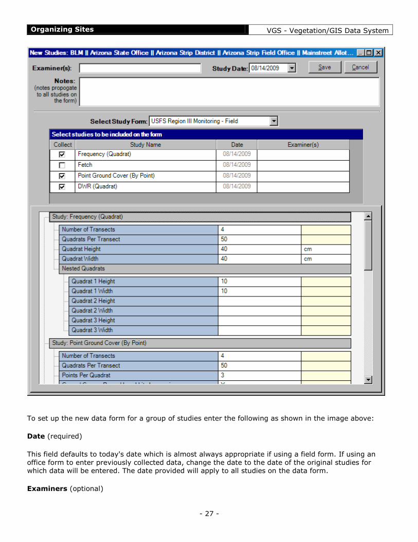
To generate new studies and setup a data form for them:
1. Open the site where the studies will be conducted (see Site Information Form)
2. Select the "Studies" tab. 3. Click on the "New" button positioned at the top-right corner of the list of studies.
The following dialog will open:
Organizing Sites VGS - Vegetation/GIS Data System
- 27 -
To set up the new data form for a group of studies enter the following as shown in the image above:
Date (required)
This field defaults to today's date which is almost always appropriate if using a field form. If using an
office form to enter previously collected data, change the date to the date of the original studies for which data will be entered. The date provided will apply to all studies on the data form.
Examiners (optional)

Organizing Sites VGS - Vegetation/GIS Data System
- 28 -
Here the names of those conducting the studies may be entered. This is a free-form field so there is no
particular format that must be used. It is somewhat limited in length, but it is longer than the size displayed. The names provided will apply to all studies on the form.
Notes (optional)
Add any notes desired. Notes entered here should refer to the specific studies for which the data form is
being generated or to conditions and so forth that are pertinent only to the day of the study. Notes about
the site (things that don't change over time) would better fit in the site notes on the Site Information
Form. Study notes are propagated to every study on the form for consistency, even though specific comments may not apply to every study.
Select Study Form (required)
Choose the data form to be used (a default form will already be chosen when this dialog opens - to
change the default, see Data Form Defaults). Data forms are pre-formatted (currently data forms cannot be changed by a user) and come with the VGS software. An example is provided in Using Data Forms.
Once the data form has been chosen, a list of all studies available for recording on the select form is
display (below the selection). In the example above, there are four studies available on the form. Any
studies for which data will not be collected in the current instance can be excluded (or included if already
excluded) by clicking the box in the "Collect" column. Excluded studies will not appear on the data form
when it is opened. Also, the parameter editor (bottom of dialog) will not show parameters and settings for any excluded studies. In the example above, the "Fetch" study has been excluded.
Study Parameters (edit as needed)
The large panel at the bottom of the dialog lists the default settings for all parameters for each study for
which data will be collected. Parameters are organized by study. Most settings may be edited as
necessary. If parameter defaults have been properly set up for your specific organization or group, a
need to make changes will usually arise infrequently (setting defaults for a form is covered in the section
Data Form Defaults). Any parameters that cannot be changed are shown for reference. Parameters or secondary columns that are not editable have a light yellow background.
Details about parameters for each kind of study are provided in Recording Data.
Study parameters may be changed after the form is opened. The same parameter editor shown above is
available on the "Notes/Attributes/Parameters" tab of a data form for making changes after the form has been generated (see Using Data Forms). However note the caution below:
CAUTION: Changes to parameters and settings after data have been entered should be avoided due to
the risk of loss of access to data already recorded. For example, if data have already been collected on
transect 3 and the "Number of Transects" parameter is changed to 2, all data on transect three will no
longer be accessible. A similar situation could occur when changing the number of nested quadrats,
ground cover points per quadrat and so forth.
Save/Cancel
Once a data form has been set up, click on the "Save" button to create the studies and display the data
form for recording data. Once the Save button has been clicked, the studies have been created and will
appear in the list of studies for the site on the Site Information Form regardless of whether data are recorded on the data form or not. Empty studies can be deleted from the site information form.

Organizing Sites VGS - Vegetation/GIS Data System
- 29 -
Using Data Forms
A study is a particular set of sample data for one point-in-time at a single site for one particular
characteristic. A data form is the form on which one or more studies are recorded concurrently. For
example, you go to the field to sample frequency, ground cover and dry-weight-rank. You are conducting
three different studies but all three may be collected at the same time using a single data form.
Data forms may be created for the field or for the office depending on data entry needs. Each form
contains panels specific to the studies to be recorded on the form which are laid out appropriate to the sampling protocol associated with those studies.
Below is an example of a typical field data form for a group of four studies:

Organizing Sites VGS - Vegetation/GIS Data System
- 30 -
Now let’s dissect the various parts of this field data form starting from the top of the form:
The top of the form displays the name of the site to which this study belongs (PVJ-3 in this example)
along with the classification path used to locate the site before the form was opened. To the right are

Organizing Sites VGS - Vegetation/GIS Data System
- 31 -
"Date" and "Examiners" fields. This information is brought in from when the form was first created (see
Creating A New Data Form), but may be changed at any time. Entries in these fields apply to every study
on the data form and are stored with each study. There is also a "Close" button which is often easier to
use with a stylus rather than the small "X" close button in the corner of the screen, though either will close the form.
All data forms consist of two tabs or pages. The "Form" tab is selected in this example and displays the
form where data are entered. The "Notes/Attributes/Parameters" tab should rarely be used, and then
only when first beginning to use a new form. It provides an opportunity to change the study layout and
other settings made when the data form was first created. Changes after data have been entered should
be avoided due to the risk of loss of access to data already recorded. This page is not shown but is
identical in appearance and behavior as when Creating A New Data Form. Currently, if changes are made
to study parameters on the "Notes/Attributes/Parameters" tab, you must close the data form and reopen
it before the changes will take effect.
CAUTION: Changes to parameters and settings after data have been entered should be avoided due to
the risk of loss of access to data already recorded. For example, if data have already been collected on
transect 3 and the "Number of Transects" parameter is changed to 2, all data on transect three will no
longer be accessible. A similar situation could occur when changing the number of nested quadrats,
ground cover points per quadrat and so forth.
In general, a field data form displays and accepts input for one sample unit at a time. In this example,
the form displays input for a single quadrat placement. Any other sample units associated with the main
sample unit are also displayed, such as the cluster of ground cover sample points associated with the quadrat in this example.
A field form almost always has three sections. Each section is described below.
Navigation Panel
The band across the top of the navigation panel is divided into partitions, one for each transect as set up
in the parameters for the studies. If the number of transects required varies among the studies, this
band will show the largest number of transects required among the various studies. The current transect
is highlighted in red. The lower band of numbers displays number of samples (quadrats in this example)
in each transect (an equal number of quadrats per transect is assumed). Like transects, if the number of
required samples per transect varies among studies, the largest number of required samples will be
displayed. The current sample the form is displaying is indicated along the transect by the large red number. In the example above, the current position is quadrat 3 on transect 1.

Organizing Sites VGS - Vegetation/GIS Data System
- 32 -
To move to the next quadrat during sampling, simply click on the "Forward" button. When the last
quadrat in the current transect has been completed and the forward button is clicked, the next transect
is highlighted and quadrat 1 becomes the current quadrat. The "Back" button moves backwards from
quadrat to quadrat.
The current transect can be changed manually by clicking on the desired transect in the transect band.
When changing transects, the current sample indicator always jumps to sample number 1. The slider can
be used to move to any sample within a transect by clicking and dragging the slider to the desired position.
Study Panels
The center section of a form contains data display panels for each study being recorded using the form,
usually one per study.
In this example, the data form contains four display panels, one each for point ground cover, fetch,
frequency and dry-weight-rank. For most studies, these panels display the results of data entered for the
current sample unit (quadrat, point, point cluster, measurement, etc.) only and are not used for direct
data entry (A few studies use these panels in concert with the data input panel described below for data
entry). However, these display panels are always used to control which study is currently accepting data
input. The currently active study is highlighted or otherwise marked as the currently active panel. In the
above example, the frequency panel is the active study. Any data entered applies to the active panel.
The active panel may be changed by clicking anywhere in the panel that displays the data for the study
to be made active. For those studies where it is possible to know when sampling has been completed for
the current sample unit, the next panel is automatically made active and ready to sample. Ground cover
and fetch behave this way in the example above, but frequency and dry-weight-rank do not since there
is no way to know when all species have been recorded. Specifics about each kind of study panel are covered in the topic about Recording Data
If there are more panels than fit in the available space, simply passing the mouse or stylus over the right edge or left edge of the study panels space will scroll the additional study panels into view.

Organizing Sites VGS - Vegetation/GIS Data System
- 33 -
Data Entry Panels
The bottom section of the form contains data input controls as they apply to the currently active study
panel. Most data entry occurs here. Which data entry panel(s) is displayed depends on which study panel
is active. Data entered here applies to the active study. In this example, the currently active study is
frequency and the input panel displayed is the species entry input panel. There are other input panels for
other kinds of data. Specific input panels and how data are entered is described specific to each study
type in the topic about Recording Data
Species Lookup
In VGS it is usually necessary to search for a species in order to add it to a species input panel on a data
form. At other times it is useful to look up a species to find names or symbols associated with it. The
species available for entry are based on the complete NRCS Plants Database with a few additions
explained here. There are two locations from which the species dialog can be invoked:
1. From a species input panel on a data form (see Recording Data).
2. From the "Species List" menu on the main VGS form. This option is useful for looking up species codes or names at times other than during specific data collection tasks.

Organizing Sites VGS - Vegetation/GIS Data System
- 34 -
When the species dialog first opens it appears in one of two states:
Species entry box is blank and the species list is empty. This will be the case when opening the
dialog from the main VGS window or from an input panel when adding a new species.
Species entry box contains a species and the species list contains a list of all species that match
the text in the entry space. This occurs when a species exists and the dialog is opened to change the species or to get information about the species.
A species is entered by typing into the "Enter Species" box. The dialog then searches on the characters
entered and finds all species in the database that either begin with or contain what is entered depending
on what is being searched for. The dialog searches for matches in the column with a check mark in the
column header. The search column can be changed by clicking the check box in a column header.
Searches can be made on the "Symbol", "Common" name, and "Species" (Latin) name columns. Rules for searching are:
Searching by Symbol
Searches for matches that begin with the characters entered.
Searching does not occur unless there are at least two characters entered.

Organizing Sites VGS - Vegetation/GIS Data System
- 35 -
Searching by Common Name or Species (Latin) Name
Searches for matches that contain the characters entered. Searching does not occur unless there are at least four characters entered.
The "Current" column displays the symbol for the currently accepted species name for any items in the
"Symbol" column whose name has officially changed. Clicking on the button alongside the "Current"
symbol takes you to the listing for the new species name. When entering data, you may use either name as you choose.
Notes
When entering data, the species dialog includes a notes field. Notes may be entered regarding a species
when it is selected for use. These notes are appended to the study notes. Typical uses of species notes is
to indicate identification issues, noting combined species when distinguishing them is difficult, and so
forth. The appended notes become part of the study notes, so for consistency they are propagated to all studies along with the rest of the study notes whether a study uses species or not.
Qualifiers
In VGS all species stored in the database actually consist of two parts - the species and a qualifier. This
allows a further division of species beyond the species name. For example, it may be important to
separate out seedlings from mature plants. The qualifier field (only available during data entry) is where
this occurs. Enter any brief text desired here and it will become part of the displayed species name.
When qualifiers are used, the same species may be added to a species input list more than once (see
Species Input).
During data entry, clicking the "Select" button returns control to the input panel from which the species
dialog was called where the results are displayed as appropriate.

Recording Data VGS - Vegetation/GIS Data System
- 36 -
Recording Data
This section of the help manual takes each specific vegetation sampling method and describes how to
enter data using the data entry and display panels set up for the method. These instructions are specific
to a method and are not dependent on a particular data form or overall sampling protocol. Therefore the
instructions should apply regardless of the form in which a data entry panel is used. Details regarding
implementation of a method is not discussed as many vegetation sampling manuals are available for
this. Instead, the focus is how to collect data using VGS regardless of various nuances surrounding
implementation of each method.
Each module is described in three sections - Settings, Display Panel and Input Panel, each of which are
discussed here
Frequency
Ground Cover
Dry-Weight-Rank
Fetch
Point-Intercept
Cover-Class Estimation
Frequency
The frequency module accommodates a variety of frequency sampling protocols including nested
frequency. In particular, it eases the process of recording nested frequency by not requiring the user to
enter the number or identity of the nested quadrat in which a species occurs.
Settings

Recording Data VGS - Vegetation/GIS Data System
- 37 -
The settings for the frequency module are shown above. In addition to setting the transect and sample
configuration, it is necessary to set the size and configuration of the main quadrat and any nested
quadrats. In the example above, in addition to the main quadrat frame there are three nested quadrats
starting with a small 5 x 5 cm quadrat. Nested quadrats should be listed in child-parent order (in order of
size). The "Nest Orientation" setting tells VGS in which corner to set the smallest quadrat. This setting is
for display purposes only (so that the display panel mimics the layout of the quadrat configuration in
use) and has no effect on function.
Display Panel
The display panel for frequency more or less mimics the appearance of the main quadrat and nested
quadrats in use. This is based on the settings for the frequency module as discussed in the Settings
section above. In this example, there is one small quadrat nested in the corner of the main quadrat.
When the frequency module is first activated for each placement of the quadrat frame, the smallest
quadrat is set to be the active or current quadrat first since nested quadrats are always read in order
from smallest to largest. To activate a different nested frame, simply click within the exclusive

Recording Data VGS - Vegetation/GIS Data System
- 38 -
boundaries of the desired frame. The active quadrat frame is highlighted in a bright color. In this example, the main (largest) frame is active and ready to receive species inputs.
Data Input Panel
The data input panel associated with the frequency module is the Species Input panel. Details about
using the Species Input panel are found in Species/Category Input. This panel will appear automatically
whenever the frequency module is activated. When an unselected species is clicked, that species is
entered into whichever nested quadrat is currently active and is highlighted as yellow within the Species
Input panel. Clicking a species that is already highlighted (already exists in a nested quadrat in the
frequency display panel) will remove that species from the display panel from whichever quadrat where it is located regardless of which size quadrat is currently active.
It is not possible to enter the same species-qualifier combination in more than one quadrat, therefore a
species must be entered in the smallest nested quadrat in which it is found. VGS reports associated with
frequency know that a species that occurs in a nested quadrat also occurs in all larger frames within
which it is nested, and will correctly report a hit for each quadrat size.
Point Ground Cover
The Point Ground Cover module accommodates entering surface ground cover hits based on point
sampling. It may be set up for recording individual points along a tape, or for recording clustered points
such as multiple points around a quadrat sample frame or pins in a point pin frame. Because this module
is designed for recording surface hits, only one category or species may be entered per point. See Line-
Point Intercept for a module for recording multiple layers/hits per point.
Settings
Settings for the Point Ground Cover module are shown above. In addition to transect and sample configuration, settings include:

Recording Data VGS - Vegetation/GIS Data System
- 39 -
Points Per Quadrat - The number of points to be recorded per quadrat or pin frame. Enter 1 here
if sampling individual points along a tape or for step-point style sampling.
Ground Cover - Record basal hits by species - Determines if hits on plant basal material is
recorded by species or as a single category. This will also determine how the data input panel is
configured as described below.
Ground Cover - Category List - Choose which list of categories to display as options in the data
input panel by selecting the name of the list from the options provided. For instructions for creating and editing category lists see Data Input Lists.
Display Panel
In this example, the Ground Cover module has been set to record 4 points per sample location. The first
two points in the cluster have been recorded and it is waiting to receive input for the third point.
Selections for each point are made by clicking on the appropriate item in the data input panel as
described below. When a selection is made for a point, the next point will be automatically activated and
ready for selection. After the final point on the module is entered, the next module, if any, will be activated.
To make corrections, click on the incorrect item in the display item to highlight it and then select the
correct item from the list(s) in the data input panel. The newly selected item will replace the previously
selected item. To clear a point, select it in the display panel and then click on the same item in the input panel (it will be highlighted yellow in the input panel).

Recording Data VGS - Vegetation/GIS Data System
- 40 -
Data Input Panel
The Ground Cover data input panel consists of two sections. The top section is for selecting surface cover
categories. The options listed depend on the list selected in the settings as described above. Within this section, categories may not be added or edited.
The bottom section is for selecting plant basal hits when the "Ground Cover - Record basal hits by
species" setting has been set to "Yes". If the setting is set to no, then this section will not appear.
Species may be added to this section at will. Instructions for using this section are provided in
Species/Category Input.
If the setting "Ground Cover - Record basal hits by species" is set to "Yes" and the category named "Live
Basal Veg." exists in the category list, that category will be hidden and a species must be selected to
identify hits on a plant base. If the setting is set to "No", the bottom section of the list will not appear
and the category "Live Basal Veg.", if it exists, must be selected for a hit on any plant base.
Dry-Weight-Rank
The Dry-Weight-Rank (DWR) module is for recording data for the dry-weight-rank method which
estimates relative species composition based on weight.
Settings
Settings for the Dry-Weight-Rank module are shown above. In addition to transect and sample configuration, settings include:
Quadrat Height/Width - Enter the dimensions of the quadrat used for sampling DWR. These
dimensions are for reference only and have no impact on function of the module.
Ranking mode - There are two modes for assigning ranks and subsequent analysis, namely
"Multiple" ranks and "Single" ranks. Multiple ranks are preferred, and due to the ease of entering

Recording Data VGS - Vegetation/GIS Data System
- 41 -
multiple ranks using a tablet, only that option is currently available at this time.
Display Panel
The display panel for DWR displays each of three ranks to which species may be assigned. Selections are
made by clicking a species in the input panel. The first selection is automatically assigned all three ranks.
If there is only one species in the quadrat, data entry is then complete for the current quadrat. If a
second selection is made, it is assigned to ranks 2 and 3. A third selection is then assigned to rank 3.
This behavior is consistent whether each selection is the same or different species. During initial data
entry, ranks that were automatically assigned rather than hard input by the user are color slightly lighter
for reference. This has no effect on the summary and analysis of the data. Which ranks are assigned
versus automatically filled is not stored in the database, so this distinction will not be visible when a form is closed and then later reopened for editing.
In the example above, all three ranks were assigned by the user. Once all three ranks have been
assigned, subsequent selections then begin to remove species rank assignments in reverse order and replaces rank assignments with the species of the next highest rank.
The "Clear" button clears all assignments and the user must reenter all ranks. The "Number of Samples"
is displayed at the top for reference during sampling because empty quadrats have no purpose for DWR
and are not included as a sample in any analysis. Therefore the number of samples may not match the
sample number displayed in the navigation panel. Use this number to determine if an adequate sample has been taken when there are many empty quadrats encountered during sampling.
Once data entry is complete for this module, activity does not automatically jump to the next module
because there is no way for the module to anticipate when data entry is complete for the module.

Recording Data VGS - Vegetation/GIS Data System
- 42 -
Data Input Panel
The data input panel for DWR is the standard Species/Category Input panel. One slight difference is that
species are highlighted a darker yellow for any species selected for more than one rank. This is for
display reference only.
Fetch
The Fetch module is for recording measurements of individual characteristics associated with a quadrat
or point sample. The most common use is measuring "fetch" for an index of relative basal gap in a plant
community.
Settings
Settings for the Dry-Weight-Rank module are shown above. Aside from transect and sample configuration, required settings include:
Number of Measurements - Enter the number of measurements to be taken at each sample point or quadrat. For fetch, this is typically one.
Display Panel
The Fetch display panel simply displays the numeric value entered for each measurement. To edit a
measurement, click on it to highlight it and then using the data input panel below, reenter the correct value or clear the value.

Recording Data VGS - Vegetation/GIS Data System
- 43 -
Data Input Panel
Data input values for the fetch module are input using the Numeric Input panel.
Point-Intercept
The Point-Intercept module supports point-based method for collecting foliar cover data such as line-
point intercept procedures. Generally, cover is recorded for ground surface characteristics as well as
plant cover. A point is vertically lowered or projected downward through the vegetation and each unique
species touched by the point is recorded. Thus, for plant species, cover values generated from the data
typically represent "foliar" cover rather than "canopy" cover. The last item recorded is when the point
reaches an item rooted or resting squarely on the ground surface.
VGS accommodates sampling schemes where points are spaced evenly along a transect or where points
are clustered, such as sampling multiple points at each placement of a point-frame or perhaps a quadrat
used for other attributes or methods. There is no restriction on the number of layers that may be
recorded for a single point.
Settings
In addition to those for transect and sample configuration, the settings for point-intercept include:
Points Per Quadrat - The number of points to be recorded per quadrat or pin frame. Enter 1 here
if sampling individual points along a tape or for step-point style sampling.
Ground Cover - Category List - Choose which list of categories to display as options in the data
input panel by selecting the name of the list from the options provided. For instructions on creating and editing category lists see Data Input Lists.

Recording Data VGS - Vegetation/GIS Data System
- 44 -
Display Panel
The example above depicts sampling a cluster of 4 points. Data have been entered for the first three points in the cluster and the fourth point is highlighted and ready to receive data.
When a ground cover category is selected, it is immediately flagged as a basal or surface level hit and
the next point (or next module if the current point is the last point in a cluster) is automatically
activated. If a plant species already recorded at any level for the point is selected a second time, it is
assumed that the second hit is a basal hit on the species and the hit is automatically flagged as a basal hit and focus moves to the next point or module.
Corrections may be made by selecting a point (by clicking anywhere within the bounds of the block
representing the point) and then clicking the clear button and reentering hits for the point. Also, if the
last level is flagged as a surface hit, clicking on any item will update the last item.
Data Input Panel
The Point-Intercept data input panel consists of two sections. The top section is for selecting surface
cover categories. The options listed depend on the list selected in the settings as described above. Within this section, categories may not be added or edited.
The bottom section is for selecting plant basal hits when the "Ground Cover - Record basal hits by
species" setting has been set to "Yes". If the setting is set to no, then this section will not appear.
Species may be added to this section at will. Instructions for using this section are provided in Species/Category Input.
If the setting "Ground Cover - Record basal hits by species" is set to "Yes" and the category named "Live
Basal Veg." exists in the category list, that category will be hidden and a species must be selected to
identify hits on a plant base. If the setting is set to "No", the bottom section of the list will not appear
and the category "Live Basal Veg.", if it exists, must be selected for a hit on any plant base.

Recording Data VGS - Vegetation/GIS Data System
- 45 -
Cover-Class Estimation
The Cover-Class Estimation module provides a mechanism for recording class or range-based numeric
data such as for Daubenmire cover classes.
Settings
In addition to configuration of transects and samples, settings for the Cover-Class Estimation module include:
Quadrat Height/Width - Enter the dimensions of the quadrat used for sampling. These dimensions
are for reference and so that the display panel mimics the shape of the quadrat. They have no
impact on function of the module.
Class End Points - This is a comma delimited list of values where each value represents the end
point of a class. End points must be listed in order. Care must be taken to make sure there are no
missing commas and no spaces within the value of a number itself. The example above shows the
setting for the set of standard Daubenmire cover classes. The units entry (Percent in this
example) is for reference only.
Class Input Display - Choose the desired option. Options include "Range" and "Mid-Point". This
determines the default setting for the class input keypad - whether buttons will display the class
ranges or the class mid-points (during sampling this may be changed at any time as described
below in the Data Input Panels section). The display panel always displays the mid-point since the
mid-point is stored as data for the method.
Canopy Cover - Record species cover - determines if the input panel should display species or
not.
Canopy Cover - Record ground cover - determines if the input panel should display ground cover
categories or not.
Ground Cover - Category List - Select the category list to be used if the previous setting is set to Yes.

Recording Data VGS - Vegetation/GIS Data System
- 46 -
Display Panel
The shape of the display panel for Cover Class Estimation somewhat mimics the sample frame in use as
set in the dimensions settings. It lists each species or category selected as occurring in the frame and
displays the mid-point of the cover class to which the species or category is assigned. The mid-point of
the class is always displayed regardless of how the input panel is set for display because that is the value
that is stored in the database. This panel displays information only and has no functionality for entry or editing which are all handled via the data input panels as described below.
Data Input Panels
There are two data input panels associated with the Cover-Class Estimation module, one for inputting species and one for assigning the cover class.
The Cover Class data input panel for entering species and categories is displayed first. It consists of two
sections. The top section is for selecting ground cover categories, but appears only if the "Record Ground
Cover" setting is set to "Yes" as described in the settings section above. The options listed depend on the
list selected in the settings. Within this section, categories may not be added or edited. The bottom
section is for selecting plant species, but appears only if the "Record plant species" setting is set to
"Yes". Species may be added to this section at will. Instructions for using this section are provided in
Species/Category Input. Both sections will highlight each species or category already selected and displayed in the display panel.
Recording Data VGS - Vegetation/GIS Data System
- 47 -
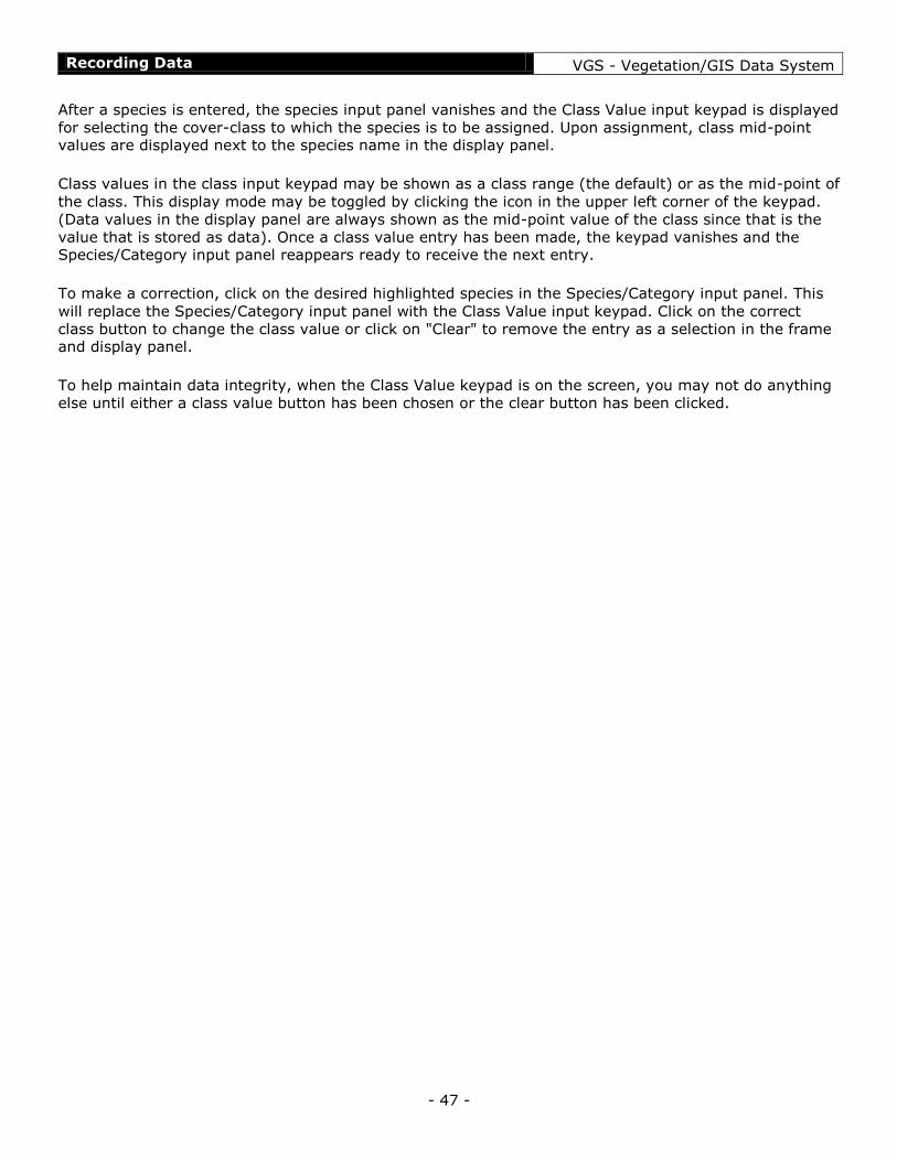
After a species is entered, the species input panel vanishes and the Class Value input keypad is displayed
for selecting the cover-class to which the species is to be assigned. Upon assignment, class mid-point values are displayed next to the species name in the display panel.
Class values in the class input keypad may be shown as a class range (the default) or as the mid-point of
the class. This display mode may be toggled by clicking the icon in the upper left corner of the keypad.
(Data values in the display panel are always shown as the mid-point value of the class since that is the
value that is stored as data). Once a class value entry has been made, the keypad vanishes and the Species/Category input panel reappears ready to receive the next entry.
To make a correction, click on the desired highlighted species in the Species/Category input panel. This
will replace the Species/Category input panel with the Class Value input keypad. Click on the correct
class button to change the class value or click on "Clear" to remove the entry as a selection in the frame and display panel.
To help maintain data integrity, when the Class Value keypad is on the screen, you may not do anything
else until either a class value button has been chosen or the clear button has been clicked.
Generic Input Panels VGS - Vegetation/GIS Data System
- 48 -
Generic Input Panels
Species/Category Input
Numeric Class Input
Numeric Input
Species/Category Input
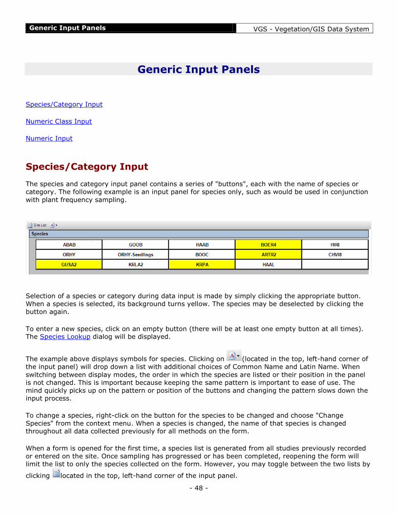
The species and category input panel contains a series of "buttons", each with the name of species or
category. The following example is an input panel for species only, such as would be used in conjunction
with plant frequency sampling.
Selection of a species or category during data input is made by simply clicking the appropriate button.
When a species is selected, its background turns yellow. The species may be deselected by clicking the
button again.
To enter a new species, click on an empty button (there will be at least one empty button at all times). The Species Lookup dialog will be displayed.
The example above displays symbols for species. Clicking on (located in the top, left-hand corner of
the input panel) will drop down a list with additional choices of Common Name and Latin Name. When
switching between display modes, the order in which the species are listed or their position in the panel
is not changed. This is important because keeping the same pattern is important to ease of use. The
mind quickly picks up on the pattern or position of the buttons and changing the pattern slows down the input process.
To change a species, right-click on the button for the species to be changed and choose "Change
Species" from the context menu. When a species is changed, the name of that species is changed throughout all data collected previously for all methods on the form.
When a form is opened for the first time, a species list is generated from all studies previously recorded
or entered on the site. Once sampling has progressed or has been completed, reopening the form will
limit the list to only the species collected on the form. However, you may toggle between the two lists by
clicking located in the top, left-hand corner of the input panel.

Generic Input Panels VGS - Vegetation/GIS Data System
- 49 -
__________________
The following example shows an input panel that displays both ground cover categories and species. This panel is used, for example, on forms that record the species of a ground cover vegetation hit.
Unlike species, categories such as the ground cover categories above (excluding species) cannot be
added to or changed from data input panels or data forms. This helps protect data integrity by
preventing different users sampling for the same protocol from using different sets of categories.
Numeric Class Input
The Numeric Class Input panel provides a mechanism for entering numeric classes.
This keypad panel lists either the range of values for each class or the mid-points of each class. This
display mode may be toggled by clicking the icon in the top, left-hand corner of the panel.
Specifics about how the panel functions depends on each module it is used with.
Numeric Input
The numeric input panel allows input of any number including real numbers. This panel is used for
methods which require an unlimited range or precision of numbers such as a measurement.

Generic Input Panels VGS - Vegetation/GIS Data System
- 50 -
Because there is no way for the panel to know when entry is complete, the "Enter" button must be clicked to complete the entry process.
The example above shows the numeric input panel with a telephone keypad layout. The panel may also be used with a calculator/ten-key keypad layout:
To change the layout, click on the desired image located at the top of the panel. Some of the
buttons on the keypad may not be functional depending on the sampling method for which it is being
used.

Reporting VGS - Vegetation/GIS Data System
- 51 -
Reporting
Exporting Data
To be completed….

Reporting VGS - Vegetation/GIS Data System
- 52 -
Backing Up Your Data
Data should always be backed up regularly, at least at the end of a day of data entry. In the field, a good
practice is to always back up the VGS database before shutting down the tablet PC. When recording data
on a data form in the field, don't be too concerned about losing data simply because a battery is
exhausted. VGS writes data to the database on the physical storage device after every sample
(whenever move positions on the navigation panel of a data form) and when close the data form itself.
So the most data you can lose due to a sudden shutdown of an exhausted battery or other failure (other
than failure of the storage device itself) is the current sample (e.g. the current quadrat).
To back up the VGS database, click on the "File" menu of the main VGS window and choose "Database"
and then "Backup" from the sub-menus. The following dialog will appear:
1. Enter the path to the desired backup location or click on the "Browse" button and choose the
backup location. The default location when the dialog opens is the "DataBackups" directory within
the VGS install space. However, best practice is to back up to a thumb drive, a network drive or
other external device. 2. Click on the "Start Backup..." button.
Once a backup is complete, the backup dialog remains in place in case a second backup is desired.
Closing the dialog returns control to the main VGS window.

Setup and Administration VGS - Vegetation/GIS Data System
- 53 -
Setup and Administration
Data Form Defaults
Categorical Lists
Data Form Defaults
Managing Data Input Lists
The Data Input Lists manager allows the user to manage categorical lists, template lists and surrogate
name lists. The list manager is accessed by clicking the "Species Lists" menu and choosing "Setup
Template/Sub Lists"
The type of list to manage is selected from the options displayed in the left-hand panel of the list
manager. A new list is created by first by clicking on and selecting the type of list to be created. Then
click the "New Button" and give the new list a name. A description of the list may be added as well.
When finished, click the save button. Members may not be added to a list until the list has been saved for the first time.

Setup and Administration VGS - Vegetation/GIS Data System
- 54 -
To add members to a list, select the list to be edited and then click on the "Members" tab. Any list with
an image of a padlock in the "Locked" column may be viewed but may not be edited. Specific
instructions for adding and editing members of each type of list are provided below. Always click on the
"Save" button when finished editing a list.
Species Input
Species Input lists are template lists for providing default species lists from which to choose during data
entry. Using a species input list is described in Species/Category Input. Species template lists are
especially useful when visiting a site for the first time and there are no previous data for the site from
which to extract a species list. Using template lists can avoid some of the time required to enter species
one by one in the field during sampling. It is recommended that template species lists focus on the most
common species only for a particular vegetation type or situation. In general, template lists should not
exceed 20-30 species in length. There is no limit to the number of template lists that may be created.
To add members to a species input list, find the first empty record in the list of members (usually at the
bottom of the list), hover over the species code column for the record with the mouse, and click on the
button at the right edge of the species code field when it appears. Clicking this button brings up the
species selection dialog. Find and select a species (including a qualifier if desired) as described in the
instructions for Species Lookup The selected species will appear in the member list. The species name and USDA PLANTS Database common name are displayed for reference.
If a species code is known, a member may also be added by directly typing the code into the species code column and directly adding a qualifier if desired. Invalid codes and duplicate entries are prohibited.

Setup and Administration VGS - Vegetation/GIS Data System
- 55 -
Common Names
Many of the common names provided by the USDA PLANTS Database may not be familiar for a particular
region or to specific clientele. And it may be desirable to use distinct common names for species with
specific qualifiers. The default common names from the PLANTS database may be overridden by creating
a list of species with desired common names. More than one common name surrogate list may be
created as needed for different circumstances or for different users. Common names, whether from the
PLANTS database or from a surrogate list, are not stored in the data. They are primarily used for display
purposes during data entry and as an output option on some reports.
Species codes are added exactly as described for the Species Input lists above. Then simply enter the
preferred common name in the "Common Name" column. The PLANTS Database equivalent is displayed for reference.

Setup and Administration VGS - Vegetation/GIS Data System
- 56 -
Category Input
Category lists are used throughout VGS for data input. Those lists are created and edited here.
Currently, the list of categories to add to a list is finite. Also, in this version of VGS, only ground surface
categories are included as options. The exact spelling of a category that is used during data entry and reporting can be adjusted using a "Category Names" list as described below.
Members are added to or removed from a list by selecting an item in either the "Available" or "Selected"
panels and then clicking buttons located between the two panels to move the item from one side to the
other as desired. The buttons with a double arrow or chevron will move all items whereas buttons with a
single arrow or chevron will move only the selected item. In the end, the items remaining in the "Selected" panel will comprise the members of the input list.

Setup and Administration VGS - Vegetation/GIS Data System
- 57 -
Category Names
Category Names lists allow you to change the spelling of a category name that is displayed during data entry and reporting.
Category Names lists work much the same as Common Names lists described above. All available
categories are included in the list. Simply select the item to be altered and type in the preferred spelling in the Category Name column.
WARNING: Do not completely change a category in an attempt to create a category not included in the
list! The category will still be the same and will still combine with other data of the same category during
reporting and analysis regardless of the wording or spelling.

Setup and Administration VGS - Vegetation/GIS Data System
- 58 -
Species Groups
Species Groups lists are for categorizing species into logical groups for reporting purposes. For example,
a default list is provided with VGS that categorizes most of the species included in the USDA PLANTS
Database into four simple groups: Annuals, Forbs - Perennial, Grass - Perennial, and Woody Species.
Currently, species group lists are only used in a couple of standard VGS reports.
Members are added to a species group list in much the same was as other lists described above. After selecting a species, simply enter a desired category into the "Categories" column.
Be careful to enter categories with consistent spelling and spacing Otherwise each variation will appear as distinct groups during reporting
Datum Input
Datum Input lists are used in analysis and summary routines. There are currently no lists that are user configurable in this list type. Existing lists are available for viewing for informational purposes only.

Setup and Administration VGS - Vegetation/GIS Data System
- 59 -
Categorical Lists
To be completed…
FAQ - Frequently Asked Questions VGS - Vegetation/GIS Data System
- 60 -
FAQ - Frequently Asked Questions
When will this help file/manual be completed?
When will this help file/manual be completed?
Like VGS, this manual is an ongoing project. It will never be completed!
However, hopefully someday it will be useful.