3.2 vegetation condition 17.23 2.27 completely degraded 18.34 2.42 3.3 vegetation of conservation...
TRANSCRIPT

Flora, Vegetation and Fauna Habitat Assessment at Southern Fortescue Borefield, 2018
NVCP Supporting Document RTIO-HSE-0323877
Page 61 of 129
3.2 Vegetation condition The majority of vegetation within the study area was in Very Good condition (Trudgen 1988). Only 18.34 ha of the study area was Completely Degraded, in the form of previously cleared tracks and existing infrastructure. Introduced (weed) flora species were scattered across the majority of the study area with the highest densities recorded in the wetter areas. Cattle grazing was also significant in the creek lines and mulga plains.
Figures 3-3 and Figure 3-4 presents the condition mapping for the study area, whilst Table 3-2 presents the extent of condition of vegetation mapped within the study area.
Table 3-2: Vegetation condition of the study area
Condition Area (ha) Proportion (%) of study area
Excellent 0.96 0.13
Very Good 502.89 66.36
Good 218.38 28.82
Poor 17.23 2.27
Completely Degraded 18.34 2.42
3.3 Vegetation of conservation significance None of the vegetation associations recorded within the study area correspond to any ecosystems listed as Threatened under the EPBC Act, and none are consistent with ecosystems listed as TECs by the DBCA (2016).
None of the vegetation associations occurring within the study area is representative of any listed PECs by DBCA (2017a).
3.4 Other vegetation of significance The vegetation units P3 and P5 are representative of ‘valley floor mulga’, an Ecosystem at Risk (Kendrick 2001). None of the remaining vegetation units within the study area are considered to hold elevated significance.
3.5 Native flora recorded during survey A total of 245 taxa from 130 genera representing 45 families were recorded during the current survey (Table 3-3, Appendix 5).
The most taxon-rich families were Poaceae (47 taxa); Fabaceae (41 taxa); Malvaceae (27 taxa). The most species rich genera were Acacia (21 taxa); Senna (8 taxa) and Eremophila (7 taxa). The dominant plant groups are consistent with other surveys of the broader locality.
The number of taxa recorded by the current study appears consistent to what was expected once the size of the study area and survey type is taken into account when compared with previous surveys in the Marandoo locality (e.g. Mattiske 1992, Biota 2008a and Rio Tinto 2011).

Flora, Vegetation and Fauna Habitat Assessment at Southern Fortescue Borefield, 2018
NVCP Supporting Document RTIO-HSE-0323877
Page 62 of 129
Table 3-3: Total recorded numbers of families, genera, taxa, priority species and weeds recorded
during survey
Flora group Number recorded
Families 45
Genera 130
Taxa 245
Priority species 3
Weeds 12

Flora, Vegetation and Fauna Habitat Assessment at Southern Fortescue Borefield, 2018 NVCP Supporting Document RTIO-HSE-0323877
Page 63 of 129
Figure 3-3 Vegetation condition of the study area (Map 1 of 2)

Flora, Vegetation and Fauna Habitat Assessment at Southern Fortescue Borefield, 2018
NVCP Supporting Document RTIO-HSE-0323877
Page 64 of 129
Figure 3-4 Vegetation condition of the study area (Map 2 of 2)

Flora, Vegetation and Fauna Habitat Assessment at Southern Fortescue Borefield, 2018
NVCP Supporting Document RTIO-HSE-0323877
Page 65 of 129
3.6 Conservation listed flora recorded in the study area No Threatened flora species were recorded during the present study, or previous studies. Two Priority flora species were recorded within the study area during the current survey. One additional Priority species was previously recorded in the study area. These species are discussed in detail below:
• Aristida jerichoensis subsp. subspinulifera (Priority 3)
A perennial, densely clumped grass. Mostly recorded from hardpan plains with deep soil with open Acacia woodland over Triodia and other grasses (app). Aristida jerichoensis subsp. subspinulifera has a range of approximately 545 km on NatureMap within Western Australia (DBCA 2018) and approximately 282 km from the Rio Tinto database
This species was recorded from a single location during the study (Figure 3-4 and Appendix 6), within vegetation unit P03, on a mulga plain with red brown loam with some clay.
This species has a total population count of 3,689 plants, from 81 records, within the Rio Tinto database (Figure 3-5). There are 38 specimens of Aristida jerichoensis subsp. subspinulifera within the collections at the WAH (2018).
• Rhagodia sp. Hamersley (M. Trudgen 17794) (Priority 3)
A perennial scrambling shrub with small lanceolate leaves and is recorded from predominantly plains (WAH 1998-2018). Rhagodia sp. Hamersley (M. Trudgen 17794) has a range of approximately 290 km on NatureMap within Western Australia (DBCA 2018) and approximately 324 km from the Rio Tinto database.
This species has previously been recorded from a single location in the study area (Figure 3-5 and Appendix 6), within vegetation unit CL, in a creek line.
This species has a total population count of 6,626 plants, from 2,061 records, within the Rio Tinto database (Figure 3-6). There are 63 specimens of Rhagodia sp. Hamersley (M. Trudgen 17794) within the collections at the WAH (2018).
• Goodenia nuda (Priority 4)
Prostrate to erect ascending annual herb to 0.5m tall. Mostly recorded from seasonally inundated clay soils and drainage lines, often in mulga. Also recorded from sand in scoured river beds and from hillsides (app). Goodenia nuda has a range of approximately 900 km on NatureMap within Western Australia (DBCA 2018) and approximately 520 km from the Rio Tinto database.
This species was recorded from five locations during the study and two locations during previous surveys (Figure 3-5 and Appendix 6), within vegetation units P03, P04, P05 and MD01.
This species has a total population count of 7,371 plants, from 808 records, within the Rio Tinto database (Figure 3-6). There are 96 specimens of Goodenia nuda within the collections at the WAH (2018).
Due to this species’ recorded broad occurrence across the Pilbara, the small scale of the Proposal and the number of records existing, the Proposal is unlikely to impact on the local or regional significance of this species.

Flora, Vegetation and Fauna Habitat Assessment at Southern Fortescue Borefield, 2018 NVCP Supporting Document RTIO-HSE-0323877
Page 66 of 129
Figure 3-5 Conservation significant flora recorded during study

Flora, Vegetation and Fauna Habitat Assessment at Southern Fortescue Borefield, 2018 NVCP Supporting Document RTIO-HSE-0323877
Page 67 of 129
Figure 3-6: Regional Rio Tinto records for conservation listed flora recorded during study

Flora, Vegetation and Fauna Habitat Assessment at Southern Fortescue Borefield, 2018
NVCP Supporting Document RTIO-HSE-0323877
Page 68 of 129
3.7 Potential conservation listed flora occurring in the study area Searches of Florabase (WAH 2018), confirm three Threatened flora species; Aluta quadrata, Pityrodia sp. Marble Bar (G. Woodman & D. Coultas GWDC Opp 4) and Thryptomene wittweri occur in the Pilbara.
Aluta quadrata is a shrub to 260 cm, known to occur 85 km to the south west of the study area. Given the separation, Aluta quadrata would not be expected to occur.
Pityrodia sp. Marble Bar (G. Woodman & D. Coultas GWDC Opp 4) is a shrub to 150 cm that has been a recent addition to the Threatened Flora list. This species is known to occur over 170 km north east of the study area. Given the separation, Pityrodia sp. Marble Bar (G. Woodman & D. Coultas GWDC Opp 4) would not be expected to occur.
Thryptomene wittweri is a shrub known from 75 km south-east of the study area, restricted to mountain crests in high altitude areas. Given the separation, Thryptomene wittweri would not be expected to occur.
The desktop study; utilising previous survey results, a NatureMap database search, an EPBC Protected Matters search and searches of the Rio Tinto database, identified 13 conservation listed flora taxa as occurring within a 20 km radius of the study area (Section 2.3.1).
Two of the 26 conservation listed flora taxa identified by the database search were recorded within the study area (Section 3.6). Seventeen of the 26 taxa identified by the database search were unlikely to exist within the study area after the study area had been traversed, and the presence or absence of suitable habitats were understood. Post-survey, seven of the 26 taxa returned from the database searches have potential to occur on habitat types available within the study area.
Although these seven species have potential to occur within the study area, due to these species not being recorded during field surveys, limited records near the study area and the small scale of the Proposal; the conservation status of these species are unlikely to be impacted. These species are described in further detail below:
• Calotis squamigera (P1)
Calotis squamigera is a small annual herb to 0.2 m high with pale yellow flowers. This taxon is known to occur 9.9 km north-east of the study area. This species has a distribution of approximately 158 km on NatureMap (DBCA 2018) and 72 km on the Rio Tinto Priority Flora database. Calotis squamigera may potentially occur in the study area despite not being detected during the survey.
• Vittadinia sp. Coondewanna Flats (S. van Leeuwen 4684) (P1)
Vittadinia sp. Coondewanna Flats (S. van Leeuwen 4684) is an erect branched herb or sub-shrub. This taxon is known to occur 18.9 km south-east of the study area. This species has a distribution of approximately 166 km on NatureMap (DBCA 2018) and 51 km on the Rio Tinto Priority Flora database. This species has been recorded as scattered occurrence in very low numbers across similar habitat in the broader locality. Therefore, if present, it would only occur in low numbers.

Flora, Vegetation and Fauna Habitat Assessment at Southern Fortescue Borefield, 2018
NVCP Supporting Document RTIO-HSE-0323877
Page 69 of 129
• Euphorbia inappendiculata var. inappendiculata (P2)
Euphorbia inappendiculata var. inappendiculata is a small prostrate, much branched annual herb and may have potentially been overlooked during the survey. This taxon is known to occur 5.2 km north of the study area. This species has a distribution of approximately 486 km on NatureMap (DBCA 2018).
• Calotis latiuscula (P3)
Calotis latiuscula is an upright annual herb with yellow flowers and may have potentially been overlooked during the survey. This taxon is known to occur < 1 km south-west of the study area. This species has a distribution of approximately of 1,300 km on NatureMap (DBCA 2018) and 125 km on the Rio Tinto Priority Flora database.
• Rostellularia adscendens var. latifolia (P3)
Rostellularia adscendens var. latifolia is a small perennial herb or shrub with hairy to glabrous leaves, angular stems and small blue flowers. This taxon is known to occur <1 km south of the study area and may potentially occur in the study area, despite not being detected during the survey. This species has a distribution of approximately of 423 km on NatureMap (DBCA 2018) and 392 km on the Rio Tinto Priority Flora database.
• Themeda sp. Hamersley Station (M.E. Trudgen 11431) (P3)
Themeda sp. Hamersley Station (M.E. Trudgen 11431) is a robust tall grass. This taxon is known to occur 0.1 km north-west of the study area. This species has a distribution of approximately of 625 km on NatureMap (DBCA 2018) and 320 km on the Rio Tinto Priority Flora database.
Although previously recorded in close proximity to the study area, several collections of Themeda suspected to be Themeda sp. Hamersley Station (M.E. Trudgen 11431) were made during the survey were later identified as Themeda triandra. This species occurs in red clay pans and grass plains such as those occurring in the study area. It is very difficult to distinguish in the field from larger individuals of the common Themeda triandra and thus may occur in the study area, but has not been detected.
• Vittadinia pustulata (P3)
Vittadinia pustulata is a poorly known low annual herb and may have potentially been overlooked during the survey. This taxon is known to occur 0.1 km north-west of the study area. This species has a distribution of approximately of 1,065 km on NatureMap (DBCA 2018) and 172 km on the Rio Tinto Priority Flora database.

Flora, Vegetation and Fauna Habitat Assessment at Southern Fortescue Borefield, 2018 NVCP Supporting Document
RTIO-HSE- RTIO-HSE-0323877
Page 70 of 129
Table 3-4: Revised likelihood of occurrence of conservation listed flora species
Species Status Likelihood of occurrence (pre-field)
Post-field rationale Revised likelihood of occurrence (post-field)
Calotis squamigera P1 Potential The timing and seasonal conditions were optimal for identifying Calotis squamigera in the field however due to its small size may have potentially been over looked
Potential
Josephinia sp. Marandoo (M.E. Trudgen 1554) P1 Likely The reference specimen of Josephinia sp. Marandoo (M.E. Trudgen 1554) has recently been re-determined to be the common and widespread species J. eugeniae
Unlikely
Vittadinia sp. Coondewanna Flats (S. van Leeuwen 4684)
P1 Potential Small annual herb to 30 cm. The timing and conditions were suitable during the survey however due to its small size this taxon may have been overlooked during the survey
Potential
Euphorbia australis var. glabra P2 Unlikely Euphorbia australis var. glabra is typical associated with heavier clays which are absent from the study area
Unlikely
Euphorbia inappendiculata var. inappendiculata P2 Potential The timing and conditions were suitable during the survey however due to its small size this taxon may have been overlooked during the survey
Potential
Indigofera ixocarpa P2 Unlikely Massive ironstones that this taxon is typically associated with is absent from the study area
Unlikely
Scaevola sp. Hamersley Range basalts (S. van Leeuwen 3675)
P2 Unlikely Basaltic volcanic rock that this taxon is typically associated with is absent from the study area
Unlikely
Acacia daweana P3 Potential Acacia daweana is a low spreading shrub and would have readily identifiably in the field during the survey if present
Unlikely
Acacia effusa P3 Potential Acacia effusa is a low spreading shrub and would have readily identifiably in the field during the survey if present
Unlikely
Astrebla lappacea P3 Unlikely Astrebla lappacea is typical associated with heavier clays which are absent from the study area
Unlikely

Flora, Vegetation and Fauna Habitat Assessment at Southern Fortescue Borefield, 2018 NVCP Supporting Document
RTIO-HSE- RTIO-HSE-0323877
Page 71 of 129
Calotis latiuscula P3 Likely The timing and conditions were suitable during the survey however due to its small size this taxon may have been overlooked during the survey
Potential
Dampiera anonyma P3 Unlikely Massive ironstones that this taxon is typically associated with is absent from the study area
Unlikely
Eremophila magnifica subsp. Velutina P3 Unlikely Massive ironstones that this taxon is typically associated with is absent from the study area
Unlikely
Geijera salicifolia P3 Unlikely No suitable habitat recorded in the study area Unlikely
Glycine falcata P3 Potential Glycine falcata is typical associated with heavy clays and crabholed plains which area absent from the study area
Unlikely
Goodenia sp. East Pilbara (A.A. Mitchell PRP 727) P3 Unlikely Goodenia sp. East Pilbara (A.A. Mitchell PRP 727) is typical associated with calcrete which are absent from the study area
Unlikely
Iotasperma sessilifolium P3 Unlikely Iotasperma sessilifolium is typical associated with heavy clays and crabholed plains which are absent from the study area
Unlikely
Oldenlandia sp. Hamersley Station (A.A. Mitchell PRP 147P39)
P3 Unlikely Oldenlandia sp. Hamersley Station (A.A. Mitchell PRP 147P39) is typical associated with heavy clays and crabholed plains which are absent from the study area
Unlikely
Rhagodia sp. Hamersley (M. Trudgen 17794) P3 Previously Recorded This taxon was not recorded during the current survey however suitable habitat was recorded
Previously Recorded
Rostellularia adscendens var. latifolia P3 Likely The timing and conditions were suitable during the survey however due to its small size may have potentially been over looked
Potential
Stylidium weeliwolli P3 Unlikely Stylidium weeliwolli typical associated with permanently wet areas which are absent from the study area
Unlikely
Swainsona thompsoniana P3 Unlikely Swainsona thompsoniana is typical associated with heavy clays and crabholed plains which are absent from the study area
Unlikely

Flora, Vegetation and Fauna Habitat Assessment at Southern Fortescue Borefield, 2018 NVCP Supporting Document
RTIO-HSE- RTIO-HSE-0323877
Page 72 of 129
Themeda sp. Hamersley Station (M.E. Trudgen 11431)
P3 Likely The timing and conditions were suitable during the survey and is unlikely to have been overlooked in the field. Several specimens of Themeda recorded during the survey were later identified as the common Themeda triandra
Potential
Vittadinia pustulata P3 Likely The timing and conditions were suitable during the survey however due to its small size may have potentially been over looked
Potential
Goodenia nuda P4 Previously recorded Recorded during the current survey Recorded
Eremophila magnifica subsp. magnifica P4 Unlikely Massive ironstones that this taxon is typically associated with is absent from the study area
Unlikely

Flora, Vegetation and Fauna Habitat Assessment at Southern Fortescue Borefield, 2018
NVCP Supporting Document RTIO-HSE-0323877
Page 73 of 129
3.8 Introduced flora occurring within the study area Fourteen introduced (weed) species were recorded from the study area the locations of which are presented in Figure 3-7 and listed in Appendix 7.
The ranking of these weed species as per the DBCA Weed Prioritisation process (DPaW 2013) is shown in Table 3-5. None of these taxa are listed as a Declared Pest under the State Biosecurity and Agriculture Management Act 2007 (BAM Act).
Strict weed hygiene protocols should be implemented during clearing of vegetation and subsequent earthworks to minimise the introduction and spread of weeds to or from the study area.
Table 3-5: Introduced species recorded in the study area and DBCA weed prioritisation rankings
Species Ecological Ranking (DPaW 2014)
Invasiveness Ranking (DPaW 2014)
*Biden bipinnata Unknown Rapid
*Cenchrus ciliaris High Rapid
*Cenchrus setiger High Rapid
*Chloris virgata High Rapid
*Citrullus lanatus Unknown Moderate
*Datura leichhardtii Unknown Unknown
*Echinochloa colona High Rapid
*Flaveria trinervia - -
*Malvastrum americanum High Rapid
*Portulaca pilosa - -
*Rumex vesicarius High Rapid
*Setaria verticillata High Rapid
*Sonchus oleraceus Low Rapid
*Vachellia farnesiana High Rapid

Flora, Vegetation and Fauna Habitat Assessment at Southern Fortescue Borefield, 2018 NVCP Supporting Document
RTIO-HSE-0323877
Page 74 of 129
Figure 3-7 Introduced flora recorded during study

Flora, Vegetation and Fauna Habitat Assessment at Southern Fortescue Borefield, 2018
NVCP Supporting Document RTIO-HSE-0323877
Page 75 of 129
Fauna habitats of the study area
Six broad fauna habitat types were described from the study area. Descriptions of fauna habitat types are provided in Table 3-6, accompanied by mapping (Figure 3-8 and Figure 3-9).
The ‘stony plain’ was the most widespread fauna habitat across the study area (411.25 ha, 54.27%), whilst ‘gullies’ were the least widespread fauna habitat recorded from the study area (0.96 ha, 0.13%).

Flora, Vegetation and Fauna Habitat Assessment at Southern Fortescue Borefield, 2018 NVCP Supporting Document
RTIO-HSE-0323877
Page 76 of 129
Table 3-6: List of habitat types within the study area including microhabitats and extent
Habitat Fauna habitat description Significant microhabitat
Extent (ha) within study area
Proportion (%) within study area
Mulga plain
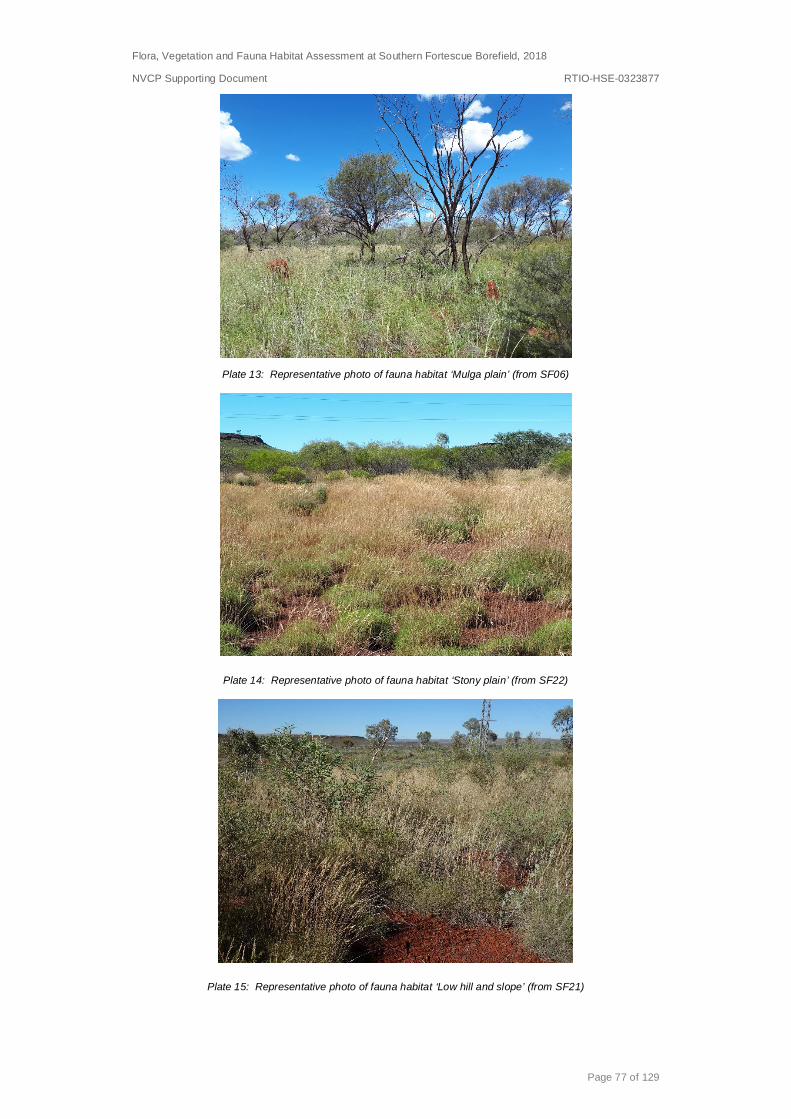
Low open woodland to woodland of Acacia aptaneura, A. pruinocarpa and A. aneura over mixed (open) tussock grassland on red brown loamy clays on plains. Associated with vegetation units P1, P3, P5 and P6.
None recorded 245.84 32.73
Stony plain Shrublands of mixed Acacia spp. over hummock grasslands of Triodia spp. on red brown loams with ironstone pebbles and rocks plains and lower slopes. Associated with vegetation units P4, P2 and P7.
None recorded 411.25 54.75
Low hill and slope
Low open woodlan d of Eucalyptus leucophloia subsp. leucophloia over open shrubland of Acacia spp., over hummock grassland of Triodia spp. on shallow red brown loams with ironstone rocks and some minor outcropping on hills and upper slopes. Associated with vegetation unit HS1.
None recorded 66.71 8.88
Minor drainage Line
Tall shrubland of mixed Acacia spp. over mixed open tussock grassland over open hummock grasslands of Triodia spp. on shallow red brown loams with mixed rocks on minor drainage lines. Associated with vegetation units MD1 and MD2.
None recorded 7.35 0.98
Creek line Woodland of Eucalyptus victrix and Acacia citrinoviridis over closed tussock grasslands of Cenchrus spp. on red brown loamy clays om moderately sized creeks. Associated with vegetation unit CL1.
Large tree hollows
6.76 0.90
Gully Low open woodland of Eucalyptus leucophloia subsp. leucophloia over mixed shrubland over open tussock grassland over open hummock grasslands on red brown loams with ironstone rocks on gullies. Associated with vegetation unit G1.
None recorded 0.96 0.13
Cleared 18.34 2.44
Total 751.19 100
Flora, Vegetation and Fauna Habitat Assessment at Southern Fortescue Borefield, 2018
NVCP Supporting Document RTIO-HSE-0323877
Page 77 of 129
Plate 13: Representative photo of fauna habitat ‘Mulga plain’ (from SF06)
Plate 14: Representative photo of fauna habitat ‘Stony plain’ (from SF22)
Plate 15: Representative photo of fauna habitat ‘Low hill and slope’ (from SF21)

Flora, Vegetation and Fauna Habitat Assessment at Southern Fortescue Borefield, 2018
NVCP Supporting Document RTIO-HSE-0323877
Page 78 of 129
Plate 16: Representative photo of fauna habitat ‘Minor drainage line’ (from SF23)
Plate 17: Representative photo of fauna habitat ‘Creek line’ (from SF16)
Plate 18: Representative photo of fauna habitat ‘Gully’ (from SF19)

Flora, Vegetation and Fauna Habitat Assessment at Southern Fortescue Borefield, 2018 NVCP Supporting Document
RTIO-HSE-0323877
Page 79 of 129
Figure 3-8 Fauna habitats within the Study Area (Map 1 of 2)

Flora, Vegetation and Fauna Habitat Assessment at Southern Fortescue Borefield, 2018
NVCP Supporting Document RTIO-HSE-0323877
Page 80 of 129
Figure 3-9: Fauna habitats within the Study Area (Map 2 of 2)

Flora, Vegetation and Fauna Habitat Assessment at Southern Fortescue Borefield, 2018
NVCP Supporting Document RTIO-HSE-0323877
Page 81 of 129
3.9 Fauna habitats of significance None of the fauna habitats occurring within the study area correspond to any ecosystems listed as Threatened under the EPBC Act and none are consistent with ecosystems listed as TECs by DBCA (2016).
None of the fauna habitats occurring within the study area are representative of listed PECs by DBCA Wildlife (2017).
3.10 Other habitats of significance None of the fauna habitats occurring within the study area were deemed to hold elevated significance either at the local or sub-regional scale.
3.11 Conservation listed fauna recorded during survey Evidence of one fauna species of conservation significance was recorded during the current study;
• Pseudomys chapmani (Western pebble-mound mouse) – Priority 4
The Western pebble-mound mouse is endemic to the Pilbara region of Western Australia and occurs west to the McKay Range and south to the Collier Range (Menkhorst and Knight 2001). The species is patchily distributed on gentle colluvial slopes of rocky, hummock grasslands with little or no soil and a sparse shrub layer.
Five Western pebble-mound mouse mounds was recorded during the study consisting of three extinct mounds and two recently inactive mounds (i.e. mound that had slightly lost their dome formation). No active mounds were recorded during the survey.
3.12 Potential conservation listed fauna occurring in the study area The desktop study, utilising previous survey results and various database searches identified ten conservation significant fauna species that may occur within the vicinity of the study area. The likelihood of their occurrence is discussed in detail in Section 2.3.2 and is presented in Table 2-6. The initial likelihood of occurrence rating was based on pre-field information, nearby records and species distributions.
The revised likelihood rating was assessed post-field and included a review of the habitats recorded in the study area and their suitability for each species, in addition to records/observations during the survey. Eight of the ten conservation listed species identified by the database search were deemed unlikely to occur within the study area due to the absence of suitable habitat within the study area, or nearby records (Table 3-77). One species is ‘likely’ to occur within the habitats available in the study area:
• Apus pacificus (Fork-tailed Swift) – Schedule 5, Migratory
The Fork-tailed Swift leaves its breeding grounds in Siberia from August–September and usually arrives in Australia around October before returning to their breeding grounds in April. Whilst in Australia the Fork-tailed Swift are said to be highly mobile with large flocks often preceding or following low pressure systems as they cross the country in search of food. The Fork-tailed Swift is almost exclusively aerial, flying from less than 1 m to at least 300 m above ground and probably much higher (DotE 2018b).
The Fork-tailed Swift may forage over the study area however given its highly mobile and aerial nature it is considered unlikely the Proposal will negatively impact the conservation status of this species on either a local or bioregional scale.

Flora, Vegetation and Fauna Habitat Assessment at Southern Fortescue Borefield, 2018 NVCP Supporting Document
RTIO-HSE- RTIO-HSE-0323877
Page 82 of 129
Table 3-7: Revised likelihood of occurrence of conservation listed fauna species
Species Common name WC Act Likelihood of occurrence (pre-field)
Habitat and discussion (post-field) Revised likelihood of occurrence (post-field)
Pezoporus occidentalis Night Parrot En, S1 Unlikely Although suitable exists in the study area this cryptic species is not known to occur from the area. Unlikely
Dasyurus hallucatus Northern Quoll En, S2 Potential The North Quoll may utilise the study area as a part of a larger home range, however, the study area lacks suitable core denning habitat.
Unlikely
Rhinonicteris aurantia Pilbara Leaf-nosed Bat Vu, S3 Unlikely No suitable caves were recorded in the study area. This taxon is unlikely to roost in the study area. Unlikely
Macrotis lagotis Greater Bilby Vu, S3 Unlikely No suitable habitat was recorded during the survey. Unlikely
Liasis olivaceus barronii Pilbara Olive Python Vu, S3 Potential
The study area does not contain core habitat (gorges, outcrops or permanent water) the study area may provide dispersal habitat whilst moving between areas of core habitat.
Unlikely
Hirundo rustica Barn Swallow Mi, S5 Unlikely This species is restricted to coastal or near coastal areas. Unlikely
Apus pacificus Fork-tailed Swift Mi, S5 Likely This species may overfly the study area however is unlikely to land within the study area. Likely
Pseudomys chapmani Western Pebble-mound mouse P4
Likely
This species was recorded during the survey. Recorded
Leggadina lakedownensis Short-tailed Mouse P4 Unlikely The preferred habitat black-soil plains especially on calcareous clays was not recorded from the study area. Unlikely
Notoscincus butleri Line soil-crevice skink P4 Unlikely Suitable habitat was observed however no nearby records exist. Unlikely

Flora, Vegetation and Fauna Habitat Assessment at Southern Fortescue Borefield, 2018
NVCP Supporting Document RTIO-HSE-0323877
Page 83 of 129
4. Statement addressing the 10 clearing principles Rio Tinto proposes to drill and replace a number of monitoring and production bores at the Southern Fortescue Borefield study area in the Pilbara. The study area comprises 751 ha of native vegetation, previously cleared tracks and infrastructure.
Based on specialist assessment of the study area and discussion below, it is deemed that the Proposal may be at variance with one of the 10 Clearing Principles under Schedule 5 of the EP Act.
4.1 Comprises high level of biological diversity Native vegetation should not be cleared if it comprises a high level of biological diversity.
The Pilbara is one of Australia’s 15 National Biodiversity Hotspots (DotEE 2018a) and is a secondary centre of endemism and species richness for Acacia, Triodia, Corymbia and Sida in Western Australia (Maslin 2001, Kendrick 2001 and Maslin and van Leeuwen 2008). The Hamersley sub-region of the Pilbara has been identified by the Threatened Species Scientific Committee for the Australian Government Biodiversity Hotspots as it provides habitat for a number of threatened, endemic and fire-sensitive species and communities.
The study area occurs within the Hamersley sub-region of the Pilbara bioregion. The Hamersley sub-region is described as: ‘Mountainous area of Proterozoic sedimentary ranges and plateaux, supporting Mulga (Acacia aneura) low woodland over bunch grasses on fine textured soils, and Eucalyptus leucophloia woodlands over Triodia brizoides hummock grasslands on skeletal sandy soils’ (Kendrick 2001).
Special features of the Hamersley sub-region include rare features such as gorges, centres of endemism including calcrete deposits, refugia and the Themeda grasslands TEC (Kendrick 2001). The buffer boundary for the ‘Themeda grasslands on cracking clays (Hamersley Station, Pilbara)’ TEC is located approximately 22 km north west of the study area, and due to the separation, will not be impacted by the Proposal.
Twelve vegetation units were described from the study area. One vegetation unit was described from low hills and slopes, one unit from gullies, seven units from plains and three units from drainage lines. None of the vegetation units occurring within the study area are listed as TECs under either the EPBC Act or under the State listing maintained by DBCA. None of the units represent PECs under the State listing maintained by DBCA.
The vegetation units identified within the study area are considered to be of low conservation value and are widely distributed both locally and throughout the Hamersley sub-region.
A total of 245 taxa from 130 genera representing 45 families were recorded during the current survey. The number of taxa recorded by the current study appears consistent to what was expected once the size of the study area and survey type is taken into account when compared with previous surveys in the Marandoo locality (e.g. Mattiske 1992, Biota 2008a and Rio Tinto 2011).
Two species of Priority Flora were recorded during the survey: Aristida jerichoensis subsp. subspinulifera (Priority 3); and Goodenia nuda (Priority 4).
Six broad fauna habitat types were recorded within the study area: ‘Mulga Plain’; ‘Stony Plain’; ‘Low Hill and Slope’; ‘Minor Drainage Lines’; ‘Creek Lines’; and ‘Gully’. These

Flora, Vegetation and Fauna Habitat Assessment at Southern Fortescue Borefield, 2018
NVCP Supporting Document RTIO-HSE-0323877
Page 84 of 129
fauna habitats are not restricted at a local or regional level. The Proposal is unlikely to be at variance with this Principle.
4.2 Potential impact to any significant habitat for fauna indigenous to Western Australia Native vegetation should not be cleared if it comprises the whole, or part of, or is necessary for the maintenance of, a significant habitat for fauna indigenous to Western Australia.
Secondary evidence in the form of old (inactive) and recently active mounds of the Priority 4 species Pseudomys chapmani (Western pebble mound mouse) were recorded within the study area. No active mounds were recorded during the survey.
One conservation significant fauna species, Apus pacificus (Fork-tailed Swift) was ‘likely’ to occur within the habitats available in the study area. However, due to the highly mobile and aerial nature of the Fork-tailed Swift it is unlikely to land in the study area, it is highly unlikely the Proposal will negatively affect the conservation status of this species, on either a local or regional scale. The Proposal is unlikely to be at variance with this Principle.
4.3 Potential impact to any rare flora Native vegetation should not be cleared if it includes, or is necessary for the continued existence of rare flora.
No Declared Rare / Threatened flora species were recorded, nor were any EPBC Act listed Threatened flora observed. It is highly unlikely that any Threatened Flora species were overlooked during the survey. The Proposal is not at variance with this Principle.
4.4 Presence of any threatened ecological communities Native vegetation should not be cleared if it comprises the whole or part of, or is necessary for the maintenance of a threatened ecological community (TEC).
There are no DBCA or Commonwealth listed TECs within or adjacent to the study area. The Proposal is not at variance with this Principle.
4.5 Significance as a remnant of native vegetation in the area that has been extensively cleared Native vegetation should not be cleared if it is significant as remnant vegetation in an area that has been extensively cleared.
The majority of the Pilbara region has not been extensively cleared. However grazing, inappropriate fire regimes and weed invasion have greatly altered the vegetation in some areas. The study area lies within three of Beard’s mapping units - Hamersley 18, Hamersley 29 and Hamersley 82.
The current extent of the Beard (1975) mapping units Hamersley 18, Hamersley 29 and Hamersley 82 have been estimated to be over 99% of their pre-European extent remaining and is considered to be of ‘least concern’. Vegetation types within the study area would not represent remnant stands of extensively cleared vegetation. The Proposal is not at variance with this Principle.
4.6 Impact on any watercourse and / or wetlands Native vegetation should not be cleared if it is growing in, or in association with, an environment associated with a watercourse or wetland.

Flora, Vegetation and Fauna Habitat Assessment at Southern Fortescue Borefield, 2018
NVCP Supporting Document RTIO-HSE-0323877
Page 85 of 129
Two major ephemeral creek lines associated with the Southern Fortescue River catchment that flow after significant rainfall events transect the study area. These creek lines were both mapped as vegetation unit CL, woodland of Eucalyptus victrix and Acacia citrinoviridis over closed grassland of *Cenchrus ciliaris and *C. setiger.
The creeklines were in Poor condition because of the high level of weed cover and historical cleared areas resulting from established pipeline maintenance tracks.
Proposal may be at variance with this Principle.
4.7 Potential to cause appreciable land degradation Native vegetation should not be cleared if the clearing of vegetation is likely to cause appreciable land degradation.
The study area lies within four land systems. The Newman and Boolgeeda Land Systems are generally not prone to degradation and not susceptible to erosion. The Paraburdoo Land System is inherently resistant to erosion except for drainage zones (unit 5, which is moderately susceptible). The Jurrawarrina Land Systems is moderately susceptible to erosion.
The Proposal is not expected to result in soil erosion, nutrient export, water-logging/flooding, acidification, salinization or deep subsoil compaction. The Proposal is therefore not at variance with this Principle.
4.8 Potential to impact on the environmental values of adjacent or nearby conservation areas Native vegetation should not be cleared if the clearing of the vegetation is likely to have an impact on the environmental values of any adjacent or nearby conservation area.
The study area is adjacent to Karijini National Park however, the Proposal is unlikely to result in an impact to the environmental values of Karijini National Park. The Proposal is therefore not at variance with this Principle.
4.9 Potential deterioration in the quality of surface or underground water Native vegetation should not be cleared if the clearing of the vegetation is likely to cause deterioration in the quality of surface or underground water.
No natural permanent or semi-permanent water features occur in or adjacent to the study area. Given the small scale of Proposal, there is no reason to expect that the Proposal would affect groundwater quality in the region.
The study area lies within the Southern Fortescue River Water Reserve. Due to the small scale of the Proposal, it is considered unlikely that clearing associated with the Proposal will negatively impact on this Water Reserve. The Proposal is therefore unlikely to be at variance with this Principle.
4.10 Potential of clearing to cause, or exacerbate, the incidence or intensity of flooding Native vegetation should not be cleared if the clearing of vegetation is likely to cause, or exacerbate, the incidence of flooding.
Local flooding occurs seasonally in the Pilbara region as a result of cyclonic activity and sporadic thunderstorm activity. The small scale of the Proposal is not expected to

Flora, Vegetation and Fauna Habitat Assessment at Southern Fortescue Borefield, 2018
NVCP Supporting Document RTIO-HSE-0323877
Page 86 of 129
exacerbate the incidence or intensity of flooding in the area. The Proposal is therefore not at variance with this Principle.
5. Conclusions Rio Tinto, on behalf of Hamersley Iron Pty Limited, is proposing to drill and replace a number of monitoring and production bores at the Southern Fortescue Borefield.
The landforms, vegetation, and fauna habitats are well represented within the Southern Fortescue locality and the broader Hamersley sub-region. Twelve vegetation units were described across the study area. One vegetation unit was described from low hills and slopes, eight units from undulating plains, two units from minor drainage lines and one unit from creek lines.
The study area does not contain any TECs or PECs and is not within any ESAs. The vegetation units identified within the study area are not considered to hold elevated significance, and are widely distributed both locally and throughout the Hamersley sub-region.
A total of 245 taxa from 130 genera representing 45 families were recorded during the survey. The number of taxa recorded by the current study appears consistent with what was expected when compared with previous surveys in the Marandoo locality.
No species of Threatened Flora were recorded during the study, or were expected to occur within the study area. Two species of Priority flora were recorded during the survey: Aristida jerichoensis subsp. subspinulifera and Goodenia nuda. An additional priority species, Rhagodia sp. Hamersley (M. Trudgen 17794) previously recorded in the study area was not recorded during this survey.
Fourteen introduced (weed) species were recorded from the study area. None these species are listed as a Declared Pest.
Six broad fauna habitat types were recorded within the study area: ‘Mulga Plain’; ‘Stony Plain’; ‘Low Hill and Slope’; ‘Minor Drainage Lines’; ‘Creek Lines’; and ‘Gully’. These fauna habitats are not restricted at a local or regional level
Secondary evidence in the form of old and recently active mounds of the Priority 4 species Pseudomys chapmani (Western pebble mound mouse) were recorded within the study area. No active mounds were recorded during the survey.
The manner in which the clearing of native vegetation is regulated, undertaken and rehabilitated is under various Government and internal Rio Tinto operational controls. These operational controls are presented in Appendix 9 and will be followed during the course of the Proposal.
The Proposal was assessed against the 10 clearing principles as defined in Schedule 5 (Principles for Clearing Native Vegetation) of the Environmental Protection Act 1986. Assessment against the Principles concluded clearing may be at variance with one of the clearing principles, Native vegetation should not be cleared if it is growing in, or in association with, an environment associated with a watercourse or wetland.

Flora, Vegetation and Fauna Habitat Assessment at Southern Fortescue Borefield, 2018
NVCP Supporting Document RTIO-HSE-0323877
Page 87 of 129
6. References Aplin, T.E.H. (1979), ‘The Flora’, Chapter 3. In: O'Brien, B.J. (ed.) Environment and
Science. University of Western Australia Press, Nedlands.
Beard, J.S. (1975), Pilbara. Explanatory notes to Sheet 4, 1:1,000,000 series vegetation survey of Western Australia. University of Western Australia Press, Nedlands.
Biota (2008a) Marandoo Mine Phase 2 Project Vegetation and Flora Survey. Unpublished report prepared for Rio Tinto.
Biota (2008b) Marandoo Mine Phase 2 Seasonal Fauna Survey. Unpublished report prepared for Rio Tinto.
Biota (2011). A single Phase Fauna Survey of the Southern Fortescue Borefield. Unpublished report prepared for Rio Tinto.
Blakers, M., Davies, S.J.J.F. and Reilly, P.N. (1984), The atlas of Australian birds. Melbourne University Press, Melbourne.
Braithwaite, R.W. and Griffiths, A. (1994), ‘Demographic variation and range contraction in the Northern Quoll Dasyurus hallucatus (Marsupialia: Dasyuridae)’, Wildlife Research, 21, pp. 203-17.
Burbidge, N.T. (1959), Notes on plants and plant habitats observed in the Abydos-Woodstock area, Pilbara District, Western Australia. CSIRO Division of Plant Industry, Technical Paper No. 12. CSIRO, Melbourne.
Burbidge. A.A. (2004), Threatened animals of Western Australia. Department of Conservation and Land Management, Kensington, Western Australia.
Bureau of Meteorology (BoM) (2018), Climate Data Online. Available: http://www.bom.gov.au/climate/data/index.shtml.
Christian, C.S. and Stewart, G.A. (1953), General report on survey of Katherine-Darwin region, 1946. Land Research Series No. 1. CSIRO, Melbourne.
Churchill, S.K. (1998), Australian bats. Reed New Holland, Frenchs Forest, NSW.
Department of Parks and Wildlife (2013), Ecological impact and invasiveness ratings from the Department of Parks and Wildlife Pilbara region species prioritisation process 2014. Microsoft Excel spreadsheet. Available: https://www.dpaw.wa.gov.au/plants-and-animals/plants/weeds/156-how-do-we-manage-weeds.
Department of Biodiversity, Conservation and Attractions (DBCA) (2016), List of Threatened Ecological Communities (TECs) endorsed by the Western Australian Minister for Environment. Species and Communities Branch of the Department of Biodiversity, Conservation and Attractions, 26 October 2016.
Department of Biodiversity, Conservation and Attractions (DBCA) (2017a), Priority Ecological Communities for Western Australia version 27. Species and Communities Branch of the Department of Biodiversity, Conservation and Attractions, 30 June 2017.
Department of Biodiversity, Conservation and Attractions (DBCA) (2017b), Conservation codes for Western Australia flora and fauna. Parks and Wildlife Services. Available:

Flora, Vegetation and Fauna Habitat Assessment at Southern Fortescue Borefield, 2018
NVCP Supporting Document RTIO-HSE-0323877
Page 88 of 129
https://www.dpaw.wa.gov.au/plants-and-animals/threatened-species-and-communities.
Department of Biodiversity, Conservation and Attractions (DBCA) (2018), NatureMap. Database Search 2018. Available: https://naturemap.dpaw.wa.gov.au/.
Department of the Environment and Energy (DotEE) (2013), Matters of national environmental significance – significant impact guidelines 1.1 – Environment Protection and Biodiversity Conservation Act 1999. Available: http://www.environment.gov.au/epbc/publications/significant-impact-guidelines-11-matters-national-environmental-significance.
Department of the Environment and Energy (DotEE) (2018a), Australia’s bioregions (IBRA). Available: http://www.environment.gov.au/parks/nrs/science/bioregion-framework/ibra/.
Department of the Environment and Energy (DotEE) (2018b), EPBC Protected Matters Search Tool. Available: http://www.environment.gov.au/epbc/pmst/index.html.
Department of the Environment and Energy (DotEE) (2018c). Liasis olivaceus barroni in Species Profile and Threats Database, Department of the Environment, Canberra. Available from: http://www.environment.gov.au/sprat. Accessed Mon, 14 May 2018 14:21:00 +1000.
Department of the Environment and Energy (DotEE) (2018d). Apus pacificus in Species Profile and Threats Database, Department of the Environment, Canberra. Available from: http://www.environment.gov.au/sprat. Accessed Tue, 8 May 2018 10:58:01 +1000.
Department of the Environment and Heritage (DEH) (2003), Australian Painted Snipe (Rostratula australis). Available: http://www.environment.gov.au/biodiversity/threatened/publications/australian-painted-snipe-rostratula-australis.
Department of Water and Environmental Regulation (DWER) (2018a), Perth Groundwater Atlas. Available online: http://www.water.wa.gov.au/idelve/gwa/.
Department of Water and Environmental Regulation (DWER) (2018b). Environmentally Sensitive Areas. Available: https://www.der.wa.gov.au/your-environment/environmentally-sensitive-areas.
Department of Water and Environmental Regulation (DWER) (2018c). Public Drinking Water Source Areas. Available: https://catalogue.data.wa.gov.au/dataset/public-drinking-water-source-areas.
Environment Australia (2012), Revision of the Interim Biogeographic Regionalisation for Australia (IBRA) 6.1 and development of Version 6.1 summary report. May 2012.
Environmental Protection Authority (2004a), Terrestrial Flora and Vegetation Surveys for Environmental Impact Assessment in Western Australia. Guidance Statement No. 51. Perth, Western Australia.

Flora, Vegetation and Fauna Habitat Assessment at Southern Fortescue Borefield, 2018
NVCP Supporting Document RTIO-HSE-0323877
Page 89 of 129
Environmental Protection Authority (2004b), Terrestrial Fauna Surveys for Environmental Impact Assessment in Western Australia. Guidance Statement No. 56. Perth, Western Australia.
Environmental Protection Authority (2016a), Environmental Factor Guideline – Flora and vegetation. Perth, Western Australia.
Environmental Protection Authority (2016b), Environmental Factor Guideline – Terrestrial fauna. Perth, Western Australia.
Environmental Protection Authority (2016c), Technical Guidance – Flora and vegetation surveys for environmental impact assessment. Perth, Western Australia.
Environmental Protection Authority (2016d), Technical Guidance – Terrestrial fauna surveys. Perth, Western Australia.
Environmental Protection Authority (2016e), Technical Guidance – Sampling methods for terrestrial vertebrate fauna. Perth, Western Australia.
Gibson, L. A., and McKenzie, N. L. (2009). Environmental associations of small ground-dwelling mammals in the Pilbara region, Western Australia. Records of the Western Australian Museum 78, 91–122.
Government of Western Australia (2016), 2016 Statewide vegetation statistics (formerly the CAR reserve analysis) - Full report. Current as of October 2016. Department of Parks and Wildlife, Western Australia. Available: https://www2.landgate.wa.gov.au/web/guest/downloader.
Kendrick, P. (2001), ‘Pilbara 3 (PIL3 – Hamersley Subregion)’. In: A biodiversity audit of Western Australia's 53 biogeographical subregions in 2002 (eds. J.E. May & N.L. McKenzie). Department of Conservation and Land Management, Western Australia.
Luke, G., Burke, K. & O’Brien, T. (1987), Evaporation data for Western Australia. Resource Management Technical Report No. 65. Department of Agriculture, Western Australia.
Maslin, B.R. (2001), WATTLE: Acacias of Australia. CSIRO Publishing, Canberra.
Maslin, B.R. and van Leeuwen, S. (2008), ‘New taxa of Acacia (Leguminosae: Mimosoideae) and notes on other species from the Pilbara and adjacent desert regions of Western Australia’, Nuytsia, 18, pp. 139-188.
Mattiske (1992), Flora and Vegetation: Marandoo Project Area. Unpublished report prepared for Rio Tinto.
Menkhorst, P. and Knight, F. (2001), A field guide to the mammals of Australia. Oxford University Press, Melbourne.
Muir, B.G. (1977), ‘Biological survey of the Western Australian wheatbelt. Part 2: Vegetation and habitat of Bendering Reserve’, Records of the Western Australian Museum, Supplement No. 3.
Flora, Vegetation and Fauna Habitat Assessment at Southern Fortescue Borefield, 2018
NVCP Supporting Document RTIO-HSE-0323877
Page 90 of 129
Payne A.L., Mitchell, A.A. and Holman, W.F. (1988), An inventory and condition survey of rangelands in the Ashburton River catchment, Western Australia. Technical Bulletin No. 62. Western Australian Department of Agriculture.
Pizzey G. and Knight F. (2007), The field guide to the birds of Australia. HarperCollins Publishers, Australia.
Rio Tinto (2011), Flora and Vegetation Assessment of the Southern Fortescue Borefields. Unpublished report prepared for Rio Tinto.
Schodde, R. and Mason, I.J. (1999), The directory of Australian birds: Passerines. CSIRO Publishing, Melbourne, Victoria.
Shepherd, D.P., Beeston, G.R., and Hopkins, A.J.M. (2002), Native vegetation in Western Australia – extent, type and status. Resource Management Technical Report No. 249. Department of Agriculture, Western Australia.
Specht, R.L. (1970), ‘Vegetation’. In: Leeper, G.W. (ed.) The Australian Environment, 4th edition, pp 44-67. CSIRO & Melbourne University Press, Melbourne.
Trudgen, M.E. (1988), A report on the flora and vegetation of the Port Kennedy area. Unpublished report prepared for Bowman Bishaw and Associates, West Perth.
Van Dyck, S. and Strahan, R. (ed.) (2008), The mammals of Australia. New Holland Publishers (Australia) Pty Ltd., Sydney, New South Wales.
van Vreeswyk, A.M.E., Payne, A.L., Leighton, K.A. and Hennig, P. (2004), An inventory and condition survey of the Pilbara region, Western Australia. Technical Bulletin No. 92. Department of Agriculture.
Western Australian Herbarium (WAH) (2018). FloraBase—the Western Australian Flora. Department of Biodiversity, Conservations and Attractions. http://florabase.dbca.wa.gov.au/.
Wilson, S. K. and Swan, G. (2008), A complete guide to reptiles of Australia, 2nd edn. New Holland Publishers, Sydney.