vegetation pattern and diversity in s.e....
TRANSCRIPT

Journal of Ecology^ (1986), 74, 465^83
VEGETATION PATTERN AND DIVERSITY IN S.E.LABRADOR, CANADA: BETULA PAPYRIFERA (BIRCH)
FOREST DEVELOPMENT IN RELATION TO FIREHISTORY AND PHYSIOGRAPHY
D. R. FOSTER AND G. A. KING
Harvard Forest, Harvard University, Petersham. MA 01366, and Limnological ResearchCenter, Pillsbury Hali 218, University of Minnesota, Minneapolis, MN 55455, U.SA.
SUMMARY
(1) The Betula papyri/era (paper birch) forest of the wilderness of south easternLabrador is described.
(2) B. papyri/era forests range in size from less than 1 ha to several km^. displaysharp borders with the adjoining conifer forests and are restricted to steep slopes thathave burned in the previous 1 10 years.
(3) Floristically, the B. papyri/era community is distinguished from conifer forests bythe presence of fourteen differential species, by the scarcity of terrestrial cr>'ptogams andby the development of a diverse understorey of vascular plants.
(4) Three minimum conditions are necessary for B. papyri/era forest development: 0)moist and well drained soils, (ii) a nearby seed source, and (iii) an open site.
(5) The nearly exclusive restriction of B. papyri/era forest to areas that have burned inthe last 110 years indicates that the open site conditions necessary for stand initiation arelargely created by lightning fires.
(6) Age structure analysis demonstrates that, following fire, regeneration by B.papyri/era is rapid and results in the formation of an even aged overstory. Gradualinvasion of canopy openings by Picea mariana and Abies balsamea results in theprogressive conversion to conifer forest.
(7) Fire maintains B. papyri/era and other early post-fire communities in a mosaicpattern and increases regional vegetation diversity. The pattern is not random, but iscontrolled by species autecologies. the pattern of fires and physiography. Thevegetation of south eastern Labrador is in a state of dynamic equilibrium.
INTRODUCTION
The recognition that disturbance is a prevalent factor in many ecosystems has led to thetheory that long-term ecosystem dynamics are frequently a consequence of succession andpatterns of periodic disruptions (Bormann & Likens 1979; Heinselman 1981). A corollaryof this theory is that perturbations may enhance regional diversity through the creation of apatchwork of successional stages that provide habitats for a diverse flora and fauna(Loucks 1970; Heinselman 1973). However, studies documenting regional disturbanceregimes are needed to examine the general validity oi' this theory. Research on thephytosociology and fire history of south eastern Labrador, Canada (Foster 1983b, 1984),provides the background for the investigation presented here on the role of fire in thedevelopment of Betula papyrifera* (paper birch) forests and the implications of thisprocess in terms of regional diversity.
• Nomenclature follows Fernald (1970) for vascular species. Stotler & Crandall Stotler (1977) forliverworts. Ireland et ai (1980) for mosses, and Hale & Culberson (1970) for lichens except Cladonia, whichfollow Ahti (1961). Voucher samples of lichens and vascular plants are deposited in the herbarium of theUniversity of Minnesota (MIN). Duplicates of all bryophyte collections are stored in the National Herbarium,National Museum of Canda (CAN).
465
466 BQi\ji\sL forest development in Labrador
The landscape of south-eastern Labrador is covered predominantly by a mixed Piceamariana (black spruce) and Abies balsamea (balsam fir) forest. However, on steep slopesin dissected terrain a vegetation mosaic is created by extensive stands o^ Beiula papyri/erathat display sharp boundaries with the adjoining conifer forest. The repeated occurrence o^hill-slope forests of B. papyri/era suggests that there is a common and widespreadmechanism for their formation. This mechanism must involve recurrent disturbance, as theshade-intolerant B. papyri/era requires open conditions for regeneration.
As little information was available on site preference, origin, or development of B.papyri/era forests, a detailed investigation was undertaken to obtain floristic. environ-mental and historical data on these stands throughout south-eastern Labrador. Thisinformation was then used to examine the role of widespread disturbance in thedevelopment and maintenance of the stands and in augmenting regional diversity.
STUDY AREA
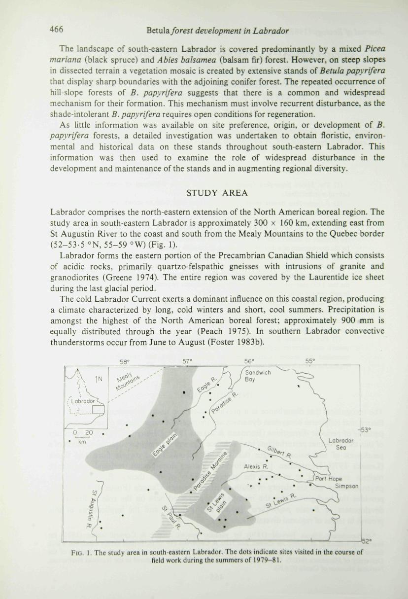
Labrador comprises the north-eastern extension of the North American boreal region. Thestudy area in south-eastern Labrador is approximately 300 x 160 km. extending east fromSt Augustin River to the coast and south from the Mealy Mountains to the Quebec border(52-53-5 °N, 55-59 °W) (Fig. 1).
Labrador forms the eastern portion of the Precambrian Canadian Shield which consistsof acidic rocks, primarily quartzo-felspathic gneisses with intrusions of granite andgranodiorites (Greene 1974). The entire region was covered by the Laurentide ice sheetduring the last glacial period.
The cold Labrador Current exerts a dominant influence on this coastal region, producinga climate characterized by long, cold winters and short, cool summers. Precipitation isamongst the highest of the North American boreal forest: approximately 900 mm isequally distributed through the year (Peach 1975). In southern Labrador convectivethunderstorms occur from June to August (Foster 1983b).
Fio. 1. The study area in south-eastern Labrador. The dots indicate sites visited in the course offield work during the summers of 1979-81.

D. R. FOSTER AND G . A. KING 467
The central portion of the study area consists of two broad glacial plains, the St Lewisand Eagle plains, separated by the undulating Paradise moraine (Fig. 1). Towards thecoast, where the rim of the plateau is dissected by the St Augustin, Fagle. Paradise. StLewis, and Alexis Rivers, there are steep bedrock hills separated by deep valleys. Thephysiography has important influences on the vegetation and environment: the flat interioris dominated by mires and forests of low productivity, whereas the hilly perimeter supportsricher, more productive forests and few mires (Foster & King 1984; Foster & Glaser 1986).
The regional vegetation consists mainly of communities dominated by Picea marianaand Abies balsamea. In addition. Betula papyri/era, and to a lesser extent Picea glauca(white spruce), are locally important, whereas Larix laricina (tamarack) is generallyrestricted to open peatlands. Across most of the study area a species-poor blacksprucc-Pleurozium forest (cf. Foster 1984: Table 1) forms a nearly continuous coverinterrupted only by innumerable mires, lakes, and streams. This forest is characterized by alow ericaceous shrub layer composed, in order of decreasing abundance, of Ledumgroenlandicum, Vaccinium angustifolium and V. myrtilloides and sparse herb layer ofCornus canadensis, Gaultheria hispidula, Trientalis borealis and Empetrum nigrum. Theforest floor is covered by a continuous mat of Pleurozium schreberi 5-20 cm thick.
On nutritionally richer sites, especially at low altitudes and on well-drained moist slopestowards the coast, the trees are more luxuriant in a fir-black spruce-feather moss forest.The richer vascular understory includes Viburnum edule, Amelanchier bartramiana andAlnus crispa in the shrub layer and the herbs Clinionia borealis. Maianthemum canadense,Trientalis borealis and Linnaea borealis. A deep carpet of mosses is composed ofSphagnum girgensohnii. and the feather mosses Ptilium crista-castrensis, Hylocomiumsplendens and Pleurozium schrebeii (Foster 1984).
Lightning is the sole source of fire in this wilderness area (Foster 1983b). The fire rotation(sensu Heinselman 1973) is approximately 500 years, which is 3-10 times longer than thatestimated for the drier, continental portions of the North American boreal region(Heinselman 1981). The long fire rotation in south-eastern Labrador is attributed to thevery high precipitation and to the predominance of extensive mires that serve as veryeffective fire breaks.
METHODS
Betula papyri/era stands of minimum si/.c 4 ha were located on 1:60 000 aerialphotographs and delimited on 1:250 000 topographic maps. A map of stand locations on a1 : lO** scale was drawn to illustrate their regional distribution and relationship with firehistory, topography and the distribution of mire-dominated terrain. The fire history of theregion is based on mapping of fires from aerial photographs and aerial reconnaissance anddating of fire scars on Picea mariana (Foster 1983b).
In order to compile maps of topographic roughness and mire distribution, the region wasfirst gridded using the Universal Mercator Transverse grid system with each cell 10 x 10km. The percentage of each cell occupied by mires was estimated to the nearest 10% fromI : 250 (300 topographic maps and 1 :60 000 black and white aerial photographs.Topographic roughness, an estimate of the amount of relief in an area, was calculated bvcounting the number of 10-m contour lines crossed by the diagonals of a cell on a1 :25O 000 map. Maps were generated from the data arrays using the programs MAPFILE
and MAPGEN.

468 Bdula. forest development in Labrador
The study sites were selected from the maps, aerial photographs and aerialreconnaissance, on the basis of stand age, fire history and accessibility by float plane. In thefield the criteria for the selection of sampling sites included (i) the dominance (>50% cover)of Betula papyrifera in the canopy, (ii) the homogeneity of the vegetation and site, and (iii)a minimum size of I ha. A total of twenty-six stands were sampled.
The methods of Braun-Blanquet (Mueller-Dombois & Ellenberg 1974) were employed,with plots measuring 20 x 20 m. Cover abundance in each releve was estimated on the10-point Domin scale (Birks 1973).
In each plot, four to six of the largest-diameter trees were recorded for height, dbh andage (estimated by the number of growth rings in cores obtained at approximately 15 cmabove the mineral soil). The organic layer and mineral soil were examined with the aid of aserrated knife and a soil auger. Other information recorded for each plot included altitude,slope, aspect, and position on the slope.
Two stands, originating from 1889 and 1941 fires (Foster 1983b), were analysed fordensity and basal area with the point-centred-quarter method (Cottam & Curtis 1956). Atleast 30 points were established at 10-m intervals along transects across each stand. Theage structure of the 1889-origin stand was determined from counts of growth rings of atleast fifty trees encountered at increasing distances from the stand centre.
In the 1941*origin stand (releve 7) a 10 x 10-cm core of the organic layer was cut to themineral soil and wrapped in plastic and aluminium foil for transport to the laboratory. Asimilar core was obtained from an adjacent old fir-black spruce-feather moss forest (cf.Foster 1984) for comparison. In the laboratory, the cores were cut in half lengthwise andtheir gross stratigraphy described. One half was dissected to identify macrofossils, charcoalhorizons and the composition of the organic matrix. Samples for pollen analysis wereobtained from continuous 5-cm intervals or at distinct horizons. The samples were preparedby the techniques of Faegri & Iversen (1975) as modified by E. J. Cushing (pers. comm.).A minimum of 250 pollen grains were identified from each level and tabulated under amicroscope at x400.
RESULTS
Regional distribution
The regional distribution of Betula papyrifera stands forms a distinctive pattern; moststands are located on steep slopes in rugged terrain that has burned within the last 110years (Figs 2 and 3).
The central portion of the study area, formed by the Eagle and St Lewis plains, iscovered by extensive patterned mires and has experienced a very low incidence of fire in therecent past (Foster 1983b). B. papyrifera is relatively uncommon, and full-canopied standsdo not occur in this area.
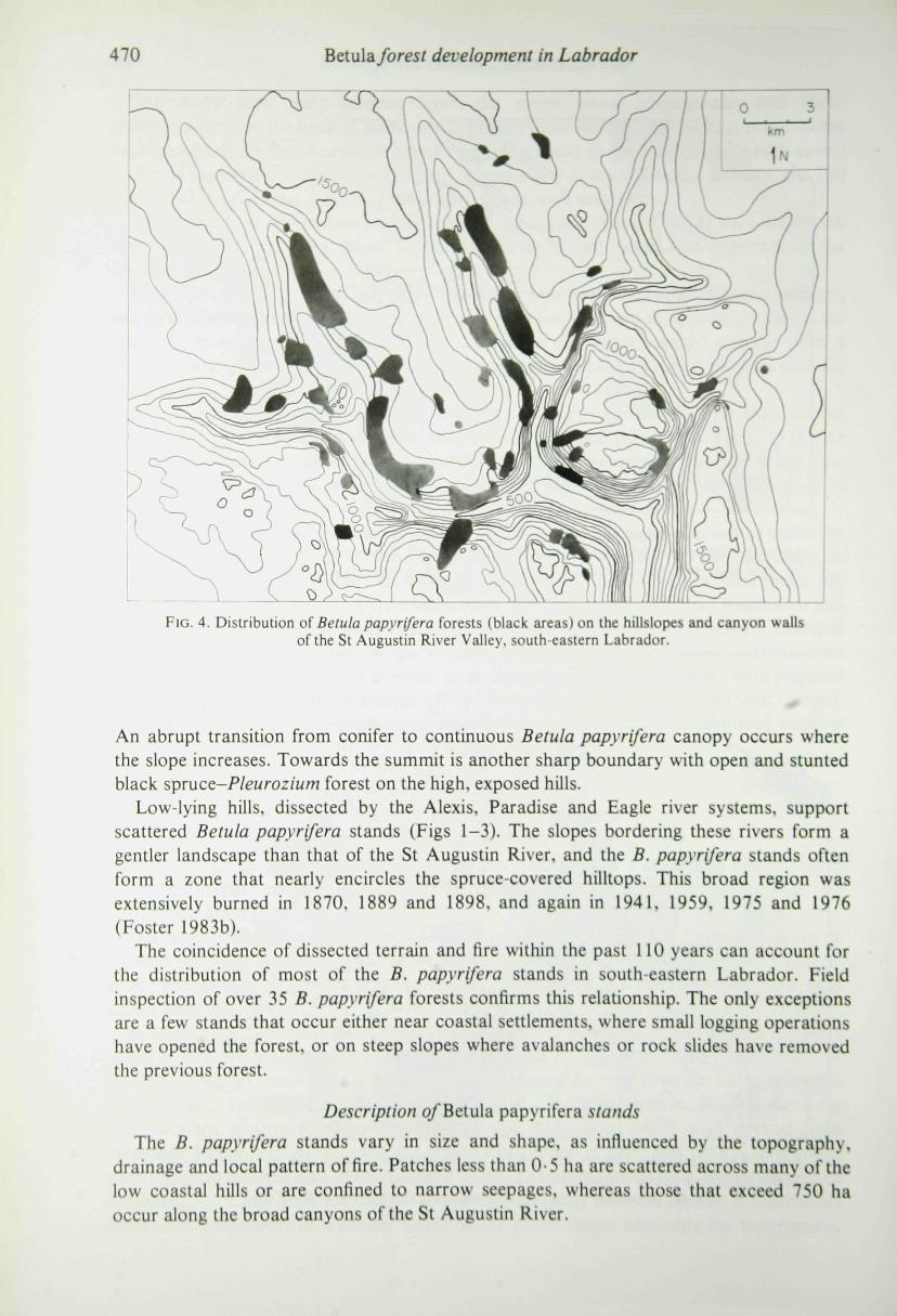
In sharp contrast, the dissected uplands towards the periphery of the plateau exhibit amuch higher incidence of fire and support extensive B. papyrifera forest in addition toproductive conifer forest. The greatest concentrations of B. papyrifera are found along theSt Augustin, Alexis and Eagle Rivers (Figs 1-3). The St Augustin River dissects thesouth-western plateau to form deep valleys and steep sided bluffs with a local reliefexceeding 300 m (Fig. 4). Most of this region was burned in 1880 and 1898, and portionswere reburned in 1959 and 1975 (Foster 1983b). Extensive forests of B. papyrifera, someexceeding 3 x 1 km, flank the valleys. In general, the valley bottoms support a 5a/i.v-scrubflood plain community or a conifer forest on the gentle slopes bordering the watercourse.

D. R. FOSTER AND G. A. KING 469
FIG. 2. The relationship between fire history, topography and the distribution of Betulapapyrifera forests in south-eastern Labrador. Symbols: (91. B. papyrifera stands; areas enclosedby solid lines were burned during 1870-1980; (D-B), topographic surface roughness, from
least to most.
Flo. 3. The relationship between fire history, the distribution of mires and the distribution o\Betula papyrifera forests in south eastern Labrador. Symbols: birch forests and fires as in Fig. 2
(D-B). percentage of mires in the landscape, from < 10% to 90-100%.
470 Beiula. forest development in Labrador
FIG. 4. Distribution of Betula papyrifera forests (black areas) on the hillslopes and canyon wallsof the St Augustin River Valley, south eastern Labrador.
An abrupt transition from conifer to continuous Betula papyrifera canopy occurs wherethe slope increases. Towards the summit is another sharp boundary with open and stuntedblack spruce-Pleurozium forest on the high, exposed hills.
Low-lying hills, dissected by the Alexis, Paradise and Eagle river systems, supportscattered Betula papyrifera stands (Figs 1-3). The slopes bordering these rivers form agentler landscape than that of the St Augustin River, and the B. papyrifera stands oftenform a zone that nearly encircles the spruce-covered hilltops. This broad region wasextensively burned in 1870, 1889 and 1898, and again in 1941, 1959, 1975 and 1976(Foster 1983b).
The coincidence of dissected terrain and fire within the past 110 years can account forthe distribution of most of the B. papyrifera stands in south-eastern Labrador. Fieldinspection of over 35 B. papyrifera forests confirms this relationship. The only exceptionsare a few stands that occur either near coastal settlements, where small logging operationshave opened the forest, or on steep slopes where avalanches or rock slides have removedthe previous forest.
Description o/Betula papyrifera stands
The B. papyrifera stands vary in size and shape, as influenced by the topography,drainage and local pattern of fire. Patches less than 0 5 ha are scattered across many of thelow coastal hills or are confined to narrow seepages, whereas those that exceed 750 haoccur along the broad canyons of the St Augustin River.
D. R. FOSTER AND G . A. KING 471
Generally, the stands are located on steep slopes with southern exposures (Fig. 4).Within the stands investigated the slope ranges from 2 to 25° (Table 2). and B. papyriferafrequently occurs on talus slopes, landslides and rock faces where the slope may exceed30^
The presence of boulders 0-5-3 m diameter, along with vertical rock faces 3 mor more inheight, gives the slopes an uneven and rugged appearance. Water drains actively throughmost stands in gentle seeps, rivulets, or small streams. Consequently the ground is quitemoist throughout the growing season, in contrast to the soil in the conifer stands onadjoining ridges, hilltops or convex-shaped slopes.
Analyses of fifteen soil profiles yields the following generalized stratigraphy. Within theorganic layer, the upper 1-8 cm of well-decomposed deciduous litter and humus overlies athin charcoal horizon. Below, there occurs a layer of partially to well decomposedbryophyte remains and conifer litter that extends 5-25 cm to the mineral soil, which istypically moist and moderately well drained. In soils exceeding 15 cm deep, awell-developed spodosol consists of an A, layer 1-cm thick, an ash-gray sandy Aj layer5-15-cm thick, and a rust-brown B layer overlying the coarser parent material.
Floristic analysis and vegetation description
The Betula papyrifera community is distinctive among the forest types of south-easternLabrador in physiognomy, composition, vascular species diversity and floristic integrity.The prominence o{ a well-developed shrub understor\'. the tush and species-richherbaceous ground cover, and the minor importance of bryophytes distinguish it from theconifer communities (Table 1). The differential species in this community are strikinglyapparent in the field.
In aggrading {sensu Bormann & Likens 1979) and mature forests. B. papyrifera forms anearly continuous canopy interspersed with Ficea mariana. Abies balsamea and,occasionally, Fopulus tremuloides. In addition. Salix bebbiana (willow) may be a minorcomponent in stands less than 50 years old and Ficea glauca occurs only sporadically(Table 2). Fopulus, when regenerating from suckers, may form an emergent canopy thattowers 5 m or more above the main canopy. Ficea mariana and Abies balsamea aresubstantially shorter than the deciduous trees and freqently comprise a layer 1-5-6 m inheight.
The Betula papyrifera are generally multi-stemmed with boles that are twisted andcurved in a downslope attitude. The multiple stems result from sprouting following winterbrowsing by moose {Alces alces (Clinton)) and snowshoe rabbit [Lepus americanus(Erxleben)). Conifers, killed in the previous fire, fall against the Betula saplings and deformthem.
A discontinuous shrub layer 1-5-3 m high includes -4//i//s crispa. Viburnum edulc, Salixbebbiana. Sorbus decora, Frunuspensylvanica and Amelanchier bartramiana (Table 2).
A floristically rich herbaceous layer generally covers 75-90% of the ground. Cornuscanadensis and Trientalis borealis are generally predominant, covering 15-75%, and arepresent in all stands investigated. Other species exhibiting high fidelity, though lowerabundance, include Linnaea borealis, Solidago macrophylla, Coptis groenlandicunuMaianthemum canadense, Lycopodium annotinuttj, Dryopteris spinulosa and D. disjuncta(Table 2).
Cryptogams are restricted to less than 10% cover beneath the B. papyrifera canopy.Pleurozium schreberi, Folytrichum juniperinunu Dicranum fuscesccns and the lichens

472 Betula/ore5/ development in Labrador
It •<
II
III
IV
V "S
VI
TABLE 1. Summary phytosociological table of mature forest vegetation of south-eastern Labrador.
Vegetation
Species
Viola pallensEpilobium angustifoliumCalamagrostis canadensisPetasites palmatusSalix bebbianaRubus pubescensRubus idaeusViburnum eduleDryopteris spinulosaDryopteris disjunctaRibes glandulosumPopulus tremuloidesPrunus pensylvanicaSolidago macrophyllaLycopodium obscurum
I Amelanchier bartramianaClintonia borealis
\ Streptopus amplexifoliusMaianthemum canadense
\^ Sorbus decora
I Trientalis borealisBetula papyrifera
< Linnaea borealisAlnus crispa
I Vaccinium myrtHloides
( Habenaria obtusataPicea glauca
J Listera cordataMoneses unijlora
I Pyrola rotundifolia
Ptilium cristacastrensisHylocomium splendensSphagnum girgensohniiAbies balsameaNephroma articumPeltigera scabrosaPeltigera apthosa
Pleurozium schreberiSphagnum russowiiPolytrichum communeDeschampsia JlexuosaLycopodium annotinumGaultheria hispidulaCornus canadensis
\l\<
marianaCladonia rangiferinaLedum groenlandicumVaccinium angustifoliumVaccinium vitis idaca
Dicranum undulatumEmpetrum nigrumVaccinium uliginosumLarix laricinaSphagnum fuscumSphagnum rubettumSphagnum angustifoliumScirpus ccspilosusVaccinium oxycoccus
^ Eriophorum spissum
MV*
222122222222232
22222
34243
11
11121
22223232222
Birch
Frequency(%)
3542231169234673811110042468061
5850466173
96100969611
411
504388115
100384673777310092696946
Fir-spruce-feather moss
MV
1121
111
2212I
22222
23222
3344222
422222242222
2
Frequency(%)
1510205
10155
4535455050
6565954035
3520402035
100908595854530
10025854045^0959050503545
5
Spruce-fir
MV
I
I1
111
23232231
1
3I24222
4212I224"1
222
21
Frequency(%)
13
1313
131313
4793606067
7720
20
87203367807313
1007207
471009310087672780
715
Spruce-Pleurozium
MV
2
12
1
122
2I2233222
4323221
4•>
322
21212
Frequencv
(%)
8
88
8
171717
88
58424292755825
10033503350100921001001007592
252581725
Spruce-Sphagnum fuscum
MV
2
3
21
1232
2224T
33I
2332433222
Frequency
(%)
7
7
277
7
1007733
7380401)3
67100807
40876087934027408427
D. R. FOSTER AND G . A. KING 473
TABLE I—continued
Vegetation
Species M V
f Mylia anomalaVII J Chamaedaphne calyculata
] Smilacina trifolia 2I Kalmia polifolia
BirchFrequency
(%)
4
Fir -spruce-feather moss
MV
21
Frequency(%)
105
Spruce-firFrequency
MV (%)
I 7
Sprxjce-Pleurozium
MV
22
Frequency(%)
2517
Spruce-Sphagnum fuscum
MV
2422
Frequency(%)
478067
100
Cover abundance values: 1. <3%: 2. 3-10%; 3. 10-35%: 4, >35%. ' MV. modal value is shown,t Roman numerals refer to species groups, identified in Foster (1984).
Cladonia mitis, C. rangiferina, C. chlorophaea and C. cornuia occur where leaf litter issparse and on stumps, dead conifer wood, tree bases and humus-covered rock. Sphagnumgirgensohnii is common in depressions and bordering streams.
A striking characteristic of the older Betula papyrifera stands is that there is littlebetween stand variability in floristic composition: the same species in similar abundancesoccur throughout the region.
B. papyrifera stands 0-20 years old generally contain a few additional cyryptogamspecies. As noted on the 1975 burns (Releves 1 and 2, Table 2) Epilobium angustifolium,Marchantia polymorpha, Funaria hygrometrica and Folytrichum juniperinum reach peakabundance 5-10 years immediately following fire. Folytrichum juniperinum remainsabundant in older stands, whereas the other species decrease rapidly in abundance within20 years of the stand origin (Table 2).
Organic soil stratigraphy
Evidence of the role of fire in the genesis of B. papyrifera forests is preserved in thehumus stratigraphy. The pollen stratigraphy and composition of the organic soil layers in a41-year-old B. papyrifera forest and the adjoining mature fir-spruce-feather moss forestare depicted in Fig. 5. The mosaic of vegetation indicates that a 1941 fire swept across themiddle and upper slopes of this south-facing watershed, leaving the conifer forest on thelower slope unburned. The B. papyrifera forest forms a block approximately 100 x 50 macross the middle of the slope.
The basal horizon of the soils in both forests consists of well decomposed conifer andbryophyte remains interspersed with abundant, small (^1 mm diameter) charcoalfragments. This layer represents repeated episodes o^ forest growth interrupted by fire,spanning an unknown period of time. Above, the profiles contain a well-decomposedmatrix of moss remains (mainly Fleurozium schreberi with some Ftilium crista-castrensis),and needles and cones of Ficea mariana and Abies balsamea. The degree of humilicationdecreases towards the top of the profiles and. in the conifer forest, the material grades intoa surface layer of Fleurozium schreberi, Ftilium cristacastrensis and conifer litter (Fig.5a).
Beneath the B. papyrifera canopy the organic profile exhibits an abrupt break from thispattern above a charcoal horizon at a depth oi 5 5 cm. This layer, composed of charredwood and needles of Ficea mariana, represents the 1941 fire. Above it there is a 5-cm layerof deciduous humus and leaf litter.

474 Betula/ore5/ development in Labrador
cd
53cd
.sCM
o•s
bO
uu
are
*
eleA
iJO•a
bra
.3
rren
3
Oo
oc:3
Veq
ing(
V
O
a .Si
^ Q.
I
cffl
2
O
o— o
rM
CN
J^CM
O
oo
r—
fN
OO
rM
oo
O
;^
CM
fN
—
OfN
ofN
fNrM
O
O
OrM
00
O(N
—
oo
O
o
oo
fN
O
a-
5:fN00
rM00
fN00
00
00
fN00
rsj
00
fN00
rM00
fN00
fN
r-
0
f*^
fN
fN
0
0
0
2
0
00
00
r-j
fN
00
0fN
;:
00
0
0
fNrM
0rM
=^
0fN
00
rM
0
0
0
rMfN
rM
r~
rM
0
0
2
2
2
2
c 00
O — — — r~r— P-r^irni-^o o o o o c o o r - r - r - r - r — r-
— Tf
— r*J r—, ^
r-i r*-, ly, — fN
r-i rj r^
— VTi — — _ -M
^^ r*** r* r* ^^
— r ^ l — fN —
fN • fN
— ••J-
— fN —
r-1 — • rM • — fN — — _
— r*-, — r^ fN
CM <N f S
4-1
u
*io
ri
o oX X
(JCL
<<Ui<
•-=• 3
53 3 tS ca c 33 3 9 • ~
111II
03

D. R. FOSTER AND G. A. KING 475
o2
r^ r*i
- • • -H
r'l ^ ^ r^ rJ f r j
—• <N — r ^ •aJO
(-J T r j —
— (--4 — — — rN — — r - i «
W
•a
1r ^ — —
r-i r-4 r~4 <N
— f*-. (N — — — — r - ^ ^ ^ ^
• — <N
r-i
r-i r-i ~-
<*>
8 t
^ - ^ kl
3 "3
E3 .24J S
3 •=1. ^
^ 3
5 3
§•
a u.
!-• o £ a a
E3
do
i a a
o a
S;
3
I E E
1111"^ c a ^ Eo C c i: 3tl r: J ? C:
: O
od

476 Betula/ore5/ development in Labrador
( a ) Oid forest
0
Q 16
24
Strotigraphy cor.i*erBefjio
papyriferOAInus LycopodiumCrispa annofmum
b) 1941-origm forest
Strotiaraphy
0 '
Total conifer
80 0 lO 0
Pollen (% tree)
Betulapopyrifera
Or
O
16
200 40 80 0t . . . 1 L_
0 5
Alr\us Lycopodiumcnspa onnotmum
40 0 10 0 5
Pollen (% iree)

D. R. FOSTER AND G . A. KING 477
The pollen assemblages from the two profiles exhibit contrasting trends that corroboratethe abrupt transition from conifer to Betula papyrifera following fire. Whereas the coniferpollen percentages remain relatively constant in the fir-spruce-feather moss forest profile(Fig. 5a). in the B. papyrifera stand there occurs a pronounced increase in Betula andAlnus crispa pollen and of Lycopodium annotinum spores, with a concomitant decrease inconifer [Picea and Abies) pollen above the charcoal horizon (Fig. 5b). This sequencedocuments the conversion of a predominantly conifer forest to a Betula papyrifera forestalong with associated changes in the understory following the fire.
Stand development
The post-fire development of B. papyrifera stands is different from that of conifer forestsin southern Labrador. In most conifer stands the initial density of seedlings is low(generally <50 ha"') and the burned areas depend on sustained recruitment over a period of40-100 years for complete restocking. Regenerating conifer forests thus often persist as anopen-lichen woodland for nearly a century (Foster 1983a, 1985).
In contrast, observations in B. papyrifera stands of 1975-76, 1967 and 1959 origindemonstrate that the initial density of B. papyrifera is quite high and accounts for most ofthe individuals that will be present in the mature forest. Rapid establishment probablyresults from the favourable moisture conditions on protected, moist slopes and fromabundant seed production from nearby stands. Extensive field observations confirm that insouth-eastern Labrador the root crowns of B. papyrifera are killed by even light surfacefires and, therefore, seldom sprout. On the 1975-76 fire sites B. papyrifera saplings weredensely packed and averaged about 1 m in height. After 10-20 years the saplings reach aheight of 2-4 m and their density probably reaches a maximum.
In the 41-year old (1941 origin) forest, an upper canopy 8-11 m high is composed of B.papyrifera 10-18 cm dbh and scattered Picea mariana and Abies balsamea less than 10cm dbh. Conifer saplings range from 0-3 to 8-0 m tall and Betula papyrifera seedlings arequite sparse. The total tree density exceeds 7000 stems ha"' and the relative density ofspecies is B. papyrifera (0 -65) , Abies balsamea (0 -17) , Salix spp . (0 -10) , Picea niariana(0-05) and Prunuspensylvanica (0-03) (Table 3).
TABLE 3. Density data for two Beiula papyrifera stands in south-eastern Labrador.
Origin (date A.D.)Basal area (m ha '}Density (stems ha ')
Species
Betuta papyriferaSalix behhianaAbies balsattieaPicea tnarianaPopulus trcmuhidesPrunus pcfisylvatnca
Relative density
0-650 1 00-17005—
0-03
19438
7484
10
Actual density(stems ha*')
4734729
1275364—182
Relative density
0-710-170-050-030 04
188920-7
783
Actual density(stems ha ' ' )
5M131392033
V\G. 5. Pollen stratigraphy o^ the organic soil layer in (a) an okt age tir-sprucc-rcather mossforest, and (b) 1941 ongm Betuia papyrifera stand that developed lollowmg tire in a coniferforest. No pollen was found in the humus and charcoal layers below 14 cm in (b). Stratigraphy
symbols: H . charcoal; [ ' " ] , mor humus; ESS . mull humus.

478 orest development in Labrador
40
Eoo
2 0 •
WA
A
A A
BB
B B8
B 8
B
S BB B B
F S
F S'
0 20 s:Growth rings (number)
FIG. 6. Age structure of an 1889 origin Betula papyrifera forest. Symbols: (A), Populustremuloides: (B), Betula papyrifera: if). Abies balsamea: (S), Picea mariana; (W). Picea glauca.
Annual rings counted in 1983.
In contrast the 92-year-old (1889 origin) stand has only 7813 stems ha * and a total basalarea more than twice that of the 1941 stand (21 m- ha"' v. 38 m- ha"')- Age-structureanalysis of the 1889-origin forest reveals a pattern of establishment and stand developmentthat is typical for Betula papyrifera stands (Fig. 6). The trees cluster into four distinctgroups of decreasing age: Populus, Betula, Picea and Abies. Picea mariana exhibits thegreatest age span—30-76 growth rings. Populus tremuloides trees have the largestdiameter and greatest number of growth rings as a result of their ability to produce rapidlygrowing root suckers following disturbances. The Betula papyrifera, which presumably allestablished by seed, date to within 15 years of the fire. With one exception, subsequentestablishment has been lacking and no saplings occur in the undcrstory to continue lhedominance o{ B. papyrifera.
The understory is composed predominantly of conifer saplings and suppressed stems.Some Picea mariana establish soon after the fire and limited regeneration occurs insubsequent years. Abies balsamea establishes prolifically 40-50 years following a fireand appears to be the species most capable of reproducing under a closed canopy. Theresults suggest that, with time and the absence of large scale disturbance, A. balsamea willbecome the dominant tree in the stand.
The signs o( Betula papyrifera stand deterioration first appear in stands 75-100 yearsold. The tops of trees start to die, leaving a broken upper canopy and a lower, bushysublayer. With the gradual opening of stands, conifer dominance increases.

D. R. FOSTER AND G . A. KING 479
DISCUSSION
Site conditions and floristic composition
Observations of Betula papyrifera communities across Labrador, from the Quebecborder to Port Hope Simpson on the east coast, indicate that the composition,physiognomy and site conditions of this vegetation type are remarkably consistent.
Soil conditions, especially nutrient availability. pH and aeration, are probably theimportant site differences between the floristically rich B. papyrifera forests and thedepauperate conifer forests. Downslope water movement through the well-drained soilsincreases the availability of nutrients to the rooting zone, and may provide a favourableenvironment for decomposition and root growth. Moreover, deciduous litter provides arelatively nutrient-rich and readily decomposed substrate of near neutral pH (Damman1971: Page 1974).
The seasonal nature of the deciduous canopy may be another factor contributing to therich development of the undergrowth. Open canopy conditions in spring result in greaterlight, as well as higher soil temperatures, than in the closed conifer forests. An early burstof growth under such favourable conditions may result in enhanced productivity fornumerous understory species.
Stand origin and the fire regime of south-eastern Labrador
From the results of the field studies it is apparent that three minimum conditions arenecessary for the establishment of extensive B. papyrifera stands: (i) moist andwell-drained soils, (ii) a nearby seed source, and (iii) an open site.
The regional distribution and local conditions o^ the stands are evidence of themicro-environment favoured for B. papyrifera establishment. Its absence from level, dry orwaterlogged sites suggests that it benefits from the relatively warm and productiveconditions present on the south-facing slopes in the topographically dissected areas.
A seed source is an absolute requirement; vegetative reproduction serves as only a veryminor mechanism for stand development. This observation is in contrast to numerousliterature reports from other regions (Lutz 1956: Ahlgren 1959: Heinselman 1973). Anadequate seed source may be provided by an adjacent unburned B. papyrifera stand or byscattered individuals within an unburned conifer forest. The pattern of seed production andrelatively great dispersal of its propagules favours rapid establishment on open sites(Marquis 1969, Marquis. Solomon & Bjorkbom 1969).
Finally, the shade intolerance of B. papyrifera necessitates broad scale disturbance ofthe closed conifer canopy for the development of large B. papyrifera forests. Rock slidesand avalanches open the forests on steep slopes and observations around coastal villagesindicate that stands may develop after clearcut logging. However, throughout the vastinterior wilderness of south-eastern Labrador, lightning fires provide the predominantdisturbance for stand development.
The role that fire plays in the origin of 5. papyrifera stands is documented by the largenumber of extensive stands found in areas burned within the last 110 years (Figs 2 and 3)and is corroborated by field studies. The frequent recurrence of fire through the watershedsof the St Augustin. Alexis, Paradise and Eagle Rivers has maintained abundant young andvigorous B. papyr(fera forests. In contrast, across the broad St Lewis and Eagle Plains,where fire frequency is extremely low (Foster 1983b) and suitable sites are rare, B.papyrifera forests are not found.

480 Betula/ores/ development in Labrador
The historical evidence contained in the organic profile of B. papyrifera stands and theexamination of young stands on recent burns detail a pattern of rapid invasion of open,favourable sites following the destruction of the previous forest cover by fire. The burnedforest that gives rise to B. papyrifera stands is generally conifer-dominated, predominantlyfir-spruce-feather moss forests that contain only scattered B. papyrifera. In all the B.papyrifera forests examined the presence of standing conifer snags and the thick coniferhumus beneath the uppermost charcoal horizon support the observation that few if anyforests originate after burning o( Betula-dominaied 0 5 0 % cover) forests. The explanationfor this may be found in an understanding of the fire regime and relative infiammability ofthe different forest types.
Whereas the conifer vegetation is quite prone to fire, the full-canopied B. papyriferaforest is the least inflammable forest cover type in the study area: on most burns the firegenerally sculptures around dense B. papyrifera forests (Fig. 7). In many places the path ofan intense crown fire in conifer forest can be followed to a large B. papyrifera stand, whichis burned only on the edges; the main body of the B. papyrifera forest remains unscathed,having itself provided an effective fire break.
The low infiammability is a result of the high moisture content of the canopy and thelush shrub and herb layers (Van Wagner 1969). Betula papyrifera stands burn only underspecial conditions, such as in early spring before bud-burst, following an unusually severedrought, or late in stand history when the proportion of conifers has increased.
An additional factor increasing the effectiveness of B. papyrifera stands as fire breaks istheir position in deep valleys and on steep slopes. As the base of many of these slopesterminates in a lake or stream, fires tend to enter the valleys from the top of the slope andburn slowly downslope rather than sweep through and up the valley. Fire movingdownslope has a low momentum and is readily suppressed by a barrier of vegetation of lowinfiammability.
There are three possible fates of developing B. papyrifera forests. First, in the absence ofdisturbance the conifers increase in density and cover at the expense of B. papyrifera.which is unable to regenerate. Concomitantly there occurs a gradual shift to a more acidicsoil as conifer litter and moss production increase. The predominance of the herb and shrublayer would decrease as soil conditions change and the conifer canopy closes. Secondly, inthe event of an intense fire, B. papyrifera forests, especially if small, may be consumed,resulting in the local elimination of the species. This has been observed in some locations on1959 and 1975 fires. The third possibility is for fire to open an area adjacent to an existingB. papyrifera forest without consuming it. In this situation, the unburned stand can serve asa seed source for the establishment of new stands on adjacent favourable sites and amosaic of deciduous stands can be maintained amidst the predominantly conifervegetation.
Fire and vegetation dynamics in south-eastern Labrador
The results of this study illustrate the effects of fire on the long-term vegetation dynamicsin south-eastern Labrador. Fire not only creates a mosaic pattern of conifer stands ofdifferent age, structure and composition (Foster 1985) but also maintains the distinctive B.papyrifera forests in the region. Without fire, forests of B. papyrifera and other earlypost-fire communities (e.g. lichen woodlands) would be gradually eliminated from thelandscape and replaced by closed canopy conifer forests.
The mosaic pattern of vegetation present in the region today will change with time butwithin the constraints imposed by fire behaviour, species autecologies and regional

D. R. FOSTER AND G. A. KING 48
Fio 7. Burn pattern on the 1975 Alexis River fire. Fire sculptures around full-canopied Betulapapyrifera forests, selectively burning the surrounding conifers. (Photograph by D. R. Foster.)

482 heiu\sL forest development in Labrador
topography. Some areas (e.g. Eagle plain) may never have suppported B.papyrifera standsduring the late Holocene or ever will, as their relief and organic soils are not suited for thisspecies even if a fire were to open the forest canopy. Conversely, other areas (e.g. AlexisRiver valley) have a high probability of maintaining B. papyrifera as the requirements forstand development (well-drained soils, seed source and frequent fire) are met. The localdistribution of 5 . papyrifera stands will change in these regions, but their overall frequencymay not vary much.
On a regional scale, the vegetation of south-eastern Labrador appears to be in a dynamicequilibrium, with the overall pattern of forest composition and age remaining unchangedwith time, as Heinselman & Wright (1973) suggest. In fact, vegetation history studies in theregion show that the overall composition of the forests in the region has changed little inthe last 4000 years (Lamb 1980; Engstrom & Hanssen 1985).
This and other studies in south-eastern Labrador (Eoster 1983a.b. 1985) support thegeneral theories explaining long-term ecosystem dynamics as in large part a function oftheir disturbance regimes (Heinselman 1973). In south-eastern Labrador and in othernorthern ecosystems, fire, in general, is the dominant disturbance infiuencing thedistribution of vegetation. However, the effects of fire are not independent of otherlandscape features such as soils, topography and vegetation type. These features interactwith fire to produce the mosaic but non-random pattern of vegetation present in northernecosystems today,
ACKNOWLEDGMENTS
We thank D. E. Engstrom.M. R. Jorgensen. H. E. Lamb and Professor H. E. Wright Jr forassistance in the field; J. Thomas for logistical support and information; Drs E. J. Cushing,P. H. Glaser, M. L. Heinselman. C. M. Wetmore. W. A. Patterson III, R. K. Peet and H.E. Wright Jr for critically reviewing the manuscript; Dr R. O. Brush for assistance with hisMAPGEN and MAPFiLE programs; E. J. Cushing for suggestions concerning physiographicmapping; and F. Phillips for typing the manuscript. Financial support was derived fromgrants from the Smithsonian Institute, National Geographic Society, National ScienceFoundation, and U.S. Department of Energy.
REEERENCES
Ahlgren, C. E. (1959). Some effects of fire on forest reproduction in northeastern Minnesota. Journal ofForesm\51. 194-200.
Ahti, T. (1961). Taxonomic studies on reindeer lichens {Cladonia, subgenus Cladina). Annales BotaniciSocietas 'Vanamo', 32,1-160.
Birks, H. J. B. (1973). Past and Present Vegetation of the Isle of Skye. Cambridge University Press,Cambridge.
Bormann, F. H. & Likens, G. E. {1919). Pattern and Process in a Forested Ecosystem. Springer, New York.Cottam, G. & Curtis, J. T. (1956), The use of distance measures in phytosociological sampling. Ecology, 37»
451^60.Damman, A. W. H. (1971). Effect of vegetation change on the fertility of a Newfoundland forest site.
Ecological Monographs. 41, 253-270.Engslrom, D, E. & Hanssen, B. S. (1985). Post glacial vegetation development of southeastern Labrador,
Canadian Journal of Botany, 63, 543-561.Faegri, K. & Iversen, J. (1975). textbook of Pollen Analysis. Blackwell Scientific Publications. Oxford.Femald, M. L. (1970). Gray's Manual of Botany. Van Nostrand. New York.Foster, D. R. (1983a). Phytosociology, fire history, and vegetation dcrelopment ofthe boreal forests of
southeastern Labrador. Canada. PhD thesis. University of Minnesota.Foster, D. R. (1983b). The fire history of southeastern Labrador. Canadian Journal of Botany, 61,2459-2471.

D. R. FOSTER AND G. A. KING 483
Foster, D. R. (1984). Phytosociology of the forest vegetation of south-eastern Labrador. Canadian Journat ofBotany. 62, 899-906.
Foster, D. R. (1986). Vegetation dynamics following fire in Picea mariana black sprucc-Pteurozium forests ofsouth eastern Labrador. Canada. Journal of Ecology. 73, 517-534.
Foster, D. R. & Glaser, P. H. (1985). The raised bogs of south eastern Labrador, Canada: classification,distribution, vegetation, and recent dynamics. Journal of Ecology. 74, 47-72.
Foster, D. R. & King, G. A. (1984). Landscape features, vegetation and developmental history o( a patternedfen in south-eastern Labrador. Canada. Journal of Ecology. 11^ 115-143.
Greene, B. A. (1974). An Outline of the Geology of Labrador. Newfoundland Department of Mines andEnergy. Mineral Development Division. Information Circular No. 15.
Hale, M. F. & Culberson, W. L. (1970). A fourth checklist of the lichens of the Continental United States andCanada. Bryologist, 73,499-533.
Heinselman, M. L. (1973). Fire in the virgin forests of the Boundary Waters Canoe Area, Minnesota.Quaternary Research, 3, 329-382.
Heinselman, M. L. (1981). Fire and succession in the conifer forests of northern North America. ForestSuccession (Ed. by D. C. West, H. H. Shugart & D. B. Botkin). pp. 374-405. Springer. New York.
Heinselman, M. L, & Wright, H. E. (1973). Preface. The ecological role of fire in natural conifer forests ofWestern and Northern America. Quaternary Research, 3, 317-318.
Ireland, R. R^ Bird, C. D., Brassard. G. R . Schofield, W. B. & Vitt. D. H. (1980). Checklist of the mossesof Canada. National Museums of Canada. Publications in Botany. .Vo. S.
Lamb, H. F. (1980). Late Quaternary vegetational history of southeastern Labrador. Arctic and AlpineResearch. 12, 117-135.
Loucks, O. L. (1970). Evolution of diversity, efficiency, and community stability. American Zoologist, 10,17-25.
Lutz, H. J. (1956). The Effects of Forest Fires in the Interior of Alaska. U.S. Forest Service. Alaska ForestResearch Center Station Report. Fairbanks. Alaska.
Marquis, D. A. (1969). Silvical requirements for natural birch regeneration. Birch Symposium Proceedings, pp.36-48. U.S.DA. Forest Service Research Paper NE 146.
Marquis, D. A., Solomon, D. S. & Bjorkbom, J. C. (1969). A silvicultural guide for paper birch in thenortheast. U.S.DA. Forest Sen ice Research Paper .\E 130.
Mueller-Dombois, D. & Ellenberg, H. (1974). Aims and Methods of Vegetation Ecology. John Wiley. NewYork.
Page. C. (1974). Effects of forest cover on the properties of some Newfoundland forest soils. CanadianDepartment of Environment. Canadian Forest Sen-ice Publication No. 1332.
Peach, J. A. (1975). The tourism and recreation climate of Newfoundland and Labrador. AtmosphericEnvironment Service. Department of Environment. Canada. REC-2-75.
Stotler, R. & Crandall-Stotler, B. (1977). A checklist o^ the liver\\'orts and hornworts o^ North America.S^'o/o^("5^ 80, 405-428.
Van Wagner, C. F. (1969). Seasonal variation in moisture content of eastern Canadian tree foliage and thepossible effects on crown fires. Canadian Forest Branch Publication No. 1204.
{Received20 March 1985)