urban water systems - indian institute of science
TRANSCRIPT

Urban Water SystemsA Framework for Collaboration between ICWaR and UNESCO
Interdisciplinary Centre for Water Research (ICWaR)Indian Institute of Science, Bangalore

Published by: Interdisciplinary Centre for Water Research (ICWaR) for UNESCO
Production: Science Media Centre, IISc
Design: Suneha Mohanty
June 2016

taBle of contents
1. Background
2. Introduction
3. Projects Under the Collaboration
3.1 Development of a Web Portal on Urban Water Systems
3.2 Development of Open, Online Video Lectures and Education Material
3.3 Demonstration Projects on ICT Applications
3.3.1 Water Distribution Systems
3.3.2 Urban Groundwater
3.3.3 Urban Floods
3.3.4 Performance Assessment of Urban Water Infrastructure
4. Concluding Remarks
Annexure: Urban Water Systems: Perspectives and Modalities of Collaboration
A.1 Introduction
A.2 The Approach
A.3 Urban Water Issues and Management
A.4 Climate Change
A.5 Smart Water Management
A.6 Outreach
References
2
3
4
4
7
7
7
9
9
11
12
13
14
16
18
24
27
34
35

2 Urban Water SyStemS
1. Background
Over the past several decades, IISc has made significant contributions in the areas related to water technologies, both at the large (country, regional and river basin) scales and at the small (watershed, experimental field and laboratory) scales. There is a significant multidisciplinary strength available in the Institute to address a large number of critical issues related to water and make notable research contributions while simultaneously providing implementable solutions to a number of problems related to water management in the country. ICWaR has brought together this multidisciplinary expertise in the institute. An Internet of Things (IoT) laboratory is being set up in the Centre this year, under collaboration with the a private industry, Alpha TKG (https://business.indiafilings.com/alfa-tkg-
integrated-solutions-india-private-limited), with a major focus on applications of sensor technologies to provide high end solutions to water problems in the country.
The ICT Division of the UNESCO (http://www.unesco.org/new/en/communication-and-information/about-us/) facilitates access to open knowledge in all fields and specifically takes up initiatives on applications of ICT tools to for the benefit of society. Over the years, the ICT division of UNESCO (ICT-UNESCO) and IISc have worked on several projects related with water problems – including rapid assessment of the Kosi river floods in the year 2008, developing a proposal for a SWITCH in Asia project, conducting several training programmes on Urban Floods including one specially designed
The Interdisciplinary Centre for Water Research (ICWaR) (www.icwar.iisc.ernet.in) at the Indian Institute of Science (IISc), Bangalore is established recently with an aim to address water-related issues that have formidable scientific challenges and, more importantly, considerable practical relevance.
for Sri Lankan engineers on Flood Hydrology, and developing ICT solutions for Urban Floods, among others.
ICWaR and ICT-UNESCO now propose to expand the scope of this prolific collaboration to address the most timely urban water issues, specifically in India but also broadly including many other South Asian cities. It is envisaged that, apart from technical projects with sharply defined deliverables achieved through ICT applications, the collaboration would initiate actions towards manpower development and open access to scientific information and knowledge.
This report provides a framework on the initial projects and collaborative ventures identified towards such a goal.

3INTRODUCTION
With a rapid growth in urban population, limited fresh water resources, inadequate and ageing water infrastructure and unplanned development, most cities in India are groping with challenges related to increasing water demands, unsustainable ground water use, waste water disposal and frequent and intense flooding. The Government of India has recently launched the Smart City Mission (http://smartcities.gov.in/ ) to enhance the overall quality of life in the cities. Urban water cycle forms the most critical component of a smart city and affects the quality of life significantly. The ICWaR-UNESCO collaboration would endeavour to identify specific overarching problems in urban water systems and develop implementable solutions through ICT. Perspectives on issues related to urban water systems with emphasis on the collaboration are provided in Annexure. While the problems and solutions remain applicable to most cities in India and in other South Asian countries, most of the tools, methodologies and products will be demonstrated through the case study of Bangalore City in Karnataka, India.
Bangalore is one of the fastest growing cities in India and is
branded as ‘Silicon Valley of India’ for heralding and spearheading the growth of Information Technology (IT) based industries in the country. In 2006, the area of ‘Greater Bangalore’ was about 750 sq.km, and has since grown to around 800 sq. km. The 2001 census showed the population of Bangalore to be around 6 million. With an extremely steep industrial growth in the city since then, the population touched around 8.5 million in 2011 (http://www.census2011.co.in/census/city/448-bangalore.html ), and it is estimated that the population has now crossed 10 million (http://worldpopulationreview.com/world-cities/bangalore-population/). With the advent and growth of IT industry, as well as numerous industries in other sectors and the onset of economic liberalisation since the early 1990s, Bangalore has taken lead in service-based industries fuelling substantial growth of the city both economically and spatially. Bangalore has become a cosmopolitan city attracting people and business alike, within and across nations.
Over the years, with a sharp increase in population and limited water infrastructure, the city is struggling to meet its water demands, safely
2. IntroductIondispose off the waste water and to manage the frequent and increasing intensity of urban floods. Overexploitation of groundwater in the city has created an additional stress that needs to be addressed immediately. The phenomenal growth of tube wells in Bangalore Urban district from 5,000 to around 4.08 lakhs over the last three decades indicates the increased dependence on ground water. It is estimated that 750 MLD of ground water is being extracted everyday (Raju et al., 2008).The city thus presents itself as an ideal candidate for demonstrating the utility of the ICT based solutions that the collaboration would aim for.
It is also important to note that urban water systems in developing countries are rather poorly understood, and often information, data and scientific knowledge is extremely limited or is inaccessible. Through this collaboration, it is envisaged to develop platforms through which knowledge data and information on urban water systems is openly shared.
With this background, the following specific projects are proposed to be taken up by the collaboration.
4 Urban Water SyStemS
Over the next five years, the following specific activities and projects would be taken up. Where relevant, pilot study areas in Bangalore city would be considered for demonstration of the outcomes. Separate terms and conditions would be worked out on mutual agreement for each of these projects.
1. Development of a Web Portal on Urban Water Systems2. Development of Open Online Video Lectures and Education Material 3. Demonstration Projects on ICT Applications:
a. Water Distribution Systemsb. Urban Groundwaterc. Urban Floodsd. Performance Assessment of Urban Water Infrastructure
3. Projects under the collaBoratIon
3.1. develoPment of a WeB Portal on urBan Water systems
A web portal would be created and hosted on the ICWaR link which should serve as a one-stop destination for all aspects of urban water systems including water supply, waste water disposal, recycling technologies for waste water reuse, rainwater harvesting, urban rainfall patterns, climate change impacts, urban heat island effect, flood hazard maps, groundwater maps etc. Links to all relevant pages worldwide would be provided on the portal. Specific products developed in the projects
with UNESCO would be made available from time to time on the portal. Figs. 1 to 4 below show some examples of useful products already developed by IISc, which could be made available through the portal Educational material – including research papers published by the ICWaR faculty, to the extent the copyright conditions permit, and presentations by the ICWaR faculty in national and international platforms. It is expected that as time progresses, this portal would be enriched with
useful information for educators, researchers, practising engineers and policy makers. Simple modelling tools (e.g., urban flood runoff computations, groundwater contaminant transport, leakage detection in distribution systems etc.) will be included on the portal. The portal will be designed to be a “one-stop” portal to understand the urban water systems in terms of modelling, databases and other knowledge products.

5
Fig. 1. Example of Processed Data to be shared on Web Portal: DEM and Drainage Network – Pilot Area in Hyderabad City
PROJECTS UNDER THE COLLABORATION
Fig. 2. Example of Processed Data to be shared on Web Portal: Spatial Return Level of Extreme Rainfall for Bangalore City (Chandra Rupa et al., 2015)
mm/hr

6 Urban Water SyStemS
Fig. 3. Example of Processed Data to be shared on Web Portal: Groundwater – Distribution of Wells and Water Bodies, Mulbagal Town
Fig. 4 Example of Processed Data to be Shared on Web Portal: Simulated groundwater levels in Mulbagal Town.
7
3.2. develoPment of oPen, onlIne vId-eo lectures and educatIon materIal
IISc has developed excellent infrastructure for high quality video recording of courses offered by its faculty. This infrastructure would be used to develop online video courses on several aspects of urban water systems. Presentation material and lecture notes would all be made openly available to help teachers, students and practitioners in all institutes across the world. Earlier contributions of IISc through participation in the NPTEL programme (www.nptel.
ac.in ) in developing open online courses have been extremely well received. Through the proposed collaboration between ICWaR and UNESCO, specific courses/lecture series related to urban water systems would be developed. The topics covered could consist of, for example, urban hydrology, water distribution systems, urban groundwater, waste water treatment and recycling, urban water foot print, and integrated urban water management. We would
also explore possibility of involving international faculty – typically, those who visit IISc- in such courses. These courses need not all be the formal courses consisting typically of 40-hour lectures. Many of them could be short courses of about 10 lectures each that cover complex issues in urban water systems, through easy-to-understand, non-technical presentations, useful for policy makers.
PROJECTS UNDER THE COLLABORATION
3.3. demonstratIon Projects on Ict aPPlIcatIons
With accomplished technical expertise available in ICWaR and ICT-UNESCO, specific projects to convert knowledge into products would be taken up. The collaboration would be extended to other institutes in the country, in a phased manner to enhance the technology transfer. Municipal bodies responsible for urban water systems would be included as project partners. Stakeholder involvement in implementing the solutions would be ensured.
The following are some typical projects that could be taken up in the next about five years.
3.3.1. Water Distribution Systems
Municipal water in India is typically transmitted from long distances and distributed over the large area of a city. For example, Bangalore city is supplied water from the Cauvery
river transmitting it over a distance of about 100 kms, involving a significant pumping against gravity. Most part of the water transmission and distribution infrastructure
is old, badly maintained and the water supply pipelines often run close to leaky sewerage pipelines. Accidental contamination is therefore encountered both

8 Urban Water SyStemS
Fig. 5. Lab-scale Simulation of Sensor-controlled Urban Water Distribution System
in the transmission and the distribution pipelines. Large amounts of leakages and frequent contamination are witnessed in many cities. With limited carrying capacity, the systems are also under stress due to increasing demand. Equitable supply of safe drinking water to the urban population is thus a growing challenge. To meet this challenge, as a first step, a continuous monitoring of the transmission and distribution systems is required. ICT provides a useful tool towards achieving this. Further, the data received from such monitoring will help in
building modelling approaches to assist in identifying anomalies in the network like leakage and contamination. . It is also possible to identify the source of contamination through inverse modelling.
With this background, the project aims at:1. Instrumenting the transmission
and distribution systems with intelligent flow, pressure and water quality sensors,
2. Setting up wireless communication of real-time data to a central-cloud based server,
3. Developing software algorithms
to ingest, filter, annotate, store and analyze the data,
4. Development of leakage detection algorithms for Indian conditions, and
5. Demonstration of a test bed leading to Smart Water Grids.
Some preliminary work at laboratory scales on detection of leakage and contamination in water supply systems, using intelligent sensors and communication is carried out at IISc (Fig. 5). This work will be upscaled to pilot scales in Bangalore city.

9
3.3.2. Urban Groundwater
Urbanization modifies local hydrology, often extensively. Changes in land cover will often reduce recharge amounts and change recharge distributions affecting the groundwater levels in some parts and furthermore induces increased flood hazard. In addition, underground space is used in urban areas and rising water levels (commonly in major several cities especially the water supply and waste water pipelines
leak large quantities of water each day of the year), which result in water logging, sub-surface flooding of underground infrastructures plus trigger feedbacks to classical flooding from extreme events.
The project aims at:1. Development of groundwater
models by combining with “smart monitoring technologies/ smart sensors” to take into account the complex
settings in Indian cities (e.g. groundwater pumping, artificial recharge, leakage from pipes) for improved groundwater management against sub-surface flooding or depleting groundwater levels at the desired granularity.
2. Testing and demonstration of viable smart technologies for sustainable urban groundwater management.
PROJECTS UNDER THE COLLABORATION
3.3.3. Urban Floods
Rapid urbanization with unplanned land use, coupled with increasing intensities of rainfall, has in recent years contributed to catastrophic flooding in urban areas. The problem is aggravated by ageing infrastructure, the general lack of integration of scientific capabilities in forecasting and managing urban drainage systems. For example, parts of Mumbai received 994 mm of rain in 24 hours in 2005, resulting in a complete collapse of the emergency response and communication system. Frequent flooding in other cities in India has also been very common in recent years (Mujumdar et al., 2010). The most recent floods in Chennai
(in November-December 2015), that killed more than 400 people apart from causing an enormous economic loss, have brought the issue of urban floods to the main focus of policy makers. In this context, there is a clear and urgent need to enhance the scientific capability in the country to meet this grand challenge. Use of ICT in managing the urban floods will greatly help in mitigating the impacts of the floods.
In an ongoing project on urban floods, deployment of flow and rain sensors at several locations in a pilot area of Bangalore city (Figs. 6-7) and a framework for providing
real time decisions is achieved (Fig 8). Preliminary flood inundation maps (Fig. 9) are also generated for the pilot study. This effort will be taken forward through the collaboration between ICWaR and UNESCO to enhance the transfer of knowledge to policy makers through integration of models, sensors and communication technologies into a decision support system. The project aims at Development of Decision Support Systems, integrating the sensor and communication technologies with hydrologic modelling and GIS.

10 Urban Water SyStemS
Fig. 6. Deployment of Flow Level Sensors in Pilot Study Area
Flow level sensor
Flow level sensor
Fig. 7. Rainfall Sensors
Fig. 8. Integration of Data and Modelling for Real-time Decisions

11
Fig. 9. Flood Inundation Maps for the Pilot Study Area
PROJECTS UNDER THE COLLABORATION
3.3.4. Performance Assessment of Urban Water Infrastructure
Bangalore has witnessed rapid urban development in the recent decades. Often, in most localities of Bangalore, flash floods occur following even short-duration storm events of less rarity. This could be the result of inadequate design of storm water drains. To investigate this, there is a need to undertake research to assess performance of major storm water drains during floods in different zones of Bangalore and determine possible options for enhancing/improving their performance. A storm water drain is said to have failed when (1) discharge into the drain exceeds the drain’s capacity, or (2) the actual flow velocity in the drain exceeds the maximum allowable velocity for scouring control, or (3) the minimum flow velocity in the drain drops below the minimum allowable velocity for deposition control. Data from the
flow and rainfall sensors will be used in the studies. Similar issues related with urban water distribution and waste water disposal systems would be addressed.
The project aims at:1. Assessment of the
performance of major storm water drains (SWDs), water distribution network and waste water disposal system in terms of indicators such as reliability and resilience, by considering three different modes of failure, changes in land-use/land-cover, population and climate. The data generated through the flow sensors in other projects listed above will be used for the purpose.
2. Developing indicator(s) for quantification of the
performance of an entire storm water drain (SWD), water supply and waste water disposal network, and using the indicator(s) for zone-wise grading of the existing infrastructure, and prioritizing zones for re-designing/retrofitting of water infrastructure.
The projects mentioned above are only indicative; the primary motivation of the collaboration between ICWaR and ICT-UNESCO remains pivoted around addressing issues of urban water systems that have an enormous implication for the society. It is therefore anticipated that problems of immediate relevance to the municipal corporations would be taken up to showcase a suite of solutions through ICT.

12 Urban Water SyStemS
Urbanization and economic
growth have historically been
linked to each other. While
opportunities for education
and livelihood attract people to
cities, the influx of skilled and
unskilled labour helps businesses
grow. It is projected that 70%
of the world’s population will live
in urban areas by 2050 (Engel
et al., 2011), and water is a
critical natural resource for the
growing urban areas. Residential
and commercial users place
considerable demands on water,
leading to conflict over water
rights. In addition to the huge
demands, water pollution due to
street litter, run-off from roofs
and disposal sites adds to the
difficulty in providing freshwater
to the public. Garbage dumps,
toxic waste and chemical storage
further contaminate groundwater
and surface water sources.
On the other hand, in the past
decade, sewer and surface water
flooding have become more
intense than can be explained
by natural weather variability.
(Min et al., 2011) Over the
past few decades, uncontrolled
urbanization has changed land-
use patterns resulting in a loss of
water storage and increased run-
off. Climate change is projected
to increase the frequency of
extreme precipitation events,
exacerbating the problem of
flooding (IPCC, 2012). Localized
floods due to failure of the
storm water drainage systems
are commonplace in many urban
areas. Storm run-off can flood
cities due to various processes,
which can occur together or in
isolation, viz. Land use changes,
intrusion of drains and lakes,
and urban heat island effects.
In order to address these
challenges, a research program
on managing urban water,
studying the impacts of climate
change on urban precipitation,
and smart water management in
cities is required (Stern, 2007).
Increased water demand of
the rising population has
already stretched the existing
water infrastructure. The cost
to maintain or renovate this
infrastructure will only increase
with time. On the other hand,
the public still expects high
quality freshwater water at low
prices. This necessitates real-
4. concludIng remarkstime profiling of water resources
and water usage by consumers.
Taking all these factors into
account, we aim to build smart
solutions for urban areas with
specific objectives implemented
in a pilot study area.
The ICT Division of the UNESCO
and the faculty in ICWaR at IISc
have together carried out several
projects of significance related
to water systems. Through this
well-established collaboration,
with exemplary complementary
skills and expertise, we would
take up specific projects with
sharply defined deliverables in
the broad area of urban water
systems, with emphasis on the
rapidly developing countries in
South Asia. This brief report
presents a broad framework of
projects to be initiated over the
next five years. The activities
span from facilitating open
access to scientific knowledge,
data and information to
demonstrate applications of
ICT to a few carefully chosen
problems of significance in urban
water systems that have an
immediate relevance to society.

13
ANNEXUREURbAN WAtER SyStEmS: PERSPEctivES
ANd modAlitiES of collAboRAtioN
ANNEXURE

14 Urban Water SyStemS
a.1. IntroductIon
Resource management based on historical hydrological cycles has been rendered obsolete by changing weather patterns. Instead, adaptive water management based on real-time tracking of water levels in freshwater sources and water usage by consumers is the need of the hour.
Urban areas are particularly vulnerable to the adverse effects of climate change. Declining lake and river water levels have caused a dearth in the availability of freshwater. To meet the need, groundwater extraction rates have been increased. A lower precipitation rate has further led to slow replenishment of groundwater. In some coastal cities, over-extraction has led to sea water entering the groundwater supply and contaminating it. Pollution from industries and domestic sewage have added to the growing strain on freshwater resources by increasing the treatment requirements for providing safe water. In the face of so many
threats, urban water authorities need to improve the management of water resources and associated infrastructure. Diversifying the sources of water supply through the construction of new storage facilities, metered extraction of groundwater, and rainwater harvesting will become crucial in the coming years.
Climate change has been accompanied by lengthy droughts as well as increased flooding. Such extreme weather must be considered in the design, construction and maintenance of urban infrastructure. Modelling a flood requires knowledge of short duration rainfall intensities and the adequacy of the existing drainage network. Real time monitoring of water logging and drainage can go a long way in providing data to these models and dynamically responding to a flood situation.
Through the collaboration, we propose to study the challenges of urban water management in
Cities are the drivers of economic growth in the 21st century, but climate change, on top of a rapidly rising urban population, is challenging the capabilities of conventional water management systems. While sustainable delivery of freshwater to millions of citizens remains the top priority, a modern urban water management system encompasses flood avoidance, wastewater treatment, and the preservation of the ecosystems of natural water bodies.
the light of climate change in a pilot study area. Information and Communication Technologies (ICTs) will be used for smart water management. These technologies allow real time observation of water source levels and water usage statistics as well as environmental variables such as soil moisture, temperature and rainfall. This information can be instantly relayed to the various stakeholders through web-enabled devices. Waste water treatment will be planned at sub-zone levels, and the recycled water is be fed back in to the supply. Sensors to measure the groundwater level as well as extraction rates will be installed to prevent over-extraction. A no flooding scenario can be developed by detailed analysis of the precipitation patterns, the existing drainage network and the hydrology of the catchment. Urban water management is encompassed by a diverse group of institutions and stakeholders, including property developers and households that invest in green roofs or buy water-
15INTRODUCTION
efficient appliances. Stakeholders from academia, industry and the ICT sector, who are developing water intelligence tools that use ICTs to alleviate global water issues, shall be made part of this effort. Integration of web-based communication tools using open communication standards will allow
a range of stakeholders to connect to the system and use the available resources. Further, communication and information systems will enable both the general public and the administrators to openly access information on water management related activities by municipalities, governments, water authorities etc.,
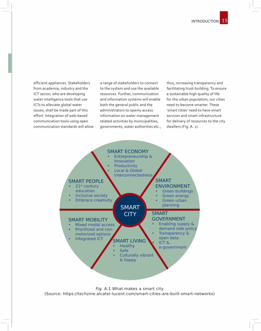
thus, increasing transparency and facilitating trust-building. To ensure a sustainable high quality of life for the urban population, our cities need to become smarter. These ‘smart cities’ need to have smart services and smart infrastructure for delivery of resources to the city dwellers (Fig. A. 1).
SMART CITY
SMART MOBILITY• Mixed modal access• Prioritized and non-
motorized options• Integrated ICT
SMART PEOPLE• 21st century
education• Inclusive society• Embrace creativity
SMART ECONOMY• Entrepreneurship &
Innovation• Productivity• Local & Global
interconnectedness
SMART LIVING• Healthy• Safe• Culturally vibrant
& happy
SMART ENVIRONMENT• Green buildings• Green energy• Green urban
planning
SMART GOVERNMENT• Enabling supply &
demand side policy• Transparency &
open data• ICT &
e-government
Fig. A.1 What makes a smart city (Source: https://techzine.alcatel-lucent.com/smart-cities-are-built-smart-networks)

16 Urban Water SyStemS
a.2. the aPProach
Fig. A.2 gives the overview of the approach to be adopted by the collaboration. A brief strategy is described below to overcome the challenges.• Urban water service will
be ensured with proper management of water supply and distribution by implementing smart water management through ICT. Leaking systems will be detected through sensor networks and repaired with a high priority to avoid wastage of water. Waste water treatment shall be done at the sub-zonal level, and the recycled water is introduced back into the system. Groundwater level monitoring sensors along with the groundwater extraction measuring devices shall be installed to keep track of the use of ground water and its levels.
• A “no-flooding scenario” can be developed by analysing the precipitation patterns, studying the existing drainage
network and hydrology of the catchment. A dense network of rainfall and run-off sensors shall be installed. Data from the sensors can be integrated with a hydrologic model to obtain vulnerable areas of flooding. Structural and non-structural measures shall be proposed and implemented to avoid flooding.
• Climate change is likely to affect the short duration rainfall intensities that contribute to urban flooding. Therefore, implications of short duration rainfall intensities will be considered while designing and testing urban drainage systems.
• The ecology of lakes and rivers, lost to urban encroachment, shall be restored.
• Urban water management is encompassed by a diverse group of institutions and stakeholders, including property developers and households that invest in green
Rapid urbanization, inadequate infrastructure and the indifference of civic bodies challenge the urban water management system. These factors are further exacerbated by the impacts of climate change and other environmental issues straining water management in cities.
roofs or buy water-efficient appliances. Stakeholders from academia, industry and the ICT sector, who develop water intelligence tools that use ICTs to alleviate global water issues, shall be made part of this effort.
• Integration of web-based communication tools using open communication standards will allow a range of stakeholders to connect to the system, and use available resources.
• At the same time, communication and information systems will enable both the general public and administrators to access relevant information, bringing transparency to water management-related activities by water boards, municipalities, governments etc.
• A website shall be created giving the entire information about the details of water management implemented and ICTs.

17THE APPROACH
1. Identification of Study area
2. Formulation of problem
3. Identification of ICT tools
4. Implementation of proposed framework
5. Policy development
6. Monitor and evaluation
7. Delivery of solutions
8. Participation of stakeholders
Fig. A.2 Overview of the Approach
18 Urban Water SyStemS
a.3. urBan Water Issues and management
Water management in urban areas has been a great challenge to the scientific and administrative community. The following sub-section discusses the issues of urban flooding, water quality and quantity and tentative mitigation or adaptive measures.
a.3.1. urBan floodIng
Flooding in cities is a major concern over the world. Detailed study of the problems associated with urban areas is required to manage floods.
A.3.1.1. Efforts to reduce flood extent and increase storm water carrying capacity
Towns and cities are frequently located adjacent to rivers. The flood plain of a river stores and subsequently releases flood water, thus attenuating flood as it travels downstream. As cities expand there is increasing pressure to build in river floodplains. The increasing use of floodplains for urban development has led to an engineered disconnection of the river from its floodplain. This results in a loss of flood attenuation and
increases flood risk downstream. To reverse the effect, flood plains can be recreated. For example, in Europe, levels of flood protection for some German cities decreased significantly due to development in the floodplains of the Rhine. Active efforts have been made in recent years to recreate floodplain storage (Wheater, 2006). Such effort needs to be carried out at other places where flooding is a concern.Another common cause for
flooding is insufficient capacity of the storm water drains. Choked drains and increase in storm run-off cause water accumulation. A detailed adequacy analysis of the storm water networks needs to be carried out so as to identify areas vulnerable to flooding. Structural and non-structural measures are proposed to avoid accumulation of water. Powerful sensing systems can be deployed to check the blockages in the storm water network.

19
A.3.1.2. Land use/land change
Replacement of green fields with urban development has direct and indirect effects. The construction of impermeable surfaces result in rapid overland flow that bypasses the natural infiltration and attenuation of the subsurface. Because of this, storm run-off volumes increase and the response times decrease, leading to a potential increase in flood peaks.
Figure A.3 shows the variation in land use patterns, obtained using remote sensing data, in Greater Bangalore, one of the largest cities in South India. It shows the gradual increase in built-up area, and decrease in vegetation and water bodies, over the period from 1973-2006.
Excess water flow is conventionally collected in storm drains and channelled to the nearest water bodies. However, due to excessive urbanisation and diminishing vegetation and water bodies, storm water drainage has become a major issue in urban areas. A sustainable urban area needs to be developed so as to ensure natural hydrologic behaviour of the catchment (Fig. A.4).
Fig. A.3 Temporal landuse changes in Greater Bangalore
(Source: Ramachandra and Uttam, 2009)
Natural water balance Urban water balance
Sustainable urban water balance
Fig. A.4 Sustain-able urban systems (Source: http://wa-
terbydesign.com.au/whatiswsud/)
URBAN WATER ISSUES AND MANAGEMENT

20 Urban Water SyStemS
A.3.1.3. Urban heat island (UHI) effects
The notable and well documented urban–rural difference is the increase in air temperature in urban areas, called the urban heat island (UHI) effect. The main causes of the UHI is modification of the land surface by urban development which uses materials that effectively retain heat (Fig. A.5), and waste heat generated by energy usage. Research has shown that the UHI intensity is strong on clear and windless nights
and exhibits diurnal and seasonal variations (e.g., Montavez et al. 2000; Morris et al. 2001; Kim and Baik 2002).
Urbanisation also influences local precipitation. Main possible causes for urban-induced changes in precipitation are mechanical turbulence resulting from increased surface roughness, the addition of sensible heat from the urban warm air and the anthropogenic
condensation nuclei floating in the urban air. Chandler (1965) showed that precipitation anomalies have been found to exist within and around cities, in particular, precipitation tends to increase downwind of an urban heat island (Changnon, 1981). A detailed research shall be carried out to understand the UHI effects on precipitation patterns in the study area.
Fig. A.5 Urban Heat Island (UHI) effects (Source: http://cimss.ssec.wisc.edu/climate change/globalCC/lesson7/UHI2.html)

21
a.3.2. Water QualIty and QuantIty
Ground water seepage is less in urban areas compared to other areas. High imperviousness alters the base flows of streams and increases the volume of surface run-off. Run-off from streets carries pollutants, heavy metals and other contaminants from automobiles. This deteriorates the quality of water in sources like lakes and rivers. Very often, treated/untreated sewage gets mixed with the storm water. Dissolved oxygen levels reduce and pollutants like nitrates, phosphorus, chemicals, coliform and other bacteria increase.
Groundwater and surface water can be contaminated from many other sources like garbage dumps, toxic waste, chemical storage and use areas, leaking fuel storage tanks and intentional dumping of hazardous substances. Non-point source pollution seeping into aquifers deteriorates the quality of ground water as well.
Handling pollution is one of the most critical challenges in urban water systems. With advances in science and technology, one can manage this problem better. Solutions involve finding sustainable ways for urban areas
to reduce the amount of polluting substances used and the amount of pollutants produced, and to properly treat pollutants and reduce contamination of soil, water, or air.
Preventing pollution in urban areas is often largely a public relations task. People need to be educated about proper ways to dispose waste. Showing each other where waste goes and the problems it can create in our watersheds is an effective way to get the message across. Detailed rules and regulations must be in place in order to reduce the amount of pollutants contaminating our watersheds. Also the reservoirs and lakes need to be rejuvenated to improve water quality with respect to physico-chemical and biological aspects.
Availability of freshwater is limited. Approximately 10% of the available freshwater is used for domestic water supply in urban areas and the demand is expected to double by 2050. By 2025, 1.8 Billion people will be living in countries or regions with absolute water scarcity (Fig. A.6), and two-thirds of the world population could be in regions
under water stress condition.
In addition to the scarcity of water from natural sources, leakages and illegal connections affect water availability. Service providers lose large volumes of water (approximately 32 billion cubic meters per year) to leaks in the distribution system. Illegal connections or shortcomings in water billing account for loss of another 16 billion cubic meters per year (Kingdom et al., 2006).
The difference between the amount of water that goes into the distribution system and the amount that eventually reaches and is billed to the customer is referred to as non-revenue water. The cost of non-revenue water to utilities is estimated at US$141 billion per year worldwide (Kingdom et al., 2006). Reducing such losses can help extend urban water supply coverage and ease pressure on water resources. This can be implemented by smart metering in the pipe networks. Also sensors for sensing the pipe leakages can be placed in the pipe distribution system within the cities.
URBAN WATER ISSUES AND MANAGEMENT

22 Urban Water SyStemS
Fig. A.6 Water scarcity (Source http://www.fewresources.org/water-scarcity-issues-were-running-out-of-water.html)

23
a.3.3. condItIonIng groundWater
Groundwater is important for providing the main water supply, and is intensively over exploited for domestic, commercial and industrial use in urban areas. Urbanization has major impact on aquifer beneath cities (Fig. A.7) due to import of large quantities of water, modifications of drainage patterns and extensive use of ground for effluent discharge and waste disposal. The consequences include problems like aquifer depletion, saline intrusion, land
subsidence etc. Land subsidence refers to the lowering of ground surface due to excessive pumping of groundwater, especially due to shrinking of sedimentary layers. It has serious implications on urban flooding as the ground levels are lowered and drainage with gravity becomes difficult. In Jakarta, (Hasanuddin et al., 2009) Indonesia, subsidence ranging from 20 to 200 cm is observed over the period of 1982–1997. In general the land subsidence exhibits spatial
and temporal variations, with the rates of about 1 to 15 cm/year. A few locations can have subsidence rates up to about 20-25 cm/year. Over exploitation of groundwater with consequent lowering of piezometric levels cause land subsidence in many big cities around the world. The extremely flat and low-lying nature of the terrain, together with differential ground subsidence, renders the region very susceptible to excessive flooding.
Fig. A.7 Deep groundwater flow beneath cities (Source : https://www.bgs.ac.uk/downloads/start.cfm?id=129)
URBAN WATER ISSUES AND MANAGEMENT

24 Urban Water SyStemS
a.4. clImate change
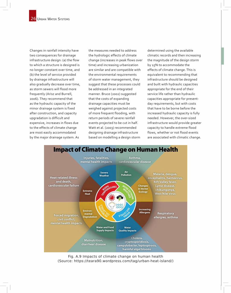
As the average global temperatures rise (Fig. A.8), extreme weather conditions of droughts and floods are becoming common (IPCC, 2012). The impact of climate change is increasingly important for the design, construction, and maintenance of water sector infrastructure. For example, in drought-hit urban areas, lower precipitation is met by an increasing demand, severely impacting fresh water sources such as lakes and rivers. Moreover, the frequency and intensity of the precipitation is likely to change in future. Climate change will alter the intensity, duration and return periods of precipitation events rendering current infrastructure inadequate. There is an increase in awareness of human health as well, due to the change in climate (Fig. A.9).
Changes in weather patterns, increasing climate variability and anticipated increases in weather extremes are expected to affect hydrologic conditions and the hydrologic responses of watersheds. The exact nature of likely variation in the rainfall intensities will depend on a large number of factors, including the
geographic location and local climate of the city. It has also been established that the heat island effect caused by concrete and other heat-absorbing materials that cities are made of will enhance the rainfall intensities in the locations surrounding the urban areas (Fig. 5). The cumulative effects of gradual changes in hydrology due to climatic change are expected to alter the magnitude and frequency of peak flows over the service life of drainage infrastructure. Potential future changes in rainfall intensity are expected to alter the level of service of drainage infrastructure, with increased rainfall intensity likely resulting in more frequent flooding of storm sewers and surcharging of culverts. A rise in sea-levels can lead to coastal inundation and decreased drainage capacities. Thus, increased flooding due to climate change, severely affects the quality of the water supply, impacting human health adversely (Fig. A.9).
High amounts of waste and greenhouse gas emissions add to the growing threats to water resources, increasing treatment
There is an increasing scientific consensus based on currently available evidence that anthropogenic activities have changed the composition of the atmosphere leading to an increase in mean global temperature and alteration of meteorological processes that define climate.
requirements for extracting safe water. With two-thirds of the world’s megacities located in regions that are vulnerable to the impacts of climate change, urban water utilities are facing an increasing need to improve the management of water resources and associated infrastructure. Alternate sources of water supply, namely, construction of new storage facilities, appropriate and sustainable extraction of groundwater, water trading or conservation, and the use of recycled water will become important in better management.
The quantification of the effects of climate change is primarily based on the results of computer simulations of General Circulation Models (GCMs) for various scenarios based upon a number of assumptions regarding the future discharge of greenhouse gasses into the atmosphere. While GCM performance with respect to global temperature is impressive, precipitation effects are not simulated as well. There are significant inconsistencies between GCMs with respect to not only the magnitude of change, but in some

25
cases, also the direction. Direct outputs of precipitation from GCMs are not generally considered reliable, and hence there has been a considerable research effort to improve the estimation
of precipitation with respect to the future climate by developing dynamical and statistical downscaling methods. In dynamical downscaling, GCMs are used to provide the boundary conditions
for smaller scale regional climate models. In statistical downscaling (e.g. Wilby et al. 1998), statistical relationships are developed between the more reliable outputs of GCMs and station precipitation.
a.4.1. adaPtIve desIgn and mItIgatIon
Climate change impact studies related to urban areas have focused generally on flood risk or water supply rather than storm water drainage. The wide range of predictions from climate change scenarios based on different assumptions result in a significant uncertainty, which limits the value of these predictions to storm water management policy definition and planning. Semadeni-Davies
et al. (2005) however concluded that despite the presence of uncertainties, using a number of climate change and urban drainage scenarios can be used to identify the direction of possible impacts and the thresholds of discontinuous responses with respect to urban drainage systems. Approaches commonly used to select appropriate values of rainfall in design of urban infrastructure
such as IDF curves, historic design storms and synthetic design storms are based on historic climate data and an assumption that there will be no change in climate over the project life. In the face of climate change, the validity of this assumption is questionable. Storm drainage systems must also be designed and operated for greater uncertainty.
Fig. A.8 Projected increase in temperatures by 2025 (Source : Revi et. al., 2014)
CLIMATE CHANGE
26 Urban Water SyStemS
Changes in rainfall intensity have two consequences for drainage infrastructure design: (a) the flow to which a structure is designed is no longer constant over time, and (b) the level of service provided by drainage infrastructure will also gradually decrease over time, as storm sewers will flood more frequently (Arisz and Burrell, 2006). They recommend that as the hydraulic capacity of the minor drainage system is fixed after construction, and capacity upgradation is difficult and expensive, increases in flows due to the effects of climate change are most easily accommodated by the major drainage system. As
the measures needed to address the hydrologic effects of climate change (increases in peak flows over time) and increasing urbanization are similar and are compatible with the environmental requirements of storm water management, they suggest that these processes could be addressed in an integrated manner. Bruce (2002) suggested that the costs of expanding drainage capacities must be weighed against projected costs of more frequent flooding, with return periods of severe rainfall events projected to be cut in half. Watt et al. (2003) recommended designing drainage infrastructure based on modelling a design storm
determined using the available climatic records and then increasing the magnitude of the design storm by 15% to accommodate the effects of climate change. This is equivalent to recommending that infrastructure should be designed and built with hydraulic capacities appropriate for the end of their service life rather than hydraulic capacities appropriate for present-day requirements, but with costs that have to be borne before the increased hydraulic capacity is fully needed. However, the over-sized infrastructure would provide greater capacity to handle extreme flood flows, whether or not flood events are associated with climatic change.
Fig. A.9 Impacts of climate change on human health (Source: https://teara90.wordpress.com/tag/urban-heat-island/)

27
a.5. smart Water management
As discussed in the preceding sections, there are multiple hurdles in effective implementation of these provisions. Accelerated urbanization, especially in the developing world puts a pressure on the resources. Increasing concerns for water security in the
face of climate change and ageing infrastructure is another challenge. In today’s integrated global economy, innovations in telecommunications have created a valuable opportunity to manage water better within cities (Fig. A.10).
Water management in urban areas has many challenges. We need to develop resources and build environment and manage public demand for water in a cost effective way to ensure easy access to water, sanitation infrastructure and services. At the same time, pollution in the storm run-off need to be monitored as well as measures to reduce the pollutants need to be taken care.
Recognizing the challenges faced by the water sector, stakeholders from academia, corporations and the Information and Communication Technology (ICT) sector have developed water intelligence tools that use ICTs to facilitate solving global water issues.
Fig. A. 10 Advantages of smart water management (Source: Berstet al., 2013)
SMART WATER MANAGEMENT

28 Urban Water SyStemS
ICTs offer a valuable opportunity to improve water management and help us find ways to use this natural resource sustainably by enabling continuous real-time monitoring of water. These help urban water managers make improvements in modelling and problem diagnostics, leading to well maintained and optimized water distribution network.
The increasing availability of intelligent, ICT-enabled means to manage and protect the planet’s water resources has led to the development of smart water management (SWM). The SWM approach aims at sustainable consumption of water resources through co-ordinated water management, by integrating ICT products, solutions and systems, by maximizing the socio-economic
welfare of a society without compromising the environment. In urban areas, SWM strives to achieve three main goals through the utilization of ICTs, viz: co-ordinated water resource management and distribution, enhanced environmental protection, and sustainable provision of public services and economic efforts.
SWM tools can be categorized in six main areas (Fig. A.11):I. Data acquisition and integration (e.g. sensor networks, smart pipes, smart meters).II. Data dissemination (e.g. wireless fidelity (Wi-Fi), Internet).III. Modelling and analytics (e.g. geographic information system (GIS), Mike Urban).IV. Data processing and storage (e.g. software as a service (SaaS), cloud computing).V. Management and control (e.g. supervisory control and data acquisition (SCADA), optimization tools).VI. Visualization and decision support (e.g. web-based communication and information systems tools).
Data acquisition
and integration
ModellingData
processing and
storage
Management and
control
Data dissemina-
tion
Visualisation and decision
support
Fig. A.11 Schematic representation of smart water management technologies and tools
29
a.5.1. data acQuIsItIon and IntegratIon
The data is collected from the sensors networks installed in the water distribution network i.e. from smart pipes, smart meters etc. This data from the sensors is integrated and processed.
A.5.1.1. Smart pipes and sensor networks
Smart pipes comprise of multifunctional sensors that provide operators with continuous monitoring and inspection features. They can measure flow, temperature and pressure, as well as quality. Connecting the smart pipes with a wireless processor and antenna enables data to be transferred directly to a command centre, enabling water managers to detect and locate leaks in real time. Wireless sensor networks provide technology for cities to accurately monitor and control water supply systems intricately using different parameters. Examples
include sensors with the ability to analyse the acoustic signature of a pipe or to monitor soil moisture and detect leaks. ICT companies are developing a wide range of sensors specifically designed for water networks. Some smart sensors can detect very low flow rates of the order of 5 liters/minute, enabling early-leak detection and thus reducing the risk of pipe break. The system reports pipe flow measurement data with pressure and acoustic measurement, combines this information to GIS data and sends automatic alerts to identify the location of possible leaks, thus
allowing the prioritization of repair work.
Sensors can also be incorporated to assess the water quality of surface water and treated sewage within cities. In situ smart sensor networks are being utilized to improve water resource and waste water management. They can perform online measurement of fundamental parameters of water quality including pH, conductivity, dissolved oxygen, turbidity, ammonia, phosphorus, nitrate, chemical oxygen demand (COD) and metal ions, etc.
A.5.1.2. Smart metering
Smart meters are electronic devices with Advanced Metering Infrastructure (AMI). Such meters can be used to measure heat, gas and water consumption. In the case of water consumption, smart meters typically consist of an embedded controller that interfaces with a metering sensor, a wireless transmitter, communication extension and a battery. The meters are connected to a network of data loggers. This allows for the continuous
monitoring of water consumption in a city. The innovative smart meters enable a two-way communication between the meter and a central system. Data can be transmitted through different channels as in radio communication, power line, Internet or telephone. Smart meters typically collect consumption data, and then transmit this data to a gateway that interfaces with the local area network (LAN), home area network (HAN) or wide area network (WAN).
Since the deployment of smart meters within an urban infrastructure enables remote access to consumption data, it can significantly improve meter reading and billing, detection of leaks, illegal connections, tamper alerts, and can enable water utilities to provide clear information about water consumption. It can help customers track and control their water usage and identify savings on their bills. Fig. A.12 illustrates an example of AMI infrastructure and SWM capabilities.
SMART WATER MANAGEMENT

30 Urban Water SyStemS
Fig. A.12 Smart meter technologies (Source: Alliance for Water Efficiency, 2014)
a.5.2. data dIssemInatIon
Communication solutions include Bluetooth, Wireless communication, global system for mobile communications/general packet radio service (GSM/GPRS) and Ethernet. Communication allows remote reading of sensors and meters by direct transfer of real-time or time-stamped data to
the central management system of the utility or water authority. The data is then made available online for customer information system, geographic information systems (GIS) and data management tools, enabling decision-making within the system. Such communication devices with smart meters and
sensors can also provide alerts to authorities (e.g. leak alerts, water quality alarms). Most of these types of communication solutions ensure spatial redundancy and enable a wide range of coverage between distant buildings, housing estates, and other districts.

31
a.5.3. modellIng and analytIcs
Model based water management improves the efficiency of water supply system and reduces the operational cost of the global water supply through comprehensive modelling applications. These modelling software incorporate processes observed in the real world (e.g. through equations, algorithms and scenarios) and contain various data reporting and visualization tools for interpreting results from water distribution piping systems, water quality monitoring data, and waste water
management systems. Multiple models such as Mike Urban, Aquacycle, AISUWRS and UGROW have been used by urban water managers.
Geographic information systems (GISs) allow water managers to capture, manage, analyse and display geographical information useful in decision-making. GIS allows visualization and analysis of water resources and human activity data by linking geographic information with descriptive
information. This is highly valuable to urban water management in assessing water quality and day-to-day operations on a local and regional scale. Other issues such as flooding can also be mitigated by the use of geographical information, by helping to identify critical areas that are at risk. This is necessary in the development of hazard maps, as well as in the planning of emergency responses. GIS utilization offers more robust analysis, increased efficiency and reduced costs.
SMART WATER MANAGEMENT
a.5.4. data ProcessIng and storage
Data processing and storage of data from the sensors is performed by cloud computing. Cloud computing uses computing power which is outside the boundary of a user’s own infrastructure. Cloud environments typically monitor and manage computing without
human involvement. They need broad network access to allow computing services to be delivered and access over several networks and heterogeneous devices. This technology has the ability to scale up or down computational resources swiftly as needed,
share resources across multiple applications and track applications/tenants for billing purposes. However issues like data privacy, security and ownership have to be clearly validated by the cities prior to any massive deployment of Cloud computing solutions.

32 Urban Water SyStemS
Fig. A.13 Example of SCADA software, Western Municipal Water District (WMWD), California (Source: Automation World, 2014)
a.5.5. management and control
Supervisory Control And Data Acquisition (SCADA) consists of multiple computer controlled systems that have a variety of communication systems and play a major role in water management systems. It allows monitor and control of water treatment and distribution, as well as waste water collection and treatment.
The system allows for supervision through data acquisition and management, and has the ability to process and send commands within the system. In some cases, SCADA systems include optional modules on modelling or optimization, thus going beyond their native functionality. Globally speaking SCADA systems have
contributed to reducing operating costs of utilities and have improved water distribution to households, businesses and industry. The monitoring and control functionalities of SCADA systems can help utilities to protect their infrastructure and prevent severe degradation (Fig. A.13).
33
a.5.6. WeB-Based communIcatIon and InformatIon system tools
Management of Information is becoming increasingly important for the effective management of water resources. A key problem faced is the existence of a large body of complex, unstructured and fragmented data from the sensors. Web-based interfaces and online platforms provide a solution to enable the effective management, display, and retrieval of relevant information required by water managers. Figure 11 provides an example of the role web-based technologies play in city-based flood maps. Web-based servers offer access to integrated
information from heterogeneous data sources and provide innovative tools for the analysis and assessment of issues such as climate change, water scarcity, sanitation and urbanization. The integration of such web-based communication tools using open communication standards allows a range of stakeholders to connect to the system, and use available resources.
It is also possible for the general public and administrators to access relevant information. This enables transparency and visibility
of water related activities mainly carried out by specialist users, and enhances trust-building and public/stakeholder involvement.
Web-based communication and information system tools are used by governments and municipalities to deliver relevant water information to the public and to provide early warnings whenever necessary. They also allow urban water managers to access relevant information such as rainfall data, storage and distribution, thus helping decision-making processes at multiple levels.
SMART WATER MANAGEMENT

34 Urban Water SyStemS
a.6. outreach
As a part of this proposal, training programmes shall be conducted to train engineers from government bodies and NGOs (from the developing world) engaged in water resources planning and operation. They are trained on all aspects of water resources,
including water quantity, hydrology, water treatment (& recycling), groundwater recharge, climate change impacts and adaptation. The training could also introduce the participants to recent tools and sensitise them on latest methodologies. Workshops/schools
shall be conducted targeting an array of stakeholders including decision makers comprising local municipalities, city development authorities, and disaster management officials.

35
a.6. outreach
Arisz, H. and Burrell, B. C. (2006). Urban drainage infrastructure planning and design considering climate change. EIC Climate Change Technology, IEEE. doi: 10.1109/EICCCC.2006.277251
Berst, J., Enbysk, L., and Williams, C. (2013), Smart Cities Readiness Guide: The Planning Manual for Building Tomor-row’s Cities Today, Smart Cities Council.
Bruce, J. P. (2002). Climate Change Effects on Regions of Canada. Prepared for the Federation of Canadian Urbani-ties, Global Change Strategies International, Ottawa.
Chandler, T. (1965). The Climate of London. Hutchinson, London.
Changnon, S. A., Ed. (1981). METROMEX: A Review and Summary. Meteor. Monogr., 40, Amer. Meteor. Soc., pp. 181.
Chandra Rupa, R., Ujjwal Saha and Mujumdar, P.P., (2015) Model and Parameter Uncertainty in IDF Relationships under Climate Change, Advances in Water Resources Vol. 79, 127-139.
Engel,K., Dorothee Jokiel, Andrea Kraljevic, Martin Geiger, Kevin Smith, Big cities. Big water. Big challenges, WWF report, 2011.
Hasanuddin Z. Abidin, H. Andreas, I. Gumilar, M. Gamal, Y. Fukuda, T. Deguchi (2009) Land Subsidence and Urban Development in Jakarta (Indonesia), 7th FIG Regiona Conference Spatial Data Serving People: Land Governance and the Environment - Building the Capacity Hanoi, Vietnam, 19-22 October 2009.http://www.allianceforwaterefficiency.org/smart-meter-introduction.aspx
http://www.automationworld.com/sites/default/files/styles/lightbox/public/field/image/120723scada_web.png?itok=IlXV7wPd
IPCC (Intergovernmental Panel on Climate Change). Manageing the Risks of Extreme Events and Disasters to Ad-vance Climate Change Adaptation (CB Field CB, Barros V, Stocker TF et al. (eds)), 2012, Cambridge University Press, Cambridge, UK and New York, NY, USA.
Kim, Y.-H. and J.-J. Baik (2002). Maximum urban heat island intensity in Seoul. J. Appl. Meteor., 41, 651–659.
Kingdom, B., Liemberger, R., and Marin, P. (2006), The Challenge of Reducing Non-Revenue Water (NRW) inDevel-oping countries, Water Supply and Sanitation Sector Board Discussion Paper Series, Paper No. 8, December.
Min SK , Zhang X , Zwiers FW . Human contribution to more-intense precipitation extremes. Nature, 2011, 470, 378–381.
Montavez, J. P., Rodriguez, A. and Jimenez, J. I. (2000). A study of the urban heat island of Granada. Int. J. Climatol., 20, 899-911.
references
REFERENCES

36 Urban Water SyStemS
Morris, C. J. G., Simmonds, I. and Plummer, N. (2001). Quantification of the influences of wind and cloud on the noc-turnal urban heat island of a large city. J. Appl. Meteor., 40, 169–182.
Mujumdar, P.P., D. Raje, and Ujjwal Saha. (2009). Urban Flooding, Journal of Hydrological Research and Develop-ment, INCOH, Roorkee, Vol. 4.
Raju, K.V., S. Manasi and N. Lata, (2008) Emerging ground water crisis in urban areas –a case study ofward no. 39, Bangalore city, Working Paper 196, Institute for Social and Economic Change, Bangalore.
Ramachandra, T. V. and Uttam, K. (2009). Land surface temperature with land cover dynamics: multi-resolution, spatio-temporal data analysis of Greater Bangalore. International Journal of Geoinformatics, 5(3), 43-53.
Revi, A., D.E. Satterthwaite, F. Aragón-Durand, J. Corfee-Morlot, R.B.R. Kiunsi, M. Pelling, D.C. Roberts, and W. Solecki. (2014). Urban areas. In: Climate Change 2014: Impacts, Adaptation, and Vulnerability. Part A: Global and Sectoral Aspects. Contribution of Working Group II to the Fifth Assessment Report of the Intergovernmental Panel on Climate Change [Field, C.B., V.R. Barros, D.J. Dokken, K.J. Mach, M.D. Mastrandrea, T.E. Bilir, M. Chatterjee, K.L. Ebi, Y.O. Estrada, R.C. Genova, B. Girma, E.S. Kissel, A.N. Levy, S. MacCracken, P.R. Mastrandrea, and L.L. White (eds.)]. Cambridge University Press, Cambridge, United Kingdom and New York, NY, USA, 535-612.
Semadeni-Davies, A., Hernebring, C., Svensson, G. and Gustafsson, L. (2005). Development of climate and urban drainage scenarios for impact assessment for Helsingborg, southern Sweden. In Proc. 10th International Conference on Urban Drainage, August 21-26, 2005, Copenhagen, Denmark.
Stern NH . The Economics of Climate Change: The Stern Review, 2007, Cambridge University Press, Cambridge, UK.
Watt, W.E., Waters, D. and McLean, R. (2003). Climate Variability and Urban Stormwater Infrastructures in Canada: Context and Case Studies. Toronto-Niagara Region Study Report and Working Paper Series, Report 2003-1. Mete-orological Service of Canada, Waterloo, Ontario.
Wheater, H. S. (2006). Flood hazard and management: a UK perspective. Phil. Trans. R. Soc. A, 364, 2135-2145. doi: 10.1098/rsta.2006.1817.
Wilby, T. M. L. Wigley, D. Conway, P. D. Jones, B.C. Hewitson, J. Main, and D. S. Wilks (1998) Statistical downscaling of general circulation model output: A comparison of methods, Water Resources Research, 34, 11, 2995-3008.

