uncertainty in remote sensing of leaf area index and
TRANSCRIPT

Uncertainty in remote sensing of Leaf Area Index and foliage cover in Australian forests
26th August, 2014
William Woodgate
Contents
1. Background • Significance of topic
2. Objectives • Aims
3. Methods & Results • Part 1 (field study) method and results • Part 2 (simulation study) method and prelim results

Vegetation as the boundary layer
Vegetation Layer
Total Area (m2)
Leaf Area Index = Total one-sided leaf area (m2) / Total Area (m2)
Evapotranspiration CO2 O2

Australian Forests
DAFF (2008)
Distribution of Australia’s forests Remote Sensing Products

Australian forest traits and challenges
Some of the main factors when remotely sensing vegetation:
1.Clumping (at all scales)
2.Leaf Angle (distribution)
3.Impact of woody components
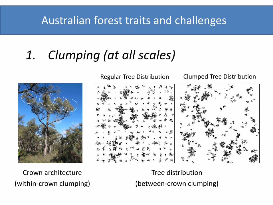
Australian forest traits and challenges
1. Clumping (at all scales)
Crown architecture (within-crown clumping)
Tree distribution (between-crown clumping)
Regular Tree Distribution Clumped Tree Distribution

Australian forest traits and challenges
2. Leaf Angle (distribution)
Vertical leaf angle (Eucalypt)
Horizontal leaf angle

Australian forest traits and challenges
3. Impact of woody components (i.e. leaf:woody ratio)
Upward-looking view of a canopy

Remote Sensing of LAI
LAI = f(canopy gaps, clumping, leaf & wood angle, leaf:wood ratio)

Part 1: Product Accuracy Requirements
• Need for accurate ground-based measurements in support of calibration/validation activities
Target Accuracies (products to match within ground-
based estimates)
± 0.5 LAI or 20% maximum (CEOS, GCOS)
5% (WMO 2013)

Main Research Questions/Themes
Part 1
Are there any significant differences between the ground-based instruments for estimating LAI?
Part 2
How accurately can you estimate LAI using these ground-based instruments?

Part 1: Field-based Investigation
Are there any significant differences between the
ground-based instruments for estimating LAI?
Following… • Best practise guidelines (where they exist) • Standard approach
Can only estimate uncertainty. Not accuracy!

Part 1 – Study sites & Instruments
Instruments
Terrestrial Laser Scanner
LAI-2200
High and Low Resolution Hemispherical Cameras

Part 1 – Instruments
Instrument Model (Manufacturer)
Angular resolution (degrees) FOV (degrees) H, V
Wavelength (nm)
LAI-2200 LAI-2200 (Li Cor Inc.) NA 300, 75 <490 High res DHP D90 (Nikon) 0.08 360, 90 400-700 Low res DHP CI-110 (CID Inc.) 0.26 360, 90 400-700 TLS VZ400 (Riegl) 0.06 360, 100 1550

Part 1 – Results
Woodgate et al., (2014) in review

Part 1 – Results
•A total of 67 method-to-method pairwise comparisons were conducted across 11 plots. •Out of 67 comparisons, 29 had an RMSE ≥ 0.5 LAIe.
HR-DHP
(S) HR-DHP
(AT) LR-DHP (S) LR-DHP
(AT) LAI-2200 TLS HR-DHP (S) - 11 6 6 3 6 HR-DHP (AT) 0.58 - 6 6 3 6 LR-DHP (S) 0.24 0.68 - 6 3 1 LR-DHP (AT) 0.23 0.51 0.33 - 3 1 LAI-2200 0.10 0.44 0.27 0.24 - 0 TLS 0.76 0.97 1.49 1.43 NA -
Bottom diagonal is the average of plot RMSE’s between instruments. Top diagonal is the number of plots where these instruments were compared.
Woodgate et al., (2014) in review

Part 1 – Results & Lessons learned
•Large uncertainties exist for these methods for LAI estimates following standard operational protocols for data collection What are the main causes of the differences? •DHP = exposure (radiometric sensitivity), lighting and sky background and conditions •TLS = combination of beam size, range/power, detection threshold, ranging method (phase vs ToF) & wavelength •LAI-2200 = assumption that all elements are ‘black’ when estimating transmittance

Part 2: Model-based Investigation
How accurately can you estimate LAI using these
ground-based instruments?
Aim Evaluate accuracy using a 3D reconstructed forest stand to simulate the instruments

Model parameterisation: creating the forest
• Rushworth Forest
5km

Model parameterisation: creating the trees

Model parameterisation: creating the forest
0.0
0.1
0.2
0.3
0.4
350 500 650 800 950
Refle
ctan
ce
Wavelength (nm)
Ground component
Vegetation component
Mixed ground and vegetation

Model parameterisation: creating the trees
Modelled structure of the trees in OnyxTree (no spectra or leaf template added)

Model parameterisation: creating the trees
Library of 51 trees (5 Eucalypt species) • First of its kind in Australian forests

Validation of the 51 tree models

Part 2 results: Within-crown clumping and Leaf Angle
Crown cover simulations
0 de
gree
vi
ew a
ngle
57
deg
ree
view
ang
le

Part 2 results: Within-crown clumping and Leaf Angle
y = 1.01x - 0.14 R² = 0.96
y = 1.01x - 0.05 R² = 0.97
0.0
0.2
0.4
0.6
0.8
1.0
0.0 0.2 0.4 0.6 0.8 1.0
Clum
ping
Clumping Erectophile
planophile
extremophile
1:1 line
y = 1.04x + 0.01 R² = 0.99
y = 1.03x + 0.00 R² = 0.99 0.0
0.2
0.4
0.6
0.8
1.0
0.0 0.2 0.4 0.6 0.8 1.0
Clum
ping
Clumping Erectophile
planophile
extremophile
1:1 line
0 degree view angle 57 degree view angle

Part 2 results: Within-crown clumping and Leaf Angle
Accounting for the woody components
Projection coefficient of leaves and wood

Part 2: Up-scaling from tree to plot to stand
Ongoing work…
Tree Plot Stand

Clumping Simulations
Regular Tree Distribution Clumped Tree Distribution

Exemplar stem distributions
Stem Density
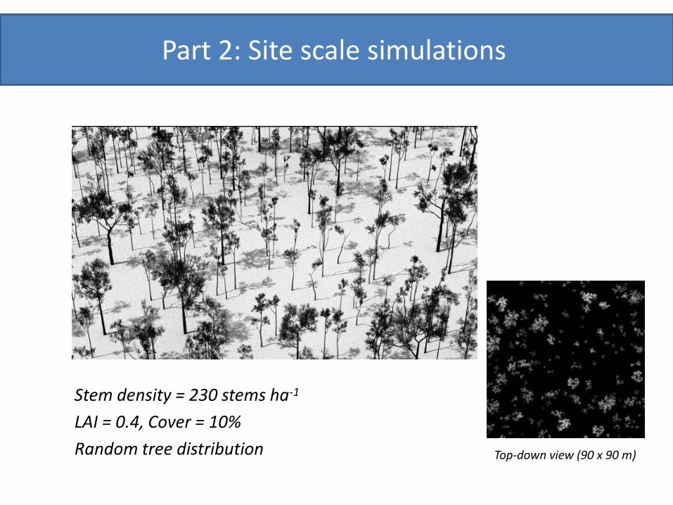
Part 2: Site scale simulations
Stem density = 230 stems ha-1 LAI = 0.4, Cover = 10% Random tree distribution Top-down view (90 x 90 m)

Part 2: Site scale preliminary results
Simulated hemi photo

Part 2: Example site simulations
Openness = 79% Reference LAI = 0.4
Openness = 65% Reference LAI = 0.8
Openness = 51% Reference LAI = 1.2

Questions?

Maybe to include…

Thanks to…
• Supervisory panel (Simon Jones, Lola Suarez, Michael Hill)
• Work colleagues (esp. CRC-SI 2.07 team – Simon Jones, Andrew Haywood, Lola Suarez, Phil Wilkes, Andrew Mellor, Mariela Soto-Berelov. Lab colleagues – Vaibhav Gupta, Laurie Buxton, Bill Langford, Barbara Rasaiah, James Leversha, Tapasya Arya. Staff –
Mark Shortis, Chris Bellman, Lucas Holden)
• Mentors (Wu Bingfang, Graeme Kernich)
• Research collaborators (John Armston, Mat Disney, Michael Schaefer)
• Friends and Family • ++

Selection of Research Outputs
Ground based method intercomparison (journal article) W. Woodgate, S. Jones, L. Suarez, M. J. Hill, J. D. Armston, P. Wilkes, M. Soto-Berelov, A.Haywood, A. Mellor (2014). Variability of ground-based instruments for estimating Leaf Area Index in diverse forest systems, Agricultural and Forest Meteorology (submitted)
Crown-scale modeling (journal article) W. Woodgate, S. Jones, L. Suarez, J. D. Armston, M. Disney, M. J. Hill, P. Wilkes, M. Soto-Berelov, A. Haywood, A. Mellor (2014). Within-crown clumping varying with leaf angle distribution, IEEE TGARS (In prep.)
TLS international collaboration effort (journal article) M. T. Schaefer, W. Woodgate, J. Armston, A. Strahler, M. Danson, C. Schaaf, G. Newnham (2014). TLSIIG – Leaf area index from foliage profiles derived from five terrestrial laser scanners: a comparison, Agricultural and Forest Meteorology, (In prep.)
TERN Greenbook (book chapter) Schaefer, M.T., Farmer, E., Soto-Berelov, M., Woodgate, W., & Jones, S. (2013). Validation of LAI and FPAR products. In M. Soto-Berelov, A. Held, S. Phinn & S. Jones (Eds.), AusCover Good Practice Guidelines: A technical handbook supporting calibration and validation activities of remotely sensed data products. http://data.auscover.org.au/xwiki/bin/view/Good+Practice+Handbook/WebHome
Sampling Design (peer reviewed conference paper) W. Woodgate, Soto-Berelov, M., Suarez, L., Jones, S., Hill, M., Wilkes, P., Axelsson, C., Haywood, A., Mellor, A. Searching for an optimal sampling design for measuring LAI in an upland rainforest. Proceedings of the Geospatial Science Research Symposium GSR2, December 2012, Melbourne. ISBN 978-0-9872527-1-5
Ground based methods and modelling introduction (peer reviewed conference paper) W. Woodgate, M. Disney, J. Armston, S. Jones, L. Suarez, M. Hill, P. Wilkes, M. Soto-Berelov, A. Haywood, A. Mellor, 2013. The impact of sensor characteristics for obtaining accurate ground-based measurements of LAI, IGARSS Melbourne, July 2013