ularring hematite project - epa wa document_rev6.pdf · ularring hematite project environmental...
TRANSCRIPT

Ularring Hematite Project Environmental Review Document – Rev6 June 2013
Macarthur Minerals Limited ULARRING HEMATITE PROJECT
ENVIRONMENTAL REVIEW DOCUMENT Rev 6 – June 2013 Page | i
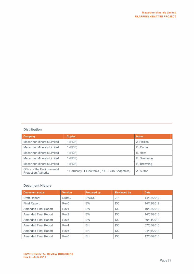
Distribution
Company Copies Name
Macarthur Minerals Limited 1 (PDF) J. Phillips
Macarthur Minerals Limited 1 (PDF) D. Carter
Macarthur Minerals Limited 1 (PDF) B. How
Macarthur Minerals Limited 1 (PDF) P. Svensson
Macarthur Minerals Limited 1 (PDF) R. Browning
Office of the Environmental Protection Authority 1 Hardcopy, 1 Electronic (PDF + GIS Shapefiles) A. Sutton
Document History
Document status Version Prepared by Reviewed by Date
Draft Report DraftC BW/DC JP 14/12/2012
Final Report Rev0 BW DC 14/12/2012
Amended Final Report Rev1 BW DC 19/02/2013
Amended Final Report Rev2 BW DC 14/03/2013
Amended Final Report Rev3 BW DC 30/04/2013
Amended Final Report Rev4 BH DC 07/05/2013
Amended Final Report Rev5 BH DC 04/06/2013
Amended Final Report Rev6 BH DC 12/06/2013

Macarthur Minerals Limited ULARRING HEMATITE PROJECT
ENVIRONMENTAL REVIEW DOCUMENT Rev 6 – June 2013 Page | i
Table of Contents
1.0 Introduction ............................................................................................................................... 1
1.1 Objectives of the EP Act and Principles of Environmental impact assessment ..................... 2
2.0 Defining the Proposal ............................................................................................................... 4
2.1 Proponent and Tenure ............................................................................................................ 4
2.2 Project Location ...................................................................................................................... 4
2.3 Summary of the Project ........................................................................................................... 4
2.4 Alternatives Considered .......................................................................................................... 6
2.5 Changes to the Project ............................................................................................................ 7
2.6 Spatial Data and Confidential Inforamtion .............................................................................. 8
3.0 Stakeholder Consultation ......................................................................................................... 9
4.0 Existing Environment ............................................................................................................. 13
4.1 Surrounding Landuses .......................................................................................................... 13
4.2 Regional Environmental Setting ............................................................................................ 13
4.3 Flora and Vegetation ............................................................................................................. 14
4.4 Fauna .................................................................................................................................... 14
4.4.1 Vertebrate Fauna – Project Area ...................................................................................................................... 14
4.4.2 Short Range Endemic Invertebrates ................................................................................................................. 15
4.4.3 Subterranean Fauna ......................................................................................................................................... 15
4.4.4 Rail Siding Area ................................................................................................................................................ 16
4.4.5 Introduced Fauna ............................................................................................................................................. 16
5.0 Environmental Baseline Studies ........................................................................................... 17
6.0 Environmental Factors ........................................................................................................... 25
7.0 Assessment of Key Environmental Factors ......................................................................... 31
7.1 Vegetation and Flora ............................................................................................................. 31
7.1.1 Discussion on the floristic values of the project area ......................................................................................... 31
7.1.2 Extension to previous vegetation mapping ........................................................................................................ 46
7.1.3 Saline water impacts ........................................................................................................................................ 48
7.2 Fauna .................................................................................................................................... 48
7.2.1 Malleefowl populations and habitat assessment ............................................................................................... 48
7.2.2 Terrestrial vertebrate fauna habitat assessment ............................................................................................... 51
7.2.3 Troglofauna ...................................................................................................................................................... 53
7.2.4 Stygofauna ....................................................................................................................................................... 54
7.2.5 Short Range Endemic Invertebrates ................................................................................................................. 54
7.3 Rehabilitation and Mine Closure ........................................................................................... 58
7.3.1 Waste rock characterisation.............................................................................................................................. 58
7.3.2 Waste dump design and management .............................................................................................................. 62
7.3.3 Rehabilitation objectives ................................................................................................................................... 63
7.4 Residual Impacts ................................................................................................................... 63
7.4.1 Potential residual impacts and environmental offsets ........................................................................................ 63

Macarthur Minerals Limited ULARRING HEMATITE PROJECT
ENVIRONMENTAL REVIEW DOCUMENT Rev 6 – June 2013 Page | ii
8.0 Assessment of Other Environmental Factors ...................................................................... 64
8.1 Water Supply ......................................................................................................................... 64
8.1.1 Water requirements .......................................................................................................................................... 64
8.1.2 Proposed water source ..................................................................................................................................... 64
8.1.3 Potential environmental impacts and management ........................................................................................... 69
8.1.4 Proposed alternatives ....................................................................................................................................... 70
8.2 Cumulative Impacts ............................................................................................................... 70
8.3 Other Regulatory Approvals .................................................................................................. 71
8.3.1 Environmental Protection and Biodiversity Conservation Act 1999 ................................................................... 71
8.3.2 Mining Act 1978 ................................................................................................................................................ 71
8.3.3 Aboriginal Heritage Act 1972 ............................................................................................................................ 71
8.3.4 Environmental Protection Act 1986 - secondary approvals ............................................................................... 71
8.3.5 Rights in Water and Irrigation Act 1914 ............................................................................................................. 72
9.0 Management and Committments........................................................................................... 73
10.0 References ............................................................................................................................... 79
Tables
Table 1: Key Proposal Characteristics .............................................................................................. 1
Table 2: Key Proposal Environmental Factors for Assessment ........................................................ 2
Table 3: Other Environmental Factors for Assessment .................................................................... 2
Table 4: Project Contact Details ........................................................................................................ 4
Table 5: Summary of Project Components ....................................................................................... 6
Table 6 Significant changes to the Project ....................................................................................... 7
Table 7: Summary of Project consultation with relevant stakeholders ............................................. 9
Table 8: Terrestrial Fauna species of conservation significance within the Project area (KLA 2011; Ninox 2012) ........................................................................................................................................... 15
Table 9: Timeline of environment studies completed for the Project .............................................. 18
Table 10: Summary of environmental studies completed for the Project’s environmental impact assessment ........................................................................................................................................... 20
Table 11: Summary of Environmental Factors and Proposed Management Outcomes .................. 26
Table 12: Literature review of flora and vegetation survey work conducted within the Project area 32
Table 13: Comparison of species recorded at Lake Giles (Nth Yerilgee) and surrounding ranges.. 35
Table 14: Species diversity of BIF and greenstone ranges including the greater Mount Manning region ........................................................................................................................................... 36
Table 15: Estimated population sizes of Priority flora in the Project area and surrounding MMS tenement area ....................................................................................................................................... 37
Table 16: ANOSIM R values for comparison between the three deposits and the Banksia arborea PEC at Sth Illaara .................................................................................................................................. 45
Table 17: Disturbance to mapped vegetation communities of the Project area ............................... 46
Table 18: Increase in area mapped for each vegetation community ................................................ 47
Table 19: Malleefowl ground survey area ......................................................................................... 49
Macarthur Minerals Limited ULARRING HEMATITE PROJECT
ENVIRONMENTAL REVIEW DOCUMENT Rev 6 – June 2013 Page | iii
Table 20: Summary of number of Malleefowl mounds and activity status recorded in the survey area ........................................................................................................................................... 50
Table 21: Summary of Malleefowl mounds occurring within the Project area and proposed disturbance areas .................................................................................................................................. 51
Table 22: Terrestrial vertebrate fauna habitat and potential Project disturbances ........................... 52
Table 23: Summary of SRE Survey Sites and Habitats .................................................................... 55
Table 24: SRE Likelihood Assessment Framework* ........................................................................ 55
Table 25: Summary of the distribution of SRE species ..................................................................... 56
Table 26: Classification of waste types* ............................................................................................ 60
Table 27: Test pumping summary ..................................................................................................... 68
Table 28: Bore details and pumping rates ........................................................................................ 68
Table 29: Prescribed Premises* for the Project ................................................................................ 72
Diagrams
Diagram 1: Example of LiDAR return showing known mound (circle) and false positives (black blotches) ....................................................................................................................................... 50
Figures
Figure 1: Regional Location Map
Figure 2: Local Project Setting
Figure 3: Project Layout Plan
Figure 4: Snark Area Layout Plan
Figure 5: Central Area Layout Plan
Figure 6: Banjo Area Layout Plan
Figure 7: Rail Siding Area Layout Plan
Figure 8: Regional Priority Flora Records
Figure 9: Priority Flora of the Snark Deposit Area and surrounds
Figure 10: Priority Flora of the Central Deposit Area and surrounds
Figure 11: Priority Flora of the Banjo Deposit Area and surrounds
Figure 12: Notable Taxa surrounding the Project Area
Figure 13: Regional Notable Taxa Records
Figure 14: Extent of Vegetation Mapping of the Project
Figure 15: Vegetation Mapping of the Snark Area and surrounds
Figure 16: Vegetation Mapping of the Central Area and surrounds
Figure 17: Vegetation Mapping of the Banjo Area and surrounds
Figure 18: Priority Ecological Communities in relation to the Project
Figure 19: Location of previous and existing Lake Giles PEC in relation to DEC survey quadrats
Figure 20: Malleefowl Ground Survey Areas of the Snark Deposit

Macarthur Minerals Limited ULARRING HEMATITE PROJECT
ENVIRONMENTAL REVIEW DOCUMENT Rev 6 – June 2013 Page | iv
Figure 21: Malleefowl Ground Survey Areas of the Central Deposit
Figure 22: Malleefowl Ground Survey Areas of the Banjo Deposit
Figure 23: Malleefowl Mounds by Survey in the Snark Deposit
Figure 24: Malleefowl Mounds by Survey in the Central Deposit
Figure 25: Malleefowl Mounds by Survey in the Banjo Deposit
Figure 26: Malleefowl Mounds by Status in the Snark Deposit
Figure 27: Malleefowl Mounds by Status in the Central Deposit
Figure 28: Malleefowl Mounds by Status in the Banjo Deposit
Figure 29: Malleefowl Mounds by Height
Figure 30: LiDAR Malleefowl Mound Records
Figure 31: Fauna Habitats of the Snark Deposit and surrounding areas
Figure 32: Fauna Habitats of the Central Deposit and surrounding areas
Figure 33: Fauna Habitats of the Banjo Deposit and surrounding areas
Figure 34: Troglofauna Records at the Snark Deposit
Figure 35: Troglofauna Records of the Central and Banjo Deposits
Figure 36: Prospective Troglofauna Habitat of the Project Area and surrounds
Figure 37: Stygofauna Sampling Locations
Figure 38: SRE Study Area and Habitats
Figure 39: SRE Sampling Locations
Figure 40: Soil Characterisation Sample Points of the Snark Deposit
Figure 41: Soil Characterisation Sample Points of the Central and Banjo Deposits
Figure 42: Project Groundwater Options
Appendices
Appendix 1: EPA-Prepared Scoping Guideline
Appendix 2: Checklist for Environmental Impact Assessments relating to terrestrial biodiversity
Appendix 3: Flora and vegetation survey of the Snark Deposit and surrounding area
Appendix 4: Flora and Vegetation Survey of the Central Deposit and surrounding area
Appendix 5: Flora and Vegetation Survey of the Banjo Deposit and surrounding area
Appendix 6: Targeted Priority Flora Survey
Appendix 7: Extension to Vegetation Mapping of the Project area
Appendix 8: Autumn Terrestrial Vertebrate Fauna Survey of the Snark Deposit
Appendix 9: Spring Terrestrial Vertebrate Fauna Survey of the Snark Deposit
Appendix 10: Targeted Malleefowl Survey of the Project area
Appendix 11: Targeted Survey for Malleefowl – Additional Areas
Appendix 12: Subterranean Fauna Pilot Study of the Project area
Appendix 13: Subterranean Fauna Baseline Survey of the Project area
Appendix 14: Troglofauna Habitat Assessment of the Project area
Macarthur Minerals Limited ULARRING HEMATITE PROJECT
ENVIRONMENTAL REVIEW DOCUMENT Rev 6 – June 2013 Page | v
Appendix 15: Short-Range Endemic Invertebrate Fauna Survey of the Project area
Appendix 16: Hydrological Baseline Assessment of the Project area
Appendix 17: Initial Assessment of Groundwater Availability of the Project area
Appendix 18: Hydrogeological Investigation of the Project area
Appendix 19: Groundwater Supply Assessment of the Project area
Appendix 20: Test Pumping Results of Potential Project Groundwater Supplies
Appendix 21: Waste Characterisation Studies of the Snark Deposit
Appendix 22: Appraisal of the Waste Characterisation Study of the Snark Deposit
Appendix 23: Mineralogical Assessment of Mine-Waste Samples
Appendix 24: Flora and Vegetation Survey of the Rail Siding Area
Appendix 25: Terrestrial Vertebrate Fauna Survey of the Rail Siding Area
Appendix 26: Short-Range Endemic Assessment of the Rail Siding Area
Appendix 27: Project Offsets Reporting Form
Appendix 28: EPBC Decision on Referral of the Project
Appendix 29: Notable Taxa Flora Survey
Appendix 30: Level 1 Flora and Vegetation Survey
Appendix 31: Flora and Vegetation Survey of Clark Hill Deposit
Appendix 32: Flora Species List
Macarthur Minerals Limited ULARRING HEMATITE PROJECT
ENVIRONMENTAL REVIEW DOCUMENT Rev 6 – June 2013 Page | vi
Abbreviations
/ per ACMC Aboriginal Cultural Material Committee AFP Acid formation potential AH Act Aboriginal Heritage Act 1972 Alt-UM Altered ultramafics AMD Acid and metalliferous drainage ANC Acid neutralisation capacity ANOSIM Analysis of Similarity API Assessment on Proponent Information BIF Banded Iron Formation DEC Department of Environment and Conservation (WA) DMP Department of Mines and Petroleum DoW Department of Water (WA) DRF Declared Rare Flora DSO Direct Shipping Ore EC Electrical conductivity EIA Environmental Impact Assessment EPA Environmental Protection Authority EP Act Environmental Protection Act 1986 EPBC Act Environmental Protection and Biodiversity Conservation Act 1999 EPSL Esperance Ports Sea and Land ER Environmental Review ESA Environmentally Sensitive Area Fe Iron GCA Graeme Campbell and Associates Pty Ltd GRM Groundwater Resources Management Pty Ltd ha hectare HIL Health Investigation Level HW Highly weathered IBRA Interim Biogeographic Regionalisation for Australia kL/day kilolitres per day km kilometres km2 kilometres squared LFA Landscape Function Analysis LiDAR Light Detection and Ranging m metre m3 metres cubed mAHD metres above Australian Height Datum mBGL metres below ground level mg/L milligrams per litre MIO Macarthur Iron Ore Pty Ltd ML Mega litres mm millimetres MMS Macarthur Minerals Limited MOC Mines Operations Centre Mt Million tonnes Mtpa Million tonnes per annum MW Mega watts NAF Non acid forming NAG Net acid generation NAPP Net acid producing potential NES National Environmental Significance NHMRC National Health and Medical Research Council P Priority PAF Potentially acid forming PAF-LC PAF – Low Capacity PEC Priority Ecological Community Project Ularring Hematite Project RIWI Act Rights in Water and Irrigation Act 1914 RL Relative level RO Reverse osmosis ROM Run of Mine

Macarthur Minerals Limited ULARRING HEMATITE PROJECT
ENVIRONMENTAL REVIEW DOCUMENT Rev 6 – June 2013 Page | vii
SEWPAC Department of Sustainability, Environmental, Water, Populations and Communities (Commonwealth)
SRE Short-Range Endemic TDS Total dissolved solids TGI Treppo Grande Iron Pty Ltd UCL Unallocated Crown Land WAM Western Australian Museum WC Act Wildlife Conservation Act 1950 WEPP Water Erosion Prediction Project

Macarthur Minerals Limited ULARRING HEMATITE PROJECT
ENVIRONMENTAL REVIEW DOCUMENT Rev 6 – June 2013
Page | 1
1.0 INTRODUCTION
The Ularring Hematite Project (the Project) is located in the Goldfields region approximately 450 km east-north-east of Perth, Western Australia (Figure 1). Macarthur Minerals Limited (MMS) manage contiguous mining tenements covering a total area of approximately 1,160 kilometres squared (km2) (Figure 2). The Project comprises all hematite/goethite mineralisation located within these tenements, including the iron ore from three individual deposits south of the Evanston Menzies Road. The Project involves the production of 2 million tonnes per annum (Mtpa) of beneficiated iron ore, which will be hauled by existing road and rail networks to the Port of Esperance for overseas export. The Project contains an estimated Mineral Reserve of approximately 42.95 Mt with a 13 year mine life.
The Project was formally referred to the Environmental Protection Authority (EPA) for assessment in accordance with Section 38(1) of the Environmental Protection Act 1986 (EP Act) on 31 May 2012. The EPA’s decision was Assessment on Proponent Information (API) – Category A and subsequently an EPA-prepared scoping document (Appendix 1) was provided to MMS on 12 October 2012 to assist in the preparation of an Environmental Review (ER) document.
In accordance with the EPA-prepared Scoping Guideline and the EPA’s Environmental Assessment Guideline No 1: Defining the Key Characteristics of a Proposal (EPA 2012), the Projects Key Proposal Characteristics are summarised in Table 1.
This document is provided to the EPA as the ER document required to complete the assessment of the Project under Section 38 of the EP Act.
Table 1: Key Proposal Characteristics
Summary of the Proposal
Proposal Title Ularring Hematite Project
Proponent Macarthur Minerals Limited
Short Description The proposal is to develop an open cut iron ore mine and associated infrastructure approximately 130 kilometres (km) west of Menzies and a rail siding approximately 8 km south of Menzies, in the Shire of Menzies.
Physical Elements
Element Location Proposed Extent Authorised
Proposal Area Refer to Figure 1 – 3 Up to 2,818 hectare (ha)
Mine Refer to Figure 3 – 6 Clearing not more than 232 ha within the Project Development Area
Infrastructure Refer to Figure 3 – 6 Clearing not more than 154 ha within the Project Development Area
Waste Rock Landform Refer to Figure 3 – 6 Clearing not more than 225 ha within the Project Development Area
Rail Siding Refer to Figure 7 Clearing not more than 32 ha within the tenement P29/1895
Operational Elements
Element Location Proposed Extent Authorised
Water Supply Refer to Figure 42 Clearing for water supply will be subject to a separate Clearing Permit once the source area has been confirmed.
The Scoping Guideline outlined a number of Key Environmental Factors considered relevant to the Proposal. These are summarised in and included in the scoping document provided as Appendix 1.

Macarthur Minerals Limited ULARRING HEMATITE PROJECT
ENVIRONMENTAL REVIEW DOCUMENT Rev 6 – June 2013
Page | 2
Table 2: Key Proposal Environmental Factors for Assessment
Key Environmental Factor
Factors that may be impacted
Information required in the ER document
Vegetation and Flora Vegetation communities, Priority Ecological Communities and Priority Flora
Literature Review of all previous flora work, including DEC studies Quantitative assessment of the Project’s impact on PECs and
vegetation associations Assessment of the local and regional significance of the PECs and
vegetation associations in the Project area Assessment of the potential impact on vegetation by the use of
saline water for dust suppression purposes
Fauna Conservation significant fauna
Survey for Malleefowl across the entire Project area (i.e. Light Detection and Ranging (LiDAR) technique) followed by ground-truthing
Quantitative assessment of the Project’s impact on the local Malleefowl population
Assessment of the local and regional significance of the Malleefowl population within the Project area
Define the terrestrial fauna habitats within the Project area based on vegetation associations
Troglofauna habitat assessment within the Project area Assessment of the Project’s impact on troglofauna species known
to occur within the Project area Short Range Endemic (SRE) habitat assessment within the rail
siding area Assess the probability of short range endemics being present
within the rail siding area Assessment of the potential impacts to SRE and styogfauna of the
Project area
Rehabilitation and Mine Closure
Surrounding ecosystem Description of the final landform design and locations of waste rock dumps
Predict the likely risk of acid and metalliferous drainage and proposed management measures
Proposed revegetation (closure) criteria, objectives and strategy
Residual Impacts Surrounding ecosystem Identification of potential residual impacts Consideration of offsets
Due to limited information that was available when the Project was referred to the EPA, the Scoping Guideline has requested further information on the Project’s water supply options, as well as any cumulative impacts resulting from the Project. The information required is summarised in Table 3 and included in (Appendix 1).
Table 3: Other Environmental Factors for Assessment
Other Environmental Factor
Factors that may be impacted
Information required in the ER document
Water Supply Groundwater dependant ecosystems and flora and fauna species
Demonstrate sufficient water supply for the Project Alternative options for water supply (should adequate groundwater
supply not be available)
Cumulative Impacts Surrounding region Address Projects contribution to cumulative regional impacts.
1.1 OBJECTIVES OF THE EP ACT AND PRINCIPLES OF ENVIRONMENTAL IMPACT ASSESSMENT
MMS has strived to meet all expectations of the environmental impact assessment (EIA) process by identifying key environmental factors, assessing alternatives to mitigate impacts, providing a sound assessment based on established scientific methods and EPA guidelines and communicating the results and potential impacts to all relevant stakeholders.

Macarthur Minerals Limited ULARRING HEMATITE PROJECT
ENVIRONMENTAL REVIEW DOCUMENT Rev 6 – June 2013
Page | 3
MMS has consulted extensively with all stakeholders in the region and formulated management and mitigation strategies where alternatives actions could not be undertaken. MMS’ responses to the EPA objectives are summarised in Table 11; Section 6.0. An assessment of environmental impacts was achieved through baseline surveys conducted over the past 24 months for:
Flora and vegetation Terrestrial fauna Short range endemic invertebrates Subterranean fauna Hydrogeological studies on local aquifers and groundwater abstraction Hydrological studies on the local catchment and potential of flooding Aboriginal heritage Mine waste characterisation Soil characterisation for rehabilitation.
All surveys were conducted in accordance with the following EPA Guidance and Position Statements:
Guidance Statements
No. 6 – Rehabilitation of Terrestrial Ecosystems No. 19 – Environmental Offsets No. 20 – Sampling of Short Range Endemic Invertebrate Fauna for Environmental Impact
Assessment in WA No. 41 – Assessment of Aboriginal heritage No. 51 – Terrestrial Flora and Vegetation Surveys for Environmental Impact Assessment in WA No. 54 – Consideration of Subterranean Fauna in Groundwater and Caves during Environmental
Impact Assessment in WA No. 54a – Sampling methods and survey considerations for subterranean fauna in WA No. 55 – Implementing best practice in proposals submitted to the Environmental Impact
Assessment Process No. 56 – Terrestrial Fauna Surveys for Environmental Impact Assessment in WA.
Position Statements
No. 2 – Environmental Protection of Native Vegetation in WA No. 3 – Terrestrial Biological Surveys as an Element of Biodiversity protection No. 7 – Principles of Environmental protection No. 8 – Environmental Protection in Natural Resource Management No. 9 – Environmental Offsets.
Through appropriate mitigation strategies and applying best-practice in environmental management, MMS consider the objectives of the EP Act with regard to the precautionary principle; the principle of intergenerational equity; the principle of the conservation of biological diversity and ecological integrity, and; the principle of waste minimisation, can be met without significant environmental impacts.
The EPA’s checklist for documents submitted for EIA on terrestrial biodiversity is included as Appendix 2.
Macarthur Minerals Limited ULARRING HEMATITE PROJECT
ENVIRONMENTAL REVIEW DOCUMENT Rev 6 – June 2013
Page | 4
2.0 DEFINING THE PROPOSAL
2.1 PROPONENT AND TENURE
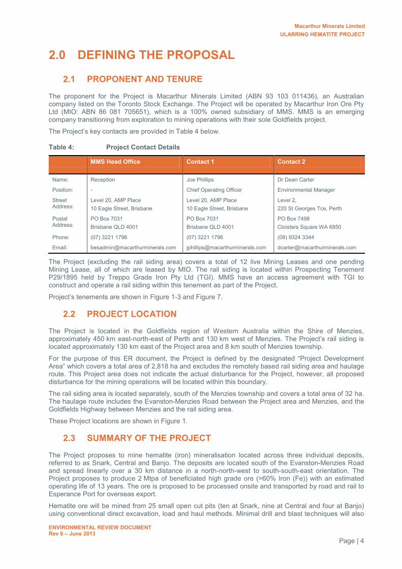
The proponent for the Project is Macarthur Minerals Limited (ABN 93 103 011436), an Australian company listed on the Toronto Stock Exchange. The Project will be operated by Macarthur Iron Ore Pty Ltd (MIO: ABN 86 081 705651), which is a 100% owned subsidiary of MMS. MMS is an emerging company transitioning from exploration to mining operations with their sole Goldfields project.
The Project’s key contacts are provided in Table 4 below.
Table 4: Project Contact Details
MMS Head Office Contact 1 Contact 2
Name: Reception Joe Phillips Dr Dean Carter
Position: - Chief Operating Officer Environmental Manager
Street Address:
Level 20, AMP Place 10 Eagle Street, Brisbane
Level 20, AMP Place 10 Eagle Street, Brisbane
Level 2, 220 St Georges Tce, Perth
Postal Address:
PO Box 7031 Brisbane QLD 4001
PO Box 7031 Brisbane QLD 4001
PO Box 7498 Cloisters Square WA 6850
Phone: (07) 3221 1796 (07) 3221 1796 (08) 9324 3344
Email: [email protected] [email protected] [email protected]
The Project (excluding the rail siding area) covers a total of 12 live Mining Leases and one pending Mining Lease, all of which are leased by MIO. The rail siding is located within Prospecting Tenement P29/1895 held by Treppo Grade Iron Pty Ltd (TGI). MMS have an access agreement with TGI to construct and operate a rail siding within this tenement as part of the Project.
Project’s tenements are shown in Figure 1-3 and Figure 7.
2.2 PROJECT LOCATION
The Project is located in the Goldfields region of Western Australia within the Shire of Menzies, approximately 450 km east-north-east of Perth and 130 km west of Menzies. The Project’s rail siding is located approximately 130 km east of the Project area and 8 km south of Menzies township.
For the purpose of this ER document, the Project is defined by the designated “Project Development Area” which covers a total area of 2,818 ha and excludes the remotely based rail siding area and haulage route. This Project area does not indicate the actual disturbance for the Project, however, all proposed disturbance for the mining operations will be located within this boundary.
The rail siding area is located separately, south of the Menzies township and covers a total area of 32 ha. The haulage route includes the Evanston-Menzies Road between the Project area and Menzies, and the Goldfields Highway between Menzies and the rail siding area.
These Project locations are shown in Figure 1.
2.3 SUMMARY OF THE PROJECT
The Project proposes to mine hematite (iron) mineralisation located across three individual deposits, referred to as Snark, Central and Banjo. The deposits are located south of the Evanston-Menzies Road and spread linearly over a 30 km distance in a north-north-west to south-south-east orientation. The Project proposes to produce 2 Mtpa of beneficiated high grade ore (>60% Iron (Fe)) with an estimated operating life of 13 years. The ore is proposed to be processed onsite and transported by road and rail to Esperance Port for overseas export.
Hematite ore will be mined from 25 small open cut pits (ten at Snark, nine at Central and four at Banjo) using conventional direct excavation, load and haul methods. Minimal drill and blast techniques will also

Macarthur Minerals Limited ULARRING HEMATITE PROJECT
ENVIRONMENTAL REVIEW DOCUMENT Rev 6 – June 2013
Page | 5
be required, where direct excavation cannot be achieved on solid, cap-rock materials. Mining is proposed to commence in the Snark deposit and then progress to the Central and Banjo Deposits.
Ore will be transported to one of two onsite Run of Mine (ROM) pads located within the Mine Operations Centre(s) (MOC). Ore delivered to the ROM pads will be fed into the processing plant and undergo crushing, screening and beneficiation. Final product will be subsequently stockpiled for offsite transport and blending (as required).
All waste products from the mineral excavation and processing activities will be stockpiled in designated waste dumps located across the Project area and adjacent to the pits. There are a total of 17 waste dumps proposed. However, where possible, waste rock from several pits will be consolidated into a single dump.
Two MOCs are proposed, although only one will be in operation at any time depending on the location of mining activity. All plant and equipment will be transportable and relocated between the Snark and Central MOCs when required. As the Snark deposit is proposed to be mined first, the northern MOC area will be initially constructed, followed by the southern MOC upon commencement of mining at the Central and Banjo deposits. Each MOC will also comprise administration, storage, workshops, maintenance and waste management facilities and support services including power generation, potable water and sewage treatment. A magazine facility for the storage of explosives has been designated at an appropriate distance from all operational and support services.
An accommodation camp will be located approximately 4 km south-east of the northern MOC to house the estimated 150 man workforce, including MMS staff, mine contractors and visitors. The camp will comprise sleeping quarters, messing, laundry, recreation, parking facilities and support services including power, sewage and potable water.
Saleable ore product will be hauled by road train along the Evanston-Menzies Road and Goldfields Highway to the rail siding near Menzies and stockpiled before being loaded onto rail and transported to the Port of Esperance.
The proposed locations of the mine pits, waste dumps and infrastructure are shown in Figure 4 – 6. Whilst the pits are unlikely to change, there is some flexibility in the location of waste dumps. The current locations have been designated in the most commonly recorded vegetation communities.
The major components of the Project are summarised in Table 5.

Macarthur Minerals Limited ULARRING HEMATITE PROJECT
ENVIRONMENTAL REVIEW DOCUMENT Rev 6 – June 2013
Page | 6
Table 5: Summary of Project Components
Element Description
Project Overview
Components Open pit, mine waste landforms, supporting infrastructure, rail siding
Mineral Resource Hematite / goethite – beneficiated ore
Processing Type Dry crushing and screening followed by beneficiation
Commencement Date Quarter two 2013 (construction), 2014 (mining)
Life of Project (mine production)
13 years
Mine and Support Infrastructure
Tenements 12 Mining Leases (11 live, one pending), one Prospecting Lease (live)
Mineral Reserve 42.95 Mt (probable) at 47% average grade (Fe)
Strip Ratio (waste:ore) 1.3 (average)
Ore Mining Rate 2 Mtpa
Depth of Mine Pit Between 40 to 85 metres below ground level (mBGL) (including height of ironstone hills)
Depth of Water Table Ranges between approximately 410 to 466 m relative level (RL)
Water Use 315 megalitres per year (ML/year) or 0.9 ML/day
Water Source Gwendolyn Gold Project (Vector Resources) groundwater supply
Road Haulage 130 km to rail siding, 112 tonne payload road trains
Mine Operations 24 hours, 365 days
Workforce 150
Area of Disturbance 611 ha
Rail Siding
Components Ore stockpiles, loading facility, supporting infrastructure
Area of Disturbance 32 ha
2.4 ALTERNATIVES CONSIDERED
The locations of the Banded Ironstone Formations (BIF) within the Project area limit the possible alternative locations of the mine footprint. The Snark, Central and Banjo deposits are the most advanced of the exploration targets to date and as such, form the targeted ore body for the Project.
Although the footprint of the open cut pits is limited to existing geological formations, alternative locations of mining infrastructure and support services were considered in order to minimise impacts to significant environmental and heritage features. Following the results of environmental surveys, infrastructure was relocated in order to avoid communities of Priority Flora, active Malleefowl mounds and/or areas of heritage significance and to utilise existing disturbed areas where possible. The final locations of infrastructure in relation to the environmental and heritage features are discussed further in Sections 6.0 and 7.0.
Several road haul options have been assessed during the planning stages of the Project and two main routes were considered viable options. One of the options considered was the construction of a 124 km private dedicated haul road between the mine and the rail siding. However, this route was considered the least preferred option for several reasons. Firstly, the route intercepts two significant road crossings, being the Davyhurst Road and the Davyhurst Mulline Road, which poses potential safety risks for haulage truck drivers and the general public which may utilise these existing roads. Secondly, the new haulage route would require significant environment impacts due to the larger area of land clearing required for the new road and associated drainage, and would require significant amounts of gravel for road fill. Lastly, this option intercepts Water and Crown reserves and proposed conservation parks (i.e. ex-Credo station, now vested in the Department of Environment and Conservation (DEC)).

Macarthur Minerals Limited ULARRING HEMATITE PROJECT
ENVIRONMENTAL REVIEW DOCUMENT Rev 6 – June 2013
Page | 7
Consequently, the option to utilise the Evanston-Menzies Road as the main haulage road between the mine site and Menzies is proposed. Although the existing road requires some upgrade works, the amount of land clearing and gravel/fill required is significantly less than the alternative. Consultation with the Shire of Menzies has shown greater support for this option. Preliminary discussions have been held to discuss funding arrangements and road maintenance costs. The Shire of Menzies is actively pursuing government funding from the Royalties for Regions scheme to assist with upgrade works.
2.5 CHANGES TO THE PROJECT
The Project was initially referred to the EPA on 1 June 2012. Since this time, the mine design has significantly progressed and more accurate details of the Project, such as mine pit layouts and waste dump locations and volumes are now available. In order to provide the most accurate information to ensure adequate assessment of the Project and its potential environmental impacts, changes to the Project made since referral are outlined in Table 6.
The most significant changes result from updated resource modelling which increased the Mineral Resource. This has resulted in greater disturbance for pits and waste dumps. However, the total area of disturbance has only increased by 8 ha due to refinement of other areas of the mine design. In addition, the beneficiation process has been optimised to use significantly less water and produce a dry-tailings by-product that will be stored in a conventional waste dump rather than a tailings dam.
Table 6 Significant changes to the Project
Factor EPA Referral Information API (ER) Information
Project Description
Life of Project 10 years 13 years
Commencement Date Q1 2013 – construction 2014 – mining and processing
Q2 2013 – construction 2014 – mining and processing
Mineral Reserve 28 Mt 42.95 Mt
Waste Rock 40 Mt 30.3 Mt
Strip Ratio 2.8:1 1.3:1
Disturbance Areas
Project Development Area 4,351 ha 2,818 ha
Camp Access Road 2.6 ha 1.3 ha
Magazine Access Road 3.0 ha 1.6 ha
General Haul Roads 141.3 ha 60.7 ha
Pit Haul Roads 44.9 ha 27.9 ha
Open Cut Pits 135.8 ha 231.8 ha
Waste Dumps 135 ha 222 ha
Topsoil Dump 15 ha 0 ha
Tailings Dam 10 ha 0 ha
Total Disturbance Area (excluding the rail siding area)
614 ha 611 ha
Resource Requirements
Water Use (excluding rail siding)
3.6 ML/day 0.9 ML/day
Energy Use (excluding rail siding)
7 megawatts (MW) 6.2 MW

Macarthur Minerals Limited ULARRING HEMATITE PROJECT
ENVIRONMENTAL REVIEW DOCUMENT Rev 6 – June 2013
Page | 8
2.6 SPATIAL DATA AND CONFIDENTIAL INFORAMTION
A full set of geo-reference spatial data has been provided as Enclosures 1 and 2 of this document. All data has been supplied in MapInfo format with all projections in Geocentric Datum of Australia (GDA) 94 and Map Grid of Australia (MGA) Zone 50, unless otherwise labelled in the layer ID (i.e. layerID_Zone51J). Some supporting documents and geospatial data relevant to this report also contain confidential information which has been separately provided as Enclosure 3 and must not be made publically available.
The contents of each of the Enclosures are provided below.
Enclosure 1 – Project Layout Spatial Information:
Project Development Area Rail Siding Development Area MMS live mineral tenements MMS pending mineral tenements Treppo Grande live mineral tenement Vector Resource live mineral tenement Haulage route. Supporting Infrastructure Open cut pits locations Waste dump locations Groundwater options bore locations Proposed Offset Relinquishment Area.
Enclosure 2 – Biological and Survey Data Spatial Information:
Vegetation communities (combined Mattiske and Ecologia mapping) MMS Priority flora records Terrestrial fauna habitat mapping Malleefowl ground survey area MMS Malleefowl mound records LiDAR search area LiDAR detected Malleefowl mound records Troglofauna survey records Soil characterisation sample locations.
Enclosure 3 – Confidential Information:
Aboriginal Heritage Sites (spatial data) Aboriginal Heritage reports.
Macarthur Minerals Limited ULARRING HEMATITE PROJECT
ENVIRONMENTAL REVIEW DOCUMENT Rev 6 – June 2013
Page | 9
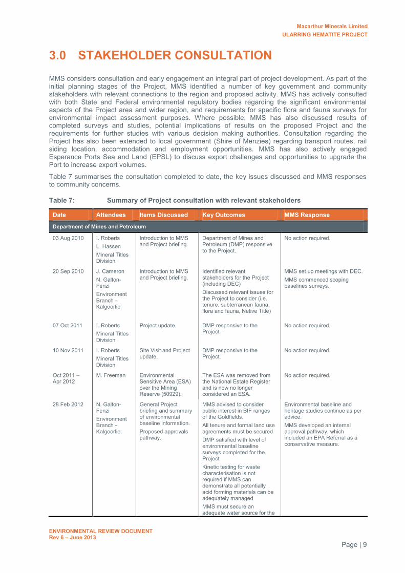
3.0 STAKEHOLDER CONSULTATION
MMS considers consultation and early engagement an integral part of project development. As part of the initial planning stages of the Project, MMS identified a number of key government and community stakeholders with relevant connections to the region and proposed activity. MMS has actively consulted with both State and Federal environmental regulatory bodies regarding the significant environmental aspects of the Project area and wider region, and requirements for specific flora and fauna surveys for environmental impact assessment purposes. Where possible, MMS has also discussed results of completed surveys and studies, potential implications of results on the proposed Project and the requirements for further studies with various decision making authorities. Consultation regarding the Project has also been extended to local government (Shire of Menzies) regarding transport routes, rail siding location, accommodation and employment opportunities. MMS has also actively engaged Esperance Ports Sea and Land (EPSL) to discuss export challenges and opportunities to upgrade the Port to increase export volumes.
Table 7 summarises the consultation completed to date, the key issues discussed and MMS responses to community concerns.
Table 7: Summary of Project consultation with relevant stakeholders
Date Attendees Items Discussed Key Outcomes MMS Response
Department of Mines and Petroleum
03 Aug 2010 I. Roberts L. Hassen Mineral Titles Division
Introduction to MMS and Project briefing.
Department of Mines and Petroleum (DMP) responsive to the Project.
No action required.
20 Sep 2010 J. Cameron N. Galton-Fenzi Environment Branch - Kalgoorlie
Introduction to MMS and Project briefing.
Identified relevant stakeholders for the Project (including DEC) Discussed relevant issues for the Project to consider (i.e. tenure, subterranean fauna, flora and fauna, Native Title)
MMS set up meetings with DEC. MMS commenced scoping baselines surveys.
07 Oct 2011 I. Roberts Mineral Titles Division
Project update. DMP responsive to the Project.
No action required.
10 Nov 2011 I. Roberts Mineral Titles Division
Site Visit and Project update.
DMP responsive to the Project.
No action required.
Oct 2011 – Apr 2012
M. Freeman Environmental Sensitive Area (ESA) over the Mining Reserve (50929).
The ESA was removed from the National Estate Register and is now no longer considered an ESA.
No action required.
28 Feb 2012 N. Galton-Fenzi Environment Branch - Kalgoorlie
General Project briefing and summary of environmental baseline information. Proposed approvals pathway.
MMS advised to consider public interest in BIF ranges of the Goldfields. All tenure and formal land use agreements must be secured DMP satisfied with level of environmental baseline surveys completed for the Project Kinetic testing for waste characterisation is not required if MMS can demonstrate all potentially acid forming materials can be adequately managed MMS must secure an adequate water source for the
Environmental baseline and heritage studies continue as per advice. MMS developed an internal approval pathway, which included an EPA Referral as a conservative measure.

Macarthur Minerals Limited ULARRING HEMATITE PROJECT
ENVIRONMENTAL REVIEW DOCUMENT Rev 6 – June 2013
Page | 10
Date Attendees Items Discussed Key Outcomes MMS Response Project DMP advise that Section 18 Applications should be well underway before submitting Mining Proposal. Project did not currently trigger EPA referral, but MMS should be aware of the potential for third party referrals.
Department of Environment and Conservation
21 Sep 2010 D. Pickles W. Astill Kalgoorlie District Office
Introduction to MMS and exploration activities.
MMS advised of Neil Gibson surveys of the area. MMS advised of potential for SRE species in the area.
MMS reviewed existing DEC information. MMS commenced scoping baseline surveys.
26 Nov 2010 D. Coffey Environmental Management Branch
Scope for subterranean fauna baseline surveys
Proposed survey scopes deemed adequate for baseline purposes. 6-10 samples advised to be collected from each mining area.
MMS prepared a response to DEC to clarify all issues raised.
29 Mar 2011 D. Coffey Environmental Management Branch D. Pickles Kalgoorlie District Office
Scope for vertebrate fauna surveys
DEC recommends two sampling periods, instead of the proposed one. Clarifications sought on bird observation periods, the number of motion activated cameras, use of scats for identifying species and use of quantitative analysis.
MMS commissioned an autumn survey, in addition to the proposed spring survey. All other issues were clarified and scopes amended.
1 Mar 2011 D. Coffey S. Thomas Environmental Management Branch D. Pickles Kalgoorlie District Office
Project briefing and update on environmental baseline information. Proposed approvals pathway.
DEC recommends comparison of consultant vegetation mapping to DEC mapping completed by N. Gibson available on NatureMap.
MMS included statistical analysis of Mattiske communities and DEC communities in final vegetation reports.
DEC recommends additional fauna trapping across unsurveyed areas.
MMS considers that the vegetation complexes across the site are similar in fauna habitat characteristics and is suitable to adequately map potential fauna habitat.
DEC recommends extending Malleefowl surveys to all of the Project area and some reference areas.
MMS commissioned the detection of Malleefowl mounds through the LiDAR technique of the entire Project area and surrounds.
Regarding troglofauna and SREs, DEC recommend identifying habitat continuation in order to determine whether singleton species are restricted to deposits.
MMS commissioned Bennelongia to conduct habitat mapping of the Project area and surrounds
DEC raised concerns of potential visual impacts resulting from the Project on DEC land (i.e. Mount Manning Nature Reserve, Mt Elvire Station).
MMS undertook a visual impact assessment for inclusion in the Projects EIA documents.
28 Mar 2012 K. Atkins Species and Communities
Priority flora of the Project area
Advice on targeted surveys required to adequately assess the risk of the Project on each of the Priority species
MMS conducted a targeted Priority flora survey of the Project area and surrounds.
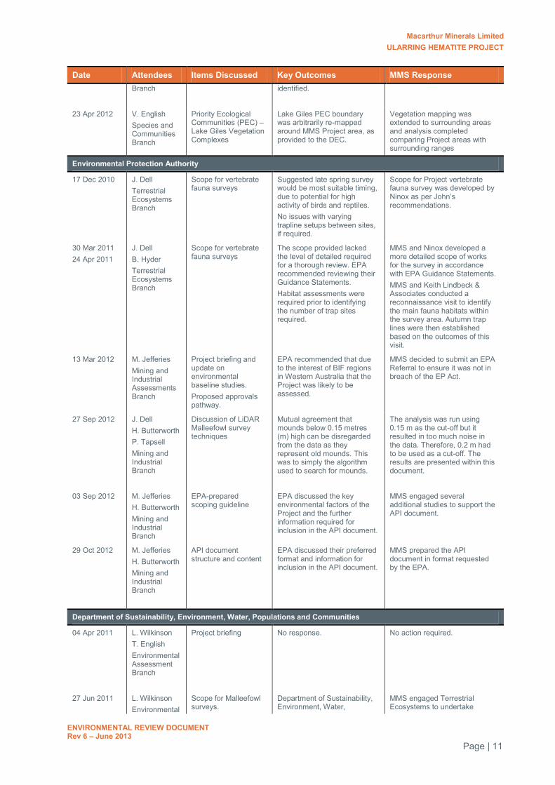
Macarthur Minerals Limited ULARRING HEMATITE PROJECT
ENVIRONMENTAL REVIEW DOCUMENT Rev 6 – June 2013
Page | 11
Date Attendees Items Discussed Key Outcomes MMS Response Branch
identified.
23 Apr 2012 V. English Species and Communities Branch
Priority Ecological Communities (PEC) – Lake Giles Vegetation Complexes
Lake Giles PEC boundary was arbitrarily re-mapped around MMS Project area, as provided to the DEC.
Vegetation mapping was extended to surrounding areas and analysis completed comparing Project areas with surrounding ranges
Environmental Protection Authority
17 Dec 2010 J. Dell Terrestrial Ecosystems Branch
Scope for vertebrate fauna surveys
Suggested late spring survey would be most suitable timing, due to potential for high activity of birds and reptiles. No issues with varying trapline setups between sites, if required.
Scope for Project vertebrate fauna survey was developed by Ninox as per John’s recommendations.
30 Mar 2011 24 Apr 2011
J. Dell B. Hyder Terrestrial Ecosystems Branch
Scope for vertebrate fauna surveys
The scope provided lacked the level of detailed required for a thorough review. EPA recommended reviewing their Guidance Statements. Habitat assessments were required prior to identifying the number of trap sites required.
MMS and Ninox developed a more detailed scope of works for the survey in accordance with EPA Guidance Statements. MMS and Keith Lindbeck & Associates conducted a reconnaissance visit to identify the main fauna habitats within the survey area. Autumn trap lines were then established based on the outcomes of this visit.
13 Mar 2012 M. Jefferies Mining and Industrial Assessments Branch
Project briefing and update on environmental baseline studies. Proposed approvals pathway.
EPA recommended that due to the interest of BIF regions in Western Australia that the Project was likely to be assessed.
MMS decided to submit an EPA Referral to ensure it was not in breach of the EP Act.
27 Sep 2012 J. Dell H. Butterworth P. Tapsell Mining and Industrial Branch
Discussion of LiDAR Malleefowl survey techniques
Mutual agreement that mounds below 0.15 metres (m) high can be disregarded from the data as they represent old mounds. This was to simply the algorithm used to search for mounds.
The analysis was run using 0.15 m as the cut-off but it resulted in too much noise in the data. Therefore, 0.2 m had to be used as a cut-off. The results are presented within this document.
03 Sep 2012 M. Jefferies H. Butterworth Mining and Industrial Branch
EPA-prepared scoping guideline
EPA discussed the key environmental factors of the Project and the further information required for inclusion in the API document.
MMS engaged several additional studies to support the API document.
29 Oct 2012 M. Jefferies H. Butterworth Mining and Industrial Branch
API document structure and content
EPA discussed their preferred format and information for inclusion in the API document.
MMS prepared the API document in format requested by the EPA.
Department of Sustainability, Environment, Water, Populations and Communities
04 Apr 2011 L. Wilkinson T. English Environmental Assessment Branch
Project briefing No response. No action required.
27 Jun 2011 L. Wilkinson Environmental
Scope for Malleefowl surveys.
Department of Sustainability, Environment, Water,
MMS engaged Terrestrial Ecosystems to undertake
Macarthur Minerals Limited ULARRING HEMATITE PROJECT
ENVIRONMENTAL REVIEW DOCUMENT Rev 6 – June 2013
Page | 12
Date Attendees Items Discussed Key Outcomes MMS Response Assessment Branch
Population and Communities (SEWPAC) satisfied with the proposed approach.
proposed Malleefowl surveys.
21 Feb 2012 T. English Environmental Assessment and Compliance Division
Project update and approvals pathway.
SEWPaC suggested submitting a draft referral to determine if the submitted information was sufficient.
MMS provided a draft referral prior to formal submission.
6 June 2012 T. English Environmental Assessment and Compliance Division
Draft review of Environmental Protection and Biodiversity Conservation (EPBC) Referral documents.
SEWPAC generally satisfied with the content of the Referral. Minor changes were advised.
MMS updated the Referral as per SEWPACs recommendations.
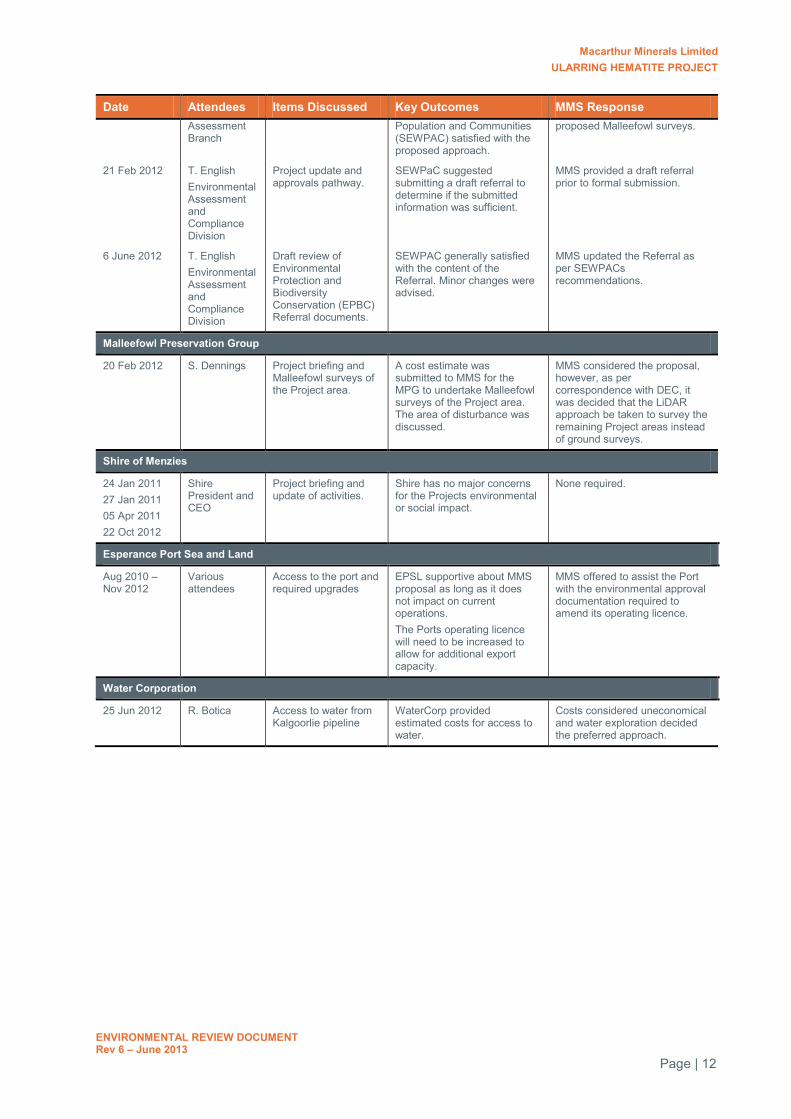
Malleefowl Preservation Group
20 Feb 2012 S. Dennings Project briefing and Malleefowl surveys of the Project area.
A cost estimate was submitted to MMS for the MPG to undertake Malleefowl surveys of the Project area. The area of disturbance was discussed.
MMS considered the proposal, however, as per correspondence with DEC, it was decided that the LiDAR approach be taken to survey the remaining Project areas instead of ground surveys.
Shire of Menzies
24 Jan 2011 27 Jan 2011 05 Apr 2011 22 Oct 2012
Shire President and CEO
Project briefing and update of activities.
Shire has no major concerns for the Projects environmental or social impact.
None required.
Esperance Port Sea and Land
Aug 2010 – Nov 2012
Various attendees
Access to the port and required upgrades
EPSL supportive about MMS proposal as long as it does not impact on current operations. The Ports operating licence will need to be increased to allow for additional export capacity.
MMS offered to assist the Port with the environmental approval documentation required to amend its operating licence.
Water Corporation
25 Jun 2012 R. Botica Access to water from Kalgoorlie pipeline
WaterCorp provided estimated costs for access to water.
Costs considered uneconomical and water exploration decided the preferred approach.

Macarthur Minerals Limited ULARRING HEMATITE PROJECT
ENVIRONMENTAL REVIEW DOCUMENT Rev 6 – June 2013
Page | 13
4.0 EXISTING ENVIRONMENT
4.1 SURROUNDING LANDUSES
The Project is located predominantly within Unallocated Crown Land (UCL) with a small portion of the Project Development Area (50 ha, <2%) located within a Crown Mining Reserve (50929) vested under the DMP for mining purposes. The Project is located adjacent to the Mount Manning Nature Reserve (36208), which is vested under the DEC for the conservation of flora and fauna. All proposed areas of disturbance for the Project are located more than 1.5 km to the north and east of the Mount Manning Nature Reserve, as shown in Figure 3.
Former pastoral stations Mt Elvire and Credo are located to the north-west and east of the Project area, respectively. Both of these stations are now vested under the DEC for proposed conservation parks. No active mine sites are located within 50 km of the Project.
Lake Giles is the closest wetland to the Project, located more than 10 km to the west, followed by Lake Ballard located approximately 20 km north-east and Lake Barlee approximately 25 km to the north-west.
The rail siding area is located wholly within a Pastoral Lease approximately 11 km south of Menzies. A railway reserve extends along the length of the western boundary of the tenement in a north-south direction for the purposes of the existing Leonora Railway. This railway extends from Leonora to the north, to the Esperance Port, located approximately 510 km to the south of the siding tenement. A transport corridor also intersects the centre of the siding tenement, parallel to the railway for the purpose of the existing Goldfields Highway. The proposed rail siding for the Project will be located between the existing railway and the highway as shown in Figure 7.
The closest conservation reserve to the rail siding area is the Goongarrie National Park located approximately 35 km east-south-east.
Lake Ballard is the closest wetland to the rail siding area, located approximately 20 km to the north, followed by Lake Marmion located approximately 30 km to the east and Lake Goongarrie located approximately 18 km to the south-south-east.
Existing surrounding landuses in relation to the Project area are shown in Figure 1 and Figure 2.
4.2 REGIONAL ENVIRONMENTAL SETTING
The regions climate can be described as semi-arid to arid and characterised by low rainfall, high evaporation and high summer temperatures. It is in an area which receives extremes of weather, from cyclones and major flooding to extreme droughts. The occurrences of these events are variable and can occur within a few years of each other (GRM 2011a).
The Project is located within the Coolgardie 2 Bioregion (COO2 – Southern Cross subregion) and East Murchison subregion (MUR1) as defined by the Interim Biogeographical Regionalisation for Australia (IBRA) (Cowan et al. 2001; Cowan 2001). The Coolgardie region is described as gently undulating with occasional ranges of low hills, with sandplains in the western part and some large playa lakes, with principally brown calcareous earths. Ironstone outcropping and BIF ranges are common in the wider area. The East Murchison subregion is composed of internal drainage and extensive areas of elevated red desert sandplains with minimal dune development (Cowan 2001).
Two landscape zones can be found within the Project, including the Bimbijy Sandplains and the Mount Jackson Plains and Hills Zone. The Bimbijy Sandplains consists of sandplains on granitic rock, with red deep sands with red loamy earths and some red shallow loams, red shallow sands, salt lake soils, yellow loamy earths and yellow deep sands. The Mount Jackson Plains and Hills Zone consists of undulating plains, with some hills and stony plains on greenstone and granitic rocks with red loamy earths with red-brown hardpan shallow loams and some red sandy earths, red shallow loams and loamy gravels.
The Project is located within the Yerilgee Greenstone Belt which is over 80 km in length and up to 10 km wide and located within the Southern Cross Province of the Achaean Yilgarn Craton which is characterised by lenticular greenstone belts partially enveloped by foliated and gneissic granitoids. The greenstone belts consist of metamorphosed ultramafic, mafic and sediments, including banded iron formation (BIF) which are Archaean in age and are commonly intruded by mafic, intermediate and

Macarthur Minerals Limited ULARRING HEMATITE PROJECT
ENVIRONMENTAL REVIEW DOCUMENT Rev 6 – June 2013
Page | 14
granitic rocks. The greenstone belts are generally metamorphosed to mid greenschist facies towards the central parts of the belt and lower amphibolite facies on the edges of the belt where they are in contact with the granitoids.
The Project lies within the Raeside-Ponton Catchment and has a reported catchment in excess of 115,000 km2. This forms part of the Department of Water’s (DoW) Salt Lake Basin No. 024 which has a total catchment area of 441,000 km2. No flow monitoring data is available for this catchment (GRM 2011a). Baseline hydrology assessments suggest that the bulk of surface water flow within the region is by overland sheet flow, with the local BIF ranges acting as watersheds which direct flow away from the ridges and eventually report to Lakes Giles and Barlee to the west and Lake Ballard to the east. Some surface water ponding can be expected in valleys located between individual ridges and flows within ephemeral creeks and drainage lines, before being discharged further downstream.
Groundwater in the region typically occurs in fresh and weathered fractured rock aquifers and surficial aquifers comprising palaeochannel alluvium. The Rebecca palaeodrainage divide is understood to run essentially north south dissecting MMS’ tenement area (GRM 2011b) however, local palaeochannel aquifers are expected to be restricted to the immediate area surrounding Lake Giles. BIF is an aquifer in favourable situations, such as where it is cut by faults and fractures or weathered to form a porous rock mass. Groundwater within the Project area is considered to flow away from the drainage divide, increasing in salinity as it moves towards Lakes Giles to the west and Lake Ballard to the east. Groundwater depths across the Project area and immediate surrounds range between 410 to 456 m Australian Height Datum (mAHD) or 37 to 75 m below ground level (mBGL). Salinity values range considerably from 600 (fresh) to 70,000 milligrams per litre (mg/L) (hypersaline) total dissolved solids (TDS).
4.3 FLORA AND VEGETATION
The Project area lies within the Coolgardie Botanical District (Beard 1990), which corresponds with the Coolgardie 2 Bioregion (COO2 – Southern Cross subregion) and East Murchison subregion (MUR1). Broad vegetation mapping by Beard (1972) provides descriptions of vegetation associations in the Project area and surrounds defined as:
Medium woodland: Salmon Gum (Eucalyptus salmonophloia) and Goldfields Blackbutt (Eucalyptus lesouefii);
Shrublands: Acacia neurophylla, A. beauverdiana and A. resinomarginea thicket; and Hummock grasslands, mallee steppe: red mallee over Spinifex (Triodia scariosa).
Several flora and vegetation surveys have been conducted across the Project area including surveys by the DEC and by botanical consultants on behalf of MMS. These surveys have been completed at various levels including desktop, Level 1 and Level 2 and targeted flora surveys. A full literature review is provided in Section 7.1 which summarises all existing knowledge on flora and vegetation of the Project area, including the rail siding area.
4.4 FAUNA
4.4.1 Vertebrate Fauna – Project Area
Desktop assessments and higher level surveys have been undertaken to develop an inventory of fauna that occurs or is likely to occur within the Project area. This work focussed on terrestrial vertebrate fauna species, terrestrial SRE invertebrates and subterranean fauna. These studies also provide a description of vertebrate fauna habitat, subterranean fauna habitat, sensitive habitat and terrestrial SRE invertebrate habitat that occurs within and surrounding the Project area. All surveys were conducted in accordance with relevant EPA Guidance Statements.
Four broad fauna habitats have been described within the Project area. These habitats are broadly categorised as BIF outcrop, Acacia shrublands, Allocasuarina shrublands and Eucalypt woodlands. Further information on these habitats is provided in Section 7.2.2.
Level 1 and 2 fauna surveys were conducted within a portion of the Project area in 2011 over two seasons (KLA 2011; Ninox 2012a). Three conservation significant species were confirmed to occur within the Project area; the Malleefowl (Leipoa occelata) listed as threatened species under the Wildlife Conservation Act (WC Act) and vulnerable under Environmental Protection and Biodiversity Protection

Macarthur Minerals Limited ULARRING HEMATITE PROJECT
ENVIRONMENTAL REVIEW DOCUMENT Rev 6 – June 2013
Page | 15
Act 1999 (EPBC Act), the Rainbow Bee-eater (Merops ornatus) listed as a Schedule 3 species under the WC Act and a migratory species under the EPBC Act, and the Crested Bellbird (southern) (Oreoica g. gutturalis), listed as Priority 4 (P4) species on the DEC Priority Fauna List (DEC 2010). No mammals or reptiles of conservation significance were positively recorded during any of the surveys. The conservation significant fauna found in the Project area is shown in Table 8.
With the exception of the Malleefowl, all species of conservation significance identified within the Project area are not considered to be impacted by the implementation of the Project due to either their migratory nature and the widespread presence of their preferred habitats immediately surrounding the Project and within nearby conservation reserves, as well as in the broader Goldfields region. Observations and the significance of the Malleefowl are discussed in greater detail in Section 7.2.1.
Although not formally protected under any legislation, the Pseudantechinus woolleyae was identified in the Project area and is thought to be restricted to rocky BIF outcrops in the Midwest and Goldfields regions (DEC 2007). Potential impacts to this based on an assessment of habitat mapping of the Project area is discussed in Section 7.2.2.
Table 8: Terrestrial Fauna species of conservation significance within the Project area (KLA 2011; Ninox 2012)
Species EPBC Act WC Act DEC Priority
Recorded within the Project area
Habitat type
Birds
Rainbow Bee-eater Merops ornatus
Migratory Schedule 3 - Yes Acacia Shrublands Allocasuarina Shurblands BIF Ridges
Malleefowl^ Leipoa ocellata
Vulnerable Schedule 1 - Yes Acacia Shrublands Eucalypt Woodlands Allocasuarina Shurblands BIF Ridges
Crested Bellbird (southern) Oreoica g. gutturalis
- - Priority 4 Yes Acacia Shrublands Eucalypt Woodlands Allocasuarina Shurblands BIF Ridges
^ MMS’ Malleefowl mound records were used instead of fauna reports
4.4.2 Short Range Endemic Invertebrates
SRE surveys were conducted during 2011 and identified three potential SRE habitats within the Project area: low woodlands on rocky undulating hills; low woodlands on sand plains, and; medium woodlands on sand plains. No species were confirmed to be an SRE or considered probably (high likelihood) an SRE. However, eight species were considered moderately likely to be an SRE and 11 were considered possibly (low likelihood) SREs. The results of these studies and an assessment of the potential impacts to SRE are discussed further in Section 7.2.5.1.
4.4.3 Subterranean Fauna
A subterranean fauna pilot study and baseline assessment were conducted during 2011. No stygobitic fauna were recorded during the sampling programs and it is considered unlikely that a significant stygofauna community occurs in the aquifers of the Project area. Seven species of troglofauna were collected during the surveys of which three were identified in non-impact reference sites or other areas within the Yilgarn. Four remaining species were recorded only within the proposed pit areas of the Project. Detailed habitat mapping for troglofauna species within the Project area has been conducted in order to assess the risk of the Project on this species. A detailed summary of these studies are discussed in Sections 7.2.3 and 7.2.4.

Macarthur Minerals Limited ULARRING HEMATITE PROJECT
ENVIRONMENTAL REVIEW DOCUMENT Rev 6 – June 2013
Page | 16
4.4.4 Rail Siding Area
A Level 1 vertebrate fauna assessment was completed for the entire rail siding area in 2011. Two main fauna habitats were observed, being shrubland and woodland communities. No fauna species of conservation significance were identified and all of the species recorded were considered common and widespread in the region.
Based on the present habitat within the rail siding area, it is unlikely that that the area supports SREs. An assessment on the likelihood of this based on targeted habitat mapping for SRE species has been conducted and the results are provided in Section 7.2.5.2.
4.4.5 Introduced Fauna
Three species of introduced fauna have been confirmed within the Project area (Ninox 2012a), including the European House Mouse (Mus musculus), One-humped Camel (Camelus dromedaries) and the Rabbit (Oryctolagus cuniculus). Unconfirmed sightings of feral dogs, cats (Felis catus) and foxes (Vulpes vulpes) have also been reported in the Project area and are commonly known to occur in the Goldfields region. Although there are cattle stations and ex-pastoral leases within the region, no cattle have been observed within the Project area, however, they are frequently sighted along the Evanston-Menzies Road between the Project and the rail siding area.
Evidence of rabbits and cattle were identified within the rail siding area (Ninox 2012b).
Macarthur Minerals Limited ULARRING HEMATITE PROJECT
ENVIRONMENTAL REVIEW DOCUMENT Rev 6 – June 2013
Page | 17
5.0 ENVIRONMENTAL BASELINE STUDIES
During early planning phases of the Project, MMS identified a number of significant environmental factors that had the potential to be impacted during the implementation of proposed mining operations. With reference to the EPA’s guidance notes and following consultation with relevant decision making authorities, MMS commissioned a range of specialist consultants to undertake environmental baseline surveys for each of these factors. The purpose of these studies was to obtain a comprehensive set of baseline data so that the potential impact to each of the factors could be adequately assessed during the planning stage. The timing of these surveys and their key outcomes are presented in Table 9 and Table 10.

Macarthur Minerals Limited ULARRING HEMATITE PROJECT
ENVIRONMENTAL REVIEW DOCUMENT Rev 6 – June 2013
Page | 18
Table 9: Timeline of environment studies completed for the Project
Baseline Study 2010 2011 2012
Q3 / Q4 Q1 Q2 Q3 Q4 Q1 Q2 Q3 Q4
Flora and Vegetation
Flora and Vegetation Survey
Targeted Priority Flora Survey
Vegetation Mapping Extension
Fauna
Vertebrate Fauna Surveys
Malleefowl Targeted Survey
Malleefowl Targeted Survey – Additional Areas
Pilot Subterranean Fauna Survey
Baseline Subterranean Fauna Survey
Troglofauna Habitat Assessment
SRE Invertebrate Baseline Survey
Heritage
Archaeological Survey – Exploration Areas
Ethnographic Survey – Exploration Areas
Heritage Sites Survey – Project area
Water
Hydrological Baseline Assessment
Initial Assessment of Groundwater Availability
Hydrogeological Investigation
Groundwater Supply Assessment
Groundwater Test Pumping Assessment
Waste Characterisation
Waste Characterisation and Acid Mine Drainage Management

Macarthur Minerals Limited ULARRING HEMATITE PROJECT
ENVIRONMENTAL REVIEW DOCUMENT Rev 6 – June 2013
Page | 19
Baseline Study 2010 2011 2012
Q3 / Q4 Q1 Q2 Q3 Q4 Q1 Q2 Q3 Q4
Appraisal of Waste and Acid Mine Drainage Management Report
Waste Landform Design and Soil Characterisation
Rail Siding Area
Level 2 Flora and Vegetation
Level 1 Fauna Assessment
SRE Habitat Assessment
Aboriginal Heritage Survey

Macarthur Minerals Limited ULARRING HEMATITE PROJECT
ENVIRONMENTAL REVIEW DOCUMENT Rev 6 – June 2013
Page | 20
Table 10: Summary of environmental studies completed for the Project’s environmental impact assessment
Survey Description Key Outcomes
Flora and Vegetation
Level 2 Flora and Vegetation Survey (Mattiske 2012a; 2012b; 2012c) Refer to Appendix 3 - 5
Level 2 Flora and Vegetation Survey Snark, Central and Banjo Deposits 184 quadrats, 25 x 25m Autumn and Spring timing Survey completed in line with DEC guideline - Recommended Interim Protocol for Flora Surveys of the Banded Iron Formations of the Yilgarn Craton
205 flora species recorded and 30 vegetation communities dominated by Acacia and Allocasuarina shrublands and Eucalypt woodlands
No declared rare flora species or Threatened Ecological Communities
Six Priority flora species recorded One PEC recorded Vegetation communities show similarity with the local area
and taxa are widespread throughout the region.
Targeted Survey of Priority Flora (MMS 2012a) Refer to Appendix 6
Targeted search for six Priority species previously identified inside and outside Project area
All Priority species are known from multiple locations outside the MMS tenement area and Project area
Project unlikely to significantly impact on any Priority species as significant populations of each species exist outside the Project area and surrounding region, including the Mount Manning Nature Reserve.
Vegetation Mapping Extension (Ecologia 2012) Refer to Appendix 7
Extension to Mattiske’s vegetation mapping
Increase in mapped area of 3,200 ha outside the Project area.
Fauna
Level 2 Vertebrate Fauna Survey (KLA 2011) Refer to Appendix 8
Level 2 Vertebrate Fauna Survey Snark Deposit and surrounds 2,840 trap nights, bird observations, audio recording, spotlighting Autumn timing.
55 fauna species recorded Two conservation significant species recorded No areas considered significant habitat for native fauna Project not considered to significantly impact native fauna or
species of conservation significance.
Level 2 Vertebrate Fauna Survey (Ninox 2012a) Refer to Appendix 9
Level 2 Vertebrate Fauna Survey Snark Deposit and surrounds 3,883 trap nights, bird observations, audio recording Spring timing
113 fauna species recorded Four species of conservation significance recorded One potentially habitat restricted species Project not considered to significantly impact on native fauna
or any species of conservation significance.
Malleefowl survey of the Snark Project (Terrestrial Ecosystems 2011) Refer to Appendix 10
Targeted search for Malleefowl populations Portions of Snark and Central deposits and areas outside the Project area Grid based search Winter timing.
Local Malleefowl population confirmed within and outside the Project area
Malleefowl habitat observed within survey area is typical of the surrounding area and region
Development of the Project is unlikely to significantly impact of the local population or the species conservation status.
Malleefowl survey of the Tenement area
Mapping of Malleefowl mounds using LiDAR data.
259 potential mounds recorded Mounds limited to >0.2 m high 95% success rate in targets based on ground-truthed results
(n=57).
Targeted Survey for Malleefowl Refer to Appendix 11
Remaining Project disturbance areas and portions of the Project Development Area Grid based search Summer timing
Additional 19 mounds recorded 1 active and 2 inactive mounds recorded Development of the Project is unlikely to significantly impact
of the local population or the species conservation status.
Results of Pilot Subterranean Fauna
Stygofauna and troglofauna desktop assessment and
No stygobitic animals recorded Project area unlikely to yield a stygofauna community

Macarthur Minerals Limited ULARRING HEMATITE PROJECT
ENVIRONMENTAL REVIEW DOCUMENT Rev 6 – June 2013
Page | 21
Survey Description Key Outcomes Investigation (Rockwater 2011) Refer to Appendix 12
sampling program. Snark, Central, Banjo impacts sites and various reference sites. 10 stygofauna samples and 62 troglofauna samples collected.
Three troglobitic species collected Troglofauna species unlikely to be restricted to the Project
area Further sampling effort is required for adequate EPA
Environmental Impact Assessment (EIA).
Results of Phase II Subterranean Fauna Investigation (Rockwater 2012) Refer to Appendix 13
Extension to pilot study sampling program for stygofauna and troglofauna. An additional 11 stygofauna and 189 troglofauna samples collected.
No stygobitic animals recorded across both sampling programs
42 troglofauna from seven species recorded across both sampling programs, indicating a moderately diverse population with a low abundance
Troglofauna habitat connectivity exists throughout the Project area and surrounding landscapes
Project will not significantly impact on local troglofauna populations or species.
Troglofauna Habitat Assessment (Bennelongia 2012b) Refer to Appendix 14
Troglofauna habitat characterisation assessment of the Project area and surrounding areas of the Yerilgee greenstone belt. Taxonomic and biogeographic review of troglofauna species collected in the Project’s impact areas.
Both enriched and unenriched BIF geologies identified as prospective troglofauna habitat
Ultramafic/mafic strata not considered prospective for troglofauna
Subsurface troglofauna habitats considered to be well connected and extend well beyond the BIF surface outcropping
Weathered saprolites may potentially connect sub-surface habitats
It is unlikely that individual troglofauna species are restricted to mine pits of the Project area.
SRE Invertebrate Survey (Bennelongia 2012a) Refer to Appendix 15
SRE baseline assessment and sampling program. Snark, Central, Banjo impact sites and various reference sites. 10 sites - wet pit traps, foraging, litter sampling Four sites – foraging, litter sampling Three sampling rounds.
No SRE species recorded Eight species moderately likely of being an SRE 11 species possibly (low likelihood) of being an SRE Project will have only minimal loss of identified SRE habitats
(<15%) Most habitats are well represented outside the Project Project unlikely to significantly impact of potential SRE
species.
Heritage
Archaeological Survey of Proposed Drilling Projects at Snark, Lost World, Central, Banjo and Moonshine Project Area (Warranup 2011a) Refer to Enclosure 3 (Confidential Information)
Archaeological survey of exploration areas Snark, Central and Banjo deposit.
No previously recorded heritage sites within the survey area Two sites identified within the Snark deposit One site identified within the Central deposit Sites will require to be recorded under the Aboriginal
Heritage Act 1972 (AH Act).
Ethnographic Survey of with Representatives of the Kalamaia Kapu(d)n People of Proposed Exploration Drilling Projects at Snark, Lost World, Central, Banjo and Moonshine Project Area Warranup (2011b) Refer to Enclosure 3 (Confidential Information)
Ethnographic survey of exploration areas with Kalamaia Kapu(d)n People Snark, Central and Banjo deposit.
No previously recorded heritage sites within the survey area One site identified within the Central deposit Sites will require to be recorded under the AH Act.
Ethnographic Survey of with Representatives of the Wati Group of Proposed Exploration Drilling Projects at Snark, Lost World, Central, Banjo and Moonshine Project Area
Ethnographic survey of exploration areas with the Wati Group Snark, Central and Banjo deposit.
No previously recorded heritage sites within the survey area No ethnographic sites identified during the survey Sites will require to be recorded under the AH Act.
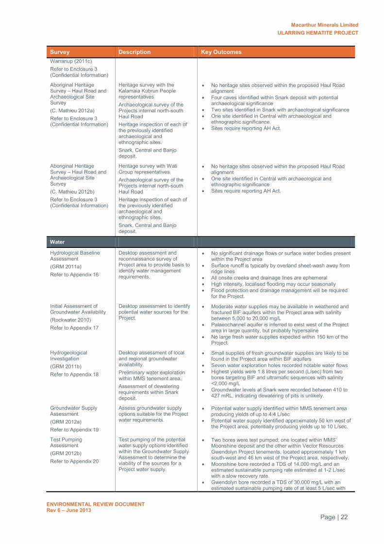
Macarthur Minerals Limited ULARRING HEMATITE PROJECT
ENVIRONMENTAL REVIEW DOCUMENT Rev 6 – June 2013
Page | 22
Survey Description Key Outcomes Warranup (2011c) Refer to Enclosure 3 (Confidential Information)
Aboriginal Heritage Survey – Haul Road and Archaeological Site Survey (C. Mathieu 2012a) Refer to Enclosure 3 (Confidential Information)
Heritage survey with the Kalamaia Kubrun People representatives Archaeological survey of the Projects internal north-south Haul Road Heritage inspection of each of the previously identified archaeological and ethnographic sites. Snark, Central and Banjo deposit.
No heritage sites observed within the proposed Haul Road alignment
Four caves identified within Snark deposit with potential archaeological significance
Two sites identified in Snark with archaeological significance One site identified in Central with archaeological and
ethnographic significance. Sites require reporting AH Act.
Aboriginal Heritage Survey – Haul Road and Archaeological Site Survey (C. Mathieu 2012b) Refer to Enclosure 3 (Confidential Information)
Heritage survey with Wati Group representatives Archaeological survey of the Projects internal north-south Haul Road Heritage inspection of each of the previously identified archaeological and ethnographic sites. Snark, Central and Banjo deposit.
No heritage sites observed within the proposed Haul Road alignment
One site identified in Central with archaeological and ethnographic significance
Sites require reporting AH Act.
Water
Hydrological Baseline Assessment (GRM 2011a) Refer to Appendix 16
Desktop assessment and reconnaissance survey of Project area to provide basis to identify water management requirements.
No significant drainage flows or surface water bodies present within the Project area
Surface runoff is typically by overland sheet-wash away from ridge lines
All onsite creeks and drainage lines are ephemeral High intensity, localised flooding may occur seasonally Flood protection and drainage management will be required
for the Project.
Initial Assessment of Groundwater Availability (Rockwater 2010) Refer to Appendix 17
Desktop assessment to identify potential water sources for the Project.
Moderate water supplies may be available in weathered and fractured BIF aquifers within the Project area with salinity between 5,000 to 20,000 mg/L
Palaeochannel aquifer is inferred to exist west of the Project area in large quantity, but probably hypersaline
No large fresh water supplies expected within 150 km of the Project.
Hydrogeological Investigation (GRM 2011b) Refer to Appendix 18
Desktop assessment of local and regional groundwater availability. Preliminary water exploration within MMS tenement area. Assessment of dewatering requirements within Snark deposit.
Small supplies of fresh groundwater supplies are likely to be found in the Project area within BIF aquifers
Seven water exploration holes recorded notable water flows Highest yields were 1.8 litres per second (L/sec) from two
bores targeting BIF and ultramafic sequences with salinity <2,000 mg/L
Groundwater levels at Snark were recorded between 410 to 427 mRL, indicating dewatering of pits is unlikely.
Groundwater Supply Assessment (GRM 2012a) Refer to Appendix 19
Assess groundwater supply options suitable for the Project water requirements.
Potential water supply identified within MMS tenement area producing yields of up to 4.4 L/sec
Potential water supply identified approximately 50 km west of the Project area, potentially producing yields up to 10 L/sec.
Test Pumping Assessment (GRM 2012b) Refer to Appendix 20
Test pumping of the potential water supply options identified within the Groundwater Supply Assessment to determine the viability of the sources for a Project water supply.
Two bores were test pumped; one located within MMS’ Moonshine deposit and the other within Vector Resources Gwendolyn Project tenements, located approximately 1 km south-west and 46 km west of the Project area, respectively.
Moonshine bore recorded a TDS of 14,000 mg/L and an estimated sustainable pumping rate estimated at 1-2 L/sec with a slow recovery rate.
Gwendolyn bore recorded a TDS of 30,000 mg/L with an estimated sustainable pumping rate of at least 5 L/sec with

Macarthur Minerals Limited ULARRING HEMATITE PROJECT
ENVIRONMENTAL REVIEW DOCUMENT Rev 6 – June 2013
Page | 23
Survey Description Key Outcomes minimal drawdown observed.
Waste Characterisation
Snark Iron Ore Deposit Waste Characterisation and Acid Mine Drainage Management (MBS Environmental 2011) Refer to Appendix 21
Geochemical characterisation and assessment of waste rock material generated from the mineral extraction of iron ore. Snark deposit. 39 samples tested from depths up to 70 mBGL.
Six waste rock classes identified Significant proportion of waste material is potentially acid
forming (PAF) material within upper 40 m Materials is not typical acid and metalliferous drainage
(AMD) Materials contain form of stored acidity associated with
aluminium sulphate and alumina silicate minerals Material should be easily identifiable during mining Encapsulation of PAF material required to prevent impacts to
surrounding environment.
Appraisal of the Requirement to Conduct Kinetic-Testing as Recommended in the MBS Environmental (Nov 2011) Report on Mine-Waste Geochemistry (G. Campbell 2012a) Refer to Appendix 22 and Mineralogical Assessment of Mine-Waste Samples (G. Campbell 2012b) Refer to Appendix 23
Review of MBS Environmental Waste Characterisation Report (MBS 2011) for the Snark Deposit. Assess the requirement for kinetic testing to be used to adequately manage mine waste for the Project. Mineralogical testing of the five samples previously subjected to static testing
Materials are not high risk, although some are naturally moderately acidic, non-acid forming (NAF) materials; NAF-[low-pH]
The NAF-[low-pH] materials roughly lies between 5 to 30 mBGL
This material should be encapsulated with approximately 5 m of soils, alluvium/colluvium, duricrusts, lower-saprolites and saprocks
Kinetic testing is not required if materials are adequately buried.
Soil Characterisation and Landform Design
Soil chemistry analysis and erosion modelling of the soil types for rehabilitation of the Project’s waste dumps.
Results are outstanding at the time of this report. The report is due to be completed in Quarter One 2014.
Rail Siding
Flora and Vegetation Mapping of the Proposed Rail Siding, Menzies Survey Area (Mattiske 2012d) Refer to Appendix 24
Level 2 Flora and Vegetation Survey 18 quadrats, 25 x 25m Spring timing
69 flora species and seven vegetation communities recorded, dominated by Acacia and Casuarina shrublands and Eucalypt woodlands
No conservation significant species or communities’ identified.
Vegetation condition excellent to very good in the south, degraded in the north.
Vegetation communities are typical of the area and species are widespread throughout the region.
Level 1 Vertebrate Fauna Assessment of a Proposed Rail Siding Near Menzies, Western Australia (Ninox 2012b) Refer to Appendix 25
Level 1 Vertebrate Fauna Survey Desktop assessment and reconnaissance survey Spring timing
21 fauna species identified within the survey area No species of conservation significance confirmed within the
survey area Two introduced species observed Fauna habitats are widespread across the region No areas are considered significant habitat for any native
fauna or conservation significant species
SRE Habitat Assessment (Bennelongia 2012c) Refer to Appendix 26
Habitat assessment to determine the likelihood of SRE’s occurring and the presence of prospective SRE habitat within the rail siding area. Assess any potential threat to SRE’s that may potentially occur in the rail siding area.
No SREs previously recorded within the rail siding area Rail siding area does not contain any obvious SRE habitats All habitats of the rail siding area appear to be well
connected and widespread within the region It is unlikely that SRE will occur within the rail siding area In the unlikely event SRE’s do occur at the siding, the limited
area of disturbance (<32 ha) and extensive habitat connectivity beyond the site mean there is a very low likelihood of impact at the species level.
Aboriginal Heritage Survey – Rail Siding Site Survey
Heritage survey with Nudding / Strickland Group representatives Archaeological and
No heritage sites previously identified within the survey area No heritage sites identified during the survey.

Macarthur Minerals Limited ULARRING HEMATITE PROJECT
ENVIRONMENTAL REVIEW DOCUMENT Rev 6 – June 2013
Page | 24
Survey Description Key Outcomes (C. Mathieu 2012c) Refer to Enclosure 3 (Confidential Information)
ethnographic survey of the Projects proposed rail siding and an alternative access track

Macarthur Minerals Limited ULARRING HEMATITE PROJECT
ENVIRONMENTAL REVIEW DOCUMENT Rev 6 – June 2013
Page | 25
6.0 ENVIRONMENTAL FACTORS
A number of environmental factors have been identified within the Project area that may be impacted by the implementation of the Project. The EPA has identified nine environmental factors that require further information to enable assessment of the Project. MMS has identified a further four factors and have provided proposed management strategies and outcomes.
The environmental factors have been segregated into the following categories:
Key Environmental Factors (identified by the EPA)
a. Flora and vegetation b. Fauna
o Terrestrial vertebrate fauna o Malleefowl o Troglofauna o Stygofauna o SRE invertebrates
c. Mine closure and rehabilitation d. Residual impacts
Other Environmental Factors (identified by the EPA)
a. Water supply b. Cumulative impacts
Environmental Factors (identified by MMS)
a. Heritage sites b. Surface water
Based on the results of the environmental baseline surveys conducted for each of the factors listed above, MMS is confident that the environment of the Project area and surrounding landscapes will not be significantly impacted and that all EPA objectives can be met based on the implementation of internal procedures and management actions.
Table 11 summarises each of these environmental factors, the relevant EPA objectives, potential impacts resulting from the Project, proposed management measures and whether these commitments are adequate to ensure the EPA’s objectives can be met.

Macarthur Minerals Limited ULARRING HEMATITE PROJECT
ENVIRONMENTAL REVIEW DOCUMENT Rev 6 – June 2013
Page | 26
Table 11: Summary of Environmental Factors and Proposed Management Outcomes
Factor EPA Objective Existing Environment Proposed Impacts Proposed Management Predicted Outcome
Key Environmental Factors (EPA defined)
Vegetation To maintain the abundance, diversity, geographic distribution and productivity of flora at species and ecosystem levels through the avoidance or management of adverse impacts and improvement in knowledge.
Project area: 30 vegetation
communities No TECs One PEC (Lake Giles
vegetation complex).
Rail siding area: Seven vegetation
communities No TECs or PECs.
Project area: Clearing of up to 611 ha of
native vegetation Disturbance to 26 vegetation
communities Disturbance to 611 ha (<3%) of
the Lake Giles PEC Removal of 42 ha of BIF surface
outcropping, <8% of the overall mapped extent within the Yerilgee Greenstone Belt.
Rail siding area: Clearing of up to 32 ha of native
vegetation Disturbance to three vegetation
communities.
All clearing activities will be undertaken within the Project Development Area and rail siding area boundaries, as shown on Figure 3 and Figure 7 and will be no more than 611 and 32 ha (respectively). Mine infrastructure will be relocated to avoid less represented communities, PECs and BIF habitat where possible. Manage disturbance activities during all construction and mining operations by implementation of the following: Land Disturbance
Management Plan Weed Management Plan Fire Management Plan Dust Management Plan. Education programs on native
flora and vegetation values of the Project area to all staff and contractors.
More than 63% of any mapped vegetation communities will remain undisturbed. More than 97% of the Lake Giles PEC will remain undisturbed. Retention of more than 92% undisturbed BIF outcropping within MMS tenements. Removal of vegetation is not expected to have a significant impact on the conservation of any communities or PECs proposed to be disturbed, as all communities are well represented outside the Project areas. MMS considers that with the proposed management actions, the EPAs objectives can be met.
Flora As above. Project area: 205 taxa No DRF Six Priority flora species One habitat restricted
species (BIF) No introduced species Rail siding area: 69 taxa No conservation
significant species One introduced species.
Removal of individuals of four Priority species due to land clearing activities
Potential introduction and spread of exotic species
Loss of native flora from accidental bush fires
Potential impacts to native flora from generation of dust from clearing and operations.
All clearing activities will be undertaken within the Project area boundary, as shown in Figure 3 - 6, and will be no more than 611 ha. Mine infrastructure will be relocated to avoid populations of Priority flora species, where possible. Disturbance activities will be managed through the same strategies as for vegetation (above).
Loss of some individuals and/or populations of Priority species within the Project area. Sustainable populations of Priority species will be maintained outside the Project within MMS tenement area and the adjacent Mount Manning Nature Reserve. Other direct/indirect effects to all other native flora will be avoided by the implementation of dust/weed/fire management plans and education programs.
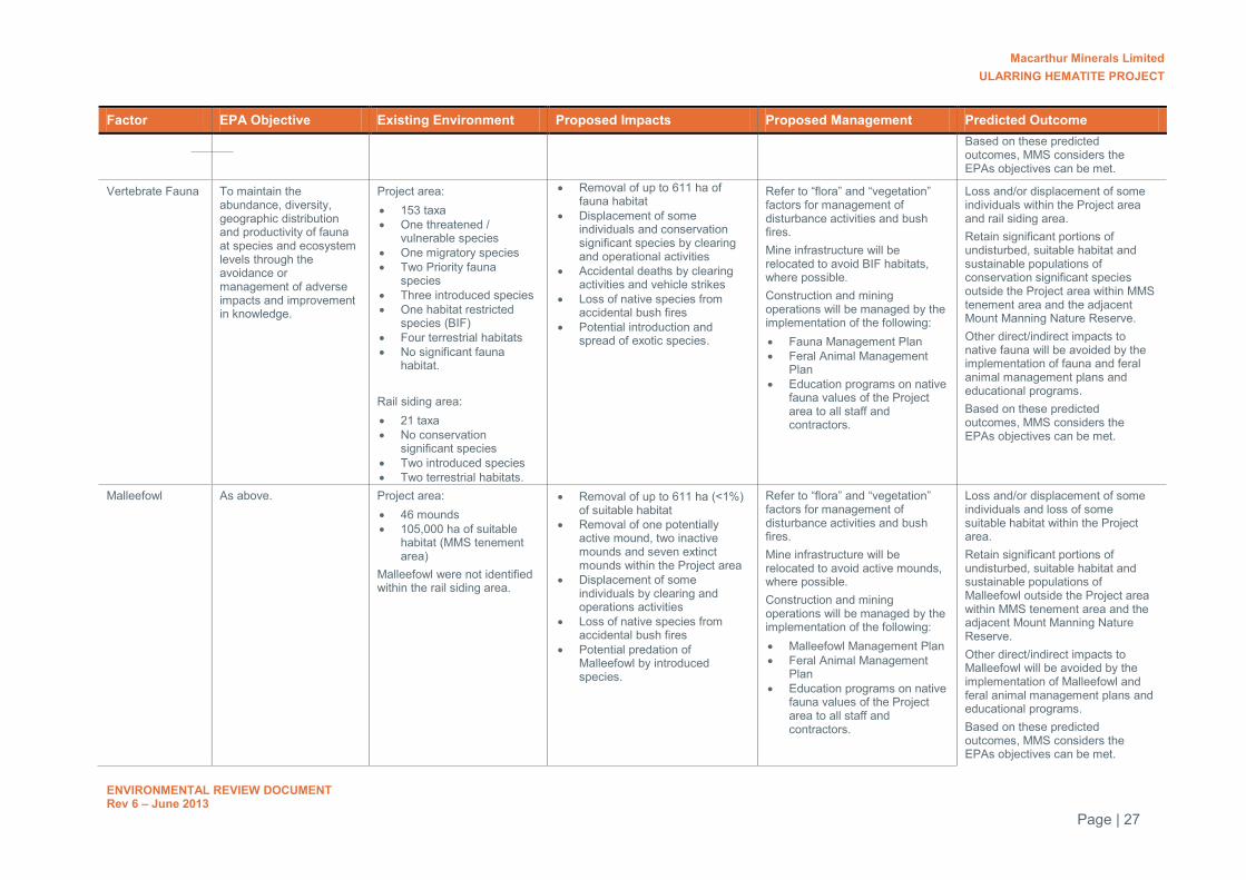
Macarthur Minerals Limited ULARRING HEMATITE PROJECT
ENVIRONMENTAL REVIEW DOCUMENT Rev 6 – June 2013
Page | 27
Factor EPA Objective Existing Environment Proposed Impacts Proposed Management Predicted Outcome Based on these predicted
outcomes, MMS considers the EPAs objectives can be met.
Vertebrate Fauna To maintain the abundance, diversity, geographic distribution and productivity of fauna at species and ecosystem levels through the avoidance or management of adverse impacts and improvement in knowledge.
Project area: 153 taxa One threatened /
vulnerable species One migratory species Two Priority fauna
species Three introduced species One habitat restricted
species (BIF) Four terrestrial habitats No significant fauna
habitat. Rail siding area: 21 taxa No conservation
significant species Two introduced species Two terrestrial habitats.
Removal of up to 611 ha of fauna habitat
Displacement of some individuals and conservation significant species by clearing and operational activities
Accidental deaths by clearing activities and vehicle strikes
Loss of native species from accidental bush fires
Potential introduction and spread of exotic species.
Refer to “flora” and “vegetation” factors for management of disturbance activities and bush fires. Mine infrastructure will be relocated to avoid BIF habitats, where possible. Construction and mining operations will be managed by the implementation of the following: Fauna Management Plan Feral Animal Management
Plan Education programs on native
fauna values of the Project area to all staff and contractors.
Loss and/or displacement of some individuals within the Project area and rail siding area. Retain significant portions of undisturbed, suitable habitat and sustainable populations of conservation significant species outside the Project area within MMS tenement area and the adjacent Mount Manning Nature Reserve. Other direct/indirect impacts to native fauna will be avoided by the implementation of fauna and feral animal management plans and educational programs. Based on these predicted outcomes, MMS considers the EPAs objectives can be met.
Malleefowl As above. Project area: 46 mounds 105,000 ha of suitable
habitat (MMS tenement area)
Malleefowl were not identified within the rail siding area.
Removal of up to 611 ha (<1%) of suitable habitat
Removal of one potentially active mound, two inactive mounds and seven extinct mounds within the Project area
Displacement of some individuals by clearing and operations activities
Loss of native species from accidental bush fires
Potential predation of Malleefowl by introduced species.
Refer to “flora” and “vegetation” factors for management of disturbance activities and bush fires. Mine infrastructure will be relocated to avoid active mounds, where possible. Construction and mining operations will be managed by the implementation of the following: Malleefowl Management Plan Feral Animal Management
Plan Education programs on native
fauna values of the Project area to all staff and contractors.
Loss and/or displacement of some individuals and loss of some suitable habitat within the Project area. Retain significant portions of undisturbed, suitable habitat and sustainable populations of Malleefowl outside the Project area within MMS tenement area and the adjacent Mount Manning Nature Reserve. Other direct/indirect impacts to Malleefowl will be avoided by the implementation of Malleefowl and feral animal management plans and educational programs. Based on these predicted outcomes, MMS considers the EPAs objectives can be met.

Macarthur Minerals Limited ULARRING HEMATITE PROJECT
ENVIRONMENTAL REVIEW DOCUMENT Rev 6 – June 2013
Page | 28
Factor EPA Objective Existing Environment Proposed Impacts Proposed Management Predicted Outcome
Troglofauna As above. Project area: Seven species of
troglofauna No conservation
significant species Two prospective
troglofauna geological habitats identified; enriched BIF and unenriched BIF
Subsurface habitats considered to be well connected throughout the Project area and beyond
Troglofauna was not considered a factor for the rail siding area as no subsurface works are required.
Removal of up to 611 ha of potential troglofauna habitat (comprising 42 ha of surface BIF outcropping)
Loss or displacement of some individuals by subsurface mining operations
Potential impacts to suitable habitat caused by direct or indirect pollution to subsurface environments.
Blasting and mining will be staged and will allow some individuals to relocate away from impacts. Construction and mining operations will be managed by the implementation of the following: Surface Water Management
Plan Hydrocarbons Management
Plan Waste Management Plan.
Loss and/or displacement of some individuals and suitable habitat within the Project area. Retain significant portions of undisturbed, connected troglofauna habitat within and outside the Project area. Other direct/indirect impacts to troglofauna and their habitat will be avoided by the implementation of surface water, chemical and hydrocarbon and waste management plans and educational programs. Based on these predicted outcomes, MMS considers the EPAs objectives can be met.
Stygofauna To maintain the abundance, diversity, geographic distribution and productivity of fauna at species and ecosystem levels through the avoidance or management of adverse impacts and improvement in knowledge.
No stygofauna population identified within the Project area. Stygofauna habitat is unlikely to be present within the Project area.
No impacts to stygofauna populations are likely.
No management required. No stygofauna communities present within the Project area and therefore, MMS considers the EPAs objectives can be met.
SRE Invertebrates (Project area)
As above Project area: No SREs identified 19 potential SRE species No conservation
significant species Three SRE habitats
identified BIF habitat supports most diverse and abundant potential SRE species.
Removal of 611 ha (3% of total mapped) of SRE habitat
Loss or displacement of some individuals due to removal of habitat
Loss of species and habitat from accidental bush fires
Potential introduction and spread of introduced species.
Refer to “flora” and “vegetation” factors for management of disturbance activities and bush fires. Mine infrastructure will be relocated to minimise impacts to BIF habitats, where possible. Construction and mining operations will be managed by the implementation of the following: Fauna Management Plan Feral Animal Management
Plan Fire Management Plan.
Loss of some SRE invertebrates and suitable habitat within the Project area. Retain significant portions of undisturbed, SRE habitat within and outside the Project area. Other direct/indirect impacts to potential SRE invertebrates and their habitat will be avoided by the implementation of fauna, feral animal and fire management plans and educational programs. Based on these predicted outcomes, MMS considers the
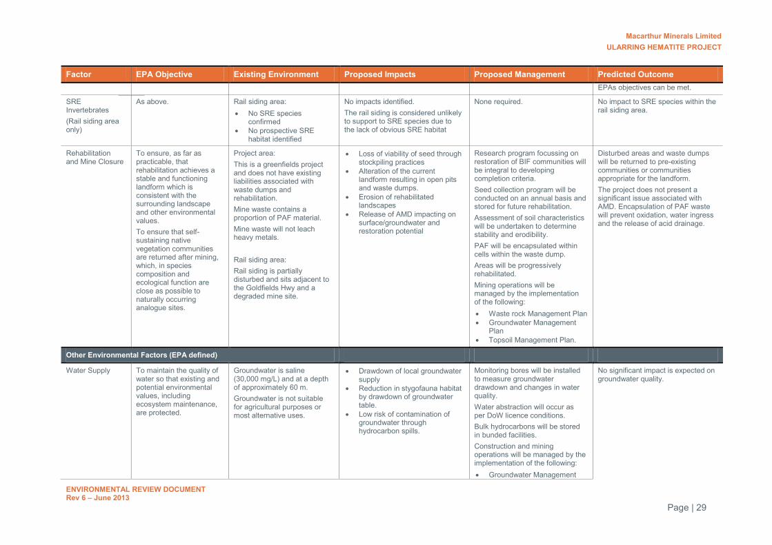
Macarthur Minerals Limited ULARRING HEMATITE PROJECT
ENVIRONMENTAL REVIEW DOCUMENT Rev 6 – June 2013
Page | 29
Factor EPA Objective Existing Environment Proposed Impacts Proposed Management Predicted Outcome EPAs objectives can be met.
SRE Invertebrates (Rail siding area only)
As above. Rail siding area: No SRE species
confirmed No prospective SRE
habitat identified
No impacts identified. The rail siding is considered unlikely to support to SRE species due to the lack of obvious SRE habitat
None required. No impact to SRE species within the rail siding area.
Rehabilitation and Mine Closure
To ensure, as far as practicable, that rehabilitation achieves a stable and functioning landform which is consistent with the surrounding landscape and other environmental values. To ensure that self-sustaining native vegetation communities are returned after mining, which, in species composition and ecological function are close as possible to naturally occurring analogue sites.
Project area: This is a greenfields project and does not have existing liabilities associated with waste dumps and rehabilitation. Mine waste contains a proportion of PAF material. Mine waste will not leach heavy metals. Rail siding area: Rail siding is partially disturbed and sits adjacent to the Goldfields Hwy and a degraded mine site.
Loss of viability of seed through stockpiling practices
Alteration of the current landform resulting in open pits and waste dumps.
Erosion of rehabilitated landscapes
Release of AMD impacting on surface/groundwater and restoration potential
Research program focussing on restoration of BIF communities will be integral to developing completion criteria. Seed collection program will be conducted on an annual basis and stored for future rehabilitation. Assessment of soil characteristics will be undertaken to determine stability and erodibility. PAF will be encapsulated within cells within the waste dump. Areas will be progressively rehabilitated. Mining operations will be managed by the implementation of the following: Waste rock Management Plan Groundwater Management
Plan Topsoil Management Plan.
Disturbed areas and waste dumps will be returned to pre-existing communities or communities appropriate for the landform. The project does not present a significant issue associated with AMD. Encapsulation of PAF waste will prevent oxidation, water ingress and the release of acid drainage.
Other Environmental Factors (EPA defined)
Water Supply To maintain the quality of water so that existing and potential environmental values, including ecosystem maintenance, are protected.
Groundwater is saline (30,000 mg/L) and at a depth of approximately 60 m. Groundwater is not suitable for agricultural purposes or most alternative uses.
Drawdown of local groundwater supply
Reduction in stygofauna habitat by drawdown of groundwater table.
Low risk of contamination of groundwater through hydrocarbon spills.
Monitoring bores will be installed to measure groundwater drawdown and changes in water quality. Water abstraction will occur as per DoW licence conditions. Bulk hydrocarbons will be stored in bunded facilities. Construction and mining operations will be managed by the implementation of the following: Groundwater Management
No significant impact is expected on groundwater quality.

Macarthur Minerals Limited ULARRING HEMATITE PROJECT
ENVIRONMENTAL REVIEW DOCUMENT Rev 6 – June 2013
Page | 30
Factor EPA Objective Existing Environment Proposed Impacts Proposed Management Predicted Outcome Plan
Hydrocarbon Management Plan
Other Environmental Factors (MMS defined)
Heritage To ensure that changes to the biophysical environment do not adversely affect historical and cultural associations and comply with relevant heritage legislation.
Two heritage sites in Snark deposit
Two heritage sites in Central deposit.
Removal of four heritage sites. Consultation with relevant local aboriginal groups prior to submission of a Section 18 Application to gain approval for the removal of these sites. Where appropriate, artefacts will be recovered. Construction and mining operations will be managed by the implementation of the following: Cultural Heritage
Management Plan.
Loss of four heritage sites within the Project area. The Aboriginal Cultural Material Committee will consider whether the sites are of cultural significance and whether MMS are granted access to the land for the purposes of the Project. Based on these predicted outcomes, MMS considers the EPAs objectives can be met.
Surface Water To maintain the quality of water so that existing and potential environmental values, including ecosystem maintenance, are protected.
No major surface water bodies or drainage channels
Runoff typically by overland sheet flow down topographical gradients
High intensity rainfall periods will occur.
Localised flooding in low lying areas during high rainfall events
Reduction in natural surface coverage, increase in hardstand
Alterations to natural drainage patterns
Potential for impacts to soils, flora and natural drainage lines from increased erosion and sedimentation
Potential for impacts to flora, fauna, soils and groundwater from contaminated runoff.
Site drainage will be constructed to maintain, as far as practicable, natural surface water flows. Sediment retention ponds will be constructed downslope of the ROM and ore stockpiles to minimise sediment loads in runoff. Bulk hydrocarbons will be stored in bunded facilities to reduce the impact of spills. Construction and mining operations will be managed by the implementation of the following: Waste Rock Management
Plan Surface Water Management
Plan Chemical and Hydrocarbons
Management Plan Waste Management Plan.
Disruptions to natural drainage patterns will be minimised by the use of site specific engineering design. Erosion and sedimentation will be controlled by the use of engineering design and the adoption of specialised landform design criteria. Contamination of runoff will be avoided by use of engineering design, waste and chemical handling, transport and storage procedures and the appropriate encapsulation of potentially contaminating waste rock materials. Based on these predicted outcomes, MMS considers the EPAs objectives can be met.

Macarthur Minerals Limited ULARRING HEMATITE PROJECT
ENVIRONMENTAL REVIEW DOCUMENT Rev 6 – June 2013
Page | 31
7.0 ASSESSMENT OF KEY ENVIRONMENTAL FACTORS
This section addresses the key environmental factors and provides an assessment of the likely impacts as a result of the implementation of the Project. Proposed management measures required to eliminate and/or minimise these impacts are also outlined.
7.1 VEGETATION AND FLORA
7.1.1 Discussion on the floristic values of the project area
A number of flora and vegetation surveys have been conducted throughout the Project area over the past six years. Table 12 summarises each of the surveys, including the survey type, seasonal timing, methodology and key outcomes, followed by a discussion on the results of the various surveys.
Being located on the convergence of two biogeographic regions, the Project area is expected to support a high level of floristic diversity. To date, approximately 208 taxa have been identified within the MMS tenement area (including areas outside the Project area but along the same greenstone belt). The most recent surveys by Mattiske recorded at least 205 species during autumn and spring (Mattiske 2012a; 2012b; 2012c). The surveys by the DEC in 2007 recorded 182 species however, their survey area did not extend as far south as the Banjo deposit.
In comparison to other BIF ranges surveyed within the Mount Manning region (as shown in Table 14), the Project area’s overall species richness is considered moderate. The level of biodiversity of the Project area (and wider MMS tenement area) is not considered as significant as some of the adjacent ranges, such as the Mount Manning, Hunt and Helena & Aurora ranges, of which are located within nature reserves, conservation parks or other DEC managed lands.
In general, species recorded within the Project area are typical of the local area, with most species being widespread throughout the region. In comparison to the DEC regional BIF data, all but five species (Acacia aff. balsamea; Frankenia desertorum; Sclerolaena drummondii; Sclerolaena obliquicuspis; Templetonia egena) have been found in the BIF ranges of the Midwest and Goldfields regions. However, all of these records are located outside the disturbance boundary. Furthermore, with the exception of the Acacia, which represents a new discovery, all the other species are widespread in areas off the BIF and are not known as BIF specialists.
Of the species recorded in the project area, between 25-61% of species were found on adjacent ranges with the most number of species in common found at Mt Manning, Johnston Range, South Illaara,Jaurdi Uplands and the Helena and Aurora Range (Table 13).

Macarthur Minerals Limited ULARRING HEMATITE PROJECT
ENVIRONMENTAL REVIEW DOCUMENT Rev 6 – June 2013
Page | 32
Table 12: Literature review of flora and vegetation survey work conducted within the Project area
Report Reference Survey Type
Survey Area and relation to Project areas
Methodology Seasonal Timing
Key Outcomes
Consultant Surveys engaged by MMS
Flora and Fauna Survey for Lake Giles Project of Tenement M30/215 (EcoSafe Environmental Consultants 2006)
Level 2 Tenement M30/215. Covers portions of north-south haul road and magazine area
28 quadrats 20 x 20 m
Spring No TEC or PECs identified No DRF, Threatened or Priority flora identified 19 taxa identified, further nine species identified only to family level Two vegetation units described; Mulga shrubland and Allocasuarina shrubland Vegetation types consist with Mount Manning Nature Reserve Minimal disturbance observed.
Vegetation Survey and Rare Flora Search of the Clark Hill North Prospect Mining Project (Paul Armstrong & Associates 2008)
Level 2 Clark Hill Prospect, E30/240. Covers portions of north-south haul road and magazine area within the Project area.
32 quadrats 20 x 20 m
Spring No TECs One PEC identified; Lake Giles vegetation complex on BIF Potential similarities to Banksia arborea on BIF PEC observed No DRF or Threatened flora identified Two Priority species recorded; Grevillea erectiloba, Spartothamnella sp. Helena &
Aurora Range Species range extension; Drosera macranthera subsp. eremaea Possible range extension or Priority species; Prostanthera? striatiflora / ferricola
(PA07/635) One species identified to family level only; Poaceae sp. (PA017/625) 95 tax recorded, 10 communities identified Dominated by Acacia and Eucalypt associations Vegetation condition good to very good Vegetation common in the local area.
Lake Giles Project Flora and Vegetation Desktop Study (Outback Ecology Services 2010a)
Desktop Lake Giles exploration areas. Covers the entire Project area.
Desktop review n/a No TECs occur One PEC mapped over portions of the survey area; Lake Giles vegetation complex Six DRF, considered unlikely to occur within survey area 27 Priority species occur in the region One considered highly likely to occur in survey area; Grevillea georgeana Five already recorded in the survey area; Banksia arborea, Grevillea erectiloba,
Eucalyptus formanii, Mirbelia ferricola, Spartothamnella sp. Helena & Aurora Range.
Revised Level 1 Flora and Vegetation Survey: Lake Giles New Exploration Areas (Outback Ecology Services 2010b)
Level 1 Lake Giles exploration areas. Covers portions of the Snark, Central and Banjo deposits.
68 revelees Spring / Summer
No TECs occur Two PECs potentially occur; Lake Giles vegetation complex on BIF, Banksia arborea on
BIF No DRF recorded Four Priority flora species recorded; Banksia arborea, Grevillea georgeana, Mirbelia
ferricola One association of interest dominated by Eucalyptus stricklandii, range is considered
restricted to the Lake Giles area 105 taxa recorded, 33 communities described
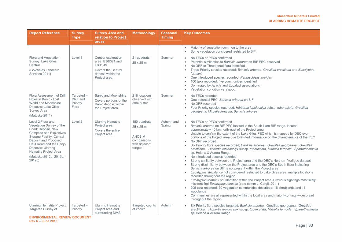
Macarthur Minerals Limited ULARRING HEMATITE PROJECT
ENVIRONMENTAL REVIEW DOCUMENT Rev 6 – June 2013
Page | 33
Report Reference Survey Type
Survey Area and relation to Project areas
Methodology Seasonal Timing
Key Outcomes
Majority of vegetation common to the area Some vegetation considered restricted to BIF.
Flora and Vegetation Survey; Lake Giles Central (Goldfields Landcare Services 2011)
Level 1 Central exploration area, E30/321 and E30/349. Covers the Central deposit within the Project area.
21 quadrats 25 x 25 m
Summer No TECs or PECs confirmed Potential similarities to Banksia arborea on BIF PEC observed No DRF or Threatened flora identified Three Priority species recorded; Banksia arborea, Grevillea erectiloba and Eucalyptus
formanii One introduced species recorded; Pentaschistis airoides 100 taxa recorded, five communities identified Dominated by Acacia and Eucalypt associations Vegetation condition very good.
Flora Assessment of Drill Holes in Banjo / Lost World and Moonshine Deposits; Lake Giles Survey Area (Mattiske 2011)
Targeted – DRF and Priority Flora
Banjo and Moonshine Covers portions of the Banjo deposit within the Project area.
218 locations observed with 50m buffer
Summer No TECs recorded One potential PEC; Banksia arborea on BIF. No DRF recorded Four Priority species recorded; Hibbertia lepidocalyx subsp. tuberculata, Grevillea
georgeana, Mirbelia ferricola, Banksia arborea.
Level 2 Flora and Vegetation Survey of the Snark Deposit, New Campsite and Explosives Storage Facility, Central Deposit and Proposed Haul Road and the Banjo Deposits; Ularring Hematite Project Area (Mattiske 2012a; 2012b; 2012c)
Level 2 Ularring Hematite Project area. Covers the entire Project area.
180 quadrats 25 x 25 m ANOSIM comparisons with adjacent ranges
Autumn and Spring
No TECs or PECs confirmed Banksia arborea on BIF PEC located in the South Illara BIF range, located
approximately 40 km north-east of the Project area Unable to confirm the extent of the Lake Giles PEC which is mapped by DEC over
portions of the Project area due to limited information on the characteristics of the PEC No DRF recorded Six Priority flora species recorded; Banksia arborea, Grevillea georgeana, Grevillea
erectiloba, Hibbertia lepidocalyx subsp. tuberculata, Mirbelia ferricola, Spartothamnella sp. Helena & Aurora Range
No introduced species recorded Strong similarity between the Project area and the DEC’s Northern Yerilgee dataset Strong dissimilarity between the Project area and the DEC’s South Illara indicating
Banksia arborea on BIF is not present within the Project area Eucalyptus stricklandii not considered restricted to Lake Giles area, multiple locations
recorded throughout the region Eucalyptus formanii not identified within the Project area. Previous sightings most likely
misidentified Eucalyptus horistes (pers comm J. Cargil, 2011) 205 taxa recorded, 30 vegetation communities described; 15 shrublands and 15
woodlands Communities are all represented within the local area and majority of taxa widespread
throughout the region.
Ularring Hematite Project; Targeted Survey of
Targeted – Priority
Ularring Hematite Project area and surrounding MMS
Targeted counts of known
Autumn Six Priority flora species targeted; Banksia arborea, Grevillea georgeana, Grevillea erectiloba, Hibbertia lepidocalyx subsp. tuberculata, Mirbelia ferricola, Spartothamnella sp. Helena & Aurora Range

Macarthur Minerals Limited ULARRING HEMATITE PROJECT
ENVIRONMENTAL REVIEW DOCUMENT Rev 6 – June 2013
Page | 34
Report Reference Survey Type
Survey Area and relation to Project areas
Methodology Seasonal Timing
Key Outcomes
Priority Flora (MMS 2012a)
Flora tenement area. Covers the entire Project area.
populations Significant populations of all species identified outside the Project area Spartothamnella sp. not identified within Project disturbance areas Significant, contiguous habitat present outside the Project area within MMS tenement
area and adjacent Mount Manning Nature Reserve.
Conservation significant flora (MMS 2012)
Flora Ularring Hematite Project area and surrounding MMS tenement area.
Targeted survey of known locations and literature review
Spring Targeted three species of conservation significant flora recently identified by DEC. Species were Acacia aff. balsamea, Acacia aff. sibirica and Sida petrophila.
No known populations encountered in the targeted survey are within the Project area. 598 locations had been previously surveyed by DEC and MMS and no populations were
encountered in the Project area. Sida petrophila and Acacia aff. sibirica are known from north of the Project area. Acacia
aff. balsamea is known from four records north of the Project area and outside the development boundary near Snark.
Acacia aff. balsamea and Sida petrophila are known from several records at some distance from the Project.
Surveys conducted by DEC
Flora and Vegetation of the Banded Iron Formations of the Yilgarn Craton: northern Yerilgee Hills
Level 2 Northern Yerilgee Hills. Covers portions of the Project area between the Snark and Central deposits.
51 quadrats 20 x 20 m
Spring Four Priority flora species identified; Spartothamnella sp. Helena & Aurora Range, Grevillea erectiloba; Banksia arborea, Austrostipa blackii
Three species of interest; possible Sida petrolphila, Acacia aff. balsamea; Acacia aff. sibirica
B. arborea and G. erectiloba considered endemic to greater Mount Manning area Spartothamnella sp. considered restricted to BIF One introduced species recorded; Pentaschistis airoides 183 taxa, six communities described Flora is typical of the Coolgardie bioregion and other BIF ranges in the region.

Macarthur Minerals Limited ULARRING HEMATITE PROJECT
ENVIRONMENTAL REVIEW DOCUMENT Rev 6 – June 2013
Page | 35
Table 13: Comparison of species recorded at Lake Giles (Nth Yerilgee) and surrounding ranges
Site No. species recorded
No. species in common with Nthn Yerilgee Hills*
% of species in common with Nthn Yerilgee Hills*
Mount Manning Range 217 73 40
Helena and Aurora Range 279 70 38
Jaurdi Uplands 268 72 39
South Illaara 140 79 43
Mount Mason (Mt Ida greenstone belt) 73 48 26
Bulga Downs (Mt Forrest - Mt Richardson Range)
104 46 25
Brooking Hills 104 45 25
Cashmere Downs 138 60 33
Diemels (Johnston Range) 170 111 61
+ Data sourced from publicly available data

Macarthur Minerals Limited ULARRING HEMATITE PROJECT
ENVIRONMENTAL REVIEW DOCUMENT Rev 6 – June 2013
Page | 36
Table 14: Species diversity of BIF and greenstone ranges including the greater Mount Manning region
Range No. DRF^ No. Priority^ Total Sp.^ Biodiversity
Ironcap Range 2 17 256 ?
Mt Gibson 2 6 242 ***
Die Hardy Range 2 5 162 **
Windarling 2 1 171 ***
Parker Range 1 13 254 ?
Central Tallering Land System - Part 2 1 12 334 ?
Helena & Aurora Range 1 9 279 ***
Mt Jackson Range 1 5 133 ***
Johnston Range 1 4 171
Koolanooka and Perenjori Hills 0 12 241 ***
Jaurdi Uplands 0 10 268 ?
Weld Range 0 8 248 *
Central Tallering Land System - Part 1 0 7 319 ?
Barloweerie and Twin Peaks 0 7 197 ?
Bremer Range 0 6 274 ?
Herbert Lukin Ridge 0 6 189 ?
Robinson Ranges and Mt Gould 0 5 165 ?
Lake Mason Zone 0 5 116 ?
Yalgoo 0 4 259 ?
Gullewa 0 4 250 ?
Highclere Hills 0 4 244
Mt Manning Range 0 4 217 **
Jack Hills 0 4 201 *
Northern Yerilgee Hills (Ularring Project) 0 4 163 ?
Montague Range 0 4 98 ?
Booylgoo Range 0 3 215 ?
Cashmere Downs Range 0 2 138 ?
Mt Forrest - Mt Richardson Range 0 2 104 ?
Western Narryer Terrane 0 1 147 ?
South Illaara greenstone belt 0 1 140 ?
Lee Steer Range 0 0 113 ?
Brooking Hills 0 0 104 ?
Perseverance greenstone belt 0 0 88 ?
Mt Ida Range 0 0 73 ?
^Data sourced from publicly available data a Comment on relative biodiversity value taken from Strategic Review of the Banded Iron Formations of the Midwest and Goldfields (DEC 2007)
? indicates relative importance unknown. *Lowest *** HIghest
Adjacent ranges are shaded blue
Conservation significant species No Declared Rare Flora (DRF) listed under the WC Act or threatened species listed under the EPBC Act are known to occur in the Project area or within the wider MMS tenement area. Six Priority flora species, listed by the DEC have been recorded in the Project area. The following Priority flora has been recorded within the MMS tenement area:
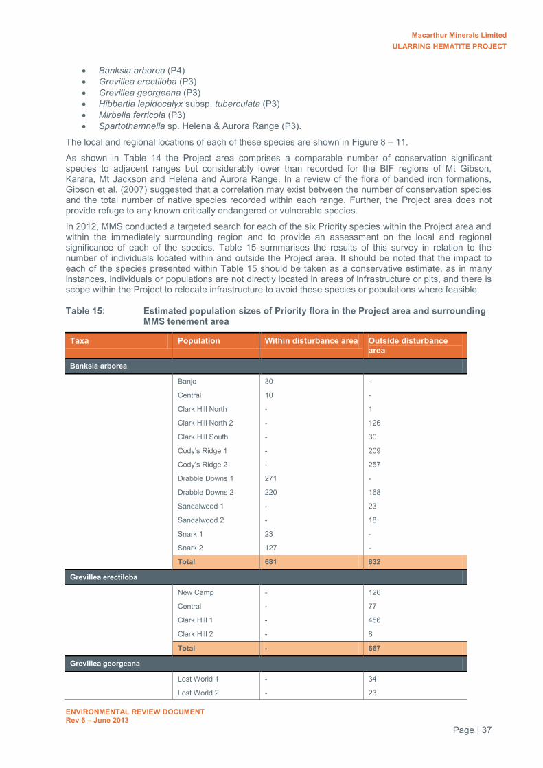
Macarthur Minerals Limited ULARRING HEMATITE PROJECT
ENVIRONMENTAL REVIEW DOCUMENT Rev 6 – June 2013
Page | 37
Banksia arborea (P4) Grevillea erectiloba (P3) Grevillea georgeana (P3) Hibbertia lepidocalyx subsp. tuberculata (P3) Mirbelia ferricola (P3) Spartothamnella sp. Helena & Aurora Range (P3).
The local and regional locations of each of these species are shown in Figure 8 – 11.
As shown in Table 14 the Project area comprises a comparable number of conservation significant species to adjacent ranges but considerably lower than recorded for the BIF regions of Mt Gibson, Karara, Mt Jackson and Helena and Aurora Range. In a review of the flora of banded iron formations, Gibson et al. (2007) suggested that a correlation may exist between the number of conservation species and the total number of native species recorded within each range. Further, the Project area does not provide refuge to any known critically endangered or vulnerable species.
In 2012, MMS conducted a targeted search for each of the six Priority species within the Project area and within the immediately surrounding region and to provide an assessment on the local and regional significance of each of the species. Table 15 summarises the results of this survey in relation to the number of individuals located within and outside the Project area. It should be noted that the impact to each of the species presented within Table 15 should be taken as a conservative estimate, as in many instances, individuals or populations are not directly located in areas of infrastructure or pits, and there is scope within the Project to relocate infrastructure to avoid these species or populations where feasible.
Table 15: Estimated population sizes of Priority flora in the Project area and surrounding MMS tenement area
Taxa Population Within disturbance area Outside disturbance area
Banksia arborea
Banjo 30 -
Central 10 -
Clark Hill North - 1
Clark Hill North 2 - 126
Clark Hill South - 30
Cody’s Ridge 1 - 209
Cody’s Ridge 2 - 257
Drabble Downs 1 271 -
Drabble Downs 2 220 168
Sandalwood 1 - 23
Sandalwood 2 - 18
Snark 1 23 -
Snark 2 127 -
Total 681 832
Grevillea erectiloba
New Camp - 126
Central - 77
Clark Hill 1 - 456
Clark Hill 2 - 8
Total - 667
Grevillea georgeana
Lost World 1 - 34
Lost World 2 - 23

Macarthur Minerals Limited ULARRING HEMATITE PROJECT
ENVIRONMENTAL REVIEW DOCUMENT Rev 6 – June 2013
Page | 38
Taxa Population Within disturbance area Outside disturbance area
Lost World 3 - 114
Moonshine - 46
North Moonshine - 146
South Banjo 35 -
Total 35 363
Hibbertia lepidocalyx subsp. tuberculata
Banjo North 1 47 89
Banjo North 2 8 20
Lost World 1 - 33
Lost World 2 200 -
Lost World 3 - 320
Lost World 4 - 100
Total 255 562
Mirbelia ferricola
Banjo South 1 -
Central - 58
Cody's Ridge - 18
Lost World 1 - 59
Lost World 2 - 57
Moonshine 2 - 72
Moonshine 3 - 29
Moonshine1 - 10
North Moonshine 1 - 23
North Moonshine 2 - 144
Total 1 470
Spartothamnella sp.
Clark Hill 1 - 3
Clark Hill2 - 6
Cody's Ridge - 1
Lost World - 69
North Moonshine - 53
South Central - 5
Total 0 137
*Disturbance area is defined as the area to be directly impacted by clearing.
B. arborea is described as a tree which typically grows on rocky BIF outcrops, but also inhabits stony slopes off the outcrop (MMS 2012a). The species is considered to be endemic to the greater Mount Manning region with known locations occurring within a 200 km diameter (Markey and Dillon 2011). Significant populations of this species are known to occur outside the Project area in the immediately surrounding BIF areas as part of the Yerilgee Greenstone Belt, and are also present within the adjacent Mount Manning Nature Reserve (MMS 2012a). In addition, the Project does not propose to remove all BIF outcrops within the Yerilgee Greenstone Belt and as such, suitable habitat will remain undisturbed. Potential impacts to this species as a result of the Project are considered to be minimal and will not adversely impact on the overall regional abundance or distribution of the species.
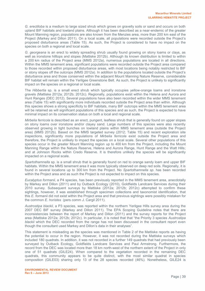
Macarthur Minerals Limited ULARRING HEMATITE PROJECT
ENVIRONMENTAL REVIEW DOCUMENT Rev 6 – June 2013
Page | 39
G. erectiloba is a medium to large sized shrub which grows on gravelly soils or sand and occurs on both upland BIF habitats and lowland plains. Although it has been described as a near-endemic of the greater Mount Manning region, populations are also known from the Menzies area, more than 200 km east of the Project (Markey and Dillon 2011). On a local scale, all populations were recorded outside the Project’s proposed disturbance areas (Table 15). As such, the Project is considered to have no impact on the species on both a regional and local scale.
G. georgeana is an erect to widely spreading shrub usually found growing on stony loams or clays, as well as ironstone hilltops and slopes (Mattiske 2012b). Although its known distribution is limited to within a 200 km radius of the Project area (MMS 2012a), numerous populations are located in all directions. Within the MMS tenement area, significant populations were recorded outside the Project area compared to those recorded within proposed disturbance areas, with most locations being notably restricted to BIF or stony slopes off the outcrops (MMS 2012a). In addition to the populations located outside the Project’s disturbance area and those conserved within the adjacent Mount Manning Nature Reserve, considerable BIF habitat will remain within the Yerilgee Greenstone Belt. As such, the Project is unlikely to significantly impact on the species on a regional or local scale.
The Hibbertia sp. is a small erect shrub which typically occupies yellow-orange loams and ironstone gravels (Mattiske 2012a; 2012b; 2012c). Regionally, populations exist within the Helena and Aurora and Hunt Ranges (DEC 2012). Several populations have also been recorded within the wider MMS tenement area (Table 15) with significantly more individuals recorded outside the Project area than within. Although this species shows a strong specificity to BIF habitats, many BIF outcrops within the MMS tenement area will be retained as will significant populations of this species and as such, the Project is expected to have minimal impact on its conservation status on both a local and regional scale.
Mirbelia ferricola is described as an erect, pungent, leafless shrub that is generally found on upper slopes on stony loams over ironstone and/or clayey sand. Large numbers of this species were also recently observed growing in tight bunches on lowland plains within MMS tenement area (outside the Project area) (MMS 2012b). Based on the MMS targeted survey (2012; Table 15) and recent exploration site inspections, significantly more populations of Mirbelia ferricola exist outside the Project area and therefore, the Project is unlikely to impact the species on a local scale. Several other populations of this species occur in the greater Mount Manning region up to 400 km from the Project, including the Mount Manning Range within the Nature Reserve, Helena and Aurora Range, Hunt Range and the Watt Hills; and at Johnson Rocks within Credo Reserve. It is therefore unlikely the species will be significantly impacted on a regional scale.
Spartothamnella sp. is a small shrub that is generally found on red to orange sandy loam and upper BIF habitats. Within the MMS tenement area it was more typically observed on deep red soils. Regionally, it is found in several locations up to 300 km from the Project. No Spartothamnella sp. has been recorded within the Project area and as such the Project is not expected to impact on this species.
Eucalyptus formanii, a P4 species, has been previously reported in the MMS tenement area, anecdotally by Markey and Dillon (2011) and by Outback Ecology (2010), Goldfields Landcare Services during their 2010 survey. Subsequent surveys by Mattiske (2012a; 2012b; 2012c) attempted to confirm these sightings, however, it was established through specimen collections and taxonomist identification, that this E. formanii did not exist within the Project area and that previous sightings were possibly mistaken for the common E. horistes (pers comm J. Cargil 2011).
Austrostipa blackii, a P3 species, was reported within the northern Yerilgee Hills survey area during the 2007 DEC BIF survey (Markey and Dillon 2011). The EPA Scoping Guideline notes that there are inconsistencies between the report of Markey and Dillon (2011) and the survey reports for the Project area (Mattiske 2012a; 2012b; 2012c). In particular, it is noted that that “the Priority 3 species Austrostipa blackii which the DEC recorded from the range has not been discussed in the consultant report even though the consultant used Markey and Dillon’s data in their analyses”.
This statement is misleading as the species was mentioned in Table 2 of the Mattiske reports as having the potential to occur in the region. However, it was not recorded during the Mattiske surveys which included 180 quadrats. In addition, it was not recorded in a further 149 quadrats that had previously been surveyed by Outback Ecology, Goldfields Landcare Services and Paul Armstrong. Furthermore, the record from the DEC was located more than 18 km north-west of the northern extent of the Project in only one of 51 quadrats (GILE24). When compared to the vegetation recorded in the remaining DEC quadrats, this community appears to be quite distinct, with the most similar quadrat in species composition (GILE03) sharing only 13 of the 28 species recorded (46%). Nonetheless, GILE24 is
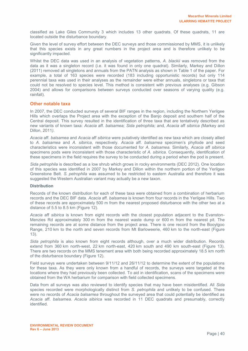
Macarthur Minerals Limited ULARRING HEMATITE PROJECT
ENVIRONMENTAL REVIEW DOCUMENT Rev 6 – June 2013
Page | 40
classified as Lake Giles Community 3 which includes 13 other quadrats. Of these quadrats, 11 are located outside the disturbance boundary.
Given the level of survey effort between the DEC surveys and those commissioned by MMS, it is unlikely that this species exists in any great numbers in the project area and is therefore unlikely to be significantly impacted.
Whilst the DEC data was used in an analysis of vegetation patterns, A. blackii was removed from the data as it was a singleton record (i.e. it was found in only one quadrat). Similarly, Markey and Dillon (2011) removed all singletons and annuals from the PATN analysis as shown in Table 1 of the paper. For example, a total of 163 species were recorded (183 including opportunistic records) but only 114 perennial taxa was used in their analyses as the remainder were either annuals, singletons or taxa that could not be resolved to species level. This method is consistent with previous analyses (e.g. Gibson 2004) and allows for comparisons between surveys conducted over seasons of varying quality (e.g. rainfall).
Other notable taxa In 2007, the DEC conducted surveys of several BIF ranges in the region, including the Northern Yerilgee Hills which overlaps the Project area with the exception of the Banjo deposit and southern half of the Central deposit. This survey resulted in the identification of three taxa that are tentatively described as new variants of known taxa: Acacia aff. balsamea; Sida petrophila; and, Acacia aff sibirica (Markey and Dillon, 2011).
Acacia aff. balsamea and Acacia aff sibirica were putatively identified as new taxa which are closely allied to A. balsamea and A. sibirica, respectively. Acacia aff. balsamea specimen’s phyllode and seed characteristics were inconsistent with those documented for A. balsamea. Similarly, Acacia aff sibirica specimens pods were inconsistent with those characteristic of A. sibirica. Consequently, identification of these specimens in the field requires the survey to be conducted during a period when the pod is present.
Sida petrophila is described as a low shrub which grows in rocky environments (DEC 2012). One location of this species was identified in 2007 by Markey and Dillon within the northern portion of the Yerilgee Greenstone Belt. S. petrophila was assumed to be restricted to eastern Australia and therefore it was suggested the Western Australian variant may actually be a new taxon.
Distribution
Records of the known distribution for each of these taxa were obtained from a combination of herbarium records and the DEC BIF data. Acacia aff. balsamea is known from four records in the Yerilgee Hills. Two of these records are approximately 500 m from the nearest proposed disturbance with the other two at a distance of 5.5 to 8.5 km (Figure 12).
Acacia aff sibirica is known from eight records with the closest population adjacent to the Evanston-Menzies Rd approximately 300 m from the nearest waste dump or 600 m from the nearest pit. The remaining records are at some distance from the project area. There is one record from the Booylgoo Range, 210 km to the north and seven records from Mt Barloweerie, 460 km to the north-east (Figure 13).
Sida petrophila is also known from eight records although, over a much wider distribution. Records extend from 360 km north-west, 22 km north-east, 420 km south and 490 km south-east (Figure 13). There are two records on the MMS tenement area with both being recorded approximately 18.5 km north of the disturbance boundary (Figure 12).
Field surveys were undertaken between 9/11/12 and 26/11/12 to determine the extent of the populations for these taxa. As they were only known from a handful of records, the surveys were targeted at the locations where they had previously been collected. To aid in identification, scans of the specimens were obtained from the WA herbarium for comparison with field collected specimens.
Data from all surveys was also reviewed to identify species that may have been misidentified. All Sida species recorded were morphologically distinct from S. petrophila and unlikely to be confused. There were no records of Acacia balsamea throughout the surveyed area that could potentially be identified as Acacia aff. balsamea. Acacia sibirica was recorded in 11 DEC quadrats and presumably, correctly identified.

Macarthur Minerals Limited ULARRING HEMATITE PROJECT
ENVIRONMENTAL REVIEW DOCUMENT Rev 6 – June 2013
Page | 41
Sida petrophila was relocated at and adjacent to DEC quadrat GILE24 but could not be found near quadrat GILE17 (WA Herbarium record 07838441) 200 m away. The population consisted of approximately 50 scattered plants covering an area of 0.5 ha.
Acacia aff. sibirica was found in an area of approximately 1.8 km along the Evanston-Menzies Rd. The area contained approximately 75 plants, although not all could be confidently identified as seed pods were not always present.
Acacia aff. balsamea was found at three locations in and adjacent to DEC quadrats Gile6, Gile7 and Gile27 covering an area of between 0.17 to 0.39 ha and consisting of 20-50 individuals.
Given the level of survey effort between the DEC surveys and those commissioned by MMS, with over 598 locations surveyed, it is unlikely that these taxa exist in any great numbers in the project area and will therefore unlikely to be significantly impacted.
A discussion was held with Bruce Maslin (WA Herbarium) whom identified the two Acacia taxa. Bruce said that it is misleading to describe these as “potential new species”, but rather that they had similarities to their parent species but showed slightly less resonance. They may not be new species and are currently just of scientific interest. Both species come from a very complex taxonomic group that would take considerable time and effort to provide a clear taxonomic position.
The record of Drosera macrantha subsp. eremaea identified by Paul Armstrong and Associates (2008) represents a range extension. However, the location of this record was revisited by Mattiske and specimens sent to the WA herbarium for identification which came back as Drosera macrantha subsp. macrantha, which is common and widespread.
Paul Armstrong and Associates (2008) also record a specimen that was identified as either Prostanthera ferricola or Prostanthera striatiflora which represents either a P3 species or range extension, respectively. This taxa was located at two locations near Clark Hill. Both locations are located outside the Project Development Area and won’t be impacted by the Project. Both of these species were not identified in further surveys of the project by Mattiske or Outback Ecology.
7.1.1.1 Discussion on the vegetation associations of the Project area
Several vegetation mapping studies have been undertaken of the Project area in the past six years by several consultant and government botanists. To ensure consistency, MMS have adopted the Mattiske vegetation community descriptions when assessing the potential impacts to associations within the Project area as this is the most recent mapping completed and the only survey in which was conducted of the entire Project area.
Within the 6,459 ha surveyed by Mattiske, a total of 15 shrubland and 15 woodland communities were described (descriptions presented below). Shrubland communities were dominated by a mixture of Acacia and Allocasuarina with occasional emergent Eucalypts, over a number of various shrubs such as Dodoneae, Eremophila, Sida and Philotheca species. Woodland communities were more widespread and typically on either low-lying drainage areas or mid-slopes to ridges. Broad vegetation units described by Mattiske were consistent with previous regional Beard mapping (1972, 1972b), as well as that conducted by other consultants prior to 2011 with similarities in dominant scrub and over storey species.
Generally, the associations of lowland communities, such as the Eucalypt woodlands and some of the Acacia shrublands are considered common of the local area and widespread throughout the region. It is more likely that the upland shrubland communities, particularly those situated on rocky BIF outcrops or mid to upper slopes, are more restricted due to strict habitat requirements. Although many species may be common to the area, the actual associations of species are considered to vary between ranges of the greater Mount Manning region (Markey and Dillon 2011).
To determine the regional significance of the communities identified within the Project area, associated described by Mattiske were compared to data collected by Markey and Dillon (2011) and to data collected from adjacent ranges; South Illaara and Mount Manning ranges located approximately 35 km north-east and 30 km west of the Project respectively. South Illaara was found to be most similar, although the degree of similarity ranged between the three deposits in the Project area with the Banjo deposit displaying the greatest similarity (Table 16).

Macarthur Minerals Limited ULARRING HEMATITE PROJECT
ENVIRONMENTAL REVIEW DOCUMENT Rev 6 – June 2013
Page | 42
Vegetation communities recorded by Mattiske (2011a; 2011b; 2011c) Shrublands
S1: Open scrub of Acacia ramulosa var. ramulosa and Acacia aneura over Philotheca brucei subsp. brucei, Dodonaea rigida, Eremophila alternifolia and Eremophila latrobei subsp. latrobei over Olearia humilis on flats to low natural relief with compact light brown clay soils.
S2: Tall scrub of Acacia ayersiana, Banksia arborea (P4) and Melaleuca leiocarpa over Philotheca brucei subsp. brucei and Prostanthera grylloana over Sida spodochroma and Cheilanthes sieberi subsp. sieberi on upper slopes and ridges with banded ironstone outcroppings.
S3: Tall scrub of Allocasuarina acutivalvis subsp. acutivalvis, Acacia quadrimarginea, Acacia ramulosa var. ramulosa, Acacia aneura with emergent Brachychiton gregorii over Philotheca brucei subsp. brucei, Eremophila latrobei subsp. latrobei, Acacia tetragonophylla and Dodonaea rigida over Sida ectogama, Cheilanthes brownii and Olearia muelleri on mid slopes to ridges with gravelly clays.
S4: Scrub of Allocasuarina campestris, Allocasuarina dielsiana, Acacia burkittii, Acacia ramulosa var. ramulosa and Acacia aneura with occasional emergent Eucalyptus capillosa subsp. capillosa and Eucalyptus stricklandii over Acacia tetragonophylla, Dodonaea rigida and Scaevola spinescens over Ptilotus obovatus var. obovatus and Sida calyxhymenia on flat to mid slopes with ironstone pebbles.
S5: Tall mixed scrub of Acacia ramulosa var. ramulosa, Acacia tetragonophylla, Acacia ?ayersiana, Acacia burkittii and Acacia aneura with emergent Eucalyptus griffithsii and Eucalyptus stricklandii over Solanum lasiophyllum, Sida ectogama, Ptilotus obovatus var. obovatus and Sida spodochroma on flat to lower slopes with red-brown clay soils.
S6: Open scrub of Acacia ayersiana, Acacia cockertoniana, Acacia tetragonophylla and Eremophila oppositifolia subsp. angustifolia over Eremophila latrobei subsp. latrobei, Eremophila decipiens subsp. decipiens, Prostanthera althoferi subsp. althoferi and Philotheca brucei subsp. brucei over Olearia humilis on mid- to upper slopes.
S7: Scrub of Allocasuarina acutivalvis subsp. acutivalvis and Casuarina pauper over Acacia burkittii, Acacia quadrimarginea and Eremophila oldfieldii subsp. angustifolia over Scaevola spinescens and Dodonaea lobulata over Santalum spicatum, Ptilotus obovatus var. obovatus and Solanum lasiophyllum on lower slopes to small ridges with compact ironstone pebbles.
S8: Mixed Scrub of Allocasuarina eriochlamys subsp. eriochlamys, Allocasuarina campestris and Allocasuarina acutivalvis subsp. acutivalvis with occasional emergent Eucalyptus horistes over Acacia quadrimarginea and Calycopeplus paucifolius over Grevillea paradoxa, Baeckea elderiana, Philotheca brucei subsp. brucei, Leucopogon sp. Clyde Hill and Phebalium canaliculatum on lower to mid slopes with gravelly clays and occasional ironstone outcropping.
S9: Scrub of Acacia ramulosa var. ramulosa and Acacia burkittii with emergent Allocasuarina campestris and Eucalyptus oleosa subsp. oleosa over Scaevola spinescens, Grevillea paradoxa and Acacia andrewsii over Hibbertia nutans and Westringia cephalantha var. ?cephalantha on flat to mid slopes with red/brown clay and ironstone pebbles.
S10: Scrub of Allocasuarina campestris with emergent Eucalyptus oleosa subsp. oleosa over Acacia ramulosa var. ramulosa and Acacia burkittii over Dodonaea rigida, Philotheca brucei subsp. brucei and Phebalium canaliculatum over Olearia muelleri and Leucopogon sp. Clyde Hill on mid slopes to ridges with compact red/brown clays and occasional ironstone outcropping.
S11: Tall scrub of Acacia aneura, Acacia ramulosa var. ramulosa, Acacia ayersiana and Acacia burkittii with occasional emergent Eucalyptus concinna and Eucalyptus yilgarnensis over Eremophila alternifolia and Eremophila decipiens subsp. decipiens over Amphipogon sp. on flats with red/brown clay and ironstone pebbles.
S12: Low open scrub of Eremophila forrestii subsp. forrestii and Eremophila maculata subsp. maculata over Streptoglossa liatroides, Eragrostis falcata, Ptilotus exaltatus var. exaltatus, Sclerolaena fusiformis and Aristida inaequiglumis on flat cracking clays.
S13: Tall scrub of Acacia ramulosa var. ramulosa, Acacia burkittii and Acacia aneura with emergent Allocasuarina acutivalvis subsp. acutivalvis and Eucalyptus griffithsii over Acacia tetragonophylla, Scaevola spinescens and Dodonaea rigida over Ptilotus obovatus var. obovatus, Sida sp. Dark
Macarthur Minerals Limited ULARRING HEMATITE PROJECT
ENVIRONMENTAL REVIEW DOCUMENT Rev 6 – June 2013
Page | 43
green fruits (S. van Leeuwen 2260) and Solanum lasiophyllum on flats with red/brown clay and small ironstone pebbles.
S14: Mixed scrub of Casuarina pauper, Allocasuarina acutivalvis subsp. acutivalvis, Acacia quadrimarginea, Acacia ramulosa var. ramulosa, Acacia burkittii and Brachychiton gregorii with emergent Eucalyptus griffithsii over Santalum spicatum, Acacia tetragonophylla, Alyxia buxifolia, Eremophila oldfieldii subsp. angustifolia and Philotheca brucei subsp. brucei over Leucopogon sp. Clyde Hill, Senna artemisioides subsp. filifolia, Ptilotus obovatus var. obovatus, Prostanthera grylloana and Olearia muelleri on lower slopes to ridges with red/orange gravelly clays and occasional ironstone outcropping.
S15: Scrub of Casuarina pauper, Acacia erinacea, Calycopeplus paucifolius, Acacia duriuscula and Acacia burkittii over Alyxia buxifolia, Acacia tetragonophylla, Eremophila alternifolia and Grevillea oligomera with occasional emergent Eucalyptus gracilis over Philotheca brucei subsp. brucei and Leucopogon sp. Clyde Hill over Triodia rigidissima and Solanum lasiophyllum on upper slopes to ridges with red/brown gravelly clays and occasional lateritic outcropping.
Woodlands
W1: Woodland of Eucalyptus salmonophloia and Eucalyptus griffithsii over Santalum spicatum, Eremophila oldfieldii subsp. angustifolia and Acacia ramulosa var. ramulosa over Scaevola spinescens and Dodonaea lobulata over Sida ectogama and Ptilotus obovatus var. obovatus on flat to lower slopes with red-brown gravelly clay.
W2: Woodland of Eucalyptus stricklandii and Eucalyptus loxophleba subsp. supralaevis with Allocasuarina acutivalvis subsp. acutivalvis over Eremophila oppositifolia subsp. angustifolia, Acacia aneura, Acacia tetragonophylla and Alyxia buxifolia over Olearia exiguifolia, Ptilotus obovatus var. obovatus and Sida ectogama on lower slopes to ridges with compact clay and small to medium ironstone pebbles.
W3: Open woodland of Eucalyptus griffithsii over Acacia erinacea and mixed Eremophila over Maireana tomentosa, Sclerolaena fusiformis, Sclerolaena diacantha and Atriplex vesicaria on compact clay drainage lines with small ironstone pebbles.
W4: Woodland of Eucalyptus oleosa subsp. oleosa, Eucalyptus salubris, Eucalyptus concinna, Eucalyptus stricklandii and Eucalyptus longissima over Allocasuarina acutivalvis subsp. acutivalvis, Acacia erinacea, Exocarpos aphyllus and Acacia burkittii over Eremophila glabra subsp. albicans, Senna artemisioides subsp. filifolia, Ptilotus obovatus var. obovatus, Mirbelia depressa and Olearia muelleri on flat to lower slopes with small to medium ironstone and quartz pebbles.
W5: Open woodland of Eucalyptus salubris with occasional Allocasuarina campestris over Acacia tetragonophylla, Eremophila oldfieldii subsp. angustifolia, Alyxia buxifolia and Santalum spicatum over Prostanthera althoferi subsp. althoferi, Enchylaena sp., Maireana trichoptera and Ptilotus obovatus var. obovatus on flat to lower slopes with fine ironstone pebbles.
W6: Open woodland of Eucalyptus ravida and Eucalyptus yilgarnensis over Eremophila alternifolia and Eremophila oldfieldii subsp. angustifolia over Rhagodia drummondii, Sclerolaena fusiformis and Maireana sp. on pale clay flats.
W7: Open woodland of Eucalyptus concinna and Eucalyptus longissima with occasional Allocasuarina campestris over Acacia burkittii, Acacia tetragonophylla and Acacia andrewsii over Maireana trichoptera, Senna artemisioides subsp. filifolia, Ptilotus obovatus var. obovatus on flat calcrete patches.
W8: Woodland of Eucalyptus stricklandii and Eucalyptus ravida with Casuarina pauper over Eremophila oppositifolia subsp. angustifolia, Eremophila oldfieldii subsp. angustifolia, Alyxia buxifolia, Scaevola spinescens and Eremophila scoparia over Olearia muelleri and Ptilotus obovatus var. obovatus on granite slopes and ridges with gravelly clays.
W9: Open woodland of Eucalyptus yilgarnensis, Eucalyptus ravida and Eucalyptus concinna over Eremophila scoparia and Santalum acuminatum over Atriplex nummularia subsp. spathulata, Atriplex vesicaria, Olearia muelleri, Ptilotus exaltatus var. exaltatus and Ptilotus obovatus var. obovatus on flat red/brown clays.
Macarthur Minerals Limited ULARRING HEMATITE PROJECT
ENVIRONMENTAL REVIEW DOCUMENT Rev 6 – June 2013
Page | 44
W10: Open woodland of Eucalyptus salubris and Eucalyptus concinna over Casuarina pauper over Acacia leptopetala, Acacia burkittii and Acacia tetragonophylla over Eremophila forrestii subsp. forrestii, Eremophila scoparia and Senna artemisioides subsp. filifolia over Atriplex nummularia subsp. spathulata, Mirbelia depressa, Ptilotus exaltatus var. exaltatus and Solanum nummularium on flat cracking clays.
W11: Open mixed woodland of Eucalyptus griffithsii, Eucalyptus gracilis, Eucalyptus concinna and Eucalyptus yilgarnensis over Casuarina pauper over Acacia tetragonophylla, Acacia burkittii and Acacia ramulosa var. ramulosa over Scaevola spinescens and Alyxia buxifolia over Senna artemisioides subsp. filifolia, Ptilotus obovatus var. obovatus, Olearia muelleri and Solanum nummularium on flat to lower slopes with red to red/brown clays and ironstone and/or quartz pebbles.
W12: Open woodland of Eucalyptus horistes and Eucalyptus loxophleba subsp. lissophloia over Allocasuarina campestris over Acacia tetragonophylla and Acacia burkittii over Triodia scariosa, Solanum lasiophyllum and Hybanthus floribundus subsp. curvifolius on flat red/brown sandy clays.
W13: Open woodland of Eucalyptus griffithsii and Eucalyptus oleosa subsp. oleosa over Santalum spicatum, Acacia erinacea, Alyxia buxifolia, Eremophila oppositifolia subsp. angustifolia, Acacia burkittii and Eremophila scoparia over Olearia exiguifolia, Ptilotus obovatus var. obovatus, Senna artemisioides subsp. filifolia and Maireana georgei on flat to upper slopes with red/brown gravelly clays and ironstone and/or quartz pebbles.
W14: Open woodland of Eucalyptus ebbanoensis subsp. glauciramula and Eucalyptus concinna over Allocasuarina campestris and Allocasuarina acutivalvis subsp. acutivalvis over Scaevola spinescens, Acacia burkittii and Alyxia buxifolia over Phebalium canaliculatum, Eremophila granitica, Acacia andrewsii, Stenanthemum stipulosum and Hibbertia exasperata over Olearia muelleri and Maireana trichoptera on flat to lower slopes with orange/brown sandy clays or gravelly clays and small ironstone pebbles.
W15: Open woodland of Eucalyptus oleosa subsp. oleosa over Acacia erinacea, Eremophila oppositifolia subsp. angustifolia, Eremophila oldfieldii subsp. angustifolia and Scaevola spinescens over Ptilotus obovatus var. obovatus, Olearia muelleri, Senna artemisioides subsp. filifolia and Maireana georgei on minor creek lines with red sandy gravel and small ironstone pebbles.
Communities of Conservation Significance Two PECs are noted as having the potential to occur in the Project area – the Banksia arborea PEC and the Lake Giles PEC.
The Banksia arborea PEC is mapped by the DEC as occurring 21 km northeast of the Project area on the South Illaara range (Figure 18). Information from the DEC Species and Communities Branch indicates that the approximate boundary was mapped from a combination of 1:100, 1:250 geology mapping, Beard vegetation, topography and endemic flora. Whilst ‘Banksia arborea BIF’ is name given for this particular BIF range; it doesn’t necessarily reflect the composition of all the vegetation units that make up the BIF. Unfortunately, there is no clear description of the communities that constitute the PEC.
Analysis of similarity (ANOSIM) was used to compare communities occurring in the Project area and in the Banksia PEC (Figure 18). There was some similarity between the Snark/Central deposits and the Banksia PEC but considerably less for the Banjo deposit. However, the degree of similarity is fairly low as demonstrated by the clustering of sites within the dendrograms presented in Mattiske reports (2012a; 2012b; 2012c).
As the Lake Giles PEC encompasses the entirety of the Project area, it can only be assumed that the Banksia PEC is not present in the project area; unless two PECs can describe the same community. Any assessment on the impact can only be limited to a determination of the area to be cleared until the DEC provides further clarification on the communities considered most significant.
Similar to the Banksia PEC, the approximate boundary of the Lake Giles PEC was mapped from a combination of 1:100, 1:250 geology mapping, Beard vegetation and topography. This was presumably done prior to the DEC survey in 2007 as only 20 of 51 quadrats fall within the PEC boundary (Figure 19).

Macarthur Minerals Limited ULARRING HEMATITE PROJECT
ENVIRONMENTAL REVIEW DOCUMENT Rev 6 – June 2013
Page | 45
The alternate option is that the communities that constitute the remaining quadrats are not considered to be part of the PEC as they are not at threat or locally endemic. Nonetheless, the Lake Giles PEC has recently undergone an extension of its boundary to now encompass the entire project area and incorporate all DEC quadrats of the Northern Yerilgee Hills.
To assist in defining the Lake Giles PEC, MMS consulted with the DEC Species and Communities Branch, who are responsible for mapping the PEC. MMS was advised that the Species and Communities Branch did not have access to the DEC BIF data. MMS retrieved this information from the DEC website and provided the DEC with shapefiles of the Mattiske vegetation mapping of the Project area and location of DEC quadrat locations on 20/3/12, for the purpose of defining the PEC. The DEC then amended the boundary of the PEC on 23/4/12 to wholly encompass the Project area as an interim measure. The change in boundary was made on the basis of random polygons of undescribed communities, as this information was not provided. However, as the area encompassing the PEC has increased from 10,150 ha to 22,940 ha, the impact of the project on the PEC as a whole is considerably less. As the individual communities that may be at greater risk have not been defined, figures have been provided on the area of disturbance to each community within the mapped range (Table 17). Figures for disturbance have been calculated from a mapped area of 9615 ha, a Project Development Area of 2820 ha and the disturbance area of 609 ha (Table 17).
Of the 30 mapped vegetation communities, 24 will be impacted to a varying extent (Table 17). Five communities will be impacted by more than 20% of their mapped area; S2, S5, S10, S14 and W2. All communities are known from 21 to 352 ha (Table 17). The greatest impact will be to community S5 which has been mapped at two disjunct locations within the Project boundary. Both areas will be impact by mine pits with little scope for avoidance. The two S5 communities are mapped as 4 ha and 17.43 ha with the area to be removed calculated as 1.38 ha and 8.21 ha respectively.
However, the clearing proposed is in accordance with the EPA’s Position Statement No.2 Environmental Protection of Native Vegetation in Western Australia. Remaining communities will be represented well above the 30% threshold level below which species loss appears accelerates at an exponential rate.
Table 16: ANOSIM R values for comparison between the three deposits and the Banksia arborea PEC at Sth Illaara
Range Ra Pb nc
Banjo, Sth Ilaarra 0.576 0.001 132
Central, Sth Ilaara 0.285 0.001 186
Snark, Sth Illaara 0.183 0.001 165
a An ANOSIM R value of 1 indicates complete dissimilarity between groups of sites; 0 corresponds to complete similarity.
b Significance level of sample statistic.
c n, number of sites included in the ANOSIM.

Macarthur Minerals Limited ULARRING HEMATITE PROJECT
ENVIRONMENTAL REVIEW DOCUMENT Rev 6 – June 2013
Page | 46
Table 17: Disturbance to mapped vegetation communities of the Project area
Vegetation Community ID
Total area (ha)
Area within PDA+
(ha)
% within PDA
Area within impact zone
%
S1 649.54 125.83 19 19.22 3
S2 91.27 76.67 84 30.85 34
S3 557.91 127.98 23 52.53 9
S4 1,462.59 450.38 31 133.61 9
S5 21.18 21.18 100 9.59 45
S6 1,113.30 280.33 25 41.99 4
S7 656.48 27.71 4 5.45 1
S8 400.38 27.55 7 3.49 1
S9 28.33 11.04 39 0.46 2
S10 351.58 278.52 79 68.81 20
S11 291.30 33.78 12 0.45 0
S12 9.26 5.89 64 0.75 8
S13 291.62 51.93 18 3.52 1
S14 235.46 149.02 63 49.83 21
S15 4.27 0 0 0 0
W1 137.42 87.74 64 15.92 12
W2 29.36 29.36 100 6.84 23
W3 32.46 15.23 47 0.50 2
W4 210.38 116.41 55 17.99 9
W5 217.34 90.44 42 14.28 7
W6 16.97 0 0 0 0
W7 35.45 1.45 4 0 0
W8 223.38 14.62 7 1.88 1
W9 499.74 126.29 25 13.83 3
W10 141.62 27.19 19 3.43 2
W11 1,639.11 479.62 29 107.37 7
W12 21.39 8.86 41 0.42 2
W13 223.07 127.64 57 7.62 3
W14 56.44 25.25 45 0 0
W15 5.94 0.23 4 0 0
TOTAL 9656.16 2819.74 29 612.29 6
+ PDA = Project Disturbance Area
7.1.2 Extension to previous vegetation mapping
Ecologia was engaged to extend the current vegetation mapping by Mattiske to surrounding areas to provide further regional context on the distribution of the vegetation assemblages within the Project area (Appendix 7). The focus of the mapping extension was on areas of BIF outcropping, rather than the surrounding plains, as this is considered to be the area of highest significance. Data was consolidated from the following sources:
Mattiske surveys of Snark, Central and Banjo (180 quadrats) DEC BIF surveys (36 quadrats) Armstrong and Associates (19 quadrats)
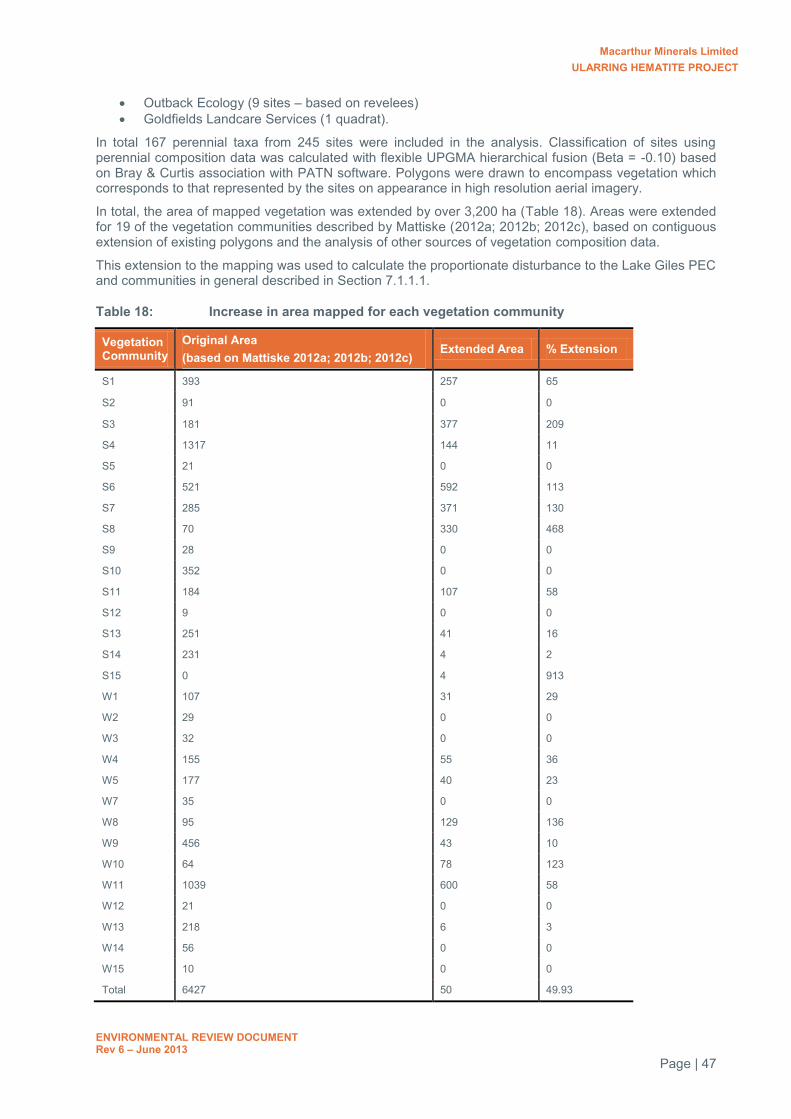
Macarthur Minerals Limited ULARRING HEMATITE PROJECT
ENVIRONMENTAL REVIEW DOCUMENT Rev 6 – June 2013
Page | 47
Outback Ecology (9 sites – based on revelees) Goldfields Landcare Services (1 quadrat).
In total 167 perennial taxa from 245 sites were included in the analysis. Classification of sites using perennial composition data was calculated with flexible UPGMA hierarchical fusion (Beta = -0.10) based on Bray & Curtis association with PATN software. Polygons were drawn to encompass vegetation which corresponds to that represented by the sites on appearance in high resolution aerial imagery.
In total, the area of mapped vegetation was extended by over 3,200 ha (Table 18). Areas were extended for 19 of the vegetation communities described by Mattiske (2012a; 2012b; 2012c), based on contiguous extension of existing polygons and the analysis of other sources of vegetation composition data.
This extension to the mapping was used to calculate the proportionate disturbance to the Lake Giles PEC and communities in general described in Section 7.1.1.1.
Table 18: Increase in area mapped for each vegetation community
Vegetation Community
Original Area (based on Mattiske 2012a; 2012b; 2012c)
Extended Area % Extension
S1 393 257 65
S2 91 0 0
S3 181 377 209
S4 1317 144 11
S5 21 0 0
S6 521 592 113
S7 285 371 130
S8 70 330 468
S9 28 0 0
S10 352 0 0
S11 184 107 58
S12 9 0 0
S13 251 41 16
S14 231 4 2
S15 0 4 913
W1 107 31 29
W2 29 0 0
W3 32 0 0
W4 155 55 36
W5 177 40 23
W7 35 0 0
W8 95 129 136
W9 456 43 10
W10 64 78 123
W11 1039 600 58
W12 21 0 0
W13 218 6 3
W14 56 0 0
W15 10 0 0
Total 6427 50 49.93

Macarthur Minerals Limited ULARRING HEMATITE PROJECT
ENVIRONMENTAL REVIEW DOCUMENT Rev 6 – June 2013
Page | 48
7.1.3 Saline water impacts
To minimise the effects of dust caused by clearing and mining operations to mine site employees, native fauna and surrounding vegetation, dust suppression methods will be employed throughout the Project’s mine life. The most common dust suppression method is to dampen exposed, silty soils and unsealed cleared areas with water.
The water source for the Project has salinity in excess of 30,000 mg/L TDS which will be treated in a reverse osmosis (RO) plant prior to use onsite for potable and processing requirements. Due to the high operating costs involved with treating the amount water required for dust suppression (500 kilolitres per day (kL/day)), MMS propose to utilise untreated groundwater.
The use of saline water for dust suppression has the potential to directly impact on surrounding vegetation by wind spray or drift, and indirectly by increasing the salinity of localised stormwater runoff. Too much saline water in the environment can change the chemical composition of the soils, reducing the ability for it to support new growth or sustain existing growth. Excess salt can also draw water away from root systems and leaf veins causing less tolerate plants to dehydrate, experience discolouration, stunted growth or potentially death.
MMS will implement a Dust Management Plan to minimise the potential for impacts to vegetation caused by saline water. Proposed management actions are detailed in Section 9.0. Through the implementation of the Dust Management Plan, the use of saline water for dust suppression is not considered to significantly impact on the native vegetation of the Project area.
7.2 FAUNA
7.2.1 Malleefowl populations and habitat assessment
Malleefowl are protected under Commonwealth and State legislation. They are listed as Vulnerable under the EPBC Act and are a Schedule 1 species under the WC Act. The geographic distribution of the Malleefowl includes much of the southern half of Australia from the Great Dividing Range to the west coast although it has contracted in recent years. In Western Australia, Malleefowl occurs as far north as Carnarvon, most of the south-west corner and much of the inland semi-arid areas below the 26th latitude and the coastal strip of mallee south of the Nullarbor Plain between Cocklebiddy and Eucla (Benshemesh 2007). The habitat requirements of Malleefowl are generally not well understood, but the Malleefowl is now primarily found in semi-arid and arid shrublands and low woodlands dominated by mallee.
Ground survey
Malleefowl are known to occur within the MMS tenement area based on recorded observations of both Malleefowl and breeding mounds. A targeted survey for Malleefowl across portions of the proposed Project area was conducted in July and August 2011 by Terrestrial Ecosystems (TES) to identify potentially active breeding mounds that may be impacted by the Project, and to assess the risk to the local Malleefowl population. Following discussion with the EPA after submission of the Environmental Review document in December 2012, an additional ground survey was completed in February 2013 focussing primarily on areas likely to be impacted (MMS 2013; Appendix 11). In addition, pre-clearance inspections of drill sites during exploration were used to broaden the search area. Under MMS’ current exploration Environmental Management System, inspections are made by on-site Environmental Advisors within 50 m of proposed drill sites to identify environmental constraints such as Malleefowl mounds, heritage sites or priority flora. A total of 2,304 holes have been drilled with inspections encompassing 827 ha. These areas combined account for 100% of the areas currently planned for disturbance. However, the Project Development Area is slightly larger than the area surveyed. The completed survey areas in relation to the Project areas are shown in Figure 20-22.
In total, the ground survey has covered 3,867 ha, of which, 62% is within the Project Development Area (Table 19). As the alignment of the internal haul road between Snark and Banjo can be adjusted to accommodate the presence of Malleefowl mounds or other environmental constraints, a calculation was also made of the area surveyed within the Project Development area excluding this road. With the road excluded, 68% of Project development area has been surveyed.

Macarthur Minerals Limited ULARRING HEMATITE PROJECT
ENVIRONMENTAL REVIEW DOCUMENT Rev 6 – June 2013
Page | 49
Table 19: Malleefowl ground survey area
Survey Ground survey area
Ground survey area within Project Development Area
% within Project Development Area
Ground survey area within Project Development Area (minus internal road)
% within Project Development Area (minus internal haul road)
TES 2011 ground survey
2,805 1,013 36 860 37
MMS 2013 ground survey
530 511# 18 511 22
MMS Pre-clearance drill hole inspections
532 212# 8 210 9
Total 3,867 1,736 62 1,581 68
# Areas surveyed were greater than presented but included some overlap with the TES survey. Where surveys overlapped, the TES data is presented for area surveyed.
Results of the targeted surveys include observations of two birds, evidence of various types of local activity such as scratchings and scats, and 75 mounds within the survey area, classified as active, inactive or extinct (Table 20). Of the mounds recorded, one was active, seven classified as inactive (recently active/potentially active) and 67 considered extinct. In total only 9% of mounds were considered inactive and likely to be used within the next breeding season. The impact of the Project on Malleefowl is discussed in section 7.2.1.1.
The location of Malleefowl mounds recorded during each of the ground surveys are shown in Figure 23-25. The locations of active, inactive and extinct mounds recorded are shown in Figure 26-28. The records of height classes for each of the mounds are presented in Figure 29.
LiDAR survey
To complement the ground survey, LiDAR was used to remotely map the presence of mounds over the majority of the MMS tenement area. LiDAR is an optical remote sensing technique that can measure the distance to a target by illuminating it with pulses of light from a laser. The resultant data can then be used to generate a fine-scaled contour map. MMS flew an extensive (105,000 ha) area with two points per square metre resolution. Data classification and alignment resulted in a maximum vertical offset of about 150 millimetres (mm) in only 10% of the data. This theoretically allowed the discrimination of mounds down to about 150 mm in height.
An algorithm was then derived to allow for an automated search where 150 mm was used as the minimum height of mounds. A meeting was held with the EPA on 19/9/12 to discuss the validity of this approach where mounds less than 150 mm in height could be discounted as they most likely represented considerably old and inactive mounds. However, it was found that a minimum height of 150 mm resulted in significant noise in the data where objects other than Malleefowl mounds were detected (Diagram 1). Consequently, the minimum height had to be raised to 200 mm.
In total, 259 potential mounds were identified from LiDAR data over an area of 105,000 ha (Figure 30). A subset of these (n = 57) were visited in the field and characterised by size and activity status (active, inactive, extinct). Of the 57 mounds visited, only 3 (5%) were not mounds; 5 (10%) were active, 8 (15%) inactive and 39 (75%) were extinct.
To determine the effectiveness of LiDAR as a survey method, a comparison was made with the area surveyed on foot. As the LiDAR targets were limited to greater than 200 mm in height, field recorded mounds were revisited and classified according to height. Of the 71 mounds (with height data) recorded by TES and MMS, 41 were >200 mm in height and therefore could potentially be identified by LiDAR. However, only 9 mounds (22%) were remotely detected. It is unclear why this was the case but indicates the algorithm needs further refinement. Nonetheless, the technique was able to identify 259 mounds over a large area, with the majority recorded outside the Project boundary.
A field survey was also undertaken in an area where multiple LiDAR targets were returned when the algorithm included mounds <150 mm high but no mounds recorded when the height was restricted to >200 mm. An area of 100 ha was traversed on foot by walking transects 50 m apart. Within this area, no mounds were identified, confirming the LiDAR results.

Macarthur Minerals Limited ULARRING HEMATITE PROJECT
ENVIRONMENTAL REVIEW DOCUMENT Rev 6 – June 2013
Page | 50
A comparison between mounds detected by ground observations and LiDAR detection is shown in Figure 23-25.
Table 20: Summary of number of Malleefowl mounds and activity status recorded in the survey area
Survey No. mounds (%) Area surveyed (ha) Active Inactive Extinct Total
TES 2011 0 (0) 5 (9) 51 (91) 56 2,805
MMS 2013 2 (11) 2 (11) 14 (78) 18 530
MMS Pre-clearance 1 (100) 0 (0) 0 (0) 1 532
Total 3 (4) 7 (9) 65 (87) 75 3,867
LiDAR* 5 (10) (15) (75) 259 105,000
* Percentages calculated from a subset of 52 mounds visited in the field
Diagram 1: Example of LiDAR return showing known mound (circle) and false positives
(black blotches)
7.2.1.1 Malleefowl impact assessment
Assuming the LiDAR data provided an underestimate of the true abundance of mounds; data from the ground-truthing survey was extrapolated to provide an indication of the maximum impact to Malleefowl. Provided that mounds are randomly distributed and not linked to particular vegetation types, it could be argued that you would expect to find approximately 1,177 mounds, given that the LiDAR only returned 22% of known mounds. As only 6-10% of mounds are known to be potentially active, this results in 70-117 active mounds spread across 105,000 ha (1 mound/897 ha)
From the ground survey results, the density of active mounds across the surveyed area is approximately 0.002 active mounds/ha. This equates to one active mound every 500 ha. This density is significantly lower than recorded for similar semi-arid environments with BIF ridges in the mid-west (see MGM, 2006; Bamford, 2006). For example, the density of mounds at Gindalbie’s Karara operation was 0.19 mounds/ha or 0.01 active mounds/ha, which equated to a density of one mound every 100 ha.

Macarthur Minerals Limited ULARRING HEMATITE PROJECT
ENVIRONMENTAL REVIEW DOCUMENT Rev 6 – June 2013
Page | 51
Within the Project Development Area, there are 46 known mounds mapped in the field consisting of one active mound, seven inactive mounds and 38 extinct mounds (Table 21). The actual disturbance within this area will be 611 ha which will result in the removal of one active mound and two inactive mounds. Across the entire area surveyed by both LiDAR and on ground, 334 mounds have been identified. Removal of three mounds that may potentially be used within the next breeding season is therefore unlikely to have a significant impact on the local Malleefowl population as substantial areas of potential habitat occur outside the disturbance footprint.
MMS propose to implement a Malleefowl Management Plan throughout the life of the Project to facilitate in minimising any potential impacts to Malleefowl. These proposed actions are outlined in Section 9.0.
Table 21: Summary of Malleefowl mounds occurring within the Project area and proposed disturbance areas
Mound Status No. Mounds within Project Development Area
No. Mounds within proposed disturbance areas
Active 1 1
Inactive 7 2
Extinct 38 16
Total 46 19
Mounds identified are a combination of LiDAR and ground survey.
7.2.2 Terrestrial vertebrate fauna habitat assessment
As discussed in Section 4.4.1, vertebrate fauna trapping surveys were only conducted at the Snark deposit, Snark MOC, accommodation camp and magazine area. The surveys targeted all major fauna habitats within the survey area in order to identify the range of local fauna present.
Survey trapping locations were decided based on the results of a reconnaissance survey and review of existing vegetation mapping conducted by Mattiske (2012a; 2012b; 2012c). A total of 15 woodland and 15 shrubland communities were identified within the entire Project area, with many of the communities differing by the presence or absence of only a few similar species. Whilst not every vegetation community defined by Mattiske was sampled for fauna, the fauna habitat characteristics within each of the communities are considered similar (i.e. leaf litter, vegetation cover, tree hollows, fallen timber, soil types) and the majority of fauna species that could occur are unlikely to distinguish between them.
In order to extend fauna habitat mapping across the entire Project area, vegetation structure was used in combination with geological mapping, aerial imagery and topographical elevations to described four separate broad fauna habitats within the Project area. The four fauna habitats, their local abundance and the projected impacts proposed by the Project are described in Table 22. The relative number of fauna trap sites located within each of the habitats is also provided to demonstrate the level of survey effort conducted across each habitat type.

Macarthur Minerals Limited ULARRING HEMATITE PROJECT
ENVIRONMENTAL REVIEW DOCUMENT Rev 6 – June 2013
Page | 52
Table 22: Terrestrial vertebrate fauna habitat and potential Project disturbances
Major Fauna Habitat Type
Description Total Habitat Area
Habitat within Project area
Habitat to be disturbed
No. Trap Nights
(ha) / % of total area surveyed
(ha) / % of total habitat type
(ha) / % of total habitat type (i.e. pits, waste dumps, infrastructure)
BIF Ridge Rocky outcropping of BIF forming ridges and cave shelters
1,159 (18%) 749 (65%) 255 (22%) 344
Acacia shrublands
Shrublands dominated by Acacia sp.
1,321 (21%) 455 (34%) 57 (4%) 1,458
Allocasuarina shrublands
Shrublands dominated by Allocasuarina sp.
1,801 (28%) 661 (38%) 155 (9%) 324
Eucalypt woodlands
Woodlands dominated by Eucalyptus sp. with many tree hollows.
2,147 (33%) 983 (46%) 144 (7%) 1,757
^ Area refers to the total area within the entire vegetation survey area completed during
* Number of trap locations refers to those used in the spring fauna trapping program (Ninox 2012a). This survey repeated the majority of the same sites as the autumn trapping program plus additional sites.
Only one vegetation association within the whole Project area (community S12), described as an Eremophila dominated shrubland, was not represented within the fauna trapping program. This community is 9.2 ha in total, with approximately 6 ha within Project area (being approximately 0.2% of the entire Project area). However, only 0.7 ha (0.8% in total) is proposed to be disturbed by the internal north-south haul road. It is unlikely that any fauna species which occur (or likely to occur) in the Project area would be restricted to such a small, isolated vegetation community. In addition, based on photographs of the community provided within the Mattiske vegetation report (Mattiske 2012b), the community comprises of fauna habitat features similar to that of the surrounding sparse woodland communities. As such, the community was included in the Eucalyptus woodlands fauna habitat.
As shown in Figure 31-33 and Table 22, each of the four fauna habitats are well represented throughout the Project area and were adequately surveyed during both autumn and spring fauna trapping programs. It is considered that the fauna surveys completed of the Snark deposit, in combination with the vegetation surveys completed across the entire Project area, were adequate in order to document the likely fauna species and fauna habitat of the remaining Project areas and provides sufficient information in order to assess the potential risks to indigenous fauna and conservation significant species and habitats.
A total of 9,651 ha of fauna habitat was mapped comprising 2,820 ha defined as the Project area and the 609 ha proposed to be disturbed. Each of the habitats expand into the surrounding, unmapped area and due to the minimal disturbance in the region, all habitats will remain well-connected to those beyond the Project area. None of the proposed disturbance for the Project will fragment or isolate any of the described habitats. Furthermore, none of the habitats described within the Project area are considered critical or significant to the survival of any native species and no species are considered restricted to the Project area. Some species were considered to be potentially restricted to BIF outcrops and upper slopes (i.e. Pseudantechinus woolleyae) (Ninox 2012a). However, more than 75% of BIF habitat will remain within the Project area, in addition to the remaining BIF outcrops which extend to the north and south of the Project across the Yerilgee Greenstone Belt.
The removal of native vegetation for the Project will impact on some local fauna and some mortality can be expected. However, the Snark project was considered unlikely to affect the overall conservation status of the any native species recorded (KLA, 2011; Ninox 2012a). Based on the similarity of fauna habitat demonstrated across the remainder of the Project area and surrounds, this conclusion can be extended to the remaining Project areas.
MMS propose to implement a Fauna Management Plan throughout the life of the Project to facilitate in minimising any potential impacts to native fauna throughout the mine life. These proposed actions are outlined in Section 9.0.

Macarthur Minerals Limited ULARRING HEMATITE PROJECT
ENVIRONMENTAL REVIEW DOCUMENT Rev 6 – June 2013
Page | 53
7.2.3 Troglofauna
Within Project Area, the only impact with significant potential to threaten troglofauna is pit excavation, which represents direct loss of troglofauna habitat. The impact area resulting from pit excavation at Snark, Central and Banjo deposits is expected to be 125, 76 and 29 ha, respectively.
Rockwater (2012) collected seven troglofauna species from the Project Area. The animals collected consisted of two species of insects, and single species of spider, centipede, slater, pauropod and symphylan. At the time Rockwater reported, four of the species collected had not been recorded outside the proposed mine pits: the spider Araneomorphae sp. B19, the centipede Cryptops sp. B27, silverfish Hemitrinemura sp. B08 and the symphylan Hanseniella sp. B12. A further hemipteran species identified to family level (Meenoplidae sp.) was also recorded from inside a proposed mine pit and owing to the low level of taxonomic resolution the conservation significance of this species was considered uncertain. The location of these species within the Project area is shown in Figure 34 and Figure 35.
While a high proportion of the species collected in the Project Area appeared to be restricted to the proposed mine pits, Rockwater considered that the documented species ranges were most likely under-estimates of the actual ranges. Use of existing range information alone is likely to over-estimate the conservation threat of mining in the Project Area.
To provide a more accurate assessment of risk to troglofauna, an expert consultant (Bennelongia) was contracted to undertake the following work:
1. Habitat characterisation. The types of geologies in which troglofauna were found at Snark, Central and Banjo were documented, as was the wider occurrence of these habitats. The aim was to show that species were unlikely to be restricted to areas proposed to be impacted by mining.
2. Taxonomic and biogeographic review of troglofauna species collected in the Project Area and wider Yilgarn. The possible wider occurrence of species designated as apparently restricted to the Project Area was investigated and more information on the habitats occupied by these species, and their likely ranges, was collated.
Detailed investigation of geology and the extent of habitat connectivity showed:
Assuming that ultramafic/mafic strata are unlikely to be prospective, it seems certain (based on drill-logs) that troglofauna occur in the target geology for mining, which is enriched hematite/goethite, and also frequently occur in unenriched Banded Iron Formation (BIF). Evidently, troglofauna species do not distinguish between different rock chemistries when selecting habitat but choose on the basis of physical structure of the rock, primarily the vugs and other spaces within the rock generated by weathering. In the case of BIF in the Project Area, it is likely that the enriched ore, which is more weathered and hence vuggier, would logically have a greater abundance of troglofauna but unenriched BIF probably contains the same troglofauna community.
Geological mapping suggests the regionally extensive BIF ridge occurs in a discontinuous manner (Figure 36). However, this is likely to under-represent the extent of the BIF within the Project Area. Outcrops of hematite/goethite BIF have been the focus of most of the drilling to date, whereas detailed mapping of sub-crop and careful step out drilling have shown that the hematite/goethite mineralization can continue in areas of limited to no existing outcrop. This is also likely to be the case for the unenriched BIF. The troglofauna survey data certainly suggests more habitat connectively than is shown by the mapped extent of the enriched hematite/goethite BIF outcropping.
The occurrence of two troglofauna species at multiple deposits within the Project Area provides insight into the possible extent and connectivity of troglofauna habitat. Trichorhina sp. B09 occurs at Snark and Central with a linear range of 17 km and Hanseniella sp. B12 was collected from Central and Banjo with a linear range of 7 km. Assuming these species do not have the ability to use surface habitats during any stage of their lifecycles, it is likely that a stratum other than BIF is providing some habitat connectivity between locations. Review of diamond-drill cores from the Project Area suggests that this connectivity may be provided by weathered volcanics (saprolite) near the surface.
Importantly, the extent of the enriched BIF outcropping does not represent the limit of troglofauna habitat in the Project Area and it is unlikely that individual troglofauna species are restricted to the proposed mine pits.

Macarthur Minerals Limited ULARRING HEMATITE PROJECT
ENVIRONMENTAL REVIEW DOCUMENT Rev 6 – June 2013
Page | 54
Based on the results of the taxonomic and biogeographical review, the following conclusions are drawn:
Two of the four species previously listed as restricted to the proposed impact area (Cryptops sp. B27 and Hemitrinemura sp. B08) now occur in the reference area outside of the proposed mine pits as a result of re-modelling of the pit boundaries.
The other two species (Araneomorphae sp. B19 and Hanseniella sp. B12) are still known only from proposed mine pit boundaries. However, based on the results of the habitat characterisation, it appears unlikely that these species are restricted to the proposed mine pits because of the extent of connected habitat available for the species outside of the proposed mine pits and the fact that related species are relatively widespread.
The outcomes of this additional work suggest the Project will not significantly impact of the local troglofauna community of the Project Area or affect the conservation status of any known troglofauna species.
The full assessment by Bennelongia is included as Appendix 14.
7.2.4 Stygofauna
Stygofauna sampling was conducted over two sampling rounds at 10 locations in Phase 1 (pilot study) and 11 locations in Phase 2 (baseline study) throughout the Project’s proposed disturbance area (Figure 37). Sites were based on depth, lithology and the intersection of water during exploration drilling. The sampling intensity employed met the criteria recommended by the EPA for a pilot-scale study.
No stygobitic fauna were recorded during Phase 1 or Phase 2 of the sampling program. One species of nematode was collected from two sites at the Central deposit in troglofauna traps. The two traps were at 15 m and 11 m below ground level, well above the groundwater table which lies around approximately 70 mBGL (Rockwater 2012).
Based on the results of the pilot study, further sampling was not considered necessary as it was deemed unlikely that a significant stygofauna community occurs in the aquifers of the Project area. In addition, dewatering of the orebody will not be required as mining will not extend below the water table and therefore impacts to any potential stygofauna community they may be present is considered minimal.
7.2.5 Short Range Endemic Invertebrates
7.2.5.1 Project Area
Prominent ridges of banded ironstone present within the MMS tenement area are considered to be potential SRE habitat as they are both relictual and fragmented where immigration and emigration are likely to be limited for certain taxonomic groups (Outback Ecology 2010c). These ridges include ironstone hills and granite outcrops and breakaways.
To determine the impact of the Project on SRE species, surveys were conducted in 2011 based on the approach and methodology of EPA Guidance Statement No. 20. The survey was conducted across the Project area to target seven main groups of recognised SREs and each of the habitats located within the Project area. For the purposes of this survey, a study area of 1250 km2 (125,000 ha) was identified and the extent of this area is shown on Figure 38.
Three habitats, referred to as habitats A, B and C, were identified within the Projects proposed disturbance area (Figure 38). Habitat A is described as low woodlands on rocky undulating hills and covers a total of 155 km2 (15,500 ha) within the study area. This habitat is isolated within the study area from other locations of this habitat in the Yilgarn and is typically surrounded by Habitats B and C. Habitat B is described as low woodlands on sand plains and Habitat C is described as medium woodlands on sand plains. Habitats B and C cover a total of 328 km2 (32,800 ha) and 449 km2 (44,900 ha) within the study area and are both well connected with similar habitats outside the Projects proposed disturbance areas.
A total of 14 sites were investigated using a combination of comprehensive level and foraging level survey techniques. Comprehensive survey techniques involved wet pit trapping, foraging and soil/litter sampling and was undertaken at seven impact sites (within the proposed Project disturbance area, including the buffer zones) and three reference sites (outside the proposed Project disturbance area, including the buffer zones) (Figure 39). The foraging level survey involved only surface foraging from SRE’s and was undertaken at one impact site and three reference sites.

Macarthur Minerals Limited ULARRING HEMATITE PROJECT
ENVIRONMENTAL REVIEW DOCUMENT Rev 6 – June 2013
Page | 55
Table 23 summaries the level of survey and location of each of the sampling sites.
Table 23: Summary of SRE Survey Sites and Habitats
Survey Site
Level of Survey*
Site Type^ Survey Timing Habitat ID
Habitat Description
1 Comprehensive Impact Mar-May A Low woodlands on rocky undulating hills
2 Comprehensive Impact Mar-May A Low woodlands on rocky undulating hills
3 Comprehensive Reference Mar-May A Low woodlands on rocky undulating hills
4 Comprehensive Impact Mar-May A Low woodlands on rocky undulating hills
5 Comprehensive Impact Mar-May A Low woodlands on rocky undulating hills
6 Comprehensive Impact Mar-May C Medium woodlands on sand plains
7 Comprehensive Reference Mar-May A Low woodlands on rocky undulating hills
8 Comprehensive Impact Mar-May A Low woodlands on rocky undulating hills
9 Comprehensive Impact Jun-Aug A Low woodlands on rocky undulating hills
10 Comprehensive Reference Jun-Aug A Low woodlands on rocky undulating hills
11 Foraging Impact Jun-Aug B Low woodlands on sand plains
12 Foraging Reference Jun-Aug B Low woodlands on sand plains
13 Foraging Reference Jun-Aug A Low woodlands on rocky undulating hills
14 Foraging Reference Jun-Aug B Low woodlands on sand plains
* Comprehensive level survey refers to a combination of wet pit trapping, foraging and soil/litter sampling. Forging level survey refer to surface foraging only.
^ Impact site refers to site located within the Projects proposed disturbance area. Reference site refers to a site located outside of the Projects proposed disturbance area.
Assessment on whether species are considered SRE’s is often inconclusive. For the purposes of this study, a two stage approach developed by SRE-specialists Bennelongia was adopted. Firstly, information from literature or expert advice (i.e. recognised invertebrate taxonomists) provided the basis for determining the SRE status of a species. In the absence of such information, the assessment was based on the maximum recorded range of the species, the number of habitats and sites it was recorded in and its recorded abundance. This framework is summarised in Table 24.
Table 24: SRE Likelihood Assessment Framework*
Likelihood Status of being an SRE
Maximum linear range (km)
No. of habitats types in which species occurs
No. of sites at which species is recorded
Species Abundance
Probably < 50 1 1 < 5
Moderately likely ≤ 50 2 2 to 3 5 to 20
Possibly ≈ 50 3 4 to 6 21 to 100
Unlikely ≥ 50 ≥ 4 6 to 10 ≥ 100
Not an SRE > 50 All All sites ≥ 100
* Framework is used in the absence of expert advice. Categories are assigned on range, then habitat type, then abundance.
A total of 861 specimens from 57 species were identified as belonging to the seven target groups likely to yield SREs. Further assessment of these species based on expert advice, previous records and sampling distribution resulted in the following SRE status:
No species was considered to be definitely an SRE No species was considered probably an SRE Eight species were assessed as moderately likely to be an SREs. These were two scorpions,
three spiders, two slaters and one centipede Eleven species were assessed as possibly being SREs. These were one scorpion, two spiders,
three pseudoscorpions, two slaters, two centipedes, and one millipede

Macarthur Minerals Limited ULARRING HEMATITE PROJECT
ENVIRONMENTAL REVIEW DOCUMENT Rev 6 – June 2013
Page | 56
The remaining species were considered either not to be SREs or unlikely to be SREs.
Table 25 summarises the distribution of potential SRE species identified during the survey.
Table 25: Summary of the distribution of SRE species
Potential SRE species
SRE Status
Habitat Located within impact areas
Located within reference areas
No. of specimens
No. of sites
Scorpionida
Isometroides sp B1 Possibly C Yes No 1 1
Isometroides sp B2 Moderate A Yes No 1 1
Urodacus sp. B4 Moderate A Yes No 1 1
Araneae
Synothele sp. B3 Possibly A Yes Yes 8 2
Conothele sp. B4 Moderate A Yes No 1 1
Aganippe sp B3 Possibly A Yes Yes 10 4
Aganippe sp B6 Moderate A Yes No 1 1
Karaops sp. B2 Moderate A Yes No 1 1
Pseudoscorpionida
Chernetidae n. gen. Possibly A Yes Yes 25 2
Beierolpium 8/3 sp. B02 Possibly A Yes No 1 1
Indolpium sp. B5 Possibly A Yes No 1 1
Isopoda
Acanthodillo sp. B5 Moderate A Yes No 12 1
Buddelundia sp. B10 Possibly A Yes No 3 1
Buddelundia sp. B14 Moderate A Yes No 3 1
Buddelundia sp. B19 Possibly A Yes No 3 1
Chilopoda
Mecistocephalus sp. B03 Moderate A Yes No 1 1
Mecistocephalus sp. B04 Possibly A Yes Yes 3 2
Orphnaeus nr. Brevilabiatus
Possibly A Yes Yes 4 2
Diplopoda
Siphonotidae sp. B1 Possibly A No Yes 2 1
Of the 19 potential SRE species, 13 were found only within the Projects proposed disturbance areas. However, the SRE status of these species is difficult to determine as all were identified from few records. Of these 13 species, nine were recorded as singletons, three from 3 records, and one species from 12 records. However, it should be noted that when related species with multiple records were found in the impact area, they also occurred in reference areas, suggesting that the local SRE species are not restricted to the impact area.
The Project proposes to impact less than 1% (64 ha) of Habitat B present within the study area and given the connectivity of this habitat, the overall impact would be significantly less. No SRE species were identified within Habitat B during the survey. This may be a result of the limited survey effort achieved within this habitat (foraging level survey), as only 1.5% of all specimens collected during the survey were collected from foraging level sites. However, given the connectivity of this habitat and the limited proposed disturbance by the Project (<1%), the impacts to any potential SRE species occupying Habitat B is considered low.
One species, Isometroides sp. B1, was identified only within Habitat C. The Project proposes to impact on less than 1% (54 ha) of this habitat within the study area. Similar to Habitat B, this would equate to

Macarthur Minerals Limited ULARRING HEMATITE PROJECT
ENVIRONMENTAL REVIEW DOCUMENT Rev 6 – June 2013
Page | 57
significantly less due to the connectivity with similar habitat outside the study area. As such, given the minimal disturbance proposed within this habitat, this species, and any other SRE species, is unlikely to be significantly impacted by the Project.
The remaining 12 potential SRE species were recorded within Habitat A. A total of 492 ha is proposed to be disturbed as part of the Project, being approximately 3% of the extent of this habitat within the study area. Five of the 12 species identified within this habitat were found at multiple sites, indicating connectivity within the habitat. Although Habitat A is isolated from other occurrences of similar habitat within the region, the disturbance proposed is minimal (3%) and it is considered unlikely that any of the SRE species would be restricted to only Project disturbance areas.
In conclusion, the overall impact to SRE species resulting from the implementation of the Project is unlikely to significantly impact on the long-term survival or conservation status of any SRE species identified during the survey.
7.2.5.2 Rail Siding Area
Whilst the impact to Short Range Endemic invertebrates was assessed for the mine area, no surveys were conducted at the Rail Siding. To satisfy the EPA requirements in the Scoping Guideline, an expert consultant (Bennelongia) was contracted to conduct a habitat assessment to:
Determine the likelihood of SRE species occurring at the Rail Siding Assess whether any prospective SRE habitats occur within the proposed Rail Siding Define the degree of connectivity, for prospective habitats, between habitat occurrences inside
and outside the Rail Siding Determine whether the Rail Siding constitutes a significant proportion of the local occurrence of
any prospective habitats Assess whether threat to SRE fauna is likely as a result of development of the Rail Siding.
Records and information on species belonging to SRE Groups were sought from previous environmental impact assessments, primary literature and records from the Western Australian Museum (WAM) databases. Records from the WAM were extracted for a 100 x 100 km ‘Search Area’ surrounding the Rail Siding (-29.321°S to -30.231°S, 120.563°E to 121.594°E). Areas of potential SRE habitat were identified using orthophotos provided by Macarthur Minerals, Beard vegetation mapping and vegetation mapping by Mattiske Consulting Pty Ltd (Mattiske 2012d).
The study identified species of a number of SRE Groups present in the Search Area surrounding the Rail Siding. Five species considered to be of SRE status were recorded, none of which were located within the proposed Rail Siding footprint. The Rail Siding site contains no obvious SRE landforms or vegetation. There are no south-facing rock faces, steep slopes, gullies, rocky outcrops or relictual habitats; the site comprises a mosaic of low-lying natural drainage areas with several vegetation communities that are considered typical of and widespread throughout the region, present on flat, compact, gravelly clays.
Within the constraints of the desktop study, it appears unlikely that development of the proposed Rail Siding south of Menzies will threaten persistence of any SRE species. This is based on the following two inferences:
SRE species are unlikely to occur at the Rail Siding site, based on the lack of likely SRE habitat; In the unlikely event that SRE species are present, the small size of the impact footprint (less
than 32 ha) and the extensive habitat connectivity beyond the site, mean that there is a very low likelihood of any significant impact to local communities or the conservation status of individual species.
Due to the low level of threat identified to SRE’s, no further SRE investigations, in particular, field surveys, are considered necessary to adequately assess the impacts posed by the development of the Rail Siding as part of the Ularring Hematite Project
The full report is included as Appendix 26.

Macarthur Minerals Limited ULARRING HEMATITE PROJECT
ENVIRONMENTAL REVIEW DOCUMENT Rev 6 – June 2013
Page | 58
7.3 REHABILITATION AND MINE CLOSURE
7.3.1 Waste rock characterisation
The potential to encounter PAF material during mining and the potential for AMD has been considered by MMS. A Waste Characterisation study was commissioned to conduct geochemical testing of the primary waste rock types associated with the proposed Snark deposit. Comparison of waste lithologies by MMS geologists confirm that waste from Central and Banjo is analogous to Snark and the results can be confidently extrapolated across deposits.
A total of 39 representative waste rock samples were taken from 11 exploration drill cores across the Snark deposit. The majority of samples came from the ‘oxidised’ zone that extends from surface to a depth of between 50 to 70 mBGL. The waste rock materials were interspersed between lenses of Banded Iron Formation (BIF) that generally comprised hematite-goethite mineralisation. For the purpose of waste rock management, the following waste rock classes were identified: ‘Highly Weathered’, ‘BIF’ ‘Altered Ultramafic’, ‘BIF / Altered Ultramafic’, ‘Dolerite’ and ‘Sedimentary’ materials.
Samples were characterised for acid generation potential using standard (AMIRA 2002) static test procedures. Potential impacts on surface and groundwater through seepage from waste rock dumps containing these rock types were assessed by laboratory leach test procedures. Both water and dilute acid leaching solutions were used to evaluate the potential for mobilisation of potential contaminants under natural pH and acidic conditions.
Geochemical data for the various waste types to be mined at the Snark deposit were assessed as a prediction tool to determine possible impact on the surrounding environment (water and soils) during operations and subsequent to closure.
Initial results from MBS (2011) indicated that a significant proportion of the total volume of waste material generated by mining activities at the Snark deposit is potentially acid forming (PAF) material. However the waste rock material contains a form of stored acidity associated with aluminium sulphate and alumino silicate minerals, rather than oxidisable iron sulphide minerals that are usually associated with AMD.
All samples classified as PAF or PAF- Low Capacity (PAF-LC) were also associated with slightly elevated total sulphur values and low water leachate pH values ranging from 3.5 to 6.0. Petrology observations suggest most of the “sulphide” in these samples is present as sulphate, rather than oxidisable iron sulphide minerals.
A significant amount of sulphur measured as ‘total sulphur’ may be bound within various aluminium sulphate minerals based upon the following evidence:
Higher total sulphur values are associated with actual acidity rather than potential acidity suggested by lower water leachate and negligible difference between Net Acid Generation (NAG) pH values and water leachate pH values. This is further supported by the absence of a correlation between elevated Net Acid Producing Potential (NAPP) values and NAG values.
Higher total sulphur values correlate with both lower water leachate pH and elevated soluble aluminium concentrations.
Aluminium sulphate minerals are almost insoluble at lower pH and thus will not be effectively measured by the dilute acid digest that determines the sulphate sulphur values used to calculate NAPP values. This behaviour would produce anomalously low sulphate sulphur to the extent that waste rock samples are incorrectly classified as PAF when they may not contain significant concentrations of oxidisable sulphur.
On that basis, samples that have been classified as PAF or PAF-LC are not likely to be acidic or potentially acidic as a result of oxidisable iron sulphide mineral content. These samples may be representative of another form of stored acidity via the following acid generation mechanisms:
Hydrolysis of aluminium sulphate minerals Aluminosilicate mineral dissolution and adsorption / desorption of soluble forms of aluminium.
However, these acid generation mechanisms are likely to also occur naturally in the iron, clay and sulphate rich soils that regionally surround the Snark deposit. The ‘shallow red clayey sands with ferruginous gravel’ soil type that is likely to be present in the vicinity of the Snark deposit is characterised by an acidic pH range of 4.5 to 6.0. The waste rock materials that were classified as either PAF or PAF-LC may have a stored acidity similar to these soils and not generate mineral acidity at a rate that lowers

Macarthur Minerals Limited ULARRING HEMATITE PROJECT
ENVIRONMENTAL REVIEW DOCUMENT Rev 6 – June 2013
Page | 59
the pH of seepage water significantly below a pH of 3.5. This predicted minimum pH is currently supported by both the water leachate results and the negligible difference between acidic water leachate values and final NAG pH values.
MBS (2011) suggested that kinetics of acid generation and the predicted minimum pH of the waste rock materials at the site can only be determined via longer term kinetic testing and detailed mineralogy work. To determine the need for kinetic testing, Graeme Campbell and Associates (GCA) was contracted to provide a review of current data and undertake mineralogical testing (GCA 2012a; 2012b). On the basis of the mineralogical work and GCA’s review, the determination of waste materials as PAF has differed to the initial results provided by MBS. All samples are classified as Non-Acid Forming (NAF) (Table 26). Samples which are acidic are labelled as NAF-[low-pH]. These are not "high-risk" lithotypes, and are devoid of sulphide-minerals. Their intrinsic pH regime is constrained to moderately-acidity only, as governed by mineral-solubility control well established, mechanistically, through research by soil/aquatic-chemists over many decades in varying contexts (e.g. acidification of arable land, deposition of "acid-rain" onto forests and lakes, etc.). Roughly, the NAF-[low-pH] lithotypes reside within a zone between 5 m and 30 mBGL, and reflects pallid/saprolite-zones that are naturally acidic – such materials are not uncommon within the waste-regolith profiles at local mines on the Yilgarn block. Such materials should not be placed within the upper-section of the waste-landforms, but instead buried with the other NAF lithotypes (which are also circum-neutral). The "surface-skin" (nominal 5 m) comprising soils, alluvium/colluvium, and possibly locally duricrusts, together with the deeper waste-regoliths (e.g. lower-saprolites and saprocks) should be employed for such burial. That it is straight forward to limit penetration of the seasonal wetting-front in the WA Goldfields is axiomatic.
GCA does not agree that there is a need to carry out kinetic-testing, as recommended in the MBS (2011) report. Such testing for the NAF-[low-pH] materials would be merely of academic interest: the volumes, occurrences and schedules of these materials should be known within the mining plan with some accuracy, and so easily accommodated for burial within the waste-dumps.
Comparison with adopted Health Investigation Levels (HIL) indicates that all elements are present at concentrations that are unlikely to pose a significant risk to humans in the commercial industrial land use of the project site. The waste lithologies of the open pits and waste dump do not represent a significant ecological risk to groundwater resources and the surrounding environment in relation to salinity or metalliferous drainage. It will however be necessary to undertake regular monitoring of groundwater in monitoring bores adjacent to the waste rock dump throughout the mining and closure phases of the project to verify predictions from this waste characterisation. It is recommended that these water samples be tested for the following water quality parameters:
pH, acidity and alkalinity. Electrical conductivity (EC) and TDS. Major cations (calcium, magnesium and sodium) and anions (chloride, fluoride, sulphate and
nitrate). Aluminium, barium, boron, silver, cobalt, chromium, copper, iron, manganese, nickel, lead and
zinc.
Copies of each of the waste characterisation reports are provided as Appendix 21 – 23.

Macarthur Minerals Limited ULARRING HEMATITE PROJECT
ENVIRONMENTAL REVIEW DOCUMENT Rev 6 – June 2013
Page | 60
Table 26: Classification of waste types*
SAMPLE NO. DRILLHOLE & DOWNHOLE INTERVAL
WASTE ROCK TYPE
pH EC TOTAL – S SO4S ANC NAG – pH AFP CATEGORY
(Unit) (m) (1:5) (1:5) (mS/cm)
(%) (%) (kg H2SO4/ tonne)
Samples (3) from 0-5m (nominal)
8A LGDD_008, 0.0-3.3 HW 6.3 0.22 0.625 0.020 7 5.9 NAF
9A LGD_009, 0.0-4.8 HW 8.6 0.30 0.054 0.013 18 NAF
11A LGDD_011, 0.0-4.9 HW 7.1 0.27 0.073 <0.001 8 NAF
Samples (20) from 5-30m (nominal)
7A LGDD_007, 0.0-9.6 HW 7.4 3.37 0.113 0.076 22 NAF
8B LGDD_007, 5.7-7.4 HW 4.4 1.08 0.977 0.044 3 4.5 NAF - (Low pH)
8C LGDD_008, 7.4-8.4 HW 3.8 0.8 1.647 0.078 1 3.9 NAF - (Low pH)
16A LGDD_016, 6.0-11.0 HW 3.5 2.94 0.426 0.065 <1 3.8 NAF - (Low pH)
7B LGDD_007, 11.6-15.85 HW 4.6 3.81 0.14 0.065 16 NAF - (Low pH)
15B LGDD_015, 13.9-22.2 HW 6.2 3.12 0.232 0.011 4 5.9 NAF
8G LGDD_008, 29.9-47.35 HW 3.6 2.48 0.21 0.043 <1 3.8 NAF - (Low pH)
15A LGDD_015, 3.1-10.5 BIF 3.6 2.43 0.323 0.030 4 3.8 NAF - (Low pH)
8D LGDD_007, 11.9-15.5 BIF 3.6 1.42 0.616 0.046 3 4.0 NAF - (Low pH)
8E LGDD_008, 15.5-17.6 BIF 4.1 0.73 0.547 0.034 2 4.2 NAF - (Low pH)
13A LGDD_013, 19.4-21.8 BIF 6.7 1.05 0.063 <0.001 9 NAF
14B LGDD_014, 16.0-23.9 BIF 3.6 1.32 0.289 0.042 3 3.8 NAF - (Low pH)
16B LGDD_016, 15.2-23.8 BIF 3.9 2.51 0.307 0.040 1 4.2 NAF - (Low pH)
17A LGDD_017, 6.9-16.3 BIF 3.8 0.91 0.129 0.021 1 NAF - (Low pH)
8F LGDD_008, 18.8-21.6 Alt.-UM 3.7 2.22 0.186 0.030 1 3.8 NAF - (Low pH)
11B LGDD_011, 16.9-20.6 Alt.-UM 4.2 1.00 0.629 0.032 5 4.8 NAF - (Low pH)
13B LGDD_013, 22.1-31.4 Alt.-UM 6.6 1.63 0.065 <0.001 5 NAF
12A LGDD_012, 4.4-13.2 BIF/Alt.-UM 4.8 1.04 0.125 0.009 6 NAF - (Low pH)

Macarthur Minerals Limited ULARRING HEMATITE PROJECT
ENVIRONMENTAL REVIEW DOCUMENT Rev 6 – June 2013
Page | 61
SAMPLE NO. DRILLHOLE & DOWNHOLE INTERVAL
WASTE ROCK TYPE
pH EC TOTAL – S SO4S ANC NAG – pH AFP CATEGORY
(Unit) (m) (1:5) (1:5) (mS/cm)
(%) (%) (kg H2SO4/ tonne)
14A LGDD_014, 6.0-15.5 BIF/Alt.-UM 3.9 1.09 0.546 0.041 4 4.2 NAF - (Low pH)
10A LGDD_010, 15.29-20.0 Sedimentary
5.9 1.28 0.088 0.016 8 NAF
Samples (14) from 30-70m (nominal)
7C LGDD_007, 32.8-43.6 BIF 6.9 0.38 0.023 0.005 5 NAF
7D LGDD_007, 48.2-57.4 BIF 8.7 0.05 0.010 0.004 16 NAF
8H LGDD_008, 47.35-53.7 BIF 6.4 1.42 0.109 0.003 7 NAF
9B LGDD_009, 30.0-40.0 BIF 7.3 0.9 0.046 0.003 9 NAF
17B LGDD_017, 30.4-38.7 BIF 6.5 2.48 0.088 0.005 6 NAF
8I LGDD_008, 53.7-62.9 Alt.-UM 6.6 2.28 0.061 <0.001 8 NAF
8J LGDD_008, 62.9-68.8 Alt.-UM 7.1 2.26 0.050 0.003 7 NAF
9C LGDD_009, 48.2-53.9 Alt.-UM 7.2 0.45 0.014 0.008 8 NAF
10B LGDD_010, 46.0-54.0 Alt.-UM 7.9 2.38 0.051 0.069 183 NAF
11C LGDD_011, 30.6-42.3 Alt.-UM 4.8 2.59 0.138 0.041 1 6.0 NAF
12B LGDD_012, 39.3-46.0 Alt.-UM 7.1 1.56 0.033 <0.001 5 NAF
13C LGDD_013, 42.95-49.6 Alt.-UM 7.1 3.68 0.095 0.022 58 NAF
14C LGDD_014, 28.9-39.9 Sedimentary
3.9 0.46 0.245 0.023 4 4.0 NAF
7E LGDD_007, 60.7-70.0 Dolerite 8.2 0.26 0.010 0.004 20 NAF
Samples (2) from 70+m
8K LGDD_008, 68.8-75.35 Alt.-UM 7.2 1.17 0.041 0.014 18 NAF
8L LGDD_008, 94.15-97.4 Dolerite 9.9 0.25 0.036 0.020 17 NAF
*Chemical analysis was undertaken by MBS Environmental with classification of waste types by Graeme Campbell and Associates
Notes:
EC = Electrical Conductivity; ANC = Acid-Neutralisation-Capacity; AFP = Acid-Formation-Potential; NAF = Non-Acid-Forming; NAG = Net-Acid Generation; HW = Highly-Weathered; Alt.-UM = Altered-Ultramafics.
Macarthur Minerals Limited ULARRING HEMATITE PROJECT
ENVIRONMENTAL REVIEW DOCUMENT Rev 6 – June 2013
Page | 62
7.3.2 Waste dump design and management
All waste landforms will be in close proximity to pits and constructed to a maximum height of 30 m. Pit locations have been selected to minimise impacts to vegetation communities that are less well represented.
Based upon current mine planning there will be:
A total of nine waste landforms in the vicinity of the Snark deposit. A total of five waste landforms in the vicinity of the Central deposit. A total of three waste landforms in the vicinity of the Banjo deposit.
The approximate waste volumes and heights is subject to change as detailed mine planning is progressed. Where values differ significantly from those presented in this document and Mining Proposal, a S45C application and amended Mining Proposal will be submitted.
Where PAF material is encountered, it will be enclosed within a containment cell. Consistent with other operations, PAF will be elevated from ground level to prevent contact with water flow at ground level and will be constructed of suitable NAF material. PAF cells will be capped with NAF or ANC material on a regular basis to minimise the potential oxidation time. Waste landforms will also be designed to prevent infiltration into the PAF cell. Routine water quality monitoring will be performed throughout the construction of the dump to identify any onset of AMD.
Groundwater and surface water quality will be managed by reducing sediment loads in run-off through the installation of sediment ponds and diversion drains. All drainage will be designed to satisfy the DMP requirements of a 1 in 100 year 72 hour rain event.
To successfully fulfil commitments to regulators, MMS will ensure that subsequent waste landforms and abandoned pits at the completion of mining are safe, stable and non-polluting. Final landforms will be resistant to erosion and support native vegetation. Achievement of successful rehabilitation outcomes through appropriate planning will reduce environmental risk and minimise the actual cost of rehabilitation activities. Application of good soil science and characterisation of mine wastes and soils is fundamental to the development of optimised landform designs, stable and safe slopes, and ultimately successful land rehabilitation. To this end, MMS has engaged MBS Environmental and Landloch to characterise and assess materials suitable for capping and rehabilitation of waste dumps. The locations of the samples collected are shown in Figure 40 and Figure 41. Laboratory testing will be completed for the following parameters:
Soil pH and salinity (EC). Exchangeable cations (Ca2+, Mg2+, Na+, K+). Cation Exchange Capacity (CEC). Exchangeable Sodium Percentage (ESP). Emerson Aggregate Test. Particle size distribution (sand, silt, and clay size fractions). Atterburg limits (Liquid Limit, Plastic Limit, and Plasticity Index). Potential for tunnel generation (considering both clay dispersion and material liquefaction). Plant-available nutrients. Plant-available water.
The Water Erosion Prediction Project (WEPP) program for predicting erosion potential will be used by Landloch to simulate runoff and erosion potential. WEPP provides a basis for determining erosion risk from which a landform design can be developed and enables quantitative demonstration that design reduces erosion potential. Assessment of the erodibility and infiltration parameters of suitable materials will be used to generate the necessary parameters to use in the WEPP model. Output from the WEPP erosion modelling will:
Predict erosional stability of various slope profiles using different materials. Determine the maximum stable height and slope shape for each material. Determine the necessity to incorporate either rock (via addition of competent waste rock) or other
resources that may be available (e.g. tree debris) based on erosion potential of the topsoil. Be used to provide guidelines on design requirements for the waste dump crest.

Macarthur Minerals Limited ULARRING HEMATITE PROJECT
ENVIRONMENTAL REVIEW DOCUMENT Rev 6 – June 2013
Page | 63
This information will be used to inform conceptual landform design parameters and provide a scientific basis for the Mine Closure Plan to be submitted to the DMP. A Waste Rock Management Plan will also be developed, as outlined in Section 9.0.
7.3.3 Rehabilitation objectives
A Mine Closure Plan will be submitted in conjunction with a Mining Approval to the DMP in accordance with the EPA/DMP closure guidelines, and will detail:
Closure objectives; Stakeholder consultation program; Closure aspects risk register; Closure design criteria; Closure standards and preliminary completion criteria; Brief description of progressive closure methodology; Closure research and monitoring plan; Basis for financial provision; and Closure schedule.
The key objective for rehabilitation is to ensure a self-sustaining ecosystem similar to the surrounding environment in terms of flora and fauna species composition and fauna habitat. The information derived from the soil classification and modelling described above will provide a scientific basis for selecting appropriate revegetation mediums. Topsoil will be stripped and stockpiled prior to mining according to MMS’ Topsoil Management Plan. Provision of funding for research on revegetation techniques applicable to BIF landscapes, as described in the offset package, will establish methods for returning recalcitrant species and those not represented in the soil seed bank of stockpiled topsoil. To assist in this work, MMS propose to collect seed from the surrounding areas on an annual basis and establish a site nursery to evaluate propagation methods and the response to species growing in various waste types. Techniques will then be applied as areas are progressively rehabilitated.
Completion criteria will be developed based on surrounding analogue sites. An ongoing monitoring program will also be developed in conjunction with the restoration research program and will include traditional measures of success such as diversity indices and plant survival. The principles of Landscape Function Analysis (LFA) will also be applied to examine changes in ecosystem function at a fine scale and identify threshold states where additional intervention may be required.
These objectives and proposed actions will be incorporated into the Project’s Rehabilitation Management Plan for implementation during the Project, as discussed in Section 9.0.
7.4 RESIDUAL IMPACTS
7.4.1 Potential residual impacts and environmental offsets
An assessment on the impact to all environmental assets, proposed mitigation measures and predicted outcomes is presented in Table 11. Where mitigation measures cannot achieve a net environmental benefit and residual impacts were identified, an environmental offset is proposed. All offsets are outcome driven rather than financial commitments to conservation groups or government departments.
For the sake of brevity, the offset package is presented within the Environmental Offsets Reporting Form (Appendix 27).

Macarthur Minerals Limited ULARRING HEMATITE PROJECT
ENVIRONMENTAL REVIEW DOCUMENT Rev 6 – June 2013
Page | 64
8.0 ASSESSMENT OF OTHER ENVIRONMENTAL FACTORS
8.1 WATER SUPPLY
8.1.1 Water requirements
The water quality requirements for the various Project water uses are as follows:
Potable supply: within limits prescribed under the Australian Drinking Water Guidelines (NHMRC 2011)
Process water supply: salinities of less than 3,000 to 4,000 mg/L TDS Dust suppression: no water quality limits.
It is proposed to treat all potable water via an RO plant to meet the potable limits required under the National Health and Medical Research Council (NHMRC) guidelines (NHMRC 2011).
The low salinities required for processing are unlikely to be met without desalination, given the generally poor quality groundwater available in the goldfields (only 25% of bores recorded in the WIN database have salinities below 3,000 mg/L TDS (GRM 2012a). It is therefore proposed to also treat the raw water via an RO plant. The feed water requirements for RO treatment include a salinity of less than 30,000 mg/L TDS.
The use of saline water for dust suppression is common in the Goldfields, because of the paucity of high quality water.
In estimating the project water demand, MMS has assumed a conservative case where desalination via a RO plant will be required to treat all process water, with an adopted raw water salinity of 14,000 to 30,000 mg/L TDS. At these salinities, recoveries of around 52% are likely from RO treatment, although this will in part be dependent upon concentrations of specific ions (e.g. silica, calcium and magnesium)(GRM, 2012a).
The process water demand has been estimated at 25.6 tonnes/hr (7.1 L/s) by MSP Engineering Pty Ltd, based upon achieving high levels of process water recovery using both a thickener and filters. The assumptions adopted in the water balance include the following:
An ore moisture content of 2% by mass. An ore feed rate of 534 tonnes/hr (solids and water). A tailings recovery of 63%.
It is proposed to use the reject brines from the RO plant to meet the dust suppression water demand. This is consistent with the use of hyper-saline water for dust suppression at many mining operations across the Goldfields, where access to high quality water is limited, and the DoW’s preferred option to re-cycle poor quality waste water where possible.
The potable demand is estimated at about 0.5 L/s (43 kL/day), based upon a camp population of 150 and a unit demand of 300 L/d/person. This is a minor flow compared to the process water demand and can readily be met on site, e.g. the Clark Hill bore which could provide up to 1 L/s of brackish quality water (approximately 2,000 mg/l TDS).
The total estimated raw water demand, based upon the assumptions presented above, is 14 L/s which equates to 1210 kL/day.
Following desalination, the reject brine (assuming a recovery efficiency of 52% as estimated by GHD) will total 581 kL/day with an upper salinity limit of 52,000 mg/L TDS.
8.1.2 Proposed water source
MMS commissioned Groundwater Resource Management Pty Ltd (GRM) to provide advice on groundwater supply options, including an assessment of the available groundwater sources. GRM previously assisted MMS with groundwater exploration within the immediate project tenements. The groundwater exploration programme comprised the drilling of 65 holes targeting potential aquifers
Macarthur Minerals Limited ULARRING HEMATITE PROJECT
ENVIRONMENTAL REVIEW DOCUMENT Rev 6 – June 2013
Page | 65
interpreted from air-photograph and geophysical lineaments, and information collected during mineral exploration and resource drilling programmes.
The results of the groundwater exploration programme indicated a low potential for groundwater supplies of the required quality on MMS tenements, although potentially 10 to 15 L/s of saline water could be drawn from a number of modestly yielding bores, most likely at the Moonshine prospect (Figure 42). As a consequence MMS has decided to allow for de-salination of process and potable water.
Four options have been considered to supply the required volume of water for the project:
1. A fractured rock borefield located at Vector Resources’ Gwendolyn Gold Project located 50 km west of the Project (Figure 42);
2. A fractured rock borefield located at the Moonshine deposit in the southern region of MMS’ tenements;
3. A fractured rock borefield located 2.5 km to the west of the Snark deposit on MMS’ tenements;
4. A nominal borefield targeting palaeochannel aquifers up to 120 km north of the projects.
However, at this stage, the Project has only investigated the potential for obtaining water from the Moonshine, Snark and Vector locations. An assessment was made from test-pump data (GRM 2012b) for Moonshine and Vector however, groundwater drilling has just been completed at Snark and no test pump data is available.
For the case at Vector, MMS propose to make use of excess groundwater from the dewatering of the proposed Gwendolyn gold mine that is scheduled for production commencing in 3013/14. This will obviate the need for Vector to construct a large evaporation pond.
8.1.2.1 Test pumping
Test pumping of the Moonshine and Gwendolyn bores was carried out by Concept Drilling between 30 October and 6 November 2012, and overseen by a GRM hydrogeologist (GRM 2012b). Both production bores were tested using a 4 inch Grundfos SP14A-18 electrical submersible pump with a maximum capacity of about 4 L/s at 80 m head. The bore casing (155 mm Nominal Diameter - ND, class 12 uPVC) precluded the use of a 6 inch pump due to the narrowing of the internal diameter with increased wall thickness. Testing comprised a four hour step, 48-hour constant rate and recovery tests. The step test was used to identify a suitable rate for the constant rate test. The pumping and drawdown data for the constant rate and subsequent recovery tests were used to estimate transmissivity using standard analytical methods. The drawdown curves were also assessed to identify any aquifer boundaries and the aquifer type (i.e. unconfined, confined or leaky). Over the period of the 48-hour constant rate test, pumping rates were measured and recorded at hourly intervals, and electrical conductivity, pH and temperature parameters recorded periodically.
The details of the step and constant rate tests are presented in Table 27.
The long-term pumping rates for the bores, based on constant rate results are provided in Table 28 and summarised below.
Moonshine No indication of drawdown flattening out during the constant rate test, indicating the test rate of
4 L/sec is an unsustainable long term yield for this bore. An estimated maximum duty rate of between 1 and 2 L/sec is recommended. Drawdown response during the recovery test indicates a slow rate of recovery, further indicating
the low potential yield.
Vector The drawdown response during the test and subsequent recovery indicates the bore is capable
of a long term yield higher than the test rate of 4.75 L/sec. However, the bore construction precludes the use of a larger 6“ pump (discussed above). As a consequence the maximum achievable pumping rate from this bore will be the maximum duty rate a 4” pump (around 5 L/sec).
The drawdown response in the nearby monitoring bore GO96 indicates similar transmissivity to the pumping bore. No drawdown was observed in the distal monitoring bore GO94.

Macarthur Minerals Limited ULARRING HEMATITE PROJECT
ENVIRONMENTAL REVIEW DOCUMENT Rev 6 – June 2013
Page | 66
The lack of drawdown suggests that multiple bores may be installed and could potentially deliver sufficient water for the project.
Based on the test-pumping results, intersection of water during resource drilling and local geology, RPS Aquaterra conducted an assessment of dewatering required for the proposed Gwendolyn Gold project, adjacent to the test bore installed. To accommodate mining, dewatering of up to 15 L/s may be required. Given the proximity of the bore to the pit and the relatively small area over which mining will occur (500x200m), it is likely that water demands for the Ularring project may be obtained from the Vector tenements alone.
8.1.2.2 Snark groundwater exploration
A magnetic anomaly extending for 8 km that has been interpreted as a source of groundwater has been the focus of recent hydrogeological exploration in an area 2.5 km west of the Snark deposit. MMS has recently completed a groundwater drilling program in this region, with nine holes drilled over a strike length of 3 km between 22/1/13 and 31/1/13.
Water was intersected in all holes at a depth of approximately 100 m (-60 degrees) with airlift flow rates recording 1.2 to 2.5 L/s and salinity ranging between 18,000 and 30,000 mg/L. Airlift rates in RC holes commonly underestimate bore yields and a mark-up factor of 2 is often used as a preliminary estimate for eventual bore pumping rates. Applying this factor would suggest combined yields of around 19 L/s may be achieved from the recent drilling program. However, test pumping to determine long-term sustainable yields and drawdown of the aquifer will be completed in the near future to quantify the supply.
8.1.2.3 Borefield and infrastructure
From the results of the test-pumping, the option going forward and to be explored in more detail, is to source water for the Project from borefields established west of Snark and the Vector Resources tenement.
MMS has entered into an access agreement with Vector Resources that provides for exploration drilling, bore development and test-pumping. Vector is currently in the exploration phase for their Gwendolyn Gold project with the aim of gaining mining approval from the DMP in early 2013. Their pit design is such that it will require dewatering with an expected positive water balance. Options for water disposal have not been fully explored but it is expected that excess water would be disposed in an evaporation pond. An alternate option is for water to be distributed to the Ularring Project for process water and dust suppression uses.
As the test-pumping has shown encouraging results for Vector, MMS will expand their water exploration program to enable the development of a borefield. MMS will then apply for a miscellaneous licence and obtain approval for bore construction and abstraction of groundwater.
To minimise environmental impacts associated with installing a water pipeline, MMS propose to run a pipeline adjacent to the Evanston-Menzies Rd between Vector and the Project (approximately 50 km). An application for clearing will be the subject of a separate application to the DEC. As the pipeline is linear infrastructure adjacent to the roadway, no additional significant environmental impacts are expected as a result of clearing. Vegetation adjacent to the Evanston-Menzies Rd is continuous and no clearing of fragmented remnant vegetation will occur. It is proposed that clearing will be restricted to a maximum width of 5 m from the edge of the road.
The proposed pipeline will be shallow buried (300 mm below surface) by creating a ditch with the edge of a grader blade and backfilling. This method proposed will require less area than conventional trenching and deep burial. It is planned that ditch digging, pipe-laying and backfilling will occur simultaneously to minimise the length of time the ditch will remain open. As the ditch will be v-shaped and shallow, fauna are unlikely to be trapped and will be able to escape without the need for additional ramps. Burial of the pipeline will also maintain natural surface water flows.
To protect the surrounding environment from the escape of saline water in the event of a leak or burst of the pipeline, the borefield will be controlled by a remote telemetry system with a leak detection system in place. Flow meters will be installed at both the inflow and outflow points. The telemetry system will allow for the water supply to be automatically turned off where a differential is recorded in the flow rates between the inflow and outflow points. This system is routinely used to manage pipelines and remote borefields. Burial of the pipeline will also protect against accidental damage.

Macarthur Minerals Limited ULARRING HEMATITE PROJECT
ENVIRONMENTAL REVIEW DOCUMENT Rev 6 – June 2013
Page | 67
An indicative pipeline route from the borefield to the project is shown in Figure 42.
8.1.2.4 Dewatering
The scoping guideline requested rates of dewatering and a map showing the expected cone of depression during and after dewatering.
As groundwater is greater than 60 mBGL, and mining is to a depth of approximately 40 m, dewatering will not be expected. MMS has drilled in excess of 103,000 m from 2303 hole with water intersected in a total of 51 holes. MMS is therefore confident that dewatering will not be required and an assessment of dewatering is not necessary.
Macarthur Minerals Limited ULARRING HEMATITE PROJECT
ENVIRONMENTAL REVIEW DOCUMENT Rev 6 – June 2013
Page | 68
Table 27: Test pumping summary
Bore ID Location (MGA zone 50)
Step test rates (L/s) 48 Hr Constant rate test
Monitoring bores
Location (MGA zone 50)
Distance from pumping bore (m)
48 Hr constant rate test final drawdown (m)
mE mN Step 1
Step 2
Step 3
Step 4
Pumping rate (L/s)
Final drawdown (m)
mE mN
Moonshine bore
788,966 6,673,921 1 2 3 4.75* 4 35.5 LGRC198** 788,855 6,673,988 130 0.03
Banjo bore 789,104 6,675,368 1,450 0
Gwendolyn bore
735,773 6,711,212 2 3 4 5* 4.75 5.2 G096** 735,767 6,711,202 15 1.14
G094** 735,795 6,711,181 40 0
Notes: *maximum duty rate; ** angled exploration drill holes used as monitoring bores (drawdown adjusted)
Table 28: Bore details and pumping rates
Bore ID Location (MGA zone 50) Bore depth (mBGL)
SWL (mBGL)
Operational pumping rate (L/s)
Pump inlet setting (m btoc)
mE mN
Moonshine bore 788,966 6,673,921 99 99 1-2 90
Gwendolyn bore 735,773 6,711,212 102 102 5 (maximum pump duty rate) 90
Notes: swl = static water level; m btoc = metres below top of casing; m bgl = metres below ground level

Macarthur Minerals Limited ULARRING HEMATITE PROJECT
ENVIRONMENTAL REVIEW DOCUMENT Rev 6 – June 2013
Page | 69
8.1.3 Potential environmental impacts and management
8.1.3.1 Dewatering
Impacts As dewatering is not expected, there will be no impacts to groundwater, subterranean fauna or vegetation on MMS’ tenements.
8.1.3.2 Vegetation
Impacts Similarly, groundwater abstraction from the Vector tenement is unlikely to result in impacts to vegetation. The salinity of groundwater is approximately 30,000 mg/L and at a depth of 90m. Vegetation in the area is unlikely to be utilising this water and is most likely exploiting fresher sources closer to the surface or from surface water alone. In the presence of saline groundwater, vegetation root systems close off at depth (Short and McConnell 2000). ). It is highly unlikely there is any groundwater dependent vegetation present in the region, given the groundwater salinity and depth of the existing water table. No impacts are expected from groundwater abstraction.
Management Impacts to vegetation can be expected as a result of clearing for a pipeline route between Vector and the Project. An appropriate impact assessment will be conducted prior to submitting an application for clearing.
8.1.3.3 Stygofauna
Impacts Stygofauna are mostly restricted to freshwater, and rarely, mildly brackish ecosystems however, the Western Shield of WA contains a diverse assemblage of taxa inhabiting waters similar to marine salinity (Humphreys, 2008). Surveys from the northern Goldfields and Murchison bioregion have recorded stygofauna in salinity up to 60,000 mg/L (Ecologia, 2009). EPA guidance statement No. 54A suggests that groundwater up to 60,000 mg/L is potentially prospective for stygofauna. Groundwater sampled at the Vector tenement has a salinity of approximately 30,000 mg/L.
Management Prior to application for a groundwater abstraction licence, a stygofauna assessment will be conducted.
Vector Resources will also be required to submit an application to the DEC for the purpose of dewatering the pit. An assessment of drawdown and impacts to both vegetation and stygofauna communities will no doubt be required.
8.1.3.4 Competing uses
Impacts The salinity of the water makes it unsuitable for other competing uses such as agriculture. The nearest bores are located approximately 6km away and were installed by the Shire of Menzies for irregular use during road maintenance. These bores have not been registered with DoW and discussions with the Shire indicate that they may never have been used.
8.1.3.5 Discharge of saline water
Impacts One of the risks involved with pumping water over 50 km is the potential for rupture of the pipeline leading to the discharge of saline water that may result in death of surrounding vegetation.
Macarthur Minerals Limited ULARRING HEMATITE PROJECT
ENVIRONMENTAL REVIEW DOCUMENT Rev 6 – June 2013
Page | 70
Management The risk of discharge will be minimised through regular inspection of infrastructure and engineered solutions. At this stage, the design has not progressed to the stage where it is known whether the pipeline will be above or below ground. Regardless, the infrastructure will be designed to include a telemetry system allow for remote control of the system. In addition, the system will allow the system to be shut-down when a differential in pressure/flow rate is recorded between the inflow and outflow. For example, if the pipeline is ruptured. This solution is commonly used to minimise the risk of accidental water discharge.
8.1.4 Proposed alternatives
Additional groundwater exploration is proposed for Q1 2014 MMS’ tenements, to the west of the Project area in tenements E30/240 and M30/249. MMS has already obtained Programme of Works Approval from the DMP to conduct the drilling. Should preliminary assessments from airlift tests show positive results, a 26D licence will be obtained from the DoW to construct and test-pump a bore.
8.2 CUMULATIVE IMPACTS
The Project area is located in the Shire of Menzies as part of the Goldfields-Esperance region. The region was initially developed by gold mining activities and since extended to pastoralism and woodcutting and the discovery of other mineral deposits including iron ore, uranium, mineral sands and nickel. With the exception of active and ex-pastoral stations and the mineral exploration and mine sites, the region is remains largely undisturbed and undeveloped with minimal, if any, habitat fragmentation.
No active mine sites and only one exploration iron ore site are located within a 50 km radial distance from the Project. Four active mining operations are located within 50 - 100 km of the Project, all of which are hematite direct shipping ore (DSO) operations. Up to 11 other iron ore exploration ventures exist within 200 km of the Project.
The Project is located within the Yilgarn Craton which consists of multiple lenticular greenstone belts that support more than 30 BIF ranges scattered across the region. The Project specifically overlies the Yerilgee Greenstone Belt that extends for approximately 80 km in a north-west to south-east trend and up to 10 km wide in sections. MMS tenement package extend over much of this belt and with their iron ore exploration being the only activity to occur, with the exception of sandalwood harvesting, within these tenements. As such, little disturbance has occurred to date and the existing vegetation condition would be considered excellent to pristine. With the greenstone belt occupying more than 51,000 ha, the Project proposes to impact less than 2% resulting in the local overall impact being very low.
Within this region several conservation areas have been vested, including the Mount Manning Nature Reserve, located 2 km from the Projects proposed disturbance area and the Helena-Aurora Range Conservation Park, located 27 km to the south-west. A number of ex-pastoral stations have also been vested to the DEC and are proposed for future conservation parks, including ex Mt Elvire, Mt Jackson, Jaurdi and Credo stations located approximately 11 west-north-west, 50 km south-west, 28 km south and 30 km east, respectively.
The Project is located within unallocated crown land and no conservation estate exists or is proposed over the area. Much of the flora and fauna described within the Project area is considered common to the region and therefore, cumulative impacts to such factors are considered negligible. Proposed disturbance to some Priority flora, threatened Malleefowl and their respective habitats has the potential to add to the overall impact to these species and habitats within the region. However, within 100 km of the Project area, approximately 186,200 ha is conserved within nature reserves, 147,360 ha is vested as conservation parks and more than 680,000 ha is vested to the DEC as proposed conservation parks. All of these reserves and parks have been established for the purposes of flora and fauna conservation and provide BIF outcrops and vegetation communities similar to those observed in the Project area. As no species were identified as being restricted to the Project area, these areas of conservation estate are considered to preserve adequate habitat within the local region to ensure the long term survival of all native and conservation significant species typical of the Project area.

Macarthur Minerals Limited ULARRING HEMATITE PROJECT
ENVIRONMENTAL REVIEW DOCUMENT Rev 6 – June 2013
Page | 71
8.3 OTHER REGULATORY APPROVALS
Mining activity in Western Australia is subject to a number of legislative requirements outside of Section 38c of the EP Act. The following sections describe the other major regulatory approvals required by MMS for the implementation or operation of the Project.
8.3.1 Environmental Protection and Biodiversity Conservation Act 1999
The EPBC Act provides a legal framework to protect and manage nationally and internationally important flora, fauna, ecological communities and heritage places, as defined within the Act as Matters of National Environmental Significance (NES). Any project that has the potential to have a significant impact on any of these Matters of NES must be referred to the Department of Sustainability, Environment, Water, Population and Communities (SEWPAC) for assessment against the principles of the EPBC Act.
A desktop search of SEWPACs Protected Matters Search Tool triggered a number species listed as potential Threatened, Migratory or Invasive under the Act with potential to occur in the Project area. As such, MMS referred the Project to SEWPAC on 8 June 2012. Following a 10 day public comment period and 30 day assessment period, the Project was considered “not a controlled action” and therefore did not require any further assessment and approval under the EPBC Act before it could commence. A copy of this decision is provided as Appendix 28.
8.3.2 Mining Act 1978
The Mining Act is the principal mining legislation in Western Australia and is administered by the DMP. Before any mining activity can commence, a proponent must submit a detailed Mining Proposal to the DMP for assessment against environmental and social related impacts relevant to the proposed Project. Mine Closure Plans are also now required with each Mining Proposal to assess the closure, rehabilitation and residual impacts of each project.
MMS is currently drafting the Projects Mining Proposal and associated Mine Closure Plan in accordance with the DMP and EPA joint Guidelines for Preparing Mine Closure Plans (DMP & EPA 2011) for submission to the DMP. MMS plan to submit this document for assessment in Quarter 4 2012 or Quarter 1 2013.
In accordance with the DMP and EPA’s jointly developed guidelines, the DMP are the lead agency for review and approval of the Mine Closure Plan. MMS are aware that the DMP have notified the EPA that the mine closure aspects of the Project can be managed by the DMP.
8.3.3 Aboriginal Heritage Act 1972
The AH Act was established to protect and manage places of significance to Aboriginal people of Australia. Where an Aboriginal site is identified, it is required to be reported to the Aboriginal Cultural Material Committee (ACMC) for assessment and determination as to whether it is recognised as an Aboriginal site for inclusion on the Registrar of Aboriginal Sites managed by the DIA. In addition, where an Aboriginal site is identified within a development area, an application under Section 18 of the Act is required to be submitted to, and approved by the ACMC to remove or disturb the site. Section 18 applications can also be sought to approve disturbance to an entire development area, rather than just an individual site.
A total of four potential Aboriginal sites have been identified in the Project area. Further heritage surveys are planned to gain further knowledge of each of the sites in regards to their archaeological or ethnographic significance. Based on the outcomes of this work, MMS will submit Site Recording Forms to the ACMC for assessment, in addition to a Section 18 application to gain approval for disturbance to the entire development area (consistent with this document).
To ensure MMS are not in breach of the AH Act, no ground disturbing works will commence at any of these potential sites until the Section 18 application is approved (if required).
8.3.4 Environmental Protection Act 1986 - secondary approvals
Under Part V, the EP Act lists a number of Prescribed Premises which have the potential to pollute air, land or water through discharges and emissions. A Works Approval must be obtained through the DEC

Macarthur Minerals Limited ULARRING HEMATITE PROJECT
ENVIRONMENTAL REVIEW DOCUMENT Rev 6 – June 2013
Page | 72
prior to constructing any Prescribed Premises. Following the construction, a Licence to Operate must also be obtained through the DEC prior to operating commencement.
A number of Works Approvals and Operating Licences will be required for the Project. MMS will prepare these applications and gain the relevant approval prior to the commencement of construction and operating activities. Table 29 summarises the Prescribed Premises required for the Project.
Table 29: Prescribed Premises* for the Project
Category Number
Description Production or Design Capacity
5 (a) Processing or beneficiation of metallic or non-metallic ore (metallic or non-metallic ore is crushed, ground, milled or otherwise processed)
50,000 tonnes or more per year
52 Electric power generation (premise on which electrical power is generated using fuel)
10 MW or more using diesel
54 (b) Sewage facility (premises from which treated sewage is discharged onto land or into waters)
100 metres cubed (m3) or more per day
64 Class II or III putrescible landfill site (premise which waste is accepted for burial)
20 tonnes or more per year
* Prescribed Premises as per Schedule 1 of the Environmental Protection Regulations 1987
8.3.5 Rights in Water and Irrigation Act 1914
The Department of Water (DoW) administers the Rights in Water and Irrigation (RIWI Act) which was developed to manage the State’s water resources. Under this act, MMS will require licences and permits to allow for the extraction of groundwater resources to supply water for the Project’s potable, operational and dust suppression requirements. Once the borefield location of the Projects groundwater supply is confirmed, MMS will apply for following licences will be applied for:
26D Licence to construct an artesian well 5C Licence to take water from an underground source.

Macarthur Minerals Limited ULARRING HEMATITE PROJECT
ENVIRONMENTAL REVIEW DOCUMENT Rev 6 – June 2013
Page | 73
9.0 MANAGEMENT AND COMMITTMENTS
The EIA process has identified a number of environmental factors that have the potential to be impacted during the implementation of the Project. As discussed in this document, the potential impacts are not considered to be significant or adversely affect the conservation of any species, community or ecosystem, particularly if mitigation measures and management actions are implemented.
MMS is currently developing an environmental management system, comprising of a number of specific management plans relating to each environmental factor. These management plans will set the framework for the company’s internal systems, procedures, data collection and reporting requirements and will specifically outline individual roles and responsibilities. Each of the management plans are listed below, along with a summary of their proposed objectives and commitments. The plans will be finalised following the receipt of all environmental approvals to ensure that all requirements under the Ministerial, DMP and licence conditions are incorporated into the management actions for each factor.
1. Land Disturbance Management Plan
2. Topsoil Management Plan
3. Rehabilitation Plan
4. Waste Rock Management Plan
5. Weed Management Plan
6. Fauna Management Plan
7. Malleefowl Management Plan
8. Feral Animal Management Plan
9. Groundwater Management Plan
10. Surface Water Management Plan
11. Chemical and Hydrocarbons Management Plan
12. Waste Management Plan
13. Dust Management Plan
14. Fire Management Plan
15. Cultural Heritage Management Plan.
Land Disturbance Management Plan A Clearing Permit must be approved by the Site Environmental Officer prior to the
commencement of any clearing activities. Clearing Permits will ensure:
o clearing is within existing regulatory approvals o significant (or less represented) flora, fauna and communities are avoided (where possible) o clearing boundaries are well defined or marked out in the field to avoid over clearing or clearing
outside of approved boundaries.
Site Environmental Officers will conduct audits of clearing activities to ensure it is conducted in accordance with MMS procedures
Site Environmental Officers will maintain an internal clearing database to manage and track clearing and rehabilitation activities in accordance with regulatory approvals
Where topsoil exists, it will be removed in accordance with the Topsoil Management Plan and stockpiled for use in rehabilitation
All off-road driving is prohibited, without prior approval from the Site Environmental Officer All staff and contractors will be educated on the local flora and vegetation, the importance of
environmental conservation and their individual roles and responsibilities under the plan Encourage the reporting of all new sightings of conservation significant species to the Site
Environmental Officer.
Macarthur Minerals Limited ULARRING HEMATITE PROJECT
ENVIRONMENTAL REVIEW DOCUMENT Rev 6 – June 2013
Page | 74
Where proposed activities lie outside of existing approved areas, MMS will undertake an appropriate level of EIA in order to identify any potential significant environmental impacts, determine appropriate management actions to minimise any potential impacts and to seek relevant approvals or amendments to existing approvals, prior to the commencement of any disturbance activities.
Topsoil Management Plan As part of the clearing process, topsoil will be removed and separately stockpiled in a designated
cleared area for later re-use. This will also include vegetation and log debris in order to provide microhabitats for fauna during revegetation activities.
The viability of harvesting topsoil at each clearing location will be decided by the Site Environmental Officer (or their delegate), as site conditions vary throughout the Project area (i.e. some rocky BIF areas have little, to no topsoil available for stripping)
Topsoil stockpiles will be placed in accessible areas, such that it can be used for progressive rehabilitation throughout the Project’s life.
Topsoil stockpiles will be placed away from (or protected from) areas that have the potential to receive contaminated or saline surface water run-off or seepage
Surface water runoff shall be directed around topsoil stockpiles to minimise potential for erosion Topsoil stockpiles shall be placed in areas where the potential for significant erosion of materials
is limited, or sediment controls may be installed Internal stockpile records will be maintained to track the origin, volume, soil type and replacement
of topsoil material The use of topsoil known to support weed species should be avoided in weed-free rehabilitation
areas Avoid stockpiling topsoil for extended periods of time to ensure the viability of the seeds and
maintain biological activity
Rehabilitation Management Plan Rehabilitation activities will aim to create a self-sustaining ecosystem, similar to the surrounding
environment Develop revegetation completion criteria based on surrounding analogue sites Disturbed areas will be progressively rehabilitated as soon as practicable Local seed material to be collected throughout the Project life and used for seeding at
rehabilitation sites Up to 100 mm of topsoil to be replaced on all rehabilitation sites, where possible Implement revegetation trials with native species and soils to improve techniques Conduct rehabilitation monitoring to regularly assess vegetation growth and rehabilitation
methods Develop contingency measures in the event that rehabilitation methods are deemed
unsuccessful Limit access to rehabilitation areas to promote undisturbed re-growth.
Waste Rock Management Plan Waste rock landforms will be designed in order to be safe, stable, non-polluting, resistant to
erosion, to prevent infiltration and able to support native vegetation Where PAF material is encountered, it will be encapsulated in a containment cell constructed of
NAF and elevated from ground level to prevent contact with water flow PAF material will be capped with NAF or ANC material as soon as practical to minimise oxidation
time Sediment ponds and diversion drains will be installed to reduce sediment loads in surface water
runoff in waste rock dumps areas Regular water monitoring will be conducted to monitor the quality of down-hydraulic gradient
surface water runoff and underlying groundwater to verify predictions and identify any potential contamination
Develop contingency plans in the unlikely event that surface water or groundwater is impacted as a result of interaction with PAF materials contained within waste rock dumps.

Macarthur Minerals Limited ULARRING HEMATITE PROJECT
ENVIRONMENTAL REVIEW DOCUMENT Rev 6 – June 2013
Page | 75
Weed Management Plan All vehicles and machinery will undergo weed inspections upon entering site Wash-down bays will be available onsite to remove all vegetation, soil and rock material that may
be brought onto site from other areas, or from known weed infested areas within the Project Prohibit off road driving to minimise the potential for vehicles and equipment to collect or spread
weed seeds between vegetated areas Educate staff and contractors on known weeds present within the Project area Encourage the reporting of new locations of weeds within the Project area to the Site
Environmental Officer Maintain a Weed Locations Register Implement weed control programs in required areas. Management of weeds will be dependent on
the type of weed and site conditions.
Fauna Management Plan Topsoil, vegetation and log debris will be removed, stockpiled and replaced to rehabilitation
areas to promote re-habitation of native fauna, where possible All drill holes and excavations will be adequately capped or egressed to prevent accidental
trapping of fauna Disturbance areas to be progressively rehabilitated to facilitate restoring habitat for native fauna Prohibit the entry of pets within the Project area Prohibit the entry and use of firearms within the Project area Prohibit all unauthorised interactions with fauna, including capture and feeding Ensure adequate waste management procedures to minimise potential for scavenging by feral
animals and the development of human dependency of native species Educate all staff and contractors on the local native fauna and the importance of fauna
conservation Encourage the reporting of conservation significant species sightings and fauna injuries or deaths
to Site Environmental Officers Implement vehicle and traffic controls to reduce speeds, particularly in areas of high or sensitive
fauna activity (i.e. close to nests or mounds during breeding seasons) Encourage the reporting of feral animal sightings to the Site Environmental Officer Develop and implement a feral animal control program in association with existing regional
programs where possible Where proposed activities lie outside of existing approved areas, MMS will undertake an
appropriate level of EIA in order to identify any potential significant environmental impacts, determine appropriate management actions to minimise any potential impacts and to seek relevant approvals or amendments to existing approvals, prior to the commencement of any disturbance activities.
Malleefowl Management Plan Restrict land clearing activities to only what is required and utilise existing disturbance areas
where possible Implement exclusion zones around active breeding mounds, where possible Execute all land disturbance activities under the Land Disturbance Management Plan, which will
include assessing potential disturbance to active Malleefowl mounds In the event that a new active mound is found within Project disturbance areas, MMS will consult
with the DEC in regards to the appropriate management of the mound (i.e. removal of eggs, avoidance during breeding season)
Disturbance areas will be progressively rehabilitated to facilitate restoring habitat for Malleefowl (and other native fauna)
Implement fire prevention and management controls under a Fire Management Plan to minimise the risk of accidental bushfires and reduce the impact of fires on local fauna and their habitats
Educate all staff and contractors on the Malleefowl including its conservation status and federal level of protection
Encourage reporting of Malleefowl and breeding mound sightings to the Site Environmental Officer

Macarthur Minerals Limited ULARRING HEMATITE PROJECT
ENVIRONMENTAL REVIEW DOCUMENT Rev 6 – June 2013
Page | 76
Implement vehicle and traffic controls to reduce speeds, particularly in areas of high or sensitive fauna activity (i.e. close to known Malleefowl activity or near active mounds during breeding seasons)
Encourage the reporting of feral animal sightings to the Site Environmental Officer Implement a Feral Animal Management Plan which aims at reducing impacts of feral animals
within the Project area Develop and implement a Malleefowl monitoring program with the following objectives:
o Identify the presence of local breeding populations and their preferred habitat o Identify significant declines in local populations o Identify requirements for recovery action plans or further studies o Contribute to industry knowledge and/or research of Malleefowl distributions and populations, where
possible.
Feral Animal Management Plan Educate all staff and contractors on the impacts of feral animals on native flora and fauna Encourage the reporting of feral animal sightings to the Site Environmental Officer Implement adequate waste management procedures to minimise potential for scavenging by
feral animals and to prevent native fauna developing human dependency Prohibit the entry of pets within the Project area Develop and implement of feral animal control programs in association with existing regional
programs, where possible.
Groundwater Management Plan Identify potential sources of groundwater contamination (i.e. waste rock dumps, bulk hydrocarbon
storage) within the Project and develop a network of groundwater monitoring bores to monitor these impacts, if required
Establish baseline water quality data within the groundwater monitoring network Implement a groundwater monitoring program to detect adverse changes in water quality Store all bulk chemicals and hydrocarbons in bunded facilities to reduce impact of spills and
accidental releases Implement immediate spill response procedures to minimise impacts of accidental spills and
releases to surrounding environment Ensure adequate waste management procedures to minimise potential for contamination of the
surrounding environment Develop a Water Operating Strategy for groundwater abstraction that includes:
o Establishing baseline water quality and quantity data o Establishing site specific trigger levels used to identify adverse changes o Understanding hydrogeological models to predict potential outcomes o Monitoring of groundwater levels and quality throughout the Project o Installation of flow meters to monitor extraction volumes o Installation of a telemetry system to remotely monitor flow rates and pressure within the pipelines o Conducting regular inspections of all pipelines and infrastructure to monitor leaks and seepages o Development of contingency plans in the event of spills, contamination, significant changes to water
levels or any other adverse impacts or incidents o Implementing sustainable water use practises across the Project area o Implementing chemical management practices, including the use, handling and transport o Implementing waste management practices, including appropriate treatment of sewage and grey
water.
Surface Water Management Plan Site drainage will be engineered to:
o Manage stormwater flows based on a 1 in 100 year ARI 72-hour storm event o Direct flows from constructed facilities to controlled outflows that aim to reflect and maintain natural
surface water flows o Minimise erosion o Control sedimentation o Prevent contaminated runoff from entering surrounding environment, particularly significant features
(i.e. heritage sites, priority flora, Malleefowl mounds).

Macarthur Minerals Limited ULARRING HEMATITE PROJECT
ENVIRONMENTAL REVIEW DOCUMENT Rev 6 – June 2013
Page | 77
Sediment retention ponds constructed downslope of the ROM, ore stockpiles, topsoils stockpiles and waste rock dumps to minimise sediment loads in runoff
Bulk chemicals and hydrocarbons stored in bunded facilities to reduce impact of spills and accidental releases
Implement immediate spill response procedures to minimise impacts of accidental spills and releases to surrounding environment
Progressively rehabilitate disturbance areas to minimise erosion of cleared surfaces.
Chemical and Hydrocarbons Management Plan Bulk fuels to be stored in above ground storage tanks in either an adequately bunded facility or
within self-bunded tanks in accordance with relevant Australian Standards Refuelling areas to be well ventilated, adequately bunded and engineered such that all spills are
contained, collected and fed to a triple interceptor trap (or similar) Chemicals to be stored in bunded facilities in accordance with relevant Australian Standards and
in accordance with their relevant Material Safety Data Sheet (MSDS) storage requirements Chemical waste and waste oils will be collected in a designated storage area and removed from
site by a licenced Controlled Waste contractor for disposal to an approved offsite facility All staff and contractors involved in the use, storage and/or transport of chemicals and
hydrocarbons are to be adequately trained in all handling aspects, including emergency response procedures, prior to use
All staff and contractors required to report spills or hazards in relation to the use, storage or transport of chemicals and hydrocarbons to their relevant supervisor
Encourage good house-keeping practices throughout Project areas to minimise the risk of spills Ensure vehicles and machinery are regularly maintained to minimise potential for spills and leaks Maintain a site chemical/hydrocarbon manifest, including the location and quantities of all
hydrocarbons and chemicals within the Project area Ensure MSDS’s are readily available to all staff and contractors at the locations in which they are
stored All staff and contractors to be educated in basic emergency spill response procedures Establish a bioremediation facility within the Project area to remediate hydrocarbon contaminated
soils for re-use around site, where possible.
Waste Management Plan Domestic waste will be temporarily stored in onsite bins throughout the Project area and
disposed to an onsite putrescible landfill Onsite bins will be adequately covered to prevent fauna scavenging Landfill will be constructed to prevent fauna access (where possible), however, a fauna egress
ramp will be installed in the event they do enter the facility Landfill site will be regularly inspected to ensure adequate housekeeping practices are
maintained and to monitor fauna activity Recyclable waste will be segregated and stored in a designated onsite waste facility and either
re-used onsite or disposed to offsite recycling facilities, where possible Chemical waste and waste oils will be collected in a designated storage area and removed from
site by a licenced Controlled Waste contractor for disposal to an approved offsite facility Establish a bioremediation facility within the Project area to remediate hydrocarbon contaminated
soils for re-use around site, where possible All domestic waste water will be treated in an onsite Waste Water Treatment Plant (WWTP) with
treated waste sent to an evaporation pond or spray field.
Dust Management Plan Clearing to occur on an ‘as needed’ basis to reduce the amount of cleared areas onsite Progressively rehab disturbed areas to minimise the amount of uncleared areas Install internal dust suppression sprays or dust extraction equipment on all equipment and
machinery, where appropriate Maintain moisture levels of ore stockpiles by spray down techniques to minimise the generation
of dust
Macarthur Minerals Limited ULARRING HEMATITE PROJECT
ENVIRONMENTAL REVIEW DOCUMENT Rev 6 – June 2013
Page | 78
Maintain moisture levels on unsealed roads by using conventional water trucks to minimise the generation of dust
Minimise effects of saline water used for dust suppression on roads by:
o Installing dribble bars on water trucks to avoid over application, drift spray and misapplication to nearby vegetation
o Designing and constructing roads with spoon drains and sump systems to capture saline run-off and prevent overflow into nearby vegetation
o Ceasing dust suppression equipment when crossing over, or adjacent to, externally owned infrastructure to avoid any damage potentially caused by saline water.
Develop a dust monitoring program to monitor dust levels across the site Establish ambient air background and trigger levels Implement dust management controls so that trigger levels are not exceeded Reduce vehicle speeds around Project facilities (i.e. camp, MOC) to minimise dust impacts to
staff and contractors Regularly inspect sources of dust emissions (i.e. MOC, clearing activities etc.) to ensure dust
controls are functioning appropriately Regularly inspect vegetation adjacent to dust-suppression treated areas to identify any potential
adverse impacts to vegetation health from saline water or dust Educate staff and contractors on the impacts of high levels of dust and the importance of
management procedures in minimising these impacts.
Fire Management Plan Prevent all open fires within the Project area (except barbeques and prescribed burning
practices) Prohibit off road driving to minimise potential for accidental bush fires caused by hot vehicle
exhausts Prohibit smoking within the Project area except for designated areas Reduce and manage fire hazards within buildings, vehicles and machinery Establish safe hot works procedures for Project operations Develop fire detection systems within Project areas Install firebreaks and fire fighting systems within Project areas where appropriate Develop fire emergency response plans for both accidental mine site related fires and natural
bushfires Educate staff and contractors on fire hazards, safe work practices and basic emergency
response Establish an emergency response team who are appropriately trained in fire fighting methods Engage with local community in regards to incorporating a regional fire management approach.
Cultural Heritage Management Plan MMS have engaged an external heritage consultant to complete all required surveys and investigations relating to cultural heritage of the Project area. This work includes site recording and submitting a Section 18 application for the entire Project area. As part of the Section 18 application, a Cultural Heritage Management Plan is required to be submitted. The management actions of this plan will be dependent on the outcomes of site recording (scheduled for Quarter 1 and 2, 2013), advice of heritage consultants and consultation with Traditional Owners.

Macarthur Minerals Limited ULARRING HEMATITE PROJECT
ENVIRONMENTAL REVIEW DOCUMENT Rev 6 – June 2013
Page | 79
10.0 REFERENCES
AMIRA (2002) ARD Test Handbook: Project 387A Prediction and Kinetic Control of Acid Mine Drainage. Australian Minerals Industry Research Association, Ian Wark Research Institute and Environmental Geochemistry International Pty Ltd.
Bamford Consulting Ecologists (2006) Fauna Values of Gindalbie Metals’ Karara and Mungada Haematite/Magnetite Projects. Unpublished report for Woodman Environmental Consulting Pty Ltd.
Beard, J.S. (1972a) Vegetation Survey of Western Australia. The Vegetation of the Jackson Area. Map and Explantory Memoir, 1:250000 series. Vegetation Survey of Western Australia. Vegmap Publications, Sydney, New South Wales
Beard, J.S. (1972a) Vegetation Survey of Western Australia. The Vegetation of the Kalgoorlie Area. Map and Explanatory Memoir, 1:250000 series. Vegetation Survey of Western Australia. Vegmap Publications, Sydney, New South Wales.
Beard, J.S. (1990) Plant Life of Western Australia. Kangaroo Press, Kenthurst, New South Wales.
Bennelongia Environmental Consultants (2012a) Ularring Hematite Project Short Range Endemic Invertebrate Surveys. Unpublished report prepared for Macarthur Minerals Limited
Bennelongia Environmental Consultants (2012b) Addendum: Troglofauna Assessment, Ularring Hematite Project. Unpublished report prepared for Macarthur Minerals Limited
Bennelongia Environmental Consultants (2012c) Ularring Hematite Project, Rail Siding: Desktop Assessment of Invertebrate Short Range Endemics. Unpublished report prepared for Macarthur Minerals Limited
Benshemesh, J. (2007) National Recovery Plan for Malleefowl. Department for Environment and Heritage, Government of South Australia, South Australia.
Cowan, M., G. Graham & N. McKenzie (2001) Coolgardie 2 (COO2 – Southern Cross subregion). In: Department of Conservation and Land Management (Ed.), A Biodiversity Audit of Western Australia’s 53 Biogeographical Subregions in 2002, pp. 143-154. Government of Western Australia, Perth, Western Australia. Available at: http://www.dec.wa.gov.au/content/view/960/180/
Cowan, M (2001) Murchison 1 (MUIR – East Murchison subregion). In: Department of Consevration and Land Management (Ed.), A Biodiversity Audit of Western Australia’s 53 Biogeographical Subregions in 2002, pp. 446-479. Government of Western Australia, Perth, Western Australia. Available at: http://www.dec.wa.gov.au/content/view/960/180/
Department of Environment and Conservation (2007) Strategic Review of the Banded Iron Formation Ranges of the Midwest and Goldfields. Government of Western Australia, Perth, Western Australia.
Department of Environment and Conservation (2010) Declared Threatened Fauna. Available from: http://www.dec.wa.gov.au/content/view/852/2010/. Accessed on 11 May 2012.
Department of Environment and Conservation (2012) FloraBase. Government of Western Australia, Perth, Western Australia. Available at: http://florabase.dec.wa.gov.au/
Department of Environment and Conservation (2013) Banded Iron Formation and Greenstone survey data. NatureMap, Department of Environment and Conservation, Government of Western Australia, Perth, Western Australia. Available for download at: http://naturemap.dec.wa.gov.au/default.aspx
Ecologia (2009) Tropicana Gold Project; Troglofauna Survey Report. Report prepared for AngloaGold Ashanti, Australia.
EcoSafe Environmental Consultants (2006) Flora and Fauna Survey for Lake Giles Project of Tenement M30/215. Unpublished report prepared for Macarthur Minerals Limited
Environmental Protection Authority (2012) EPA Prepared Scoping Guideline. Unpublished document prepared for Macarthur Minerals Limited
Gibson, N. (2004) Flora and vegetation of the eastern goldfields ranges. Part 6, Mt Manning Range. Journal of the Royal Society of Western Australia 87, pp. 35-47

Macarthur Minerals Limited ULARRING HEMATITE PROJECT
ENVIRONMENTAL REVIEW DOCUMENT Rev 6 – June 2013
Page | 80
Gibson, N. D.J. Coates and K.R. Thiele (2007) Taxonomic research and the conservation status of flora in the Yilgarn Banded Iron Formation ranges. Nuytsia 17: 1-12, Department of Environment and Conservation, Western Australia.
Goldfields Landcare Services (2011) Flora and Vegetation Survey Lake Giles Central. Unpublished document prepared for Macarthur Minerals Limited
Graeme Campbell & Associates (2012a) Appraisal of the Requirement to Conduct Kinetic-Testing as Recommended in the MBS Environmental (November 2011) Report on Mine-Waste Geochemistry. Unpublsihed letter report prepared for Macarthur Minerals Limited.
Graeme Campbell & Associates (2012b) Snark Iron Ore Deposit: Mineralogical Assessment of Mine-Waste Samples
Groundwater Resource Management (2011a) Hydrological Baseline Assessment Lake Giles Hematite Project. Unpublished report prepared for Macarthur Minerals Limited
Groundwater Resource Management (2011b) Lake Giles Project Hydrogeological Investigation. Unpublished report prepared for Macarthur Minerals Limited
Groundwater Resource Management (2012a) Ularring Hematite Project Groundwater Supply Assessment. Unpublished report prepared for Macarthur Minerals Limited.
Groundwater Resource Management (2012b) Ularring Hematite Project – Test Pumping Programme. Unpublished letter erport prepared for Macarthur Minerals Limited
Humphreys, W.F. (2008) Rising from Down Under: developments in subterreanean biodiversity in Australia from a groundwater fauna perspective. Invertebrate Systematics 22, pp. 85-101
Keith Lindbeck and Associates (2011) Snark Project Fauna Assessment. Unpublished report prepared for Macarthur Minerals Limited.
Macarthur Minerals Limited (2012a) Targeted Survey of Priority Flora. Unpublished report.
Macarthur Minerals Limited (2012b) Site Inspection of New Exploration Areas for Conservation Significant Flora and Previously Unrecorded Species. Unpublished report.
Macarthur Minerals Limited (2012c) Notable Taxa Survey. Unpublished report.
Markey, A.S and S.J. Dillon (2011) Flora and vegetation of the banded iron formations of the Yilgarn Craton: the northern Yerilgee Hills, Menzies. Conservation Science Western Australia Journal 8 (1), pp. 163-186, Department of Environment and Conservation, Western Australia.
Mathieu, C. (2012a) Report of an Archaeological Heritage Survey; Ularring Hematite Project Haul Road and Archaeological Site Survey with KALAMAIA-GUBRUN heritage consultants. Unpublished (CONFIDENTIAL) report prepared for Macarthur Minerals Limited.
Mathieu, C. (2012b) Report of an Archaeological Heritage Survey; Ularring Hematite Project Haul Road and Archaeological Site Survey with WATI heritage consultants. Unpublished (CONFIDENTIAL) report prepared for Macarthur Minerals Limited.
Mathieu, C. (2012c) Report of an Archaeological Heritage Survey; Ularring Hematite Project Rail Siding Site Survey, Menzies, WA with NUDDING / STRICKLAND heritage consultants. Unpublished (CONFIDENTIAL) report prepared for Macarthur Minerals Limited.
Mattiske Consulting Pty Ltd (2011) Flora Assessment of Drill Holes in Banjo/Lost World and Moonshine Deposits, Lake Giles Survey Area. Unpublished report prepared for Macarthur Minerals Limited.
Mattiske Consulting Pty Ltd (2012a) Level 2 Flora and Vegetation Survey of the Snark Deposit, New Campsite and Explosives Storage Facility, Ularring Hematite Project Area. Unpublished report prepared for Macarthur Minerals Limited.
Mattiske Consulting Pty Ltd (2012b) Level 2 Flora and Vegetation Survey of the Central Deposit and Proposed Haul Road, Ularring Hematite Project Area. Unpublished report prepared for Macarthur Minerals Limited.
Mattiske Consulting Pty Ltd (2012c) Level 2 Flora and Vegetation Survey of the Banjo Deposit, Ularring Hematite Project Area. Unpublished report prepared for Macarthur Minerals Limited.

Macarthur Minerals Limited ULARRING HEMATITE PROJECT
ENVIRONMENTAL REVIEW DOCUMENT Rev 6 – June 2013
Page | 81
Mattiske Consulting Pty Ltd (2012d) Flora and Vegetation Mapping of the Proposed Rail Siding, Menzies Survey Area. Unpublished report prepared for Macarthur Minerals Limited.
MBS Environmental (2011) Macarthur Minerals Snark Iron Ore Deposit Waste Characterisation and Acid Mine Drainage Management. Unpublished (draft) report prepared for Macarthur Minerals Limited.
Mount Gibson Iron Limited (2006) Mount Gibson Iron Ore and Infrastructure Project. Public Environmental Review.
National Health and Medical Research Council (2011) Australian Drinking Water Guidelines. National Health and Medical Research Council and the Natural Resource Management Ministerial Council, Australian Government, Australian Capital Territory.
Ninox Wildlife Consulting (2012a) A Spring Vertebrate Fauna Survey, Ularring Hematite Project, Snark Area, Western Australia. Unpublished report prepared for Macarthur Minerals Limited.
Ninox Wildlife Consulting (2012b) A Level 1 Vertebrate Fauna Assessment of a Proposed Rail Siding Near Menzies, Western Australia. Unpublished report prepared for Macarthur Minerals Limited.
Outback Ecology Services (2010a) Lake Giles Project Flora and Vegetation Desktop Study. Unpublished report prepared for Macarthur Minerals Limited.
Outback Ecology Services (2010b) Internickel Australia Lake Giles project including E30/317; Revised Level 1 Flora and Vegetation Survey: Lake Giles New Exploration Areas. Unpublished report prepared for Macarthur Minerals Limited.
Outback Ecology Services (2010c) Lake Giles Project Terrestrial Fauna (including Short Range Endemics) Desktop Study. Unpublished report prepared for Macarthur Minerals Limited.
Paul Armstrong and Associates (2008) Vegetation and Rare Flora Search of the Clark Hill North Prospect Mining Project. Unpublished report prepared for Macarthur Minerals Limited.
Rockwater (2010) Initial Assessment of Groundwater Availability; Lake Giles Magnetite and Hematite Projects. Unpublished report prepared for Engenium (on behalf of Macarthur Minerals Limited)
Rockwater (2011) Results of Pilot Subterranean Fauna Investigation. Unpublished report prepared for Macarthur Minerals Limited.
Rockwater (2012) Ularring Hematite Project; Results of Phase II Subterranean Fauna Investigation. Unpublished report prepared for Macarthur Minerals Limited.
Short and McConnell (2000) National Land and Water Resources Audit – Extent and Impacts of Dryland Salinity. Short and McConnell, Department of Agriculture, Government of Western Australia, Perth, Western Australia.
Terrestrial Ecosystems (2011) Malleefowl (Leipoa ocellata) survey for the Snark Project. Unpublished report prepared for Macarthur Minerals Limited.
Warranup Pty Ltd (2011a) Preliminary Report of an Archaeological Survey of Proposed Drilling Projects at Snark, Lost World, Central, Banjo and Moonshine Project Areas. Unpublished report prepared for Macarthur Minerals Limited.
Warranup Pty Ltd (2011b) Preliminary Report of an Ethnographic Survey with Representatives of the Wati Group of Proposed Exploration Drilling Projects at the Snark, Lost World, Central, Banjo and Moonshine Project Areas. Unpublished report prepared for Macarthur Minerals Limited.
Warranup Pty Ltd (2011c) Preliminary Report of an Ethnographic Survey with Representatives of the Kalamaia Kapu(d)n People of Proposed Exploration Drilling Projects at the Snark, Snark North, Lost World, Central Banjo and moonshine Project Areas. Unpublished report prepared for Macarthur Minerals Limited.

Macarthur Minerals Limited ULARRING HEMATITE PROJECT
ENVIRONMENTAL REVIEW DOCUMENT Rev 6 – June 2013
Figures
Figure 1: Regional Location Map Figure 2: Local Project Setting Figure 3: Project Layout Plan Figure 4: Snark Area Layout Plan Figure 5: Central Area Layout Plan Figure 6: Banjo Area Layout Plan Figure 7: Rail Siding Area Layout Plan Figure 8: Regional Priority Flora Records Figure 9: Priority Flora of the Snark Deposit Area and surrounds Figure 10: Priority Flora of the Central Deposit Area and surrounds Figure 11: Priority Flora of the Banjo Deposit Area and surrounds Figure 12: Notable Taxa surrounding the Project Area Figure 13: Regional Notable Taxa Records Figure 14: Extent of Vegetation Mapping of the Project Figure 15: Vegetation Mapping of the Snark Area and surrounds Figure 16: Vegetation Mapping of the Central Area and surrounds Figure 17: Vegetation Mapping of the Banjo Area and surrounds Figure 18: Priority Ecological Communities in relation to the Project Figure 19: Location of previous and existing Lake Giles PEC in relation to DEC survey
quadrats Figure 20: Malleefowl Ground Survey Areas of the Snark Deposit Figure 21: Malleefowl Ground Survey Areas of the Central Deposit Figure 22: Malleefowl Ground Survey Areas of the Banjo Deposit Figure 23: Malleefowl Mounds by Survey in the Snark Deposit Figure 24: Malleefowl Mounds by Survey in the Central Deposit Figure 25: Malleefowl Mounds by Survey in the Banjo Deposit Figure 26: Malleefowl Mounds by Status in the Snark Deposit Figure 27: Malleefowl Mounds by Status in the Central Deposit Figure 28: Malleefowl Mounds by Status in the Banjo Deposit Figure 29: Malleefowl Mounds by Height Figure 30: LiDAR Malleefowl Mound Records Figure 31: Fauna Habitats of the Snark Deposit and surrounding areas Figure 32: Fauna Habitats of the Central Deposit and surrounding areas Figure 33: Fauna Habitats of the Banjo Deposit and surrounding areas Figure 34: Troglofauna Records at the Snark Deposit Figure 35: Troglofauna Records of the Central and Banjo Deposits Figure 36: Prospective Troglofauna Habitat of the Project Area and surrounds Figure 37: Stygofauna Sampling Locations Figure 38: SRE Study Area and Habitats Figure 39: SRE Sampling Locations Figure 40: Soil Characterisation Sample Points of the Snark Deposit Figure 41: Soil Characterisation Sample Points of the Central and Banjo Deposits Figure 42: Project Groundwater Options
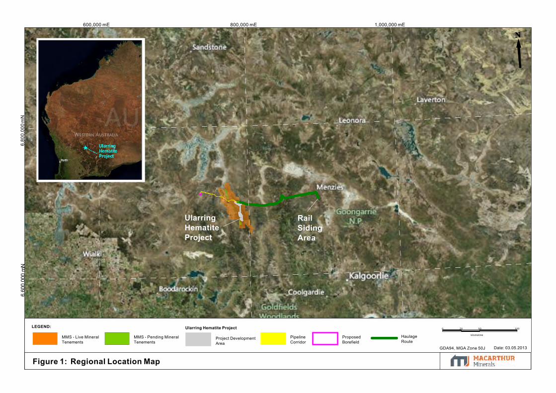
800,000 mE6,
800,
000
mN
6,60
0,00
0 m
N600,000 mE 1,000,000 mE
Ularring Hematite ProjectLEGEND:
ProposedBorefield
PipelineCorridor
MMS - Pending MineralTenements
Project DevelopmentArea
HaulageRoute
MMS - Live MineralTenements
UlarringHematiteProject
RailSidingArea
0 25 50
kilometres
100
GDA94, MGA Zone 50J Date: 03.05.2013
Figure 1: Regional Location Map

6,60
0,00
0 m
N750,000 mE 800,000 mE 850,000 mE
6,65
0,00
0 m
N6,
700,
000
mN
6,75
0,00
0 m
N
ex Mt Elvire
ex Credo
ex Jaurdi
ex.Mt Jackson
Mount Manning
Nature Reserve
MountManningConservationPark
Helena& AuroraConservationPark
Wallaroo RockConservation park
UlarringHematiteProject
LEGEND:Crown Land Tenure:
Nature Reserve
National Park
Conservation Park
Former Leasehold
Ularring Hematite Project
ProposedBorefieldLocation
ProposedPipeline
Existing MajorRoads
MMS - Live MineralTenements
Mining Reserve
Haulage Route
Project DevelopmentArea
GDA94, MGA Zone 50J
Date: 03.05.2013
0 7.5 15
kilometres
30
Figure 2: Local Project Setting

790,000 mE6,
680,
000
mN
6,69
0,00
0 m
N6,
670,
000
mN780,000 mE
M30/249
E77/1299
E30/240
M30/227
E30/349
E30/408
M30/219
M30
/215
M30/248
M30/229
M30
/228
M3 0
/218
M30
/217
M30
/216
M30
/214
M30
/ 213
M30/207
M30/208
M30/206
E30/
411
E30/317
E30/410
E30/392
E30/321
E30/318
P30/1095
M30/251
P30/1096
M30/250
M30/249
E77/1299
E30/240
M30/227
E30/349
E30/408
M30/219
M30
/215
M30/248
M30/229
M30
/228
M3 0
/218
M30
/217
M30
/216
M30
/214
M30
/ 213
M30/207
M30/208
M30/206
E30/
411
E30/317
E30/410
E30/392
E30/321
E30/318
P30/1095
M30/251
P30/1096
M30/250Ularring Hematite Project:
Crown Land Tenure:LEGEND:
Project Development Area(Option 1)
Option 2: Haul RoadAlignment
Mine Infrastructure Areas
Internal Haul Road
Mount ManningNature Reserve
Mining Reserve
Waste Dumps
Open Cut Pits
Existing MajorRoads
HaulageRoute
MMS - PendingMineral Tenements
MMS - Live MineralTenements
GDA94, MGA Zone 50J Date: 03/05.2013
SnarkDeposit
CentralDeposit
BanjoDeposit
MinesOperationsCentre
Magazine
AccomodationCamp
MinesOperationsCentre
0 1 2
kilometres
4
Figure 3: Project Layout Plan

786,000 mE 788,000 mE 790,000 mE6,
696,
000
mN
6,69
8,00
0 m
N6,
694,
000
mN
784,000 mE782,000 mE
E30/240 M30/213 M30/248
M30/249
M30/215M30/214
E30/324
E30/240 M30/213 M30/248
M30/249
M30/215M30/214
E30/324
LEGEND: Ularring Hematite Project:Project Development Area
MMS - Live Mineral TenementsMount Manning Nature Reserve
Mining Reserve
Open Cut Pits
Waste DumpsMine Infrastructure Areas
Internal Haul Roads
Existing Major RoadsHaulage Route
0 250 500
metres
1,000
Figure 4: Snark Project Layout Plan
AccomodationCamp
Magazine
MinesOperationsCentre
SnarkDeposit
Evanston-Menzies Road
GDA94, MGA Zone 50J
Date: 05.12.2012
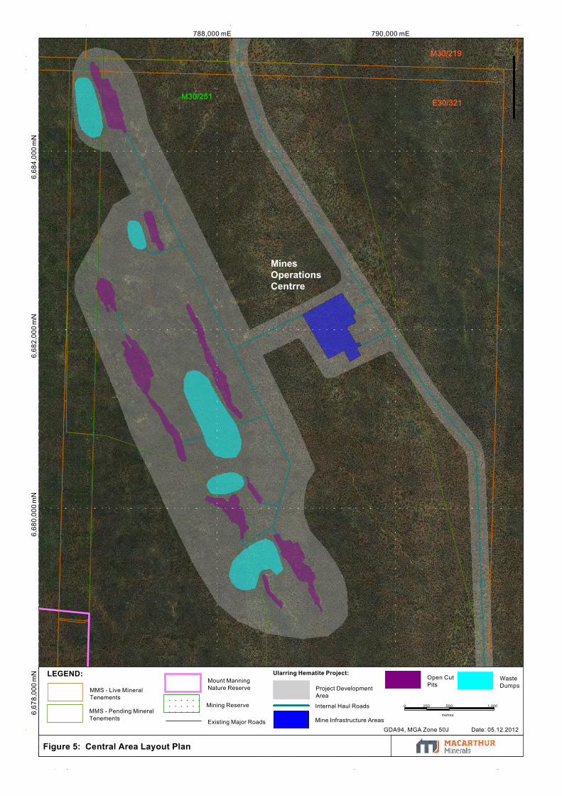
790,000 mE6,
684,
000
mN
6,68
2,00
0 m
N788,000 mE
6,67
8,00
0 m
N6,
680,
000
mN
M30/219
E30/321M30/251
M30/219
E30/321M30/251
Figure 5: Central Area Layout Plan
Ularring Hematite Project:LEGEND:
Project DevelopmentArea
MMS - Live MineralTenements
MMS - Pending MineralTenements
Mining Reserve
Mount ManningNature Reserve
Open CutPits
WasteDumps
Mine Infrastructure Areas
Internal Haul Roads
Existing Major Roads
0 250 500
metres
1,000
GDA94, MGA Zone 50J Date: 05.12.2012
MinesOperationsCentrre

6,67
5,00
0 m
N790,000 mE 791,000 mE
6,67
3,00
0 m
N6,
674,
000
mN
6,67
6,00
0 m
N789,000 mE
M30/229
M30/206
M30/227
M30/228
M30/229
M30/206
M30/227
M30/228
Figure 6: Banjo Area Layout Plan
Ularring Hematite Project:LEGEND:
Project DevelopmentArea
MMS - Live MineralTenements
MMS - Pending MineralTenements
Mining Reserve
Mount ManningNature Reserve
Mine Infrastructure Area
Internal Haul Road
Open CutPits
WasteDumps
Existing Major Roads
0 125 250
metres
500
GDA94, MGA Zone 50J Date: 05.12.2012

6,70
0,00
0 m
N893,000 mE 893,500 mE
6,70
0,50
0 m
N6,
699,
000
mN
6,69
9,50
0 m
N
P29/1895P29/1895
Figure 7: Rail Siding Area Layout Plan
Ularring Hematite Project:LEGEND:
Rail Siding Development Area Haulage RouteTreppo Grande Pty LtdLive Mineral Tenement GDA94, MGA Zone 50J Date: 05.12.2012
Goldfields Highw
ay
Esperance - Leonora Railway
0 75 150
metres
300

6,65
0,00
0 m
N6,
600,
000
mN
700,000 mE6,
700,
000
mN
6,75
0,00
0 m
N750,000 mE 800,000 mE
Figure 8: Regional Priority Flora Records
Priority Flora Records:
Banksia arborea
Grevillea erectiloba
Grevillea georgeana
Hibbertia lepidocalyx subsp. tuberculata
Mirbelia ferricola
Spartothamnella sp. Helena & Aurora Range
LEGEND:Crown Land Tenure:
Nature Reserve
Conservation Park
Former Leasehold
MMS - Live MineralTenements
MMS - Pending MineralTenements
GDA94
MGA Zone 50J
Date: 12.06.2013
0 7.5 15
kilometres
30

790,000 mE785,000 mE6,
695,
000
mN
780,000 mE
E30/240
M30/249
M30/248M30
/215
E30/408
M30
/214
M30
/ 213
E30/240
M30/249
M30/248M30
/215
E30/408
M30
/214
M30
/ 213
Priority Flora Locations:
Banksia arborea
Grevillea erectiloba
Grevillea georgeana
Hibbertia lepidocalyx subsp. tuberculata
Mirbelia ferricola
Spartothamnella sp. Helena & Aurora Range
Ularring Hematite Project:LEGEND:
Project DevelopmentArea
Mining Reserve
Mount ManningNature Reserve
Open Cut Pits
Waste Dumps
Mine Infrastructure Areas
Internal Haul Roads
Existing Major Roads Haulage RouteMMS - PendingMineral Tenements
MMS - Live MineralTenements
0 0.5 1
k ilometres
2
GDA94, MGA Zone 50J
Date: 28.11.2012
Figure 9: Priority Flora of the Snark Deposit Area and surrounds

6,68
8,00
0 m
N6,
684,
000
mN
6,68
6,00
0 m
N6,
678,
000
mN
6,68
0,00
0 m
N6,
682,
000
mN
794,000 mE788,000 mE 790,000 mE 792,000 mE
E30/321
M30/216
E30/408
E30/318E30/317
M30/248
M30/219
M30/251
E30/321
M30/216
E30/408
E30/318E30/317
M30/248
M30/219
M30/251Priority Flora Records
Banksia arborea
Grevillea erectiloba
Grevillea georgeana
Hibbertia lepidocalyx subsp. tuberculata
Mirbelia ferricola
Spartothamnella sp. Helena & Aurora Range
Ularring Hematite Project:
LEGEND:
Project DevelopmentArea
MMS - Live MineralTenements
MMS - Pending MineralTenements
Mining Reserve
Mount ManningNature Reserve
Open Cut Pits
Waste Dumps
Mine InfrastructureAreas
Internal Haul Road Existing Major Roads
Figure 10: Priority Flora of the Central Deposit and surrounds
0 0.5 1
kilometres
2
GDA94, MGA Zone 50J Date: 12.06.2013

790,000 mE 795,000 mE785,000 mE6,
670,
000
mN
6,67
5,00
0 m
N
E30/392
E30/317
E30/411
M30/208
M30/207
M30/206
M30/229M30/227
M30/250
E30/392
E30/317
E30/411
M30/208
M30/207
M30/206
M30/229M30/227
M30/228
M30/250
Figure 11: Priority Flora of the Banjo Deposit area and surrounds
Priority Flora Records:
Banksia arborea
Grevillea erectiloba
Grevillea georgeana
Hibbertia lepidocalyx subsp. tuberculata
Mirbelia ferricola
Spartothamnella sp. Helena & Aurora Range
LEGEND: Ularring Hematite Project:
Existing Major Roads
Mining Reserve
Mount Manning Nature Reserve
MMS - Pending MineralTenements
MMS - Live MineralTenements
Waste DumpsOpen Cut Pits
Mine Infrastructure Area
Internal Haul Roads
Project Development Area
0 0.5 1
kilometres
2
GDA94, MGA Zone 50J Date:12.06.2013
6,675,000 mN
790,
000
mE
6,675,000 mN
790,
000
mE

6,67
0,00
0 m
N770,000 mE 780,000 mE 790,000 mE 800,000 mE
6,68
0,00
0 m
N6,
690,
000
mN
6,70
0,00
0 m
N6,
710,
000
mN
E30/321
M30/229
M30/227
M30/206
E30/404
E30/322
E30/349
M30/219
E30/317
E30/240
M30/249
E77/1299
E30/324
E30/408
E30/318
E77/1969
M30/207
E30/443
E30/321
M30/229
M30/227
M30/206
E30/404
E30/322
E30/349
M30/219
E30/317
E30/240
M30/249
E77/1299
E30/324
E30/408
E30/318
E77/1969
M30/207
E30/323
E30/385
E30/392
E30/399
E30/410
M30/208
M30/214
M30/217
M30/248
P30/1061
P30/1071
P30/1083
E30/443
M30/251
Notable Taxa Records:
Acacia aff. balsamea
Acacia aff. sibirica
Sida petrophila
Ularring Hematite Project:LEGEND:
HaulageRoute
Project DevelopmentArea
Existing MajorRoads
Mining Reserve
Mount ManningNature Reserve
MMS - Pending MineralTenements
MMS - Live MineralTenements
5
k ilometres
0 2.5
GDA94, MGA Zone 50J Date: 05.12.2012
Figure 12: Notable Taxa surrounding the Project Area

800,
000
mE
1,40
0,00
0 m
E
6,800,000 mN
1,20
0,00
0 m
E
1,00
0,00
0 m
E
6,200,000 mN
6,400,000 mN
6,600,000 mN
600,
000
mE
400,
000
mE
200 ,
000
mE
Figure 13: Regional Notable TaxaRecords
Notable Taxa Records:
Acacia aff. balsamea
Acacia aff. sibirica
Sida petrophila
LEGEND:
Ularring Hematite ProjectHaulage Route
MMS - Live Mineral Tenements
0 50 100
kilometres
200
GDA94, MGA Zone 50JDate: 28.11.2012
UlarringHematiteProject

790,000 mE 800,000 mE6,
720,
000
mN
6,69
0,00
0 m
N6,
700,
000
mN
6,71
0,00
0 m
N6,
680,
000
mN
780,000 mE6,
670,
000
mN
770,000 mE
M30/207
M30/208
M30/206
E30/317
E30/318
E30/410
E30/408
E30/322
E30/240
E30/324E30/385
E30/323
E77/1969
E30/404
M30/207
M30/208
M30/206
E30/317
E30/318
E30/410
E30/408
E30/322
E30/240
E30/324E30/385
E30/323
E77/1969
E30/404
E77/1299
P30/1062
E30/443
Figure 14: Extent of Vegetation Mapping of the Project Area
Ularring Hematite Project:
LEGEND:
LakeGilesPEC
VegetationMappingArea
ProjectDevelopmentAreaHaulage Route
Existing MajorRoads
Mining Reserve
Mount ManningNature Reserve
Pending MineralTenements
MMS Live MineralTenements
0 2 4
kilometres
8
Date: 14.12.2012 GDA94, Zone 50J
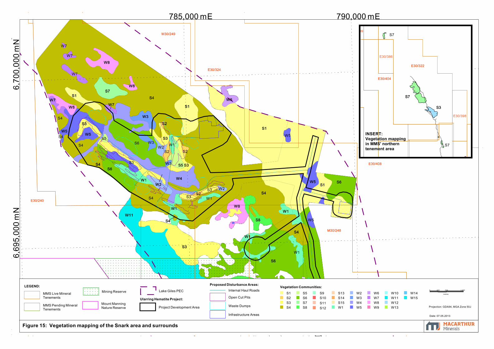
785,000 mE 790,000 mE6,
695,
000
mN
6,70
0,00
0 m
N
S5 S3
W2W4
W1
S8
S6
S4
W1
S4
W3
W8
S1
S3
S2
W6
S7
W8
W7
S3
W5
W1
W7
W8
S1
S4
W1
S1
S8
S13
W11
S3
W8
S4
W5 S6
S1
S4S6
W5
M30
/21 3
M30
/ 215
M30/248
M30
/214
E30/408
E30/240
E30/324
M30/249
S5 S3
W2W4
W1
S8
S6
S4
W1
S4
W3
W8
S1
S3
S2
W6
S7
W8
W7
S3
W5
W1
W7
W8
S1
S4
W1
S1
S8
S13
W11
S3
W8
S4
W5 S6
S1
S4S6
W5
W1
W3
W7
W7
W7
S3 W2
W1
S2
S2S3
S2W2
W3
S4
S3
S5
S4
S4
S4
W5
W5
S6
W1
M30
/21 3
M30
/ 215
M30/248
M30
/214
E30/408
E30/240
E30/324
M30/249
Vegetation Communities:
S1S2S3S4
S5S6S7S8
S9S10S11S12
S13S14S15W1
W2W3W4W5
W6W7W8W9
W10W11W12W13
W14W15
Proposed Disturbance Areas:
Ularring Hematite Project:
LEGEND:
Open Cut Pits
Waste Dumps
Infrastructure Areas
Internal Haul RoadsLake Giles PEC
Project Development AreaMount ManningNature Reserve
Mining Reserve
MMS Pending MineralTenements
MMS Live MineralTenements
0 250 500
metres
1,000
Figure 15: Vegetation mapping of the Snark area and surrounds
Projection: GDA94, MGA Zone 50J
Date: 07.05.2013
S7
S3
E30/322
E30/404
S7
S3
E30/322
E30/404
E30/386
E30/398
E30/399
INSERT:Vegetation mappingin MMS' northerntenement area
S7
S7

790,000 mE 795,000 mE6,
680,
000
mN
6,68
5,00
0 m
N6,
690,
000
mN
6,67
5,00
0 m
N785,000 mE
S7
W9
W9
S13W9
W11W11
W13
S8
W13
S10
W11
S3
S10
W11
W11 W9
W9
W5
W9W11
W11
W10
W4
S9
S2
W5
W11
S13
S12
W9
S13S11
W9
S13
W5
S6
S8
S3S13
S7
S13
M30/219
E30/321
M30/251
S7
W9
W9
S13W9
W11W11
W13
S8
W13
S10
W11
S3
S10
W11
W11 W9
W9
W5
W9W11
W11
W10
W4
S9
S2
W5
W11
S13
S12
W9
S13S11
W9
S13
W5
S6
S8
S3S13
S7
S13
W9
W12
W13
S9W9
W9
S10
W13S7 S2
S2W1
W12
S2
W13
W9
S3
S13
W11
W13S7
W13
S3
W13
S3
W13
W13
S10S13
S10W13
W13
S7 W5
S3S3S7
S3S3
W11
W5S8
S6
W13S14
S14W11
W11 S15
W11S7
W13
W11
W13
W10
W8
S11
M30/219
E30/321
E30/408
E30/410
M30/213 M30/214 M30/215
M30/216M30/217M30/218
M30/227
M30/248
P30/1085
M30/251
S8
S7
S3
Figure 16: Vegetation mapping of the Central area and surrounds
Vegetation Communities:S1
S2
S3
S4
S5
S6
S7
S8
S9
S10
S11
S12
S13
S14
S15
W1
W2
W3
W4
W5
W6
W7
W8
W9
W10
W11
W12
W13
W14
W15
Proposed Disturbance Areas:LEGEND:
Ularring Hematite Project:
Open Cut Pits
Waste Dumps
Infrastructure Areas
Internal Haul RoadMMS Live MineralTenements
MMS Pending MineralTenements
Mining Reserve
Mount ManningNature Reserve
Project DevelopmentArea
Lake Giles PEC
0 0.5 1
k ilometres
2
Projection: GDA94, MGA Zone 50J
Date: 03.05.2013

792,000 mE 794,000 mE6,
676,
000
mN
6,67
8,00
0 m
N 788,000 mE 790,000 mE786,000 mE6,
674,
000
mN
6,67
2,00
0 m
N
S14
W13
S7
S8
W13S11
W11
W5
W8
S14
W13S14W14
W15
S14W11
M30/228
E30/321
M30/227
M30/229
E30/317
E30/411
M30/206
M30/251
M30/250
S14
W13
S7
S8
W13S11
W11
W5
W8
S14
W13S14W14
W15
S14W11
S7
S2
S2
W9
S7
W11
S7
W13S7
W11
S14
S14
W11
W11
W11
S14
S2
S8
S15
W13
W11
S7
S2
S2
W13
S14
W13
W8
M30/228
E30/321
M30/227
M30/229
E30/317
E30/411
M30/206
M30/251
M30/250
S7
S7
Vegetation Communities:
S1S2S3S4S5
S6S7S8S9S10
S11S12S13S14
S15W1W2W3
W4W5W6W7
W8W9W10W11
W12W13W14W15
Proposed Disturbance Areas:LEGEND: Ularring Hematite Project:
Open Cut Pits
Waste Dumps
Infrastructure Areas
Internal Haul Road
MMS Live Mineral Tenements
Pending Mineral Tenements Mining Reserve
Mount ManningNature Reserve Project Development Area
Lake Giles PEC
Figure 17: Vegetation mapping of the Banjo area and surrounds
0 250 500
metres
1,000
Projection: GDA94 MGA Zone 50J
Date: 03.05.2013
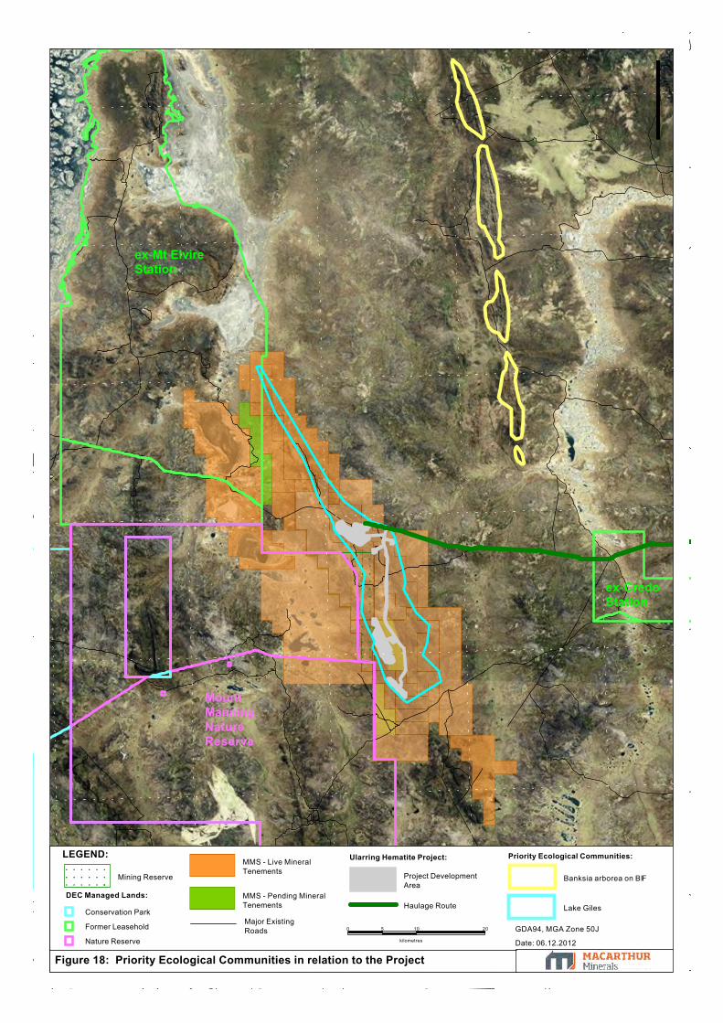
Figure 18: Priority Ecological Communities in relation to the Project
DEC Managed Lands:
Conservation Park
Former Leasehold
Nature Reserve
LEGEND: Ularring Hematite Project: Priority Ecological Communities:
MMS - Pending MineralTenements
MMS - Live MineralTenements
Mining Reserve
Major ExistingRoads
Project DevelopmentArea
Lake Giles
Banksia arborea on BIF
Haulage Route
0 5 10
kilometres
20 GDA94, MGA Zone 50J
Date: 06.12.2012
ex-Mt ElvireStation
ex-CredoStation
MountManningNatureReserve
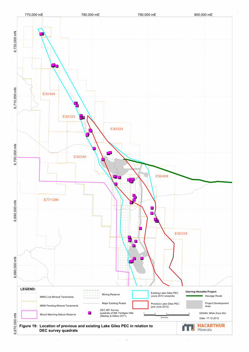
780,000 mE 790,000 mE 800,000 mE6,
710,
000
mN
770,000 mE6,
700,
000
mN
6,72
0,00
0 m
N6,
670,
000
mN
6,68
0,00
0 m
N6,
690,
000
mN E77/1299
E30/404
E30/322
E30/240
E30/318
E30/408
E30/324
M30/206
M30/207
Figure 19: Location of previous and existing Lake Giles PEC in relation toDEC survey quadrats
LEGEND:Ularring Hematite Project:
MMS Live Mineral Tenements
MMS Pending Mineral Tenements
Mining Reserve
Mount Manning Nature Reserve
Project DevelopmentArea
Existing Lake Giles PEC(June 2012 onwards)
Previous Lake Giles PEC(pre June 2012)
Haulage Route
Major Existing Roads
DEC BIF Surveyquadrats of Nth Yerillgee Hills(Markey & Dillion 2011)
0 2 4
kilometres
8 GDA94, MGA Zone 50J
Date: 17.12.2012

792,500 mE790,000 mE 795,000 mE782,500 mE 785,000 mE 787,500 mE6,
700,
000
mN
6,69
5,00
0 m
N6,
692,
500
mN
6,69
7,50
0 m
N
E 3000324
M 3000248
E 3000408
M 3000215M 3000214M 3000213
E 3000240
M 3000249
E 3000324
M 3000248
E 3000408
M 3000215M 3000214M 3000213
E 3000240
M 3000249
Figure 20: Malleefowl Ground Survey Areas of the Snark Deposit
0 0.5 1
kilometres
2
Projection: MGA94 Zone50JCreated by: MMS Date: 15.02.2013
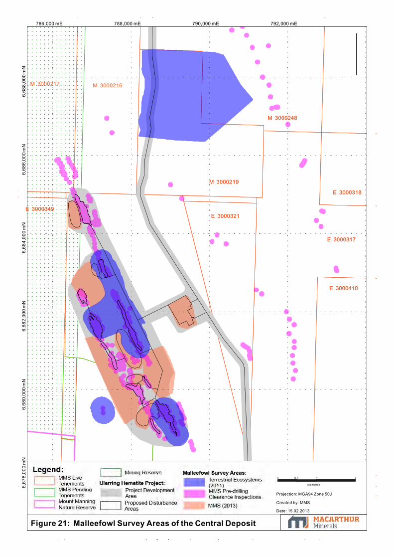
6,67
8,00
0 m
N6,
680,
000
mN
6,68
2,00
0 m
N786,000 mE
6,68
8,00
0 m
N6,
686,
000
mN
788,000 mE 790,000 mE 792,000 mE6,
684,
000
mN
M 3000248
M 3000219
E 3000321
E 3000410
E 3000317
E 3000318
M 3000227
E 3000349
M 3000251M 3000252
M 3000248
M 3000219
E 3000321
E 3000410
E 3000317
E 3000318
M 3000227
E 3000349
M 3000251
P 3001085
M 3000217 M 3000216
M 3000252
Figure 21: Malleefowl Survey Areas of the Central Deposit
0 0.5 1
kilometres
2
Projection: MGA94 Zone 50J
Created by: MMS
Date: 15.02.2013
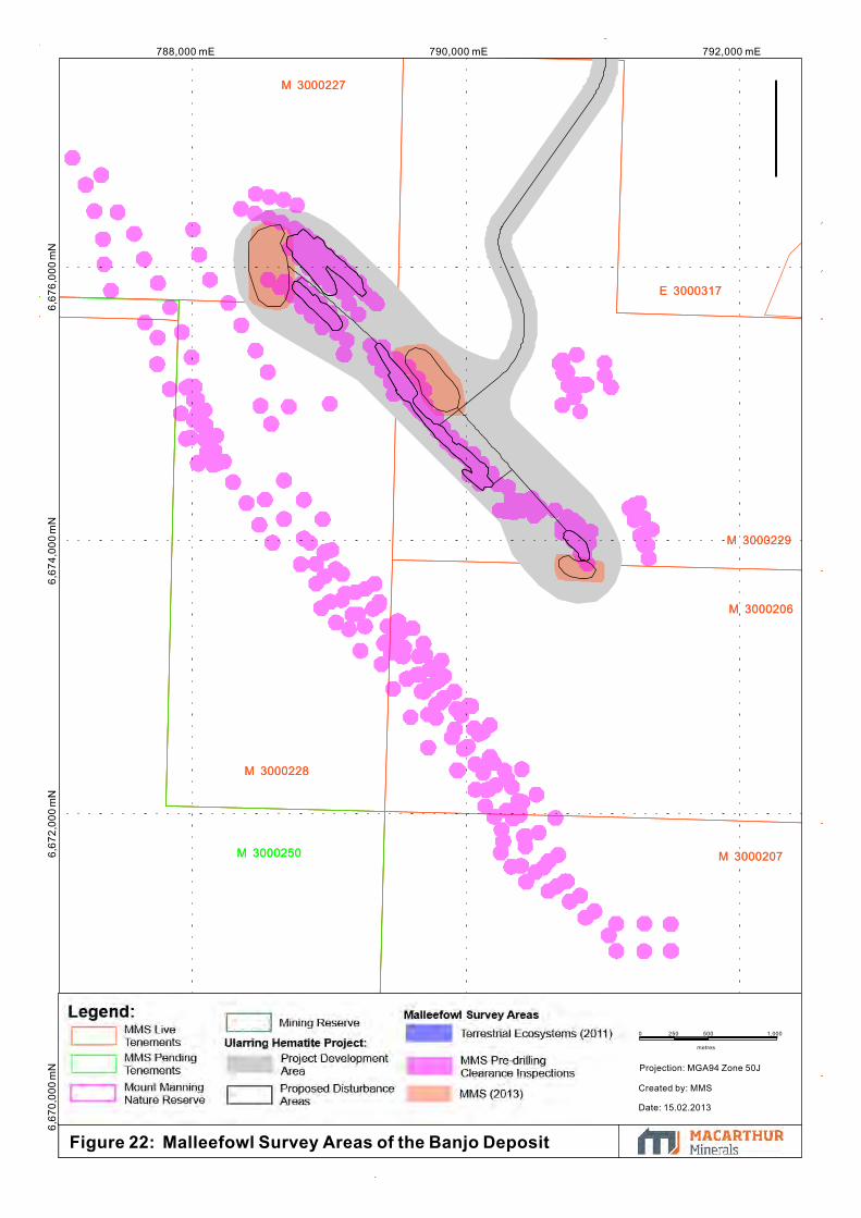
6,67
0,00
0 m
N6,
674,
000
mN
788,000 mE 790,000 mE 792,000 mE6,
676,
000
mN
6,67
2,00
0 m
N
E 3000317
M 3000227
M 3000229
M 3000207
M 3000206
M 3000228
M 3000250
E 3000317
M 3000227
M 3000229
M 3000207
M 3000206
M 3000228
E 3000392
M 3000250
Figure 22: Malleefowl Survey Areas of the Banjo Deposit
0 250 500
metres
1,000
Projection: MGA94 Zone 50J
Created by: MMS
Date: 15.02.2013

790,000 mE 795,000 mE785,000 mE6,
695,
000
mN
6,70
0,00
0 m
N
E 3000324
E 3000240
M 3000249
M 3000248
E 3000408
M 3000214M 3000213M 3000215
E 3000324
E 3000240
M 3000249
M 3000248
E 3000408
M 3000214M 3000213M 3000215
Figure 23: Malleefowl Mounds by Survey in the Snark Deposit
0 0.5 1
kilometres
2
Projection: MGA94m Zine50J
Created by: MMS Date: 15.02.2013

792,000 mE6,
684,
000
mN
6,68
6,00
0 m
N6,
688,
000
mN
6,68
2,00
0 m
N6,
680,
000
mN
6,67
8,00
0 m
N790,000 mE786,000 mE 788,000 mE
E 3000317
E 3000321
M 3000219
E 3000349
M 3000251M 3000252
E 3000317
E 3000321
M 3000219
E 3000349
M 3000251
P 3001085M 3000227
M 3000218 M 3000217 M 3000216
M 3000252
Figure 24: Malleefowl Mounds by Survey in the Central Deposit
0 0.5 1
kilometres
2
Projection: MGA94 Zone 50J
Created by: MMS
Date: 15.02.2013

788,000 mE 790,000 mE 792,000 mE6,
676,
000
mN
6,67
4,00
0 m
N
E 3000317
M 3000229
M 3000206
M 3000228
E 3000317
M 3000229
M 3000206
M 3000228
Figure 25: Malleefowl Mounds by Survey in the Banjo Deposit
0 250 500
metres
1,000
Projection: MGA94 Zone 50J
Created by: MMS
Date: 15.02.2013

790,000 mE 795,000 mE785,000 mE6,
695,
000
mN
6,70
0,00
0 m
N
M 3000213M 3000214
M 3000215
E 3000240
M 3000249
M 3000248
E 3000408
M 3000213M 3000214
M 3000215
E 3000240
M 3000249
M 3000248
E 3000408
Figure 26: Malleefowl Mounds by Status in the Snark Deposit
0 0.5 1
kilometres
2
Projection: GDA94, Zone 50J
Created by: MMS
Date: 18.02.2013

6,68
4,00
0 m
N786,000 mE
6,68
6,00
0 m
N6,
688,
000
mN
788,000 mE 790,000 mE 792,000 mE 794,000 mE6,
676,
000
mN
6,67
8,00
0 m
N6,
680,
000
mN
6,68
2,00
0 m
N
E 3000410
E 3000317E 3000321
M 3000219
E 3
0003
49
M 3000251M 3000252
E 3000410
E 3000317E 3000321
M 3000219
E 3
0003
49
M 3000251
P 3001085M 3000227
M 3000217 M 3000216
M 3000252
Figure 27: Malleefowl Mounds by Status in the Central Deposit
Projection: GDA94, Zone 50J
Created by: MMS Date: 18.02.2013
0 0.5 1
kilometres
2

790,000 mE 792,000 mE6,
674,
000
mN
6,67
6,00
0 m
N6,
678,
000
mN
6,67
2,00
0 m
N6,
670,
000
mN
788,000 mE
M 3000251
E 3000317
M 3000227
M 3000228
M 3000229
M 3000207
M 3000252 M 3000251
E 3000317
M 3000227
M 3000228
M 3000229
M 3000207
E 3000392
M 3000208
M 3000252
M 3000250
Figure 28: Malleefowl Mounds by Status in the Banjo Deposit
0 250 500
metres
1,000
Projection: MGA94 Zone 50
Created by: MMS
Date: 15.02.2013
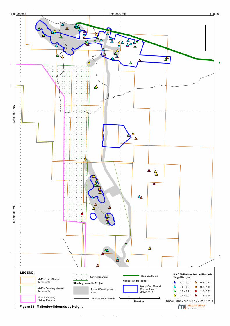
790,000 mE 800,000 mE780,000 mE6,
680,
000
mN
6,69
0,00
0 m
N
Figure 29: Malleefowl Mounds by Height
MMS Malleefowl Mound RecordsHeight Ranges:
-0.3 - 0.0
0.0 - 0.2
0.2 - 0.4
0.4 - 0.6
0.6 - 0.8
0.8 - 1.0
1.0 - 1.2
1.2 - 2.0
Malleefowl Records:Ularring Hematite Project:
LEGEND:
Malleefowl MoundSurvey Area(MMS 2011)
Haulage Route
Project DevelopmentArea
Existing Major Roads
Mining Reserve
Mount ManningNature Reserve
MMS - Pending MineralTenements
MMS - Live MineralTenements
2
k ilometres
410
GDA94, MGA Zone 50J Date: 05.12.2012
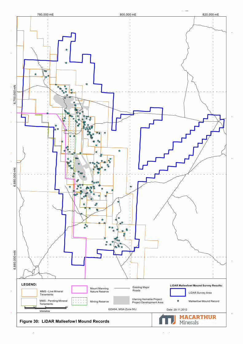
780,000 mE 800,000 mE 820,000 mE6,
700,
000
mN
6,68
0,00
0 m
N6,
660,
000
mN
Figure 30: LiDAR Malleefowl Mound Records
LiDAR Malleefowl Mound Survey Results:LEGEND:
Malleefowl Mound Record
LiDAR Survey Area
Ularring Hematite Project:Project Development Area
Existing MajorRoads
Mining Reserve
Mount ManningNature Reserve
MMS - Pending MineralTenements
MMS - Live MineralTenements
0 2.5 5
k ilometres
10GDA94, MGA Zone 50J Date: 29.11.2012
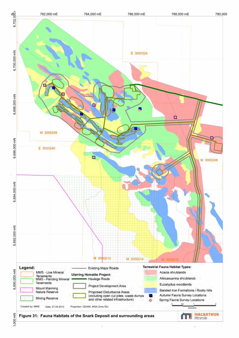
788,000 mE 790,000 mE786,000 mE780,000 mE 782,000 mE 784,000 mE6,
696,
000
mN
6,69
8,00
0 m
N6,
700,
000
mN
6,70
2,00
0 m
6,69
4,00
0 m
N6,
692,
000
mN
8,00
0 m
N6,
690,
000
mN
M 3000248
E 3000240
M 3000249
M 3000217
M 3000214M 3000213
M 3000218 M 3000216
M 3000215
E 3000324
M 3000248
E 3000240
M 3000249
M 3000217
M 3000214M 3000213
M 3000218 M 3000216
M 3000215
E 3000324
Figure 31: Fauna Habitats of the Snark Deposit and surrounding areas
0 0.5 1
kilometres
2
Date: 27.04.2013 Projection: GDA94, MGA Zone 50JCreated by: MMS
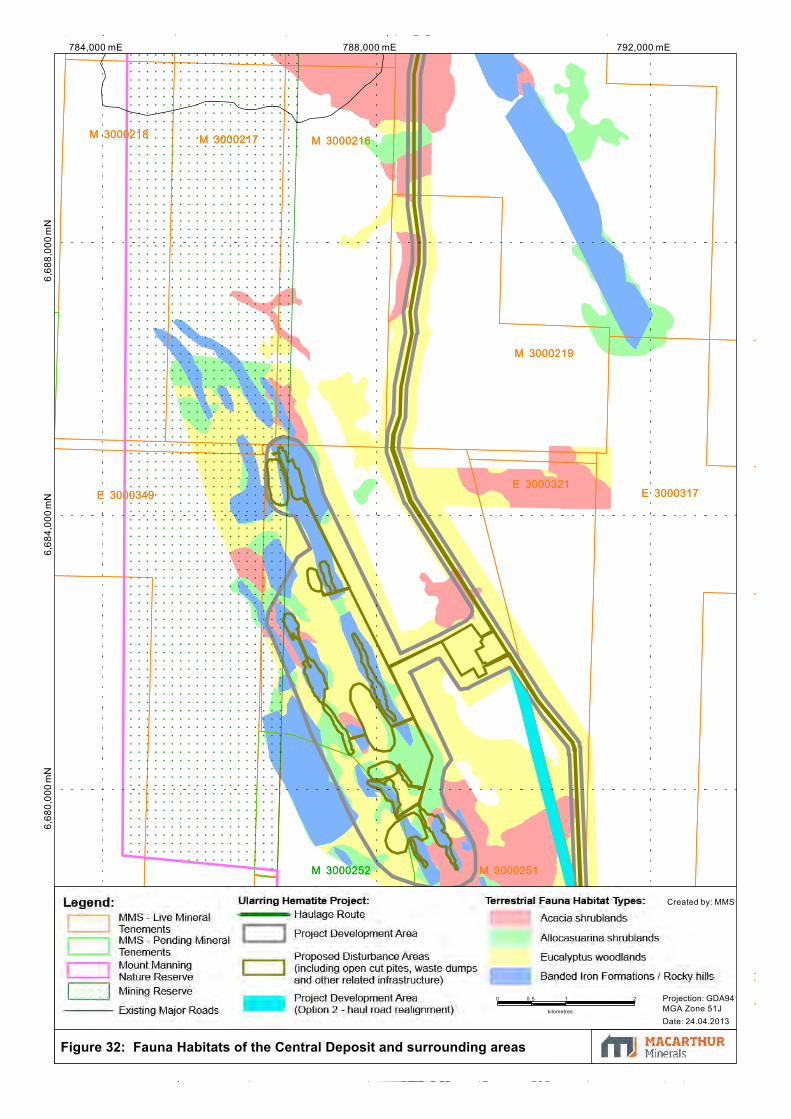
784,000 mE 788,000 mE 792,000 mE6,
688,
000
mN
6,68
4,00
0 m
N6,
680,
000
mN
M 3000216M 3000217M 3000218
M 3000251
M 3000227
E 3000317E 3000321
M 3000219
E 3000349
M 3000252
M 3000216M 3000217M 3000218
M 3000251
M 3000227
E 3000317E 3000321
M 3000219
E 3000349
M 3000252
Figure 32: Fauna Habitats of the Central Deposit and surrounding areas
0 0.5 1
kilometres
2
Date: 24.04.2013
Projection: GDA94MGA Zone 51J
Created by: MMS

6,67
6,00
0 m
N788,000 mE 790,000 mE 792,000 mE
6,67
8,00
0 m
N6,
674,
000
mN
M 3000251
M 3000227
M 3
0002
50
M 3000252 M 3000251
M 3000227
M 3000206
M 3000228
M 3000229
M 3
0002
50
M 3000252
Figure 33: Fauna Habitats of the Banjo Deposit and surrounding areas
0 250 500
metres
1,000
Date: 24.04.2013 Created by: MMS Projection: GDA94, MGA Zone 50J
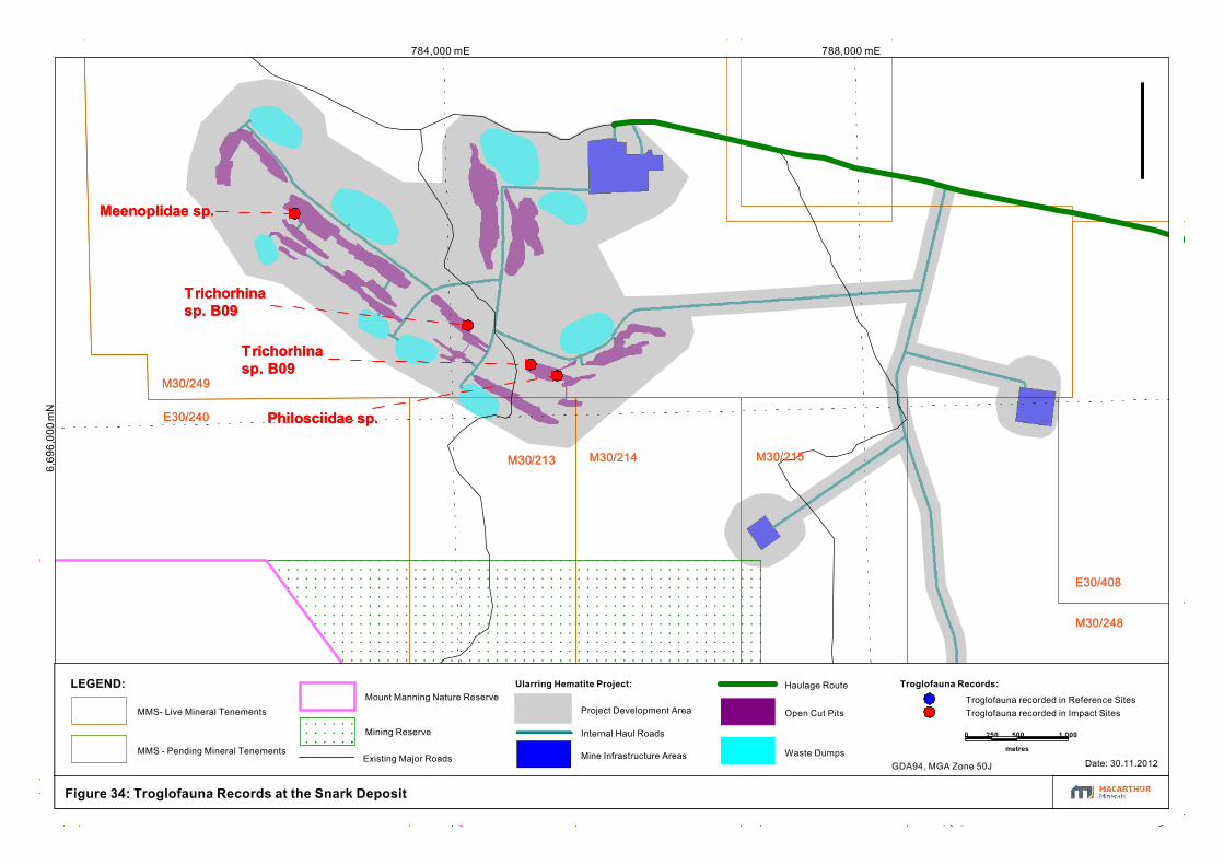
784,000 mE 788,000 mE6,
696,
000
mN
E30/240
M30/249
M30/248
E30/408
M30/213 M30/214 M30/215
Philosciidae sp.
Trichorhinasp. B09
Trichorhinasp. B09
Meenoplidae sp.
E30/240
M30/249
M30/248
E30/408
M30/213 M30/214 M30/215
Philosciidae sp.
Trichorhinasp. B09
Trichorhinasp. B09
Meenoplidae sp.
Figure 34: Troglofauna Records at the Snark Deposit
Troglofauna Records:Ularring Hematite Project:LEGEND:
Open Cut Pits
Mine Infrastructure Areas
Internal Haul Roads
Troglofauna recorded in Reference SitesTroglofauna recorded in Impact Sites
Waste Dumps
Haulage Route
Project Development Area
Existing Major Roads
Mining Reserve
Mount Manning Nature Reserve
MMS - Pending Mineral Tenements
MMS- Live Mineral Tenements
500
metres
1,0002500
GDA94, MGA Zone 50J Date: 30.11.2012

6,67
8,00
0 m
N6,
676,
000
mN
6,67
4,00
0 m
N6,
684,
000
mN
794,000 mE6,
682,
000
mN
6,68
0,00
0 m
N786,000 mE 788,000 mE 790,000 mE 792,000 mE
E30/321
E30/410
E30/349
M30/227 M30/229
E30/317
M30/251
Pauropodinasp. B08
Araneomorphaesp. B19
Hanseniellasp. B12
Hemitrinemurasp. B08
Hanseniellasp. B12
Cryptopssp. B27
Trichorhinasp. B09 (x4)
E30/321
E30/410
E30/349
M30/227 M30/229
E30/317
M30/206
M30/228
M30/251
M30/250
Pauropodinasp. B08
Araneomorphaesp. B19
Hanseniellasp. B12
Hemitrinemurasp. B08
Hanseniellasp. B12
Cryptopssp. B27
Trichorhinasp. B09 (x4)
Troglofauna Records:
Ularring Hematite Project:
LEGEND:Troglofauna recordsin Reference Sites
Troglofauna recordsin Impact Sites
Waste Dumps
Open Cut Pits
Mine Infrastructure Areas
Internal Haul Roads
Project Development Area
Existing Major Roads
Mining Reserve
Mount ManningNature Reserve
MMS - Pending MineralTenements
MMS - Live MineralTenements
Figure 35: Troglofauna Records of the Central and Banjo Deposits
0 0.5 1
kilometres
2
GDA94, MGA Zone 50J Date: 30.11.2012

6,70
0,00
0 m
N800,000 mE
6,69
0,00
0 m
N6,
670,
000
mN
6,68
0,00
0 m
N790,000 mE780,000 mE
E30/392 M30/208
E30/408
E30/321
M30/219
E77/1299
E30/349
M30/248
E30/318
E30/317
E30/410
E30/240
M30/249
M30/207
M30/206
M30/250
E30/392 M30/208
E30/408
E30/321
M30/219
E77/1299
E30/349
M30/248
E30/318
E30/317
E30/410
E30/240
M30/249
M30/207
M30/206
P30/1071
P30/1083
M30/250
M30/251
P30/1095
P30/1096
Figure 36: Prospective Troglofauna Habitat of the Project Area and surrounds
Propsective Troglofauna Habitat:
Altered, enriched hematite / goethite BIF
Un-altered silica rich BIF magnetite
Ularring Hematite Project:LEGEND:
Troglofauna Records
Haulage Route
Project Development Area
Existing Major Roads
Mining Reserve
Mount ManningNature Reserve
MMS - Pending MineralTenements
MMS - Live MineralTenements
0 1.25 2.5
kilometres
5
GDA94, MGA Zone 50J Date: 30.11.2012

6,67
0,00
0 m
N6,
680,
000
mN
6,69
0,00
0 m
N790,000 mE780,000 mE
M 3
0002
18
M 3
0002
17M
300
0214
M 3
0002
13
M 3
0002
16M
300
0215
M 3000219
M 3000248
E 3000408
E 3000240
M 3
0002
28 M 3000229
M 3000206
E 3000349
M 3000251
E 3000321 E 3000317
E 3000410
M 3000249
M 3
0002
18
M 3
0002
17M
300
0214
M 3
0002
13
M 3
0002
16M
300
0215
M 3000219
M 3000248
E 3000408
E 3000240
M 3
0002
28 M 3000229
M 3000206
E 3000349
M 3000251
E 3000321 E 3000317
E 3000410
M 3000249
M 3000207
M 3000208
M 3000227
0 1 2
k ilometres
4
Figure 37: Stygofauna Sampling LocationsProjection: GDA94 Zone50J Created by: MMS Date: 18.02.2013
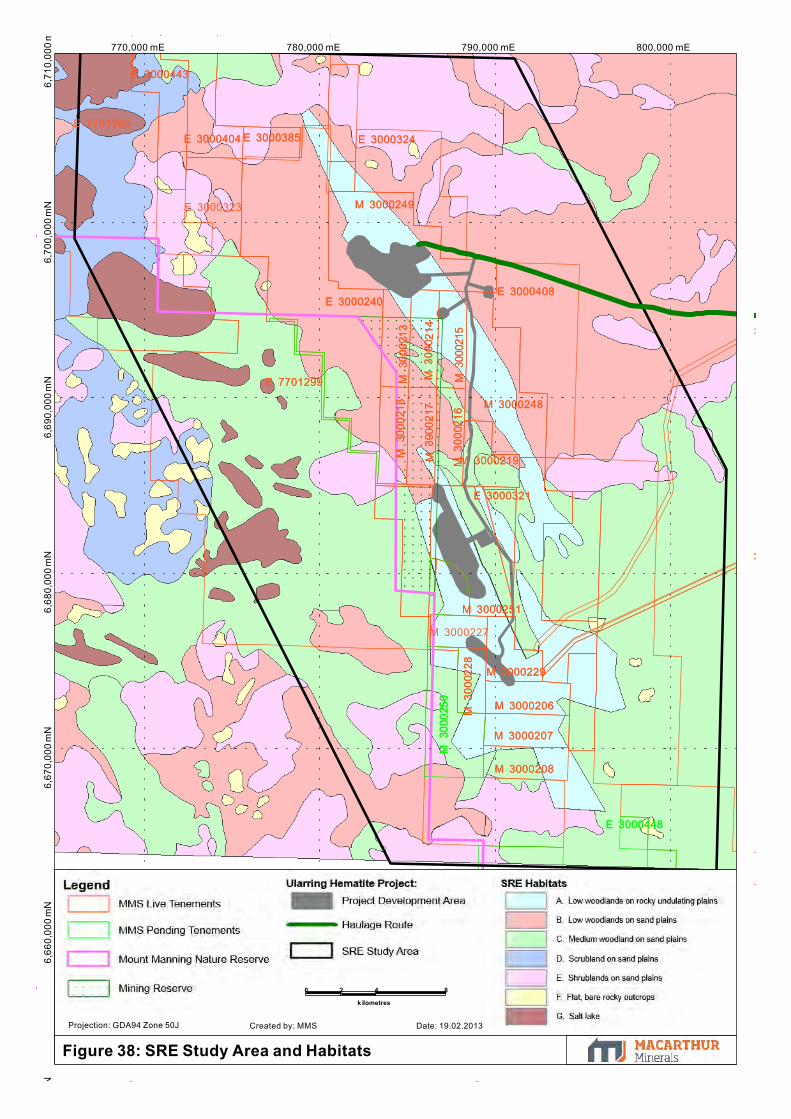
6,69
0,00
0 m
N6,
680,
000
mN
800,000 mE770,000 mE 780,000 mE 790,000 mEN
6,66
0,00
0 m
N6,
670,
000
mN
6,70
0,00
0 m
N6,
710,
000
m
M 3
0002
28
M 3000251
M 3000206
M 3000208
M 3000207
M 3000229
E 3000321
M 3000219M 3
0002
16
M 3
0002
17
M 3
0002
18 M 3000248
M 3
0002
15
M 3
000 2
14
M 3
0002
13
E 3000408E 3000240
E 7701299
M 3000249
E 3000324E 3000385E 3000404
E 3000443
M 3
0002
50
E 3000448
M 3
0002
28
M 3000251
M 3000206
M 3000208
M 3000207
M 3000229
E 3000321
M 3000219M 3
0002
16
M 3
0002
17
M 3
0002
18 M 3000248
M 3
0002
15
M 3
000 2
14
M 3
0002
13
E 3000408E 3000240
E 7701299
M 3000249
E 3000324E 3000385E 3000404
E 3000443
E 3000407
E 3000323
M 3000227
E 7701969
M 3
0002
50
E 3000448
E 3000447
E 3000444
0 2 4
k ilometres
8
Figure 38: SRE Study Area and Habitats
Projection: GDA94 Zone 50J Created by: MMS Date: 19.02.2013

780,000 mE 790,000 mE 800,000 mE6,
690,
000
mN
6,70
0,00
0 m
N6,
680,
000
mN
6,67
0,00
0 m
N
E 3000392
M 3
0002
28
M 3000208
M 3000207
M 3000206
M 3000229
M 3000251
E 3000410
E 3000317E 3000321
M 3000219
E 3000349
M 3
0002
17
M 3
0002
18
M 3
0002
16
M 3
0002
13
M 3
0002
14
M 3
0002
15
E 3000408
M 3000248
M 3000249
E 3000240
E 3000324
E 3000392
M 3
0002
28
M 3000208
M 3000207
M 3000206
M 3000229
M 3000251
E 3000410
E 3000317E 3000321
M 3000219
E 3000349
M 3
0002
17
M 3
0002
18
M 3
0002
16
M 3
0002
13
M 3
0002
14
M 3
0002
15
E 3000408
M 3000248
M 3000249
E 3000240
E 3000324E 3000323
E 7701299
M 3000227
Figure 39: SRE Sampling Locations
0 1.25 2.5
kilometres
5
Projection: GDA94 Zone 50J Created by: MMS Date: 19.02.2013
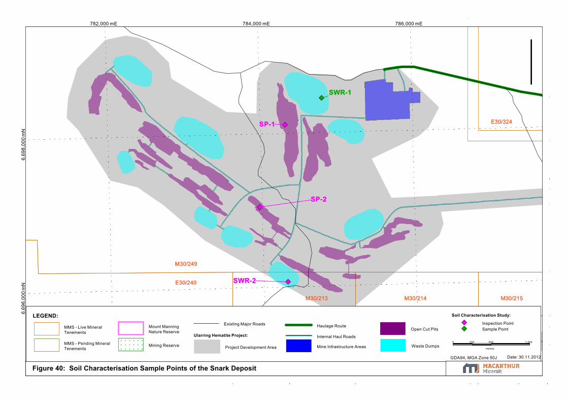
6,69
8,00
0 m
N782,000 mE
6,69
6,00
0 m
N784,000 mE 786,000 mE
M30/249
E30/240
M30/213 M30/215M30/214
E30/324
SWR-2
SP-1
SWR-1
SP-2
M30/249
E30/240
M30/213 M30/215M30/214
E30/324
SWR-2
SP-1
SWR-1
SP-2
Figure 40: Soil Characterisation Sample Points of the Snark Deposit
Soil Characterisation Study:
Ularring Hematite Project:
LEGEND:Inspection PointSample Point
Waste Dumps
Open Cut Pits
Mine Infrastructure Areas
Internal Haul Roads
Haulage Route
Project Development Area
Existing Major Roads
Mining Reserve
Mount ManningNature Reserve
MMS - Pending MineralTenements
MMS - Live MineralTenements
0 250 500
metres
1,000
GDA94, MGA Zone 50J Date: 30.11.2012

790,000 mE 792,000 mE6,
680,
000
mN
6,68
2,00
0 m
N6,
684,
000
mN
786,000 mE 788,000 mE6,
678,
000
mN
6,67
4,00
0 m
N6,
676,
000
mN
M30/229M30/228
M30/206
E30/349E30/321
M30/227
E30/410
E30/317
M30/251
BP-1
BWR-1
CWR-2
CP-1
CP-2
M30/229M30/228
M30/206
E30/349E30/321
M30/227
E30/410
E30/317
P30/1083
M30/251
M30/250
BP-1
BWR-1
CWR-2
CP-1
CP-2
Figure 41: Soil Characterisation Sample Points of the Central and Banjo Deposits
Soil Characterisation Study:
Ularring Hematite Project:
LEGEND:Inspection PointSample Point
Waste Dumps
Open Cut Pits
Mine InfrastructureAreas
Internal HaulRoads
Project DevelopmentArea
Existing Major Roads
Mining Reserve
Mount ManningNature Reserve
MMS - Pending Mineral Tenements
MMS - Live MineralTenements
0.50 1
k ilometres
2
GDA94, MGA Zone 50J
Date: 30.11.2012

820,000 mE780,000 mE 800,000 mE6,
660,
000
mN
740,000 mE 760,000 mE6,
680,
000
mN
6,70
0,00
0 m
N6,
720,
000
mN
840,000 mE
Helena andAurora Ranges
ConservationPark
ex Mt JacksonStation
Mount Manning RangeNature Reserve
ex CredoStation
ex Mt ElvireStation
Figure 42: Project Groundwater Options
DEC Managed Lands:
Conservation Park
Former Leasehold
Nature Reserve
LEGEND:Crown Land Tenure:
Ularring Hematite Project:
MMS - Live MineralTenements
MMS - Pending MineralTenements
Project Development AreaMining Reserve
Vector Resources -Live Mineral Tenementsfor the Gwedolyn Project
Existing MajorRoads Haulage Route
Groundwater Option Locations
0 5 10
kilometres
20
GDA94, MGA Zone 50J Date: 30.11.2012
M30/207
M30/206
M30/229
M30/250
M30/207
M30/206
M30/229
M30/250
Insert B:Moonshine Bore Location
P77/3976P77/3976
Insert A:Vector ResourcesBore Location
Evanston-Menzies Road
Evanston-Menzies Road
Potential Groundwater PipelineRoute

Macarthur Minerals Limited ULARRING HEMATITE PROJECT
ENVIRONMENTAL REVIEW DOCUMENT Rev 6 – June 2013
Appendices
Appendix 1: EPA-Prepared Scoping Guideline


Macarthur Minerals Limited ULARRING HEMATITE PROJECT
ENVIRONMENTAL REVIEW DOCUMENT Rev 6 – June 2013
Appendix 2: Checklist for Environmental Impact
Assessments relating to terrestrial biodiversity


Macarthur Minerals Limited ULARRING HEMATITE PROJECT
ENVIRONMENTAL REVIEW DOCUMENT Rev 6 – June 2013
Appendix 3: Flora and vegetation survey of the Snark
Deposit and surrounding area
Refer to Enclosure 4

Macarthur Minerals Limited ULARRING HEMATITE PROJECT
ENVIRONMENTAL REVIEW DOCUMENT Rev 6 – June 2013
Appendix 4: Flora and Vegetation Survey of the Central
Deposit and surrounding area
Refer to Enclosure 4

Macarthur Minerals Limited ULARRING HEMATITE PROJECT
ENVIRONMENTAL REVIEW DOCUMENT Rev 6 – June 2013
Appendix 5: Flora and Vegetation Survey of the Banjo
Deposit and surrounding area
Refer to Enclosure 4

Macarthur Minerals Limited ULARRING HEMATITE PROJECT
ENVIRONMENTAL REVIEW DOCUMENT Rev 6 – June 2013
Appendix 6: Targeted Priority Flora Survey
Refer to Enclosure 4

Macarthur Minerals Limited ULARRING HEMATITE PROJECT
ENVIRONMENTAL REVIEW DOCUMENT Rev 6 – June 2013
Appendix 7: Extension to Vegetation Mapping of the
Project area
Refer to Enclosure 4
Macarthur Minerals Limited ULARRING HEMATITE PROJECT
ENVIRONMENTAL REVIEW DOCUMENT Rev 6 – June 2013
Appendix 8: Autumn Terrestrial Vertebrate Fauna
Survey of the Snark Deposit
Refer to Enclosure 4

Macarthur Minerals Limited ULARRING HEMATITE PROJECT
ENVIRONMENTAL REVIEW DOCUMENT Rev 6 – June 2013
Appendix 9: Spring Terrestrial Vertebrate Fauna
Survey of the Snark Deposit
Refer to Enclosure 4

Macarthur Minerals Limited ULARRING HEMATITE PROJECT
ENVIRONMENTAL REVIEW DOCUMENT Rev 6 – June 2013
Appendix 10: Targeted Malleefowl Survey of the Project
area
Refer to Enclosure 4

Macarthur Minerals Limited ULARRING HEMATITE PROJECT
ENVIRONMENTAL REVIEW DOCUMENT Rev 6 – June 2013
Appendix 11: Targeted Survey for Malleefowl –
Additional Areas
Refer to Enclosure 4

Macarthur Minerals Limited ULARRING HEMATITE PROJECT
ENVIRONMENTAL REVIEW DOCUMENT Rev 6 – June 2013
Appendix 12: Subterranean Fauna Pilot Study of the
Project area
Refer to Enclosure 4
Macarthur Minerals Limited ULARRING HEMATITE PROJECT
ENVIRONMENTAL REVIEW DOCUMENT Rev 6 – June 2013
Appendix 13: Subterranean Fauna Baseline Survey of
the Project area
Refer to Enclosure 4

Macarthur Minerals Limited ULARRING HEMATITE PROJECT
ENVIRONMENTAL REVIEW DOCUMENT Rev 6 – June 2013
Appendix 14: Troglofauna Habitat Assessment of the
Project area
Refer to Enclosure 4

Macarthur Minerals Limited ULARRING HEMATITE PROJECT
ENVIRONMENTAL REVIEW DOCUMENT Rev 6 – June 2013
Appendix 15: Short-Range Endemic Invertebrate Fauna
Survey of the Project area
Refer to Enclosure 4
Macarthur Minerals Limited ULARRING HEMATITE PROJECT
ENVIRONMENTAL REVIEW DOCUMENT Rev 6 – June 2013
Appendix 16: Hydrological Baseline Assessment of the
Project area Refer to Enclosure 4

Macarthur Minerals Limited ULARRING HEMATITE PROJECT
ENVIRONMENTAL REVIEW DOCUMENT Rev 6 – June 2013
Appendix 17: Initial Assessment of Groundwater
Availability of the Project area
Refer to Enclosure 4

Macarthur Minerals Limited ULARRING HEMATITE PROJECT
ENVIRONMENTAL REVIEW DOCUMENT Rev 6 – June 2013
Appendix 18: Hydrogeological Investigation of the
Project area Refer to Enclosure 4

Macarthur Minerals Limited ULARRING HEMATITE PROJECT
ENVIRONMENTAL REVIEW DOCUMENT Rev 6 – June 2013
Appendix 19: Groundwater Supply Assessment of the
Project area
Refer to Enclosure 4

Macarthur Minerals Limited ULARRING HEMATITE PROJECT
ENVIRONMENTAL REVIEW DOCUMENT Rev 6 – June 2013
Appendix 20: Test Pumping Results of Potential Project
Groundwater Supplies
Refer to Enclosure 4

Macarthur Minerals Limited ULARRING HEMATITE PROJECT
ENVIRONMENTAL REVIEW DOCUMENT Rev 6 – June 2013
Appendix 21: Waste Characterisation Studies of the
Snark Deposit
Refer to Enclosure 4

Macarthur Minerals Limited ULARRING HEMATITE PROJECT
ENVIRONMENTAL REVIEW DOCUMENT Rev 6 – June 2013
Appendix 22: Appraisal of the Waste Characterisation
Study of the Snark Deposit
Refer to Enclosure 4

Macarthur Minerals Limited ULARRING HEMATITE PROJECT
ENVIRONMENTAL REVIEW DOCUMENT Rev 6 – June 2013
Appendix 23: Mineralogical Assessment of Mine-Waste
Samples
Refer to Enclosure 4
Macarthur Minerals Limited ULARRING HEMATITE PROJECT
ENVIRONMENTAL REVIEW DOCUMENT Rev 6 – June 2013
Appendix 24: Flora and Vegetation Survey of the Rail
Siding Area
Refer to Enclosure 4
Macarthur Minerals Limited ULARRING HEMATITE PROJECT
ENVIRONMENTAL REVIEW DOCUMENT Rev 6 – June 2013
Appendix 25: Terrestrial Vertebrate Fauna Survey of the
Rail Siding Area Refer to Enclosure 4

Macarthur Minerals Limited ULARRING HEMATITE PROJECT
ENVIRONMENTAL REVIEW DOCUMENT Rev 6 – June 2013
Appendix 26: Short-Range Endemic Assessment of the
Rail Siding Area
Refer to Enclosure 4

Macarthur Minerals Limited ULARRING HEMATITE PROJECT
ENVIRONMENTAL REVIEW DOCUMENT Rev 6 – June 2013
Appendix 27: Project Offsets Reporting Form

Environmental offsets reporting form See EPA Guidance Statement No. 19: environmental offsets - biodiversity
Please note that the EPA may request additional information.
Section A: Administrative information 1. Proposal or scheme name: Ularring Hematite Project 2. Summary of proposal or scheme: The Project proposes to produce 2 million tonnes per annum of hematite iron ore from a series of small open cut pits located across three deposits in the Goldfields region of Western Australia. The Project is located within the Yilgarn Craton and targets the Banded Iron Formations of the Yerilgee Greenstone Belt. Development of the Project will require the disturbance of up to 611 ha within a 2,818 ha Project Development Area. Raw ore product will be directly excavated with some drill and blast techniques required, followed by a series of crushing, screening and beneficiation to produce a saleable ore product. All waste material from mining and processing will be stockpiled in a manner to recreate natural landforms. Saleable ore will be transported by road and rail to Esperance Port for overseas export. Section B: Type of environmental asset (s) – State whether Critical or High Value, describe the environmental values and attributes High Value Asset – Banded Iron Formations within the Lake Giles PEC The Project is located within the Banded Iron Formations (BIF) of the Yilgarn which the DEC considers to support a high level of biodiversity due to the unique habitat the BIF ridges provide. A Priority One Priority Ecological Community (PEC) also covers the entire Project area and beyond, the Lake Giles PEC. Environmental surveys have identified a total of 208 flora species within the Project area and immediate surrounding tenement area, including

six Priority flora species: Banksia arborea (P4), Grevillea erectiloba (P3), Grevillea georgeana (P3), Hibbertia lepidocalyx subsp. tuberculata (P3), Mirbelia ferricola (P3) and Spartothamnella sp. Helena & Aurora Range (P3). No DRF or Threatened flora species have been recorded. A total of 63 faunal species have been recorded within the Project area; including one Threatened/Vulnerable species, Malleefowl (Leipoa occelata); one migratory species, Rainbow Bee-eater (Merops ornatus); and two Priority 4 species - the White-browed Babbler (Pomatostomus superciliosis) and the Crested Bellbird (southern) (Oreoica g. gutturalis). No species are considered restricted to the Project area and the Project area does not provide significant critical habitat to any species. Three flora species (B. arborea, G. georgeana and H. lepidocalyx sp.) and one fauna species, Pseudantechinus woolleyae, are thought to be restricted to rocky BIF outcrops in the Midwest and Goldfields regions. Section C: Significant impacts (describe the significant adverse environmental impacts related to the proposal or scheme before mitigation measures are applied)
Removal of 611 ha of native vegetation for open cut pits, waste dumps and related infrastructure.
Some loss of individuals Priority species listed in Section B, with the exception of Spartothamnella sp. and G. erectiloba which have not been recorded within any proposed disturbance area.
Removal of approximately 22% of BIF outcropping within the area mapped for vegetation that is known to support potentially habitat restricted species. This loss attributes to less than 8% of the estimated BIF outcropping mapped within the Yerilgee Greenstone Belt.
Potential impact to native vegetation, including Priority species, from the use of saline water for dust suppression methods.
Section D: Mitigation measures (describe all measures to Avoid, Minimise, Rectify and Reduce)

The location of infrastructure and waste landforms have been situated in areas where they will present the least possible impact to conservation significant species, restricted vegetation communities, landforms and habitats. Results of impact assessment surveys were instrumental in identifying sensitive areas to be avoided wherever practicable. In addition, existing disturbance areas have been, and will be used wherever practicable. Disturbance to the BIF habitat has been mostly restricted to the mine pits with all infrastructure and waste dumps located on the flat areas where BIF outcropping is not present. Considerable effort has been made to retain the remaining BIF habitat in the Project Development Area where possible. Further, several other BIF deposits remain undisturbed outside this Project area within the MMS tenement package.
MMS will implement Vegetation and Flora and Fauna management plans to manage construction and operational phases of the Project. Under the plans, systems, procedures and actions will be developed in order to minimise impacts to conservation significant species and habitats by managing clearing activities.
The placement of infrastructure has been designed to impact on few individuals of the Priority species. The main impact to Priority species will be from pits as this is unavoidable. Surveys of the location and population size/density of Priority species show that a considerable number of individuals exist outside the disturbance boundary.
MMS will develop a Rehabilitation Management Plan which will aim at progressively rehabilitating all disturbance areas as soon as practical or upon decommissioning of the site.
Section E: Significant residual impacts (describe all the significant adverse residual impacts that remain after all mitigation attempts have been exhausted)
The Proposal is not expected to have significant residual impacts to any ‘Critical Assets’ within the Lake Giles area. Following the implementation of all mitigation measures the Project may have the following residual impacts on ‘High Value’ assets:
Removal of 611 ha of native vegetation, including 42 ha of BIF outcrop
Some loss of individuals of five Priority species
Rehabilitation activities will attempt to restore the entire disturbance area into new landforms that mimic the existing environment as much as possible.

Section F: Proposed offsets for each significant residual impact (identify direct and contributing offsets). Include a description of the land tenure and zoning / reservation status of the proposed offset site. Identify any encumbrances or other restrictions on the land that may impact the implementation of the proposed offset and provide evidence demonstrating how these issues have been resolved. Direct Offset – Relinquishment of 24,765 ha from exploration tenements E77/1299 and E77/1969
MMS currently holds exploration tenements E77/1299 and E77/1969 located to the west of the Project area. The tenements cover approximately 20,830 ha and 18,490 ha, of which 19,330 ha and 4,010 ha lie within the existing Mount Manning Nature Reserve (36208) (respectively). The nature reserve was established for the purposes of flora and fauna conservation.
MMS propose to relinquish a combined total of 24,765 ha from these two tenements, being 19,100 ha from E77/1299 and 5,363 ha from E77/1969 of which 96% and 75% (respectively) is located within the Mount Manning Nature Reserve.
Due to the existing mineral tenements currently over this land, MMS has the potential to conduct mineral exploration and mining activities (dependant on gaining standard exploration and mining approvals). MMS considers the relinquishment of these mineral leases as a direct offset against the Project. This area of the proposed relinquishment is located directly adjacent to the Project and although no environmental surveys have been conducted of the area by the Company, it is expected that the offset area would provide similar environmental values of the Project area. Although no BIF outcrops are located within the relinquished area, the majority is located within a nature reserve which comprises of BIF habitat adjacent to the relinquished area and may act as suitable corridors for migration of species.
The proposed relinquishment would provide a guarantee to the State that the Company will not seek any mineral based activities within the defined area. This allows the portions located within the nature reserve to remain undisturbed from mineral activity and provide suitable habitat for fauna, including Malleefowl.
Contributing Offset – Establish a biological research foundation for the region
MMS propose to establish and fund a biological research foundation that will focus on research projects relevant to the Lake Giles region. The foundation will allow all research findings to be publically available to increase the knowledge base on biological matters important to the region and will be able to be accessed by both regulators and other operators in the region. It is intended that this offset will be driven by several core objectives rather than a blanket financial amount, as is common to most offset packages. The key reason is that there is little documented evidence that offsets presented as part of the approval process have provided a positive gain in relation to the impacts of the project. Under this offset package, the key objectives delivered by research programs will be auditable as opposed to the financial contribution.

The foundation will allow collaboration between conservation agencies/groups and mining companies to enhance the scientific rigour of conservation and restoration activities. It is anticipated that provision of funding will be available for the life of the project (13 years). Dissemination of funds will be through an annual invitation extended to groups to apply for funding linked to the core objectives of the foundation. A number of relevant projects have been identified that are linked to the residual impacts of the project and aim to provide a positive benefit. These include:
Research regarding Malleefowl habitats and populations within the Goldfields region;
Understanding the ecological limitations for translocation of species restricted to BIF communities;
Research into the regenerative and restorative potential of BIF communities;
Undertaking taxonomic assessments of potential new species in the region;
Development of an online database housing flora and fauna surveys specifically for the region that provides population data for all recorded flora (including community data) and fauna (including subterranean fauna and short-range endemics). Currently, data obtained during impact assessments is mostly not available on NatureMap or FloraBase. This reduces the ability to analyse cumulative impacts for a region. Additionally, available information is only recorded as point data and does not contain population metrics.
MMS believes that this foundation will be able to significantly increase the existing knowledge on environmental factors that are critical to the region and as a result, this will aid regulators and operators in undertaking more informed impact assessments in the future. Further, it will aim to provide more information to operators on successful techniques or programs that are designed specifically for the region. In addition, the foundation also has the potential to provide assistance to tertiary institutions looking to undertake research projects related to the mining industry or the Goldfields region.
MMS considers the establishment of this foundation contributes to the development of effective rehabilitation of landforms within the Yilgarn BIF habitats and increases the knowledge of conservation significant species relevant to the region.
Section G: Spatial data relating to offset site/s (see EPA Guidance Statement No. 19: environmental offsets- biodiversity, Appendix 4) A polygon of the proposed relinquishment area is provided as Enclosure 1 of the Environmental Review document. Section H: Relevant data sources and evidence of consultation (consultation with agencies, relevant stakeholders, community and
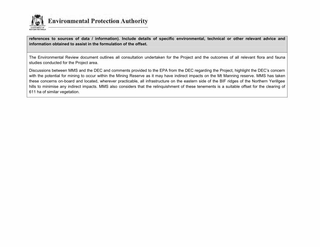
references to sources of data / information). Include details of specific environmental, technical or other relevant advice and information obtained to assist in the formulation of the offset.
The Environmental Review document outlines all consultation undertaken for the Project and the outcomes of all relevant flora and fauna studies conducted for the Project area.
Discussions between MMS and the DEC and comments provided to the EPA from the DEC regarding the Project, highlight the DEC’s concern with the potential for mining to occur within the Mining Reserve as it may have indirect impacts on the Mt Manning reserve. MMS has taken these concerns on-board and located, wherever practicable, all infrastructure on the eastern side of the BIF ridges of the Northern Yerillgee hills to minimise any indirect impacts. MMS also considers that the relinquishment of these tenements is a suitable offset for the clearing of 611 ha of similar vegetation.

Macarthur Minerals Limited ULARRING HEMATITE PROJECT
ENVIRONMENTAL REVIEW DOCUMENT Rev 6 – June 2013
Appendix 28: EPBC Decision on Referral of the Project
Refer to Enclosure 4

Macarthur Minerals Limited ULARRING HEMATITE PROJECT
ENVIRONMENTAL REVIEW DOCUMENT Rev 6 – June 2013
Appendix 29: Notable Taxa Flora Survey
Refer to Enclosure 4

Macarthur Minerals Limited ULARRING HEMATITE PROJECT
ENVIRONMENTAL REVIEW DOCUMENT Rev 6 – June 2013
Appendix 30: Level 1 Flora and Vegetation Survey
Refer to Enclosure 4

Macarthur Minerals Limited ULARRING HEMATITE PROJECT
ENVIRONMENTAL REVIEW DOCUMENT Rev 6 – June 2013
Appendix 31: Flora and Vegetation Survey of Clark Hill Deposit
Refer to Enclosure 4

Macarthur Minerals Limited ULARRING HEMATITE PROJECT
ENVIRONMENTAL REVIEW DOCUMENT Rev 6 – June 2013
Appendix 32: Flora Species List

^ Species names have been updated as per correspondence from the EPA in their document titles “Amendments to be made to API Rev 4 prior to release document”, as emailed on 24 May 2013.
Flora Species List
Reference: Flora and Vegetation Surveys of the Snark, Central and Banjo Deposits (Mattiske 2012a; 2012b; 2012c)
?Digitaria sp. Abutilon cryptopetalum Abutilon oxycarpum subsp. prostratum ms^ Acacia ?duriuscula Acacia acanthoclada subsp. acanthoclada Acacia andrewsii Acacia aneura^ Acacia ayersiana Acacia burkittii Acacia cockertoniana Acacia colletioides Acacia duriuscula Acacia erinacea Acacia leptopetala Acacia mulganeura Acacia quadrimarginea Acacia ramulosa var. ramulosa Acacia sibina Acacia tetragonophylla Allocasuarina ?acutivalvis Allocasuarina acutivalvis subsp. acutivalvis Allocasuarina acutivalvis subsp. prinsepiana Allocasuarina campestris Allocasuarina dielsiana Allocasuarina eriochlamys subsp. eriochlamys Allocasuarina spinosissima Alyxia buxifolia Amphipogon ?caricinus Amphipogon sp. Amyema gibberula var. gibberula Aristida holathera var. holathera Aristida inaequiglumis Atriplex nummularia subsp. spathulata Atriplex vesicaria Austrostipa ?trichophylla Austrostipa elegantissima Austrostipa platychaeta Austrostipa sp. Austrostipa trichophylla Baeckea elderiana Banksia arborea (P4) Beyeria brevifolia Beyeria sulcata var. brevipes or var. sulcata^ Bossiaea walkeri Brachychiton gregorii Callitris columellaris Callitris preissii Calycopeplus paucifolius Casuarina obesa Casuarina pauper
Cheilanthes brownii Cheilanthes sieberi subsp. sieberi Chenopodium curvispicatum Comesperma volubile Convolvulus remotus Cryptandra connata Dianella revoluta var. divaricate^ Dichanthium sericeum subsp. sericeum or var. humilius^ Dillwynia sp. Coolgardie (V.E. Sands 637.3.1) Dodonaea adenophora Dodonaea lobulata Dodonaea microzyga Dodonaea microzyga var. acrolobata Dodonaea rigida Duperreya commixta Dysphania kalpari Enchylaena sp. Enchylaena tomentosa var. tomentosa Eragrostis falcata Eremophila alternifolia Eremophila compacta subsp. compacta or subsp. fecunda^ Eremophila decipiens subsp. decipiens Eremophila forrestii subsp. forrestii Eremophila glabra subsp. albicans Eremophila glabra subsp. glabra Eremophila glutinosa Eremophila granitica Eremophila ionantha Eremophila latrobei ?subsp. latrobei Eremophila latrobei subsp. latrobei Eremophila maculata subsp. brevifolia Eremophila oldfieldii subsp. angustifolia Eremophila oppositifolia subsp. angustifolia Eremophila pustulata Eremophila scoparia Eremophila sp. Eriachne pulchella subsp. pulchella Erodium sp. Eucalyptus capillosa subsp. capillosa Eucalyptus clelandii Eucalyptus concinna Eucalyptus corrugata Eucalyptus ebbanoensis subsp. glauciramula Eucalyptus ewartiana Eucalyptus gracilis Eucalyptus griffithsii Eucalyptus horistes Eucalyptus longissima Eucalyptus loxophleba subsp. lissophloia Eucalyptus loxophleba subsp. supralaevis Eucalyptus oleosa subsp. oleosa Eucalyptus ravida Eucalyptus salmonophloia Eucalyptus salubris Eucalyptus stricklandii

^ Species names have been updated as per correspondence from the EPA in their document titles “Amendments to be made to API Rev 4 prior to release document”, as emailed on 24 May 2013.
Eucalyptus yilgarnensis Euphorbia drummondii subsp. drummondii Exocarpos aphyllus Grevillea acuaria Grevillea erectiloba (P4) Grevillea georgeana (P3) Grevillea nematophylla subsp. nematophylla Grevillea obliquistigma subsp. obliquistigma Grevillea oligomera Grevillea paradoxa Hakea recurva subsp. recurva Haloragis gossei subsp. ?gossei^ Hemigenia pedunculata Hibbertia exasperata Hibbertia lepidocalyx subsp. tuberculata (P3) Hibbertia nutans Hybanthus floribundus subsp. curvifolius Isotoma petraea Leiocarpa semicalva subsp. semicalva^ Leucopogon sp. Clyde Hill (M.A. Burgman 1207) Lysiana casuarinae Maireana ?thesioides Maireana ?trichoptera Maireana georgei Maireana sp. Maireana tomentose subsp. tomentosa^ Maireana triptera Malleostemon tuberculatus Marsdenia australis Melaleuca hamata Melaleuca leiocarpa Mirbelia depressa Mirbelia microphylla Mirbelia ferricola (P3) ^ Monachather paradoxus Olearia exiguifolia Olearia humilis Olearia muelleri Olearia pimeleoides Paspalidium basicladum Phebalium canaliculatum Phebalium filifolium Philotheca brucei subsp. brucei Pimelea ?microcephala subsp. microcephala^ Pittosporum angustifolium Poaceae sp. Prostanthera ?campbellii Prostanthera althoferi subsp. althoferi Prostanthera campbellii Prostanthera grylloana Prostanthera prostantheroides^ Psydrax suaveolens Ptilotus aervoides Ptilotus chamaecladus Ptilotus nobilis subsp. nobilis Ptilotus holosericeus Ptilotus obovatus var. obovatus Rhagodia ?spinescens Rhagodia drummondii Rhagodia preissii subsp.preissii Rhyncharrhena linearis Salsola australis
Santalum acuminatum Santalum spicatum Scaevola spinescens Sclerolaena diacantha Sclerolaena fusiformis Senna artemisioides subsp. filifolia Senna artemisioides subsp. x artemisioides Sida ?sp. dark green fruits (S. van Leeuwen 2260) Sida calyxhymenia Sida cardiophylla Sida ectogama Sida sp. Dark green fruits (S. van Leeuwen 2260) Sida sp. Golden calyces glabrous (H.N.Foote 32) Sida spodochroma Solanum ferocissimum Solanum lasiophyllum Solanum nummularium Spartothamnella sp. Helena & Aurora Range (P3) Spartothamnella teucriiflora Stenanthemum stipulosum Streptoglossa liatroides Swainsona ?kingii Swainsona canescens Triodia rigidissima Triodia scariosa Vittadinia sulcata Waitzia acuminata var. acuminate^ Westringia cephalantha var. ?cephalantha^ Zygophyllum ?eremaeum Zygophyllum ?iodocarpum Zygophyllum aurantiacum subsp. aurantiacum^