typhoons affecting taiwan: current understanding and
TRANSCRIPT

67Bulletin of the American Meteorological Society
1. Introduction
Tropical cyclones are the most serious meteoro-logical phenomena that threaten Taiwan. On average,three or four typhoons occur annually. The strongwinds and heavy precipitation associated with a ty-phoon significantly affect the weather in Taiwan, evenif the storm does not make landfall. Due to the highaltitude and complicated mesoscale topography asso-ciated with Taiwan’s Central Mountain range (CMR),which has an average elevation of about 3000 m anda dimension of 300 km × 100 km, significant varia-tions in track and intensity occur as a typhoon ap-proaches the island. [Note that similar effects also
occur for tropical storms approaching other island ter-rains, such as the islands of Cuba, Hispaniola, andPuerto Rico in the Caribbean, as well as Luzon in thenorthern Philippines (Bender et al. 1987).]
The interaction of the typhoon circulation with theCMR also produces significant mesoscale variationsin pressure, wind, and precipitation distribution overTaiwan. For example, mesoscale secondary low cen-ters can form on the lee side of the CMR, which maydevelop into a new tropical cyclone, replacing theoriginal storm. The track deflection, the developmentof secondary lows, the changes in intensity, and themesoscale structure of pressure, wind, and precipita-tion associated with an approaching typhoon make theforecasting of a tropical cyclone approaching Taiwanan extremely difficult task. The understanding of thedynamics of typhoon circulation and their interactionwith the Taiwan terrain, and the forecasting of track, in-tensity, and mesoscale wind and precipitation distribu-tion are some of the most important scientific andforecasting problems for meteorologists in Taiwan.
The recent occurrence of Typhoon Herb between31 July and 1 August 1996 was a special example of a
Typhoons Affecting Taiwan:Current Understandingand Future Challenges
Chun-Chieh Wu* and Ying-Hwa Kuo+
*Department of Atmospheric Sciences, National Taiwan Univer-sity, Taipei, Taiwan.+National Center for Atmospheric Research, Boulder, Colorado.Corresponding author address: Dr. Chun-Chieh Wu, Departmentof Atmospheric Sciences, National Taiwan University, 61, Lane144, Section 4, Keelung Rd., Taipei 10772, Taiwan.E-mail: [email protected] final form 8 September 1998. 1999 American Meteorological Society
ABSTRACT
Of all the natural disasters occurring in Taiwan, tropical cyclones are the most serious. Over a 20-yr period, Taiwanwas hit by an average of 3.7 typhoons per year. These storms can produce heavy rainfall and strong winds, leading tosevere damage to agriculture and industry, and serious loss of human life. An outstanding example is Typhoon Herb,which made landfall in Taiwan on 31 July 1996. Typhoon Herb took 70 lives and caused an estimated $5 billion ofdamage to agriculture and property.
Accurate prediction of the track, intensity, precipitation, and strong winds for typhoons affecting Taiwan is not aneasy task. The lack of meteorological data over the vast Pacific Ocean and the strong interaction between typhoon cir-culation and Taiwan’s mesoscale Central Mountain range are two major factors that make the forecasting of typhoons inthe vicinity of Taiwan highly challenging. Improved understanding of the dynamics of typhoon circulation and theirinteraction with the Taiwan terrain is needed for more accurate prediction. With this objective in mind, the NationalScience Council in Taiwan sponsored the Workshop on Typhoon Research in the Taiwan Area at Boulder, Colorado,on 17–18 May 1997. In this paper, the authors review the observational and numerical studies of typhoons affectingTaiwan, present some preliminary results from the study of Typhoon Herb, summarize the recommendations obtainedfrom the workshop, and provide suggestions for future research.

68 Vol. 80, No. 1, January 1999
typhoon making landfall on Taiwan. This storm pro-duced a maximum 24-h rainfall of 1798 mm over theCMR. Although the track forecast by the CentralWeather Bureau (CWB) in Taiwan was essentiallycorrect, the unusually strong winds and torrential pre-cipitation associated with Herb caused tremendousdamage. In particular, the extremely heavy rainfall inthe central mountain areas triggered disastrous flood-ing, debris flows, and landslides, which led to the lossof 51 human lives, with an additional 22 people miss-ing and presumed dead. The total damage to agricultureand property is estimated at more than $5 billion. Thus,Typhoon Herb replaced Typhoon Thelma (1977) as themost disruptive weather event on record in Taiwan.
In view of the impact of typhoons on the lives andthe economy of Taiwan, the Fifth National Science andTechnology Conference (Taipei, September 1996) de-cided to launch a national project for disaster mitigation,under which an integrated program of both basic andforecasting research into typhoons was established. Inorder to provide a forum for discussion on typhoon re-search and forecasting, and to stimulate internationalcollaboration, the National Science Council of Taiwansponsored the Workshop on Typhoon Research in theTaiwan Area on 17–18 May 1997 at the National Cen-ter for Atmospheric Research in Boulder, Colorado. Theobjectives of the workshop, which was attended by 60scientists, were 1) to review the current state of scienceon basic and forecasting research into tropical cyclones,2) to identify critical research and forecasting issues fortyphoons affecting Taiwan, and 3) to discuss opportuni-ties for international collaboration on typhoon research.
The purpose of this paper is to discuss the current un-derstanding of research and forecasting issues related totyphoons affecting Taiwan and to summarize the discus-sion that took place at the workshop. Section 2 providesa brief review of previous studies on typhoons affectingTaiwan. For a thorough review of the effects of Taiwantopography on typhoons, see Lin (1993). Preliminaryanalysis and model simulation of Typhoon Herb aregiven in section 3 to highlight the research and forecast-ing issues. Section 4 provides a summary of the Work-shop on Typhoon Research in the Taiwan Area.Suggestions for future research are given in section 5.
2. Review of previous studies ontyphoons affecting Taiwan
a. Observational studiesWhen a typhoon approaches Taiwan, its circula-
tion and track are significantly affected by the CMR.Brand and Blelloch (1974) found that westbound ty-phoons tend to move cyclonically around the north-ern side of the CMR and experience an averageintensity decrease of over 40%, beginning about 12 hbefore the storm centers reach the island. Usingstreamline analysis, Chu et al. (1977) showed a moredetailed flow structure, such as flow separation andvortex shedding, associated with typhoon circulationaround the island. Wang (1980) documented and ana-lyzed the path, intensity, propagation speed, and evo-lution of 53 typhoons that approached Taiwan over theperiod 1946–75. He found that some typhoons passedover Taiwan by taking a cyclonic track similar to thosedescribed in Brand and Blelloch (1974). Based onthese observations, Wang (1980) proposed a concep-tual model, indicating that the typhoon center will bedeflected toward the north as it approaches Taiwan andtoward the south after its passage over the CMR dueto the deflection of the mean steering flow upstreamof the CMR.
For a typhoon impinging on the Taiwan CMR,Wang (1980, 1989) also showed that the center of thestorm could either cross Taiwan continuously or havea discontinuous track due to the formation of a sec-ondary low that replaces the terrain-blocked low-levelcenter. Wang (1980) proposed that, for typhoons witha continuous track, the circulation is only modifiedslightly by the mountain range, while for typhoonswith a discontinuous track, it is modified significantly.This seems to be consistent with nonlinear theories ofstratified flow over a mountain (e.g., Smith 1979) sincetyphoons with a continuous track have stronger windsassociated with them and tend to be more linear becausethe local Froude number associated with the mountainis larger. This is also related to the contrast in intensitybetween the two classes of typhoons (Chang 1982).
The CMR affects not only the track of a typhoon,but also its structure. A recent observational study(Shieh et al. 1996) has categorized four possible flowregimes as a typhoon approaches Taiwan: 1) the par-allel flow regime, where the flow field associated witha typhoon basically moves along the CMR with asmall incident flow angle, which is defined as the flowdirection relative to the main axis of the CMR; 2) theblocked flow regime, where the incident angle is quitelarge and the Froude number (Fr) is low; 3) the un-blocked (upsloping) flow regime, which is the sameas 2) but with a relatively high Fr; 4) the combinedflow regime with low-level flow passing around, butupper-level flow crossing over, the mountain. Wang

69Bulletin of the American Meteorological Society
(1989) suggested that the factors determining theabove flow regimes include the typhoon’s headingdirection, the Froude number, the typhoon incidentangle, and the location of the typhoon center.
It should be noted that comprehensive archives of rawobservational data for typhoons affecting Taiwan arelocated in the “Typhoon Data Bank” of the CentralWeather Bureau in Taiwan. Although some statisticalresults from the observations have been carried out (e.g.,Lee et al. 1997), more detailed analyses of these data haveyet to be conducted to further improve our understand-ing of the effect of Taiwan’s terrain on typhoons.
An important issue associated with the observa-tional studies of typhoons affecting Taiwan is the lackof data. Most of the previous observational studies onthis subject are based on traditional surface and upper-air observations, which are highly inadequate in de-scribing the important three-dimensional structurechanges associated with a typhoon as it approaches theisland. Due to the lack of surface observations over themountains and the surrounding oceans, even the sur-face analysis of an approaching storm can be subjectto numerous uncertainties, not to mention the diffi-culty in accurately describing the three-dimensionalstorm structure. Mesoscale observations from ground-based and airborne Doppler radars and other remotesensing instruments are needed to advance the obser-vational studies.
b. Numerical studies1) IDEALIZED FLOW OVER TOPOGRAPHY
The interaction between a typhoon and topographyis highly complicated. To gain insight into such a chal-lenging problem, it is important to review relevant lit-erature on the dynamics of airflow passing a mountain.
During the past three decades, much effort has beendevoted to the study of the dynamics of uniform flowpast a mountain. Smith (1989a) proposed a lineartheory to predict the occurrence of stagnation pointsas a function of hill shape and ambient shear. For along ridge perpendicular to a weakly sheared flow,stagnation begins aloft. Stagnation aloft is believe tobe responsible for gravity wave breaking and severedownslope winds (Clark and Peltier 1977). For a ridgealigned with the flow, waves weaken dispersively aloftand stagnation first occurs on the surface. This allowsdensity surfaces to intersect the ground and the low-level flow to split around the hill. As a ridge is alignedmore in parallel with wind direction, the critical moun-tain height for the occurrence of stagnation both up-wind and aloft increases, but the critical mountain
height for stagnation aloft increases more rapidly. Thisis because, in a stratified flow, the vertically propagat-ing waves weaken aloft due to dispersion.
The salient features in the response of a density-stratified fluid passing a three-dimensional obstacle atlow Fr are the existence of a flow reversal zone on thewindward side and intense vertically oriented vorticeson the lee side of the obstacle. The generation of leevortices was explained as a consequence of the sepa-ration of the viscous boundary layer from the obstacle(Batchelor 1967). However, Smolarkiewicz andRotunno (1989, SR hereafter) argued that lee vorticescan be produced even in inviscid numerical simula-tions. They proposed that the vertically oriented vor-ticity of lee vortices is generated through the tilting ofhorizontally oriented vorticity that is producedbaroclinically as isentropes deform in response to theflow over the obstacle. Smolarkiewicz and Rotunnobelieved that the lee vortices are closely associatedwith the dynamics of nonlinear gravity waves and theconservation of potential vorticity (PV). However,Smith (1989b) argued that the onset of stagnationpoints might result in regions with collapsed densitysurfaces and/or convective overturning and turbulence.These processes can lead to PV generation, which ex-plains the formation of lee vortices.
Wang et al. (1997) conducted systematic numeri-cal experiments to study the formation mechanisms forthe stagnation points in a three-dimensional flow overidealized bell-shaped mountains with different aspectratios. The flow regimes, especially the critical Froudenumber for the occurrence of stagnation points, havebeen investigated. Their findings are 1) the upwindstagnation is a necessary rather than a sufficient con-dition for the generation of lee vortices; 2) both theupwind blocking effects and lee deceleration in thecentral portion of the obstacle are suppressed as theobstacle elongates in the direction along the meanflow; 3) the major role of the nonlinear terms is todecelerate the zonal flow in the central portion of thelee surface; 4) the vertically propagating gravity wavesand at higher levels are suppressed by the nonlinearterms. The diagnosis of the sources of the verticallyoriented vorticity and PV (see Wu and Kurihara 1996)on the lee side of the obstacle is being carried out andmay help clarify the above discrepancies in the lee vor-tices’ formation mechanisms.
2) TYPHOONS OVER THE CMR
Several numerical studies have been conducted toinvestigate the effects of the CMR on track modifica-

70 Vol. 80, No. 1, January 1999
tion. Using a primitive-equation model, Chang (1982)showed that, due to blocking effects, the mountain-induced flow deflections are mainly confined to thelower levels, and the typhoon’s passage induces amean cyclonic circulation around the mountain, forc-ing the storm to take a cyclonic track around the north-ern end of the CMR. This is consistent with theconceptual model proposed by Wang (1980).
Chang (1982) also found that the secondary vor-tex centers form in the lee trough and may developwhen they are in phase with the upper-level vortex cen-ters. He proposed that the horizontal advection of posi-tive vorticity, in conjunction with the lee side vortexstretching, results in a mean positive vorticity aroundthe mountain. Later, Chan (1984) showed a definitelink between the local change of relative vorticity andtyphoon movement, which is consistent with the find-ings of Chang (1982).
Using the Geophysical Fluid Dynamics Laboratory(GFDL) hurricane model with triply nested, movablemeshes, Bender et al. (1985) found that tropical cy-clones fill much more rapidly in numerical simulationswith a mountain included. The mountain range affectsthe decay rate through reduction in the supply of la-tent and kinetic energy into the storm circulation bothduring, as well as after, passage of the storm over themountain. The mountain range also enhances theheavy precipitation to the right of the storm track im-mediately after landfall, which is possibly related toan increase in coastal convergence and orographiclifting.
Bender et al. (1987) also examined the effects ofdifferent island terrains on tropical cyclones underdifferent zonal mean flows. In a control experimentwith a typhoon embedded in a uniform 5 m s−1 east-erly flow over Taiwan, a northward (cyclonic) trackdeflection was found. They suggested that the terrain-induced steering flow modification was the main causeof the typhoon track deflection. In a subsequent ex-periment with a 10 m s−1 easterly flow, deflection wasfound to be much weaker. In contrast, the northwarddeflection was larger and began farther upstream in thecase of a weaker zonal flow. This is in agreement withthe results found in the aforementioned observationaland numerical studies. In the simulation with a 10 m s−1
easterly flow, a secondary surface low or lows formedbehind the CMR. It appears that the upper-level vor-tex becomes detached from the original surface lowand eventually couples with the secondary one. Thelatent energy supply and the vertical coherence of thestorm system are the important factors that determine
the storm’s change in intensity near and over topog-raphy. The storm is weakened by the advection of dryair from the mountain region into the storm’s inner cir-culation and by the vertical tilting of the storm center.
Yeh and Elsberry (1993a,b) studied the upstreamtrack deflections of westward-moving tropical cy-clones approaching the mountainous terrain of Tai-wan. They showed that the deflections tend to be largerfor weaker and slower-moving storms, which is con-sistent with the findings of Bender et al. (1987). Usinga primitive equation model with 45-km horizontalresolution, two distinct regions of upstream track de-flection found in observational studies were explored.As the outer circulation of the storm begins to inter-act with the mountain barrier, the zonal decelerationsand southward track deflections are explained by anenhanced blocking and deflection of the environmen-tal flow advecting the cyclone. The increased effect forstorms approaching the southern part of the islandcompared to those approaching the northern part iscaused by the stronger winds on the right side of thestorm impinging more directly on the barrier.
Yeh and Elsberry (1993a,b) also showed that theamount of upstream track deflection and the continu-ity of the storm track across Taiwan depend on thestorm’s position relative to the CMR. In general, vor-tices approaching the northern part of the CMR tendto track continuously around the northern end of theisland due to the deflection of the deep-layer meanflow. Discontinuous tracks predominate for vorticesapproaching the central and southern portions of theTaiwan topography. The numerical simulations alsoindicate that vortex reorganization downstream mayoccur as two types: 1) as a downward extension fromthe upper-level remnants of the typhoon; 2) as an up-ward growth of a lower-level secondary vortex. Thefirst type is consistent with the modeling results ofChang (1982), while for the second type, a new low-level center that is separate from the original vortexor the terrain-induced pressure trough becomes thecenter around which the tropical cyclone reorganizes.
Smith and Smith (1995) applied the shallow-watermodel to the problem of a typhoon drifting past Tai-wan and demonstrated that many of the observedphenomena, such as upstream blocking, downstreamsheltering, corner winds, foehn, and secondary vortexformation can be simulated. Smith and Smith (1995)also found that vortex interaction with ideal topogra-phy results in a pair of trailing banners of vorticity thatget wrapped up into the vortex as it drifts away. ThePV production over the lee side when the cyclone ap-

71Bulletin of the American Meteorological Society
proaches the mountain is explained by the transitionfrom an irrotational flow regime to a regime of flowover a mountain with wakes. In Smith and Smith’s PVgeneration mechanism, new positive vorticity on thelee side is generated to the left (as one faces down-stream) of the strongest wind normal to the mountainrange, while in Chang’s (1983) vorticity stretchingmechanism, it is generated to the right of the stron-gest wind normal to the mountain range.
A real case simulation of Typhoon Gladys (1994)using the GFDL hurricane prediction system (Kuriharaet al. 1995) was presented by Wu and Cho (1997). Thecontrol numerical experiment showed a fairly accu-rate track simulation for Gladys, especially during thefirst 54 h. The deceleration of Gladys’s translationspeed as it approached the northeastern part of Tai-wan and the acceleration after it passed Taiwan wereshown. In general, a cyclonic track induced by theTaiwan topography was found. Although the GFDLhurricane model forecast underestimated Gladys’s in-tensity, the model captured the evolution of Gladys’sintensity, especially the weakening of Gladys duringlandfall. The mesoscale phenomena, including thepattern of heavy precipitation and the formation ofsecondary lows, were also well simulated by themodel, though their locations were somewhat differ-ent from the observations.
Detailed analyses indicate that the surface lowpressure center to the east of the CMR was inducedby the downslope adiabatic warming (foehn) associ-ated with the circulation of Gladys. The two quasi-stationary secondary vortices to the west of the CMRwere mainly induced by the environmental easterlyflow over the CMR, with the circulation of Gladystending to strengthen these vortices.
Recently, Lin et al. (1997, manuscript submittedto Mon. Wea. Rev.) used a primitive-equation numeri-cal model with prescribed latent heating to investigatethe orographic influence on a propagating tropical cy-clone over an idealized topography. They showed thatwhen the cyclone approaches the mountain, orographicblocking causes the vorticity field to become asym-metric and produces new potential vorticity throughturbulence and diffusion. This result suggests a newvortex generation mechanism.
c. Some remaining issuesIn the above sections, various observational and
modeling studies on typhoons affecting Taiwan andthe interaction of typhoons with the Taiwan topog-raphy have been reviewed. Even though some
progress has been made in the past two decades, manyof the details of such interaction are still not well un-derstood. Several fundamental issues have yet to befully answered.
• The kinematics and dynamics of track deflection,as well as typhoon circulation change, under dif-ferent flow regimes.
• The wake formation and vorticity generationmechanisms and their evolution.
• The physical mechanism responsible for the for-mation and development of the secondary lows thatreplace the original typhoon circulation.
• The physics of diabatic processes and the planetaryboundary layer, and their impact on typhoon track,structure, and intensity when the storm passes overtopography.
• The topographic effect on the mesoscale weatherfeatures, such as the distribution of wind and pre-cipitation, associated with approaching typhoons.
In summary, the major limitations of previous re-search on this subject are 1) the lack of mesoscaleobservations that can provide a detailed description ofthe storms as they move across the island of Taiwan;and 2) the lack of high-resolution mesoscale modelsimulations that offer insights into the mesoscale pro-cesses responsible for the structural changes associ-ated with the interaction of a typhoon with themesoscale topography. The mesoscale observationsare also very important in providing verification formodel simulations so that improved models can bedeveloped for typhoon research and prediction.
3. Typhoon Herb (1996)
a. Synopsis of HerbTo provide an example of typhoons affecting
Taiwan we present a preliminary analysis and numeri-cal simulation for Typhoon Herb in this section.Typhoon Herb was the eighth typhoon in the westernNorth Pacific in 1996, and the third storm for which atyphoon warning was issued by the CWB in 1996.Herb formed at 19.9°N, 148.8°E, about 800 km north-east of Guam, at 1200 UTC 24 July. As indicated fromthe best track analysis (Fig. 1), while intensifying,Herb moved westward in the first two days after itsformation and followed the southern edge of thePacific high. Herb then turned west-southwestwardafter passing 139°E at 0600 UTC 26 July and reached

72 Vol. 80, No. 1, January 1999
about 130°E at 1800 UTC 28 July. A maximum sur-face wind of 51 m s−1 and a minimum central pressureof 925 hPa were analyzed by the CWB at 0600 UTC27 July with an estimated gale-force-wind radius of300 km.
After 29 July, due to the retrogression of the Pa-cific high, Herb turned northwestward and headed to-ward the northeastern part of Taiwan with somecycloidal track oscillation. Accordingto the best track analysis, the centralpressure of Herb was about 930 hPaduring 30 July 1996 as it moved to-ward northern Taiwan along a west-northwestward track. The estimatedintensity of the storm decreased to935 hPa at 1200 UTC 31 July. Herbturned west-northwestward and madelandfall at I-Lan at 1244 UTC July 31.During this period, a central pressureof 944.7 hPa (Fig. 2) was recorded atthe I-Lan station, with a gale-force-windradius estimated at about 350 km.
The elliptical eyewall and spiralrainbands on the western half of Herband over northern Taiwan are well illus-trated in the reflectivity factor (Fig. 3)at 0602 UTC 30 July, when Herb wasabout 250 km from the WSR-88D lo-cated over northeastern Taiwan [Wu-Fun Shan radar station (RCWF)] and
just south of Iriomote Shima,Japan. At 1321 UTC 31 July,about 40 min after Herb madelandfall at I-Lan, RCWF re-corded a few pixels with re-trieved maximum wind speed of82 m s−1 near the eyewall regionat 1 km above sea level (Jouet al. 1997; W.-C. Lee 1998,personal communication). OnHerb’s way across northern Tai-wan, RCWF’s radar dome andantenna were destroyed.
Because of the interactionwith the Taiwan terrain and theweakening of the steering flow,the center of Herb traversednorthern Taiwan slowly andeventually moved off to sea nearHsin-Chu at 2100 UTC 31 July.Herb’s intensity weakened sig-
nificantly (Fig. 4) while passing across Taiwan. Themeasured surface wind near the storm’s centerdropped from 53 to 44 m s−1 in 6 h, and the radius ofgale-force wind (as estimated from satellite imageryat the CWB) also decreased from 350 to 300 km. TheHsin-Chu station, which the center of the storm passeddirectly over, recorded a minimum central pressure of968.6 hPa (Fig. 2). The storm weakened by 24 hPa
FIG. 1. Best tracks for Typhoon Herb (1996). Solid (open) storm symbol indicates besttrack of typhoon (tropical storm) every 6 h. Time, translation speed (in knots), and intensity(in knots) at each time is also indicated.
FIG. 2. Observed average surface wind (wind barb in m s−1) and minimum centralpressure at I-Lan and Hsin-Chu stations as function of time during passage of Ty-phoon Herb (1996) over northeastern Taiwan (after Shieh et al. 1997).

73Bulletin of the American Meteorological Society
during the 7-h period its center was over land. Finally,Herb entered the Taiwan Strait and continued track-ing west-northwestward, entering southern China on1 August.
b. Rainfall and wind analysisA detailed analysis of Herb (S-.T. Wang 1997, per-
sonal communication) indicates several interesting me-soscale features associated with this case. The mostdramatic aspect of Typhoon Herb is the enormousamount of rain it produced over the CMR (Fig. 5). AsTyphoon Herb traversed northern Taiwan, the airflowover the main body of Taiwan changed from northwest-erly to westerly, and then to southwesterly. The mois-ture-laden typhoon circulation was forced to move overthe CMR, and the lifting associated with the upslopemotion produced extremely heavy precipitation.
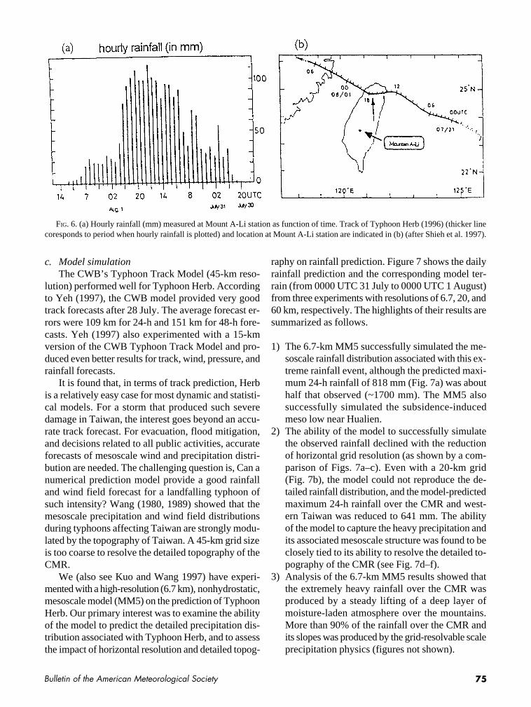
Figure 5 shows the Taiwan topography superimposedon an analysis of the rainfall accumulated during thepassage of Herb between 30 July and 2 August. Twomajor precipitation centers are identified: one at Moun-tain Nio-Dray in northern Taiwan, with a total precipi-tation of 1044 mm, and the other at Mount A-Li in centralTaiwan, with a record-breaking total accumulation of1987 mm over the 2-day period (including a 24-h rain-fall of 1094.5 mm on 31 July, and 892 mm on 1 August).The heavy rainfall at Mount A-Li is also manifested inthe analysis of its hourly rainfall (Fig. 6); over 14consecutive hours, rainfall in excess of 80 mm was re-corded. In sharp contrast, downslope flow persisted overeastern Taiwan, and very little precipitation was re-corded. The downslope flow also produced a topo-graphically induced mesolow over eastern Taiwannear Hualien. According to S.-T. Wang (1997, per-sonal communication), a few hours before landfall,
FIG. 3. Reflectivity factor (in dBZ) of Typhoon Herb at 0.5°PPI scan at 060255 UTC 31 July 1995 from RCWF (indicated bythick black dot in northeast corner of Taiwan). Black line showstrack and position (black dots) of Typhoon Herb at 3-h intervalsfrom 1800 UTC 30 July to 0000 UTC 1 August 1996 (W.-C. Lee1997, personal communication).
FIG. 4. Measured maximum surface wind and minimum central pressure center as function of time during passage of TyphoonHerb (1996) over Taiwan (after Shieh et al. 1997).

74 Vol. 80, No. 1, January 1999
Typhoon Herb changed its track froma northwestward direction (before1200 UTC 31 July) to a southwestwarddirection (after 1200 UTC 31 July).After landfall, the storm changed di-rection to track northwestward againafter 1800 UTC. The Hualien mesolowwas generated at around 1800 UTC.This mesolow then moved northwardalong the east coast of Taiwan.
The heavy rainfall in the centralmountain area resulted in numerousdevastating landslides and debrisflows along the New-Central Cross-Island Highway, leading to heavy lossof both life and property. Several fac-tors that led to such heavy rainfall aresummarized as follows.
• Herb was an intense typhoon witha track (making landfall in thenorthern part of Taiwan) thatprevented it from being totallyblocked or destroyed by the CMR.
• The circulation of Herb carried anunusually large amount of watervapor that provided the moisturesupply for the convective systemsembedded within Herb.
• Herb’s relatively slow passage(~7 h) over Taiwan allowed persis-tent upslope flow on the westernslopes of the CMR that resulted inheavy local rainfall over certaingeographical areas.
Shieh et al. (1997) indicated thatthe relation between rainfall and ty-phoon position (for typhoons with tracks similar toHerb) can be qualitatively described by a schematicdiagram with three stages.
• While the typhoon approaches northern Taiwan,the western part of Taiwan experiences an increas-ing northwesterly flow so that the heavy rainfalloccurs in the northern and central areas.
• As the typhoon makes landfall in northern Taiwan,stronger upslope westerly flow in south Taiwanconverges with the northwesterly flow in centralTaiwan, thus leading to heavy rainfall in the south–central area of Taiwan.
• After the typhoon leaves Taiwan, its inducedmoisture-rich southwesterly flow may bring morerain. Later, as the typhoon center moves fartheraway from Taiwan, the induced southwesterly flowis nearly parallel to the orientation of the CMR, andprecipitation is reduced.
Note that several storms (e.g., Typhoon Gloria of1963) with a track similar to that of Herb have resultedin similarly heavy rainfall in the central mountain areaof Taiwan (Shieh et al. 1995). More studies are neededto improve our understanding of the physical mecha-nisms that caused the exceptionally heavy rainfall with Herb.
FIG. 5. Accumulated rainfall (mm, with contour interval of 100 mm) during pas-sage of Typhoon Herb (30 July–2 August 1996) with track over northeastern Taiwanindicated. Taiwan topography is plotted from 1-km-resolution dataset with shadingfor every 500 m.
75Bulletin of the American Meteorological Society
c. Model simulationThe CWB’s Typhoon Track Model (45-km reso-
lution) performed well for Typhoon Herb. Accordingto Yeh (1997), the CWB model provided very goodtrack forecasts after 28 July. The average forecast er-rors were 109 km for 24-h and 151 km for 48-h fore-casts. Yeh (1997) also experimented with a 15-kmversion of the CWB Typhoon Track Model and pro-duced even better results for track, wind, pressure, andrainfall forecasts.
It is found that, in terms of track prediction, Herbis a relatively easy case for most dynamic and statisti-cal models. For a storm that produced such severedamage in Taiwan, the interest goes beyond an accu-rate track forecast. For evacuation, flood mitigation,and decisions related to all public activities, accurateforecasts of mesoscale wind and precipitation distri-bution are needed. The challenging question is, Can anumerical prediction model provide a good rainfalland wind field forecast for a landfalling typhoon ofsuch intensity? Wang (1980, 1989) showed that themesoscale precipitation and wind field distributionsduring typhoons affecting Taiwan are strongly modu-lated by the topography of Taiwan. A 45-km grid sizeis too coarse to resolve the detailed topography of theCMR.
We (also see Kuo and Wang 1997) have experi-mented with a high-resolution (6.7 km), nonhydrostatic,mesoscale model (MM5) on the prediction of TyphoonHerb. Our primary interest was to examine the abilityof the model to predict the detailed precipitation dis-tribution associated with Typhoon Herb, and to assessthe impact of horizontal resolution and detailed topog-
raphy on rainfall prediction. Figure 7 shows the dailyrainfall prediction and the corresponding model ter-rain (from 0000 UTC 31 July to 0000 UTC 1 August)from three experiments with resolutions of 6.7, 20, and60 km, respectively. The highlights of their results aresummarized as follows.
1) The 6.7-km MM5 successfully simulated the me-soscale rainfall distribution associated with this ex-treme rainfall event, although the predicted maxi-mum 24-h rainfall of 818 mm (Fig. 7a) was abouthalf that observed (~1700 mm). The MM5 alsosuccessfully simulated the subsidence-inducedmeso low near Hualien.
2) The ability of the model to successfully simulatethe observed rainfall declined with the reductionof horizontal grid resolution (as shown by a com-parison of Figs. 7a–c). Even with a 20-km grid(Fig. 7b), the model could not reproduce the de-tailed rainfall distribution, and the model-predictedmaximum 24-h rainfall over the CMR and west-ern Taiwan was reduced to 641 mm. The abilityof the model to capture the heavy precipitation andits associated mesoscale structure was found to beclosely tied to its ability to resolve the detailed to-pography of the CMR (see Fig. 7d–f).
3) Analysis of the 6.7-km MM5 results showed thatthe extremely heavy rainfall over the CMR wasproduced by a steady lifting of a deep layer ofmoisture-laden atmosphere over the mountains.More than 90% of the rainfall over the CMR andits slopes was produced by the grid-resolvable scaleprecipitation physics (figures not shown).
FIG. 6. (a) Hourly rainfall (mm) measured at Mount A-Li station as function of time. Track of Typhoon Herb (1996) (thicker linecoresponds to period when hourly rainfall is plotted) and location at Mount A-Li station are indicated in (b) (after Shieh et al. 1997).

76 Vol. 80, No. 1, January 1999

77Bulletin of the American Meteorological Society
4) The CMR was found to play a key role by both sub-stantially increasing the total rainfall produced byTyphoon Herb (by almost a factor of 3), and by fo-cusing the heavy rainfall over the western slopesof the mountains.
The results presented above show that a high-resolution mesoscale model, such as MM5, can be avery useful tool for Taiwan in forecasting the detailedmesoscale precipitation and wind distribution associ-ated with an approaching typhoon. Additional researchis required to access the potential of such high-resolution mesoscale or typhoon models in order toimprove the detailed wind and rainfall forecasts fortyphoons near Taiwan.
4. Workshop on Typhoon Research inthe Taiwan Area: 17–18 May 1997
The workshop was held at the Mesa Laboratory ofthe National Center for Atmospheric Research,Boulder, Colorado. The aims of this workshop were1) to review the state of science in typhoon research,with the emphasis on typhoon–topography interaction;2) to discuss forecasting issues for typhoons approach-ing Taiwan; and 3) to identify opportunities for col-laboration in both basic and forecasting research intotyphoons. Participants of the workshop included ap-proximately 25 scientists from Taiwan and 35 scien-tists invited from the United States, Australia, andChina. The workshop was divided into several ses-sions: Theoretical and Observational Studies of Tropi-cal Cyclones, Modeling Studies of Tropical Cyclones,Forecasting Tropical Cyclones, Aerosonde Experi-ment 1998, and Planning for Future Research.Excluding the discussions of the problem of hazardmitigation, the major conclusions and recommenda-tions of the workshop can be summarized as follows:
a. Difficulties in the prediction of typhoons nearTaiwan
1) Inadequate observations: The current operationalobservation systems do not provide an accurate de-
scription of the structure and intensity of typhoonsor the environmental flow associated with them.
2) Insufficient model resolution: Current operationaltyphoon prediction models have insufficient hori-zontal resolution to provide detailed descriptionsof mesoscale wind and precipitation distribution.
3) Complicated influence of the CMR of Taiwan: Theeffects of the CMR on the movement and structureof a typhoon are very complicated. Many of thesephysical processes are not well understood.
b. Bottleneck of typhoon research in Taiwan1) Lack of observations: With a lack of mesoscale ob-
servations, the three-dimensional dynamic andthermodynamic structures of a typhoon are notproperly described before, during, or after it passesover Taiwan. The lack of observations of the four-dimensional evolution of the storm poses a majordifficulty in typhoon research.
2) Lack of synergy between observational and mod-eling work: An interplay between high-resolutionnumerical simulations and high-resolution meso-scale analysis would offer much insight into theproblem of typhoons in Taiwan. Such efforts arerare in the literature.
3) Lack of mesoscale focus: Previous observationaland modeling work focused on track prediction,while the main concerns are the mesoscale windand the precipitation associated with typhoons.
c. Recommended important research topicsThe working group suggested the following three
topics as high priority for typhoon research in theTaiwan area.
1) Effects of topography on typhoon motion, meso-scale wind, and precipitation distribution on me-soscale structure of typhoons (in terms of pressure,wind, moisture, temperature, and vorticity), and onthe development of secondary vortices.
2) Mesoscale convective systems embedded withintyphoons, their interaction with vortex circulationand the CMR, and their impact on wind gusts andrainfall distribution.
3) The priority for typhoon forecasts in Taiwan arelisted as 1) track forecast; 2) intensity forecast; 3)wind and precipitation forecast. To improve trackforecast, the interaction between environmentalflow and a typhoon, and the environmental flow’simpact on typhoon motion, needs to be betterunderstood.
FIG. 7 (preceding page). The 24-h rainfall (mm) ending at0000 UTC 1 August 1996 from MM5 simulations with highesthorizontal resolutions of (a) 6.7, (b) 20, and (c) 60 km. Contourintervals are (a) 100 mm, and 50 mm for (b) and (c). Correspondingmodel terrains (m) are shown in (d), (e), and (f), respectively.

78 Vol. 80, No. 1, January 1999
d. Other suggestions for applied typhoon researchtopics1) DATA IMPROVEMENT
As discussed earlier, the improvement in the quan-tity and quality of data associated with typhoons ishighly important to typhoon research and forecasting.Supplementary soundings during the period when atyphoon affects Taiwan, setting up an around-the-island Doppler radar network, an enhanced surface raingauge network, and an integrated sounding system, aswell as the use of aerosondes (Holland et al. 1992)could all bring a lot of useful new data relating to ty-phoons. Conducting a specific field experiment, withthe use of a modern mesoscale observation platform(such as a research aircraft and airborne Doppler ra-dar), to study the four-dimensional evolution of thestorm as it interacts with the CMR is of very high pri-ority and should be seriously considered. Meanwhile,the strategy for adaptive observation near the Taiwanarea should also be evaluated.
2) STUDY OF THE STATISTICAL AND ANALOG
FORECAST METHODS
The existence of the CMR is a mixed blessing fortyphoon forecasting. Because the topography is fixed,if a model can predict the position and intensity of astorm well, the rainfall and wind field distribution canbe forecast reasonably well. In other words, as longas the track forecast is correct, the mesoscale precipi-tation distribution and wind field distribution duringtyphoons affecting Taiwan are strongly modulated bythe topography of Taiwan. Therefore, the statisticaland analog method can be very useful for the forecast-ing of the mesoscale wind and precipitation distribu-tion. One shortcoming of the statistical and analogmethod is the limited database. One possible approachto increasing the database is to perform high-resolutionnumerical simulation. By placing typhoons at differentlocations relative to Taiwan, we can make short-rangeforecasts of the wind and rainfall distribution. Theseexperiments can be done beforehand and stored forfuture use. The accuracy and skill of the statistical andanalog approaches should be carefully evaluated.
In addition, a high-resolution numerical modelcould be used to provide “deterministic” forecasting.It is interesting to note that there is a major differencebetween a 0–24-h forecast and a 24–72-h forecast fortyphoons. The focus of a 0–24-h forecast is short-rangemesoscale prediction of rainfall and wind field distri-bution, which requires the use of a high-resolutionmodel. For the longer-range forecast, however, the
focus is track and intensity prediction. Therefore, aproper vortex specification and an accurate descriptionof the environmental flow are very important, andthese, in turn, require the assimilation of all availableremote sensing observations (in particular, satellitedata) and the use of advanced techniques (such as thefour-dimensional variational data assimilation).
3) MODEL IMPROVEMENT
Numerical models are the essential tool for ty-phoon forecasting and research. The workshop partici-pants recommended many areas for research anddevelopment in numerical models.
a) Assimilation of satellite data for model initializa-tion. Because of the sparsity of data over the ocean,we should make use of satellite remote-sensingobservations. This requires the development of ad-vanced data assimilation systems including 3DVAR(variational data assimilation) and 4DVAR. All avail-able satellite observations including cloud-top winds,water vapor winds, Special Sensor Microwave/Im-ager rainfall rate, precipitable water observations,as well as scatterometer and Advanced Very HighResolution Radiometer data should be used.
b) Improvement in the methods for vortex implanta-tion (e.g., Kurihara et al. 1995). Vortex specifica-tion has a major impact on the performance of atyphoon model. Therefore, improved methods ofvortex implantation should be developed andimplemented. To improve the implantation proce-dure, observations from aerosondes may also beused to describe the vortex structure.
c) Model improvement, ensemble forecasting, andhigh-resolution modeling. Model physics and nu-merics should be improved. The use of ensembleforecasting techniques and high-resolution mesos-cale models should be explored to seek improve-ment in forecasting skill.
d) Conducting model intercomparison research to as-sess the advantages and disadvantages of variousmodeling approaches.
4) INTERACTION BETWEEN SCIENTISTS IN TAIWAN AND
OTHER COUNTRIES
Typhoons and hurricanes are essentially the same.Collaboration with the international community canbring new input to the typhoon research program inTaiwan. As an example, scientists in Taiwan shouldbe encouraged to take part in the Hurricane at Land-fall (HaL) program. To this end, it should be noted that

79Bulletin of the American Meteorological Society
HaL is one of the three research foci under the U.S.Weather Research Program (see Emanuel et al. 1995;Marks et al. 1998). International scientists should beencouraged to participate in the planning and execu-tion of future typhoon field experiments near Taiwan.
5. Summary and future directions
The highly complicated orographic influence ontyphoon tracks, circulation, and the associated meso-scale weather systems provides a unique and outstand-ing research topic in the Taiwan area. The predictionof storm tracks under the influence of the CMR alsoposes a challenging forecasting problem because of itsintimate relationship with the prediction of mesoscalewind and rainfall distribution around the island. Thisis an interesting and difficult research area worthy offurther exploration.
However, as we know, the interaction of a typhoonwith the CMR starts when the storm is still severalhundred kilometers away from Taiwan. Also, the be-havior of a typhoon as a result of terrain interaction isa function of the intensity and size of the typhoon, aswell as the environmental flow. Unfortunately, sincethere are virtually no conventional observations out-side the immediate vicinity of Taiwan, our knowledgeof the typhoon structure and its environmental flowbefore the storm comes to Taiwan is extremely lim-ited. This limitation essentially impedes the progressof investigation into the effect of terrain on typhoons.
Due to the limited number of observations, and thevery complicated interaction between typhoons andtopography, numerical models become a crucial re-search vehicle to improve our knowledge. However,increased observations are needed for model initial-ization and verification. In addition, the ability tosimulate the detailed typhoon–topography interactionand its associated mesoscale wind and precipitationfeatures by numerical models is still far from perfect,although some progress has been made [e.g., theGFDL hurricane model (Kurihara et al. 1998)].
It is hoped that improved observations from thesatellites (e.g., Merrill and Velden 1996), Doppler ra-dars (e.g., Marks et al. 1992), reconnaissance [e.g., theimpact of Omega Dropwindsonde (Franklin et al.1996)], unmanned aircraft (e.g., Holland et al. 1992;Langford and Emanuel 1993), as well as specific fieldexperiments and the GPS/MET system [Global Posi-tioning System/Meteorology (e.g., Ware et al. 1996)],can all be incorporated into high-resolution numeri-
cal models through advanced data assimilation tech-niques. By combining the observational analyses andnumerical model experiments, we hope to advance ourknowledge of the dynamics of the mountain–typhooninteraction and to use such knowledge to aid typhoonforecasting near Taiwan. It is also hoped that morebasic and applied typhoon research can be carried outto improve our understanding of typhoon dynamics,as well as to improve typhoon forecasting in the Tai-wan area.
Acknowledgments. The authors would like to thank the Na-tional Science Council (NSC) of Taiwan for sponsoring the Work-shop on Typhoon Research in the Taiwan Area. Special thanksgo to Dr. Ching-Yen Tsay (vice-chairman of NSC) for his sup-port of the workshop, to Mr. Hsinn-Liang Shieh (director generalof the Central Weather Bureau of Taiwan), Mr. Shih-Ting Wang,Dr. Wei Wang, and Dr. Wen-Chau Lee for providing data or fig-ures on Typhoon Herb, and to Dr. Cheng-Shang Lee, Dr. Hung-Chi Kuo, and Ms. Ingrid Moore for helping to organize theworkshop. We also thank all the participants of the workshop fortheir contribution.
References
Batchelor, G. K., 1967: An Introduction to Fluid Dynamics. Cam-bridge University Press, 615 pp.
Bender, M. A., R. E. Tuleya, and Y. Kurihara, 1985: A numericalstudy of the effect of a mountain range on a landfalling tropi-cal cyclone. Mon. Wea. Rev., 113, 567–582.
——, ——, and ——, 1987: A numerical study of the effect of is-land terrain on tropical cyclones. Mon. Wea. Rev., 115, 130–155.
Brand, S., and J. W. Blelloch, 1974: Changes in the characteris-tics of typhoons crossing the island of Taiwan. Mon. Wea. Rev.,102, 708–713.
Chan, J. C.-L., 1984: An observational study of the physical pro-cesses responsible for tropical cyclone motion. J. Atmos Sci.,41, 1036–1048.
Chang, S. W., 1982: The orographic effects induced by an islandmountain range on propagating tropical cyclones. Mon. Wea.Rev., 110, 1255–1270.
Chu, K.-K., S.-T. Wang, and H. P. Pao, 1977: Surface wind fieldsand moving tracks of typhoons when encountering the islandof Taiwan. Preprints, 11th Tech. Conf. Hurricane and TropicalMeteorology, Miami Beach, FL, Amer. Meteor. Soc., 84–87.
Clark, T. L., and W. R. Peltier, 1977: On the evolution and stabil-ity of finite-amplitude mountain waves. J. Atmos. Sci., 34,1715–1730.
Emanuel, K. A., and Coauthors, 1995: Report of the first Prospec-tus Development Team of the U.S. Weather Research Programto NOAA and the NSF. Bull. Amer. Meteor. Soc., 76, 1194–1208.
Franklin, J. L., S. E. Feuer, J. Kaplan, and S. D. Aberson, 1996:Tropical cyclone motion and surrounding flow relations:Searching for beta gyres in Omega Dropwindsonde Datasets.Mon. Wea. Rev., 124, 64–84.

80 Vol. 80, No. 1, January 1999
Holland, G. J., T. McGeer, and H. Youngren, 1992: Autonomousaerosondes for economical atmospheric sounding anywhereon the globe. Bull. Amer. Meteor. Soc., 73, 1987–1998.
Jou, B. J.-D., P.-L. Chang, C.-S. Lee, 1997: Dual Doppler radaranalysis of Typhoon Herb (1996). Preprints, Conf. on WeatherAnalysis and Forecasting, Taipei, Taiwan, Central WeatherBureau, 356–364.
Kuo, Y.-H., and W. Wang, 1997: Rainfall prediction of TyphoonHerb with a mesoscale model. Preprints, Workshop on Ty-phoon Research in the Taiwan Area. Boulder, CO, NationalScience Council, 35–45.
Kurihara, Y., M. A. Bender, R. E. Tuleya, and R. J. Ross, 1995:Improvements in the GFDL hurricane prediction system. Mon.Wea. Rev., 123, 2791–2801.
——, ——, ——, and ——, 1998: The GFDL hurricane predic-tion system and its performance in the 1995 hurricane season.Mon. Wea. Rev., 126, 1306–1322.
Langford, J. S., and K. A. Emanuel, 1993: An unmanned aircraftfor dropwindsonde development and hurricane reconnais-sance. Bull. Amer. Meteor. Soc., 74, 367–375.
Lee, C.-S., S.-T. Wang, S.-L. Shieh, and T.-C. Chen Wang, 1997:Typhoons in the Taiwan area. Preprints, Workshop on TyphoonResearch in the Taiwan Area, Boulder, CO, National ScienceCouncil, 9–10.
Lin, Y.-L., 1993: Orographic effects on airflow and mesoscaleweather systems over Taiwan. Terr., Atmos. Oceanic Sci., 4,381–420.
Marks, F. D., R. A. Houze, and J. F. Gamache, 1992: Dual-air-craft investigation of the inner core of Hurricane Norbert. PartI: Kinematic structure. J. Atmos. Sci., 49, 919–942.
——, and Coauthors, 1998: Landfalling tropical cyclones: Fore-cast problems and associated research opportunities. Bull.Amer. Meteor. Soc., 79, 305–323.
Merrill, R. T., and C. S. Velden, 1996: A three-dimensional analy-sis of outflow layer of Supertyphoon Flo (1990). Mon. Wea.Rev., 124, 47–63.
Shieh, S.-L., Y.-W. Lin, C.-D. Chen, and C.-Y. Wen, 1995: Studyof the characteristics of the precipitation pattern associated withtyphoons in the Chia-Nan area (in Chinese). Tech. Rep. NSC 83-0414-P-052-003-B, National Science Council of Taiwan, 95 pp.
——, S.-T. Wang, M.-D. Cheng, and T.-C. Yeh, 1996: User’sguide (1) for typhoon forecasting in the Taiwan area (in Chi-nese). Res. Rep. CWB84-1M-01, 356 pp.
——, ——, ——, and ——, 1997: User’s guide (2) for typhoonforecasting in the Taiwan area (in Chinese). Res. Rep. CWB85-1M-01, 381 pp.
Smith, R. B., 1979: The influence of mountains on the atmo-sphere. Advances in Geophysics, Vol. 21, Academic Press,87–230.
——, 1989a: Mountain-induced stagnation points in hydrostaticflow. Tellus, 41A, 270–274.
——, 1989b: Comment on “Low-Froude-number flow past three-dimensional obstacles. Part I: Baroclinically generated leevortices.” J. Atmos. Sci., 46, 3611–3613.
——, and D. F. Smith, 1995: Pseudoinviscid wake formation bymountains in shallow-water flow with a drifting vortex. J.Atmos. Sci., 52, 436–454.
Smolarkiewicz, P., and R. Rotunno, 1989: Low-Froude numberflow past three-dimensional obstacles. Part I: Baroclinicallygenerated lee vortices. J. Atmos. Sci., 46, 1154–1164.
Wang, S.-T., 1980: Prediction of the behavior and strength of ty-phoons in Taiwan and its vicinity. Res. Rep. 108, NationalScience Council, Taipei, Taiwan, 100 pp.
——, 1989: Observational analysis of the orographically induceddisturbances during TAMEX. Workshop on TAMEX Prelimi-nary Scientific Results, Taipei, Taiwan, National ScienceCouncil, 279–286.
Wang, T.-A., C.-C. Wu, and Y.-L. Lin, 1997: An idealized numeri-cal study of the effects of Taiwan topography on typhoons.Preprints, Conf. on Weather Analysis and Forecasting, Taipei,Taiwan, Central Weather Bureau, 190–198.
Ware, R., and Coauthors, 1996: GPS sounding of the atmospherefrom low Earth orbit: Preliminary results. Bull. Amer. Meteor.Soc., 77, 19–40.
Wu, C.-C., and Y. Kurihara, 1996: A numerical study of the feed-back mechanisms of hurricane–environment interaction onhurricane movement from the potential vorticity perspective.J. Atmos. Sci., 53, 1398–1416.
——, and Y.-T. Cho, 1997: A numerical study of the effect of Tai-wan terrain on Typhoon Gladys (1994). Preprints, 22d Conf.on Hurricanes and Tropical Meteorology, Fort Collins, CO,Amer. Meteor. Soc., 240–241.
Yeh, T.-C., 1997: A review of the typhoon forecast in CWB andthe performance of CWB Typhoon Track Model. Preprints,Workshop on Typhoon Research in the Taiwan Area, Boul-der, CO, National Science Council, 46–49.
——, and R. L. Elsberry, 1993a: Interaction of typhoons with theTaiwan orography. Part I: Upstream track deflections. Mon.Wea. Rev., 121, 3193–3212.
——, and ——, 1993b: Interaction of typhoons with the Taiwanorography. Part II: Continuous and discontinuous tracks acrossthe island. Mon. Wea. Rev., 121, 3213–3233.