tula wireless communications tower - home | … environmental assessment tula wireless...
TRANSCRIPT
DraftEnvironmentalAssessment
Tula Wireless Communications Tower
Tula,LafayetteCounty,Mississippi Mississippi Interoperable Communications Grant Program FEMA 2008-MS-MX-0001, MSWIN 30305
November 16, 2011
U.S. Department of Homeland Security
Washington, DC 20472 Tula, DC 20472

Document Prepared for DHS-FEMA
Prepared by: Environmental Engineers, Inc.
11578 US Highway 411, Odenville, Alabama 35120
Phone: (205) 629-3868 • Fax: (877) 847-3060 Project No.: JSE01P1121

Draft Environmental Assessment Proposed MSWIN 30305 Tula Wireless Communications Tower Tula, Lafayette County, Mississippi
TABLE OF CONTENTS
1.0 INTRODUCTION .................................................................................................................... 1
2.0 PURPOSE AND NEED ........................................................................................................... 1
3.0 ALTERNATIVES CONSIDERED .......................................................................................... 2
3.1 NO-ACTION ALTERNATIVE ................................................................................... 2 3.2 PROPOSED ACTION .................................................................................................. 2 3.3 ALTERNATIVES CONSIDERED AND DISMISSED .............................................. 2
4.0 AFFECTED ENVIRONMENT AND POTENTIAL IMPACTS ............................................. 3
4.1 PHYSICAL RESOURCES ........................................................................................... 4 4.1.1 Geology and Soils .......................................................................................... 4 4.1.2 Air Quality ..................................................................................................... 5
4.2 WATER RESOURCES ................................................................................................. 6 4.2.1 Wild and Scenic Rivers ................................................................................. 6 4.2.2 Water Quality ................................................................................................. 6 4.2.3 Wetlands ........................................................................................................ 7 4.2.4 Floodplain Information .................................................................................. 8
4.3 COASTAL RESOURCES ............................................................................................ 8 4.4 BIOLOGICAL RESOURCES ...................................................................................... 9
4.4.1 Threatened and Endangered Species ............................................................. 9 4.4.2 Migratory Birds ............................................................................................. 9 4.4.3 Wildlife and Fish ......................................................................................... 11 4.4.4 General Vegetation ...................................................................................... 12
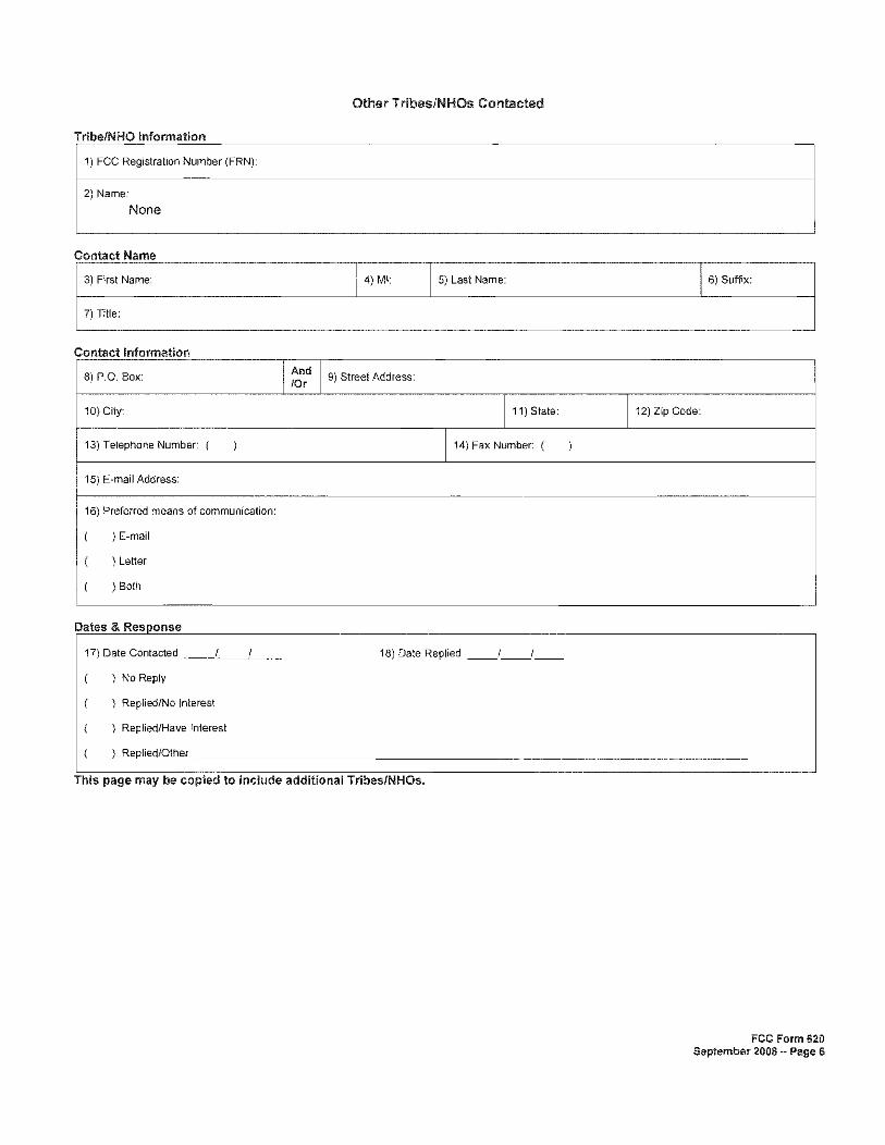
4.5 CULTURAL RESOURCES ....................................................................................... 12 4.5.1 ACHP Program Comment ........................................................................... 12 4.5.2 FCC Nationwide Programmatic Agreement ................................................ 13 4.5.3 FCC Tower Construction Notification System ............................................ 13 4.5.4 State Historic Preservation Officer .............................................................. 14 4.5.5 Indian Tribal Consultation ........................................................................... 14 4.5.6 Inadvertent Discovery .................................................................................. 16
4.6 SOCIOECONOMIC CONCERNS ............................................................................. 16 4.6.1 Human Health and Safety ............................................................................ 16 4.6.2 Environmental Justice .................................................................................. 17 4.6.3 Noise ............................................................................................................ 17 4.6.4 Infrastructure, Utilities, Transportation, and Waste Management .............. 18 4.6.5 Aesthetics and Visual Impacts ..................................................................... 18
4.7 CUMULATIVE IMPACTS ........................................................................................ 18
5.0 AGENCY COORDINATION, PUBLIC INVOLVEMENT AND PERMITS ...................... 20

Draft Environmental Assessment Proposed MSWIN 30305 Tula Wireless Communications Tower Tula, Lafayette County, Mississippi
6.0 LIST OF PREPARERS .......................................................................................................... 21
7.0 INFORMATION SOURCES ................................................................................................. 21
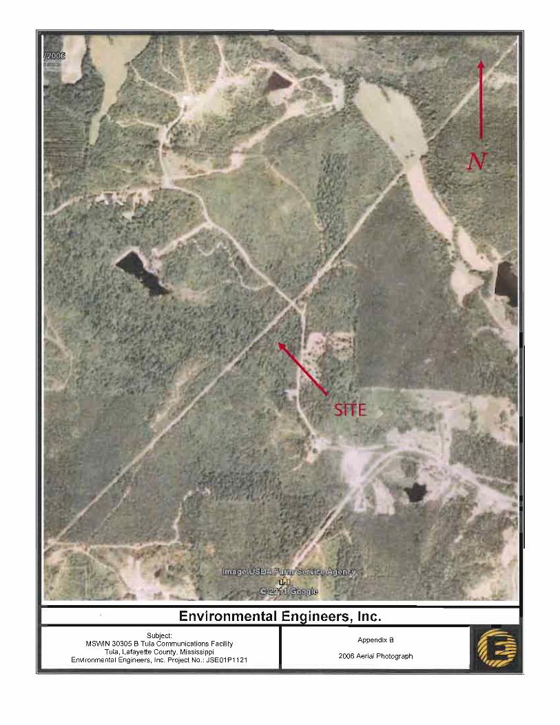
FIGURES Figure 1 Site Locator Map - State Figure 2 Site Locator Map - County Figure 3 Site Location Map Figure 4 2010 Aerial Photograph Figure 5 through 10 Site Photographs Figure 11 National Wetland Inventory Map Figure 12 Flood Insurance Rate Map
APPENDICES
Appendix A Site Survey Appendix B Correspondence to and from the USDA NRCS Appendix C Correspondence to and from the U.S. Army Corps of Engineers Appendix D Correspondence to and from the U.S. Fish and Wildlife Service Appendix E USFWS Tower Guidelines Appendix F Avian Mitigation Plan Appendix G TCNS Notice of Organizations Which Were Sent Proposed TCN Information Appendix H FCC Form 620 Appendix I Correspondence to and from the Mississippi Department of Archives and History Appendix J Correspondence to and from Native American Indian Tribes/Organizations Appendix K Phase I ESA Appendix L Local Government/Public Notice

Draft Environmental Assessment Proposed MSWIN 30305 Tula Wireless Communications Tower Tula, Lafayette County, Mississippi
1
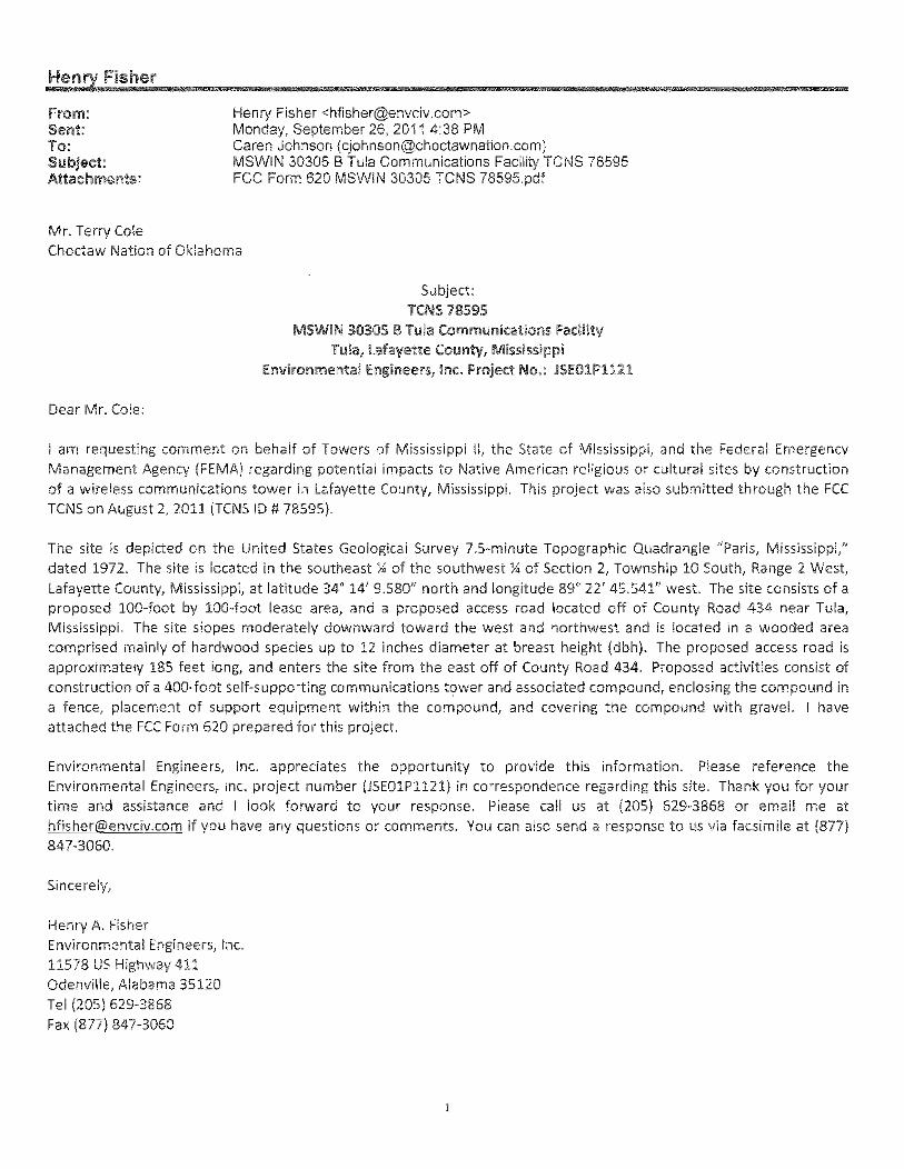
1.0 INTRODUCTION The State of Mississippi created the Mississippi Wireless Communication Commission (MWCC) by statute in 2005 to oversee the construction and operation of the Mississippi Wireless Integrated Network (MSWIN) project. MSWIN is wireless voice and data capable infrastructure, providing all users with a public-safety grade, statewide, interoperable, seamless roaming radio system. This 700 MHZ Public Safety System is intended to provide highly reliable, fast access, private (within groups and individuals) communications to a wide variety of government and first-responder users within the State of Mississippi. MSWIN is funded largely by federal funds administered through the Department of Homeland Security and the Federal Emergency Management Agency. This project is being funded using a FEMA grant (2008-MS-MX-0001) and the State of Mississippi’s expenditures at this site would include construction of a telecommunications facility, purchase and installation of 700 MHz RF equipment and microwave telecommunication backbone network, equipment shelter, network integration, acceptance testing, communication hardware optimization and system exercising and piloting of interoperability capabilities of the network. As part of the MSWIN network, this tower would support a myriad of equipment that would provide emergency response communications for the population within approximately fifteen miles surrounding this proposed site.
2.0 PURPOSE AND NEED This Environmental Assessment has been prepared in accordance with the National Environmental Policy Act (NEPA) of 1969, the President’s Council on Environmental Quality regulations implementing NEPA (40 Code of Federal Regulations (CFR) Parts 1500-1508), and FEMA’s regulations implementing NEPA (44 CFR Part 10). FEMA is required to consider potential environmental impacts before funding or approving actions and projects. The purpose of this EA is to analyze the potential environmental impacts of the proposed construction of a communications tower facility. FEMA will use the findings in this EA to determine whether to prepare an Environmental Impact Statement (EIS) or a Finding of No Significant Impact (FONSI). The purpose of the MSWIN is to establish a better communications network for State system users, varying from public safety to governmental executive and administrative personnel to road maintenance crews. The MSWIN network would also be used extensively during life threatening conditions and emergency situations. Flooding, hurricanes, earthquakes, tornadoes, and other natural or man-made catastrophes often require effective wide-area, interoperable communications. Following Hurricane Katrina, there was a significant lack of communication or communication delays between government agencies due to inadequate coverage or inadequate capacity-handling capabilities. A high degree of redundancy and fail-safe design is essential to the success of this project since communications within the State of Mississippi are most critical when they are most susceptible to failure.

Draft Environmental Assessment Proposed MSWIN 30305 Tula Wireless Communications Tower Tula, Lafayette County, Mississippi
2
3.0 ALTERNATIVES CONSIDERED The State of Mississippi considered six alternatives to meet the purpose and need stated in Section 2.0. These alternatives included the Proposed Action, No-Action Alternative, and four alternatives that were considered but dismissed for reasons discussed in greater detail below. Two alternatives, the No Action and Proposed Action, are evaluated in this EA. 3.1 NO-ACTION ALTERNATIVE Under the No-Action Alternative the proposed project would not be constructed. The No-Action alternative is being included to provide a baseline for comparison purposes. 3.2 PROPOSED ACTION The Proposed Action would consist of construction of a 400-foot self-supporting communications tower and associated equipment compound to facilitate installation and operation of wireless communications antennae to provide integrated emergency communications between federal, state, and local agencies. These antennae would include microwave dishes that are to be used to send and receive information over long distances without the limitations associated with connection to land lines/cables (primarily interruptions in service due to damage to land lines/cables during emergencies or natural disasters). 3.3 ALTERNATIVES CONSIDERED AND DISMISSED The State of Mississippi considered four additional alternatives to meet the purpose and need. These alternatives were collocation, satellite communications, commercial cellular communications, and use of the existing State operated networks; all were dismissed from further consideration for the reasons described below. Collocation opportunities were considered as an alternative to the proposed action. However, the technical loading requirements for this project are for all used structures to be engineered and constructed to the latest tower standards of ANSI/TIA-222-G (class III supporting public safety and mission critical communications). As this is the latest engineering standard and the Class III (public safety) level is the most rigorous engineering standard in the tower industry, there are no existing towers within the coverage area for this project that can be modified to meet this standard and handle the loading requirements MSWIN would place on the tower. Satellite communications are commercially available and are currently used as a backup communications method in the event the primary systems fail. Satellite communications are cost prohibitive for the 30,000 users who would be a part of the MSWIN radio network. Commercial cellular communication services are available in much of the service area MSWIN would provide, but not all of the State of Mississippi is covered by a single cellular operator. MSWIN would

Draft Environmental Assessment Proposed MSWIN 30305 Tula Wireless Communications Tower Tula, Lafayette County, Mississippi
3
provide 97% radio coverage over the state, is more secure than commercial cellular service, is more survivable in the event of natural disasters, and is dedicated to public safety missions. Cellular is an adequate limited backup to the routine and emergency requirements of public safety, but is not adequate for daily operational usage and extreme emergency situations, as compared to the MSWIN system. The existing State operated radio systems are aging and limited in their coverage reach. The field and dispatch radios are nearing obsolescence and are difficult to find new replacement parts for. The needs of a growing Mississippi would best be met by the new technology the MSWIN network provides.
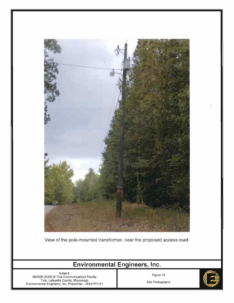
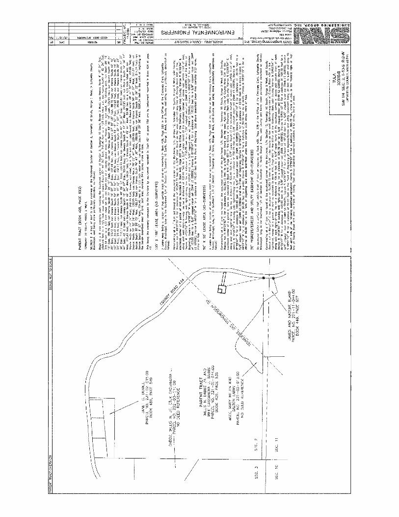
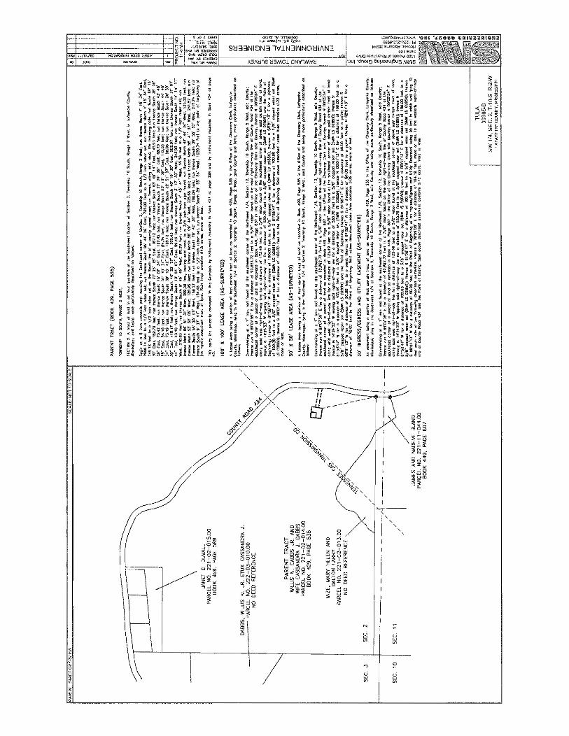
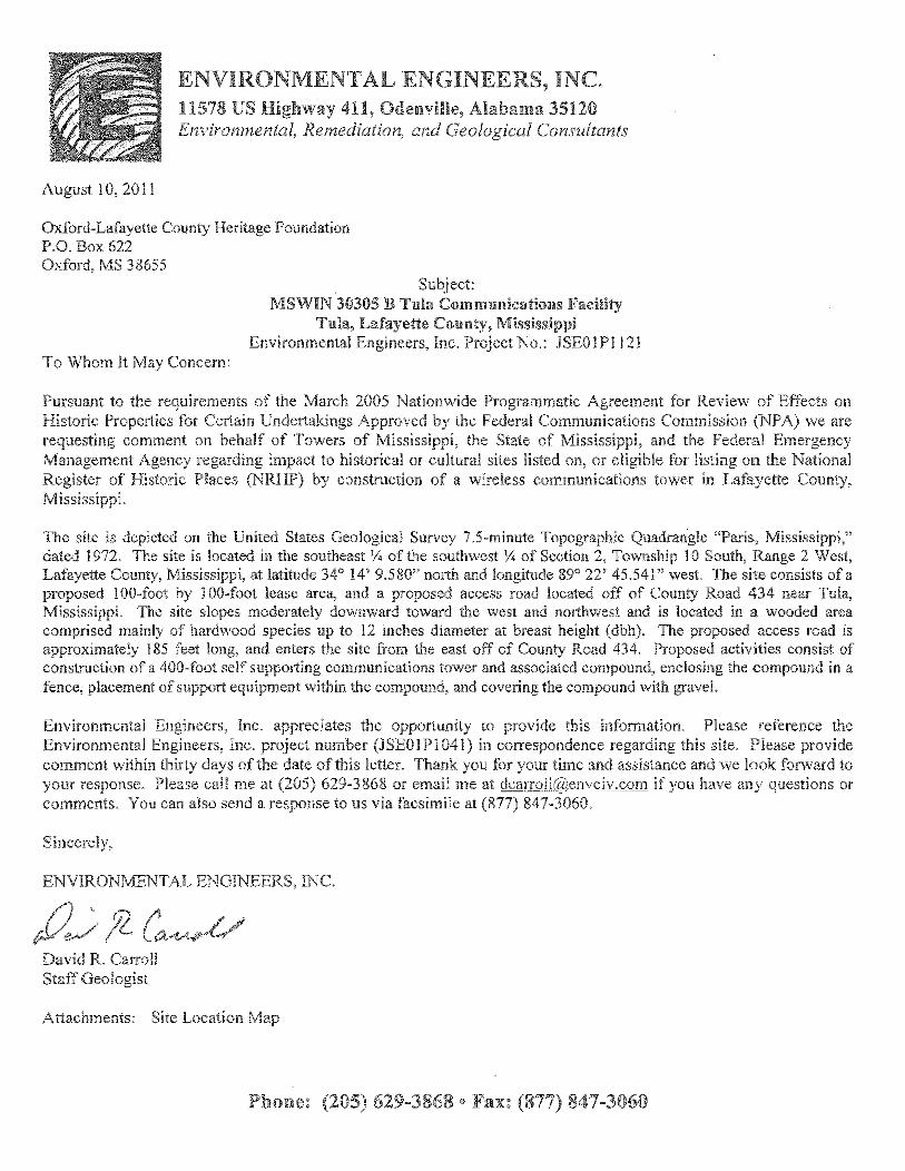
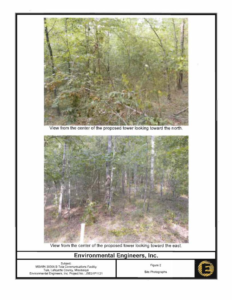
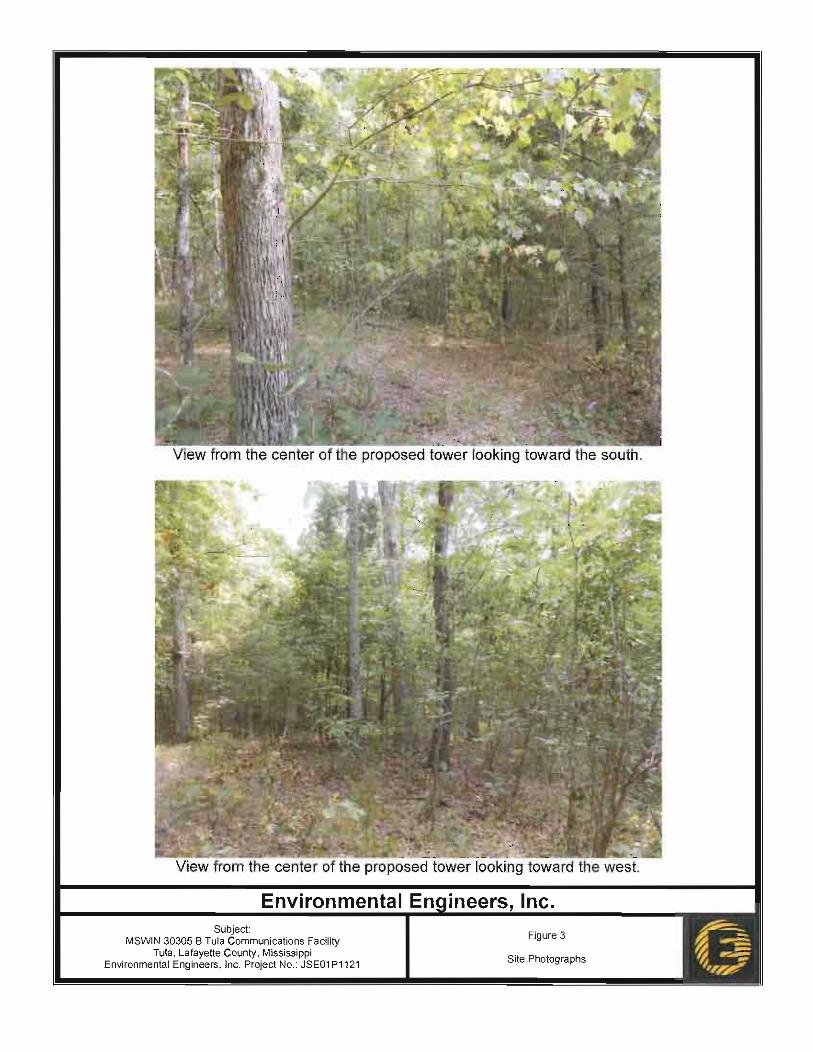
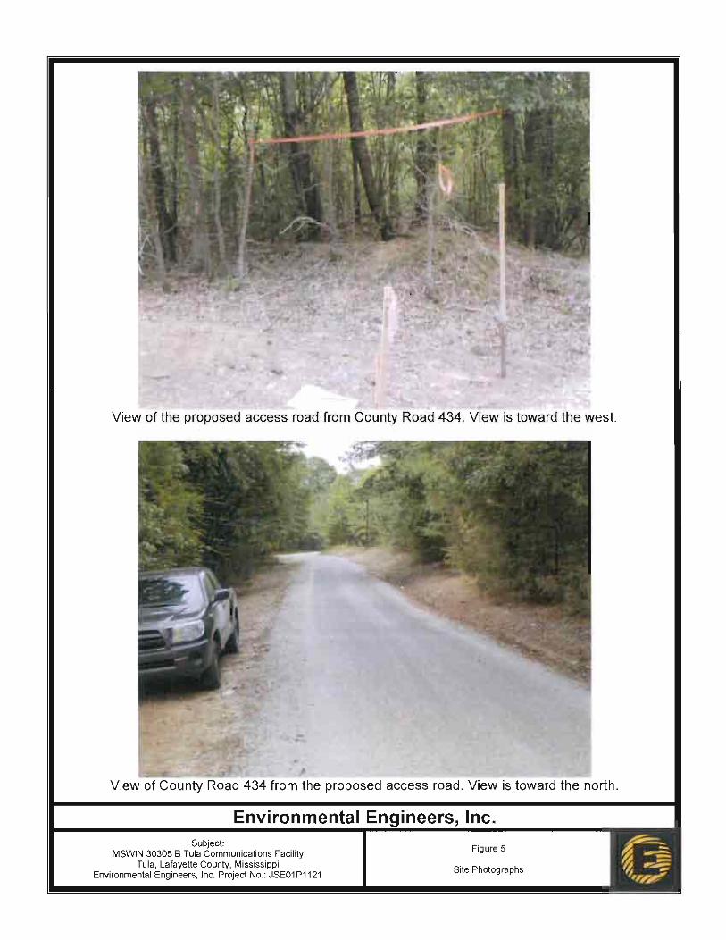
4.0 AFFECTED ENVIRONMENT AND POTENTIAL IMPACTS The site is depicted on the United States Geological Survey 7.5-minute Topographic Quadrangle “Paris, Mississippi,” dated 1972. The site is located in the southeast ¼ of the southwest ¼ of Section 2, Township 10 South, Range 2 West, Lafayette County, Mississippi, at latitude 34° 14’ 9.580” north and longitude 89° 22’ 45.541” west. The site consists of a proposed 100-foot by 100-foot lease area and a proposed access road located off of County Road 434 near Tula Mississippi. The site slopes moderately downward toward the west and northwest and is located in a wooded area comprised mainly of hardwood species up to 12 inches diameter at breast height (dbh). The proposed access road is approximately 185 feet long, and enters the site from the east off of County Road 434. Proposed activities consist of construction of a 400-foot self-supporting communications tower and associated compound, enclosing the compound in a fence, placement of support equipment within the compound, and covering the compound and access road with gravel. Maps depicting the site location are included as Figures 1 through 3. The proposed tower facility would be accessed via locked gate off of County Road 434. The tower would have two parking spaces at the entrance of the fenced tower compound. The compound surrounding the tower and equipment would consist of a seven-foot tall security fence with an additional foot of barbed wire surrounding the site. The tower would be built to withstand extreme weather conditions and engineered and constructed to the latest tower standards of ANSI/TIA-222-G (class III supporting public safety and mission critical communications). All radio equipment on the tower would be operated in compliance with all requirements of frequency and power output as regulated by the Federal Communications Commission. Additionally, the gates and fence would have attached no trespassing and other notice and warning signs as may be required by applicable local and federal laws. Routine operations of the tower facility would have limited vehicular traffic excepting maintenance and routine periodic inspections. Running water or sanitary facilities would not be provided at the facility. Power facilities are available and would be routed in during construction. The tower would not interfere with local residence or the use of the surrounding properties. The increase of vehicular traffic into the area is anticipated to be negligible. The tower and communication systems located thereon would not interfere with other communication systems in the area.

Draft Environmental Assessment Proposed MSWIN 30305 Tula Wireless Communications Tower Tula, Lafayette County, Mississippi
4
The tower is designed to allow other users on the structure to promote collocation with up to three positions suitable for cellular telephone type wireless service providers. This would potentially reduce the need for additional towers in the area. In addition, the tower is designed to accommodate additional government communications equipment as needed to provide mission critical radio infrastructure increases in the future. A copy of the portion of the 2010 aerial photograph depicting the site layout has been included as Figure 4 and site photographs have been included as Figures 5 through 10. A copy of the site survey is included as Appendix A. A table summarizing the potential impacts of the proposed action is included at the end of Section 4. 4.1 PHYSICAL RESOURCES 4.1.1 Geology and Soils Under the no action alternative there would be no impact to geologic resources or soils. 4.1.1.1 Geology According to the Mississippi Geological Survey, Geologic Map of Mississippi, dated 1969 and reprinted 1985, the site is underlain by the Wilcox Formation. The Wilcox Formation consists of irregularly bedded fine to coarse sand, more or less lignite clay, and lignite, and includes the bauxite bearing Fearn Springs member at the base. Geologic resources may be minimally impacted by drilling or excavation of footings for the proposed communications tower and associated equipment. However, the proposed communications facility would have no significant or wide-spread impacts to geologic resources. 4.1.1.2 Soils Prime farmland, unique farmland, and land of statewide or local importance is protected under the Farmland Protection Policy Act (FPPA) of 1981 (7 U.S.C. § 4201 et seq.). The intent of the FPPA is to minimize the impact Federal programs have on the irreversible conversion of farmland to non-agricultural uses. Prime farmland is defined as land that has the best combination of physical and chemical characteristics for producing food, feed, forage, fiber, and oilseed crops and that is available for these uses. Prime farmland cannot be areas of water or urban or built-up land. Unique farmland is defined as land other than prime farmland that is used for the production of specific high value food and fiber crops such as citrus, tree nuts, olives, cranberries, fruit, and vegetables. Based on the USDA’s Soil Survey of Lafayette County, Mississippi, issued May 1981, site soils are classified as Maben-Smithdale-Tippah association, hilly. This map unit consists of steep, well-drained and moderately well-drained soils that occur on rough uplands. The Maben soil formed in stratified shaly clay and loamy sediments on lower side slopes next to drainageways. The Smithdale soil formed in loamy material on the steep upper parts of side slops. The Tippah soil formed in a thin mantle of loess underlain by clay on ridgetops and on the lower part of the steep side slopes.

Draft Environmental Assessment Proposed MSWIN 30305 Tula Wireless Communications Tower Tula, Lafayette County, Mississippi
5
Typically, the surface layer of the Maben soil is yellowish-brown fine sandy loam about five inches thick. To a depth of about 20 inches, the subsoil is yellowish-red clay. From 20 to 40 inches, yellowish-red silty clay with brownish mottles is present. Below this, to a depth of 60 inches is stratified red, brown, and gray clay loam and partially weathered shale. Typically, the surface layer of Smithdale soil is brown sandy loam about 12 inches thick. The upper part of the subsoil, to a depth of about 40 inches, is yellowish-red sandy clay loam. The lower part of the subsoil, to a depth of 80 inches, is red sandy loam with a few pockets of uncoated sand grains. Typically, the surface layer of Tippah soil is yellowish-brown silt loam about three inches thick, underlain by about nine inches of yellowish-red silty clay loam. Below this, it is silty clay mottled in shades of red, brown and gray. Based on information available at the United States Department of Agriculture Natural Resource Conservation Service (NRCS) Web Soil Survey Internet website, Maben-Smithdale-Tippah association, hilly is not classified as prime farmland. EEI submitted information regarding the proposed project to the USDA NRCS office in Jackson, Mississippi via letter dated August 10, 2011. The NRCS responded via letter dated November 8, 2011 stating “The proposed activity does not significantly impact or alter the site condition. No FPPA determination is required.” Copies of the correspondence to and from the NRCS are included as Appendix B. Soil at the proposed project site is not classified as prime farmland, the proposed communications facility would have no significant impact on soils protected by the FPPA because the NRCS does not consider the action to significantly impact or alter the site condition. 4.1.2 Air Quality The Clean Air Act (CAA) was established in 1970 (42 U.S.C. § 7401 et seq.) to reduce air pollution nationwide. The US Environmental Protection Agency (EPA) has developed primary and secondary National Ambient Air Quality Standards (NAAQS) under the provisions of the CAA. The EPA classifies the air quality within an air quality control region (ACQR) according to whether the region meets or exceeds Federal primary and secondary NAAQS. An AQCR or a portion of an AQCR may be classified as being in attainment, non-attainment, or it may be unclassified for each of the seven criteria pollutants (carbon monoxide, lead, nitrogen dioxide, coarse particulates, fine particulates, ozone, and sulfur dioxide). Under the no action alternative there would be no short or long term impacts to air quality. According to information available through the Mississippi Department of Environmental Quality (MDEQ) Internet website, the State of Mississippi is currently designated as attainment and meets all ambient air quality standards. Short-term impacts to air quality such as exhaust emissions from

Draft Environmental Assessment Proposed MSWIN 30305 Tula Wireless Communications Tower Tula, Lafayette County, Mississippi
6
grading and equipment, and dust from grading activities may occur during site grading and construction activities. Equipment used for these activities would meet local, state, and federal requirements for air emissions, and dust would be controlled as necessary by wetting the surface of the work areas. The only long-term air emissions anticipated at the site would be from the emergency generator. The generator would only operate briefly while being tested and during power failure events affecting the electrical power supply to the site. Therefore, the proposed communications facility would have no significant impact to air quality. 4.2 WATER RESOURCES 4.2.1 Wild and Scenic Rivers Under the no action alternative there would be no impact to wild or scenic rivers. A review of information available through the Rivers.gov Internet website indicates that one Wild and Scenic River is located in Mississippi. This Wild and Scenic River is a section of Black Creek located in the DeSoto National Forest in southeastern Mississippi. The County in which the site is located is more than 200 miles north of the DeSoto National Forest. Therefore, the proposed communications facility would have no impacts to any designated Wild and Scenic River. 4.2.2 Water Quality The Federal Water Pollution Control Act (FWPCA), also known as the Clean Water Act (CWA) was passed by congress in 1972 (33 U.S.C. § 1251 et seq.) with an objective of restoring and maintaining the chemical, physical, and biological integrity of waters of the United States. The National Pollutant Discharge Elimination System (NPDES) was established under the CWA and regulates wastewater discharges from point sources. NPDES regulations require that construction sites resulting in greater than one acre of disturbance obtain a permit from the EPA, or the corresponding state agency where the permitting role has been assumed by the state. The Mississippi Department of Environmental Quality (MSDEQ) is the state agency that has assumed this responsibility for Mississippi. Under the no action alternative there would be no short- or long-term impacts to water quality. No water bodies are located on or immediately adjacent to the proposed tower site. Land-disturbing activities at this facility would be approximately 0.36 acres, which is below the one acre threshold requiring an NPDES permit. However, appropriate best management practices (BMPs) would be implemented during site development to minimize sediment migration from the site into nearby water bodies. Examples of BMPs that may be used during site development to further minimize any impacts to nearby water resources include, but are not limited to, silt fence, hay or straw bales, hay or straw mulch, gravel, erosion control blankets, and riprap. Therefore, the proposed communications facility would have no significant short- or long-term impacts to water quality in the area of the site.
Draft Environmental Assessment Proposed MSWIN 30305 Tula Wireless Communications Tower Tula, Lafayette County, Mississippi
7
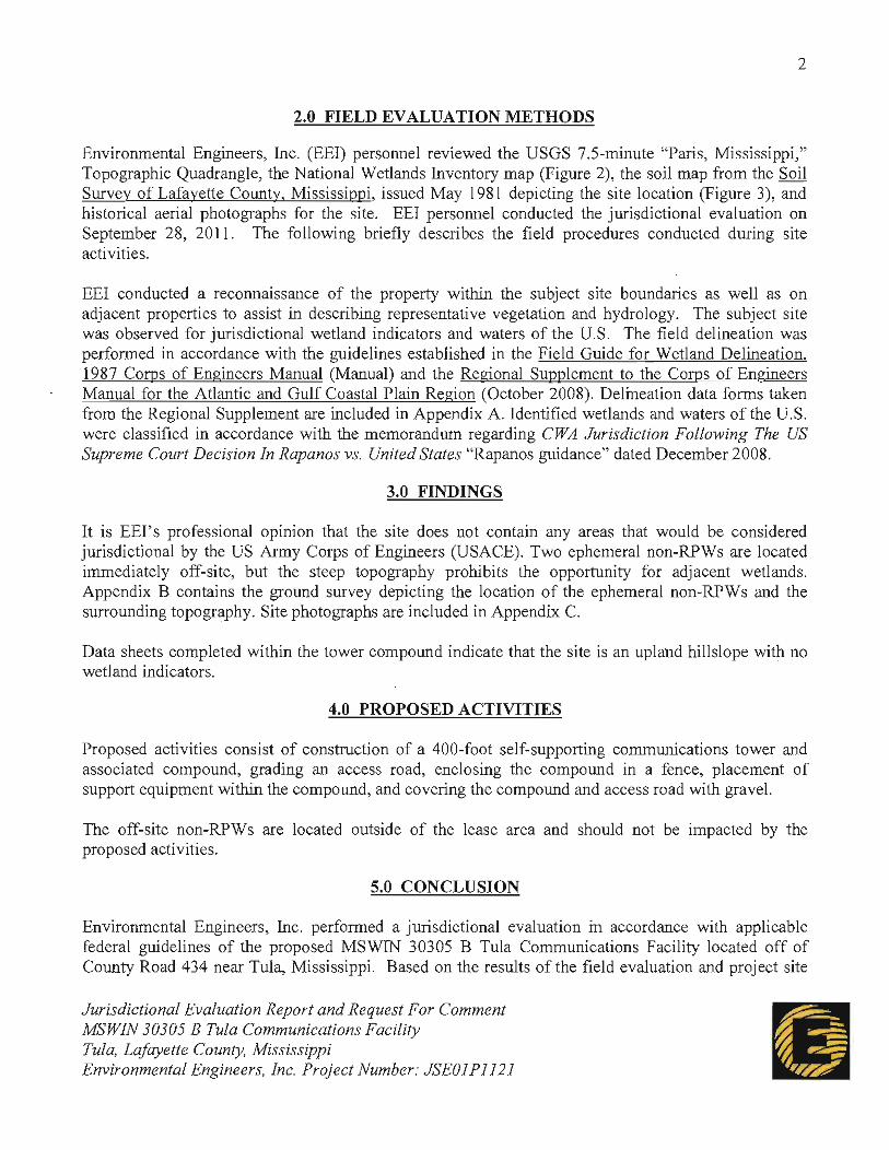
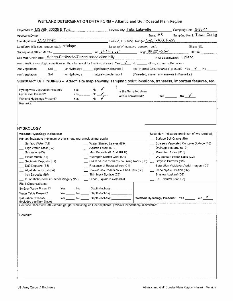
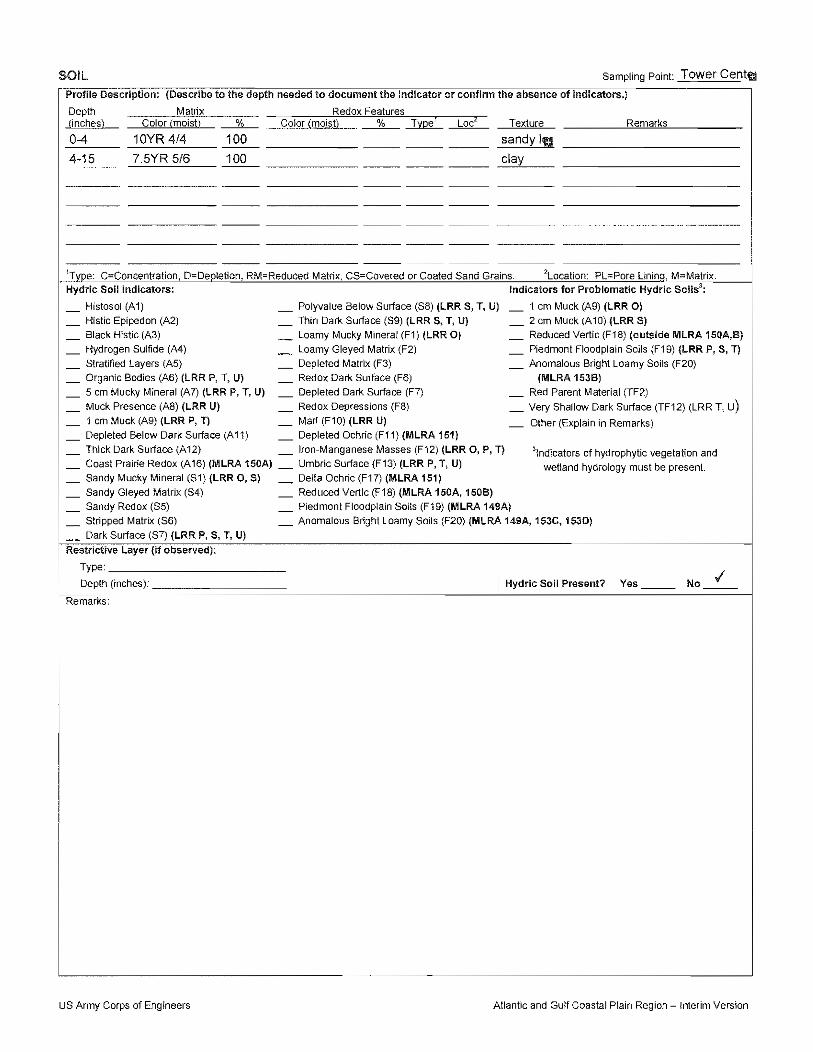
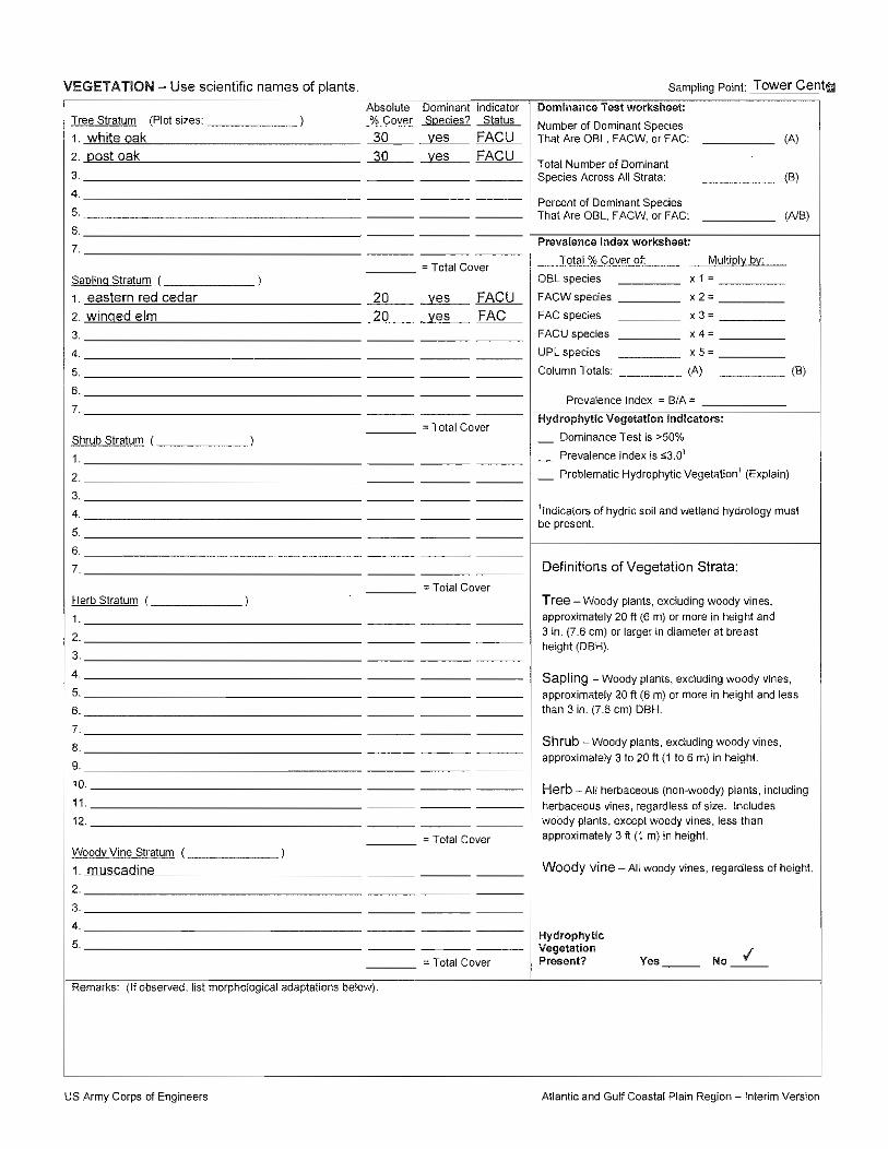
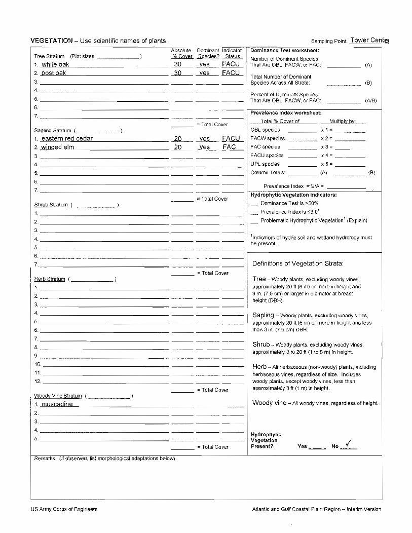
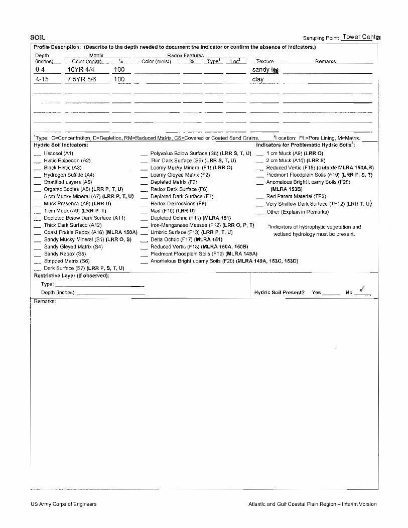
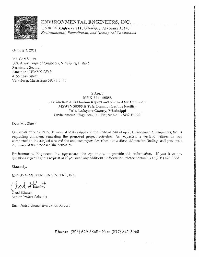
4.2.3 Wetlands According to Executive Order (EO) 11990, wetlands are defined as “...those areas inundated by surface or ground water with a frequency sufficient to support and under normal circumstances does or would support a prevalence of vegetative or aquatic life that requires saturated or seasonally saturated soil conditions for growth and reproduction. Wetlands generally include swamps, marshes, bogs, and similar areas such as sloughs, potholes, wet meadows, river overflows, mud flats, and natural ponds. EO 11990 requires that each federal agency take action to minimize the destruction, loss, or degradation of wetlands, and to preserve and enhance the natural and beneficial value of wetlands. Section 404 of the CWA established a program to regulate the discharge of dredged or fill material into waters of the United States, including wetlands. Activities in waters of the United States regulated under this program include fill for development, water resource projects (such as dams and levees), infrastructure development (such as highways and airports) and mining projects. The United States Department of the Army Corps of Engineers administers the permitting process created under Section 404 of the CWA. Under the no action alternative there would be no impacts to wetlands. Information on the USFWS Wetlands Geodatabase website (digital NWI map) was reviewed to determine if any wetlands were delineated on or near the site. Based on a review of information available on this website, the site is not mapped within a jurisdictional wetland. A copy of a portion of the Digital National Wetlands Inventory map depicting the site location has been included as Figure 11. Environmental Engineers, Inc. personnel conducted a jurisdictional evaluation on September 28, 2011. Environmental Engineers, Inc. conducted a reconnaissance of the property within the subject site boundaries as well as on adjacent properties to assist in describing representative vegetation and hydrology. The subject site was observed for jurisdictional wetland indicators and waters of the U.S. The field delineation was performed in accordance with the guidelines established in the Field Guide for Wetland Delineation, 1987 Corps of Engineers Manual (Manual) and the Regional Supplement to the Corps of Engineers Manual for the Atlantic and Gulf Coastal Plain Region (October 2008). No potential jurisdictional wetland indicators were noted on the site at the time of the site reconnaissance. Information regarding the proposed project was submitted to the United States Army Corps of Engineers (USACE) for review via report entitled “Jurisdictional Evaluation Report and Request for Comment” dated October 3, 2011. The USACE responded via letter dated October 20, 2011 stating “Based upon the information provided (enclosure 1), it appears that a Department of the Army permit, pursuant to Section 10 of the Rivers and Harbors Act of 1899 and Section 404 of the Clean Water Act, will not be required for the proposed work. In the event that project plans are changed, or if you anticipate any additional construction, please contact this office for a reevaluation of permit requirements and refer to identification no. MVK-2011-858 when submitting the information.” Copies

Draft Environmental Assessment Proposed MSWIN 30305 Tula Wireless Communications Tower Tula, Lafayette County, Mississippi
8
of the correspondence submitted to and response from the USACE are included as Appendix C. The proposed communications facility would have no impacts to wetlands. 4.2.4 Floodplain Information According to EO 11988, the term floodplain refers to the lowland and relatively flat areas adjoining inland and coastal waters including flood prone areas of offshore islands, including at a minimum, that area subject to a one percent or greater chance of flooding in any given year. This EO requires that each federal agency take action to reduce the risk of flood loss, to minimize the impact of floods on human safety, health and welfare, and to restore and preserve the natural and beneficial values served by floodplains. Under the no action alternative there would be no impacts to floodplains. According to the Federal Emergency Management Agency’s (FEMA) Flood Insurance Rate Map (FIRM) “Panel 425 of 475, Lafayette County, Mississippi and Incorporated Areas” effective date November 26, 2010, the site is located in Zone X which is described as areas determined to be outside the 0.2% annual chance floodplain. Therefore, the site is not located in a floodplain. The portion of the FEMA FIRM depicting the site is included as Figure 12. The towers that comprise the MSWIN system are considered critical facilities and project design requirements include that the communications equipment at each facility be elevated at least five feet above the 500-year flood elevation (where mapped). In areas where the 500-year floodplain is not mapped, the equipment will be elevated a minimum of five feet above the 100-year base flood elevation. In the case of the proposed action, the FIRM depicting the site location does not include areas of 500-year flood. The support equipment at this facility would be elevated at least five feet above the 100-year base flood elevation. In addition, increased stormwater runoff is not considered a significant concern. The increase in stormwater runoff associated with the proposed action would not significantly change the potential damage to other properties associated with flooding. 4.3 COASTAL RESOURCES The Coastal Zone Management Act (CZMA) was established in 1972 (16 U.S.C. § 1451 et seq.) to preserve, protect, and (where possible) restore or enhance the resources of the coastal zones of the United States. Under the no action alternative there would be no impact to coastal resources. The Coastal Zone in Mississippi includes the three counties along the coast (Hancock, Harrison, and Jackson) and the adjacent coastal waters. The site is located more than 300 miles from the Gulf of Mexico and is not located in the Mississippi Coastal Zone. Therefore, the proposed communications facility would have no impacts to coastal resources.

Draft Environmental Assessment Proposed MSWIN 30305 Tula Wireless Communications Tower Tula, Lafayette County, Mississippi
9
4.4 BIOLOGICAL RESOURCES 4.4.1 Threatened and Endangered Species The Endangered Species Act (ESA) of 1973 (16 U.S.C. 1531 – 1544) provides for the conservation of ecosystems upon which threatened and endangered species of fish, wildlife, and plants depend. The ESA prohibits actions that may harm or jeopardize the continued existence of any threatened or endangered species, or critical habitat. Under the no action alternative there would be no impact to threatened or endangered species. The proposed communications facility will not adversely affect federally-listed threatened or endangered species. Information regarding the proposed wireless communications tower was submitted to the USFWS by Environmental Engineers, Inc. The USFWS responded via letter dated August 22, 2011 stating “There are no federally listed species for Lafayette County.” Copies of the correspondence to and the response from the USFWS are included as Appendix D. 4.4.2 Migratory Birds The Migratory Bird Treaty Act (16 U.S.C. 703) established a Federal prohibition, unless permitted by regulations, to "pursue, hunt, take, capture, kill, attempt to take, capture or kill, possess, offer for sale, sell, offer to purchase, purchase, deliver for shipment, ship, cause to be shipped, deliver for transportation, transport, cause to be transported, carry, or cause to be carried by any means whatever, receive for shipment, transportation or carriage, or export, at any time, or in any manner, any migratory bird, or any part, nest, or egg of any such bird." Under the no action alternative there would be no impact to migratory birds. The United States Fish and Wildlife Service (USFWS) developed voluntary recommendations regarding communications tower siting, construction, operation, and decommissioning. These recommendations include collocating of antennae on existing towers or other structures, limiting the height of new towers to less than 199 feet above ground level (AGL), if taller than 199 feet use of the minimum amount of pilot warning and obstruction avoidance lighting required (preferably white strobes), use of non-guyed towers (monopoles, self-supporting towers), consideration of cumulative impacts on migratory birds, locating towers within “antenna farms” where possible, use of the minimum lighting permissible, use daytime visual markers on guy wires, minimization of the footprint of the facility to avoid habitat loss, design of new towers to accommodate additional comparable antennae for at least two additional users, and down-shielding security lighting for on-ground facilities. A copy of the USFWS communications tower siting, construction, operation, and decommissioning recommendations are included in Appendix E. A basic principal of radio communication coverage is increasing the height extends signal range. Effective coverage is a function of height so to lower each site to less than 199 feet increases the
Draft Environmental Assessment Proposed MSWIN 30305 Tula Wireless Communications Tower Tula, Lafayette County, Mississippi
10
potential tower count over 300 to accomplish the coverage requirements, resulting in roughly 3,000,000 square feet of ground disturbance, or well over twice the current footprint disturbance requirements. Such an increase in ground impact risks a much greater adversity to terrestrial based habitat such as animals and plants, plus the additional carbon footprint produced by the increased development and construction activities. The build plan for the MSWIN project generally involves construction of one to three towers per county with a total of approximately 140 towers covering the 46,907 square miles (121,489 square kilometers) of land area in the state. This averages out to one tower for every 335 square miles (867 square kilometers) of land area in the state. No county will contain more than five MSWIN towers and many counties will contain only one tower. It is important to note that fewer towers are to be constructed in the delta along the Mississippi River due to the flat terrain and corresponding longer transmit and receive distances achieved. This would reduce potential impacts to migratory birds utilizing the Mississippi Flyway migratory route along the Mississippi River. The Federal Aviation Administration (FAA) has jurisdiction over all tower lighting and conducts aeronautical studies under the provisions of 49 U.S.C., Section 44718 and if applicable Title 14 of the Code of Federal Regulations, part 77, concerning the impact on arrival, departure, and en route procedures for aircraft operating under VFR/IFR conditions at existing and planned public use airports, as well as aeronautical facilities. For purposes of MSWIN tower development, obstruction lighting may be one of three types:
(1) Medium intensity flashing white obstruction lights (white strobes in both day and night (D-1 or D-2); or
(2) Dual lighting with red / medium intensity flashing white lights (white strobes in
daylight and red strobes at night – E-1 or E-2); or (3) Marking and lighting with painted towers and red night beacons. This applies to towers
over 500 feet in height (E-2 light system). The proposed tower would be equipped with dual lighting with red / medium intensity flashing white lights. As stated in Section 1.0, the proposed tower would be designed to accommodate equipment for up to three additional wireless communications providers thereby reducing the need for additional towers in the service area of the proposed project. Security lighting at this facility would consist of motion-activated wall-mounted lights on the equipment shelter at the site. The construction of the proposed tower would not have a significant impact on migratory birds. However, this tower is part of the MSWIN program that may have the potential for cumulative impacts to migratory birds.

Draft Environmental Assessment Proposed MSWIN 30305 Tula Wireless Communications Tower Tula, Lafayette County, Mississippi
11
FEMA has identified that the statewide MSWIN program has the potential for cumulative impacts to migratory birds, as birds could be injured or killed by colliding into guy wires and/or the tower structure, or could be disoriented by the tower lighting. FEMA has worked with MWCC and Mississippi Department of Wildlife, Fisheries, and Parks (MDWFP) to develop an Avian Mitigation Plan (Appendix F) to address this potential for cumulative impacts. The mitigation includes monitoring the presence of deceased birds at MSWIN tower sites and providing a collection kit on site to collect the remains and record the location of any deceased bird. The remains of the bird along with the data will be delivered to MDWFP and included in the state’s Avian Mortality database. USFWS will also be given access to this database. If an injured bird is found, all efforts will be made to help the bird recover so that it can be released back into the wild. In addition, MDWFP and USFWS (Jackson, MS Ecological Services office) will be given access to the MSWIN tower sites for monitoring. If a particular tower is found to have adverse effects to migratory birds (greater than 10 kills per night) the towers will be reported to MDWFP, USFWS, and FEMA. MWCC will also provide an annual report documenting the number of avian deaths and provide that report to MDWFP, FEMA, and USFWS for five years after all towers have been constructed. This mitigation plan will contribute scientific data that can be used by MDWFP and USFWS in determining the significance of potential impacts of towers on migratory birds. The implementation of the Avian Mitigation Plan will lower the potential for the MSWIN program to have adverse cumulative impacts on migratory birds. 4.4.3 Wildlife and Fish
The Wilderness Act (16 U.S. C. 1131-1136) established the National Wilderness Preservation System to be composed of federally owned areas designated by Congress as "wilderness areas."
Under the no action alternative there would be no impact to wilderness areas. The proposed communications facility would not adversely affect wilderness areas. Based on a review of information available through the Wilderness.net Internet website, two wilderness areas are located in Mississippi – Black Creek Wilderness and Leaf Wilderness. The site is not located within the boundaries of, or adjacent to either wilderness area. Therefore, the proposed communications facility would have no impact on wilderness areas. On October 9, 1997, President Clinton signed the National Wildlife Refuge System Improvement Act of 1997 (P.L. 105-57) into law. This new law amended and built upon the National Wildlife Refuge System Administration Act of 1966 to ensure that the National Wildlife Refuge System is managed as a national system of related lands, waters, and interests for the protection and conservation of the Nation's wildlife resources. The 1966 Act provides guidelines and directives for administration and management of all areas in the system, including "wildlife refuges, areas for the protection and conservation of fish and wildlife that are threatened with extinction, wildlife ranges, game ranges, wildlife management areas, or waterfowl production areas." Under the no action alternative there would be no impact to wildlife refuges.

Draft Environmental Assessment Proposed MSWIN 30305 Tula Wireless Communications Tower Tula, Lafayette County, Mississippi
12
Based on a review of information available at the USFWS Internet website and at the Nationalatlas.gov Internet website, the site is not located within the boundaries of, or adjacent to, any wildlife refuges. Therefore, the proposed communications facility is expected to have no impacts to wildlife refuges. 4.4.4 General Vegetation Impacts to general vegetation are anticipated to be limited to the areas that are to be excavated and/or graded in preparation of the site for construction of the proposed communications tower and access road. The site is located in a wooded area comprised mainly of hardwood species. The total area of vegetation to be impacted at this site is approximately 0.36 acres. Therefore, the proposed communications facility would have no significant impact on general vegetation. 4.5 CULTURAL RESOURCES Under Section 106 of the National Historic Preservation Act (NHPA), Federal agencies are required to consider the impacts of their actions on historic properties. Historic properties are those that are listed on or eligible for listing on the National Register of Historic Places, and are defined as districts, sites, buildings, structures, and objects significant in American history, architecture, archeology, engineering, and culture. The goal of the NHPA is to have federal agencies act as responsible stewards of the nation’s resources when their actions affect historic properties. The historic preservation review process mandated by Section 106 is outlined in regulations issued by the Advisory Council on Historic Preservation (ACHP) (36 CFR Part 800). The ACHP is an independent federal agency that promotes the preservation, enhancement, and productive use of the nation's historic resources, and advises the President and Congress on national historic preservation policy. The ACHP is the only agency with the legal responsibility to encourage federal agencies to integrate historic preservation compliance considerations into their project requirements. 4.5.1 ACHP Program Comment FEMA is required under Section 106 of NHPA to consider the impacts of its grant-funded projects on historic properties. Similarly, the Federal Communications Commission (FCC) is required under NHPA to consider the impacts to historic properties of communications facilities that receive an FCC license to operate. The FCC has executed two nationwide Programmatic Agreements (PA) under NHPA that streamline the Section 106 review process for new tower construction and collocation projects. On October 23, 2009, the ACHP issued a Program Comment for “Streamlining the Section 106 Review for Wireless Communication Facilities Construction and Modification Subject to Review Under the FCC Nationwide Programmatic Agreement and/or the Nationwide Programmatic Agreement for the Collocation of Wireless Antennas.” Under the ACHP’s Program Comment, FEMA is not required to conduct its own Section 106 review with regard to the effects of communication facilities construction or modification projects that have undergone Section 106 review by the FCC or that are exempt from Section 106 review by the FCC under the FCC Nationwide PA or the FCC Collocation PA. Therefore, the Section 106 review conducted for the proposed project to meet FCC requirements is described in this EA, but no separate 106 review was required for FEMA.

Draft Environmental Assessment Proposed MSWIN 30305 Tula Wireless Communications Tower Tula, Lafayette County, Mississippi
13
4.5.2 FCC Nationwide Programmatic Agreement On March 7, 2005 the FCC implemented a Nationwide Programmatic Agreement (NPA) regarding Section 106 reviews (State Historic Preservation Officer and Indian tribal consultation) for wireless telecommunications tower sites. In summary, the NPA set forth rules regarding consultation with the State Historic Preservation Officer (SHPO) in each state where a proposed wireless telecommunications tower is to be constructed; consultation with Indian tribes and Native Hawaiian Organizations (NHOs) that would have been historically located in the area of the proposed wireless telecommunications tower or had indicated an interest in the geographical area containing the proposed wireless telecommunications tower; and involvement of the public and/or local government. As part of the process associated with the NPA the FCC developed the Tower Construction Notification System (TCNS) and FCC Form 620. The TCNS is described in Section 4.5.3 and FCC Form 620 is described in Section 4.5.4. The NPA requires that a response be received from each Indian tribe or NHO that has indicated an interest in the state or geographical area containing the proposed tower. If no response is received from a particular Indian tribe or NHO within a reasonable time (typically 30 days), the NPA requires that the non-responding Indian tribe or NHO be contacted a second time in an effort to obtain a response. If the Indian tribe or NHO continues to be unresponsive to the initial or follow-up inquiries, the FCC must be contacted to consult with the non-responding Indian tribe or NHO. 4.5.3 FCC Tower Construction Notification System The TCNS is an Internet-based notification system developed by the FCC that allows input of basic information regarding the proposed location, type, and height of a new wireless telecommunications tower. This information is then made available to Indian tribes and NHOs that have expressed an interest in the state or geographical location containing the proposed wireless telecommunications tower via electronic or regular mail. According to the FCC the TCNS can be used as the initial contact to Indian tribes or NHOs. Information regarding the proposed wireless telecommunications tower was submitted to Indian tribes, NHOs, and SHPOs via the TCNS on August 2, 2011. The FCC assigned Notification I.D. #78595 to the notification submitted for this proposed wireless communications tower. The FCC sent an electronic mail notification to our office on August 5, 2011 listing the Indian tribes, NHOs, and SHPOs that were contacted through the TCNS regarding the proposed tower. As noted in Section 4.5.2, the NPA requires a response be obtained from each Indian tribe or NHO that has indicated an interest in the geographical area or state containing the site. Environmental Engineers, Inc. used the list of Indian tribes that had defined their area of geographical interest on the FCC Internet web site, conversations with Tribal Historic Preservation Officers (THPOs), Internet web sites for many of the Indian tribes and Alaskan villages, and the Encyclopedia of North American Indians by Frederick E. Hoxie (published in 1996 by Houghton Mifflin) to determine which Indian tribes included in the TCNS list would be interested in this wireless

Draft Environmental Assessment Proposed MSWIN 30305 Tula Wireless Communications Tower Tula, Lafayette County, Mississippi
14
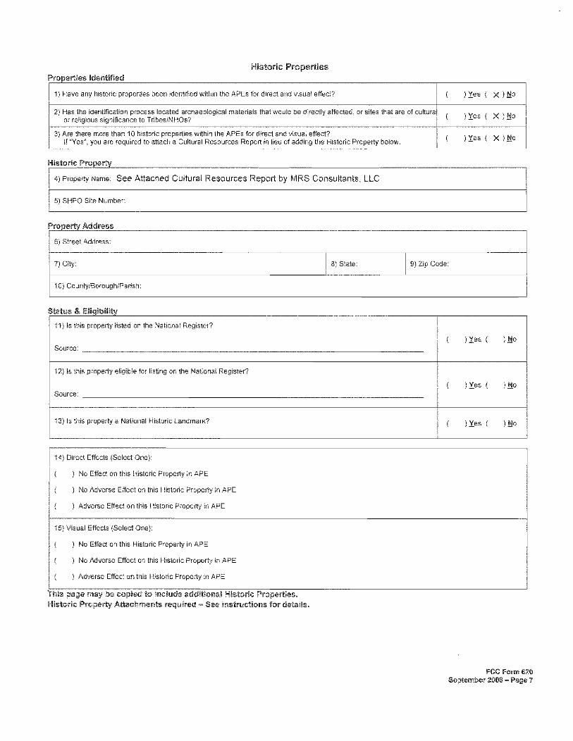
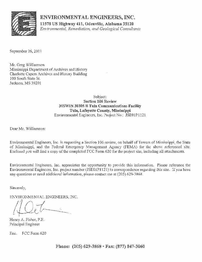
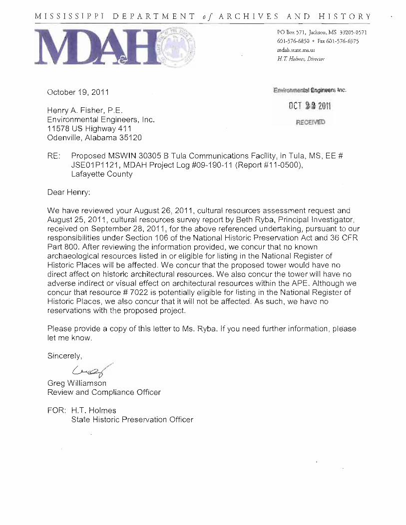
telecommunications tower site. This review indicated that the following Indian tribes would have a potential interest in this wireless telecommunications tower site: Alabama-Coushatta Tribe of Texas, Chickasaw Nation, Choctaw Nation of Oklahoma, Jena Band of Choctaw Indians, Kialegee Tribal Town, and the Tunica-Biloxi Indians of Louisiana. A description of the follow-ups to and responses from each of these Indian tribes are included in Sections 4.5.5.1 through 4.5.5.6. Copies of the TCNS notifications and list of Indian tribes and SHPOs are included in Appendix G. 4.5.4 State Historic Preservation Officer MRS Consultants, LLC and Environmental Engineers, Inc. completed the FCC Form 620 required for submittal to the SHPO and to those Indian tribes requesting additional information regarding the proposed wireless telecommunications tower. MRS Consultants, LLC personnel satisfy the United States Secretary of the Interior’s Professional Qualification Standards. A copy of the FCC Form 620 prepared for this site is included in Appendix H. Ten historic resources were identified within the Mississippi Archaeological Site Files for the APE. Of these sites only one is considered eligible for listing on the National Register of Historic Places: a two-story dogtrot that is unoccupied and used as storage for garbage. The proposed tower would not be visible from this identified resource as vegetation presently envelopes the resource. Moreover, intervening forests between the proposed tower site and the resource would prevent any view shed issues regarding the proposed tower. The proposed tower would have no adverse effect on any significant cultural resource. The FCC Form 620 was submitted to the Mississippi Department of Archives and History (MDAH) for review. Based on the review of this report, the MDAH responded via letter dated October 19, 2011 stating “After reviewing the information provided, we concur that no known archaeological resources listed in or eligible for listing in the National Register of Historic Places will be affected. We concur that the proposed tower would have no direct affect on historic architectural resources. We also concur the tower will have no adverse indirect or visual effect on architectural resources within the APE. Although we concur that #7022 is potentially eligible for listing in the National Register of Historic Places, we also concur that it will not be affected. As such, we have no reservations with the proposed project.” Copies of the correspondence to and from the MDAH are included in Appendix I. 4.5.5 Indian Tribal Consultation Environmental Engineers, Inc. followed up with each of the Indian tribes identified (as necessary) through a review of the TCNS listing provided by the FCC for this site. Sections 4.5.5.1 through 4.5.5.6 describe follow-up contacts to each of these Indian tribes and their responses. 4.5.5.1 Alabama-Coushatta Tribe of Texas Mr. Bryant Celestine of the Alabama-Coushatta Tribe of Texas provided comment via electronic mail dated October 24, 2011 regarding TCNS #78595 stating “On behalf of Mikko Oscola Clayton Sylestine and the Alabama-Coushatta Tribe, our appreciation is expressed on your efforts to consult us

Draft Environmental Assessment Proposed MSWIN 30305 Tula Wireless Communications Tower Tula, Lafayette County, Mississippi
15
regarding TCNS #78595 (JSE01P1121) in Panola County…Upon review of your September 26, 2011 submission, no immediately known impacts to cultural assets of the Alabama-Coushatta Tribe of Texas are anticipated in conjunction with this proposal. As there had been significant Alabama presence within Panola County, we request the immediately notification of the inadvertent discovery of human remains and/or archaeological artifacts as well as a cease of activity in proximity to the location until all formal consultations with appropriate authorities, including our office, are complete.” It should be noted that although this response mentions Panola County, the TCNS number is the correct location. Copies of the correspondence to and from the Alabama-Coushatta Tribe of Texas are included in Appendix J. 4.5.5.2 Chickasaw Nation Ms. Virginia Nail of the Chickasaw Nation responded via TCNS on September 12, 2011 regarding TCNS #78595 stating “We do not presently know of any specific historic properties or properties of significant religious or sacred value. In the event your agency becomes aware of the need to enforce other statutes we request to be notified under NEPA, NAGPRA, AIRFA and ARPA. If you have any questions, please contact Ms. Gingy Nail, assistant historic preservation officer.” A copy of the response from Ms. Nail is included in Appendix J. 4.5.5.3 Choctaw Nation of Oklahoma Ms. Caren Johnson of the Choctaw Nation of Oklahoma provided comment via electronic mail on November 7, 2011 regarding TCNS #78595 stating that “The Choctaw Nation of Oklahoma has reviewed cell tower(s) FCC # 78595 and based on the information provided to the best of our knowledge it will have no adverse effect on any historic properties in the project’s area of potential effect. However, should construction expose buried archaeological or building materials such as chipped stone, tools, pottery, bone, historic crockery, glass or metal items, or should it uncover evidence of buried historic building materials such as rock foundations, brick, or hand poured concrete, this office should be contacted immediately.” Copies of the correspondence to and from the Choctaw Nation of Oklahoma are included in Appendix J. 4.5.5.4 Jena Band of Choctaw Indians Mr. Michael Tarpley of the Jena Band of Choctaw Indians was contacted via letter dated September 26, 2011 regarding TCNS #78595. Mr. Tarpley provided comment via letter dated October 3, 2011 stating “At this time, we know of no known sacred and/or ceremonial sites in the immediate area. Although, if any cultural resources, such as, bone, pottery, flakes or stone tools, etc. are found during construction please contact us immediately.” Copies of the correspondence to and from the Jena Band of Choctaw Indians are included in Appendix J. 4.5.5.5 Kialegee Tribal Town The TCNS listing (Appendix G) for this site included information from the Kialegee Tribal Town that states “If the Applicant receives no response from the Kialegee Tribal Town within 30 days after

Draft Environmental Assessment Proposed MSWIN 30305 Tula Wireless Communications Tower Tula, Lafayette County, Mississippi
16
notification through TCNS, the Kialegee Tribal Town has no interest in participating in pre-construction review for the site. The Applicant, however, must immediately notify the Kialegee Tribal Town in the event archaeological properties or human remains are discovered during construction.” The TCNS notification for this site is dated August 5, 2011 and the end of the 30-day period indicated by the Kialegee Tribal Town was September 4, 2011. Environmental Engineers, Inc. has not received a response from the Kialegee Tribal Town as of the date of this report. Therefore, it is our understanding that additional consultation with the Kialegee Tribal Town is not necessary. 4.5.5.6 Tunica-Biloxi Indians of Louisiana Mr. Earl Barbry of the Tunica-Biloxi Indians of Louisiana was contacted via electronic mail on May 3, 2005 regarding submittal of wireless telecommunications projects. Mr. Barbry responded via electronic mail on May 3, 2005 and indicated that he wanted to be notified regarding cell tower requests via electronic mail and that if he had not responded within 30 days of our contacting him, the project can proceed. We contacted Mr. Barbry regarding this site via electronic mail on September 26, 2011, and the end of the 30-day response period as indicated by Mr. Barbry was October 26, 2011. We have not received a response from Mr. Barbry as of the date of this report. Therefore, we have assumed that the Tunica-Biloxi Indians of Louisiana concur with the proposed project. Copies of the electronic mail to and from Mr. Barbry are included in Appendix J. Based on the information presented above, the proposed communications facility would have no impact on cultural resources. 4.5.6 Inadvertent Discovery The personnel that would have a potential to be involved in land-disturbing activities must be instructed to stop work immediately in the event of an inadvertent discovery of human remains or cultural or archaeological materials and contact FEMA and SHPO. A copy of this information must be provided to all personnel that would have a potential to be involved in land-disturbing activities at the site. 4.6 SOCIOECONOMIC CONCERNS Under the no action alternative there would be no impact to socioeconomic resources. No significant adverse impacts to socioeconomic resources, economic development, demographics, demand for public housing, or public services are anticipated. The emergency communications coverage provided by this project would benefit all populations in the coverage area. 4.6.1 Human Health and Safety Under the no action alternative, there could be adverse impacts to human health and safety because of a lack of adequate communication between emergency response personnel during an emergency event.

Draft Environmental Assessment Proposed MSWIN 30305 Tula Wireless Communications Tower Tula, Lafayette County, Mississippi
17
The results of a Phase I Environmental Site Assessment (ESA) conducted at the site by EEI for the MSWIN 30305 communications tower site in August 2011 (EEI Project No.: JSE01P1121) did not indicate the presence of hazardous materials or petroleum products at the site at that time. The equipment (including the emergency generator and associated propane/natural gas tank) that would be installed at the site would meet local, state, and federal regulations regarding hazardous materials. The Phase I ESA is included in Appendix K. The antennae and equipment that would be installed at the site would meet local, state, and federal regulations regarding radiofrequency emissions. Lastly, this project is intended to provide better communications between emergency response personnel which would have a beneficial effect on human health and safety. Therefore, the proposed communications facility would have no significant impacts to human health and safety. 4.6.2 Environmental Justice Section 1-101 of EO 12898 states “To the greatest extent practicable and permitted by law, and consistent with the principles set forth in the report on the National Performance Review, each Federal agency shall make achieving environmental justice part of its mission by identifying and addressing, as appropriate, disproportionately high and adverse human health or environmental effects of its programs, policies, and activities on minority populations and low-income populations in the United States and its territories and possessions, the District of Columbia, the Commonwealth of Puerto Rico, and the Commonwealth of the Mariana Islands.” Under the no action alternative there would be no impact to minority or low income populations. No disproportionately high or adverse effects on minority or low-income populations are anticipated by development of the proposed communications facility. The proposed communications facility would benefit all populations in the project service area by providing better communications between emergency service personnel. 4.6.3 Noise Noise is generally described as unwanted sound. Sound becomes unwanted when it either interferes with normal activities such as sleeping, conversation, or disrupts or diminishes one’s quality of life. Under the no action alternative there would be no noise generation. Short-term noise generation is anticipated to result from grading and construction activities. Long-term noise generation is anticipated to be minimal and to result primarily from equipment used to cool electronic components and from testing or operation of an emergency generator at the site. However, the generator would only operate briefly when tested, and during power failure events affecting the electrical power supply to the site. Therefore, the proposed communications facility would not generate significant noise.

Draft Environmental Assessment Proposed MSWIN 30305 Tula Wireless Communications Tower Tula, Lafayette County, Mississippi
18
4.6.4 Infrastructure, Utilities, Transportation, and Waste Management Under the no action alternative there would be no impact to infrastructure, utilities, transportation, or waste management. No significant impacts are anticipated to infrastructure, utilities, transportation, or waste management from the proposed communications facility. Traffic to and from the site would be minimal and would be associated with maintenance and repair of equipment at the site. Minimal waste would be generated at the site during maintenance activities. All waste generated at the site would be disposed of in compliance with federal, state, and local regulations. The project is intended to provide enhanced communications services for emergency response personnel. This could have a beneficial effect on the ability to identify and correct problems with infrastructure, utilities, transportation, and waste management. 4.6.5 Aesthetics and Visual Impacts Under the no action alternative there would be no aesthetic or visual impacts. The proposed project will not impact national scenic or historic trails. . There are no national scenic or historic trails located in Lafayette County, Mississippi. The proposed tower would not be equipped with high intensity white lighting. Lastly, the site is not located within the boundaries of any state or national park, national forest, or wildlife management area. No city or other community parks are depicted within 1,000 feet of the proposed project on the USGS Topographic Quadrangle “Paris, Mississippi,” (Figure 3). Therefore, the proposed communications facility would have no significant impacts to aesthetics and visual resources. 4.7 CUMULATIVE IMPACTS Under the no action alternative there would be no cumulative impacts. Cumulative impacts are an incremental impact on either the natural environment or human environment by an action when added to past and anticipated future actions. No ongoing or proposed actions are known for the project area. According to information available through the FCC Antenna Structure Registration (ASR) System Internet website, there are 3,313 registered towers in the state of Mississippi (generally only those towers over 200 feet in height are included in this database). Construction of the towers comprising the MSWIN network would result in an increase of approximately 4.25% in the number of towers in the state of Mississippi. As described in Section 1.0 of this document, the proposed tower is designed to allow collocation of up to three additional cellular-type service providers, thereby potentially reducing cumulative impacts as new/changing technologies

Draft Environmental Assessment Proposed MSWIN 30305 Tula Wireless Communications Tower Tula, Lafayette County, Mississippi
19
and increased demand for service, both public and private, create more pressure on existing infrastructure. The statewide MSWIN program would not have cumulative impacts on geology, air quality, noise, water resources, cultural resources, fish and wildlife, threatened or endangered species, vegetation, or socioeconomics. However, cumulative impacts to migratory birds may result from the MSWIN program, as birds could be injured or killed by colliding into guy wires and/or the tower structure, or could be disoriented by the tower lighting. FEMA has worked with MWCC and MDWFP to develop an Avian Mitigation Plan (Appendix F) to address this potential for cumulative impacts to birds. The mitigation includes monitoring the presence of deceased birds at MSWIN tower sites and providing a collection kit on site to collect the remains and record the location of any deceased bird. The remains of the bird along with the data will be delivered to the MDWFP and included in the state’s Avian Mortality database. USFWS will also have access to this database. If an injured bird is found, all efforts will be made to help the bird recover so that it can be released back into the wild. In addition, MDWFP and USFWS (Jackson, MS Ecological Services office) will be given access to the MSWIN tower sites for monitoring. If a particular tower is found to have adverse effects to migratory birds (greater than 10 kills per night) the towers will be reported to MDWFP, USFWS, and FEMA. MWCC will also provide an annual report documenting the number of avian deaths and provide that report to FEMA, USFWS (Jackson, MS Ecological Services office), and MDWFP for five years after all towers have been constructed. This mitigation plan will contribute scientific data that can be used by MDWFP and USFWS in determining the significance of potential impacts of towers on migratory birds. The implementation of the Avian Mitigation Plan will lower the potential for the MSWIN program to have adverse cumulative impacts on migratory birds.
Table 1. Summary of Impacts
Resource No Impact
No Significant Impact
Significant Impact
Mitigation/Best Management Practices
Geology X None
Prime/unique farmland; farmland of statewide or local importance
X None
Air Quality X Fugitive dust emissions from construction activities would be controlled by wetting the ground
Wild and Scenic Rivers X None
Water Quality
X
Examples of BMPs that may be used during construction activities include, but are not limited to, silt fence, hay or straw bales, hay or straw mulch, gravel, erosion control blankets, and riprap
Wetlands X None
Floodplains X
Support equipment will be elevated a minimum of five feet above base flood elevation

Draft Environmental Assessment Proposed MSWIN 30305 Tula Wireless Communications Tower Tula, Lafayette County, Mississippi
20
Table 1. Summary of Impacts, Continued
Resource No Impact
No Significant Impact
Significant Impact
Mitigation/Best Management Practices
Coastal Resources X None
Threatened and Endangered Species
X None
Migratory Birds X Tower lighting would be in accordance with USFWS recommendations; tower design would allow for future collocation; requirements of the Avian Mitigation Plan would be followed.
Wildlife and Fish X None
General Vegetation X None
Cultural Resources X If any human remains or cultural or archaeological materials are discovered, grantee would stop work immediately and contact FEMA and SHPO.
Socioeconomic Resources X None
Human Health and Safety X None – project would improve interoperable communications
Environmental Justice X None – project would benefit all communities
Noise X None
Infrastructure, Utilities, Transportation, and Waste Management
X None
Aesthetics and Visual Impacts X None
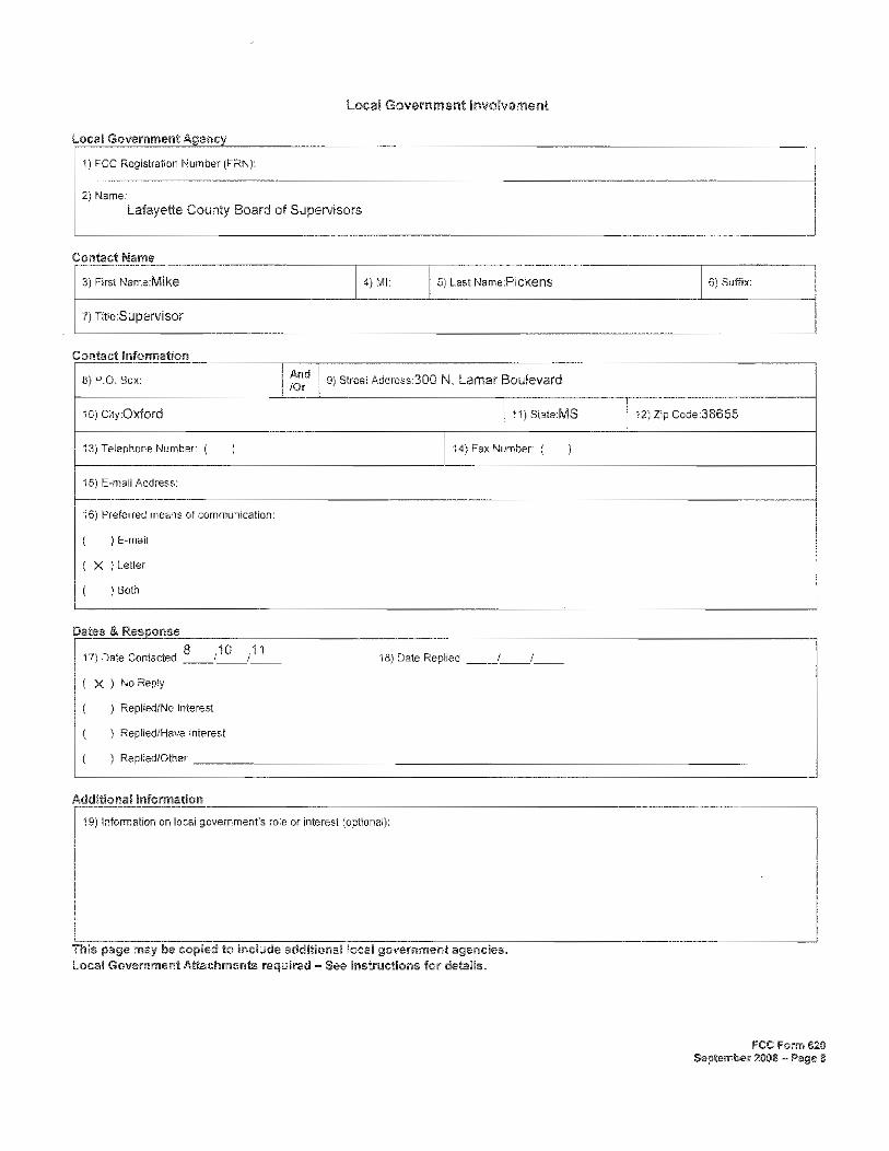
5.0 AGENCY COORDINATION, PUBLIC INVOLVEMENT AND PERMITS The Lafayette County Board of Supervisors and the Oxford-Lafayette County Heritage Foundation were contacted regarding the proposed wireless communications tower via letters dated August 10, 2011. No response has been received from the Lafayette County Board of Supervisors or the Oxford-Lafayette County Heritage Foundation as of the date of this report. A public notice was published in the Oxford Eagle on August 8, 2011 requesting comment regarding potential impacts to historical or archaeological properties by the proposed wireless communications tower. No comments have been received as of the date of this report in response to the public notice. Copies of the correspondence submitted to the Lafayette County Board of Supervisors and the Oxford-Lafayette County Heritage Foundation, and a copy of the public notice are included in Appendix L. In addition, notice of availability of this draft Environmental Assessment will be published in the Oxford Eagle.
Draft Environmental Assessment Proposed MSWIN 30305 Tula Wireless Communications Tower Tula, Lafayette County, Mississippi
21
6.0 LIST OF PREPARERS
Mindy Manners, Environmental Engineers, Inc. Henry A. Fisher, Environmental Engineers, Inc. Science Kilner, FEMA Amanda Pereira, FEMA
7.0 INFORMATION SOURCES Completion of this Draft Environmental Assessment included utilization of the following sources: 1. Review of the portion of the 2010 aerial photograph depicting the site location available through
Mapcard. 2. Review of the site survey prepared by SMW Engineering, Inc.
3. Review of information regarding National Scenic Trails and All-American Roads available on the
Mississippi Department of Transportation Internet website.
4. State and county maps available through the Mississippi Department of Transportation Internet website.
5. Review of information regarding wild and scenic rivers in the vicinity of the proposed project
available at Rivers.gov.
6. Review of the Nationwide Programmatic Agreement for Review of Effects on Historic Properties for Certain Undertakings Approved by the Federal Communications Commission.
7. Correspondence to and from the United States Army Corps of Engineers regarding potential
impacts to jurisdictional wetlands by the proposed project.
8. Review of information available on the USFWS National Wetlands Inventory Internet website regarding potential jurisdictional wetlands on or adjacent to the site.
9. A review of information available on the USFWS Internet website, at Nationalatlas.gov, and on
Wilderness.net regarding officially designated wilderness areas or wildlife refuges. 10. Correspondence from the USFWS regarding threatened and endangered species on or near the site. 11. Review of the FCC Form 620 prepared for the site by MRS Consultants, LLC and Environmental
Engineers, Inc.
Draft Environmental Assessment Proposed MSWIN 30305 Tula Wireless Communications Tower Tula, Lafayette County, Mississippi
22
12. Correspondence from the Mississippi Department of Archives and History regarding historical resources and properties listed on or eligible for listing on the National Register of Historic Places on or near the site.
13. Review of the Tower Construction Notification System Notice of Organizations Which Were Sent
Proposed Tower Construction Notification Information provided by the FCC. 14. Correspondence and conversations with representatives of the Alabama-Coushatta Tribe of Texas,
Chickasaw Nation, Choctaw Nation of Oklahoma, Jena Band of Choctaw Indians, Kialegee Tribal Town, and the Tunica-Biloxi Indians of Louisiana regarding wireless telecommunications projects.
15. Review of the portion of the FEMA Flood Insurance Rate Map depicting the site location regarding
flood zone designations for the site. 16. Information regarding the MSWIN system provided by Towers of Mississippi. 17. Soil information from the USDA’s Soil Survey of Lafayette County, Mississippi, issued May 1981
and the USDA’s NRCS Web Soil Survey Internet website. 18. Correspondence to and from the USDA Natural Resource Conservation Service (NRCS) office in
Jackson, Mississippi regarding impacts to prime farmland, unique farmland, and land of statewide or local importance.
19. A reconnaissance of the subject property.