tsunami early warning service guidebook for inatews ... early warning... · tsunami early warning...
TRANSCRIPT

Tsunami Early Warning Service Guidebook for InaTEWS – Second Edition
The Guidebook has been translated from the original Indonesian version “Buku Pedoman Pelayanan Peringatan Dini Tsunami InaTEWS”, second edition, August 2012.
Authors and Reviewers: see full list on the last pageIndonesian language editing: Ririn Indah Permata Sari and Henny VidiarinaEnglish translation: Ruth F. Mackenzie and Lynda MillsEnglish language editing: Lynda Mills and Harald SpahnLayout: ErmaMaghfirohPictures: BMKG, GTZ-IS GITEWS, and Ursula MeissnerDesign and layout: Box Breaker, BMKG
For further information please contact:
BMKG Head Office Geophysics DepartmentHead of Earthquake and Tsunami Mitigation DivisionJl. Angkasa 1 No. 2, Kemayoran, Jakarta Pusat 10720Telephone: 021-424 6321, 021-654 6316, 021-654 2983Fax: 021-654 2983 Website: www.bmkg.go.id E-mail: [email protected] Network: www.facebook.com/InfoBMKG http://twitter.com/infoBMKG
Related information: www.gitews.org/tsunami-kit
First Edition: March 2011, supported by GIZ IS-GITEWS (German Indonesian Cooperation for a Tsunami Early Warning System)
Second Edition: August 2012, supported by GIZ IS-PROTECTS (Project for Training, Education and Consulting for Tsunami Early Warning Systems)
Supported by:
Tsunami Early Warning Service Guidebook for InaTEWS | i
Table of Contents
Foreword .................................................................................................................................ivPreface .....................................................................................................................................vIntroduction .............................................................................................................................viSummary of the 12 Principles ................................................................................................viiiLegal Basis ..............................................................................................................................xii. Laws ..................................................................................................................................xiii. Government regulations ....................................................................................................xiiiii. Ministerial regulation ..........................................................................................................xiiiv. Regulation by the Head of the BNPB ................................................................................xiiiv. Decrees .............................................................................................................................xiv
Principle 1Indonesia is Prone to Local Tsunamis........................................................................................1i. Tectonic condition in Indonesia ............................................................................................3ii. Tsunamis in Indonesia .........................................................................................................5iii. Categories of tsunamis ........................................................................................................6iv. Short warning and evacuation time ...................................................................................7
Principle 2 InaTEWS – Indonesia Tsunami Early Warning System and Community Empowerment ...........11i. The objective of a People - Centred Early Warning System ............................................13ii. Active involvement of the community and authorities in the area at risk:
from risk assessment to preparedness ..............................................................................13iii. Institutional requirements for an effective early warning system ........................................13iv. Multi-sector, multi-discipline involvement ...........................................................................14v. The four main elements of an early warning system ..........................................................14
Principle 3 Roles and Responsibilities of Institutions and Communities in the Tsunami Early Warning Communication Chain .............................................................................................................17i. The National Tsunami Warning Centre (NTWC) at the BMKG Head Office .....................20ii. The BNPB ........................................................................................................................20iii. The local government ......................................................................................................21iv. The Indonesian Military ....................................................................................................21v. The national Indonesian Police ........................................................................................21vi. Television and radio stations ............................................................................................21vii. Communities at risks ........................................................................................................22viii. Cellular service providers ................................................................................................22ix. Hotel managers ...............................................................................................................22

| Tsunami Early Warning Service Guidebook for InaTEWSii
Principle 4 Instruments for Earthquake and Tsunami Observation ............................................................24i. InaTEWS design ...............................................................................................................27ii. Instruments for earthquake observation ...........................................................................28iii. Instruments for tsunami observation ...................................................................................31iv. Processing and analysis – Decision Support System (DSS) ............................................35
Principle 5Sequence and Contents of Tsunami Warnings ........................................................................41i. InaTEWS warning sequence .............................................................................................43ii. Warning levels and advice for local governments .............................................................45iii. Format of InaTEWS tsunami early warning messages .....................................................47
Principle 6 Dissemination of Earthquake Information and Tsunami Early Warnings by the BMKG ..............65i. The tsunami-warning communication chain ......................................................................67ii. The BMKG’s warning dissemination system .....................................................................67
Principle 7Local Government – the Key Actor in the Provision of Tsunami Early Warning Services to People at Risk..........................................................................................................................75i. The three main tasks of local government in tsunami early warning services.....................77ii. Legal and institutional requirements for local tsunami early warning services.....................79iii. Other requirements ...........................................................................................................81
Principle 8Reception of Tsunami Warnings by Local Governments ..........................................................83i. Information received automatically ....................................................................................85ii. Information retrieved by user .............................................................................................86iii. Direct link between local institutions and the BMKG ..........................................................86
Principle 9 Decision Making by Local Governments .................................................................................89 i. Local governments make decisions based on advice from the BMKG ..............................93
Principle 10Dissemination of Tsunami Warnings and Guidance by Local Governments .............................97i. Announcements to the public using direct communication channels .................................99ii. Announcements to the public through other institutions or interfaces ..............................100iii. Guidance messages that are instructive and easy for people to understand .......................100iv. Siren protocol ..................................................................................................................102
Principle 11 Standard Strategy for Community Reaction to Natural Tsunami Warning Signs,EarthquakeInformation, Tsunami Warnings from the BMKG and Guidance from Local Governments .......103i. Standard reaction strategy ..............................................................................................105ii. Exception for some areas ................................................................................................106
Tsunami Early Warning Service Guidebook for InaTEWS | iii
Principle 12Recommendations for Local Tsunami Preparedness .............................................................107i. Tsunami risk assessment ................................................................................................109ii. Tsunami contingency plans and evacuation plans ..........................................................110iii. Local government regulations on disaster management ..................................................112iv. Building tsunami early warning capacity and infrastructure .............................................113v. Public awareness activities ..............................................................................................113vi. Key messages to be considered for tsunami preparedness and early warning ....................115
Appendix: Warning Segments ............................................................................................117Appendix: What the InaTEWS Logo means ........................................................................125List of Figures ......................................................................................................................126List of Tables ........................................................................................................................128List of Boxes ........................................................................................................................128List of Photographs .............................................................................................................128Abbreviations ......................................................................................................................131Bibliography ........................................................................................................................135Authors and Reviewers ......................................................................................................136
| Tsunami Early Warning Service Guidebook for InaTEWSiv
Foreword
I welcome with delight the publication of “InaTEWS Tsunami Early Warning Service Guidebook”, which was developed by a team consisting of representatives from the Meteorological, Climatological and Geophysical Agency (BMKG), the German International Cooperation – International Services (GIZ-IS), the German-Indonesian Cooperation for a Tsunami Early Warning System (GITEWS) and the Project for Training Education and Consulting for Tsunami Early Warning Systems (PROTECTS). This guidebook will certainly assist BMKG in explaining the Indonesian Tsunami Early Warning System (InaTEWS) as well as the products of BMKG Jakarta to all stakeholders and the public.
The InaTEWS Tsunami Early Warning Service Guidebook is covering all important aspects related to tsunami early warning in Indonesia and explains the roles and responsibilities of key institutions and actors in receiving and reacting upon tsunami early warning from BMKG.
This publication is expected to strengthen the capacities of all stakeholders and the general public to correctly understand the content of tsunami early warning messages provided by BMKG. Such correct understanding will in turn enhance the effectiveness of users in responding to tsunami early warning messages and eventually minimize casualties in the incidence of tsunami.
We hope that the Guidebook will also serve as a reference to the National Agency for Disaster Management (BNPB), the Regional Agencies for Disaster Management (BPBD), the provincial governments, city and district governments as well as all interface institutions, both at national and regional level, including the Ministry of Home Affairs, the National Armed Forces, the Police, the Ministry of Communication and Informatics and the media. In responding to tsunami early warning messages, these interface institutions function as part of the early warning chain that receives and disseminates tsunami warnings to the public.
Finally, I would like to express my highest appreciation to the team of authors of this Guidebook from BMKG, GIZ-IS, GITEWS and PROTECTS, who have completed with full dedication this piece of work, which will benefit the provider and users of tsunami early warning in Indonesia. I also thank all resource persons who have contributed to the completion of this book and in particular the Ministry of Communication and Information, which has helped to print and distribute this Guidebook.
Jakarta, August 2012
Dr. Ir. Sri Woro B. Harijono, M.ScDirector-GeneralMeteorological, Climatological and Geophysical Agency of Indonesia
Tsunami Early Warning Service Guidebook for InaTEWS | v
Preface
BMKG’s role in tsunami early warning is based on Law 31 passed in 2009, the legal framework regarding the function, technologies, instruments, systems, and arrangements in tsunami early warning that had been developed since 2005 and was completed in March 2008. During the World Meteorological Day on 23 March 2007, the President of the Republic of Indonesia instructed to accelerate the development of early warning in order to increase the speed in disseminating warning messages to the communities at risk in Indonesia. The early warning service is in line with the Hyogo Framework for Action 2005-2015 on building nation and community resilience to face disaster through the development of early warning as the main component in disaster risk reduction.
We have reached significant progress in the development of the Indonesian Tsunami Early Warning System, including the dissemination of earthquake information and tsunami warnings to the communities, the improvement in awareness and understanding, leading to a better preparedness to anticipate tsunamis. This process includes the installation of sirens, development of evacuation maps, structured simulation and drills, and the development of evacuation areas with sufficient access to the designated location. It is expected that the technology of the early warning system is reliable and capable to help communities at risk in receiving, understanding, and reacting to tsunami warnings in a quick and appropriate way.
The guidebook covers all aspects regarding tsunami early warning in Indonesia. The second edition provides updates on the warning scheme in accordance to the technical development and clarification on the roles and responsibilities of the institutions involved. The guidebook is expected to be a reference for institutions at national and local level supporting them as public service provider to receive and disseminate tsunami early warnings.
We are most delighted that the Warning Service Guidebook for InaTEWS can be completed in time after the team of authors and reviewers finished the revision and evaluation process.
This guidebook is the result of good cooperation and dedicated work by the teams of authors and reviewers. A list of all who have contributed is provided in the end of this book. We would like to express our appreciation to those who have been involved in the process. Their contributions and experiences enriched the content of the guidebook.
Last but not least, we hope that this guidebook will be useful for all stakeholders at national and local level, especially in the earthquake and tsunami prone areas. It is also expected that the Guidebook contributes to strengthen tsunami preparedness and minimize the impact of tsunamis in Indonesia. It will need continuous cooperation of all stakeholders in Indonesian disaster management supporting the future development and maintenance of the system to assure a reliable 24/7 tsunami warning service in Indonesia.
Jakarta, August 2012
Team of Authors
| Tsunami Early Warning Service Guidebook for InaTEWSvi
Introduction
The “Tsunami Early Warning Service Guidebook for InaTEWS” – second edition - is a publication of the Agency for Meteorology, Climatology, and Geophysics (BMKG) in its function as the warning provider in the Indonesian Tsunami Early Warning System (InaTEWS).
The objective of the guidebook is to support the efforts of national and local institutions in their function as public service provider to disseminate tsunami warnings to the communities at risk as well as other institutions responsible for disaster management especially in preparedness and emergency response at the local level.
Summarizing, the guidebook consists of: • 12 principles, describing all important aspects of tsunami early warning as well as
clarification regarding roles and responsibilities of institutions and key actors in receiving, interpreting, and reacting to tsunami warnings from the BMKG. The content of the guidebook is based on the inputs and experiences from several local governments along with national institutions.
• Operational information, such as relevant SOPs and national policies (illustrated by diagrams, figures, and tables).
The guidebook is intended to be a reference for operational arrangement and policy procedure development in local level.
1. The status of the guidebook
The guidebook is a living document which can and shall be updated and republished from time to time, as the development of the warning system is still ongoing. Updates can be made in the whole guidebook or partially (by principles) in accordance to the latest developments regarding policies and operational arrangements of the tsunami early warning system.
The second edition of the guidebook includes changes and updates regarding the following topics:
• Clarification on the changes in roles, responsibilities, or procedures of each related institution
• Adjustment regarding capacities of existing and introduction of the new technologies• Newly developed or revised government policies which affect the management of early
warning• Changes due to experiences gained through daily operations and evaluations of tsunami
and earthquake events
2. Target user
The guidebook is intended to be used by national and local institutions working as public service provider in receiving and disseminating tsunami early warning. In addition, the guidebook also addresses institutions at local level, especially those with direct responsibility
Tsunami Early Warning Service Guidebook for InaTEWS | vii
in disaster management in the field of preparedness and emergency response. These institutions are the Regional and Local Disaster Management Agencies (BPBD) in province level and district/city level and the decision maker in emergency situations. It is expected that the guidebook contributes to a common vision and synergies between all stakeholders on tsunami management.
3. Set-up of the guidebook
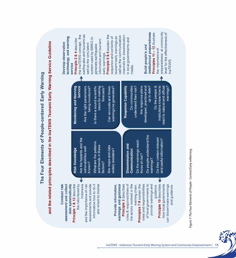
The content of the guidebook is arranged around the four elements of early warning. Figure 7 in Principle 2 provides an overview of the four elements and the related aspects. To get a good understanding, the reader is advised to read each of the Principles as a whole.
The table of contents and numbering help navigating through the guidebook. A specific color code was applied in the flow chart graphics to visualize main roles and functions of institutions in a consistent way.
The 12 Principles in the Tsunami Early Warning System Guidebook for InaTEWS address the following topics:
• Principles 1 to 6 elaborates on the roles and responsibilities of national level insitution in the early warning system
• Principles 7 to 10 describe the roles and responsibilities of local government in the early warning system
• Principle 11 describes the roles and responsibilities of communities at risk in the early warning system
• Principle 12 provides recommendations to improve awareness and preparedness for earthquake and tsunami hazard at the local level
4. Further revision and update
For technical and editorial purposes, the Head of BMKG may decide on a revision and update of the guidebook if necessary. Comments and inputs in relation to the contents of the guidebook can be sent through e-mail to [email protected]. All comments and inputs received will be assessed and considered for a future update of the guidebook. Revisions and updates of the guidebook can be made for the whole guidebook or partially (based on Principles). Information will be provided as soon as an updated version is available. Users should make sure that they get access to updated versions. When an updated version becomes available, the previous version of the guidebook is considered not valid anymore.
5. Focus of recent revison and update
The latest revision and update of the „Tsunami Early Warning Service Guidebook for InaTEWS“ was necessary due to the introduction of the new warning scheme and lessons learned from the Mentawai tsunami in 2010.
| Tsunami Early Warning Service Guidebook for InaTEWSviii
Summary of the 12 Principles
Principle 1: Indonesia is Prone to Local Tsunamis“Indonesia is prone to local tsunamis due to the fact that its coastline is generally very close to tsunami sources. Local tsunamis can reach the shore in less than 30 minutes after an earthquake occurs.”
Principle 2: InaTEWS - Indonesia Tsunami Early Warning System and Community Empowerment “Early warning is a combination of technology and community capacity that responds to information provided by the technology. As a component of disaster risk reduction, early warning requires not only the production of timely, technically accurate warnings but also an understanding of risk, a reliable link between providers and users of warnings and the capacity, on the part of communities and authorities, to respond appropriately to warnings. A failure in any one of these elements can mean failure of the whole warning system.”
Principle 3: Roles and Responsibilities of Institutions and Communities in the Tsunami Early Warning Communication Chain“The BMKG provides earthquake information and tsunami warnings to BNPB, local governments and the media. Local governments are responsible for guiding their communities’ reaction to this information and for deciding whether or not to call for evacuation.”
Principle 4: Instruments for Earthquake and Tsunami Observation“There are three kinds of observation instruments, seismograph for earthquake observation, GPS for earth plate deformation observation, and tide gauges, buoy, CCTV and tsunami radar for tsunami observation. Through communication networks, data from these instruments are sent to the BMKG to be processed and used as the basis for developing tsunami threat scenarios.”
Principle 5: Sequence and Contents of Tsunami Warnings“The BMKG publishes earthquake information or tsunami warnings five minutes after an earthquake, which are followed by several updates and/or an all-clear message. The warning messages contain the tsunami threat level by district: ‘Major Warning’ (Awas), ‘Warning’ (Siaga) and ‘Advisory’ (Waspada).”
Tsunami Early Warning Service Guidebook for InaTEWS | ix
Principle 6: Dissemination of Earthquake Information and Tsunami Early Warning by the BMKG“The BMKG sends earthquake information and tsunami warnings to the public via local governments, interface institutions, and the media, using various communication channels.”
Principle 7: Local Government – the Key Actor in the Provision of Tsunami Early Warning Services to People at Risk“Local governments are obliged to guide people’s reaction to groundshaking from a nearby earthquake based on the information received from the BMKG.”
Principle 8: Reception of Tsunami Warnings by Local Governments“Local governments have to ensure that they are able to receive earthquake information or tsunami warnings and advice from the BMKG accurately and at all times (24/7) through various communication devices.”
Principle 9: Decision Making by Local Governments
“Local governments are expected to have the capacity to make a decision about the action to be taken in their region (i.e. whether or not to call for evacuation) in a timely manner, based on earthquake information, tsunami warnings and advice from the BMKG, as well as local standard operating procedures (SOPs).”
Principle 10: Dissemination of Tsunami Warnings and Guidance by Local Governments“Local governments are required to make use of various communication devices that enable them to widely disseminate earthquake information or warnings, and guidance for evacuation, to the public. Sirens are one of several effective tools to call for evacuation. A steady three-minute sound from a tsunami siren means immediate evacuation.”
Principle 11: Standard Strategy for Community Reaction to Natural Tsunami Warning Signs, Earthquake Information, Tsunami Warnings from the BMKG and Guidance from Local Governments“If people feel a strong earthquake, they should immediately evacuate to a safe location while seeking guidance from the local government. Earthquake information and warnings from the BMKG that contain the estimated threat level and advice for response are the basis for official guidance to the public that either reinforces the need for evacuation or cancels an evacuation if there is no tsunami threat.”
| Tsunami Early Warning Service Guidebook for InaTEWSx
Principle 12: Recommendations for Local Tsunami Preparedness“Tsunami preparedness depends on the preparedness both of local institutions and communities at risk. Local governments, together with other stakeholders, are obliged to analyse the tsunami risk, prepare tsunami contingency and evacuation plans, develop institutional capacity and infrastructure for early warning, issue local regulations for disaster management and raise people’s awareness of the tsunami risk and appropriate ways to respond it.”

Tsunami Early Warning Service Guidebook for InaTEWS | xi
Legal Basis
Following is a list of some of the statutes that form the legal foundation for the implementation of tsunami early warning in Indonesia. This list will change in accordance with changes to the prevailing statutes in Indonesia.
i. Laws• Law 24/2007 on Disaster Management:
» Article 1: (Definition of Early Warning). » Article 12(c): (The BNPB is responsible for transmitting information to communities). » Article 18: (Local governments set up local disaster management bodies Badan
Penanggulangan Bencana Daerah - BPBD). » Article 21(b): (The BPBD is responsible for setting standards and identifying needs
for the implementation of disaster management). » Article 21(c): (The BPBD is responsible for preparing, establishing and
communicating disaster-risk maps). » Article 21(d): (The BPBD is responsible for developing and establishing disaster
management procedures). » Article 27: (Everyone is required to provide accurate information to the public about
disaster management). » Article 46: (Observation, analysis, decision-making, and dissemination of
information). » Article 48: (In the event of implementing disaster management procedures during
the emergency response phase, the government shall, among other things, perform rapid and accurate surveys of the location, damage sustained, and resources; declare a disaster emergency situation; and rescue and evacuate people affected by the disaster).
• Law 31/ 2009 on Meteorology, Climatology and Geophysics: » Article 29, Clause 1: “The government is responsible for providing meteorology
climatology and geophysic services, including public information, early warning, and special information.”
» Article 37: “In the event that a personnel of an observation station, offshore rig, ship, or aircraft becomes aware of the occurrence of an extreme meteorological, climatological or geophysical event, the person is required to immediately inform others and report to the relevant agencies pursuant to statutory provisions.”
» Article 34, Clause 1: “Government- and local government run public information agencies and mass media sources must allocate time or slots every day to disseminate public information pursuant to statutory provisions.”
» Article 44, Clause 1: “The Government, local governments, and other stakeholders are required to use meteorological, climatological and geophysical information in policy making in related sectors.”
| Tsunami Early Warning Service Guidebook for InaTEWSxii
» Article 45: “The Government is required to meet the need for facilities and infrastructure for the implementation of meteorological, climatological, and geographical operations.”
• Law 32/2004 on Local Governments: » Article 22: (In executing autonomy, regions have a responsibility to protect the
people by providing adequate social facilities and public facilities.”
ii. Government regulations• Government Regulation 21/2008 on the Implementation of Disaster Response
» Article 19: (The BMKG is the institution that has the authority to convey analysis results to the BNPB and the BPBD to form the basis of subsequent decisions. The BNPB/ BPBD are tasked with coordinating action to save lives).
» Article 19, Clause 2: “Early warning as referred to in Clause (1) involves:a. observing disaster signs;b. analysing data from observation;c. making decisions based on the result of analysis;d. disseminating the decisions;e. local communities taking action.
» Article 19, Clause 3: “Observation of disaster signs as referred to in Clause (2), Subclause (a), is undertaken by the appropriate institution/ agency responsible for that type of disaster risk, and by the public, to gather data on a possible disaster event, with due regard for local knowledge.”
» Article 19, Clause 4: “The institution/ agency responsible, as referred to in Clause (3), communicates the results of the analysis to the BNPB and/ or the BPBD according to the location and intensity of the disaster, as the basis for making early warning decisions and taking early warning action.”
iii. Ministerial regulations• Regulation by the Minister for Communications and Information 20/2006 on Tsunami and
other Disaster Early Warning through Broadcast Agencies across Indonesia » Article 1: (on the Obligations of Broadcast Agencies with regard to Broadcasting
Disaster Early Warning). » Article 2: (on Disaster Early Warning Information). » Article 3: (on Television Broadcast Agency Broadcasting Procedures for Tsunami
and Other Disaster Early Warning). » Article 4: (on Radio Station Broadcasting Procedures for Tsunami and Other
Disaster Early Warning). » Article 5: (Early Warning Drills).
Tsunami Early Warning Service Guidebook for InaTEWS | xiii
• Regulation by the Minister for Home Affairs 27/2007 on Disaster Management Facilities and Infrastructure
» Article 2: “Local governments provide disaster management facilities and infrastructure in their regions in the effort to prevent, control and manage disasters in their regions pursuant to statutory provisions.”
» Article 3: “Facilities and infrastructure, as referred to above, include early warning systems appropriate to the condition and capacity of the region.”
• Regulation by the Minister for Home Affairs 46/2008 on Guidelines for the Organisation and Work Procedures of a BPBD
» Article 2, Clause 2: (the formation of a BPBD shall be established by a local regulation).
» Article 2, Clause 1: (in each province a provincial BPBD shall be formed, and in each district/ municipality a district/municipal BPBD may be formed)
» Article 20: (according to the need, workload, and financial capacity of the region).
iv. Regulations by the Head of the BNPB• Regulation by the Head of the BNPB 4/2008 on Guidelines for the Formation of a BPBD
» Chapter 2 (explains that local governments are responsible for allocating and providing adequate disaster management funds in the regional budget for the implementation of disaster management in the pre-disaster, disaster response and post-disaster phases).
» Chapter 2 (explains that local governments are responsible for implementing emergency response procedures, from rapid survey and establishing the intensity of the disaster, to rescue and evacuation).
» Chapter 2: (the responsibilities of the Governor/ District Head/ Mayor include establishing the status and intensity of the disaster emergency situation pursuant to statutory provisions).
» Chapter 3: (in executing his or her duties, the BPBD Head of Operations is required to form, among others things, Operations Control Centre Task Forces)
• Regulation by the Head of the BNPB 4/2008 on Guidelines for Preparing Disaster Management Plans
» Chapter 5: (on the choice of disaster response management procedures, one of which is readiness, which includes preparing and installing early warning-system instruments).
| Tsunami Early Warning Service Guidebook for InaTEWSxiv
v. Decrees• Decree by the Coordinating Minister for Social Welfare as the Chair of the Disaster
Management National Coordination Agency (BAKORNAS PB) 21/2006 on the Designation of Government Agencies as Focal Points and the Formation of an Indonesian Tsunami Early Warning System (InaTEWS) Development Team.
With the formation of the BNPB in 2008, pursuant to Law 24/2007, the Decree by the Coordinating Minister for Social Welfare 21/2006 should have been void. However, the InaTEWS Development Team continues. To replace this decree, a draft presidential instruction to strengthen InaTEWS is being prepared. This presidential instruction is expected to be issued this year.

Principle 1Indonesia is Prone to Local Tsunamis
“Indonesia is prone to local tsunamis due to the fact that its coastline is generally very close to tsunami sources. Local tsunamis can reach the shore in less than 30 minutes after an earthquake occurs.”“ “

3Indonesia is Prone to Local Tsunamis |
“Indonesia is prone to local tsunamis due to the fact that its coastline is generally very close to tsunami sources. Local tsunamis can reach the shore in less than 30 minutes after an earthquake occurs.”
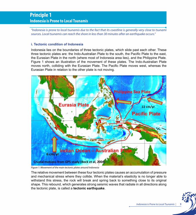
i. Tectonic condition of IndonesiaIndonesia lies on the boundaries of three tectonic plates, which slide past each other. These three tectonic plates are: the Indo-Australian Plate to the south, the Pacific Plate to the east, the Eurasian Plate in the north (where most of Indonesia area lies), and the Philippine Plate. Figure 1 shows an illustration of the movement of these plates. The Indo-Australian Plate moves north, colliding with the Eurasian Plate. The Pacific Plate moves west, whereas the Eurasian Plate in relation to the other plate is not moving.
Principle 1Indonesia is Prone to Local Tsunamis
Figure 1: Movement of the main tectonic plates around Indonesia
The relative movement between these four tectonic plates causes an accumulation of pressure and mechanical stress where they collide. When the material’s elasticity is no longer able to withstand this stress, the rock will break and spring back to something close to its original shape. This rebound, which generates strong seismic waves that radiate in all directions along the tectonic plate, is called a tectonic earthquake.

4 | Tsunami Early Warning Service Guidebook for InaTEWS
Millions of these earthquakes have occurred over hundreds and millions of years on the geological time scale. Evidence of these past earthquakes is recorded in natural geological phenomena (paleo-seismology). Today, earthquakes can be recorded using seismometer networks, which calculate an earthquake’s location and focal depth (hypocentre) and measure its magnitude. The seismicity map (Figure 2) shows the distribution pattern of earthquakes marking the boundaries of the tectonic plates.
Figure 2: Distribution of earthquakes in Indonesia, 1973 – 2010
There are approximately 4000 earthquakes happened in Indonesia per year, whereas earthquakes of a magnitude greater than 5.5, or earthquakes that can be physically felt on land, average around 70-100 per year, and destructive earthquakes around one to two times a year. Between 1991 and 2011, 186 significant earthquakes were recorded.
As shown in Figures 2 and 4, most areas in Indonesia are prone to earthquakes and tsunamis, except the island of Kalimantan, eastern part of Sumatera, and southern part of Papua islands.
As shown in Figure 3, at the boundary of two colliding plates, the oceanic plate will slide below the continental plate due to the difference in the specific gravity of the rock mass. When a plate suddenly moves in an area that is normally stable, an earthquake occurs. Earthquakes with large magnitudes (7 RS or greater), which occur at a shallow depth beneath the ocean floor, are capable of changing the height of the seawater column, thus generating a tsunami wave.

5Indonesia is Prone to Local Tsunamis |
Figure 3: Plate boundaries (USGS)
ii. Tsunamis in IndonesiaTsunamis are sea waves that are generated as a result of impulsive disturbance on the ocean floor. This impulsive disturbance occurs as a result of sudden changes in the geological structure of the seabed in either a vertical or horizontal direction. There are three main causes of these shifts: tectonic earthquakes, volcanic eruptions, or landslides on the seabed. Out of three, earthquakes are the major cause of tsunamis in Indonesia.
Not all earthquakes cause tsunamis, but the majority of tsunamis are caused by earthquakes. To trigger a tsunami, an earthquake must meet the following criteria:
• occurs under the sea (undersea earthquake)• with a hypocentrum at a depth of less than 100 km • magnitude 7 or higher on the Richter scale• causes a vertical movement of tectonic plates, resulting in the seabed rising and lifting
the water above it.
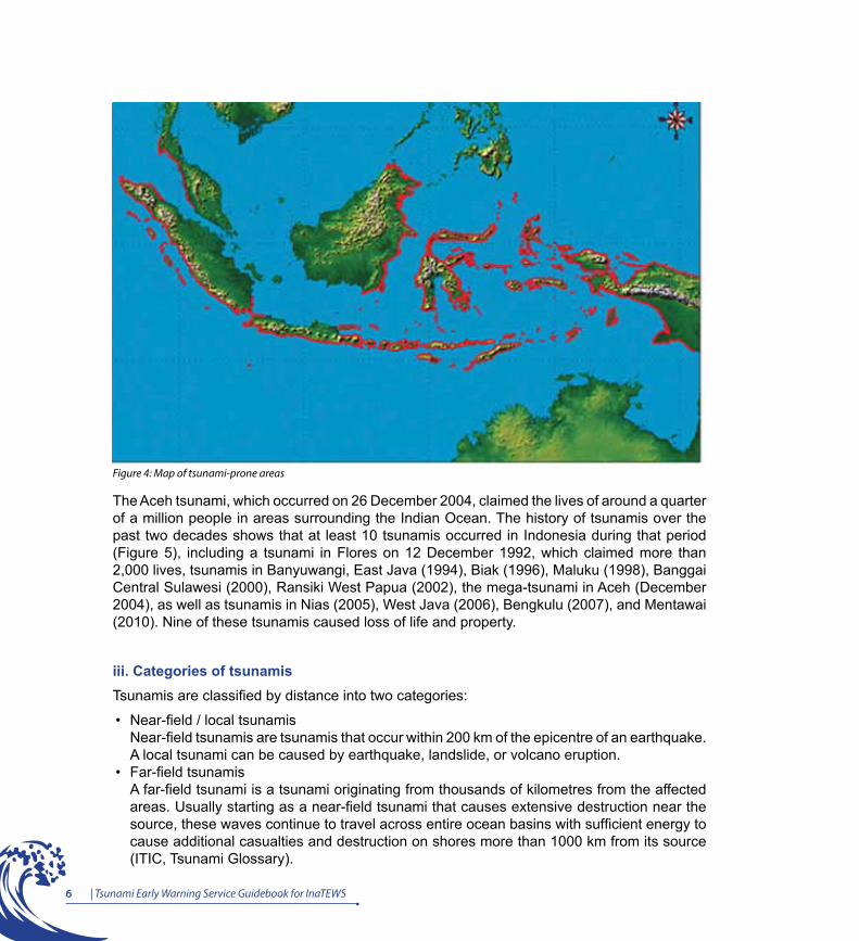
Indonesia is prone to tsunamis, particularly those islands that are directly adjacent to the boundaries of the Eurasian, Indo-Australian and Pacific Plates, including the western part of Sumatra, the southern part of Java, Nusa Tenggara, the northern parts of Papua, Sulawesi and Maluku, and the eastern part of Kalimantan (Figure 4).
6 | Tsunami Early Warning Service Guidebook for InaTEWS
Figure 4: Map of tsunami-prone areas
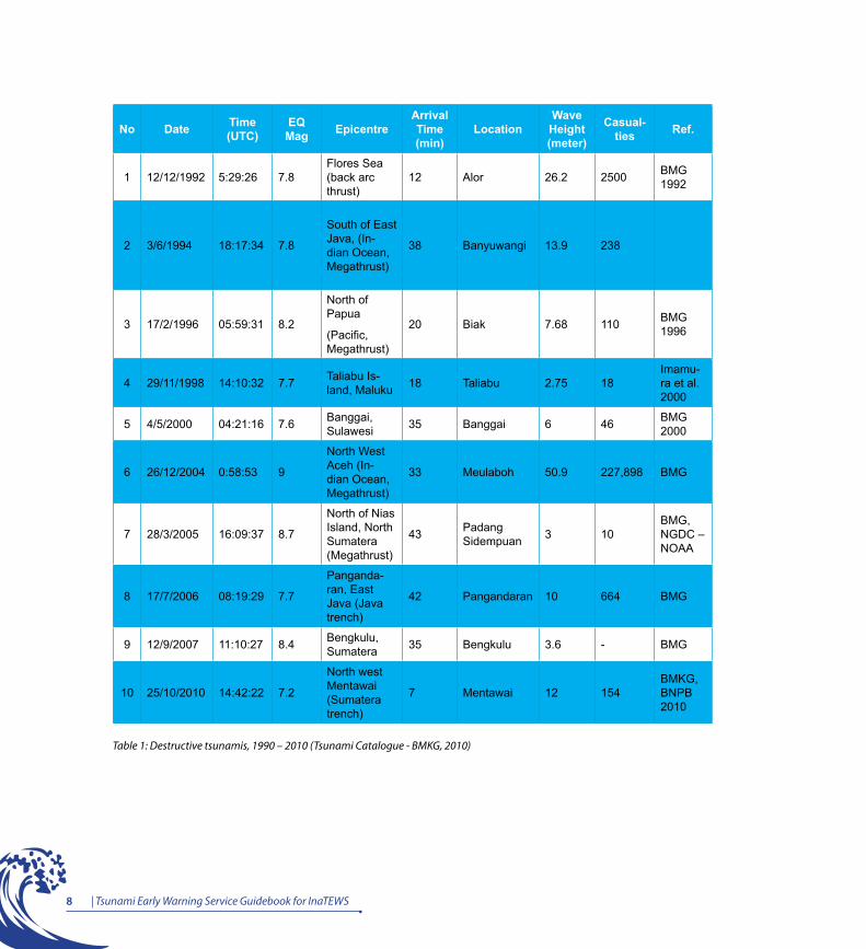
The Aceh tsunami, which occurred on 26 December 2004, claimed the lives of around a quarter of a million people in areas surrounding the Indian Ocean. The history of tsunamis over the past two decades shows that at least 10 tsunamis occurred in Indonesia during that period (Figure 5), including a tsunami in Flores on 12 December 1992, which claimed more than 2,000 lives, tsunamis in Banyuwangi, East Java (1994), Biak (1996), Maluku (1998), Banggai Central Sulawesi (2000), Ransiki West Papua (2002), the mega-tsunami in Aceh (December 2004), as well as tsunamis in Nias (2005), West Java (2006), Bengkulu (2007), and Mentawai (2010). Nine of these tsunamis caused loss of life and property.
iii. Categories of tsunamisTsunamis are classified by distance into two categories:
• Near-field / local tsunamis Near-field tsunamis are tsunamis that occur within 200 km of the epicentre of an earthquake. A local tsunami can be caused by earthquake, landslide, or volcano eruption.
• Far-field tsunamisA far-field tsunami is a tsunami originating from thousands of kilometres from the affected areas. Usually starting as a near-field tsunami that causes extensive destruction near the source, these waves continue to travel across entire ocean basins with sufficient energy to cause additional casualties and destruction on shores more than 1000 km from its source (ITIC, Tsunami Glossary).
7Indonesia is Prone to Local Tsunamis |
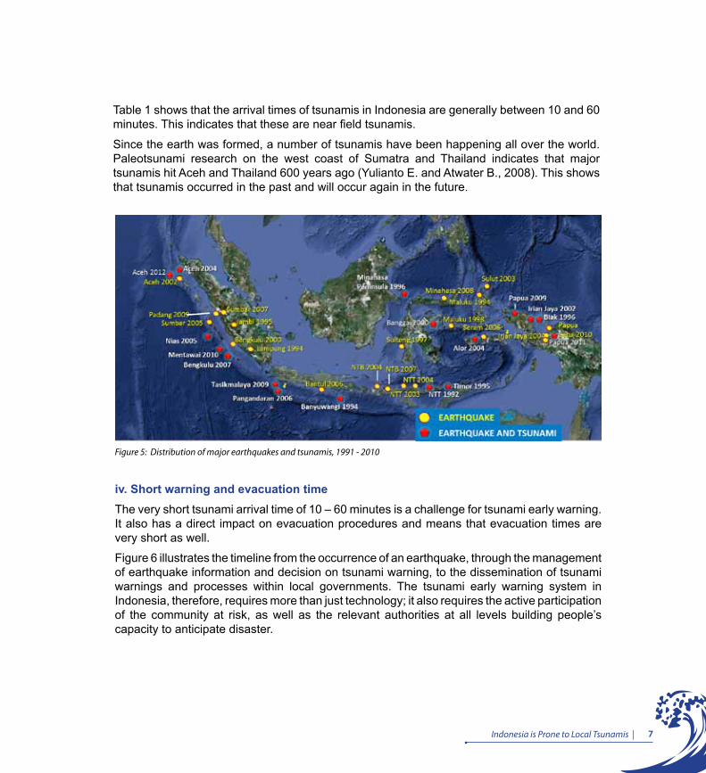
Figure 5: Distribution of major earthquakes and tsunamis, 1991 - 2010
Table 1 shows that the arrival times of tsunamis in Indonesia are generally between 10 and 60 minutes. This indicates that these are near field tsunamis.
Since the earth was formed, a number of tsunamis have been happening all over the world. Paleotsunami research on the west coast of Sumatra and Thailand indicates that major tsunamis hit Aceh and Thailand 600 years ago (Yulianto E. and Atwater B., 2008). This shows that tsunamis occurred in the past and will occur again in the future.
iv. Short warning and evacuation time The very short tsunami arrival time of 10 – 60 minutes is a challenge for tsunami early warning. It also has a direct impact on evacuation procedures and means that evacuation times are very short as well.
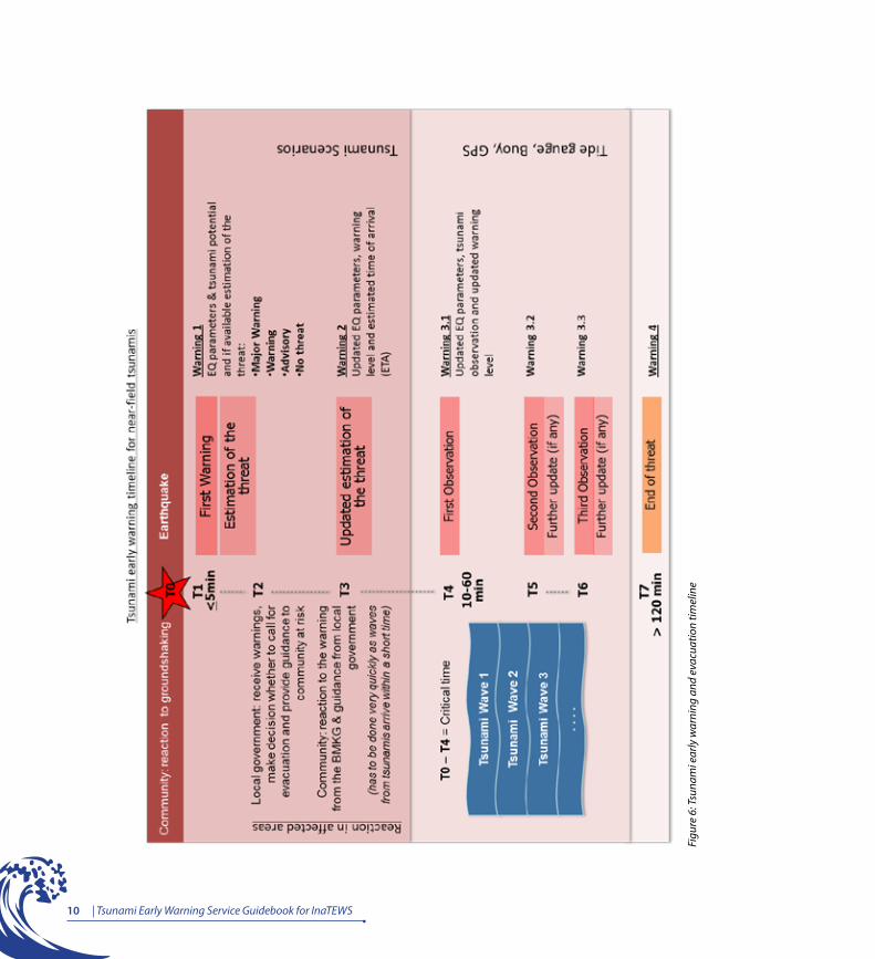
Figure 6 illustrates the timeline from the occurrence of an earthquake, through the management of earthquake information and decision on tsunami warning, to the dissemination of tsunami warnings and processes within local governments. The tsunami early warning system in Indonesia, therefore, requires more than just technology; it also requires the active participation of the community at risk, as well as the relevant authorities at all levels building people’s capacity to anticipate disaster.
8 | Tsunami Early Warning Service Guidebook for InaTEWS
No Date Time (UTC)
EQ Mag Epicentre
Arrival Time (min)
LocationWave Height (meter)
Casual-ties Ref.
1 12/12/1992 5:29:26 7.8Flores Sea (back arc thrust)
12 Alor 26.2 2500 BMG 1992
2 3/6/1994 18:17:34 7.8
South of East Java, (In-dian Ocean, Megathrust)
38 Banyuwangi 13.9 238
3 17/2/1996 05:59:31 8.2
North of Papua
(Pacific, Megathrust)
20 Biak 7.68 110 BMG 1996
4 29/11/1998 14:10:32 7.7 Taliabu Is-land, Maluku 18 Taliabu 2.75 18
Imamu-ra et al. 2000
5 4/5/2000 04:21:16 7.6 Banggai, Sulawesi 35 Banggai 6 46 BMG
2000
6 26/12/2004 0:58:53 9
North West Aceh (In-dian Ocean, Megathrust)
33 Meulaboh 50.9 227,898 BMG
7 28/3/2005 16:09:37 8.7
North of Nias Island, North Sumatera (Megathrust)
43 Padang Sidempuan 3 10
BMG, NGDC – NOAA
8 17/7/2006 08:19:29 7.7
Panganda-ran, East Java (Java trench)
42 Pangandaran 10 664 BMG
9 12/9/2007 11:10:27 8.4 Bengkulu, Sumatera 35 Bengkulu 3.6 - BMG
10 25/10/2010 14:42:22 7.2
North west Mentawai (Sumatera trench)
7 Mentawai 12 154BMKG, BNPB 2010
Table 1: Destructive tsunamis, 1990 – 2010 (Tsunami Catalogue - BMKG, 2010)
9Indonesia is Prone to Local Tsunamis |
A tsunami early warning system can achieve its main goal - to save people’s lives and livelihoods, and to reduce injury and damage - only if the proper procedures governing the processing of earthquake information and the dissemination of tsunami warnings are followed; and only if local governments receive warnings in a timely fashion and then proceed to provide prompt guidance, to ensure that the evacuation of affected communities, if required, is performed as quickly as possible when ordered by the local authorities.
For further explanation of the tsunami early warning timeline as shown in Figure 6, see Principle 5.
10 | Tsunami Early Warning Service Guidebook for InaTEWS
Figu
re 6
: Tsu
nam
i ear
ly w
arni
ng a
nd e
vacu
atio
n tim
elin
e

Principle 2InaTEWS – Indonesia Tsunami Early Warning System and Community Empowerment
Early warning is a combination of technology and community capacity that responds to information provided by the technology. As a component of disaster risk reduction, early warning requires not only the production of timely, technically accurate warnings but also an understanding of risk, a reliable link between providers and users of warnings and the capacity, on the part of communities and authorities, to respond appropriately to warnings. A failure in any one of these elements can mean the failure of the whole warning system.
“
“

13InaTEWS - Indonesia Tsunami Early Warnng System and Community Empowerment |
Principle 2InaTEWS – Indonesia Tsunami Early Warning System and Community Empowerment“Early warning is a combination of technology and community capacity that responds to information provided by the technology. As a component of disaster risk reduction, early warning requires not only the production of timely, technically accurate warnings but also an understanding of risk, a reliable link between providers and users of warnings, and the capacity, on the part of communities and authorities, to respond appropriately to warnings. A failure in any one of these elements can mean the failure of the whole warning system.”
i. The objective of a People - Centred Early Warning System“People-centred early warning suggests that rather than being vulnerable, people can be capable, resilient and able to protect themselves” (IFRC, 2009). The main objective of a people-centred early warning system is “to enable individuals, communities and organizations threatened by a hazard to prepare and to act appropriately and in sufficient time to reduce the possibility of harm or loss” (UNISDR, 2006).
In the context of mitigating disaster risk in communities, an early warning system like InaTEWS must produce and disseminate accurate and scientifically valid warnings. However, the system is considered effective and successful only if the warnings produced are able to trigger appropriate reactions and people are able to save themselves before the tsunami waves reach the shore. Therefore, early warning is about more than just early warning technology.
ii. Active involvement of the community and authorities in the area at risk: from risk assessment to preparedness
For early warning to be effective, the early warning system requires the active involvement of both the community in the risk area and the authorities at all levels in building their capacity to react. Disaster risk, which results from natural hazards and community vulnerabilities, needs to be analysed, understood and communicated to the public. Participatory risk assessment and public education are vital to building a community’s awareness of the risks that it is facing. Preparedness is also needed to ensure that people know how to receive early warnings and react appropriately to these warnings, both from nature and from official sources. Only then can the early warning system achieve its main goal, which is to save people’s lives and prevent injury and damage.
iii. Institutional requirements for an effective early warning systemEarly warning and risk reduction are the responsibility of government, and necessarily require an effective management structure and solid institutional regulations. A sound legal framework, adequate planning and funding, and political commitment at all levels form the foundation for an effective warning system.
14 Tsunami Early Warning Service Guidebook for InaTEWS
iv. Multi-sector, multi-discipline involvementVertical and horizontal information exchange and coordination among stakeholders in InaTEWS form a key step towards building a consistent warning system. Early warning systems are complex and require collaboration among many sectors and disciplines, including natural and social sciences, engineering, public administration and service delivery, disaster management, mass media and the public. Therefore, developing and maintaining a warning system demands the contribution and coordination of a broad range and large number of individuals and institutions. Without the involvement of all these stakeholders, such as government authorities and institutions from various sectors at all levels, the community at risk, NGOs, and the private sector, the early warning system will not be effective. Whether or not a warning reaches those in an area at risk largely depends on whether all the stakeholders in the warning communication chain are aware of, and are able to carry out, their roles and responsibilities. In the next chapter, Principle 3 identifies the stakeholders in the tsunami-warning communication chain and discusses their roles and responsibilities in InaTEWS.
v. The four main elements of an early warning systemBased on worldwide experiences of early warning, international disaster management academics and practitioners attending three global conferences on early warning (in 1998, 2003 and 2006) agreed that there are four distinct but interconnected essential elements to a comprehensive and effective people-centred early warning system. These elements are: risk knowledge, risk monitoring and warning service, dissemination and communication, and response capability (UNISDR, 2006). Figure 7 shows these four elements and how they relate to the principles discussed in this book.
15InaTEWS - Indonesia Tsunami Early Warnng System and Community Empowerment |
Figu
re 7
: The
Fou
r Ele
men
ts o
f Peo
ple
- Cen
tred
Ear
ly w
War
ning

Principle 3Roles and Responsibilities of Institutions and Communities in the Tsunami Early Warning Communication Chain
The BMKG provides earthquake information and tsunami warnings to BNPB, local governments and the media. Local governments are responsible for guiding their communities’ reaction to this information and for deciding whether or not to call for evacuation.
““

19Roles and Responsibilities of Institutions and Communities in the Tsunami Early Warning System Communication Chain |
The tsunami early warning communication chain allows for the dissemination of prompt and effective tsunami early warnings and guidance. These warnings and guidance are issued by recognised agencies using the agreed channels of communication to allow the community exposed to the tsunami risk to react appropriately and, if necessary, to evacuate the area at risk and save themselves before the tsunami reaches the shore. This chain links the National Tsunami Early Warning Centre to communities at risk along the tsunami-prone coasts of Indonesia.
The agencies that play a role in the InaTEWS tsunami early warning communication chain are:
• The Meteorological, Climatological and Geophysical Agency (Badan Meteorologi, Klimatologi dan Geofisika – BMKG), with its head office in Jakarta, which hosts the National Tsunami Warning Centre
• Local governments at provincial, district and municipal levels • National and local television and radio stations (public and commercial) • The National Disaster Management Agency (Badan Nasional Penanggulangan Bencana
– BNPB)• The Indonesian Military• The National Indonesian Police• Communities at risk• Cellular service providers• Managers of hotels/tourist sites
These institutions that play a role in the early warning chain are obliged to immediately confirm (manually) that they have received early warning messages sent by BMKG.
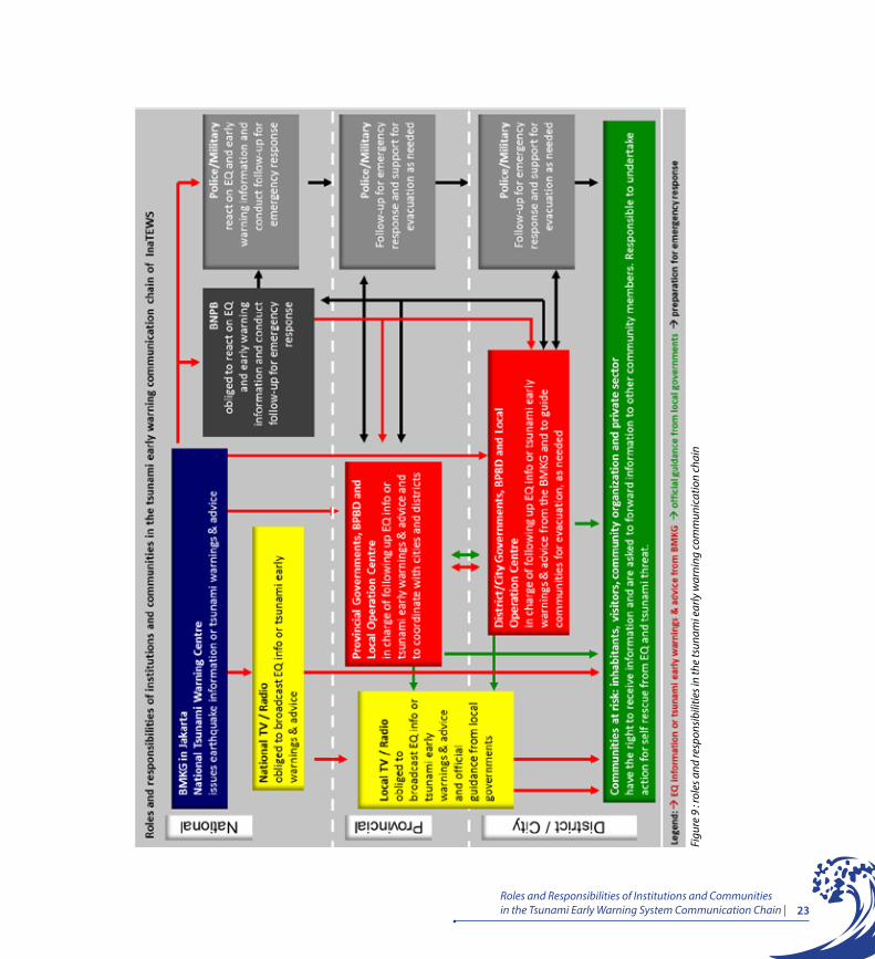
Each has specific roles and responsibilities in the tsunami early warning communication chain (see also Figure 9):
Principle 3Roles and Responsibilities of Institutions and Communities in the Tsunami Early Warning Communication Chain
“The BMKG provides earthquake information and tsunami warnings to BNPB, local governments and the media. Local governments are responsible for guiding their communities’ reaction to this information and for deciding whether or not to call for evacuation.”
20 | Tsunami Early Warning Service Guidebook for InaTEWS
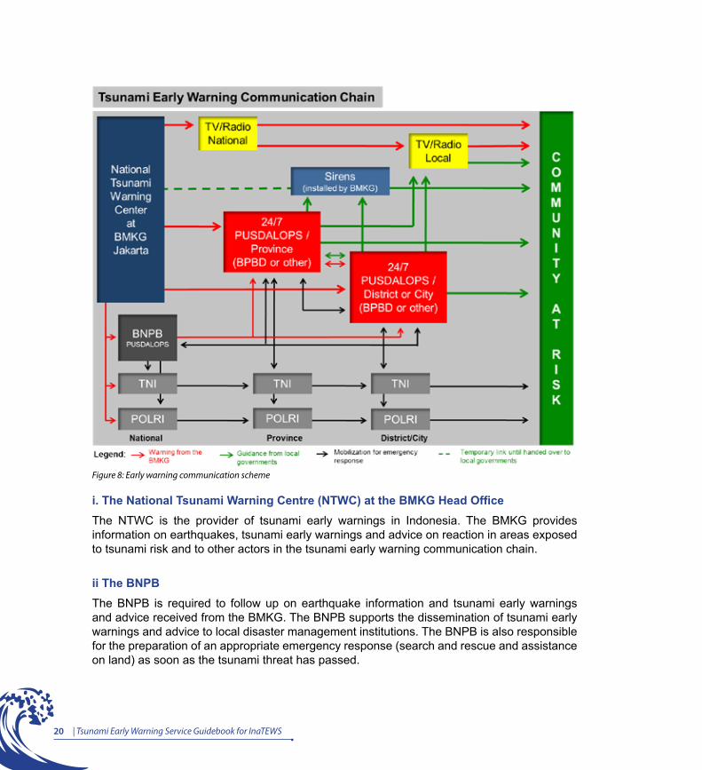
Figure 8: Early warning communication scheme
i. The National Tsunami Warning Centre (NTWC) at the BMKG Head OfficeThe NTWC is the provider of tsunami early warnings in Indonesia. The BMKG provides information on earthquakes, tsunami early warnings and advice on reaction in areas exposed to tsunami risk and to other actors in the tsunami early warning communication chain.
ii The BNPB The BNPB is required to follow up on earthquake information and tsunami early warnings and advice received from the BMKG. The BNPB supports the dissemination of tsunami early warnings and advice to local disaster management institutions. The BNPB is also responsible for the preparation of an appropriate emergency response (search and rescue and assistance on land) as soon as the tsunami threat has passed.
21Roles and Responsibilities of Institutions and Communities in the Tsunami Early Warning System Communication Chain |
iii. Local governments Local governments are required to act on earthquake information and tsunami early warnings and advice issued by the BMKG. Local government is the only actor in the tsunami early warning communication chain that has the authority and responsibility to make the decision on, and to officially announce, an evacuation status based on information from the BMKG. Pursuant to Articles 46 and 47 of Law 24/2007, Article 19 of Government Regulation 21/2008, and Chapter 2 of the Decree by the Head of the BNPB 3/2008, local governments are responsible for issuing immediate public announcements containing clear directions and instructions to help the inhabitants of, and visitors to, an area react quickly and appropriately to a tsunami threat.
iv. The Indonesian MilitaryThe Indonesian Military is required to follow up on earthquake information and tsunami early warnings and advice received from the BMKG. The military has a role in disseminating earthquake information and tsunami early warnings at the local level. If an evacuation is announced, the military can help to evacuate people. The military is required to make preparations for an emergency response (search and rescue and assistance on land) as soon as the tsunami threat has passed.
v. The national Indonesian PoliceThe Indonesian Police are required to follow up on earthquake information and tsunami early warnings and advice received from BMKG. The police have a role in disseminating earthquake information and tsunami early warnings at the local level. If an evacuation is announced, the police can help to evacuate people. The police are required to make preparations for an emergency response (search and rescue and assistance on land) as soon as the tsunami threat has passed.
vi. Television and radio stations National and local television and radio stations (commercial and public) are required to broadcast earthquake information and tsunami early warnings from the NTWC and guidance from local government, pursuant to Article 34 of Law 31/2009 and Articles 1 to 6 of the Decree by the Minister of Communications and Information 20/2006. Television and radio stations form the actor in the tsunami early warning communication chain that has direct, rapid and nationwide access to the public. Television and radio stations are required to immediately interrupt programs to broadcast tsunami early warnings and advice from the NTWC to viewers and listeners.
22 | Tsunami Early Warning Service Guidebook for InaTEWS
vii. Communities at risk Communities at risk are entitled to accurate information about the tsunami risk and instructive guidance to allow them to respond appropriately and quickly. Communities are responsible for making the necessary preparations to save themselves from earthquake and tsunami risks. Individuals and community organisations are responsible for passing on accurate information and guidance to others. Community organisations, such as the Indonesian Amateur Radio Organisation (Organisasi Amatir Radio Indonesia – ORARI), Indonesian Citizens’ Band Radio (Radio Antar Penduduk Indonesia – RAPI) and Search and Rescue (SAR), play a role in disseminating earthquake information and tsunami early warnings and guidance.
viii. Cellular service providersCellular service providers comprise one part of the earthquake information and tsunami early warning dissemination chain using the mode of short message service (SMS). Cellular service providers are obliged to forward information on earthquakes and tsunami early warnings from the BMKG to the selected and previously registered handphone users. These cellular service providers give higher priority to the delivery of SMS from the BMKG as opposed to general SMS, such as individual/personal SMS. In a situation where the traffic of SMS message is high, SMS-es from the BMKG are given precedence in the queue for sending to registered users. In addition, cellular service providers must keep their service operating in good condition. All these services are provided free of charge.
ix. Hotel managers The managers of hotels are obliged to protect the guests staying in their hotels,visitors to their hotels and are encouraged to care for the members of the public located around the hotels. Hotel managers have the responsibility to prepare all procedures and action plans for earthquake and tsunami emergencies via the following steps: create a receiving mechanism for early warnings from the BMKG, Pusdalops or the BPBD; provide complete information to guests on the steps that must be taken in the event of a tsunami emergency; prepare a temporary evacuation site together with evacuation route signs both inside and outside the hotel building. (If evacuating inside, a hotel must meet the requirements of earthquake- and tsunami-resistant structures and it must be on higher ground than the estimated height of tsunami waves in the given area). When hotel guests have to evacuate to a place outside the hotel, the manager is obliged to provide guests with detailed information on the location of the temporary evacuation site and he/she must guide them to the evacuation site at the time of a tsunami emergency.
23Roles and Responsibilities of Institutions and Communities in the Tsunami Early Warning System Communication Chain |
Figu
re 9
: rol
es a
nd re
spon
sibi
litie
s in
the
tsun
ami e
arly
war
ning
com
mun
icat
ion
chai
n

Principle 4Instruments for Earthquake and Tsunami Observation
“There are three kinds of observation instruments, seismograph for earthquake observation, GPS for earth plate deformation observation, and tide gauges, buoy, CCTV and tsunami radar for tsunami observation.Through communication networks, data from these instruments are sent to the BMKG to be processed and used as the basis for developing tsunami threat scenarios.
““


27Intruments for Earthquake and Tsunami Observation |
i. InaTEWS DesignThe Indonesian Tsunami Early Warning System (InaTEWS) is the only official tsunami early warning system in Indonesia and, as such, all regions are required to adapt to this system. Pursuant to Law 31/2009, only the BMKG has the authority to issue tsunami early warnings.
InaTEWS has two monitoring systems, namely:
1. Land monitoring system comprising the broadband seismometer network and GPS
2. Sea monitoring system consisting of tide gauges, buoys, CCTV, tsunami radar and under-the-sea cable (the last two are currently at development stage). The observation results are sent to BMKG mainly using satellite-based communication system.
Principle 4Instruments for Earthquake and Tsunami Observation
“There are three kinds of observation instruments, seismograph for earthquake observation, GPS for earth plate deformation observation, and tide gauge, buoy, CCTV and tsunami radar for tsunami obervation. Through communication networks, data from these instruments are sent to the BMKG to be processed and used as the basis for developing threat scenarios.”
Figure 10: InaTEWS design

28 | Tsunami Early Warning Service Guidebook for InaTEWS
Figure 11: Seismometer and seismogram
BMKG operates the network of seismometers, accelerometers, CCTV and, in the future, tsunami radars. The National Survey and Mapping Coordination Agency (BAKOSURTANAL / BIG) operates the network of GPS and tide gauges. The Agency for the Assessment and Application of Technology (BPPT) operates the network of buoys and under-the-sea cable. The Ministry of Fisheries and Marine Affairs (KKP) operates tsunami radars. Until now the tsunami early warning is issued by BMKG within 5 minutes after the earthquake based on the network of broadband seismometers and accelerometers, combined with modeling results. In the future, the GPS network can possibly improve the accuracy of seismic results. Meanwhile the sea monitoring network is used to confirm the occurrence of tsunami, its movement as well as its height.
ii. Instruments for earthquake observationThe main instruments of InaTEWS to observe earthquake are the seismometer network and SeisComP3 software. Both these two instruments are used to gather and process initial data of earthquake parameter which serve as the main data to generate tsunami warnings.
Seismometer Network
More than 90% of tsunamis are triggered by strong, shallow earthquakes. Therefore, earthquake observation plays the main role in the tsunami early warning system. However, not all earthquakes trigger tsunamis. Earthquakes have the potential to trigger tsunamis if they are located under the sea at a depth of less than 100 km and of a magnitude of 7 or more on the Richter Scale and are associated with a vertical movement of the surface of the earth. The last criterion is currently not yet considered when BMKG issues tsunami warnings.
29Intruments for Earthquake and Tsunami Observation |
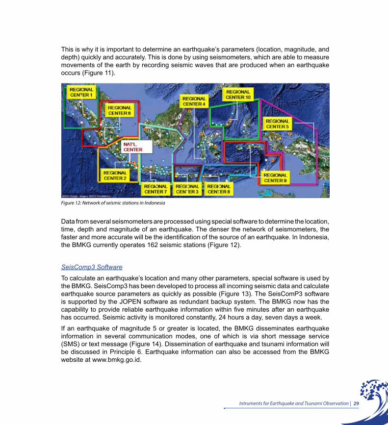
Figure 12: Network of seismic stations in Indonesia
This is why it is important to determine an earthquake’s parameters (location, magnitude, and depth) quickly and accurately. This is done by using seismometers, which are able to measure movements of the earth by recording seismic waves that are produced when an earthquake occurs (Figure 11).
Data from several seismometers are processed using special software to determine the location, time, depth and magnitude of an earthquake. The denser the network of seismometers, the faster and more accurate will be the identification of the source of an earthquake. In Indonesia, the BMKG currently operates 162 seismic stations (Figure 12).
SeisComp3 Software
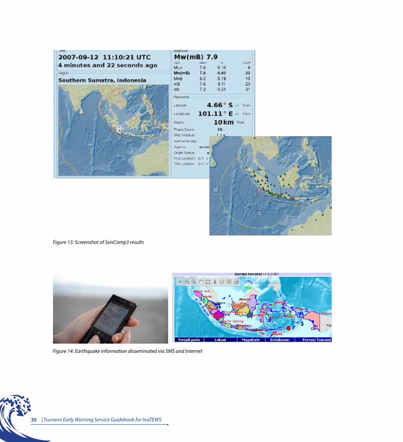
To calculate an earthquake’s location and many other parameters, special software is used by the BMKG. SeisComp3 has been developed to process all incoming seismic data and calculate earthquake source parameters as quickly as possible (Figure 13). The SeisComP3 software is supported by the JOPEN software as redundant backup system. The BMKG now has the capability to provide reliable earthquake information within five minutes after an earthquake has occurred. Seismic activity is monitored constantly, 24 hours a day, seven days a week.
If an earthquake of magnitude 5 or greater is located, the BMKG disseminates earthquake information in several communication modes, one of which is via short message service (SMS) or text message (Figure 14). Dissemination of earthquake and tsunami information will be discussed in Principle 6. Earthquake information can also be accessed from the BMKG website at www.bmkg.go.id.
30 | Tsunami Early Warning Service Guidebook for InaTEWS
Figure 14: Earthquake information disseminated via SMS and Internet
Figure 13: Screenshot of SeisComp3 results
31Intruments for Earthquake and Tsunami Observation |
As explained previously, not all earthquakes trigger tsunami waves. The criteria for an earthquake capable of triggering a tsunami are:
a. Large magnitude earthquake, usually of M > 7 RS
b. Undersea earthquake with a shallow depth (< 100 km)
c. Deformation or uplift of the sea floor, which is evident from a normal fault or thrust fault earthquake mechanism
d. Distance from the earthquake epicentre to the shore sufficient to allow a tsunami wave to form. If an earthquake occurs close to the shore, the likelihood of it triggering a tsunami is small, although the impact of the earthquake may be large. The depth of water plays a pivotal role.
When an earthquake’s parameters match the criteria for an earthquake that could potentially trigger a tsunami, the earthquake information will be followed by a tsunami warning. However, even if an earthquake meets the parameters (location, depth and magnitude) that could potentially trigger a tsunami, it does not necessarily mean that a tsunami will occur.
So, a second component of InaTEWS is designed to monitor the surface of the sea to confirm the formation of a tsunami. Several instruments are used for this, including buoys, which monitor changes in the surface of the sea water; tide gauges, which monitor changes in the water’s surface at the shore; CCTV which observe tsunami arrival in the beach; and tsunami radar which expected to be able to detect tsunami waves 150km away from the beach (where the instrument is placed).
iii. Instruments for tsunami observation
Buoy Network
A buoy is an instrument that measures the height of tsunamis offshore. It is also known as a tsunameter (Figure 15). It consists of two separate parts, one of which, called an Ocean Bottom Unit (OBU), is positioned on the ocean floor. This unit is able to detect changes in water pressure when a tsunami wave passes. When it detects a tsunami wave, the OBU sends data to the buoy floating nearby on the surface. This buoy is the other component of the tsunameter and measures fluctuations in the level of the water’s surface. It also sends data from the OBU via satellite to the control centre at the BPPT to be forwarded to the BMKG. In addition, the buoy is fitted with a high-precision GPS unit, which measures movements on the surface of the sea and is able to detect passing tsunami waves.

32 | Tsunami Early Warning Service Guidebook for InaTEWS
Figure 16: Tide gauge station
Figure 15: Ocean Bottom Unit (OBU) and buoy
When a tsunami occurs, this instrument will simultaneously record the tsunami wave and transmit the data. The data from the buoy is used to determine that a tsunami has been generated. The BPPT operates the research vessel Baruna Jaya for the installation, maintenance and relocation of buoys. So far, the buoy system in Indonesia still faces a lot of challenges in the field.
Tide Gauge Network A tide gauge is an instrument for measuring ocean tides (Figure 16). A tsunami causes an anomalous change on the surface of the sea water, which is recorded on a tide gauge. This instrument is positioned on the shore confirming that the tsunami has arrived onshore or that the tsunami has subsided.

33Intruments for Earthquake and Tsunami Observation |
Figure 17: Network of tide gauge stations
The tide gauges are operated by the National Survey and Mapping Coordination Agency (BAKOSURTANAL / BIG) but real-time data is also directed to the BMKG, where the information is analyzed to verify that a tsunami has arrived on the shore. BAKOSURTANAL / BIG is responsible for the installation and operation of tide gauges and the GPS networks.
CCTV NetworkCCTV (Closed Circuit Television) is a digital video camera that is used to send signals to a display monitor in a room or predetermined place. CCTV is often used to observe public areas, such as train stations, roads, town squares, shops and buses, banks, hotels, airports, military storerooms, factories and warehouses. Nowadays, CCTV is also used to protect people’s homes.
Figure 18: CCTV cameras fitted for tsunami monitoring
34 | Tsunami Early Warning Service Guidebook for InaTEWS
InaTEWS uses CCTV to monitor the arrival of a tsunami. Once CCTV has been fitted in areas exposed to tsunamis, an incoming tsunami can be detected by pictures that are sent real time. Currently, five online CCTV cameras have been installed, which send pictures to the Tsunami Early Warning Center in Jakarta. Four of these cameras are located in Bali at Benoa Beach, Kuta Beach, Sanur Beach and Seminyak, while the fifth camera is in Simpang Layang, Banda Aceh (NAD).
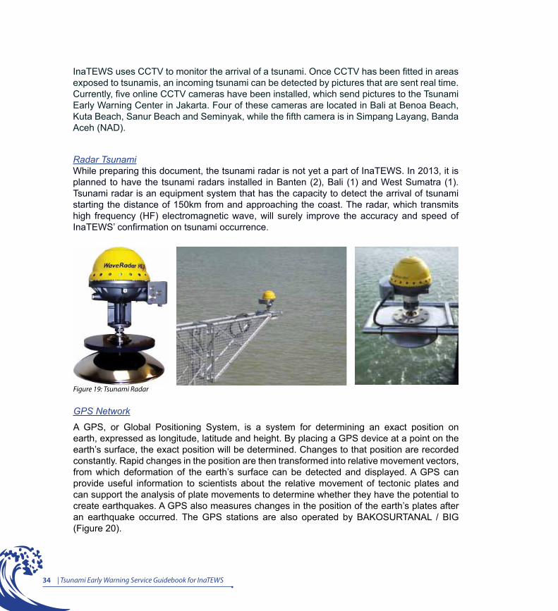
Radar TsunamiWhile preparing this document, the tsunami radar is not yet a part of InaTEWS. In 2013, it is planned to have the tsunami radars installed in Banten (2), Bali (1) and West Sumatra (1). Tsunami radar is an equipment system that has the capacity to detect the arrival of tsunami starting the distance of 150km from and approaching the coast. The radar, which transmits high frequency (HF) electromagnetic wave, will surely improve the accuracy and speed of InaTEWS’ confirmation on tsunami occurrence.
Figure 19: Tsunami Radar
GPS Network
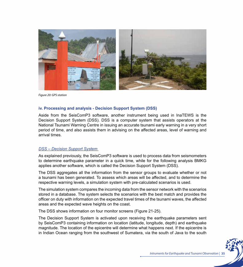
A GPS, or Global Positioning System, is a system for determining an exact position on earth, expressed as longitude, latitude and height. By placing a GPS device at a point on the earth’s surface, the exact position will be determined. Changes to that position are recorded constantly. Rapid changes in the position are then transformed into relative movement vectors, from which deformation of the earth’s surface can be detected and displayed. A GPS can provide useful information to scientists about the relative movement of tectonic plates and can support the analysis of plate movements to determine whether they have the potential to create earthquakes. A GPS also measures changes in the position of the earth’s plates after an earthquake occurred. The GPS stations are also operated by BAKOSURTANAL / BIG (Figure 20).
35Intruments for Earthquake and Tsunami Observation |
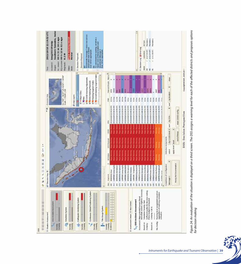
iv. Processing and analysis - Decision Support System (DSS)Aside from the SeisComP3 software, another instrument being used in InaTEWS is the Decision Support System (DSS). DSS is a computer system that assists operators at the National Tsunami Warning Centre in issuing an accurate tsunami early warning in a very short period of time, and also assists them in advising on the affected areas, level of warning and arrival times.
DSS – Decision Support System
As explained previously, the SeisComP3 software is used to process data from seismometers to determine earthquake parameter in a quick time, while for the following analysis BMKG applies another software, which is called the Decision Support System (DSS).
The DSS aggregates all the information from the sensor groups to evaluate whether or not a tsunami has been generated. To assess which areas will be affected, and to determine the respective warning levels, a simulation system with pre-calculated scenarios is used.
The simulation system compares the incoming data from the sensor network with the scenarios stored in a database. The system selects the scenarios with the best match and provides the officer on duty with information on the expected travel times of the tsunami waves, the affected areas and the expected wave heights on the coast.
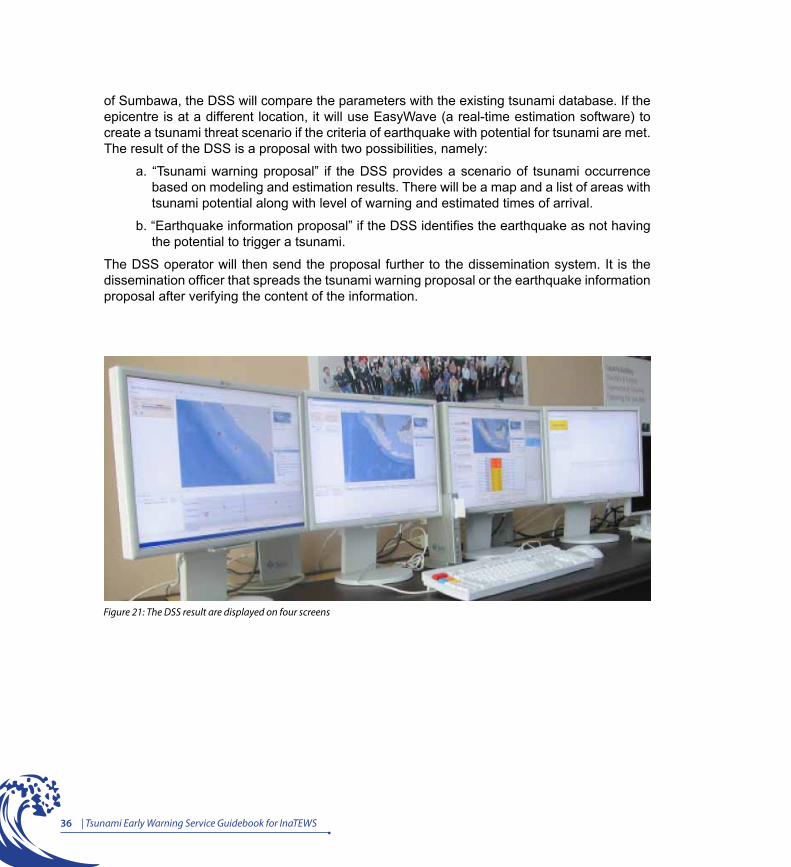
The DSS shows information on four monitor screens (Figure 21-25).
The Decision Support System is activated upon receiving the earthquake parameters sent by SeisComP3 containing information on location (latitude, longitude, depth) and earthquake magnitude. The location of the epicentre will determine what happens next. If the epicentre is in Indian Ocean ranging from the southwest of Sumatera, via the south of Java to the south
Figure 20: GPS station
36 | Tsunami Early Warning Service Guidebook for InaTEWS
Figure 21: The DSS result are displayed on four screens
of Sumbawa, the DSS will compare the parameters with the existing tsunami database. If the epicentre is at a different location, it will use EasyWave (a real-time estimation software) to create a tsunami threat scenario if the criteria of earthquake with potential for tsunami are met. The result of the DSS is a proposal with two possibilities, namely:
a. “Tsunami warning proposal” if the DSS provides a scenario of tsunami occurrence based on modeling and estimation results. There will be a map and a list of areas with tsunami potential along with level of warning and estimated times of arrival.
b. “Earthquake information proposal” if the DSS identifies the earthquake as not having the potential to trigger a tsunami.
The DSS operator will then send the proposal further to the dissemination system. It is the dissemination officer that spreads the tsunami warning proposal or the earthquake information proposal after verifying the content of the information.
37Intruments for Earthquake and Tsunami Observation |
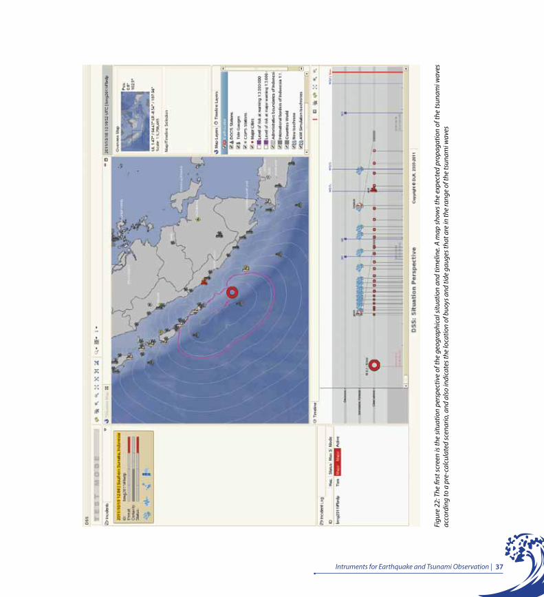
Figu
re 2
2: T
he fi
rst s
cree
n is
the
situ
atio
n pe
rspe
ctiv
e of
the
geog
raph
ical
situ
atio
n an
d tim
elin
e. A
map
show
s the
exp
ecte
d pr
opag
atio
n of
the
tsun
ami w
aves
ac
cord
ing
to a
pre
-cal
cula
ted
scen
ario
, and
als
o in
dica
tes t
he lo
catio
n of
buo
ys a
nd ti
de g
auge
s tha
t are
in th
e ra
nge
of th
e ts
unam
i wav
es

38 | Tsunami Early Warning Service Guidebook for InaTEWS
Figu
re 2
3: A
seco
nd sc
reen
pro
vide
s mor
e de
taile
d in
form
atio
n fro
m in
com
ing
mea
sure
men
ts o
f the
diff
eren
t sen
sors
as w
ell a
s sim
ulat
ion
data
39Intruments for Earthquake and Tsunami Observation |
Figu
re 2
4: A
n ev
alua
tion
of th
e si
tuat
ion
is d
ispl
ayed
on
a th
ird sc
reen
. The
DSS
ass
igns
a w
arni
ng le
vel f
or e
ach
of th
e aff
ecte
d di
stric
ts a
nd p
ropo
ses o
ptio
ns
for d
ecis
ion
mak
ing
40 | Tsunami Early Warning Service Guidebook for InaTEWS
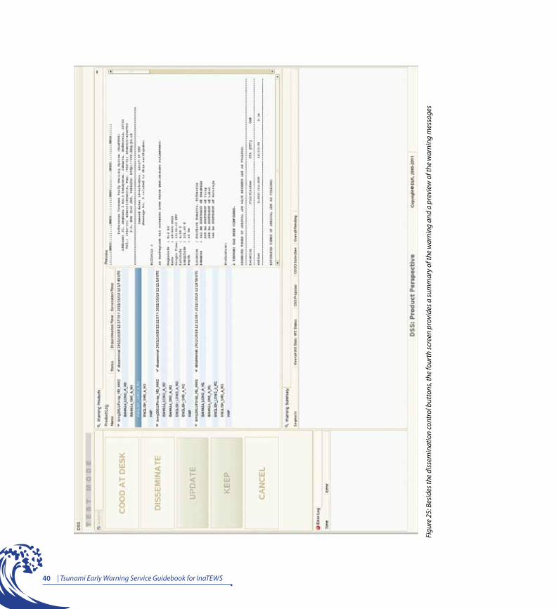
Figu
re 2
5: B
esid
es th
e di
ssem
inat
ion
cont
rol b
utto
ns, t
he fo
urth
scre
en p
rovi
des a
sum
mar
y of
the
war
ning
and
a p
revi
ew o
f the
war
ning
mes
sage
s

Principle 5Sequence and Contents of Tsunami Warnings
The BMKG publishes earthquake information or tsunami warnings five minutes after an earthquake, which are followed by several updates and/or an all-clear message. The warning messages contain the tsunami threat level by district: ‘Major Warning’ (Awas), ‘Warning’ (Siaga) and ’Advisory’ (Waspada). “
“
43Sequence and Contents of Tsunami Warnings |
Principle 5Sequence and Contents of Tsunami Warnings
“The BMKG publishes earthquake information or tsunami warnings five minutes after an earthquake, which are followed by several updates and/or an all-clear message. The warning messages contain the tsunami threat level by district: ‘Major Warning’ (Awas), ‘Warning’ (Siaga) and ’Advisory’ (Waspada).’.”
i. InaTEWS warning sequenceFrom the time an earthquake happens until the tsunami threat ends, the BMKG will issue four types of warnings:
1. Warning 1: Disseminated based on earthquake parameters and the estimated impact of the tsunami reflected by warning level (Major Warning - Awas, Warning - Siaga or Advisory - Waspada) for every affected district.
2. Warning 2: Contains updated earthquake parameters and, in addition to the warning levels in Warning 1, also the tsunami wave’s estimated time of arrival (ETA) on shore.
3. Warning 3: Contains tsunami observation information, updated warning levels and tsunami arrival times, which may be disseminated several times depending on the tsunami observations at the tide gauge stations, the buoys, the CCTVs, and the tsunami radars.
4. Warning 4: Announces that tsunami early warning has ended (end of threat).
Following is an explanation of the sequence and types of tsunami early warning messages that are issued and the expected reaction by local governments and communities at risk
T0 – T1:When an earthquake occurs (T0), all the earthquake recording sensors at the seismic stations around the earthquake source region will record earthquake data and transmit the data to the NTWC at the BMKG for processing. For earthquakes in Indonesia, this takes less than 5 minutes (T0-T1).
At the BMKG’s NTWC, the automatic seismic-data processing system calculates earthquake parameters. The SeisComP3 operator then checks the results of the automatic processing and applies corrections interactively to increase the accuracy of the earthquake’s parameters. At that time, the earthquake parameters are ready for dissemination and are sent to the dissemination system as well as to the DSS. The DSS will process the data and generates a proposal which has to be reviewed and confirmed by the DSS operator. The result is either a tsunami warning proposal or an earthquake information proposal that will be sent by the dissemination system.
If the earthquake is powerful and can be felt very strongly, (or is less powerful but lasts for a long time), people in risk areas must take immediate action themselves without waiting for an early warning message.
44 Tsunami Early Warning Service Guidebook for InaTEWS
T1: Dissemination of earthquake information and/or tsunami early warning (T1 ≤ 5 minutes). For any earthquake of M ≥ 5 RS, information will be disseminated simultaneously via SMS, e-mail and fax to local governments, relevant officials and the owners of mobile phones whose numbers are on the list of recipients for the BMKG’s earthquake information.
If the earthquake parameters indicate a tsunami threat (an earthquake of M ≥ 7 RS with a depth of ≤ 100 km and an epicentre located at sea or in coastal areas), Warning 1 is disseminated based on the output of the Decision Support System (DSS), using the tsunami model in the tsunami database. Warning 1 contains the earthquake parameters and, if available, information about the estimated impact of the tsunami reflected by a warning level (Major Warning - Awas, Warning - Siaga or Advisory - Waspada) for every district that might be affected.
T2: Depending on the warning level, local governments need to react to Warning 1 by taking the decision whether or not to evacuate and informing the community of the required action to be taken using the equipment available, such as sounding sirens, mosque loudspeakers, kentongan (gong-like equipment) and other devices. People must be able to understand the warning signals and to follow the guidance from the local government to immediately evacuate to a designated safe location.
T3: Warning 2 is issued to provide updated earthquake parameters and warning levels, and additional information about the tsunami’s estimated time of arrival on shore.
T4: Warning 3 contains tsunami observation information and updated warning levels, which may be disseminated several times depending on the tsunami observations at the tide gauge stations and the buoys.
T5 – T6: The BMKG meanwhile continues to monitor the propagation of the tsunami waves and provides tsunami information updates via the updates provided with Warning 3 (T6 – T7). Warning 3 can be issued more than once (with updates).
T7: Warning 4: The announcement“The tsunami threat is over” will be disseminated after the retrieval of supporting data from the tide gauges and/or information from the community which can confirm there was no subsequent tsunami. Warning 4 will be sent out at the earliest 2 hours after the announcement of the initial tsunami warning (T1).
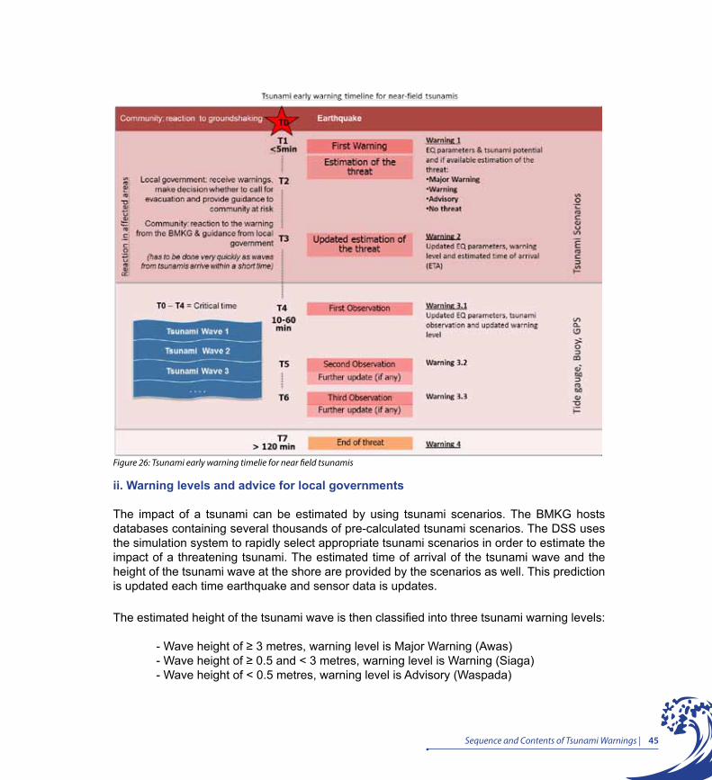
45Sequence and Contents of Tsunami Warnings |
ii. Warning levels and advice for local governments
The impact of a tsunami can be estimated by using tsunami scenarios. The BMKG hosts databases containing several thousands of pre-calculated tsunami scenarios. The DSS uses the simulation system to rapidly select appropriate tsunami scenarios in order to estimate the impact of a threatening tsunami. The estimated time of arrival of the tsunami wave and the height of the tsunami wave at the shore are provided by the scenarios as well. This prediction is updated each time earthquake and sensor data is updates.
The estimated height of the tsunami wave is then classified into three tsunami warning levels:
- Wave height of ≥ 3 metres, warning level is Major Warning (Awas) - Wave height of ≥ 0.5 and < 3 metres, warning level is Warning (Siaga) - Wave height of < 0.5 metres, warning level is Advisory (Waspada)
Figure 26: Tsunami early warning timelie for near field tsunamis
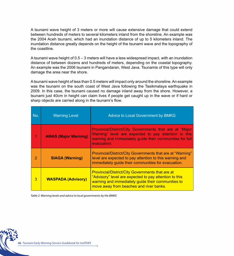
46 Tsunami Early Warning Service Guidebook for InaTEWS
No. Warning Level Advice to Local Government by BMKG
1 AWAS (Major Warning)
Provincial/District/City Governments that are at “Major Warning” level are expected to pay attention to this warning and immediately guide their communities for full evacuation.
2 SIAGA (Warning)Provincial/District/City Governments that are at “Warning” level are expected to pay attention to this warning and immediately guide their communities for evacuation.
3 WASPADA (Advisory)
Provincial/District/City Governments that are at “Advisory” level are expected to pay attention to this warning and immediately guide their communities to move away from beaches and river banks.
Table 2: Warning levels and advice to local governments by the BMKG
A tsunami wave height of 3 meters or more will cause extensive damage that could extend between hundreds of meters to several kilometers inland from the shoreline. An example was the 2004 Aceh tsunami, which had an inundation distance of up to 5 kilometers inland. The inundation distance greatly depends on the height of the tsunami wave and the topography of the coastline.
A tsunami wave height of 0.5 – 3 meters will have a less widespread impact, with an inundation distance of between dozens and hundreds of meters, depending on the coastal topography. An example was the 2006 tsunami in Pangandaran, West Java. Tsunamis of this type will only damage the area near the shore.
A tsunami wave height of less than 0.5 meters will impact only around the shoreline. An example was the tsunami on the south coast of West Java following the Tasikmalaya earthquake in 2009. In this case, the tsunami caused no damage inland away from the shore. However, a tsunami just 40cm in height can claim lives if people get caught up in the wave or if hard or sharp objects are carried along in the tsunami’s flow.
47Sequence and Contents of Tsunami Warnings |
iii. Format of InaTEWS tsunami early warning messages
There are three formats of tsunami warning messages: short-text format (text message/SMS), long-text format (fax, e-mail and GTS) and media format (website and WRS).
1. Short-text format
Used to disseminate warnings via text message (SMS). The number of characters is limited to 160.
2. Long-text format
Contains more complete information and is disseminated via e-mail, fax and GTS. The outline of the long-text format includes:
a. Header, indicating the source of the information, i.e., the BMKG as the official provider of warning messages under InaTEWS.
b. Information content, which consists of three components:
i. First, the earthquake parametersii. Second, tsunami observation data, if already availableiii. Third, the warning level, estimated tsunami arrival time, and affected locations
c. Advice, containing recommendations to local governments regarding the appropriate response
3. WRS format for interface institutions and the media
Contains information regarding EQ parameters, tsunami threat, affected areas, warning levels and estimated time of arrival. It also includes a map indicating the EQ location. The format is designed to be displayed on monitor screens and has a graphic user interface. Additionally, a special graphic is provided to TV media.

48 Tsunami Early Warning Service Guidebook for InaTEWS
Format Content Target audience Mode
Long Version Earthquake Parameter, warning segment, warning level, advice, map
Interface institutions, local government, decision maker, media
Long Version Earthquake Parameter, warning segment, warning level, advice, map
Interface institutions, local government
WRS
Long Version Earthquake Parameter, warning segment, warning level, advice, map
Interface institutions, local government, media
Fax
Media Version Earthquake Parameter, map, “berpotensi tsunami”
Media WRS
Short Version Earthquake Parameter, warning level in province
Interface institutions, local government, decision maker, media
SMS
Web Version Earthquake Parameter, Tsunami potential
public Website
Table 3: Comparison of tsunami warning formats
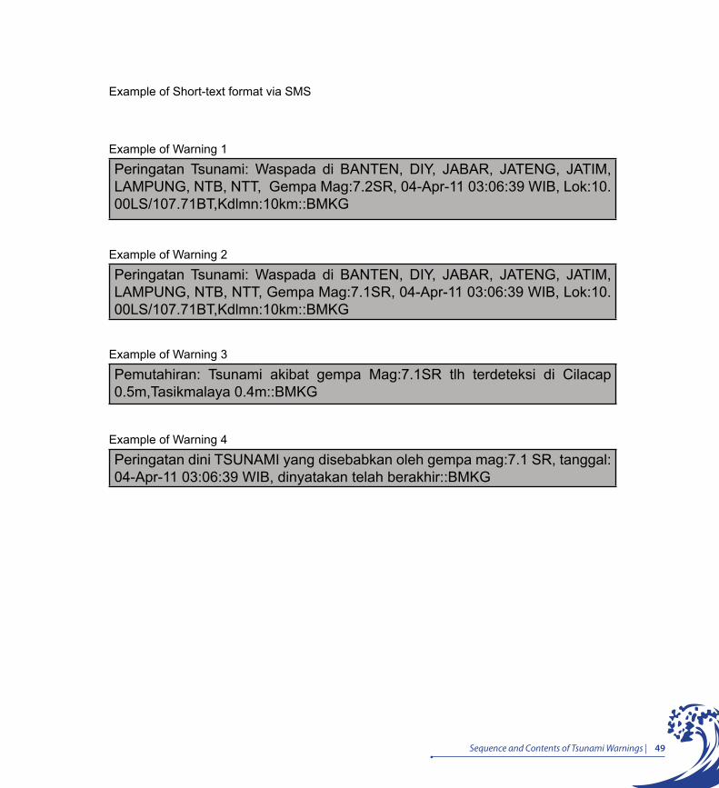
49Sequence and Contents of Tsunami Warnings |
Example of Warning 1
Peringatan Tsunami: Waspada di BANTEN, DIY, JABAR, JATENG, JATIM, LAMPUNG, NTB, NTT, Gempa Mag:7.2SR, 04-Apr-11 03:06:39 WIB, Lok:10.00LS/107.71BT,Kdlmn:10km::BMKG
Example of Warning 2
Peringatan Tsunami: Waspada di BANTEN, DIY, JABAR, JATENG, JATIM, LAMPUNG, NTB, NTT, Gempa Mag:7.1SR, 04-Apr-11 03:06:39 WIB, Lok:10.00LS/107.71BT,Kdlmn:10km::BMKG
Example of Warning 3
Pemutahiran: Tsunami akibat gempa Mag:7.1SR tlh terdeteksi di Cilacap 0.5m,Tasikmalaya 0.4m::BMKG
Example of Warning 4
Peringatan dini TSUNAMI yang disebabkan oleh gempa mag:7.1 SR, tanggal: 04-Apr-11 03:06:39 WIB, dinyatakan telah berakhir::BMKG
Example of Short-text format via SMS
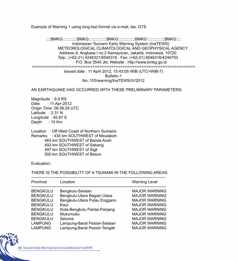
50 Tsunami Early Warning Service Guidebook for InaTEWS
Example of Warning 1 using long-text format via e-mail, fax, GTS
::::BMKG:::::::::::::BMKG::::::::::::::::BMKG:::::::::::::::BMKG::::::::::::::::BMKG::::
Indonesian Tsunami Early Warning System (InaTEWS) METEOROLOGICAL CLIMATOLOGICAL AND GEOPHYSICAL AGENCY
Address:Jl. Angkasa I no.2 Kemayoran, Jakarta, Indonesia, 10720 Telp.: (+62-21) 4246321/6546316 , Fax: (+62-21) 6546316/4246703
P.O. Box 3540 Jkt, Website : http://www.bmkg.go.id======================================================================
Issued date : 11 April 2012, 15:43:05 WIB (UTC=WIB-7)Bulletin-1
No.:103/warning/InaTEWS/IV/2012
AN EARTHQUAKE HAS OCCURRED WITH THESE PRELIMINARY PARAMETERS:
Magnitude : 8.9 RSDate : 11-Apr-2012Origin Time: 08:38:29 UTCLatitude : 2.31 NLongitude : 92.67 EDepth : 10 Km
Location : Off West Coast of Northern SumatraRemarks : 434 km SOUTHWEST of Meulaboh 463 km SOUTHWEST of Banda Aceh 493 km SOUTHWEST of Sabang 497 km SOUTHWEST of Sigli 550 km SOUTHWEST of Bireun
Evaluation:
THERE IS THE POSSIBILITY OF A TSUNAMI IN THE FOLLOWING AREAS:-----------------------------------------------------------------------------------------------------Province Location Warning Level-----------------------------------------------------------------------------------------------------BENGKULU Bengkulu-Selatan MAJOR WARNINGBENGKULU Bengkulu-Utara Bagian Utara MAJOR WARNINGBENGKULU Bengkulu-Utara Pulau Enggano MAJOR WARNINGBENGKULU Kaur MAJOR WARNINGBENGKULU Kota-Bengkulu Pantai-Panjang MAJOR WARNINGBENGKULU Mukomuko MAJOR WARNINGBENGKULU Seluma MAJOR WARNINGLAMPUNG Lampung-Barat Pesisir-Selatan MAJOR WARNINGLAMPUNG Lampung-Barat Pesisir-Tengah MAJOR WARNING
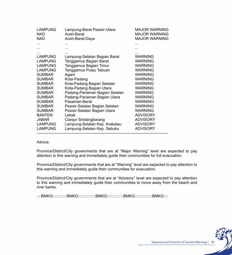
51Sequence and Contents of Tsunami Warnings |
LAMPUNG Lampung-Barat Pesisir-Utara MAJOR WARNINGNAD Aceh-Barat MAJOR WARNINGNAD Aceh-Barat-Daya MAJOR WARNING... ... ...... ... ...... ... ...LAMPUNG Lampung-Selatan Bagian Barat WARNINGLAMPUNG Tanggamus Bagian Barat WARNINGLAMPUNG Tanggamus Bagian Timur WARNINGLAMPUNG Tanggamus Pulau Tabuan WARNINGSUMBAR Agam WARNINGSUMBAR Kota-Padang WARNINGSUMBAR Kota-Padang Bagian Selatan WARNINGSUMBAR Kota-Padang Bagian Utara WARNINGSUMBAR Padang-Pariaman Bagian Selatan WARNINGSUMBAR Padang-Pariaman Bagian Utara WARNINGSUMBAR Pasaman-Barat WARNINGSUMBAR Pesisir-Selatan Bagian Selatan WARNINGSUMBAR Pesisir-Selatan Bagian Utara WARNINGBANTEN Lebak ADVISORYJABAR Cianjur Sindangbarang ADVISORYLAMPUNG Lampung-Selatan Kep. Krakatau ADVISORYLAMPUNG Lampung-Selatan Kep. Sebuku ADVISORY-----------------------------------------------------------------------------------------------------
Advice:
Province/District/City governments that are at “Major Warning” level are expected to pay attention to this warning and immediately guide their communities for full evacuation.
Province/District/City governments that are at “Warning” level are expected to pay attention to this warning and immediately guide their communities for evacuation.
Province/District/City governments that are at “Advisory” level are expected to pay attention to this warning and immediately guide their communities to move away from the beach and river banks.
::::BMKG:::::::::::::BMKG::::::::::::::::BMKG:::::::::::::::BMKG::::::::::::::::BMKG::::

52 Tsunami Early Warning Service Guidebook for InaTEWS
Example of Warning 2 using long-text format via e-mail, fax, GTS
::::BMKG:::::::::::::BMKG::::::::::::::::BMKG:::::::::::::::BMKG::::::::::::::::BMKG:::: Indonesian Tsunami Early Warning System (InaTEWS)
METEOROLOGICAL CLIMATOLOGICAL AND GEOPHYSICAL AGENCY Address:Jl. Angkasa I no.2 Kemayoran, Jakarta, Indonesia, 10720
Telp.: (+62-21) 4246321/6546316 , Fax: (+62-21) 6546316/4246703 P.O. Box 3540 Jkt, Website : http://www.bmkg.go.id
================================================================================== Issued date : 11 April 2012, 15:47:45 WIB (UTC=WIB-7)
Bulletin-2No.:104/warning/InaTEWS/IV/2012
UPDATING OF EARTHQUAKE PARAMETERS:
Magnitude : 8.5 RSDate : 11-Apr-2012Origin Time: 08:38:33 UTCLatitude : 2.40 NLongitude : 92.99 EDepth : 10 Km
Location : Off West Coast of Northern SumatraRemarks : 398 km SOUTHWEST of Meulaboh 433 km SOUTHWEST of Banda Aceh 464 km SOUTHWEST of Sabang 465 km SOUTHWEST of Sigli 515 km SOUTHWEST of Bireun
Evaluation:
THERE IS THE POSSIBILITY OF A TSUNAMI IN THE FOLLOWING AREAS:-----------------------------------------------------------------------------------------------------------------------------------------------Province Warning Segment Warning Level ETA Date [UTC] [YYYY-MM-DD]-----------------------------------------------------------------------------------------------------------------------------------------------NAD Simeulue Pulau Simeulue MAJOR WARNING 09:00:13 2012-04-11SUMUT Nias Bagian Barat MAJOR WARNING 09:16:58 2012-04-11SUMUT Nias-Selatan Pulau Nias MAJOR WARNING 09:22:03 2012-04-11SUMUT Nias-Selatan Pulau Tanahmasa WARNING 09:22:48 2012-04-11

53Sequence and Contents of Tsunami Warnings |
NAD Aceh-Jaya MAJOR WARNING 09:25:13 2012-04-11NAD Aceh-Besar Bagian Barat MAJOR WARNING 09:27:03 2012-04-11... ... ... ... ...... ... ... ...... ... ... ... ...
BENGKULU Kota-Bengkulu Pantai-Panjang ADVISORY 10:58:18 2012-04-11BANTEN Pandeglang Pulau Panaitan WARNING 11:01:43 2012-04-11BENGKULU Bengkulu-Utara Bagian Selatan ADVISORY 11:03:13 2012-04-11BANTEN Pandeglang Bagian Selatan NO THREAT 11:03:52 2012-04-11JABAR Sukabumi Pelabuhan-Ratu NO THREAT 11:05:18 2012-04-11JABAR Sukabumi Ujung-Genteng NO THREAT 11:05:18 2012-04-11LAMPUNG Lampung-Selatan Kep. Krakatau NO THREAT 11:05:22 2012-04-11LAMPUNG Lampung-Selatan Kep. Sebuku NO THREAT 11:05:22 2012-04-11LAMPUNG Tanggamus Bagian Barat ADVISORY 11:05:48 2012-04-11LAMPUNG Tanggamus Pulau Tabuan ADVISORY 11:05:48 2012-04-11LAMPUNG Lampung-Selatan Bagian Barat NO THREAT 11:06:22 2012-04-11LAMPUNG Tanggamus Bagian Timur NO THREAT 11:06:22 2012-04-11JABAR Cianjur Sindangbarang NO THREAT 11:06:33 2012-04-11BANTEN Lebak NO THREAT 11:06:52 2012-04-11------------------------------------------------------------------------------------------------------------------------------------------(ETA: estimated time of arrival)
ACTUAL ARRIVAL TIMES MAY DIFFER AND THE INITIAL WAVE MAY NOT BE THE LARGEST.
Advice:
Province/District/City governments that are at “Major Warning” level are expected to pay attention to this warning and immediately guide their communities for full evacuation.
Province/District/City governments that are at “Warning” level are expected to pay attention to this warning and immediately guide their communities for evacuation.
Province/District/City governments that are at “Advisory” level are expected to pay attention to this warning and immediately guide their communities to move away from the beach and river banks.
::::BMKG:::::::::::::BMKG::::::::::::::::BMKG:::::::::::::::BMKG::::::::::::::::BMKG::::
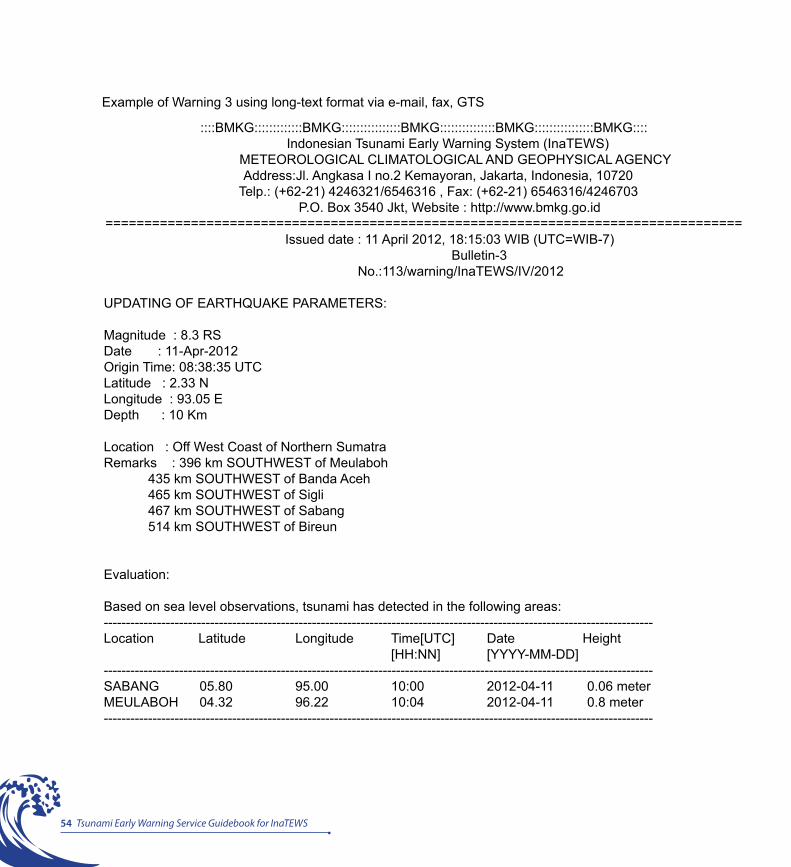
54 Tsunami Early Warning Service Guidebook for InaTEWS
Example of Warning 3 using long-text format via e-mail, fax, GTS
::::BMKG:::::::::::::BMKG::::::::::::::::BMKG:::::::::::::::BMKG::::::::::::::::BMKG:::: Indonesian Tsunami Early Warning System (InaTEWS)
METEOROLOGICAL CLIMATOLOGICAL AND GEOPHYSICAL AGENCY Address:Jl. Angkasa I no.2 Kemayoran, Jakarta, Indonesia, 10720
Telp.: (+62-21) 4246321/6546316 , Fax: (+62-21) 6546316/4246703 P.O. Box 3540 Jkt, Website : http://www.bmkg.go.id
================================================================================== Issued date : 11 April 2012, 18:15:03 WIB (UTC=WIB-7)
Bulletin-3 No.:113/warning/InaTEWS/IV/2012
UPDATING OF EARTHQUAKE PARAMETERS:
Magnitude : 8.3 RSDate : 11-Apr-2012Origin Time: 08:38:35 UTCLatitude : 2.33 NLongitude : 93.05 EDepth : 10 Km
Location : Off West Coast of Northern SumatraRemarks : 396 km SOUTHWEST of Meulaboh 435 km SOUTHWEST of Banda Aceh 465 km SOUTHWEST of Sigli 467 km SOUTHWEST of Sabang 514 km SOUTHWEST of Bireun
Evaluation:
Based on sea level observations, tsunami has detected in the following areas:----------------------------------------------------------------------------------------------------------------------------Location Latitude Longitude Time[UTC] Date Height [HH:NN] [YYYY-MM-DD]----------------------------------------------------------------------------------------------------------------------------SABANG 05.80 95.00 10:00 2012-04-11 0.06 meterMEULABOH 04.32 96.22 10:04 2012-04-11 0.8 meter----------------------------------------------------------------------------------------------------------------------------
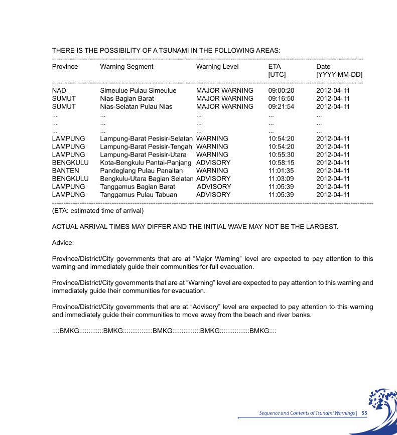
55Sequence and Contents of Tsunami Warnings |
THERE IS THE POSSIBILITY OF A TSUNAMI IN THE FOLLOWING AREAS:--------------------------------------------------------------------------------------------------------------------------------------------Province Warning Segment Warning Level ETA Date [UTC] [YYYY-MM-DD]--------------------------------------------------------------------------------------------------------------------------------------------NAD Simeulue Pulau Simeulue MAJOR WARNING 09:00:20 2012-04-11SUMUT Nias Bagian Barat MAJOR WARNING 09:16:50 2012-04-11SUMUT Nias-Selatan Pulau Nias MAJOR WARNING 09:21:54 2012-04-11... ... ... ... ...... ... ... ... ...... ... ... ... ...LAMPUNG Lampung-Barat Pesisir-Selatan WARNING 10:54:20 2012-04-11LAMPUNG Lampung-Barat Pesisir-Tengah WARNING 10:54:20 2012-04-11LAMPUNG Lampung-Barat Pesisir-Utara WARNING 10:55:30 2012-04-11BENGKULU Kota-Bengkulu Pantai-Panjang ADVISORY 10:58:15 2012-04-11BANTEN Pandeglang Pulau Panaitan WARNING 11:01:35 2012-04-11BENGKULU Bengkulu-Utara Bagian Selatan ADVISORY 11:03:09 2012-04-11LAMPUNG Tanggamus Bagian Barat ADVISORY 11:05:39 2012-04-11LAMPUNG Tanggamus Pulau Tabuan ADVISORY 11:05:39 2012-04-11--------------------------------------------------------------------------------------------------------------------------------------------(ETA: estimated time of arrival)
ACTUAL ARRIVAL TIMES MAY DIFFER AND THE INITIAL WAVE MAY NOT BE THE LARGEST.
Advice:
Province/District/City governments that are at “Major Warning” level are expected to pay attention to this warning and immediately guide their communities for full evacuation.
Province/District/City governments that are at “Warning” level are expected to pay attention to this warning and immediately guide their communities for evacuation.
Province/District/City governments that are at “Advisory” level are expected to pay attention to this warning and immediately guide their communities to move away from the beach and river banks.
::::BMKG:::::::::::::BMKG::::::::::::::::BMKG:::::::::::::::BMKG::::::::::::::::BMKG::::
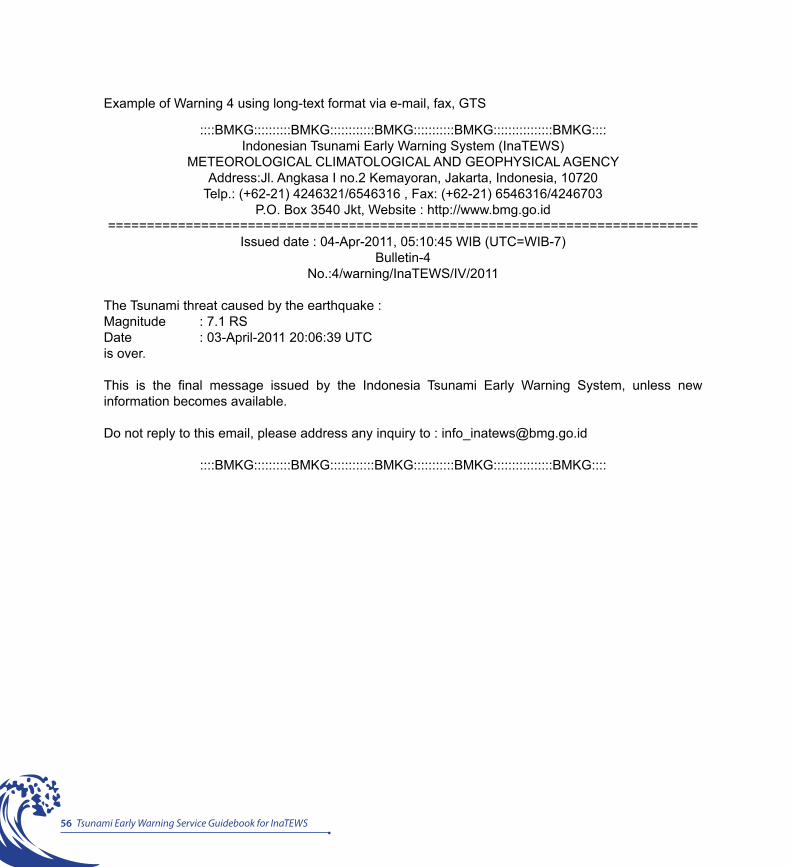
56 Tsunami Early Warning Service Guidebook for InaTEWS
Example of Warning 4 using long-text format via e-mail, fax, GTS
::::BMKG::::::::::BMKG::::::::::::BMKG:::::::::::BMKG::::::::::::::::BMKG::::Indonesian Tsunami Early Warning System (InaTEWS)
METEOROLOGICAL CLIMATOLOGICAL AND GEOPHYSICAL AGENCYAddress:Jl. Angkasa I no.2 Kemayoran, Jakarta, Indonesia, 10720
Telp.: (+62-21) 4246321/6546316 , Fax: (+62-21) 6546316/4246703P.O. Box 3540 Jkt, Website : http://www.bmg.go.id
============================================================================Issued date : 04-Apr-2011, 05:10:45 WIB (UTC=WIB-7)
Bulletin-4No.:4/warning/InaTEWS/IV/2011
The Tsunami threat caused by the earthquake : Magnitude : 7.1 RSDate : 03-April-2011 20:06:39 UTCis over.
This is the final message issued by the Indonesia Tsunami Early Warning System, unless new information becomes available.
Do not reply to this email, please address any inquiry to : [email protected]
::::BMKG::::::::::BMKG::::::::::::BMKG:::::::::::BMKG::::::::::::::::BMKG::::
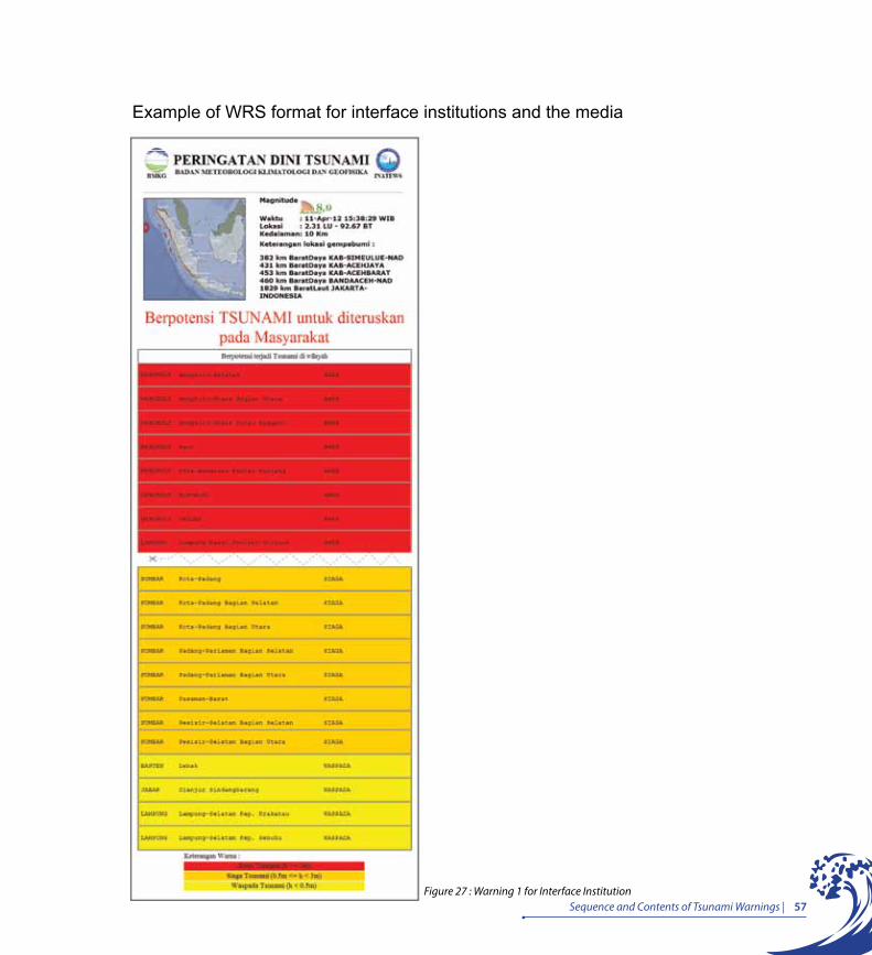
57Sequence and Contents of Tsunami Warnings |Figure 27 : Warning 1 for Interface Institution
Example of WRS format for interface institutions and the media
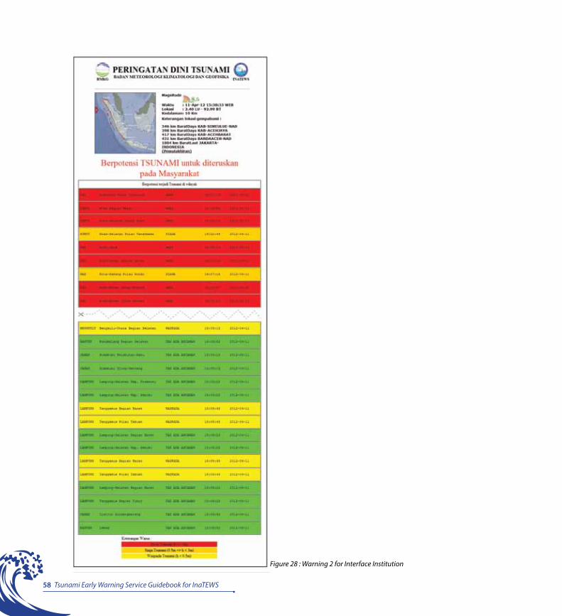
58 Tsunami Early Warning Service Guidebook for InaTEWS
Figure 28 : Warning 2 for Interface Institution
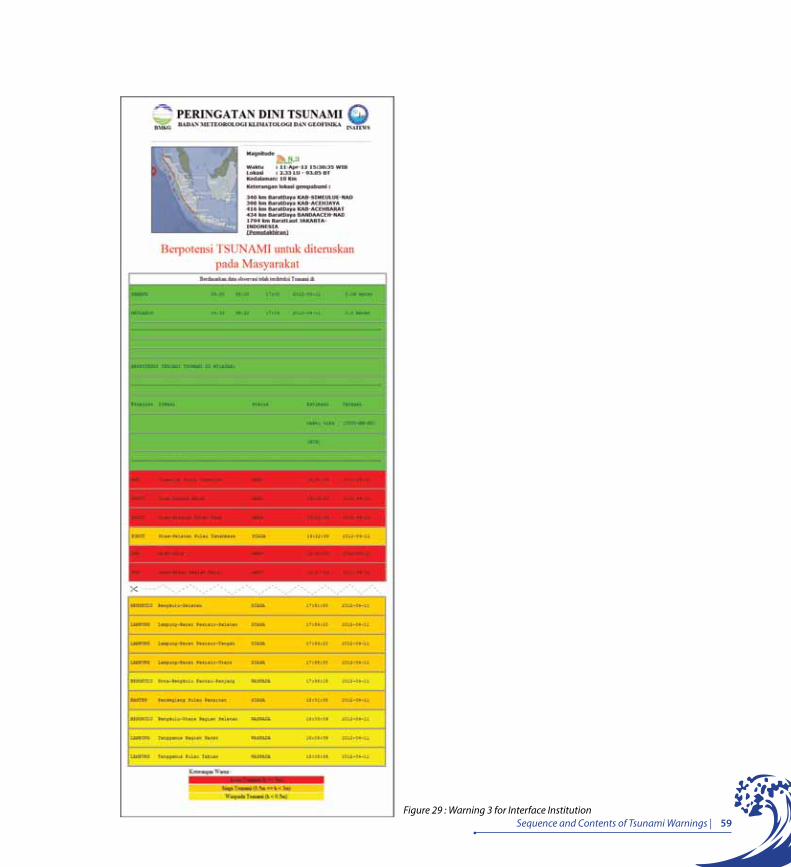
59Sequence and Contents of Tsunami Warnings |Figure 29 : Warning 3 for Interface Institution
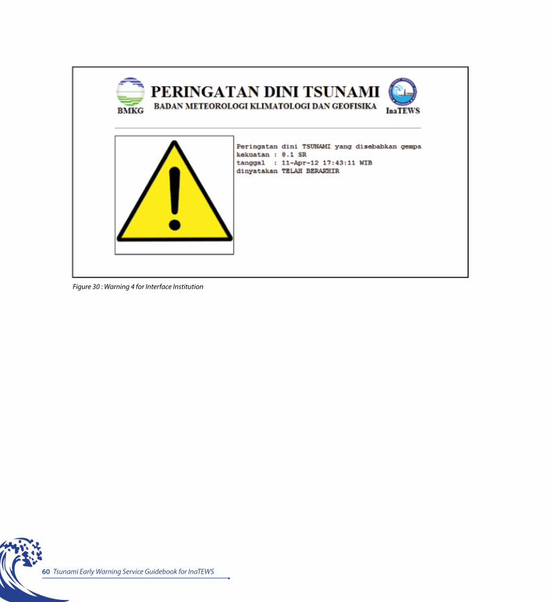
60 Tsunami Early Warning Service Guidebook for InaTEWS
Figure 30 : Warning 4 for Interface Institution
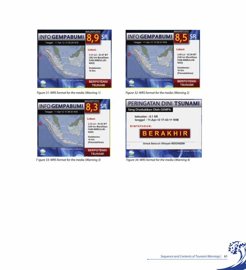
61Sequence and Contents of Tsunami Warnings |
Figure 31: WRS format for the media (Warning 1) Figure 32: WRS format for the media (Warning 2)
F igure 33: WRS format for the media (Warning 3) Figure 34: WRS format for the media (Warning 4)
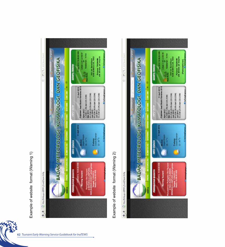
62 Tsunami Early Warning Service Guidebook for InaTEWS
Exa
mpl
e of
web
site
for
mat
(War
ning
1)
Exa
mpl
e of
web
site
for
mat
(War
ning
2)

63Sequence and Contents of Tsunami Warnings |
Exa
mpl
e of
web
site
for
mat
(War
ning
3)
Exa
mpl
e of
web
site
for
mat
(War
ning
4)


Principle 6Dissemination of Earthquake Information and Tsunami Early Warnings by the BMKG
The BMKG sends earthquake information and tsunami warnings to the public via local governments, interface institutions, and the media, using various communication channels. “
“

67Dissemination of Earthquake Information and Tsunami by the BMKG |
i. The tsunami-warning communication chain The BMKG operates the Indonesian National Tsunami Warning Centre, and is the only designated government institution responsible for issuing tsunami early warnings, which have two objectives: to trigger evacuation if there is a tsunami threat and mobilise emergency assistance, if needed.
The BMKG issues tsunami warnings to interface institutions (media, local governments, the BNPB, police, military, SAR and other institutions at national and local levels) through a 6-in-1 communication system. These tsunami warning messages can also be accessed by the public through the mass media, the BMKG website and social networks, such as Facebook and Twitter.
All information about earthquakes and tsunami warnings is distributed by the BMKG through six separate channels and is sent only when an earthquake of a magnitude greater than 5 on the Richter scale occurs. Information about earthquakes of lesser magnitudes is posted on the BMKG website (www.bmkg.go.id and http://inatews.bmkg.go.id).
In principle, the dissemination of warnings to the public is the responsibility of the institutions concerned with disaster management. The BMKG is responsible only for preparing and issuing warnings to be disseminated to the public via interface institutions. According to an instruction by the President of the Republic of Indonesia, which was announced at a press conference at the Anyer Marbela Hotel, Banten, on July 20, 2006, it is the responsibility of the BMKG to prepare and issue a tsunami warning within the first five minutes following an earthquake. After that, it is the responsibility of the various interface institutions to disseminate the warning to people living in the area at risk.
ii. The BMKG’s warning dissemination systemHow the BMKG distributes warnings
The following overview of the warning dissemination process used by the BMKG’s National Tsunami Early Warning Centre offers a picture of the key issues. The BMKG currently uses six communication channels (SMS, e-mail, internet, fax, WRS and GTS) to distribute tsunami warnings (Figure 35).
Principle 6Dissemination of Earthquake Information and Tsunami Early Warnings by the BMKG
“The BMKG sends earthquake information and tsunami warnings to the public via local governments m interface institutions, and the media, using various communication channels.”
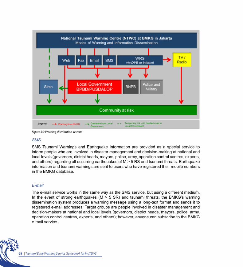
68 | Tsunami Early Warning Service Guidebook for InaTEWS
Figure 35: Warning distribution system
SMS
SMS Tsunami Warnings and Earthquake Information are provided as a special service to inform people who are involved in disaster management and decision-making at national and local levels (governors, district heads, mayors, police, army, operation control centres, experts, and others) regarding all occurring earthquakes of M > 5 RS and tsunami threats. Earthquake information and tsunami warnings are sent to users who have registered their mobile numbers in the BMKG database.
The e-mail service works in the same way as the SMS service, but using a different medium. In the event of strong earthquakes (M > 5 SR) and tsunami threats, the BMKG’s warning dissemination system produces a warning message using a long-text format and sends it to registered e-mail addresses. Target groups are people involved in disaster management and decision-makers at national and local levels (governors, district heads, mayors, police, army, operation control centres, experts, and others); however, anyone can subscribe to the BMKG e-mail service.
69Dissemination of Earthquake Information and Tsunami by the BMKG |
Internet
The BMKG provides a website where the public can access information on earthquakes and tsunami threats: www.bmkg.go.id and http://inatews.bmkg.go.id. Besides that, people can also access additional information and disaster warnings, such as weather forecasting, information about waves and floods, etc.
Fax
Long-text format messages for earthquakes and tsunami threats are also distributed via facsimile. The target group is much smaller than those receiving SMS and e-mails, comprising only those people involved in disaster management and decision-making at national and local levels.
Warning Receiver System – WRS
A WRS service is used to distribute earthquake information and warning messages to registered WRS clients (the media, local government, the BNPB, police, army, emergency operation centres, other national institutions, private companies, etc.). All local PUSDALOPS are expected to have a WRS installed in their warning centres. The WRS is software specially designed by the BMKG for tsunami early warnings. A client must have a personal computer with a continuous Internet link or a satellite connection system (DVB) to the BMKG WRS server. Additionally, the WRS can be used as a local dissemination server to send warnings and advice to local stakeholders in a direct and systematic way.
Global Telecommunications System – GTS
This is not a public server. The main function of a GTS server is to send information to, and communicate with, other members of the World Meteorological Organisation (WMO). The BMKG is a member of the WMO.
Figure 36 describes the warning dissemination chain from the BMKG to the community through an interface institution. It is expected that interface institutions will continue the dissemination through other institutions linked to them or directly to the public. The warning dissemination system at local levels is explained in Principle 10.

70 | Tsunami Early Warning Service Guidebook for InaTEWS
TV / Radio
Radio and television are the most common mass media channels used for the distribution of general information to a wide area. In Indonesia, the government obliges all television and radio stations to broadcast tsunami or other hazard-related early warnings, pursuant to the Decree by the Minister of Communications and Information 20/P/M.Kominfo/8/2006. Upon reception of the broadcasting request, the respective media stations will activate a high-tone alarm (1kHz) combined with a text message on TV or an announcement, if transmitted by radio. Messages will be disseminated via TV and radio as long as necessary, until the ‘End of threat’ message is given. Presently, the main national television stations are directly connected to the BMKG Warning Centre and they broadcast earthquake information as running text and “Stop Press”.
Local radio stations are a good option for the dissemination of more detailed and location-specific messages. Local calls for evacuation could be broadcasted via local radio. Almost
Figure 36: BMKG communication network for information dissemination (via Telkomsel, Indosat, 5-in-1, electronic media, sirens)
71Dissemination of Earthquake Information and Tsunami by the BMKG |
every household and every car possesses a radio. Battery-powered receivers are cheap and widely used. Local radio stations need to be notified through the official local warning centre. For communication between the radio stations and local officials, separate means of communication that are safeguarded against breakdowns and power failures, such as satellite phones or VHF radio, must be utilised.
Tsunami sirens operated by the BMKG
Sirens are among the most popular and widely used outdoor alerting devices. In Indonesia, based on a joint protocol on sirens (see Principle 10), sirens are considered as devices to deliver the call for immediate evacuation.
As of 2010, the BMKG had installed sirens in Aceh, West Sumatra, Bali, Bengkulu, Gorontalo, Manado, East Nusa Tenggara, Maluku, Manokwari and Jayapura (Figure 37).
Figure 38 shows the minimum number of sirens that should, according to the BMKG, be installed in tsunami-prone locations across Indonesia. Local governments are expected to continue with the development of these sirens and to take responsibility for their control and maintenance, to ensure that the sirens function properly in compliance with siren protocol (see Principle 10 for more detailed discussion of siren protocol).
Control of the sirens in all these locations was initially in the hands of the BMKG. However, according to Law 24/2007, specifically Article 12, the BNPB is directly responsible to the public and is in charge of providing the public with information. In addition, pursuant to Government Regulation 21/2008, the BNPB and the BPBD are jointly tasked with coordinating activities to save lives, making use of the information provided by the BMKG. This task division between national and provincial levels is resulting in the control of sirens being gradually handed over to local governments.
In 2010, the provincial governments of Aceh, West Sumatra and Bali assumed full control of their locally based sirens, while those in the other locations are still operated by the BMKG. Siren control will remain in the hands of the BMKG until such time that the BPBDs at a provincial level are ready to take over their operation.

72 | Tsunami Early Warning Service Guidebook for InaTEWS
Figure38: Minimum number of sirens that should be installed across Indonesia
Figure 37: Locations (10) of the 28 sirens as of 2010

73Dissemination of Earthquake Information and Tsunami by the BMKG |
Factors to consider regarding the use of sirens
Advantages of Sirens Disadvantages of Sirens
Wide outdoor coverage, especially in areas with no other means of alerting people
Inaudible in certain areas with strong winds
Can awake/alert indoor residents near sirens and thus supplement indoor alerting systems
Devices cannot always be heard in buildings and vehicles, or in areas that have high levels of background noise
Siren units may already be in common use in the community for volunteer fire departments or other purposes
The public may have to be able to distinguish between several different signals indicating different hazards or intended use
Public address versions can broadcast in different languages and can store a large number of pre-recorded messages
For non-public address versions, the public must be informed about additional sources to obtain more information. Additional notification must be provided by other means.
Low electrical current required to operate from integral batteries and can be charged by solar panels or other alternative systems (e.g., wind generators) as protection from utility power disruptions
Must have a reliable power source
Radio-controlled and, therefore, can be independent of landline utilities, Can be centrally-controlled and remotely accessed
A large number of sirens may be needed to cover populated areas and must be loud enough to be heard indoors by most people
Full-time conditioning/monitoring, reducing the need for live testing, which would be required solely for maintenance purposes
Poorly protected units can be damaged by waves, wind, sand, and salt spray
System is available 24/7 Siren soundings must be coordinated with other alerting methods
Table 4: Advantages and disadvantages of sirens
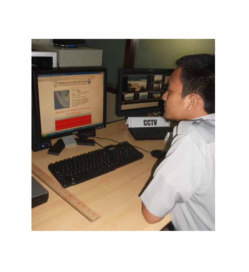
Principle 7Local Government – the Key Actor in the Provision of Tsunami Early Warning Services to People at Risk
Local governments are obliged to guide people’s reaction to groundshaking from a nearby earthquake based on the information received from the BMKG. ““

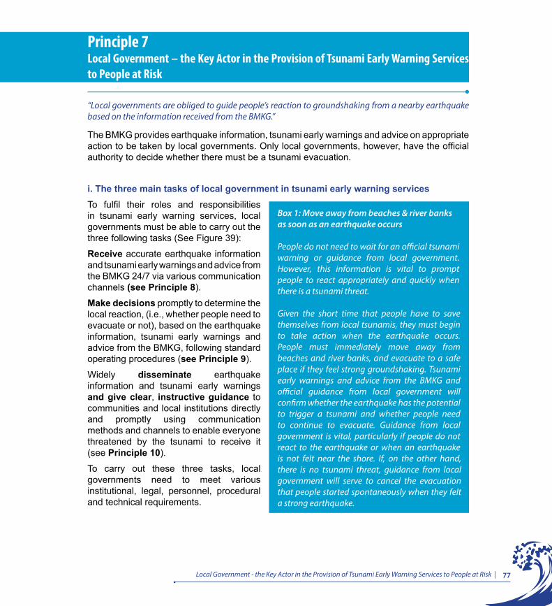
77Local Government - the Key Actor in the Provision of Tsunami Early Warning Services to People at Risk |
The BMKG provides earthquake information, tsunami early warnings and advice on appropriate action to be taken by local governments. Only local governments, however, have the official authority to decide whether there must be a tsunami evacuation.
i. The three main tasks of local government in tsunami early warning servicesTo fulfil their roles and responsibilities in tsunami early warning services, local governments must be able to carry out the three following tasks (See Figure 39):
Receive accurate earthquake information and tsunami early warnings and advice from the BMKG 24/7 via various communication channels (see Principle 8).
Make decisions promptly to determine the local reaction, (i.e., whether people need to evacuate or not), based on the earthquake information, tsunami early warnings and advice from the BMKG, following standard operating procedures (see Principle 9).
Widely disseminate earthquake information and tsunami early warnings and give clear, instructive guidance to communities and local institutions directly and promptly using communication methods and channels to enable everyone threatened by the tsunami to receive it (see Principle 10).
To carry out these three tasks, local governments need to meet various institutional, legal, personnel, procedural and technical requirements.
Principle 7Local Government – the Key Actor in the Provision of Tsunami Early Warning Services to People at Risk
“Local governments are obliged to guide people’s reaction to groundshaking from a nearby earthquake based on the information received from the BMKG.”
Box 1: Move away from beaches & river banks as soon as an earthquake occurs
People do not need to wait for an official tsunami warning or guidance from local government. However, this information is vital to prompt people to react appropriately and quickly when there is a tsunami threat.
Given the short time that people have to save themselves from local tsunamis, they must begin to take action when the earthquake occurs. People must immediately move away from beaches and river banks, and evacuate to a safe place if they feel strong groundshaking. Tsunami early warnings and advice from the BMKG and official guidance from local government will confirm whether the earthquake has the potential to trigger a tsunami and whether people need to continue to evacuate. Guidance from local government is vital, particularly if people do not react to the earthquake or when an earthquake is not felt near the shore. If, on the other hand, there is no tsunami threat, guidance from local government will serve to cancel the evacuation that people started spontaneously when they felt a strong earthquake.
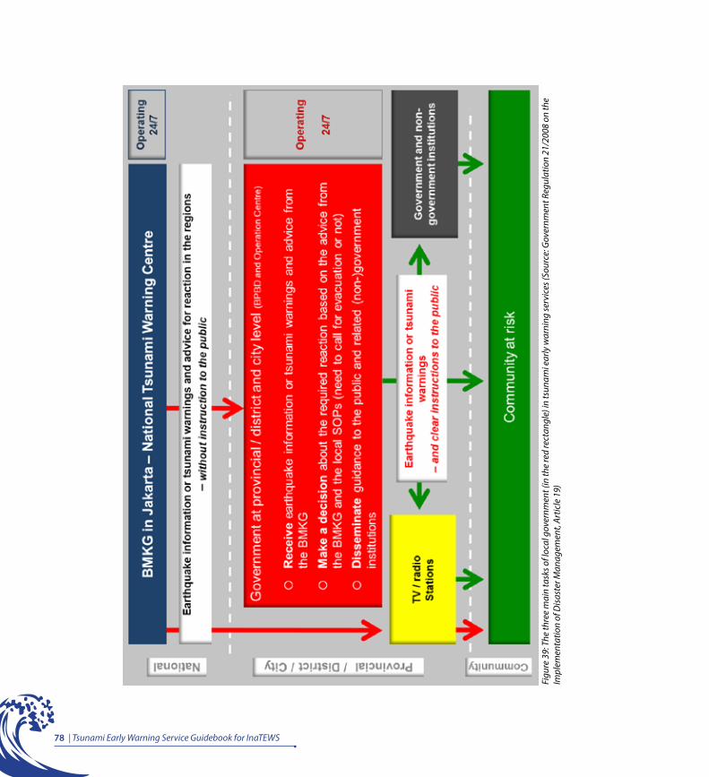
78 | Tsunami Early Warning Service Guidebook for InaTEWS
Figu
re 3
9: T
he th
ree
mai
n ta
sks o
f loc
al g
over
nmen
t (in
the
red
rect
angl
e) in
tsun
ami e
arly
war
ning
serv
ices
(Sou
rce:
Gov
ernm
ent R
egul
atio
n 21
/200
8 on
the
Impl
emen
tatio
n of
Dis
aste
r Man
agem
ent,
Artic
le 1
9)
79Local Government - the Key Actor in the Provision of Tsunami Early Warning Services to People at Risk |
ii. Legal and institutional requirements for local tsunami early warning services
Tsunami early warning services must operate 24/7
Earthquakes that have the potential to trigger tsunamis can happen at any time. To meet their obligations, therefore, local governments must also be able to act on tsunami early warnings at any time, which means there needs to be an institution or unit that operates 24/7. Each local tsunami early warning service is the responsibility of the local disaster management agency (BPBD). A technical implementation unit within the BPBD, called the Operations Control Centre (Pusat Pengendalian Operasi – Pusdalops), has four main sections: data and information centre, early warning services, response services, and emergency services. Thus, the Pusdalops is charged with fulfilling the BPBD’s duties with regard to local early warning services, including tsunami early warning
Tsunami early warning services need to use SOPs
Local tsunamis arrive quickly after an earthquake, so local governments must be able to make decisions about the local reaction as soon as possible after receiving tsunami early warnings and advice from the BMKG, and immediately disseminate guidance to the public to enable people to act appropriately and promptly. Due to short warning times, SOPs are needed for rapid and reliable decision making and information dissemination (see Principle 9 and Principle 10). Standard operating procedures (SOPs) are an agreed set of written instructions, which document the activities or routine steps to be followed by institutions or individuals. These procedures explain the who, what and how of local tsunami early warning services and need to be endorsed by local governments as the official reference for all those involved in tsunami early warning.
Tsunami early warning requires official delegation of authority
Tsunami early warnings must be disseminated quickly, but when earthquakes occur there may be power cuts and communication channels may be down. Therefore, the Pusdalops, as the local tsunami early warning centre that has the equipment to receive information
Box 2: Temporary solution for regions that do not have a BPBD and Pusdalops
It is strongly recommended that a local area that does not have a BPBD or Pusdalops, relying instead on Satlak and Kesbanglinmas, seeks a temporary solution as quickly as possible. Usually the fire service, police or military runs a 24/7 unit and this can also be used for a tsunami early warning service.

80 | Tsunami Early Warning Service Guidebook for InaTEWS
from the BMKG and disseminate guidance to the public, needs to be given full authority and independence to carry out tsunami early warning tasks. Based on agreed and approved SOPs, the Pusdalops could represent the head of a region (governor, district head or mayor) who has officially delegated to the Pusdalops the authority to make and announce decisions to evacuate or otherwise, as is the case in Bali Province and Padang City.
Synchronisation of SOPs at the provincial, district and municipal levels
Tsunamis can cross district, city and provincial administrative boundaries. To avoid inconsistencies in decision making at the provincial, municipal and district levels on the basis of information from the BMKG, it is essential to synchronise the SOPs within each of the administrative areas concerned. If all levels of government agree on synchronised SOPs, inconsistencies in decision making can be avoided.
Cooperation between provinces, districts and municipalities in delivery of tsunami early warning services and guidance
Ideally, each district and city provides 24/7 tsunami early warning services. However, it may be that not all tsunami-prone districts and municipalities are able to set up and run an operations control centre that operates 24/7. There are two possible solutions to this problem and to institutional, personnel and funding needs in each region:
Box 3: Example from Padang
Regulation by the Mayor 14/2010 on the Implementation of the Padang City Tsunami Early Warning System, Chapter III, Article 6 stipulates that the Mayor:
a) Delegates the decision to evacuate or not evacuate (in the event of a tsunami threat) to the disaster management operations control centre.b) Delegates the dissemination of warnings and guidance for evacuation (in the event of a tsunami threat) to the disaster management operations control centre.
81Local Government - the Key Actor in the Provision of Tsunami Early Warning Services to People at Risk |
Model 1: Delegate early warning services to the provincial level
Although the authority to make the decision whether or not to evacuate lies with the district or city government, it can be delegated to the provincial government. This is because the BMKG issues standard format tsunami early warnings and advice, which should guide a standard reaction along the coastline. Using this model, the province assumes the main role in tsunami early warning services and the district/city supports the dissemination of tsunami early warnings and guidance to their communities.
Model 2: Delegate early warning services to one district/municipality
In this model, one district is designated by the others to function as the service centre for all of them. All districts that will receive the services need to contribute towards setting this up.
iii. Other requirementsThe minimum requirements for delivering local tsunami early warning services include:
• A 24/7 operations control centre. • Earthquake-resistant office space located outside the tsunami risk zone.• Communication equipment and channels to receive warnings from the BMKG and to
disseminate warnings and guidance to the public and the relevant authorities (see Principle 8 and Principle 9).
• Backup power should there be a power cut when there is a strong earthquake.
Box 4: Examples from Bali and Aceh
In the provinces of Bali and Aceh, the roles of decision making and the dissemination of tsunami early warnings and guidance to the public are officially delegated to the provincial government. These two provinces have prepared the procedures and equipment for carrying out tsunami early warning. Tsunami sirens are triggered by an operations control centre at the provincial level.
Box 5: Example from the South Coast of Java
The districts of Bantul, Purworejo, Kebumen, Cilacap and Ciamis, with support from the provinces of Yogyakarta and Central Java, are planning to set up a Tsunami Forum, which, among other things, will allow for cooperation across districts and provinces in tsunami early warning services.
82 | Tsunami Early Warning Service Guidebook for InaTEWS
• A supervisor and at least two personnel working in shifts to provide 24/7 warning services (two or three personnel working in shifts are recommended).
• All personnel trained in the SOPs for decision making and information dissemination.• Personnel trained in the use of communication equipment on each shift.• All procedures and information relevant to tsunami early warning services in the 24/7 unit are
documented in Tsunami Early Warning Operational Guidelines.

Principle 8Reception of Tsunami Warnings by Local Governments
Local governments have to ensure that they are able to receive earthquake information or tsunami warnings and advice from the BMKG accurately and at all times (24/7) through various communication devices.
““

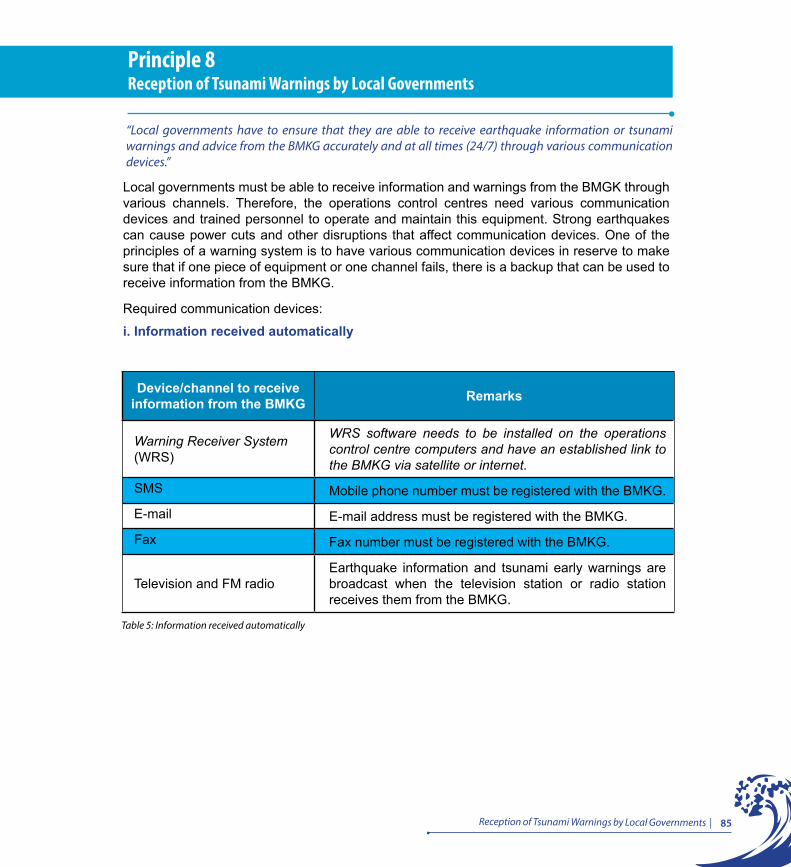
85Reception of Tsunami Warnings by Local Governments |
Local governments must be able to receive information and warnings from the BMGK through various channels. Therefore, the operations control centres need various communication devices and trained personnel to operate and maintain this equipment. Strong earthquakes can cause power cuts and other disruptions that affect communication devices. One of the principles of a warning system is to have various communication devices in reserve to make sure that if one piece of equipment or one channel fails, there is a backup that can be used to receive information from the BMKG.
Required communication devices:
i. Information received automatically
Principle 8Reception of Tsunami Warnings by Local Governments
“Local governments have to ensure that they are able to receive earthquake information or tsunami warnings and advice from the BMKG accurately and at all times (24/7) through various communication devices.”
Device/channel to receive information from the BMKG Remarks
Warning Receiver System (WRS)
WRS software needs to be installed on the operations control centre computers and have an established link to the BMKG via satellite or internet.
SMS Mobile phone number must be registered with the BMKG.
E-mail E-mail address must be registered with the BMKG.
Fax Fax number must be registered with the BMKG.
Television and FM radioEarthquake information and tsunami early warnings are broadcast when the television station or radio station receives them from the BMKG.
Table 5: Information received automatically
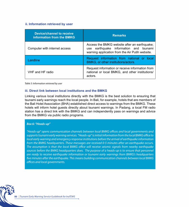
86 | Tsunami Early Warning Service Guidebook for InaTEWS
Device/channel to receive information from the BMKG Remarks
Computer with internet accessAccess the BMKG website after an earthquake; use earthquake information and tsunami warning application from the Air Putih website.
Landline Request information from national or local BMKG, or other institutions/actors.
VHF and HF radioRequest information or receive information from national or local BMKG, and other institutions/actors.
iii. Direct link between local institutions and the BMKGLinking various local institutions directly with the BMKG is the best solution to ensuring that tsunami early warnings reach the local people. In Bali, for example, hotels that are members of the Bali Hotel Association (BHA) established direct access to warnings from the BMKG. These hotels will inform hotel guests directly about tsunami warnings. In Padang, a local FM radio station has a direct link with the BMKG and can independently pass on warnings and advice from the BMKG via public radio programs.
Box 6: “Heads-up”
“Heads-up” opens communication channels between local BMKG offices and local governments and supports tsunami early warning services. “Heads-up” is initial information from the local BMKG office to local early warning and emergency response institutions before the arrival of earthquake information from the BMKG headquarters. These messages are received 0-5 minutes after an earthquake occurs. The assumption is that the local BMKG office will receive seismic signals from nearby earthquake sources before the BMKG headquarters does. The purpose of a heads-up is to ensure that personnel are ready to receive earthquake information or tsunami early warnings from BMKG’s headquarters five minutes after the earthquake. This means building communication channels between local BMKG offices and local governments.
ii. Information retrieved by user
Table 5: Information retrieved by user
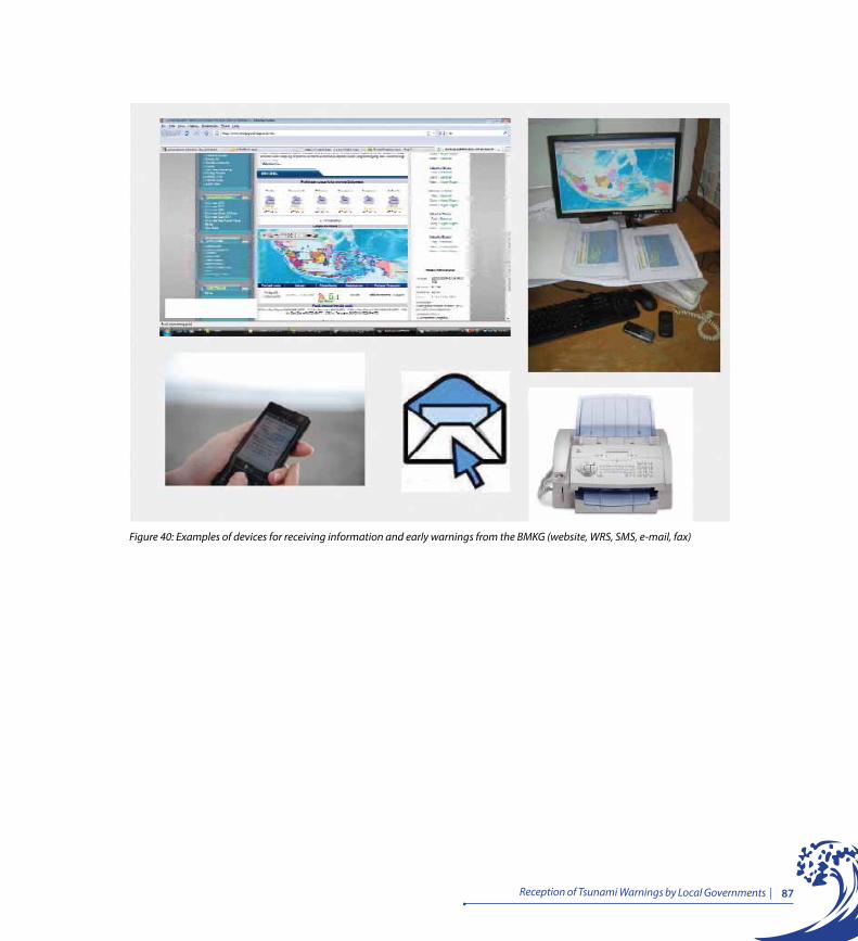
87Reception of Tsunami Warnings by Local Governments |
Figure 40: Examples of devices for receiving information and early warnings from the BMKG (website, WRS, SMS, e-mail, fax)


Principle 9Decision Making by Local Governments
Local governments are expected to have the capacity to make a decision about the action to be taken in their region (i.e. whether or not to call for evacuation) in a timely manner, based on earthquake information, tsunami warnings and advice from the BMKG, as well as local standard operating procedures (SOPs). “
“
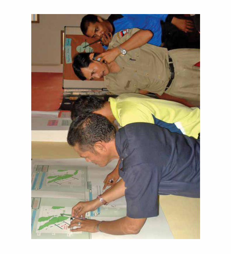

91Decision Making by Local Governments |
Given the short time between an earthquake occurring and the arrival of a tsunami, local governments must be able to disseminate tsunami early warnings and guidance to people quickly: there is not a minute to lose!
A physically felt earthquake is a natural sign, to be taken as the first tsunami early warning. However, not all earthquakes trigger tsunamis. If an earthquake could potentially trigger a tsunami, the BMKG issues a Warning 1 (see Principle 5) ≤ 5 minutes after the earthquake occurs. This warning message contains the earthquake parameters and, if available, information about the estimated impact of the tsunami, which is reflected by a warning level (Major Warning, Warning or Advisory) for every district that might be affected. Warning 2 is issued as soon as possible, to provide updated earthquake parameters and updated warning levels, as well as additional information about the estimated tsunami arrival times (ETA) on shore. Nevertheless, local governments must react directly to Warning 1 by taking the decision whether or not to evacuate and inform the community of the required action to be taken using the available communication equipment and employing their evacuation plans. People in high-risk areas must be able to understand natural warning signs and follow the guidance provided by the local government and, if required, immediately evacuate to a designated safe location.
At the time Warnings 1 and 2 are issued, it is still unclear whether a tsunami was actually generated. Once data from buoys and tide gauges become available, the BMKG is able to confirm whether the earthquake has triggered a tsunami and will send out a Warning 3, providing observed wave heights and updated warning levels. Waiting for Warning 3 before reaching a decision on whether to evacuate is not an option, as precious time will be wasted and people will not have enough time to evacuate.
Principle 9Decision Making by Local Governments
“Local governments are expected to have the capacity to make a decision about the action to be taken in their region (i.e. whether or not to call for evacuation) in a timely manner, based on earthquake information, tsunami warnings and advice from the BMKG, as well as local standard operating procedures (SOPs).”

92 | Tsunami Early Warning Service Guidebook for InaTEWS
Figure 41: Estimated time from a local tsunami occurring until information is received with confirmation of the tsunami, and the limited reaction time (Source: GTZ IS-GITEWS)
Box 7: False warnings?
Imagine there is a tsunami warning issued by the BMKG for your area, and the local government decides to call for an evacuation but even after waiting for several hours, a tsunami does not occur. Actually, this can happen and there are some reasons for this:
You already know that tsunamis in Indonesia usually arrive within a very short timeframe, and official tsunami warnings have to be issued within the first five minutes of an earthquake occurring in order to provide the necessary guidance to communities at risk. At that early stage, information from tide gauges and buoys are not yet available and, therefore, the first warning from the BMKG is based on earthquake data alone. This means when sending out the first warning, the BMKG knows that the earthquake has the potential to trigger a tsunami but cannot immediately confirm whether a tsunami was generated.
If within a certain time no tsunami waves have been observed by the buoys or tide gauges, the BMKG issues information that the threat has ended and people can return from their evacuation areas. Often, people tend to call this a “false warning”.
But is it really “false”? Given that all the indicators pointed to a potential tsunami and there was not enough time to wait for further analysis, should we call this a “false warning”? Or should we just consider ourselves lucky that, despite a serious threat and the fact that people had already evacuated, in the end there was no tsunami…?
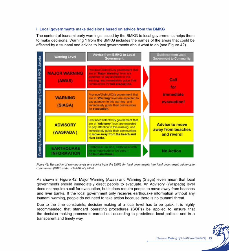
93Decision Making by Local Governments |
i. Local governments make decisions based on advice from the BMKGThe content of tsunami early warnings issued by the BMKG to local governments helps them to make decisions. Warning 1 from the BMKG includes the names of the areas that could be affected by a tsunami and advice to local governments about what to do (see Figure 42).
Figure 42: Translation of warning levels and advice from the BMKG for local governments into local government guidance to communities (BMKG and GTZ IS-GITEWS, 2010)
As shown in Figure 42, Major Warning (Awas) and Warning (Siaga) levels mean that local governments should immediately direct people to evacuate. An Advisory (Waspada) level does not require a call for evacuation, but it does require people to move away from beaches and river banks. If the local government only receives earthquake information without any tsunami warning, people do not need to take action because there is no tsunami threat.
Due to the time constraints, decision making at a local level has to be quick. It is highly recommended that standard operating procedures (SOPs) be applied to ensure that the decision making process is carried out according to predefined local policies and in a transparent and timely way.
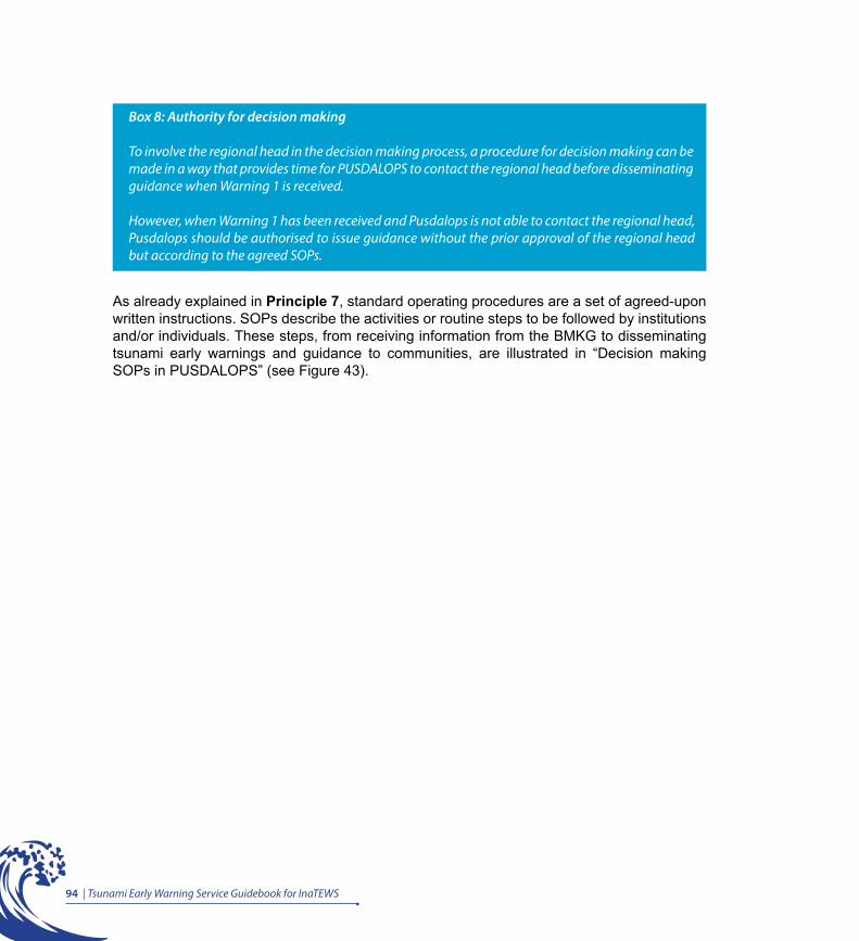
94 | Tsunami Early Warning Service Guidebook for InaTEWS
As already explained in Principle 7, standard operating procedures are a set of agreed-upon written instructions. SOPs describe the activities or routine steps to be followed by institutions and/or individuals. These steps, from receiving information from the BMKG to disseminating tsunami early warnings and guidance to communities, are illustrated in “Decision making SOPs in PUSDALOPS” (see Figure 43).
Box 8: Authority for decision making
To involve the regional head in the decision making process, a procedure for decision making can be made in a way that provides time for PUSDALOPS to contact the regional head before disseminating guidance when Warning 1 is received.
However, when Warning 1 has been received and Pusdalops is not able to contact the regional head, Pusdalops should be authorised to issue guidance without the prior approval of the regional head but according to the agreed SOPs.
95Decision Making by Local Governments |
Figu
re 4
3: D
ecis
ion
mak
ing
SOPs
in P
usda
lops


Principle 10Dissemination of Tsunami Warnings and Guidance by Local Governments
Local governments are required to make use of various communication devices that enable them to widely disseminate earthquake information or warnings, and guidance for evacuation, to the public. Sirens are one of several effective tools to call for evacuation. A steady three-minute sound from a tsunami siren means immediate evacuation. “
“

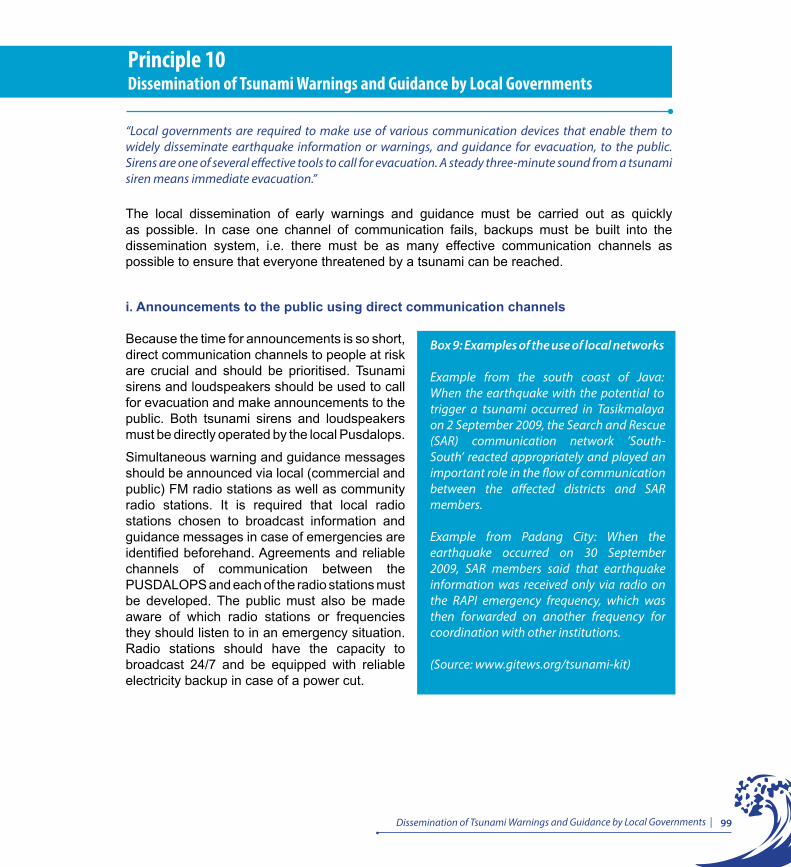
99Dissemination of Tsunami Warnings and Guidance by Local Governments |
Principle 10Dissemination of Tsunami Warnings and Guidance by Local Governments
“Local governments are required to make use of various communication devices that enable them to widely disseminate earthquake information or warnings, and guidance for evacuation, to the public. Sirens are one of several effective tools to call for evacuation. A steady three-minute sound from a tsunami siren means immediate evacuation.”
The local dissemination of early warnings and guidance must be carried out as quickly as possible. In case one channel of communication fails, backups must be built into the dissemination system, i.e. there must be as many effective communication channels as possible to ensure that everyone threatened by a tsunami can be reached.
i. Announcements to the public using direct communication channels
Because the time for announcements is so short, direct communication channels to people at risk are crucial and should be prioritised. Tsunami sirens and loudspeakers should be used to call for evacuation and make announcements to the public. Both tsunami sirens and loudspeakers must be directly operated by the local Pusdalops.
Simultaneous warning and guidance messages should be announced via local (commercial and public) FM radio stations as well as community radio stations. It is required that local radio stations chosen to broadcast information and guidance messages in case of emergencies are identified beforehand. Agreements and reliable channels of communication between the PUSDALOPS and each of the radio stations must be developed. The public must also be made aware of which radio stations or frequencies they should listen to in an emergency situation. Radio stations should have the capacity to broadcast 24/7 and be equipped with reliable electricity backup in case of a power cut.
Box 9: Examples of the use of local networks
Example from the south coast of Java: When the earthquake with the potential to trigger a tsunami occurred in Tasikmalaya on 2 September 2009, the Search and Rescue (SAR) communication network ’South-South’ reacted appropriately and played an important role in the flow of communication between the affected districts and SAR members.
Example from Padang City: When the earthquake occurred on 30 September 2009, SAR members said that earthquake information was received only via radio on the RAPI emergency frequency, which was then forwarded on another frequency for coordination with other institutions.
(Source: www.gitews.org/tsunami-kit)
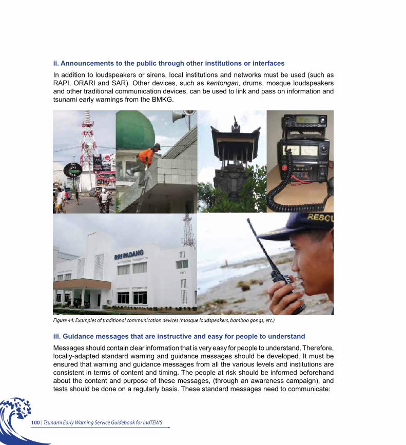
100 | Tsunami Early Warning Service Guidebook for InaTEWS
ii. Announcements to the public through other institutions or interfacesIn addition to loudspeakers or sirens, local institutions and networks must be used (such as RAPI, ORARI and SAR). Other devices, such as kentongan, drums, mosque loudspeakers and other traditional communication devices, can be used to link and pass on information and tsunami early warnings from the BMKG.
Figure 44: Examples of traditional communication devices (mosque loudspeakers, bamboo gongs, etc.)
iii. Guidance messages that are instructive and easy for people to understandMessages should contain clear information that is very easy for people to understand. Therefore, locally-adapted standard warning and guidance messages should be developed. It must be ensured that warning and guidance messages from all the various levels and institutions are consistent in terms of content and timing. The people at risk should be informed beforehand about the content and purpose of these messages, (through an awareness campaign), and tests should be done on a regularly basis. These standard messages need to communicate:
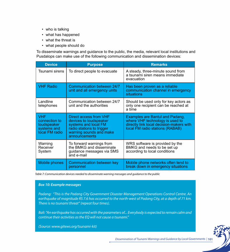
101Dissemination of Tsunami Warnings and Guidance by Local Governments |
• who is talking• what has happened• what the threat is• what people should do
To disseminate warnings and guidance to the public, the media, relevant local institutions and Pusdalops can make use of the following communication and dissemination devices:
Box 10: Example messages
Padang: “This is the Padang City Government Disaster Management Operations Control Centre. An earthquake of magnitude RS 7.6 has occurred to the north-west of Padang City, at a depth of 71 km. There is no tsunami threat” (repeat four times).
Bali: “An earthquake has occurred with the parameters of... Everybody is expected to remain calm and continue their activities as the EQ will not cause a tsunami.”
(Source: www.gitews.org/tsunami-kit)
Device Purpose RemarksTsunami sirens To direct people to evacuate A steady, three-minute sound from
a tsunami siren means immediate evacuation
VHF Radio Communication between 24/7 unit and all emergency units
Has been proven as a reliable communication channel in emergency situations
Landline telephones
Communication between 24/7 unit and the authorities
Should be used only for key actors as only one recipient can be reached at a time
VHF connection to loudspeaker systems and local FM radio
Direct access from VHF devices to loudspeaker systems and local FM radio stations to trigger warning sounds and make announcements
Examples are Bantul and Padang, where VHF technology is used to directly link local decision-makers with local FM radio stations (RABAB)
Warning Receiver System
To forward warnings from the BMKG and disseminate guidance messages via SMS and e-mail
WRS software is provided by the BMKG and needs to be set up according to local conditions
Mobile phones Communication between key personnel
Mobile phone networks often tend to break down in emergency situations
Table 7: Communication devices needed to disseminate warning messages and guidance to the public
102 | Tsunami Early Warning Service Guidebook for InaTEWS
iv. Siren Protocol
Given that sirens are the most important outdoor mass dissemination device, as they are used to call for evacuations, it became necessary to establish a clearly-defined siren sound as a standard for the whole country. In 2007, therefore, the national government (DEPDAGRI, RISTEK, the BNPB and the BMKG) along with representatives from local governments in tsunami-prone areas agreed on a standard siren protocol that applies to all tsunami-prone areas in Indonesia. The content of this protocol is as follows:
1. In case of tsunami early warnings, a steady, three-minute sound is the official call for immediate evacuation. This sound may be repeated for as long as there remains a threat.
2. For maintenance purposes, sirens need to be tested as a matter of routine. Tests will be carried out on the 26th of each month at 10 am local time (recalling the Aceh tsunami, which hit Indonesia at 10 am on the 26th December 2004).
3. For testing purposes, the siren emits a steady, one-minute sound at low volume following a recorded statement saying, “This is a tsunami early warning test. This is just a test.” This is repeated three times during each test.
Due to the fact that triggering a siren will cause communities to immediately react by evacuating, it is necessary to ensure that the decision to sound the siren is backed up by official and clear information from the BMKG, as well as additional, authentic information.
Currently, the NTWC at the BMKG and some local governments have siren control systems. In the future, it is intended that local governments will assume full responsibility for the siren control systems in their areas, including their maintenance. The siren control centre at the BMKG in Jakarta will then act solely as a backup. It is also recommended that local governments inform people living near siren towers about the siren protocol to ensure that they fully understand it.
Box 11: Local sirens and RABABExamples from Padang (West Sumatra Province) and Bantul (Yogyakarta Province): Local experts in Bantul District and Padang City have developed a communication system that allows FM radio stations to be accessed directly from VHF equipment. In Padang, this system is called RABAB (named after a Minangkabau musical instrument). This technology allows for direct access to the public. A special frequency has been agreed upon, which needs to be communicated to the public, so they can receive announcements via radios in their homes, mobile phones or cars. FM receivers can also be linked directly to mosque loudspeakers so that people who do not have access to a radio can hear the announcements via the loudspeakers. (Source: www.gitews.org/tsunami-kit)
Principle 11Standard Strategy for Community Reaction to Natural Tsunami Warning Signs, Earthquake Information, Tsunami Warnings from the BMKG and Guidance from Local Governments
If people feel a strong earthquake, they should immediately evacuate to a safe location while seeking guidance from the local government. Earthquake information and tsunami warnings from the BMKG that contain the estimated threat level and advice for response are the basis for official guidance to the public that either reinforces the need for evacuation or cancels an evacuation if there is no tsunami threat. “
“


105Standard Strategi for Community Reaction to Natural Tsunami Warning Signs, Earthquake Information, Tsunami Warnings from the BMKG and Guidance from Local Governments |
Principle 11Standard Strategy for Community Reaction to Natural Tsunami Warning Signs, Earthquake Information, Tsunami Warnings from the BMKG and Guidance from Local Governments
”If people feel a strong earthquake, they should immediately evacuate to a safe location while seeking guidance from the local government. Earthquake information and tsunami warnings from the BMKG that contain the estimated threat level and advice for response are the basis for official guidance to the public that either reinforces the need for evacuation or cancels an evacuation if there is no tsunami threat.”
i. Standard reaction strategy
There are three main ways in which people can know there is a tsunami threat: 1) natural warning signs (particularly an earthquake), 2) tsunami early warnings from the Tsunami Early Warning Centre at the BMKG and 3) warning and guidance from local government.
People are expected to react to these signs and information using simple logic: An earthquake (especially a strong, long earthquake) is the first sign that a tsunami may occur, so they should move away from beaches and river banks but also seek further information. Official warnings from the BMKG broadcasted on television and radio stations, and guidance from the local government will help people decide whether to continue with, or cancel, an evacuation.
As explained in Principle 5, the BMKG issues earthquake information and tsunami early warnings within five minutes of an earthquake occurring, which are followed by updates and/or an announcement that the tsunami threat has ended. Early warning messages contain the local tsunami threat of which there are three levels: Major Warning (Awas) (tsunami height of ≥ 3 metres), Warning (Siaga) (tsunami height of > 0.5 and < 3 metres), and Advisory (Waspada) (tsunami height of < 0.5 metres). For each level of tsunami threat, the BMKG provides advice for local governments on how to react; for coastal areas, however, “Major Warning” and “Warning” demand one reaction only: evacuation. A tsunami warning level of “Advisory” from the BMKG should not trigger an official call for evacuation but it does mean people should “move away from beaches and river banks”. The content of the tsunami early warnings issued by the BMKG are an invaluable aid to local decision making.
Based on natural warning signs and information from the BMKG, local institutions responsible for early warning (such as the BPBD, if one has been set up), need to develop early warning procedures and standard reaction strategies. A clear local policy about how to react to natural warning signs and official early warnings and to calls for evacuation will help people to react consistently in the event of a tsunami threat. This reaction strategy should also be a part of the tsunami evacuation plan and can target the community at risk and local decision makers.

106 | Tsunami Early Warning Service Guidebook for InaTEWS
Figure 45: Standard reaction strategy for communities to react to natural warning signs and official guidance
Standard reaction strategies, like the one shown in Figure 45, are based on a combination of natural signs and official warnings from government, but they also need to take into account these three important factors:
• The limited time available for announcing warnings and evacuation orders• The possibility of a failure in warning services• An understanding that there is a factor of uncertainty to local tsunami early warnings,
natural signs, and official warnings
ii. Exceptions for some areasThere are exceptions for some areas at risk, such as islands that lie above or very close to tectonic collision zones. In these areas, tsunamis arrive very quickly, sometimes less than five minutes after an earthquake occurs, so there is not enough time to wait for warnings from the BMKG. Therefore, communities in these areas should immediately react to an earthquake by evacuating themselves without waiting for an official warning from the NTWC. Some local knowledge on when and how to carry out “self-evacuation” has saved many people in these areas from tsunamis.

Principle 12Recommendations for Local Tsunami Preparedness
Tsunami preparedness depends on the preparedness both of local institutions and communities at risk. Local governments, together with other stakeholders, are obliged to analyse the tsunami risk, prepare tsunami contingency and evacuation plans, develop institutional capacity and infrastructure for early warning, issue local regulations for disaster management and raise people’s awareness of the tsunami risk and appropriate ways to respond to it.
““

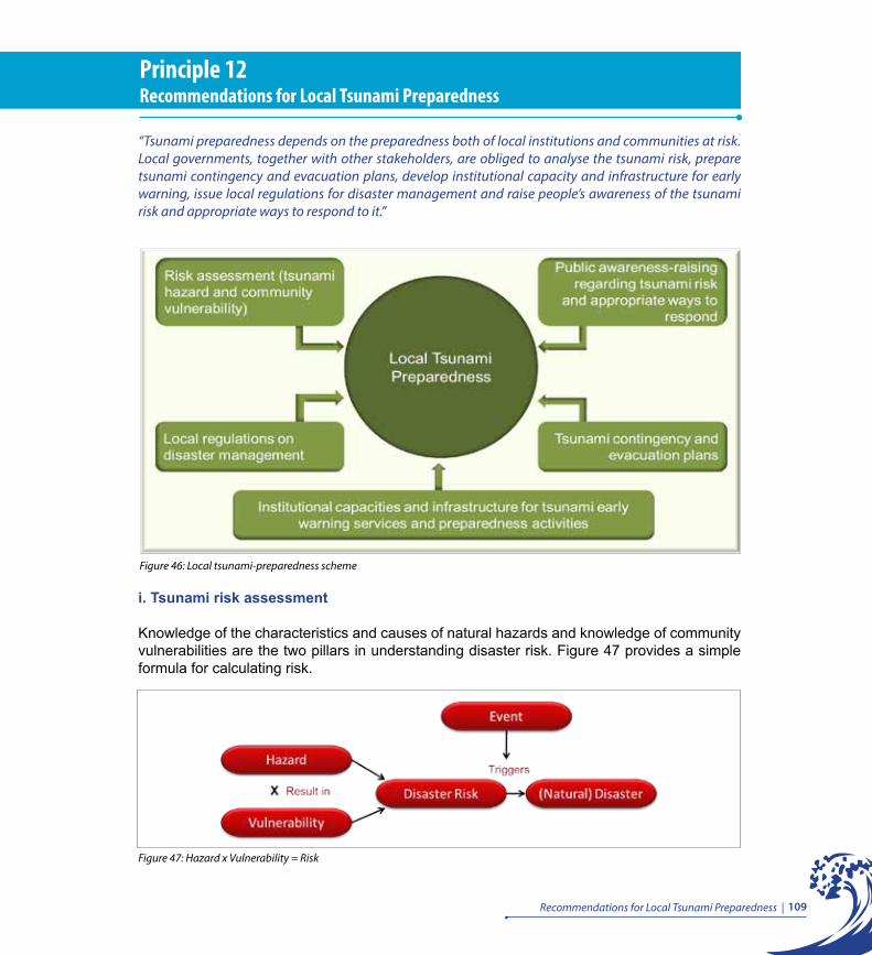
109Recommendations for Local Tsunami Preparedness |
Principle 12Recommendations for Local Tsunami Preparedness
“Tsunami preparedness depends on the preparedness both of local institutions and communities at risk. Local governments, together with other stakeholders, are obliged to analyse the tsunami risk, prepare tsunami contingency and evacuation plans, develop institutional capacity and infrastructure for early warning, issue local regulations for disaster management and raise people’s awareness of the tsunami risk and appropriate ways to respond to it.”
i. Tsunami risk assessment
Knowledge of the characteristics and causes of natural hazards and knowledge of community vulnerabilities are the two pillars in understanding disaster risk. Figure 47 provides a simple formula for calculating risk.
Figure 47: Hazard x Vulnerability = Risk
Figure 46: Local tsunami-preparedness scheme
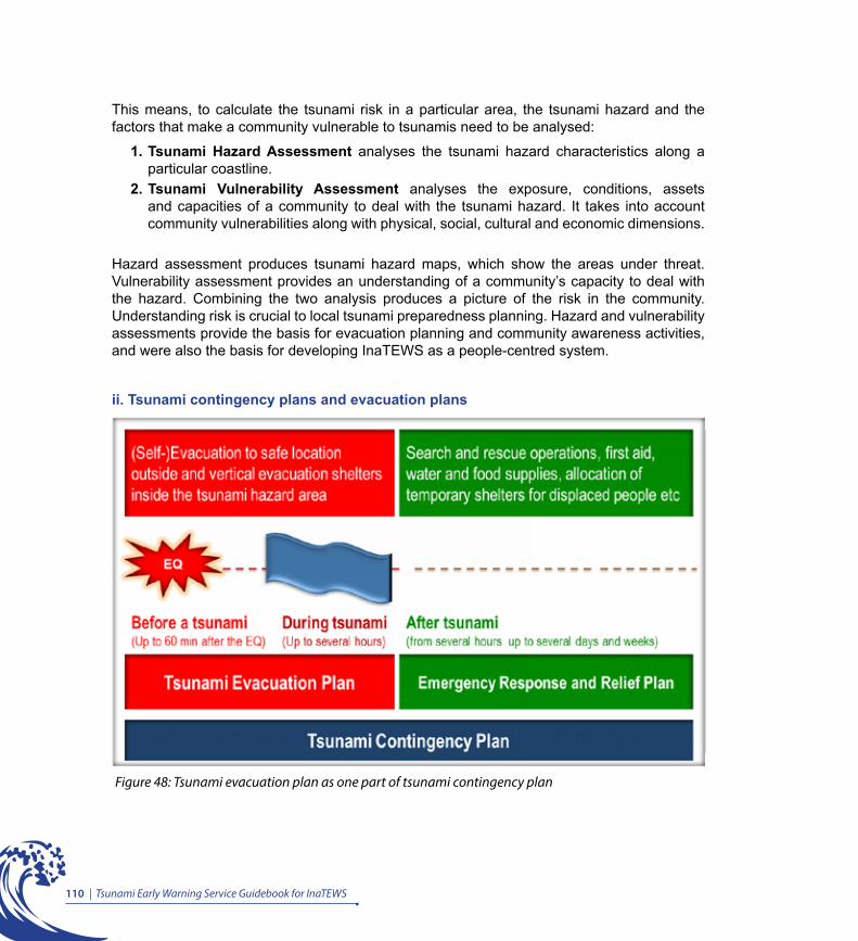
110 | Tsunami Early Warning Service Guidebook for InaTEWS
This means, to calculate the tsunami risk in a particular area, the tsunami hazard and the factors that make a community vulnerable to tsunamis need to be analysed:
1. Tsunami Hazard Assessment analyses the tsunami hazard characteristics along a particular coastline.
2. Tsunami Vulnerability Assessment analyses the exposure, conditions, assets and capacities of a community to deal with the tsunami hazard. It takes into account community vulnerabilities along with physical, social, cultural and economic dimensions.
Hazard assessment produces tsunami hazard maps, which show the areas under threat. Vulnerability assessment provides an understanding of a community’s capacity to deal with the hazard. Combining the two analysis produces a picture of the risk in the community. Understanding risk is crucial to local tsunami preparedness planning. Hazard and vulnerability assessments provide the basis for evacuation planning and community awareness activities, and were also the basis for developing InaTEWS as a people-centred system.
ii. Tsunami contingency plans and evacuation plans
Figure 48: Tsunami evacuation plan as one part of tsunami contingency plan
111Recommendations for Local Tsunami Preparedness |
Figure 48 shows that the contingency plan is an important part of the overall preparedness plan (pre- and post-disaster, including evacuation plans) up to the emergency response and humanitarian assistance phase (post-disaster). Contingency plans need to be developed for each type of hazard, and then updated and tested regularly.
To produce contingency plans, local governments need a planning process, starting from the initial regulations through to the establishment of strategies and procedures for responding to potential crises or emergencies, and on to the establishment of monitoring and evaluation plans. This includes developing scenarios (to anticipate emergencies), designating responsibilities to all stakeholders, identifying roles and resources, collecting data and disseminating information, regulating each stakeholder so that they are ready when needed, determining needs so that objectives can be achieved, understanding warning systems and procedures, making sector plans for receiving warnings and determining procedures for informing the public.
Tsunami contingency plans describe the action that needs to be taken before, during and after a tsunami emergency. It covers two types of preparation:
1. For tsunami evacuation, which lasts from the earthquake occurring through the tsunami event until the end of threat has been announced.
2. For tsunami emergency response, which usually starts after the tsunami has receded and the end of threat has been announced.
As explained in Principle 11, people need to begin evacuating as soon as they feel either a strong earthquake or a lighter but long-lasting earthquake. Official early warnings, advice, and guidance serve to confirm evacuations and are tools for informing people, especially those who did not feel the earthquake, or those who are unsure whether or not they need to evacuate.
Tsunami evacuation planning is part of disaster management and is the responsibility of local governments. However, tsunami risks are of interest to everyone in a community. Therefore, all elements of the community need to be involved in disaster risk reduction. Meetings between representatives from the various elements within a community in the planning process is the best way of reaching a realistic solution to producing an evacuation plan that meets people’s needs, so that when a tsunami does occur, the people are ready to deal with it.
Box 12: BNPB definition of contingency planning
The National Disaster Management Agency’s (BNPB) definition of contingency planning: “A forward-planning process, for times of uncertainty, in which scenarios and objectives are agreed upon, technical and managerial actions are agreed upon, and response and guidance systems are agreed upon for better avoidance and management of emergency or critical situations.” (BNPB, 2008)
112 | Tsunami Early Warning Service Guidebook for InaTEWS
iii. Local government regulations on disaster managementAs mandated by Law 32/2004, the preparation and passing of regulations to protect people in a particular area is an obligation of local government. Law 24/2007 gives a mandate and authority to local governments for drafting regulations to form the legal basis for disaster risk reduction, including tsunami early warning systems. Regulations on disaster mitigation and tsunami early warning may take the form of a Regional Regulation, a Regulation, or a Decree by the Governor/Mayor/District Head.
As a public service, tsunami early warning is also the responsibility of central government. Therefore, the government must prepare a clear legal framework and legislation, show political commitment, and lead the coordination and cooperation among stakeholders.
There are several topics to be taken into account when drafting regional regulations for tsunami early warning, including:
• Risk analysis (tsunami hazard and vulnerability)• Warning timeline• Warning chain (flow of warnings and information from the BMKG to the public)• Policy on warning dissemination and evacuation decisions• The roles and responsibilities of stakeholders in decision making and dissemination of
warnings and guidance• Policy on evacuation planning• Socialisation and awareness raising of tsunami early warnings• Procedure for when there is a system failure or breach of regulations
Box 13: Definition of evacuation plan
An evacuation plan is a document that contains information about local conditions, evacuation strategies and procedures, evacuation maps, and recommendations for future action to improve local tsunami preparedness.
(Source: www.gitews.org/tsunami-kit)
Box 14: When drafting legislation
Law 10/2004 on Drafting statutory provisions states that when drafting a regulation, a local government is obliged to state the objective and the institutions responsible. The content of the regulation must be appropriate to the type of regulation, i.e. it must have clear definitions, feasibility and guidelines, and must not be ambiguous.
113Recommendations for Local Tsunami Preparedness |
In general, SOPs should not be part of the regulation itself but should be included as an appendix to regulations, because they need to be evaluated and updated as a matter of routine to ensure that they are effective and efficient, based on local conditions and needs.
Examples of local regulations
Padang City Government passed Regional Regulation 3/2008 on disaster management. Article 6 states that the local government is responsible for implementing the early warning mechanism. Regulation by the Mayor 14/2010 explains the tsunami early warning system for Padang City.
Bali Provincial Government issued the Decree by the Governor 30/2009 and the Decree by the Governor 31/2009 on the operations control centre that is responsible for issuing tsunami early warnings to the public, tsunami-hazard maps, budget allocation, human resource development, and related SOPs.
Cilacap District Government issued the Decree by the District Head 360/298/14/2007 on the formation of working groups to manage the implementation of tsunami early warning systems at the district level.
iv. Building tsunami early warning capacity and infrastructure Analysis of the capacity of organisations and institutions involved in a tsunami early warning system should be carried out before capacity-building plans are made and training programs developed. The development of capacity and infrastructure in local Pusdalops should focus on the overall mechanism for receiving information from the BMKG, making decisions, and disseminating warnings and guidance to the public.
As explained in the other principles, local government needs to have an office operating 24/7 that has well-trained and competent personnel, completed infrastructure, and properly functioning planning tools, such as evacuation maps, vulnerability maps, evacuation routes, evacuation plans and SOPs.
Other capacity development needed by personnel is the maintenance of the operating equipment, and the conducting of routine checks to ensure the reliability of operations 24/7.
v. Public awareness activities Because they are so complex, tsunami early warning systems like the Indonesian Tsunami Early Warning System (InaTEWS) probably have more requirements than any other warning system. To ensure that the system is installed and operating properly, there needs to be cooperation between experts, personnel and practitioners from various levels, with various backgrounds, and with different perspectives. Therefore, building a common understanding of the system as a whole is vital.

114 | Tsunami Early Warning Service Guidebook for InaTEWS
This means that actors involved in strengthening community preparedness, for example, need to understand the process of producing warnings and what can be expected from the National Tsunami Warning Centre. Planners of the warning dissemination mechanism and developers of warning messages need to know the needs of the end-users (the community at risk). Initial criteria for those involved in operating an effective warning system are that they share knowledge, understand their own responsibilities, and are aware of the roles of other stakeholders.
Important points that should be made to people during awareness activities include: basic information of the principles of disaster management, general information about earthquakes and tsunamis, people’s knowledge and understanding of their area, information about InaTEWS, where warnings come from and how people can receive them (warning chain), the set-up of the local warning- and guidance-dissemination system and procedures, the reaction scheme regarding siren sounds and their meanings, the content of guidance messages and, last but not least, the local evacuation plan.
115Recommendations for Local Tsunami Preparedness |
vi. Key messages to be considered for tsunami preparedness and early warning Out of the 12 Principles in this Guidebook the following key messages related to tsunami preparedness and early warning in Indonesia are as follows:
1. Tsunami arrival times in Indonesia are usually very short, between 10 and 60 minutes, which means that people should not wait for an official warning before they react. If a strong earthquake or lighter but long-lasting earthquake is felt, people should immediately move away from beaches and rivers and evacuate to a safe location.
2. The first wave may not be the largest one. People should not return to the hazard zone before the end of threat has been announced.
3. There are four essential components to a comprehensive and effective people-centred early warning system: risk knowledge, risk monitoring and warning service, dissemination and communication, and response capability (UNISDR, 2006).
4. The agencies that play a role in the InaTEWS tsunami early warning communication chain are:• The Meteorological Climatological and Geophysical Agency (Badan Meteorologi,
Klimatologi dan Geofisika – BMKG) with headquarters in Jakarta, which incorporates the National Tsunami Warning Centre
• Local governments at provincial, district and municipal levels • National and local television and radio stations (public and commercial) • The National Disaster Management Agency (Badan Nasional Penanggulangan
Bencana – BNPB)• The Indonesian Military• The National Police• Communities at risk
5. The BMKG categorises tsunami warning levels based on the predicted tsunami impact:
• Wave height of > 3 metres, warning level is Major Warning (Awas)• Wave height of > 0.5 and < 3 metres, warning level is Warning (Siaga) • Wave height of < 0.5 metres, warning level is Advisory (Waspada)
6. There are four types of warning issued by the BMKG:
• Warning 1: Disseminated based on earthquake parameters and the estimated impact of the tsunami reflected by a warning level (Major Warning - Awas, Warning - Siaga or Advisory - Waspada) for every affected district.
• Warning 2: Contains updated earthquake parameters and, in addition to the warning levels in Warning 1, also the tsunami wave’s estimated time of arrival (ETA) on shore.
• Warning 3: Contains tsunami observation information, updated warning level and tsunami arrival times, which may be disseminated several times depending on the tsunami observations at the tide gauge stations and the buoys.
• Warning 4: Announces that tsunami early warning has ended (end of threat).
116 | Tsunami Early Warning Service Guidebook for InaTEWS
7. To fulfil their roles and responsibilities in tsunami early warning services, local governments must be able to carry out the three following tasks:• Receive accurate earthquake information and tsunami early warnings and advice from
the BMKG 24/7 through various communication media. • Make decisions promptly about the local reaction (whether people need to evacuate
or not) based on the earthquake information and tsunami early warnings and advice from the BMKG, following standard operating procedures (SOPs).
• Widely disseminate earthquake information and early warnings and give clear and instructive guidance to communities and local institutions directly and promptly using communication methods and channels to allow everyone threatened by a tsunami to receive the information.
8. Building public awareness and capacity is key to the success of a tsunami early warning system in Indonesia because, however good the early warning system, if the community at risk does not understand or accept it, the system will not be effective.
Box 15: UNESCO – How to survive a tsunami
UNESCO (2009), representing the Intergovernmental Oceanographic Commission (IOC) examined recent experiences in Indonesia from the tsunamis that hit Aceh (2004) and Pangandaran, West Java (2006). These experiences, which were gathered from survivors, have been turned into a booklet that summarises the lessons learned about how to survive a tsunami, such as:
• Abandon belongings• Keep away from cars• Take care near rivers and bridges• Get up a tall building or a tree• Use floating debris as rafts• If you are offshore, move out to sea• Expect more than one wave
This booklet is available at the Jakarta Tsunami Information Centre website: www.jtic.org

Tsunami Early Warning Service Guidebook for InaTEWS | 117
Appendix: Warning Segments
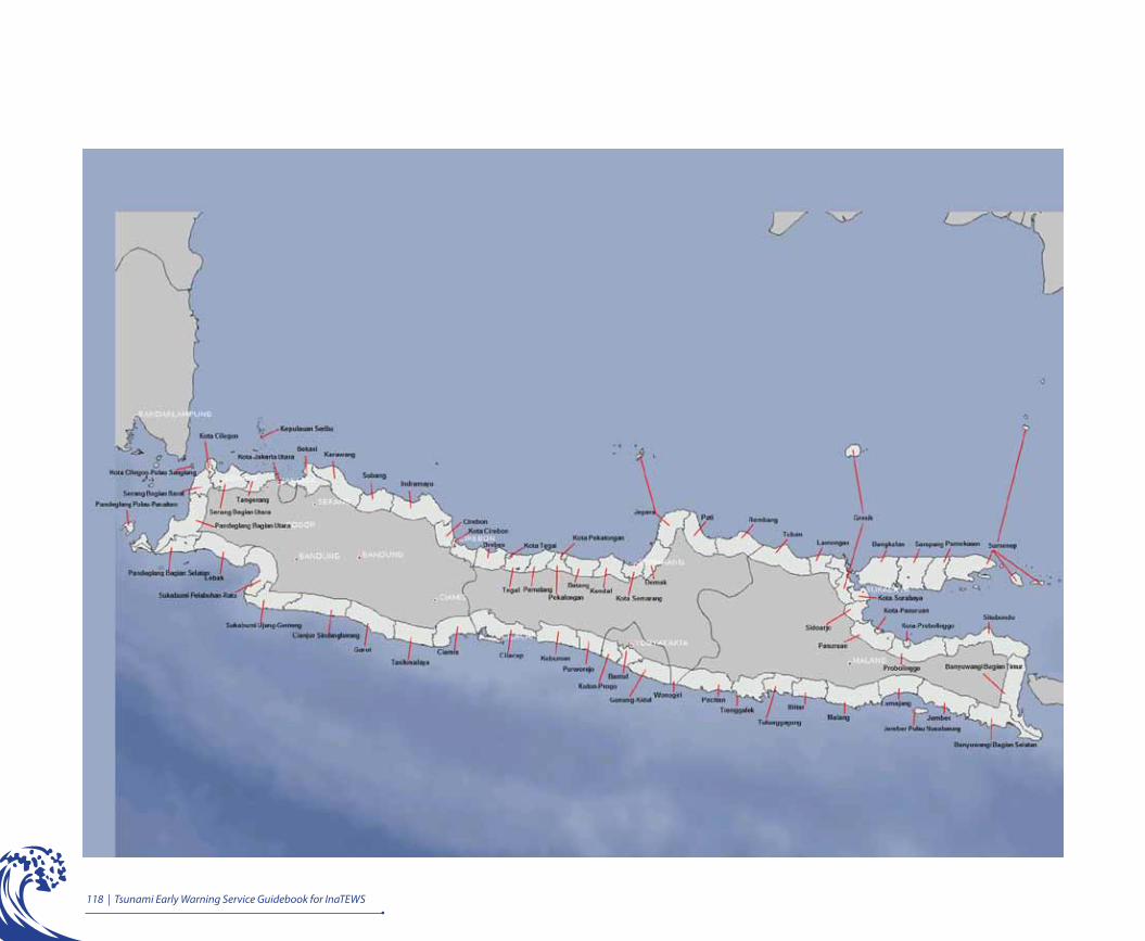
118 | Tsunami Early Warning Service Guidebook for InaTEWS
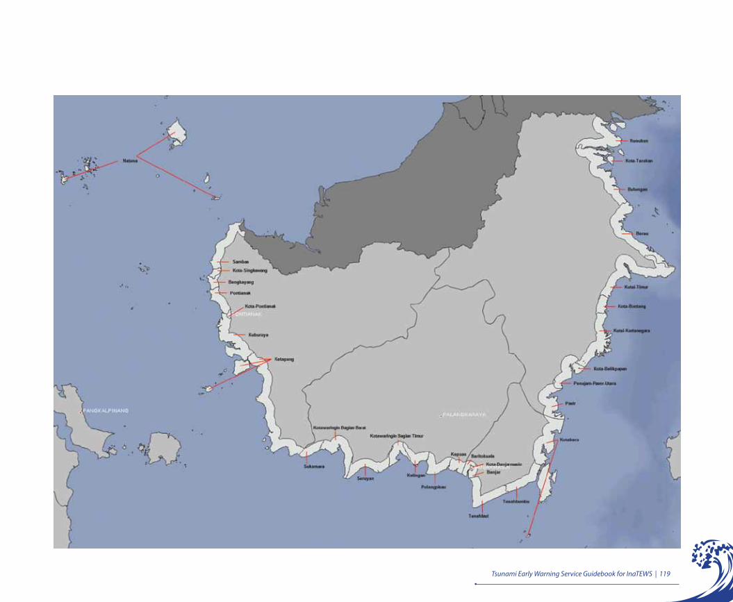
Tsunami Early Warning Service Guidebook for InaTEWS | 119

120 | Tsunami Early Warning Service Guidebook for InaTEWS
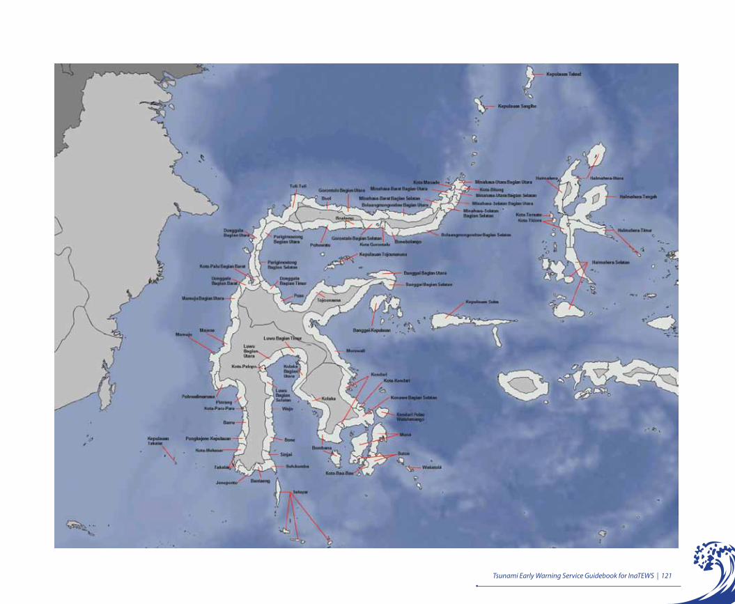
Tsunami Early Warning Service Guidebook for InaTEWS | 121
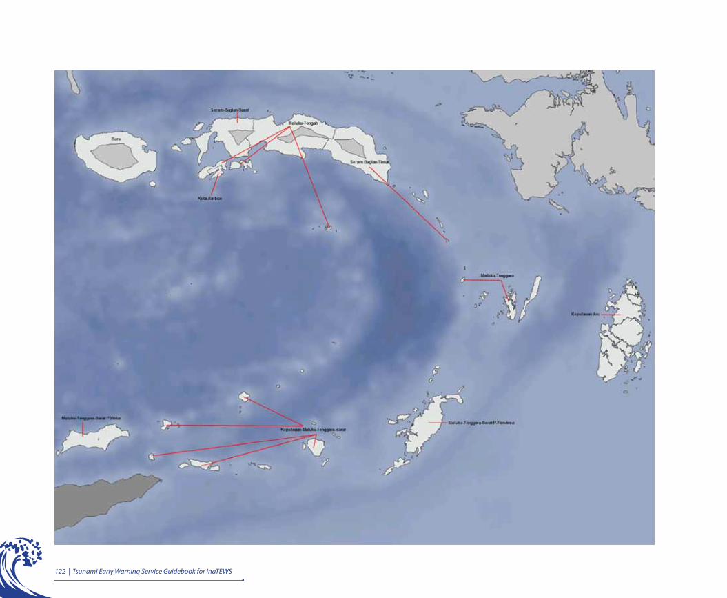
122 | Tsunami Early Warning Service Guidebook for InaTEWS
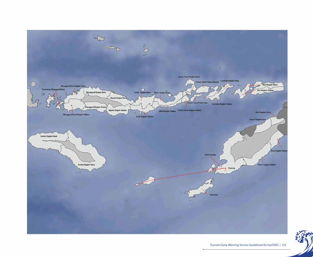
Tsunami Early Warning Service Guidebook for InaTEWS | 123
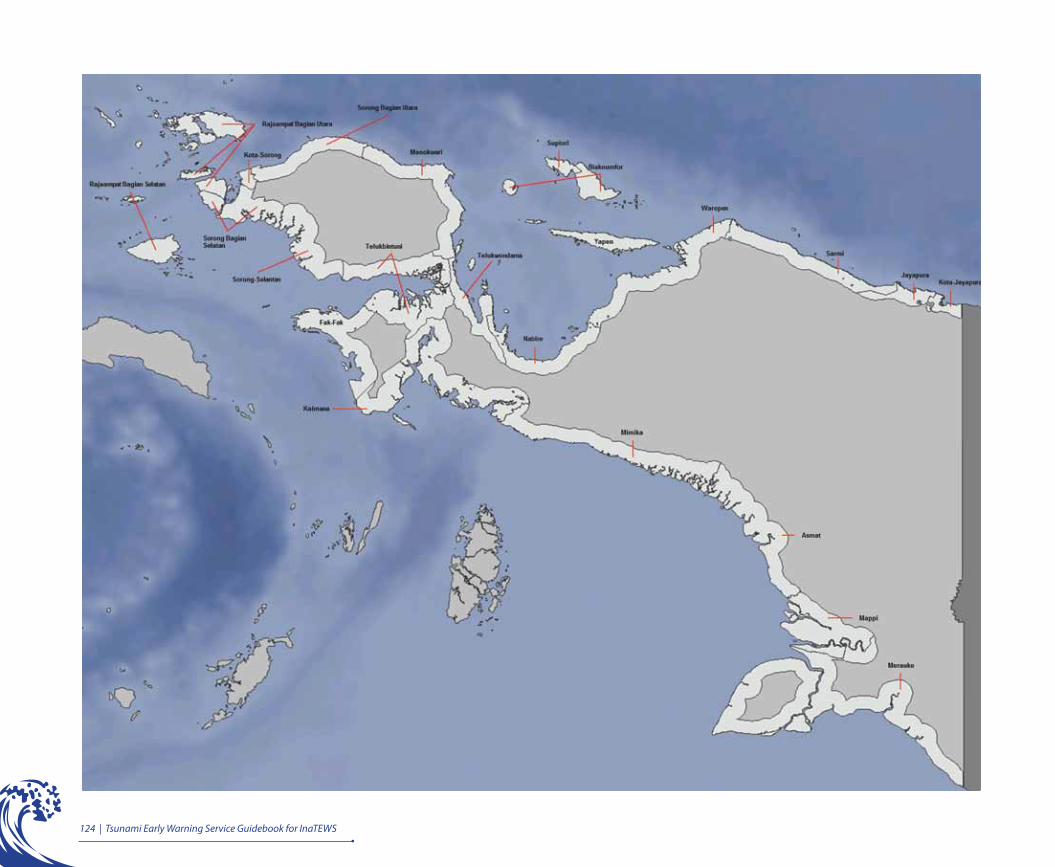
124 | Tsunami Early Warning Service Guidebook for InaTEWS

125Tsunami Early Warning Service Guidebook for InaTEWS |
Appendix: What the InaTEWS Logo Means
The circle with the words Tsunami Early Warning System and Indonesia:• ThewordIndonesiaunderneathTsunamiEarlyWarningSystemindicatesthatallareasinIndonesiaarecoveredbytheIndonesiaTsunamiEarlyWarningSystem(InaTEWS).IfanypartoftheterritoryofIndonesiawerethreatenedbyatsunami,InaTEWSwouldsendatsunamiearlywarningtopeoplelivinginthatarea.
• Thecirclesymbolisestheglobe,sinceInaTEWScontributestowardsprotectingtheworldcommunityfromthethreatoftsunamis.ThisisenforcedbytherecognitionofInaTEWSasoneoftheRegionalTsunamiServiceProviders(RTSP)fortheIndianOceanregion.
A picture of a tsunami accompanied by five relatively small signals inside the circle:
The chronology from right to left illustrates the flow of tsunamiearly warning information, which begins with the results frommonitoringseismicwavesuntilthetsunamiarrives.
• Tsunamiearlywarningannouncementsareissuedbaseduponanalysisoftheseismicmonitoringsystem
• Tsunamiobservationsareissuedbaseduponsignalsobtainedfrombuoys,tidegaugesand/orCCTV
• The GPS Network, Buoy-OBU and Tsunami Radars are still at an experimental/assessmentstagewithaviewtobecomingoperationalfeaturesofInaTEWS
SeismicsignalSignalfromGlobalPositioningSystem(GPS)DisseminationoftsunamiearlywarningannouncementsBuoySignal/OBU/CODARTide gauge signal/CCTV show when a tsunami has alreadyreachedcoastalareas

126 | Tsunami Early Warning Service Guidebook for InaTEWS
List of Figures
Figure 1: MovementofthemaintectonicplatesaroundIndonesia.................................................3Figure 2: DistributionofearthquakesinIndonesia,1973–2010...................................................4Figure 3: Plateboundaries(USGS)...............................................................................................5Figure 4: Mapof tsunami-proneareas ..........................................................................................6Figure 5: Distributionofmajorearthquakesandtsunamis,1991–2010........................................7Figure 6: Tsunamiearlywarningandevacuationtimeline..............................................................10Figure 7: Thefourelementsofpeople-centredearlywarning........................................................15Figure 8: Tsunamiearlywarningcommunicationchain..................................................................20Figure 9: Rolesandresponsibilitiesoforganizationsandcommunitiesinthetsunamiearly
warningcommunicationchain........................................................................................23Figure 10: InaTEWSdesign............................................................................................................27Figure 11: Seismometerandseismogram.....................................................................................28Figure 12: NetworkofseismicstationsinIndonesia........................................................................29Figure 13: ScreenshotofSeisComp3..............................................................................................30Figure 14: EarthquakeinformationdisseminatedviaSMSandinternet..........................................30Figure 15: OceanBottomUnit(OBU)andbuoy..............................................................................32Figure 16: Tidegaugestation..........................................................................................................32Figure 17: Networkoftidegaugestations.......................................................................................33Figure 18: GPSstationsontidegaugeandonland........................................................................33Figure 19 CCTVcamerasfittedfortsunamimonitoring..................................................................34Figure 20: Tsunamiradar.................................................................................................................35Figure 21: TheDSSresultsaredisplayedonfourscreens.............................................................36Figure 22: Thefirstscreenisthesituationperspectiveofthegeographicalsituationandtimeline.
Amapshowstheexpectedpropagationofthetsunamiwavesaccordingtoapre-calculatedscenario,andalsoindicatesthelocationofbuoysandtidegaugesthatareinthe range of the tsunami waves .................................................................................37
Figure 23: Asecondscreenprovidesmoredetailedinformationfromincomingmeasurementsofthedifferentsensorsaswellassimulationdata..........................................................38
Figure 24: Anevaluationofthesituationisdisplayedonathirdscreen.TheDSSassignsawarninglevelforeachoftheaffecteddistrictsandproposesoptionsfordecisionmaking...........................................................................................................................39
Figure 25: Besidesthedisseminationcontrolbuttons,thefourthscreenprovidesasummaryofthetsunamiwarningandapreviewofthewarningmessages.....................................40
Figure 26: Tsunamiearlywarningtimelinefornearfieldtsunamis..................................................45
127Tsunami Early Warning Service Guidebook for InaTEWS |
Figure27: Warning1forforinterfaceinstitutions.............................................................................57Figure28: Warning2forforinterfaceinstitutions.............................................................................58Figure29: Warning3forforinterfaceinstitutions.............................................................................59Figure30: Warning4forforinterfaceinstitutions.............................................................................60Figure31: WRSformatforthemedia(Warning1)...........................................................................61Figure32: WRSformatforthemedia(Warning2)...........................................................................61Figure33: WRSformatforthemedia(Warning3)...........................................................................61Figure34: WRSformatforthemedia(Warning4)...........................................................................61Figure35: Warningdistributionsystem............................................................................................68Figure36: BMKGcommunicationnetworkforinformationdissemination(viaTelkomsel,Indosat,
5in1,electronicmedia,sirens).......................................................................................70Figure37: Locations(10)ofthe28sirensasof2010.......................................................................72Figure38: MinimumnumberofsirensthatshouldbeinstalledacrossIndonesia..............................72Figure39: The three main tasks of local government (in the red rectangle) in tsunami early
warningservices(Source:GovernmentRegulation21/2008ontheImplementationofDisasterManagement,Article19)...............................................................................78
Figure40: ExamplesofdevicesforreceivinginformationandearlywarningsfromtheBMKG(website,WRS,SMS,e-mail,fax)...................................................................................87
Figure41: Estimatedtimefromalocaltsunamioccurringuntilinformationisreceivedwithconfirmationofthetsunami,andthelimitedreactiontime(Source:GIZIS-GITEWS)..92
Figure42: TranslationofwarninglevelsandadvicefromtheBMKGforlocalgovernmentsintolocalgovernmentguidancetocommunities(BMKGandGTZIS-GITEWS,2010...93
Figure43: DecisionmakingSOPsinPusdalops..............................................................................95Figure44: Examplesoftraditionalcommunicationdevices(mosqueloudspeakers,bamboogongs,
etc)...............................................................................................................................100Figure45: Standardreactionstrategyforcommunitiestoreacttonaturalwarningsignsand
officialguidance............................................................................................................106Figure46: Localtsunamipreparednessscheme.............................................................................109Figure47: HazardxVulnerability=Risk..........................................................................................109Figure48: Tsunamievacuationplanasonepartoftsunamicontingencyplan.................................110
128 | Tsunami Early Warning Service Guidebook for InaTEWS
List of Tables
Table1: Destructive tsunamis, 1990 – 2010 (Tsunami Catalogue – BMKG, 2010) .................8
Table2: Warning levels and advice to local governments by the BMKG.................................46
Table3: Comparisonoftsunamiwarningformats.............................................................................48
Table4: Advantagesanddisadvantagesofsirens............................................................................73
Table5: Informationreceivedautomatically....................................................................................85
Table6: Informationretrievedbyuser............................................................................................86
Table7: Communicationdevicesneededtodisseminatewarningmessagesandguidancetothe
public .............................................................................................................................101
List of Boxes
Box1: Moveawayfrombeaches&riverbanksassoonasanearthquakeoccurs............................77
Box2: TemporarysolutionforregionsthatdonothaveaBPBDandPusdalops..............................79
Box3: ExamplefromPadang.......................................................................................................80
Box4: ExamplesfromBaliandAceh.............................................................................................81
Box5: ExamplefromthesouthcoastofJava.............................................................................81
Box6: “Heads-up” .......................................................................................................................86
Box7: False warnings? ..............................................................................................................92
Box8: Authorityfordecisionmaking...........................................................................................94
Box9: Examplesoftheuseoflocalnetworks................................................................................99
Box10: Examplemessages ........................................................................................................101
Box11: LocalsirensandRABAB.................................................................................................102
Box12: BNPBdefinitionofcontingencyplanning .......................................................................111
Box13: Definitionofevacuationplan...........................................................................................112
Box14: Whendraftinglegislation.................................................................................................112
Box15: UNESCO–Howtosurviveatsunami..............................................................................116

129Tsunami Early Warning Service Guidebook for InaTEWS |
List of Photographs
Photo on Principle1.Impact of the Aceh Tsunami, Desember 26, 2004.
Photo on Principle 3.Activities at the “Warning Centre” at the Time the Japanese Earthquake struck on March 11, 2011.
Photo on Principle 5.SeisComP3 Display at the Time of the Japanese Earthquake, March 11, 2011.
Photo on Principle 2.The BMKG Operational Building and Tsunami Warning Center.
Photo on Principle 3.Awareness Raising for School Students via the Tsunami Evacuation Training Programme.
Photo on Principle 6.Tsunami Siren in Bali.
Photo on Principle 2.Socialisation Programme to raise Awareness among the Public about Preparedness and Tsunami Early Warning.
Photo on Principle 4.Antenna as data receiver for the Tsunami Early Warning System.
Photo on Principle 5.SeisComP3 Displat after the Earthquake on April, 11 2012.

130 | Tsunami Early Warning Service Guidebook for InaTEWS
Photo on Principle 8.Tsunami Early Warning Short Message Format
Photo on Principle 11.Parangtritis Beach in 2010.
Photo on Principle 9.Working Group Activities in Padang during a Decision-Making Training.
Photo on Principle 12.Socialisation of Evacuation Plans in Java, 2010.
Photo on Principle 10.Bantul Working Group Visits PUSDALOPS Bali to Exchange Experience .
Photo on Principle 7.Local Working Group discussing Tsunami Hazard Map in Southern Java
Photo on Principle 6.Tsunami Warning sent via the WRS.
Photo on Principle 8.Pusdalops receives Tsunami Warning.
Photo on Principle 9.Decision Making by the Local Government during Drill.
131Tsunami Early Warning Service Guidebook for InaTEWS |
Bakosurtanal/BIG BadanKoordinasiSurveidanPemetaanNasional/BadanInformasi
Geospasial
(CoordinatingBodyforSurveyandNationalChartingDevelopment
Agency/GeospatioalInformationAgency)
BHA BaliHotelsAssociation
BMKG BadanMeteorologiKlimatologidanGeofisika
(MeteorologicalClimatologicalandGeophysicalAgency)
BNPB BadanNasionalPenanggulanganBencana
(NationalDisasterManagementAgency)
BPBD BadanPenanggulanganBencanaDaerah
(RegionalDisasterManagementAgency)
BPPT BadanPengkajiandanPenerapanTeknologi
(AgencyfortheAssessmentandApplicationofTechnology)
CCTV ClosedCircuitTelevision
CODAR CoastalOceanDynamicsApplicationsRadar
DIY DaerahIstimewaYogyakarta
(YogyakartaProvince)
DSS DecisionSupportSystem
DVB DigitalVideoBroadcasting
EQ Earthquake
ETA EstimatedTimeofArrival
FM FrequencyModulation
FMRDS FrequencyModulationRadioDataSystem
GITEWS GermanIndonesianCooperationforaTsunamiEarlyWarningSystem
GFZ GermanResearchCentreforGeosciences
GPS GlobalPositioningSystem
GTS GlobalTelecommunicationSystem
GTZIS GermanTechnicalCooperation-InternationalServices
Abbreviations

132 | Tsunami Early Warning Service Guidebook for InaTEWS
GIZIS GermanInternationalCooperation-InternationalServices
HP Handphone
HF HighFrequency
IFRC InternationalFederationofRedCrossandRedCrescentSocieties
InaTEWS IndonesiaTsunamiEarlyWarningSystem
IOC IntergovernmentalOceanographicCommission
ITIC InternationalTsunamiInformationCenter
JTIC JakartaTsunamiInformationCenter
Kemendagri KementerianDalamNegeri
(MinistryofHomeAffairs)
Kemenristek KementerianNegaraRisetdanTeknologi
(StateMinistryofResearchandTechnology)
Kesbanglinmas KesatuanBangsadanPerlindunganMasyarakat
(CivilDefenseAgency)
kHz kilohertz
KM Kilometer
LC LendChannel
LIPI LembagaIlmuPengetahuanIndonesia
(IndonesianInstituteofSciences)
Litbang PenelitiandanPengembangan
(ResearchandDevelopment)
LSM LembagaSwadayaMasyarakat
(Non-GovernmentOrganization)
M Magnitudo
NAD NanggroeAcehDarussalam
(NanggroeAcehDarussalamProvince)
NGDC NationalGeophysicalDataCenter
NGO Non-GovernmentalOrganization
NOAA NationalOceanicandAtmosphericAdministration
133Tsunami Early Warning Service Guidebook for InaTEWS |
NTT NusaTenggaraTimur
(EastNusaTenggara)
NTWC NationalTsunamiWarningCenter
OBU OceanBottomUnit
ORARI OrganisasiRadioAmatirRepublikIndonesia
(AmateurRadioOrganizationofIndonesia)
Pemda pemerintahdaerah
(localgovernment)
Perda peraturandaerah
(RegionalRegulation)
Pergub peraturangubernur
(GovernorRegulation)
Perka peraturankepala
(TheRegulationoftheHead)
Perwako peraturanwalikota
(MayorRegulation)
PMI PalangMerahIndonesia
(IndonesianRedCross)
POLRI KepolisianNegaraRepublikIndonesia
(NationalPolice)
PP peraturanpemerintah
(GovernmentRegulation)
Pusdalops PusatPengendalianOperasi
(OperationControlCentre)
PusdalopsPB PusatPengendaliandanOperasionalPenanggulanganBencana
(OperationandControlCentreforDisasterManagement)
PROTECTS ProjectforTraining,EducationandConsultingforTsunamiEarly
WarningSystems
RAPI RadioAntarpendudukIndonesia
(Inter-PopulationRadioofIndonesia)
134 | Tsunami Early Warning Service Guidebook for InaTEWS
RS RichterScale
SAR SearchandRescue
Satlak SatuanPelaksana
(ImplementationUnit)
SK suratkeputusan
(Decree)
SKPD SatuanKerjaPemerintahDaerah
(LocalGovernmentWorkingUnit)
SMS ShortMessageSystem
SOP StandardOperatingProcedure
TEWS TsunamiEarlyWarningSystem
TNI TentaraNasionalIndonesia
(IndonesianMilitary)
TV Television
UHF UltraHighFrequency
UNISDR UnitedNationInternationalStrategyforDisasterReduction
UNESCO UnitedNationsEducational,ScientificandCulturalOrganization
UU undang-undang
(StatutoryLaw)
VHF VeryHighFrequency
WMO WorldMeteorologicalOrganization
WRS WarningReceiverSystem
135Tsunami Early Warning Service Guidebook for InaTEWS |
Bibliography
NationalMeteorological,ClimatologicandGeophysicalAgency(BMKG):InaTEWS,IndonesiaTsunamiEarlyWarningSystem,KonsepdanImplementasi,March2010.
Meteorological,ClimatologicalandGeophysicalAgency(BMKG):KatalogTsunami,2010.
NationalAgency forDisasterManagement (BNPB): PerencanaanKontinjensiMenghadapiBencana,July2008.
Bernard E.N.: TheU.S.NationalTsunamiHazardMitigation Program:A successful State-Federalpartnership.NaturalHazards,35,5-24,2005.
EkoYulianto,FauziKusmayanto,NandangSupriyatna,Dirhamsyah:SelamatDariBencanaTsunami, Pembelajaran dari Tsunami Aceh dan Pangandaran, UNESCO-JTIC,2010.
JankaewA.,AtwaterB.F.,SawaiY.,ChoowongM.,CharoentiratT.,MartinM.E.,PrendergastA.: Medieval forewarning of the 2004 Indian Ocean tsunami in Thailand.NatureInternationalWeeklyJournalofScience,October2008.
SubandonoDiposaptono,Budiman.HidupAkrabDenganGempadanTsunami, printedbyBukuIlmiahPopuler,January2008.
TheInternationalFederationofRedCrossandRedCrescentSocieties:WorldDisasterReport2009-FocusonEarlyWarning,2009.
UNISDR:EWCIIIThirdInternationalConferenceonEarlyWarning,FromConcepttoAction.DevelopingEarlyWarningSystems:AChecklist,March2006.
UnitedNations:GlobalSurveyofEarlyWarningSystems-AnAssessmentofCapacities,GapsandOpportunitiestowardsBuildingaComprehensiveGlobalEarlyWarningSystemforAllNaturalHazards.AReportPreparedatTheRequestofTheSecretary-GeneralofTheUnitedNations,September2006.
Online
WebsiteBMKG: www.bmkg.go.idWebsiteBNPB: www.bnpb.go.idWebsiteBAPPENAS,Kerentanan: http://kawasan.bappenas.go.idWebsiteGTZ-ISGITEWS,TsunamiKit: www.gitews.org/tsunami-kitWebsiteITIC,TsunamiGlossary: www.drgeorgepc.com/TsunamiGlossary.pdfWebsiteJTIC-UNESCO: www.jtic.org

136 | Tsunami Early Warning Service Guidebook for InaTEWS
Authors and Reviewers
i. Authors for the First Edition of the Indonesian Version
-Drs. M. Riyadi, M.Si, HeadofDivisionforEarthquakeandTsunamiMitigation,BMKG- Fadly Yusuf, OperationalStaffSupervisorforEarthquakeMonitoring,BMKG-Fauzi Msc PhD, HeadofCentreforEarthquakeandTsunami,BMKG - Henny D Vidiarina, SeniorAdviser,GTZ-ISGITEWS
- Ir. Sindhu Nugroho, M.Si, DivisionHeadforTsunamiMitigation,BMKG- Michael Hoppe, TechnicalAdviser,GTZ-ISGITEWS
-Tiar Prasetya, S.Si, M.Sc, DivisionHeadforTsunamiEarlyWarning,BMKG
-Titi Handayani, DivisionStaffforTsunamiEarlyWarning,BMKG
ii. Authors for the Second Edition of the Indonesian Version and the First Edition of the English Version
-Dr. Jaya Murjaya M.Si,HeadofDivisionforEarthquakeandTsunamiManagement,BMKG-Dr. Wandono,HeadofDivisionforEarthquakeandTsunamiEarlyWarningInformation,BMKG
-Dr. Horst Letz, TechnicalAdvisor,BMKG–GFZTsunamiEarlyWarningProject
-Drs. Suhardjono,DiplSEIS,HeadofCentreforEarthquakeandTsunami,BMKG-Fachrizal, S.SI, MSc.HeadofDivisionforResearchandDevelopmentonGeophysics,BMKG-Fadly Yusuf,OperationalStaffSupervisorforEarthquakeMonitoring,BMKG-Harald Spahn,TeamLeader,GIZ-ISPROTECTS-Henny D Vidiarina,NationalAdviser,GIZ-ISPROTECTS-Istiyanati, SSi.DivisionHeadforTsunamiMitigations,BMKG-Karyono, S.Kom., M.Kom, DivisionHeadofEarthquakeOperationsDevelopment,BMKG-Rahmat Triyono, ST, M.Sc,HeadofDivisionforEarthquakeandTsunamiMitigation,BMKG-Thorsten Schöckel,TechnicalAdvisor,PROTECTS–BMKGTsunamiEarlyWarningProject
-Tiar Prasetya, S.Si, M.Sc,DivisionHeadforTsunamiEarlyWarning,BMKG
-Titi Handayani,DivisionStaffforTsunamiEarlyWarning,BMKG
-Yanuar Sulaeman,FieldEngineer,GFZPostdam

137Tsunami Early Warning Service Guidebook for InaTEWS |
iii. Reviewers for the First Edition of the Indonesian Version
-Andi Susilo MSi,DeputySecretaryoftheCilacapbranchoftheIndonesianRedCross(PMI)-Agus Riyanto,MeteorologyandGeophysicsYouthObservers,BMKGBali-Benny Usdianto,LocalAdviserforJava,GTZ-ISGITEWS
-Budi Suharjo,HeadofthePB-PMRProgramme,PMI,Bali-Budi Sunarso Ssi.MSi,DivisionalHeadforEarlyWarning,BNPB
-Dayat,ServiceDivisionHead,PMI,WestSumatra
-Dedi Henidal,Working-GroupCoordinatorTEWS,Padang;HeadoftheBPBD,PadangCity,WestSumatera
-Dr. Ir. Hery Harjono,DeputyofEarthSciences,LIPI-Dr. Prih Harjadi,DeputyforGeophysics,BMKG-Dwi Daryanto,Working-GroupCoordinatorTEWS,BantulRegency,DIY
-Edy Purwanto,Working-GroupCoordinatorTEWS,PurworejoRegency,CentralJava
-Drs. Erwin M., MA,,HeadofSocio-CulturalDivision,RegionalPlanningandDevelopmentAgency,PadangCity,WestSumatera
-Febri Azharsyah,RAPIPadang-I Gede Sudiartha,LocalAdviserBali,GTZ-ISGITEWS
-I Gusti Ngr Udiana S.Kom,OperationsControlCentre,BaliProvince-Ipung Purwanto, Coordinator,OperationsControlCentre(PUSDALOPS),BaliProvince-Ir. B Wisnu Widjaja,PreparednessDirector,BNPB-Ir. Sugeng Triutomo DESS,DeputyHeadofDisasterPreventionandPreparedness,BNPB-Irina Rafliana S.E,CoordinatorforPublicEducation,CommunityPreparedness(COMPRES),LIPI-Karyono, S.Kom., M.Kom,DivisionalHeadforEarthquakeOperationsDevelopment,BMKG-Nono Mulyono,Working-GroupCoordinatorTEWSCiamisDistrict,WestJava
-Rahmat Triyono, ST, M.Sc,HeadofDivisionforEarthquakeMitigation,BMKG-Revanche Jefrizal,ProgrammeDirectorfortheTsunamiAlertCommunity(KOGAMI),Padang-Subeno,Working-GroupCoordinatorTEWS,KebumenRegency,CentralJava
-Suherman,Working-GroupCoordinatorTEWS,CilacapRegency,CentralJava
-Willy Wicaksono,LocalAdviserPadang,GTZ-ISGITEWS

138 | Tsunami Early Warning Service Guidebook for InaTEWS
iv. Reviewers for the Second Edition of the Indonesian and the First Edition of the English Version
- Adi Wiguna,BPBDBali-Adnyam, BPBD,BadungRegency,Bali
-Arus Horizon MT, HeadofPreparedness,BPBDCentralJavaProvince
-Benny Usdianto,LocalAdviserJava,GIZ-ISPROTECTS-Budi Antono,HeadofBPBD,ProvinceofYogyakarta-Budi Sunarso Ssi.MSi,DivisionalHeadforEarlyWarning,BNPB
-Dr. Prih Harjadi,DeputyofGeophysics,BMKG-Drs. Siswanto MM,HeadofBPBD,EastJavaProvince-Drs. Udjwalprana Sigit MM, M. Si,HeadofBPBD,WestJavaProvince
-Dwi Daryanto,Working-GroupCoordinatorTEWS,BantulRegency,DIY
-Heri Siswanto, BPBD,ProvinceofYogyakarta-I Gede Sudiartha,LocalAdviserBali,GIZ-ISPROTECTS-I Made Sukadana, AgencySecretary,Kesbangpollinmas,BaliProvince-I Putu Suardhika, SH, MH,AgencyHead,Kesbangpollinmas,BaliProvince-Ir. B Wisnu Widjaja,PreparednessDirectorate,BNPB-Ir. Haji Husnudin, MM,AgencyHead,BPBD,WestNusaTenggaraProvince
-Ir. Sugeng Triutomo DESS,DeputyofPreventionandPreparedness,BNPB-Irina Rafliana S.E,CommunityPreparedness(COMPRES),LIPI-Ivan Hadri, BPBD,WestJava
-Mulyo Santoso,PreparednessSection,BPBD,ProvinceofYogyakarta-Noor A H Tj,BPBD,WestNusaTenggaraProvince
-Nyoman Swanjaya,HeadofTsunamiEarlyWarningDivision,OperationsControlCentre(PUSDALOPS),
BPBD,BaliProvince
-Odang R Widjaya,AgencyHead,BPBD,CiamisRegency
-Putu Adhi Sutrisna,EmergencyandLogisticsDivision,BPBD,CentralJavaProvince-Sarwo Pramana, SH., M.Si.,AgencyHead,BPBD,CentralJavaProvince-Sudarisman, HeadofPreparednessDivision,BPBD,EastJavaProvince
-Sugeng Yanu,PreparednessDivision,BPBD,EastJavaProvince-Tri Mudjiharto, HeadofBPBD,PacitanRegency
-Wasi Ariadi,HeadofBPBD,CilacapRegency -Wayan Loka,BPBD,BadungRegency

