trip kit index airport information for lhbp printed on 01 feb … · liszt ferenc...
TRANSCRIPT

List of pages in this Trip Kit
Trip Kit IndexAirport Information For LHBPTerminal Charts For LHBPRevision Letter For Cycle 03-2020Change NoticesNotebook
Trip Kit IndexPrinted on 07 Feb 2020Page 1(c) JEPPESEN SANDERSON, INC., 2020, ALL RIGHTS RESERVED
jep=JEPPESEN
JeppView for Windows

General Information
Location: BUDAPEST HUNICAO/IATA: LHBP / BUDLat/Long: N47° 26.37', E019° 15.72'Elevation: 496 ft
Airport Use: PublicDaylight Savings: ObservedUTC Conversion: -1:00 = UTCMagnetic Variation: 4.0° E
Fuel Types: 100 Octane (LL), Jet A-1Repair Types: Minor Airframe, Minor EngineCustoms: YesAirport Type: IFRLanding Fee: YesControl Tower: YesJet Start Unit: NoLLWS Alert: NoBeacon: No
Sunrise: 0602 ZSunset: 1553 Z
Runway Information
Runway: 13LLength x Width: 12162 ft x 148 ftSurface Type: concreteTDZ-Elev: 496 ftLighting: Edge, ALS, Centerline, TDZ
Runway: 31RLength x Width: 12162 ft x 148 ftSurface Type: concreteTDZ-Elev: 416 ftLighting: Edge, ALS, Centerline, TDZ
Runway: 13RLength x Width: 9872 ft x 148 ftSurface Type: concreteTDZ-Elev: 448 ftLighting: Edge, ALS, Centerline, TDZ
Runway: 31LLength x Width: 9872 ft x 148 ftSurface Type: concreteTDZ-Elev: 448 ftLighting: Edge, ALS, Centerline, TDZ
Communication Information
ATIS: 117.300ATIS: 132.380Budapest Tower: 119.975 SecondaryBudapest Tower: 118.100Budapest Ground: 121.910Budapest Apron 1 Ramp/Taxi: 131.555Budapest Apron 2 Ramp/Taxi: 122.440Budapest Clearance Delivery: 134.540Budapest Approach: 119.510Budapest Approach: 122.975Budapest Approach: 123.860Budapest Approach: 124.900 SecondaryBudapest Information Nort Information: 119.350 Flight Info Service RCO
General Information
Location: BUDAPEST HUNICAO/IATA: LHBP / BUDLat/Long: N47° 26.37', E019° 15.72'Elevation: 496 ft
Airport Use: PublicDaylight Savings: ObservedUTC Conversion: -1:00 = UTCMagnetic Variation: 4.0° E
Fuel Types: 100 Octane (LL), Jet A-1Repair Types: Minor Airframe, Minor EngineCustoms: YesAirport Type: IFRLanding Fee: YesControl Tower: YesJet Start Unit: NoLLWS Alert: NoBeacon: No
Sunrise: 0602 ZSunset: 1553 Z
Runway Information
Runway: 13LLength x Width: 12162 ft x 148 ftSurface Type: concreteTDZ-Elev: 496 ftLighting: Edge, ALS, Centerline, TDZ
Runway: 31RLength x Width: 12162 ft x 148 ftSurface Type: concreteTDZ-Elev: 416 ftLighting: Edge, ALS, Centerline, TDZ
Runway: 13RLength x Width: 9872 ft x 148 ftSurface Type: concreteTDZ-Elev: 448 ftLighting: Edge, ALS, Centerline, TDZ
Runway: 31LLength x Width: 9872 ft x 148 ftSurface Type: concreteTDZ-Elev: 448 ftLighting: Edge, ALS, Centerline, TDZ
Airport Information For LHBPPrinted on 07 Feb 2020Page 1(c) JEPPESEN SANDERSON, INC., 2020, ALL RIGHTS RESERVED
jep=JEPPESEN
JeppView for Windows

General Information
Location: BUDAPEST HUNICAO/IATA: LHBP / BUDLat/Long: N47° 26.37', E019° 15.72'Elevation: 496 ft
Airport Use: PublicDaylight Savings: ObservedUTC Conversion: -1:00 = UTCMagnetic Variation: 4.0° E
Fuel Types: 100 Octane (LL), Jet A-1Repair Types: Minor Airframe, Minor EngineCustoms: YesAirport Type: IFRLanding Fee: YesControl Tower: YesJet Start Unit: NoLLWS Alert: NoBeacon: No
Sunrise: 0602 ZSunset: 1553 Z
Runway Information
Runway: 13LLength x Width: 12162 ft x 148 ftSurface Type: concreteTDZ-Elev: 496 ftLighting: Edge, ALS, Centerline, TDZ
Runway: 31RLength x Width: 12162 ft x 148 ftSurface Type: concreteTDZ-Elev: 416 ftLighting: Edge, ALS, Centerline, TDZ
Runway: 13RLength x Width: 9872 ft x 148 ftSurface Type: concreteTDZ-Elev: 448 ftLighting: Edge, ALS, Centerline, TDZ
Runway: 31LLength x Width: 9872 ft x 148 ftSurface Type: concreteTDZ-Elev: 448 ftLighting: Edge, ALS, Centerline, TDZ
Communication Information
ATIS: 117.300ATIS: 132.380Budapest Tower: 119.975 SecondaryBudapest Tower: 118.100Budapest Ground: 121.910Budapest Apron 1 Ramp/Taxi: 131.555Budapest Apron 2 Ramp/Taxi: 122.440Budapest Clearance Delivery: 134.540Budapest Approach: 119.510Budapest Approach: 122.975Budapest Approach: 123.860Budapest Approach: 124.900 SecondaryBudapest Information Nort Information: 119.350 Flight Info Service RCO
Airport Information For LHBPPrinted on 07 Feb 2020Page 2(c) JEPPESEN SANDERSON, INC., 2020, ALL RIGHTS RESERVED
jep=JEPPESEN
JeppView for Windows

BUDAPEST, HUNGARYLHBP/BUDLISZT FERENC INTL .AIRPORT.BRIEFING.
+ JEPPESEN
1.1. ATISATIS 132.380 117.3Pilots of 8.33 KHz exempted ACFT are requested to receive ATIS broadcast viathe audio channel of BUD VOR on 117.3 MHz.
1.2. NOISE ABATEMENT PROCEDURES1.2.1. GENERAL
The aim of noise abatement procedures is to mitigate the impacts of the noisegenerated by ACFT at the APT and on the residential areas affected by landingand take-off procedures.Budapest Ferenc Liszt Intl APT may be used by ACFT which comply with therequirements prescribed by joint decree no. 18/1997 (X.11.) of the Minister ofTransport, Telecommunication and Water Affairs and of the Minister of Environ-mental Protection and Regional Development.Only ACFT which comply with Chapters 3, 4, 5, 6, 8, 10 and 11 of Part II, Volume I of Annex 16 of the Convention on International Civil Aviation, or withstricter requirements in terms of noise emissions than the aforementioned regu-lations, may use the APT on a regular basis.The airline or ACFT operator planning to use the APT is obliged to send to theAPT operator in advance the noise certification of its ACFT intending to use theAPT. The noise certificate must be sent in advance by email: [email protected] orby fax to: (+361) 296-6890.The selection of the RWY to be used is performed by ATC on the basis of the reg-ulations specified below.The time periods specified in this chapter shall be interpreted as follows: allperiods include the starting time of the period, but not its closing time.
1.2.2. RWY USESelection of RWY in Use
The direction in which ACFT take-off and land is determined by the speed anddirection of the surface wind or by the preferential RWY system.The term "RWY in use" is used to indicate the RWY that - at a particular time - is considered by ATC to be the most suitable for use by the types of ACFTexpected to land or take off according to the preferential RWY system.Normally, an ACFT will take-off and land into the wind, unless safety, RWY con-figuration or traffic conditions determine that a different direction is preferable.However, in selecting the RWY in use, ATC shall also take into considerationother relevant factors such as the aerodrome traffic circuits, the length of theRWY, the approach and landing aids available, meteorological conditions, ACFTperformance, the existence of a preferential RWY system and noise abatement. Accepting a RWY is a pilot’s decision. If the pilot-in-command considers the RWYin use not usable for the reason of safety, he shall request perission to useanother RWY. ATC will accept such request, provided that traffic and air safetyconditions permit.
10-1P27 DEC 19 .Eff.2.Jan.
1. GENERAL
| JEPPESEN, 2008, 2018. ALL RIGHTS RESERVED.
Printed from JeppView for Windows 5.3.0.0 on 07 Feb 2020; Terminal chart data cycle 03-2020; Notice: After 20 Feb 2020, 0000Z, this chart may no longer be valid

BUDAPEST, HUNGARYLHBP/BUDLISZT FERENC INTL .AIRPORT.BRIEFING.
+ JEPPESEN
Noise-preferential Use of RWY System
RWY configuration scheme (normal operation):
RWY configuration scheme (single RWY operation):
Times of RWY changeover are subject to flexibility in order to ensure transitionin safe conditions. ATC will operate the changeover as close as possible from theindicated time, taking into account the traffic conditions.
Daytime (0600-2200LT):
- RWY direction 31:In case of all traffic arriving to Terminal 2 and ICAO code E traffic arriving toTerminal 1, RWY 31R, and, in case of ICAO code A-D traffic arriving to Ter-minal 1, RWY 31L is to be used, but if traffic conditions require, RWY 31R canalso be used for landings. In case of departing traffic, RWY 31L is to be usedfor take-off.
- RWY direction 13:In case of arriving traffic, RWY 13R, and 13L with the restrictions defined inthis chapter are to be used for landings. In case of traffic departing from Ter-minal 2 and ICAO code E traffic departing from Terminal 1, RWY 13L, and, incase of ICAO code A-D traffic departing from Terminal 1, RWY 13R is to beused, but if traffic conditions require, RWY 13L is to be used for take-off.
Nighttime (2200-0600LT) - Operational Regulations which differ from Daytime:Primarily RWY 31R or RWY 13R are to be used by arriving traffic, in compliancewith the authority resolution on the designation of noise protection zones. Lightturbulence category ACFT arriving for the Terminal 1 apron may also use RWY 31Lfor landing between 2200-2400LT and between 0500-0600LT.Between 0000-0500LT, RWY 13L is to be used for take-offs and RWY 31R is to beused for landings (reciprocal RWY operation). In case RWY 13L/31R is closed inthis period, RWY 13R is to be used for take-offs and RWY 31L is to be used forlandings.Reciprocal RWY operations are to be conducted with a tailwind component greaterthan 5 KT, up to a MAX 10 KT tailwind, or 15 KT crosswind component (includinggusts) if the following conditions are met: - May only be conducted on RWY 13L/31R; - RWY must be dry and estimated surface braking action must be good;- Authorized only for ICAO WTC L and M ACFT;- For departure from RWY 13L take-off shall be planned from TWY intersection
B5 (full length);- Authorized in VMC conditions only;- All CNS and AGL systems must be fully operational for the instrument
approach in use, to the extent required by the prevailing weather conditions;- All RWY end and rapid exit TWYs must be available for the RWY in use.Holding of arriving or departing ACFT can be expected occasionally up to 30 min-utes between 0000-0500LT.
0000 - 0500LT 0500 - 0800LT 0800 - 2400LT
TAKE-OFF 13L 13L 31LLANDING 31R 13R 31R
0000 - 0500LT 0500 - 2400LT
TAKE-OFF 13L or 13R 31R or 31LLANDING 31R or 31L 31R or 31L
10-1P127 DEC 19 .Eff.2.Jan.
1. GENERAL
| JEPPESEN, 2008, 2019. ALL RIGHTS RESERVED.
Printed from JeppView for Windows 5.3.0.0 on 07 Feb 2020; Terminal chart data cycle 03-2020; Notice: After 20 Feb 2020, 0000Z, this chart may no longer be valid

BUDAPEST, HUNGARYLHBP/BUDLISZT FERENC INTL .AIRPORT.BRIEFING.
+ JEPPESEN
Exceptions:
Deviation from the basic rules on RWY use is o nly possible under the followingcircumstances:- During the closure one of the two RWYs due to maintenance works, or another
unexpected event;- In case of calibration flights;- If no ILS approach is available on the RWY selected on the basis of standard
regulations;- When the crosswind component exceeds 15 KT or more (gusts included);- When the tailwind component exceeds 5 KT or more (gusts included);- When wind shear has been reported or forecast, or when thunderstorms are
expected to affect arriving or departing traffic;- When pilots report excessive wind at higher altitudes resulting in go-arounds;- When the RWYs are contaminated or when estimated surface friction is less
than good;- For landing, when the ceiling is lower than 500’ or the visibility is less than
1900m;- For departure, when the visibility is less than 1900m;- When alternative RWYs are successively requested by pilots for safety
reasons.Gust components are derived from the maximum 3 second average wind speedwhich occurred during the last 10 minutes (or a shorter period in case of a markeddiscontinuity).
1.2.3. NIGHTTIME RESTRICTIONThe number of movements of scheduled and non-scheduled commercial landingsand take-offs may be planned as follows:- 50 movements between 2200-0600LT;- Out of this, 6 movements between 0000-0500LT.
1.2.4. REVERSE THRUSTThe use of reverse thrust should be limited to idle thrust, except if aviationsafety considerations require the use of a higher level of thrust (e.g. if the RWYis wet or snowy).
1.2.5. RUN-UP TESTS
1.2.5.1. GENERALThe functional testing of ACFT engines on the ground is subject to permission. Theselection of the location and the time for the activity is dependent on the sizecategory of the ACFT and the power of the engine test.Engine power tests (on power levels higher than idle power) for up to ICAOcodeC ACFT must be performed at the engine test stand constructed for this pur-pose. Deviations from this are only permitted as detailed in section 1.2.5.4.Engine power tests for ACFT larger than ICAO code C may be performed at thelocation and with the conditions described in section 1.2.5.4.The obstacle-free nature (FOD) and cleanliness of the area must be verified in allcases. In case of any issues, the APT Operations Control Center (AOCC airsidecontroller): Tel: (+361) 296-6914) must be notified.The appropriate brake blocks must be provided for engine tests, and the presenceof the hand-held fire extinguishers must be checked at the site.Any surface pollution generated during engine testing must be reported to theAOCC.Continuous two-way radio contact must be maintained with the unit competent inthe area during engine testing.The time periods specified in this section shall be interpreted as follows: allperiods include the starting time of the period, but not its closing time.
10-1P227 DEC 19 .Eff.2.Jan.
1. GENERAL
| JEPPESEN, 2008, 2019. ALL RIGHTS RESERVED.
Printed from JeppView for Windows 5.3.0.0 on 07 Feb 2020; Terminal chart data cycle 03-2020; Notice: After 20 Feb 2020, 0000Z, this chart may no longer be valid

BUDAPEST, HUNGARYLHBP/BUDLISZT FERENC INTL .AIRPORT.BRIEFING.
+ JEPPESEN
1.2.5.2. PERMITTING PROCEDURERequests for engine power tests must be sent to the AOCC in advance, at least24hours prior to the planned time of the engine test. The AOCC confirms theapproval of the request to the applicant. Email: [email protected] for actual engine start-up must be requested from the unit responsiblefor traffic management in the given area, by DRR radio (or air-to-air radio on thefrequency of the competent unit in the given area), and the completion of theengine test must be reported to the same unit.- Apron: Terminal 1 and Terminal 2 apron, engine test stand, helicopter tie-
down position, apron AA, AG, AL;- TWR GRD: B5 holding bay, TWYs outside of the terminal and technical aprons,
RWYs.The AOO service records the most important specifics of engine tests (e.g. begin-ning and end of test, ACFT type, name of the company performing the test,location, etc.) using the form "Engine test voucher".
1.2.5.3. ENGINE TESTS AT IDLE POWEREngine tests at idle power may be performed at the following locations, with amaximum of one engine, for a maximum of 5 minutes, without restriction interms of the time of day:- On the stands of the Terminal 1 apron with no exception of stands;- On the stands of the Terminal 2 apron with no exception of stands;- On the AA, AG, AL apron section, on the marked taxilane, at the starting
position marked at the apron exit point.Engine tests at idle power may be performed at the locations listed in points 1-3in section 1.2.5.4 without restriction in terms of the time of day and the durationof the test.
1.2.5.4. ENGINE POWER TESTSEngine power tests may only be performed at the following locations:1. At the engine test stand established for ACFT up to ICAO code C, without
restriction in terms of power, time of day and the duration of the test;2. For helicopters at the helicopter tie-down position next to the engine test
stand, without restriction in terms of power, between 0800-1800LT;3. If the engine test stand is not suitable for the performance of the test for
whatever reason, the B5 holding bay or TWY A9 may also be designated,between 0800-1800LT.
If engine power testing is necessary between 1800-2200LT or between 0600-0800LT at the locations listed in point 3 above, the prior written permission ofthe National Transport Authority Office for Air Transport must also be obtainedseparately at least 24 hours prior to the planned time of the engine test, andmust be attached to the request, to be submitted to the AOCC. The engine testcomplying with the contents of the authority permission is supervised andchecked by the Duty Airside Manager (DAM).It is prohibited to perform engine power test between 2200-0600LT outside theengine test stand.
1.2.5.5. THE OPERATIONAL RULES OF THE ENGINE TEST STANDThe procedural rules for the operation of the engine test stand are outlined inappendix M4-9. of the APT Rules. (See: URL:http://www.bud.hu/english/buda-pest-airport/facts about bud/airport rules).
1.2.5.6. THE FEE PAYABLE FOR FUNCTIONAL ENGINE TESTINGBudapest APT Zrt. may levy an area usage fee for testing in the areas whereengine power testing may be performed.
10-1P327 DEC 19 .Eff.2.Jan.
1. GENERAL
| JEPPESEN, 2008, 2017. ALL RIGHTS RESERVED.
Printed from JeppView for Windows 5.3.0.0 on 07 Feb 2020; Terminal chart data cycle 03-2020; Notice: After 20 Feb 2020, 0000Z, this chart may no longer be valid

BUDAPEST, HUNGARYLHBP/BUDLISZT FERENC INTL .AIRPORT.BRIEFING.
+ JEPPESEN
1.2.6. AUXILIARY POWER UNIT (APU) (2200-0600LT)- The APUs must be stopped at the latest within 5 minutes of arrival on stands
equipped with a ready-installed external power source in operationalcondition.
- APUs may only be restarted for essential technical checks, or immediatelyprior to planned departure maximum 5-30 minutes prior to passenger boarding,depending on the ACFT type.
- The operation of APUs is not permitted without the presence of trained spe-cialist staff.
1.2.7. EXCEPTIONSThe restrictions listed in paragraph 1.2.1. - 1.2.4. and 1.2.6. do not apply to thefollowing cases:- If the ACFT is in an emergency;- Movements of ACFT operating due to various exceptional purposes, such as for
humanitarian purposes, emergency search and rescue operations, medicalassistance, patient transportation and life-saving (including the transporta-tion of organs for transplantation, blood plasma and medication), as well asfor disaster relief operations;
- ACFT participating in government flights, including movements for military,customs, law enforcement, fire-fighting, criminal investigation and nationalsecurity purposes, as well as movements serving the transportation of headsof state and government on official visits;
- The restrictions also do not apply to exceptional cases when their enforcementwould endanger aviation safety, under the given circumstances. The aviationsafety justification must in all cases be attested by the party making refer-ence to it.
1.3. LOW VISIBILITY PROCEDURES1.3.1. OPERATION PHASE 1
When any RVR is 600m or less and/or cloud base is 200' or below, ATC will ensurethat the ILS protection area is clear of known traffic before landing ACFT reaches2NM distance from touchdown zone.ACFT will be advised of these procedures in ATIS broadcast with followingexpression: "Attention! Low visibility procedures in force."
1.3.2. OPERATION PHASE 2When any of the RVRs is less than 400m the ATC is responsible for preventing col-lision between ACFT and other traffic on TWYs and at intersections on themaneuvering area.ACFT will be advised of these procedures in ATIS broadcast with followingexpression: "Attention! Low visibility procedures in force."During the approach pilots will be informed of:- Failure and/or downgrading of aids or facilities;- Significant changes in surface wind;- Changes in RVR.
1.4. SURFACE MOVEMENT GUIDANCE AND CONTROL SYSTEM1.4.1. OPERATION OF MODE S TRANSPONDERS WHEN ACFT IS ON THE
GROUNDACFT operators shall ensure that Mode S transponders are able to operate whenthe ACFT is on the ground.Pilots shall select AUTO Mode and assigned Mode A code.
10-1P424 JAN 20 .Eff.30.Jan.
1. GENERAL
| JEPPESEN, 2008, 2020. ALL RIGHTS RESERVED.
Printed from JeppView for Windows 5.3.0.0 on 07 Feb 2020; Terminal chart data cycle 03-2020; Notice: After 20 Feb 2020, 0000Z, this chart may no longer be valid

BUDAPEST, HUNGARYLHBP/BUDLISZT FERENC INTL .AIRPORT.BRIEFING.
+ JEPPESEN
If AUTO Mode is not available, select ON (e.g. XPDR) and assigned Mode A code- from the request for push-back or taxi, whichever is earlier;- after landing, continuously until the ACFT is fully parked on stand;- when fully parked on stand, select STBY.Whenever the ACFT is capable of reporting ACFT ident (i.e. call sign used inflight), the ACFT ident should also be entered from the request for push-back ortaxi, whichever is earlier (through the FMS or the transponder control panel). Flight crew shall use ACFT ident format as defined by ICAO (e.g. SAS589,BAW869).To ensure that the performance of systems based on SSR frequencies (includingairborne TCAS units and SSR radars) is not compromised- if ACFT departs TCAS should not be selected before receiving the clearance to
line-up;- if ACFT arrives TCAS should then be deselected after vacating the RWY.For ACFT taxiing without flight plan, Mode A code 2000 shall be selected.
1.5. TAXI PROCEDURESFor wingspan and ground movement restrictions refer to 10-9 charts.Crossing active RWY 13R/31L is permitted with specific clearance only. In theabsence of a specific clearance to cross the active RWY ahead ACFT shall not pro-ceed beyond the relevant taxi holding point. They are designated as follows: A1, A2, A9, B1, B2, B5, C, D, K and X.The maximum taxi speed on the aprons shall not exceed 16 KT.Traffic on the maneuvering area will be monitored by ATC (ASMGCS).Taxiing ACFT have to maintain continuous radio contact with BUDAPEST Ground orTower while taxiing on the area.
1.6. PARKING INFORMATIONStands 31 thru 39R and 42 thru 45 equipped with SAFEDOCK visual docking guid-ance system.On stands 31 thru 36, 37 thru 39, 42 thru 45, R101 thru R108, R110 thru R117,G150 thru G155, and R270 thru R277, R278 thru R279 for ICAO code D and E ACFTpush-back required.On stands R220 thru R227 push-back required.Due to length of the aviobridge, the following ACFT types have to shut down theengines on the port side (Left) just after turning into the centerline of the stands31, 42, thru 45 (Airbus A319, Boeing B737-500, B737-600, Bombardier CS100 andEmbraer E170/175).Follow-me car mandatory for taxiing to stands G150 thru G172.
1.7. OTHER INFORMATIONBirds.
10-1P524 JAN 20 .Eff.30.Jan.
1. GENERAL
| JEPPESEN, 2008, 2019. ALL RIGHTS RESERVED.
Printed from JeppView for Windows 5.3.0.0 on 07 Feb 2020; Terminal chart data cycle 03-2020; Notice: After 20 Feb 2020, 0000Z, this chart may no longer be valid

BUDAPEST, HUNGARYLHBP/BUDLISZT FERENC INTL .AIRPORT.BRIEFING.
+ JEPPESEN
2.1. SPEED RESTRICTIONS165 KT at 5NM from RWY THR.Speed limits apply at specified waypoints for track containment purposes.Pilots who are unable to comply with these speed assignments, shall inform ATCaccordingly.
2.2. COMMUNICATION FAILURE PROCEDURES- During a STAR procedure shall continue via the acknowledged full procedure
with the relevant constraints, then complete the instrument approach for theRWY in use.
- During a "direct to a waypoint" shall proceed to the acknowledged waypointand join the remaining arrival route or instrument procedure with the relevantconstraints, then complete the instrument approach for the RWY in use.
- Prior to entering the Budapest TMA shall proceed to the TMA entry pointaccording to the flight plan and continue via the STAR procedure with the rele-vant constraints, then complete the instrument approach for the RWY in use.
- Without RNAV capability, prior to entering the Budapest TMA or under RADARvectoring shall proceed to TPS VOR/DME and follow the standard VOR approachprocedure then complete the final approach for the RWY in use.
2.3. NOISE ABATEMENT PROCEDURES- With the exception of ACFT using Visual Flight Rules (VFR) and calibration
ACFT, primarily the instrument landing procedure of the highest availablelevel shall be used during landing, except if the pilot of the ACFT expresslyrequests a lower level approach procedure. In case of the unrestricted availa-bility of both RWYs and their navigation equipment, visual approachprocedures may not be used on threshold 13L.
- Prior to final approach, the last reported altitude must be maintained as longas possible.
- The reduction of the speed of the ACFT and the release of the landing gear andof high lift devices must be planned so that the conditions of stabilizedapproach and the appropriate approach speed should be in place by 5NM fromthe touchdown point.
- Descent during final approach should be controlled so that increases to enginepower can be avoided as much as possible.
10-1P624 JAN 20 .Eff.30.Jan.
2. ARRIVAL
| JEPPESEN, 2008, 2020. ALL RIGHTS RESERVED.
Printed from JeppView for Windows 5.3.0.0 on 07 Feb 2020; Terminal chart data cycle 03-2020; Notice: After 20 Feb 2020, 0000Z, this chart may no longer be valid

BUDAPEST, HUNGARYLHBP/BUDLISZT FERENC INTL .AIRPORT.BRIEFING.
+ JEPPESEN
Exceptions:
The restrictions do not apply to the following cases:- If the ACFT is in an emergency;- Movements of ACFT operating due to various exceptional purposes, such as for
humanitarian purposes, emergency search and rescue operations, medicalassistance, patient transportation and life-saving (including the transporta-tion of organs for transplantation, blood plasma and medication), as well asfor disaster relief operations;
- ACFT participating in government flights, including movements for military,customs, law enforcement, fire-fighting, criminal investigation and nationalsecurity purposes, as well as movements serving the transportation of headsof state and government on official visits;
- The restrictions also do not apply to exceptional cases when their enforcementwould endanger aviation safety, under the given circumstances. The aviationsafety justification must in all cases be attested by the party making refer-ence to it.
2.4. CAT II/III OPERATIONSRWYs 13L, 13R and 31R approved for CAT II/III and RWY 31L approved for CAT IIoperations, special aircrew and ACFT certification required.
2.5. TAXI PROCEDURES2.5.1. GENERAL
ATC expects arriving ACFT to vacate the RWY via rapid exit TWY. If ACFT is notable to comply, immediately notify Tower.After vacating the RWY, pilots shall immediately contact BUDAPEST Ground fordetailed taxi instructions. Restrictions affecting the use of rapid exit TWYs J4, Y and Z will be given byTower with landing clearance.For Taxi Routings refer to 10-9 charts.
10-1P724 JAN 20 .Eff.30.Jan.
2. ARRIVAL
| JEPPESEN, 2008, 2019. ALL RIGHTS RESERVED.
Printed from JeppView for Windows 5.3.0.0 on 07 Feb 2020; Terminal chart data cycle 03-2020; Notice: After 20 Feb 2020, 0000Z, this chart may no longer be valid

BUDAPEST, HUNGARYLHBP/BUDLISZT FERENC INTL .AIRPORT.BRIEFING.
+ JEPPESEN
2.5.2. ARRIVAL INFOList of available taxi clearances issued by ATC:
ARR on
RWY
Exit points
Taxi route on the maneuvering area (TWY segments) to be followed
Stand/Gate numbers
Taxi route on apron (taxilane
or TWY segments) to be followed
TML Remarks
13R
A1 A1 R110-R108G150-G172
R110-R117A*G 1
*Code D & E ACFT:
Exit via B1 onlyB1 B1
M10 A1/B1 G130-G141 Apron taxilane Apron AG Max Code B
UA2-A3-U
orB2/J4-T-A3-U
31-36L U
2
R220-R223 U-W1 MAX Code C ACFT
H1
A2-A3-A4-H1 or
B2/J4-T-A3-A4-H1
37-39L H1*Code D ACFT: Exit via P1 only by Follow-me
car
42R210-R212-
R212A*H1-H2
R224-R227 H1-W2
P1
A2-A3-A4-P1or
B2/J4-B3-M-P1B2/J4-T-A3-A4-
P1**
R270-R279* P1-P2-P3 *Code D & E ACFT:
Exit via P4 only**Due to traf-
fic reason43-45 P1-Q-S
31R L Y-A7-L orZ-L
31-34*-35*-36*-36L L-P2-W2-W1-U
2
U (+);*Code D & E
ACFT:Exit via U only
37-39*-39L42-43
R210-R212L-R-H2/H1
*Code E ACFT: Exit via H1 only by Follow-me
car
R220-R223 L-P2-W2-W1P4 (+);
*Code D & E ACFT:
Exit via P4 only
R224-R227 L-P2-W2
R270-R279* L-P344, 45 L-R-S
31L
B1 B1 R101-R108G150-G172
R110-R117A**
G* 1
*Max Code D; **Code E, F:
Exit via B1 only by Follow-me
car
C C
D D
M10B1-A1
or D/C-G-A1
G130-G141 Apron taxilane Apron AG
MAX Code B ACFT
(+) after coordination
10-1P824 JAN 20 .Eff.30.Jan.
2. ARRIVAL
| JEPPESEN, 2008, 2019. ALL RIGHTS RESERVED.
Printed from JeppView for Windows 5.3.0.0 on 07 Feb 2020; Terminal chart data cycle 03-2020; Notice: After 20 Feb 2020, 0000Z, this chart may no longer be valid

BUDAPEST, HUNGARYLHBP/BUDLISZT FERENC INTL .AIRPORT.BRIEFING.
+ JEPPESEN
2.6. OTHER INFORMATION2.6.1. ACFT WITHOUT RNAV CAPABILITY
All arriving traffic to LHBP without RNP APCH capability should advise the appro-priate ATC unit at first contact and request RADAR vectors for the relevantconventional approach.
2.6.2. HANDLING THE ARRIVING TRAFFIC IN BUDAPEST TMA- STAR procedures can be expected during peak traffic periods by ATC.- In low traffic periods or in nighttime operations shortcuts may be expected.- To eliminate additional radio communication to clarify the navigational capa-
bility of ACFT, the phrase "UNABLE RNAV DUE EQUIPMENT" shall be includedby the pilot immediately following the ACFT call sign, whenever initial con-tact on the Budapest Approach frequency is established.
3.1. START-UP, PUSH-BACK AND TAXI PROCEDURES3.1.1. GENERAL
Request start-up and push-back/power-back clearance from BUDAPEST Groundstating stand number and receipt of ATIS information by reading back QNH.In case of multi-engine ACFT separate clearance to start-up should be requestedfor each engine from the ground staff. In case of no ground-cockpit connection,advise BUDAPEST Ground to provide Marshaller assistance to control theprocedure.Power-back procedure shall be performed by visual signals of marshaller.ACFT making start-up, push-back or power-back procedure should be ready fortaxi within 4 min after off-block time.At stands 31, 32 and 44 engine start-up during push-back is allowed on idle poweronly.At stand 45 engine start-up during push-back procedure is not allowed (silentpush-back). It is allowed at the break away point only.At stands R220 thru R227 start-up engines and taxi-out could be performed withpower-back procedure for the prop and turboprop ACFT, if the MTOW is not morethan 36,000 kg. The power-back procedure is not applicable when the Low Visibil-ity Procedures are in operation or the published breaking action is at or less thanmedium-to-poor.When engine start-up or power-back procedure is completed, request taxi clear-ance from BUDAPEST Ground and indicate receipt of clearance to the ground staff.The disconnected ground staff will give approval to commence taxiing.At the stand taxi clearance will be given by BUDAPEST Ground to the designatedholding point at the RWY.For Taxi Routings refer to 10-9 charts.
3. DEPARTURE
10-1P924 JAN 20 .Eff.30.Jan.
2. ARRIVAL
| JEPPESEN, 2017, 2020. ALL RIGHTS RESERVED.
Printed from JeppView for Windows 5.3.0.0 on 07 Feb 2020; Terminal chart data cycle 03-2020; Notice: After 20 Feb 2020, 0000Z, this chart may no longer be valid
BUDAPEST, HUNGARYLHBP/BUDLISZT FERENC INTL .AIRPORT.BRIEFING.
+ JEPPESEN
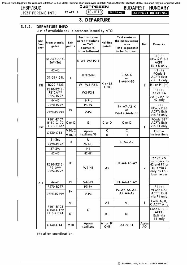
3.1.2. DEPARTURE INFOList of available taxi clearances issued by ATC:
DEP from RWY
From stands/gates
Exit points
Taxi route on apron (taxilane
or TWY segments)
to be followed
Holding points
Taxi route onthe maneuvering
area (TWY segments)to be followed
TML Remarks
13L
31-34*-35*-36*-36L
L
U-W1-W2-P2-L
K or B5 O/R
L-A6-Kor
L-A6-N-B52
U (+);*Code D & E
ACFT: Exit U only
42-43
H1/H2-R-L
H1 (+)*Code E
ACFT: Exit via H1 only
37-39*-39L
R220-R223 W1-W2-P2-L H1 or P1 (+)
R210-R212-R212A**R224-R227
W2-P2-LP1 (+)
**R212A push-back to
H2 only44-45 S-R-L
R270-R277
P4
P3-P4 P4-A7-A6-Kor
P4-A7-A6-N-B5
L (+)*Code D&E ACFT: Exit via P4 only
R278-R279* V-P4
13R
R101-R107R150-G172
R110-R117A*C or D G C or D C or D
1
*Code E&F ACFT: Exit via B1 only
G130-G141M10/C Apron
taxilane/GC C Follow
instructionsM10/D D D
31L
31-36LU
U
A2
U-A3-A2
2
R220-R223 W1-U37-39L
H1
H1
H1-A4-A3-A2
42-43 H2-H1
R210-R212-R212**
R224-R227W2-H1
**R212A push-back to H2 and P1 or
exit via L only by Fol-low-me car
44-45 P1 S-Q-P1 P1-A4-A3-A2R270-R277
P4
P3-P4P4-A7-A6-A5-
A4-A3-A2
P1 (+)*Code D&E ACFT: Exit via P4 only
R278-R279* V-P4
R101-R108G150-G172R110-R117A
A1
G
A1 A1 1 Code A, B, C ACFT only
B1 B1 B1
Code D, E, F ACFT:
Exit viaB1 only
G130-G141 M10 Apron taxilane
A1 or B1 O/R A1 or B1 Apron
AG
(+) after coordination
10-1P1012 APR 19 .Eff.25.Apr.
3. DEPARTURE
| JEPPESEN, 2017, 2019. ALL RIGHTS RESERVED.
Printed from JeppView for Windows 5.3.0.0 on 07 Feb 2020; Terminal chart data cycle 03-2020; Notice: After 20 Feb 2020, 0000Z, this chart may no longer be valid

BUDAPEST, HUNGARYLHBP/BUDLISZT FERENC INTL .AIRPORT.BRIEFING.
+ JEPPESEN
3.2. NOISE ABATEMENT PROCEDURES- ACFT should not be diverted from assigned route unless for safety reasons.- Pilots are invited to execute a rolling take-off whenever possible and to avoid
the significant increase of engine power, while standing in the line-upposition.
- In case of departure from RWY 13L, take-off shall be planned from TWY inter-section K.
- If a departing ACFT belonging in the "medium" or "heavy" turbulence cate-gory receives RWY 31R for take-off, it must commence take-off from the endof the RWY, using TWY A9. If RWY 13R/31L is not available, a RWY 31R take-off from TWY intersection X may also be permitted for flow managementreasons.
- Noise abatement take-off procedures, specified in Section 7 of Part I. of ICAODoc 8168-OPS/611 (PANOPS) Volume I. (5th edition, 2006), must be used dur-ing take-offs, except if this is not recommended by the pilot of the ACFT orATC due to foreseeable reasons (meteorological or aviation safety). If thenoise abatement take-off cannot be executed due to foreseeable reasons, ATCmust record this fact.
- The noise abatement take-off procedure must be executed in accordance withthe NADP procedures described in the Appendix to Chapter 3 of Section 7 ofPart I. of ICAO Doc 8168-OPS/611 (PAN-OPS) Vol. I. (5th edition, 2006).
Exceptions:
The restrictions do not apply to the following cases:- If the ACFT is in an emergency;- Movements of ACFT operating due to various exceptional purposes, such as for
humanitarian purposes, emergency search and rescue operations, medicalassistance, patient transportation and life-saving (including the transporta-tion of organs for transplantation, blood plasma and medication), as well asfor disaster relief operations;
- ACFT participating in government flights, including movements for military,customs, law enforcement, fire-fighting, criminal investigation and nationalsecurity purposes, as well as movements serving the transportation of headsof state and government on official visits;
- The restrictions also do not apply to exceptional cases when their enforcementwould endanger aviation safety, under the given circumstances. The aviationsafety justification must in all cases be attested by the party making refer-ence to it.
3.3. OTHER INFORMATION3.3.1. COMMUNICATION FAILURE PROCEDURES
If departing ACFT has acknowledged an initial or intermediate clearance to climbto a level other than those specified in the filed FPL for the enroute phase of theflight and no time or geographical limit was included in the clearance, shouldmaintain for a period of 7 minutes the level to which it was cleared and thenshould climb to the level included in the filed FPL unless the cruising level wasdefinitely specified in the enroute clearance.
10-1P1112 APR 19 .Eff.25.Apr.
3. DEPARTURE
| JEPPESEN, 2017, 2018. ALL RIGHTS RESERVED.
Printed from JeppView for Windows 5.3.0.0 on 07 Feb 2020; Terminal chart data cycle 03-2020; Notice: After 20 Feb 2020, 0000Z, this chart may no longer be valid

60NM
40NM
20NM20N
M
50NM
30NM
10NM
10NM
30N
M
40NM
50N
M
40NM
50NM
60NM
30NM
20NM
10NM
60NM
SLOVAKIA
HUNGARY
BUDAPESTLiszt Ferenc Intl
4000
10000
3500
6000
10000
2500
3000
BUDAPEST LHCC FIR
Apt Elev
496Alt Set: hPa Trans level: By ATC Trans alt: 10000
JEPPESEN
| JEPPESEN, 2020. ALL RIGHTS RESERVED.
LHBP/BUDLISZT FERENC INTL
BUDAPEST, HUNGARY.RADAR.MINIMUM.ALTITUDES.10-1R
100
2030
4050
10
.Eff.30.Jan.24 JAN 20
6000
1. Only for cross-check assigned altitudes by ATC.2. Temperature corrected down to -13^C.
3907
46-30
47-00
47-30
48-00
48-30
18-30 19-00 19-30 20-00
CHANGES: New chart.
BRATISLAVA LZBB FIR
CONTOURINTERVALS
4000
2000
Printed from JeppView for Windows 5.3.0.0 on 07 Feb 2020; Terminal chart data cycle 03-2020; Notice: After 20 Feb 2020, 0000Z, this chart may no longer be valid

SLOVAKIA
HUNGARY
SZOLNOK
LHSN
COMMS
LOST
COMMS
LOST
COMMS
LOST
COMMS
COMMS
LOST
COMMS
COMMS
LOST
COMMS
LOST
COMMS
LOST
COMMS
LOST
3600
RA
P
5000
BETED
KEZA
L
EDEM
U
ZURFA
OCRIT
LUCLA
LAHO
R
ARFO
X
1. R
NA
V 1
.A
TIS
117.
313
2.38
0
Apt
Ele
v
496
Alt
Set
: hP
aTr
ans
leve
l: B
y A
TC
2. D
ME/
DM
E or
GN
SSre
quir
ed.
230^
185^
219^
309^
BETE
D 1
T
EDEMU 1T
KEZA
L 1T
11.1
25.4
20.8
5.5
16.0
LHBP
/BUD
BUDAPE
ST, HUNGARY
LISZ
T FE
REN
C I
NTL
JEPPESEN
10-2
24 J
AN
20
.Eff.30.Jan.
.RNAV.STA
R.
BP786
BP785
BP784
BP783
ULP
AX
BP774
BP772
CA
TUZ
104^
129^
128^
219^
308^
309^
250^
ARFOX 1
T17
.5
10.6
7.5
6.0
7.0
6.0
7.4
15.7
10.7
1020304050 0515253545 5
1
1
3907
6.9
ARF
OX 1
T:
ARF
OX 1
T,BET
ED 1
T,ED
EMU 1
T:
(IA
F)
3. F
or h
oldi
ng p
roce
dure
sre
fer
to 1
0-2D
.
For
Radi
o Com
mun
icat
ion
Fail
ure
proc
edur
esre
fer
to 1
0-1P
pag
es.
308^
hdg
52
60
60
76
91
88
47-00
47-30
48-00
18-30
19-00
19-30
20-00
20-30
MA
X 2
30 K
T
MA
X 2
30 K
T
MA
X 2
50 K
T
EDEM
U 1
T [EDEM
1T]
KEZ
AL 1T
[KE
ZA1T
]
ARF
OX 1
T [ARF
O1T
]BE
TED 1
T [BET
E1T]
(RWYS 13
L/13
R)RN
AV A
RRIV
ALS
ARFO
X 1
T
RO
UTIN
GSTA
R
BETED 1
T
EDEM
U 1
T
KEZA
L 1T
CHA
NG
ES:
| J
EPPE
SEN
, 20
20.
ALL
RIG
HTS
RES
ERVED
.CHA
NG
ES:
From
BET
ED t
o LA
HO
R, t
o LU
CLA
, to
BP7
83,
to U
LPA
X,
to B
P774
, to
CA
TUZ.
From
ED
EMU t
o LA
HO
R, t
o LU
CLA
, to
BP7
83,
to U
LPA
X,
to B
P774
, to
CA
TUZ.
From
KEZ
AL
to O
CRI
T, t
o ZU
RFA
, to
BP7
72,
to U
LPA
X,
to B
P774
, to
CA
TUZ.
From
ARF
OX t
o BP7
86,
to B
P785
, to
BP7
84,
to B
P783
, to
ULP
AX,
to B
P774
,to
CA
TUZ.
Aft
er C
ATU
Z co
ntin
ue o
n 30
8^ h
eadi
ng,
RAD
AR
vect
orin
g w
ill
be p
rovi
ded,
unl
ess
othe
rwis
e in
stru
cted
.
New
pro
cedu
res
at t
his
airp
ort.
CO
NTO
UR
INTE
RVA
LS
4000
2000
Printed from JeppView for Windows 5.3.0.0 on 07 Feb 2020; Terminal chart data cycle 03-2020; Notice: After 20 Feb 2020, 0000Z, this chart may no longer be valid

SLOVAKIA
HUNGARY
SZOLNOK
LHSN
COMMS
LOST
COMMS
LOST
COMMS
LOST
COMMS
COMMS
LOST
COMMS
COMMS
LOST
COMMS
LOST
COMMS
LOST
COMMS
LOST
3600
RA
P
4000
BETED
KEZA
L
EDEM
U
BP87~
BP871
BP872
ULP
AX
BP874
BP883
BP884
BP885
NIC
RA
ZURFA
OCRIT
LUCLA
LAHO
R
ARFO
X
1. R
NA
V 1
.A
TIS
117.
313
2.38
0
Apt
Ele
v
496
Alt
Set
: hP
aTr
ans
leve
l: B
y A
TC
2. D
ME/
DM
E or
GN
SSre
quir
ed.
230^
185^
219^
308^
309^
219^
128^
128^
129^
BETE
D 1
H
EDEMU 1H
ARF
OX
1H
KEZA
L 1H
13.5
11.0
9.8
5.8
7.1
7.9
8.8
5.1
11.1
25.4
20.8
7.2
7.8
6.2
5.5
16.0
LHBP
/BUD
BUDAPE
ST, HUNGARY
LISZ
T FE
REN
C I
NTL
24 J
AN
20
.Eff.30.Jan.
.RNAV.STA
R.
10-2
AJEPPESEN 1
1
1020304050 0515253545 5
3907
KEZ
AL
1H:
BET
ED 1
H,
EDEM
U 1
H,
KEZ
AL
1H:
3. F
or h
oldi
ng p
roce
dure
sre
fer
to 1
0-2D
.
For
Radi
o Com
mun
icat
ion
Fail
ure
proc
edur
esre
fer
to 1
0-1P
pag
es.
(IA
F)
hdg
128^
52
60
60
76
91
88
47-00
47-30
48-00
18-30
19-00
19-30
20-00
20-30
MA
X 2
30 K
T
MA
X 2
30 K
T
MA
X 2
50 K
T
EDEM
U 1
H [ED
EM1H
]KEZ
AL 1H
[KEZ
A1H
]
ARF
OX 1
H [ARF
O1H
]BE
TED 1
H [BE
TE1H
]
(RWYS 31
L/31
R)RN
AV A
RRIV
ALS
ARFO
X 1
H
RO
UTIN
GSTA
R
BETED 1
H
EDEM
U 1
H
KEZA
L 1H
CHA
NG
ES:
| J
EPPE
SEN
, 20
20.
ALL
RIG
HTS
RES
ERVED
.CHA
NG
ES:
From
ARF
OX t
o BP8
7~,
to B
P871
, to
BP8
72,
to U
LPA
X,
to B
P874
, to
NIC
RA.
From
BET
ED t
o LA
HO
R, t
o LU
CLA
, to
BP8
83,
to U
LPA
X,
to B
P874
, to
NIC
RA.
From
ED
EMU t
o LA
HO
R, t
o LU
CLA
, to
BP8
83,
to U
LPA
X,
to B
P874
, to
NIC
RA.
From
KEZ
AL
to O
CRI
T, t
o ZU
RFA
, to
BP8
85,
to B
P884
, to
BP8
83,
to U
LPA
X,
toBP8
74,
to N
ICRA
.
Aft
er N
ICRA
con
tinu
e on
128
^ he
adin
g,RA
DA
R ve
ctor
ing
wil
l be
pro
vide
d, u
nles
sot
herw
ise
inst
ruct
ed.
New
pro
cedu
res
at t
his
airp
ort.
CO
NTO
UR
INTE
RVA
LS
4000
2000
Printed from JeppView for Windows 5.3.0.0 on 07 Feb 2020; Terminal chart data cycle 03-2020; Notice: After 20 Feb 2020, 0000Z, this chart may no longer be valid

SLOVAKIA
HUN
GARY
KECSKEMET
LHKE
SZOLNOK
LHSN
COMMS
LOST
COMMS
LOST
COMMS
LOST
COMMS
COMMS
LOST
COMMS
COMMS
LOST
COMMS
LOST
COMMS
LOST
COMMS
LOST
3600R
AP
5000
ATI
S1.
RN
AV 1
.11
7.3
132.
380
Apt
Ele
v
496
Alt
Set
: hP
aTr
ans
leve
l: B
y A
TC
2. D
ME/
DM
E or
GN
SSre
quir
ed.
LHBP
/BUD
BUDAPE
ST, HUNGARY
LISZ
T FE
REN
C I
NTL
JEPPESEN
24 J
AN
20
.Eff.30.Jan.
.RNAV.STA
R.
1020304050 0515253545 5
1
ANEXA BP736
BP735
BP734
BP733
BP743
BP744
BP742
BP741
BP723
JOZEP
VA
JDI
ULZ
AK
EBA
MO
ECM
AN
168^
128^
117^
027^
054^
038^
309^
308^
356^VAJD
I 1T
ULZAK 1T
EBAMO 1T
ANEXA 1T
15.7
21.6
13.7
7.4
5.8
7.0
6.1
6.0
7.3
12.7
7.4
15.7
9.9
16.3
1
10-2
B
3907
AN
EXA
1T,
ULZ
AK 1
T,VA
JDI
1T:
3. F
or h
oldi
ng p
roce
dure
sre
fer
to 1
0-2D
.
For
Radi
o Com
mun
icat
ion
Fail
ure
proc
edur
esre
fer
to 1
0-1P
pag
es.
(IA
F)
308^
hdg
40
40
40
52
60
60
47-00
47-30
48-00
18-30
19-00
19-30
20-00
20-30
MA
X 2
30 K
T
MA
X 2
30 K
T
MA
X 2
50 K
T
ULZ
AK 1
T [ULZ
A1T
]VAJD
I 1T
[VAJD
1T]
ANEX
A 1
T [ANEX
1T]
EBAMO 1
T [EBA
M1T
]
(RWYS 13
L/13
R)RN
AV A
RRIV
ALS
ANEXA
1T
RO
UTIN
GSTA
R
EBA
MO
1T
ULZ
AK 1
T
VA
JDI 1T
CHA
NG
ES:
| J
EPPE
SEN
, 20
20.
ALL
RIG
HTS
RES
ERVED
.CHA
NG
ES:
New
pro
cedu
res
at t
his
airp
ort.
From
ULZ
AK t
o JO
ZEP,
to
BP7
23,
toBP7
33,
to B
P743
, to
BP7
44,
to E
CM
AN
.
From
VA
JDI
to J
OZE
P, t
o BP7
23,
toBP7
33,
to B
P743
, to
BP7
44,
to E
CM
AN
.
Aft
er E
CM
AN
con
tinu
e on
308
^ he
adin
g,RA
DA
R ve
ctor
ing
wil
l be
pro
vide
d, u
nles
sot
herw
ise
inst
ruct
ed.
From
EBA
MO
to
BP7
41,
to B
P742
, to
BP7
43,
to B
P744
, to
ECM
AN
.
From
AN
EXA
to
BP7
36,
to B
P735
, to
BP7
34,
to B
P733
, to
BP7
43,
to B
P744
,to
ECM
AN
.
CO
NTO
UR
INTE
RVA
LS
4000
2000
Printed from JeppView for Windows 5.3.0.0 on 07 Feb 2020; Terminal chart data cycle 03-2020; Notice: After 20 Feb 2020, 0000Z, this chart may no longer be valid

SLOVAKIA
HUN
GARY
KECSKEMET
LHKE
SZOLNOK
LHSN
COMMS
LOST
COMMS
LOST
COMMS
LOST
COMMS
COMMS
LOST
COMMS
COMMS
LOST
COMMS
LOST
COMMS
LOST
COMMS
LOST
3600R
AP
4000
1. R
NA
V 1
.A
TIS
117.
313
2.38
0
Apt
Ele
v
496
Alt
Set
: hP
aTr
ans
leve
l: B
y A
TC
2. D
ME/
DM
E or
GN
SSre
quir
ed.
LHBP
/BUD
BUDAPE
ST, HUNGARY
LISZ
T FE
REN
C I
NTL
24 J
AN
20
.Eff.30.Jan.
.RNAV.STA
R.
10-2
CJEPPESEN
ANEXA JO
ZEP
VA
JDI
ULZ
AK
EBA
MO
117^
027^
VAJD
I 1H
ULZAK 1H
21.6
13.7
BP84~
BP841
BP842
BP843
BP844
BP834
BP835
BP836
BP837
ATIC
O
143^
128^
128^
038^
085^
308^
1
1
EBAMO 1H
ANEXA 1
H
11.8
9.8
7.8
7.4
7.5
8.4
10.5
12.1
11.2
10.5
5.8
6.0
1020304050 0515253545 5
3907
EBA
MO
1H
,ULZ
AK 1
H,
VA
JDI
1H:
3. F
or h
oldi
ng p
roce
dure
sre
fer
to 1
0-2D
.
For
Radi
o Com
mun
icat
ion
Fail
ure
proc
edur
esre
fer
to 1
0-1P
pag
es.
(IA
F)
128^
hdg
40
40
40
52
60
60
47-00
47-30
18-30
19-00
19-30
20-00
20-30
MA
X 2
30 K
T
MA
X 2
30 K
T
MA
X 2
50 K
T
(RWYS 31
L/31
R)RN
AV A
RRIV
ALS
RO
UTIN
GSTA
R
CHA
NG
ES:
| J
EPPE
SEN
, 20
20.
ALL
RIG
HTS
RES
ERVED
.CHA
NG
ES:
New
pro
cedu
res
at t
his
airp
ort.
From
AN
EXA
to
BP8
4~,
to B
P841
, to
BP8
42,
to B
P843
, to
BP8
44,
to A
TICO
.
VAJD
I 1H
[VAJD
1H]
ULZ
AK 1
H [ULZ
A1H
]EB
AMO 1
H [EB
AM1H
]ANEX
A 1
H [ANEX
1H]
Aft
er A
TICO
con
tinu
e on
128
^ he
adin
g,RA
DA
R ve
ctor
ing
wil
l be
pro
vide
d, u
nles
sot
herw
ise
inst
ruct
ed.
ANEXA
1H
EBA
MO
1H
ULZ
AK 1
H
VA
JDI 1H
From
EBA
MO
to
BP8
37,
to B
P836
, to
BP8
35,
to B
P834
, to
BP8
44,
to A
TICO
.
From
ULZ
AK t
o JO
ZEP,
to
BP8
34,
toBP8
44,
to A
TICO
.
From
VA
JDI
to J
OZE
P, t
o BP8
34,
toBP8
44,
to A
TICO
.
CO
NTO
UR
INTE
RVA
LS
4000
2000
Printed from JeppView for Windows 5.3.0.0 on 07 Feb 2020; Terminal chart data cycle 03-2020; Notice: After 20 Feb 2020, 0000Z, this chart may no longer be valid

SLOVAKI
A
HUNGARY
KECSKEMETLHKE
3600
RA P
ZURFA
JOZEP
LAHOR
UTCON
WONTA
HUZTA
ALZUR
115.9 TPSTAPIOSAP
TPSD
MHA 6000
130^
MAX 230 KTMHA 6000
130^
310^
MAX 230 KT
050^
230^
MAX 230 KTMHA 3000
066^
246^
MAX 230 KTMHA 6000
130^310^
MAX 230 KTMHA 3000
310^
130^
MAX 230 KTMHA 3000
310^
130^
310^
MAX 230 KT
MAX 230 KT
280^
100^
LHBP/BUD BUDAPEST, HUNGARY10-2D
JEPPESEN
LISZT FERENC INTL 24 JAN 20 .Eff.30.Jan.
| JEPPESEN, 2020. ALL RIGHTS RESERVED.
010
2030
4050
10
3907
MHA 10000
MHA 10000
.RNAV.ARRIVAL.
Alt Set: hPaTrans level: By ATC 496
ATIS
117.3132.380
Apt Elev
40 40
52
60
76 91
47-00
47-30
48-00
19-00 19-30 20-00
CHANGES: New procedures at this airport.
HOLDING PROCEDURES
CONTOURINTERVALS
4000
2000
Printed from JeppView for Windows 5.3.0.0 on 07 Feb 2020; Terminal chart data cycle 03-2020; Notice: After 20 Feb 2020, 0000Z, this chart may no longer be valid

MA
X 2
50 K
T B
ELO
W 1
0000
.SPEED
:
COMMS
LOST
COMMS
LOST
COMMS
LOST
COMMSLOST
COMMS
LOST
COMMS
LOST
COMMS
LOST
COMMS LOST
SLO
VA
KIA
HUNG
ARY
SZOLNOK
LHSN
3600
ARP
FL1
40
FL1
40
JEPPESEN
24 J
AN
20
.Eff.30.Jan.
.RNAV.SID.
1020304050 0515253545 5
Apt
Ele
v
496
BADOV 1
B [BADO1B
]LITK
U 1
B [LITK1B
]
RNAV D
EPART
URE
S(RWY 1
3L)
BUD
APE
STA
ppro
ach
122.
975
VET
IK 1
B [VET
I1B]
WITRI 1
B [W
ITR1
B]
117.
3 BUD
BUD
APE
ST
BU
DD
LITKU
WIT
RI
BA
DO
V
VETIK
BP7~1
BP7~2
BP7~3
BP7~4
BP7~5
25.2
17.8
16.0
12.0
12.2
24.4
17.6
120^
309^
308^
281^
039^
055^
356^
VET
IK 1
B
BADOV 1
B
LITKU 1B
WIT
RI 1
B
115^
BADOV 1B
LITK
U 1B
WITRI 1B
3907
5.5%
V/V
(fp
m)
418
557
835
1114
1392
1671
Gnd
spe
ed-K
T75
100
150
200
250
300
Tran
s al
t: 1
0000
1. R
NA
V-1
.2.
GN
SS o
r D
ME/
DM
E re
quir
ed.
3. I
f un
able
to
com
ply
RNA
V-1
inf
orm
ATC
.4.
If
not
othe
rwis
e in
stru
cted
by
Tow
er c
onta
ct
BUD
APE
ST A
ppro
ach
whe
n pa
ssin
g 30
00.
5. N
o tu
rns
befo
re D
ER.
6. R
ecom
men
ded
nava
id:
BUD
VO
R.7.
Due
to
nois
e ab
atem
ent
reas
ons
com
plia
nce
wit
hth
e SI
D p
roce
dure
is
MA
ND
ATO
RY f
or A
CFT
up
to40
00,
exce
pt f
or t
urbo
prop
and
lig
ht t
urbu
lenc
eca
tego
ry A
CFT
or
ACFT
req
uest
ing
a cr
uise
alt
itud
eof
les
s th
an 9
500.
52
60
60
40
76
91
88
47-30
48-00
19-00
19-30
20-00
20-30
21-00
MA
X 2
30 K
TFo
r Ra
dio
Com
mun
icat
ion
Fail
ure
proc
edur
es r
efer
to
10-1
P pa
ges.
LHBP
/BUD
10-3
CHA
NG
ES:
CHA
NG
ES:
LISZ
T FE
REN
C I
NTL
BUDAPE
ST, HUNGARY
New
pro
cedu
res
at t
his
airp
ort.
RO
UTIN
G
furt
her
clim
b by
ATC
SID
BA
DO
V 1
B
LITKU 1
B
VETIK
1B
WIT
RI 1B
| J
EPPE
SEN
, 20
20.
ALL
RIG
HTS
RES
ERVED
.
If u
nabl
e to
com
ply
advi
se A
TC.
Thes
e SI
Ds
requ
ire
a m
inim
um c
lim
b gr
adie
nt o
f5.
5% u
p to
700
0.
Init
ial
clim
b cl
eara
nce
7000,
Cli
mb
on 1
15^
cour
se t
o BP7
~1,
dire
ctto
BP7
~2,
to B
P7~3
, to
BP7
~4,
toBA
DO
V.
Cli
mb
on 1
15^
cour
se t
o BP7
~1,
dire
ctto
BP7
~2,
to B
P7~3
, to
BP7
~5,
toLI
TKU.
Cli
mb
on 1
15^
cour
se t
o BP7
~1,
dire
ctto
BP7
~2,
to V
ETIK
.Cli
mb
on 1
15^
cour
se t
o BP7
~1,
dire
ctto
BP7
~2,
to B
P7~3
, to
BP7
~5,
toW
ITRI
.
CO
NTO
UR
INTE
RVA
LS
4000
2000
Printed from JeppView for Windows 5.3.0.0 on 07 Feb 2020; Terminal chart data cycle 03-2020; Notice: After 20 Feb 2020, 0000Z, this chart may no longer be valid

MA
X 2
50 K
T B
ELO
W 1
0000
.SPEED
:
COMMS
LOST
COMMS
LOST
COMMS
LOST
COMMSLOST
COMMS
LOST
COMMS
LOST
COMMS
LOST
COMMS LOST
SLO
VA
KIA
HUNG
ARY
SZOLNOK
LHSN
3600
ARP
FL1
40
FL1
40
JEPPESEN
24 J
AN
20
.Eff.30.Jan.
.RNAV.SID.
1020304050 0515253545 5
Apt
Ele
v
496
BADOV 1
J [BADO1J
]LITK
U 1
J [LITK1J
]
RNAV D
EPART
URE
S(RWY 1
3R)
BUD
APE
STA
ppro
ach
122.
975
VET
IK 1
J [VET
I1J]
WITRI 1
J [W
ITR1
J]
117.
3 BUD
BUD
APE
ST
BU
DD
LITKU
WIT
RI
BA
DO
V
VETIK
BP711
BP7~2
BP7~3
BP7~4
BP7~5
25.2
17.8
16.0
12.0
12.2
24.4
17.6
120^
309^
308^
281^
039^
055^
356^
VET
IK 1
J
BADOV 1
J
LITKU 1J
WIT
RI 1
J
BADOV 1J
LITK
U 1J
WITRI 1J
128^
3907
Tran
s al
t: 1
0000
1. R
NA
V-1
.2.
GN
SS o
r D
ME/
DM
E re
quir
ed.
3. I
f un
able
to
com
ply
RNA
V-1
inf
orm
ATC
.4.
If
not
othe
rwis
e in
stru
cted
by
Tow
er c
onta
ct
BUD
APE
ST A
ppro
ach
whe
n pa
ssin
g 30
00.
5. R
ecom
men
ded
nava
id:
BUD
VO
R.6.
Due
to
nois
e ab
atem
ent
reas
ons
com
plia
nce
wit
hth
e SI
D p
roce
dure
is
MA
ND
ATO
RY f
or A
CFT
up
to40
00,
exce
pt f
or t
urbo
prop
and
lig
ht t
urbu
lenc
eca
tego
ry A
CFT
or
ACFT
req
uest
ing
a cr
uise
alt
itud
eof
les
s th
an 9
500.
5.5%
V/V
(fp
m)
418
557
835
1114
1392
1671
Gnd
spe
ed-K
T75
100
150
200
250
300
52
60
60
40
76
91
88
47-30
48-00
19-00
19-30
20-00
20-30
21-00
MA
X 2
30 K
T
For
Radi
o Com
mun
icat
ion
Fail
ure
proc
edur
es r
efer
to
10-1
P pa
ges.
LHBP
/BUD
CHA
NG
ES:
CHA
NG
ES:
LISZ
T FE
REN
C I
NTL
BUDAPE
ST, HUNGARY
New
pro
cedu
res
at t
his
airp
ort.
RO
UTIN
GSID
BA
DO
V 1
J
LITKU 1
J
VETIK
1J
WIT
RI 1J
10-3
A
| J
EPPE
SEN
, 20
20.
ALL
RIG
HTS
RES
ERVED
.
If u
nabl
e to
com
ply
advi
se A
TC.
Thes
e SI
Ds
requ
ire
a m
inim
um c
lim
b gr
adie
nt o
f5.
5% u
p to
700
0. furt
her
clim
b by
ATC
Init
ial
clim
b cl
eara
nce
7000,
Cli
mb
on 1
28^
cour
se t
o BP7
11,
dire
ctto
BP7
~2,
to B
P7~3
, to
BP7
~4,
toBA
DO
V.
Cli
mb
on 1
28^
cour
se t
o BP7
11,
dire
ctto
BP7
~2,
to B
P7~3
, to
BP7
~5,
toLI
TKU.
Cli
mb
on 1
28^
cour
se t
o BP7
11,
dire
ctto
BP7
~2,
to V
ETIK
.Cli
mb
on 1
28^
cour
se t
o BP7
11,
dire
ctto
BP7
~2,
to B
P7~3
, to
BP7
~5,
toW
ITRI
.
CO
NTO
UR
INTE
RVA
LS
4000
2000
Printed from JeppView for Windows 5.3.0.0 on 07 Feb 2020; Terminal chart data cycle 03-2020; Notice: After 20 Feb 2020, 0000Z, this chart may no longer be valid

MA
X 2
50 K
T B
ELO
W 1
0000
.SPEED
:
COMMS
LOST
COMMS
LOST
COMMS
LOST
COMMSLOST
COMMS
LOST
COMMS
LOST
COMMS
LOST
COMMS LOST
SLO
VA
KIA
HUNG
ARY
SZOLNOK
LHSN
3600
ARP
FL1
40
FL1
40
JEPPESEN
24 J
AN
20
.Eff.30.Jan.
.RNAV.SID.
1020304050 0515253545 5
Apt
Ele
v
496
BADOV 1
L [BADO1L
]LITK
U 1
L [LITK1L
]
RNAV D
EPART
URE
S(RWY 3
1L)
BUD
APE
STA
ppro
ach
122.
975
LITK
U 1
X [LITK
1X]
VET
IK 1
L [VET
I1L]
117.
3 BUD
BUD
APE
ST
BU
DD
LITKU
WIT
RI
BA
DO
V
VETIK
WITRI 1
X [WITR1
X]
WITRI 1
L [W
ITR1
L]
BP813
BP8~3
BP8~2
BP8~1
BP811
BP812
308^
031^
039^
129^
049^
007^
039^
309^15
.8
9.4
41.4
32.6
16.19.1
43.8
23.0
19.2
12.3 BA
DOV 1
L
LITK
U 1L
WITRI 1
L
LITKU
1X
VETIK
1L
WIT
RI 1
X
BADOV 1L
LITK
U 1L
WIT
RI 1
L
LITKU 1X
VET
IK 1L
WITRI 1
X
058^
3907
007^
Tran
s al
t: 1
0000
1. R
NA
V-1
.2.
GN
SS o
r D
ME/
DM
E re
quir
ed.
3. I
f un
able
to
com
ply
RNA
V-1
inf
orm
ATC
.4.
If
not
othe
rwis
e in
stru
cted
by
Tow
er c
onta
ct
BUD
APE
ST A
ppro
ach
whe
n pa
ssin
g 30
00.
5. R
ecom
men
ded
nava
id:
BUD
VO
R.6.
Due
to
nois
e ab
atem
ent
reas
ons
com
plia
nce
wit
hth
e SI
D p
roce
dure
is
MA
ND
ATO
RY f
or A
CFT
up
to70
00,
exce
pt f
or t
urbo
prop
and
lig
ht t
urbu
lenc
eca
tego
ry A
CFT
or
ACFT
req
uest
ing
a cr
uise
alt
itud
eof
les
s th
an 9
500.
5.5%
V/V
(fp
m)
418
557
835
1114
1392
1671
Gnd
spe
ed-K
T75
100
150
200
250
300
52
60
60
40
76
91
88
47-30
48-00
19-00
19-30
20-00
20-30
21-00
MA
X 2
30 K
T
furt
her
clim
b by
ATC
Init
ial
clim
b cl
eara
nce
7000,
For
Radi
o Com
mun
icat
ion
Fail
ure
proc
edur
es r
efer
to
10-1
P pa
ges.
LHBP
/BUD
CHA
NG
ES:
CHA
NG
ES:
LISZ
T FE
REN
C I
NTL
BUDAPE
ST, HUNGARY
New
pro
cedu
res
at t
his
airp
ort.
RO
UTIN
GSID
BA
DO
V 1
L
LITKU 1
L
LITKU 1
X
VETIK
1L
10-3
B
WIT
RI 1L
WIT
RI 1X
| J
EPPE
SEN
, 20
20.
ALL
RIG
HTS
RES
ERVED
.
Cli
mb
on 3
08^
cour
se t
o BP8
~1,
dire
ctto
BP8
~2,
to B
P8~3
, to
BA
DO
V.
Cli
mb
on 3
08^
cour
se t
o BP8
~1,
dire
ctto
BP8
~2,
to B
P8~3
, to
BP8
13,
toLI
TKU.
Cli
mb
on 3
08^
cour
se t
o BP8
~1,
031^
cour
se t
o BP8
11,
to B
P812
, to
BP8
13,
to L
ITKU.
Cli
mb
on 3
08^
cour
se t
o BP8
~1,
031^
cour
se t
o BP8
11,
to B
P812
, to
VET
IK.
Cli
mb
on 3
08^
cour
se t
o BP8
~1,
dire
ctto
BP8
~2,
to B
P8~3
, to
WIT
RI.
Cli
mb
on 3
08^
cour
se t
o BP8
~1,
031^
cour
se t
o BP8
11,
to B
P812
, to
WIT
RI.
If u
nabl
e to
com
ply
advi
se A
TC.
Thes
e SI
Ds
requ
ire
a m
inim
um c
lim
b gr
adie
nt o
f5.
5% u
p to
100
00.
CO
NTO
UR
INTE
RVA
LS
4000
2000
Printed from JeppView for Windows 5.3.0.0 on 07 Feb 2020; Terminal chart data cycle 03-2020; Notice: After 20 Feb 2020, 0000Z, this chart may no longer be valid

MA
X 2
50 K
T B
ELO
W 1
0000
.SPEED
:
COMMS
LOST
COMMS
LOST
COMMS
LOST
COMMSLOST
COMMS
LOST
COMMS
LOST
COMMS
LOST
COMMS LOST
SLO
VA
KIA
HUNG
ARY
SZOLNOK
LHSN
3600
ARP
FL1
40
FL1
40
JEPPESEN
24 J
AN
20
.Eff.30.Jan.
.RNAV.SID.
1020304050 0515253545 5
Apt
Ele
v
496
BADOV 1
R [BADO1R
]LITK
U 1
A [LITK
1A]
RNAV D
EPART
URE
S(RWY 3
1R)
BUD
APE
STA
ppro
ach
122.
975
LITK
U 1
R [LITK1R
]VET
IK 1
R [VET
I1R]
117.
3 BUD
BUD
APE
ST
BU
DD
LITKU
WIT
RI
BA
DO
V
VETIK
WITRI 1
R [W
ITR1
R]WITRI 1
A [WITR1
A]
BP813
BP8~3
BP8~2
BP8~1
BP811
BP812
031^
039^
129^
049^
007^
039^
309^15
.8
9.4
41.4
32.6
16.19.1
43.8
23.0
19.2
12.3 BA
DOV 1
R
LITK
U 1R
WITRI 1
R
LITKU
1A
VETIK
1R
WIT
RI 1
A
BADOV 1R
LITK
U 1R
WIT
RI 1
R
LITKU 1A
VET
IK 1
R
WITRI 1
A
058^ 296^
3907
007^
5.5%
V/V
(fp
m)
418
557
835
1114
1392
1671
Gnd
spe
ed-K
T75
100
150
200
250
300
Tran
s al
t: 1
0000
1. R
NA
V-1
.2.
GN
SS o
r D
ME/
DM
E re
quir
ed.
3. I
f un
able
to
com
ply
RNA
V-1
inf
orm
ATC
.4.
If
not
othe
rwis
e in
stru
cted
by
Tow
er c
onta
ct
BUD
APE
ST A
ppro
ach
whe
n pa
ssin
g 30
00.
5. N
o tu
rns
befo
re D
ER.
6. R
ecom
men
ded
nava
id:
BUD
VO
R.7.
Due
to
nois
e ab
atem
ent
reas
ons
com
plia
nce
wit
hth
e SI
D p
roce
dure
is
MA
ND
ATO
RY f
or A
CFT
up
to70
00,
exce
pt f
or t
urbo
prop
and
lig
ht t
urbu
lenc
eca
tego
ry A
CFT
or
ACFT
req
uest
ing
a cr
uise
alt
itud
eof
les
s th
an 9
500.
52
60
60
40
76
91
88
47-30
48-00
19-00
19-30
20-00
20-30
21-00
MA
X 2
30 K
T
For
Radi
o Com
mun
icat
ion
Fail
ure
proc
edur
es r
efer
to
10-1
P pa
ges.
LHBP
/BUD
CHA
NG
ES:
CHA
NG
ES:
LISZ
T FE
REN
C I
NTL
BUDAPE
ST, HUNGARY
New
pro
cedu
res
at t
his
airp
ort.
RO
UTIN
GSID
BA
DO
V 1
R
LITKU 1
A
LITKU 1
R
VETIK
1R
10-3
C
WIT
RI 1A
WIT
RI 1R
| J
EPPE
SEN
, 20
20.
ALL
RIG
HTS
RES
ERVED
.
Cli
mb
on 2
96^
cour
se t
o BP8
~1,
dire
ctto
BP8
~2,
to B
P8~3
, to
BA
DO
V.
Cli
mb
on 2
96^
cour
se t
o BP8
~1,
031^
cour
se t
o BP8
11,
to B
P812
, to
BP8
13,
to L
ITKU.
Cli
mb
on 2
96^
cour
se t
o BP8
~1,
dire
ctto
BP8
~2,
to B
P8~3
, to
BP8
13,
toLI
TKU.
Cli
mb
on 2
96^
cour
se t
o BP8
~1,
031^
cour
se t
o BP8
11,
to B
P812
, to
VET
IK.
Cli
mb
on 2
96^
cour
se t
o BP8
~1,
031^
cour
se t
o BP8
11,
to B
P812
, to
WIT
RI.
Cli
mb
on 2
96^
cour
se t
o BP8
~1,
dire
ctto
BP8
~2,
to B
P8~3
, to
WIT
RI.
If u
nabl
e to
com
ply
advi
se A
TC.
Thes
e SI
Ds
requ
ire
a m
inim
um c
lim
b gr
adie
nt o
f5.
5% u
p to
100
00.
furt
her
clim
b by
ATC
Init
ial
clim
b cl
eara
nce
7000,
CO
NTO
UR
INTE
RVA
LS
4000
2000
Printed from JeppView for Windows 5.3.0.0 on 07 Feb 2020; Terminal chart data cycle 03-2020; Notice: After 20 Feb 2020, 0000Z, this chart may no longer be valid

MAX 250 KT BELOW 10000.SPEED:
COMMSLOST COMMSLOST COMMSLOST
COMMS
LOST
COMMSLOST COMMSLOST COMMSLOST
COMMS
LOST
3600
RP
A
JEPPESEN
24 JAN 20LHBP/BUDLISZT FERENC INTL 10-3D
BUDAPEST, HUNGARY.RNAV.SID.
DUZLA 1B [DUZL1B], FAHAZ 1B [FAHA1B]
RNAV DEPARTURES(RWY 13L)
122.975ApproachBUDAPEST
496Apt Elev
GAZDA 1B [GAZD1B], GILEP 1B [GILE1B]
5.5% V/V (fpm) 418 557 835 1114 1392 1671
Gnd speed-KT 75 100 150 200 250 300
GILEP
DUZLA
FAHAZ
GAZDA
PUCOG
BP712
117.3 BUDBUDAPEST
BUDD
BP7~1
115^
304^
283^
216^ 172^
142^
14.2
22.0
18.3
18.2
27.9
GILEP 1B
DUZ
LA 1
B
FA
HA
Z 1
B
GAZD
A 1B
.Eff.30.Jan.
| JEPPESEN, 2020. ALL RIGHTS RESERVED.
2119
1020
3040
500
515
2535
455
Trans alt: 100001. RNAV-1.2. GNSS or DME/DME required.3. If unable to comply RNAV-1 inform ATC.4. If not otherwise instructed by Tower contact BUDAPEST Approach whenpassing 3000.5. No turns before DER.6. Recommended navaid: BUD VOR.7. Due to noise abatement reasons compliance with the SID procedure isMANDATORY for ACFT up to 4000, except for turboprop and light turbulencecategory ACFT or ACFT requesting a cruise altitude of less than 9500.
40
40
52
60
47-00
47-30
18-30
19-00
MAX230 KT
CHANGES:
ROUTINGSID
DUZLA 1B
FAHAZ 1B
GAZDA 1B
GILEP 1B
If unable to comply advise ATC.
These SIDs require a minimum climb gradient of5.5% up to 7000.
NOT TOSCALE
New procedures at this airport.
For Radio Communication Failureprocedures refer to 10-1P pages.
Initial climb clearance 7000, further climb by ATC
Climb on 115^ course to BP7~1, direct to BP712, to FAHAZ.
Climb on 115^ course to BP7~1, direct to BP712, to DUZLA.
Climb on 115^ course to BP7~1, direct to BP712, to GAZDA.
Climb on 115^ course to BP7~1, direct to BP712, to PUCOG, to GILEP.
Printed from JeppView for Windows 5.3.0.0 on 07 Feb 2020; Terminal chart data cycle 03-2020; Notice: After 20 Feb 2020, 0000Z, this chart may no longer be valid

MAX 250 KT BELOW 10000.SPEED:
COMMSLOST COMMSLOST COMMSLOST
COMMS
LOST
COMMSLOST COMMSLOST COMMSLOST
COMMS
LOST
3600
RPA
JEPPESEN
24 JAN 20LHBP/BUDLISZT FERENC INTL 10-3E
BUDAPEST, HUNGARY.RNAV.SID.
DUZLA 1J [DUZL1J], FAHAZ 1J [FAHA1J]
RNAV DEPARTURES(RWY 13R)
122.975ApproachBUDAPEST
496Apt Elev
GAZDA 1J [GAZD1J], GILEP 1J [GILE1J]
5.5% V/V (fpm) 418 557 835 1114 1392 1671
Gnd speed-KT 75 100 150 200 250 300
GILEP
DUZLA
FAHAZ
GAZDA
PUCOG
BP712
117.3 BUDBUDAPEST
BUDD
BP711
304^
283^
216^ 172^
142^
14.2
22.0
18.3
18.2
27.9
GILEP 1J
DUZ
LA 1
J
FA
HA
Z 1
J
GAZD
A 1J
.Eff.30.Jan.
128^
| JEPPESEN, 2020. ALL RIGHTS RESERVED.
2119
1020
3040
500
515
2535
455
Trans alt: 100001. RNAV-1.2. GNSS or DME/DME required.3. If unable to comply RNAV-1 inform ATC.4. If not otherwise instructed by Tower contact BUDAPEST Approach whenpassing 3000.5. Recommended navaid: BUD VOR.6. Due to noise abatement reasons compliance with the SID procedure isMANDATORY for ACFT up to 4000, except for turboprop and light turbulencecategory ACFT or ACFT requesting a cruise altitude of less than 9500.
40
40
52
60
47-00
47-30
18-30
19-00
MAX230 KT
CHANGES:
ROUTINGSID
DUZLA 1J
FAHAZ 1J
GAZDA 1J
GILEP 1J
If unable to comply advise ATC.
These SIDs require a minimum climb gradient of5.5% up to 7000.
NOT TOSCALE
New procedures at this airport.
For Radio Communication Failureprocedures refer to 10-1P pages.
Initial climb clearance 7000, further climb by ATC
Climb on 128^ course to BP711, direct to BP712, to DUZLA.
Climb on 128^ course to BP711, direct to BP712, to FAHAZ.
Climb on 128^ course to BP711, direct to BP712, to GAZDA.
Climb on 128^ course to BP711, direct to BP712, to PUCOG, to GILEP.
Printed from JeppView for Windows 5.3.0.0 on 07 Feb 2020; Terminal chart data cycle 03-2020; Notice: After 20 Feb 2020, 0000Z, this chart may no longer be valid

MAX 250 KT BELOW 10000.SPEED:
COMMSLOST COMMSLOST COMMSLOST
COMMS
LOST
COMMSLOST COMMSLOST COMMSLOST
COMMS
LOST
3600
RPA
JEPPESEN
24 JAN 20LHBP/BUDLISZT FERENC INTL 10-3F
BUDAPEST, HUNGARY.RNAV.SID.
DUZLA 1L [DUZL1L], FAHAZ 1L [FAHA1L]
RNAV DEPARTURES(RWY 31L)
122.975ApproachBUDAPEST
496Apt Elev
GAZDA 1L [GAZD1L], GILEP 1L [GILE1L]
5.5% V/V (fpm) 418 557 835 1114 1392 1671
Gnd speed-KT 75 100 150 200 250 300
GILEP
DUZLA
FAHAZ
GAZDA
PUCOG
BP821
117.3 BUDBUDAPEST
BUDD
BP8~1
283^
14.1
.Eff.30.Jan.
308^
BP822
201^
140^
123^
GILEP 1L
DUZLA
1L
FAHAZ 1L GAZDA 1L
13.1
15.6
9.5
15.6
29.3
| JEPPESEN, 2020. ALL RIGHTS RESERVED.
2119
1020
3040
500
515
2535
455
Trans alt: 100001. RNAV-1.2. GNSS or DME/DME required.3. If unable to comply RNAV-1 inform ATC.4. If not otherwise instructed by Tower contact BUDAPEST Approach whenpassing 3000.5. Recommended navaid: BUD VOR.6. Due to noise abatement reasons compliance with the SID procedure isMANDATORY for ACFT up to 7000, except for turboprop and light turbulencecategory ACFT or ACFT requesting a cruise altitude of less than 9500.
40
40
52
60
47-00
47-30
18-30
19-00
MAX230 KT
CHANGES:
ROUTINGSID
DUZLA 1L
FAHAZ 1L
GAZDA 1L
GILEP 1L
If unable to comply advise ATC.
These SIDs require a minimum climb gradient of
NOT TOSCALE
New procedures at this airport.
5.5% up to 10000.
Climb on 308^ course to BP8~1, 201^ course to BP821, to BP822, to DUZLA.
Climb on 308^ course to BP8~1, 201^ course to BP821, to BP822, to FAHAZ.
Climb on 308^ course to BP8~1, 201^ course to BP821, to BP822, to GAZDA.
Initial climb clearance 7000, further climb by ATC
For Radio Communication Failureprocedures refer to 10-1P pages.
Climb on 308^ course to BP8~1, 201^ course to BP821, direct to PUCOG, to GILEP.
Printed from JeppView for Windows 5.3.0.0 on 07 Feb 2020; Terminal chart data cycle 03-2020; Notice: After 20 Feb 2020, 0000Z, this chart may no longer be valid
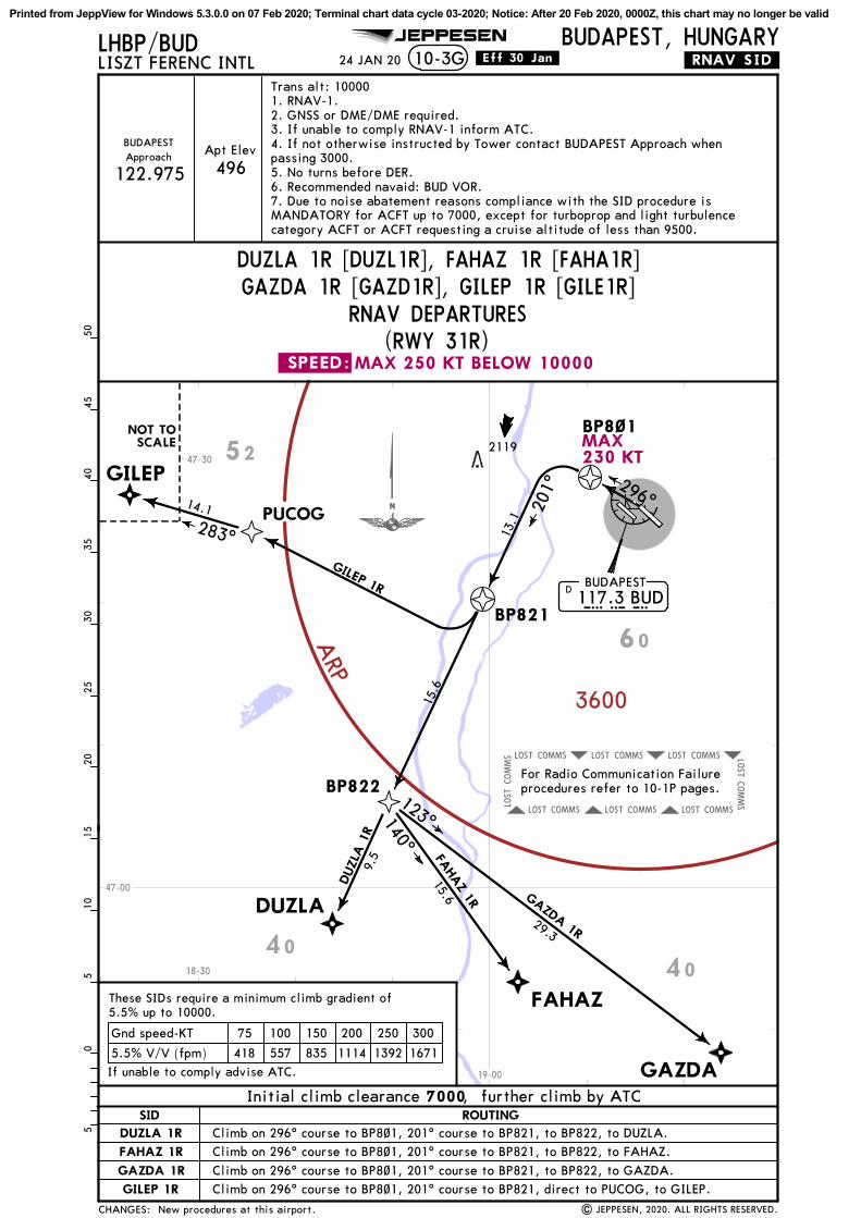
MAX 250 KT BELOW 10000.SPEED:
COMMSLOST COMMSLOST COMMSLOST
COMMS
LOST
COMMSLOST COMMSLOST COMMSLOST
COMMS
LOST
3600
ARP
JEPPESEN
24 JAN 20LHBP/BUDLISZT FERENC INTL 10-3G
BUDAPEST, HUNGARY.RNAV.SID.
DUZLA 1R [DUZL1R], FAHAZ 1R [FAHA1R]
RNAV DEPARTURES(RWY 31R)
122.975ApproachBUDAPEST
496Apt Elev
GAZDA 1R [GAZD1R], GILEP 1R [GILE1R]
5.5% V/V (fpm) 418 557 835 1114 1392 1671
Gnd speed-KT 75 100 150 200 250 300
GILEP
DUZLA
FAHAZ
GAZDA
PUCOG
BP821117.3 BUDBUDAPEST
BUDD
BP8~1
283^
14.1
.Eff.30.Jan.
BP822
201^
140^
123^
GILEP 1R
DUZLA
1R
FAHAZ 1R GAZDA 1R
13.1
15.6
9.5
15.6
29.3
| JEPPESEN, 2020. ALL RIGHTS RESERVED.
296^
2119
1020
3040
500
515
2535
455
Trans alt: 100001. RNAV-1.2. GNSS or DME/DME required.3. If unable to comply RNAV-1 inform ATC.4. If not otherwise instructed by Tower contact BUDAPEST Approach whenpassing 3000.5. No turns before DER.6. Recommended navaid: BUD VOR.7. Due to noise abatement reasons compliance with the SID procedure isMANDATORY for ACFT up to 7000, except for turboprop and light turbulencecategory ACFT or ACFT requesting a cruise altitude of less than 9500.
4040
52
60
47-00
47-30
18-30
19-00
MAX230 KT
CHANGES:
ROUTINGSID
DUZLA 1R
FAHAZ 1R
GAZDA 1R
GILEP 1R
If unable to comply advise ATC.
These SIDs require a minimum climb gradient of
NOT TOSCALE
New procedures at this airport.
5.5% up to 10000.
For Radio Communication Failureprocedures refer to 10-1P pages.
Initial climb clearance 7000, further climb by ATC
Climb on 296^ course to BP8~1, 201^ course to BP821, to BP822, to DUZLA.
Climb on 296^ course to BP8~1, 201^ course to BP821, to BP822, to FAHAZ.
Climb on 296^ course to BP8~1, 201^ course to BP821, to BP822, to GAZDA.
Climb on 296^ course to BP8~1, 201^ course to BP821, direct to PUCOG, to GILEP.
Printed from JeppView for Windows 5.3.0.0 on 07 Feb 2020; Terminal chart data cycle 03-2020; Notice: After 20 Feb 2020, 0000Z, this chart may no longer be valid

Elev
496'
CO
MPA
SS
BA
SE
9872' 30
09m
12,162'370
7m
VO
R
Lctr
Lctr
Lctr
Lctr
A1
A8
A9
B1
B4
B5
B2
D
NK
X
Y
C
47-25
47-25
47-26
47-26
47-27
47-27
19-13
19-13
19-14
19-14
19-15
19-15
19-16
19-16
19-17
19-17
19-18
19-18
ATIS Tower
118.1
Apt Elev 10-9
117.3
APRO
N1
APRO
N2
D
C
B1
B2
B5
K
X
A9
A1
Twys
A1
and
B1:
Con
fusi
ng t
wys
.Ver
ify
the
corr
ect
taxi
rou
te.
Twy
K:
Ver
ify
the
corr
ect
taxi
rou
te b
efor
e en
teri
ng t
he t
wy.
LEG
END
BUDAPEST Delivery
J4
One
way
For
AIR
PO
RT B
RIE
FIN
G r
efe
r to
10-1
P p
ages
| JEPPESEN, 2001, 2020. ALL RIGHTS RESERVED.
JEPPESEN
Lim
it o
f ap
ron
cont
rol
com
pete
nce
Entr
y/Ex
it p
oint
Apron 1 Apron 2
04^E
Twys
A1
and
A2:
Do
not
cros
s th
e ho
ldin
g po
siti
ons
wit
hout
Tow
er
clea
ranc
e.
Twys
B1
and
B2:
Do
not
cros
s th
e ho
ldin
g po
siti
ons
wit
hout
Tow
er
clea
ranc
e.
Ground BUDAPEST
HO
T SP
OTS
FO
R D
ETA
ILS
SEE 1
0-9
C
FO
R D
ETA
ILS
SEE 1
0-9
B
Elev
448'
A2
A5
A6
A7Z
M
A2
T
132.380 134.540 131.555 122.440
APR
ON
1
131.
555
APR
ON
2
122.
440
121.910 119.975
31 JAN 20
E
CA
RG
OA
PRO
N
13R/31L rwy length. Cargo apron added.
U
A1
A4
APR
ON
1
131.
555
F
2
2
2M
AX w
ings
pan
118'
/36m
, M
AX c
ode
C a
cft.
1A
lso
usab
le b
y8.
33 e
xem
pted
acf
t
1
Elev
448'
Elev
416'
ARP
13R
128^
13L
128^
31R
308^
Feet
Meters
0 0
1000
1000
2000
3000
4000
5000
1500
500
496'BUDAPEST, HUNGARY
N47 26.4 E019 15.7
CHANGES:
LHBP/BUD
Con
trol
Tow
er
31L
308^
A1
LISZT FERENC INTL
B3
A3
P4
U
L
WIN
GSPA
N R
ESTRIC
TIO
NS
Printed from JeppView for Windows 5.3.0.0 on 07 Feb 2020; Terminal chart data cycle 03-2020; Notice: After 20 Feb 2020, 0000Z, this chart may no longer be valid

10,947' 3337m
3411m11,190'
2694m
2620m
8839'8596'
10-9ALHBP/BUD
1
3
HST-Y&Z1
3 HSTIL HST-J4
| JEPPESEN, 2001, 2020. ALL RIGHTS RESERVED.
JEPPESEN
(60m) (15m)
(60m) (15m)
(60m) (15m)
(60m) (15m)
2
4
2
4
1
TAKE-OFF
ABCD
(Day only)Day: RL or RCLMNight: RL or CL
1HIRL, CL &
relevant RVRRL, CL &
relevant RVR RL & CLDay: RL & RCLMNight: RL or CL
Adequate vis ref
TDZ, MID, RO TDZ, MID, RO
Low Visibility Take-off
.Standard.
RVR125m 150m 200m 300m 400m 500mRVR RVR RVR
RWY 13R & 31R: RVR 75m with approved guidance system or HUD/HUDLS.
HIRL CL ALSF-II TDZ PAPI-L(3.0^)HIRL CL ALSF-II TDZ PAPI-L(3.0^)
HIRL CL ALSF-II TDZ PAPI-L(3.0^)HIRL CL ALSF-II TDZ PAPI-L(3.0^)
31 JAN 20
Landing beyond glide slope. 13R/31L take-off run available length.
BUDAPEST, HUNGARY
13R31L
CHANGES:
RWY
ADDITIONAL RUNWAY INFORMATION
ThresholdLANDING BEYOND
USABLE LENGTHS
WIDTHTAKE-OFFGlide Slope13L
31RRVR 148'
45m
148'45m
RVR
RVRRVR
LISZT FERENC INTL
RWY 13L:TAKE-OFF RUN AVAILABLE
RWY 31R:
RWY 13R:TAKE-OFF RUN AVAILABLE
RWY 31L:
From rwy headtwy X inttwy K int
From rwy headtwy K int
12,162'(3707m)9678'(2950m)
From rwy headtwy C int
twy B1/B2 int
9872'(3009m)8038'(2450m)3937'(1200m)
From rwy headtwy B1/B2 int
twy C int
12,162'8694'2313'
(3707m)(2650m)(705m)
(3009m)(1800m)(505m)
9872'5906'1657'
Printed from JeppView for Windows 5.3.0.0 on 07 Feb 2020; Terminal chart data cycle 03-2020; Notice: After 20 Feb 2020, 0000Z, this chart may no longer be valid

JEPPESEN
R116
C
B1
B2
Twys
A1
and
B1:
Con
fusi
ng t
wys
.Ver
ify
the
corr
ect
taxi
rou
te.
Twys
B1
and
B2:
Do
not
cros
s th
e ho
ldin
g po
siti
ons
wit
hout
Tow
er
clea
ranc
e.
APR
ON
1
131.
555
APR
ON
1
131.
555 HA
NG
AR
CO
MPA
SS
BA
SE
A1
A2
Twys
A1
and
A2:
Do
not
cros
s th
e ho
ldin
g po
siti
ons
wit
hout
Tow
er
clea
ranc
e.
LEG
END
One
way
Lim
it o
f ap
ron
cont
rol
com
pete
nce
Entr
y/Ex
it p
oint
HO
T SP
OTS
19-15
19-14
19-15
47-26
LHBP
/BUD
| J
EPPE
SEN
, 20
01,
2019
. A
LL R
IGHTS
RES
ERVED
.
31 J
AN
20
10-9
B
19-14
Non
e.
CD
B1
A1
M10
M20
M30
M10
1M
AX w
ings
pan
118'
/36m
, M
AX c
ode
C a
cft.
1
1
1
On
Apr
on A
G t
axii
ng i
s al
low
ed w
ith
Mar
shal
ler
only
.O
n A
pron
AA
and
AL
taxi
ing
is n
ot a
llow
ed,
only
tow
ing
betw
een
stan
d an
d br
eak
away
poi
nt.
CHA
NG
ES:
R101 R102 R1
03G
R105
R104 R1
07R108
R106
G15
1G
150
G15
2G
153
G15
4
G16
0G
161
G16
2G
170
G17
1 G17
2
G15
5
GR1
17R1
17A
R115
R110
R111
R112
R113
R114
APRO
N 1
CD
TERM
INA
L 1
HA
NG
AR
A1
B1
HA
NG
AR
B2
RWY
13R/
31L
AIR
CA
RG
O
G13
1G
133
G13
5G
137
G13
9G14
1
G13
0 G13
2 G13
4
A1
A2
A3
A4
L1L2
APRO
N A
G
MA
INTENA
NCE
APRO
N A
AM
AIN
TENA
NCE
APRO
N A
L
J4
A1
A1
A2
B2
B3
TA
3
FB3
M10
M20
M30
Engi
ne s
tart
poin
t A
A Engi
ne s
tart
poin
t A
L
47-26
BUDAPE
ST, HUNGARY
LISZ
T FE
REN
C I
NTL
STA
ND N
o.
CO
ORDIN
ATES
Apro
n A
A N47
25.
9 E0
19 1
4.3
N47
25.
8 E0
19 1
4.4
A1,
A2
A3,
A4
Apro
n A
G
Apro
n A
L N47
25.
8 E0
19 1
4.5
N47
25.
8 E0
19 1
4.6
L1 L2
N47
25.
9 E0
19 1
4.2
N47
25.
9 E0
19 1
4.1
N47
25.
9 E0
19 1
4.2
G13
0 G
131
G13
2 th
ru G
141
Apro
n 1
G15
0G
151,
G15
2G
153
thru
G15
5G
160
thru
G16
2G
170
thru
G17
2
R101
thr
u R1
03R1
04 t
hru
R108
R110
thr
u R1
12R1
13 t
hru
R115
R116
, R1
17
R117
A
N47
26.
4 E0
19 1
3.5
N47
26.
4 E0
19 1
3.6
N47
26.
4 E0
19 1
3.5
N47
26.
3 E0
19 1
3.5
N47
26.
3 E0
19 1
3.6
N
47 2
6.6
E0
19 1
3.4
N47
26.
5 E0
19 1
3.5
N47
26.
4 E0
19 1
3.7
N47
26.
3 E0
19 1
3.7
N47
26.
3 E0
19 1
3.8
N
47 2
6.3
E0
19 1
3.7
CA
RG
O
WIN
GSPA
N R
ESTRIC
TIO
NS
GRO
UND M
OV
EM
ENT R
ESTRIC
TIO
NS
Printed from JeppView for Windows 5.3.0.0 on 07 Feb 2020; Terminal chart data cycle 03-2020; Notice: After 20 Feb 2020, 0000Z, this chart may no longer be valid

44
45
P2
P3
SA
7
Q
L
R
4342
H2
A4B
3
3132
33U
TERM
INA
L2A
TERM
INA
L2B
R227
R226
R225
R224
R223
R222
R221
R220
W2
W1
R278
R279
R278
A
R274
R275
R276
R277
R270
R271
R272
R273
R210
R211
R212
R212
A
39R
38
37
35R
3535
L
36L36
36R
LEG
END
One
way
Lim
it o
f ap
ron
cont
rol
com
pete
nce
Entr
y/Ex
it p
oint
HO
T SP
OTS
JEPPESEN
A4
P1
P3
V
P4
M
A5
B4
B5
N
KK
Z
A6
Y
A8
CO
NTRO
LTO
WER
APR
ON
2
122.
440
Twy
K:
Ver
ify
the
corr
ect
taxi
rou
te b
efor
e en
teri
ng t
he t
wy.
LHBP
/BUD
19-16
19-16
47-26
47-26
31 J
AN
20
34R
3434
L
H1
H1
39 39L
19-16.6
19-16.5
19-16.7
47-25.6
47-25.7
19-16.6
19-16.5
19-16.7
47-25.6
E
A8
4Stan
ds C
1R,
C1L
, C2R
and
C2L
pus
h ba
ck t
o TW
Y E
.
For
stan
ds C
1R,
C1L
, C2R
and
C2L
bet
wee
nsu
nset
to
sunr
ise
ACFT
has
to
stop
on
TWY A
8an
d th
e A
CFT
tow
ed i
nto
park
ing
stan
d, p
ush
back
and
pull
for
war
d to
TW
Y A
8 fo
r st
art
up.
Foll
ow-m
ees
cort
req
uire
d.
For
stan
ds C
1 an
d C2
push
bac
k an
d pu
llfo
rwar
d to
TW
Y A
8 fo
r st
art
up a
nd t
axi.
Stan
ds.
Coo
rdin
ates
. N
otes
. Car
go a
pron
add
ed.
CA
RG
O A
PRO
N info
rmati
on b
ased o
n n
on-A
IPsourc
e.
P1
H1
UP4
L
1 2 3
1
1
1
1
1
13
2
2
2
22
2
2
3
3
3
3
3
H1
MA
X w
ings
pan
118'
/36m
.M
AX w
ings
pan
171'
/52m
.M
AX w
ings
pan
213'
/65m
.
4
APRO
N2
10-9
C
CHA
NG
ES:
CO
ORDIN
ATES
INS C
OO
RDIN
ATES
STA
ND N
o.
BUDAPE
ST, HUNGARY
LISZ
T FE
REN
C I
NTL
| J
EPPE
SEN
, 20
18,
2020
. A
LL R
IGHTS
RES
ERVED
.
RWY
13L/
31R
N47
25.
9 E0
19 1
5.6
N47
25.
9 E0
19 1
5.5
N47
26.
0 E0
19 1
5.5
N47
26.
0 E0
19 1
5.4
N47
26.
0 E0
19 1
5.5
N
47 2
6.0
E0
19 1
5.6
N47
26.
0 E0
19 1
5.7
N47
26.
1 E0
19 1
5.7
N47
26.
0 E0
19 1
5.8
N47
26.
1 E0
19 1
5.6
N
47 2
6.2
E0
19 1
5.6
N47
26.
0 E0
19 1
5.3
N47
26.
0 E0
19 1
5.4
N47
26.
1 E0
19 1
5.4
N47
26.
1 E0
19 1
5.5
N
47 2
6.2
E0
19 1
5.5
N47
26.
2 E0
19 1
5.6
N47
26.
1 E0
19 1
5.8
N47
26.
1 E0
19 1
5.9
N47
26.
0 E0
19 1
6.0
N
47 2
6.0
E0
19 1
6.1
31,
3233
thr
u 35
35R
36L,
36,
36R
37,
38,
39R
39
L, 3
942
43,
44
45R2
10,
R211
, R2
12A
R2
12
R220
R221
R222
, R2
23R2
24
R2
25,
R226
R227
R270
, R2
71R2
72 t
hru
R275
R276
thr
u R2
78A
R2
79
C1R
C1L
C2R
C2L
C1
C2
CA
RG
O A
PRO
N
N47
25.
7 E0
19 1
6.6
C1R
thr
u C2LCA
RG
O A
PRO
N
APRO
N 2
WIN
GSPA
N R
ESTRIC
TIO
NS
Printed from JeppView for Windows 5.3.0.0 on 07 Feb 2020; Terminal chart data cycle 03-2020; Notice: After 20 Feb 2020, 0000Z, this chart may no longer be valid

10-9DLHBP/BUD
| JEPPESEN, 2001, 2020. ALL RIGHTS RESERVED.
TERMINAL2
TERMINAL1
Control Tower
A1
A2
A5 A6
A8
B1
B3
B4
B5
B2
D
NK
Y
Z
MET
M
T
C
AIS +
A3 P4
LA7
U
B5
K
A2
A1
B1
B2
D
C
A9
J4
ControlTower
TERMINAL2
TERMINAL1
A1
A2
A5 A6
A7
B1
B3
B4
B5
B2
D
N
Y
Z
MET
M
T
C
L
P4
P1
UA8
D
B1
B2
A1
A2 A3
K
K
B5
LEGEND
C
X
X
A9NOT TO SCALE
AIS+
J4
JEPPESEN
TAXI ROUTING RWYs 31L/R
RWY 13L/31R
RWY 13R/31L
NOT TO SCALE
RWY 13R/31L RW
Y 13L/31R
After landing
LEGEND
After landing
TAXI ROUTING RWYs 13L/R
Alternative taxi routefor take-off RWY 13L
Before take-off
Before take-off
A4
A4
P2
P1P2
Apron AGM10
M10Apron AG
G
G
G
G
31 JAN 20
F
F
MAITENANCEAPRON AA
MAITENANCEAPRON AL
MAITENANCEAPRON AA
MAITENANCEAPRON AL
W2
H1 H2W1
H2
W2
H1W1
CARGO
CARGO
E
CARGOAPRON
E
CARGOAPRON
Cargo apron added.
X
X
BUDAPEST, HUNGARY
CHANGES:
LISZT FERENC INTL
Printed from JeppView for Windows 5.3.0.0 on 07 Feb 2020; Terminal chart data cycle 03-2020; Notice: After 20 Feb 2020, 0000Z, this chart may no longer be valid

10-9ELHBP/BUD
SAFEGATE DOCKING SYSTEM
A. SYSTEM DESCRIPTION
B. DOCKING PROCEDURE
WARNING:
The SAFEDOCK system is a microprocessor controlled laser scanning device which directs an approaching aircraft to the terminal gate stopping position with assistance of a real time display unit that is clearly visible from cockpit.
1. Follow the taxi-in line to the respective gate.2. Check correct aircraft type, the flashing arrows of direction and floating arrows. (The system is activated and ready for docking procedure)3. When the aircraft has been caught by the system, the floating arrows are replaced by the closing rate indicator. - Watch the yellow center line indicator and the flashing arrow indicate the correct azimuth guidance. - Watch the flashing red arrows for required direction of turn.4. When the aircraft is 12m from the stop position, the closing rate is indicated by turning off one row per half meter indicating the remaining distance to the stop position.5. If the docking speed of the aircraft is more than 4 KT "SLOW DOWN" is displayed for the correct docking.6. At the correct stop position all yellow closing rate indicator bars are switched off and "STOP" is displayed and 2 red lights will be lit.7. When the aircraft has parked correctly "OK" is displayed.8. When the aircraft has overshot the stop position, "TOO FAR" is displayed.
a. Display indications: Aircraft type, STOP, OK, TOO FAR, SLOW, SLOW DOWN, ID FAIL. WAIT, BR IN.b. Flashing red arrows, for indication of the required direction of turn.c. Yellow arrows for indication of direction and position of aircraft in relation to the yellow center line.d. Yellow center line indicator.e. Yellow closing rate indicator (half meter per yellow row)/ yellow floating arrows.f. Laser scanning unit.
| JEPPESEN, 2001, 2012. ALL RIGHTS RESERVED.
JEPPESEN
1. When the detection of the aircraft is not possible (the closing rate indicator does not appear) the aircraft has to stop safety distance from the aviobridge (as primary obstacle) and wait for the marshaller's manual guidance.2. When the identification of the aircraft is not made 12m before the correct stop position, "STOP" then "ID FAIL" is displayed. In this case the docking procedure has to be interrupted. The aircraft has to wait for the system restarting or for the manual guidance by the marshaller.3. During heavy fog, opposite sunlight or snow the visibility of the docking system can be reduced. In this case the display deactivates the floating arrows and "SLOW" is displayed. This configuration is superseded by the closing rate indicator bar, as soon as the system detects the approaching aircraft.
None.
31 JAN 20
B 747
BUDAPEST, HUNGARY
CHANGES:
SAFEDOCK
LISZT FERENC INTL
Printed from JeppView for Windows 5.3.0.0 on 07 Feb 2020; Terminal chart data cycle 03-2020; Notice: After 20 Feb 2020, 0000Z, this chart may no longer be valid

LH(R)-1
LH(W)-LHSDZLHGD
LH(W)-LHSDZLHGR1
LH(W)-LHSDZLHGR2
1000
1000
1000
1000
1000
1000
1000
1000
1000
2000
1000
ATISBRIE
FIN
G S
TRIP
TM
11-1
117.3LOCBPL
109.15 128^ 3500'(3004')
DA(H)
PAPI
128^
BUDAPEST Tower Ground
118.1Final
Apch Crs
LHBP/BUD
ALSF-II
128^
JEPPESEN
BUDAPEST ApproachPA
NS O
PS
132.380 122.975
Rwy 496'
Apt Elev 496'D9.5 BPL
Rwy 496'
128^
038^
218^
6.0
5.9
5.0
BP766
TAPIOSAP115.9 TPSTPSD
128^ 109.15 BPLILS DME
B P L
128^
128^
(IAF)
(IAF)
(IF)
MAX 230 KT
MAX 230 KT
MAX 230 KT
GIFRA
CATUZ
ECMAN
2300'
TAA25 NM
STRAIGHT-IN LANDING RWY
A
B
C
D
FULL ALS out MDA(H)
CIRCLE-TO-LAND.Standard.
MaxKts100
135
180
205
VIS
980' 1500m
1600m
2400m
3600m
DA(H)
13L
(484')
1190'(694')
1310'(814')
1510'
696'(200')
(1014')
47-30
47-40
18-50 19-00 19-10 19-20 19-30
6000'
5000'
5000'(SMA 3600)
BUDAPEST
117.3 BUDBUDD
MISSED APCH (RNAV):
MISSED APCH (CONVENTIONAL):
Refer toMissed Apch
above
1
1
| JEPPESEN, 2016, 2020. ALL RIGHTS RESERVED.
123.860 119.510 121.910119.9751
124.91
1
1
.Eff.30.Jan.
TDZ or CL out
RVR 550m RVR 550m RVR 1200m
RVR 750m when a Flight Director or Autopilot or HUD to DA is not used.
24 JAN 20
CATUZ
ECMAN
BP763
MAX 230 KT
BP765
246^
066^
Climb to BP763. Turn LEFT (MAX 185 KT) to TPS VOR and continue
D4.4 BUD
1090'
D15.3 BPL
IAF
MHA 3000
Procedure revised. Minimums.
MANDATORY
MANDATORY
Gnd speed-Kts3.00^
70 90 100 120 140 160372 478 531 637 743 849
climb to 3000'. At 3000' enter holding at TPS VOR.
passing D4.4 BUD turn LEFT (MAX 185 KT) direct to TPS VOR. At 3000' enter holdingat TPS VOR.
696'(200')
Climb to 3000' and continue on R-128 BUD. When
MAX 230 KT
BP766
GS
955'
899'
942'
1021'1060'
1027'
1073'
913'
1358'
998'899' 1112'
2119'
1135'1089'
1011'1010'
938'1214'
1109'1720'
2478'
3000'MANDATORY
05
510
15
1. DME required. 2. ECMAN, CATUZ and GIFRA transitions RNAV1 (GNSS or DME) required. 3. GNSSrequired for missed approach. 4. In case of conventional missed approach, VOR/DME required. 5. Unlessotherwise instructed, after IAF ECMAN and IAF CATUZ continue on heading 308^, RADAR vectoring will beprovided. 6. When cleared for the procedure follow the vertical profile. 7. Straight-in TAA value ischecked within LHCC FIR only.
BP764
BP764
MAX 185 KT
BUDAPEST, HUNGARY
Rwy Elev: 18 hPa Trans level: By ATC
CHANGES:
BP765D9.5
3500'
5.8
BPL
5.5 3.8
Alt Set: hPa
LISZT FERENC INTL
D4.0BPL
Trans alt: 10000'218^
038^
218^
038^
D4.0 BPL
4000'
4200
3200
3200
Also usable by 8.33 exempted acft
ILS Rwy 13L
1760'
22
D9.5 BPL
TCH 50'
D15.3 BPL
308^
308^
128^5.8 (SMA 3600)GIFRA
(IAF)
6000'NOT TO SCALE
Printed from JeppView for Windows 5.3.0.0 on 07 Feb 2020; Terminal chart data cycle 03-2020; Notice: After 20 Feb 2020, 0000Z, this chart may no longer be valid

LH(R)-1
LH(W)-LHSDZLHGD
LH(W)-LHSDZLHGR1
LH(W)-LHSDZLHGR2
1000
1000
1000
1000
1000
1000
1000
1000
1000
2000
1000
ATISBRIE
FIN
G S
TRIP
TM
117.3LOCBPL
109.15 128^
FinalApch Crs
LHBP/BUD JEPPESEN
PA
NS O
PS
132.380
Rwy 496'
Apt Elev 496'
.Standard.
Refer toMinimums
11-1A
25 NMIAF
TAA
PAPI
ALSF-IIRefer to
Missed Apchabove
| JEPPESEN, 2016, 2020. ALL RIGHTS RESERVED.
1 11
.Eff.30.Jan.
CAT IIIB, IIIA& II ILS
300mRVR
50'
200mRVR
DH
400mRVR
CATIIIA
CATIIIB
75mRVR
24 JAN 20
MISSED APCH (RNAV):
MISSED APCH (CONVENTIONAL):
Climb to BP763. Turn LEFT (MAX 185 KT) to TPS VOR and continue
Climb to 3000' and continue on R-128 BUD. When
3500'(3004')
D9.5 BPL
Procedure revised. Minimums.
MANDATORY
Gnd speed-Kts3.00^
70 90 100 120 140 160372 478 531 637 743 849
climb to 3000'. At 3000' enter holding at TPS VOR.
passing D4.4 BUD turn LEFT (MAX 185 KT) direct to TPS VOR. At 3000' enter holdingat TPS VOR.
128^
038^
218^
6.0
5.9
5.0
BP766
TAPIOSAP
115.9 TPSTPSD128^ 109.15 BPL
ILS DME
B P L
128^
128^
(IAF)
(IAF)
(IF)
MAX 230 KT
MAX 230 KT
MAX 230 KT
GIFRA
CATUZ
ECMAN47-30
47-40
18-50 19-00 19-10 19-20 19-30
6000'
5000'
5000'(SMA 3600)
BUDAPEST117.3 BUDBUDD
1
CATUZ
ECMAN
BP763
MAX 230 KT
BP765
246^
066^
D4.4 BUD
MHA 3000MAX 230 KT
BP766
955'
899'
942'
1021'1060'
1027'
1073'
913'
1358'
998'899' 1112'
2119'
1135'1089'
1011'1010'
938'1214'
1109'1720'
2478'
3000'MANDATORY
05
510
15
128^
128^
Rwy 496'
2300'
1090'
D15.3 BPL
MANDATORY
GS
1. DME required. 2. ECMAN, CATUZ and GIFRA transitions RNAV1 (GNSS or DME) required. 3. GNSSrequired for missed approach. 4. In case of conventional missed approach, VOR/DME required. 5. Unlessotherwise instructed, after IAF ECMAN and IAF CATUZ continue on heading 308^, RADAR vectoring will beprovided. 6. When cleared for the procedure follow the vertical profile. 7. Straight-in TAA value ischecked within LHCC FIR only.
BP764
BP764
MAX 185 KT
BUDAPEST, HUNGARY
CHANGES:
BUDAPEST Approach
LISZT FERENC INTL
STRAIGHT-IN LANDING RWY 13L
596'(100')
RA 92'
BUDAPEST Tower Ground
Alt Set: hPa Rwy Elev: 18 hPa Trans level: By ATC Trans alt: 10000'
617'(121')
D
122.975 123.860 119.510 124.9 118.1 119.975 121.910
CAT II/III ILS Rwy 13L
603'(107')
C
RA 98'DA(H) DA(H)DA(H)
RA 109'AB
CAT IIILS
218^
038^
218^
038^
D4.0 BPL
4200
3200
3200
Also usable by 8.33 exempted acft
22
D9.5 BPL
D15.3 BPL
308^
308^
128^5.8 (SMA 3600)
BP765D9.5
3500'
5.8
BPL
5.5 3.8
D4.0BPL4000'
1760' TCH 50'
GIFRA(IAF)
6000'NOT TO SCALE
Printed from JeppView for Windows 5.3.0.0 on 07 Feb 2020; Terminal chart data cycle 03-2020; Notice: After 20 Feb 2020, 0000Z, this chart may no longer be valid

LH(R)-1
LH(W)-LHSDZLHGD
LH(W)-LHSDZLHGR1
LH(W)-LHSDZLHGR2
1000
1000
1000
1000
1000
1000
1000
1000
1000
2000
1000
ATISBRIE
FIN
G S
TRIP
TM
11-2
117.3LOCBPL
109.15 128^
PAPI
BUDAPEST Tower Ground
118.1Final
Apch Crs
LHBP/BUD
ALSF-II
JEPPESEN
BUDAPEST ApproachPA
NS O
PS
132.380 122.975
Rwy 496'
Apt Elev 496'
TAA
IAF25 NM
STRAIGHT-IN LANDING RWY
A
B
C
D
MDA(H)
CIRCLE-TO-LAND.Standard.
MaxKts100
135
180
205
VIS
980' 1500m
1600m
2400m
3600m
13L
(484')
1190'(694')
1310'(814')
1510'
860'(364')ALS out
RVR 1700m(1014')
Refer toMissed Apch
above
DA/MDA(H)
| JEPPESEN, 2016, 2020. ALL RIGHTS RESERVED.
123.860 119.510 121.910119.9751
124.911
.Eff.30.Jan.
CDFA
DA/MDA(H)
RVR 1500m
RVR 1000m
24 JAN 20
128^
128^
Rwy 496'
2300'
[4~LOC]
1090'
D15.3 BPL
3.00^
Procedure revised. Minimums.
MANDATORY
3500'(3004')
D9.5 BPL
MANDATORY
Gnd speed-KtsDescent Angle 3.00^
70 90 100 120 140 160372 478 531 637 743 849
128^
038^
218^
6.0
5.9
5.0
BP766
TAPIOSAP115.9 TPSTPSD
128^ 109.15 BPLILS DME
B P L
128^
128^
(IAF)
(IAF)
(IF)
MAX 230 KT
MAX 230 KT
MAX 230 KT
GIFRA
CATUZ
ECMAN47-30
47-40
18-50 19-00 19-10 19-20 19-30
6000'
5000'
5000'(SMA 3600)
BUDAPEST117.3 BUDBUDD
1
CATUZ
ECMAN
BP763
MAX 230 KT
BP765
246^
066^
D4.4 BUD
MHA 3000MAX 230 KT
BP766
955'
899'
942'
1021'1060'
1027'
1073'
913'
1358'
998'899'
1112'
2119'
1135'1089'
1011'1010'
938'1214'
1109'1720'
2478'
3000'MANDATORY
05
510
15
MISSED APCH (RNAV):
MISSED APCH (CONVENTIONAL):
Climb to BP763. Turn LEFT (MAX 185 KT) to TPS VOR and continueclimb to 3000'. At 3000' enter holding at TPS VOR.
passing D4.4 BUD turn LEFT (MAX 185 KT) direct to TPS VOR. At 3000' enter holdingat TPS VOR.
Climb to 3000' and continue on R-128 BUD. When
BUDAPEST335 BDFBDF
860'(364')
MAP at BDF NDB/D0.8 BPL
1. DME required. 2. ECMAN, CATUZ and GIFRA transitions RNAV1 (GNSS or DME) required. 3. GNSSrequired for missed approach. 4. In case of conventional missed approach, VOR/DME required. 5. Unlessotherwise instructed, after IAF ECMAN and IAF CATUZ continue on heading 308^, RADAR vectoring will beprovided. 6. When cleared for the procedure follow the vertical profile. 7. Straight-in TAA value ischecked within LHCC FIR only.
BP764
BP764
[4~LOC]
D0.8 BPL
MAX 185 KT
BUDAPEST, HUNGARY
Rwy Elev: 18 hPa Trans level: By ATC
CHANGES:
Alt Set: hPa
LISZT FERENC INTL
Trans alt: 10000'
LOC Rwy 13L
BPL DME
ALTITUDE
2.01120'
3.01440'
4.01760'
5.02710'
6.03350'
7.02390'
BP765D9.5
3500'
5.8
BPL
5.5 3.2
D4.0BPL4000'
1760' TCH 50'
BDF NDBD0.8 BPL
8.09.03030' 2070'
218^
038^
218^
038^
D4.0 BPL
4200
3200
3200
Also usable by 8.33 exempted acft
22
D9.5 BPL
D15.3 BPL
308^
308^
128^5.8 (SMA 3600)
0.6 0
GIFRA(IAF)
6000'NOT TO SCALE
Printed from JeppView for Windows 5.3.0.0 on 07 Feb 2020; Terminal chart data cycle 03-2020; Notice: After 20 Feb 2020, 0000Z, this chart may no longer be valid

308^MNRVOR
LH(R)-1
LH(W)-LHSDZLHGD
LH(W)-LHSDZLHGR1
LH(W)-LHSDZLHGR2
1000
1000
1000
2000
1000
1000
1000
1000
1000
1000
1000
1000
128^ 218^
037^
6.0 5.8
5.0
ECMAN(IAF)
MAX 230 KT
CATUZ(IAF)
MAX 230 KT
BP756MAX 230 KT
128^
(IF)
ATISBRIE
FIN
G S
TRIP
TM
11-3
117.3LOCFER
110.5 128^ 3500'(3052')
DA(H)
PAPI
128^
BUDAPEST Tower Ground
FinalApch Crs
LHBP/BUD
ALSF-II
128^
JEPPESEN
BUDAPEST ApproachPA
NS O
PS
132.380
Rwy 448'
Apt Elev 496'D9.6 FER
Rwy 448'
2300'
TAA25 NM
STRAIGHT-IN LANDING RWY
A
B
C
D
MDA(H)
CIRCLE-TO-LAND.Standard.
MaxKts100
135
180
205
VIS
980' 1500m
1600m
2400m3600m
13R
(484')
1190'(694')
1310'(814')
1510'(1014')
Refer toMinimums
DA(H) 648'(200') 654'(206') (217')665'
CATUZ
128^ 110.5 FERF E RILS DME
ECMAN
6000'
5000'
5000'(SMA 3600)
TAPIOSAP115.9 TPSTPSD
| JEPPESEN, 2016, 2020. ALL RIGHTS RESERVED.
1
1
122.9751 123.860 119.510 124.9 121.9101 118.1 119.9751
1
.Eff.30.Jan.
RVR 550m RVR 550m RVR 1200m
FULL ALS outTDZ or CL out
RVR 750m when a Flight Director or Autopilot or HUD to DA is not used.
24 JAN 20
BP755
TORAZ
BP753
161^
5.9(SMA 3600)
128^
TORAZ
MISSED APCH (RNAV):
MISSED APCH (CONVENTIONAL):
Climb to BP753. Turn RIGHT to heading 161^ and countinue climbto 3000'. Expect Radar vectoring.
MISSED APCH (WITH COMM FAILURE): Follow missed approach procedure and at D13.0
MAX 230 KT
128^MONOR
112.5 MNRMNRD
D14.0 FER
D9.6
MANDATORY
MANDATORY
IAF
Procedure revised. Minimums.
Gnd speed-Kts3.00^
70 90 100 120 140 160372 478 531 637 743 849
Climb on R-308 MNR inbound. When passing D6.3 MNRturn RIGHT to heading 161^ and continue climb to 3000'. Expect Radar vectoring.
BP756
GS
47-30
47-40
18-40 18-50 19-00 19-10 19-20 19-30
955'
899'
988'
942'
1057'
1021'1060'
1027'
1073'
913'
1358'915'
942'
998'
899'
1112'
2119'
1135'1011'1788'
1010'
938'
1214'
1109'
1720'
2478'1499'
Refer toMissed Apch
above
05
510
15
FER on heading 161^ turn LEFT to TPS VOR and hold.
MANDATORY3000'
246^
066^
MAX 230 KTMHA 3000
1. DME required. 2. CATUZ, ECMAN and TORAZ transitions RNAV1 (GNSS or DME) required. 3. RNAV1 (GNSS)required for missed approach. 4. In case of conventional missed approach, VOR/DME required. 5. If holdingis necessary advice ATC and expect TPS VOR/DME holding. 6. Unless otherwise instructed, after IAF ECMANand IAF CATUZ continue on heading 308^, RADAR vectoring will be provided. 7. When cleared for theprocedure follow the vertical profile. 8. Straight-in TAA value is checked within LHCC FIR only.
D4.0 FER
BUDAPEST, HUNGARY
Rwy Elev: 16 hPa Trans level: By ATC
CHANGES:
BP755 D9.6
3500'
1710'4.4 5.6 3.8
Alt Set: hPa
LISZT FERENC INTL
D4.0 FER
Trans alt: 10000'
4000'
C: D:AB:
218^
308^
308^
037^
3200
3200
Also usable by8.33 exempted acft
ILS Rwy 13R
D14.0 FER
TCH 50'
037^
4200
218^
FER
FER
D6.3 MNR
BP754
BP754
(IAF)
6000'
Printed from JeppView for Windows 5.3.0.0 on 07 Feb 2020; Terminal chart data cycle 03-2020; Notice: After 20 Feb 2020, 0000Z, this chart may no longer be valid

308^MNRVOR
LH(R)-1
LH(W)-LHSDZLHGD
LH(W)-LHSDZLHGR1
LH(W)-LHSDZLHGR2
1000
1000
1000
2000
1000
1000
1000
1000
1000
1000
1000
1000
ATISBRIE
FIN
G S
TRIP
TM
117.3LOCFER
110.5 128^
FinalApch Crs
LHBP/BUD JEPPESEN
132.380
Rwy 448'
Apt Elev 496'
TAA
IAF25 NM
11-3A
Refer toMinimums
.Standard.
PA
NS O
PS
PAPI
ALSF-II
| JEPPESEN, 2016, 2020. ALL RIGHTS RESERVED.
111
.Eff.30.Jan.
CAT IIIB, IIIA & II ILS
300mRVR200mRVR75mRVR 400mRVR
24 JAN 20
3500'(3052')
D9.6 FER
MANDATORY
128^
128^
Rwy 448'
2300'
D14.0 FER
MANDATORY
MISSED APCH (RNAV): Climb to BP753. Turn RIGHT to heading 161^ and countinue climbto 3000'. Expect Radar vectoring.
MISSED APCH (WITH COMM FAILURE): Follow missed approach procedure and at D13.0
Procedure revised. Minimums.
Gnd speed-Kts3.00^
70 90 100 120 140 160372 478 531 637 743 849
128^ 218^
037^
6.0 5.8
5.0
ECMAN(IAF)
MAX 230 KT
CATUZ(IAF)
MAX 230 KT
BP756MAX 230 KT
128^
(IF)
CATUZ
128^ 110.5 FERF E RILS DME
ECMAN
6000'
5000'
5000'(SMA 3600)
1
BP755
TORAZ
BP753
161^
5.9(SMA 3600)
128^
TORAZ MAX 230 KT
128^MONOR
112.5 MNRMNRD
D9.6BP756
47-30
47-40
18-40 18-50 19-00 19-10 19-20 19-30
955'
899'
988'
942'
1057'
1021'1060'
1027'
1073'
913'
1358'915'
942'
998'
899'
1112'
2119'
1135'1011'1788'
1010'
938'
1214'
1109'
1720'
2478'1499'
GSRefer to
Missed Apchabove
05
510
15
TAPIOSAP115.9 TPSTPS
MANDATORY3000'
D
FER on heading 161^ turn LEFT to TPS VOR and hold.
246^
066^
turn RIGHT to heading 161^ and continue climb to 3000'. Expect Radar vectoring.Climb on R-308 MNR inbound. When passing D6.3 MNRMISSED APCH (CONVENTIONAL):
MAX 230 KTMHA 3000
1. DME required. 2. CATUZ, ECMAN and TORAZ transitions RNAV1 (GNSS or DME) required. 3. RNAV1 (GNSS)required for missed approach. 4. In case of conventional missed approach, VOR/DME required. 5. If holdingis necessary advice ATC and expect TPS VOR/DME holding. 6. Unless otherwise instructed, after IAF ECMANand IAF CATUZ continue on heading 308^, RADAR vectoring will be provided. 7. When cleared for theprocedure follow the vertical profile. 8. Straight-in TAA value is checked within LHCC FIR only.
BUDAPEST, HUNGARY
Rwy Elev: 16 hPa Trans level: By ATC
BUDAPEST Tower Ground
CHANGES:
BUDAPEST Approach
Alt Set: hPa
LISZT FERENC INTL
Trans alt: 10000'
CAT II/III ILS Rwy 13R
CAT II ILS
STRAIGHT-IN LANDING RWY 13R
DA(H)
D
(127')575'DA(H)
C
(113')561'DA(H)
B
(101')549'
RA 108' RA 121' RA 136'
CAT IIIA ILS
DH50'
121.910119.975118.1124.9119.510123.860122.975
CAT IIIB ILS
BP755 D9.6
3500'
1710'4.4 5.6 3.8
D4.0 FER4000'
TCH 50'
FER
DA(H)
A
(100')548'
RA 107'
D4.0 FER
218^
308^
308^
037^
3200
3200
Also usable by8.33 exempted acft
D14.0 FER
037^
4200
218^
FER
D6.3 MNR
BP754
BP754
(IAF)
6000'
Printed from JeppView for Windows 5.3.0.0 on 07 Feb 2020; Terminal chart data cycle 03-2020; Notice: After 20 Feb 2020, 0000Z, this chart may no longer be valid

308^MNRVOR
LH(R)-1
LH(W)-LHSDZLHGD
LH(W)-LHSDZLHGR1
1000
2000
1000
1000
1000
1000
1000
1000
1000
1000
1000
1000
ATISBRIE
FIN
G S
TRIP
TM
11-4
117.3LOCFER
110.5 128^
PAPI
BUDAPEST Tower Ground
FinalApch Crs
LHBP/BUD
ALSF-II
JEPPESEN
BUDAPEST ApproachPA
NS O
PS
132.380
Rwy 448'
Apt Elev 496'
TAA
IAF25 NM
STRAIGHT-IN LANDING RWY
A
B
C
D
MDA(H)
CIRCLE-TO-LAND.Standard.
MaxKts100
135
180
205
VIS
980' 1500m
1600m
2400m3600m
13R
(484')
1190'(694')
1310'(814')
1510'
940'(492')ALS out
(1014')
| JEPPESEN, 2016, 2020. ALL RIGHTS RESERVED.
1
1
or higher straight-in minimums
122.9751 123.860 119.510 124.9 121.9101 118.1 119.9751
.Eff.30.Jan.
DA/MDA(H)
RVR 1500m
RVR 1500mRVR 2300m
CDFA
DA/MDA(H)
24 JAN 20
128^
128^
Rwy 448'
2300'
D14.0 FER
MANDATORY
MISSED APCH (RNAV):Climb to BP753. Turn RIGHT to heading 161^ and countinue climbto 3000'. Expect Radar vectoring.
MISSED APCH (WITH COMM FAILURE): Follow missed approach procedure and at D13.0
3500'(3052')
D9.6 FERMANDATORY
Procedure revised. Minimums.
3.00^
Gnd speed-KtsDescent Angle 3.00^
70 90 100 120 140 160372 478 531 637 743 849
MAP at BDA NDB/D0.7 FER
128^ 218^
037^
6.0 5.8
5.0
ECMAN(IAF)
MAX 230 KT
CATUZ(IAF)
MAX 230 KT
BP756MAX 230 KT
128^
(IF)
CATUZ
128^ 110.5 FERF E RILS DME
ECMAN
6000'
5000'
5000'(SMA 3600)
1
BP755
TORAZ
BP753
161^
5.9(SMA 3600)
128^
TORAZ MAX 230 KT
128^ MONOR112.5 MNRMNRD
D9.6BP756
47-30
47-40
18-40
18-50 19-00 19-10 19-20 19-30
955'
899'
988'
942'
1057'
1021'1060'
1027'
1073'
913'
1358'915'
942'
998'899'
1112'
2119'
1135'1011'1788'
1010'
938'
1214'
1109'
1720'
2478'1499'
Refer toMissed Apch
above
940'(492')
BUDAPEST
335 BDFBDF
Climb on R-308 MNR inbound. When passing D6.3 MNRMISSED APCH (CONVENTIONAL):turn RIGHT to heading 161^ and continue climb to 3000'. Expect Radar vectoring.
05
510
15
TAPIOSAP115.9 TPSTPS
MANDATORY3000'
D
246^
066^
FER on heading 161^ turn LEFT to TPS VOR and hold.
1. DME required. 2. CATUZ, ECMAN and TORAZ transitions RNAV1 (GNSS or DME) required. 3. RNAV1 (GNSS)required for missed approach. 4. In case of conventional missed approach, VOR/DME required. 5. If holdingis necessary advice ATC and expect TPS VOR/DME holding. 6. Unless otherwise instructed, after IAF ECMANand IAF CATUZ continue on heading 308^, RADAR vectoring will be provided. 7. When cleared for theprocedure follow the vertical profile. 8. Straight-in TAA value is checked within LHCC FIR only.
MAX 230 KTMHA 3000
RECOMMENDEDALTITUDES
ALTITUDE
9.0 3300'8.0 2980'7.0 2660'6.0 2340'5.0 2030'4.0 1710'3.0 1390'2.0 1070'
FER DME
BUDAPEST, HUNGARY
Rwy Elev: 16 hPa Trans level: By ATC
CHANGES:
Alt Set: hPa
LISZT FERENC INTL
Trans alt: 10000'
LOC Rwy 13R
BP755 D9.6
3500'
1710'4.4 5.6 3.3
D4.0 FER4000'
TCH 50'
FER BDA NDBD0.7 FER
D4.0 FER
218^
308^
308^
037^
3200
3200
Also usable by8.33 exempted acft
D14.0 FER
037^
4200
218^
FER
D6.3 MNR
D0.7 FER
BP754
BP754
0.5 0
(IAF)
6000'
Printed from JeppView for Windows 5.3.0.0 on 07 Feb 2020; Terminal chart data cycle 03-2020; Notice: After 20 Feb 2020, 0000Z, this chart may no longer be valid

LH(R)-1
1000
ATIS
MISSED APCH:
BRIE
FIN
G S
TRIP
TM
11-5
117.3LOCFHL
111.5 308^ 2500'(2052')
DA(H)
PAPI
FinalApch Crs
LHBP/BUD
ALSF-II
JEPPESEN
PA
NS O
PS
132.380
Rwy 448'
Apt Elev 496'D6.5 FHL
TAA
IAF25 NM
STRAIGHT-IN LANDING RWY
A
B
C
D
FULL ALS out MDA(H)
CIRCLE-TO-LAND.Standard.
MaxKts
100
135
180
205
VIS
980' 1500m
1600m
2400m
3600m
31L
RVR 550m RVR 1200m
(484')
1190'(694')
1310'(814')
1510'
RVR 550m
(1014')
3000'308^
Refer toMinimums
NICRA(IAF)
MAX 230 KT
BP856MAX 230 KT
ATICO(IAF)
MAX 230 KT
308^
BP855(IF)
308^ 111.5 FHLF H LILS DME
308^
FUTNA
ATICO
NICRA
Rwy 448'
308^
BP855
FHL
1200'
4000'
4000'
4000'
BP854
BP854
3000'MANDATORY
on
TDZ or CL out
1
1
| JEPPESEN, 2016, 2020. ALL RIGHTS RESERVED.
1
1 11
Gnd speed-KtsGS 3.00^
70 90 100 120 140 160372 478 531 637 743 849
.Eff.30.Jan.
RVR 750m when a Flight Director or Autopilot or HUD to DA is not used.
24 JAN 20
MANDATORY
MAX 230 KT
5000'FUTNA
(IAF)
5.7
6.0
309^
309^
(SMA 1600)
(SMA 1600)
039^5.
0
219^5.
9
219^
039^
BP856
039^
219^
at D10.0 NM from FHL on heading 308^ turn RIGHT to TPS VOR and hold.Follow missed approach procedure and
Procedure revised.
115.9 TPSD
TAPIOSAP
TPS
MISSED APCH (WITH COMM FAILURE):Climb on RWY heading to 3000'. Expect radar vectors.
308^
05
510
15
47-10
47-20
47-30
19-00 19-10 19-20 19-30 19-40
246^
066^
1027'
1358'
928'
998'
899'1112'
2119'
1135'1089'
MAX 230 KTMHA 3000
MANDATORY
BUDAPEST, HUNGARY
Rwy Elev: 16 hPa Trans level: By ATC
BUDAPEST Tower Ground
CHANGES:
BUDAPEST Approach
Alt Set: hPa
LISZT FERENC INTL
Trans alt: 10000'
D6.5 FHL
128^
128^
1710'
6.73.8
2500'
FHLD6.5
2.5
D4.0
122.975 123.860 119.510 124.9 118.1 119.975 121.910
2800
20003200
ILS Rwy 31L
DA(H) (200') (205')D:648' 653'
FHLD4.0
ABC:
TCH 50'
Also usable by 8.33exempted acft.
D13.2 FHL
D13.2 FHL
3000'
1. DME required. 2. ATICO, NICRA and FUTNA transitions RNAV1 (GNSS or DME) required.3. If holding is necessary advice ATC and expect TPS VOR/DME holding. 4.Unless otherwise instructed,after IAF ATICO and IAF NICRA continue on heading 128^, radar vectoring will be provided.5. When cleared for the procedure,follow the vertical profile.
Printed from JeppView for Windows 5.3.0.0 on 07 Feb 2020; Terminal chart data cycle 03-2020; Notice: After 20 Feb 2020, 0000Z, this chart may no longer be valid

LH(R)-1
1000
CAT II ILSRA/DA(H)Refer to
Minimums
RVR
ATIS
MISSED APCH:
BRIE
FIN
G S
TRIP
TM
117.3LOCFHL
111.5 308^ 2500'(2052')
PAPI
FinalApch Crs
LHBP/BUD
ALSF-II
JEPPESEN
PA
NS O
PS
132.380
Rwy 448'
Apt Elev 496'D6.5 FHL
TAA
IAF25 NM
.Standard.
3000'308^
NICRA(IAF)
MAX 230 KT
BP856MAX 230 KT
ATICO(IAF)
MAX 230 KT
308^
BP855(IF)
308^ 111.5 FHLF H LILS DME
308^
FUTNA
ATICO
NICRA
Rwy 448'
308^
4000'
4000'
4000'
BP854
on
| JEPPESEN, 2016, 2020. ALL RIGHTS RESERVED.
1 11
Gnd speed-KtsGS 3.00^
70 90 100 120 140 160372 478 531 637 743 849
MANDATORY
MAX 230 KT
5000'FUTNA
(IAF)
5.7
6.0
309^
309^039^5.
0
219^5.
9
219^
039^
039^
219^
1027'
1358'
928'
998'
899'1112'
2119'
at D10.0 NM from FHL on heading 308^ turn RIGHT to TPS VOR and hold.Follow missed approach procedure and
Procedure revised.
115.9 TPSD
TAPIOSAP
TPS
11-5A24 JAN 20 .Eff.30.Jan.
FHL
BP854
BP856
(SMA 1600)
(SMA 1600)
MISSED APCH (WITH COMM FAILURE):Climb on RWY heading to 3000'. Expect radar vectors.
RVR
1
BP855
3000'308^MANDATORY
1200'
47-10
47-20
47-30
19-00 19-10 19-20 19-30 19-40
066^
246^1135'
05
510
15
1089'
MAX 230 KTMHA 3000
MANDATORY
CAT II ILS
STRAIGHT-IN LANDING RWY
300m
31L
DA(H) 548'(100')
RA 91'
578'(130')
D
DA(H) 563'(115') DA(H)
C
RA 118'A
BUDAPEST, HUNGARY
BUDAPEST Tower Ground
CHANGES:
BUDAPEST Approach
LISZT FERENC INTL
D6.5 FHL
128^
128^
3.8 2.5
122.975 123.860 119.510 124.9 118.1 119.975 121.910
2800
20003200
FHLD4.0
TCH 50'
DA(H) 552'(104')
RA 94'B
RA 104'
CAT II ILS Rwy 31L
D4.0
D6.5 FHL
400m
Trans alt: 10000'Trans level: By ATCRwy Elev: 16 hPaAlt Set: hPa
Also usable by 8.33exempted acft.
2500'
6.7
D13.2 FHL
D13.2 FHL
3000'
1. DME required. 2. ATICO, NICRA and FUTNA transitions RNAV1 (GNSS or DME) required.3. If holding is necessary advice ATC and expect TPS VOR/DME holding. 4.Unless otherwise instructed,after IAF ATICO and IAF NICRA continue on heading 128^, radar vectoring will be provided.5. When cleared for the procedure,follow the vertical profile.
Printed from JeppView for Windows 5.3.0.0 on 07 Feb 2020; Terminal chart data cycle 03-2020; Notice: After 20 Feb 2020, 0000Z, this chart may no longer be valid

LH(R)-1
ATIS
MISSED APCH:
BRIE
FIN
G S
TRIP
TM
11-6
117.3LOCFHL
111.5 308^ 2500'(2052')
PAPI
FinalApch Crs
LHBP/BUD
ALSF-II
JEPPESEN
PA
NS O
PS
132.380
Rwy 448'
Apt Elev 496'D6.5 FHL
TAA
IAF25 NM
3000'308^
Refer toMinimums
NICRA(IAF)
MAX 230 KT
BP856MAX 230 KT
ATICO(IAF)
MAX 230 KT
308^
BP855(IF)
308^
FUTNA
ATICO
NICRA
Rwy 448'
308^
FHL
4000'
4000'
4000'
BP854
BP854
on
| JEPPESEN, 2016, 2020. ALL RIGHTS RESERVED.
1 11
Gnd speed-Kts3.00^
70 90 100 120 140 160372 478 531 637 743 849
.Eff.30.Jan.24 JAN 20
MANDATORY
MAX 230 KT
5000'FUTNA
(IAF)
5.7
6.0
309^
309^
(SMA 1600)
(SMA 1600)
039^5.
0
219^5.
9
219^
039^
039^
219^
1027'
1358'
928'
998'
899'1112'
2119'
at D10.0 NM from FHL on heading 308^ turn RIGHT to TPS VOR and hold.Follow missed approach procedure and
Procedure revised.
115.9 TPSD
TAPIOSAP
TPS
DA/MDA(H)
Descent Angle
308^ 111.5 FHLF H LILS DME
BUDAPEST403 BUABUA
D0.8 FHL
STRAIGHT-IN LANDING RWY
A
B
C
D
MDA(H)
CIRCLE-TO-LAND.Standard.
MaxKts100
135
180
205
VIS
1500m
1600m
2400m
3600m
ALS out
1190'1310'
1510'
(814')
(694')
(484')
31L
980'
(1014')
CDFA
3.00^
RVR 800m
RVR 900mRVR 1500m
RVR RVR 1700m
RVR RVR 1800m
1000m
1100m
BP856
MISSED APCH (WITH COMM FAILURE):Climb on RWY heading to 3000'. Expect radar vectors.
MAP at BUA NDB/D0.8 FHL
05
510
15
47-10
47-20
47-30
19-00
19-10 19-20 19-30 19-40
1
BP855
3000'308^MANDATORY
1200'
1089' 1135'246
^
066^
MAX 230 KTMHA 3000
MANDATORY
RECOMMENDEDALTITUDES
ALTITUDEFHL DME6.0 2340'5.0 2030'4.0 1710'3.0 1390'2.0 1070'
C: (372') (382')D:A: (322') (342')B:DA/MDA(H)
BUDAPEST, HUNGARY
BUDAPEST Tower Ground
CHANGES:
BUDAPEST Approach
LISZT FERENC INTL
D6.5 FHL
128^
128^
1710'
3.2
FHLD6.5
2.5
D4.0
122.975 123.860 119.510 124.9 118.1 119.975 121.910
2800
20003200
LOC Rwy 31L
FHLD4.0
TCH 50'
0.6
D0.8 FHL
BUA NDB
3.2
770' 820'790' 830'
Rwy Elev: 16 hPa Trans level: By ATCAlt Set: hPa Trans alt: 10000'
Also usable by 8.33exempted acft.
2500'
6.7
D13.2 FHL
3000'
D13.2 FHL
1. DME required. 2. ATICO, NICRA and FUTNA transitions RNAV1 (GNSS or DME) required.3. If holding is necessary advice ATC and expect TPS VOR/DME holding. 4.Unless otherwise instructed,after IAF ATICO and IAF NICRA continue on heading 128^, radar vectoring will be provided.5. When cleared for the procedure,follow the vertical profile.
Printed from JeppView for Windows 5.3.0.0 on 07 Feb 2020; Terminal chart data cycle 03-2020; Notice: After 20 Feb 2020, 0000Z, this chart may no longer be valid

LH(R)-1
1000
ATISBRIE
FIN
G S
TRIP
TM
11-7
117.3LOCBPR
109.5 308^ 2500'(2084')
DA(H)
PAPI
BUDAPEST Tower Ground
FinalApch Crs
LHBP/BUD
ALSF-II
JEPPESEN
BUDAPEST ApproachPA
NS O
PS
132.380
Rwy 416'
Apt Elev 496'D6.6 BPR
TAA
IAF25 NM
980' (484')
1190' (694')
1310' (814')
1510' (1014')
Refer toMinimums
BP866MAX 230 KT
ATICO(IAF)
MAX 230 KT
BP865(IF)
ATICO
NICRA
308^ 109.5 BPRB P RILS DME
Rwy 416'
308^
BP865
1300'
DA(H) 616'(200') 623'(207') (217')633'
BP864
4000'
4000'
BP864
MANDATORY 3000'
BUDAPEST117.3 BUDBUDD
MISSED APCH (RNAV):
MISSED APCH (CONVENTIONAL):
Refer toMissed Apch
above
| JEPPESEN, 2016, 2020. ALL RIGHTS RESERVED.
1
121.910119.975118.111
124.9119.510123.8601122.975
1
Gnd speed-KtsGS 3.00^
70 90 100 120 140 160372 478 531 637 743 849
.Eff.30.Jan.
RVR 750m when a Flight Director or Autopilot or HUD to DA is not used.
24 JAN 20
MANDATORY
Climb to 3000' initially on R-128 BUD inbound. Afterpassing the station continue on R-308 BUD outbound. When passing D1.5 BUD on
MAX 230 KT
039^5.
9
039^
309^
6.0(SMA 1600)
OFENA(IAF)
5000'
309^
5.7(SMA 1600)
(IAF)
NICRAMAX 230 KT
4000'219^5.
0
219^
OFENA
BP866
039^
219^
BP863
246^
066^
MAX 230 KTMHA 3000
1027'
998'899' 1112'
1135'
TAPIOSAP115.9 TPS
D TPS
308^
STRAIGHT-IN LANDING RWY
A
B
C
D
FULL ALS out MDA(H)
CIRCLE-TO-LAND.Standard.
MaxKts100
135
180
205
VIS
1500m
1600m
2400m
3600m
TDZ or CL out
31R
RVR 550m RVR 1200mRVR 550m1
Procedure revised.
MAX 185 KT
MANDATORY 3000'
05
510
15
47-10
47-20
47-30
19-10 19-20 19-30 19-40 19-50
R-308 BUD turn RIGHT (MAX 185 KT) to TPS VOR. At 3000' enter holding at TPS VOR.
Climb to BP863. Turn RIGHT (MAX 185 KT) direct to TPS VOR.and continue climb to 3000'. At 3000' enter holding at TPS VOR.
MAX 185 KT
1. DME required. 2. NICRA, ATICO and OFENA transitions RNAV1 (GNSS or DME) required.3. RNAV1 (GNSS) required for missed approach. 4.In case of conventional missed approach VOR/DMErequired. 5. Unless otherwise instructed, after IAF ATICO and IAF NICRA continue on heading 128^,radar vectoring will be provided. 6. When cleared for the procedure, follow the vertical profile.
BUDAPEST, HUNGARY
Rwy Elev: 15 hPa Trans level: By ATC
CHANGES:
Alt Set: hPa
LISZT FERENC INTL
Trans alt: 10000'
308^
D6.6 BPR
D4.0 BPR
128^
128^
2500'
1680'2.63.8
D6.6 BPR
5.0
D4.0 BPR
C: D:AB:
2800
3200
ILS Rwy 31R
2000
TCH 50'
Also usable by 8.33exempted acft.
D11.6 BPR
D11.6 BPR
Printed from JeppView for Windows 5.3.0.0 on 07 Feb 2020; Terminal chart data cycle 03-2020; Notice: After 20 Feb 2020, 0000Z, this chart may no longer be valid

LH(R)-1
1000
11-7AATIS
BRIE
FIN
G S
TRIP
TM
117.3LOCBPR
109.5 308^ 2500'(2084')
PAPI
BUDAPEST Tower Ground
FinalApch Crs
LHBP/BUD
ALSF-II
JEPPESEN
BUDAPEST ApproachPA
NS O
PS
132.380
Rwy 416'
Apt Elev 496'D6.6 BPR
TAA
IAF25 NM
BP866
ATICO(IAF)
BP865(IF)
ATICO
NICRA
308^ 109.5 BPRB P RILS DME
Rwy 416'
308^
BP865
BP864
BP864
BUDAPEST117.3 BUDBUDD
MISSED APCH (RNAV):
MISSED APCH (CONVENTIONAL):
Refer toMissed Apch
above
| JEPPESEN, 2016, 2020. ALL RIGHTS RESERVED.
121.910119.975118.111
124.9119.510123.8601122.975
1
Gnd speed-KtsGS 3.00^
70 90 100 120 140 160372 478 531 637 743 849
MANDATORY
Climb to 3000' initially on R-128 BUD inbound. Afterpassing the station continue on R-308 BUD outbound. When passing D1.5 BUD on
MAX 230 KT
039^5.
9
039^
309^
6.0(SMA 1600)
OFENA(IAF)
5000'
309^
5.7(SMA 1600)
(IAF)
NICRA219^5.
0
219^
039^
219^
246^
MAX 230 KTMHA 3000
1027'
998'899' 1112'
1135'
Procedure revised.
Refer toMinimums
STRAIGHT-IN LANDING RWY.Standard. 31R
RVR RVR RVR
.Eff.30.Jan.24 JAN 20
CAT IIIA
RVR 200m
CAT IIIB
RVR 75m
1300'
MANDATORY308^ 3000'
MAX 230 KT4000'
4000'MAX 230 KT
4000'MAX 230 KT
TAPIOSAP115.9 TPS
D TPSMANDATORY 3000'
066^
MAX 185 KTBP863
BP866
OFENA
CAT IIIB, IIIA& II ILS
05
510
15
Climb to BP863. Turn RIGHT (MAX 185 KT) direct to TPS VOR.
R-308 BUD turn RIGHT (MAX 185 KT) to TPS VOR. At 3000' enter holding at TPS VOR.
and continue climb to 3000'. At 3000' enter holding at TPS VOR.
50'
47-10
47-20
47-30
19-10 19-20 19-30 19-40 19-50
MAX 185 KT
1. DME required. 2. NICRA, ATICO and OFENA transitions RNAV1 (GNSS or DME) required.3. RNAV1 (GNSS) required for missed approach. 4.In case of conventional missed approach VOR/DMErequired. 5. Unless otherwise instructed, after IAF ATICO and IAF NICRA continue on heading 128^,radar vectoring will be provided. 6. When cleared for the procedure, follow the vertical profile.
BUDAPEST, HUNGARY
Rwy Elev: 15 hPa Trans level: By ATC
CHANGES:
Alt Set: hPa
LISZT FERENC INTL
Trans alt: 10000'
308^
D6.6 BPR
D4.0 BPR
128^
128^
2.63.8
D6.6 BPR
5.0
D4.0 BPR
2800
32002000
TCH 50'
CAT II/III ILS Rwy 31R
300m
DA(H)516'(100') 558'(142')
D
DA(H) 543'(127') DA(H)
C
RA 149'A
DA(H) 531'(115')
B
RA 133'
CAT II ILS
RA 104' RA 120'
400m 450m
Also usable by 8.33exempted acft.
5.05.0
2500'
D11.6 BPR
D11.6 BPR
DH
Printed from JeppView for Windows 5.3.0.0 on 07 Feb 2020; Terminal chart data cycle 03-2020; Notice: After 20 Feb 2020, 0000Z, this chart may no longer be valid

LH(R)-1
1000
RVR 1500m
RVR 1600m
RVR 900m
ATISBRIE
FIN
G S
TRIP
TM
11-8
117.3LOCBPR
109.5 308^ 2500'(2084')
PAPI
BUDAPEST Tower Ground
FinalApch Crs
LHBP/BUD
ALSF-II
JEPPESEN
BUDAPEST ApproachPA
NS O
PS
132.380
Rwy 416'
Apt Elev 496'D6.6 BPR
TAA
IAF25 NM
980' (484')
1190' (694')
1310' (814')
1510' (1014')
Refer toMinimums
BP866
ATICO(IAF)
BP865(IF)
ATICO
NICRA
308^ 109.5 BPRB P RILS DME
Rwy 416'
308^
BP865
1300'
760'(344') (354')770'
BP864
BP864
BUDAPEST117.3 BUDBUDD
MISSED APCH (RNAV):
MISSED APCH (CONVENTIONAL):
Refer toMissed Apch
above
| JEPPESEN, 2016, 2020. ALL RIGHTS RESERVED.
121.910119.975118.111
124.9119.510123.8601122.975
Gnd speed-Kts3.00^
70 90 100 120 140 160372 478 531 637 743 849
.Eff.30.Jan.24 JAN 20
MANDATORY
Climb to 3000' initially on R-128 BUD inbound. Afterpassing the station continue on R-308 BUD outbound. When passing D1.5 BUD on
MAX 230 KT
039^5.
9
039^
309^
6.0(SMA 1600)
OFENA(IAF)
5000'
309^
5.7(SMA 1600)
(IAF)
NICRA219^5.
0
219^
OFENA
BP866
039^
219^
246^
MAX 230 KTMHA 3000
1027'
998'899' 1112'
1135'
STRAIGHT-IN LANDING RWY
A
B
C
D
ALS out MDA(H)
CIRCLE-TO-LAND.Standard.
MaxKts100
135
180
205
VIS
1500m
1600m
2400m
3600m
31R
Procedure revised.
Descent Angle
DA/MDA(H)
CDFA
BUDAPEST381 BUFBUF
DA/MDA(H)
MAX 230 KT4000'
MAX 230 KT4000'
4000'MAX 230 KT
MANDATORY 3000'
066^
MAX 185 KTBP863
ALTITUDE 1040' 1360' 1680' 1990' 2310'BPR DME 2.0 3.0 4.0 5.0 6.0
MANDATORY308^ 3000'
3.00^
MAP at BUF NDB/D0.7 BPR
05
510
15
1
R-308 BUD turn RIGHT (MAX 185 KT) to TPS VOR. At 3000' enter holding at TPS VOR.
Climb to BP863. Turn RIGHT (MAX 185 KT) direct to TPS VOR.and continue climb to 3000'. At 3000' enter holding at TPS VOR.
TAPIOSAP115.9 TPS
D TPS
47-10
47-20
47-30
19-10 19-20 19-30 19-40 19-50
MAX 185 KT
1. DME required. 2. NICRA, ATICO and OFENA transitions RNAV1 (GNSS or DME) required.3. RNAV1 (GNSS) required for missed approach. 4.In case of conventional missed approach VOR/DMErequired. 5. Unless otherwise instructed, after IAF ATICO and IAF NICRA continue on heading 128^,radar vectoring will be provided. 6. When cleared for the procedure, follow the vertical profile.
BUDAPEST, HUNGARY
Rwy Elev: 15 hPa Trans level: By ATC
CHANGES:
Alt Set: hPa
LISZT FERENC INTL
Trans alt: 10000'
308^
D6.6 BPR
D4.0 BPR
128^
128^
1680'
2.63.3
D6.6 BPR
5.0
D4.0 BPR
2800
3200
LOC Rwy 31R
2000
TCH 50'
0.5
AB: CD:
D0.7 BPRBUF NDB
D0.7 BPR
2500'
Also usable by 8.33exempted acft.
D11.6 BPR
D11.6 BPR
Printed from JeppView for Windows 5.3.0.0 on 07 Feb 2020; Terminal chart data cycle 03-2020; Notice: After 20 Feb 2020, 0000Z, this chart may no longer be valid

LH(R)-1
LH(W)-LHSDZLHGD
LH(W)-LHSDZLHGR1
LH(W)-LHSDZLHGR2
1000
1000
1000
1000
1000
1000
10001000
2000
ATIS
MISSED APCH:
BRIE
FIN
G S
TRIP
TM
12-1
117.3
128^ 3500'(3004')
DA(H)
PAPI
128^
FinalApch Crs
LHBP/BUD
ALSF-II
128^
JEPPESEN
PA
NS O
PS
132.380
Rwy 496'
Apt Elev 496'
Rwy 496'
038^
218^
6.0
5.9
5.0
05
510
1520
128^
128^
(IAF)
(IAF)
(IAF)
(IF)
GIFRA
2300'
TAA
IAF25 NM
STRAIGHT-IN LANDING RWY
A
B
C
D
MDA(H)
CIRCLE-TO-LAND.Standard.
MaxKts100
135
180
205
VIS
980' 1500m
1600m
2400m
3600m
13L
RVR
(484')
1190'(694')
1310'(814')
1510'
RVR1200m
(1014')
ALS out
DA(H) (200')696'
BP764
CATUZ
ECMAN
6000'(SMA 3600)
5000'
5000'
MANDATORY
Ch 41188E13A
Ch 41188 E13A
550m
Gnd speed-KtsGlide Path Angle 3.00^
70 90 100 120 140 160372 478 531 637 743 849
LPV, LNAV/VNAV: MAP at DA
LNAV: MAP at RW13L
BP763
EGNOS
EGNOS
TAPIOSAP115.9 TPSTPSD
RVR 550m
FULL
| JEPPESEN, 2016, 2020. ALL RIGHTS RESERVED.
TDZ or CL out
LPV CAT I
1
1
111
1
LPV CAT I
.Eff.30.Jan.24 JAN 20
CATUZGIFRA
BP766
ECMAN
BP763
6000'
5.8128^(SMA 3600)
MAX 230 KT
MAX 230 KT
MAX 230 KT
MAX 230 KT
to RW13L
to RW13L
1090'
1760'
MHA 3000066
^
246^
RVR 750m when a Flight Director or Autopilot or HUD to DA is not used.
(200')696'
3090'9.0 8.0 7.0 6.0 5.0 4.0 3.0 2.0
3410'
Procedure revised.
2 CDFA3
3
ALS out ALS out
RVR800m
RVR1500m
RVR750m
RVR1400m
2
RVR RVR
RVR RVR
1200m
1300m
1900m
2000m
RVR 1100m
RVR 1000mRVR 1500m
899'
942'
1021'1060'
1027'
1073'
1358'
942'
998'899'
1112'
2119'
1135'1089'
1011'1010'
938' 1214'
1109' 1720'
2478'
MAX 230 KT
47-30
47-40
18-50 19-00 19-10 19-20 19-30
3.9
MANDATORY
2
2
Climb to BP763. Turn LEFT (MAX 185 KT) direct to
MAX 185 KT
2
TPS VOR and continue climb to 3000'. At 3000' enter holding at TPS VOR.
BP766
With TDZ & CL & HUD: RVR 700m.
3000'MANDATORY
TCH50'
BUDAPEST, HUNGARY
Rwy Elev: 18 hPa Trans level: By ATC
BUDAPEST Tower Ground
CHANGES:
0
BP765
3500'
5.8 5.5
BUDAPEST Approach
Alt Set: hPa
LISZT FERENC INTL
15.1
Trans alt: 10000'
BP765
218^
038^
308^
038^
4000'
RNAV (GNSS) Rwy 13L
BP764
RW13L
BP764 RW13L
9.3
218^
308^
ALTITUDE
DIST to RW13L
Straight-in TAA value ischecked within LHCC FIR only.
121.910119.975118.1124.9119.510123.860122.975
3200
4200
3200
Also usable by8.33 exempted acft
3.8
3.8 NM
3.8 NM
When cleared for the procedure,follow the vertical profile.
Unless otherwise instructed,after IAF ECMAN and IAF CATUZcontinue on heading 308^,RADAR vectoring will be provided.
2780' 2460' 2140' 1820' 1500' 1180'
B: (318')
(337')D:
A: (306')
(326')C:
802'814'822'833'
LNAV/VNAV
DA(H)B: (384')
(424')D:
A: (364')
(414')C:
LNAV860'880'910'920'
DA/MDA(H)
[38THR]
[38THR]
RNP APCH.
LNAV only
1. GNSS required. 2. Baro-VNAV not authorized below -20^C for LNAV/VNAV.
Printed from JeppView for Windows 5.3.0.0 on 07 Feb 2020; Terminal chart data cycle 03-2020; Notice: After 20 Feb 2020, 0000Z, this chart may no longer be valid
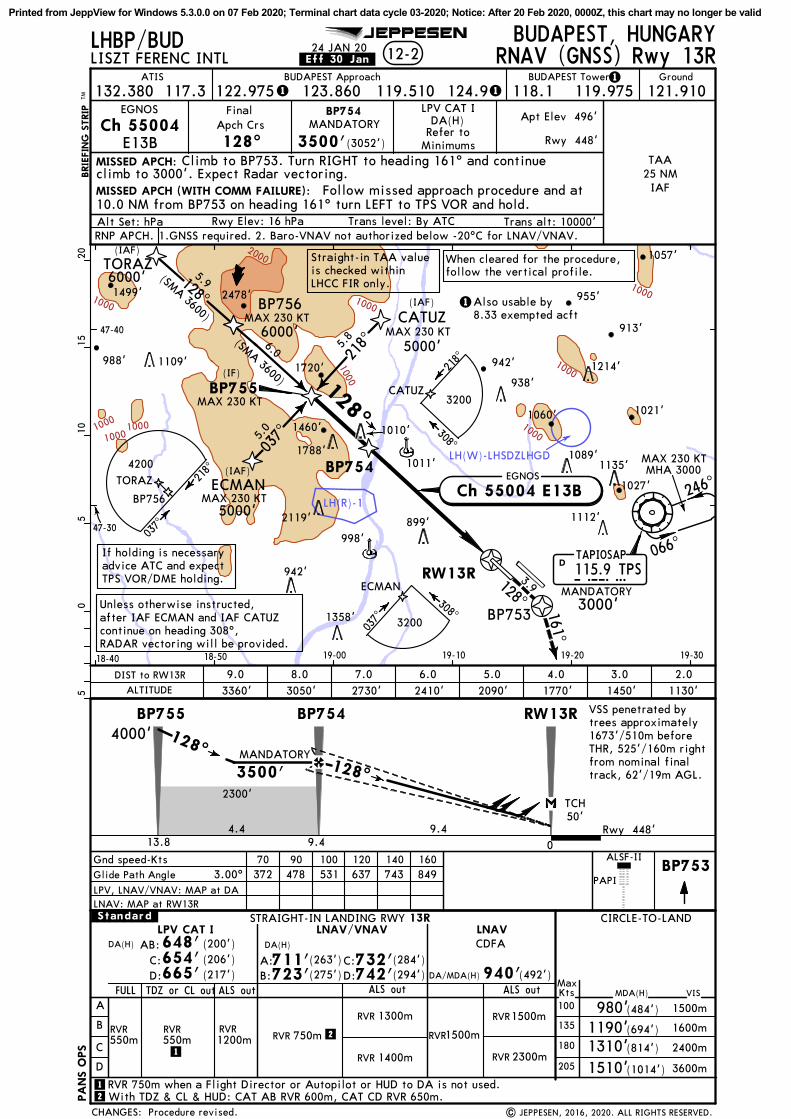
LH(R)-1
LH(W)-LHSDZLHGD1000
1000
1000
1000
1000
10001000
1000
1000
2000
218^
037^
6.0 5.8
5.0
(IAF)
(IAF)
128^
(IF)
TORAZ
ATIS
MISSED APCH:
BRIE
FIN
G S
TRIP
TM
12-2
117.3
128^ 3500'(3052')
DA(H)
PAPI
FinalApch Crs
LHBP/BUD
ALSF-II
JEPPESEN
PA
NS O
PS
132.380
Rwy 448'
Apt Elev 496'
05
510
1520
TAA
IAF25 NM
Refer toMinimums
BP754
128^
128^
Rwy 448'
2300'
ECMAN
CATUZ
6000'(SMA 3600)
5000'
5000'
MANDATORY
BP753
3.9128^
Ch 55004E13B
Ch 55004 E13B
LNAV
A
B
C
D
MDA(H)
CIRCLE-TO-LAND.Standard.
MaxKts100
135
180
VIS
1500m
1600m
2400m
DA(H)
(217') (492')ALS outALS out
STRAIGHT-IN LANDING RWY
RVR1500mRVR1200m
RVR550m
ALS out
LNAV/VNAV
1400mRVR
1300mRVR
13R
665' 940'
205 3600m
980'(484')
1190'(694')
1310'(814')
1510'(1014')
RVR 750m
RVR 2300m
Gnd speed-KtsGlide Path Angle 3.00^
70 90 100 120 140 160372 478 531 637 743 849
LPV, LNAV/VNAV: MAP at DALNAV: MAP at RW13R
EGNOS
EGNOS
TAPIOSAP115.9 TPSTPSD
VSS penetrated bytrees approximately1673'/510m beforeTHR, 525'/160m rightfrom nominal finaltrack, 62'/19m AGL.
RVR1500m
(206')654'(200')648'
RVR550m 2
2
Straight-in TAA valueis checked withinLHCC FIR only.
FULL
| JEPPESEN, 2016, 2020. ALL RIGHTS RESERVED.
TDZ or CL out
DA/MDA(H)
LPV CAT I
1
1
With TDZ & CL & HUD: CAT AB RVR 600m, CAT CD RVR 650m.
DA(H) CDFA
111
1
LPV CAT I
.Eff.30.Jan.24 JAN 20
BP753 161^
When cleared for the procedure,follow the vertical profile.
BP756
TORAZ128^
(SMA 3600)
5.9
(IAF)
6000'
MAX 230 KT
MAX 230 KT
MAX 230 KT
MAX 230 KT
ECMAN
CATUZ
RVR 750m when a Flight Director or Autopilot or HUD to DA is not used.
9.0 8.0 7.0 6.0 5.0 4.0 3.0 2.0
MISSED APCH (WITH COMM FAILURE):
Procedure revised.
MANDATORY
Climb to BP753. Turn RIGHT to heading 161^ and continue climb to 3000'. Expect Radar vectoring.
Follow missed approach procedure and at
MAX 230 KTMHA 3000
066^
246^
955'
988' 942'
1057'
1021'1060'
1027'
913'
1358'
942'
998'899' 1112'2119'
1135'1089'
1011'1788'
1010'
938'1214'1109' 1720'
2478'
1460'
1499'
47-30
47-40
18-40 18-50 19-00 19-10 19-20 19-30
BP756
10.0 NM from BP753 on heading 161^ turn LEFT to TPS VOR and hold.
MANDATORY3000'
BP755
218^
037^
BUDAPEST, HUNGARY
Rwy Elev: 16 hPa Trans level: By ATC
BUDAPEST Tower Ground
CHANGES:
BUDAPEST Approach
Alt Set: hPa
LISZT FERENC INTL
Trans alt: 10000'
RNAV (GNSS) Rwy 13R
RW13R
BP754
TCH50'
0
BP755
3500'
4.4 9.413.8
4000'BP754 RW13R
9.4
308^
037^
If holding is necessaryadvice ATC and expectTPS VOR/DME holding.
218^
308^
D: (294')742'
ALTITUDE 2730' 2410' 2090' 1770' 1450' 1130'DIST to RW13R
B: (275')723'C: (284')732'A: (263')711'
D:C:
AB:
121.910119.510123.860 119.975118.1124.9122.975
4200
3200
3200
Also usable by8.33 exempted acft
Unless otherwise instructed,after IAF ECMAN and IAF CATUZcontinue on heading 308^,RADAR vectoring will be provided.
3050'3360'
RNP APCH. 1.GNSS required. 2. Baro-VNAV not authorized below -20^C for LNAV/VNAV.
Printed from JeppView for Windows 5.3.0.0 on 07 Feb 2020; Terminal chart data cycle 03-2020; Notice: After 20 Feb 2020, 0000Z, this chart may no longer be valid

LH(R)-1
1000
ATIS
MISSED APCH:
BRIE
FIN
G S
TRIP
TM
12-3
117.3
308^ 2500'(2052')
FinalApch Crs
LHBP/BUD JEPPESEN
PA
NS O
PS
132.380
Rwy 448'
Apt Elev 496'
05
510
1520
TAA
IAF15 NM
(IAF)
(IAF)
(IAF)
219^
039^
308^
5.0 6.0
5.9
(IF)
308^
If holding is necessaryadvice ATC and expectTPS VOR/DME holding.
FUTNA
ATICO
NICRA
47-10
47-20
47-30
19-00 19-10 19-20 19-30 19-40
BP854
Rwy 448'
1200'
4000'
5000'
(SMA 1600)
4000'
MANDATORY
Ch 56065E31A
DA(H)Refer to
Minimums
Ch 56065 E31A
Gnd speed-KtsGlide Path Angle 3.00^
70 90 100 120 140 160372 478 531 637 743 849
LPV, LNAV/VNAV: MAP at DALNAV: MAP at RW31L
LNAV
A
B
C
D
MDA(H)
CIRCLE-TO-LAND.Standard.
MaxKts100
135
180
VIS
1500m
1600m
2400m
DA(H) (200')
ALS outALS out
STRAIGHT-IN LANDING RWY
RVR1400mRVR1200m
RVR550m
ALS out
LNAV/VNAV
1700mRVR
1500mRVR
31L
648'
205 3600m
980'(484')
1190'(694')
1310'(814')
1510'(1014')
RVR
RVR2200m
RVR
RVR 1800mRVR
EGNOS
EGNOS
TAPIOSAP115.9 TPS
D
RVR1500mRVR550m
1
FULL
| JEPPESEN, 2016, 2020. ALL RIGHTS RESERVED.
LPV CAT I
TDZ orCL out
1
DA(H)CDFA
111
1
LPV CAT I
.Eff.30.Jan.24 JAN 20
FUTNA
4000'309^
5.7(SM
A 1600)
MAX 230 KTBP856
ATICO
NICRA
MAX 230 KT
MAX 230 KT
MAX 230 KT
MISSED APCH (WITH COMM FAILURE):
Climb on RWY heading to 3000'. Expect Radar vectoring.
Follow missed approach procedure and at
When cleared for procedure follow the vertical profile.
1000m
1100m
DA/MDA(H)
RVR 750m when a Flight Director or Autopilot or HUD to DA is not used.
RVR1300m
RVR1500m
Procedure revised.
308^
308^
1027'
1001'
1358'
942'
998'899'
1112'2119'
898' 1135'
MANDATORY
Unless otherwise instructed, after IAF ATICO and IAF NICRA continue on heading 128^, RADAR vectoring will be provided.
900m
MAX 230 KTMHA 3000
066^
246^
BP856
on 308^PAPI
ALSF-II3000'
10.0 NM from RW31L on heading 308^ turn RIGHT to TPS VOR and hold.
3000'MANDATORY
BUDAPEST, HUNGARY
Rwy Elev: 16 hPa Trans level: By ATC
BUDAPEST Tower Ground
CHANGES:
BUDAPEST Approach
Alt Set: hPa
LISZT FERENC INTL
Trans alt: 10000'
BP855
039^
219^
128^
039^
219^
128^
RNAV (GNSS) Rwy 31L
RW31L
BP854
TCH50'
0
BP855
2500'
6.76.313.0
BP854RW31L
6.3
3000'
(462')910'
TPS
ALTITUDE
2.01130'
3.01450'
4.01770'
5.02090'
6.02410'
DIST to RW31L
B: (366')814'B: (442')890'A: (354')802'
2800
2000
3200
121.910119.975118.1124.9119.510123.860122.975
Also usable by8.33 exempted acft
653'D: (205')ABC:
D: (385')833'C: (374')822'
A: (422')870'
CD:
RNP APCH. 1. GNSS required. 2. Baro-VNAV not authorized below -20^C for LNAV/VNAV.
Printed from JeppView for Windows 5.3.0.0 on 07 Feb 2020; Terminal chart data cycle 03-2020; Notice: After 20 Feb 2020, 0000Z, this chart may no longer be valid

LH(R)-1
ATIS
MISSED APCH:
BRIE
FIN
G S
TRIP
TM
12-4
117.3
308^ 2500'(2084')
DA(H)
PAPI
FinalApch Crs
LHBP/BUD
ALSF-II
JEPPESEN
PA
NS O
PS
132.380
Rwy 416'
Apt Elev 496'
05
510
1520
TAA
IAF25 NM
Refer toMinimums
(IAF)
BP866
(IAF)
219^
039^5.
9
6.0
5.0
(IF)
ATICO
NICRA
OFENA
BP864
Rwy 416'
1300'
4000'
(SMA 1600) 4000'
4000'
MANDATORY
Ch 57172E31B
Ch 57172 E31B
Gnd speed-KtsGlide Path Angle 3.00^
70 90 100 120 140 160372 478 531 637 743 849
LPV, LNAV/VNAV: MAP at DALNAV: MAP at RW31R
LNAV
A
B
C
D
MDA(H)
CIRCLE-TO-LAND.Standard.
MaxKts100
135
180
VIS
1500m
1600m
2400m
DA(H)
(217')ALS outALS out
RVR 1500m
RVRRVR1200m
ALS out
DA(H)LNAV/VNAV
633'
205 3600m
980'(484')
1190'(694')
1310'(814')
1510'(1014')
RVR 1300m
900m
EGNOS
TAPIOSAP115.9 TPSTPSD
EGNOS
(207')623'(200')616'
RVR 550m 1
1
| JEPPESEN, 2016, 2020. ALL RIGHTS RESERVED.
2
2
DA/MDA(H)
TDZ or CL outFULL
LPV CAT I
RVR550m
31RSTRAIGHT-IN LANDING RWY
750mRVR
CDFA
111
1
LPV CAT I
.Eff.30.Jan.24 JAN 20
ATICO
NICRAMAX 230 KT
MAX 230 KT
MAX 230 KT
OFENA
BP863
5000'
(IAF)
309^
5.7(SMA 1600)
MAX 230 KT
308^
308^
BP863
MANDATORY3000'
MHA 3000
066^
246^ MAX 230 KT
When cleared for the procedure,follow the vertical profile.
Climb to BP863. Turn RIGHT (MAX 185 KT) direct to
RVR 1500m800mRVR
RVR 1600m900mRVR
RVR 750m when a Flight Director or Autopilot or HUD to DA is not used.
RVR 1600m
Procedure revised.
1027'
998'
1112'
1135'
1089'984'
47-10
47-20
47-30
19-10 19-20 19-30 19-40 19-50
MANDATORY
Unless otherwise instructed,after IAF ATICO and IAF NICRAcontinue on heading 128^, RADARvectoring will be provided.
TPS VOR and continue climb to 3000'. At 3000' enter holding at TPS VOR.
MAX 185 KT
BP866
With TDZ & CL & HUD: RVR 550m.
RNP APCH. 1. GNSS required. 2. Baro-VNAV not authorized below -20^C for LNAV/VNAV.
BUDAPEST, HUNGARY
Rwy Elev: 15 hPa Trans level: By ATC
BUDAPEST Tower Ground
CHANGES:
BUDAPEST Approach
Alt Set: hPa
LISZT FERENC INTL
Trans alt: 10000'
308^BP865
128^
039^
219^
128^
039^
219^
BP864
RW31R
TCH50'
BP865
2500'
5.06.411.4
BP864RW31R
6.40
3000'
(250')C: (332')
666'748'
(354')770'
ALTITUDE
1.0 2.01100'
3.01420'
4.01740'
5.02060'
6.02380'
DIST to RW31R780'
D:
C:
RNAV (GNSS) Z Rwy 31R
121.910119.975118.1124.9119.510123.860122.975
2800
2000
3200
Also usable by8.33 exempted acft
3.9308^
AB:
759'D: (343')
AB:
Printed from JeppView for Windows 5.3.0.0 on 07 Feb 2020; Terminal chart data cycle 03-2020; Notice: After 20 Feb 2020, 0000Z, this chart may no longer be valid

1000
ATISBRIE
FIN
G S
TRIP
TM
12-5
117.3
308^ 1800'(1384')
PAPI
FinalApch Crs
LHBP/BUD
ALSF-II
JEPPESEN
132.380
Rwy 416'
Apt Elev 496'BP331
Rwy 416'
CATA, B & C
RNAVDA/MDA(H)
1300'(884')
TAPIOSAP115.9 TPSTPSD
3000'
ODVAS 038^4.
2
3000'
BEREV
BP329
2300'
2300'
BP328
338^
278^219^
3.4
3.43.
3
Gnd speed-KtsDescent Angle 3.00^
70 90 100 120 140 160372 478 531 637 743 849
LNAV
A
B
C
D
.Standard.
308^3.00^
STRAIGHT-IN LANDING RWY 31R
.CEILING.REQUIRED.
5 km
CDFA
05
510
NOT APPLICABLE
47-20
47-30
19-10 19-20 19-30 19-40
(IAF)
(IAF)
(IF)
(IF)
PA
NS O
PS
DA/MDA(H)
MAP at RW31R
3600
MSA ARP
| JEPPESEN, 2017, 2020. ALL RIGHTS RESERVED.
111
1
.Eff.30.Jan.24 JAN 20
MAX 180 KT
MAX 180 KT
MAX 180 KT
MAX 180 KT
MAX 165 KT
BP863
MAX 230 KTMHA 3000
066^
246^
BP863
MISSED APCH:
Missed apch. Speed restriction. Note.
1027'
899'1112'
898'1135'
Climb to BP863. Turn RIGHT (MAX 185 KT) direct to TPS VOR and continue climb to 3000'. At 3000' enter holding at TPS VOR.
MANDATORY3000'
BUDAPEST, HUNGARY
Rwy Elev: 15 hPa Trans level: By ATC
BUDAPEST Tower Ground
CHANGES:
BUDAPEST Approach
Alt Set: hPa
LISZT FERENC INTL
Trans alt: 10000'
1800'
4.2
BP331RW31R
4.20
ALTITUDE
3.01420'
4.01740'
5.02060'
6.02380'
DIST to RW31R
RNAV (GNSS) Y Rwy 31R
308^
BP331
RW31R
CEILING-VISIBILITY
1500'-
TCH 50'
(884')1300'
121.910119.510123.860 119.975118.1124.9122.975
Also usable by8.33 exempted acft
RNP APCH. 1. GNSS required. 2. Only on pilot request in VMC. 3. When cleared for the procedure, follow the vertical profile.
Printed from JeppView for Windows 5.3.0.0 on 07 Feb 2020; Terminal chart data cycle 03-2020; Notice: After 20 Feb 2020, 0000Z, this chart may no longer be valid

128^
304^
LH(R)-1
LH(W)-LHSDZLHGD
1000
1000
1000
1000
10002000
BRIE
FIN
G S
TRIP
TM
13-1
VORBUD
117.3 128^
Apt Elev
Rwy
496'
496'
STRAIGHT-IN LANDING RWY
A
B
C
D
MDA(H)
CIRCLE-TO-LAND.Standard.
MaxKts100
135
180
205
VIS
980' 1500m
1600m
2400m
3600m
880'(384')
13L
RVR 1100m
(484')
1190'(694')
1310'(814')
1510'
FinalApch Crs
LHBP/BUD
090^
180^
360 ^
270^
JEPPESEN
MSATPS VOR
RVR 1800m
RVR 1500m
ATIS
117.3
3500'(3004')
D8.8 BUD
PA
NS O
PS
132.380
BUDAPEST117.3 BUDBUDD
TAPIOSAP115.9 TPSTPSD
128^
246^
066^
05
510
1520
47-30
47-40
18-50 19-00 19-10 19-20 19-30
128^
128^
128^
Rwy 496'
2300'
Gnd speed-KtsDescent Angle 3.00^
70 90 100 120 140 160372 478 531 637 743 849
MAP at BUD VOR
(1014')
ALS out
MISSED APCH:
PAPI
ALSF-II
(IAF)(IF)
304^
3
3128^
(SMA 2900)
5000'
4000'
on
MANDATORY
2200' within 15NM.
[FD13L]
[FD13L]
BUD
117.3R-128
DA/MDA(H)
| JEPPESEN, 2016, 2020. ALL RIGHTS RESERVED.
DA/MDA(H)
3600 3800
3200 2100
1
11
1
[D128D]
3.00^
.Eff.30.Jan.24 JAN 20
MANDATORY
MANDATORY
5000'MANDATORY
MAX 230 KTMHA 3000
[34VOR]
955'
942'
1021'1060'
1027'
1073'
913'
1358'
942'
998'899'
1112'
2119'
1135'1089'
1011'1010'
938'
1214'1109' 1720'
2478'
1057'
[34VOR]
CDFA
Procedure revised.
(384')880'
(MANDATORY 3000' for
Missed Apch)
Climb to 3000' and continue on R-128 BUD. Whenpassing D4.4 BUD turn LEFT (MAX 185 KT) direct to TPS VOR.At 3000' enter holding at TPS VOR.
1760'
1090'
BUDD4.4
BUDArc
18.0
DME
315^
308^
BUDAPEST, HUNGARY
CHANGES:
2
Rwy Elev: 18 hPa Trans level: By ATC
BUDAPEST Tower GroundBUDAPEST Approach
Alt Set: hPa
LISZT FERENC INTL
Trans alt: 10000'
D8.8 BUD
BUDD14.6
DME required.
BUD DME
ALTITUDE
6.02620'
5.02300'
4.01980'
3.01660'
2.01340'
1.01020'
TCH50'
0
3500'
5.8
BUD
5.4
D8.8BUD
0.5
D14.6BUD VOR
D18.0 BUD
D4.4 BUD
VOR Rwy 13L
4000'
2
119.975 121.910118.1124.9119.510123.860122.975
[D3~4R]
D18.0 BUD[D3~8R]
[CD13L]
[CD13L]
Also usable by8.33 exempted acft
7.02930'
8.03250'
D3.4 BUD
BUDD3.4
3.4
Printed from JeppView for Windows 5.3.0.0 on 07 Feb 2020; Terminal chart data cycle 03-2020; Notice: After 20 Feb 2020, 0000Z, this chart may no longer be valid

128^
136^122^
LH(R)-1
LH(W)-LHSDZLHGD
1000
BRIE
FIN
G S
TRIP
TM
13-2
VORBUD
117.3 308^
Apt Elev
Rwy
496'
416'
FinalApch Crs
LHBP/BUD
090^
180^
360^
270^
JEPPESEN
MSATPS VOR
2500'(2084')
ATIS
117.3D8.8 BUD
PA
NS O
PS
132.380
Gnd speed-KtsDescent Angle 3.00^
70 90 100 120 140 160372 478 531 637 743 849
MAP at D2.5 BUD
BUDAPEST117.3 BUDBUDD
TAPIOSAP115.9 TPSTPSD
066^
308^
05
510
1520
47-20
47-30
19-10 19-20 19-30 19-40 19-50
MISSED APCH:
308^ 308^
Rwy 416'
1200'
PAPI
ALSF-II
STRAIGHT-IN LANDING RWY
A
B
C
D
MDA(H)
CIRCLE-TO-LAND.Standard.
MaxKts100
135
180
205
VIS
980' 1500m
1600m2400m
3600m
31R
RVR
(484')
1190'(694')
1310'(814')
1510'RVR 1600m
RVR 1500m
(1014')
ALS out
770'(354')
900m
(IAF)
136^
4000'
3500'
(IF)
308^(SMA1800) 20.0 BUD
DME Arc
3
3
2200' within 15NM.
[RW31R]
[FD31R]
MANDATORY[RW31R] [FD31R]
3.00^
DA/MDA(H)
DA/MDA(H)
| JEPPESEN, 2016, 2020. ALL RIGHTS RESERVED.
CDFA
3600 3800
3200 2100
11
1
1
.Eff.30.Jan.24 JAN 20
1060'
1027'
998'1112'
1135'1089'
1011'1010' 1021'
MANDATORY770'(354')
MAX 230 KTMHA 3000
5000'MANDATORY
(MANDATORY 3000' for
Missed Apch)
Climb to 3000' initially on R-128 BUD inbound. After
MSA. Missed approach procedure. Holding. Minimums.
passing the station continue on R-308 BUD. When passing D1.5 BUD turn RIGHT (MAX 185 KT) direct to TPS VOR. At 3000' enter holding at TPS VOR.
Refer toMissed Apch
above
246^
2
VOR Rwy 31RBUDAPEST, HUNGARY
CHANGES:
2
BUDAPEST Tower GroundBUDAPEST Approach
Rwy Elev: 15 hPa Trans level: By ATCAlt Set: hPaDME required.
LISZT FERENC INTL
Trans alt: 10000'
BUD
D8.8 BUD
D2.5 BUD
D13.8
BUD DME
ALTITUDE
8.02220'
7.01900'
6.01580'
5.01260'
4.0940'
TCH50'
2500'
BUD
5.06.3
D2.5BUD BUD
D13.8D8.8
D20.0 BUD
D20.0 BUD
2500'
121.910119.975118.1124.9119.510123.860122.975
[D136T]
[D128T]
[CD31R]
[CD31R]
Also usable by8.33 exempted acft
[D3~8B]D1.5 BUD
Printed from JeppView for Windows 5.3.0.0 on 07 Feb 2020; Terminal chart data cycle 03-2020; Notice: After 20 Feb 2020, 0000Z, this chart may no longer be valid

Chart changes since cycle 02-2020
ADD = added chart, REV = revised chart, DEL = deleted chart.ACT PROCEDURE IDENT INDEX REV DATE EFF DATE
BUDAPEST, (LISZT FERENC INTL - LHBP)REV AIRPORT 10-9 31 Jan 2020REV AIRPORT INFO, TAKE-OFF MN... 10-9A 31 Jan 2020REV PARKING STANDS (APRON 1, ... 10-9B 31 Jan 2020REV PARKING STANDS (APRON 2) ... 10-9C 31 Jan 2020REV TAXI PROCS FOR ARRIVING A... 10-9D 31 Jan 2020REV SAFEGATE DOCKING SYSTEM 10-9E 31 Jan 2020
Revision Letter For Cycle 03-2020Printed on 07 Feb 2020Page 1(c) JEPPESEN SANDERSON, INC., 2020, ALL RIGHTS RESERVED
jep=JEPPESEN
JeppView for Windows

TERMINAL CHART CHANGE NOTICES
No Chart Change Notices for Airport LHBP
TERMINAL CHART CHANGE NOTICES
No Chart Change Notices for Airport LHBP
Terminal Chart Change NoticesPage 1 - Printed on 07 Feb 2020Notice: After 20 Feb 2020, 0000Z, this data may no longer be valid(c) JEPPESEN SANDERSON, INC., 2020, ALL RIGHTS RESERVED
jep=JEPPESEN
JeppView for Windows