transmission gully: guide to the lodgement … a few specific instances, transmission gully is used...
TRANSCRIPT
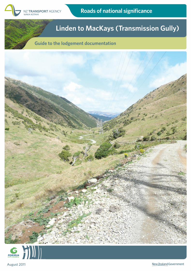
Roads of national significance
Linden to MacKays (Transmission Gully)
August 2011
Guide to the lodgement documentation
Transmission Gully Project
Guide to the lodgement documentation
Table of contents
1 Contents and structure of the lodgement documentation ......................................... 1 1.1 Volume 1: Assessment of Environmental Effects report................................................ 1 1.2 Volume 2: Resource Management Act 1991 forms ....................................................... 1 1.3 Volume 3: Technical reports and supporting documents ............................................. 2 1.4 Volume 4: Plan set ...................................................................................................... 2 1.5 Volume 5: Draft management plans ............................................................................ 2 1.6 Volume 6: Transmission Line Relocation Project .......................................................... 3
2 Terminology used ........................................................................................................................ 3 2.1 Key terms ................................................................................................................... 3 2.2 Transmission Gully ..................................................................................................... 3 2.3 Transmission Gully Motorway ..................................................................................... 3
3 Referencing conventions ........................................................................................................... 4 3.1 Position along the Main Alignment .............................................................................. 4 3.2 Sections of the Main Alignment ................................................................................... 4 3.3 Numbering of features ................................................................................................ 4 3.4 Hydrological catchments and watersheds affected by the Project ................................. 5 3.5 Referring to properties................................................................................................ 7 3.6 Phases of the Project................................................................................................... 7
Attachment 1: Contents of Volumes 1 – 6 .................................................................................. 8
Attachment 2: List of abbreviations .......................................................................................... 11
Attachment 3: Glossary of terms ................................................................................................ 16
Transmission Gully Project
Guide to the lodgement documentation | 1
1 Contents and structure of the lodgement documentation
The lodgement documentation for the Transmission Gully Project is made up of six volumes and is structured as follows:
• Volume 1: Assessment of Environment Effects report
• Volume 2: Resource Management Act 1991 forms
• Volume 3: Technical reports and supporting documents
• Volume 4: Plan set
• Volume 5: Draft management plans
• Volume 6: Transmission Line Relocation Project
A full list of the contents of Volumes 1 - 6 is contained as Attachment 1 to this document.
1.1 Volume 1: Assessment of Environmental Effects report
This report covers all of the aspects required for the assessment of environmental effects in support of NoRs and the applications for resource consent. Much of the technical information is from reports contained in Volume 3 and a cross-reference is provided to these reports where necessary.
The AEE report should also be read in conjunction with the plans contained in Volume 4 and the draft management plans contained in Volume 5. A cross-reference to relevant plans is provided in the AEE report where necessary.
1.2 Volume 2: Resource Management Act 1991 forms
The forms required under the RMA for the NoRs and resource consent applications are contained in Volume 2.
There are forms relating to:
• the lodgement of matters with the EPA by the NZTA and PCC;
• notices of requirement by the NZTA and PCC; and
• applications for resource consent by the NZTA and PCC.
In general, the forms provide a reference to where in the lodgement documentation the required information is located.
Transmission Gully Project
Guide to the lodgement documentation | 2
1.3 Volume 3: Technical reports and supporting documents
Technical reports and supporting documents are contained in Volume 3. Each report has been assigned a number for easy reference.
Within each report, the numbering of figures, tables and appendices also relates to the report number.
For example:
• Figure 6.1 refers to the first figure of Technical Report 6;
• Table 6.1 refers to the first table of Technical Report 6; and
• Appendix 6.A refers to the first appendix of Technical Report 6.
This numbering system is intended to avoid confusion when referring to figures, tables and appendices within reports contained in Volume 3.
Technical reports refer to specific plans in Volume 4 as necessary. In addition, some reports should also be read in conjunction with specific plans (contained in Volume 4):
Report number Report name To be read in conjunction with… 1 Road design philosophy Road layout plans GM01- 21
Longitudinal sections and cross-sections
GM22- 84
2 Design philosophy: Bridges and retaining walls
Structures plans S01- 29
5 Assessment of landscape and visual effects
Landscape plans LA01- 124
12 Assessment of acoustic effects
Noise plans NA series
NB01- 21
NC series
14 Assessment of hydrology and stormwater effects
Drainage plans DR01- 21
1.4 Volume 4: Plan set
All of the main plans and drawings are contained in Volume 4 and are referenced by other documents.
1.5 Volume 5: Draft management plans
All of the draft management plans lodged for the Project are contained in Volume 5.
There are three types of management plans:
• the construction environmental management plan;
• topic specific management plans (e.g. noise, traffic etc.); and
Transmission Gully Project
Guide to the lodgement documentation | 3
• site specific environmental management plans.
1.6 Volume 6: Transmission Line Relocation Project
Applications by Transpower New Zealand Limited for resource consents to relocate an existing transmission line required as enabling works for the Transmission Gully Project are contained in Volume 6.
Volume 6 contains an AEE report for the works as well as relevant supporting technical reports.
2 Terminology used
A complete list of abbreviations used is provided as Attachment 2 and a glossary of terms used is provided as Attachment 3.
2.1 Key terms
Particular attention is drawn to the following key terms:
Term Meaning Main Alignment A proposed 27km expressway between Linden (Wellington City) and MacKays
Crossing (Kapiti Coast). Kenepuru Link Road A proposed State highway from the Kenepuru Interchange to Kenepuru Drive,
providing vehicular access to the Main Alignment from western Porirua. Porirua Link Roads Refers collectively to the Whitby Link Road and the Waitangirua Link Road, which
will both provide vehicular access to the Main Alignment from eastern Porirua. NZTA Project The construction, operation and maintenance of the Main Alignment and the
Kenepuru Link Road. PCC Project The construction, operation and maintenance of the Porirua Link Roads. Transmission Line Relocation Project
The works required to the existing 110kV PKK-TKR-A electricity transmission line to enable the Transmission Gully Project.
2.2 Transmission Gully
The term ‘Transmission Gully’ is not used widely throughout the documents as this can create confusion as to whether the Project or a geographical place is being referred to. In a few specific instances, Transmission Gully is used to refer to a geographical place. While not an official geographical place name, Transmission Gully is used colloquially to refer to a general route up the Te Puka Valley to the Wainui Saddle and down the Horokiri Valley to Pauatahanui.
2.3 Transmission Gully Motorway
Historically, former versions of the Project have been referred to in a number of different ways, including:
Transmission Gully Project
Guide to the lodgement documentation | 4
• the Transmission Gully Motorway (or TGM); or
• the Inland Route;
These terms have not been widely used in this set of documents and are only used in reference to historical versions of the Project.
3 Referencing conventions
3.1 Position along the Main Alignment
The position of features along the Main Alignment is given as a station value (or chainage distance) from MacKays Crossing. For example, a feature described as being at 2,200m is located approximately 2.2km south of MacKays Crossing.
3.2 Sections of the Main Alignment
The Main Alignment has also been divided into nine sections which are used to refer to specific lengths of the Main Alignment:
Section number Section name Station value (m) Length (km) 1 MacKays Crossing 0 – 3,500 3.5 2 Wainui Saddle 3,500 – 6,500 3.0 3 Horokiri Stream 6,500 – 9,500 3.0 4 Battle Hill 9,500 – 12,500 3.0 5 Golf Course 12,500 – 15,500 3.0 6 State Highway 58 15,500 – 18,500 3.0 7 James Cook 18,500 – 21,500 3.0 8 Cannons Creek 21,500 – 24,900 3.4 9 Linden 24900 – 27700 2.8
3.3 Numbering of features
The following features are numbered sequentially from north (MacKays Crossing) to south (Linden):
• bridges;
• culverts;
• stream realignments; and
• erosion and sediment control ponds.
Transmission Gully Project
Guide to the lodgement documentation | 5
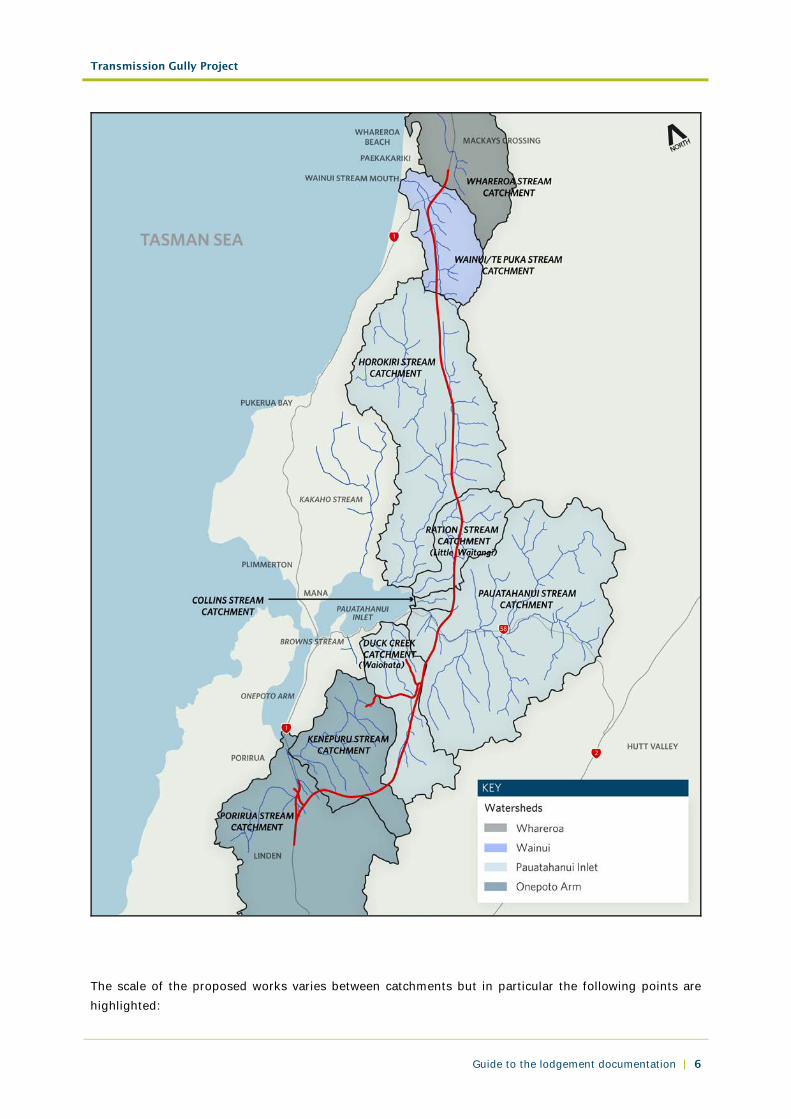
3.4 Hydrological catchments and watersheds affected by the Project
The Project involves works in nine (9) separate hydrological catchments which are part of four (4) separate watersheds, as shown below.
Transmission Gully Project
Guide to the lodgement documentation | 6
The scale of the proposed works varies between catchments but in particular the following points are highlighted:
Transmission Gully Project
Guide to the lodgement documentation | 7
• The Project involves earthworks and stream works in all catchments except the Whareroa Stream catchments.
• In the Whareroa catchment a small amount of earthworks are proposed, but no stream works.
• Te Puka Stream is a tributary of the Wainui Stream and they are in the same catchment. However, as the confluence of the two streams is downstream of the Project, they have been treated as different streams.
• The Project does not involve works in the Browns Stream and Kakaho Stream but the location of them is shown for reference.
• Duck Creek is also known as Waiohata Stream.
• Ration Stream is also known as Little Waitangi Stream.
3.5 Referring to properties
Where all or part of a property is required, it is listed in the Land Requirement Schedule (plans LR19 and
LR20) and has been assigned a property number. This number will be used to refer to the property.
Properties not listed on the schedule are referred to by their street address and legal description.
3.6 Phases of the Project
The development of the Project has been divided into six phases:
Phase Name Indicative timeframe
1 Scheme assessment 2007 – 2009 2 Preliminary design and preparation of regulatory consent applications 2009 – 2011 3 Consideration of the regulatory consent applications 2011 – 2012 4 Completion of a complying specimen design 2012 – 2014 5 Construction (including enabling works) 2014 - 2021 6 Commissioning 2021
These phases are referred to throughout the documents.
Transmission Gully Project
Guide to the lodgement documentation | 8
Attachment 1: Contents of Volumes 1 – 6
Contents Tab reference VOLUME 1: ASSESSMENT OF ENVIRONMENTAL EFFECTS REPORT
Chapter 1: Introduction 1
Chapter 2: Background to the Project 2
Chapter 3: Resource Management Act 1991 3
Chapter 4: Statutory considerations 4
Chapter 5: Additional considerations 5
Chapter 6: Description of the environment 6
Chapter 7: Operation of the Project 7
Chapter 8: Construction of the Project 8
Chapter 9: Assessment of alternatives 9
Chapter 10: Consultation and engagement 10
Chapter 11: Summary of effects on the environment 12
Chapter 12: Assessment methodology 12
Chapter 13: Traffic and transport 13
Chapter 14: Land use and property impacts 14
Chapter 15: Network utilities 15
Chapter 16: Noise and vibration 16
Chapter 17: Air quality 17
Chapter 18: Contaminated land 18
Chapter 19: Hydrology 19
Chapter 20: Water quality 20
Chapter 21: Terrestrial ecology 21
Chapter 22: Freshwater ecology 22
Chapter 23: Marine ecology 23
Chapter 24: Tangata whenua 24
Chapter 25: Landscape and visual 25
Chapter 26: Archaeology and built heritage 26
Chapter 27: Social effects 27
Chapter 28: Environmental management and monitoring 28
Chapter 29: Proposed designation conditions 29
Chapter 30: Proposed resource consent conditions 30
Chapter 31: Approach to the assessment 31
Chapter 32: Statutory assessment 32
VOLUME 2: RESOURCE MANAGEMENT ACT 1991 FORMS
Notices of requirement and applications for resource consent lodged by the NZ Transport Agency
NZTA forms
Transmission Gully Project
Guide to the lodgement documentation | 9
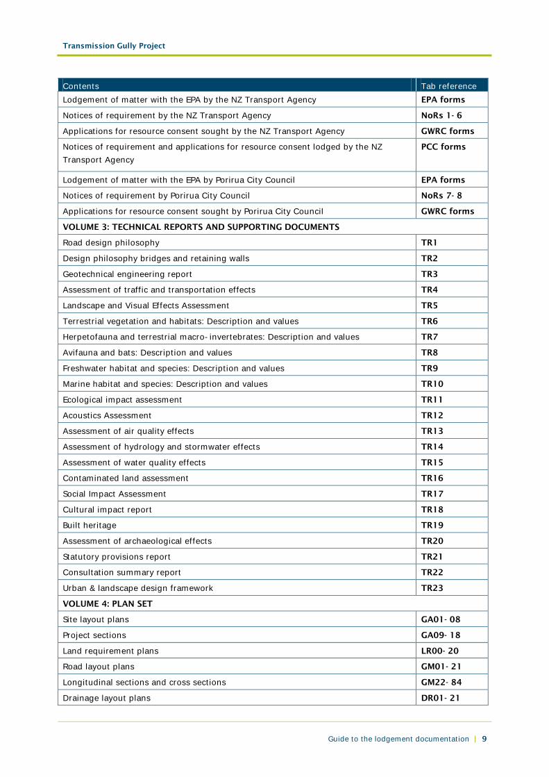
Contents Tab reference Lodgement of matter with the EPA by the NZ Transport Agency EPA forms
Notices of requirement by the NZ Transport Agency NoRs 1- 6
Applications for resource consent sought by the NZ Transport Agency GWRC forms
Notices of requirement and applications for resource consent lodged by the NZ Transport Agency
PCC forms
Lodgement of matter with the EPA by Porirua City Council EPA forms
Notices of requirement by Porirua City Council NoRs 7- 8
Applications for resource consent sought by Porirua City Council GWRC forms
VOLUME 3: TECHNICAL REPORTS AND SUPPORTING DOCUMENTS
Road design philosophy TR1
Design philosophy bridges and retaining walls TR2
Geotechnical engineering report TR3
Assessment of traffic and transportation effects TR4
Landscape and Visual Effects Assessment TR5
Terrestrial vegetation and habitats: Description and values TR6
Herpetofauna and terrestrial macro-invertebrates: Description and values TR7
Avifauna and bats: Description and values TR8
Freshwater habitat and species: Description and values TR9
Marine habitat and species: Description and values TR10
Ecological impact assessment TR11
Acoustics Assessment TR12
Assessment of air quality effects TR13
Assessment of hydrology and stormwater effects TR14
Assessment of water quality effects TR15
Contaminated land assessment TR16
Social Impact Assessment TR17
Cultural impact report TR18
Built heritage TR19
Assessment of archaeological effects TR20
Statutory provisions report TR21
Consultation summary report TR22
Urban & landscape design framework TR23
VOLUME 4: PLAN SET
Site layout plans GA01- 08
Project sections GA09- 18
Land requirement plans LR00- 20
Road layout plans GM01- 21
Longitudinal sections and cross sections GM22- 84
Drainage layout plans DR01- 21
Transmission Gully Project
Guide to the lodgement documentation | 10
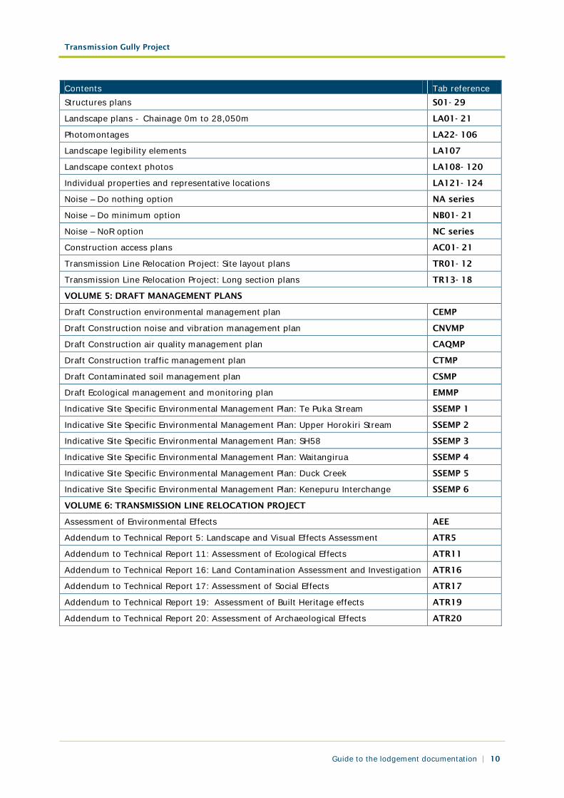
Contents Tab reference Structures plans S01- 29
Landscape plans - Chainage 0m to 28,050m LA01- 21
Photomontages LA22- 106
Landscape legibility elements LA107
Landscape context photos LA108- 120
Individual properties and representative locations LA121- 124
Noise – Do nothing option NA series
Noise – Do minimum option NB01- 21
Noise – NoR option NC series
Construction access plans AC01- 21
Transmission Line Relocation Project: Site layout plans TR01- 12
Transmission Line Relocation Project: Long section plans TR13- 18
VOLUME 5: DRAFT MANAGEMENT PLANS
Draft Construction environmental management plan CEMP
Draft Construction noise and vibration management plan CNVMP
Draft Construction air quality management plan CAQMP
Draft Construction traffic management plan CTMP
Draft Contaminated soil management plan CSMP
Draft Ecological management and monitoring plan EMMP
Indicative Site Specific Environmental Management Plan: Te Puka Stream SSEMP 1
Indicative Site Specific Environmental Management Plan: Upper Horokiri Stream SSEMP 2
Indicative Site Specific Environmental Management Plan: SH58 SSEMP 3
Indicative Site Specific Environmental Management Plan: Waitangirua SSEMP 4
Indicative Site Specific Environmental Management Plan: Duck Creek SSEMP 5
Indicative Site Specific Environmental Management Plan: Kenepuru Interchange SSEMP 6
VOLUME 6: TRANSMISSION LINE RELOCATION PROJECT
Assessment of Environmental Effects AEE
Addendum to Technical Report 5: Landscape and Visual Effects Assessment ATR5
Addendum to Technical Report 11: Assessment of Ecological Effects ATR11
Addendum to Technical Report 16: Land Contamination Assessment and Investigation
ATR16
Addendum to Technical Report 17: Assessment of Social Effects ATR17
Addendum to Technical Report 19: Assessment of Built Heritage effects ATR19
Addendum to Technical Report 20: Assessment of Archaeological Effects ATR20

Transmission Gully Project
Guide to the lodgement documentation | 11
Attachment 2: List of abbreviations
Abbreviation Meaning AADT Annual average daily traffic AAQG Ambient air quality guidelines AEE Assessment of environmental effects AEP Annual exceedence probability ASCV Area of significant conservation value AST Aboveground storage tank ATMS Advanced traffic management system BCR Benefit-cost ratio BHFFP Battle Hill Farm Forest Park BoI Board of inquiry BPO Best practicable option BRP Belmont Regional Park BS British Standard CAU Census area unit CEMP Construction environmental management plan CIA Cultural impact assessment CLMG Contaminated land management guidelines CH4 Methane CLS Contaminated land specialist CMA Coastal marine area CNVMP Construction noise and vibration management plan CO Carbon monoxide CO2 Carbon dioxide COPTTM Code of practice for temporary traffic management [NZTA] CRTN Calculation of road traffic noise CSMP Contaminated soils management plan CVO Costed viaduct option dB Decibels DHB District health board DM Do minimum DOC Department of Conservation DPTS (Draft) Porirua Transportation Strategy EEM Economic evaluation manual [NZTA] EMME/2 Equilibre multimodal/multimodal equilibrium Version 2 EMG Environmental monitoring guidelines EMI Electromagnetic induction EPA Environmental Protection Authority ESCP Erosion and sediment control plan FFR Freshwater Fisheries Regulations 1983 GATS Greater Wellington Area Transportation Strategic review GDP Gross domestic product GIS Geographic information system GNS Institute of Geological and Nuclear Sciences
Transmission Gully Project
Guide to the lodgement documentation | 12
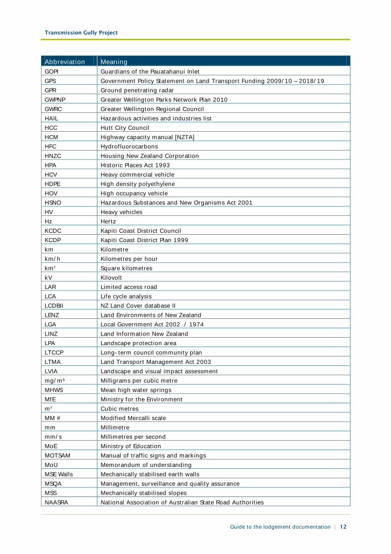
Abbreviation Meaning GOPI Guardians of the Pauatahanui Inlet GPS Government Policy Statement on Land Transport Funding 2009/10 – 2018/19 GPR Ground penetrating radar GWPNP Greater Wellington Parks Network Plan 2010 GWRC Greater Wellington Regional Council HAIL Hazardous activities and industries list HCC Hutt City Council HCM Highway capacity manual [NZTA] HFC Hydrofluorocarbons HNZC Housing New Zealand Corporation HPA Historic Places Act 1993 HCV Heavy commercial vehicle HDPE High density polyethylene HOV High occupancy vehicle HSNO Hazardous Substances and New Organisms Act 2001 HV Heavy vehicles Hz Hertz KCDC Kapiti Coast District Council KCDP Kapiti Coast District Plan 1999 km Kilometre km/h Kilometres per hour km2 Square kilometres kV Kilovolt LAR Limited access road LCA Life cycle analysis LCDBII NZ Land Cover database II LENZ Land Environments of New Zealand LGA Local Government Act 2002 / 1974 LINZ Land Information New Zealand LPA Landscape protection area LTCCP Long-term council community plan LTMA Land Transport Management Act 2003 LVIA Landscape and visual impact assessment mg/m³ Milligrams per cubic metre MHWS Mean high water springs MfE Ministry for the Environment m3 Cubic metres MM # Modified Mercalli scale mm Millimetre mm/s Millimetres per second MoE Ministry of Education MOTSAM Manual of traffic signs and markings MoU Memorandum of understanding MSE Walls Mechanically stabilised earth walls MSQA Management, surveillance and quality assurance MSS Mechanically stabilised slopes NAASRA National Association of Australian State Road Authorities

Transmission Gully Project
Guide to the lodgement documentation | 13
Abbreviation Meaning NATO North Atlantic Treaty Organisation NES National environmental standard NES AQ Resource Management (National Environmental Standards Relating to Certain Air
Pollutants, Dioxins, and Other Toxics) Regulations 2004 NES CS Proposed National Environmental Standard for Assessing and Managing
Contaminants in Soil NES ET Resource Management (National Environmental Standards for Electricity Transmission
Activities) Regulations 2009 NES SHDW Resource Management (National Environmental Standards for Sources of Human
Drinking Water) Regulations 2007 NIMT North Island Main Trunk (Railway Line) NIP National Infrastructure Plan 2011 NPS National policy statement NPS ET National Policy Statement on Electricity Transmission 2008 NPS FM National Policy Statement on Freshwater Management 2011 NLTP National Land Transport Programme 2009 - 2012 NO Nitric oxide N2O Nitrous oxide NO2 Nitrogen dioxide NOx Oxides of nitrogen NoR Notice of requirement for designation NS Norwegian Standard NTU Nephelometric turbidity units NZCPS New Zealand Coastal Policy Statement 2010 NZGD New Zealand Geodetic Datum NZHPT New Zealand Historic Places Trust NZLRI New Zealand Land Use Resource Inventory NZS New Zealand Standard NZTM New Zealand Transverse Mercator NZTA NZ Transport Agency NZTABM NZ Transport Agency Bridge Manual 2003 [NZTA] NZTS New Zealand Transport Strategy 2008 NZTTG New Zealand Health and Environmental Guidelines for Selected Timber Treatment
Chemicals NZUDP New Zealand Urban Design Protocol 2005 OGPA Open graded porous asphalt OLS Old landslide scars ORC Organochlorine ORP Organophosphate ORN Organonitrogen OSH Occupational safety and health OSNZ Ornithological Society of New Zealand PAH Polycyclic aromatic hydrocarbons PCB Polychlorinated biphenyls PCC Porirua City Council PCDP Porirua City District Plan 1999 PCE Parliamentary Commissioner for the Environment PCP Pentachlorophenol
Transmission Gully Project
Guide to the lodgement documentation | 14
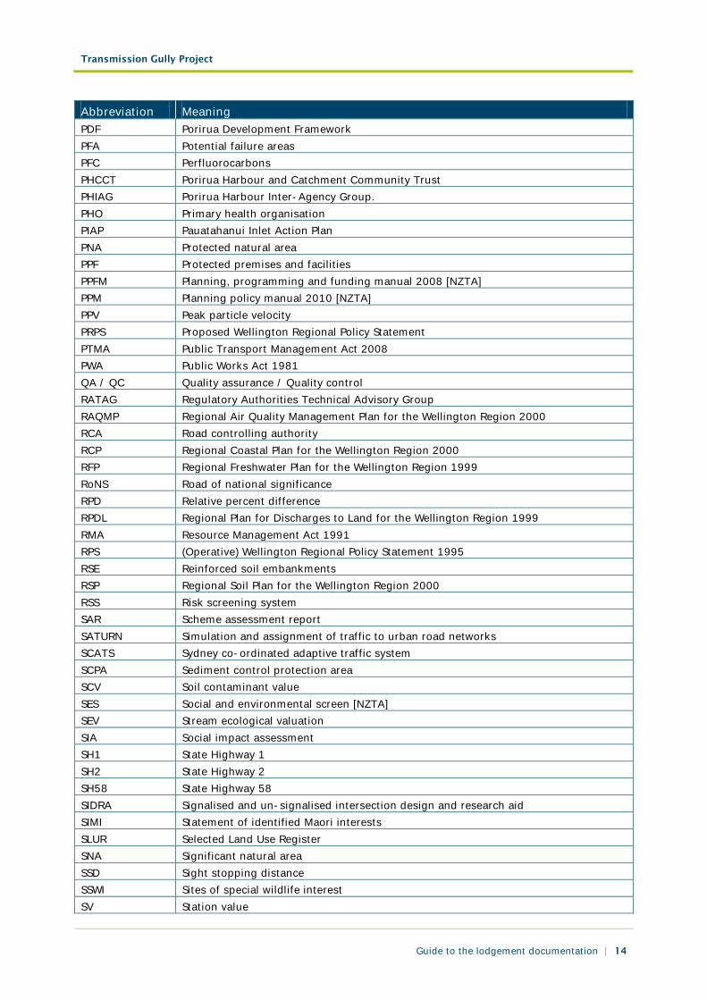
Abbreviation Meaning PDF Porirua Development Framework PFA Potential failure areas PFC Perfluorocarbons PHCCT Porirua Harbour and Catchment Community Trust PHIAG Porirua Harbour Inter-Agency Group. PHO Primary health organisation PIAP Pauatahanui Inlet Action Plan PNA Protected natural area PPF Protected premises and facilities PPFM Planning, programming and funding manual 2008 [NZTA] PPM Planning policy manual 2010 [NZTA] PPV Peak particle velocity PRPS Proposed Wellington Regional Policy Statement PTMA Public Transport Management Act 2008 PWA Public Works Act 1981 QA / QC Quality assurance / Quality control RATAG Regulatory Authorities Technical Advisory Group RAQMP Regional Air Quality Management Plan for the Wellington Region 2000 RCA Road controlling authority RCP Regional Coastal Plan for the Wellington Region 2000 RFP Regional Freshwater Plan for the Wellington Region 1999 RoNS Road of national significance RPD Relative percent difference RPDL Regional Plan for Discharges to Land for the Wellington Region 1999 RMA Resource Management Act 1991 RPS (Operative) Wellington Regional Policy Statement 1995 RSE Reinforced soil embankments RSP Regional Soil Plan for the Wellington Region 2000 RSS Risk screening system SAR Scheme assessment report SATURN Simulation and assignment of traffic to urban road networks SCATS Sydney co-ordinated adaptive traffic system SCPA Sediment control protection area SCV Soil contaminant value SES Social and environmental screen [NZTA] SEV Stream ecological valuation SIA Social impact assessment SH1 State Highway 1 SH2 State Highway 2 SH58 State Highway 58 SIDRA Signalised and un-signalised intersection design and research aid SIMI Statement of identified Maori interests SLUR Selected Land Use Register SNA Significant natural area SSD Sight stopping distance SSWI Sites of special wildlife interest SV Station value
Transmission Gully Project
Guide to the lodgement documentation | 15
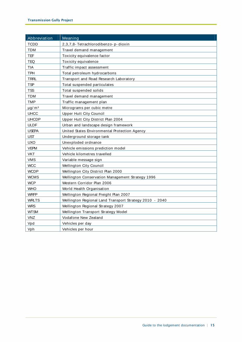
Abbreviation Meaning TCDD 2,3,7,8-Tetrachlorodibenzo-p-dioxin TDM Travel demand management TEF Toxicity equivalence factor TEQ Toxicity equivalence TIA Traffic impact assessment TPH Total petroleum hydrocarbons TRRL Transport and Road Research Laboratory TSP Total suspended particulates TSS Total suspended solids TDM Travel demand management TMP Traffic management plan µg/m³ Micrograms per cubic metre UHCC Upper Hutt City Council UHCDP Upper Hutt City District Plan 2004 ULDF Urban and landscape design framework USEPA United States Environmental Protection Agency UST Underground storage tank UXO Unexploded ordnance VEPM Vehicle emissions prediction model VKT Vehicle kilometres travelled VMS Variable message sign WCC Wellington City Council WCDP Wellington City District Plan 2000 WCMS Wellington Conservation Management Strategy 1996 WCP Western Corridor Plan 2006 WHO World Health Organisation WRFP Wellington Regional Freight Plan 2007 WRLTS Wellington Regional Land Transport Strategy 2010 - 2040 WRS Wellington Regional Strategy 2007 WTSM Wellington Transport Strategy Model VNZ Vodafone New Zealand Vpd Vehicles per day Vph Vehicles per hour
Transmission Gully Project
Guide to the lodgement documentation | 16
Attachment 3: Glossary of terms
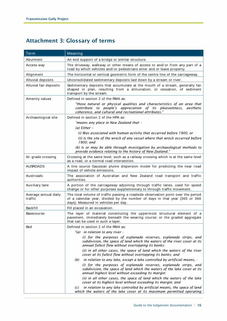
Term Meaning Abutment An end support of a bridge or similar structure. Access way The driveway, walkway or other means of access to and/or from any part of a
road by which vehicles and/or pedestrians enter and or leave property. Alignment The horizontal or vertical geometric form of the centre line of the carriageway. Alluvial deposits Unconsolidated sedimentary deposits laid down by a stream or river. Alluvial fan deposits Sedimentary deposits that accumulate at the mouth of a stream, generally fan
shaped in plan, resulting from a dimunation, or cessation, of sediment transport by the stream.
Amenity values Defined in section 2 of the RMA as: “those natural or physical qualities and characteristics of an area that contribute to people’s appreciation of its pleasantness, aesthetic coherence, and cultural and recreational attributes.”
Archaeological site Defined in section 2 of the HPA as: “means any place in New Zealand that –
(a) Either –
(i) Was associated with human activity that occurred before 1900; or
(ii) Is the site of the wreck of any vessel where that wreck occurred before 1900; and
(b) Is or may be able through investigation by archaeological methods to provide evidence relating to the history of New Zealand.”
At-grade crossing Crossing at the same level, such as a railway crossing which is at the same level as a road, or a normal road intersection.
AUSROADS A line source Gaussian plume dispersion model for predicting the near road impact of vehicle emissions.
Austroads The association of Australian and New Zealand road transport and traffic authorities.
Auxiliary lane A portion of the carriageway adjoining through traffic lanes, used for speed change or for other purposes supplementary to through traffic movement.
Average annual daily traffic
The total volume of traffic passing a roadside observation point over the period of a calendar year, divided by the number of days in that year (365 or 366 days). Measured in vehicles per day.
Backfill Fill placed in an excavation. Basecourse The layer of material constituting the uppermost structural element of a
pavement, immediately beneath the wearing course; or the graded aggregate that can be used in such a layer.
Bed Defined in section 2 of the RMA as: “(a) in relation to any river -
(i) for the purposes of esplanade reserves, esplanade strips, and subdivision, the space of land which the waters of the river cover at its annual fullest flow without overtopping its banks:
(ii) in all other cases, the space of land which the waters of the river cover at its fullest flow without overtopping its banks; and
(b) in relation to any lake, except a lake controlled by artificial means, -
(i) for the purposes of esplanade reserves, esplanade strips, and subdivision, the space of land which the waters of the lake cover at its annual highest level without exceeding its margin:
(ii) in all other cases, the space of land which the waters of the lake cover at its highest level without exceeding its margin; and
(c) in relation to any lake controlled by artificial means, the space of land which the waters of the lake cover at its maximum permitted operating
Transmission Gully Project
Guide to the lodgement documentation | 17
Term Meaning level; and
(d) in relation to the sea, the submarine areas covered by the internal waters and the territorial sea.”
Bench A ledge cut or formed in the batter of a cutting or bank to provide greater security against slips.
Benefit-cost ratio The ratio that compares the benefits accruing to land transport users and the wider community from implementing a project or providing a service, with that project’s or service’s costs.
Berm The edge of a road reserve between the kerb or surface water channel and property boundary, exclusive of footpath.
Best practicable option
Defined in section 2 of the RMA as: “in relation to a discharge of a contaminant or an emission of noise, means the best method for preventing or minimising the adverse effects on the environment having regard, among other things, to -
(a) the nature of the discharge or emission and the sensitivity of the receiving environment to adverse effects; and
(b) the financial implications, and the effects on the environment, of that option when compared with other options; and
(c) the current state of technical knowledge and the likelihood that the option can be successfully applied.”
Betterment The increased value of land arising from improved access. Box cut Describes a situation where the road alignment is cut down into the natural
ground surface to the extent that there are cut faces on both sides of the road. Bridge A structure designed to carry a road or path over an obstacle by spanning it.
This includes culverts with a cross-sectional area greater than or equal to 3.4 square metres.
Bulking The increase in volume of a material resulting from disturbance or from changes in its condition, in particular from an increase in moisture content.
Camber A transverse slope given to the surface of a carriageway or footway to provide surface drainage.
Capacity The maximum number of vehicles that can reasonably be expected to pass a given point on a lane or carriageway in a specified time, usually one hour. It varies with the prevailing traffic and carriageway conditions.
Carriageway That portion of the road devoted particularly to the use of travelling vehicles, including shoulders.
Centre line Pavement marking on a road, which delineates opposing traffic flows. Centreline The basic line, at or near the centre or axis of a road or other work, from which
measurements for setting out or constructing the work can conveniently be made.
Channel The drain which accepts water directly from the pavement. Chip seal A wearing course consisting of a layer or layers of chips originally spread onto
the pavement over a film of freshly sprayed binder and subsequently rolled into place.
Clear zone An area adjacent to a road carriageway that is clear of fixed objects and other hazards, providing a recovery zone for vehicles that have left the carriageway.
Coastal marine area Defined in section 2 of the RMA as: “the foreshore, seabed, and coastal water, and the air space above the water:
a) Of which the seaward boundary is the outer limits of the territorial sea
b) Of which the landward boundary is the line of mean high water springs, except that where that line crosses a river, the landward boundary at that point shall be whichever is the lesser of:
(i) 1 kilometre upstream from the mouth of the river; or
(ii) The point upstream that is calculated by multiplying the width of the
Transmission Gully Project
Guide to the lodgement documentation | 18
Term Meaning river mouth by 5.”
Collector road A sub-arterial road which collects and distributes traffic in an area, as well as serving abutting property.
Colluvium Loose deposits of rock debris accumulated through the action of gravity found at the base of slopes.
Condition A condition placed on a resource consent (pursuant to section 108 of the RMA) or conditions of a designation (pursuant to subsection 171(2)(c) of the RMA).
Construction environmental management plan
A plan to ensure that appropriate environmental management practices are followed during the construction of a project, and which can be handed over to the operator of the project following construction.
Contaminant Defined in section 2 of the RMA as: “any substance (including gases, odorous compounds, liquids, solids, and micro-organisms) or energy (excluding noise) or heat, that either by itself or in combination with the same, similar, or other substances, energy, or heat -
(a) when discharged into water, changes or is likely to change the physical, chemical, or biological condition of water; or
(b) when discharged onto or into land or into air, changes or is likely to change the physical, chemical, or biological condition of the land or air onto or into which it is discharged.”
Contaminated land Defined in section 2 of the RMA as: “land that has a hazardous substance in or on it that -
(a) has significant adverse effects on the environment; or
(b) is reasonably likely to have significant adverse effects on the environment.”
Crib wall A retaining wall made of interlocking concrete or timber sections with earth or gravel fill between.
Crossfall The slope, at right-angles to the alignment, of the surface of any part of the carriageway.
Cross-section A vertical section, generally at right-angles to the centreline showing the ground. On drawings it commonly shows the road to be constructed, or as constructed.
Culvert One or more adjacent pipes or enclosed channels running across and below road formation level having a cross-sectional area less than 3.4 square metres.
Cutting That portion of the road where the finished road surface is below the natural surface.
Cycle lane That portion of the carriageway devoted to the use of cycles only and marked accordingly (but which may occasionally be crossed by motor vehicles, turning at intersections or driveways or manoeuvring into parking spaces).
Cycle path A separately formed path designed specifically for the use of cycles, to which motor vehicles do not have access.
Deceleration lane A speed-change lane provided to allow vehicles to decrease speed. Designation Defined in section 166 of the RMA as:
“a provision made in a district plan to give effect to a requirement made by a requiring authority under section 168 or section 168A or clause 4 of schedule 1.”
Design life The period during which the performance of a pavement, e.g. riding quality, is expected to remain acceptable.
Design period A period considered appropriate to the function of the road. It is used to determine the total traffic for which the pavement is designed.
Design speed A speed fixed for the design of minimum geometric features of a road. Design year The predicted year in which the design traffic volume would be reached. District plan Defined in section 43AA of the RMA as:
“(a) means an operative plan approved by a territorial authority under
Transmission Gully Project
Guide to the lodgement documentation | 19
Term Meaning Schedule 1; and
(b) includes all operative changes to the plan (whether arising from a review or otherwise).”
Divided highway A road with physically separated carriageways for traffic travelling in opposite directions.
Edge line A line painted on a road to indicate the outer edge of the traffic lane. Effect Defined in section 3 of the RMA as including:
”(a) Any positive or adverse effect;
(b) Any temporary or permanent effect;
(c) Any past, present, or future effect;
(d) Any cumulative effect which arises over time or in combination with other effects –
Regardless of the scale, intensity, duration, or frequency of the effect and also includes –
(e) Any potential effect of high probability; and
(f) Any potential effect of low probability, which has a high potential impact.”
Embankment A construction work (usually of earth or stone) that raises the ground (or formation) level above the natural surface.
Environment Defined in section 2 of the RMA as including: “(a) Ecosystems and their constituent parts, including people and communities;
(b) All natural and physical resources;
(c) Amenity values; and
(d) The social, economic, aesthetic and cultural conditions which affect the matters stated in paragraphs (a) to (c) of this definition or which are affected by those matters.”
Environmental monitoring guidelines
Site or project specific guidelines setting out the monitoring responsibilities for the project.
Environmental risk assessment
An evaluation of possible risk from a receptor contacting a source through a completed pathway. Risk may manifest in the form of acute (immediate) or chronic (long-term) adverse effects. Environmental risk is typically evaluated for human health and ecological receptors.
Estuarine deposits Unconsolidated sedimentary deposits laid down in an estuary. Exposure pathway A route by which contaminants can contact a receptor. Receptors can include
people, flora and fauna, groundwater, surface water, or air. Examples of pathways for human receptors include routes such as ingestion, inhalation, dermal absorption, or injection. Environmental pathway examples include percolation of rainwater carrying contaminants to groundwater, stormwater runoff into surface water bodies, and uptake of contaminants through plant root systems.
Expressway A road mainly for through traffic, usually dual carriageway, with full or partial control of access. Intersections are generally grade separated.
Footpath That portion of the road reserve set aside for the use of pedestrians only. Formation The surface of the finished earthworks, excluding cut or fill batters. Free-field Description of a location which is at least 3.5 metres from any significant sound
reflecting surface other than the ground. Furniture A general term to describe features placed on or near the road to improve
safety and assist drivers. Furniture includes barriers, guard rails, lighting, parking meters, poles, posts, signs, lights, etc.
Gabion A rectangular wire-mesh cage filled with boulders, used to retain embankments and riverbanks.
Grade separation The separations of road, rail or other traffic so that crossing movements which would otherwise conflict are at different elevations.
Transmission Gully Project
Guide to the lodgement documentation | 20
Term Meaning Guard rail A rail erected to restrain vehicles from physically leaving the road, including
wire-rope barriers. Grassed swale An open vegetated drainage channel or shallow trough-like depression running
alongside a road and explicitly designed to carry, detain, partly treat and promote the filtration of stormwater run-off.
Guideline values Risk-based values for individual contaminants that are based on various studies. Guideline values are used to evaluate laboratory analytical data from soil and water samples to determine whether additional action is required. Guideline values are typically media-specific and provided for protection of human health and ecological receptors.
Hazardous activities and industries list
A list of activities and industries that are considered likely to cause land contamination resulting from hazardous substance use, storage or disposal.
Haul The distance through which material is transported between points of loading and unloading.
Historic heritage Defined in section 2 of the RMA as: ”(a) means those natural and physical resources that contribute to an understanding and appreciation of New Zealand’s history and cultures, deriving from any of the following qualities:
(i) Archaeological
(ii) Architectural
(iii) Cultural
(iv) Historic
(v) Scientific
(vi) Technological; and
(b) Includes:
(i) Historic sites, structures, places and areas;
(ii) Archaeological sites;
(iii) Sites of significance to Maori, including waahi tapu; and
(iv) Surroundings associated with the natural and physical resources.” Hertz Unit of frequency, used for sound and vibration. Horizontal curve A curve in the carriageway alignment in the horizontal plane. Interchange ramp A carriageway within an interchange providing for travel between two arms
(legs) of the intersecting roads. Interchange A grade separation of two or more roads with one or more interconnecting
carriageways. Intersection A place at which two or more roads cross at grade or with grade separation. Judgmental sampling strategy
A sampling strategy that involves sample collection at areas that, in the judgement of the environmental professional, may be contaminated. The goal of this strategy is to provide a “worst case” sampling result.
Kenepuru Link Road A proposed State highway from the Kenepuru Interchange to Kenepuru Drive. This road will provide vehicular access to the Main Alignment across the NIMT and existing SH1 for traffic from western Porirua.
KiwiRail KiwiRail is the trading name of the NZ Railways Corporation. There are a number of divisions within KiwiRail, with KiwiRail Network being responsible for railway infrastructure such as tracks, bridges and tunnels. The NZ Railways Corporation is the requiring authority for all railways designations.
LAeq(24h) Time-average sound level over a twenty-four hour period, measured in dB. LAeq(1h) Time-average sound level over a one hour period, measured in dB. LAFmax Maximum sound level, measured in dB. Lane line A line, usually painted, other than the centre line which divides adjacent traffic
lanes. Limited access road Limited access roads are declared by NZTA under section 88 the Government
Roading Powers Act 1989 as a means of controlling access between state
Transmission Gully Project
Guide to the lodgement documentation | 21
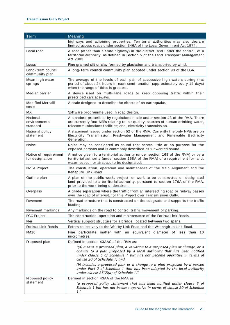
Term Meaning highways and adjoining properties. Territorial authorities may also declare limited access roads under section 346A of the Local Government Act 1974.
Local road A road (other than a State highway) in the district, and under the control, of a territorial authority, as defined in Section 5 of the Land Transport Management Act 2003.
Loess Fine grained silt or clay formed by glaciation and transported by wind. Long-term council community plan
A long-term council community plan adopted under section 93 of the LGA.
Mean high water springs
The average of the levels of each pair of successive high waters during that period of about 24 hours in each semi lunation (approximately every 14 days) when the range of tides is greatest.
Median barrier A device used on multi-lane roads to keep opposing traffic within their prescribed carriageways.
Modified Mercalli scale
A scale designed to describe the effects of an earthquake.
MX Software programme used in road design. National environmental standard
A standard prescribed by regulations made under section 43 of the RMA. There are currently four NESs relating to: air quality; sources of human drinking water, telecommunications facilities; and, electricity transmission.
National policy statement
A statement issued under section 52 of the RMA. Currently the only NPSs are on Electricity Transmission, Freshwater Management and Renewable Electricity Generation.
Noise Noise may be considered as sound that serves little or no purpose for the exposed persons and is commonly described as ‘unwanted sound’.
Notice of requirement for designation
A notice given to a territorial authority (under section 168 of the RMA) or by a territorial authority (under section 168A of the RMA) of a requirement for land, water, subsoil or airspace to be designated.
NZTA Project The construction, operation and maintenance of the Main Alignment and the Kenepuru Link Road
Outline plan A plan of the public work, project, or work to be constructed on designated land provided to a territorial authority, pursuant to section 176A of the RMA, prior to the work being undertaken.
Overpass A grade separation where the traffic from an intersecting road or railway passes over the road of interest, for this Project over Transmission Gully.
Pavement The road structure that is constructed on the subgrade and supports the traffic loading.
Pavement markings Any markings on the road to control traffic movement or parking. PCC Project The construction, operation and maintenance of the Porirua Link Roads. Pier Vertical support structure for a bridge, located between two spans. Porirua Link Roads Refers collectively to the Whitby Link Road and the Waitangirua Link Road. PM10 Fine particulate matter with an equivalent diameter of less than 10
micrometres. Proposed plan Defined in section 43AAC of the RMA as:
“(a) means a proposed plan, a variation to a proposed plan or change, or a change to a plan proposed by a local authority that has been notified under clause 5 of Schedule 1 but has not become operative in terms of clause 20 of Schedule 1; and
(b) includes a proposed plan or a change to a plan proposed by a person under Part 2 of Schedule 1 that has been adopted by the local authority under clause 25(2)(a) of Schedule 1.”
Proposed policy statement
Defined in section 43AA of the RMA as: “a proposed policy statement that has been notified under clause 5 of Schedule 1 but has not become operative in terms of clause 20 of Schedule 1.”
Transmission Gully Project
Guide to the lodgement documentation | 22
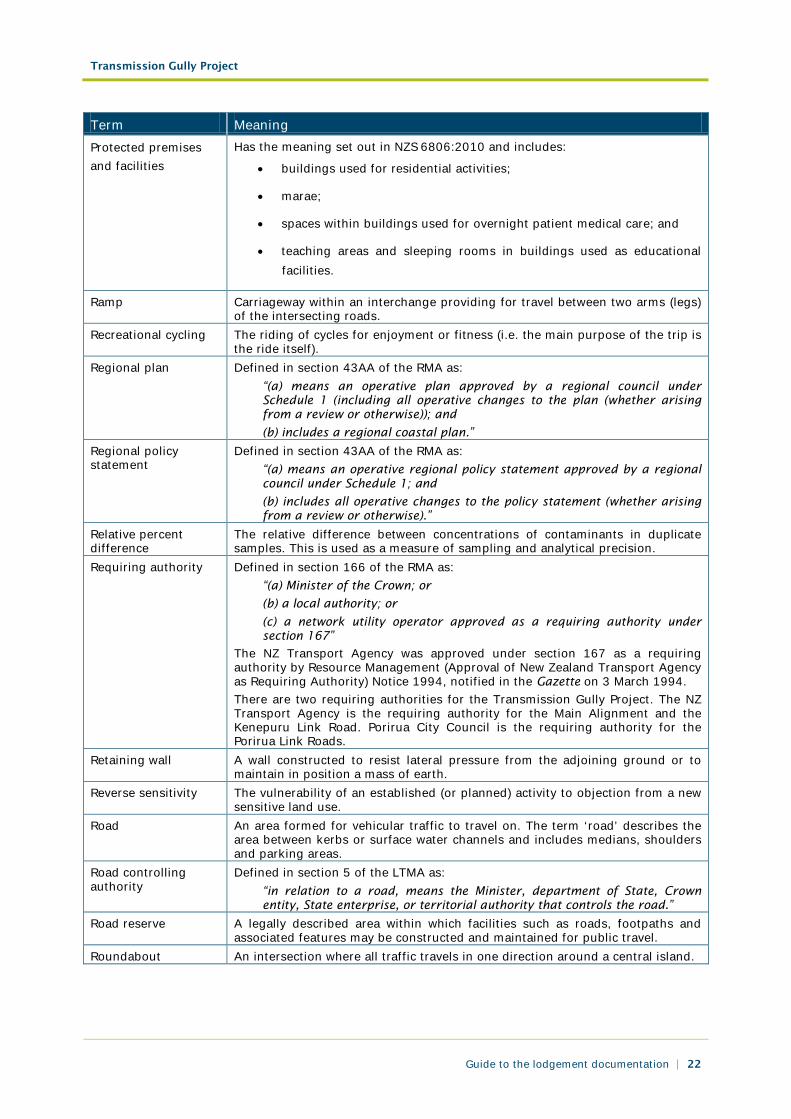
Term Meaning Protected premises and facilities
Has the meaning set out in NZS 6806:2010 and includes:
• buildings used for residential activities;
• marae;
• spaces within buildings used for overnight patient medical care; and
• teaching areas and sleeping rooms in buildings used as educational facilities.
Ramp Carriageway within an interchange providing for travel between two arms (legs) of the intersecting roads.
Recreational cycling The riding of cycles for enjoyment or fitness (i.e. the main purpose of the trip is the ride itself).
Regional plan Defined in section 43AA of the RMA as: “(a) means an operative plan approved by a regional council under Schedule 1 (including all operative changes to the plan (whether arising from a review or otherwise)); and
(b) includes a regional coastal plan.” Regional policy statement
Defined in section 43AA of the RMA as: “(a) means an operative regional policy statement approved by a regional council under Schedule 1; and
(b) includes all operative changes to the policy statement (whether arising from a review or otherwise).”
Relative percent difference
The relative difference between concentrations of contaminants in duplicate samples. This is used as a measure of sampling and analytical precision.
Requiring authority Defined in section 166 of the RMA as: “(a) Minister of the Crown; or
(b) a local authority; or
(c) a network utility operator approved as a requiring authority under section 167”
The NZ Transport Agency was approved under section 167 as a requiring authority by Resource Management (Approval of New Zealand Transport Agency as Requiring Authority) Notice 1994, notified in the Gazette on 3 March 1994. There are two requiring authorities for the Transmission Gully Project. The NZ Transport Agency is the requiring authority for the Main Alignment and the Kenepuru Link Road. Porirua City Council is the requiring authority for the Porirua Link Roads.
Retaining wall A wall constructed to resist lateral pressure from the adjoining ground or to maintain in position a mass of earth.
Reverse sensitivity The vulnerability of an established (or planned) activity to objection from a new sensitive land use.
Road An area formed for vehicular traffic to travel on. The term ‘road’ describes the area between kerbs or surface water channels and includes medians, shoulders and parking areas.
Road controlling authority
Defined in section 5 of the LTMA as: “in relation to a road, means the Minister, department of State, Crown entity, State enterprise, or territorial authority that controls the road.”
Road reserve A legally described area within which facilities such as roads, footpaths and associated features may be constructed and maintained for public travel.
Roundabout An intersection where all traffic travels in one direction around a central island.
Transmission Gully Project
Guide to the lodgement documentation | 23
Term Meaning Simulation and Assignment of Traffic to Urban Road Network (SATURN)
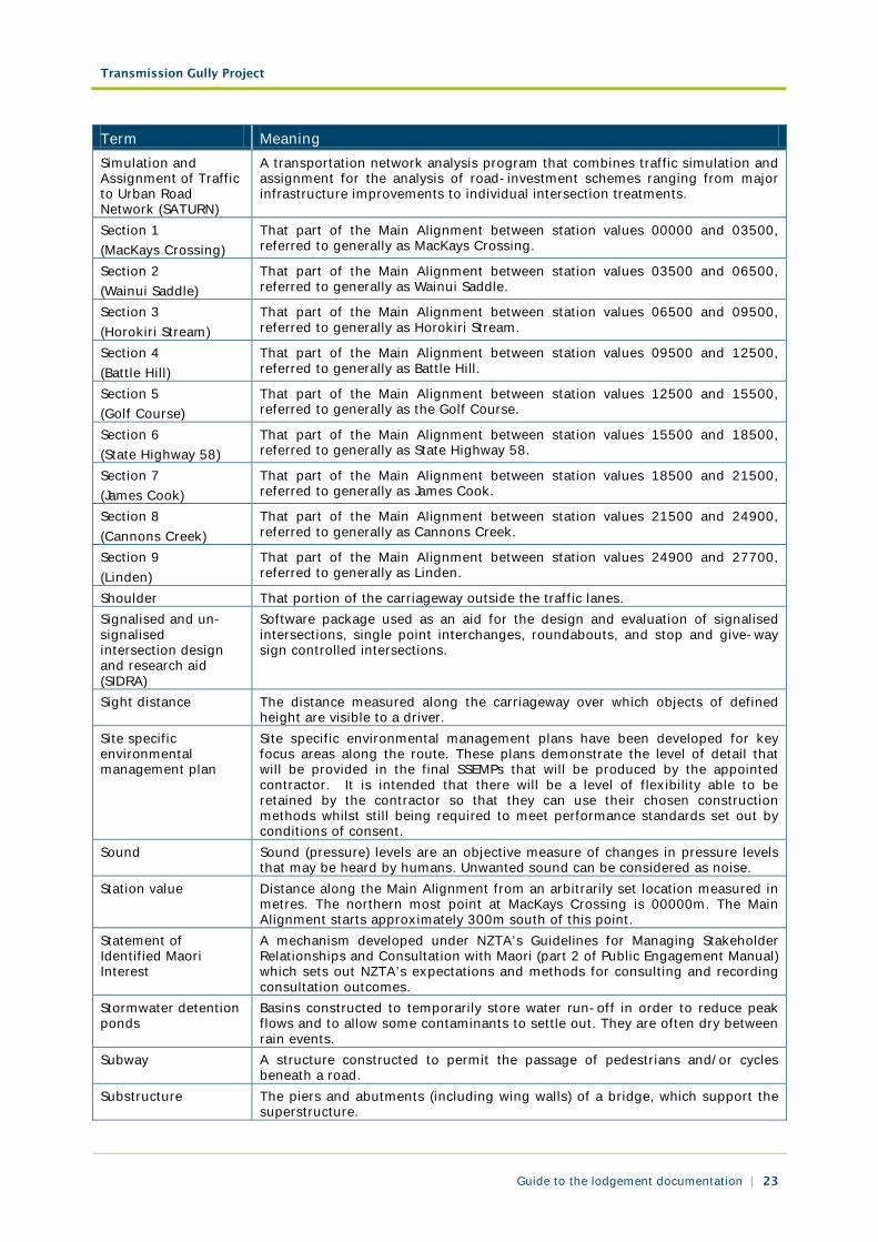
A transportation network analysis program that combines traffic simulation and assignment for the analysis of road-investment schemes ranging from major infrastructure improvements to individual intersection treatments.
Section 1 (MacKays Crossing)
That part of the Main Alignment between station values 00000 and 03500, referred to generally as MacKays Crossing.
Section 2 (Wainui Saddle)
That part of the Main Alignment between station values 03500 and 06500, referred to generally as Wainui Saddle.
Section 3 (Horokiri Stream)
That part of the Main Alignment between station values 06500 and 09500, referred to generally as Horokiri Stream.
Section 4 (Battle Hill)
That part of the Main Alignment between station values 09500 and 12500, referred to generally as Battle Hill.
Section 5 (Golf Course)
That part of the Main Alignment between station values 12500 and 15500, referred to generally as the Golf Course.
Section 6 (State Highway 58)
That part of the Main Alignment between station values 15500 and 18500, referred to generally as State Highway 58.
Section 7 (James Cook)
That part of the Main Alignment between station values 18500 and 21500, referred to generally as James Cook.
Section 8 (Cannons Creek)
That part of the Main Alignment between station values 21500 and 24900, referred to generally as Cannons Creek.
Section 9 (Linden)
That part of the Main Alignment between station values 24900 and 27700, referred to generally as Linden.
Shoulder That portion of the carriageway outside the traffic lanes. Signalised and un-signalised intersection design and research aid (SIDRA)
Software package used as an aid for the design and evaluation of signalised intersections, single point interchanges, roundabouts, and stop and give-way sign controlled intersections.
Sight distance The distance measured along the carriageway over which objects of defined height are visible to a driver.
Site specific environmental management plan
Site specific environmental management plans have been developed for key focus areas along the route. These plans demonstrate the level of detail that will be provided in the final SSEMPs that will be produced by the appointed contractor. It is intended that there will be a level of flexibility able to be retained by the contractor so that they can use their chosen construction methods whilst still being required to meet performance standards set out by conditions of consent.
Sound Sound (pressure) levels are an objective measure of changes in pressure levels that may be heard by humans. Unwanted sound can be considered as noise.
Station value Distance along the Main Alignment from an arbitrarily set location measured in metres. The northern most point at MacKays Crossing is 00000m. The Main Alignment starts approximately 300m south of this point.
Statement of Identified Maori Interest
A mechanism developed under NZTA’s Guidelines for Managing Stakeholder Relationships and Consultation with Maori (part 2 of Public Engagement Manual) which sets out NZTA’s expectations and methods for consulting and recording consultation outcomes.
Stormwater detention ponds
Basins constructed to temporarily store water run-off in order to reduce peak flows and to allow some contaminants to settle out. They are often dry between rain events.
Subway A structure constructed to permit the passage of pedestrians and/or cycles beneath a road.
Substructure The piers and abutments (including wing walls) of a bridge, which support the superstructure.
Transmission Gully Project
Guide to the lodgement documentation | 24
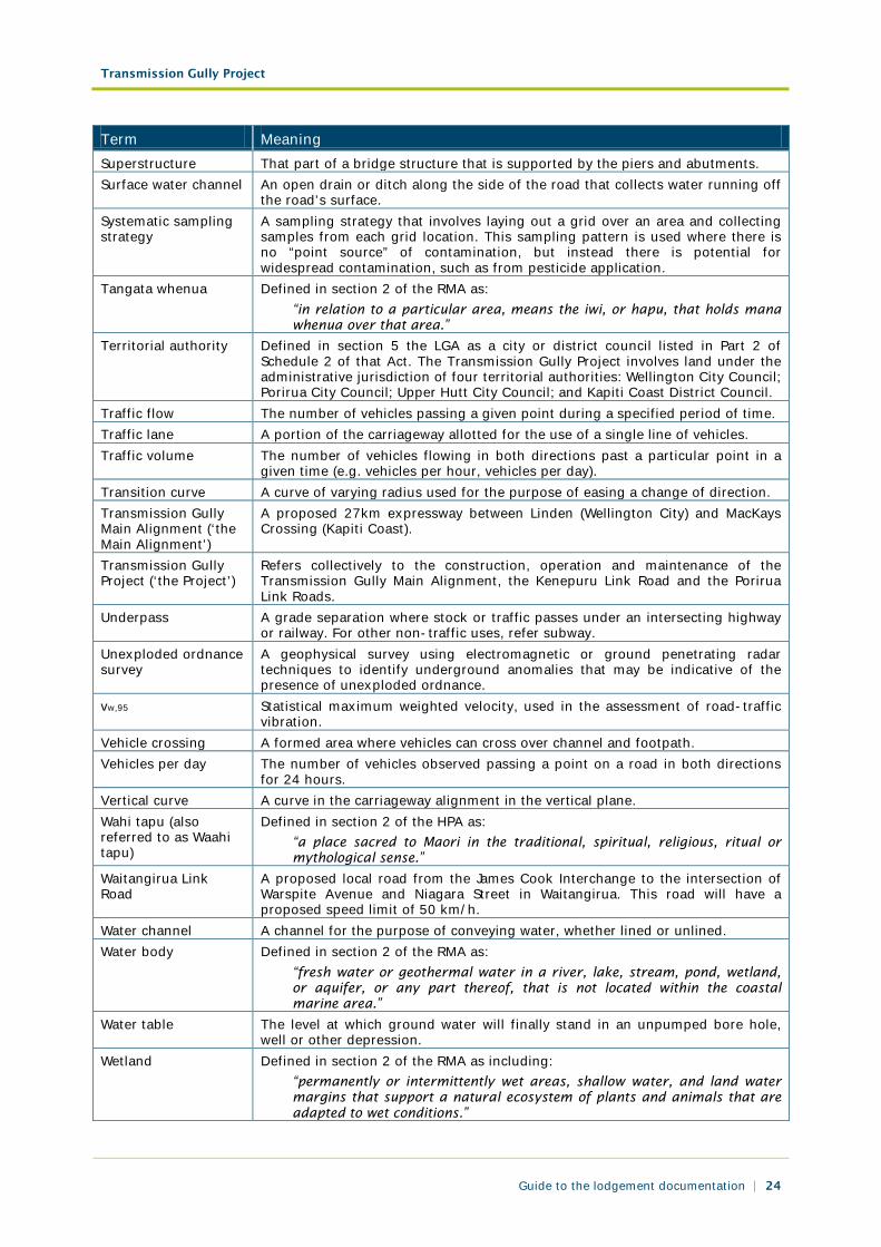
Term Meaning Superstructure That part of a bridge structure that is supported by the piers and abutments. Surface water channel An open drain or ditch along the side of the road that collects water running off
the road’s surface. Systematic sampling strategy
A sampling strategy that involves laying out a grid over an area and collecting samples from each grid location. This sampling pattern is used where there is no “point source” of contamination, but instead there is potential for widespread contamination, such as from pesticide application.
Tangata whenua Defined in section 2 of the RMA as: “in relation to a particular area, means the iwi, or hapu, that holds mana whenua over that area.”
Territorial authority Defined in section 5 the LGA as a city or district council listed in Part 2 of Schedule 2 of that Act. The Transmission Gully Project involves land under the administrative jurisdiction of four territorial authorities: Wellington City Council; Porirua City Council; Upper Hutt City Council; and Kapiti Coast District Council.
Traffic flow The number of vehicles passing a given point during a specified period of time. Traffic lane A portion of the carriageway allotted for the use of a single line of vehicles. Traffic volume The number of vehicles flowing in both directions past a particular point in a
given time (e.g. vehicles per hour, vehicles per day). Transition curve A curve of varying radius used for the purpose of easing a change of direction. Transmission Gully Main Alignment (‘the Main Alignment’)
A proposed 27km expressway between Linden (Wellington City) and MacKays Crossing (Kapiti Coast).
Transmission Gully Project (‘the Project’)
Refers collectively to the construction, operation and maintenance of the Transmission Gully Main Alignment, the Kenepuru Link Road and the Porirua Link Roads.
Underpass A grade separation where stock or traffic passes under an intersecting highway or railway. For other non-traffic uses, refer subway.
Unexploded ordnance survey
A geophysical survey using electromagnetic or ground penetrating radar techniques to identify underground anomalies that may be indicative of the presence of unexploded ordnance.
vw,95 Statistical maximum weighted velocity, used in the assessment of road-traffic vibration.
Vehicle crossing A formed area where vehicles can cross over channel and footpath. Vehicles per day The number of vehicles observed passing a point on a road in both directions
for 24 hours. Vertical curve A curve in the carriageway alignment in the vertical plane. Wahi tapu (also referred to as Waahi tapu)
Defined in section 2 of the HPA as: “a place sacred to Maori in the traditional, spiritual, religious, ritual or mythological sense.”
Waitangirua Link Road
A proposed local road from the James Cook Interchange to the intersection of Warspite Avenue and Niagara Street in Waitangirua. This road will have a proposed speed limit of 50 km/h.
Water channel A channel for the purpose of conveying water, whether lined or unlined. Water body Defined in section 2 of the RMA as:
“fresh water or geothermal water in a river, lake, stream, pond, wetland, or aquifer, or any part thereof, that is not located within the coastal marine area.”
Water table The level at which ground water will finally stand in an unpumped bore hole, well or other depression.
Wetland Defined in section 2 of the RMA as including: “permanently or intermittently wet areas, shallow water, and land water margins that support a natural ecosystem of plants and animals that are adapted to wet conditions.”
Transmission Gully Project
Guide to the lodgement documentation | 25
Term Meaning Wellington Transport Strategic Model
The transportation model developed for the Wellington region using EMME/2 software.
Whitby Link Road A proposed local road from the Waitangirua Link Road to the intersection of James Cook Drive and Navigation Drive in Whitby. This road will have a proposed speed limit of 50 km/h.