transboundary river water for ganges and teesta rivers in
TRANSCRIPT
Global Science and Technology Journal Vol. 1. No. 1. July 2013 Issue. Pp.100-111
100
Transboundary River Water for Ganges and Teesta Rivers in Bangladesh: An Assessment
Rounak Afroz* and Md. Ataur Rahman**
A total of 57 major rivers of Bangladesh have entered the country, of which 54 rivers are from India and 3 rivers are from Myanmar. These 57 rivers have many tributaries and distributaries which contribute in forming almost 230 rivers in Bangladesh. As hydrologically Bangladesh has a long duration of dry period which remains almost 7 to 8 months in a year, these transboundary rivers are very significant in agriculture, navigation, ground water contribution, fisheries resources of Bangladesh. But among the 54 rivers coming from India more than twenty five rivers face one or more upstream diversion basically in dry months. For this reason, abundant water during monsoon and water scarcity during non-monsoon months cause year round water related socio-economic and environmental problems for Bangladesh. This study includes assessment of upstream water diversion from the selected two main rivers such as Ganges and Teesta. The study also finds the impact of water withdrawal from Ganges. Some analysis of International Water Law related to transboundary water management has been done.
1. Introduction A river that crosses at least one political border, either a border within a nation or an international boundary is called Trans-boundary River. The country of Bangladesh has the greatest number of these rivers, almost all of which cross national boundaries. The environment, economic growth and development of Bangladesh are all highly influenced by water - its regional and seasonal availability, and the quality of surface and groundwater. Spatial and seasonal availability of surface and groundwater is highly responsive to the monsoon climate and physiography of the country. Availability also depends on upstream withdrawal for consumptive and non-consumptive uses. Bangladesh is one of the largest active deltas of the world having a flat topography with very low elevations which are larger than 10 meters from mean sea level. Eighty percent of the country is deltaic floodplains which are crisscrossed by about 230 rivers including 57 Transboundary Rivers of which 54 is shared with India and 3 with Myanmar. The river system that flows through Bangladesh is the third largest source of freshwater discharge to the world's ocean. Catchments area of the three major rivers system of the Ganges-Brahmaputra-Meghna (GBM) region is about 1.72 million km2, 93% of which lies outside the country. Bangladesh, being a lower riparian country, does not have any control on the flow of these rivers. This has deprived the country of any opportunity for effective water management. ___________________ *Rounak Afroz, Lecturer, Department of Water Resource Engineering, BUET, Dhaka. Email: [email protected] **Md. Ataur Rahman, Professor, Department of Water Resource Engineering, BUET, Dhaka. Email: [email protected]

Afroz & Rahman
101
The conditions and challenges of water management in Bangladesh are two folds; scarcity of water during dry season together with water quality deterioration, ground water depletion, salinity intrusion and environmental degradation and too much water during monsoon with devastating flood. This study includes the assessment of transboundary river water, their management and to find the hydrological and morphological impact on Bangladesh due to upstream water withdrawal. The specific objectives of this study are to make an assessment of Transboundary Rivers of Bangladesh and their importance, to get the historical information about the discharge carried by these rivers, to find the impact of upstream water withdrawal on major rivers in dry and flood season, to assess the international river law and to study about the successful transboundary river water management in international river basins and to recommend for transboundary water management in GBM basin. As Hydrologically Bangladesh has a long duration of dry period which remains almost 7 to 8 months in a year, these transboundary rivers are very significant in agriculture, navigation, ground water contribution, fisheries resources of Bangladesh. But among the 54 rivers coming from India about 30 rivers face one or more upstream diversion basically in dry months. For this reason, abundant water during monsoon and water scarcity during non-monsoon months cause year round water related socio-economic and environmental disasters for Bangladesh. As the study includes the assessment of transboundary river water, their management and to find the hydrological and morphological impact on Bangladesh due to upstream water withdrawal, for this the paper is organised with an introduction about transboundary river and their significance in the hydrology and morphology of Bangladesh. After that there is the significance of the study which is followed by Literature Review of relevant past studies. Then the process of data collection and the methodology of analysis is given with the discussion on results. After that the impact analysis for upstream withdrawal of Ganges water for different sectors of Bangladesh is described. and at the end conclusion is given with limitations and suggestions for further studies. 2. Literature Review Ahmed (2000) showed that the sustainable river basin management through River Basin Organization will create a common platform and a joint forum for all expertise for promoting the concept of Multipurpose River Basin Development (MRD). It will seek a reasonable solution for water resources management shared by all and renewable energy schemes at river basin level. Major activities would include effective cooperation for disaster management, basin-wide development, ecosystem protection and regional institutional framework. An overall framework of regional cooperation among the co-riparian countries to set principles of transboundary water resources management on the basis of broad political and social consensus is evaluated by Salman and Uprety (2002).

Afroz & Rahman
102
Adel (2005) presented his studies over hundreds of meetings between India and Bangladesh, the resulting temporary water-sharing agreements on the Ganges water, and the Indian Grand River networking plan and its potential downstream impact. He focuses on the world record number of meetings toward a permanent water-sharing treaty, resulting shorter-term water-sharing treaties, and the Indian Grand River networking plan that reflects the Indian hegemony of transboundary river control. Ahmed (2007)seeks for a permanent solution and durable system to resolve conflict in sharing of water resources call for enhancing effective regional cooperation for integrated use of the water resources of the region. Rahman (2009) reveals that principle of equitable and reasonable utilization, obligation not to cause significant harm, principles of cooperation, information exchange, notification, consultation and peaceful settlement of disputes are widely acknowledged by modern international conventions, agreements and treaties. These principles could facilitate effective transboundary water resources management involving riparian countries of shared watercourses and hence, promote sustainable development around the world. 3. Methodology and Data Analysis This study is based on analyses of hydrological data collected from Bangladesh Water Development Board. Daily discharge data for the Ganges River at Hardinge Bridge gauging station during the period of 1970 to 2011 and for the Teesta River at Dalia point during the period of 1979 to 2011 were collected. These data were analyzed by plotting graph with Microsoft Excel to visualize the changes between before and after upstream withdrawal. 3.1 Data Analysis of Ganges River Historical discharge data of Ganges River at Hardinge Bridge station from 1970 to 2011 are plotted against time and shown if Figure 1. Two demarcation lines are established, one at the year 1975 when the Farakka Barrage operation started and another at the year 1996 when the Ganges Water Sharing Treaty was signed (Figure 1(b)). From Figure 1 (b), possible changes in the peak discharge series have been examined. Average peak annual discharges during pre-Farakka, post-Farakka and post 1996 Ganges treaty were found to be 42200 m3/s, 76000 m3/s and 73091 m3/s, respectively.

Afroz & Rahman
103
(b)
(a)
(b)
Figure 1: (a) Variation of Discharges from the Year 1970 to 2011; (b) Variation of
Peak Discharges from the Year 1970 to 2010 An increase flood discharge of about 80% has been occurred after the operation of Farakka Barrage and an increase of about 73% occurred after the 1996 Ganges treaty. The average discharges of these three phases are almost constant. For this reason Bangladesh gets inundated with devastating floods every year. In the monsoon period when there is already huge rainfall occurs in Bangladesh, then there is an uncontrolled amount of water is received by Bangladesh which deteriorates the flood condition. In Figure 2 (a), a significant decreasing trend is observed in the annual minimum discharge. In this figure, pre- Farakka, post-Farakka and post 1996 Ganges treaty minimum annual discharges were found to be 2070 m3/s, 261 m3/s and 87.345 m3/s, respectively. A huge decrease on dry period has been occurred due to operation of Farakka Barrage. From Figure 2 (b) it can be seen that, during dry months (November to May) the discharges are found to be decreasing. A decrease of about 82% is found in case of the minimum discharges during these dry months, after the operation of Farakka Barrage which slightly increased after 1996 Ganges treaty.

Afroz & Rahman
104
.
(a)
(b)
Figure 2: (a) Variation of Annual Minimum Discharges from the Year 1970 to 2011;
(b) Variation of Discharges of the Months November to May from the Year 1970 to 2010
From Figure 3, in case of Monsoon months (June to October) there is an opposite scenario to the dry months. In these months flood occurs in Bangladesh almost every year due to the heavy rainfall and uncontrolled discharges coming from upstream. There is an increase of about 53% in discharges is found after the construction of Farakka Barrage and there is no significant change is found after the 1996 Ganges treaty. From the graphs spectacular effects of diversion are noticed in the daily and lowest annual discharges. FAP 4 (1993a) study reported that increases in the frequency of discharge greater than 50,000 m3/sec occurred in the post-Farakka period. In the post-Farakka period, low flows below 2500 m3/sec are more pronounced in the dry season (FAP 4, 1993a). The decrease in the dry season flow is worst in February and March, followed by April and May.

Afroz & Rahman
105
Figure 3: Discharges of the Months of June to October from the
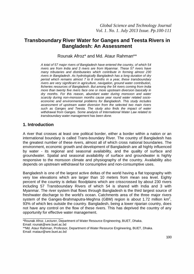
Year 1970 to 2010 3.2 Data Analysis of Teesta River In Figure 4 (a), yearly discharges of Teesta River at Dalia station from 1979 to 2011 are plotted against time. Two demarcation lines are established, one at the year 1985 when the operation of Gajoldoba Barrage in India started and another at the year 1990 when the Teesta Barrage operation started in Bangladesh. After the operation of Gajoldoba Barrage started the flow in Teesta River became significantly low which increased after the Teesta Barrage operation started in Bangladesh. This is because after the construction of Teesta Barrage water stored in the monsoon could be used in the dry season. From the Figure 4(b), spectacular effects are noticed after the Gajoldoba and Teesta Barrage operation. The annual peak discharges have an increasing value after the operation of Teesta Barrage. It has increased about 24% after the operation of Gajoldoba Barrage.
Afroz & Rahman
106
(a) (b) (b)
Figure 4: (a) Variation of Discharges from the Year 1979 to 2011; (b) Variation of Peak Discharges from the Year 1979 to 2010
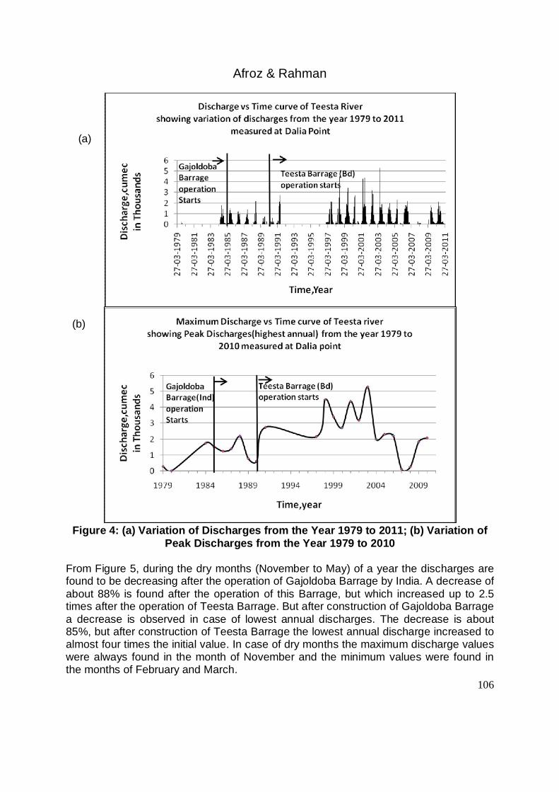
From Figure 5, during the dry months (November to May) of a year the discharges are found to be decreasing after the operation of Gajoldoba Barrage by India. A decrease of about 88% is found after the operation of this Barrage, but which increased up to 2.5 times after the operation of Teesta Barrage. But after construction of Gajoldoba Barrage a decrease is observed in case of lowest annual discharges. The decrease is about 85%, but after construction of Teesta Barrage the lowest annual discharge increased to almost four times the initial value. In case of dry months the maximum discharge values were always found in the month of November and the minimum values were found in the months of February and March.
Afroz & Rahman
107
(a) (b)
Figure 5: (a) Discharges of the Months of November to May from the Year 1979 to 2011; (b) Variation of Minimum Discharges from the Year 1979 to 2010
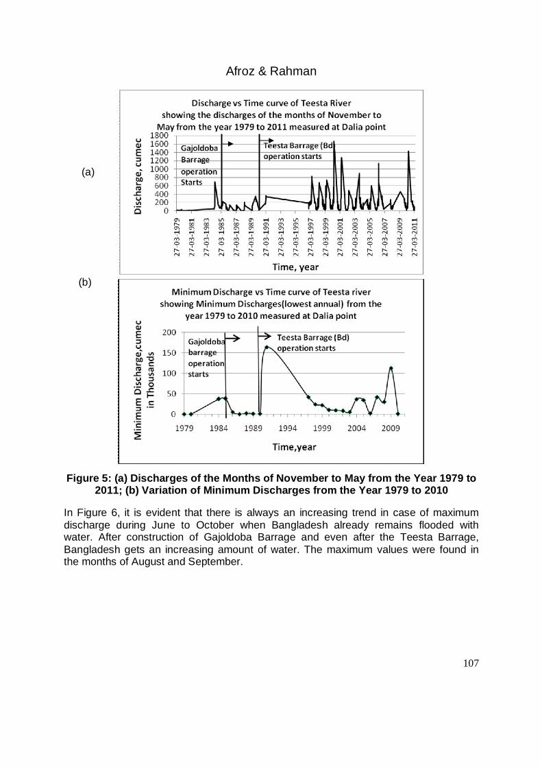
In Figure 6, it is evident that there is always an increasing trend in case of maximum discharge during June to October when Bangladesh already remains flooded with water. After construction of Gajoldoba Barrage and even after the Teesta Barrage, Bangladesh gets an increasing amount of water. The maximum values were found in the months of August and September.

Afroz & Rahman
108
Figure 6: Discharges of the Months of June to October from the Year 1979 to 2011
4. Impact Analysis for Upstream Withdrawal of Ganges Water The diversion of water by the Farakka Barrage has introduced significant changes in the hydrology of the Ganges River system in Bangladesh. Available discharge data show that the water supply during July–October in the monsoon has increased while the dry season (November–May) flow has decreased considerably. Increased monsoon flow has introduced changes in the annual flooding pattern in Bangladesh (Khan 1993). There are concerns that the reduced dry season flow may have significant socioeconomic impacts in the Bangladesh part of the basin by altering the hydrological pattern, inducing accelerated sedimentation in the Gorai River (an offtake of the Ganges) and helping saline water to penetrate further inland from the sea (MOEF 1995, Swain 1996). 4.1 Reduced Dry Season Flow in the Gorai River and Its Effects on Increased Salinity A vast network of rivers in the southwest region of Bangladesh is dependent on the water supply through the Gorai River. Water from this river is used for irrigation, industry, and urban water supply. Most importantly, the Gorai River flow pushes away the saline water front in the Passur River, near Khulna. Monsoon flow is adequate for repelling the salinity intrusion. The dry season flow of the Gorai River is most critical in controlling salinity in a large part of the southwest region of Bangladesh. During the post-Farakka period, salinity in the south-west region of Bangladesh increased significantly. For example, at the Khulna station, the average monthly maximum salinity for April in the pre-Farakka period was 1626 µmho/cm. During 1976, when the Gorai discharge dropped to 0.5 m3/sec from its pre-Farakka average of 190

Afroz & Rahman
109
m3/sec, maximum salinity in April increased to 13,000 µmho/cm. Recall that the Farakka Barrage was commissioned in April 1975. In recent years, extreme low flow in the Gorai River in the dry months has appeared to exacerbate the intrusion of saline water to the most inland parts of the southwest part of Bangladesh (Khan, 1993). (a) (b)
(c)
Figure 7: (a) Salinity Variations at Chalna Station; (b) Salinity Variations at
Goalpara Power Station; (c) Salinity Variations at Mongla Station.
5. Conclusion This study includes assessment of upstream water diversion from the selected two main rivers such as Ganges and Teesta. The study also finds the impact of water withdrawal from Ganges. Some analysis of International Water Law related to transboundary water management has been done. Discharge data of Ganges River for the period of 1970 to 2011 show that dry season (November–May) flow has decreased up to 82% after the construction of Farakka Barrage. In case of Teesta River, after commissioning Gajoldoba Barrage in India in 1985, flow reduced up to 88% in Bangladesh which was found increasing up to 2.5 times after the operation of Teesta Barrage in Bangladesh in

Afroz & Rahman
110
1990. The diversion of water by the Farakka Barrage has introduced significant changes in the hydrology of the Ganges River system in Bangladesh. There are concerns that the reduced dry season flow has significant socioeconomic impacts in the Bangladesh part of the basin by altering the hydrological pattern and helping saline water to penetrate further inland from the sea. The study reveals that principle of equitable and reasonable utilization, obligation not to cause significant harm, principles of cooperation, information exchange, notification, consultation and peaceful settlement of disputes are widely acknowledged by modern international conventions, agreements and treaties This study also suggests for formation of a regional river commission with the co-riparian countries, undertaking a common storage reservoir and also to ratify the UN convention on the Law of the Non-Navigational Uses of International Watercourses as recommendation for proper management of Transboundary Rivers in GBM basin. This Study will be helpful to the concerned water management authorities of Bangladesh and India to understand the problems associated with the upstream withdrawal of transboundary River water. The astudy also provides some guidelines of smooth management of transboundary river water among the concerned countries based on the existing International Laws and conventions by formming a regional river commission. A common storage reservoir should be undertaken at a suitable location to meet up the scarcity of water during the dry season by storing the water in flood season. Also the lower riparian countries must have voices to create strong public opinion and to participate in all decision making processes which may affect the stakeholders at the sub-regional level. Again any treaty or agreement among the countries should include suitable provisions for consultations, conciliation, mediation, arbitration, adjudication, as may be agreed upon - for the resolution of differences and disputes. And a downstream environmental and social impact assessment should be undertaken by an independent party for any large project in transboundary basins. For future study, these procedures can be conducted for other major rivers of the country to observe the impact in a large scale. References Ahmed, M., (2004), ‘Development and management Challenges of Integrated Planning
for Sustainable Productivity of Water Resources’, Bangladesh Journal of Political Economy (BJPE), Bangladesh Economic Association, Volume 21, No. 2, December 2004.
Ahmed, M., (2007), ‘Regional Co-Operation on Transboundary Water Resources Management:Opportunities and Challenges’, Conference of Bangladesh Economic Association, Dhaka, Bangladesh.
Adel, M. M., (2005), The Ordeals to Have Due Share of Transboundary River Water, University of Arkansas, USA.
FAP 4 (Flood Action Plan 4). 1993a, Southwest area water resources management project, Vol. 3, Morphological studies. Sir William Halcrow and Partners Ltd., Dhaka.

Afroz & Rahman
111
FAP 4 (Flood Action Plan 4). 1993b, Southwest area water resources management project, Vol. 9, Impact studies. Sir William Halcrow and Partners Ltd., Dhaka.
Khan, A. H., (1993), Farakka Barrage: Its impact on Bangladesh-an overview, Dhaka, P. 13.
MOEF (Ministry of Environment and Forest). 1995, National environment management plan, Main report. MOEF, Dhaka, P. 167.
MPO (Master Plan Organization). 1986, Chapter 7: Salinity. National water plan, Vol. 1, MPO, Dhaka.
Mirza, M. Q. 1998, Diversion of the Ganges Water at Farakka and Its Effects on Salinity in Bangladesh, Centre for Environmental and Resource Studies (CEARS), University of Waikato, Hamilton, New Zealand.
Rahman, M. M., (2009), Principles of International Water Law: creating effective transboundary water resources management, Int. J. Sustainable Society, Vol. 1, No. 3.
Salman, M.A.S., and Uprety, K., (2002), Conflict and Cooperation on South Asia’s International Rivers: A Legal Perspective. Washington, DC: The World Bank.
Swain, A., (1996), The environmental trap: The Ganges River diversion, Bangladeshi migration and conflicts in India. Department of Peace and Conflict Research, Uppsala University, Sweden, P.135.