topcon tools familiarization -...
TRANSCRIPT
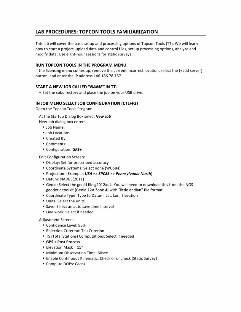
LAB PROCEDURES: TOPCON TOOLS FAMILIARIZATION This lab will cover the basic setup and processing options of Topcon Tools (TT). We will learn how to start a project, upload data and control files, set up processing options, analyze and modify data. Use eight-‐hour sessions for static surveys. RUN TOPCON TOOLS IN THE PROGRAM MENU. If the licensing menu comes up, remove the current incorrect location, select the (+add server) button, and enter the IP address 146.186.78.157 START A NEW JOB CALLED “NAME” IN TT. • Set the subdirectory and place the job on your USB drive.
IN JOB MENU SELECT JOB CONFIGURATION (CTL+F2) Open the Topcon Tools Program
At the Startup Dialog Box select New Job New Job dialog box enter:
• Job Name: • Job Location: • Created By: • Comments: • Configuration: GPS+
Edit Configuration Screen: • Display: Set for prescribed accuracy • Coordinate Systems: Select none (WGS84) • Projection: (Example: USA => SPC83 => Pennsylvania North) • Datum: NAD83(2011) • Geoid: Select the geoid file g2012au4. You will need to download this from the NGS geodetic toolkit (Geoid 12A Zone 4) with "little endian" file format
• Coordinate Type: Type to Datum, Lat, Lon, Elevation • Units: Select the units • Save: Select an auto save time interval • Line work: Select if needed
Adjustment Screen: • Confidence Level: 95% • Rejection Criterion: Tau Criterion • TS (Total Stations) Computations: Select if needed • GPS + Post Process • Elevation Mask = 15° • Minimum Observation Time: 60sec • Enable Continuous Kinematic: Check or uncheck (Static Survey) • Compute DOPs: Check

May need to adjust the settings in the Quality Control section (i.e. change the defaults for short baselines)
Click “OK” to create the job DOWNLOAD THE FILES AS DESCRIBED BELOW http://www.ngs.noaa.gov/UFCORS/ • Download eight-‐hour sessions of data (from User Friendly CORS website if using CORS stations for the control) for control stations, use a 30-‐sec epoch rate. Need the station coordinate file, meterological file, NGS data sheet, and IGS precise ephemeris. (only need the IGS precise ephemeris and meterological file once for each session, only need the station data sheet and coordinate file once for each station).
• Check with WORDPAD (write.exe) to ensure there is data in the files. • Import control files (listed above) into Topcon Tools. • Import the Unknown Station file(s) into Topcon Tools. • Obtain the control coordinates from the xxxx.pos.txt files. View these files with WordPad or Word and manually type latitude and longitude information along with the control station ellipsoid height from the data sheet into in TT.
• Again, if files do not open in TT, then open the particular file(s) with WORDPAD and check for an error message. (You may need to re-‐download the files if several users are trying to download at the same time).
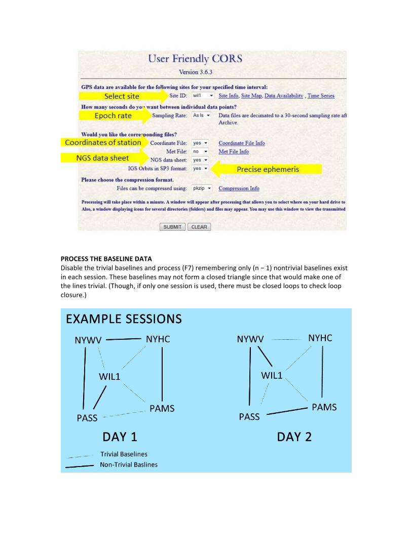
PROCESS THE BASELINE DATA Disable the trivial baselines and process (F7) remembering only (n − 1) nontrivial baselines exist in each session. These baselines may not form a closed triangle since that would make one of the lines trivial. (Though, if only one session is used, there must be closed loops to check loop closure.)

Correct any problems that may occur during this processing (i.e. some baselines may be red) Corrections can be made by computing the estimated error in the horizontal and vertical components of the baseline, then raising horizontal and/or vertical tolerances.
𝜎!"!#$ = 𝑛 ∙ 𝜎!! + 𝑎! + 𝐷 ∙𝑏10!
!
σi = estimated error in the setup of the receivers n = number of setups
a = constant error for the horizontal or vertical component b = scalar error for the horizontal or vertical component
D = length of the line The manufacturer's values for a and b are given in the technical specs for the instruments.
(In class, this was assumed a = 5 mm and b = 0.5ppm)
𝒑𝒑𝒎 =𝜎𝑡𝑜𝑡𝑎𝑙
𝐿𝑜𝑜𝑝 𝐿𝑒𝑛𝑔𝑡ℎ 𝑜𝑟 𝐵𝑎𝑠𝑒𝑙𝑖𝑛𝑒 𝐿𝑒𝑛𝑔𝑡ℎ∙ 10!
Additionally, red baselines may be caused by the GPS receiver antennas being set improperly or the fact that there is no receiver antenna selected. • Repeat the above steps for each session (starting at “DOWNLOAD THE FILES AS DESCRIBED BELOW”.
• Perform loop closures • Perform a network adjustment (F8)

CREATE THE REPORT Go to Report => Report Configuration • Add Sections as necessary, do not overload the report page width. • Use the Snipping Tool to copy and paste the Traverse Diagram into the report. • Make an Excel file of the Report so that editing will be simplified.
REPORT SECTIONS Project Summary Adjustment Summary Control Points • Latitude • Longitude • Elevation (Datum) • X, Y, Z • Ellipsoid Height
Used GPS Observations • dN • dE • dHt • Horz RMS • Vert RMS • PDOP • HDOP • VDOP
GPS Observation Residuals • Res X • Res Y • Res Z • Res n • Res e • Res u
Final Adjusted Coordinates • Latitude • Longitude • Elevation (Datum) • Standard Deviation N • Standard Deviation E • Standard Deviation U • X, Y, Z • Sigma X • Sigma Y • Sigma Z • Ellipsoid Height
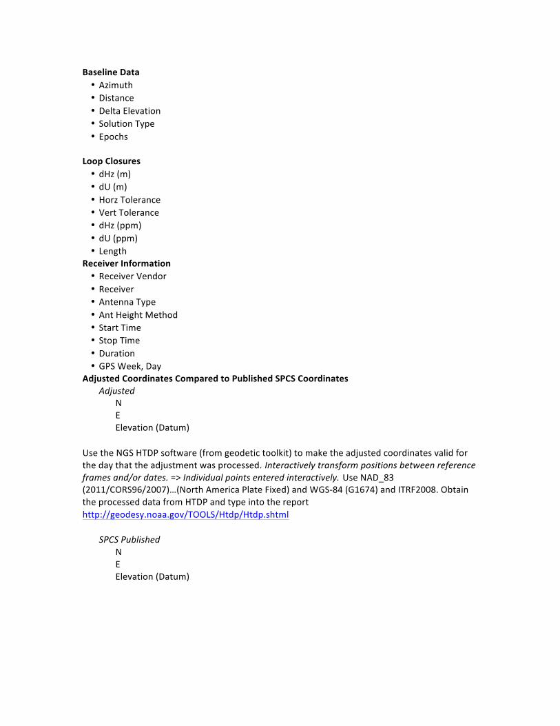
Baseline Data • Azimuth • Distance • Delta Elevation • Solution Type • Epochs
Loop Closures • dHz (m) • dU (m) • Horz Tolerance • Vert Tolerance • dHz (ppm) • dU (ppm) • Length
Receiver Information • Receiver Vendor • Receiver • Antenna Type • Ant Height Method • Start Time • Stop Time • Duration • GPS Week, Day
Adjusted Coordinates Compared to Published SPCS Coordinates Adjusted N E Elevation (Datum)
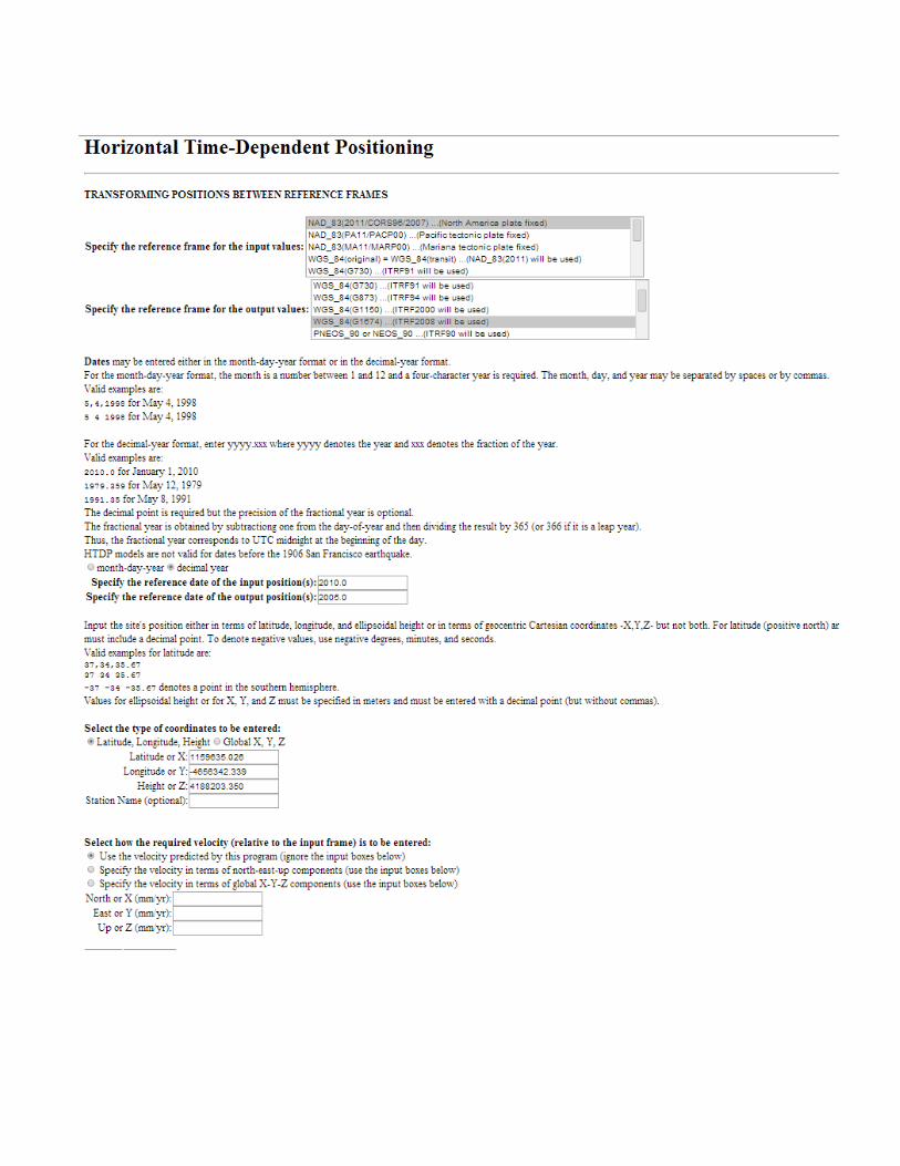
Use the NGS HTDP software (from geodetic toolkit) to make the adjusted coordinates valid for the day that the adjustment was processed. Interactively transform positions between reference frames and/or dates. => Individual points entered interactively. Use NAD_83 (2011/CORS96/2007)…(North America Plate Fixed) and WGS-‐84 (G1674) and ITRF2008. Obtain the processed data from HTDP and type into the report http://geodesy.noaa.gov/TOOLS/Htdp/Htdp.shtml
SPCS Published N E Elevation (Datum)