to establish a vision for no. 3 road with an elevated rav ... · transit-oriented development (tod)...
TRANSCRIPT

October 2005
No. 3 Road Corridor Steetscape Study Open House #1
City of Richmond No. 3 Road Corridor Streetscape StudyIBI Group with Don Wuori Design James KM Cheng Architects Inc. Ward Consulting Group and GEHL Architects
1Study Purpose
Goals of the Study
Study Purpose
To establish a vision for No. 3 Road with an elevated RAV guideway as its catalyst.The newest leg of the region’s rapid transit system will soon link the City of Richmond to both downtown Vancouver and the Vancouver International Airport.
The City of Richmond is undertaking a detailed urban design analysis of No. 3 Road in anticipation of rapid transit service. Referred to as the Richmond No. 3 Road Corridor Streetscape Study, its goals and objectives are to:
• Integrate the elevated guideway into the east side fabric of No. 3 Road in the interest of making it a ‘Great Street’.
• Develop placemaking strategies to make No. 3 Road more pedestrian-friendly at and beyond transit station plazas.
• Lay the foundation for subsequent Transit-Oriented Development (TOD) surrounding each transit station.
• Ensure that a functioning rapid transit system contributes positively to other developments within the City Centre such as the Olympic Oval, Aberdeen Mall, Great Canadian Casino and the Garden City lands.
We want your views on how to make No. 3 Road the best possible street in Richmond! Your participation at this, and subsequent Open Houses will enable your voice to be heard and for your preferences
to be known regarding the evolution of No. 3 Road and a number of related issues such as long range transportation
improvements, as well as topics such as public art and street tree programs.
Your Opportunity
Open House #2 is slated for early December 2005, while the final Open House #3 will be conducted in late January
2006, at the conclusion of the study.
Next Open Houses
Streetscape: The design of No. 3 Road from City Hall in the south to the Fraser River in the north. Aspects of this work will deal with items such as street curb-to-curb cross-section and function; pedestrian and vehicle zones; and placemaking strategies, including street furniture and lighting.
Fronting Buildings: The investigation of policies and design guidelines to help ensure that buildings on either side of No. 3 Road are developed to complement the guideway structure; to ensure that No. 3 Road remains the preeminent retail precinct in Richmond.
Study Components

October 2005
No. 3 Road Corridor Steetscape Study Open House #1
City of Richmond No. 3 Road Corridor Streetscape StudyIBI Group with Don Wuori Design James KM Cheng Architects Inc. Ward Consulting Group and GEHL Architects
�
The City of Richmond participated in a prior RAVCO-sponsored Open House regarding the Richmond-Airport-Vancouver (RAV) Rapid Transit Project – Preliminary Streetscape Study in June 2005. Open House respondents were asked questions regarding the character of No. 3 Road Streetscape. Your Response:
1. A majority favoured the notion of No. 3 Road’s transformation into a “Grand Avenue”.
2. Regarding No. 3 Road streetscape character, preferences and considerations included: • Pedestrian promenade • Decorative sidewalks/plaza paving • On-street bicycles lanes • On-street parking • Seasonal or accent street lighting • Landscaped median • Sidewalk seating, drinking fountains & trash receptacles
• Urban plazas, street trees and public art • Pedestrian weather protection • Security and multi-language signage
3. Respondents indicated a need for improved linkages including: • Sidewalks • Curb-side passenger drop-off/pick-up • On -street and off-street bicycle lanes • Walkways to shopping malls • Access between high-density developments and transit stations • Transit for east/west routes.
Streetscape Context
How Does RAV Fit Within the City’s Transportation Network?
• New roads resulting from acqui-sition of the CPR r-o-w will con-tribute to ring road-type access through Richmond’s downtown core;
• Many larger street blocks up and down No. 3 Road will be subdi-vided to both support pedestri-anization and enable more east/west street connections;
• Improved or enhanced local bus service will be integrated with the RAV Line; and
• Multi-modal transfer points will occur at both the Richmond City Centre (Brighouse) Station (local bus service) and Bridgeport Sta-tion (regional bus service).
Bridgeport Road
Hwy 99
Sea Island Way
Cambie Road
Alderbridge Way
Westminster Highway
Granville Ave
Blundell Road
Lansdowne Road
No. 4
Roa
d
No. 3
Roa
d
No. 2
Roa
d
Gilb
ert R
oad
Gard
en C
ity R
oad
VancouverInternational Airport
Mid
dle
Arm
Fras
er R
iver
Dinsmore Bridge
No.2
Roa
d Br
idge
Moray Channel Bridge
North Arm Fraser River
Arth
ur L
aing
Brid
ge
Oak Street Bridge
0 500
N
Lansdowne Station
Cambie Station
Richmond City Centre(Brighouse) Station
Bridgeport Station
Capstan Station [future]
BRIDGEPORT STATIONPeak Hour Frequency
Bus Route (min.) Post RAV100 Marine Station 10301 Newton 10311 Scottsdale 15351 Crescent Beach 10352 Ocean Park 15354 White Rock South 15404 Ladner 15405 Cambie/Five Road 20407 Gilbert/Bridgeport 12420 Richmond Ctr/Metrotown 12482 UBC 15601 South Delta 10602 Tsawassen 20603 Beach Grove 20604 English Bluff 20620 Tsawassen Ferry 30C92 Airport South 30
RICHMOND CITY CENTRE STATIONPeak Hour Frequency
Bus Route (min.) Post RAV301 Newton 10401 One Road/Garden City 8402 Two Road 10403 Three Road 8404 Ladner/Bridgeport 15405 Cambie/Five Road 20405 Five Road 20407 Gilbert/Bridgeport 12410 Railway/22nd St Stn 7.5420 Metrotown 12480 UBC 15
What We’ve Heard to Date
RAV reduces peak travel times between downtown Vancouver and Richmond City Centre from up to 50 minutes to �4-�8 minutes. Bridgeport to Waterfront will take 17-18 minutes on RAV vs. up to 30 minutes by express bus. RAV “saves” about 65 buses, after allowing for Richmond and Delta and South Surrey/White Rock service increases. The RAV Bus Integration Strategy will be reviewed as part of the update of the Richmond Area Transit Plan (planned for mid 2006).
October 2005
No. 3 Road Corridor Steetscape Study Open House #1
City of Richmond No. 3 Road Corridor Streetscape StudyIBI Group with Don Wuori Design James KM Cheng Architects Inc. Ward Consulting Group and GEHL Architects
3
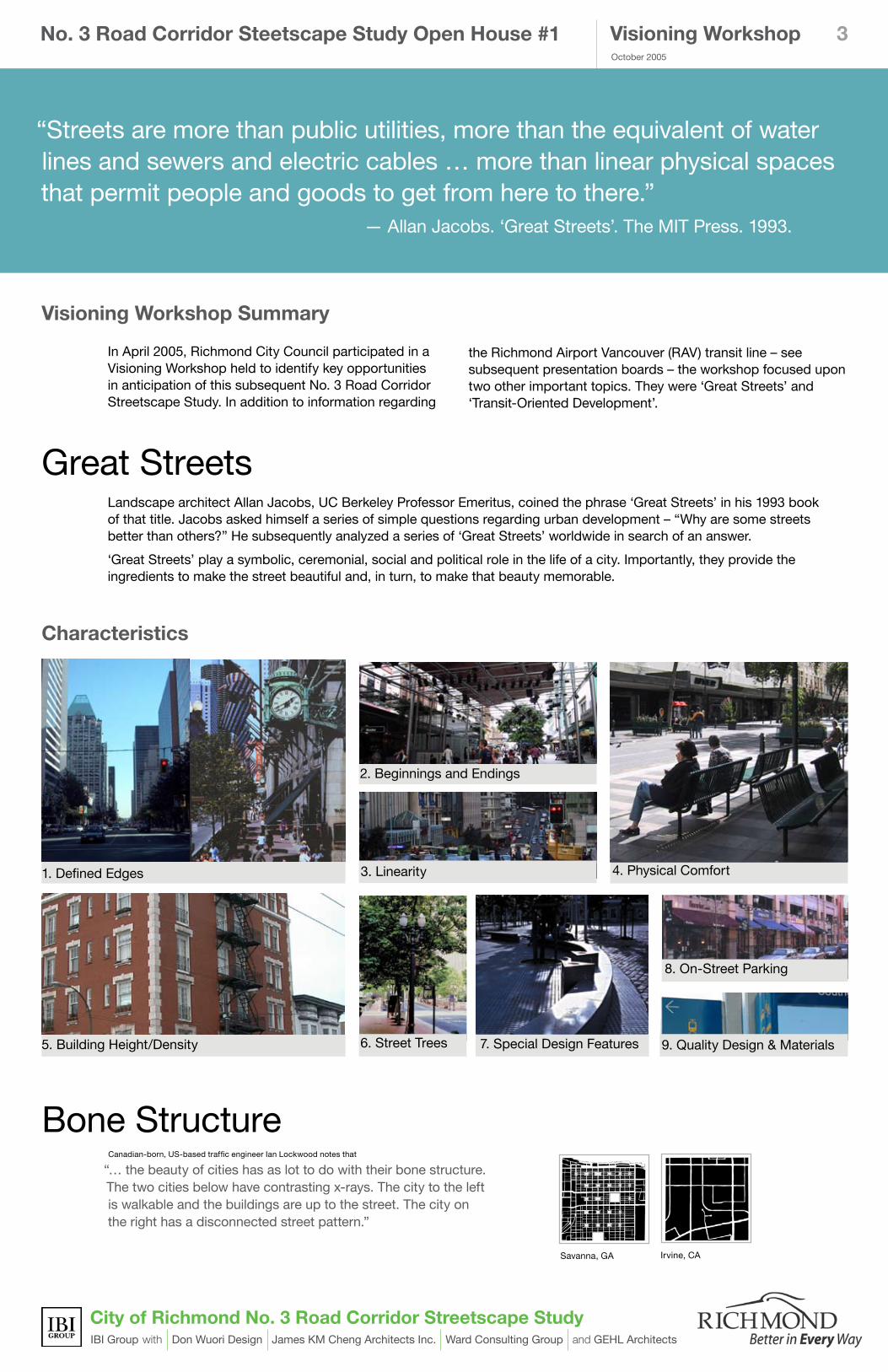
Bone StructureCanadian-born, US-based traffic engineer Ian Lockwood notes that
“… the beauty of cities has as lot to do with their bone structure. The two cities below have contrasting x-rays. The city to the left is walkable and the buildings are up to the street. The city on the right has a disconnected street pattern.”
Savanna, GA Irvine, CA
Great Streets
Visioning Workshop Summary
Landscape architect Allan Jacobs, UC Berkeley Professor Emeritus, coined the phrase ‘Great Streets’ in his 1993 book of that title. Jacobs asked himself a series of simple questions regarding urban development – “Why are some streets better than others?” He subsequently analyzed a series of ‘Great Streets’ worldwide in search of an answer.
‘Great Streets’ play a symbolic, ceremonial, social and political role in the life of a city. Importantly, they provide the ingredients to make the street beautiful and, in turn, to make that beauty memorable.
In April 2005, Richmond City Council participated in a Visioning Workshop held to identify key opportunities in anticipation of this subsequent No. 3 Road Corridor Streetscape Study. In addition to information regarding
1. Defined Edges
2. Beginnings and Endings
3. Linearity 4. Physical Comfort
5. Building Height/Density 6. Street Trees 7. Special Design Features
8. On-Street Parking
9. Quality Design & Materials
“Streets are more than public utilities, more than the equivalent of water lines and sewers and electric cables … more than linear physical spaces that permit people and goods to get from here to there.” — Allan Jacobs. ‘Great Streets’. The MIT Press. 1993.
Visioning Workshop
Characteristics
the Richmond Airport Vancouver (RAV) transit line – see subsequent presentation boards – the workshop focused upon two other important topics. They were ‘Great Streets’ and ‘Transit-Oriented Development’.

October 2005
No. 3 Road Corridor Steetscape Study Open House #1
City of Richmond No. 3 Road Corridor Streetscape StudyIBI Group with Don Wuori Design James KM Cheng Architects Inc. Ward Consulting Group and GEHL Architects
4
Transit-Oriented Development (TOD)
“Compact, mixed-use and pedestrian-friendly neighbourhoods containing a range of housing types, workplaces, shops, entertainment, schools, parks and civic facilities essential to the daily lives of residents – all within a 5 to 10 minute walk from a transit station.”
1. Connected Streets 2. Compact Development 3. Mixed Land Uses 4. Smaller City Blocks 5. Pedestrian-Friendly
6. Public Realm/Civic Identity
10. Transit Station at its Centre 12. Street-Facing Buildings 13. Mixed-Use Building Types
14. Architectural Variety 15. Relaxed Parking Standards 16. Market Acceptance
The key ingredient required for TOD is rapid transit. With the arrival of RAV, the City of Richmond can look to the positive application of the principles of TOD to guide future growth. TOD Characteristics are presented below.
Visioning Workshop
Characteristics
7. Natural Open Space 8. Narrow & Calmed Streets 9. Bicycle-Friendly Streets
11. Retail ‘High Street’

October 2005
No. 3 Road Corridor Steetscape Study Open House #1
City of Richmond No. 3 Road Corridor Streetscape StudyIBI Group with Don Wuori Design James KM Cheng Architects Inc. Ward Consulting Group and GEHL Architects
5
RAV’s component pieces within Richmond include:
• North Arm Fraser River Bridge west of Mitchell Island and Middle Arm Fraser River Bridge to Sea Island;
• System-wide Operations and Maintenance facility under Highway 99 in vicinity of Bridgeport Road;
• Transit station locations include Bridgeport Station (with bus exchange and park-n-ride), Cambie Station, Lansdowne Station and Richmond City Centre Terminus Station (with bus exchange); a future station is planned for Capstan Way;
• Guideway elevated along east side of No. 3 Road;
• Single guideway south of Lansdowne Station; and
• Formal pedestrian connection from Richmond City Centre Station to City Hall.
RAV Definitions
1. Corridor: A broad geographical band that follows the directional flow of a transit system. No. 3 Road has been selected as the RAV transit corridor in Richmond.
horizontal
vertical
The RAV Line will connect the Vancouver Waterfront Station to the Vancouver International Airport (YVR) and Richmond City Centre, via No. 3 Road in Richmond.
4. Alignment: The 3D pathway (in both horizontal and vertical ground plane) of a transit route. Care has been taken to ensure that the RAV alignment is as straight as possible in support of both community context and rider comfort.
RAV Project Overview
Bridgeport Road
Hwy 99
Sea Island Way
Cambie Road
Alderbridge Way
Westminster Highway
Granville Ave
Blundell Road
Lansdowne Road
No. 4
Roa
d
No. 3
Roa
d
No. 2
Roa
d
Gilb
ert R
oad
Gard
en C
ity R
oad
VancouverInternational Airport
Mid
dle
Arm
Fras
er R
iver
Dinsmore Bridge
No.2
Roa
d Br
idge
Moray Channel Bridge
North Arm Fraser River
Arth
ur L
aing
Brid
ge
Oak Street Bridge
Cambie Station
Saba Station
Capstan Station [future]
Bridgeport Station
Lansdowne Station
Cambie Station
Richmond City Centre(Brighouse) Station
Capstan Station [future]
Bridgeport Station
0 500
N
�. Route: The transit pathway through a corridor. Transit routes may share existing road rights-of-way or run across developed or undeveloped lands. More specifically the east side of No. 3 Road has been selected as the RAV transit route.
3. Station Location: The selected site for a transit passenger Facility.RAV stations have been selected in locations that will anchor subsequent Transit-Oriented Development (TOD) and best support transit ridership.
5. Guideway: A track or riding surface that supports and physically guides transit vehicles designed to travel exclusively on it. The RAV guideway will physically alter the appearance and function of No. 3 Road. This Streetscape study is intended to ensure the best possible fit for the RAV system along No. 3 Road.
robsonwaterfront
broadway/city hallyaletown
king edward
49th ave41st ave
marine dr.
bridgeport
cambie
lansdowne
richmond city centre (brighouse)
YVR 1
YVR 2YVR 3 (deferred)
YVR 4
false creek south
capstan (deferred)
Guideway
October 2005
No. 3 Road Corridor Steetscape Study Open House #1
City of Richmond No. 3 Road Corridor Streetscape StudyIBI Group with Don Wuori Design James KM Cheng Architects Inc. Ward Consulting Group and GEHL Architects
�
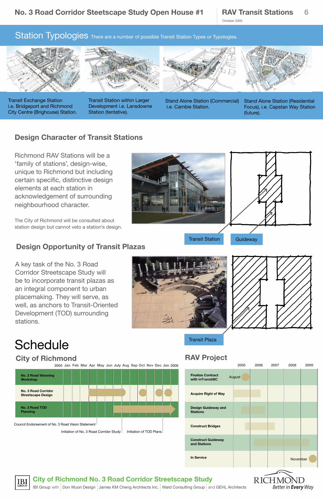
Richmond RAV Stations will be a ‘family of stations’, design-wise, unique to Richmond but including certain specific, distinctive design elements at each station in acknowledgement of surrounding neighbourhood character. The City of Richmond will be consulted about station design but cannot veto a station’s design.
A key task of the No. 3 Road Corridor Streetscape Study will be to incorporate transit plazas as an integral component to urban placemaking. They will serve, as well, as anchors to Transit-Oriented Development (TOD) surrounding stations.
No. 3 Road Visioning Workshop
No. 3 Road Corridor Streetscape Design
No. 3 Road TOD Planning
JAN
Jan Feb Mar Apr May Jun July Aug Sep Oct Nov Dec Jan
Council Endorsement of Vision Statement
No.3 Road Streetscape Plan TOD Plans
2005 2006
Finalize Contract with InTransitBC
Acquire Right of Way
Design Guideway and Stations
Construct Bridges
Construct Guideway and Stations
In Service
2005 2006 2007 2008 2009
August
November
ScheduleRAV ProjectCity of Richmond
Design Character of Transit Stations
Design Opportunity of Transit Plazas
RAV Transit Stations
Station Typologies There are a number of possible Transit Station Types or Typologies.
Transit Exchange Stationi.e. Bridgeport and Richmond City Centre (Brighouse) Station.
Transit Station within Larger Development i.e. Lansdowne Station (tentative).
Stand Alone Station (Commercial) i.e. Cambie Station.
Stand Alone Station (Residential Focus), i.e. Capstan Way Station (future).
GuidewayTransit Station
Transit Plaza
Initiation of No. 3 Road Corridor Study
Council Endorsement of No. 3 Road Vision Statement
Initiation of TOD Plans

October 2005
No. 3 Road Corridor Steetscape Study Open House #1
City of Richmond No. 3 Road Corridor Streetscape StudyIBI Group with Don Wuori Design James KM Cheng Architects Inc. Ward Consulting Group and GEHL Architects
�
• Has many driveways that disrupt pedestrian flow;
• Has long blocks that make it onerous to
walk and a roadway width that makes it difficult to cross; and
• Lacks a terminus at the north end.
The Problem: In its present condition, the No. 3 Road Corridor:
The Challenge:No. 3 Road needs to transform from an auto-oriented to a walking and cycling friendly street, so that it becomes more livable and appealing.
Possible Solutions: Streetscape Design approach for the entire No. 3 Road corridor:
• Character Zones: Establish distinct precincts, complete with a series of ‘special places’ to improve the rhythm of the street;
• Placemaking: Apply principles of Great Streets, Public Squares, Urban Patterns and TOD to the No. 3 Road Corridor.
“No. 3 Road should be the spine that intersects a series of memorable places that, in turn, define character zones.”
The Challenge
DowntownCore North
InternationalDistrictSouth
International DistrictNorth
DowntownCore South
Gateway Corridor
Gateway District
Bridgeport RoadHwy 99
Sea Island Way
Cambie Road
Alderbridge Way
Westminster Highway
Granville Ave
Blundell Road
Lansdowne Road
No. 4
Roa
d
No. 3
Roa
d
No. 2
Roa
d
Gilb
ert R
oad
Gard
en C
ity R
oad
VancouverInternational Airport
Middl
e Arm
Fras
er R
iver
Dinsmore Bridge
No.2
Roa
d Br
idge
Moray Channel Bridge
North Arm Fraser RiverAr
thur
Lain
g Br
idge
Oak Street Bridge
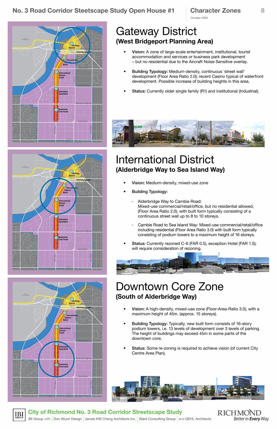
Character Zones: Contribute to the rhythm of the street by accommodating a variety of different places along the spine of No. 3 Road.
October 2005
No. 3 Road Corridor Steetscape Study Open House #1
City of Richmond No. 3 Road Corridor Streetscape StudyIBI Group with Don Wuori Design James KM Cheng Architects Inc. Ward Consulting Group and GEHL Architects
8
International District(Alderbridge Way to Sea Island Way)
• Vision: Medium-density, mixed-use zone
• Building Typology:
- Alderbridge Way to Cambie Road: Mixed-use commercial/retail/office, but no residential allowed, (Floor Area Ratio 2.0), with built form typically consisting of a continuous street wall up to 8 to 10 storeys.
- Cambie Road to Sea Island Way: Mixed-use commercial/retail/office including residential (Floor Area Ratio 3.0) with built form typically consisting of podium towers to a maximum height of 16 storeys.
• Status: Currently rezoned C-6 (FAR 0.5), exception Hotel (FAR 1.5); will require consideration of rezoning.
DowntownCore North
InternationalDistrictSouth
International DistrictNorth
DowntownCore South
Gateway Corridor
Gateway District
Bridgeport Road
Hwy 99
Sea Island Way
Cambie Road
Alderbridge Way
Westminster Highway
Granville Ave
Blundell Road
Lansdowne Road
No. 4
Roa
d
No. 3
Roa
d
No. 2
Roa
d
Gilb
ert R
oad
Gard
en C
ity R
oad
VancouverInternational Airport
Mid
dle
Arm
Fras
er R
iver
Dinsmore Bridge
No.2
Roa
d Br
idge
Moray Channel Bridge
North Arm Fraser River
Arth
ur L
aing
Brid
ge
Oak Street Bridge
Character Zones
Downtown Core Zone (South of Alderbridge Way)
• Vision: A high-density, mixed-use zone (Floor-Area-Ratio 3.0), with a maximum height of 45m. (approx. 15 storeys).
• Building Typology: Typically, new built form consists of 16-story podium towers, i.e. 13 levels of development over 3 levels of parking.The height of buildings may exceed 45m in some parts of the downtown core.
• Status: Some re-zoning is required to achieve vision (of current City Centre Area Plan).
DowntownCore North
InternationalDistrictSouth
International DistrictNorth
DowntownCore South
Gateway Corridor
Gateway District
Bridgeport Road
Hwy 99
Sea Island Way
Cambie Road
Alderbridge Way
Westminster Highway
Granville Ave
Blundell Road
Lansdowne Road
No. 4
Roa
d
No. 3
Roa
d
No. 2
Roa
d
Gilb
ert R
oad
Gard
en C
ity R
oad
VancouverInternational Airport
Mid
dle
Arm
Fras
er R
iver
Dinsmore Bridge
No.2
Roa
d Br
idge
Moray Channel Bridge
North Arm Fraser River
Arth
ur L
aing
Brid
ge
Oak Street Bridge
Gateway District (West Bridgeport Planning Area)
• Vision: A zone of large-scale entertainment, institutional, tourist accommodation and services or business park development – but no residential due to the Aircraft Noise Sensitive overlay.
• Building Typology: Medium-density, continuous ‘street wall’ development (Floor Area Ratio 2.0); recent Casino typical of waterfront development. Possible increase of building heights in this area.
• Status: Currently older single family (R1) and institutional (Industrial).
x
DowntownCore North
InternationalDistrictSouth
International DistrictNorth
DowntownCore South
Gateway Corridor
Gateway District
Bridgeport Road
Hwy 99
Sea Island Way
Cambie Road
Alderbridge Way
Westminster Highway
Granville Ave
Blundell Road
Lansdowne Road
No. 4
Roa
d
No. 3
Roa
d
No. 2
Roa
d
Gilb
ert R
oad
Gard
en C
ity R
oad
VancouverInternational Airport
Mid
dle
Arm
Fras
er R
iver
Dinsmore Bridge
No.2
Roa
d Br
idge
Moray Channel Bridge
North Arm Fraser River
Arth
ur L
aing
Brid
ge
Oak Street Bridge

October 2005
No. 3 Road Corridor Steetscape Study Open House #1
City of Richmond No. 3 Road Corridor Streetscape StudyIBI Group with Don Wuori Design James KM Cheng Architects Inc. Ward Consulting Group and GEHL Architects
�
Where placemaking might occur: 1. At transit stations and transit plazas
2. Between transit stations3. At key intersections
4. Within major developments5. At North Arm of Fraser River
Public Art Strategies
Placemaking
“The Public Square – It’s an ancient concept. You go to a square, to the marketplace. Not to anyone’s house – to everyone’s house.”
Placemaking: creation of places with both a strong sense of community and a comfortable image, as well as settings for public activities and uses.
• The Richmond No. 3 Road Streetscape Study will include public art recommendations in support of the City of Richmond’s vision for Great Streets and to lay the groundwork for future placemaking art opportunities;
• Additionally, public art can be incorporated into street furniture and ‘artful’ transit stations.
• Existing No. 3 Road street trees will be permanently relocated to nearby roadway boulevards, medians or parks;
• The No. 3 Road Streetscape Study will identify number and location of new street trees to be planted within the road right-of-way as part of future streetscape improvements.
5
4
3�
1
Street Trees
October 2005
No. 3 Road Corridor Steetscape Study Open House #1
City of Richmond No. 3 Road Corridor Streetscape StudyIBI Group with Don Wuori Design James KM Cheng Architects Inc. Ward Consulting Group and GEHL Architects
10
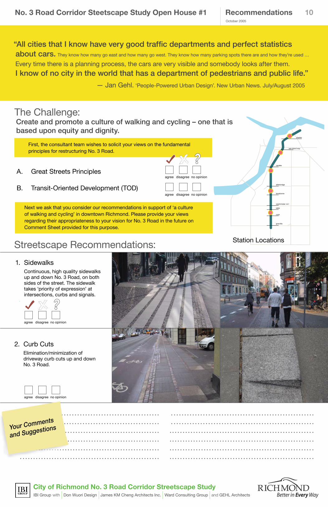
First, the consultant team wishes to solicit your views on the fundamental principles for restructuring No. 3 Road.
Recommendations
“All cities that I know have very good traffic departments and perfect statistics about cars. They know how many go east and how many go west. They know how many parking spots there are and how they’re used …
Every time there is a planning process, the cars are very visible and somebody looks after them.
I know of no city in the world that has a department of pedestrians and public life.”
— Jan Gehl. ‘People-Powered Urban Design’. New Urban News. July/August 2005
Next we ask that you consider our recommendations in support of ‘a culture of walking and cycling’ in downtown Richmond. Please provide your views regarding their appropriateness to your vision for No. 3 Road in the future on Comment Sheet provided for this purpose.
1. Sidewalks Continuous, high quality sidewalks
up and down No. 3 Road, on both sides of the street. The sidewalk takes ‘priority of expression’ at intersections, curbs and signals.
The Challenge: Create and promote a culture of walking and cycling – one that is based upon equity and dignity.
2. Curb Cuts Elimination/minimization of
driveway curb cuts up and down No. 3 Road.
alderbridge
lansdowne
westminster hwy
saba
cook
granville
cambie
sea island way
charles
Streetscape Recommendations:
agree disagree no opinion
agree disagree no opinion
Station Locations
Your Comments
and Suggestions
A. Great Streets Principles
B. Transit-Oriented Development (TOD)
agree disagree no opinion
agree disagree no opinion

October 2005
No. 3 Road Corridor Steetscape Study Open House #1
City of Richmond No. 3 Road Corridor Streetscape StudyIBI Group with Don Wuori Design James KM Cheng Architects Inc. Ward Consulting Group and GEHL Architects
11Recommendations
4. On-Street Parking Short term on-street parking
wherever possible, as a positive signal to the importance of street front retail and to serve as a buffer between pedestrians and vehicles.
5. Pedestrian Linkages Convenient linkages to transit
stations and bus stops, including ‘kiss-n-ride’ drop-off & pick-up.
alderbridge
lansdowne
westminster hwy
saba
cook
granville
cambie
sea island way
charles
6. Outdoor Rooms Public realm urban plazas, boulevards
and linear parks, including street trees and greenery along the length of No. 3 Road; adhere to principles of CPTED (Crime Prevention through Environmental Design).
3. Cycle Paths Continuous, raised cycle paths
on each side of No. 3 Road; preferably separating cyclists and pedestrians from vehicles.
agree disagree no opinion
agree disagree no opinion
agree disagree no opinion
agree disagree no opinion
Outdoor Rooms
Bridgeport Green Plaza
No.3 Road Extension
Capstan Greenway
Cambie Market Plaza
Lansdowne Civic Celebration Plaza
Richmond City Centre (Brighouse) Green Promenade
Your Comments
and Suggestions

October 2005
City of Richmond No. 3 Road Corridor Streetscape StudyIBI Group with Don Wuori Design James KM Cheng Architects Inc. Ward Consulting Group and GEHL Architects
1�Recommendations
9. Wayfinding A simple, informative system of out-
door signage to inform pedestrians and cyclists up and down No. 3 Road and beyond.
8. Public Art Promote public art within the No. 3
Road Corridor, both at and between transit stations; consider a strategy of ‘artful’ transit stations.
7. Street Hardware & Seating A coordinated, understated and
timeless approach to outdoor furniture, including street lighting complete with banner arms, seating, bollards, recycling bins, information kiosks, and bicycle racks.
agree disagree no opinion
10. Street-facing Retail Wherever economically viable,
the inclusion of street-facing retail facilities to encourage pedestrian activity including window shopping.
alderbridge
lansdowne
westminster hwy
saba
cook
granville
cambie
sea island way
charles
agree disagree no opinion
agree disagree no opinion
agree disagree no opinion
Fronting Buildings
No. 3 Road Corridor Steetscape Study Open House #1
Thank you! Please fill out a Comment Sheet. We look forward to seeing you at Open House � in early December �005.
Your Comments
and Suggestions