tnr gold shotgun gold project in alaska presentation
DESCRIPTION
Shotgun Gold Project in Alaska. 100% TNR Gold Corp. owned porphyry style gold mineralized system that is being targeted for a bulk mineable gold resource. Approx. 190km south of the Donlin Creek deposits.TRANSCRIPT
Shotgun Gold Project – Alaska NOV, 2013

Company Overview
“Lead Project Generator”
• Mineral Exploration:
– Precious Metals and Base Metals
– Strategic Focus on Rare Metals and Rare Earth Elements
• Proven Business Model:
– Early Identification and Acquisition of Mineral Prospects
– Selectively Advance Projects Internally
– Employ JV Partnerships to Diversify Costs and Risk
– Maximum Value Achieved Over Minimum Period of Time
• 65% Owned by Insiders and Management
• Experienced Management Team

Corporate Structure
Generating Quality
Asset Base
Unlocking Value
TNR GOLD CORP. TNR.TSXV
Amerigold Corp.
Alaskan Projects
Au
Minera Solitario Argentina Projects
Cu-Au
International Lithium Corp. (ILC:TSX.V)
Li + Rare Metals
(25.5% Equity owner)
Multi-Commodity
Multi-Jurisdiction
Exposure
ILC Spinoff
Successfully Listed
May 24, 2011
TNR shareholders
received 1 unit for
every 4 shares of
TNR held

Actively Sourcing Additional Opportunities
Project Locations
LEGEND
Au
Au-Cu
Office
Vancouver
Shotgun
ALASKA
ARGENTINA
Los Azules
Gold Corp.
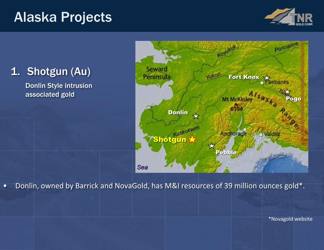
• Donlin, owned by Barrick and NovaGold, has M&I resources of 39 million ounces gold*.
1. Shotgun (Au)
Donlin Style intrusion
associated gold
Alaska Projects
Shotgun
Pebble
Donlin
Fort Knox
Pogo
*Novagold website

Shotgun Project, Alaska
Inferred Resource Estimate *:
Shotgun Resource Estimate - modelled at an ~ 0.3 to 0.5 g/t cut-off.
* The Shotgun Ridge prospect contains an inferred mineral resource of 20,734,313 tonnes at 1.06 grams per tonne (“g/t”) for a total of 705,960 ounces gold (“Au”) using a 0.5 g/t Au cut-off. The inferred mineral resource estimate was prepared by Allan Armitage, PhD., P.Geol., of GeoVector Management Inc., a Qualified Person as defined by the Canadian Institute of Mining (CIM) Definition Standards for Mineral Resources and Mineral Reserves and the National Instrument 43-101 Standards of Disclosure for Mineral Projects. The Shotgun Zone mineral resource estimate, publicly reported on April 22, 2013, is based on 34 diamond drill holes (NQ) totalling 4,932.3 metres, with 2,481 assays (0.2 up to 10 metres in length). Holes were drilled by several operators in five drill campaigns conducted between 1984 and 2012. The 34 drill holes are spaced primarily 40 to 100 metres apart in an area of approximately 375 x 300 metres. The drill holes tested mineralization to a vertical depth up to 150 metres. A resource model for the Shotgun Zone was constructed based on the distribution of the gold mineralization (> 0.3 to 0.5 g/t Au) and this model was used to constrain the composite values chosen for interpolation. A block model with block dimensions of 5 x 5 x 5 metres in the x, y and z directions was placed over resource model solids with only that proportion of each block below the topographic/overburden surface and inside the solid recorded. Grades for gold were interpolated into the blocks by the inverse distance squared (“ID2”) method using a minimum of 2 and maximum of 12 composites to generate block grades in the Inferred resource category. The search ellipse used to interpolate grade into the blocks measured 110 x 60 x 110 (Principle Az – 235°, Principle Dip - 25°, Intermediate Az.- 325°). The size and orientation of the search ellipse approximates the strike, dip and thickness of the resource model and takes into account the limited drilling and relatively wide spacing of the drilling. There are currently no known encumbrances with regards to legal, political, environmental or other risks that could materially affect the potential development of the Shotgun Ridge prospect, and however, the EPA is conducting an environmental review of the Bristol Bay watershed in response to the proposed development of the Pebble Deposit, approximately 150 kilometres to the southeast of Shotgun Ridge. The mineral resources reported herein are classified as inferred mineral resources according the CIM Definition Standards for Mineral Resources and Mineral Reserves. No economic studies were undertaken on this mineral resource estimate and it should be noted that mineral resources are not mineral reserves and there is no guarantee that the current mineral resource at Shotgun Ridge will result in an economically viable deposit.
Au Cut-off Tonnes Grade (g/t) Ounces
0.3 g/t 24,509,842 0.96 759,442
0.5 g/t 20,734,313 1.06 705,960
0.7 g/t 14,779,225 1.24 590,600
1.0 g/t 9,101,458 1.49 437,365

Camp
Shotgun Project, Alaska
• 4 mineralized target areas
• 96 mineral claims (3,658 ha)
• Elevation: 200 – 850m
PROSPECT COMPANY YEAR DRILLING
(m)
Shotgun Ridge
Cominco
NovaGold
TNR Gold
1984,88
1998
2006
2012
226
3,107
762
814
Shot
TNR Gold
2005
301
King
TNR Gold
2005
145
Winchester
TNR Gold
2005
2006
535
1,118
7,008
Exploration Drilling History
25 k
m

Shotgun Project, Alaska
Geology
• Predominantly underlain by Cretaceous sediments of the Kuskokwim Group
• Granite to syenite intrusive bodies intruded the Kuskokwim Group
• Some of these intrusions appear to be directly related to gold mineralization
• north-south oriented string of gold prospects
Ridges that are resistant to weathering are indicative of alteration centers and are the Prime Exploration Targets
25 k
m

Shotgun Ridge – 2006 Drill Program
06-43 @ 102m
• TNR’s drill hole 2006-43 returns 210m of 1.29g/t Au, including 27.4m of 2.3 g/t Au
• Drilling reveals a model of “Southwest dipping mineralized zones”
• New potential to significantly expand mineralization at depth
27.4m of 2.3 g/t Au

2011: 3D IP/Resistivity Survey
06-43 @ 102m
100m
27.4m of 2.3 g/t Au
• In 2011, TNR conducted a 3D IP and Resistivity survey over the Shotgun Ridge prospect
• Results were able to map structural controls on mineralization in 3D, through the ridge
• These interpretations provided a basis for 2012 drill targeting
3D Modelled Resistivity
50m below surface

Shotgun Ridge –2012 Drilling on 3D IP
• Location of 2012 drill holes relative to DDH 06-43
• Drill holes plotted in sliced section through semitransparent 3D IP voxel
50m
40m
100m
• 2012 drilling designed to test and confirm structural model of mineralization along strike and at depth – mineralization remains open at depth
• Resistivity and chargeability jointly correlate with gold mineralization
06-43
12-56
12-58
OPEN
12-57
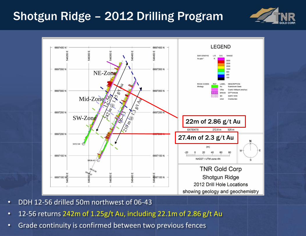
Shotgun Ridge – 2012 Drilling Program
27.4m of 2.3 g/t Au
22m of 2.86 g/t Au
NE-Zone
Mid-Zone
SW-Zone
• DDH 12-56 drilled 50m northwest of 06-43
• 12-56 returns 242m of 1.25g/t Au, including 22.1m of 2.86 g/t Au
• Grade continuity is confirmed between two previous fences

Shotgun Ridge – 2012 Drilling Program
27.4m of 2.3 g/t Au
NE-Zone
Mid-Zone
SW-Zone
• DDH 12-57 and 12-58 drilled 40m south-southwest of 06-43
• 12-57 returns 209m of 1.02g/t Au over all three zones (SW+Mid+NE)
• 12-58 returns 46.55m of 1.14 g/t Au over the SW zone
22m of 2.86 g/t Au
18.4m of 2.03 g/t Au

Shotgun Ridge – 2012 IP Surveys
• Mineralization in 12-56 shows good correlation with chargeability
• Higher gold grades encountered in Quartz-Feldspar-Porphyry (QFP)
• Mineralization is shallow and open at depth (ie topographic effect)
10
0m
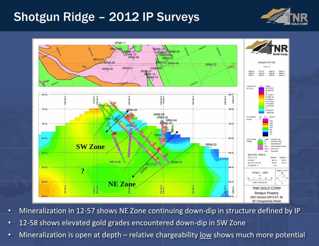
Shotgun Ridge – 2012 IP Surveys
• Mineralization in 12-57 shows NE Zone continuing down-dip in structure defined by IP
• 12-58 shows elevated gold grades encountered down-dip in SW Zone
• Mineralization is open at depth – relative chargeability low shows much more potential
NE Zone
SW Zone
?
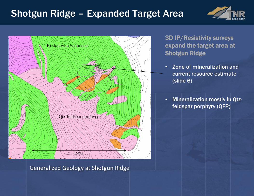
Shotgun Ridge – Expanded Target Area
1500m
Qtz-feldspar porphyry
Kuskokwim Sediments
3D IP/Resistivity surveys
expand the target area at
Shotgun Ridge
• Zone of mineralization and
current resource estimate
(slide 6)
• Mineralization mostly in Qtz-
feldspar porphyry (QFP)
Generalized Geology at Shotgun Ridge

Shotgun Ridge – Expanded Target Area
Generalized Geology at Shotgun Ridge
3D IP level plan at 600m elevation
1500m
Qtz-feldspar porphyry
Kuskokwim Sediments
3D IP/Resistivity surveys
expand the target area at
Shotgun Ridge
• Zone of mineralization and
current resource estimate
(slide 6)
• Mineralization mostly in Qtz-
feldspar porphyry (QFP)
• 3D IP shows higher
chargeabilities in QFP
• Elevated chargeabilities
connected at depth
• Significant potential to add
to gold resource
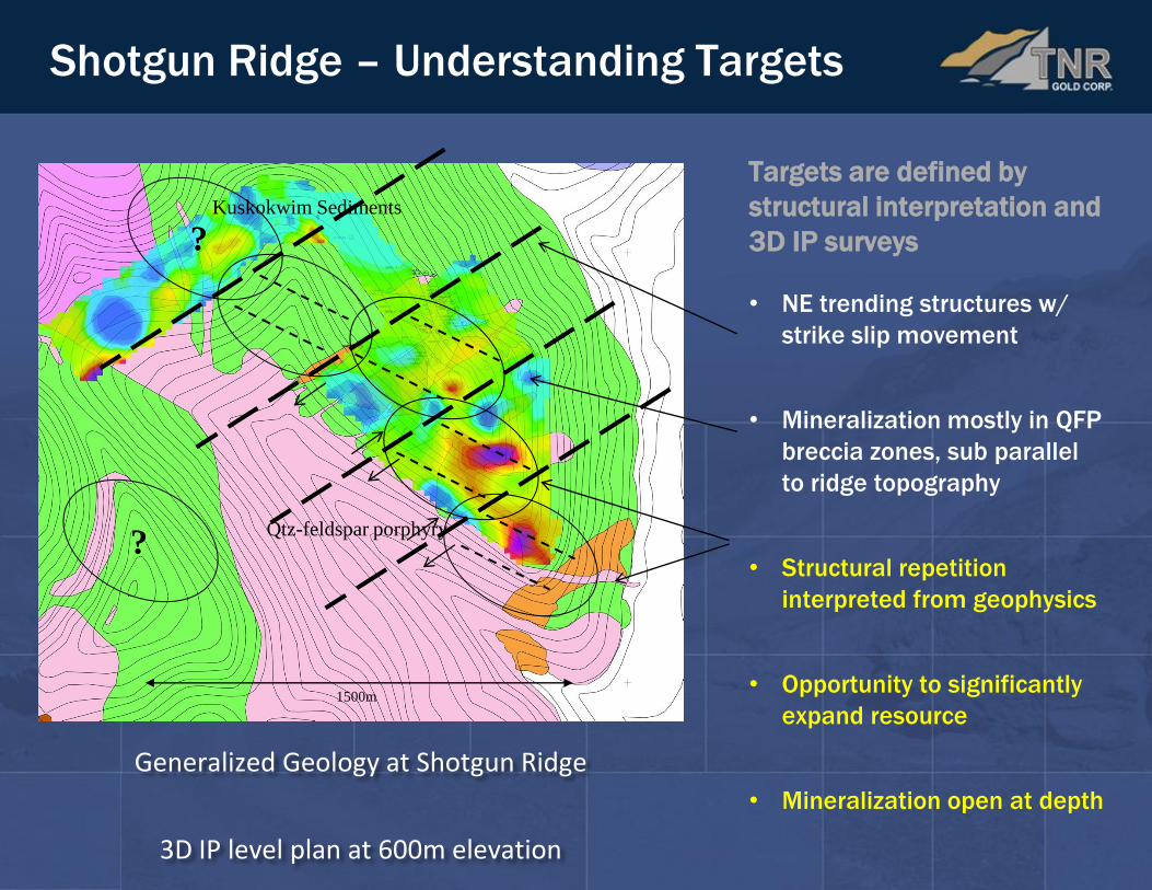
Shotgun Ridge – Understanding Targets
Generalized Geology at Shotgun Ridge
3D IP level plan at 600m elevation
1500m
Qtz-feldspar porphyry
Kuskokwim Sediments
Targets are defined by
structural interpretation and
3D IP surveys
• NE trending structures w/
strike slip movement
• Mineralization mostly in QFP
breccia zones, sub parallel
to ridge topography
• Structural repetition
interpreted from geophysics
• Opportunity to significantly
expand resource
• Mineralization open at depth
?
?

Shotgun Ridge – Understanding Targets
Generalized Geology at Shotgun Ridge
Regional Magnetic Image
1500m
Qtz-feldspar porphyry
Kuskokwim Sediments
Targets are defined by
structural interpretation and
3D IP surveys
• NE trending structures w/
strike slip movement
• Mineralization mostly in QFP
breccia zones, sub parallel
to ridge topography
• Structural repetition
interpreted from geophysics
• Opportunity to significantly
expand resource
• Mineralization open at depth
?
?

Shotgun Project, Alaska
Camp Scale Opportunity
• Shotgun Ridge is just one of multiple gold target areas
• Gold mineralization identified at each prospect: Shot, King, and Winchester
• This group of prospects forms a distinct gold district held 100% by TNR
• Surface geochemistry identifies multiple gold anomalies with no known source
• Poor outcrop limited prospecting efforts in the past
• IP surveys identify mineralized areas
25 k
m
Summary
Discovery and Early Exploration
• 1998 mineralization is interpreted to have a “cap” or inverted bowl shape
• 2006 mineralization reinterpreted as structurally controlled with deep feeders
• Structurally controlled “Southwest Dipping Mineralized Zones” identified
• IP and resistivity surveys highlight gold mineralized breccias (hornfelsed sediments
and porphyritic intrusive)
• 2012 drill program designed to test predictability of mineralized zones
• Mineralization model confirmed
Way Forward – Advanced Exploration and Resource Definition
1. Acquire strategic partner to jointly advance project
2. Ensure stakeholders are informed on project developments, and maintain best
practises for community relations and involvement
3. Design significant drill program to define full resource potential
4. Explore potential of other target areas (Shot, King, and Winchester)

Contact Information
Address
P.O. Box 11604
620 - 650 West Georgia St.
Vancouver, British Columbia
V6B 4N9, Canada
Phone: (604) 687-7551
Fax: (604) 687-4670
Toll Free: 1-800-667-4470
E-mail: [email protected]
Caroline Klukowski
Manager, Corporate Communications
E-mail: [email protected]
Gary Schellenberg
President
E-mail: [email protected]
Disclaimer
The TSX Venture Exchange has not reviewed and does not accept responsibility for the adequacy or accuracy of this presentation. Statements in this presentation other than purely historical information, historical estimates should not be relied upon, including statements relating to the Company’s future plans and objectives or expected results, are forward-looking statements. This presentation contains certain "Forward-Looking Statements" within the meaning of Section 21E of the United States Securities Exchange Act of 1934, as amended. Forward-looking statements are based on numerous assumptions and are subject to all of the risks and uncertainties inherent in the Company’s business, including risks inherent in resource exploration and development. As a result, actual results might vary materially from those described in this presentation. Readers should verify any & all claims and do their due diligence before investing in any securities mentioned. Investing in securities is speculative and carries a high degree of risk.
Disclosure
John Harrop, PGeo, FGS, Vice President of Exploration of the Company is a "Qualified Person" as defined under NI 43-101 has reviewed and approved the technical content of this document.