tim: assessing the sustainability of agricultural land management
TRANSCRIPT

Jou
rnal
ofE
nviron
men
talM
anagem
ent
(2000)60,267–288doi:10.1006/jem
a.2000.0384,availableon
line
ath
ttp://ww
w.idealibrary.com
on
TIM
:Assessing
thesustainab
ilityo
fag
riculturallandm
anagem
ent
C.S
.Sm
ith†*,G
.T.M
cDo
nald‡
andR
.N.T
hwaites
§
TIM(ThreatId
entificationM
odel)is
afram
ework
forthe
exante
assessmentofagriculturalland
managem
entsustainab
ilityat
theland
unitscale
thatid
entifiessources
ofunsustainab
ilityw
ithinagricultural
landm
anagement
systems.
Them
odel
explicitly
linksd
efinedhazard
sto
landp
roductivity
andenvironm
entalintegrity,
landresource
data
andinform
ation,and
landm
anagement
practice
options
usingexp
ertand
localknowled
geon
landm
anagement
andits
potentialeffects.
Them
odelw
astested
inthe
CrystalC
reekS
ubcatchm
ent,anarrow
coastalstripofland
situatedin
northQ
ueensland,A
ustralia.Thisarea
was
chosend
ueto
theexp
ansionof
thesugar
industry
ontoincreasingly
marginalland
inthe
area,w
hichrep
resentsa
threatto
sustainable
landuse
anda
requirem
entfor
carefulland-use
planning
andland
managem
ent.TIM
may
be
usedin
arelationald
atabase
asa
standalone
decision
supp
ortsystemfor
land-m
anagement
planning.Its
usefulnessin
land-use
planning
isgreatestw
henitis
linkedto
aG
eographic
Information
System
(GIS
)as
shown
inthis
pap
er.G
ISallow
sTIM
outputs,
suchas
constraintsto
agricultureand
site-specific
best-m
anagement
practices,to
be
identified
ina
spatially
explicit
manner.
Them
ainad
vantagesof
TIMare
thatit
canb
ed
oneex
ante,it
removes
theneed
tod
efinesustainab
ilityassessm
entcriteria
andind
icators,it
utilisescurrent
understand
ingof
thecauses
andeffects
ofland
degrad
ationand
howd
ifferentland
-managem
entp
racticesinfluence
these,and
linksthis
knowled
geto
definite
land-m
anagement
options.
2000
Acad
emic
Press
Keyw
ords:
sustain
ableagricu
lture,
land-u
seplan
nin
g,lan
devalu
ation,
sustain
abledevelopm
ent.
Introd
uction
Lan
d-use
plann
ersan
dm
anagers
have
tradi-tion
allyu
sedth
eF
AO
Fram
ework
forL
and
Evalu
ation(F
AO
,1976),orsim
ilarm
ethods,
toprovide
them
with
the
land
suitability
inform
ationn
eededto
make
agricultu
rallan
d-use
plann
ing
decisions.
Th
eF
AO
docu-
men
tationstates
that
land
evaluation
‘takesin
tocon
siderationth
eecon
omics
ofth
epro-
poseden
terprises,th
esocial
consequ
ences
forth
epeople
ofth
earea
and
the
coun
-try
concern
ed,an
dth
econ
sequen
ces,ben
e-fi
cialor
adverse,for
the
environ
men
t’(FA
O,
1976:2).H
ence,
land
evaluation
techn
iques
relatedto
the
FA
OF
ramew
orkare
pre-su
mably
basedon
the
principles
ofsu
stain-
ability,th
atis,
developmen
tis
econom
icallyfeasible,
sociallyacceptable,
and
compatible
with
the
main
tenan
ceof
ecologicalprocesses
Em
ailofcorrespon
ding
auth
or:c.smith
@en
g.un
imelb.
edu.au
ŁC
orrespond
ingauthor
†The
Dep
artment
ofG
eomatics,The
University
ofMelb
ourne,Parkville,
3010V
ictoria,Australia
‡The
Dep
artment
ofG
eographicalS
ciencesand
Planning,U
niversityof
Queensland
,St.Lucia,
4072,Queensland
,A
ustralia
§S
choolofFoodand
Land,The
University
ofQ
ueensland,S
tLucia,
4072Q
ueensland,
Australia
Received
20A
ugust1999;accep
ted21
August2000
(Pearce
etal.,
1993;W
CE
D,
1990;A
non
.,1990).
How
ever,agricu
ltural
land-u
seplan
-n
ing
basedon
land-evalu
ationm
ethods,
inA
ustralia
atleast,
has
frequen
tlyn
otled
tosu
stainable
agricultu
ralland
use.O
ne
exam-
pleis
the
Au
stralianS
ugar
Indu
stry,w
here
land-evalu
ationtech
niqu
esbased
onth
eF
AO
Fram
ework
have
beenu
sedexten
sivelyfor
plann
ing
purposes
(Wilson
and
Baker,1990).
Arecen
ten
vironm
ental
audit
ofth
eA
us-
tralianS
ugar
Indu
strycon
cluded
that
itw
asperform
ing
poorlyon
an
um
berof
envi-
ronm
ental
issues
inclu
ding
water
man
age-m
ent,
land
man
agemen
t,fertiliser
man
age-m
ent,
vegetationcon
servation,
complian
cew
ithen
vironm
ental
legislationan
den
viron-
men
talawaren
ess(G
utteridge
etal.,1996)
Wh
yth
enh
avelan
d-evaluation
meth
odsn
otlead
tosu
stainable
agricultu
ralland
use?
Sim
ply,cu
rrent
land-evalu
ationm
ethods
have
not
providedadequ
atein
formation
relating
toth
esu
stainable
man
agemen
tof
0301–4797/00/120267C22
$35.00/0
2000A
cademic
Press

268C
.S.S
mith
etal.agricu
ltural
land.G
reateratten
tionn
eedsto
begiven
toh
owsu
stainable
land-m
anage-
men
tdecision
scan
bem
adeon
the
basisof
inform
ationobtain
edfrom
land
evalua-
tion(D
ent,
1991).F
armers
and
land
users
remain
the
ultim
atedecision
-makers
and
they
require
inform
ationdescribin
gth
oselan
d-man
agemen
toption
sth
atare
the
most
appropriatefor
the
resources
they
have.
Th
ese‘best
practices’willbe
those
that
main
-tain
land
productivity
and
environ
men
talin
tegrity,are
econom
icallyviable
and
easilyim
plemen
tedgiven
the
skillsan
dkn
owl-
edgeof
the
farmin
gpopu
lation.
Th
islan
d-m
anagem
ent
inform
ation,
know
ledgean
dassessm
ent
mu
stbe
incorporated
into
plan-
nin
gprocesses
toach
ievesu
stainable
agri-cu
lturallan
du
se.In
additionto
land
evaluation
,man
yalter-
natives
toth
eassessm
ent
ofagricu
ltural
sustain
abilityh
avebeen
publish
ed,eachw
ithth
eirow
nadvan
tagesan
ddisadvan
tages.For
adescription
ofboth
the
conceptu
alan
dm
ethodological
approaches
toagricu
ltural
sustain
abilityassessm
ent,
seeS
mith
and
McD
onald
(1998).Insu
mm
ary,mostm
ethods
fallinto
one
ofth
efollow
ing
categories:(i)
Su
stainability
asan
approachto
agricul-
ture:
žsu
stainability
asan
alternative
ideology(adh
erence
toprescribed
practices);ž
sustain
abilityas
aset
ofstrategies
(alter-n
ativeagricu
lture,organ
icfarm
ing);
(ii)S
ustain
abilityas
aproperty
ofagricu
l-tu
re:
žsu
stainability
asth
eability
tosatisfy
goals(m
ultiple
qualitative
and
quan
tita-tive
indicators,
sustain
abilityin
dicators,E
nviron
men
talIm
pactA
ssessmen
t(E
IA)
and
Strategic
En
vironm
ental
Assessm
ent
(SE
A));
žsu
stainability
asan
abilityto
contin
ue
(time
trend
analysis,
resilience
and
sen-
sitivityan
alysis,system
ssim
ulation
and
modelin
g).
Th
ispaper
outlin
esan
approachto
land
evalu-
ation,th
eT
hreat
Identifi
cationM
odel(TIM
),th
atbuilds
onth
eF
AO
basedlan
d-evaluation
techn
iques.
Itprovides
anim
proved‘lan
d-m
anagem
ent
based’assessmen
tfor
land-u
seplan
ners
and
man
agersto
use
instrategic
decision-m
aking,
exan
te,before
land
uses
areim
plemen
ted.It
relatesm
ostclosely
toth
oseagricu
ltural
sustain
abilityassessm
ent
meth
odsth
atview
sustain
abilityas
aprop-
ertyof
agricultu
re,m
orespecifi
callyas
the
abilityto
satisfygoals
(inth
iscase,
main
-tain
ing
land
productivity
and
environ
men
talin
tegrity).T
IMdoes
not
encom
passall
the
dimen
sions
and
scalesof
agricultu
ralsu
s-tain
abilityassessm
ent.
Itoperates
atth
elan
du
nit
scale,providing
anexplicit
meth
odfor
identifyin
gbest
land-m
anagem
ent
prac-tices.U
sing
this
inform
ationat
the
land
un
itscale
(e.g.fi
eldscale),
socio-econom
ican
aly-sis,based
onlan
d-man
agemen
trecomm
enda-
tions,can
beperform
edatth
een
terprisescale
(e.g.farmscale),an
dsu
bsequen
tly,biophysi-
callyan
dsocio-econ
omically
viablelan
d-use
patterns
canbe
examin
edat
the
catchm
ent
(orw
atershed)scale
toassess
the
cum
ulative
effectsof
land
man
agemen
t.L
and-u
seplan
nin
gin
the
Au
stralianS
ugar
Indu
stryis
used
inth
ispaper
todem
onstrate
the
applicationof
TIM
.U
nder
Qu
eenslan
d’sn
ewIn
tegratedP
lann
ing
Act
(IPA
)1998,
agricultu
raldevelopm
ents
arecon
sidereda
‘materialch
ange’in
the
use
ofthe
land,h
ence
localgovern
men
tsn
owh
aveth
epow
erto
applyen
vironm
ental
condition
sto
the
use
ofagricu
ltural
land.
TIM
canassist
this
agri-cu
ltural
land-u
seplan
nin
gprocess
intw
ow
ays:(i)identifyin
gth
een
vironm
entalissu
esrelevan
tto
futu
resites
ofagricu
ltural
devel-opm
ent;
(ii)defi
nin
gcon
ditions
forth
eu
seof
agricultu
rallan
d.B
othth
eseapplication
sare
demon
strated.
The
threatid
entificatio
nm
od
el(T
IM):an
overview
TIM
isbased
oniden
tifying
sources
ofu
nsu
stainability
with
inagricu
ltural
land-
man
agemen
tsystem
s.T
he
rationale
isth
atth
econ
ceptof
sustain
abilityis
difficu
ltto
defin
e,an
dit
isoften
easierto
identify
features
ofa
systemth
atare
un
sustain
-able
rather
than
those
that
aresu
stainable
(Jodha,
1990;S
vendsen
,1990).
Th
iscon
ceptof
un
sustain
abilityassessm
ents
issim
ilarto
that
used
inlan
d-evaluation
meth
odologies,w
here
limitation
sto
land
use
areiden
tified.
Itis
alsocon
sistent
with
the
Precau
tionary
Prin
ciple,wh
ichaim
sto
identify
and
prevent
the
causes
ofseriou
sor
irreversibleen
viron-
men
taldamage
(You
ng,1993).
Th
em
odelwas
testedin
the
CrystalC
reekS
ubcatch
men
t,an
arrowcoastalstrip
ofland

Sustainab
ilityo
fag
riculturallandm
anagem
ent269
020
40
Kilom
etres
Upperston
e
Palu
ma
Ingh
am
Abergow
rie Cardw
ell
N
Figure
1.Location
ofthe
Crystal
Creek
subcatchm
ent.Locations,ž,
Crystal
Creek
Sub
catchment
(),
Herb
erR
iverC
atchment
().
situated
inth
eL
ower
Herbert
River
Catch
-m
ent
near
Ingh
amin
north
Qu
eenslan
d,A
ustralia
(Figu
re1).
Un
tilrecen
tly,farm
-ers
inth
earea
grazedcattle
mostly
onn
ativepastu
res,or
grewpin
eapplesan
dm
angoes.
Alan
dsu
itabilityan
alysiscon
ducted
byth
eQ
ueen
sland
Departm
ent
ofP
rimary
Indu
s-tries
(Wilson
and
Baker,
1990)sh
owed
the
areato
besu
itablefor
sugarcan
eprodu
ction,
wh
ichgives
high
erretu
rns
than
other
uses.
Th
iscau
sedm
any
landh
oldersin
the
sub-
catchm
ent
toseek
mill
assignm
ents
togrow
sugarcan
e.Th
eexpan
sionofth
esu
garin
dus-
tryin
toth
eC
rystalC
reekS
ubcatch
men
traises
an
um
berof
importan
tlan
dm
anage-
men
tissu
es.M
ostof
the
areais
‘margin
allan
d’forcan
eprodu
ction,h
aving
more
severelim
itations
toprodu
ction,
and
high
erpoten
-tial
forlan
ddegradation
,th
anth
eexistin
gcan
eland
elsewh
erein
the
Low
erH
erbertR
iverC
atchm
ent.
Th
em
ajorityof
the
sub-
catchm
ent
iscovered
byD
uplex
soils,often
with
sodicsu
bsoils(S
odosolsin
the
Au
s-tralian
Soil
Classifi
cation(Isbell,
1996)or
Soloth
s,Solodic
Soils
and
Solodised
Solon
etzin
Great
Soil
Grou
ps(S
taceet
al.,1968)).
Th
esesoils
have
poorph
ysicalan
dch
emical
propertiesm
aking
them
difficu
ltto
man
age,are
deficien
tin
major
plant
macro-n
utrien
ts(N
,P
,K
,S
)an
dm
icro-nu
trients
(Zn
,C
u,
Mn
),and
lowin
organic
matter.T
heir
sodicity
makes
them
prone
tostru
ctural
decline
and
compaction
,dispersion
and
surface
crust-
ing,resu
lting
inpoor
water
infi
ltration,poor
water
retention
,w
aterlogging
and
soilero-
sion.T
hey
arealso
acid,increasin
gth
elikeli-
hood
ofalu
min
ium
and
heavy
metal
toxicitydevelopin
g.In
additionto
these
soilproperties,the
Su
b-catch
men
tis
alow
-lying
coastalplain
with
poorlateral
and
intern
al(vertical)
drainage,
hen
ceh
ighw
atertables
and
salinisation
throu
ghsalt-w
aterin
trusion
areh
azards.A
cidsu
lfatesoils
alsooccu
rin
the
areasadja-
cent
toth
ecoastlin
ean
dm
angrove
swam
ps.T
he
extent
and
locationof
these
have
not
beenm
apped.Floodin
gis
alsoa
hazard
with
the
flat
terrainan
dtropicalclim
ate.D
ue
toits
proximity
tocoastal
wetlan
dsan
ddrain
agein
toth
eG
reatB
arrierR
eefw
aters,n
utrien
t,pesticide
and
herbicide
leachin
gan
dru
noff,
along
with
soilerosion
have
the
potential
tocau
seseriou
soff-site
impacts.
Th
eC
rystalC
reekS
ubcatch
men
talso
contain
sm
any
riparianan
du
ncleared
areasof
native
vegetationkn
own
tosu
p-port
rarean
dth
reatened
native
flora
and
faun
aspecies,
most
notably
the
Mah
ogany
Glider
(Petau
rus
gracilis).R
iparianzon
edam
agean
dh
abitatdeclin
eare
therefore
additional
hazards
ofagricu
ltural
develop-m
ent.

270C
.S.S
mith
etal.
Itis
clearth
atth
eplan
nin
gof
canelan
dexpan
sionin
the
Crystal
Creek
Su
bcatch-
men
t,prim
arilyth
rough
the
cane
assign-
men
tprocess,
mu
staddress
man
yrisks
toecological
sustain
abilityan
dth
esu
bse-qu
ent
econom
icsu
stainability
ofth
ein
dus-
triesdepen
dant
onth
en
atural
resources
ofth
earea.S
oun
dplan
nin
gbased
onscien
tific
dataan
dkn
owledge
will
becru
cialto
the
sustain
ableagricu
ltural
developmen
tof
this
subcatch
men
t.H
ence,
itw
asch
osenas
the
case-study
areafor
TIM
.
The
elements
of
thethreat
identifi
cation
mo
del
Stag
e1:id
entifyin
gan
dratin
gp
otentialh
azards
tolan
d-u
sesu
stainab
ility
TIM
has
five
main
stagesin
wh
ichh
azardsto
land
productivity
and
environ
men
talin
te-grity,
land-resou
rcedata
and
land-m
anage-
men
tkn
owledge
arelin
ked.T
he
first
stageof
TIM
issim
ilarto
conven
tional
land
suitability
analysis
inth
atlan
d-resource
dataare
used
torate
land-u
selim
itations.
Th
edifferen
cesare
that
potential
hazard
sto
land
productivity
and
environ
men
talin
tegrityreplace
limitation
s,an
dh
azardratin
gsreplace
limitation
ratings.
Inlan
dsu
itabilityan
alysislim
itationratin
gsrelate
toboth
land
attributes
and
land-u
tilisationtype.
Hen
ce,fora
givenlan
dattribu
televel,
the
limitation
rating
may
differfor
different
land
uses
since
different
cropsh
avediffer-
ent
sensitivities
toth
eiren
vironm
ent
and
different
land
uses
implem
ent
different
land-
man
agemen
tpractices.
InT
IM,
hazard
rat-in
gsn
eedon
lyrelate
tolan
dattribu
televels
since
land-m
anagem
ent
practices,wh
ichw
illdiffer
fordifferen
tlan
du
ses,are
assessedspecifi
callyfor
eachh
azard.F
orexam
ple,in
TIM
the
land
attributes
ofsoiltypean
dslope
wou
ldbe
used
torate
the
erosionpoten
tialof
land.
Th
enin
dividual
land-m
anagem
ent
practicessu
chas
trashblan
keting
orcu
lti-vation
wou
ldbe
assessedas
goodor
poorpractice.
Poten
tialh
azardsto
land
use
sustain
-ability
areth
oseeffectin
gon
-siteprodu
cti-vity,bu
talso
inclu
depossible
off-siteim
pactsn
otin
cluded
intradition
allan
dsu
itabilityan
alysis.Table
1sh
ows
the
potentialh
azardsin
the
Crystal
Creek
Su
bcatchm
ent,
classed(H
1to
H4)
according
toth
eirorigin
(onor
off-site)an
deffect
(onor
off-site).T
oqu
antify
these
hazards,
itis
neces-
saryto
identify
land
attributes
that
canbe
used
tom
easure
the
severityof
eachh
az-ard
acrossth
elan
dscape,sim
ilarto
the
way
land
attributes
areu
sedin
the
assessmen
tof
limitation
sin
land
suitability
analysis.
Hazards
arisefrom
soilattribu
tes,lan
d-form
attributes,
climatic
attributes,
locationattribu
tes,vegetation
attributes
ora
combi-
nation
ofth
ese.T
able2
outlin
esth
elan
dattribu
tesu
sedto
assesssom
eofth
eh
azardsof
the
CrystalC
reekS
ubcatch
men
t.O
nce
land
attributes
have
beeniden
tified,
land
attribute
levelscan
bedeterm
ined
toqu
antify
the
severityof
eachh
azardon
each
Tab
le1.
Potentialhazard
sassessed
inthe
CrystalC
reekS
ubcatchm
ent
H1
Hazard
s—m
ostlyon-site
inorigin
andH
2H
azards—
mostly
on-sitein
originand
onand
on-sitein
effectoff-site
ineffect
SA
:S
oilacidification
AS
:A
cidsulfate
soildisturb
anceS
C:
Soild
ispersion
orsurface
crustingW
G:
Ground
water
fluctuationS
D:
Soilstructurald
eclineor
comp
actionW
I:S
alinisationor
saltw
aterintrusion
SE
:S
urfacesoilerosion
SM
:H
eavym
etaloralum
iniumtoxicity
H3
Hazard
s—m
ostlyon-site
inorigin
andoff-site
ineffect
SN
:S
oilnutrientd
eclineS
O:
Soilorganic
matter
decline
HD
:H
abitat
lossS
S:
Sod
icor
salinesub
soilLN
:P
esticide,herb
icide
andnutrient
leachingS
T:S
hallowtop
soilorsub
soilexposure
RD
:R
iparian
zoned
amage
WL:
Waterlogging
RN
:P
esticide,herb
icide
andnutrient
runoffW
R:
Poor
soilwater
retentionH
4H
azards—
mostly
off-sitein
originand
on-sitein
effectC
L:P
oorclim
aticcond
itionsP
D:
Pests,w
eeds
andd
iseasesW
F:Flood
ing

Sustainab
ilityo
fag
riculturallandm
anagem
ent271
Tab
le2.
Landattrib
utesused
toassess
some
hazards
inthe
CrystalC
reekS
ubcatchm
ent
Hazard
Land-attrib
uteclass
Landattrib
utes
AS
:Acid
sulfatesoild
isturbance
Locationž
Elevation
above
mean
sealevel
CL:P
oorclim
aticcond
itionsS
oil,climate
žS
oilwater
deficit
žTem
perature
HD
:Hab
itatloss
Vegetation
žC
onservationstatus
SA
:Soilacid
ificationS
oilž
pH
buffering
capacity
(pH
BC
)
Tab
le3.
Acid
sulfatesoild
isturbance
hazardrating
usingthe
land-attrib
uteelevation
Acid
sulfateN
egligible
hazardM
inorhazard
Mod
eratehazard
Strong
hazardS
everehazard
hazard(A
S)
(1)(2)
(3)(4)
(5)
Elevation
(m)
>5
5—4
4—3
3—2
<2
Tab
le4.
Thep
rimary
andsecond
aryhazard
sfor
thetexture
contrastsoils
ofthe
Crystal
Creek
Sub
catchment
Soiltyp
eP
rimary
hazards
Second
aryhazard
s
Althaus
CL
HD
RD
SA
SC
SD
SE
SN
SO
SS
ST
WG
WL
WR
AS
LNP
DR
NS
MW
FW
IB
yabra
CL
HD
SA
SC
SD
SE
SM
SN
SO
SS
ST
WG
WL
WR
AS
LNP
DR
NW
FW
ILannercost
CL
HD
RD
SA
SC
SD
SE
SM
SN
ST
WG
WL
WR
AS
LNP
DR
NW
FW
IM
anorA
SC
LH
DR
DS
AS
CS
DS
ES
NS
TW
FW
GW
IWL
WR
LNP
DR
NS
MS
OS
SY
urugaC
LH
DS
AS
CS
DS
ES
MS
NS
OS
SS
TW
GW
LW
RA
SLN
PD
RN
WF
WI
land
un
itor
land
type(T
able3),
againsim
ilarto
land
suitability
analysis,
wh
ichu
sesa
five-class
systemof
limitation
s(F
AO
,1976).
Hazard
ratings
determin
eboth
primary
and
second
aryh
azardsfor
eachlan
du
nit.
Prim
aryh
azardsare
the
domin
ant
hazards
oneach
land
un
it,defi
ned
asm
oderate(3),
strong
(4)or
severe(5)
hazards.
Secon
daryh
azardsare
leastsign
ifican
th
azardson
eachlan
du
nit
and
areh
azardsw
itha
rating
of1
or2
(negligible
and
min
orh
azards).T
able4
show
sth
em
ostcom
mon
primary
and
secondary
hazards
forth
etextu
recon
-trast
soilsof
the
Crystal
Creek
Su
bcatch-
men
t.T
hese
soilsh
aveth
eprim
aryh
azardsof
surface
crustin
g(S
C),
structu
raldeclin
e(S
D),
soilerosion
(SE
),w
aterlogging
(WL
)an
dpoor
soilw
aterreten
tion(W
R).
All
ofth
esesoils
aresu
sceptibleto
structu
raldeclin
ean
dsu
rfacecru
sting
due
toth
eirpoor
physical
and
chem
icalch
aracteristics.T
his
alsom
akesth
emh
ighly
susceptible
tosoil
erosion.D
ue
toth
eirsh
allowtopsoil(S
T)an
dim
permeable
sodicsu
bsoil(S
S),
allof
these
soilsh
avelow
plant
availablew
ater-holdin
gcapacity
(PA
WC
)an
dpoor
soilw
aterreten
-tion
(WR
).S
hallow
rooting
depthan
dlow
PA
WC
makes
them
drough
tin
tolerant
and
susceptible
topoor
climatic
condition
s(C
L).
Th
eirpoor
intern
aldrainage
alsom
akesth
emh
ighly
susceptible
tow
aterlogging
(WL
).T
hese
soilsh
avelow
pHbu
ffering
capacityan
dh
aveacidic
topsoils,h
ence
soilacid-
ification
(SA
)an
dm
etaltoxicity
(SM
)are
comm
onprim
aryh
azards.S
oilorgan
icm
at-ter
decline
(SO
)is
anoth
ercom
mon
primary
hazard
due
toth
elow
carbonto
nitrogen
ratioof
these
soils.T
he
soilsare
bothch
em-
icallyan
dph
ysicallyin
fertilean
dall
have
soiln
utrien
tdeclin
e(S
N)
asa
primary
haz-
ard.D
ue
toth
eposition
ofth
esesoils
ona
flood
plainat
the
baseof
am
oun
tainran
ge,sprin
gsare
comm
onan
dgrou
ndw
a-ter
tablescan
beclose
toth
esu
rface.Hen
ce,grou
ndw
aterfl
uctu
ation(W
G)
canbe
aprob-
lemon
most
ofth
esoils
asin
dicatedby
the
strong
mottlin
gof
their
subsoil.
Du
eto
the
extensive
clearing
ofth
eH
erbertR
iverC
atchm
ent,
rarean
dth
reatened
veg-etation
typesare
comm
on.
Th
erefore,h
abi-tat
loss(H
D)
isa
comm
onprim
aryh
azard.C
learing
has
alsoleft
littleriparian
vege-tation
,m
aking
riparianzon
edam
age(R
D)
anaddition
alprim
aryh
azardon
most
land
types.

272C
.S.S
mith
etal.S
tage
2:iden
tifying
land
-man
agem
ent
option
s
Th
isstage
ofTIM
identifi
esth
elan
d-man
age-m
ent
options
availableto
land
users
form
anagin
gth
eirlan
d,an
alternative
totradition
allan
devalu
ation,
wh
ichevalu
-ates
the
suitability
oflan
dfor
aparticu
larlan
d-utilisation
type(L
UT
)w
ithgiven
land
man
agemen
tpractices.
For
example,
Wilson
and
Baker
(1990)u
seda
prescribedset
ofm
anagem
ent
practicesto
evaluate
the
suit-
abilityof
land
forsu
garcane
production
inth
eIn
gham
districtof
North
Qu
eenslan
d.F
romth
elan
dsu
itabilityan
alysisof
this
LU
T,
the
land
user
know
sw
here
traditional
rainfed
and
fully
mech
anised
sugarcan
epro-
duction
issu
itableor
un
suitable,
and
wh
atlim
itations
most
limit
production
atparti-
cular
locations.T
he
suitability
analysis
doesn
otin
dicateh
owth
eL
UT
shou
ldch
ange
toadapt
todifferen
tlan
dtypes
orlocation
s,nor
doesit
indicate
wh
atis
bestpractice
fordif-
ferent
land
typesor
locations.
For
example,
wh
ereis
irrigationben
eficial
and
wh
attype
ofirrigation
practiceis
best(fl
ood,spray
ortrickle)?
Sh
ould
farmers
use
groun
dw
aterto
irrigateor
wou
ldsu
rfacew
aterbe
better?W
here
areu
ndergrou
nd
pipesn
eededto
con-
trolsalin
ityor
waterloggin
g?W
here
shou
ldgypsu
mbe
applied?W
hat
varietiesare
bestto
planton
flood
prone
land?
Wh
atcultivation
practicesare
bestfor
different
soils?A
setof
land-m
anagem
ent
options
canbe
identifi
edth
rough
interview
sw
ithlocal
farmers,
land
man
agersan
dresou
rcem
an-
agemen
tprofession
als.Interview
sw
ithlocal
farmers
and
land
man
agersw
ereu
sedto
identify
the
specific
land
-man
agemen
tprac-
ticesavailable
foru
sein
the
Crystal
Creek
Su
bcatchm
ent
(Table
5).T
hese
were
per-son
alin
terviews
condu
ctedon
aon
e-to-one
basis.Visu
alaidsw
ereu
sedin
the
interview
sto
assistfarm
ersin
describing
the
different
man
agemen
tpractices
they
used
onth
edif-
ferent
land
types.T
hese
were:
(i)soil
maps
ofeach
propertyin
the
casestu
dyarea;
and
(ii)soil
profile
photograph
sof
the
main
soiltypes
inth
ecase-stu
dyarea.
AG
eographic
Inform
ationS
ystem(G
IS)
contain
ing
digitalsoil
maps
and
the
Digital
Cadastre
Data
Base
(DC
DB
)ofthe
case-study
area,alon
gw
ithdigital
photograph
sof
soilprofi
les,installed
ona
laptopcom
puter
were
used
toprovide
these.
Stag
e3:relation
ship
/reversibility
rating
—ratin
gth
erelation
ship
sb
etween
land
man
agem
ent
and
hazard
sto
sustain
ability
On
ceavailable
land-m
anagem
ent
practicesh
avebeen
identifi
ed,th
eirrelation
ship
toh
azardsm
ust
bedefi
ned
soth
atbest
prac-tices,
ifth
eyexist,
canbe
identifi
ed.In
TIM
,relation
ships
arebased
onexperien
ceof
the
natu
rean
dstren
gthof
the
relation-
ship
between
hazards
and
land-m
anagem
ent
practices,an
dth
ereversibility
ofan
ylan
ddegradation
that
may
result
fromh
azards.T
hese
areterm
edrelation
ship/
reversibility(R
/R
)ratin
gsan
dcan
bedeterm
ined
byeith
erm
odeling
wh
ererelation
ships
arekn
own
,orth
rough
the
use
ofexpertan
dlocal
know
ledgew
here
relationsh
ipscan
not
beenqu
antifi
ed.
Th
en
ature
ofrelation
ship
s
Relation
ships
between
land-m
anagem
ent
practicesan
dh
azardsm
aybe
benefi
cialrela-
tionsh
ips(B
),ad
verserelation
ships
(A)
and
no
relationsh
ip(N
).A
benefi
cialrelation
ship
(B)
existsw
hen
alan
d-man
agemen
tpracticepreven
ts,reduces,
orreverses
the
developmen
tof
ah
azard.F
orexam
ple,the
relationsh
ipbetw
eentrash
blanketin
gan
dsoil
erosionm
aybe
consid-
eredben
eficial
because
trashblan
keting
canpreven
tor
reduce
surface
soilloss.A
nad
verserelation
ship
(A)
existsw
hen
alan
d-man
agemen
tpractice
promotes,
in-
creasesor
facilitatesth
edevelopm
ent
ofa
hazard.
An
example
isth
eu
seof
heavy
equipm
ent
causin
gsoilcom
paction.
No
relationsh
ip(N
)exists
wh
ena
land-
man
agemen
tpractice
doesn
otpreven
t,redu
ceor
reverseth
edevelopm
ent
ofa
haz-
ard;nor
doesit
promote,in
creaseor
facilitateth
edevelopm
ent
ofa
hazard.
An
example
isveh
icular
traffic
and
soilacidifi
cationsin
cetraffi
cing
soilisu
nlikely
toch
ange
itspH
.In
defin
ing
benefi
cialrelationsh
ips(B
),TIM
incorporates
am
easure
ofben
efit
strength
since
some
land
man
agemen
tpractices
may
bem
oreeffective
inpreven
ting,
reducin
gor
reversing
the
developmen
tof
ah
azardth
anoth
ers.Lim
ing,for
example,can
improve
soildrain
agean
dcan
bea
benefi
cialpracticew
ithrespect
toa
waterloggin
gh
azard.H
owever,

Sustainab
ilityo
fag
riculturallandm
anagem
ent273
Tab
le5.
Land-m
anagement
practice
options
forthe
CrystalC
reekS
ubcatchm
ent
Cod
eLand
-managem
entp
racticeC
ode
Land-m
anagement
practice
Sub
surfaced
rainage(S
)Trash
blanketing
(T)S
1N
osub
surfaced
rainageT1
Surface
trashb
lanketingS
2S
ubsurface
drainage
(Ag
pip
e)T2
Trashincorp
orationFlood
mitigation
works
(M)
Pad
dock
design
(Y)
M1
No
floodm
itigationw
orksY
1G
rassedw
aterways
M2
Floodm
itigationw
orks(levee
banks)
Y2
Flatb
ottomd
rillsand
hilling-upR
otation(R
)Y
3D
iversiond
rainsR
1P
lough-outand
replant
Clearing
(Z)
R2
Sp
rayfallow
Z1
10m
riparian
andb
ufferzones
R3
Leguminous
manure
cropZ
220
mrip
arianand
buffer
zonesR
4B
arefallow
Z3
30m
riparian
andb
ufferzones
Surface
drainage
(D)
Z4
40m
riparian
andb
ufferzones
D1
Unstep
ped
topsoilleveling
(straightleveling)
Soilam
eliorates(L)
D2
Step
ped
topsoilleveling
(micro
terracing)L1
No
soilameliorates
D3
Sub
soillevelingL2
Lime
(topsoilrem
ovalandrep
lacement)
D4
Shallow
drains
(spoon
drains)
L3M
gLim
eD
5D
eepd
rains(channeld
rains)L4
Gyp
sumIrrigation
(I)L5
Dolom
iteI1
No
irrigationL6
Surface
app
licationI2
Floodirrigation
L7S
ubsurface
orslotted
app
licationI3
Sp
rayirrigation
Traffic(V
)I4
Trickleirrigation
V1
TrucksI5
0to
1M
L/hap
erirrigation
V2
Doub
leb
intrailers
I61
to2
ML/ha
per
irrigationV
3Trip
leb
intrailers
I7Irrigation
fromsurface
water
V4
High
flotationeq
uipm
entI8
Irrigationfrom
subsurface
water
V5
Trafficon
dry
soilC
ultivation(C
)V
6Traffic
onm
oderately
moist
soilC
1D
eeprip
ping
V7
Trafficon
moist
soilC
2C
utterb
arV
8Traffic
onw
etsoil
C3
Disc
harrowor
off-setterP
est,weed
andd
iseasecontrol(P
)C
4R
otaryhoe
P1
Cultivation
C5
Tynep
loughor
chiselplough
P2
Trashb
lanketingC
6C
ultivationon
dry
soilP
3H
otw
atertreatm
entC
7C
ultivationon
mod
eratelym
oistsoil
P4
Clean
seedp
lantingC
8C
ultivationon
moist
soilP
5G
ramoxone
C9
Cultivation
onw
etsoil
P6
2,4D
/Atrazine
Fertiliserap
plication
(F)P
7D
iuronF1
Mineralfertilisers
P8
Stom
pF2
Slow
releaseor
organicfertilisers
P9
Velp
arK
4F3
Fertilisershigher
inN
itrogen(N
)P
10Tord
anthan
currentlyused
P11
Suscon
Blue
F4Fertilisers
higherin
Sulfur
(S)
Variety
selection(X
)than
currentlyused
X1
Q96
F5Fertilisers
higherin
Potassium
(K)
X2
Q115
thancurrently
usedX
3Q
117F6
Fertilisershigher
inP
hosphorous
(P)
X4
Q119
thancurrently
usedX
5Q
124F7
Fertilisershigher
inm
icronutrients(Z
n,Cu,M
n)X
6Q
127than
currentlyused
X7
Q136
F8Fertilisers
lessthan
thestand
ardrate
X8
Q138
F9Fertilisers
atthe
standard
rateX
9Q
142F10
Fertilisersgreater
thanthe
standard
rateX
10Q
152F11
Fertilisationb
asedon
soiltestsX
11Q
157X
12Q
158X
13Q
162X
14Q
164X
15C
assius

274C
.S.S
mith
etal.specifi
cdrain
agew
orkssu
chas
topsoillevel-
ing
may
befar
more
effectivein
improvin
gsoil
drainage,
and
hen
cebe
am
oreben
e-fi
cialpractice
with
respectto
waterloggin
g.F
urth
ermore,
the
same
land-m
anagem
ent
practicem
ayh
avevaryin
gdegrees
ofben
efit
ondifferen
tlan
dtypes.L
imin
g,forexam
ple,m
aybe
am
oreben
eficial
practiceon
high
lydispersive
sodicsoils
inth
epreven
tionof
soildispersion
than
itis
onn
on-sodic
soils.H
ence,
there
areth
reecategories
ofben
efit
strength
represented
inT
IM:
strongly
ben-
eficial
(SB
),m
oderately
benefi
cial(M
B)
and
weakly
benefi
cial(W
B).
As
forben
efit
strength
,T
IMalso
incorpo-
ratesa
measu
reof
the
strength
ofad
verserelation
ships
(A)becau
sesom
elan
d-man
age-m
ent
practicesprom
ote,increase
orfacilitate
the
developmen
tofhazards
more
than
others.
Hen
ce,th
ereare
three
categoriesof
adver-sity
strength
represented
inT
IM:
strongly
adverse
(SA
),m
oderately
adverse
(MA
)an
dw
eaklyad
verse(W
A).
Th
ereversib
ilityof
hazard
s
InT
IMh
azardsare
splitin
totw
ocate-
gories:reversible
(R)
and
irreversible(I).
Reversible
(R)
hazards
cause
degradationth
atcan
berepaired
usin
gth
eran
geof
land-m
anagem
ent
practicesavailable
tolan
du
sers.S
oilacidifi
cationcan
bereversed
bylim
ing,
and
soiln
utrien
tdeclin
ecan
bereversed
byfertiliser
application.
Irre-versible
(I)h
azardscau
sedegradation
that
cann
otbe
repairedu
sing
the
range
oflan
d-m
anagem
ent
practicesavailable
tolan
du
sers.An
example
issoilerosion
.If
ah
azardis
considered
reversible(R
),T
IMin
corporatesan
estimate
ofreversibil-
itydu
rationsin
cesom
eform
sof
degradationm
aybe
repairablein
the
short-term
,w
hile
the
repairof
others
may
bea
long-term
pro-cess.T
here
areth
reecategories
ofreversibil-
itydu
ration:
reversiblein
the
short-term
(S),
reversiblein
the
med
ium
-term(M
)an
dreversible
inth
elon
g-term(L
).H
azardsth
atare
reversiblein
the
short-term
(S)
areth
oseth
atcan
berepaired
with
inon
ecroppin
gor
man
agemen
tcycle.
Th
isis
generally
with
in5
yearsfor
sugarcan
eprodu
ctionin
North
Qu
eenslan
d(plan
t-cane
plus
four
ratoons).
Hazards
that
arereversible
inth
em
edium
-term
(M)
areth
oseth
atcan
only
berepaired
overseveral
cropping
orm
anagem
ent
cycles.T
his
equates
toapproxim
ately25
years(fi
vecroppin
gcycles
of5years
each)for
sugarcan
eprodu
ctionin
North
Qu
eenslan
d.H
azardsth
atare
reversiblein
the
long-term
(L)
areth
oseth
atcan
only
berepaired
overm
any
cropping
orm
anagem
ent
cycles(greater
than
25years
forsu
garcane
production
inN
orthQ
ueen
sland).
Th
ereversibility
ofh
azardsalso
chan
gesaccordin
gto
the
leveloftechn
ologyem
ployedan
dth
elan
d-man
agemen
tpractices
avail-able
tolan
du
sers.For
example,soil
nu
trient
declin
em
ight
bereversible
inth
esh
ort-term(R
S)ifm
ineralfertilisers
areavailable
tolan
du
sers.How
ever,m
ostlan
du
sersin
volvedin
slashan
dbu
rnagricu
lture
don
oth
avem
in-
eralfertilisersavailable
toth
em,an
drely
onn
atural
nu
trient
recycling
torestore
soilfer-
tility.Un
dersu
cha
man
agemen
tregim
esoil
nu
trient
decline
may
only
bereversible
inth
em
ediu
m-term
(RM
).Hen
ce,wh
atisreversible
inth
esh
ort-termin
high
-inpu
tw
esternagri-
cultu
rem
aybe
reversiblein
the
long-term
,or
evenirreversible,in
low-in
put
subsisten
cefarm
ing.
Calib
rating
TIM
Usin
gR
/Rratin
gs,ad
ecisionm
atrixw
ascon
-stru
ctedfor
the
main
landscape
un
it(L
U5)
ofth
eC
rystalC
reekS
ubcatch
men
t,textu
recon
trastsoils
ofth
ecreek
alluvial
plains
orS
odosolsu
nder
the
Au
straliansoil
classifica-
tionsystem
(Isbell,1996).Lan
dresou
rcesci-
entists
and
land-m
anagem
ent
professionals
workin
gin
Federal,
State
and
Local
govern-
men
tagen
ciesas
well
asin
dustry
groups
were
interview
edto
determin
eR
/Rratin
gs.A
consen
sus
formin
gtech
niqu
e,com
mon
lykn
own
asD
EL
PH
I,was
used
toreach
consen
-su
sin
the
decisionm
atrix.Th
isis
aniterative
processw
hereby
the
results
ofthe
first
roun
dofin
terviews
arepresen
tedto
allthe
intervie-
wees,
modifi
edif
necessary
and
the
processrepeated
un
tilconsen
sus
isreach
ed.A
ppendix
1con
tains
asu
bsetof
the
rela-tion
ship
matrix
constru
ctedfor
the
texture
contrast
soilsof
the
Crystal
Creek
Su
bcatch-
men
t.A
ppendix
2is
the
hazard
reversibil-ity
matrix,
wh
ichalso
inclu
desin
formation
onth
ecertain
tyof
the
reversibilityratin
gs.T
hese
certainty
ratings
canbe
used
toqu
alifyth
ereliability
ofkn
owledge
inth
edecision
matrix.

Sustainab
ilityo
fag
riculturallandm
anagem
ent275
Stag
e4:p
racticeclassifi
cationan
dlan
d-m
anag
emen
trecom
men
dation
sfor
sustain
ability
Stage
4of
TIM
uses
the
results
ofth
eearlier
stagesto
rateth
efavou
rabilityof
eachlan
d-m
anagem
ent
practicefor
use
oneach
land
un
it,u
sing
apractice
classification
systemsh
own
inT
able6.F
orexam
ple,the
relation-
ship
matrix
inA
ppendix
1sh
ows
the
practiceD
1(u
nstepped
topsoilleveling)to
bestron
glyben
eficial(S
B)w
ithrespect
toa
waterloggin
gh
azard(W
L).T
he
hazard
reversibilitym
atrixin
Appen
dix2
show
sth
atw
aterlogging
(WL
)is
reversiblein
the
short-term
(RS
).H
ence,
the
R/R
rating
forpractice
D1
with
respectto
hazard
WL
isS
BR
S.
Usin
gth
epractice
classification
systemin
Table
6,practice
D1
wou
ldbe
classedas
afavou
rablepractice
(F2)
with
respectto
aw
aterlogging
hazard.
Th
epractice
classification
systemrefl
ectsth
eprem
iseth
atlan
d-man
agemen
tpractices
preventin
g,reducin
g,orreversin
gth
edevel-
opmen
tof
ah
azard(ben
eficial
practices)on
aparticu
larlan
du
nit
arefavou
rablefor
the
man
agemen
tof
that
land
un
it.Practices
that
increase
the
developmen
tof
ah
azard(adverse
practices)on
aparticu
larlan
du
nit
areu
nfavou
rablefor
the
man
agemen
tofth
atlan
du
nit.
Th
eresu
ltsofpractice
classification
canbe
used
toprovide
land
man
agemen
trecomm
en-
dations
and
identify
‘bestlan
d-man
agemen
tpractices’
forin
dividual
land
un
its.T
his
isillu
stratedu
sing
asm
allsu
bsetof
the
results
fromth
eC
rystalCreek
Su
bcatchm
ent
(Table
7),w
hich
show
sth
eprim
aryan
dsec-
ondary
hazards
forth
reelan
du
nits.
Th
esew
eredeterm
ined
instage
1of
TIM
.T
able8
isa
subset
ofth
epractice
classification
Tab
le6.
Landm
anagement
practice
classificationsystem
usingrelationship
/reversibility
ratings
Relationship
/reversibility
Practice
classificationrating
NN
eutralpractice
(N)
SB
I,MB
I,SB
RL
Essentialp
ractice(F1)
SB
RS
,MB
RS
,WB
RS
,Favourab
lep
ractice(F2)
SB
RM
,MB
RM
,WB
RM
,M
BR
L,WB
RL,W
BI
SA
RS
,MA
RS
,WA
RS
Cond
itionalpractice
(F3)M
AR
L,WA
RL,S
AR
M,
Unfavourab
leM
AR
M,W
AR
M,W
AI
practice
(U)
SA
RL,S
AI,M
AI
Prohib
itivep
ractice(P
)
matrix
forth
etextu
recon
trastsoils
ofth
eC
rystalC
reekS
ubcatch
men
t.Itw
asderived
usin
gth
erelation
ship
matrix
and
reversibil-ity
matrix
show
nin
Appen
dices1
and
2,an
dth
epractice
classification
systemsh
own
inT
able6.
Usin
gth
epractice
classification
matrix,
land-m
anagem
ent
practicescan
bedivided
into
favourable
and
condition
alprac-tices
forprim
aryh
azards,un
favourable
prac-tices
forprim
aryh
azards,an
dcon
ditional
and
un
favourable
practicesfor
secondary
hazards.
Table
9u
sesT
able8
todo
this
forth
eh
azardsof
land
un
it1
inT
able7.
As
show
nin
Table
9,a
land-m
anagem
ent
practicem
aybe
favourable
foron
eprim
aryh
azardbu
tu
nfavou
rablefor
anoth
erprim
aryh
azard.By
identifyin
gan
delim
inatin
gth
esepractices,
alan
d-man
agemen
trecom
men
da-tion
foreach
land
un
itcan
begen
erated.T
hese
land
man
agemen
trecom
men
dations
arebased
onth
eprem
iseth
atfavou
rable(N
,F
1or
F2)or
cond
itional(F
3)practicesfor
the
primary
hazard
sof
alan
du
nit
canbe
imple-
men
tedw
ithm
inim
um
riskof
mediu
m-term
,lon
g-termor
irreversibledam
ageto
the
land
resource.P
racticesth
atare
un
favourable
(Uor
P)
foran
yprim
aryh
azards
shou
ldbe
avoided.T
hose
practicesth
atare
favourable
orcon
ditional
foron
eor
more
primary
haz-
ardsof
alan
du
nit
but
not
un
favourable
foran
yoth
erprim
aryh
azardsof
that
land
un
itare
termed
primary
practices(best
practices).T
hese
areD
eeprippin
g,Cu
tterbar
and
Tyn
eplou
ghor
Ch
iselplough
inT
able9.
Stag
e5:id
entifyin
gp
otential
second
aryh
azards
tosu
stainab
ilityfor
prim
aryp
ractices
Th
efi
nal
stageof
TIM
identifi
espoten
tialsecon
daryh
azardsto
land
man
agemen
t.P
otential
second
aryh
azards
result
fromth
eim
plemen
tationofprim
arypractices,an
dare
Tab
le7.
Prim
aryand
secondary
hazards
forthree
landunits
inthe
CrystalC
reekS
ubcatchm
ent
LandP
rimary
hazards
Second
aryunit
hazards
1C
LS
AS
CS
DS
ES
MS
NS
OS
SS
TW
GW
LW
RA
SLN
PD
RN
WF
WIR
DH
D2
CL
SA
SC
SD
SE
SM
SN
SO
SS
ST
WG
WL
WR
AS
LNP
DR
NW
FW
IRD
HD
3C
LS
AS
CS
DS
ES
MS
NS
OS
SS
TW
GW
LW
RA
SLN
PD
RN
WF
WIR
DH
D

276C
.S.S
mith
etal.T
able
8.S
ubset
ofthe
practice
classificationm
atrixfor
thetexture
contrastsoils
ofthe
Crystal
Creek
Sub
catchment
Hazard
Deep
Clutter
Disc
Harrow
Rotary
hoeTyne
plough
ripp
ingb
aror
off-setter(C
4)or
chisel(C
1)(C
2)(C
3)p
lough(C
5)
Poor clim
atic conditions (C
L)N
NN
NN
Soil acid
ication (SA
)N
NN
NN
Soil d
ispersion or surface crusting (S
C)
NN
F3F3
NS
oil structural decline or com
paction (S
D)
NN
UU
NS
urface soil erosion (SE
)N
NU
PN
Heavy m
etal or aluminium
toxicity (SM
)N
NN
NN
Soil nutrient d
ecline (SN
)N
NN
NN
Soil organic m
atter decline (S
O)
NN
UP
NS
odic or saline sub
soil (SS
)N
NN
NN
Shallow
topsoil or sub
soil exposure (S
T)N
NN
NN
Ground
water fluctuation (W
G)
NN
NN
NW
aterlogging (WL)
NN
NN
NP
oor soil water retention (W
R)
F2F2
UU
NA
cid sulfate soil d
isturbance (A
S)
NN
NN
NP
esticide, herb
icide and
nutrient leaching (LN)
NN
NN
NP
ests, weed
s and d
iseases (PD
)N
NF2
F2F2
Pesticid
e, herbicid
e and nutrient runoff (R
N)
NN
F3F3
NFlood
ing (WF)
NN
NN
NS
alinisation or salt water intrusion (W
I)N
NN
NN
Rip
arian zone dam
age (RD
)N
NN
NN
Hab
itat loss (HD
)N
NN
NN
Shad
edhazard
sare
prim
aryhazard
sfor
landunit
1in
Table
7.
Tab
le9.
Land-m
anagement
practices
inTab
le8
grouped
intofavourab
leand
conditional
practices
forthe
prim
aryhazard
s,unfavourab
lep
racticesfor
thep
rimary
hazards,
andcond
itionaland
unfavourable
practices
forthe
secondary
hazards
oflandunit
1in
Table
7
Favourable
andcond
itionalpractices
forp
rimary
hazards
žA
llpractices
neutral(N)for
poor
climatic
conditions
(CL)
žA
llpractices
neutral(N)for
soilacidification
(SA
)ž
Deep
ripp
ing,Cutter
bar
andTyne
plough
orchiselp
loughneutral(N
)forsoild
ispersion
orsurface
crusting(S
C)
žD
ischarrow
oroff-setter
andR
otaryhoe
conditional(F3)for
soildisp
ersionor
surfacecrusting
(SC
)ž
Deep
ripp
ing,Cutter
bar
andTyne
plough
orchiselp
loughneutral(N
)forsoilstructurald
eclineor
comp
action(S
D)
žD
eeprip
ping,C
utterb
arand
Tynep
loughor
chiselplough
neutral(N)for
soilsurfaceerosion
(SE
)ž
Allp
racticesneutral(N
)forheavy
metalor
aluminium
toxicity(S
M)
žA
llpractices
neutral(N)for
soilnutrientd
ecline(S
N)
žD
eeprip
ping,C
utterb
arand
Tynep
loughor
chiselplough
neutral(N)for
soilorganicm
atterd
ecline(S
O)
žA
llpractices
neutral(N)for
sodic
orsaline
subsoil(S
S)
žA
llpractices
neutral(N)for
shallowtop
soilorsub
soilexposure
(ST)
žA
llpractices
neutral(N)for
groundw
aterfluctuation
(WG
)ž
Allp
racticesneutral(N
)forw
aterlogging(W
L)ž
Tynep
loughor
chiselplough
neutral(N)for
poor
soilwater
retention(W
R)
žD
eeprip
ping
andC
utterb
arfavourab
le(F2)for
poor
soilwater
retention(W
R)
Unfavourab
lep
racticesfor
prim
aryhazard
sž
Disc
harrowor
off-setterand
Rotary
hoeunfavourab
le(U
)forsoilstructurald
eclineor
comp
action(S
D)
žD
ischarrow
oroff-setter
andR
otaryhoe
unfavourable
(U)for
soilsurfaceerosion
(SE
)ž
Disc
harrowor
off-setterand
Rotary
hoeunfavourab
le(U
)forsoilorganic
matter
decline
(SO
)ž
Disc
harrowor
off-setterand
Rotary
hoeunfavourab
le(U
)forp
oorsoilw
aterretention
(WR
)
Cond
itionalandunfavourab
lep
racticesfor
secondary
hazards
žD
ischarrow
oroff-setter
andR
otaryhoe
conditional(F3)for
pesticid
e,herbicid
eand
nutrientrunoff(R
N)

Sustainab
ilityo
fag
riculturallandm
anagem
ent277
those
second
aryh
azards
that
arecon
dition
al(F
3)or
un
favourable
(Uor
P)
with
respectto
primary
practices.InT
able9,th
eelim
inated
practicesD
isch
arrowor
off-setteran
dR
otaryh
oeboth
have
the
potentialsecon
daryh
azardof
pesticide,h
erbicidean
dn
utrien
tru
noff.
How
ever,the
primary
practicesD
eeprippin
g,C
utter
bar,T
yne
plough
orC
hisel
plough
have
no
potentialsecon
daryh
azards.P
otentialsecon
daryh
azardsresu
lting
fromth
eim
plemen
tationof
primary
practiceson
the
Alth
aus
soiltype
(texture
contrast
soil)of
the
Crystal
Creek
Su
bcatchm
ent
aresu
mm
arisedin
Table
10.Agroch
emicalru
noff
(RN
)is
apoten
tialh
azardw
ithan
yform
oflan
ddrain
agean
dT
IMdetected
this
forth
edrain
agepractices
D3
and
D4.
Ina
similar
way,
agrochem
icalru
noff
isa
riskw
here
chem
icalform
sof
pest,w
eedan
ddisease
control
areu
sed.H
ence
practicesP
5to
P11
were
associatedw
ithth
ispoten
tialsecon
daryh
azard.O
verirrigation
may
leadto
run
offproblem
san
dm
ayalso
leadto
secondary
salinisation
.T
IMh
ighligh
tedth
isby
associating
flood
irrigation(I2)
and
1to
2M
L/h
aper
irrigation(I6)
with
the
potential
secondary
hazards
ofagroch
emical
run
off(R
N)
and
salinisation
orsalt
water
intru
sion(W
I).O
nth
eA
lthau
ssoiltypes,severalfertilisa-
tionpractices
(F1,
F2,
F3,
F6,
F8,
F9,
F10,
F11)
were
associatedw
ithh
eavym
etalor
alum
inu
mtoxicity
(SM
).F
ertilisersten
dto
acidifyagricu
lturalsoils
overtim
e,and
ifthe
pHof
the
soildrops
below5Ð5,m
etaltoxicity
problems
may
occur.
Inaddition
,ph
ospho-
rous
fertilserscon
taincadm
ium
(Cd),
wh
ichalso
accum
ulates
inagricu
ltural
soilsover
time.
Fin
ally,fl
ooding
(WF
)w
asdetected
asa
potential
secondary
hazard
wh
eren
ofl
oodm
itigationw
orks(M
1)w
ererecom
men
ded.
Tab
le10.
Them
ostcom
mon
prim
aryp
racticesand
potential
secondary
hazards
forthe
Althaus
texturecontrast
soiloftheC
rystalCreek
Sub
catch-m
ent
Soiltyp
eP
rimary
practices
Potential
secondary
hazards
Althaus
D3,D
4R
NF1,F2,F3,F6,F8,F9,
SM
F10,F11I2,I6
RN
,WI
M1
WF
P5,P
6,P7,P
8,P9,P
10,P11
RN
Op
erationalasp
ectsand
outp
utso
fT
IMfo
rp
lanning
TIM
canbe
implem
ented
usin
ga
relational
database,su
chas
Microsoft
Access,
asa
stand
alone
decisionsu
pportsystem
forlan
d-man
agemen
tplan
nin
g.Its
usefu
lness
inlan
d-use
plann
ing
isgreatest
wh
enit
islin
kedto
aG
IS.
GIS
allows
TIM
outpu
tsto
bem
appedan
din
tegratedw
ithoth
erspatial
inform
ation.In
itsapplication
toth
eC
rystalC
reekS
ubcatch
men
t,T
IMw
aslin
kedto
ArcV
iew,
aP
C-based
GIS
.F
igure
2sh
ows
the
curren
tform
ofT
IMin
ArcV
iewan
dits
five
outpu
ttables:
Table
1,favou
rable(N
,F
1an
dF
2)an
dcon
dition
al(F
3)practices
forth
eprim
aryh
azardsof
eachlan
du
nit;
Table
2,u
nfavou
rable(U
and
P)
practicesfor
the
primary
hazards
ofeach
land
un
it;T
able3,con
dition
al(F3)an
du
nfavou
rable(U
and
P)practices
forth
esecon
daryh
azardsof
eachlan
du
nit;T
able4,prim
arypractices
foreach
land
un
it;T
able5,
potential
second
aryh
azards
foreach
land
un
it.E
achof
these
tablesare
linked
(viaa
man
y-to-one
link)
toth
eattribu
tetable
ofa
land
un
itm
apof
the
CrystalC
reekS
ubcatch
men
t.B
yqu
erying
the
appropriatetable
inA
rcView
,T
IMcan
produce
five
basictypes
ofou
tput
that
canbe
used
forassess-
ing
land-m
anagem
ent
sustain
ability:(i)lan
dattribu
tean
dh
azardm
aps;(ii)
Favou
rablepractice
maps;
(iii)U
nfavou
rablepractice
maps;
(iv)P
rimary
practiceor
‘bestpractice’
maps;(v)
Poten
tialsecondary
hazard
maps.
Figu
re3
show
sh
owT
IMcan
beu
sedto
map
hazards
tolan
dprodu
ctivityan
den
vironm
ental
integrity.
Th
issoil
erosionh
azard(S
E)m
apfor
the
texture
contrastsoils
(LU
5)of
the
Crystal
Creek
Su
bcatchm
ent
show
sth
atmostofth
esoils
areh
ighly
erosivedu
eto
their
tenden
cyto
dispersew
hen
wet.
Figu
re4
depictsth
oseareas
wh
ereirrigat-
ing
ata
rateof
1to
2M
L/h
aper
irrigationis
considered
tobe
aprim
arypractice.
Note
that
the
most
low-lyin
gareas
areexclu
dedsin
ceth
eseare
areaspron
eto
salinisation
and
run
offto
wetlan
ds.
Prod
ucin
gb
estm
anag
emen
tp
racticeg
uid
elines
InJu
ne
1995,th
eC
anegrow
ersC
oun
cilcom
mission
edan
environ
men
talau
ditof

278C
.S.S
mith
etal.Fig
ure2.
Querying
TIM(w
herep
racticeM
2is
unfavourable).
04
12
Kilom
etres
N
8
Soil E
rosion H
azard 2-M
inor h
azard 3-M
oderate hazard
4-Stron
g hazard
5-Severe h
azard M
angroves
Figure
3.S
oilerosionhazard
map
forthe
CrystalC
reekS
ubcatchm
ent.

Sustainab
ilityo
fag
riculturallandm
anagem
ent279
04
12
Kilom
etres
N
8
Lan
dscape Un
it 51 to 2 M
L/h
a per irrigation-P
rimary P
racticeM
angroves
Figure
4.A
reasw
here1
to2
ML/ha
per
irrigationis
ap
rimary
practice
within
thetexture
contrastsoils
(LU5)ofthe
CrystalC
reekS
ubcatchm
ent.
the
Qu
eenslan
dC
anegrow
ing
Indu
stryin
response
toth
edevelopm
ent
ofn
ewQ
ueen
s-lan
dG
overnm
ent
environ
men
tallegislation
(Gu
tteridgeet
al.,1996).
Th
eau
ditsh
owed
that
the
sugar
indu
stryw
asperform
ing
poorlyon
an
um
berof
environ
men
talissu
esin
cludin
gw
aterm
anagem
ent,
land
man
-agem
ent,
fertiliserm
anagem
ent,
vegetationcon
servation,
complian
cew
ithen
vironm
en-
tallegislationan
den
vironm
entalaw
areness.
Inrespon
seto
these
fin
dings,
and
toen
sure
cane
farmers
have
legaldefen
seu
nder
the
En
vironm
ental
Protection
Act
1994,C
ane-
growers
developeda
‘Code
ofP
racticefor
Su
stainable
Can
eG
rowin
g’(C
anegrow
ers,1998).
Wh
ileth
esecodes
ofpractice
pro-vide
goodpractical
guidan
cefor
farmers,
they
arebroad
and
oflim
itedu
sefor
land-u
seplan
nin
gbecau
seth
eyare
not
locationspecifi
c.In
addition,
no
explicitm
ethod
was
used
togen
erateth
eman
dh
ence
itis
impossible
toexam
ine
the
logicbeh
ind
any
decisionbased
onth
eiru
se.F
orplan
nin
gpu
rposes,lan
d-man
agemen
tgu
idelines
need
tobe
locationspecifi
c,fl
ex-ible
and
basedon
soun
dn
atural
resource
dataan
dlan
dm
anagem
ent
know
ledge.
Gu
idelines
mu
stalso
begen
eratedu
sing
anexplicit
meth
odth
atallow
su
sersto
examin
eth
elogic
behin
dlan
d-man
agemen
tdecision
san
du
nderstan
dw
hy
certainlan
d-m
anagem
ent
practicesare
more
sustain
ableth
anoth
ers.In
afu
llycalibrated
TIM
,best
man
age-m
ent
practicegu
idelines
canbe
developedfor
individu
alfarm
sbased
onth
eirlan
dresou
rces.T
he
primary
and
secondary
haz-
ardsfor
eachlan
du
nit
ofth
efarm
canbe
identifi
edan
da
listof
bestpractices
and
potential
secondary
hazards
generated
foreach
.F
orexam
ple,T
able11
liststh
elan
du
nits
ofa
sugarcan
efarm
inth
eC
rystalC
reekS
ubcatch
men
tan
dth
eirprim
aryan
dsecon
daryh
azards.N
oteth
atth
ereis
some
variationin
the
spatialdistribu
tionof
haz-
ardson
the
farm.
Th
ish
azardin
formation
canbe
used
togu
idelan
dm
anagem
ent.A
ppendix
3provides
asu
bsetof
the
primary
practicesgen
eratedby
TIM
foreach
land
un
itin
Table
11.P
rimary
practicesare
equivalen
tto
‘bestpractices’
and
areth
oseth
atare
likelyto
prevent
long-term
orirreversible
damage
toth
elan
dresou
rce.

280C
.S.S
mith
etal.T
able
11.P
rimary
andsecond
aryhazard
sfor
theland
unitsof
asugarcane
farmin
theC
rystalC
reekS
ubcatchm
ent
Landunit
numb
erP
rimary
hazards
Second
aryhazard
s
1067C
LS
AS
CS
DS
ES
NS
TW
GW
LW
RA
SLN
PD
RN
SM
SO
SS
WF
WI
1215C
LS
AS
CS
DS
ES
NS
TW
GW
LW
RA
SLN
PD
RN
SM
SO
SS
WF
WI
1169C
LS
AS
CS
DS
ES
NS
OS
SS
TW
GW
LW
RA
SLN
PD
RN
SM
WF
WI
1127A
SC
LH
DS
AS
CS
DS
NS
TW
FW
GW
IWL
WR
LNP
DR
NS
ES
MS
OS
S1129
AS
CL
HD
SA
SC
SD
SN
ST
WF
WG
WIW
LW
RLN
PD
RN
SE
SM
SO
SS
1178C
LH
DS
AS
CS
DS
ES
NS
OS
SS
TW
GW
LW
RA
SLN
PD
RN
SM
WF
WI
1195C
LH
DS
AS
CS
DS
ES
NS
OS
SS
TW
GW
LW
RA
SLN
PD
RN
SM
WF
WI
1196C
LS
AS
CS
DS
ES
NS
OS
SS
TW
GW
LW
RA
SLN
PD
RN
SM
WF
WI
Tab
le12.
Them
ostcomm
onland
-managem
entpractices
usedb
ysugarcane
farmers
inthe
CrystalC
reekS
ubcatchm
ent
Practice
groupLand
-managem
entp
ractice
Sub
surfaced
rainageN
osub
surfaced
rainage(S
1)S
urfaced
rainageS
hallowd
rains(D
4)Flood
mitigation
works
No
floodm
itigationw
orks(M
1)Irrigation
Sp
rayirrigation
(I3)0to
1M
L/hap
erirrigation
(I5)C
ultivationD
eeprip
ping
(C1)D
ischarrow
oroff-setter
(C3)
TrafficTruck
(V1)
Fertiliserap
plication
Mineralfertilisers
(F1)Fertiliserap
plication
atthe
standard
rate(F9)
Soilam
elioratesLim
e(L2)
Rotation
Leguminous
manure
crop(R
3)Trash
blanketing
Surface
trashb
lanketing(T1)
Pest,w
eedand
disease
controlC
ultivation(P
1)Trash
blanketing
(P2)
Hot
water
treatment
(P3)
Gram
oxone(P
5)2,4
D/A
trazine(P
6)D
iuron(P
7)S
usconB
lue(P
11)V
arietyselection
Q124
(X5)
Q138
(X8)
Q158
(X12)
Pad
dock
design
Grassed
waterw
ays(Y
1)C
learing10
mrip
arianand
buffer
zones(Z
1)
Assessin
gcu
rrent
land
man
agem
ent
TIM
has
beendesign
edfor
use
inth
eex
ante
assessmen
tof
land
man
agemen
t,bu
tit
canalso
beu
sedto
identify
the
sustain
abil-ity
weakn
essesof
curren
tlan
d-man
agemen
tpractices.T
able12
sum
maries
the
most
com-
mon
land-m
anagem
ent
practicesu
sedby
sugarcan
efarm
ersin
the
CrystalC
reekS
ub-
catchm
ent.
Ifth
esepractices
areapplied
toth
eexam
plelan
du
nits
inT
able11,
favourable
and
un
favourable
practicescan
beseparated.T
his
issh
own
inT
able13.T
he
reasons
wh
ysom
epractices
areu
nfavou
rableon
specific
land
un
itscan
alsobe
examin
ed,as
show
nin
Table
14,w
here
the
hazards
listedu
nder
eachlan
du
nit
areth
oserelatin
gto
un
favourable
practices.F
orexam
ple,n
o
flood
mitigation
work
(M1)
was
considered
un
favourable
onlan
du
nits
1127an
d1129
due
toth
eh
ighrisk
oftidal
inu
ndation
oflan
dby
saltw
ater.D
iscplou
ghin
gor
disch
arrowin
gw
ascon
sideredu
nfavou
rableon
alllan
du
nits
due
toth
eh
ighrisk
ofsoil
structu
raldecline
(SD
),soilerosion(S
E),soil
organic
matter
decline
(SO
)an
dredu
cedsoil
water
retention
(WR
).In
asim
ilarw
ay,th
eu
seof
trucks
was
considered
un
favourable
due
toth
eh
ighrisk
ofsoil
structu
raldeclin
e(S
D),
soilerosion
(SE
)an
dredu
cedsoil
water
retention
(WR
).F
inally,
cultivation
asa
mean
sof
pest,w
eedan
ddisease
con-
trolw
ascon
sideredu
nfavou
rablealso
due
toth
eh
ighrisk
ofsoil
structu
raldeclin
e(S
D),
soilerosion
(SE
),soil
organic
matter
decline
(SO
)an
dredu
cedsoil
water
reten-
tion(W
R).
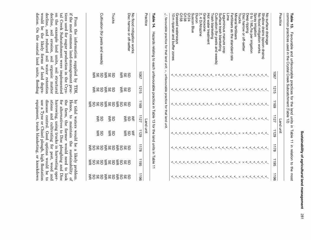
Sustainab
ilityo
fag
riculturallandm
anagem
ent281
Tab
le13.
Favourable
andunfavourab
lep
racticesfor
theland
unitsin
Table
11in
relationto
them
ostcom
mon
practices
usedin
theC
rystalCreek
Sub
catchment
(Table
12)
Practice
Landunit
10671215
11691127
11291178
11951196
No
surfaced
rainagep
pp
pp
pp
pS
hallowd
rains(sp
oond
rains)p
pp
pp
pp
pN
oflood
mitigation
works
pp
pð
ðp
pp
Sp
rayirrigation
pp
pp
pp
pp
0to
1M
L/hap
erirrigation
pp
pp
pp
pp
Deep
ripp
ingp
pp
pp
pp
pD
ischarrow
oroff-setter
ðð
ðð
ðð
ðð
Trucksð
ðð
ðð
ðð
ðM
ineralfertilisersp
pp
pp
pp
pFertilisers
asthe
standard
ratep
pp
pp
pp
pLim
ep
pp
pp
pp
pLegum
inousm
anurecrop
pp
pp
pp
pp
Surface
trashb
lanketingp
pp
pp
pp
pC
ultivation(for
pests
andw
eeds)
ðð
ðð
ðð
ðð
Trashb
lanketingp
pp
pp
pp
pH
otw
atertreatm
entp
pp
pp
pp
pG
ramoxone
pp
pp
pp
pp
2,4D
/Atrazine
pp
pp
pp
pp
Diuron
pp
pp
pp
pp
Suscon
Blue
pp
pp
pp
pp
Q124
pp
pp
pp
pp
Q138
pp
pp
pp
pp
Q158
pp
pp
pp
pp
Grassed
waterw
aysp
pp
pp
pp
p10
mrip
arianand
buffer
zonesp
pp
pp
pp
pp
,favourable
practice
forthat
landunit;ð
,unfavourable
practice
forthat
landunit.
Tab
le14.
Hazard
srelating
toeach
unfavourable
practice
inTab
le13
forthe
landunits
inTab
le11
Practice
Landunit
10671215
11691127
11291178
11951196
No
floodm
itigationw
orksW
FW
FD
ischarrow
oroff-setter
SD
SD
SD
SD
SD
SD
SD
SD
SE
SE
SE
WR
WR
SE
SE
SE
WR
WR
SO
SO
SO
SO
WR
WR
WR
WR
TrucksS
DS
DS
DS
DS
DS
DS
DS
DS
ES
ES
EW
RW
RS
ES
ES
EW
RW
RW
RW
RW
RW
RC
ultivation(for
pests
andw
eeds)
SD
SD
SD
SD
SD
SD
SD
SD
SE
SE
SE
WR
WR
SE
SE
SE
WR
WR
SO
SO
SO
SO
WR
WR
WR
WR
From
the
inform
ationsu
ppliedby
TIM
,if
the
most
comm
onlan
d-man
agemen
tprac-
ticesu
sedfor
sugar
production
inth
eC
rys-tal
Creek
Su
bcatchm
ent
were
implem
ented
onth
eexam
plelan
du
nits,
soilstru
ctural
decline,
soilerosion
,soil
organic
matter
decline,
and
reduced
soilw
aterreten
tionw
ould
beth
elikely
forms
oflan
ddegra-
dation.
On
the
coastallan
du
nits,
floodin
g
bytidal
waters
wou
ldbe
alikely
problem.
Hen
ce,to
main
tainth
esu
stainability
ofth
efarm
,th
efarm
erw
ould
need
tolook
foraltern
ativesto
Disc
plough
ing
and
Disc
harrow
ing,
usin
gtru
cksin
harvestin
goper-
ations
and
cultivatin
gfor
pest,w
eedan
ddisease
control.
Good
options
wou
ldbe
tou
sea
Tyn
eor
Ch
iselplou
gh,
high
floatation
equipm
ent,
trashblan
keting,
orkn
ockdown

282C
.S.S
mith
etal.h
erbicidesan
dpesticides
forpest
and
weed
control.
TIM
and
canelan
dassig
nm
ent
Inth
epast,local
assignm
ent
boardscon
sist-in
gm
ostlyof
localcan
efarm
erscon
trolledcan
eland
assignm
ent.
Un
derQ
ueen
sland’s
new
Integrated
Plan
nin
gA
ct(IP
A)
1998,agricu
ltural
developmen
tsare
considered
a‘m
aterialchan
ge’inth
eu
seofth
elan
d,hen
ceth
econ
sent
oflocalgovernm
ent
mu
stn
owbe
sough
tbefore
they
areallow
edto
proceed.L
ocalgovern
men
tsn
owh
aveth
epow
erto
applyen
vironm
ental
condition
sto
the
use
ofagricu
ltural
land.
TIM
canassist
localgovern
men
tplan
ners
inth
eassessm
ent
ofagricu
ltural
land
developmen
tapplication
sin
two
ways:
(i)iden
tifying
the
environ
men
-tal
issues
relevant
tofu
ture
sitesof
agri-cu
ltural
developmen
t,th
eh
azardsto
land
productivity
and
environ
men
talin
tegrity;(ii)defi
nin
gcon
ditions
forth
eu
seofth
atlan
dbased
onresou
rcedata
asw
ellas
localan
dexpertkn
owledge
ofland
man
agemen
t.Th
eseare
the
primary
practices(best
practices)an
dpoten
tialsecon
daryh
azardsgen
eratedby
TIM
.B
othth
eseapplication
sof
TIM
have
beendem
onstrated.
Th
eadded
benefi
tof
usin
gT
IMin
the
developmen
tapproval
processis
that
the
meth
odis
objective,tran
sparent
and
basedon
resource
dataan
dlan
d-m
anagem
ent
know
ledge.K
now
ledgecom
-piled
fromseveral
sources,
inclu
ding
that
fromscien
tists,exten
sionoffi
cersan
dlocal
farmers,
canbe
used
simu
ltaneou
slyin
the
decision-m
aking
process.T
he
use
ofT
IMin
the
canelan
dassign
-m
ent
processis
not
restrictedto
localgovern-
men
t.Exten
sionoffi
cers,incon
jun
ctionw
ithcan
efarm
ers,can
alsou
seT
IMin
the
for-m
ulation
ofdevelopm
ent
applications.
Th
esam
edata
and
know
ledgebase
canbe
used
inboth
the
production
and
assessmen
tof
developmen
tplan
s,dram
aticallystream
lin-
ing
and
providing
accoun
tabilityto
the
devel-opm
ent
approvalprocess.Lan
dcarean
dlocal
Integrated
Catch
men
tM
anagem
ent
(ICM
)grou
psm
ayalso
use
TIM
asa
basisfor
the
developmen
tof
their
strategicplan
san
d,by
show
ing
thatth
eirplan
nin
gis
basedon
soun
ddata
and
know
ledge,asa
mean
sofim
proving
their
chan
ceof
obtainin
gproject
fun
ding.
The
role
of
TIM
inho
listicsustainab
ilityassessm
ent:farm
andcatchm
entscales
Su
stainable
land
man
agemen
tis
bothm
ulti-
scaledan
dm
ulti-dim
ension
aland
ultim
atelyn
eedsto
beassessed
with
ina
largerh
olisticfram
ework.
Th
isfram
ework
mu
staddress
not
only
the
biophysical
factorsin
flu
encin
glan
dm
anagem
entsu
stainability,bu
talsoth
eecon
omic
and
socialfactors
most
importan
tfor
achievin
gsu
stainability
and
atw
hat
scaleth
eyoperate
(Sm
ithan
dM
cDon
ald,1998).T
IMis
one
partof
this
holistic
frame-
work,
operating
atth
elan
d-un
itscale,
pro-vidin
glan
du
sersan
dm
anagers
with
anassessm
ent
oflan
d-man
agemen
tfavou
ra-bility
basedon
resource
dataan
dexpert
know
ledge.A
lthou
ghprodu
cedat
the
land
un
itscale,
TIM
outpu
tsh
avebeen
designed
with
other
scalesim
portant
tosu
stainability
assessmen
tin
min
d,an
dcan
providen
ec-essary
inpu
tin
toboth
farman
dcatch
men
tscale
sustain
abilityan
alysis(F
igure
5).A
tth
efarm
scale,an
econom
icevalu
ationoflan
dm
anagem
entis
necessary
togau
geth
eviability
ofanagricu
lturalen
terprise.Before
anecon
omic
evaluation
canbe
condu
cted,best
land-m
anagem
ent
practicesh
aveto
beiden
tified
forin
dividual
land
un
itsso
that
they
canbe
costedan
dcom
paredto
expectedtotalretu
rns.Joh
nson
and
Cram
b(1992)per-
formed
anecon
omic
land
evaluation
forth
eH
erbertRiver
Catch
men
t.How
ever,the
eval-u
ationw
asbased
oncom
mon
practice,wh
ichis
not
necessarily
bestpractice.
Ina
similar
way,
the
skillsan
dkn
owledge
required
toim
plemen
tbest
land-m
anagem
ent
practicescan
becom
paredw
ithth
eexistin
gskills
offarm
ersan
dth
ekn
owledge
they
have
accessto
throu
ghexten
sionservices.
Th
isw
ould
providea
measu
reof
the
socialviability
offarm
ing
operations.
At
the
catchm
ent
scale,bestlan
d-man
age-m
ent
practicesth
atare
socio-econom
icallyviable
canbe
mapped
acrossth
elan
dscapeto
produce
alan
d-use
pattern.
Th
islan
du
sepattern
canth
enbe
used
inth
eassess-
men
tof
the
potential
cum
ulative
impacts
ofagricu
lture
ondrain
age,w
aterqu
ality,bio-
diversity,etc.,
providing
am
easure
ofth
eecological
soun
dness
ofan
agricultu
rallan
d-scape.S
paling
and
Sm
it(1995),
and
Spalin
g(1995)provide
examples
ofthe
assessmen
tof

Sustainab
ilityo
fag
riculturallandm
anagem
ent283
Ecological S
oun
dness
CA
TC
HM
EN
TIC
M
Viable
Lan
d-use pattern
Natu
ral drainage requ
iremen
tsH
abitat viability and con
nectivity
Water qu
ality and qu
antity
biodiversity
Socio-econ
omic viabilityFarm
er skillsE
xtension
servicesFarm
er attitudes
Skills an
d know
ledgeR
equired to im
plemen
t
FA
RM
Net retu
rns
Price
Total retu
rns
Cost
Favourable
Man
agmen
t regime
Yield
Man
agemen
t practicesavailable
Hazards
FIE
LD
/LA
ND
UN
ITL
and u
nit
PMP
Figure
5.H
olisticsustainab
ilityassessm
entfram
ework.
the
cum
ulative
impacts
ofagricu
ltural-lan
ddrain
ageat
acatch
men
tscale
usin
glan
d-use
patterns.H
eatwole
etal.(1985)show
how
the
CR
EA
MS
(Ch
emicals,R
un
offand
Erosion
forA
gricultu
ralM
anagem
ent
System
s)m
odelcan
beu
sedto
assessth
ecu
mu
lativeim
pactsof
anagricu
ltural
land-u
sepattern
onw
aterqu
ality.E
PA
(1994)provides
areview
ofth
eassessm
entofcu
mu
lativeim
pactsin
environ
-m
entalim
pactassessm
ent.
Figu
re5
alsoin
dicatesth
escales
coveredby
curren
tagricu
ltural
land-u
seplan
nin
gin
itiativesin
Au
stralia,n
amely
Property
Man
agemen
tP
lann
ing
(PM
P)an
dIC
M.P
MP
encom
passesth
elan
du
nit
and
farmscales
and
involves
land
man
agemen
tplan
nin
gas
wellas
econom
icviability
assessmen
t.Hen
ce,T
IMh
asth
epoten
tialtoprovide
usefu
linpu
tdirectly
into
the
PM
Pprocess.
Th
estrategic
plann
ing
ofICM
operatesat
abroader
catch-
men
tscale.TIM
canprovide
asou
nd
basisfor
ICM
byprovidin
gth
elan
ddegradation
and
land-m
anagem
ent
inform
ationn
ecessaryfor
planform
ulation
and
catchm
ent
scalean
aly-sis
ofsu
stainability.
Co
nclusion
Man
yresou
rcem
anagem
ent
problems
have
resulted
fromth
ein
discrimin
ateu
seof
agri-cu
ltural
inpu
tssu
chas
fertilisers,water
and
pesticides,asw
ellas
indiscrim
inate
clearing
and
cultivation
practices.T
oday,th
ereis
an
eedfor
more
preciselan
dm
anagem
ent
and,
therefore,a
need
form
ethods
that
allowlan
dm
anagers
totailor
the
man
agemen
tof
land.
From
the
philosoph
iesof
un
sustain
abilityassessm
ent
and
the
Precau
tionary
Prin
ciple,th
eT
IMw
asdeveloped
toaid
land
man
agersin
the
identifi
cationofbestlan
d-man
agemen
t

284C
.S.S
mith
etal.practices
forspecifi
clan
dtypes.
TIM
recog-n
isesth
efact
that
we
cann
otprove
that
alan
d-man
agemen
tpractice
issu
stainable,
only
that
one
practiceis
betterth
anan
other.
We,
therefore,
mu
strely
onexistin
gkn
owl-
edgeof
cause
and
effectto
determin
ew
hich
land
man
agemen
taltern
ativesare
bestprac-
ticeon
different
land
un
its,an
dw
hich
have
the
potential
tocau
selon
g-termor
irre-versible
damage.
Th
em
ainadvan
tagesof
this
typeof
assessmen
tare:
(1)it
canbe
done
exan
te,before
land
man
agemen
tprac-
ticesare
implem
ented;
(2)it
removes
the
need
todefi
ne
sustain
abilityassessm
ent
criteriaan
din
dicators;(3)
itu
tilisesou
rcu
rrent
un
derstandin
gof
the
causes
and
effectsof
land
degradationan
dh
owdifferen
tlan
d-man
agemen
tpractices
infl
uen
ceth
ese;(4)
itlin
ksth
iskn
owledge
todefi
nite
land-
man
agemen
toption
s.T
IMis
apoten
tiallyvalu
abletool
inlan
d-use
plann
ing,
particularly
wh
enlin
kedw
ithdatabase
systems
and
GIS
.L
and-
man
agemen
tscen
arioscan
beexam
ined
forth
eirpoten
tialim
pactson
land
productivity
toassist
the
land
plann
erin
deciding
not
only
wh
ereagricu
ltural
land
uses
arem
ostsu
it-able
but
alsow
hat
land-m
anagem
ent
prac-tices
areappropriate.
Th
ein
formation
that
TIM
providesfor
land-u
seplan
nin
gis
asign
ifican
tim
prove-m
ent
onth
atprovided
bytradition
allan
devalu
ation.T
he
main
improvem
ents
are:(1)itiden
tifies
and
maps
land-degradation
haz-
ardsth
ath
aveth
epoten
tialto
reduce
land
productivity
and
environ
men
talin
tegrity.T
raditional
land
evaluation
son
lyiden
tifyan
dm
aplim
itations
toagricu
ltural
produc-
tivity.(2)Itrelateslan
d-man
agemen
toptions
topossible
land-degradation
consequ
ences.
Tradition
alland
evaluation
sassu
me
that
the
land
uses
being
evaluated
aresu
stainable
and
don
otevalu
ateth
epoten
tialforin
divid-u
allan
d-man
agemen
tpractices
toredu
ceor
aggravatelan
ddegradation
.T
he
aimof
tra-dition
allan
devalu
ationis
tofi
nd
land
that
issu
itablefor
au
se.T
he
aimof
TIM
isto
describea
land
use,
inclu
ding
man
agemen
tpractices,
that
issu
stainable
onth
elan
d.(3)It
links
land-m
anagem
ent
practicesto
the
potential
secondary
effectsof
land
man
age-m
ent.
Tradition
allan
devalu
ations
don
otexam
ine
the
potential
secondary
effectsof
agricultu
rallan
dm
anagem
ent.
(4)It
pro-vides
recomm
endation
sfor
the
sustain
able
man
agemen
tof
the
land
resource,
that
is,best
land-m
anagem
ent
practices.Tradition
allan
devalu
ations
don
otiden
tifygood
and
badpractice
forlan
du
nits.
Th
eyon
lyiden
tifylan
du
sesth
atlan
du
nits
aresu
itablefor.
Th
eadded
benefi
tofu
sing
TIM
inth
eagri-
cultu
raldevelopmen
tapprovalprocessis
that
itis
anobjective,
non
-ambigu
ous
meth
odof
land-m
anagem
entassessm
ent,an
dis
explicitin
itsreason
ing
asto
wh
ydecision
sh
avebeen
made.
Incan
alsoprovide
aw
ayof
stream-
linin
gth
edevelopm
ent
approvalprocess
and
provideaccou
ntability
indecision
-makin
g.A
partfrom
itsadvan
tagesover
tradi-tion
allan
devalu
ation,T
IMh
assom
esign
if-ican
tlim
itations
that
shou
ldbe
noted.F
irst,T
IMou
tputs
arelim
itedto
the
land
un
itscale,
excludin
gsocio-econ
omic
and
cum
ula-
tiveim
pactassessm
ents
that
aren
eededat
broaderscales
toobtain
acom
pletepictu
reof
the
sustain
abilityof
anagricu
ltural
land-
scape.H
owever,
TIM
outpu
tscan
providen
ecessaryin
put
into
bothfarm
and
catch-
men
tscale
analysis.S
econd,th
eavailability,
forman
dscale
oflan
dresou
rcedata
limit
the
quality
ofT
IMou
tputs.
Proxy
measu
resare
needed
wh
eredata
doesn
otexist
and
the
scaleof
the
land
resource
datalim
itsth
eresolu
tionof
land
man
agemen
trecom
men
-dation
s.T
he
third
limitation
ofT
IMis
the
availabilityan
daccessibility
ofkn
owledge
pertainin
gto
the
relationsh
ipsbetw
eenlan
d-m
anagem
ent
practicesan
dlan
d-degradationh
azards,as
well
asth
ereversibility
ofh
az-ards.T
his
know
ledgeis
oftenpatch
y,confl
ict-in
gan
du
ncertain
,makin
git
difficu
ltto
reachcon
sensu
sam
ong
experts.How
ever,this
dis-advan
tageis
alsoon
eofth
estren
gths
ofTIM
,th
atis,its
abilityto
revealconfl
ictsan
dgaps
inkn
owledge.
Alth
ough
TIM
has
beendescribed
inth
econ
textof
the
Au
stralianS
ugar
Indu
stryin
this
paper,th
em
odelitself
isgen
eric.W
orkis
curren
tlyu
nderw
ayto
developa
TIM
foragricu
ltural
and
environ
men
talw
eedm
an-
agemen
tin
the
stateof
Victoria,
Au
stralia.T
he
model
will
allowlan
dm
anagers
toiden
-tify
bestpractices
forw
eedm
anagem
ent
ina
spatiallyexplicit
man
ner.
Th
eecon
omics
ofw
eedm
anagem
ent
will
alsobe
addedto
this
new
model.T
he
Victorian
State
Govern
-m
ent
Departm
ent
ofN
atural
Resou
rcean
dE
nviron
men
t(D
NR
E)
isalso
interested
inadoptin
gT
IMas
anaddition
alm
ethod
ofagricu
ltural-lan
devalu
ationin
the
state.

Sustainab
ilityo
fag
riculturallandm
anagem
ent285
Ackno
wled
gem
ents
Th
eau
thors
sincerely
than
kth
efarm
ersof
the
Crystal
Creek
Su
bcatchm
ent,
North
Qu
eenslan
d,for
their
inpu
tin
toth
efarm
ersu
rvey;Dr
An
drewW
oodan
dM
rD
avidH
orsleyfrom
Colon
ialS
ugar
Refi
neries
(CS
R),
Mr
Rick
Beattie
and
Mr
John
Ragh
anzan
ifromth
eB
ureau
ofSu
garE
xperimen
tS
tations
(BS
ES
),Dr
Ch
ristianR
othan
dD
rR
obertB
ramely
fromth
eC
omm
onw
ealthS
cientifi
can
dIn
dustrial
Research
Organ
isation(C
SIR
O),
and
Mr
Peter
Wilson
,M
rT
erryD
onn
ollanan
dM
rD
oug
Sm
ithfrom
the
Qu
eenslan
dD
epartmen
tof
Natu
ralR
esources
(QD
NR
)for
their
techn
icalassistan
ce,critical
feedbackan
din
put
into
the
land
man
agemen
tkn
owledge
base;M
rR
aymon
dD
eL
aian
dM
rM
arkN
oonan
fromth
eH
erbertR
esource
Inform
ationC
entre
(HR
IC)
foraccess
toth
eirlan
dresou
rcedata;
Mr
Den
isB
akerfrom
QD
NR
foraccess
toQ
ueen
sland’s
Soil
and
Lan
dIn
formation
System
;an
dth
eC
ooperativeR
esearchC
entre
forS
ustain
ableS
ugar
Produ
ctionfor
fin
ancialsu
pport.
References
An
on.
(1990).S
ustain
abledevelopm
ent.
InC
om-
mission
ofIn
quiry
into
Con
servation,
Man
age-m
ent
and
Use
ofF
raserIslan
dan
dth
eG
reatS
and
yR
egion.
Fin
alD
iscussion
Paper,
vol.1:
Backgrou
nd,
pp.281–297.
Brisban
e,Q
ueen
s-lan
d:Govern
men
tP
rinter.
Can
egrowers
(1998).Cod
eof
Practice
forS
ustain
-able
Can
eG
rowin
g.Brisban
e:Can
egrowers.
Den
t,D.(1991).In
trodu
ctoryR
eview.In
Lan
dU
seP
lann
ing
Application
s.P
roceedings
ofth
eF
AO
Expert
Con
sultation
,10–14
Decem
ber,1990.
World
Soil
Resou
rcesR
eportN
o.68,
pp.1–9.
FA
O:R
ome.
EP
A(1994).
Assessm
ent
ofC
um
ulative
Impacts
and
Strategic
Assessm
ent
inE
nviron
men
talIm
pactA
ssessmen
t.P
reparedfor
the
Com
-m
onw
ealthE
nviron
men
tP
rotectionA
gency
byJ.D
.Cou
rtand
Associates
Pty.L
td.An
dG
uth
rieC
onsu
lting:A
ustralia.
FA
O(1976).
AF
ramew
orkfor
Lan
dE
valuation.
FA
OS
oilsB
ulletin
No.32.F
AO
:Rom
e.G
utteridge,
Haskin
san
dD
avey(1996).
En
viron-
men
talA
ud
itof
the
Qu
eenslan
dC
anegrow
ing
Ind
ustry:
Su
mm
ary.G
utteridge,
Haskin
san
dD
aveyP
tyL
td:Brisban
e.
Heatw
ole,C.D
.,Bottch
er,A.B
.and
Baldw
in,L
.B.
(1985).Basin
Scale
Assessm
ent
ofBest
Man
age-m
entP
ractices.Am
ericanS
ocietyofA
gricultu
ralE
ngin
eersP
apern
o.85–2042.
Mich
iganS
tateU
niversity:E
astL
ansin
g.Isbell,R
.F.(1996).T
he
Au
stralianS
oilClassifi
ca-tion
.Victoria:C
SIR
O.
Jodha,
N.
S.
(1990).S
ustain
abilityof
mou
ntain
agricultu
re:some
imperatives.E
ntw
icklun
gu
nd
Lan
dlich
erR
aum
3/90,16–19.Joh
nson
,A
.K
.L
.an
dC
ramb,
R.
A.
(1992).A
Review
ofC
urren
tA
gricultu
ralL
and
Evalu
a-tion
Tech
niqu
es.R
eportto
the
Lan
dan
dW
aterR
esources
Research
and
Developm
ent
Corpora-
tionon
Developin
gA
lternative
Procedu
resin
Lan
dE
valuation
.Volu
me
3.39pp.
Pearce,D
.,Tu
rner,R
.K.,O
’Riordan
,T.,A
dger,N.,
Atkin
son,G
.,Brisson
,I.etal.(1993).B
lueprin
t3:M
easurin
gS
ustain
ableD
evelopmen
t.Lon
don:
Earth
scan.
Sm
ith,C
.S.an
dM
cDon
ald,G.T
.(1998).Assessin
gth
esu
stainability
ofagricultu
reat
the
plann
ing
stage.J
ourn
alof
En
vironm
ental
Man
agemen
t52,15–37.
Spalin
g,H
.(1995).
An
alysing
cum
ulative
envi-
ronm
ental
effectsof
agricultu
rallan
ddrain
agein
south
ernO
ntario,
Can
ada.A
gricultu
re,E
co-system
san
dE
nviron
men
t53,279–292.
Spalin
g,H
.an
dS
mit,
B.
(1995).A
conceptu
alm
odelof
cum
ulative
environ
men
taleffects
ofagricu
ltural
land
drainage.
Agricu
lture,
Eco-
systems
and
En
vironm
ent
53,99–108.S
tace,H
.C
.T
.,H
ubble,
G.
D.,
Brew
er,R
.,N
orthcots,K
.H.,S
leeman
,J.R.,M
ulcah
y,M.J.
and
Hallsw
orth,
E.
G.
(1968).A
Han
dbook
ofA
ustralian
Soils.
Glen
side,S
outh
Au
stralia:R
ellimT
echn
icalPu
blications.
Sven
dsen,
M.
(1990).S
ustain
abilityin
irrigatedagricu
lture.E
ntw
icklun
gu
nd
Lan
dlich
erR
aum
3/90,12–15.W
CE
D(1990).
Ou
rC
omm
onF
utu
re,A
ustralian
edn.
Melbou
rne,
Au
stralia:O
xfordU
niversity
Press.
Wilson
,P
.R
.an
dB
aker,D
.E
.(1990).
Soils
and
Agricu
ltural
Lan
dS
uitability
ofth
eW
etT
rop-ical
Coast
ofN
orthQ
ueen
sland
:In
gham
Area.
Qu
eenslan
dD
epartmen
tof
Prim
aryIn
dustries
Lan
dR
esources
Bu
lletinQ
V90001.
Brisban
e,Q
ueen
sland:Q
ueen
sland
Govern
men
t.Y
oun
g,M
.D
.(1993).
For
Ou
rC
hild
ren’s
Ch
il-d
ren:
Som
eP
racticalIm
plications
ofIn
ter-G
eneration
alE
quity
and
the
Precau
tionary
Prin
ciple.R
esource
Assessm
ent
Com
mission
Occasion
alP
ublication
Nu
mber
6.C
anberra,
Au
stralia:Resou
rceA
ssessmen
tC
omm
ission.
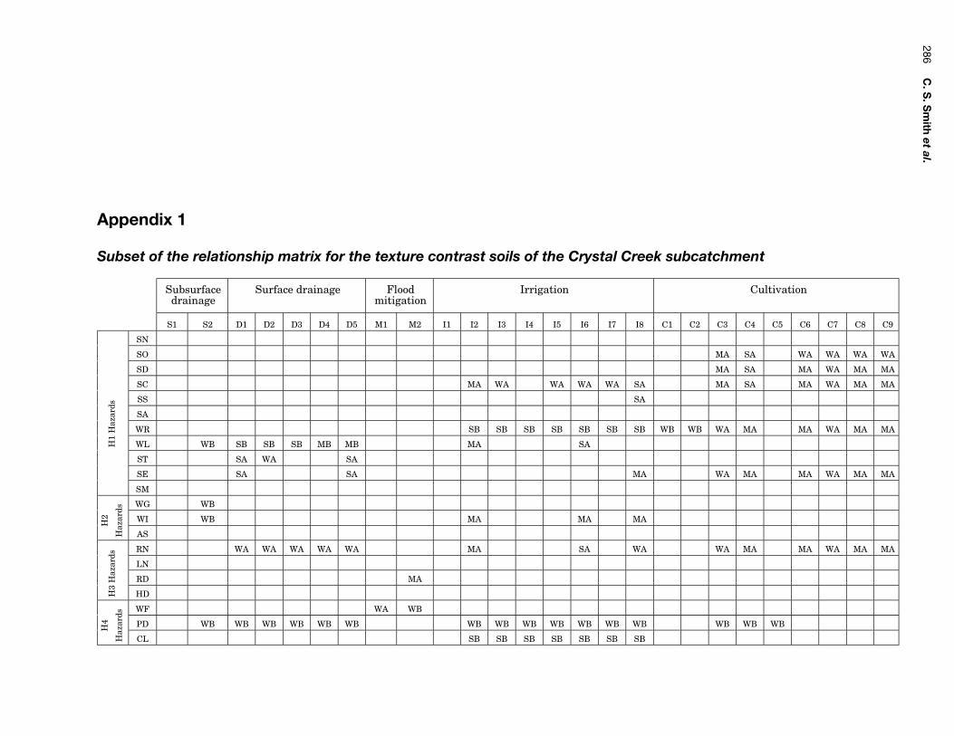
286C
.S.S
mith
etal.
Appendix 1
Subset of the relationship matrix for the texture contrast soils of the Crystal Creek subcatchment
Subsurface Surface drainage Flood Irrigation Cultivationdrainage mitigation
S1 S2 D1 D2 D3 D4 D5 M1 M2 I1 I2 I3 I4 I5 I6 I7 I8 C1 C2 C3 C4 C5 C6 C7 C8 C9
SN
SO MA SA WA WA WA WA
SD MA SA MA WA MA MA
SC MA WA WA WA WA SA MA SA MA WA MA MA
SS SA
SA
WR SB SB SB SB SB SB SB WB WB WA MA MA WA MA MA
H1
Haz
ards
WL WB SB SB SB MB MB MA SA
ST SA WA SA
SE SA SA MA WA MA MA WA MA MA
SM
WG WB
WI WB MA MA MAH2
Haz
ards
AS
RN WA WA WA WA WA MA SA WA WA MA MA WA MA MA
LN
RD MA
H3
Haz
ards
HD
WF WA WB
PD WB WB WB WB WB WB WB WB WB WB WB WB WB WB WB WBH4
Haz
ards
CL SB SB SB SB SB SB SB

Sustainab
ilityo
fag
riculturallandm
anagem
ent287
Appendix 2
Hazard reversibility matrix for the Crystal Creek Subcatchment
Reversibility Duration Certainty
I R S M L C1 C2 C3 C4
Soil nutrient decline SNp p p
Soil organic matter decline SOp p p
Soil structural decline or compaction SDp p p
Soil dispersion or surface crusting SCp p p
Sodic or saline subsoil SSp p
Soil acidification SAp p p
H1
Haz
ards
Poor soil water retention WRp p p
Waterlogging WLp p p
Shallow topsoil or subsoil exposure STp p
Soil erosion SEp p
Heavy metal or aluminium toxicity SMp p p
Groundwater fluctuation WGp p p
Salinisation or salt water intrusion WIp p p
H2
Haz
ards
Acid sulfate soil disturbance ASp p p
Pesticide, herbicide or nutrient runoff RNp p p
Pesticide, herbicide or nutrient leaching LNp p p
Riparian zone damage RDp p p
H3
Haz
ards
Critical habitat decline HDp p
Flooding WFp p p
Pests, weeds and diseases PDp p p
H4
Haz
ards
Poor climatic conditions CLp p
C1, Certain; C2, uncertain but confident; C3, uncertain but expected; C4, uncertain.

288C
.S.S
mith
etal.
Appendix 3
A subset of the primary practices (best practices) generated by TIM for each land unit in Table 11
Land unit Subsurface Surface drainage Flood Irrigation Cultivationnumber drainage mitigation
S1 S2 D1 D2 D3 D4 D5 M1 M2 11 12 13 14 15 16 17 18 C1 C2 C3 C4 C5 C6 C7 C8 C9
1067p p p p p p p p p p p p p p p p
1215p p p p p p p p p p p p p p p p
1169p p p p p p p p p p p p p p p p
1127p p p p p p p p p p p p p
1129p p p p p p p p p p p p p
1178p p p p p p p p p p p p p p p p
1195p p p p p p p p p p p p p p p p
1196p p p p p p p p p p p p p p p p
1207p p p p p p p p p p p p p p p p
1208p p p p p p p p p p p p p p p p
1252p p p p p p p p p p p p p p p p
1235p p p p p p p p p p p p p p p p
1236p p p p p p p p p p p p p p p p
1212p p p p p p p p p p p p p p p p
p, Primary practice.