this project was funded by caltrans through a
TRANSCRIPT

DECEMBER 2004

This project was funded by Caltrans through a
Community Based Transportation Planning Grant.
POLICY ADVISORY COMMITTEE:
Nancy Nadel, Oakland City Council Member
Danny Wan, Oakland City Council Member
Lynette Sweet, BART Board Member
Carole Ward-Allen, BART Board Member
PROJECT TEAM:
Natalie Fay, City of Oakland
Pamela Kershaw, Port of Oakland
Tina Spencer, AC Transit
Andrew Thomas, City of Alameda
Carolyn Trunnell, Caltrans
John Nemeth, BART
Val Menotti, BART
Marian Lee-Skowronek, BART
Jim Gravesande, BART
Ric Rattray, BART
Sam Lau, BART
CONSULTANT TEAM:
Daniel Iacofano, MIG, Inc.
Rosemary Dudley, MIG, Inc.
Paul Tuttle, MIG, Inc.
Lou Hexter, MIG, Inc.
Jerry Walters, Fehr & Peers
Gregory Saurs, Fehr & Peers
Robert Rees, Fehr & Peers
Eddie Barrios, Fehr & Peers
Thomas Matoff, LTK Engineering Services
John Schumann, LTK Engineering Services
A C K N O W L E D G E M E N T S
1 : I N T R O D U C T I O N . . . . . . . . . . . . . . . . . . . . . . . . . . . . . . 5
Project Background . . . . . . . . . . . . . . . . . . . . . . . . . . . . . . . . . . . . . . . . . . . . . . . . . . . . . . . . . .6BART’s Priorities and Project Goals . . . . . . . . . . . . . . . . . . . . . . . . . . . . . . . . . . . . . . . . . . . . .6The Planning Process . . . . . . . . . . . . . . . . . . . . . . . . . . . . . . . . . . . . . . . . . . . . . . . . . . . . . . . . .7
2 : E X I S T I N G C O N D I T I O N S . . . . . . . . . . . . . . . . . . . . . . . . . . . . . . 1 1
Jack London District . . . . . . . . . . . . . . . . . . . . . . . . . . . . . . . . . . . . . . . . . . . . . . . . . . . . . . . .12Travel Markets . . . . . . . . . . . . . . . . . . . . . . . . . . . . . . . . . . . . . . . . . . . . . . . . . . . . . . . . . . . . .15Existing Transit Service . . . . . . . . . . . . . . . . . . . . . . . . . . . . . . . . . . . . . . . . . . . . . . . . . . . . . .15
3 : A LT E R N AT I V E S C O N S I D E R E D . . . . . . . . . . . . . . . . . . . . . . . . . 1 7
Infill BART Station . . . . . . . . . . . . . . . . . . . . . . . . . . . . . . . . . . . . . . . . . . . . . . . . . . . . . . . . . .18Group Rapid Transit (GRT) . . . . . . . . . . . . . . . . . . . . . . . . . . . . . . . . . . . . . . . . . . . . . . . . . . .20Underground BART Shuttle . . . . . . . . . . . . . . . . . . . . . . . . . . . . . . . . . . . . . . . . . . . . . . . . . . .22Streetcar . . . . . . . . . . . . . . . . . . . . . . . . . . . . . . . . . . . . . . . . . . . . . . . . . . . . . . . . . . . . . . . . . .24Distinctive Bus or Shuttle . . . . . . . . . . . . . . . . . . . . . . . . . . . . . . . . . . . . . . . . . . . . . . . . . . . . .31
4 : R E F I N E M E N T O F S T R E E T C A R A LT E R N AT I V E . . . . . . . . . . . . . 3 3
Alignment Options . . . . . . . . . . . . . . . . . . . . . . . . . . . . . . . . . . . . . . . . . . . . . . . . . . . . . . . . . .34Alignment Conclusions . . . . . . . . . . . . . . . . . . . . . . . . . . . . . . . . . . . . . . . . . . . . . . . . . . . . . . .39Streetscape Compatibility . . . . . . . . . . . . . . . . . . . . . . . . . . . . . . . . . . . . . . . . . . . . . . . . . . . . .41Traffic Impacts . . . . . . . . . . . . . . . . . . . . . . . . . . . . . . . . . . . . . . . . . . . . . . . . . . . . . . . . . . . . .45
5 : S T R E E T C A R F U N D I N G C O N C E P T S . . . . . . . . . . . . . . . . . . . . . 4 9
Capital Funding . . . . . . . . . . . . . . . . . . . . . . . . . . . . . . . . . . . . . . . . . . . . . . . . . . . . . . . . . . . .50Operations Funding . . . . . . . . . . . . . . . . . . . . . . . . . . . . . . . . . . . . . . . . . . . . . . . . . . . . . . . . .51
6 : C O N C L U S I O N S . . . . . . . . . . . . . . . . . . . . . . . . . . . . . . . . . . . . 5 3
Lessons from Other Cities . . . . . . . . . . . . . . . . . . . . . . . . . . . . . . . . . . . . . . . . . . . . . . . . . . . .54Next Steps . . . . . . . . . . . . . . . . . . . . . . . . . . . . . . . . . . . . . . . . . . . . . . . . . . . . . . . . . . . . . . . .55
J A C K L O N D O N B A R T F E A S I B I L I T Y S T U D Y | 3
TA B L E O F C O N T E N T S

1 : I N T R O D U C T I O N 5
Project Background 6BART’s Priorities and Project Goals 6The Planning Process 7
“...the connection between downtown Oakland and the
Jack London Square District is a necessary component
to create the energy that both destinations need to
thrive.”

J A C K L O N D O N B A R T F E A S I B I L I T Y S T U D Y | 5
Jack London Square has always been a hub of activity, first as an active
seaport and more recently as an entertainment district for Bay Area resi-
dents and visitors. Located ten blocks south of the heart of downtown
Oakland, Jack London Square (JLS) offers a glimpse into the history of
Oakland’s industrial seaport, which has been adapted to provide visitors a
unique experience that capitalizes on the port’s identity. The area features
a cluster of entertainment venues, including restaurants, bars, performance
spaces, and a movie theater. While these activities raise Jack London
Square’s profile as a regional destination, the area is separated from
downtown by the I-880 freeway and is just far enough away
from BART that it requires additional effort to reach, lim-
iting its visitors. Given the perception of inaccessibility, stakeholders
in the Jack London District, including the Port of Oakland, local mer-
chants, residents, and developers, were interested in improving connections
to downtown Oakland, the BART system, and adjacent neighborhoods.
These interested parties brought their concerns to the City of Oakland
and the City requested that BART initiate a study on how to better con-
nect JLS to the downtown area and the BART network.
1: Introduction
I N T R O D U C T I O N

1: Introduction > Project Background
6 | J A C K L O N D O N B A R T F E A S I B I L I T Y S T U D Y
1.1 Project Background
In 2001, the City of Oakland requested that
BART study an infill station in the vicinity of
Jack London Square on the existing train line.
The City of Oakland’s Estuary Policy Plan
(1999), an element of the City’s General Plan,
had also identified the need to connect JLS to
downtown. BART conducted an Opportunity
Scan to examine future land use and transporta-
tion opportunities, identify stakeholders, develop
project goals, and develop a scope of work for
further study.
After this initial assessment, stakeholders com-
prised of local business owners, nonprofit agen-
cies, and residents supported BART staff ’s effort
to seek funding to study the feasibility of an infill
BART station in greater detail. In 2003, the City
of Oakland and BART obtained funding from
the Caltrans Community-Based Transportation
Planning Grant Program to proceed with the
study.
BART initiated the Jack London BART Feasibility
Study in 2003 to determine the feasibility of con-
structing an additional BART station near Jack
London Square. Ultimately, however, a variety of
transit alternatives were considered and compared
in this study with input that included public meet-
ings and technical analysis, such as technology
options, ridership forecasts, engineering and oper-
ations analysis, and estimated construction and
operating costs.
1.2 BART’s Priorities and Project Goals
BART has established the following goals to
determine and prioritize its system expansion
projects:
– Enhance regional mobility, especially access to jobs.
– Generate new ridership on a cost-effectivebasis.
– Demonstrate a commitment to transit-supportive growth and development.
– Enhance multimodal access to the BART
system.
– Develop projects in partnership withcommunities that will be served.
– Implement and operate technology-appropriate service.
– Assure that all projects address the needs ofthe District’s residents.
In addition to BART’s system expansion goals,
the project stakeholders identified the following
goals and objectives in 2002 for the Jack London
Study:
– Examine the feasibility of a BART station inthe JLS vicinity to improve regional transitaccess and intermodal connections.
– Generate new transit ridership on a cost-effective basis, encourage off-peak ridership,and support entertainment uses.
– Enhance the regional image and identity ofthe entire Jack London District.
– Support mixed-use, higher-density develop-ment and a pedestrian-friendly environment.
“Ultimately...a variety
of transit alternatives
were considered and
compared in this
study through input
that included commu-
nity meetings and
technical analysis...”

J A C K L O N D O N B A R T F E A S I B I L I T Y S T U D Y | 7
1: Introduction > The Planning Process
1.3 The Planning Process
In 2003, BART began the study by assembling a
Project Team, which consisted of local partners
including: the City of Oakland, City of Alameda,
Port of Oakland, and AC Transit. BART also
finalized the workscopes, budgets and agreements
for its consultants, which included: MIG, LTK
Engineering Services, and Fehr & Peers. To pro-
vide oversight, the Project Team assembled a
Policy Advisory Committee (PAC), which consist-
ed of BART Board Members, Lynette Sweet and
Carole Ward Allen, and Oakland City Council
Members, Danny Wan and Nancy Nadel. In addi-
tion, the Project Team considered future Alameda
Point improvements, as well as AC Transit,
Capitol Corridor, and Ferry plans to determine
how they might affect this study.
The study included four stakeholder meetings at
which the Project Team received comments from
representatives of local agencies, nonprofit
organizations, businesses, and residents.
In December 2003, the Project Team conducted
the first Stakeholder Meeting. Three conceptual
alternatives were presented at this meeting: the
BART Infill Station, an Underground BART
Shuttle, and an electric streetcar. At the request of
a stakeholder, an additional alternative was includ-
ed for consideration: Group Rapid Transit
(GRT).
BART engineering and operations staff then
reviewed the feasibility of an infill station on the
existing BART line in the vicinity of Jack London
Square. An infill station at the desired location
would not fit into the existing track geometry
without major modifications. Consequently, it was
determined to be infeasible and not reviewed fur-
ther. An infill station closer to West Oakland was
found to be feasible, but did not satisfy project
goals given its distance from JLS.
Consultants also considered a GRT alternative
and determined that it would not be an appropri-
ate technology given the goals of the study and
local preferences. As a result, this alternative was
also no longer considered in the study.
The two other transit alternatives: an electric
streetcar connecting JLS to the 12th Street
Station area and an Underground BART Shuttle
connecting JLS directly into the 12th Street
Station itself were both carried on for further
BART staff considered many alternatives which they presented tothe public for review throughout the study.

1: Introduction > The Planning Process
8 | J A C K L O N D O N B A R T F E A S I B I L I T Y S T U D Y
analysis. The Project Team developed conceptual
alignments, service assumptions, operational and
maintenance plans, and rough capital and operat-
ing costs for these two alternatives. Based on
travel demand models, fieldwork, interviews, and
a review of comparable systems, consultants also
estimated future ridership for these two alterna-
tives.
The Project Team conducted a second
Stakeholder Meeting in March 2004 to present
the two alternative transit options still under con-
sideration. The PAC was intrigued with the long-
term prospect of a new BART line beginning at
12th Street Station that could link to both JLS
and Alameda, with either a single or double track.
These “Alameda-oriented” BART extension con-
cepts have the potential to be further investigated
in upcoming 2005 studies sponsored and directed
by the City of Alameda. The PAC, however, was
not interested in further investigation of a single-
tracked underground BART shuttle that simply
terminated at JLS, given its relatively high costs.
To improve both the connection from the 12th
Street area to JLS and downtown circulation, the
PAC advised staff to continue to refine and
explore the streetcar alternative. It also advised
that staff consider rubber-tire (bus/shuttle) alter-
natives to a streetcar.
Given this direction, the Project Team hosted an
interactive design “charrette” as the third
Stakeholder Meeting in July 2004. The Team pre-
sented five streetcar alignment options to the
stakeholders for feedback, encouraging partici-
pants to formulate additional routes. All of the
options, at a minimum, connected 12th Street to
Broadway at 2nd Street near Jack London Square.
The Team compared and evaluated the operating
characteristics, potential stop locations, capital
and operating costs, and the ridership projections
for these five options. The Team also presented a
rubber-tire (bus/shuttle) alternative for each of
the five alignment scenarios.
The meeting included an interactive work session
to allow participants to compare the five streetcar
options. Stakeholders were divided into small
groups to discuss the advantages and disadvan-
tages of each alignment and determine which
streetcar alignment best met the project goals. No
single option appealed universally to all stake-
holders, with each generating a list of pros and
cons. Two options, however, stood out as having
the broadest appeal among participants. The first
was the “small” loop option that would use
Washington, Franklin and Webster Streets as the
primary corridors, and the second was a simple
alignment along Broadway. Either of these could
serve as the first phase of a potentially bigger cir-
culation system. Lastly, the stakeholders showed
little interest in a new, distinctive bus or shuttle
service in lieu of, or as a prelude to, a future
streetcar.

1: Introduction > The Planning Process
J A C K L O N D O N B A R T F E A S I B I L I T Y S T U D Y | 9
P L A N N I N G P R O C E S S G R A P H I C
Following the meeting, BART staff began to
develop a funding strategy for the proposed
streetcar by first conducting research on other
successful streetcar systems in the United States.
Given the limited availability of public funds in
the near term, the method used by Portland,
Oregon and Tampa, Florida that involved a local
voluntary assessment district to cover a share of
costs was an attractive model. At the request of
several stakeholders, BART staff met with devel-
opers and property owners in the Jack London
District and downtown to discuss the idea.
To refine these two streetcar options further, the
Project Team studied the compatibility of a
streetcar in these two alignments with current
City of Oakland streetscape improvement plans.
Given the concerns expressed by the PAC, con-
sultants also analyzed the impact of a streetcar on
traffic circulation along these two alignments.
Both of these analyses determined that a street-
car would be feasible, but could require some
street modifications.
In December of 2004, the Final Public Meeting
was held to discuss the study’s conclusions and
potential next steps. There was strong support
from the PAC for a new bus or shuttle service
given its lower development costs. At the same
time others in attendance considered creating a
nonprofit to keep the streetcar concept alive.

2 : E X I S T I N G C O N D I T I O N S 1 1
Jack London District 12Travel Markets 15Existing Transit Service 15
“...All this development greatly increases the need for transit
options that link Jack London District to other parts of
downtown.”

J A C K L O N D O N B A R T F E A S I B I L I T Y S T U D Y | 11
The Jack London District and surrounding districts are experiencing a sig-
nificant amount of new housing development in response to the Oakland
10K Initiative. Now more than ever, Jack London Square could benefit
from a permanent transit service to connect this new residential and
mixed-use development to the rest of downtown.
This chapter provides an overview of the Jack London area, including the
locations of recent and planned development, increased travel demand, the
level of service that currently exists, and the expected transit ridership.
The growth in this district will influence the anticipated number of people
who choose to use public transit to travel within downtown and to make
connections beyond.
2: Existing Conditions
E X I S T I N G C O N D I T I O N S

2: Existing Conditions > JLS Surroundings
12 | J A C K L O N D O N B A R T F E A S I B I L I T Y S T U D Y
2.1 Jack London District
The Jack London District is surrounded by a
number of other thriving districts, including
Chinatown, Old Oakland, City Center, the
Produce District, and the Waterfront Warehouse
District. Each district draws its own base of
clientele and enlivens downtown with streetscape
activity. Further north of downtown is the
Lakeside neighborhood and the planned mixed-
use Uptown District.
The land uses surrounding Jack London Square
are primarily mixed-use industrial, commercial,
and residential. Immediately north of the district
are warehouses that have been converted into
entertainment venues and office space. Interstate
880 (I-880) creates a physical separation between
downtown and the southern districts, including
Jack London District, the Produce District, and
the Waterfront Warehouse District. City govern-
ment buildings are located on both sides of the
freeway along Broadway and Washington Streets.
Spurred by Mayor Jerry Brown’s 10K Initiative to
bring 10,000 new residents to downtown
Oakland, a number of housing development
projects are underway throughout the downtown
area. These projects are noted in orange in the
map to the right. Areas of intense pedestrian
activity are noted in tan to illustrate where district
activity is the highest.
Old Oakland along Washington Street
Jack London District at Broadway and the Embarcadero

2: Existing Conditions > JLS Surroundings
J A C K L O N D O N B A R T F E A S I B I L I T Y S T U D Y | 13
J A C K L O N D O N S Q U A R E S U R R O U N D I N G A R E A S D I A G R A M
Areas of Intense Pedestrian Activity
New Housing Development Sites
Source Data: City of Oakland Community & Economic Development Agency. Map prepared by MIG, Inc. - December 2004
Identifiable Districts within Downtown
N
Not to Scale
Chinatown
Uptown
Lakeside
OldOakland
WaterfrontWarehouse
District
Jack London District
19th St.Station
12th St.Station
Lake MerrittStation
Produce District

2: Existing Conditions > JLS Surroundings
14 | J A C K L O N D O N B A R T F E A S I B I L I T Y S T U D Y
Some housing near Jack London Square has
recently been completed. Immediately adjacent
to the Square, the Phoenix Lofts on 2nd Street
added 29 live-work lofts to the district in 2000.
A year later, two new rental properties, the
Allegro at Jack London Square and the Landing,
opened nearly 600 apartments. In 2002, the
Market Lofts mixed-use development on 4th
Street constructed 46 new lofts.
Other housing developments are anticipated in
the near future, including the Market Square
project in Old Oakland, with over 200 new resi-
dences (which will be completed in March
2005). Lastly, the Oak to 9th project to the east
of the Jack London District, and the Uptown
project to the north are underway and will pro-
vide thousands more residential units in the area.
All this development greatly increases the need
for transit options that link Jack London District
to other parts of downtown.
I-880 separating the District from downtown Oakland
Chinatown
The Produce District along Second Street The Phoenix Lofts on Second Street
Source: www.lonestartours.com/loftsunlimited/737-2nd-street

2: Existing Conditions > Travel Markets
J A C K L O N D O N B A R T F E A S I B I L I T Y S T U D Y | 15
2.2 Travel Markets
Given current and future development activity in
the Jack London area south of I-880, the number
of trips to and from the area are expected to
grow significantly over the next two decades. In
2003, there were approximately 48,000 daily trips
to and from the Jack London area (south of I-
880). This is expected to grow 108% to about
100,000 trips by the year 2025. The biggest driver
of this trip growth is the expected increase in the
residential population in the area.
The number of residents in the Jack London
area, particularly to the east of Jack London
Square, is expected to grow significantly by about
131% between now and 2025. As this residential
population grows, so will commute trips leaving
the Jack London District in the a.m. and return-
ing in the p.m. Many of these trips will be bound
for downtown Oakland as well as the BART sys-
tem to reach San Francisco and other job rich
destinations. The new population in this areas
means that there will also be a significant amount
of trip growth within the Jack London District
itself. The number of trips within the District is
expected to grow by 70% by 2025.
Given Jack London Square’s emergence as an
entertainment and retail area, another driver of
travel growth will be in social and recreational
trips attracted to the Jack London District. These
trips will occur disproportionately during midday,
evening and weekends, when local transit service
is less frequent. At present, the Jack London
District is more automobile-oriented, with lower
percentages of people using transit than other
parts of downtown. For example, the automobile
mode share for people working in the 12th Street
area is 42%, while in other parts of downtown it
is 64% and in Jack London Square it is 75%. This
could be due to the relative ease of parking in the
Jack London District compared with elsewhere
downtown, or the lack of BART service, or both.
2.3 Existing Transit Service
Jack London Square is served by several modes
of transit including ferries, Capitol Corridor com-
muter rail service, Amtrak, and several AC Transit
bus routes. The number of AC Transit riders
(those getting on or off within the Jack London
area south of I-880) is currently about 600 and
expected to grow to 1,000 by 2025. About 75%
of these are patrons are traveling from the Jack
London area to downtown Oakland.
Despite the presence of this transit, there appears
to be a market for additional transit services, par-
ticularly those that connect to other parts of
downtown Oakland or the BART system. The
Broadway Shopper Shuttle, a free service which
ran from 11 a.m. to 2 p.m. on weekdays, carried
nearly 1,200 riders daily before it was discontin-
ued for lack of funds.

“The cost estimates, project benefits, community
support, and construction feasibility of each alter-
native were considered...”
3 : A LT E R N AT I V E S C O N S I D E R E D 1 7
Infill BART Station 18Group Rapid Transit (GRT) 20Underground BART Shuttle 22Streetcar 24Distinctive Bus or Shuttle 31

J A C K L O N D O N B A R T F E A S I B I L I T Y S T U D Y | 17
Five transit alternatives were considered as a means to better connect JLS
with downtown Oakland and the 12th Street BART Station, including:
1. Infill BART Station2. Group Rapid Transit (GRT)3. Underground BART Shuttle4. Streetcar5. Distinctive Bus or Shuttle
Each of these five alternatives are described in this chapter. The cost esti-
mates, project benefits, community support, and construction feasibility of
each alternative were considered during this process.
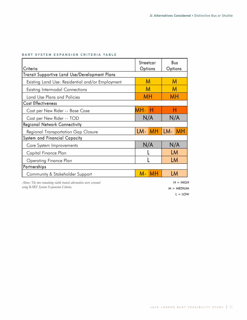
Based on initial findings, the Infill Station and GRT were removed from the
study process and further analysis focused on the feasibility of the streetcar
and the underground shuttle. Based on stakeholder and PAC input, the
options were further narrowed to focus on the streetcar alternative with the
inclusion of a distinctive bus or shuttle alternative.
3: Alternatives Considered
A L T E R N A T I V E S C O N S I D E R E D

3: Alternatives Considered > Infill BART Station
18 | J A C K L O N D O N B A R T F E A S I B I L I T Y S T U D Y
3.1 Infill BART Station
An infill station is a new station built on an exist-
ing BART line between existing stations. This
alternative would provide direct connections
between the Jack London District, downtown
Oakland, and San Francisco.
BART has established a variety of criteria for the
development of potential infill stations, including
track configuration, slope, and maintenance of
service throughout construction. Also, a new sta-
tion cannot impact throughput capacity and
proper train sequencing through the Oakland
Wye and Transbay Tube. To satisfy these opera-
tional requirements, a new station in this general
area would require a minimum of three tracks,
with one reversible track operating in the peak
direction. The proposed infill station would
resemble MacArthur Station with multiple tracks.
Using these criteria, BART staff examined three
alternative infill station possibilities:
Option 1:
Original Concept – A station site at the exit of
the Washington Street BART Portal.
Option 2A:
A station site on existing track between Castro
and Market Streets.
Option 2B:
A station site on existing track between Market
and Filbert Streets.
OPTION 1: INFILL STATION AT
WASHINGTON STREET PORTAL
The installation of a station at the exit of the
Washington Street BART Portal would provide
the greatest proximity to Jack London Square.
The track in the vicinity of the Portal has a
3.75% grade, while BART’s station design criteria
require an overall grade of 1% or less.1
Consequently, to allow for the necessary grade at
an infill station, some tracks that converge under-
ground in the Oakland Wye would have to be re-
configured. Moreover, the three switches located
in this area of track would need to be maintained.
The addition of a station would thus entail the
relocation of the existing switches westward
towards the West Oakland Station. In so doing,
the aerial structure would need to be reconfigured
to carry the three tracks and associated switches.
These factors would make the location of a sta-
tion here an enormously costly endeavor with sig-
nificant operational impacts in the densest por-
tion of the BART system where routes merge
and diverge. Since revenue service would have to
be maintained during construction, this would
add greatly to the complexity and cost of the
project. While the precise cost of such an
endeavor is unknown, it is many more times
greater than other options considered in this
study. A thorough analysis of this option would
require substantial funds for an engineering
review.
1 As an example, a 1% grade over the length of an 800-footplatform would produce a difference of 8 feet between the twoends of the platform.

3: Alternatives Considered > Infill BART Station
J A C K L O N D O N B A R T F E A S I B I L I T Y S T U D Y | 19
I N F I L L B A R T S TAT I O N L O C AT I O N D I A G R A M
Source Data: City of Oakland Community & Economic Development Agency. Map prepared by MIG, Inc. - December 2004 Moore Iacofano Goltsman, Inc., LTK Engineering, Fehr and Peers
Identifiable Districts within Downtown
N
Not to Scale
Chinatown
Uptown
Lakeside
OldOakland
WaterfrontWarehouse
District
Jack London District
19th St.Station
12th St.Station
Lake MerrittStation
Produce District
BART Route with Proposed Station Locations
Option 1Option 2aOption 2b
Market
Filbert

20 | J A C K L O N D O N B A R T F E A S I B I L I T Y S T U D Y
3: Alternatives Considered > Infill BART Station
OPTION 2A: INFILL STATION BETWEEN
CASTRO AND MARKET STREETS
Another option is to locate the station closer to
the existing West Oakland BART Station, utilizing
the existing track configuration and conforming
to design criteria. One such location for such a
station exists between Castro Street and Market
Street. To utilize this site and maintain opera-
tional flexibility, a third track would need to
adjoin one of the two platforms. Unfortunately,
the vertical curve in the existing trackwork lead-
ing out of the Portal compresses the available
space for a turnout and crossover to be installed,
and precludes this track from fitting between the
Portal and this particular site. However, locating
the station slightly further towards the West
Oakland Station to make room for the turnouts
and crossover only pushes the station past the
available straight section of track. As a result the
station cannot be constructed at this location to
meet BART’s criteria and is therefore not a viable
option.
OPTION 2B: INFILL STATION BETWEEN
MARKET AND FILBERT STREETS
A final infill option was evaluated that would
meet the minimum three-track configuration
needed for operations. This option entails the
installation of additional switches and crossovers
to configure a three-track station that meets both
operational and station design criteria. For this
option, three completely new aerial tracks (30 feet
in height) would need to be constructed. Switches
would be needed to tie the new tracks to the
mainline tracks. The distance from the Portal
needed to install station platform, switches, and
crossovers would likely put the station between
Market and Filbert Streets.
In order to construct the new track alignment
and station, new rights-of-way would need to be
acquired. It appears that about eight city blocks
would be needed, which would cause displace-
ment of approximately 15 businesses and 5 resi-
dences. In addition, the traffic flow would be
severely restricted in the area during construction.
While this option is technically feasible, its high
costs (approximately $250-300 M) make it an
unattractive option. Most importantly, its location
is far enough away from the heart of Jack
London District to put it at odds with the study’s
goal of better linking this neighborhood with
downtown Oakland and the region. This alterna-
tive was dropped from further analysis.
“The track in the
vicinity of the Portal
has a 3.75% grade,
while BART’s station
design criteria require
an overall grade of 1%
or less.”
The elevated tracks in the vicinity of Jack London Square wereconsidered as a site for an infill station.

3: Alternatives Considered > Group Rapid Transit
J A C K L O N D O N B A R T F E A S I B I L I T Y S T U D Y | 21
3.2 Group Rapid Transit (GRT)
A Group Rapid Transit (GRT) system would be
comprised of a fleet of small- to medium-sized
vehicles operated on a grade separated guideway.
GRT guideways can be at grade, elevated, or
underground; for this particular application, an
elevated structure was assumed. The primary dis-
tinction of a GRT system as compared to more
traditional automated guideway transit is the abili-
ty to bypass stations, allowing vehicles to provide
service between two non-adjacent stations.
BART’s consultants evaluated a potential elevated
GRT system for the Jack London District, specif-
ically considering the technology developed and
marketed by CyberTran Inc. (CTI) of Alameda,
California. However, the CTI system is not cur-
rently in any revenue service application any-
where, nor is there yet a fully functional proto-
type in operation. As such, despite some poten-
tial advantages of the GRT concept, the use of
this technology for a Jack London District appli-
cation presently comes with a variety of risks and
downsides.
These images of GRT concepts illustrate the elevated monorail anddriverless cars of a hypothetical GRT system.
Source: www.poitra.com
Source: www.cybertran.com
G R O U P R A P I D T R A N S I T D I A G R A M
Group Rapid Transit Route
Identifiable Districts within Downtown
ChinatownOld
Oakland
WaterfrontWarehouse
District
Jack London District
12th St.Station
Lake MerrittStation
Produce District

22 | J A C K L O N D O N B A R T F E A S I B I L I T Y S T U D Y
3: Alternatives Considered > Group Rapid Transit
The CTI Group Rapid Transit concept is at a
very early stage in development. It still needs
concept refinement through engineering, proto-
type development, regulatory review, testing, rev-
enue application, modification, and general appli-
cability. Until it has moved farther along in the
development process, it is a risky option for an
application in the context of downtown Oakland
and JLS. In time, it may become a reliable, cost-
effective, and attractive modal and technological
choice for some applications.
Moreover, the proposed CTI technology uses an
aerial guideway beam that functions as a track for
vehicles, and consequently requires supporting
structures for beams. These structures would
have to be designed with great care so as not to
interfere with fire and emergency crews, traffic
patterns and flow, visual lines of sight, and views
of existing architecture and other sites of inter-
est. The beam and associated elements would also
cast permanent shadows. Altogether, there could
be significant visual and physical intrusion into
the urban environment, which may not be appro-
priate in neighborhoods like Old Oakland,
Chinatown, and JLS. Overall this impact was
deemed undesirable for this context. Other loca-
tions may eventually prove to be more appropri-
ate for this technology. Therefore, this alternative
was dropped from further analysis.
3.3 Underground BART Shuttle
Another alternative considered was an under-
ground BART shuttle connecting the 12th Street
BART Station with an underground station in the
heart of JLS. This would involve the creation of
a new BART line under Broadway. The under-
ground shuttle would improve transit frequency,
speed, BART connectivity, route permanence,
vehicle comfort, and image over the existing bus
service, generating 3,000 - 4,000 net new weekday
transit riders by 2025. On weekends, new rider-
ship would be about half the weekday figures.
The benefit of an underground shuttle is that it
could take travelers from downtown right into
the heart of JLS with a quick travel time of about
two minutes, which is the fastest of all the
options. This could also be a potential point of
departure to Alameda and conceivably even
across the Bay over the long-term.
The current single-sided platform on the lower
level of the 12th Street Station would be expand-
ed to allow for a center platform with the existing
BART tracks on one side and the new BART
shuttle track on the other (see image to the right).
This would allow a direct cross-platform transfer
for San Francisco/Fremont-bound passengers to
JLS. Richmond- and Pittsburg/Bay Point-bound
passengers from JLS would transfer on the upper
level platform. The shuttle could be designed to
fit into existing BART system infrastructure,

J A C K L O N D O N B A R T F E A S I B I L I T Y S T U D Y | 23
3: Alternatives Considered > Underground BART Shuttle
using a BART guideway, vehicles, and train con-
trol, and operating with a standard BART fare
structure.
BART has operational objectives that would have
to be met for this concept to be viable. First, the
BART shuttle system could not be allowed to dis-
rupt existing BART operations. Second, the inter-
face between the existing BART system and the
new BART shuttle system would need to be as
seamless as possible, without significantly incon-
veniencing passengers who wish to transfer from
one line to the other.
In order for the BART shuttle system to integrate
seamlessly with the existing BART system, the
BART shuttle operating plan must complement
and operate as an extension of the BART system.
The hours of operation must match BART’s
hours of operation. The level-of-service should
allow for coordinated headways between the
BART shuttle and the BART system to facilitate
easy transfers. The headway should be no longer
than the minimum BART route headway during
the peak, which is currently around five minutes
on the Pittsburg/Bay Point - SFO/Daly
City/Millbrae route. Off-peak headway can be
reduced to 15 minutes or 20 minutes on the
evenings or weekends to match BART’s base
operating headway. The shuttle system is assumed
to be operated with a train operator, though the
possibility of a “driverless environment” was
considered and would require further study.
U N D E R G R O U N D B A R T S H U T T L E
Underground Shuttle Route
Identifiable Districts within Downtown
ChinatownOld
Oakland
WaterfrontWarehouse
District
Jack London District
12th St.Station
Lake MerrittStation
Produce District
Jack London Square Shuttle
Upper LevelPlatform
Lower LevelPlatform
Pittsburg/BaypointTrains
RichmondTrains
San Francisco/FremontTrains
The image below indicates how the underground shuttle would fit within the 12th Street Station.

24 | J A C K L O N D O N B A R T F E A S I B I L I T Y S T U D Y
The image above (left) shows the Square as it exists today; the image above (right) illustrates what the entrance to the underground shuttlecould look like.
3: Alternatives Considered > Underground BART Shuttle
Unless the system were automated, BART would
also require adequate facilities for an end-of-line
operations area and staff break room for train
crew supervisors to observe and monitor train
and platform operation as well as provide report-
ing and break location for train operators per
BART’s Facilities Design Criteria. Maintenance
would be performed in current maintenance
facilities that are adequate to handle the addition-
al small number of car hours. Access to these
facilities would be achieved through a track inter-
locking south of the 12th Street BART station,
tying the new shuttle tracks to existing tracks.
This project would cost in the range of $180-250
million with an annual operating cost of $2-4
million.
The complication would be the need for tunnel-
ing under Broadway or an adjacent street, which
would have impacts on the surface. While con-
struction would not require the length of
Broadway to be excavated, it would require two
to three excavated areas of about one block in
length each. In addition, BART would have to
maintain weekday revenue service during the
construction, which could not negatively impact
throughput through the Oakland Wye and
Transbay Tube.
The Underground Shuttle with a terminus at JLS
was not considered by the PAC to be worth fur-
ther investigation in this study given its high capi-
tal costs. However, a shuttle that could connect
downtown Oakland to Alameda, with a com-
bined or intermediary stop at JLS, was considered
more desirable and worthy of further review.
Such an endeavor was beyond the scope of this
study. However, this concept will likely be further
investigated in a 2005 study sponsored by the
City of Alameda.

J A C K L O N D O N B A R T F E A S I B I L I T Y S T U D Y | 25
3: Alternatives Considered > Streetcar
3.4 Streetcar
The fourth alternative studied was the electric
streetcar. There is a range of options to consider
with surface operating rail technology. The fastest
and highest capacity technology, which often
involves multiple vehicles and a regional scope is
commonly known as light rail transit (LRT), as
found in Sacramento, Salt Lake City, and Denver.
At the lightest end of the spectrum are historic
or museum operations, which typically use single
vehicle vintage trolleys (such as in Charlotte,
Seattle, and Memphis). This service is typically
slower with a lower capacity, but also a lower
cost. The proposed streetcar to Jack London
Square is a single car system that could use mod-
ern or vintage vehicles, or both.
The single car streetcar system works best in
areas with short trips and high passenger vol-
umes. Several streetcar builders produce modern
cars that are smaller than regional light rail vehi-
cles. They emphasize easy access with short dis-
tances between stops rather than high top speeds
and longer station spacing. Streetcars usually have
short distance between stops (500 - 1000 feet),
and frequent service (approximately 10 minute
wait times).
The streetcar proposal would offer ADA compli-
ant level boarding from the sidewalk. It would
use a double track and generally operate in mixed
traffic. Modern track installation and construction
is relatively simple and fast, a benefit to local
businesses that can be affected during the con-
struction phase of infrastructure projects. The
proposed construction technique, as recently used
in Portland, is called shallow track method. It
allows most utilities to remain in place, reducing
An example of the track construction is shown in the imageabove.
Portland, Oregon
Historic streetcars,such as this one,are being reintro-duced into citiesacross the country.San Francisco hashad tremendoussuccess with theirhistoric streetcars.

26 | J A C K L O N D O N B A R T F E A S I B I L I T Y S T U D Y
cost and shortening construction time to a few
weeks per block. The track depth is typically 12
inches.
The benefits of a streetcar are numerous. It is the
cheapest rail option since it is constructed on the
surface and requires relatively minimal street
interference during construction. The system
could operate with modern cars or historic
Oakland cars or some combination. The streetcar
could also be expanded in any direction and
could serve as a circulator for the downtown area.
In addition to its transportation function, the
streetcar could also be part of an economic
development strategy for downtown Oakland.
The streetcar has the potential to enliven the
streetscape and spur development on underuti-
lized parcels. Track infrastructure laid in the street
has a permanence that sends the message that
investment and the value it brings is there to stay.
In addition to connecting the Jack London
District to the City Center area, the streetcar
could serve adjacent districts, providing them
with an attractive transit service that could help
to activate broad areas of downtown. Other cities
that recently implemented streetcars consider
them catalysts for development of underutilized
parcels.
A disadvantage of the streetcar is that, though
cheaper than other rail options, it still has a high-
er capital cost than a rubber-tire bus or shuttle
3: Alternatives Considered > Streetcar
There are successful examples of streetcar systems throughout thecountry. The images below show how streetcars have fit into theurban context in Portland, Oregon and Tacoma, Washington.
Tacoma, Washington
Portland, Oregon
Portland, Oregon
Portland, Oregon

J A C K L O N D O N B A R T F E A S I B I L I T Y S T U D Y | 27
option. It would also require more stops than the
underground shuttle, making it slower (for trips
from 12th Street Station to JLS). Finally, due to
Federal regulations, it cannot cross the train
tracks on the Embarcadero at grade, and, there-
fore, could not stop in the heart of JLS without a
tunnel or bridge.
The streetcar alternative would improve transit
service frequency, route presence, and vehicle
image, adding approximately 2,000 - 3,000 net
new transit riders each weekday by 2025 to the
projected baseline transit ridership of 1,000 daily
riders.
Depending upon the size of the initial system, a
streetcar alternative for the Jack London District
is generally estimated to cost between $30 - $75
million, with a range of annual operating costs of
$1.5 - $5 million. To determine the ideal align-
ment for the streetcar, the PAC requested further
analysis. Potential alignments are discussed in the
next chapter.
3: Alternatives Considered > Streetcar
B E F O R E A F T E R
The streetcar is a flexible system that can fit into existing infra-structure, such as under the I-880 overpass, as illustrated here.
An historic car in Tampa, Florida has become one of the city’smost popular forms of public transit. It is paid for in part by theadvertisements you see on the front of the car.

28 | J A C K L O N D O N B A R T F E A S I B I L I T Y S T U D Y
3: Alternatives Considered > Streetcar
B E F O R E
A F T E R
The streetcar has the potential to enhance
property values, improve the pedestrian realm,
and spark development, as shown in these
before and after illustrations of Washington
Street at 10th Street.

J A C K L O N D O N B A R T F E A S I B I L I T Y S T U D Y | 29
3: Alternatives Considered > Streetcar
B E F O R E
A F T E R
Another example of a before and after illus-
tration at the intersection of Washington
Street at 4th Street is shown above.

30 | J A C K L O N D O N B A R T F E A S I B I L I T Y S T U D Y
3.5 Distinctive Bus or Shuttle
The PAC requested that the study consider the
alternative of a rubber-tired vehicle such as a bus
or a shuttle. As a result, the Project Team ana-
lyzed the costs and benefits of bus service for
each of the alignment options, with the same
operational frequency, run times, and stops as the
proposed streetcar. Such an alternative had sever-
al advantages. These included a lower capital cost,
the flexibility to change routes, and the ability to
implement much faster than other alternatives. A
bus or shuttle would also have the ability to drive
over the railroad tracks on Embarcadero, which
could allow a stop closer to the heart of Jack
London Square.
The disadvantage of such a service includes
lower ridership potential than the other alterna-
tives and higher annual operating costs than a
streetcar. Buses and shuttles also tend to have less
flair than streetcars, which are more novel and
generate more public enthusiasm and support.
Moreover, while buses and shuttles are flexible,
the lower level of public investment and commit-
ment as compared to a streetcar can translate into
a less stimulating effect on development. This
could limit the ability of buses or shuttles to con-
tribute to the revitalization of downtown
Oakland and adjacent districts.
For all of these reasons, the stakeholders present
at the July Public Meeting determined that the
disadvantages outweighed the advantages of this
alternative as compared to the streetcar. Despite
the lack of stakeholder enthusiasm, however, this
remains a low cost and technically feasible option
if a streetcar lacks funding in the short term.
The lack of rubber-tire appeal could be mitigated
somewhat with a distinctive bus with an unusual
form, such as a double-decker or mock vintage
trolley.
Distinctive buses come in many styles. Double-decker buses areoften considered more charming than the average bus and capturehigher ridership numbers. The image below shows an example ofhistoric trolley cars adapted to operate with rubber tires.
3: Alternatives Considered > Distinctive Bus or Shuttle
“Because Jack
London Square is a
destination that
appeals to tourists, the
charm of a double-
decker bus could
encourage visitors to
take public transporta-
tion.”
J A C K L O N D O N B A R T F E A S I B I L I T Y S T U D Y | 31
3: Alternatives Considered > Distinctive Bus or Shuttle
B A R T S Y S T E M E X PA N S I O N C R I T E R I A TA B L E
Criteria
Existing Land Use: Residential and/or Employment
Existing Intermodal Connections
Land Use Plans and Policies
Cost per New Rider -- Base Case MH- HCost per New Rider -- TOD
Regional Transportation Gap Closure LM- MMH LM- MMH
Core System Improvements
Capital Finance Plan
Operating Finance Plan
Community & Stakeholder Support M- MMH
LM
LM
MM
MH
H
N/A
N/A
Partnerships
Streetcar Options
Bus Options
MM
L
Transit Supportive Land Use/Development Plans
Cost Effectiveness
Regional Network Connectivi ty
System and Financial Capacity
MH
N/A
N/AL LM
Above: The two remaining viable transit alternatives were screenedusing BART System Expansion Criteria.
H = HIGH
M = MEDIUM
L = LOW