the urban and regional planning praxis: theories, …the urban and regional planning praxis:...
TRANSCRIPT

THE URBAN AND REGIONAL
PLANNING PRAXIS: THEORIES,
MODELS AND CASES
Asst. Prof. Dina Cartagena Magnaye, PhD, EnP
March 7, 2016
SCURP 2016A BASIC COURSE IN URBAN AND REGIONAL PLANNING (ABC in URP)Training and Extension Services Division 3/F Cariño Hall, School of Urban and Regional PlanningUniversity of the Philippines - Diliman, Quezon City7-11 March 2016

OUTLINE OF
PRESENTATION
I. The Concept and Scope of Planning
II. Urban and Regional Planning Theories
A. Urban Planning TheoriesB. Regional Planning Theories

THE CONCEPT AND
SCOPE OF PLANNING

Regulator
Policy AdvisorImplements
government rules and standards
DesignerVisionary
Works as private consultant, creates and
promotes own plan
Mediator
Facilitator
Reconciles conflicting interests of contending groups in society
AdvocateEducator
Advances the civic agenda of the general public
Roles of a Planner

Goals of Planning
Goals ofPlanning
Generic Strategies
Efficiency Engineering and entrepreneurial innovation
Effectiveness Enforcement of policies
Ecology Equilibrium and balance
Equity Evenhandedness
Empowerment of people
Education and participation of different sectors

Urban and Regional Planning
Urban Planning
The act of anticipating change, and arbitrating between the economic, social, physical, and environmental forces that determine the location, form and effect of urban development (John Ratcliffe)

Urban and Regional Planning
Urban Planning
Production of citywide development plan (aspects of land use and development) that determines which site/s can be built upon

Urban and Regional Planning
Regional Planning
Planning for an area with distinctive economic and social characteristics, opportunities and problems and setting it apart from other regions

Urban and Regional Planning
Region
• City or central place plus the outlying territories that are functionally integrated with it.
• Based on natural/physical as well as economic/political relationships between urban areas and its surrounding rural territories.

Urban and Regional Planning
Region
• Flexible concept referring to continuous and localized area intermediate between national and urban levels (local level)

Urban and Regional Planning
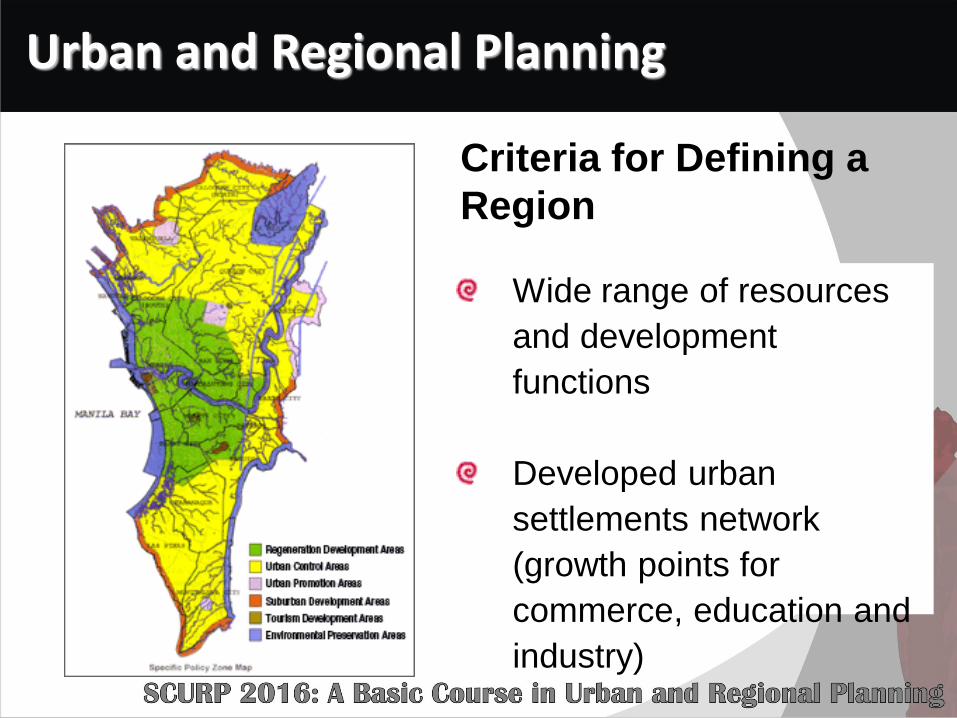
Criteria for Defining a
Region
Geographical balance
between mountains and
plains (existing ecological
barriers)
Urban and Regional Planning
Criteria for Defining a
Region
Wide range of resources
and development
functions
Developed urban
settlements network
(growth points for
commerce, education and
industry)
Urban and Regional Planning
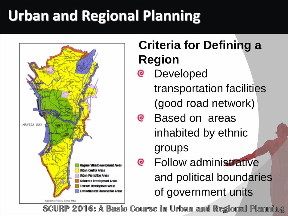
Criteria for Defining a
Region Developed
transportation facilities
(good road network)
Based on areas
inhabited by ethnic
groups
Follow administrative
and political boundaries
of government units

Urban and Regional Planning
Why Regional Planning?
Address problem of depressed industrial
and rural regions suffering from economic
malaise: economic disparities between
regions
Separate regional cultures and political
identities produced necessary pressure
for action

Urban and Regional Planning
Why Regional Planning?
Movement towards a
regional structure of
administration and decision
making
Interregional allocation of
resources

Urban and Regional Planning (URP)
URP is the unified development of urban communities and their environs and of states, regions and the nation as a whole, as expressed through determination of the comprehensive arrangement of land uses and land occupancy and their regulation
URP refers to the scientific, orderly and aesthetic disposition of land, buildings, resources, facilities and communication routes, in use and in development, with a view to obviating congestion and securing the maximum practicable degree of economy, efficiency, convenience, sound environment

Urban and Regional Planning
Urban Planning
Regional Planning
Place making
(creating livable human spaces
and natural communities)

SoPlace
Making
Governance
Equity
Ho
us
ing
&
Bu
lk
En
vir
on
me
nt
We
ll
Re
nd
ere
d
We
ll
De
sig
n
an
d b
uil
t
Well
Run
Fair for
Everyone

URBAN AND REGIONAL
PLANNING THEORIES

Urban Planning Theories

Urban Planning Theories
Theory Planning Advocate
Concentric Zone Ernest Watson Burgess (1886-1966)
Sector Theory Homer Hoyt (1895-1984)
Multiple Nuclei Edward Ullman and Chauncy Harris (1945)
Concentric Zone –Sector Theory
Peter Mann (1965)
• Urban Morphology

Concentric Zone Theory (Burgess)
(Burgess Model/Bull’s Eye Model/Concentric Ring Model/Concentric Rings Model
Concentric Zone Theory of Urban Spatial Structure
City grows outward in
concentric rings and has
single center (CBD)

• Zonal Description
Concentric Zone Theory (Burgess)
(Burgess Model/Bull’s Eye Model/Concentric Ring Model/Concentric Rings Model
Zone Characteristics
Zone 1: Central Business District (CBD)
• ”loop” district• location of most tertiary
employment and urban transport infrastructure making it the most accessible zone.
Zone 2: Zone of Transition (residential)
• area of older industry• low income and mix of
low-end uses• near labor and market• where transport
terminals (port and railyards) are located

• Zonal Description
Concentric Zone Theory (Burgess)
(Burgess Model/Bull’s Eye Model/Concentric Ring Model/Concentric Rings Model
Zone Characteristics
Zone 3: Zone of Low Cost Homes
Working Class Residence Ring (slums, contains poorest segment of urban population)
Zone 4: Zone of Better Residences
High Class Apartment and Single Family Ring (including shopping & commercial) – white collar workers and middle class families
Zone 5: Commuter Zone (sub-urban and semi-rural)
Middle class and upper income groups

Sector Theory – 1939 (Homer Hoyt)
1 – CBD
2 – Wholesale and light
manufacturing
(factories/industry) –
transitional
3 – Low-class residential
(old inner city area)
4 – Middle-class
residential
5 – High class residential
(modern suburbs)

Sector Theory – 1939 (Homer Hoyt)

Recognizes existence of land use zones
Presence of sectors or wedges of land uses in the city due
to emergence of star-shaped transportation routes (bus
lines and streetcar lines)

Industries would lie in a sector along the rail lines coming
into the city centre
Poorer people live adjacent to industries near their jobs
Rich live on the opposite side of town far from the industry
and poor-middle income in between

Multiple Nuclei Theory (Chauncy Harris and Edward Ullman,1945)
1 – CBD
2 – Wholesale and light
manufacturing
3 – Low class residential
4 – Middle-class
residential
5 – High-class residential
6 – Heavy manufacturing
7 – Outlying business
district
8 – Residential suburb
9 – Industrial suburb
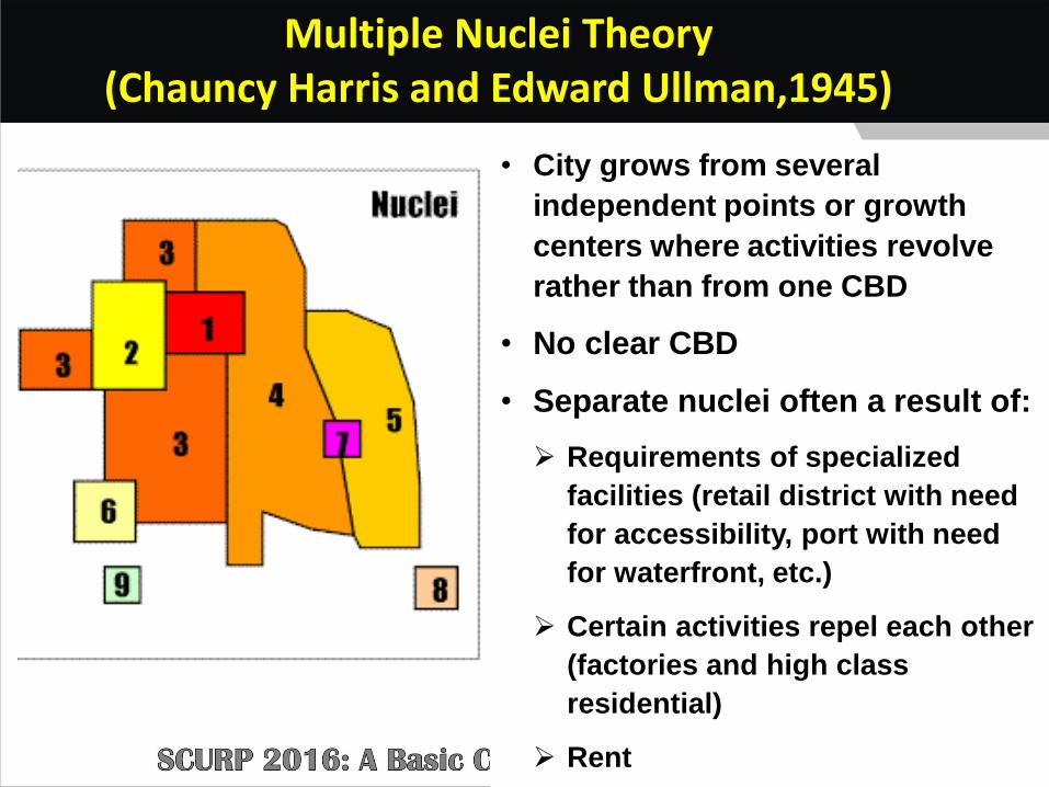
Multiple Nuclei Theory (Chauncy Harris and Edward Ullman,1945)
• City grows from several
independent points or growth
centers where activities revolve
rather than from one CBD
• No clear CBD
• Separate nuclei often a result of:
Requirements of specialized
facilities (retail district with need
for accessibility, port with need
for waterfront, etc.)
Certain activities repel each other
(factories and high class
residential)
Rent

Concentric – Sector Theory
(Peter Mann, 1965)
Structure of a city is a complex
interplay between rings and
sectors (combination of
Burgess and Hoyt)
Main feature: commuter village
separated from built up areas

Urban Planning Theories
Theory Planning Advocate
Central Place Theory Walter Chrystaller
Range and Threshold Berry and Garrison
Rank Size Rule George Zipf
Bid Rent William Alonso
• Urban Growth and Spatial Interaction

Central Place Theory
Urban System
Number of Human
Settlement
Size of Human
Settlements
Location of Human
Settlements
“Settlements function as central places providing services to
surrounding areas”

Central Place Settlement
• Settlement providing one or more services for the population living around it.
•• Simple basic services
(eg. grocery stores, bakeries)
Low Order Services
• Specialized services (eg. university, large shopping arcades, malls)
High Order
Services

Central Place Settlement
• Are said to be low (high) order settlements
Settlements providing LOS (HOS)
• There are low order services around it, but not vice versa
Existence of High Order
Services

Hierarchy of Central Place: The
Case of Tarlac City

Hierarchy of Center
Primary Role Indicator Function Population Size Range
Municipality/City
Small City · Inter-regional distribution center
· Provincial service and administrative
center · Industrial center
· Major center of trade, commerce and
business
· Financial institutions, telecommunication facilities,
supermarkets, housing estates and subdivisions, recreation
centers, tertiary education, health services, and drugstores
150,000 and above
Tarlac City
Large Town 1. Provider of lower level amenities
2. Serve as link to primary growth
center
· Financial institutions, telecommunication facilities,
shopping centers and consumer shops, restaurants,
transportation facilities, manufacturing firms, training
centers, warehousing
50,000-149,999
Camiling Paniqui
Capas Concepcion
Medium Town
· Processing establishments, some commercial banks and
financial institutions, post-harvest facilities, manufacturing
firms, slaughter house, secondary education and
municipal hospital, health services
5,000-24,999 Bamban Gerona
La Paz Moncada
San Jose Mayantoc
Sta. Ignacia Victoria
Small Town
3 Agro-forestry 4 Agriculture
5 Aquaculture production
6 Tourism
· Extension services, convenient
shops, sari-sari stores, rural banks, cottage industries, public
calling offices, agricultural production, cooperatives, multi-
purpose center, basketball court, eatery
<4,999 San Manuel
Anao San Clemente
Ramos Pura
Source of basic data: Final Report of the Consultancy Services for the Development Studies for PDPFP and PDIP for the Province of Tarlac. UP PLANADES. 2008.
Hierarchy of Center

Range and Threshold

Range and Threshold
(Brian Berry and William Garrison )
Distribution of central places controlled by
the concepts of “range and threshold”
Each service activity has range and threshold

Rank Size Rule

Rank Size Rule
(George Sipf 1949 – American Linguist)
– Settlements in a given country may be ranked in order of their size
Pn =P1
nq
Pn = population of nth settlementP1 = population of largest settlementn = settlement rankq = exponent which usually
approximates unity

Rank Size Rule
(George Sipf 1949 – American Linguist)
The population of a given urban area tends to be equal to the population of the largest city
divided by the rank of the population size into which the
given urban area falls, the population of settlements thus being arranged according to the
series 1, ½, 1/3, ¼, etc.

Rank Size Rule
(George Sipf 1949 – American Linguist)
• The 2nd rank city will have ½ the population of the 1st
•
The 3rd rank city will have 1/3 the
population of the 1st
The 4th rank city will have 1/4
the population of the 1st

Example
• The population of the largest city is
1,000,000
• The population of the 2nd largest city is
1,000,000/2 = 500,000
• The population of the 3rd largest city is
1,000,000/3 = 333,333
• And so on…

District/Barangay
Rank Total Pn
Tondo 1 630,604
Sampaloc 2 354,514 315,302.00
Sta. Ana 3 178,769 210,201.33
Sta. Cruz 4 118,779 157,651.00
Malate 5 78,132 126,120.80
Pandacan 6 76,134 105,100.67
Paco 7 69,300 90,086.29
Port Area 8 46,864 78,825.50
San Nicolas 9 43,225 70,067.11
Quiapo 10 23,138 63,060.40
San Miguel 11 16,115 57,327.64
Binondo 12 12,100 52,550.33
Ermita 13 6,205 48,508.00
Intramuros 14 5,015 45,043.14
Rank Size rule does not apply given the case of Manila
630,604/2
630,604/3
630,604/4
630,604/14
CONCLUSION:

Bid Rent Theory
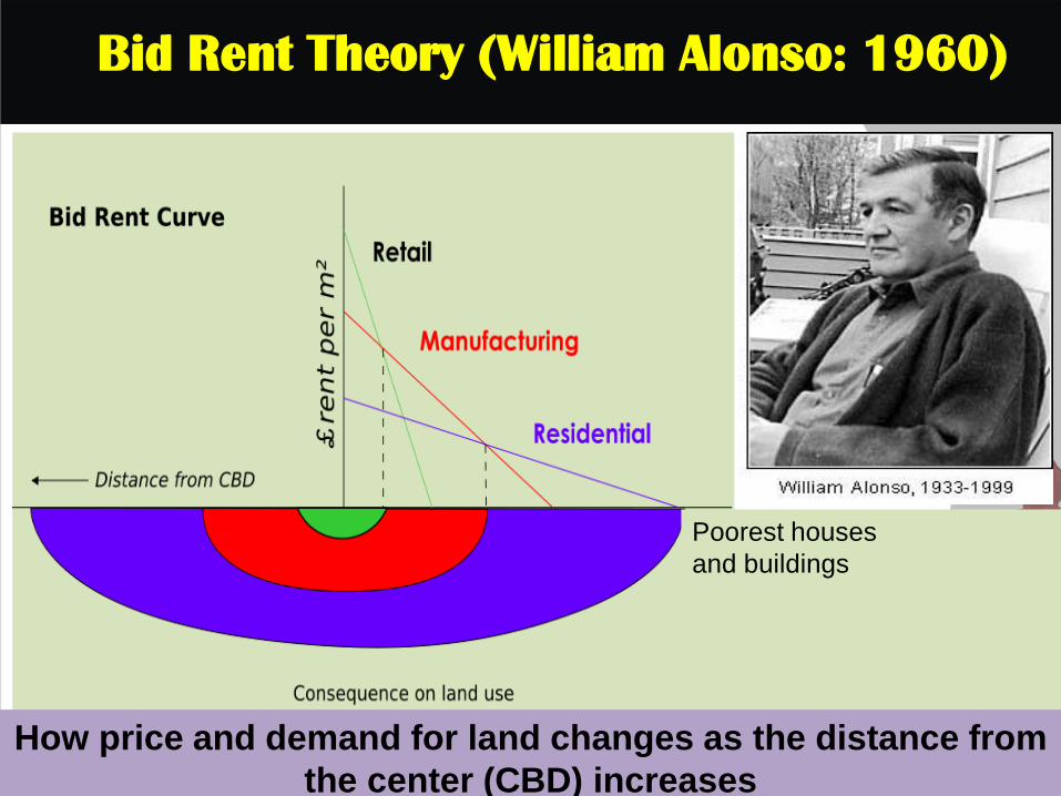
Bid Rent Theory (William Alonso: 1960)
Poorest houses
and buildings
How price and demand for land changes as the distance from
the center (CBD) increases

Theories of Spatial
Interaction

Gravity Model of Human Interaction
Analyze spatial interaction between spatially
separated nodes (migration, commodity flows,
traffic flows, residence-workplace trips, etc)
Interaction between two centers is directly
proportional to their size and inversely
proportional to the distance between them
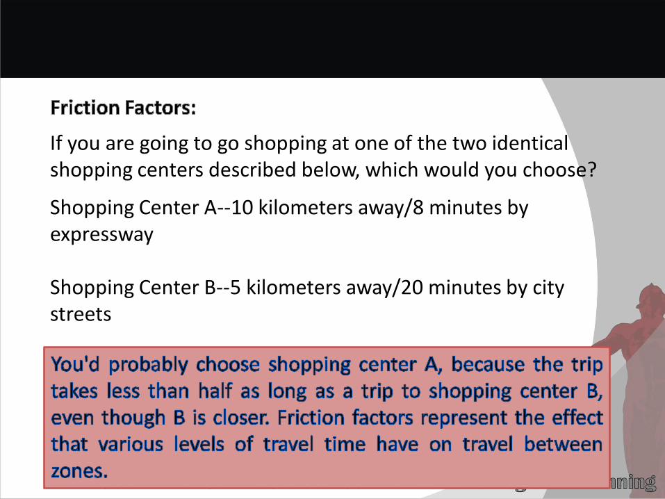
If you are going to go shopping at one of the two identical shopping centers described below, which would you choose?
Shopping Center A--10 kilometers away/8 minutes by expressway
Shopping Center B--5 kilometers away/20 minutes by city streets

REGIONAL PLANNING THEORIES
1. Growth Poles Concept
1. Regional Development Planning
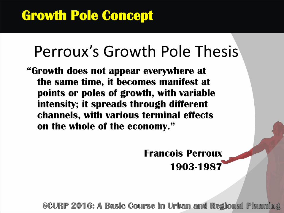
Perroux’s Growth Pole Thesis“Growth does not appear everywhere at
the same time, it becomes manifest at
points or poles of growth, with variable
intensity; it spreads through different
channels, with various terminal effects
on the whole of the economy.”
Francois Perroux
1903-1987
Growth Pole Concept

The Growth Point and the Region
The growth point is surrounded by a
swarm of affected industries, thinning
out as you move away from growth point.
At a later stage, the growth point has
spawned to a secondary growth
point

Cumulative Causation
Theory

Myrdal’s Theory of Cumulative Causation
Gunnar Myrdal’s Theory of Cumulative Causation
Introduction of a new industry or expansion of an
existing firm
Area becomes a
growth pole

Core-Periphery Theory
(Friedman)
- Spread Effects -

CORE AND PERIPHERY THEORY
The theory highlights the inequality in levels of development
between core and periphery.
Core – propulsive & can be represented by concepts such as metropolitan areas,
growth poles and growth centers
Periphery – exists in state of
dependence; hinterland or fringe areas

Regional Planning Theories
Polarization and Trickle Down Effect (Albert Hirschman)
Regional Planning
Growth at poles = decline in
peripheral areas
“Backwash effect” = loss of jobs and
migration of young to growth poles (Polarization)
Counteracted over time by “trickle down”
effect which makes periphery more
attractive spurring urban and rural
migration

Industrial Location
Theory

• Comparative Advantage
• Theory of Agricultural Location
• Industrial Location Theories
Least Cost Approach (Weber)
Market Area Approach (Losch, Hooever)
Profit Maximizing Approach (Isaard and Greenhut)
Industrial Location Theories

Regional Planning Theories and Concept
Industrial Location
• Comparative Advantage
• (David Ricardo-1772-1823)
- Site that has the tendency to produce more output per unit of input given factors such as natural endowments, transportation, institutional advantages, amenity factors, etc.
- Sites near metropolitan areas enjoy high comparative advantage

Industrial Location
• Theory of Agricultural Location
• (Johann Heinrich von Thunen-1783 to 1850)
• Use of a piece of land = function of cost of transport to market and land rent a farmer can afford to pay (determined by yield)
• Agricultural land use = accessibility, costs, distance, and prices
Regional Planning Theories and Concept

Johann Heinrich von Thünen's model of agricultural
distribution around a city in concentric circles.

Industrial Location Theories
Least Cost Approach (Alfred Weber, 1909)
Market Area Approach (Losch and Weber)
Profit Maximizing Approach (Walter Isaard, 1956 and Melvin Greenhut, 1974)

Industrial Location Theories
Least Cost Approach (Alfred Weber)
Choose location where the costs
(transportation, labor and
agglomeration) are least
If sources of raw materials are found in a
single site and the principal market in
another site, firm should be located at
the market or some site between the
source of raw materials and the market
Industrial Location Theories
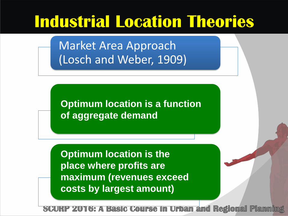
Market Area Approach (Losch and Weber, 1909)
Optimum location is a function
of aggregate demand
Optimum location is the
place where profits are
maximum (revenues exceed
costs by largest amount)

Industrial Location Theories
Profit Maximizing Approach (Isaard and Greenhut)
Companies locate to maximize
revenues not locations with
least cost
Costs and revenues vary with
location

Thank you for your attention!