the impact of traditional land use on woodlands: a case study in the spanish central system
TRANSCRIPT

www.elsevier.com/locate/jhg
Journal of Historical Geography 31 (2005) 390e408
The impact of traditional land use on woodlands:a case study in the Spanish Central System
Fernando Pardo and Luis Gil*
Unidad de Anatomıa, Fisiologıa y Genetica Forestal, ETS de Ingenieros de Montes, Ciudad Universitaria s/n,
Universidad Politecnica de Madrid, 28040 Madrid, Spain
Abstract
We analyse the consequences of traditional use on forest characteristics during the last millennium ina mountain area of Spanish Central System, using information contained in documents, as well as carto-graphy and toponymy. In the Middle Ages the local forests were transformed into municipal dehesas (com-munal fenced woods), communal wood pastures and arable lands. Pinewoods located in areas above1500 m decreased because of the high grazing pressure. In the fifteenth century two manors were created(Buitrago and Montesclaros). Livestock became an important factor during this period. As a consequencean open wood was formed and oak coppices were also abundant (the felling of this species was at that timepermitted by the Ordinances). At the end of the period of traditional management, pinewoods were disap-pearing and the main forest areas were located only in municipal dehesas. The area of beech was reduced infavour of melojo oak and scrub, due to the lower sprouting capacity of the beeches and their lower droughttolerance. Open wood pastures remain only in the eastern part of the study area, where there has been lessintense human intervention. After the abolition of manors in the nineteenth century, arable land increasedin the western part of the area, which had a higher population density. In the twentieth century, both hu-man and livestock pressure decreased substantially and pine species were reintroduced by reforestation. Theprimitive savannah was transformed into ‘infilled savannah’, while temperate species spread around theirrefuges in municipal woods.� 2005 Elsevier Ltd. All rights reserved.
Keywords: Communal wood; dehesa; Grazing; Infilled savannah; Ordinance
* Corresponding author.
E-mail address: [email protected] (L. Gil).
0305-7488/$ - see front matter � 2005 Elsevier Ltd. All rights reserved.doi:10.1016/j.jhg.2004.11.002

391F. Pardo, L. Gil / Journal of Historical Geography 31 (2005) 390e408
Introduction
Human impact on European forests varied with the land-use history, the climate and the soilsof each region,1 although forest structure and composition reflect in most cases an ancient historyof management and exploitation.2 Significant woodland reduction in the Iberian Peninsula beganto take place during the first millennium B.C., a fact that has also been observed in other Med-iterranean areas.3 The most ancient documents related to Spanish geography, Avieno’s OraMarıtima, dating back to the fourth century A.D.,4 show that woodland alteration had been tak-ing place over a long period of time. This Latin author described the coasts between Marseillesand Cadiz, basing his observations on an oral tradition going back to the third century B.C. Re-ferring to a Spanish locality in the Southeast of Spain, he notes: ‘pinus hanc quondam frecuens’,suggesting a huge loss in pine forests.
Local species extinction and reduction has not always been taken into account by researchers,because of the absence of a historical perspective. In Spain this has caused the overvaluation ofsome species to the detriment of others, mainly pines.5 Furthermore, this is why it is consideredto be an artificially introduced species even though there is documentary evidence of ancient pine-wood presence since the Middle Ages.6 In addition, the absence of a historical perspective hascaused the historical existence of some wood types to be disregarded. A good example is the his-torical presence of pinewood (mainly Pinus halepensis) and gall-oak woods (Quercus faginea),which disappeared during the last millennium in the most arid areas of the European continent,in southeast Spain, for anthropogenic reasons.7 However, some studies8 show the utility of com-bining historical analysis with plant ecology in order to understand present landscape patterns.Written sources have been used to assess the continuity of the forest in certain areas,9 to confirmthe local extinction of widely distributed forest species10 and to analyse historical changes inwoodland management.11
As the characteristics of the present woods reflect a history of human exploitation, it is impor-tant to understand the details and history of land use and management. Traditional woodlandmanagement in Spain dates back at least as far as the Middle Ages. After the reconquest period,a process of human resettlement and land redistribution took place.12 The land use around vil-lages and towns was agro-silvo-pastoral. The main types of wood management were coppicesand woody pastures. Virtually no woodland was left unexploited: the large and distant mountain-ous areas with their rough terrain were not left derelict or unoccupied but was used for communalinstead of private purposes.13 In this period, a typical Spanish system of grazing land was created,nowadays known as the Spanish dehesa, a name derived from the Latin defensa (Zdefence). Adehesa is a portion of land protected and reserved for domestic livestock used for land plough-ing.14 Traditional management of woods continued until the middle of the twentieth century whenindustrial development of cities encouraged emigration from rural to urban areas.
The objective of this study is to analyse the effects of traditional management practice on forests ofthe mountain area of Spanish Central System. Written documentation, cartography and toponymywere all instrumental in this study. The changes in the area, structure and composition of forests dur-ing the last millennium are studied.We selected this specific area because it has two important biogeo-graphical characteristics: (1) natural pinewood is totally absent but fossil pollen indicates the presenceof this species in the past,15 (2) It constitutes one of the southern most Iberian limits of beech (Fagussylvatica), sessile oak (Quercus petraea) and other temperate tree species of the Iberian Peninsula.16

392 F. Pardo, L. Gil / Journal of Historical Geography 31 (2005) 390e408
Study area
The study area is located at an altitude ranging from 1000 to 2200 m above sea level, in thesoutheast of the Spanish Central System, a mountain system which divides the Duero and Tajobasins of the Iberian Peninsula. The area includes a group of villages located below 1500 m. Bed-rocks are of a metamorphic type, with a greater abundance of gneiss in the west and of mica-schistand slates in the east. The study area was divided into two zones coinciding with the manor towhich they belonged in the Middle Ages (Fig. 1):
(i) The western part, with a 69.9 km2 area, a 1414 m mean elevation and a 27.7% mean slope,belonged to the Buitrago Manor.
(ii) The eastern part, with a 184.7 km2 area, a 1504 m mean elevation and a 35.6% mean slope,belonged to the Montesclaros Manor.
The climate is sub-Mediterranean, with a marked summer drought from July to August. Thenearest meteorological station with a 40-year record is located at 1000 m a.s.l. (Fig. 1). The aver-age rainfall is 797 mm (94 mm in summer) and mean annual temperature is 12 �C. Summer rain-fall increases at higher elevation but the water deficit remains, as was recorded during a 6-yearperiod in a meteorological station situated in El Chaparral de Montejo, at 1400 m above sea levelHere, the minimum summer rainfall recorded in 1994, was 15.6 mm. Frosts occur from Novemberto April and seldom in May. The frost period also increases with elevation.
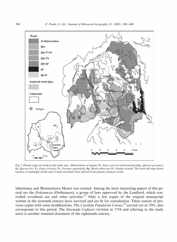
Nowadays, forests of the sub-Mediterranean melojo oak (Quercus pyrenaica) and Pinus sylves-tris afforestations are the main wood types in the area (Fig. 2). In addition, typical European tem-perate broadleaf species such as beech (F. sylvatica), wild cherry (Prunus avium), white oak(Q. petraea), rowan (Sorbus aucuparia), holly (Ilex aquifolium) and yew (Taxus baccata) are pres-ent in the most humid areas, mainly over 1500 m above sea level.17
Historical periods and written sources
The written sources used in this work were of primary and secondary origin. The former camefrom the National Historical Archive of Spain and the latter from diplomatic copies, which arecited in each case. No written documentation dating back further than the eleventh century refer-ring to the study area has been found. From the tenth to the eleventh centuries the study areaconstituted a frontier between the Moorish and Christian regions, and had a low population den-sity.18 The population increased after the reconquest of the Arab Kingdom of Toledo (1085).From this date we distinguish the following periods.
Communal period (1076e1366)
In 1076, the Castilian King granted a large area of land to the village of Sepulveda in the Cen-tral System. A huge part of the Sepulveda Community on the southern slope of the Central Sys-tem was segregated in 1256 in order to form the Buitrago Community (Fig. 1). A large number of

393F. Pardo, L. Gil / Journal of Historical Geography 31 (2005) 390e408
documents exist referring to this period.19 Perhaps the most important document is the Fuero(Charter) of Sepulveda, a legal code composed of 35 articles in its first version of 1076. After suc-cessive additions, the Fuero grew extensively to include 254 articles in 1300. The Libro de la Mon-terıa (Hunting Book) of Alfonso XI, written in the fourteenth century,20 also provided referencesto the woods in the study area.
Noble period (1366e1837)
In 1366, the Castilian King conferred ownership of the Buitrago Community to the Mendozafamily. In 1458, the western part of Buitrago Manor was segregated as a consequence of an
1000
1500
2000
1000
1500
1500
Sepúlveda
Buitrago
a
b
2000
1500
1000
Sepúlveda
Sierra
ba
Ele
vatio
n (m
)
N
EW
S
Study area
Meteorological stations
124 0 4 8 16 km
Community of Sepúlveda (11th century)Señorío of Buitrago (14th century)
Señorío of Montesclaros (14th century)
Fig. 1. Location map of study area. The extension of Communities and Manors, a topographic profile and situation of meteorological
stations are shown.
394 F. Pardo, L. Gil / Journal of Historical Geography 31 (2005) 390e408
inheritance and Montesclaros Manor was created. Among the most interesting papers of this pe-riod are the Ordenanzas (Ordinances), a group of laws approved by the Landlord, which con-trolled woodland use and other activities.21 Only a few copies of the original manuscriptwritten in the sixteenth century have survived and are fit for consultation. These consist of pre-vious copies with some modifications. The Castilian Population Census,22 carried out in 1591, alsocorresponds to this period. The Ensenada Cadastre (written in 1754 and referring to the studyarea) is another essential document of the eighteenth century.
1500
1500
1500
15002000
1000
1500
Scattered wood (Qpy)
Wood
Ps-Reforestation
Qpy
Qpy-Fs-Ia
Qpy-Fa
Qpy-Qi
Bp-Pt
Qi
1500
Unforested
0 5 km
6
132
7
8
9
10
11
Ancientopenwood
5
4
Villages
2 0 2 4 6 8 km
Fig. 2. Present types of woods in the study area. Abbreviations of species: Ps, Pinus sylvestris (reforestation) Qpy, Quercus pyrenaica;
Qi, Quercus ilex; Fs, Fagus sylvatica; Fa, Fraxinus angustifolia; Bp, Betula pubescens; Pt, Populus tremula. The lower left map shows
location of municipal woods and of main savannah forest derived from pasture common woods.
395F. Pardo, L. Gil / Journal of Historical Geography 31 (2005) 390e408
Contemporary period (1837 to the present)
After the first Spanish Constitution was approved in 1837, the Manors were abolished anda huge number of public properties, such as communal woods, were sold by the State. Somewoodlands were excluded from the 1855 alienation law due to interest in the tree species.23 Thefirst inventory of these woodlands is the General Classification of Public Woods (1859), whichlisted in detail the main characteristics of public woods such as their name, area and dominantand secondary species.24 This inventory was brought up to date in 1862 and in 1901. Additionalinformation is provided by the litigation maintained between the Lord of Montesclaros and thetowns of this Manor in the first half of nineteenth century.25 Geographical dictionaries providedata on population and livestock figures.26 Data from the National Institute for Statistics and mu-nicipal data from Livestock Census of the Agriculture Ministry from 1950 were used to acquireinformation on the twentieth century. The equivalents between the different types of livestockwere established following the work of A. San Miguel Ayanz.27 In his classification one cow isequivalent to seven sheep, one horse, donkey or mule to six sheep, one pig to five sheep andone goat to three sheep.
Cartographic analysis
The cartographical material we used is from the nineteenth and twentieth century. Maps on thescale of 1:25 000 (pages 432-III, 458-II, 458-IV, 459-I and 459-III), published between 1991 and1999, were used to situate the toponyms related to pines and beeches and to locate the woodlandsreferred to in the Ensenada Cadastre. The 1:25 000 land-use maps of the nineteenth century dateback to 1874 in the western area and include three sheets. Those of the eastern area, with fivesheets, were from 1897. Each map was digitalized to be used in the GIS Idrisi.28 The land wasclassified into four categories: (1) agricultural, (2) unforested (scrub and pastures), (3) woodand (4) scattered wood. Present vegetation maps in a digital format and scaled 1:50 000 (pages423, 458 and 459) were supplied by the National Data Bank of Nature (Ministry for the Environ-ment). These maps include data regarding plant species and tree cover for the four main tree spe-cies in homogeneous patches. The patches were classified in the same categories as the land-usemaps of 1874 and 1897. Finally, the present and past distribution of pines and beeches was ana-lysed by means of toponyms, historical records, surveys of the study area and interviews with localfarmers and forest guards.
Woodland traditional management from eleventh to eighteenth century
In the eleventh century the study area was included in the Sierra (mountains) of SepulvedaCommunity (Fig. 1). Some laws of the Fuero de Sepulveda prohibited pinewood (mainly P. sylves-tris) exploitation. Grubbing pine roots, resin or pitch tapping from pines were forbidden. Anotherlaw allowed the cutting of oak (Q. pyrenaica and Q. petraea), yew (T. baccata) or holly (I. aqui-folium) branches as long as the tree was not pollarded nor felling. The felling of other tree specieswas also forbidden in the Sierra, including the following: beech (F. sylvatica), whitebeam (Sorbus

396 F. Pardo, L. Gil / Journal of Historical Geography 31 (2005) 390e408
aria), pine, poplar (Populus tremula), cherry (P. avium), apple (Malus syvestris), willow (Salix sp.),oak and holly. However, in this area, heather and oak charcoal production was permitted, as wasbranch cutting for the manufacture of carts, fences or ploughs.
Two documents from the thirteenth and fourteenth centuries reveal that pines were present inthe study area. One is the royal donation of terrain to the religious Community of San Audito in1208.29 Lands granted included montibus, nemoribus et pinario (montibus refer to non-cultivatedlands, nemoribus to the forest and pinario to pinewood). As the limits of this territory are onlyvery vaguely defined, pinpointing the exact location of the primitive pinewood is an impossibletask, however, it was most likely situated in the highest of the lands granted to the community(Fig. 5). This document also stated that the inhabitants of Buitrago, Sepulveda and the religiouscommunity could use woodlands and pastures for communal purposes. In the second document,from 1300, a land concession to a town in the Sierra is detailed and Rabinate pinewood is cited.30
This pinewood was located near the San Audito pinewood, where the toponym Rabinate, refer-ring to a watercourse, still exists today (Fig. 5).
TheHunting Book of Alfonso XI, written in the fourteenth century, also mentioned some of thewoods of the study area. Four of the dehesas and three other forests are cited. One of these woodsrefers to the beech one located in the northern part of the study area (Fig. 5). The book also men-tions the toponym Hayuela derived from the Spanish word haya (beech), along with a locationwhere presently beech trees are no longer found.
After the creation of Buitrago Manor in 1366, woodland management was regulated by theOrdinances, which, in their preamble, noted that woods were the region’s main source of wealthbecause of the shelter and the food they provided to livestock. The articles of Ordinances mainlyreferred to trees (48 articles) and livestock (35 articles). A limited number of articles were dedicatedto agriculture (13 articles) and coexistence among neighbouring communities (28 articles). Somelaws dealt exclusively with a type of property, which could be communal, municipal or private.Communal property included pastures (with or without trees), while municipal properties weremainly found in dehesas. The Ordinances dictated that a 1.3 m high defensive wall be constructedin all dehesas and arable lands, as a defence against grazing by sheep, goats and pigs. Municipalauthorities gave permission to use the timber and firewood of dehesas in accordance with theOrdinances. Finally, the private properties mainly consisted of agriculture lands and meadows.
The Ordinances did not make any reference to pines or beeches. Cutting down or uprootingany tree species, except small oaks, was forbidden in any type of property, even the private ones.However, each municipal government, in their own dehesas, was allowed to cut down a maximumof 10 large oaks per year, which could then be used only by neighbouring houses. Restricted per-mission was also given to cut larger oak branches, but oaks could not be pollarded as it wasobligatory to leave at least three branches. Holly branches were only to be cut in winter, withoutpollarding and leaving four green branches in every tree. Livestock access to holly woods wasprohibited in winter with a maximum of 12 goats for every sheep herd allowed. The lightingof fires in communal woodlands was also a punishable offence with the sentence depending onthe number of trees burnt and not on the burned area. The Ordinances also regulated the wayin which oak stools were to be uprooted in arable lands. It was obligatory to leave at leastone tree for each stool. If stool density was particularly high, some of them could be eliminated,as long as one stem of each stool for every 280 m2 (or the equivalent of 36 stems per hectare) wasrespected.

397F. Pardo, L. Gil / Journal of Historical Geography 31 (2005) 390e408
According to the Ensenada Cadastre, during the eighteenth century arable lands occupied 33%of the western area and 10% of eastern area. In communal pastures these figures were 53% and46%, respectively. Pastures were mainly composed of scrub and rock outcrops, not to mention thetree presence in the western area. In the communal pastures of the eastern area, a significant zoneof scattered oaks existed, but its exact location is not specified. As stated in the manuscript, oaks‘were felled due to their old age’. However, a large number of these oaks have survived even untiltoday, thus allowing for a probable primitive distribution design (Fig. 2).
Forestland was located on municipal land, which included six municipal dehesas, the dehesa ofthe religious Community of San Audito and four other forests (Table 1). In the western area therewere three dehesas (one per village), with a total area of 676 ha. In the eastern area, there were twodehesas, whose area totalled 373 ha (one belonging to the village of El Cardoso, while the othertwo were shared between the other villages). Three coppices existed in the western area, whereas inthe eastern area there were only two. The rotation period in coppices oscillated between 15 and 30years. Oak was the most commonly cited tree, but the exact species was not reported. Only in twowoods were other tree species cited: number 4 (beech and holly) and number 8 (beech).
Population density changed only slightly between 1600 and 1850. In the eastern area it was fivetimes less than in the western area, with six to eight inhabitants per square kilometre (Fig. 3). Atthe end of the period of traditional management the most abundant livestock was sheep (Table 2).The density of goats was similar in both areas but four times lower than that of sheep. Unlikegoats and sheep, the density of the rest of the livestock (cows, pigs, horses and mules) was higherin the western area. Total density of livestock units was higher in the western area, in which therewas a higher density of ploughing livestock.
The end of traditional woodland management (nineteenth and twentieth centuries)
During the first half of the nineteenth century, some important economic and social transfor-mations occurred, which greatly affected traditional woodland management. The abolition ofmanors resulted in the Ordinances losing their validity. The woods of the western area were in-cluded in the Public Wood Catalogue. This led to better management by the local and state forestauthorities. The communal pastures were put up for sale. Mainly the inhabitants of the nearbyvillages and cities bought this lands.
In the eastern area, the manor and the inhabitants of villages were in dispute over the woods andpastures until 1879. After several litigations between the lord and municipal governments, theselands were returned to the villages in 1879.31 As a consequence of these disputes, the woods ofthe eastern area suffered other changes. Between 1801 and 1830 the neighbours of El Cardosocut several hundred beeches in the wood number 8 (Fig. 2). One year later, the Lord of Montes-claros ordered the cutting down of 200 beeches in the same wood. Finally in 1866, some neighbourswere accused of felling trees and burning pastures without the permission of the lord. In the westernarea there are no data to suggest that similar changes in wood management took place. However,large oaks and beeches were felled at the end of nineteenth century in the woods 4 and 5.
The human population of the western area remained constant during the nineteenth century(Fig. 3). The privatisation of communal pastures in this century favoured the increase of arablelands, which occupied 49% of this area at the end of nineteenth century. The livestock density

398 F. Pardo, L. Gil / Journal of Historical Geography 31 (2005) 390e408
Table 1Area, composition and uses of municipal woods in twentieth century and uses of municipal woods in eighteenth century
No. Usea Present speciesb Area (ha)
Eighteenth century Twentieth century Main Secondary
West area
1 Municipal dehesa Co Co ME, AS MA, HL 185
2 Municipal dehesa Co Co ME AS, HO 168
3 Oak wood Co Co ME CH, HO 146
4 Beecheoak wood WP I ME, BE, HO SE, CH, RO 122
5 Municipal dehesa Co, WP Co, I ME SE, CH, RO 323
East area
6 Municipal dehesa Co Co ME CH, RO 161
7 Oak wood Co Co ME CH, HO 143
8 Oakebeech wood WP Co, A, S, I ME BE, HO, SE 1092
9 Municipal dehesa WP I, S ME, HL SE 139
10 Municipal dehesa WP I ME BE, HO 102
11 San Autido dehesa WP Co ME HO, CH 630
Source: Data Bank of Nature, Ministry for the Environment.a Use: Co, coppice; WP, wood pasture; S, shrubland; I, infilled savannah; A, aforestation.b Species: MA, maple (Acer monspesulanum); AS, ash (Fraxinus angustifolia); BE, beech (Fagus sylvatica); HO, holly
(Ilex aquifolium); CH, wild cherry (Prunus avium); ME, melojo oak (Quercus pyrenaica); HL, holm oak (Quercus ilex);SE, sessile oak (Quercus petraea); RO, rowan (Sorbus aucuparia).
El Cardoso
11
3240
33
564339
6,16,9 7,8
5,5
1,6 1,5
0,6West areaEast area
0
1
10
100
1500
1600
1700
1800
1900
2000
Inha
bita
nts
/ km
2
1500
1500
2000
1500
1000
1500
Present villages
Disapeared villages
20th century
19th century
MontejoColmenar
500100
Inhabitants(1754)
2 0 2 4 6 8 km
Fig. 3. Human population change between sixteenth and twentieth centuries (left), and location of villages (right) in the two areas
studied. The population of villages at the end of the period of traditional management of woods (eighteenth century) is also shown.

399F. Pardo, L. Gil / Journal of Historical Geography 31 (2005) 390e408
also increased slightly (Table 2). The human population of the eastern area has decreased contin-uously until the present; three villages were depopulated in the nineteenth century and anotherduring the twentieth century (Fig. 3). The livestock density also decreased. In spite of the popu-lation decrease, the surface area of arable lands increased slightly in respect to the eighteenth cen-tury (15% and 10%, respectively), as a consequence of the acquisition of woods and pastures bythe inhabitants of villages in 1879. The cultivated lands reach zones above 1500m. In the easternarea some of these lands were located in ancient woods such as number 8 (Fig. 4).
Traditional management almost disappeared during the twentieth century. Population and live-stock rising decreased significantly (Fig. 3, Table 2). Sheep, the most important livestock duringthe preceding centuries, almost disappeared. A comparison of maps from the end of the nine-teenth and twentieth centuries shows the main changes in land uses. The two greatest changesare the vanishing of agriculture and the reforestation of the area with P. sylvestris (Fig. 4). Thearable lands were transformed into pasturelands and, in a smaller proportion, into forests. Somereforestation programs commencing after the State acquired lands in high-altitude areas (Fig. 2).They were focused on lands which were deforested, cultivated or had scattered trees (Fig. 4). Thefirst reforestation program began in 1950 and others continued until 1993. At the present timethe areas where reforestation has taken place account for 26% of land in the western area andthe 31% in the eastern area.
The primitive pinewoods mentioned in medieval documents have disappeared. Nowadays onlyfour natural pines are known to survive in the study area (Fig. 5). They are trees of more than 100years old and 40 cm in diameter, located between 1500 and 1800 m a.s.l. Furthermore, eleven top-onyms derived from the Spanish word pino have been conserved, located at a height of between1500 and 2000 m (Fig. 5). Moreover, the primitive beech woods have also almost totally
Table 2Livestock number per square kilometre and (in brackets) absolute number in the two zones of study area.
Sheep Goats Cows Pigs Horses, mules and donkeys L. U.
1754
West 130.3 (9108) 36.5 (2554) 10.1 (707) 7.1 (499) 3.7 (258) 361.1
East 140.9 (26 026) 33.9 (6268) 3.9 (712) 2.7 (493) 2.3 (416) 294.5
1827
West 192.3 (13 442)a 64.9 (1500)b 8.7 (200)b e 6.5 (150)b e
East 184.1 (34 000) 54.1 (10 000) e e e e
1950
West 125.0 (8738) 25.3 (1770) 6.2 (430) 5.1 (356) 1.2 (85) 271.9
East 22.1 (4077) 23.8 (4387) 1.5 (270) 1.2 (230) 1.1 (205) 115.4
1982
West 1.6 (112) 0.7 (52) 5.7 (395) 0.1 (10) 0 (0) 15.5
East 0.2 (46) 1.1 (194) 1.6 (298) 0.2 (32) 0 (0) 15.7
Sources: 1754 e Ensenada Cadastre, 1827 e Minano (1827), 1950 y 1982 e Census of Agriculture Ministry.‘e’ repre-sents lack of data.
L.U.: Livestock units.a Only dates of two villages (77% of western area).b Only dates of one village (44% of western area).

400 F. Pardo, L. Gil / Journal of Historical Geography 31 (2005) 390e408
disappeared. Four toponyms and two historical documents show that, in the past, they hada much wider distribution. At present, the species is abundant only in a small area (wood number4), which it shares with melojo oaks (Table 1). The rest of the sites where this species is still presentare small stands, usually next to streams in which large beeches (more than 40 cm in diameter)alternate with small regenerated ones. In these stands other temperate species like sessile oak, hollyor yew are also frequently found.
Nowadays, thewood structure has beenmodified by the relinquishment of traditional uses. Largetrees remain only in woods number 4, 5, 8, 9, 10 (Table 1). Ancient woodland pastures have becomeinfilled savannah32 or scrublands with scattered ancient trees. Firewood is obtained only from cop-pices. Besides pine reforestation, the main types of forests are Q. pyrenaica forests, which occupyapproximately a third of the area (Fig. 2), while a small surface ofmelojo oaksmixedwith holmoaks(Quercus ilex) and with ash trees (Fraxinus angustifolia) is also present. Pure holm oak forests arealso found in the southeast area. The pasturelands occupy a similar percentage of the area to thatof the nineteenth century but they are dominated by scrub rather than by herbaceous plants.
Landscape changes under the traditional woodland management
According to the Fuero de Sepulveda, in force until the formation of the Buitrago Communityin 1256, firewood and timber were obtained from oaks, yews and holly in the Sierra (mountains).
150015
002000
1500
1000
1500
Forest
Scattered forest
Pasture
Cultivation
2
1
8 km2 0 2 4 6
0%
20%
40%
60%
80%
100%
Cultiva
tion (
24 %
)
Pastur
e (39
%)
Scatte
red fo
rest (
30 %
)
Fores
t (7 %
)
19th century usesP
rese
nt u
ses
Forest (28 %)
Scatteredforest (9 %)
Pasture(33 %)
Aforestation(30 %)
Fig. 4. Map of land uses in the end of the nineteenth century (left) and land-use changes between the end of the nineteenth and twen-
tieth centuries. The left figure also shows the location of municipal wood number eight (1) and the main savannah forest derived from
pasture communal woods (2). In the right-hand figure each column shows the percentage of nineteenth century land use, which has
determined twentieth century land use.

401F. Pardo, L. Gil / Journal of Historical Geography 31 (2005) 390e408
Until the formation of Buitrago Manor in 1366, the inhabitants of the Sepulveda and BuitragoCommunities used pastures and wood for common purposes.33 Later, the Buitrago Ordinancesregulated the control of forest exploitation in the study area. These made specific reference tothe fact that, before the document was published, woodlands suffered the consequences of corruptexploitation.34 The establishment of the Lords Regime in the Buitrago area specifically favouredlivestock raising and impeded agricultural development. In fact, 83 articles from the Manor Or-dinances were dedicated to the protection of trees and grazing management, and only 13 to agri-culture. This economic change was caused by pressure from the nobility whose intention was thatsheep herds, their main source of wealth, could use the largest possible surface of Buitrago com-mon pastures.35 The pressure and influence exerted by the nobility on common pastures wasa widespread tendency in Spain during the Middle and Modern ages.36 In the eighteenth century,according to the Ensenada Cadastre, the Lord of Buitrago had more than 30 000 sheep, a numberalmost equal to the total number of sheep belonging to the people in the nearby villages. The Or-dinances also favoured the use of agriculture lands for livestock, where trees provided food andshelter for the animals after the crops had been harvested. As the Ordinances made it compulsoryto leave at least 36 trees per hectare in progressively ploughed lands, they encouraged the forma-tion of savannahs of a very similar density to the present Mediterranean dehesas.37
Pinus sylvestrisFagus sylvatica
4 0 4 8 12 16 km
1500
2000
1500
1500
1500
1500
Beech forests
Isolated trees
Documentary evidences
Toponyms
Fagus sylvaticaPinus sylvestris
12
3
4
5
Study area
Mixed beech stands 2 0 2 4 6 8 km
10001500
Fig. 5. Location of Pinus sylvestris and Fagus sylvatica natural forest in the study area (upper left). The right map shows: (i) present
natural pines and beeches; (ii) documented references to pinewoods (1, Rabinate and 2, San Audito) and beech woods (3, wood number
8 of the Ensenada Cadastre (eighteenth century); 4 and 5 beech woods cited in the Hunting Book of Alfonso XI (fourteenth century);
(iii) pine and beech toponyms. The present mixed beech stands are composed of big beeches and their regeneration and of other tree
species, mainly melojo oak.

402 F. Pardo, L. Gil / Journal of Historical Geography 31 (2005) 390e408
The Ordinances promoted the survival of the largest trees since they impeded their felling andburning. This defence had a remote origin: the Visigothic Liber Iudiciorum (published in 654) es-tablished the penalty for the cutting of a large tree to be twice that for cutting a small one.38 Al-though herdsmen were allowed to cut trees throughout the entire Kingdom they had to respect thelargest ones.39 The large trees in dehesas and communal pastures, acquired a characteristic ap-pearance because of lopping.40 The style of lopping adopted in the study area was typical of thatemployed in the rest of Spain. The most ancient Spanish laws determined that on each tree two orthree branches had to be left from which the tree could regrow.41 Sometimes, lopping was carriedout to improve fruiting, as occurred in the village of Riaza, to the north of study area. In the Or-dinances of this village it was recommended that woodland should be scattered, dead trees re-moved and branches lopped, so that oaks would become better fruit producers.42
Little by little a typical medieval landscape was formed in which dehesas, communal pasturesand arable lands were the main elements. The pattern of landscape was also related to the econ-omy of farmers. During the period of traditional management each farmer had some arable lands,one pig, one or two cows or mules and some sheep or goats. For this reason the extension of cul-tivated lands, dehesas and ploughing livestock was proportional to the population density (higherin the western area). In contrast the number of sheep and goats was proportional to the surface ofeach area, having a similar density of sheep and goats in the west and east area. The main differ-ences between the two studied areas are the distribution of lands types and livestock types. In thewestern area agriculture was more important than in the eastern area, which was characterized byhigher number of livestock, because of their higher extension and more mountainous character-istics (higher altitudes and slopes).
In forestlands, oak coppices were favoured because oaks of small dimensions were the onlytrees allowed to be cut. Over time, savannah formations composed of big lopped trees and wideoak stools were established. We found proof of the scattering of trees in the Ordinance on fires;according to this document, a penalty was established for the number of burnt trees and not forthe burnt area. In fact the name of Montesclaros, given to one of the manors in the area in thefifteenth century, probably comes from the abundance of scattered woods (montes means woodand claros open or scattered). Despite the Ordinance penalties, the number of trees in commonpastures progressively diminished due to fires, the planting of occasional crops by the more poorpeople43 and the high grazing pressure. The livestock density was much higher than that of her-bivores in natural communities. For example deer density in near-natural forest remnants rarelyexceeded five animals per square kilometre.44 In Mediterranean ecosystems the damage done bydomestic herbivores to woody vegetation by trampling, browsing, fraying and peeling is verysignificant with densities higher than 45 livestock units/km2. This damage is more pronouncedon more than 40% of slopes45 which dominate a great part of our study area. This high grazingpressure favoured the erosion of slopes and the increase of rock outcrops.
The main landscape change during the period of traditional management was the loss oftrees in communal pastures. Some pollen analysis shows the reduction of trees in the study areaand in other near areas during the last millennium.46 The reduction of tree pollen is associatedwith the presence of pollen of cultivated cereals and the presence of charcoal rests. In the mid-dle of the eighteenth century large lopped trees remained only in the Montesclaros area. Woodwas progressively limited to municipal dehesas, preserved for ploughing oxen and mules. Thesewere fenced off as a way of protecting them from grazing sheep, goats and pigs.47 Coppices,

403F. Pardo, L. Gil / Journal of Historical Geography 31 (2005) 390e408
lopped trees and some standards occupied dehesas. Rotation periods of coppices in the eighteenthcentury were similar to present-day rotations in Spain48 and other European countries49 and oscil-lated between 15 and 30 years. Among oak stools, large scattered trees appeared, fromwhich differenttypes of timber would be obtained. We do not know if, as in other European areas, there were lawsthat forced inhabitants to leave a predetermined number of standards in each coppiced area. In Eng-land, for example, in the sixteenth century itwas obligatory to leave at least 30 standards per hectare.50
Extinction of pinewoods and changes in broadleaved woods
Woodland use did not carry the same consequences for all tree species, pines being those mostaffected. According to the Fuero de Sepulveda, during the fourteenth century pines existed in themountain area of this community, and it was forbidden to grub the roots or to extract pitch andresin from them. This could be related to empirical knowledge of sensitivity of pines to excessiveexploitation. The absence of pines, as mentioned in the Ordinances of the sixteenth century, couldhave been due to the communal use of mountain pastures by the inhabitants of Buitrago andSepulveda. Destruction of pinewoods would have permitted the mountain pastures areas to ex-pand. These were very much appreciated by livestock dealers because of the higher summerdrought effects in lowland areas. Shepherds used fire to promote the regrowth of herbaceousand woody vegetation until the middle of the twentieth century.
The area occupied by pines in the middle Ages was estimated by examining the two historicalreferences, the four trees currently still standing and the eleven toponyms. P. sylvestris was placedbetween 1500 and 2000 m a.s.l., which coincides with the present elevation rank of this species inother sites of the Spanish Central System.51 Similar reductions in the number of pines have beenobserved in other places of the Spanish Central System.52 Other mountain conifers such as Cedruslibani and Cedrus atlantica53 have suffered a similar reduction in some Mediterranean mountains.
Pines are frugal, heliophytic and pioneer species, whose survival is linked to disturbances, such asfire or felling which favour erosion and soil rejuvenation.54 However, in many cases, the damageinflicted on them by human action is greater than that on the broadleaved species.55 The incapacityof pines to sprout makes them highly vulnerable to short-term fires, grazing or lopping. Theirstraight timbers alsomake them ideal candidates for constructing buildings and were therefore usedas balks and scaffolds. P. sylvestris, the characteristic pine species of the area, has a thick bark anda canopy stretching several metres over the soil surface in the old trees, a feature which enables themto survive pasture and scrub fires.56 However, canopy fires eliminate trees. Once the seed source dis-appears the few surviving seedlings from a fire will suffer grazing pressure. In time, many of thesepinewoods will become great-impoverished masses, as recorded in some toponyms such as Pinarejo(scattered and reduced pine forest in Spanish). In the end only scattered pines remain, like the fourpine trees in the studied area, which will, of course finally succumb to age. Some pollen analysesshow this reduction of pines, while the reduction of Quercus species was not so important.57
Unlike pines, oaks posses a series of characteristics that made them useful in the medieval econ-omy: acorns, bark, charcoal, firewood and timber to build houses, carts and ploughs.58 In thestudy area the melojo oak is the species which best adapts to the effects of exploitation becauseof its greater coppicing and suckering capacity.59 This enables the species to resist lopping, cut-ting, browsing and fire. The fact that oak was the only species allowed to be cut proves that

404 F. Pardo, L. Gil / Journal of Historical Geography 31 (2005) 390e408
the peasants knew of its sprouting capacity, a fact that favoured coppice formation. Its greaterfrugal condition, as opposed to other temperate broadleaved species like sessile oak (Q. petraea)or beech (F. sylvatica) and its greater drought tolerance enable the species to survive in the infertilesites where high grazing pressure lead to compression and erosion of soil.
In spite of their capacity to adapt to grazing pressure, when this becomes particularly intensemelojo oak trees are reduced to a sprout carpet of less than 50 cm in height, a phenomenon ob-served in certain melojo oak lands of the area in the nineteenth century.60 If uprooting or exhaus-tion does not eliminate the sprouts, the decrease of shepherding activities permits forestreconstitution, as long as the soil is not completely lost. This was the origin of most secondarymelojo oak woods in ancient pasture areas. Melojo oak is similar to other Mediterranean species,which form scrub or tree vegetation depending on environmental conditions or disturbance pat-terns.61 This ecological plasticity is not showed by other species such as sessile oak or beech.
The beech area has been reduced in favour of melojo oak or scrub, due to their lower sproutingcapacity and their greater water necessities. Beech also suffered lopping and cuttings, as can beseen in woods number 8 and 10 and other beech located to the north of the studied area.62 Wehave proof of the beech reduction in two woods of the studied area. The first is cited in the Hunt-ing Book of Alfonso XI, and the other is wood number 8 of Fig. 2. The latter was, in the nine-teenth century, composed of a mixture of beeches and melojo oaks. Nowadays, however, beechhas only a vestigial presence in this woodland, owing to fellings, which took place in the nine-teenth century, from which this species has not been able to recover. Beech trees have a lowerdrought tolerance than sessile and melojo oaks63, which were thus more influenced by deforesta-tion. The primitive beech area was located close to the primitive P. sylvestris area. Both specieswould have formed mixed pineebeech forests at least in some zones of the studied area. This typeof forest is frequent in most continental areas of the Spanish beech distribution area.64
The other temperate species found near beech locations, like holly, yew or sessile oak, also de-creased due to abusive exploitation. Holly, as the most abundant evergreen leaf species in the areawas exploited to obtain food for livestock in winter. Despite the protection established by the Or-dinances, holly has suffered a vast reduction in its numbers. This species was exploited in thetwentieth century by pollarding trees up to a height of 1.5 m.65 Nowadays, the larger holly pop-ulation is located in the highest municipal woodlands (numbers 8 and 10) mixed with beech andother temperate species.
The present-day forests
At present, the landscape reflects a typically medieval arrangement modified by the exploitationand intervention taken place over the last two centuries. Traces of medieval management can be ob-served in somemunicipal woods, someofwhich have a high number of old lopped trees. Its primitivesavannah condition has altered to become an infilled savannah,66 with a scattered stratum of largeold trees. With the decline in the amount of livestock, poles have occupied the spaces amongst thesetrees. Because of theminor alteration some of these woodlands suffered, they have conserved a greatspecific diversity, as occurred in the case of wood number 4.67 However, in the majority of the mu-nicipal woods of the study area, exploitation has led to the prevalence of the melojo oak. Some ofthese woods show regeneration problems in places with shallow soils. They have been transformed

405F. Pardo, L. Gil / Journal of Historical Geography 31 (2005) 390e408
into a type of fossilised wood, whose endurance depends on the trees’ longevity.68 This significantchange in wood structure had already begun in the eighteenth century, with the spreading of rockyzones throughout the study area, a phenomenon mentioned in the Ensenada Cadastre.
After the depopulation of the twentieth century, secondary broadleaved forests (mainly of me-lojo oaks) have developed, to the particular detriment of scattered wood and agricultural areas.The demographic reduction first occurred in the eastern area due to its inner position, its moremountainous character (more altitude and slope) and the litigations between peasants and thelord over common lands. On the contrary, in the western area the pressure on woodland remainedhigh until the first half of the twentieth century when the density of sheep was still comparable tothat of the eighteenth century.
During the twentieth century pine reforestation in the higher altitude areas was carried outmainly in territories of scattered wood or arable land (Fig. 4). These actions were part of a pro-gram designed to reconquest a small part of Spanish land from the so-called ‘vast kingdom of goatand sheep’.69 These reforestations, 50 years after their establishment, prove useful for protectingshade tolerant species. The holly area has increased in these artificial pinewoods due to a high dis-persal rate of its seeds by birds which feed on their fleshy fruit. The natural regeneration of beechis slower and occurs mainly around large beeches. However, artificial reforestation has permittedbeech reintroduction, giving best results under pine forests rather than under a melojo oak cover,because of the better water conservation capacity of the soil in the former.70 In this way, in thefuture it should be possible to recover the primitive mixed forests of pines and beeches whichshould now exist in numerous points of the study area.
The present situation in the study area is very different to that which we might have encoun-tered one thousand years ago. The Fuero de Sepulveda proves that while in the eleventh centurysuch diverse species as pine, beech, holly, cherry, poplar or oak were considered in the same way.In contrast, nowadays melojo oak has become prevalent. In broadleaved temperate forests, hu-man intervention has allowed the Quercus species to increase to the detriment of other temperateones.71 A similar process has occurred in the study area where the melojo oak decline has beenlesser than that of the temperate species. The higher herbaceous cover under melojo oak cano-pies72 and the greater sprouting capacity of melojo oaks would favour this species as grazing pres-sure increases. Nowadays, as observed in other temperate woods, the decreasing amount ofhuman intervention has meant that the present conditions are optimum for shadow tolerant spe-cies such as beech or holly.73
Acknowledgements
We thank Ana Cervan Carmona for translation into English and Leonie Woodin for correctingthe final version. Financial support was provided by the Consejerıa de Medio Ambiente y Desar-rollo Regional de la Comunidad Autonoma de Madrid.
Notes
1. E.P. Farrel, E. Fuher, D. Ryan, F. Anderson, R. Hull and P. Piussi, European forest ecosystems: building the future
on the legacy of the past, Forest Ecology and Management 132 (2000) 5e20.

406 F. Pardo, L. Gil / Journal of Historical Geography 31 (2005) 390e408
2. G.F. Peterken, Woodland Conservation and Management, 2nd edition, London, 1993; O. Rackham, Trees and
Woodland in the British Landscape, London, 1990.3. O.T. Grove and O. Rackham, The Nature of Mediterranean Europe. An Ecological History, London, 2001; M. Cos-
ta Tenorio, C. Morla and H. Sainz (Eds), Los bosques ibericos. Una interpretacion geobotanica, Barcelona, 1997.
4. J. Mangas and D. Placido (Eds), Avieno: ora maritima, descriptio orbis terrae, phaenomena, Madrid, 1994.5. M. Costa Tenorio, M. Garcıa Anton, C. Morla and H. Sainz, La evolucion de los bosques de la Penınsula Iberica:
una interpretacion basada en datos paleobiogeograficos, Ecologıa, Fuera de Serie 1 (1990) 31e58.6. L. Gil, Consideraciones historicas sobre Pinus pinaster Aiton en el paisaje vegetal de la Penınsula Iberica, Estudios
geograficos 202 (1991) 5e27.7. J. Garcıa Latorre and J. Garcıa Latorre, Los bosques ignorados de la Almerıa arida. Una interpretacion his-
torica y ecologica, in: A.S. Picon (Ed.), Historia y medio ambiente en el territorio almeriense, Almerıa, 1996,
99e126.8. O. Rackham, Trees and Woodland in the British Landscape, 1st edition, London, 1976.9. J.W. Spencer and K.J. Kirby, An inventory of ancient woodland or England and Wales, Biological Conservation 62
(1992) 77e93; M. Bohan, Manx woodland history and vegetation, in: K.J. Kirby and C. Watkins (Eds), The Eco-logical History of European Forests, New York, 1988, 155e166.
10. L. Gil, Consideraciones historicas sobre Pinus pinaster Aiton en el paisaje vegetal de la Penınsula Iberica, Estudiosgeograficos 202 (1991) 5e27.
11. R.C. Thomas, Ecological changes in Bernwood forest. Woodland management during the present millennium, in:K.J. Kirby and C. Watkins (Eds), The Ecological History of European Forests, New York, 1998, 225e239.
12. J.A. Garcıa de Cortazar, La sociedad rural en la Espana medieval, Madrid, 1988.
13. V. Clement, La foret et les hommes en Castille au XIIIe Siecle. L’ exemple du territoire de Sepulveda, Melanges dela Casa de Velazquez 301 (1994) 253e274.
14. G. Montero, A. San Miguel and I. Canellas, Systems of Mediterranean agriculture: ‘‘La Dehesa’’, in: R. Jimenez
and J. Lamo de Espinosa (Eds), Sustainable Agriculture, Madrid, 1998, 519e554.15. M.J. Gil Garcıa, Dinamica de la paleovegetacion en el sector oriental del Sistema Central durante el Holoceno en base
al analisis polınico. Implicaciones climaticas, Ph.D. dissertation, Universidad de Alcalade Henares, Alcalade He-
nares, Madrid, 1992; J. Ruiz del Castillo, Analisis palinologico de nueve perfiles turbosos cuaternarios en el sectororiental del Sistema Central espanol. Estudio paleoecologico regional, Ph.D. dissertation, Universidad Complutensede Madrid, Madrid, 1993.
16. J.E. Hernandez and H. Sainz, Ecologıa de los hayedos meridionales ibericos: El Macizo de Ayllon, Madrid, 1984.
17. Data supplied by National Data Bank of Nature (Ministry for the Environment).18. T.F. Glick, Islamic and Christian Spain in the Early Middle Ages, Princeton, 1991.19. These documents have been compiled by: E. Saez, Los Fueros de Sepulveda, Segovia, 1953; E. Saez, Coleccion dip-
lomatica de Sepulveda (1076e1454), Segovia, 1956; M. Fernandez, Fuentes para la historia de Buitrago y su tierra,author edition, Madrid, 1966; M. Fernandez, Buitrago y su tierra (algunas notas historicas), author edition, Vol. 1,Madrid, 1980; C. Saez Sanchez, Coleccion diplomatica de Sepulveda (1076e1485), Segovia, 1991 (Diputacion Pro-
vincial de Segovia).20. J. Gutierrez de la Vega (Ed.), Libro de la monterıa del Rey D. Alfonso XI, Vol. 2, Madrid, 1983.21. M. Fernandez, Buitrago y su tierra (algunas notas historicas), author edition, Vol. 1, Madrid, 1980; R. Flaquer, El
aprovechamiento de los comunales: las Ordenanzas de Buitrago, Agricultura y Sociedad 2 (1979) 323e370.22. E. Garcıa and A. Molinie-Bertrand, Censo de Castilla de 1591, Madrid, 1996.23. E. Bauer, Los montes de Espana en la historia, Madrid, 1990.24. E. Bauer, Los montes de Espana en la historia, Madrid, 1990.
25. Anonymous, Memoria del pleito entablado por los Ayuntamientos de Colmenar de la Sierra, El Vado, Bocıgano yPenalba contra D. Segundo de Colmenares, Conde de Polentinos, sobre reinvindicacion de los montes, dehesas y pastosque dotaban al Estado y Marquesado de Montesclaros, Madrid, 1880.
26. S. Minano, Diccionario geografico-estadıstico de Espana y Portugal, Madrid, 1827; P. Madoz, Diccionario geogra-fico-estadıstico-historico de Espana y sus posesiones de ultramar, Madrid, 1850.
27. A. San Miguel Ayanz, Pastos naturales espanoles: caracterizacion, aprovechamiento y posibilidades de mejora,
Madrid, 2001.

407F. Pardo, L. Gil / Journal of Historical Geography 31 (2005) 390e408
28. Clark and University, Idrisi for Windows. Version 2.00, 1997.
29. C. Saez Sanchez, Coleccion diplomatica de Sepulveda (1076e1485), Segovia, 1991 (doc. number 23).30. Anonymous, Privilegio al Concejo del Cardoso (28 de Julio de 1300), in: Coleccion de Privilegios y Fueros conce-
didos a varios pueblos y corporaciones de la Corona por el Rey de Castilla, Valladolid, 1833 (Simancas Royal Ar-
chive, doc. number 276).31. Anonymous, Memoria del pleito entablado por los Ayuntamientos de Colmenar de la Sierra, El Vado, Bocıgano y
Penalba contra D. Segundo de Colmenares, Conde de Polentinos, sobre reinvindicacion de los montes, dehesas y pastosque dotaban al Estado y Marquesado de Montesclaros, Madrid, 1880.
32. O. Rackham, Savannah in Europe, in: K.J. Kirby and C. Watkins (Eds), The Ecological History of European For-ests, New York, 1998, 1e24.
33. C. Saez Sanchez, Coleccion diplomatica de Sepulveda (1076e1485), Segovia, 1991 (doc. number 23).
34. M. Fernandez, Fuentes para la historia de Buitrago y su tierra, author edition, Madrid, 1966.35. Grupo73, La economıa del Antiguo Regimen. El Senorıo de Buitrago, Madrid, 1973.36. J.A. Garcıa de Cortazar, La sociedad rural en la Espana medieval, Madrid, 1988.
37. J.E. Hernandez and H. Sainz, Ecologıa de los hayedos meridionales ibericos: El Macizo de Ayllon, Madrid, 1984;F.J. Pulido, M. Dıaz and S.J. Hidalgo de Trucios, Size structure and regeneration or Spanish holm oak Quercusilex forest and dehesas: effects of agroforestry use on their long-term sustainability, Forest Ecology and Management146 (2001) 1e13.
38. S.P. Scott (Ed.), The Visigothic Code (Forum Judicum), Boston, 1910.39. J. Klein, The Mesta. A Study in Spanish Economic History, 1273e1836, Cambridge, MA, 1920.40. V. Clement, La foret et les hommes en Castille au XIIIe Siecle. L’ exemple du territoire de Sepulveda, Melanges de
la Casa de Velazquez 301 (1994) 253e274.41. J.M. Mangas, El regimen comunal agrario de los concejos de Castilla, Madrid, 1981.42. A. Ubieto, Coleccion diplomatica de Riaza (1258e1457), Segovia, 1959 (Diputacion Provincial de Segovia).
43. M. Fernandez, Buitrago y su tierra (algunas notas historicas), author edition, Vol. 1, Madrid, 1980.44. J. Latham, Interspecific interactions of ungulates in European forests: an overview, Forest Ecology and Manage-
ment 120 (1999) 13e21.
45. J.M. Montoya, Pastoralismo mediterraneo, Monografıas ICONA, Vol. 25, Madrid, 1983.46. M.J. Gil Garcıa, Dinamica de la paleovegetacion en el sector oriental del Sistema Central durante el Holoceno en base
al analisis polınico. Implicaciones climaticas, Ph.D. dissertation, Universidad de Alcalade Henares, Alcalade He-nares, Madrid, 1992; J. Ruiz del Castillo, Analisis palinologico de nueve perfiles turbosos cuaternarios en el sector ori-
ental del Sistema Central espanol. Estudio paleoecologico regional, Ph.D. dissertation, Universidad Complutense deMadrid, Madrid, 1993; R. Vazquez, Evolucion paisajıstica durante el cuaternario reciente en la zona central y orientalde la Sierra de Guadarrama a partir de polınicos, Ph.D. dissertation, Universidad de Alcalade Henares, Alcalade He-
nares, 1992; F. Franco, Estudio palinologico de turberas holocenas del Sistema Central espanol: reconstruccion paisa-jıstica y accion antropica, Ph.D. dissertation, Facultad de Ciencia, Universidad Autonoma, Madrid, 1995.
47. J.M. Mangas, El regimen comunal agrario de los concejos de Castilla, Madrid, 1981.
48. R. Serrada, Apuntes de Selvicultura, Madrid, 1997.49. J. Evans, Silviculture of broadleaved woodland, Forestry Commission Bulletin 62 (1984).50. P.J. Stewart, Tudors standards, Quarterly Journal of Forestry 763 (1982) 188e191.51. F. Martınez Garcıa and G. Montero, Typology of Pinus silvestris L. forests in Spain, Investigacion Agraria, Siste-
mas y recursos forestales 1, Fuera de Serie (2000) 41e65.52. J.M. Mancebo, J.R. Molina and F. Camino, Pinus sylvestris L. en la vertiente septentrional de la Sierra de Gredos
(Avila), Ecologıa 7 (1993) 233e245; C. Luis Lopez, Documentacion medieval del Archivo Municipal de Piedrahıta
(1372e1549). Fuentes Historicas Abulenses, Vol. 3, Avila, 1987 (Diputacion de Avila).53. J.V. Thirgood, Man and the Mediterranean Forest. A History of Resource Depletion, London, 1981; J. Charco, El
bosque mediterraneo en el norte de Africa. Biodiversidad y lucha contra la desertificacion, Ediciones Mundo arabe e
Islam, Madrid, 1999.54. D. Richardson, Ecology and Biogeography of Pinus, Cambridge, 1988.55. L.Gil, Consideraciones historicas sobrePinus pinasterAiton en el paisaje vegetal de la Penınsula Iberica,Estudios geo-
graficos 202 (1991) 5e27; J.M.Montoya, Ecologıa y pinares, Boletın Estacion Central de Ecologıa 1530 (1986) 19e24.

408 F. Pardo, L. Gil / Journal of Historical Geography 31 (2005) 390e408
56. R. Tapias and L. Gil, Adaptacion reproductiva de las especies forestales ante el fuego, in: R. Velez (Ed.), La defensa
contra los incendios forestales, Madrid, 2000, 4.36e4.66.57. M.J. Gil Garcıa, Dinamica de la paleovegetacion en el sector oriental del Sistema Central durante el Holoceno en base
al analisis polınico. Implicaciones climaticas, Ph.D. dissertation, Universidad de Alcalade Henares, Alcalade
Henares,Madrid, 1992; J. Ruiz del Castillo,Analisis palinologico de nueve perfiles turbosos cuaternarios en el sector ori-ental del Sistema Central espanol. Estudio paleoecologico regional, Ph.D. dissertation, Universidad Complutense deMadrid, Madrid, 1993; F. Franco, Estudio palinologico de turberas holocenas del Sistema Central espanol: reconstruc-cion paisajıstica y accion antropica, Ph.D. dissertation, Facultad de Ciencia, Universidad Autonoma, Madrid, 1995.
58. H. Behre, The role of man in European vegetation history, in: B. Huntley and T. Webb III (Eds), Vegetation His-tory, Dordrecht, 1988, 633e672.
59. J. Ruiz de la Torre, Arboles y arbustos de la Espana peninsular, Madrid, 1979.
60. M. Laguna, Memoria de reconocimiento de la Sierra de Guadarrama, bajo el punto de vista de la repoblacion de susmontes, Madrid, 1864; J. Secall, Apuntes, noticias y datos de una excursion forestal, Revista de montes 292 (1889)143e148.
61. M. Costa Tenorio, C. Morla and H. Sainz (Eds), Los bosques ibericos. Una interpretacion geobotanica, Barcelona,1997; R. Tomaselli, Degradation of Mediterranean maquis, in: Mediterranean Forest and Maquis: Ecology, Conser-vation and Management, Paris, 1977, 33e72.
62. M. Laguna, Memoria de reconocimiento de la Sierra de Guadarrama, bajo el punto de vista de la repoblacion de sus
montes, Madrid, 1864; J. Secall, Apuntes, noticias y datos de una excursion forestal, Revista de montes 292 (1889)143e148.
63. I. Aranda, L. Gil and J.A. Pardos, Seasonal water relations of three broadleaved species (Fagus sylvatica L., Quer-
cus petraea (Matt.) Liebl. and Quercus pyrenaica Willd.) in a mixed stand in the center of the Iberian Peninsula,Forest Ecology and Management 84 (1996) 219e229.
64. M. Costa Tenorio, C. Morla and H. Sainz (Eds), Los bosques ibericos. Una interpretacion geobotanica, Barcelona,
1997.65. J.A. Madariaga, El hayedo mas meridional, Revista de Montes 788 (1909) 769e775.66. Sensu O. Rackham, Savannah in Europe, in: K.J. Kirby and C. Watkins (Eds), The Ecological History of European
Forests, New York, 1998, 1e24.67. J. Alonso, Inventario Forestal del Sitio Natural de Interes Nacional ‘‘Hayedo de Montejo de la Sierra’’, Monte no 89
del C.U.P. ‘‘El Chaparral y la Solana’’ (Comunidad de Madrid), Madrid, 2001, 222.68. P. Quezel, Mediterranean forests, in: Mediterranean Forest and Maquis: Ecology, Conservation and Management,
Paris, 1977, 1e32.69. J. Ximenez de Embun and L. Ceballos, Plan general para la repoblacion forestal de Espana, in: Tres trabajos fore-
stales. Homenaje a Luis Ceballos, Madrid, 1939, 7e338.
70. I. Aranda, L.F. Bergasa, L. Gil and J.A. Pardos, Effects of relative irradiance on the leaf structure of Fagus sylva-tica L. seedlings planted in the understory of a Pinus sylvestris L. stand after thinning, Annals of Forest Science 58(2001) 673e680.
71. C.D. Oliver, Forest development in North America following major disturbances, Forest Ecology and Management3 (1981) 153e168; M.D. Abrams, Distribution, historical development and ecophysiological attributes of oak spe-cies in the eastern United States, Annales des Sciences Forestieres 53 (1996) 487e512; T.R. Crow, Reproductivemode and mechanisms for self-replacement of northern red oak (Quercus rubra): a review, Forest Science 341
(1988) 19.40.72. F. Pardo, Caracterizacion de rodales arbolados del ‘‘Hayedo de Montejo’’: estructura, composicion e incorporacion de
la hojarasca al suelo, Ph.D thesis, Universidad Politecnica, Madrid, 2000, 164.
73. N. Malmer, L. Lindgren and S. Persson, Vegetational succession in a south Swedish deciduous wood, Vegetatio 36(1978) 17e29; C.G. Lorimer, Development of the red maple understorey in northeastern oak forests, Forest Science30 (1984) 3e22; M.D. Abrams and J.A. Downs, Successional replacement of old-growth white oak by mixed me-
sophytic hardwoods in southwestern Pennsylvania, Canadian Journal of Forest Research 20 (1990) 1864e1870.