the glamorgan-gwent archaeological trust · ggat 146 southeast wales medieval and early post...
TRANSCRIPT

The Glamorgan-Gwent Archaeological Trust LtdHeathfield House Heathfield Swansea SA1 6EL
The Glamorgan-Gwent Archaeological Trust
ANNUAL REVIEW 2016-2017

Front cover photographs: left to right, GGAT 100 Regional Outreach: National Eisteddfod 2016, recreating a wattle and daub wall. GGAT 100 Regional Outreach: Gurnos Mens Group Trek to Connect, using archwilio to research sites. GGAT 146 Southeast Wales Medieval and Early Post Medieval Lowland Settlement & High Status Settlement Survey:Wernheolydd two adjacent building platforms.

1
CONTENTS
CONTENTS ........................................................................................................................................ 1
REVIEW OF CADW PROJECTS APRIL 2016–MARCH 2017 ......................................................... 3
GGAT 1 Regional Heritage Management Services ........................................................................ 3
GGAT 43 Regional Archaeological Planning Management and GGAT 92 Local Development
Plan Support ................................................................................................................................... 7
GGAT 100 Regional Outreach ....................................................................................................... 9
GGAT 118 Accessing Archaeological Planning Management Derived Data ............................... 18
GGAT 135 Historic Environment Record Management and Enhancement ................................. 21
GGAT 137 Southeast Wales and the First World War ................................................................. 23
GGAT 144 Southeast Wales and the First World War: Casualties of War .................................. 26
GGAT 145 Southeast Wales Coastline Zone Assessment Scoping Project ................................ 28
GGAT 146 Southeast Wales Medieval and Early Post Medieval (c1100—1750): Lowland
Settlement & High Status Settlement Survey ............................................................................... 29
POST-EXCAVATION AND PUBLICATION REVIEW ..................................................................... 33
Possible Projects for Contingency Funding and 2018–2019 Outline Project Proposals ........ 33
Appendix 1 Welsh Archaeological Trust Grant Scheme 2016–2017: Schedule 2: The Targets . 34
Appendix 2 Planning Statistics 2016–2017 .................................................................................. 35
Appendix 3 Eisteddfod August 2016 GGAT Stand Visitor Evaluation (Extract) ........................... 36
Abbreviations
The following abbreviations are commonly used throughout this report:
APM: Archaeological Planning Management
BBNP: Brecon Beacons National Park
EIA: Environmental Impact Assessment
GIS: Geographical Information System
GGAT: The Glamorgan-Gwent Archaeological Trust Ltd
HEDS: Historic Environment Data Standards
HER: Historic Environment Record
LDP: Local Development Plan
LPA: Local Planning Authority
NMR: National Monuments Record
NPRN: National Primary Record Number
NRW: Natural Resources Wales
PDF: Portable Document Format
PRN: Primary Record Number
RCZA: Rapid Coastal Zone Assessment
RCAHMW: Royal Commission on the Ancient and Historical Monuments in Wales
SAM: Scheduled Ancient Monument (Scheduled Monument)
WATs: Welsh Archaeological Trusts
© Glamorgan-Gwent Archaeological Trust and Cadw. All rights reserved, underlying copyrights are
stated.

2
Figures
Fig 1 Historic Environment Record Enquiries 2014-2017. ................................................................. 6
Fig 2 Statistics for the Archwilio HER Public Access Website 2014-2017. ........................................ 6
Fig 3 Twentieth Century Military remains recorded on Clyne Common. The maps are based on Ordnance Survey mapping provided by the National Assembly for Wales with the permission of the Controller of Her Majesty’s Stationary Office, Crown Copyright. All rights reserved. Unauthorised reproduction infringes Crown Copyright and may lead to prosecution or civil proceedings. Licence No: 100017916 (2016). ..................................................................................................................... 25
Fig 4 Map of the study area showing the distribution of recorded hospitals. ................................... 26
Fig 5 The topographic survey of Llanddewi, Gower. The maps are based on Ordnance Survey mapping provided by the National Assembly for Wales with the permission of the Controller of Her Majesty’s Stationary Office, Crown Copyright. All rights reserved. Unauthorised reproduction infringes Crown Copyright and may lead to prosecution or civil proceedings. Licence No: 100017916 (2016). ................................................................................................................... ....... 30
Plates
Pl 1 Gower Archaeology Day 2016. ................................................................................................. 10
Pl 2 National Eisteddfod 2016, recreating a wattle and daub wall. .................................................. 14
Pl 3 Gurnos Men’s Group Trek to Connect: a) using archwilio to research sites; b) field visit to Pontygwaith Bridge. .......................................................................................................................... 15
Pl 4 St John’s House, Bridgend, finds handling. ............................................................................. 16
Pl 5 Flyer for GGAT Churches Web Pages. ..................................................................................... 17
Pl 6 Volunteer recruited via Get Britain Working scheme with Jobcentre Plus (RCT). .................... 20
Pl 7 RCAHMW aerial photograph of the Sunnybank complex which clearly shows trenches A, B and C. Trench F is less obvious (©RCAHMW). Insert mapping shows area of photograph and plotted trenches (© GGAT), Underlying maps are based on Ordnance Survey mapping provided by the National Assembly for Wales with the permission of the Controller of Her Majesty’s Stationary Office, Crown Copyright. All rights reserved. Unauthorised reproduction infringes Crown Copyright and may lead to prosecution or civil proceedings. Licence No: 100017916 (2016). ........................ 23
Pl 8 Staff and wounded soldiers pose outside Windsor House, Aberdare and Merthyr Red Cross Hospital (PRN 07539m) (Image courtesy Gwent Archives). ............................................................ 27
Pl 9 Runston Deserted Medieval Village view down length of east or agricultural wing, view to southwest, 1m scale. ........................................................................................................................ 31
Pl 10 Wernheolydd two adjacent building platforms, view to northwest, 1m scale. ......................... 32
Tables
Table 1 Historic Environment Record Enquiries 2014-2017. ............................................................ 5
Table 2 Statistics for the Archwilio HER Public Access Website 2014-2017. .................................... 6
Table 3 Progress with Local Development Plans in South Wales. .................................................... 9
Table 4 GGAT Outreach Statistics (quantitative participant data). .................................................... 9
Table 5 Collation of feedback from talks (qualitative data). ............................................................. 11
Table 6 Participant feedback from walks (qualitative data). ............................................................. 12
Table 7 Geopark Walk feedback from participants (qualitative data). .............................................. 12
Table 8 Feedback from participants in events at Caldicot, Castle Coch, and Oystermouth (qualitative data). .............................................................................................................................. 13
Table 9 Social media and website statistics (quantitative data). ...................................................... 18
Table 10 New Record Creation and Record Edits made as part of core HER management activities.21

3
REVIEW OF CADW PROJECTS APRIL 2016 — MARCH 2017
GGAT 1 Regional Heritage Management Services
This project is reported under the four main headings of the agreed task list.
A. Information and advice to national and local government
The Trust continued to supply information, advice, and support to Cadw on issues to do with the
condition of the historic environment. In the past year, Trust staff forwarded information sent to us
by the public on damage to: the stone circle on Gray Hill (MM031); Backingston Chapel (GM548);
Penmaen Burrows church (GM130); St Peter’s Caswell (GM374); and Culver Hole cave (GM087). At
the last site there was a second report of interference following police involvement with removal of
bones in the previous year. We also passed on reports of damage to features within the Registered
Park and Garden at St Donat’s Castle. Following an approach by a community councillor from
Llanrhidian Higher about management of Penclawdd Dock (GM398) the Trust referred him to Cadw
so that discussions could take place as to the suitability of the proposals. We also supplied information
on the lime and coke works in Deri, Bargoed, with reference to a proposal by Caerphilly CBC for
scheduling. Information was also supplied about: Ewenny Priory and its relationship to sites in the
vicinity; Banwen Ironworks; The British Ironworks; and the cemetery at Cwm Nash which is subject
to coastal erosion.
As a result of discussions between Cadw, the WATs, and other historic environment professionals,
over the best way of providing a consistent record of monument condition from which management
recommendations can be derived, GGAT staff developed a recording form for use on all classes of
site, based on a template originally devised for volunteers to record scheduled monuments in the
BBNP and the Blaenavon World Heritage Site. This was trialled at Neath Abbey Ironworks and Sully
Island, where local representatives had asked the Trust to provide conservation advice (see below,
section D), and before being put out for consultation to other members of the Pan-Wales Heritage
Management group.
We also worked with other Welsh Government departments and agencies to ensure that the historic
environment is properly managed. Pending the finalisation of the Glastir contract, we carried out four
consultations on Glastir Woodland Creation and two for Glastir Entry. We continued to provide
information to the Environmental Impact Assessment (Agriculture) team on sites where permission
to plough had been sought, and where ploughing had already taken place, responding to six cases
in the year. We also attended a meeting of the Caerwent MoD Training Area Management Group.
We responded to Welsh Government consultations on the draft regulations and supplementary
guidance introduced as a consequence of the Historic Environment (Wales) Act 2016 and the
Planning (Wales) Act 2015. We also reviewed proposed changes to EIA Regulations concerning
Forestry, Water Directive, and Marine Consents.
For local government, we advised on a conservation and interpretation plan for the ruins of Cwm Cidy
Sawmill and the surrounding woodland in Porthkerry Country Park being carried out by the Vale of
Glamorgan CBC with HLF funding. Information was provided to the local authorities of Neath Port
Talbot (Neath Roman fort and Rheola House) and Monmouthshire (Caldicot Castle). We continued
to provide information and advice on the Carmarthen Bay, Gower & Swansea Bay Local Seascape
Character Study being prepared for Swansea and Neath Port Talbot councils.
Trust staff continued to represent historic environment interests on a variety of local authority-led
committees that meet on a regular basis, such as the Caldicot Castle Advisory Group, the Gower
AONB Steering Group and Gower Landscape Partnership (Swansea), Merthyr Tydfil Heritage Forum,
Rhondda Cynon Taff Local Action Group and Swansea Built Heritage Forum, and received papers
from the Fforest Fawr Geopark Management Group. In Rhondda Cynon Taff this has included

4
advising on the allocation of Welsh Government funds for heritage conservation in the rural wards.
We also provided information to individual councillors to assist with their work, and they in turn provide
information about sites which have not previously been included on the GGAT HER.
B. Information and advice arising out of projects funded by Cadw
The Trust has a regular commitment to work that has arisen form the pan-Wales assessments on
Historic Churches and Early Medieval Ecclesiastical sites, and the Caerleon Environs project. The
Trust continued to sit on the National Welsh Medieval Sculpture Advisory Panel. Consultations took
place with other members over a dedicated form to record the condition of carved and inscribed
stones, which is being trialled in the diocese of Swansea and Brecon. Eight stones were recorded
during the year. Staff provided the secretariat for the Caerleon Research Committee. Staff also
continued to sit on the Swansea and Brecon Diocesan Advisory Committee as Diocesan
Archaeological Advisor. This involves meetings, consultations, and site visits to assess the impact
of proposed changes and to provide advice to the incumbent and parishioners; as well as the pre-
Victorian churches surveyed as part of the pan-Wales Historic Churches project in the 1990s, we are
also called upon to assess impacts on Victorian foundations. We also represented the WATs on the
Welsh Places of Worship Forum.
We also dealt with numerous enquiries from members of the public requesting information derived
from the Burnt Mounds, Prehistoric Funerary and Ritual Sites, Prehistoric Defended Enclosures,
Roman Roads and Vici, and Early Medieval Ecclesiastical Sites assessment projects, the Historic
Churches survey, the Medieval Wells and Deserted Rural Settlements assessment projects, the
Historic Landscape Characterisation projects, the Ironworks assessment projects, and the various
First and Second World War assessment projects.
C. Information and advice on other matters concerned with conservation and the
environment
During the course of the year, the Trust provided information and advice on the historic environment
to other individuals and bodies concerned with management of the environment. We provided
information and advice to the Chepstow Society for their research on St Kynemark’s Priory and to the
West Glamorgan Wildlife Trust regarding the preservation of a Second World War structure on their
land at Overton.
We also provided historic environment information and advice to Keep Wales Tidy for their Heritage
Lottery Fund Long Forest project. However, we have concerns that historic environment work for this
project may be underfunded and inadequately supervised.
We now have an arrangement with the Gower Society by which the society forwards directly to the
Trust enquiries from correspondents who need HER information or advice on management of the
historic environment.
Following a report from a member of the public about excavation on an unscheduled cave at Overton,
Gower, the Trust entered into discussions with land owner, the West Wales Wildlife Trust, as to the
procedures to be followed in these circumstances, and they have agreed that they will liaise with us
in future regarding such activity.
The four Welsh Archaeological Trusts have signed a Memorandum of Understanding with NRW that
governs the provision of historic environment advice to NRW over and above the basic level which is
funded by Cadw (for which statistics are now being provided to Cadw each quarter). Initial
consultations still fall within the Cadw-funded Heritage Management project, and resulted in two
screenings on flood risk management programmes and three consultations on forestry matters,
arising from forestry and woodland management operations. We were also notified of initial plans for
a dune mobilisation programme at Merthyr Mawr National Nature Reserve, which included an
extensive area that has been scheduled to protect the buried landscape.

5
These followed the arrangements already in place for marine licence consultations, of which there
were fourteen. A co-ordination meeting was held between the WATs, Cadw and RCAHMW on the
one hand, and NRW’s marine licence team on the other; it is intended that this should be an annual
occurrence. A consultation was held with the WATs and RCAHMW over NRW proposals to change
the licencing regime and reduce the number of consultations by dividing applications into three bands,
Band 1 being low-risk and low-impact procedures and therefore not needing to go out to external
consultees. Representations by the WATs that some of the proposed Band 1 activities could be
damaging to historic environment features were accepted by the marine licence team, and the
proposals were amended to build in a consultation with the Trusts or RCAHMW.
Under the additional provisions, NRW funded the Trust to organise a training day on historic
environment attended by a number of their officers, and a field visit was undertaken to Wentwood to
advise on an underground masonry structure which had appeared near a popular parking spot. A
liaison meeting was held between the four Welsh Trusts, Cadw and NMR on Historic Landscapes. It
is intended that this will be an annual occurrence.
In the marine environment, the Trust continued its involvement with the Severn Estuary Partnership
and Severn Estuary Joint Advisory Committee attending meetings and annual forum, and provided
input into the Shoreline Management Plan Review through the Severn Estuary Coastal Engineering
Group and the Swansea/Carmarthen Bay Coastal Engineering Group. During the year, Trust staff
provided an update to the Chair of SMP2 for the Severn Estuary concerning progress on identified
target outcomes.
D. Information and advice to members of the public and community groups
Information and advice continues to be provided to a wide range of individuals and other groups. In
particular university students and lecturers continued to make use of our enquiries service for their
research projects. Information and advice was also provided to St Madoc’s Christian Youth Centre,
Llanmadoc, on management of a cave, quarry limekiln and other features on their land; and to the
landowners and managers of Gray Hill, and to others about the promontory fort on Sully Island, a
stone well at Pontarddulais and a newly-discovered enclosure at Cheriton. A site meeting was held
with the newly-formed Friends of Neath Abbey ironworks to discuss how they should go about trying
to involve themselves in the ongoing management of the site. Trust staff were able to put them in
contact with the Conservation Officer at Neath Port Talbot CBC, which owns the site and agrees its
management with Cadw. These cases all involved site visits, but other cases were resolved remotely.
These mainly concerned industrial structures, including some possible late 18th century tram plates
at Blaenavon.
Historic Environment Record Information to enquirers in accordance with the Trust’s ‘Guidelines for Access and Cost Recovery’ (except paragraph 11) The Heritage Management and Historic Environment Record Sections of the Trust provided individuals and communities in the region with archaeological information and advice in pursuit of their projects and interests. During the year 2016-2017 221 HER enquiries were made, comparable with 203 for the previous year.
Year *Total consultations addressed to Trust staff
Enquiries Commercial
External Enquiries Other
Total visits to Trust
2014-2015 231 109 123 9
2015-2016 203 123 80 16
2016-2017 221 127 94 15
Table 1 Historic Environment Record Enquiries 2014-2017.

6
Fig 1 Historic Environment Record Enquiries 2014-2017.
*These exclude consultations for Natural Resources Wales, the Forestry Industry and Public Utilities, etc, which are reported elsewhere.
Year Sessions/ Visits to homepage www.archwilio.org.uk
Users/ Unique visitors to homepage www.archwilio.org.uk
Sessions/ visits to GGAT homepage
Users/ Unique visits to GGAT homepage
2014-2015 11,399 6,611 4,091 2,177
2015-2016 12,329 7,021 5,055 2,786
2016-2017 10,349 5,914 4,149 2,455
Table 2 Statistics for the Archwilio HER Public Access Website 2014-2017.
Fig 2 Statistics for the Archwilio HER Public Access Website 2014-2017.
Figures for Archwilio, show a slight decrease in visits to the website: statistics for the reporting period indicate that there were over 10,000 user sessions to the Archwilio home page
0
20
40
60
80
100
120
140
2014-15 2015-16 2016-17
HER Enquiries 2014-2017
Commercial Non-commercial
0
5,000
10,000
15,000
20,000
25,000
30,000
35,000
40,000
Archwilio main page no.of sessions
Archwilio main page no.users
GGAT Archwilio page no.of sessions
GGAT Archwilio page no.of users
Archwilio Statistics 2014-2017
2014-15 2015-16 2016-17

7
(www.archwilio.org.uk). The number of users were 5,941 with a 45:54 ratio for returning vs new visitors. Statistics available for users going straight to the GGAT Archwilio search page were also slightly down on the previous year, totaling 4,149 sessions with 2,455 users. Only 7% accessed the site via referral from the Archwilio Home Page (www.archwilio.org.uk), which equates to less than 0.25% of users visiting the main site who then go on to the GGAT Archwilio search page. However, nearly 70% of all traffic came direct to the GGAT Archwilio home page which suggests users have bookmarked the page and are frequently using the site. As can be seen from the figures above the number of users visiting the GGAT Archwilio pages continues to rise.
Non-HER Enquiries
Non-HER enquiries cover a wide range of topics, including requests for information on previous
projects and requests for management advice. There are also notifications of new sites by the public
as a result of observations they have made on the ground or from Google Earth and LiDAR. The
Trust has been approached during 2016-17 about a range of topics including: the development of
fieldscapes; an enquiry for detailed plans of the Caerwent defences; and requests for management
advice on assorted historic industrial features. We also received requests from editors of new
publications to use images from the Trust’s past work, and 28 photographs were provided for the
website of the Airfields of Britain Conservation Trust. Requests from students included information
on preservation of organic/skeletal remains in soils of South Wales, and advice how to go about
planning an excavation. An animal bone found in the peat shelf at Brynmill was brought in for
identification. We also had discussions with the BBC ‘Coast’ programme on how best to approach
filming of human footprints on intertidal peats around Gower.
A student technical writing placement gave the opportunity to produce information for the public on
the place of the historic environment in woodland creation and management and marine licencing,
and dealing with human remains which were subsequently posted on our website
(http://www.ggat.org.uk/hm/heritageman.html).
The only call-outs from members of the public were from members of our Arfordir groups. These are
reported below under GGAT 100.
Additional tasks this year were:
Attend two Twentieth Century Military Structures seminars
During the year the Trust also provided the secretariat to the Welsh Conflict Archaeology Advisory
Panel which arranges these seminars.
Provide any additional advice required on the development of the Glastir agri-environment scheme
See under advice to national government.
GGAT 43 Regional Archaeological Planning Management and GGAT 92 Local
Development Plan Support
Planning Statistics 2016-2017 (see Appendix 2)
The archaeological planning management works require the trust to initially assess all of the region’s
planning applications and to notify the planning authorities of archaeological constraints to proposals,
giving information and specific recommendations on the best course of action required to protect
archaeological interests whilst enabling permitted development. Thereafter, and with the combined
resources provided by all twelve regional authorities, APM has provided further detailed services,
such as the provision of archaeological briefs for pre-determination assessments, approving detailed

8
specifications submitted by developers and monitoring the work from inception and fieldwork to the
production of the final report.
The 2016-2017 detailed statistics of the responses to planning applications made by the APM team,
which vary from recommending desk-based assessments and intrusive field evaluations in the
predetermination period of planning applications through to the attachment of appropriate
archaeological conditions on planning consents, are attached (Appendix 2).
In 2016-2017 there was an increase of 8.31% in the number of applications registered by the Local
Planning Authorities in South Wales: from 15,053 up to 16,304.
For a total of 35 applications we advised the LPA that additional information on the impact of the
proposed development on the archaeological resource would need to be provided by the applicant
prior to the determination of the planning application.
The number of applications where we recommended that conditions requiring archaeological work to
be undertaken should be attached to the planning consent was 313. These conditions can be divided
into three types, those requiring programmes of archaeological investigation of which there were 154;
those requiring an archaeological watching brief to be conducted during the development 63; and
those requiring buildings and structures to be recorded 96. The team has also been involved in eight
planning appeals providing information and written advice to the Planning Inspectorate of the Welsh
Assembly Government.
Screening and Scoping Environmental Impact Assessments
The Town and Country Planning (Environmental Impact Assessment) (Wales) Regulations 2016
requires developers to consult LPAs as to the need or not for an EIA to be submitted with a planning
application for large developments (screening). If it is determined that an EIA is required, they can
request that the issues required to be covered by the EIA are outlined by the LPA and a methodology
for the study is agreed (scoping).
We commented on 23 screening requests (previous year was 43) and 12 scoping consultations
(previous year was 11) during 2016-2017.
Major development impacts
A number of large-scale and complex development projects continue to be initiated in South Wales
and the team continues to commit considerable time and effort in ensuring that the historic
environment is carefully considered during the planning process and that mitigation measures
including preservation in situ and excavation are included in these developments. These include
several large housing developments such as St Johns Well, Land at Gwern-y-Domen and the
Whitehead Works, and the continuing work at Five Mile Lane, Vale of Glamorgan.
Utilities
The Trust has continued to provide advice to the utility companies on the impact of their works on the
archaeological resource; we were consulted on 76 proposals in 2016-2017 (105 in 2015-2016).
Following our advice, archaeological monitoring of some of these developments, in the form of
watching briefs, has led to a number of historic environment interests being recorded.
Local Development Plan Support
On the 28th June 2017 the Vale of Glamorgan LDP 2011-2026 was adopted. The City and County of
Swansea submitted the Swansea LDP 2010-2025 to the Ministers of the Welsh Government for
independent examination on 28th July 2017. Caerphilly have withdrawn the Replacement Caerphilly
County Borough LDP up to 2031 in a meeting of full Council on 11th October 2016.
In South Wales, eleven LDPs have now been adopted, but. Caerphilly have withdrawn theirs, with
the Swansea LDP having been submitted to Welsh Government.

9
LPA Stage Date Comment
Blaenau Gwent ADOPTED 22/11/12
BBNPA ADOPTED 17/12/13
Bridgend ADOPTED 18/08/13
Caerphilly WITHDRAWN 11/10/16
Cardiff ADOPTED 28/01/16
Merthyr Tydfil ADOPTED 25/05/11
Monmouthshire ADOPTED 27/02/14
Neath - Port Talbot ADOPTED 27/01/16
Newport ADOPTED 27/01/15
Rhondda Cynon Taff ADOPTED 02/03/11
Swansea SUBMITTED 28/07/17
Torfaen ADOPTED 03/12/13
Vale of Glamorgan ADOPTED 28/06/17
Table 3 Progress with Local Development Plans in South Wales.
The Trust has provided input to the development of these plans, including on the impact of
development on the archaeological resource in regards to land proposed for allocation. Revised
Candidate Sites for Merthyr Tydfil were also commented on, as were proposed Archaeologically
Sensitive Areas and related draft Archaeological Supplementary Planning Guidance for Bridgend,
Cardiff, Merthyr Tydfil, and Monmouthshire. Several plans will be due for review in 2017-18.
GGAT 100 Regional Outreach
The Trust takes an active role in the provision of diverse opportunities for the public to engage with
archaeology, some of which are supported by Cadw. This project has seven discrete areas of activity:
Arfordir; Talks; Events; Schools activities and work experience; supporting and developing local
heritage networks; providing web-based information; administration and reporting. Each has its own
rationale and monitoring requirements.
Outreach statistics are provided to Cadw on a quarterly timescale throughout the year, and are based
on a count of people interacting directly with Trust staff. These statistics include all interactions
irrespective of funding source.
Activity Areas Year
2015-16 2016-17
Facilitated Learning (total number of participants) 237 37
Work Experience & Training (total number of hours
298 1,009
Participation (total number of participants per activity)
Talks 1,191 318
Walks 69 162
Events 1,097 1,651
Conference 0 120
Volunteering (total recorded participant hours) 2,976.5 4,531.5
Table 4 GGAT Outreach Statistics (quantitative participant data).
Arfordir
Support for the Arfordir groups was able to be maintained ensuring continuing engagement with and
monitoring of the progress of the groups by professional archaeologists.
Individual Arfordir groups have now developed their own trajectories. The most successful are
proving to be the ones that either originally grew out of pre-existing interest groups (the Porthcawl
group from Porthcawl U3A, the Margam group from the Friends of Margam Park) or after having been
established as an Arfordir group are now pursuing wider archaeological interests within their
respective area (Llantwit Major group). From the way the groups have evolved, involvement in these

10
new activities seems to be the best way of maintaining group cohesion and membership: members
of other groups which have not moved on in this way have tended to feel there is a certain amount of
déja vue with coastal monitoring, which could result in significant drop-out. The Kenfig Archaeological
Trust, whose members were also involved in monitoring for the Arfordir project group, have decided
to fold. Active members from this group have now transferred to the neighbouring Friends of Margam
Park group.
The contact time built into the Regional Outreach project provides opportunities for the Trust to
continue training and mentoring the members in the development of further archaeological skills they
need in order to carry out their future programmes successfully. The Llantwit Group has focused on
the preparation of HER entries, the Porthcawl group on measured recording, and the Margam group
on project design and preparation. The Outreach Officer also disseminates information that comes
into the Trust from academic research to the various groups. During the last few months of 2016
and the beginning of 2017 Arfordir members reported remains of vessels on the beaches at Morfa,
Ogmore and Sker to Trust staff. Information about these sites, if known, was passed on and advice
provided. In the case of the remains from Morfa beach, Port Talbot a 3D model was constructed and
uploaded to the Trusts website and the projects social media stream (see
https://sketchfab.com/models/6c3df919593f42509ad73d783bab0735). However, by and large, the
winter months did not produce any of the expected storm events as seen in other years, so there was
little in the way of new information reported.
In 2016-17, the Margam group commissioned geophysical survey of the earthwork enclosure around
Capel Mair, and wrote a project design for a small excavation to examine some areas identified by
the geophysics as being of interest.
The Trust attended the annual MOROL conference, held this year in Porthmadog, along with the
RCAHMW to promote the Arfordir project and highlight the work that the volunteers have been
undertaking.
Pl 1 Gower Archaeology Day 2016.

11
Talks
Trust staff delivered a total of fourteen individual talks over the course of the year, but excluding those
that were commissioned for continuing professional development purposes. Of these eight were
delivered under the Regional Outreach project; one of these also falls within our ‘school’s activities’
strand (see below), and one reported on ongoing Arfordir work (see above). The other topics we
were invited to speak on were historic churches, the Romans in South East Wales, rock art, the
archaeology of Gower. Whilst we wanted to focus on delivering talks on how to carry out
archaeological research and although this option was heavily promoted, only one group was
interested in commissioning a talk on this subject. Most of the members of grass roots organisations
in our area are primarily interested in being given an overview of the local archaeology. The value of
these talks is largely in awareness-raising.
A new development this year was a collaboration with the Gower Society and the Gower Landscape
Partnership in a day school on the archaeology of Gower. This proved to be very popular – intending
participants had to be turned away after the event became booked to the maximum capacity of the
venue at the National Waterfront Museum. Two members of Trust staff presented papers.
Although feedback forms are made available to audiences at talks, feedback tends to be scarce and
patchy, owing to the general disinclination of the public to fill in feedback forms. However, a total of
seven forms were completed, breaking down as follows:
Strongly
agree
Agree Neither
agree nor
disagree
Disagree Strongly
disagree
The lecturer’s appearance was neat and
presentable
6 1 0 0 0
The lecturer’s presentation was clear and
understandable
4 3 0 0 0
The lecturer understood the subject. 7 0 0 0 0
The slides/illustrations were well chosen to
illustrate the points made
7 0 0 0 0
The talk/lecture was the right length 6 1 0 0 0
The presentation of the talk/lecture was
appropriate to the audience
6 1 0 0 0
There was sufficient time allocated for audience
questions
6 1 0 0 0
Audience questions were satisfactorily answered 7 0 0 0 0
I understand the subject of the talk/lecture better
now.
6 1 0 0 0
Table 5 Collation of feedback from talks (qualitative data).
Events
The events that we took part in over the year included the Fforest Fawr Geofest, the Festival of
Archaeology, the National Eisteddfod and Open Doors. The Trust benefitted over the summer by the
presence of a student from Cardiff University on a three-month internship with separate funding,
carrying out a feasibility study on widening the Trust’s membership. As part of her background
research, she attended some of the events where she collected feedback on the visitor experience
as well as their relationship more generally with archaeology and the historic environment.
The Trust collaborated with the Fforest Fawr Geopark, part of the Brecon Beacons National Park,
and the Park Society in an archaeological walk as part of the Geofest. This year saw a higher turn-
out of walkers than any previous year. The Pontsticill area, where the walk was held, provided a

12
more varied archaeological experience than that in previous years, including a medieval motte and
ruined church and a possible Roman road. A second walk in collaboration with the Park Society was
arranged for Open Doors, and was also well attended; but a walk in collaboration with Bridgend CBC,
although fully booked beforehand, was only actually attended by five individuals, the rest having been
put off by bad weather. We also provided guest speakers for walks arranged by Cardiff
Archaeological Society, Cardiff University’s MSc Sustainable Building Conservation course, and
(bilingually) for Cymdeithas Hanes Penybont-ar-Ogwr.
Where a nearly identical form was used to record visitor satisfaction on walks, results were received
from four submissions, and all were positive.
Strongly
agree
Agree Neither
agree nor
disagree
Disagree Strongly
disagree
The lecturer’s appearance was neat and
presentable
3 0 1 0 0
The lecturer’s presentation was clear and
understandable
4 0 0 0 0
The lecturer understood the subject. 4 0 0 0 0
The talk/lecture was the right length 4 0 0 0 0
The presentation of the talk/lecture was
appropriate to the audience
4 0 0 0 0
There was sufficient time allocated for audience
questions
4 0 0 0 0
Audience questions were satisfactorily answered 4 0 0 0 0
I understand the subject of the talk/lecture better
now.
4 0 0 0 0
Table 6 Participant feedback from walks (qualitative data).
The Geopark organised collection of feedback for the GeoFest walk, and not all questions were
related to the presentation of the archaeology. The digest of answers to questions related to the
archaeological subject matter of the walk were as follows, from a total of four respondents:
On a scale of 1-11, with 1= ‘Not at all’ to 11= ‘Very much’ 1 2 3 4 5 6 7 8 9 10 11
Was the information/were the stories told on the walk interesting? (Scale from 1= ‘Not at all’ to 11= = ‘Very interesting’)
1 1 2
Please tell us why: “excellent” “glaciation story and archaeology” “see above”
4. What was the one piece of information/story you particularly remember or are likely to tell others? “Bronze Age cairns”, “mystery around Bronze Age stone & meaning”
Table 7 Geopark Walk feedback from participants (qualitative data).
We also received a letter of thanks from the Brecon Beacons Park Society, which included the
following comment:
‘The attendances speak for themselves: 35 people came on your joint BBPS / Fforest Fawr Geopark
Festival walk from Pontsticill on June 3rd and almost as many to Mynydd y Glog on September 16th.
I do hope you will be able to lead another walk for us in 2017.’
For the Festival of Archaeology, we attended two events organised by Cadw, at Neath Abbey
(Prince’s Retinue) and Castell Coch. At Neath Abbey we provided an exhibition on the community
survey of 2013 and finds handling (medieval and post-medieval pottery); for the children there was a

13
mock excavation, and a demonstration of the workings of a monastic drain and water-wheel driven
ironworks machinery. Disappointing attendance figures at Castell Coch reflected the persistent rain
that set in during the course of the day. Here, the finds handling was supplemented by workshops in
pottery drawing. Discussion with visitors at this site was largely focussed on the items in the handling
collection.
At Castell Coch Trust staff presented a finds handling activity, with an emphasis on medieval and
post-medieval pottery, and pottery drawing. Whilst all visitors looked at or handled the pottery on
display, only 25 tried their hand at drawing. Conversations with Trust staff focussed on the finds on
display, and how they would have been used.
For other Festival events, we worked in partnership with local authorities. The Trust provided hands-
on fish-trap making at Swansea Museum, linked to the themes of the museum’s ‘Lost treasures of
Swansea Bay’ project. We again collaborated with Swansea City Council and the Friends of
Oystermouth Castle to provide a Medieval Funday with a display and talks on the community
excavation of 2010-11, finds handling and a children’s excavation. Subjects of discussion with the
public specifically related to the site and activities on offer included excavation; Medieval pottery,
pottery in general and Medieval life as illustrated in the examples of vessels that formed part of the
handling collection; Early Medieval Social History; as well as the HER on Archwilio. Other topics
introduced by members of the public included Latin and Greek Languages, Roman engineering, and
family history.
Also repeated from the previous year were the ‘Living in Bronze Age Caldicot’ event, organised by
the Trust in collaboration with Monmouthshire County Council, and attendance at Cadw’s festival
event at Castell Coch. Attendance figures at Caldicot were not as good as in the previous year, as
the date set by the castle turned out to be the day before the start of the Monmouthshire County
Council schools’ summer holidays. Activities included finds handling again and, new this year, face-
painting based around prehistoric motifs, of which the significance in prehistoric archaeology, was
explained to the subjects. Other archaeological subjects of discussion at this event included Bronze
Age archaeology and sea level rise, Bronze Age pottery, Bronze Age burials, Rock art, Prehistoric
body art, Radiocarbon dating, Early Medieval Warfare, Castles and Churches; visitors were also
interested in finding out about Archwilio and Volunteering, and expressed their opinion about other
historic environment bodies.
Table 8 Feedback from participants in events at Caldicot, Castle Coch, and Oystermouth (qualitative
data).
The questionnaire used at Caldicot, Oystermouth and Castell Coch contained five questions,
designed to elucidate answers with respect to the respondents’ experiences in the fields of
Enjoyment, inspiration, creativity; Knowledge and understanding; Skills; Attitudes and values; and
Action, behaviour, progression. There was also a free text field for any additional comments that the
respondents wished to make. There were eight respondents at Caldicot, twenty at Oystermouth, and
seven at Castell Coch.
Strongly
Agree Agree
Neither
agree or
disagree
Disagree Strongly
Disagree
I had an enjoyable time. 14 19 2 0 0
I understand more about the past. 12 10 2 0 0
I learned how to do some new things. 12 10 13 0 0
I didn’t realise there was so much to
archaeology.
9 13 7 4 0
I am now more likely to attend events of this
type. 9 18 10 0 0

14
Although the results from each event were analysed separately, they have been aggregated here.
The patterns at Caldicot and Castell Coch were broadly similar, but were somewhat less positive at
Oystermouth, possible because here there had been an overlap in attendees from the previous year
when a very similar programme of activities had been presented.
For the National Eisteddfod, the Trust was part of a collaboration between the National Library,
National Museum, RCAHMW and local historical and archaeological societies, in supporting Lle
Hanes, a large stand devoted to the presentation of history and the historic environment. The Trust
contributed to the exhibition on the history and archaeology of Monmouthshire, and provided
children’s activities on three days. The opportunity was used to capture interest in both the work of
the Trust and the wider historic environment from visitors to the stand (see appendix 3; this was
carried out be student on an internship with the Trust).
Pl 2 National Eisteddfod 2016, recreating a wattle and daub wall.
For ‘Takeover Day 2016’, part of the Kids in Museums events, we once again partnered with Swansea
Museum. Working with pupils from Cwmrhydyceirw Primary School, the children learnt all about finds
processing and helped record and draw finds from current Trust excavations.
Schools activities and work experience
There was a disappointing lack take-up from schools in Communities First areas for our offer of
classroom presentations linked to events over the summer, and there were no applications from
school students for work placements. However, we were able to go into the classroom at
Cwmrhydyceirw Primary School for a preparatory session for the ‘Takeover Day’ session which we
held jointly with Swansea Museum. This component of the Trust’s outreach budget went largely
towards recruiting and supporting placements for university students, not only archaeology students
but also those from other disciplines for whom our activities offer the opportunity to gain transferrable
skills. The Trust offered seven placements to students from Cardiff University over summer 2016.
One was as a Website Assistant, to produce a popular account of the Trust’s excavations at Cardiff

15
Castle. Three were two-week placements as Archives Assistants, preparing old project archives for
deposition in the NMR. Two additional placements, lasting a month and entitling the student to a
bursary offered by Santander, were in technical writing with the students preparing guidance
document on heritage management matters to be posted on the Trust’s website. A sixth placement,
also supported by a Santander bursary, was to carry out a feasibility study into extending the
participation of the public in the Trust’s activities through revising membership or similar. In January
2017, recruitment started on a further round of Cardiff placements for the following summer.
Placements have also been arranged with Swansea University. The Trust hosted a placement for
the heritage skills course, and have been in discussions about providing a second placement for the
university’s taught MA course in Public History and Archaeology. The skills assessments filled in by
the participants at the beginning and end of their placements indicated that all had gained in skills
and confidence in the areas in which they were working, and where specific opinions were expressed
about the experience, these were positive.
Supporting and developing local heritage networks
Following on from the strong connections made during 2015–16 with communities involved in the
Fusion Initiative ‘From Fort to Pit to Port’, further work was carried out with groups in Cardiff and
Merthyr. Working with the Trek to Connect project and the Gurnos Men’s group a heritage based
geocaching trail was created along the Taff trail from Merthyr to Aberfan (for more information on this
see https://www.cardiff.ac.uk/city-region-exchange/our-work/funded-projects-2016-17/trek-to-
connect and https://www.cardiff.ac.uk/news/view/777811-learning-award-for-unemployed-men).
Guided walks were also carried out along this route with the groups to promote the heritage along its
path. Further information concerning heritage assets was provided for a second heritage geocache
trail around the Ely area in conjunction with the CAER project and ACE (Action in Caerau & Ely).
Members of the Gurnos Men’s Group attended the community excavation at Cyfarthfa Park and a
Find Processing and Recording event was held at the 3Gs Health and Resource Centre, Merthyr.
The Trust also supplied guidance and support to artists working with children in local schools in
Grangetown to record their local environment as part of the Grangetown and Riverside Historic
Character Survey.
Pl 3 Gurnos Men’s Group Trek to Connect: a) using archwilio to research sites; b) field visit to
Pontygwaith Bridge.
The Trust maintains an active role in the Penderry Providers Forum, and undertook a photographic
recording training event with youth members of Spark Blaenymaes at St. Teilo’s Church, Portmead.
Residents from the Blaenymaes and Town Hill Community First clusters also attended the pilot event
of the Lost Treasures of Swansea Bay HLF project on Oystermouth beach.
In October a Ministerial Statement on the possible phasing out of Communities First was released.
It was felt within the partnerships that due to the lack of certainty of the future of Communities First
scheme planning new events, activities and partnerships could not be further implemented, and that
it would be more productive if further meetings could draw on the past experiences over the last 18
months into order to contribute our collective thoughts as to how the aims of the Baroness Andrews

16
report, and its core vision, could be realised in order to benefit people living in poverty. The final
meeting of the Cardiff/Merthyr Fusion group took place on 28th March. Some contact has also been
maintained with the Torfaen Fusion Initiative, but we have not been able to be involved with either
the Caerphilly or Newport groups.
The Trust has continued to provide secretarial support for the Bridgend Heritage Network and, as
part of the partnership working with this group, provided input into St John’s House Open Doors event,
with finds handling opportunity for visitors.
Pl 4 St John’s House, Bridgend, Finds Handling.
Devising and mounting resources and information on our website
A set of pages was produced presenting the results from on past Cadw-funded project on churches
and other ecclesiastical sites. Rather than being merely an account of each individual project, the
set of ten core pages presented a narrative of the development of the archaeology of Christianity in
South Wales, focussed around the following themes drawn out of the project work:
The Age of the Saints
The Normans and the New Church Order
Holy Wells
Building for the Monastic Life
Parish Churches in the Later Middle Ages
The Reformation
Lost Churches and Graveyards
Stuart and Georgian Parish Churches
New Churches for Old in the 19th and 20th Centuries

17
Learn more about the rich history of Christianity in South Wales
from the Historical Christian Sites in South Wales pages on our
website
http://www.ggat.org.uk/cadw/historic_christian/pages/index.
html
Pl 5 Flyer for GGAT Churches Web Pages.

18
To these nine was added a tenth, on
Nonconformist Chapels
without which no narrative of the religious life of Wales over the last 400 years can be complete.
The sequence was completed by two other pages:
New Directions, covering the heritage management aspects of keeping churches viable,
redundancy, and adaptation to non-ecclesiastical use
More about our projects: below this twelfth page was a sequence of pages introducing each
of the Cadw-funded projects and providing a link to PDFs of the project reports, which have
thus been made available online.
Each of the thematic pages has a gallery of photographs illustrating significant aspects of the
subject, whose captions provide an amplification of aspects of the main text. The pages can be
accessed from the home page of the Trust’s website, and links are also provided from the Medieval
and Post-medieval sections of the Timeline.
The Half-Yearly Review was translated and a PDF version was made available on the Trust
website, whilst the previous years was added to our online archive. Further 3D models were
generated and added to our online resource. These include material recorded through our Arfordir
scheme, GGAT 140 Community Survey on the Northeast Gower Coastline and the GGAT 137 First
World War Call to Arms project.
Social Media
Updating of information about the Trust’s activities throughout the year has been done through
social media, where we have maintained an active presence.
Website 16,210 Views (Percentage taken from 6,184 sessions showed
a 72.22% increase in new visitors)
Twitter (only GGAT Tweets
counted not re-tweets)
195 tweets
(Main/Web/Arfordir)
441 items
Table 9 Social media and website statistics (quantitative data).
GGAT 118 Accessing Archaeological Planning Management Derived Data
This project is designed to enhance the Historic Environment Record (HER) with information from
grey literature reports, resulting from the planning process, to improve access to the resource and
facilitate the role of archaeological planning and wider research in the archaeology of Southeast
Wales. Paper sources will also be digitised to approved standards to aid their preservation.
Through the use of volunteers, the Trust intends to enable members of the local community,
community groups, history groups and university students to learn more about the HER and general
archaeology of South Wales, and provide them with the knowledge of how archaeology is factored
into the planning process, as well as transferable IT and cartographic skills.
The HER staff are training the volunteers and providing them with the skills and knowledge to
enable them to update/edit existing sites or add new sites and archaeological events to the HER,
how to search and retrieve information from the HER and its use as a research tool. It is intended
that through this project, raised awareness of available archaeological resources, such as the HER,
will be created and spread throughout the wider community. In turn, awareness of the importance
of the archaeological resource of Wales, both in situ and that preserved through record will be

19
promoted. This task was identified as of High Priority in the 2010 Historic Environment Record Audit
and remains as such in the latest Audit (2015).
The fifth year of the project ran during 2016–17. This is part of a six-year programme to add grey
literature information to the HER dating between 1978 and 2009.
Following on from the first four years, a number of methods were used to advertise the project and
recruit volunteers. This year all recruitment was carried out using digital media and platforms,
including Facebook and the Volunteering Wales website. This briefly outlined the aims of the
project, and provided links for further information, application details and contact details. The bi-
lingual micro-website and blog were updated (http://accesstoarchaeology.blogspot.co.uk). As well
as a project overview, the site contained a Volunteer Application Pack, further information about
the Trust and the HER, and contact details. The project was advertised on the Trust’s website’s
news pages, and other related blogs. Links to the project micro-site were provided so interested
people could go straight to the project site to find out more. The total number of volunteers recruited
was 17, and 15 of these spent at least three weeks working on the project.
Recruitment strategies also included social media and volunteering organisations outside of the
heritage industry. Social media proved a useful tool in recruiting volunteers, with project
advertisements on the GGAT Facebook page being shared and staff contacted via Facebook for
further information. It was also promoted in collaboration with external voluntary schemes - two of
our volunteer work placements for the project were in association with TBG Learning and one under
the Get Britain Working scheme with Jobcentre Plus (Rhondda Cynon Taff).
Pl 6 Volunteer recruited via Get Britain Working scheme with Jobcentre Plus (RCT).
Training for volunteers throughout the course of the project included a mixture of structured group
and one-to-one training and more informal support and assistance on an individual basis as and
when required. The main aspects covered by the training were:
Role and remit of the HER.
Recording archaeological sites, events and artefacts.
Creating new archaeological records.
Reading cartographic sources.

20
Using the HER software and other computer programmes.
Using the HER as a research tool.
Use of Geographical Information Systems.
The context of archaeology in the Welsh Planning process.
Best practice for the digitisation and preservation of paper and digital sources.
The work programme involved the assessment of 461 reports held in the HER report archive dating
between 2004 and 2005 (inclusive). The assessment involved determining whether the reports
contain material that would be recorded as an Event record in the HER, if the information has
already been recorded on the HER as an Event, and also if the information recorded in the reports
has been recorded as Core (site) records in the HER.
All relevant information which had not already been recorded on the HER was then recorded,
previously existing records were checked for accuracy and completeness and the necessary
relationship links between Core, Events, Artefacts and Bibliographic records were made.
The results of the assessment of all 461 reports were as follows;
Reports that were only bibliographic references to an event 2
Duplicate reports 17
Reports where all information had already been added to the HER 20
Reports that had been superseded or revised by a later version 1
Reports that lie outside the coverage area of GGAT’s HER 18
Reports that do not constitute an Event record in the HER 24
Reports that were missing 12
Reports that were allocated to other work programmes 35
Reports requiring information to be added to the HER 332
From the 332 reports requiring information to be added to the HER, the following figures relate:
Number of new Event records created 397
Number of new Core records created 418
Number of new Artefact records 679
Number of edits to existing Event/Core records over 6,000
Number of Event areas added to MapInfo 309
Number of PDFs created/linked to online 329
Initial quality assurance was undertaken as each record was completed; more thorough quality
assurance was then undertaken at the end of every month.
PDF versions of the reports were created where GGAT held the copyright for the report, as well as
for the following organisations from whom we have received permissions: Birmingham University
Archaeology Field Unit (BUFAU), Archaeological Investigations Ltd, Cambrian Archaeological
Projects, Cardiff Archaeological Unit Ltd, Channel Archaeology, Cotswold Archaeology,
Foundations Archaeology, GSB Prospection, Monmouth Archaeology and Wessex Archaeology.
In the case of Cotswold Archaeology and Wessex Archaeology, we have also been able to link to
reports in the respective online digital report archives where available. Other organisations were
approached for permission to digitise paper copies of reports or, where available, to supply copies
of these reports in a digital format to the HER. A number of permissions were received, permissions
from more organisations are required prior to incorporating the digitisation of other organisations’
reports into the project in future years.
The 329 reports will be made accessible through the Archwilio website as well as the Trusts HER
system.
The project was very successful in raising awareness of the HER and archaeological work in South
Wales, with a tangible benefit to those who took part by addressing gaps in employability
competencies, aiding to develop a broader set of core and technical transferrable skills, and by

21
differentiating job applicants in a career where prospective employers are increasingly requesting
experience as well as academic qualifications.
GGAT 135 Historic Environment Record Management and Enhancement
The report is made against the five main headings of the project task list:
A. User Services and Access
During 2016–2017 a feedback was sought from HER user groups, in the form of a HER User
Survey, predominantly in the form of a Survey Monkey online survey. The full results of this were
reported on in a separate reports submitted to Cadw. In summary, however, users rated the service
as excellent to good overall. Customer service factors rated highly and this is something that the
Trust should be proud of and strive to maintain.
Participation in data exchange has continued through the provision of data to the Historic
Environment Data Standards (HEDS) for Wales’ partners and supply of information to the 12 Unitary
Authorities in the area and Brecon Beacons National Park. In addition, during the period, data links
were made with records of the Canal and River Trust and Church in Wales.
In relation to outreach and promotion there has been an Archwilio and HER presence at events
during the spring and summer 2016 for the Festival of Archaeology Events the 'Pride in Penderry’
Grand Opening, Caldicot, Oystermouth castle, and Castell Coch as well as at the Aberdewi Festival
in Swansea.
Statistics relating to HER enquiries can be found in the GGAT 1 report above.
B. Information Coverage and Content
General enhancement and maintenance of the physical and digital HER was carried out year-round
by both staff and volunteers. Regarding the physical documentary archive, volunteers have been
working on finalising cataloguing of the archaeological archive of Bernard Morris.
A: Record Edits B: New Record
Record type No of updates
Location 245
Artefact 175
Condition 291
Core 883
Site Type/ Period 131
Event 305
Management record 69
Photograph 104
Bibliographic Source 348
Status 25
Threat 8
Cross Reference 245
Record type Number of new records
Location 559
Artefact 22
Condition 304
Core 18
Site Type/ Period 136
Event 51
Management record 77
Photograph 19
Bibliographic Source 95
Status 7
Threat 0
Cross Reference 238
Table 10 New Record Creation and Record Edits made as part of core HER management activities.
The table above details the number of record edits, new records and photographs catalogued for
2016–2017, excluding those that can be identified as being made against other funding (principally,
the GGAT 118 project – reported above).

22
There were over 12,000 record edits for the period, of which on the basis of the percentage time
spent on this project compared to that from other sources of funding and, minus any known edits
created for specific projects, c2,800 may be attributed to this project.
There were over 16,700 new records created for the period over 1,500 of which can be attributed
to this project.
Incoming information from non-commercial sources for the period plus the majority of that for
previous years was entered onto the record. In total 30 archwilio app submissions were processed
which resulted in 1 site update, and 14 photographs catalogued and uploaded. Sixty sites have
been updated and 16 new sites added based on other submissions by members of the public or
the trust’s heritage management staff.
Additional tasks carried out to improve the quality and content of the record were:
Add records and create links to data recorded by the Canals and Rivers Trust and by Church in Wales.
Add Community and Unitary Authority location information for coastal and maritime sites.
The specific tasks undertaken relating to the progression of the HER backlog were:
Continue to compile descriptions for digital HER records, where missing. A total of 889
sites in Monmouthshire required descriptions to be compiled in the digital record, 122 were
compiled during the year.
Incorporate the remaining records recorded as part of the Tir Gofal programme into the
HER.
C. Information Management
Work on terminology focussed upon the completion of terminology lists and guidance
documentation for the following: Survival Condition, Condition Rating, Condition Trend, Threat
Significance, Risk Vulnerability, Risk Level and Period. In total we attended four meetings and two
workshops of the HEDS Working Group.
Other specific tasks relating to information management included the concordance of Event Types recorded within the HER with the agreed terms in the Event Type Thesaurus and cleansing of data fields in Cross References table and Bibliography table.
Metadata relating to the key HER datasets were updated as a routine matter.
D. Strategic Management
In relation to the Historic Environment (Wales) 2016 Act, staff attended meetings with Cadw and
others to discuss the impact of and work required for implementation of the HER Measures. Actions
have been undertaken arising from the meeting, which included gathering statistics on number of
records created and associated word counts. The remainder of the work required for
implementation was conducted under separate funding.
HER staff have also been present at the following meetings and fora relating to HER issues
including the Records Co-ordination Group and HEROS Development Group.
E. Reporting
Reporting was carried out throughout the year in the form of Quarterly Reports to Cadw and
RCAHMW.
The user-focussed report HER User Survey Report was produced. The GGAT HER Forward Plan
for 2017–18 was been submitted to Cadw.

23
GGAT 137 Southeast Wales and the First World War
In March 2016, aerial photography carried out by the Royal Commission on Ancient and Historical
Monuments in Wales (RCAHMW) identified a series of earthworks bearing a strong resemblance
to military trenches similar to those constructed during the First World War, located on the
Sunnybank area of Clyne Common. Subsequent research by RCAHMW and GGAT, and a field
visit carried out by GGAT identified a further four possible sets of earthworks with strong superficial
resemblance to military entrenchments spread across Clyne and Fairwood Commons. Clyne
Common in particular was used for volunteer military training purposes from at least 1906, with low
level military activity still being carried out into the 1950s. The north west of Clyne Common was
used to construct decoy earthworks to help protect the Swansea area during the Second World
War but these features are located some distance away and are not thought to be related to the
newly identified earthworks.
It was thought possible that the earthworks could be the remains of First World War practice
trenches, which, if proved, would be the most intact examples of such features yet identified within
South Wales. These remains were surveyed in late January and early February 2017 by GGAT
staff with the support of local volunteers. A total of sixteen target sites were visited, with eight
proving to be genuine. All of the genuine sites identified are believed to be military in origin but
contrary to expectation, none of them are believed to date to the First World War. Six sites are
believed to pre-date the First World War, having likely been constructed in the first decade of the
20th century. One site is of indeterminate date and one site is believed to date to the Second World
War.
Pl 7 RCAHMW aerial photograph of the Sunnybank complex which clearly shows trenches A, B and C.
Trench F is less obvious (©RCAHMW). Insert mapping shows area of photograph and plotted trenches
(© GGAT), Underlying maps are based on Ordnance Survey mapping provided by the National
Assembly for Wales with the permission of the Controller of Her Majesty’s Stationary Office, Crown
Copyright. All rights reserved. Unauthorised reproduction infringes Crown Copyright and may lead to
prosecution or civil proceedings. Licence No: 100017916 (2016).

24
Pre-First World War Earthworks
The pre-First World War earthworks consist primarily of basic practice trenches of a type that
resemble those constructed by the British Army around the time of the Second Anglo-Boer War and
are focussed in a discrete area of Clyne Common (Sunnybank), an area that documentary research
has demonstrated was utilised for military training by local Volunteer and Territorial Force units in
1907 and 1909. These earthworks are believed to be rare survivors and may be unique in South
Wales. The form of the earthworks closely follows those illustrated in the Manual of Military
Engineering (1905). However, there was some variations in the form and complexity of the remains
and the most likely explanation is that they represent a series of military training episodes. Up-cast
from the ditches was in all case located to the north and west and implies that they were designed
to provide protection from that direction. This would have been necessary to defend from a real
attack from these directions, but also conforms to the scheme of the attack and defence exercise
mentioned in contemporary newspaper accounts.
Trench A - This was an irregular trench oriented east-west. The up-cast from the ditch was piled to
the north of the feature. The trench had an average depth of between 0.4m and 0.6m and an
average width of approximately 1.5m; the length was measured at 39.6m although the eastern
terminal was somewhat indistinct. There was no evidence of revetment and little evidence for the
creation of traverses, although there were several changes of direction which could be attempts at
introducing a basic traverse.
Trench B - This was an irregular trench, oriented north to south, originating close to the west
terminal of Trench A; no junction was visible between Trenches A and B. Trench B had an average
depth of 0.5m and a width of approximately 1m. At least three short traverses had been cut although
the overall direction of the trench remained constant. No revetting was visible and there was no
obvious bank on either side that indicated what had been done with the up-cast from the ditch;
although the aerial photograph suggests that the banks are present, this is not particularly obvious
on the ground. The north terminal was clearly visible as an almost vertical cut but the south terminal
became obscure as it became shallower. It is unclear as to whether this was due to backfilling or
as a result of natural deposition. The aerial photographs suggest however that it could have joined
or come close to joining Trench C, at that trench’s visible western terminal. No such junction was
evident during the field survey although the nature of the undergrowth may have obscured such a
feature. No additional features were observed during the survey.
Trench C
This was the most substantial trench on the site, consisting of a stretch of northwest to southeast
oriented trench, approximately 40m long, joined close to its south centre by a separate trench which
formed a ‘flattened Z’ shape with an approximate length of 20m. The longer trench was at least
1.5m deep in places, although the average depth was 0.9m, with up-cast on either side forming
banks, although most prominently to the north. It had an average width of approximately 2m, and
was waterlogged at the base. At least two traverses had been created, with the possibility of more
being obscured by undergrowth towards the west. The shorter ‘Z’ shaped trench had an average
depth of 1m and an average width of 1m. The north wall of the ‘Z’ trench contained an arched
recess cut into the bank after the first traverse, measuring approximately 1m wide and which had a
visible depth of at least 1.5m from the entrance. Material had collapsed from the roof, there being
no sign of revetment but there was some evidence that the base of the recess was also cut lower
than the existing floor of the trench. The recess did not appear to be an animal burrow as there was
an absence of excavated spoil from the interior and there was no sign of any nesting or bedding
material.
Trench D
This was a ‘Y’ shaped junction of two trenches close to a footpath. One branch was visible travelling
north towards the east edge of an old gravel pit (06411w) for approximately 15m, whilst another

25
branch ran to the east for approximately 10m. A third branch to the southwest visible on an aerial
photograph of 1981 ran for a length of 22.4m, being separated from the rest by the course of a
modern footpath across the common at this point. Trench D had an average depth of 0.6m and a
width of 0.5m and contained occasional changes of direction though not obvious traversing. To the
south of the modern footpath, the up-cast from the ditch had been deposited on the west side to
form a low bank, no greater than 0.4m in height.
Trench F
This north/south oriented trench was initially identified in an aerial photograph and subsequently
located during the survey by one of the volunteers. The trench was heavily overgrown by a
combination of gorse and bramble and was difficult to see unless adjacent to it. The trench was 1m
wide on average, with a depth ranging from 0.5m to 1m. The up-cast from the trench had been piled
to the west to create a continuous bank which had a height above the ground level of approximately
0.5m. The trench meandered somewhat but was not furnished with obvious traverses. A single spur
trench branched towards the northeast for a length of 35m.
Fig 3 Twentieth Century Military remains recorded on Clyne Common. The maps are based on
Ordnance Survey mapping provided by the National Assembly for Wales with the permission of the
Controller of Her Majesty’s Stationary Office, Crown Copyright. All rights reserved. Unauthorised
reproduction infringes Crown Copyright and may lead to prosecution or civil proceedings. Licence
No: 100017916 (2016).
Howitzer Emplacements
Of particular significance was the confirmation of the presence on Clyne Common of what is
believed to be an earthwork artillery emplacement for four howitzers, also dating to the first decade
of the 20th century. It is believed that this emplacement is currently one of only two known to survive
in the whole of the United Kingdom and is therefore of national importance.
The emplacement comprised four features each represented by a semi-circular bank of earth with
a slight ‘wing’ projection at either end; the convex section of each bank faced west. A ditch had
been excavated below each of the wings, with an average depth of 0.5m; the ditch associated with
the south wing of each of the earthworks had been extended to the east, resulting in an ‘L’ shaped

26
appearance. This ditch was provided with its own bank either side, with that on the south generally
being more prominent. Each set of earthworks covered an area averaging 13.5m by 12.5m; the
ground partially enclosed by the curving bank measured approximately 4m by 4m. There was little
real variation in the design or dimensions of each of the features. The depth of the north ditch of
each feature was similar, at an average of 0.4m. Each set of earthworks was allocated the letter
code H (H1-4) for the purpose of the survey.
Only one site on Fairwood Common was proved to be genuine and is believed to be a system of
five defensive trenches.
The date of the Complex C is uncertain but each of the entrenchments are strongly reminiscent of
the type of trench illustrated in Home Guard manuals of the Second World War period, and known
as ‘Section Posts’. The fact that the trenches are clearly visible in the 1947 RAF aerial photograph
suggests that they were likely to have been present during the Second World War. There is a
possibility that the entrenchments formed part of the local defences for RAF Fairwood. All five of
the trenches appear to be designed to work as part of a system and were probably intended to be
used by an infantry platoon consisting of three or four rifle sections.
GGAT 144 Southeast Wales and the First World War: Casualties of War
Sir Alfred Keogh (1857-1936) was reappointed as Director General of the Army Medical Service at
the outbreak of the First World War. Keogh's far-sighted policy in ear-marking public buildings for
use as hospitals in times of war proved crucial. Twenty-five large buildings had initially been chosen
throughout the United Kingdom. Although these auxiliary general hospitals were primarily intended
to meet the needs of the Territorial Force, they were also ready to receive patients from the regular
British Army. Each was intended to accommodate 520 patients. The auxiliary hospitals were
attached to central military hospitals and the patients remained under military control. As demand
for beds grew however additional solutions needed to be found; wooden huts sprang up in hospital
grounds on land either on existing army bases or acquired nearby, to cope with the huge numbers
of returning wounded. Further public and private buildings such as universities, hotels, youth
hostels and stately homes, were turned over for use as small hospitals, most of which operated as
annexes to nearby larger hospitals. These were set up by organisations like the British Red Cross,
the Order of St John of Jerusalem, St John's Ambulance, as well as by private individuals.
Fig 4 Map of the study area showing the distribution of recorded hospitals.

27
Auxiliary hospitals were classified as Class A (those who took cot cases, i.e. the bedridden, from
military hospitals) and Class B (for convalescent and ambulant patients). Specialised units were
also set up for shell-shocked and neurasthenic patients, such as that at 3rd General Western
Hospital, Cardiff.
The staff of an auxiliary hospital included a commandant (who was in charge of the hospital, but
not the medical and nursing services), a quartermaster, a matron and members of the local
Voluntary Aid Detachment (VAD) who had been trained in first aid and home nursing. In many
cases, women in the local neighbourhood volunteered on a part-time basis. Medical care was
provided voluntarily as needed by the local doctors.
It has become apparent during undertaking this project that the survival of visible archaeological or
architectural remains, from any of the buildings recorded, directly attributable to their utilization
during the First World War was minimal. This factor can be attained in some respect not due to the
paucity of sites, but to the actual nature of the buildings themselves. The vast majority of structures
provided to the Government to help house and treat the wounded were done so on a temporary
basis, with the realisation that these buildings would need to be returned to their original state at
the end of their use and all evidence of their wartime undertakings expunged. This statement is
clearly supported by archival evidence which contains numerous tenancy agreements between
organisations such as the Red Cross or St. John’s and local Education Committees or Church
Councils stressing this point, as well as internal building plans outlying how buildings would be laid
out post use.
Pl 8 Staff and wounded soldiers pose outside Windsor House, Aberdare and Merthyr Red Cross
Hospital (PRN 07539m) (Gwent Archives).
The project discovered a high percentage of military hospitals/auxiliary hospitals within the Trust
area, 102 in total with an additional 18 War Hospital Depots, though it is difficult to gauge if this
represents the true level of activity within South Wales. It is clear from the records that the life span
of auxiliary hospitals was varied, with those which first opened at the start of the conflict such as

28
Sketty Church Hall in Swansea (PRN 08354w) and Heddfan (PRN 08350w) which opened a year
later in 1915, soon became superfluous when larger properties with better facilities became
available. These buildings would then either be used as convalescence homes or returned to their
original use. Such changes would go unrecognised without the documentary material as reference.
Without such material, the true level of military activity within Glamorgan and Gwent is unlikely to
be ascertained and by extension the identification of sites with potentially significant connections to
the First World War becomes problematic.
The data, however accurate or inaccurate as a snapshot of military usage, does display distinctive
distribution patterns. A clustering of locations can be seen around the main South Wales ports of
Swansea, Barry, and Cardiff; this may be due to a number of variables. One of the most important
was probably the fact that these areas had the best transport links; casualties were brought in by
hospital ship and by hospital train, so it would have been easier to provide hospital places closer to
the main disembarkation points. Highlighting the difficulty of transporting wounded personal, it is
well documented that hospitals had to rely on the goodwill of individuals with automobiles, carts or
carriages to transport patients. Alternatively, it could be down to the fact the main military hospital
in the area, the 3rd Western General Hospital (PRN 05179s/05132s) along with its numerous sub-
section properties was located at Cardiff. This hospital acted as an HQ for other regional hospitals
as well as becoming the headquarters for all the other military hospitals within Glamorgan and
Monmouthshire and was the administrative centerpoint for all military medical activity in that area.
The rest of the hospitals recorded show a more even spread of sites across all the other unitary
authorities. This general spread may support the ascertains of Macpherson and Mitchell (1921,
83), who suggested that small, local voluntary hospitals were kept open, even when uneconomic,
specifically to link small communities to the war, allowing them to ‘do their bit’ and in part to expose
them to the realities of the conflict, with which they had little other contact as a community (rather
than as the families of individual combatants). As it was put in the Official History: ‘One medical
officer, in an isolated country town in Wales, wrote in May, 1915, to the director-general
emphasizing this point. “We do not wish,” he wrote, “to close down, as these small hospitals do a
good work in keeping alive the people’s interest in the war and we feel that if for no other reason
than this, it would be unwise to remove the only object-lesson which an isolated country district like
this can possibly have of the existence of our national struggle”.
Ref: Macpherson, WG & Mitchell, TJ 1921 History of the Great War based on official documents by direction
of the Historical Section of the Committee of Imperial Defence. Medical Services, General History (London:
Macmillan)
GGAT 145 Southeast Wales Coastline Zone Assessment Scoping Project
The purpose of the coastal survey carried out under GGAT 50 in the mid 1909s, and of its various
spin-off projects, was to inform management decisions that need to be made in the light of the
dynamic conditions on the coast which affect the integrity of the historic environment. However,
both the methodology of GGAT 50 and the data captured as a result of the project were of their
time. GGAT’s involvement in the management of the Severn Estuary has highlighted the fact that
the methodology used in England for its later programme of Rapid Coastline Zone Assessment
(RCZA), undertaken under the auspices of English Heritage (now Historic England) is now far in
advance to that used in Wales, having been upgraded as work progresses (most recent published
methodology, Version 10 dated 2007: https://historicengland.org.uk/images-
books/publications/rczas-brief/). Consequently, the study of the English side of the estuary is able
to provide management information which is of much greater value that which can be given in
Wales. The time has now come to upgrade the information available on the Welsh side.
This scoping project re-examined the dataset produced by the Coastal Archaeology Survey 1995-
98 (GGAT 50) in order to assess the level of work that would bring it up to the standard now required
for coastal zone management. It has also examined the results of research and recording carried

29
out in the coastal zone of Glamorgan and Gwent since the end of GGAT 50, both by the Trust and
by other bodies, in order to assess what needs to be done to incorporate them into the revised and
updated dataset. The project has reviewed and quantified the resource, and established the form
which the new upgraded desk-based Rapid Coastal Zone Assessment should take. Establishing
this new RCZA will provide a tool for the effective management of change on the coast, particularly
that driven by natural processes such as sea-level rise, but will also have relevance to changes
caused by development.
The project established a study area from GIS datasets compiled by RCAHMW to enable an
assessment of the heritage assets that would be at risk as a result of climate change associated
with sea level rise along the Welsh coast, combined with Flood Zone 3 GIS polygon from the Flood
Map available on the Lle Geo-Portal, which was used in order to eliminate areas where the risk was
not caused by marine flooding.
The new RCZA should be linked with the HER on HEROS to ensure active management in the
future and should contain:
PRN point data with at least a summary description for each PRN and polygons where
possible;
Photographs linked to PRNs, where possible, to provide a record of the condition of the
relevant site over time;
Mapping of all recorded peat shelves and a much as possible of other intertidal features, in
order to permit identification of single-point timber-feature PRNs and peat-exposure PRNs
with their parent bodies;
•Shoreline management units with status information;
Management recommendations for individual PRNs in areas of particular risk of coastal
erosion.
In order to achieve this, 522 HER entries will have to be upgraded, 2,532 photographs from Cadw-
funded projects in the area that were carried out before the HER had the ability to contain images
will need to be assessed for inclusion, an estimated 1,311 new PRNs created, and layers mapping
peats and wooden structure in the intertidal zone will have to be added to the Trust’s GIS.
GGAT 146 Southeast Wales Medieval and Early Post Medieval (c1100—1750):
Lowland Settlement & High Status Settlement Survey
Following on from previous projects examining deserted or shrunken lowland settlement sites and
high status settlement sites in Glamorgan and Gwent carried out in 2015, this project to undertook
specific enhanced aerial photographic and LiDAR plotting, followed by topographic survey. Seven
sites were examined PRN 00469g St Bride’s Netherwent (excluding SAM area), PRN 00856w
Shrunken Village, Llanddewi, PRN 01043g Runston DMV (excluding SAM area), PRN 04879g
Llanfihangel, NPRN 400380 Wernheolydd, Settlement Complex SE of, LS006 Possible DMV N of
Llanwecha, Llandenny, PRN 00429m/00430m Earthworks, Clemenstone. Permission was given for
targeting of topographic survey at three settlement areas, Llanddewi, Runston, and Wernheolydd.
Llandewi
A substantial area of surviving settlement features within the enclosures to the north of the church
has been identified. This includes: a deeply set sunken or hollow way extending to the north and
east in an arc between the existing boundary, where it bifurcates at a low mound, which may have
been the site of a calvary or preaching cross (unconfirmed); a long hut; another hut with a group of
3 or 4 small rectangular enclosures; seven roughly rectangular enclosures divided by a system of
low banks and paths; possible stock enclosures or pens; features related to extensive limestone
quarries and associated limekilns.
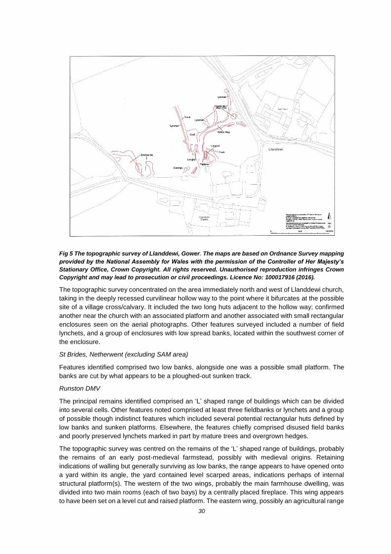
30
Fig 5 The topographic survey of Llanddewi, Gower. The maps are based on Ordnance Survey mapping
provided by the National Assembly for Wales with the permission of the Controller of Her Majesty’s
Stationary Office, Crown Copyright. All rights reserved. Unauthorised reproduction infringes Crown
Copyright and may lead to prosecution or civil proceedings. Licence No: 100017916 (2016).
The topographic survey concentrated on the area immediately north and west of Llanddewi church,
taking in the deeply recessed curvilinear hollow way to the point where it bifurcates at the possible
site of a village cross/calvary. It included the two long huts adjacent to the hollow way; confirmed
another near the church with an associated platform and another associated with small rectangular
enclosures seen on the aerial photographs. Other features surveyed included a number of field
lynchets, and a group of enclosures with low spread banks, located within the southwest corner of
the enclosure.
St Brides, Netherwent (excluding SAM area)
Features identified comprised two low banks, alongside one was a possible small platform. The
banks are cut by what appears to be a ploughed-out sunken track.
Runston DMV
The principal remains identified comprised an ‘L’ shaped range of buildings which can be divided
into several cells. Other features noted comprised at least three fieldbanks or lynchets and a group
of possible though indistinct features which included several potential rectangular huts defined by
low banks and sunken platforms. Elsewhere, the features chiefly comprised disused field banks
and poorly preserved lynchets marked in part by mature trees and overgrown hedges.
The topographic survey was centred on the remains of the ‘L’ shaped range of buildings, probably
the remains of an early post-medieval farmstead, possibly with medieval origins. Retaining
indications of walling but generally surviving as low banks, the range appears to have opened onto
a yard within its angle, the yard contained level scarped areas, indications perhaps of internal
structural platform(s). The western of the two wings, probably the main farmhouse dwelling, was
divided into two main rooms (each of two bays) by a centrally placed fireplace. This wing appears
to have been set on a level cut and raised platform. The eastern wing, possibly an agricultural range

31
(or an earlier dwelling with attached byre, and other outbuildings) set down the slope. The latter
contained four separate rooms at different levels and retained possible openings including at least
one likely doorway. The adjacent enclosure retained the remains of small embanked huts or pens.
The banks and lynchets forming associated enclosures were also surveyed.
Pl 9 Runston Deserted Medieval Village view down length of east or agricultural wing, view to
southwest, 1m scale.
Llanfihangel
Features noted included a substantial embanked platform, possibly the remains of a dwelling, a
sub-rectangular building platform, several linear features which may have defined the positon of
crofts, tracks and a sunken way.
Wernheolydd, Settlement Complex
The remains comprised: a scarped bank and associated track with a series of small rectangular
enclosures; at least three possibly more house and building platforms, and other smaller
rectangular huts and sunken features; several curvilinear enclosures defined by pronounced scarps
surmounted by low banks, which also delineated a sunken area at the junction of four to five hollow
ways; a pond; two areas of slight ridge and furrow; an extensive area of field banks, lynchets, and
drains, with a small number of smaller features of unknown purpose.
The topographic survey was carried out on the main settlement taking in the north-south spinal
linear scarped bank and trackway, the rectangular enclosures, and the site of the settlement itself
(i.e. the three building platforms, the partly sunken rectangular huts and a small sub-rectangular
sunken feature). The site likely represents a single isolated farm unit of farmstead and out buildings
and associated animal enclosures. An area of disturbance was noted towards the south of the site,
probably the result of placing feeders near the entrance gate. The curvilinear enclosures and
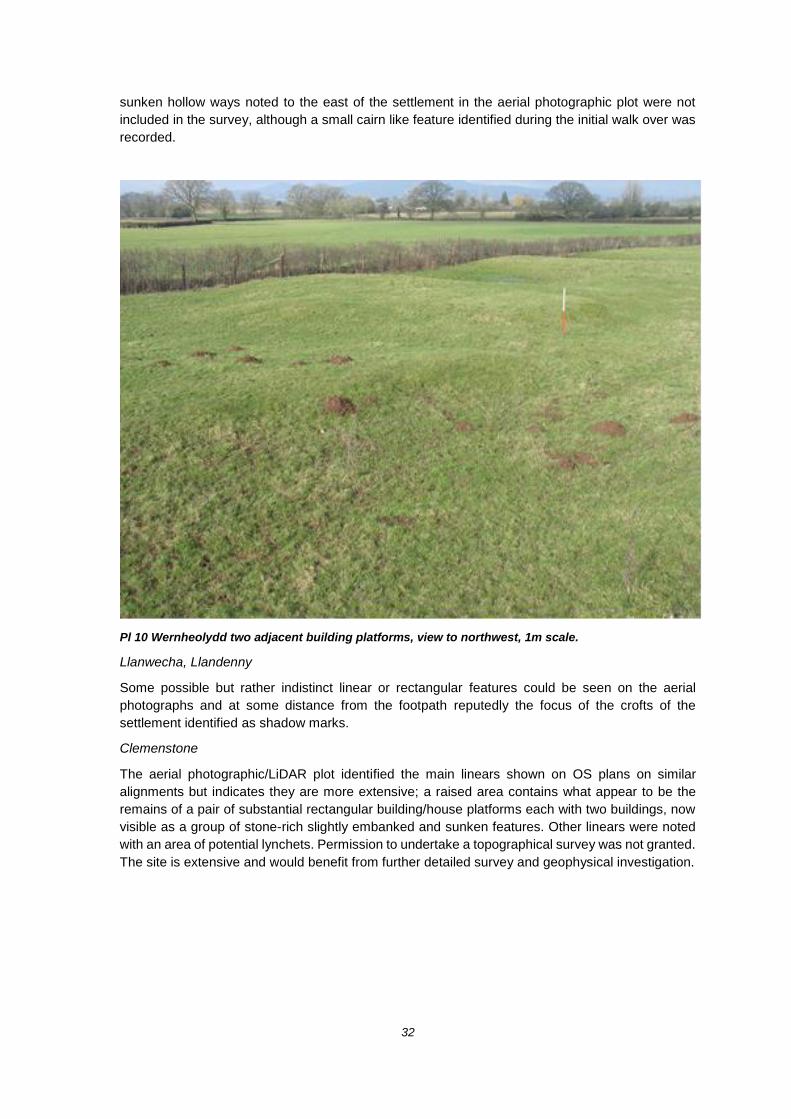
32
sunken hollow ways noted to the east of the settlement in the aerial photographic plot were not
included in the survey, although a small cairn like feature identified during the initial walk over was
recorded.
Pl 10 Wernheolydd two adjacent building platforms, view to northwest, 1m scale.
Llanwecha, Llandenny
Some possible but rather indistinct linear or rectangular features could be seen on the aerial
photographs and at some distance from the footpath reputedly the focus of the crofts of the
settlement identified as shadow marks.
Clemenstone
The aerial photographic/LiDAR plot identified the main linears shown on OS plans on similar
alignments but indicates they are more extensive; a raised area contains what appear to be the
remains of a pair of substantial rectangular building/house platforms each with two buildings, now
visible as a group of stone-rich slightly embanked and sunken features. Other linears were noted
with an area of potential lynchets. Permission to undertake a topographical survey was not granted.
The site is extensive and would benefit from further detailed survey and geophysical investigation.

33
POST-EXCAVATION AND PUBLICATION REVIEW
The database of all ‘grey’ literature reports produced for Cadw has been maintained. In the past
year the reports listed below have been produced:
Evans EM and Hill S Rapid Coastline Zone Assessment in Glamorgan and Gwent: Scoping for an upgrade GGAT Report No 2017/002 Roberts, R GGAT 146: Lowland Settlement & High Status Settlement Survey GGAT Report No 2017/010 Crawford H Clyne Common and Fairwood Common, Gower, Swansea: archaeological survey of military earthworks GGAT Report No 2017/014 Huckfield PW GGAT 144 Casualties of War: South East Wales and the First World War GGAT Report No 2017/018 Rouse C GGAT 118: Accessing Archaeological Planning Management Derived Data Year 5 GGAT Report No 2017/025
POSSIBLE PROJECTS FOR CONTINGENCY FUNDING AND 2018–
2019 OUTLINE PROJECT PROPOSALS
Contingency Funding
We have no planned submissions.
2018–2019 Outline Project Proposals
These have been presented in a separate document.

34
Appendix 1 Welsh Archaeological Trust Grant Scheme 2016–2017: Schedule
2: The Targets
Conserving and protecting the historic environment of Wales including; Complete all threat-related archaeological recording, surveys, assessments, excavations; identifying historic assets of national importance meeting the individual project objectives detailed in the Final Grant Application dated Feb 2016.
The target was delivered through undertaking our Southeast Wales Medieval and Early Post Medieval (c1100–1750) Lowland Settlement & High Status Settlement Survey, First World War Call to Arms and Casualties of War Assessments, and Southeast Wales Coastline Zone Scoping Assessment. The target was completed by the end of March 2017.
Maintain and manage the regional Historic Environment Record (HER).
This target was delivered through undertaking our Historic Environment Record Management, Accessing APM Derived Data, and Historic Environment (Wales) Act HER Measures Enhancement Projects. The target was completed by the end of March 2017.
Support the sustainable management of the historic environment of Wales by providing: Planning Advisory Service; Heritage Management Advisory service delivering against agreed Task List (provided in your Final Grant Application dated Feb 2016)
The targets were delivered through undertaking various works set out in our Heritage Management, Archaeological Planning Management, Local Development Plan Support projects. It was also addressed through undertaking works in our Accessing APM Derived Data and Southeast Wales Coastline Zone Assessment projects. The target was completed by the end of March 2017.
Promoting public understanding and appreciation of Welsh heritage; support community engagement with the historic environment. Provide Historic Environment Learning, Engagement and Outreach Projects as detailed in your Final Grant Application (Feb 2016).
This target was delivered through undertaking our Outreach project, and partially through delivery of our First World War Call to Arms Assessment work. The target was completed by the end of March 2017.
Deliver projects in and with Communities First clusters.
This target was achieved as part of the works delivered by undertaking our Outreach project. The target was completed by the end of March 2017.

35
Appendix 2 Planning Statistics 2016–2017
LPA Applications Mapped
No of
IPE
No
Reply DARi
DAR
Disc
DAR
Disc+
LB
Disc WB ASS EVA
Sec
23 Record Objection Other
No
Response Determined LPA
BLG 419 60 38 0 0 26 2 0 2 0 0 2 0 0 4 0 2 BLG
BRI 1,307 189 104 0 0 31 15 1 1 2 1 4 9 0 10 0 30 BRI
CAE 902 97 65 0 1 20 5 2 2 0 0 3 4 0 17 0 11 CAE
CAR 3,135 270 229 0 2 74 37 6 5 4 2 19 11 0 27 0 42 CAR
MON 1,554 375 425 0 6 83 82 14 20 2 11 40 25 0 54 0 88 MON
MTY 357 102 80 0 2 24 12 0 1 0 0 4 4 0 17 0 16 MTY
NEW 1,198 162 227 0 2 48 63 2 10 1 3 27 5 0 34 0 32 NEW
NPT 1,031 111 111 0 0 25 13 0 2 1 0 9 14 0 16 0 31 NPT
RCT 1,283 214 149 0 11 39 12 1 4 0 0 5 8 0 38 0 31 RCT
SWA 2,147 297 200 0 0 63 24 7 1 0 3 8 4 0 56 0 34 SWA
TOR 546 60 42 0 0 14 3 5 0 1 0 5 2 0 5 0 7 TOR
VOG 1,783 301 249 0 3 77 28 12 14 0 4 27 10 1 35 0 38 VOG
BBNP 642 19 4 0 0 1 0 0 1 0 0 1 0 0 1 0 0 BBNP
TOTAL 16,304 2257 1923 0 27 525 296 50 63 11 24 154 96 1 314 0 362 TOTAL
BLG = Blaenau Gwent County Borough Council Applications = Number of planning applications submitted to LPA
BRI = Bridgend County Borough Council Mapped = Number of planning applications checked against HER
CAE = Caerphilly County Borough Council No IPE = Number of planning applications requested by GGAT
CAR = Cardiff County Council No Reply = Number of applications requested by GGAT but not received
MON = Monmouthshire County Council DARi = Number of applications received which had no archaeological impact
MTY = Merthyr Tydfil County Borough Council DAR Disc = Number of applications received where it was determined that there was unlikely to be an archaeological impact
NEW = Newport City Council DAR Disc + = Number of applications received where it was determined that there was minimal archaeological impact
NPT = Neath Port Talbot County Borough Council LB Disc = Number of applications received which affected listed buildings but were perceived not to have an archaeological impact
RCT = Rhondda Cynon Taff County Borough Council WB = Number of applications which were received which were determined to require the imposition of a watching brief condition
SWA = City and County of Swansea ASS = Number of applications received which required further information in the form of a desk-top assessment prior to determination
TOR = Torfaen County Borough Council EVA = Number of applications received which required further information in the form of an evaluation prior to determination
VOG = Vale of Glamorgan Council Sec 23 = Applications where the archaeological resource can be protected by the imposition of conditions requiring archaeological work
BBNP = Brecon Beacons National Park Record = Applications where it was determined that condition requiring the developer to record the standing structure should be imposed
Objection = Applications where the development would cause damage to the archaeological resource and GGAT object
Other = Number of applications received where GGAT's response could not be classified. No Response = Number of applications received which GGAT failed to respond during consultation period
Determined = Applications determined by LPA before being sent to GGAT
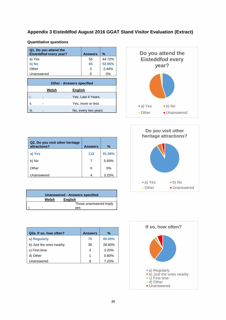
36
Appendix 3 Eisteddfod August 2016 GGAT Stand Visitor Evaluation (Extract)
Quantitative questions
Q1. Do you attend the Eisteddfod every year? Answers %
a) Yes 55 44.72%
b) No 65 52.85%
Other 3 2.44%
Unanswered 0 0%
Other - Answers specified
Welsh English
i. - Yes, Last 4 Years
ii. - Yes, more or less
iii. - No, every two years
Q2. Do you visit other heritage attractions? Answers %
a) Yes 112 91.06%
b) No 7 5.69%
Other 0 0%
Unanswered 4 3.25%
Unanswered - Answers specified
Welsh English
i. - Those unanswered imply yes
Q2a. If so, how often? Answers %
a) Regularly 75 60.00%
b) Just the ones nearby 36 28.80%
c) First time 4 3.20%
d) Other 1 0.80%
Unanswered 9 7.20%
Do you attend the Eisteddfod every
year?
a) Yes b) No
Other Unanswered
Do you visit other heritage attractions?
a) Yes b) No
Other Unanswered
If so, how often?
a) Regularlyb) Just the ones nearbyc) First timed) OtherUnanswered
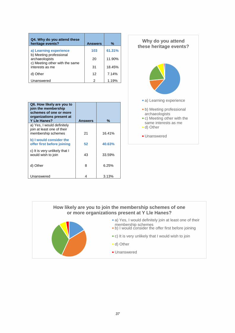
37
Q4. Why do you attend these heritage events? Answers %
a) Learning experience 103 61.31%
b) Meeting professional archaeologists 20 11.90% c) Meeting other with the same interests as me 31 18.45%
d) Other 12 7.14%
Unanswered 2 1.19%
Q6. How likely are you to join the membership schemes of one or more organizations present at Y Lle Hanes? Answers %
a) Yes, I would definitely join at least one of their membership schemes 21 16.41%
b) I would consider the offer first before joining 52 40.63%
c) It is very unlikely that I would wish to join 43 33.59%
d) Other 8 6.25%
Unanswered 4 3.13%
Why do you attend these heritage events?
a) Learning experience
b) Meeting professionalarchaeologistsc) Meeting other with thesame interests as med) Other
Unanswered
How likely are you to join the membership schemes of one or more organizations present at Y Lle Hanes?
a) Yes, I would definitely join at least one of theirmembership schemesb) I would consider the offer first before joining
c) It is very unlikely that I would wish to join
d) Other
Unanswered

38
Qualitative questions
Q3. What do you enjoy about Y Lle Hanes and other heritage attractions?
Welsh (Followed by number of survey) English (Followed by number of survey)
Ysbryd y cymunedau lleol trwy'r hanes nhw (3) Spirit of the local community through their history (3)
Newydd gyrraedd! Just got here! (6)
Mae pethau a ddigwyddodd yn y gorffennol o ddiddordeb mawr gen i (68)
I have great interest in things and happenings in the past (68)
Mae'n helpu i mi ddysgu am ddiwylliant + hanes y wlad (71)
It helps me to learn about the culture and history of the country (71)
Y mapiau adwerthiol a fotograffiau o'r awyr (73) The interactive[?] maps and air photographs
Hanesydd ydw i ac felly mae gen I ddiddordeb proffesionol (74)
I'm a historian so I have a professional interest (74)
Y hanes yr ardal (75) The history of the area (75)
Gwybodaeth am hanes Mynwy (79) Knowledge of the history of Monmouth (75)
Dod a hanes yn fyw. Arddangosfeydd diddorol. Mynediad in adeiladau wedi'u hatgyweirio ayyb (81)
Bring living history. Interesting exhibitions. Going into restored buildings etc. (81)
Lle hanes - hanes lleol i'r Eisteddfod. Dysgu [illegible] (82)
The history place - Local history to the eisteddfod. Learning [illegible]
Esbonio'n hanes i'r plant (87) Explaining our history to the children (87)
Hanes y safle & gwahanol ddulliau o ddehongli'r hanes (88)
The history of the site and other forms of interpretation of the history (88)
Dysgu am ein treftadaeth, a pasio hanes ymlaen i'r plant (89)
Learning about our history, and passing history on to the children (89)
Hanes lleol (90) Local history (90)
Dysgu rhywbeth am hanes lleol ardal y Steddfod (92) Leaning something about the local history of the area of the Eisteddfod (89)
Dysgu rhywbeth newydd (93) Learning something new (93)
Y cyfle i weld popeth dan yr un to (94) The chance to see everything under the same roof (94)
Cyfleoed addysgol (96) Educational opportunities (96)
Hanes lleol ardal yr Eisteddfod (97) Local history of the Eisteddfod area (97)
Cyfle i ddysgu mwy am ardal newydd (98) Chance to learn more about a new area 998)
I wybod mwy am hanes a phobl Cymru (99) Learning more about the history of the Welsh people (99)
Gweld am hanes yr ardal/ein gwlad (100) Seeing about the history of the area/our country (100)
Hanes yn dod yn fyw (102) History comes to life (102)
Dysgu am ein hanes fel Cymry (103) Learning about our history as welsh people (103)
Yr awyr hanesol [sic] (104) The historical atmosphere [?] (104)
Deall hanes & fy nghefndir (103) Understanding history and my background (105)
Gwybodaeth newyd[sic] - Ymestyn gwerthfawrogi (106) New information - Appreciating outreach (106)
Ein cynsylliad a'r amygylchedd ddoe a heddiw (107) Our connection with our environment yesterday and today (107)
Gwybodaeth am ein gorffennol fel cenadl (108) Information about our past as a nation (108)
Y stori, y cefndir i lle ni wedi dod (109) The story, the background to where we've come from (109)
Rwyn eilod o Cymdeithas (Antiquarians) Sir Fynwy (110) I'm a member of the Monmouthshire Antiquarian Association (110)
Pethau diddorol am y hanes yn yr ardal (112) Interesting things about the history in the area (112)
Cyfle I ddysgu mwy am hanes Cymru (113) Chance to learn more about history of Wales (113)
Learning about the past (F2)
Learning about history (F3)
The interest in history (F5)
They interest me (1)

39
Seen it last year (2)
Understanding how people lived/ thinks, worked (4)
Various things, learning about the history and heritage that surrounds us (5)
I just like old things! (7)
Finding out what's available and widening horizons (8)
The stories (10)
The history (13)
Learning opportunities (18)
Interesting (19)
Interested in Welsh history tent, don't know a great deal about it (23)
Son loves history! (24)
Learning about the past (24)
Local history (25)
Sense of time and welsh roots (26)
Information which opens new horizons (27)
I'm a professional historian! (28)
The maps (32)
Learning about the local area (34)
Professional interest (35)
Learning about the past (37)
Part of the welsh culture - finding out more of history, archaeology and culture (38)
Professional and personal interest (42)
Brings history to life (44)
The history is a blessing (45)
Family days out about history (52)
History (54)
Learning about the past and the way things have changed (55)
Learning more about local, welsh and wider history (56)
Helps you understand the area you're visiting (58)
Learn more about history of an area and discover more places to visit (59)
Inspired by the work of our predecessors (60)
Advancement of my knowledge (62)
I love to learn, information is power (66)
The information on display (91)
Open/Friendly (118)
The way of learning more about the history and people of wales (115)
Bringing together information about many/diverse historical organizations (116)

40
Q5. Y Lle Hanes promotes the work of various local, regional and national heritage organizations. Are there any other events where you think these organizations could be present?
Welsh (Followed by number of survey) English (Followed by number of survey)
Dyddiau agored mewn gwahanol llefydd (F1) Open days in different places (F1)
Llangollen (Eisteddfod) (69) Llangollen (Eisteddfod) (69)
Cymmunedau lleol[?] (70) Local [?]communities
Nac oes (71) No (71)
Mudiadau hanes teuliol (achau) (73) Family history organisations (73)
Eistedfod yr Urdd (74) The Urdd (74)
Cynifer ag y bo'n ymarfeol (79) As many as is practicable (79)
Sioe Amaethyddiaeth Cymru (80) Welsh Agricultural Show (80)
Gwyliau rhyngwladol os bosib? Datblygi dealltwriaeth gwledydd eraill (81)
International festivals if possible? Develop understanding with other countries (81)
Green Man, Yr Urdd (82) green man, the Urdd (82)
Ddim yn siwr (88) Not sure (88)
Sioeau amaethyddol (97) Agricultural shows (97)
Ydych chi yn mynd i'r Sioes Frenhinol? Ydych chi yn mynd i Sioe Mon a'r Tair Sir? (109)
Do you go to the Royal Welsh? Do you go to the Anglesey Show and the Three Counties? (109)
Eisteddfod yr Urdd. Sioe Amaethyddol a sioeau rhanbarthol eraill (111)
The Urdd. Agricultural show and other regional shows
Urdd; Tafwyl; Gwyl y Gelli; Sioe Frehinol Urdd; Tafwyl; Hay Festival; Royal Welsh
Vale of Glamorgan show (F3)
Family History Open days (F3)
Anywhere where there is interest (F5)
Historic houses, archaeological sites etc. (2)
Local shows (8)
Family History Event (10)
Maybe more local focused activities (14)
Possibly more connection with local authority elected members (14)
Royal Welsh show and local town festival (16)
Community and castles (18)
Usk agricultural show (29)
No - only getting to know these organizations currently (30)
Local events/schools (34)
School and University fairs and events (35)
Belong to Gwynedd group (37)
Summer Fayre August Bank Holidays, Mountain Centre Libraries Brecon, contact Andrew Powell (43)
The BBC Country File Festival. The cathedrals of Britain (44)
Church exhibitions of art and culture (valleys) (45)
Alzheimer's memory café's in the valleys (46)
Local fairs/festivals (55)
Country shows, food festivals, farmer markets, multi ethnic festivals such as Maindee Festival Newport Gwent (56)
Other cultural and national events (57)
Urdd Eisteddfod, Lots of local/county shows (58)
Old churches (60)
Nothing springs to mind but I’m probably not the best to ask (61)
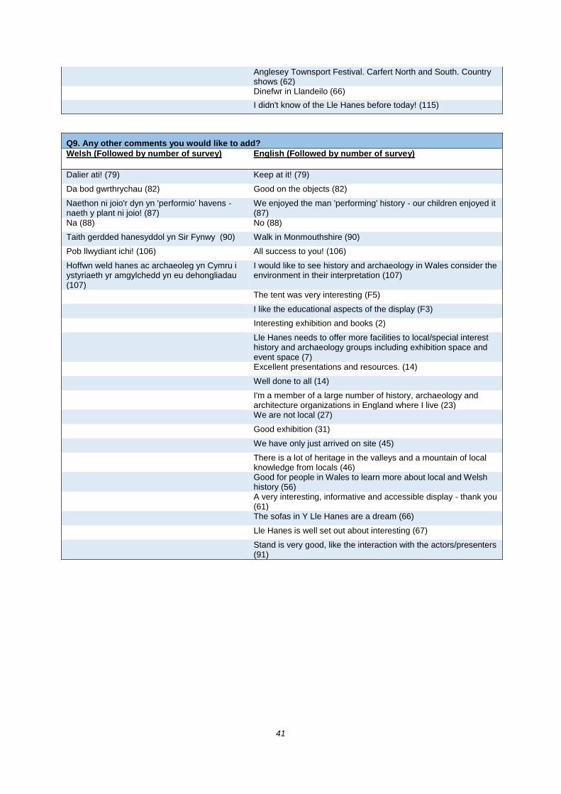
41
Anglesey Townsport Festival. Carfert North and South. Country shows (62)
Dinefwr in Llandeilo (66)
I didn't know of the Lle Hanes before today! (115)
Q9. Any other comments you would like to add?
Welsh (Followed by number of survey) English (Followed by number of survey)
Dalier ati! (79) Keep at it! (79)
Da bod gwrthrychau (82) Good on the objects (82)
Naethon ni joio'r dyn yn 'performio' havens - naeth y plant ni joio! (87)
We enjoyed the man 'performing' history - our children enjoyed it (87)
Na (88) No (88)
Taith gerdded hanesyddol yn Sir Fynwy (90) Walk in Monmouthshire (90)
Pob llwydiant ichi! (106) All success to you! (106)
Hoffwn weld hanes ac archaeoleg yn Cymru i ystyriaeth yr amgylchedd yn eu dehongliadau (107)
I would like to see history and archaeology in Wales consider the environment in their interpretation (107)
The tent was very interesting (F5)
I like the educational aspects of the display (F3)
Interesting exhibition and books (2)
Lle Hanes needs to offer more facilities to local/special interest history and archaeology groups including exhibition space and event space (7)
Excellent presentations and resources. (14)
Well done to all (14)
I'm a member of a large number of history, archaeology and architecture organizations in England where I live (23)
We are not local (27)
Good exhibition (31)
We have only just arrived on site (45)
There is a lot of heritage in the valleys and a mountain of local knowledge from locals (46)
Good for people in Wales to learn more about local and Welsh history (56)
A very interesting, informative and accessible display - thank you (61)
The sofas in Y Lle Hanes are a dream (66)
Lle Hanes is well set out about interesting (67)
Stand is very good, like the interaction with the actors/presenters (91)