the future of soil mapping using lidar technology future of soil mapping using lidar technology...
TRANSCRIPT
The Future of Soil Mapping using LiDAR Technology
Jessica PhilippeSoil Scientist/GIS Specialist
March 24, 2016
Natural Resources Conservation Service Helping People Help the Land

USDA is an equal opportunity provider, employer, and lender.
Area 12-STJ covers parts of 5 states and dozens of traditional, non-MLRA soil
survey areas; about 17 million acres.
Responsible for MLRA 143, Northeastern
Mountains (excluding Adirondack region, NY).

12-STJ specialty: knowledge based raster soil mapping
USDA is an equal opportunity provider, employer, and lender.

USDA is an equal opportunity provider, employer, and lender.
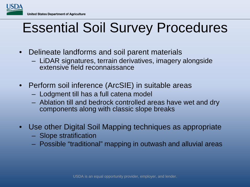
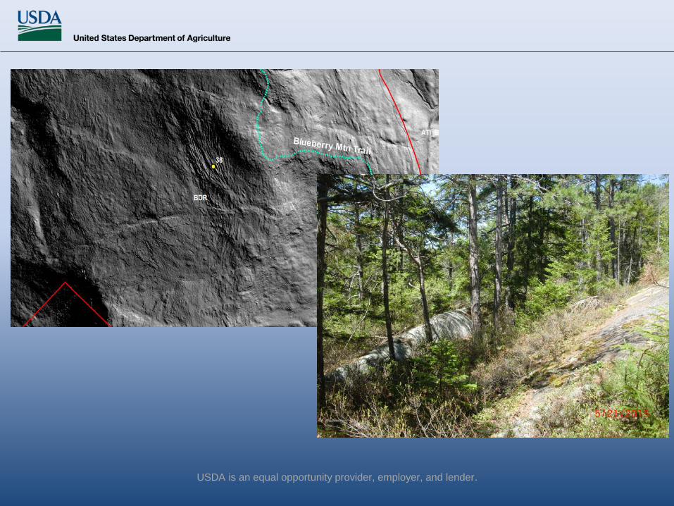
• Delineate landforms and soil parent materials– LiDAR signatures, terrain derivatives, imagery alongside
extensive field reconnaissance
• Perform soil inference (ArcSIE) in suitable areas– Lodgment till has a full catena model– Ablation till and bedrock controlled areas have wet and dry
components along with classic slope breaks
• Use other Digital Soil Mapping techniques as appropriate– Slope stratification– Possible “traditional” mapping in outwash and alluvial areas
Essential Soil Survey Procedures

USDA is an equal opportunity provider, employer, and lender.
Main uses of LiDAR in support of soil survey:
• A tool for landscape/landform/soil parent material visualization and stratification
• A source of terrain derivatives for soil predictive models

USDA is an equal opportunity provider, employer, and lender.
courtesy of the US Geological Survey
Light Detection and Ranging System (LiDAR)

USDA is an equal opportunity provider, employer, and lender.
LiDAR Point Cloud
USDA is an equal opportunity provider, employer, and lender.
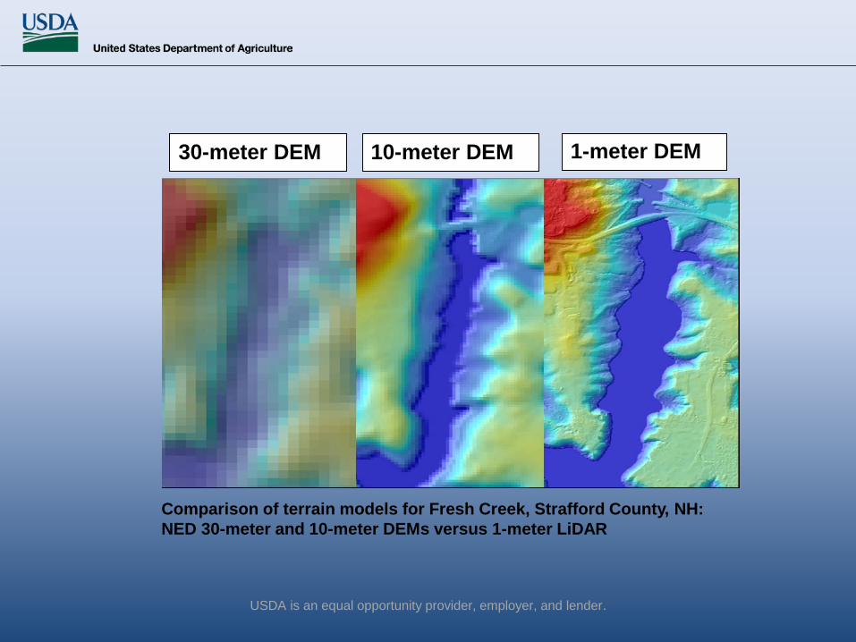
Comparison of terrain models for Fresh Creek, Strafford County, NH: NED 30-meter and 10-meter DEMs versus 1-meter LiDAR
30-meter DEM 10-meter DEM 1-meter DEM
USDA is an equal opportunity provider, employer, and lender.
• Delineate landforms and soil parent materials– LiDAR signatures, terrain derivatives, imagery alongside
extensive field reconnaissance
• Perform soil inference (ArcSIE) in suitable areas– Lodgment till has a full catena model– Ablation till and bedrock controlled areas have wet and dry
components along with classic slope breaks
• Use other Digital Soil Mapping techniques as appropriate– Slope stratification– Possible “traditional” mapping in outwash and alluvial areas
Essential Soil Survey Procedures

Visualization
Prior to 2000 and the implementation of GIS in soil survey offices, landscape/landform visualization was via aerial photography and topographic maps.
USDA is an equal opportunity provider, employer, and lender.

Now, bare-earth LiDAR elevation data, terrain derivatives, CIR (and other imagery), and GPS waypoints from reconnaissance are used for initial landscape stratification.
USDA is an equal opportunity provider, employer, and lender.
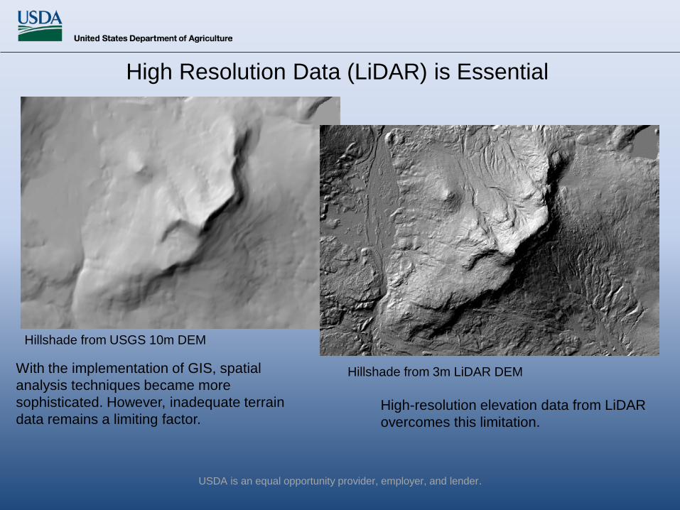
Hillshade from USGS 10m DEM
Hillshade from 3m LiDAR DEMWith the implementation of GIS, spatial analysis techniques became more sophisticated. However, inadequate terrain data remains a limiting factor.
High-resolution elevation data from LiDAR overcomes this limitation.
High Resolution Data (LiDAR) is Essential
USDA is an equal opportunity provider, employer, and lender.
USDA is an equal opportunity provider, employer, and lender.
USDA is an equal opportunity provider, employer, and lender.
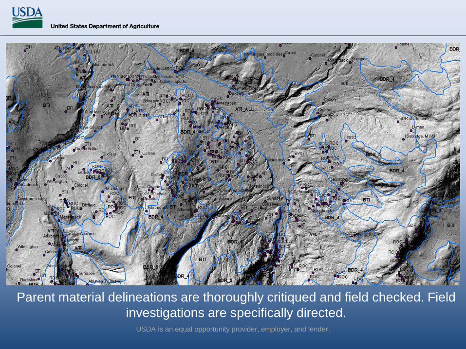
Parent material delineations are thoroughly critiqued and field checked. Field investigations are specifically directed.

USDA is an equal opportunity provider, employer, and lender.
Parent Material and Landform Maps Provide the Basis for all Subsequent Soil Mapping
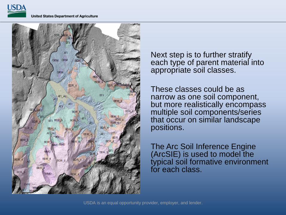
Next step is to further stratify each type of parent material into appropriate soil classes.
These classes could be as narrow as one soil component, but more realistically encompass multiple soil components/series that occur on similar landscape positions.
The Arc Soil Inference Engine (ArcSIE) is used to model the typical soil formative environment for each class.
USDA is an equal opportunity provider, employer, and lender.
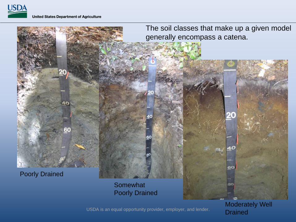
Poorly Drained
Somewhat Poorly Drained
Moderately Well Drained
The soil classes that make up a given model generally encompass a catena.
USDA is an equal opportunity provider, employer, and lender.
• Digital soil mapping (DSM) is a very broad concept.
• Knowledge-based Raster Soil Mapping is a specific approach to DSM
USDA is an equal opportunity provider, employer, and lender.

USDA is an equal opportunity provider, employer, and lender.
ArcSIE is a proven tool, designed for field soil scientists to implement knowledge-based raster soil mapping.
We define the typical soil formative environment in the model, and the resulting fuzzy membership values represent the similarity of the soil at each pixel location to a particular soil series.
Raster Soil Mapping
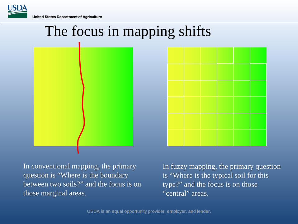
In conventional mapping, the primary question is “Where is the boundary between two soils?” and the focus is on those marginal areas.
The focus in mapping shifts
In fuzzy mapping, the primary question is “Where is the typical soil for this type?” and the focus is on those “central” areas.
USDA is an equal opportunity provider, employer, and lender.

USDA is an equal opportunity provider, employer, and lender.
Elevation 200–600m is typical for soil A.
As elevation deviates from this range, the soil’s similarity to type A gradually decreases.
200m 600m1.0 -
Sim
ilarit
y
Elevation (m)
Knowledge Represented as a Rule
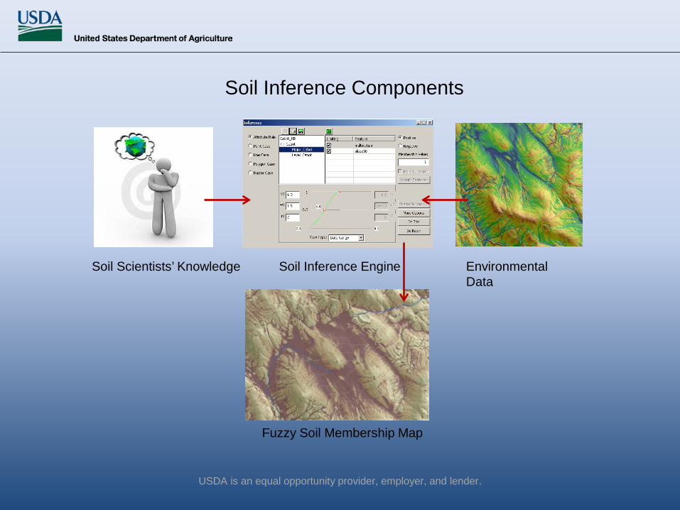
Soil Inference Components
Environmental Data
Soil Inference Engine
Fuzzy Soil Membership Map
Soil Scientists’ Knowledge
USDA is an equal opportunity provider, employer, and lender.
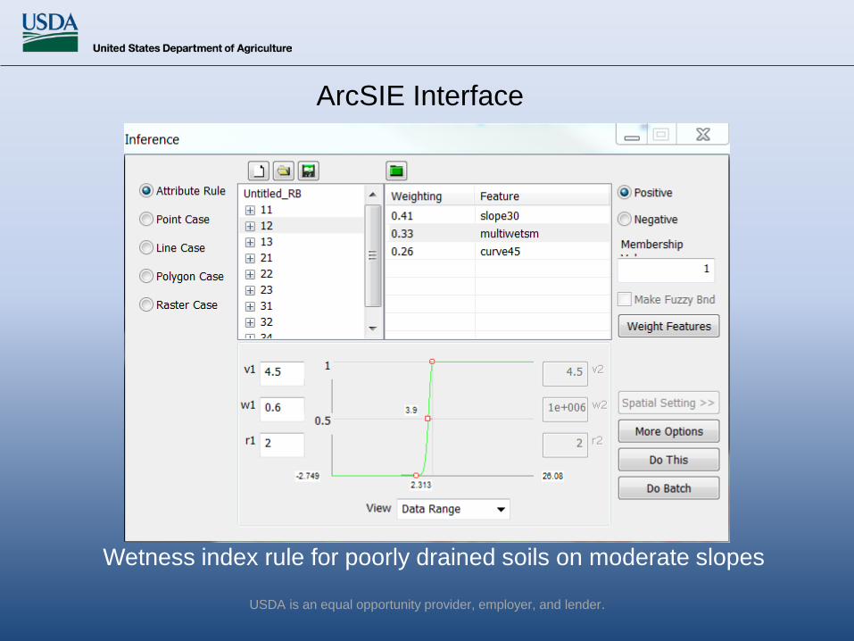
Wetness index rule for poorly drained soils on moderate slopes
ArcSIE Interface
USDA is an equal opportunity provider, employer, and lender.

Raster Soil Mapping
DEM Cabot
An illustration of a basic raster soil mapping process that only uses terrain attributes. Terrain Attributes
USDA is an equal opportunity provider, employer, and lender.
USDA is an equal opportunity provider, employer, and lender.
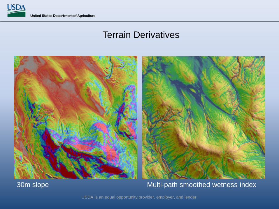
30m slope Multi-path smoothed wetness index
Terrain Derivatives

Fuzzy membership maps are created for each soil class.
We define the typical soil formative environment in the model, and the resulting fuzzy membership values represent the similarity of the soil at each pixel location to a particular soil class.
USDA is an equal opportunity provider, employer, and lender.
USDA is an equal opportunity provider, employer, and lender.
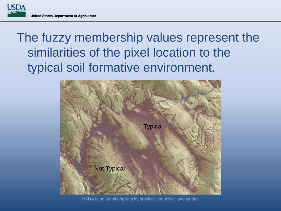
The fuzzy membership values represent the similarities of the pixel location to the typical soil formative environment.
Typical
Not Typical
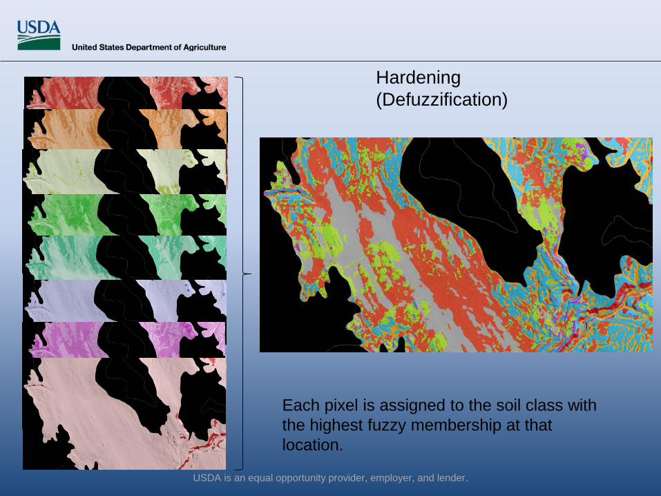
Hardening (Defuzzification)
Each pixel is assigned to the soil class with the highest fuzzy membership at that location.
USDA is an equal opportunity provider, employer, and lender.

SIE Results are Validated in the Field
USDA is an equal opportunity provider, employer, and lender.

Inference by Soil Series Harden Results
Integrate Slope Phases Create Logical Map Units
Traditional ArcSIE Process Steps
USDA is an equal opportunity provider, employer, and lender.

Predictive modeling by soil series Brute force modeling by
landform and slope class Traditional mapping with modern enhancements
---All combined to create the SSURGO product
USDA is an equal opportunity provider, employer, and lender.
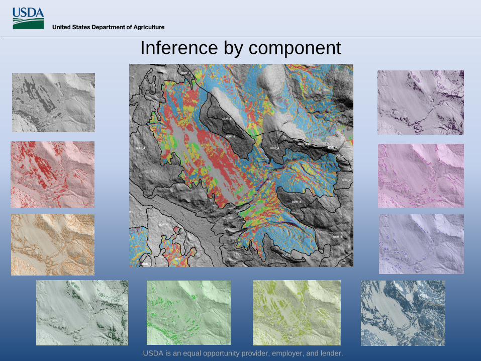
Inference by component
USDA is an equal opportunity provider, employer, and lender.
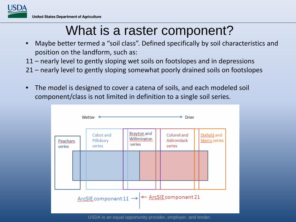
What is a raster component?• Maybe better termed a “soil class”. Defined specifically by soil characteristics and
position on the landform, such as:11 – nearly level to gently sloping wet soils on footslopes and in depressions21 – nearly level to gently sloping somewhat poorly drained soils on footslopes
• The model is designed to cover a catena of soils, and each modeled soil component/class is not limited in definition to a single soil series.
USDA is an equal opportunity provider, employer, and lender.

USDA is an equal opportunity provider, employer, and lender.
The catena models allows us to visualize where different components occur within a “traditional” map unit.

USDA is an equal opportunity provider, employer, and lender.
Essex County, VT is the first published raster soil survey in the country
USDA is an equal opportunity provider, employer, and lender.
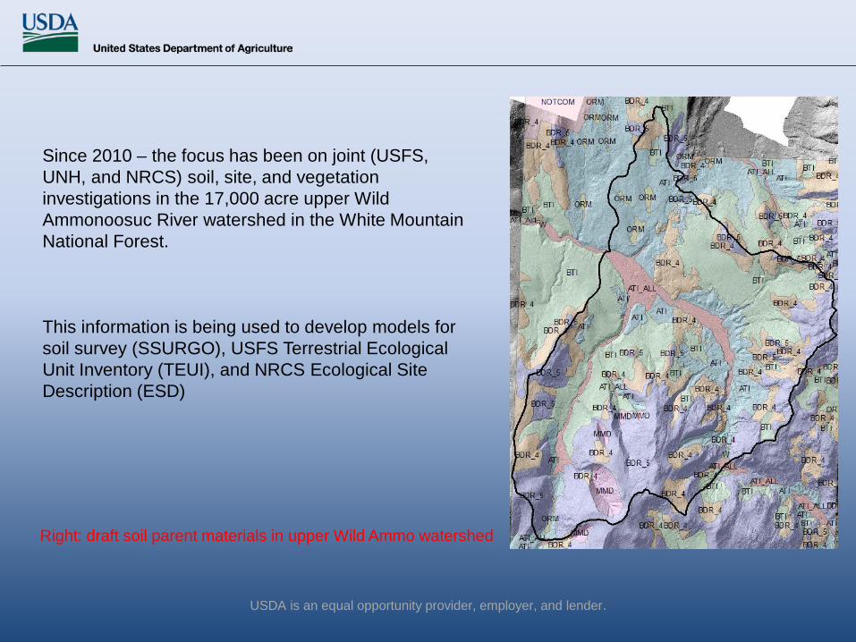
Since 2010 – the focus has been on joint (USFS, UNH, and NRCS) soil, site, and vegetation investigations in the 17,000 acre upper Wild Ammonoosuc River watershed in the White Mountain National Forest.
This information is being used to develop models for soil survey (SSURGO), USFS Terrestrial Ecological Unit Inventory (TEUI), and NRCS Ecological Site Description (ESD)
Right: draft soil parent materials in upper Wild Ammo watershed
USDA is an equal opportunity provider, employer, and lender.
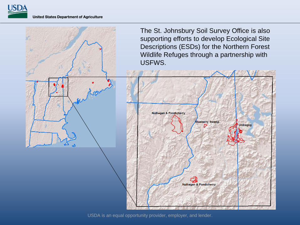
The St. Johnsbury Soil Survey Office is also supporting efforts to develop Ecological Site Descriptions (ESDs) for the Northern Forest Wildlife Refuges through a partnership with USFWS.
USDA is an equal opportunity provider, employer, and lender.
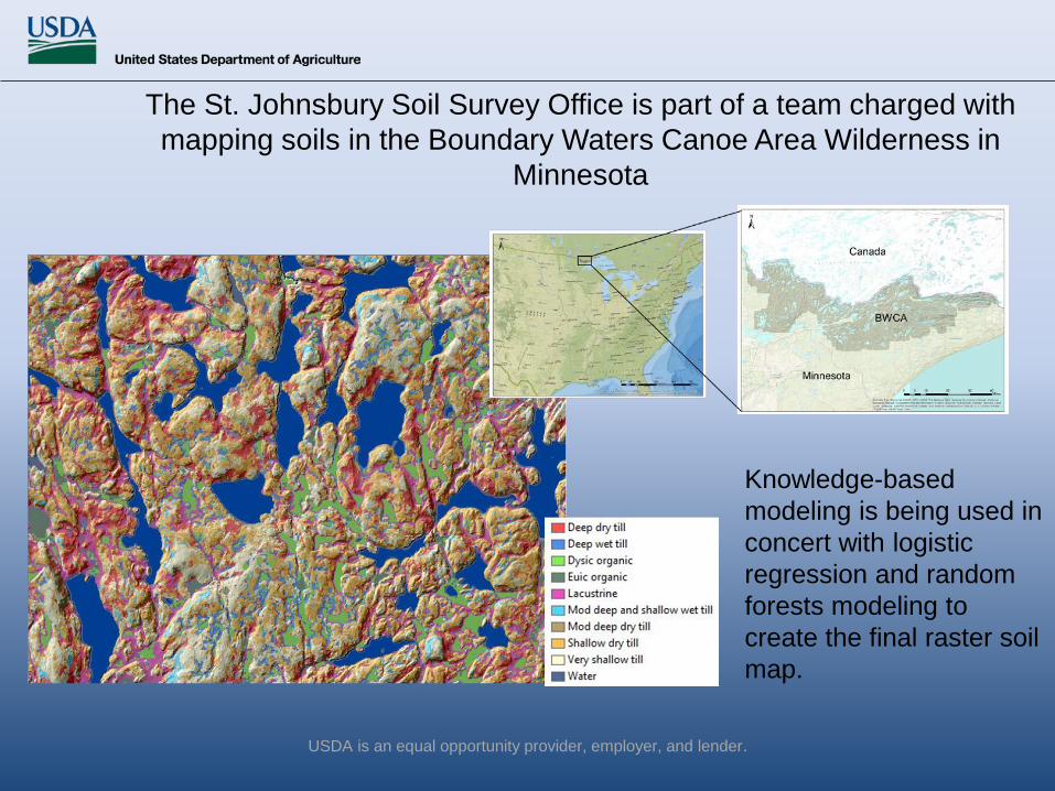
The St. Johnsbury Soil Survey Office is part of a team charged with mapping soils in the Boundary Waters Canoe Area Wilderness in
Minnesota
Knowledge-based modeling is being used in concert with logistic regression and random forests modeling to create the final raster soil map.

USDA is an equal opportunity provider, employer, and lender.
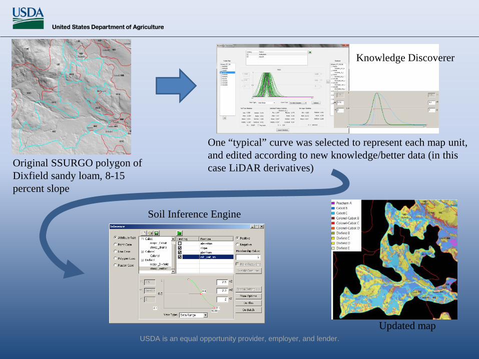
Knowledge Discoverer (KD) is a module in ArcSIE for soil survey update.
The approach is to discover, revise, and reuse the knowledge (soil-landscape model) implicitly represented by an existing soil map, during which it incorporates updated (better) knowledge and data.
USDA is an equal opportunity provider, employer, and lender.
Original SSURGO polygon of Dixfield sandy loam, 8-15 percent slope
Updated map
One “typical” curve was selected to represent each map unit, and edited according to new knowledge/better data (in this case LiDAR derivatives)
Knowledge Discoverer
Soil Inference Engine

USDA is an equal opportunity provider, employer, and lender.

USDA is an equal opportunity provider, employer, and lender.
Thank You!
For more information, email me: [email protected]