the douglas oil and gas field, converse county, wyoming ... · the douglas oil and gas field,...
TRANSCRIPT
THE DOUGLAS OIL AND GAS FIELD, CONVERSE COUNTY,WYOMING.
By V. H. BARNETT.
LOCATION AND DEVELOPMENT OF THE FIELD.
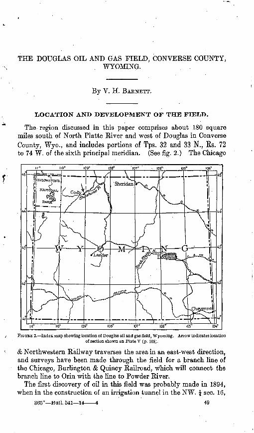
The region discussed in this paper comprises about 180 square miles south of North .Platte River and west of Douglas in Converse County, Wyo., and includes portions of Tps. 32 and 33 N., Rs. 72 to 74 W. of the sixth principal meridian. (See fig. 2.) The Chicago
107°__ - 106°' 105" 104°
A3
108' 107° 106°
FIGURE 2. Index map showing location of Douglas oil and gas field, Wyoming. Arrow indicates location of section shown on Plate V (p. 108).
& Northwestern Railway traverses the area in an east-west direction, and surveys have been made through the field for a branch line of the Chicago, Burlington & Quincy Railroad, which will connect the branch line to Orin with the line to Powder River.
The first discovery of oil in this field was probably made in 1894, when in the construction of an irrigation tunnel in the NW. J sec. 16,
365° Bull. 541 14 49
50 CONTRIBUTIONS TO ECONOMIC GEOLOGY, 1912, PART II.
T. 32 N., R. 73 W., a sandstone more or less saturated with heavy oil was found in the top of the "Cleverly77 formation. Since this dis covery several companies have put down wells at different times until at present some 50 or 60 borings are scattered over the Bren- ning Basin. When drilling began the presence of gas in the basin was little suspected, but a number of the wells have proved to con tain more gas than oil. In December, 1904, gas was struck at a depth of 435 feet in a well (No. 18, PI. IV) in sec. 4, T. 32 N., R. 73 W., in which, according to a statement of J. B. Phillips in applying for title for mineral claim, a pressure of 50 pounds to the square inch was obtained when tested two days later. The Douglas Oil Fields Co. piped the gas to the adjoining claim and used it for several months under a boiler for drilling and for camp purposes. Gas from this well in 1912 was still used at the nearest house. Oil is reported to have been found in 32 wells, gas in 20 wells, and water in 24 wells in this basin. All the 66 wells indicated by numbers on the map (PL IV) have corresponding numbers in the list of wells on pages 73-74.
VEGETATION, FUEL, AND WATER SUPPLY.
Farming is carried on extensively in favorable localities, where alfalfa, timothy, and smaU grain are profitably raised by irrigation. The part of the area not under cultivation yields a good growth of grass which supplies perennial range for stock.
The rainfall is not sufficient to support a growth of timber, except r cattered cottonwood and boxelder trees along the streams and a few scrubby pine and cedar on some of the rocky hills. However, marketable pine timber grows in isolated areas in the mountains to the south, especially along the precipitous walls of Boxelder Creek in T. 32 N., R. 75 W. This area was included in one of the wood re serves of the old Fort Fetterman Military Reservation.
The domestic fuel, for the most part, consists of pine and cedar wood, which is hauled from the mountains, and coal, which is mined in the northern part of the area near Inez or at Glenrock, just north west of the field. Oil and gas have also been utilized to a slight ex tent as fuel. In 1912 a number of ranchmen in Brenning Basin were using gas for lighting and heating and in one place crude oil was used for heating.
The several streams which rise in the mountains and flow across the field to North Platte River yield a good supply of fresh water for domestic use. For a number of years water from La Prele, Boxelder, and Little Boxelder creeks has been utilized for irrigating small tracts along these streams, but within the last few years irrigation on a larger scale has been made practicable by the completion of the La Prele dam. This dam is so located that the water may be used to generate electricity before it is allowed to flow into the irrigation
DOUGLAS OIL AND GAS FIELD, WYO. 51
canals. With this end in view the Platte Valley Development Co. has constructed a power plant below the dam and proposes to trans mit electricity to a pumping station on the North Platte, where water for irrigation is to be taken from that stream.
Several good springs of water seep from the gravel and sand beds of the White River formation, notably from the thick conglomerate covering the higher hills in T. 32 N., R. 72 W. A perennial spring with a flow of water several inches in diameter, coming from the sand stone or limestone of the Casper formation, rises at the foot of the mountain in sec. 2, T. 32 N., R. 74 W. Other springs of minor im portance come from the granitic rocks or the Casper formation along the foot of the mountain ridge.
ACKNOWLEDGMENTS.
In presenting this report the writer wishes to express his thanks for courtesies extended during the progress of the field work by the people of Douglas and vicinity, and to Messrs. Consaul & Heltman, attorneys for the Wyoming Oil & Development Co., and Douglas Oil Fields (Ltd.). Especial credit is due to Mr. A. W. Phillips, who gave well logs and other information, and to Mr. L. C. Bishop, a local sur veyor, who loaned a map of a part of the field.
The field work was done in September and October, 1912, by a party consisting of Frank A. Herald, R. Z. Pierce, Frank Elliott, Bernard Jackson, and the writer.
PURPOSE OF THE INVESTIGATION.
The primary object of the investigation of this field was to ascer tain the mineral resources, especially oil, gas, and coal, for the pur pose of classifying the land by legal subdivisions into mineral land and nonminera' land. A secondary object and one closely connected with the first was to determine, so far as possible, the geologic struc ture, the various formations involved, and the conditions which have resulted in the accumulation of oil and gas.
METHOD OF FIELD WORK.
The Douglas field was mapped on a scale of 2 inches to the mile ' by means of a plane table and telescopic alidade, the township being the unit represented by each field sheet. A complete system of triangulation was established covering the field, and the stations of this system served the purpose of horizontal and vertical control and as a means of tying the different plane-table sheets together. In beginning tbe primary control or triangulation a base line 11,200 feet in length was measured with a steel tape along a level road between two intervisible points. The line extended from the north quarter corner of sec. 8, T. 32 N., R. 73 W., eastward to a point a
52 CONTRIBUTIONS TO ECONOMIC GEOLOGY, 1912, PART II.
short distance west of the northeast corner of sec. 10 of the same township. The land net of T. 32 N., R. 73 W., having been drawn on the plane-table sheet before entering the field, the plane table l was set up at the west end (the north quarter corner of sec. 8) of the base and approximately oriented by compass. The telescopic alidade was then sighted on the station at the opposite end of the base, a line was drawn along the edge of the alidade, and the distance as determined by the steel tape scaled off. The exact position of the base line having thus been determined on the plane-table sheet, lines were drawn in the direction of a great number of prominent points, such as houses, trees, derricks, and buttes, and the vertical angles read. After sighting at as many points as were desired from this end of the base the other end was occupied and the table oriented by a back sight on the first station. A second line was then drawn in the direction of as many of the points first sighted as could be seen, thus locating these landmarks on the plane-table sheet. Many of the newly located points were in turn occupied and other points throughout the field were located that were invisible from either end of the original base line. This system was continued throughout the field by transferring points on the margin of one sheet to an adjoining sheet. Wherever a section corner was found it was located on the map with respect to triangulation stations. Altitudes were determined in a large part of the area by means of vertical angles, and in addition a line of levels was carried by the same method from Douglas, at an altitude of 4,800 feet, to each well. (See p. 73.) Stadia traverses were employed in conjunction with triangulation for mapping formation boundaries and locating wells. The map, Plate IV, was assembled .after returning to the office by joining the individual plane-table sheets, using the points common to two or more of them.
LAND SURVEYS.
The positions of the Government land corners shown on the map were determined by triangulation and therefore are correct so far as the scale of the map would permit. No attempt was made to find all the section corners, but in the vicinity of the oil and gas wells a considerable number were found. The net shown on the map is based on section corners located in the field and from the alignment map of the Chicago & Northwestern Railway and the General Land Office plats. The net of R. 72£ was drawn from plats in the files of the General Land Office and from three corners shown on the map (PL IV), which were located by triangulation in the field and agree with the Land Office record. R. 72£ was surveyed in 1907, as well as
iA 15 by 15 inch plane table was used for mapping individual townships, but for carrying locations the larger 24 by 24 inch plane table was employed.
DOUGLAS OIL AND GAS FIELD, WYO. 53
sec. 18, T. 32 N., R. 72 W., the net of which is copied from the Land Office data.
TOPOGRAPHY.
The Douglas oil field may be described in a general way as a rolling 'prairie dotted with a few prominent buttes and ridges that stand above the general level and inclosed on the south by a low range of mountains. Several small streams which emerge from the mountains through deep canyons cross the area in flat-bottomed valleys and flow into North Platte River. The main part of the oil field lies in the so-called Brenning Basin, a basin-like area in the northern part of T. 32 N., R. 73 W., which is surrounded on three sides by an upland of considerably greater altitude.
The elevation along North Platte River is about 4,800 feet above sea level, b.ut the land rises gradually toward the south until at the foot of the mountains it is 5,400 feet above sea. Thence to the summit of the range, a horizontal distance of less than a mile, the surface rises about 600 feet.
GEOLOGY.
STRATIGRAPHY.
GENERAL SECTION,
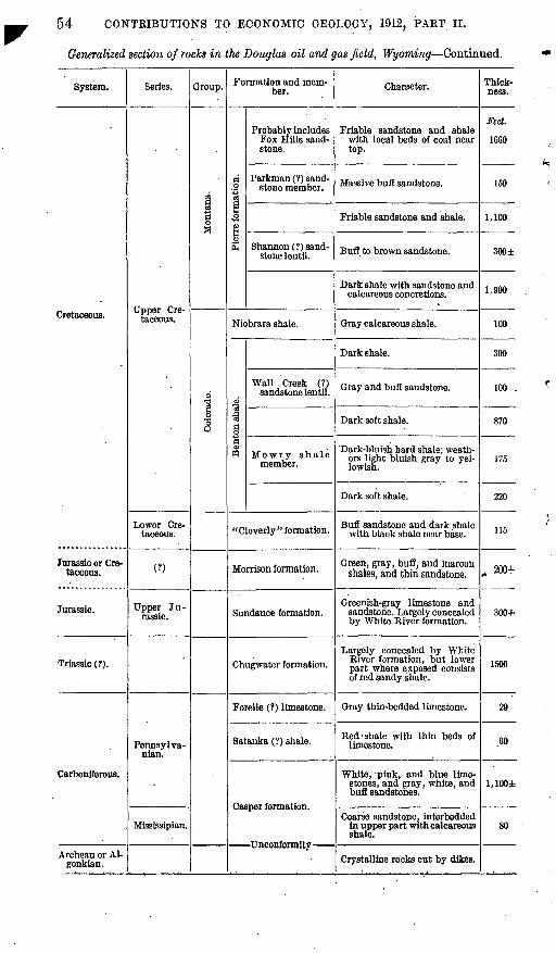
The rocks of the Douglas oil field and vicinity include about 10,000 feet of Paleozoic and Mesozoic formations, ranging in age from Car boniferous to late Cretaceous, and extensive beds of Tertiary (Ceno- zoic) age, as shown by the following table:
Generalized section of rocks in the Douglas oil and gas field and vicinity, Wyoming.
System.
Quaternary.
Cretaceous or Tertiary.
Series.
Oligocene.
Eocene.
(?)
Group. Formation and member.
White River forma tion.
Fort Union formation.
Lance formation.
Character.
Alluvium, gravel, and sand.
Clay, conglomerate, and sand stone.
Friable sandstone and shale with beds of coal.
Friable sandstone and shale with local bed of coal.
Thick ness.
Feet. 25±
1,070
(?)
4,000+
54 CONTRIBUTIONS TO ECONOMIC GEOLOGY, 1912, PART II.
Generalized section of rocks in the Douglas oil and gas field, Wyoming Continued.
System.
Cretaceous.
Jurassic or Cre taceous.
Jurassic.
Triassic (?).
Carboniferous.
Archean or Al- gonkian.
Series.
Upper Cre taceous.
Lower Cre taceous.
(?)
Upper Ju rassic.
Pennsylva- nian.
Mississipian.
Group.
Montana.
Colorado.
Formation and mem ber.
|
o
g<o£
Probably includes Fox Hills sand stone.
Parkman (?) sand stone member.
Shannon (?) sand stone lentil.
Niobrara shale.
Benton shale.
Wall Creek (?) sandstone lentil.
Mowry shale member.
"Cloverly " formation.
Morrison formation.
Sundance formation.
Chugwater formation.
Forelle (?) limestone.
Satanka (?) shale.
Casper formation.
Character.
Friable sandstone and shale with local beds of coal near top.
Massive buff sandstone.
Friable sandstone and shale.
Buff to brown sandstone.
Dark shale with sandstone and calcareous concretions.
Gray calcareous shale.
Dark shale.
Gray and buff sandstone.
Dark soft shale.
Dark-bluish hard shale; weath ers light bluish gray to yel lowish.
Dark soft shale.
Buff sandstone and dark shale with black shale near base.
Green, gray, bufl, and maroon shales, and thin sandstone.
Greenish-gray limestone and sandstone. Largely concealed by White River formation.
Largely concealed by White- River formation, but lower part where exposed consists of red sandy shale.
Gray thin-bedded limestone.
Red -shale with thin beds of limestone.
White, pink, and blue lime stones, and gray, white, and buff sandstones.
Coarse sandstone, interbedded in upper part with calcareous shale.
Crystalline rocks cut by dikes.
Thick ness.
Feet.
1660
150
1,100
300±
1,900
100
300
100 .
870
175
220
115
200+
300+
1500
29
60
l,100i
. 80
DOUGLAS OIL AtfD GAS FIELD, WYQ. 55
The map (PL IV) shows the limiting boundaries of each formation listed in the table, so far as they could be traced. These boundaries have been extended across the territory covered by the White River .formation and represent the position which the formations would probably occupy if the overlapping White River formation was removed. In drawing boundaries across the White River formation the writer has used the data afforded by well records, which, however, if taken alone would be of very little use, but combined with other data are of considerable value. . A fair estimate of the thickness of the several formations under the overlap is afforded by a measured section of the rocks exposed in T. 33 N., R. 74 W. In this township the Cretaceous formations strike east and west and pass under the White River formation east of Boxelder Creek. As shown on the map, there is an outcrop of the "Cleverly" formation in the extreme southeast corner of the area. This, with the other outcrops of the formation (indicated on the map), gives data for determining the general strike of the "Cleverly" across the entire field from east to west. Other formation boundaries, where concealed by the White River, are drawn approximately parallel to the "Cloverly." It should be borne in mind, however, that the location of the forma tion boundaries under the White River is more or less hypothetical and that the possible error may be hah0 a mile.
CARBONIFEROUS SYSTEM.
CASPER FORMATION.
The term Casper formation was proposed by Darton1 for limestone and sandstone constituting the greater part of the sedimentary rocks in the Casper and Laramie Mountains. Darton says that "these rocks represent the southeastward extension of the Amsdan and Ten- sleep formations but are so changed in character and indefinite in statigraphic limits that correlation is not desirable."
The Casper formation in the Douglas field is a thick mass of lime stone and sandstone interbedded locally with red calcareous or gypsii'erous shale. It is the oldest sedimentary formation of the' region and rests upon the uneven surface of the granite.
The lowest member of the Casper formation in this area consists of 80 to 100 feet of very hard coarse-grained sandstone interbedded in the upper part with calcareous shale. This sandstone resembles the Deadwood formation of the Black Hills and it has been so called by Jamison,2 but in the present discussion it will be included in the Casper formation, as was done in Darton's original description. The following detailed section of the rocks was measured in Box-
i Darton, N. H., Qeol. Soc. America Bull., vol. 19, pp. 418-430,1908.s Jamison, C. E., The Douglas oil field and the Muddy Creek oil field, Wyoming: Wyoming Geoi. Sur
vey Bull. 3, ser. B, 1912.
56 CONTRIBUTIONS TO ECONOMIC GEOLOGY, 1912, PART H.
elder Canyon, where the exposures are good. Fossils determined by George H. Girty to be of Mississippian age were collected from the base of the top member and include five species given in the table of Casper fossils (station No. 70 in list, p. 57).
Section of lower part of Casperjormation in Boxelder Canyon, sec. 6, T. 32 N., R. 74 W.
Ft. in. 'Sandstone, pink, calcareous, with quartz pebbles and brachiopoda. 15 Conglomerate of quartz pebbles the size of a pea .................. 7 6Shale, pink, calcareous......................................... 6 6Limestone, thin bedded ...................................... 1 6Shale, greenish blue, calcareous, with beds of impure limestone
4 inches thick............................................... 13Sandstone, heavy bedded, very hard, locally contains white
quartz pebbles, generally about as large as a pea but a few 1£ inches in diameter........................................... 55
Granite. 98 6
The Casper formation is the surface rock throughout a large part of the Laramie Mountains just south of the Douglas oil field, where its thick resistant beds are folded and faulted about the core of igneous rocks. It outcrops as a narrow strip along the south side of the Douglas oil fieldh where a thickness of over 1,100 feet was measured by the writer. This section is given below:
Section of Casper formation in sec. 23, T. 32 N., R. 73 W.-
White River formation. Feet. Sandstone, upper 20 feet very hard, quartzitic and cherty. ...... 40Limestone, hard, compact, impure............................... 15Sandstone, buff, cross-bedded................................... 150Sandstone, reddish, readily breaking into slabs in lower part;
upper half calcareous......................................... 310Dolomite, hard................................................ 10Sandstone, yellowish........................................... 12Dolomite, light buff, hard....................................... 211Limestone, blue, hard, compact................................. 16Shale, red, calcareous, sandy.................................... 97Sandstone, white and red, saccharoidal......................... 81Dolomite, pink and gray, impure, hard and cherty............... 150Sandstone, conglomeratic, with some very small white quartz
pebbles..................................................... 81Granite. , -
1,173
Fossils collected from the Casper formation are given in the accompanying list. Three of these species are referred by Mr. Girty to the Pennsylvanian; the rest belong to the Mississippian series. It might be added that the three species referred to the Pennsylvanian were found near the top of the Casper, and the others at lower horizons in the formation.
DOUGLAS OIL AND GAS FIELD, WYO. 57
Fossil? from Casper formation in the Douglas oilfield.
[Determined by George H. Glrty.]
Eumetria? sp.. ......................................
Splrifer centronatus. .................................
Spirifer sp ........................'...................Syringothyris sp.. ...................................
Station No.
7067,68
706969696870'6770 687068
Town ship N.
32322232323232323232 323232
Range W.
74
7473737373
- 747374 737473
Missis- sippian.
Vv
X
I v/ X XX
Pennsyl vania^
v
SATANKA (I) SHALE.
The name Satanka shale was given by Darton and Siebenthal 1 to the red sandy shale which lies between the Casper formation and the Forelle limestone in the Laramie region. The shale is a red calcare ous and gypsiferous rock, closely resembling the shale of the Chug- water formation, but it is separated from the Chugwater in the Lara mie Basin for the reason that Pennsylvanian fossils were obtained from the overlying Forelle limestone, and this would necessarily mean that the Satanka shale belongs to that series, whereas the Chugwater is probably Triassic. No fossils were collected by the writer in the Douglas oil field either from the Satanka (?) shale or from the Forelle (?) limestone, but the lithology and stratigraphic position of the shale and limestone agree with those of the Satanka shale and Forelle limestone of the Laramie region, as described by Darton and Siebenthal, and for this reason these terms are provisionally applied here rather than the terminology employed in the Black Hills.
The soft Satanka (?) shale lying between the more resistant Casper strata below and the Forelle (?) limestone above is usually eroded into shallow, narrow valleys. It is not differentiated from the For elle (?) limestone on the accompanying map, however, because the scale would not perunit. The Satanka (?) shale, on account of its softness, is in few places well exposed, but with the Forelle (?) lime stone it outcrops in a very narrow strip in the southern part of T. 32 N., R. 72 W., and a similar strip in T. 32 N., Rs. 73 and 74 W. Dar ton and Siebenthal state that in the Laramie Basin the Satanka shale varies in thickness from a thin film to 240 feet. There are but one or two places in the Douglas oil field where the shale is wholly exposed, and here a thickness of only 50 feet was observed. The following
i Darton, N. H., and Siebenthal, C. E., Geology and mineral resources of the Laramie Basin, Wyo.:. U. 8. Geol. Survey Bull. 364, p. 22,1909.
58 CONTRIBUTIONS TO ECONOMIC GEOLOGY, 1912, PART II.
section, which includes the Satanka (?) shale, Forelle (?) limestone, and a part of the Chugwater formation, was measured on La Prele Creek:
Section of Satanka (?) shale, Forelle (?) limestone, and a part of the Chugwater forma tion near natural bridge in sec. 16, T. 32 N., R. 78 W.
Chugwater formation: Ft. in. Shale, red, sandy........................................ 8Limestone, red, sandy, crushed............................ 10Shale, red, sandy........................................ 15Sandstone, slabby in lower half, upper part locally, saccha-
roidal.................................................: 2Shale, red, calcareous, sandy............................... 12Sandstone, calcareous.................................... 4
Forelle (?) limestone:Limestone, with red shale bands 2 or 3 inches thick near base.. 10 Limestone, bluish gray on fresh surface, slabby, thin bedded. 19
Satanka (?) shale:Shale, red, calcareous.................................... 45Limestone, gray........................................... 3Shale, red............................................... 10Limestone............................................... 4Shale, red, calcareous.................................... 5Sandstone, red, massive, top of Casper formation.
131 5
FORELLE (1) LIMESTONE.
The name Forelle limestone, from a station on the railroad near Laramie, was applied by Darton and Siebenthal 1 to a limestone ex posed along the west slope of the Laramie Mountains. From their description of the formation and its stratigraphic position there seems little doubt that the formation described by them as showing on the west slope of the Laramie Mountains is the same as the lime^ stone found in this -field on the north slope of the same range. The strata consist of thin-bedded compact bluish-gray limestones with a slight pinkish tint and an average thickness of about 25 feet. The individual beds are from half an inch to 2 or 3 inches thick and in places are so closely cemented that they present the appearance of a single heavy bed of limestone.
The exposures of the Forelle (?) limestone are not numerous, but wherever seen along the south side of Brenning Basin they present the same thin-bedded or laminated chai acter and are weathered into low sharp ridges.
iLoc. cit.
DOUGLAS OIL AND GAS FIELD, WYO. 59
TKIASSIC (?) SYSTEM.
: CHUGWATER FORMATION.
The Chugwater formation, according to Darton,1 "ranges in thick ness from 900 to 1,200 feet and consists of sandy shales or soft mas sive sandstones, nearly all of bright-red color. Gypsum deposits occur in most places."
The Chugwater formation is almost wholly concealed in this field by the overlap of the White River formation. The only exposure noted is in sec. 16, T. 32 N., R. 73 W., where about 50 feet of the lower part is exposed (shown in the top of the section on p. 58). The strata consist of red sandy shale, limestone, and sandstone. It is probable, however, that some of the Chugwater strata are also exposed in sec. 1, T. 32 N., R. 74 W. The thickness of the formation is estimated at about 1,500 feet. This estimate is based on a calculation of the thickness of the beds concealed along La Prele Creek in sec. 16, T. 32 N., R. 73 W., and controlled by the dip of the "Cleverly" formation on the north and the outcrop of the
-Forelle (?) limestone on the south. As a section of the overlying Sundance and Morrison formations was measured near the southeast corner of the field, the remaining thickness after subtracting this meas urement gives the probable thickness of the Chugwater formation.
JURASSIC SYSTEM.
SUNDANCE FORMATION.
The marine Sundance formation (of Upper Jurassic age) and the overlying fresh-water Morrison formation (of Jurassic or Cretaceous age) are poorly exposed in this area on account of the overlap of the White River formation, but in the east bluff of North Platte River, about 6 miles south of Douglas, the full thickness is exposed and about 180 feet of Morrison formation and 250 feet of Sundance were measured. The two formations are similar lithologically, each consisting predominantly of shale interbedded with sandstone and limestone, but the Sundance is marine and contains more limestone than the fresh-water Morrison formation.
Section of Morrison and Sundance formations in east bluff of North Platte River, insec. 9, T.31 N., R. 71 W.
Morrison formation: Feet. Shale, blue and red, with a 6-foot carbonaceous shale near top. 180 Limestone, compact, fossiliferous.............................. 3
i Darton, N. H., Paledzolc and Mesozoic of central Wyoming: Geol. Soc. America Bull., vol. 19, p. 432,1908.
60 CONTRIBUTIONS TO ECONOMIC GEOLOGY, 1912J PART H.
Sundance formatioD: Feet. Shale, blue and pink, calcareous and sandy, fossiliferous in
lower part................................................. 60Sandstone.................................................... 10Shale, bluish gray, sandy, with few bands ol' sandstone......... 60Sandstone.................................................. 12Shale, bluish gray, sandy.................................... 30Sandstone, gray, heavy bedded............................... 75
430
Fossils were collected at two horizons in the foregoing section, about 50 feet apart. In the collection from the upper horizon T. W. Stanton determined a single species, Planorlis veternum M. and EL, which he refers to the Morrison. He also determined from the col lection from the lower horizon two species, Nucula sp. and Tancredia warrenana M. and H., which are referred to the Sundance formation. The latter collection is from the top member of the Sundance forma tion, whereas the other is from the 3-foot bed of limestone at the base of the Morrison formation. The formation boundary, therefore, between the Morrison and Sundance formations is determined- in the section within 50 feet.
Of the four small areas of outcrop of the Sundance formation shown on the map (PI. IV) two are verified by fossils, one in sec. 34, T. 33 N., R. 74 W., and the other in sec. 1, T. 32 N., R. 74 W. (See table of fossils below.) The other two areas, one in T. 32 N., R. 73 W., and the other in sec. 28, T. 33 N., R. 74 W., may be partly or wholly Morrison.
The fossils collected from the Sundance formation are given in the following list:
Fossils from the Sundance formation.
[Determined by T. W. Stanton.]
Camptonectes sp.... ......................................................Eumicrotis curta Hall. ...................................................
Ostrea strigilecula White. ................................................
Tancredia? inornata(M. and H.).. .......................................
Tancredia warrenana M. and H.. .........................................Trigonia conradi M. and H ...............................................
Station No;
0172 727172 72917271 91729171
Town ship N.
3133 333233 33313332 31333132
Range W.
7174 747474 74717474 71747174
DOUGLAS OIL AND GAS FIELD, WYO. 61
JURASSIC OR CRETACEOUS SYSTEM.
MORRISON FORMATION.
The Morrison formation, which is discussed in connection with the Sundance formation, is mapped with the overlying "Cleverly" for mation, as it could not be differentiated in the field. The " Cloverly "- Morrison contact is so poorly exposed throughout the field that little evidence was obtained regarding the true relations of the two forma tions. Future field work in surrounding areas may throw some light on this subject. The scale of the map is so small that it would not permit much more detail than is already included on it, even if the data were at hand.
CRETACEOUS SYSTEM.
"CLOVERLY" FORMATION.
The "Cleverly" formation is partly exposed along Boxelder Creek in sees. 27, 28, 29, and 30, T. 33 N., R. 74 W.; sees. 6, 7, 17, and 16, T. 32 N., R. 73 W.; sec. 36, T. 32 N., R. 71 W. of the sixth principal meridian, and at several other localities as shown on Plate IV. The excavation for an irrigation ditch has removed the cover in one place (sec. 27, T. 33 N., R. 74 W.), where the full thickness of the forma tion appears to be exposed. This section is as follows:
Section of " Cloverly" formation in SW. { sec. 27, T. S3 N., R. 74 W.Ft. in.
Sandstone, gray to buff..................................... 25Shale, dark, light, and sandy in upper half................... 25Sandstone, firm, hard....................................... 3Shale, blue, sandy, and carbonaceous ...................... 1 2Sandstone, hard, coarse.............:....................... 1Sandstone, gray to buff, saccharoidal (not well exposed)...... 50±
105 2±
The sandstones of the "Cloverly" form a low ridge where they outcrop. They are brown, buff, or gray in color and locally con glomeratic and ripple-marked. As described by Darton and Siebenthal1 the "Cloverly" formation of the Laramie Basin consists of sandstone and clay, representing the Dakota sandstone, Fuson formation, and Lakota sandstone, and lies unconformably upon the Morrison forma tion. As shown in the foregoing section, in the Douglas field the formation consists of two thick sandstones separated by a shaly member. At the "Cloverly" type locality, however, it is under stood, no Dakota sandstone is present, and the rocks are wholly of Lower Cretaceous age. The application of the name, therefore, in other regions to include strata of Upper Cretaceous age is not regarded as good usage, and for that reason the name is now quoted.
»Loc. cit.
62 CONTRIBUTIONS TO ECONOMIC GEOLOGY, 1912, PART II.
COLORADO GROUP.
BENTON SHALE.
The Benton shale consists of about 1,600 feet of dark and light shale with a thick sandstone member near the top. It lies directly upon the "Cloverly" formation and is followed above by about 100 feet of hard chalky shale of the Niobrara. The Benton shale com prises at the base about 220 feet of dark soft shale overlain by about 175 feet of dark-bluish hard shale, the Mo wry shale member, which weathers light bluish gray to yellowish and produces low ridges. Above the Mowry member is some 870 feet more of dark soft shale which is overlain by 100 feet of gray to yellowish-brown sandstone containing locally abundant Benton fossils. Above the sandstone member and below the Niobrara shale there is about 300 feet of dark shale similar to the dark shale in the lower part of the formation.
Section of the Benton shale measured in sec. 29, T. 33 N., R. 74 W.Feet.
Shale, dark................................................... 300Sandstone, forming ridge, fossiliferous........................... 100Shale................:............................-........... 867Shale, dark, weathering light bluish gray; yellowish gray in upper
half, and locally forming pine-clad ridges (Mowry shale member) 175 Clay (bentonite?), gray and yellow mottled, gummy, interbedded
in darker clay (one bed of the light clay 8 inches thick)....... 3Shale, dark................................................... 215
1,660
A collection of invertebrate fossils from the sandstone member of the Benton yielded nine species, which T. W. Stanton assigned to the Benton shale. These fossils are included in the list on pages 64-65, where they are designated by station No. 74. The fossiliferous sand stone member of the Benton shale in the foregoing section corre sponds with the Wall Creek sandstone lentil of the section in the Salt Creek field, as described by Wegemann.1 The Mowry shale member of the Benton, about 175 feet thick, is shown in the section, but its limits are not defined on the map, Plate IV, because the scale will not permit. The base of the Mowry in sec. 29, T. 33 N., R. 74 W., is marked by some thin beds of bentonite, a compact clay which has the property of absorbing great quantities of water. The Mowry contains numerous fish scales, a characteristic feature of the member, and locally produces low rounded pine-clad ridges, another feature characteristic of the Mowry member in this vicinity.
1 Wegemann, C. H., The Salt Creek oil field, Natrona County, Wyo.: U. S. Oeol. Survey Bull.452,1911, pp. 37-83.
DOUGLAS OIL AND GAS FIELD, WYO. 63
NIOBRARA SHALE.
The Benton shale is overlain in sec. 25, T. 33 N., R. 75 W. ; by about 100 feet of hard chalky Niobrara shale, which contains a few Ostrea congesta (Conrad) and some fragments of an Inoceramus characteristic of the Niobrara. The outcrop of the shale was trav ersed for a distance of a little over a mile, as indicated on the map (PL IV) by a solid line at the top of the Benton shale, in T. 33 N., R. 75 W. East and west of this outcrop the position of the Niobrara is inferred, as indicated on the map by the broken line. It is con tinued eastward across the White River formation (indicated by dotted line on the map) approximately parallel to the line mark- ing the top of the "Cleverly" formation, which projects through the White River in T. 32 N., R. 73 W., and outcrops in the bluff of North Platte River in the southeast corner of the field.
MONTANA GROUP.
PIERRE FORMATION AND FOX HILLS (?) SANDSTONE.
The Niobrara shale is succeeded by about 5,000 feet of interbedded shale and sandstone, which is largely marine. There is, however, in the upper part a few coal beds above which marine fossils were col lected. Besides Halymenites major Lesquereux, the collection in cludes about 10 species of invertebrates, which according to Mr. Stanton probably belong to the Fox Hills. The species include those in the list (pp. 64-65) bearing locality Nos. 85 and 86. In the area dis cussed in this report the Montana group is exposed only in the western part of the field, mainly in T. 33 N., Rs, 74 and 75 W., but one little exposure was noted in sec. 19, T. 33 N., R. 73 W., as indicated on the map. The following section was measured in T. 33 N., R. 74 W., and compares favorably (except in the upper part) with the section of the Montana group in the Salt Creek oil field described by Wege- mann.1
Section of Montana group in T. S3 N., R. 74 W.
Ft. in.Sandstone, brown, friable, with Halymenites major and other
marine forms and with a thin bed' of oysters near middle. 50Shale, brown, carbonaceous................................. 4 11
Coal................................................... 2 2Shale, brown, carbonaceous............................. 1 5Coal................................................... l 9
Shale, brown, carbonaceous................................. 1 9Sandstone, friable.......................................... 1 6
Coal, bony............................................. , 8
<i Loc. cit.
64 CONTRIBUTIONS TO ECONOMIC GEOLOGY, 1912, PART II.
Ft. In. Clay..................................................... 2Shale, brown, carbonaceous................................. 10
Coal................................................... 1 9Sandstone, friable, interbedded with shale, carbonaceous and
sandy.................................................. 1, GOOSandstone, buff, massive bedded........................... 150Sandstone and shale....................................... 1,100Sandstone, buff and brown.................................. 300Shale, dark, with calcareous concretions.................... 1,900
5,118 9
In the foregoing section the following comparisons may be made with the section of the Montana group in the Salt Creek oil field. The lower 1,900 feet of dark shale with inclusions of sandstone and calcareous concretions is typical of the Pierre. Overlying this shale is a thick sandstone (300 ± feet) which seems to occupy the same stratigraphic position as the Shannon sandstone lentil of the Salt Creek field.. At 1,100 feet above this is another sandstone about 150 feet thick occupying the stratigraphic position of the Parkman sand stone member. The Fox Hills sandstone is probably represented in the upper 1,600 feet of the section, but it can not be differentiated from the lower beds of the Montana group until more detailed field work is done. Further detailed work may prove also that the 150- foot sandstone here referred to the Parkman is a much higher sand stone and the 300 ± feet of sandstone referred to the Shannon sand stone lentil is the Parkman member, the Shannon sandstone lentil being absent. The following list of fossils includes all invertebrates from the Colorado and Montana groups collected in the field.
Fossils from Colorado and Montana groups.
[Determined by T. W. Stanton.]
Callistasp................................................
Dentalium SB................. ..........................
StationNo.
78,8180
81,8380
78,81,838880
81,8377,8078,81
8476,8385,86
7774
78,8486838386
Town ship N.
333333333333333333333333333333333331
3333
Range W.
7574757475737475747575757474747574757574
Ben- ton
shale.
Mon tana
group.
Xv
Mon tana
group prob ably Foxmils.
X
X
X
X
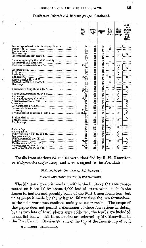
DOUGLAS OIL AND GAS FIELD, WYO.
Fossils from Colorado and Montana groups Continued.
65
it,
Donax? sp. related to D.( ?) oblonga Stanton. ............
Haminea? sp. ............................................Inoceramus barabinl Morton .............................
"WoptfQ crrQpiliQ AT Q.T1 (\ TT
Pvrifusus so
Sta tion No.
7474808677827478
78,8180837878
74,8679748884
78,8180,86
8383
78,8186848574
80,8578,81,83,
84 88838880837476788386
74,80-84
81,7880
Town shipN.
33-3333333333333333333333333333333333333333333333333^
333333
3333333333333333333333333333
Range W.
747474747475747575747575757474747375757475757574757474
' 7475
7375737475747575757474757574
Ben- ton
shale.
X
X
X
Mon tana
group.
y
y
y
X
yX
xX
X
Mon tana
group; prob ably Fox
Hills.
Fossils from stations 83 and 84 were identified by F. H. Knowlton as Halymenites major Lesq. and were assigned to the Fox Hills.
CRETACEOUS OK TERTIARY SYSTEM.
LANCE AND FORT TTNION (1) FORMATIONS.
The Montana group is overlain within the limits of the area repre sented on Plate IV by about 4,000 feet of strata which include the Lance formation and possibly some of the Fort Union formation, but no attempt is made by the writer to differentiate the two formations, as the field work was confined mainly to older rocks. The scope of this paper does not permit a discussion of these formations in detail, but as two lots of fossil plants were collected, the fossils are included in the list below. All these species are referred by Mr. Knowlton to the Fort Union. Station 89 is near the top of the Inez group of coal
365° Bull. 541 14 5
66 CONTBIBUTIONS TO ECONOMIC GEOLOGY, 1912, PAET H.
beds, about 3,000 feet stratigraphically above the top of the Montana. Station 90 is at a little higher horizon.
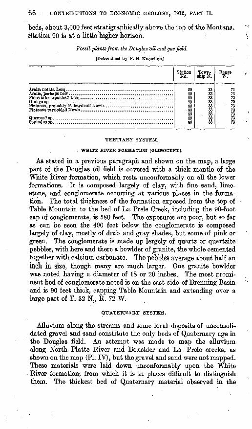
Fossil plants from the Douglas 'oil and gas field.
Petennined by F. H. Knowlton.]
Platanus raynoldsii Newb ................................................
Station No.
8989Qflan
899089 89SO
Town ship N.
33333333333333 3333
Range W.
737372
. 72737273 7373
TEETIAKY SYSTEM.
. WHITE RIVER FORMATION (OLIGOCENE).
As stated hi a previous paragraph and shown on the map, a large part of the Douglas oil field is covered with a thick mantle of the White River formation, which rests unconformably on all the lower formations. It is composed largely of clay, with fine sand, lime stone, and conglomerate occurring at various places in the forma tion. The total thickness of the formation exposed from the top of Table Mountain to the bed of La Prele Creek, including the 90-foot cap of conglomerate, is 580 feet. The exposures are poor, but 30 far as can be seen the 490 feet below the conglomerate is composed largely of clay, mostly of drab and gray shades, but some of pink or green. The conglomerate is made up largely of quartz or quartzite pebbles, with here and there a bowlder of granite, the whole cemented together with calcium carbonate. The pebbles average about half an inch in size, though many are much larger. One granite bowlder was noted having a diameter of 18 or 20 inches. The most promi nent bed of conglomerate noted is on the east side of Brenning Basin and is 90 feet thick, capping Table Mountain and extending over a large part of T. 32 N., R. 72 W.
QUATERNARY SYSTEM.
Alluvium along the streams and some local deposits of unconsoli- dated gravel and sand constitute the only beds of Quaternary age in the Douglas field. An attempt was made to map the alluvium along North Platte River and Boxelder and La Prele creeks, as shown on the map (PI. IV), but the gravel and sand were not mapped. These materials were laid down unconformably upon the White River formation, from which it is in places difficult to distinguish them. The thickest bed of Quaternary material observed in the
DOUGLAS OIL AND GAS FIELD, WYO. 67
field is in the east bank'of Little Boxelder Creek in the NE. | sec. 25, T. 33 N., R. 74 W., where there is a cliff 40 feet high, the upper half of which is gravel and sand of Quaternary age, and the lower half the White River formation.
IGNEOUS BOCKS.
Underlying the Casper formation just south of the Douglas oil field and forming the core of the Laramie Mountains is red granite, which is cut by basic dikes of various kinds. Only one little area, of the granite is indicated on the map, but it forms the surface rock of a large part of T. 32 N., Rs. 74 and 75 W., just south of the area treated in this report. The granite exposed in sees. 23, 26, and 27, T. 32 N., R. 73 W., is cut by several parallel dikes, as indicated on the map. The dike rock is a hornblende gneiss, as determined in the laboratory of the United States Geological Survey by J. Fred Hunter, from microscopic slides. The dikes have been prospected for copper by local mining companies, one prospect having been extended into the largest of the dikes to a depth of about 75 feet. A little copper in the form of chalcopyrite was found, but it is hardly probable that it will ever be found in paying quantities.
STRUCTURE.
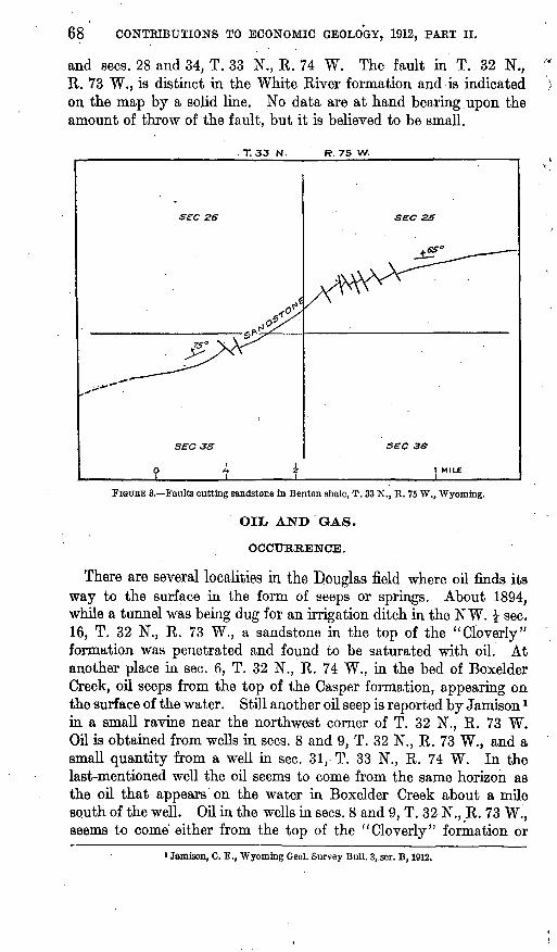
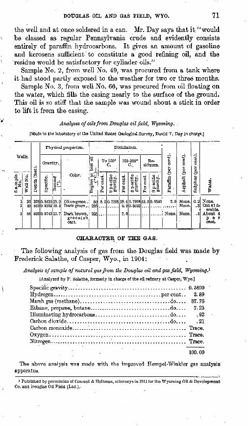
The overlap of the White River (Tertiary) formation renders the interpretation of the structure of the older beds very difficult, yet it is apparently monoclinal, with a general dip toward the north. This interpretation is based on the observed dips of the older beds north, west, and south of the overlap. At all these places the dip is uni formly toward the north, northeast, or northwest, with the excep tion of a narrow belt in T. 33 N., Rs. 74 and 75 W., where the beds are slightly overturned to the north. If the great fault described by. Darton,1 as striking eastward in the vicinity of Casper Mountain (20 or 30 miles west of the Douglas oil field), extends under the mantle of the White River formation, it probably has no great throw, as the structure seems to resemble a fold more than a fault. That this flexure was produced by compressive forces is evident, however, from the fact that there are.numerous small thrust faults and some overturned strata at a number of places in the field. The displace ment in most of the small faults is only a few inches. Such an over- thrust was observed in sec. 25, T. 33 N., R. 75 W., where a sand stone in the Benton shale, dipping at a high angle, has been broken by a series of parallel faults, as shown in figure 3. There are also overturned strata in sees. 31, 32, 33, and 34, T. 33 N., R. 75 W.,
i Darton, N.-H., Preliminary report on the geology and underground water resources of the central Great Plains: U. S. Geol. Survey, Prof. Paper 32, pp. 63-55,1905.
68 CONTEIBUTIONS TO ECONOMIC GEOLOGY, 1912, PAET II.
and sees. 28 and 34, T. 33 N., R. 74 W. The fault in T. 32 N., R. 73 W., is distinct in the White River formation and is indicated on the map by a solid line. No data are at hand bearing upon the amount of throw of the fault, but it is believed to be small.
T. 33 N. F?. 75 W-
S£C 26
sec 35
sec 25
sec
FIGTTRE 3. Faults cutting sandstone in Benton shale, T. 33 N., R. 75 W., Wyoming.
OIL AND GAS.
OCCURRENCE.
There are several localities in the Douglas field where oil finds its way to the surface in the form of seeps or springs. About 1894, while a tunnel was being dug for an irrigation ditch in the NW. \ sec. 16, T. 32 N., R. 73 W., a sandstone in the top of the "Cloverly" formation was penetrated and found to be saturated with oil. At another place in sec. 6, T. 32 N., R. 74 W., in the bed of Boxelder Creek, oil seeps from the top of the Casper formation, appearing on the surface of the water. Still another oil seep is reported by Jamison * in a small ravine near the northwest corner of T. 32 N., R. 73 W. Oil is obtained from wells in sees. 8 and 9, T. 32 N., R. 73 W., and a small quantity from a well in sec. 31, T. 33 N., R. 74 W. In the last-mentioned well the oil seems to come from the same horizon as the oil that appears on the water in Boxelder Creek about a mile south of the well. Oil in the wells in sees. 8 and 9, T. 32 N., R. 73 W., seems to come' either from the top of the "Cloverly" formation or
i Jamison, C. E., Wyoming Geol. Survey Bull. 3, ser. B, 1912.
DOUGLAS OIL AND GAS FIELD, WYO. 69
from the lower part of the .Benton. The wells in sec. 8, however, yield a much lighter oil than those in sec. 9. This suggests differ ent horizons or at least different conditions of accumulation. It is probable that in sec. 8 the oil is held in a reservoir formed either by a small anticline, suggested by the curve in the outcrop of the "Cloverly" and the Chugwater formations, or by the White River formation, which overlies the older rocks and on account of its water- saturated condition is impervious to oil. In sec. 9 the wells are near the seeps and also near a fault, so that the lighter elements of the oil may have escaped, leaving a heavy oil behind.
. It is difficult to determine with any degree of certainty the geologic structure under the heavy mantle of the White River formation. Jamison 1 has assumed an anticline striking in an east-west direction through the northern part of T. 32 N., R. 73 W., but the writer isinclined to the. view that the beds dip rather uniformly toward the north and that the accumulation of oil and gas is due to the thick impervious mantle of clay of the White River formation. The base of the White River seems to contain conglomerate and other porous material in which the oil and gas might accumulate after migrating from the underlying older rocks. Such a relationship exists in the Coalinga district, California, described by Arnold and Anderson 2 as follows:
Within the tested territory of the Coalinga district it has been found that the areas of Miocene sediments (either Vaqueros, Santa Margarita (?), or Jacalitos) immediately underlain by the shales of the Tejon are oil bearing; that the productiveness of these beds varies roughly inversely with their distance from the shales of the Tejon; that the productiveness is greatest where the Tejon occupies a position of angular uncon formity with the Miocene sands or is more or less disturbed, as near the axis of an anticline such as the Coalinga anticline.
The White River formation in the Douglas field rests unconformably on the upturned edges of the older rocks, which include nearly all the beds of the Colorado and Montana groups, both of which are known to yield oil in the Salt Creek field and near-by areas. It is believed by the writer that the oil in migrating upward along bedding planes and through porous sandstone finds a-barrier when it reaches the White River formation, so that oil and gas accumulate near this line, penetrating the White River only where they encounter lenses of porous material or fault planes. There are at least two parallel faults cutting the White River formation in T. 32 N., R. 73 W. (see PI. IV), and others are believed to exist. In sec. 6, T. 32 N., R. 72 W., heavy oil is reported hi a water well at a depth of 175 feet. The White River formation is almost certainly over 175 feet thick at this
1 Loc. cit.2 Arnold, Ralph, and Anderson, Robert, Geology and oil resources of the Coalinga district, California:
U. S. Geol. Survey Bull. 398, p. 186, 1910.
70 CONTBIBUTIONS TO ECONOMIC GEOLOGY, 1912, PART II.
place, so that probably the oil is in the White River, having migrated from older underlying beds.
Oil is found in the Salt Creek field, according to Wegemann,1 as high in the section as the Shannon sandstone, a lentil in the Pierre formation. If the boundaries of that formation where it extends under the White River are as indicated on the map, then the wells in the northern part of T. 32 N., R. 73 W., if extended entirely through the White River formation, would penetrate shale of the Pierre formation below the horizon of the Shannon sandstone lentil. The writer holds that less than half of the wells in the Brenning Basin, except those near the outcrop of the "Cleverly" formation, have gone deep enough to enter the older formations. If this is granted, another hypothesis must be postulated, namely, that the White River for mation occupies an old valley, the bottom of which is near the same elevation as the present bed of North Platte River above Douglas. To illustrate, the elevation of the bed of North Platte River at Douglas is about 4,750 feet. The altitude of the surface at well No. 2 in sec. 1, T. 32 N., R. 73 W., is 5,140 feet, and the depth to the bottom of the White River formation in this well (according to the writer's inter pretation of the well log) is at least 412 feet, making the base of the White River formation 4,728 feet above the sea, or 22 feet lower than the bed of the North Platte at Douglas. From other calculations, the elevation of the base of the White River varies in different wells from about 4,600 to 5,244 feet; therefore, to account for this variation, it is held that prior to the deposition of the White River there was a valley extending eastward from the Brenning Basin and passing just south of Douglas.
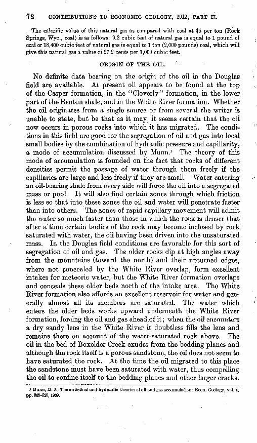
CHARACTER OF THE OIL.
There are two grades of oil in the Douglas field. One of these is a heavy oil, having a specific gravity ranging from 0.9309 to 0.9743, and the other is comparatively light and has a specific gravity'of 0.8439. The light oil is of good quality, as shown by the analysis below. The well from which this oil comes (No. 30, PL IV) is re ported to have yielded about 40 barrels a day for a long time, the oil being used in connection with the construction of the La Prele dam. The heavy oil is said to be a good lubricating oil in the crude state, having been used on the machinery of drilling outfits.
The following analyses of oil from the Douglas field were made in the laboratory of the United States Geological Survey under the direction of David T. Day:
Sample No. 1, from well No. 30, is evidently the best oil in the field. This sample was unoxidized, having been pumped direct from
i Wegemann, C. H., The Salt Creek oil fleld, Natrona County, Wyo.: IT. S. Geol. Survey Bull. 452, pp. 37-83,1911.
DOUGLAS OIL AND GAS FIELD, WYO. 71
the well and at once soldered in a can. Mr. Day says that it "would be classed as regular Pennsylvania crude and evidently consists entirely of paraffin hydrocarbons. It gives an amount of gasoline and kerosene sufficient to constitute a good refining oil, and the residue would be satisfactory for cylinder oils."
Sample No. 2, from well No. 49, was procured from a tank where it had stood partly exposed to the weather for two or three months.
Sample No. 3, from well No. 66, was procured from oil floating on the water, which fills the casing nearly to the surface of the ground. This oil is so stiff that the sample was wound about a stick in order to lift it from the casing.
Analyses of oils from Douglas oilfield, Wyoming. .
[Made in the laboratory of the United States Geological Survey, David T. Day in charge.]
Wells.
i 1 Sample1 w ton- 1 No.
Well No.'
30 49
66
8 £f§ 1 Depth (feet).
1 o o oo 1
Physical properties.
Gravity..
Specific.
0.8439 0. 9309
0. 9743
MJa^w~
35.9 20.4
13.7
Color.
Olive-green . Dark green..
Dark brown, greenish cast.
Distillation.
Sd
't>0S3M
80 225
225
To 150° C.
Per cent.
8.0
Specific gravity.
0.7205
150-300°c..
1H
PH
38.5 6.0
? 0
S p ecific gravity.
0.7928 0.8605
Re siduum.
Per cent.
53.5
pj to So
0.9340
a
PH '
2.0
None.
Asphalt (per cent).
None. None.
None.
Sulphur (per cent).
0.2 .3
.5
Water.
None. Consid
erable. About 4 per cent.
CHARACTER OF THE GAS.
The following analysis of gas from the Douglas field was made by Frederick Salathe, of Casper, Wyo., in 1904:
Analysis of sample of natural gas from the Douglas oil and gas field, Wyoming.1
[Analyzed by F. Salathe, formerly in charge of the oil refinery at Casper, Wyo.]
Specific gravity.............................................. 0. 5890Hydrogen.......................................... per cent.. 3.89Marsh gas (methane)................................... .do.... 87.75Ethane, propane, butane................................ do.... 7.23Illuminating hydrocarbons............................. do.... .92Carbon dioxide........................................do.... .21Carbon monoxide............................................. Trace.Oxygen..................................................... Trace.Nitrogen..................................................... Trace.
100.00
The above analysis was made with the improved Hempel-Winkler gas analysis apparatus.
i Published by permission of Consaul & Heltman, attorneys in 1911 for the Wyoming Oil & Development Co. and Douglas Oil Field (Ltd.)...
72 CONTKIBUTION& TO ECONOMIC GEOLOGY, 1912, PART II.
The calorific value of this natural gas as compared with coal at $5 per ton (Rock Springs, Wyo., coal) is as follows: 9.2 cubic feet of natural gas is equal to 1 pound of ( coal or 18,400 cubic feet of natural gas is equal to 1 ton (2,000 pounds) coal, which will give this natural gas a value of 27.2 cents per 1,000 cubic feet.
ORIGIN OF THE OIL.
No definite data bearing on the origin of the oil in the Douglas ' field are available. At present oil appears to be found at the top \ of the Casper formation, in the "Cleverly" formation, in the lower part of the Benton shale, and in the White River formation. Whether the oil originates from a single source or from several the writer is unable to state, but be that as it may, it seems certain that the oil now occurs in porous rocks into which it has migrated. The condi- '' tions in this field are good for the segregation of oil and gas into local small bodies by the combination of hydraulic pressure and capillarity, a mode of accumulation discussed by Munn.1 The theory of this mode of accumulation is founded on the fact that rocks of different densities permit the passage of water through them freely if the capillaries are large and less freely if they are small. Water entering an oil-bearing shale from every side will force the oil into a segregated mass or pool. It will also find certain zones through which friction is less so that into these zones the oil and water will penetrate faster than into others. The zones of rapid capillary movement will admit the water so much faster than those in which the rock is - denser that after a time certain bodies of the rock may become inclosed by rock saturated with water, the oil having been driven into the unsaturated mass. In the Douglas field conditions are favorable for this sort of segregation of oil and gas. The older rocks dip at high angles away from the mountains (toward the north) and their upturned edges, where not concealed by the White River overlap, form excellent intakes for meteoric water, but the White River formation overlaps and conceals these older beds north of the intake area. The White River formation also affords an excellent reservoir for water and gen erally almost all its members are saturated. The water which ' enters the older beds works upward underneath the White River formation, forcing the oil and gas ahead .of it; when the oil encounters a dry sandy lens in the White River it doubtless fills the lens and remains there on account of the water-saturated rock above. The oil in the bed of Boxelder Creek exudes from the bedding planes and although the rock itself is a porous sandstone, the oil does not seem to have saturated the rock. At the time the oil migrated to this place the sandstone must have been saturated with water, thus compelling the oil to confine itself to the bedding planes and other larger cracks.
i Munn, M. J., The anticlinal and hydraulic theories of oil and gas accumulation: Econ. Geology, vol. 4, pp. S09-629,1909.
DOUGLAS OIL AND GAS FIELD, WYO. 73
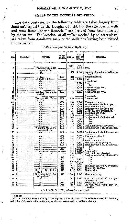
WELLS IN THE DOUGLAS OIL FIELD.
The data contained in the following table are taken largely from Jamison's report l on the Douglas oil field, but the altitudes of wells and some items under "Remarks" are derived from data collected by the writer. The locations of all wells 2 marked by an asterisk (*) are taken from Jamison's map, these wells not having been visited by the writer.
Wells in Douglas oil field, Wyoming.
No.
1
2
34 5 6 7 8 9
10
11 12
*13 14 15 16 17 18 19 20 21 22 23 24 25
26
27 28 29 30 31 32 33 34 35
*36 *37 38 39 40 41 42 44
45
46
47 48
Section.o
1................
1.. ..............
2................2................2................3................
3................
3................
q3................4................4................4................4................4................6..........:.....6................6................6................7..........:.....8................
8................
8................8................8...... ..........8................8................8................8................8................8................8................8................8................8................8................8................8................
9................
9................
Owner.
Wyoming Oil & De velopment Co.
.. ...do. ...... ........
..... do. ..............LaPreleOilCo...........do....................do....................do..............:.....do...............
Douglas Oil Fields (Ltd.)
Douglas Oil Fields (Ltd.) .
.....do...............
.....do...............
.....do...............
.....do...............
.....do...............
.....do...............
.....do...............
.....do...............
.....do...............
.....do...............
.....do...............Wyoming Oil & De
velopment Co.
.....do....... .......
.....do........:......
.....do...............
.....do...............
.....do...............
.....do....:..........
.....do...............
.....do...............
.....do...............
.....do...............
.....do...............
.....do...............
.....do...............
.....do...............
.....do...............
.....do...............Douglas Oil Fields
(Ltd.)- Wyoming Oil & De
velopment Co.
.....do...................do..........:....
When drilled.
1906
1905
1904
1904 1904 1905 1905 1902 1904 1907 1905 1905 1905 1905 1905 1905
1905
1904 1905 1905 1906 1905
1905
1907 1907 1906 1907 1906 1906 1902
1907
1907 1906
Depth.
Feet.
1,575
200 542
436
526
563 526 507
1,705 485 435 578
. 624 161 693 159 110 655
302
215 325 365 328 632 393 602 930 725 510 390 236 670 374 401 428 342
780
742
320 425
Alti tude of surface.
Feet. 5,140
5,140
5,260
5,230 5,230 5,210
5,210
5,240 5,200 5,210 5,210 5,200 5,175
5,380 5,370 5,390 5,440 5,360
5,400
5,350 5,360
5,340 5,330 5,320
5,280(?) 5,290(?) 5,300(?)
5,320 5.320(?)
5,320 5,320 5,320 5,300
5,340
5,330
5,300 5,290
Remarks.
Dry.
Casing collapsed and well aban doned.
Well unfinished. Gas. Abandoned. Gas.
Do. Abandoned gas well. Abandoned. Abandoned gas, well.
Abandoned. Gas reported.
Abandoned; water. Small amount of oil and gas. Small amount of oil. Small amount of oil and gas. Gas at 457 feet; abandoned. Producing gas well. Crooked hole. Small amount of oil reported.
Do. Do. Do.
Well unfinished; abandoned. Small amount of oil; abandoned.
Small amount of oil; flowing wa ter well.
Abandoned oil well. Do.
Small amount of oil. Producing oil by pumping. Small amount of oil; abandoned.
Do. Do.
Abandoned. Light oil to top of casing. Small amount of oil; abandoned.
Do. Do. Do. Do.
Producing light oil by pumping. Abandoned oil well. Abandoned.
Abandoned; dry.
Small amount of oil and gas; abandoned.
Abandoned oil well. Oil well with pump Jack at
tached.o In T. 32 N., R. 73 W., unless otherwise stated.
iLoc.cit. .' The writer found some difficulty in attempting to identify some of the wells mentioned by Jamison,
as his descriptions do not invariably agree with the locations of the wells on his map.
74 CONTBD3UTIONS TO ECONOMIC GEOLOGY, 1912, PABT II.
Wells in Douglas oilfield, Wyoming Continued.
No.
49
50*51
62*53
6465
*56
57*5859
60
61fi?63
64
65
66
Section, a
9................
9...... .........I9................
9................9................9... ..............9................
9................
9..............:.9................11...............
11...............
12...............12...............Lot in T. 32 N..
R. 72* W. Sec. 35. T. 33 N..
K. 74 W. Sec. 29. T. 33 N.,
K. 74 W. Sec. 31, T. 33 N.,
B. 74 W.
Owner.
(Ltd.).
Wyoming Oil & Development Co.
.....do...............
.....do...............
.....do...............Douglas OH Fields
(Ltd.).
. ..:.do. ..............
.. ...do..... .. .........Wyoming Oil & De
velopment Co. Douglas Oil Fields
(Ltd.).
.....do...............Wyoming Oil & De
velopment Co.
Power Co. .....do...............
When drilled.
1908
19081907
1907 "1907
1902
IQfU
190319051907
1904
ions1906
( &)
1912
Depth.
Feet. 440
475767
765970406466
388
470600615
498
493520665
600
Alti tude of surface.
Feet. 5,300
5,290
5,'250
5,2505,200
5,210
5,220
5,230
5,2205,2605,316
5,150
5,350
Eemarks.
tached.
Small amount of oil and gas.
Small gas well.
court. Small gas well.Water well.
Abandoned; no data.
A little heavy oil collects on thewater, which rises to top of casing.
o In T. 32 N., R. 73 W., unless otherwise stated. 6 Unfinished.
DETAILS OF WELLS AND WELL LOGS.
INTERPRETATION OF THE LOGS.
In the well logs that follow there are five columns. In the first is given the name of the geologic formation as interpreted by the writer; in the second the driller's description of the rock; in the third in formation as to whether gas, oil, or water was found; in the fourth the thickness of beds; and in the fifth the depth from the surface of the ground to the base of each bed.
It should be borne in mind that the interpretation of well logs is difficult at best, but when the logs are complicated, as many of these are by starting in the White Kiver formation and then passing into some other formation unconformably underlying it, the difficulty is greatly increased. Another source of possible error is the lithologic similarity between the Benton and Pierre formations. When these are encountered under the White River, the geologist can determine which is which only by the assumption that the strike of the older rocks continues under the mantle of White River in the same direc tion as it is where these rocks have been removed.
The logs of wells Nos. 2, 4, 16, 17, 18, 30, 35, 41, 44, 48, 49, 50, 55, 59, 60, and 63 were obtained from A. W. Phillips, of Douglas, Wyo., and the remainder are taken from the report of C. E. Jamison (State geologist of Wyoming) on the Douglas oil field, published in 1912.
DOUGLAS OIL AND GAS FIELD, WYO. 75
WELL NO. 2.
Well No. 2 is located on the south bank of La Prele Creek in sec. 1, T. 32 N., R. 73 W. It is 1,575 feet deep, the first 500 feet of which seem to be in the White River formation, and the remaining 1,000 feet are quite certainly in the lower shale of the Pierre formation. The well is abandoned but is marked by the casing projecting a few feet above the surface of the ground. The log follows:
Log of well.No. 2, sec. 1, T. 32 N., R. 73 W.
[Altitude of surface, 5,140 feet.]
Probable forma tion.
Driller's descrip tion of the rock.
Shale.............Sand..............
(?).............
Content.
Water at 40 feet................."Showing" of gas and oil at 412 feet, water at
525 feet.
Thick ness.
Feet, j-tri
I 128
1,035
Depth.
Feet.412
540
1,575
WELL NO. 4.
WeU No. 4 is in the SW. | sec. 2, T. 32 N., R. 73 W., and is cased and capped. A good flow of gas is reported from a sand at 542 feet below the surface, which was used for a time at a driller's camp about half a mile away.
Log of well No. 4, SW. i sec. 2; T. 82 N., R. 73 W.
[Altitude of surface, 5,260 feet.]
Probable forma tion. Driller's description of the rock.
Sand................................
Sand................................
Content. Thick ness.
Feet.. 46837
355
177
Depth.
Feet. 468605508613518535642
WELL NO. 14.
Well No. 14 is about 700 feet northeast of well No. 16. It is cased and capped, but apparently only a small amount of oil or gas was obtained in it. The lower 10 feet of the well undoubtedly is in the Pierre formation, the White River formation being 516 feet thick*
76 CONTBIBUTIONS TO ECONOMIC GEOLOGY, 1912, PAET II.
Log of well No. U, SW.ifSW.i sec. 3, T. 32 N., R. 73 W.
[Altitude of surface, 5,200 feet.]
Probable forma tion.
White River for-
Pierre formation.
Driller's description of the rock.
Red shale. ..........................
Red shale............... ...;........
Black shale.........................
Content.
Gas.........................
Thick ness.
Feet. 440
116
' 1940
10
Depth.
Feet. 440451457476516
526
WELL NO. 16.
Well No. 16 is one of two deep wells in the Brenning Basin. The writer believes that it penetrates the Pierre formation to a depth of 1,000 feet. In the sand at the base of the White River formation small amounts of gas and oil are reported, but none below that level.
Log of well No. 16, SE. J SE. $ sec. 4, T. 32 N., R. 73 W.
[Altitude of surface, 5,210 feet.]
Probable forma tion.
mation.
Pierre formation.
Driller's description of the rock.
White, grayish" shale formation. .....Red rock ...........................
m....... ............. ..............to..................................Coarse sand. ........................Finer sand ..........................
Black shale, with small streaks of sand.
Content.
Oil..............................do...........................do......................
Water at 815, 1,420, and 1,448 feet.
Thick ness.
Feet. 57
3635311
110
20
896
Depth.
Feet. 57
420473484487488498501504524
1,420
1,705
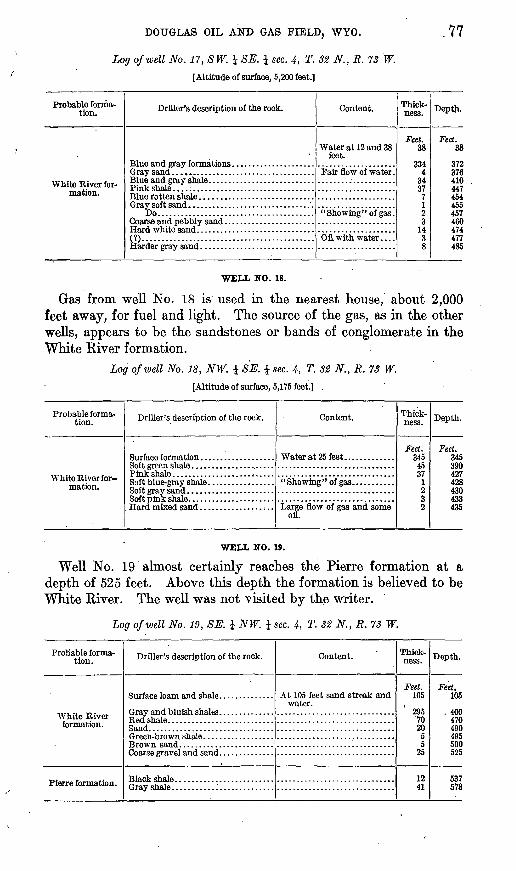
WELL NO. 17.
Well No. 17 is about 800 feet west of No. 16. It is cased and is plugged with wood. It probably does not extend more than a few feet, if at all, below the White River formation, as it is less than 500 feet deep. In well No. 16 the base of the White River Was probably reached at 524 feet.
DOUGLAS OIL AND GAS FIELD, WYO. .77
Log of well No. 17, SW. i SE. \ sec. 4, T. 32 N., R. 73 W.
[Altitude of surface, 5,200 feet.]
Probable forma tion.
mation.
Driller's description of the rock.
Do........................................
(T)......................... ...................
Content.
Water at 12 and 38 feet.
Thick ness.
Feet. 38
3344
OJ.
377123
1438
Depth.
Feet. 38
372376410447454455457460474477485
WELL NO. 18.
Gas from well No. 18 is used in the nearest house, about 2,000 feet away, for fuel and light. The source of the gas, as in the other wells, appears to be the sandstones or bands of conglomerate in the White River formation.
Log of well No. 18, NW. i SK i sec. 4, T. 32 N.,R. 73 W.
[Altitude of surface, 5,175 feet.) .
Probable forma tion.
White River formation.
Driller's description of the rock. Content.
Water at 25 feet.............
oil.
Thick ness.
Feet. 345
45VJ
1232
Depth.
Feet. 045IQniVl
428A3ft433435
WELL NO. 19.
Well No. 19 almost certainly reaches the Pierre formation at a depth of 525 feet. Above this depth the formation is believed to be White River. The well was not visited by the writer.
Log of well No. 19, SE. i NW. i sec. 4, T. 32 N., R. 73 W.
Probable forma tion.
formation.
Pierre formation.
Driller's description of the rock. Content.
At 105 feet sand streak andwater.
Thick ness.
Feet. 105
2957020
55
25
1241
Depth.
Feet. 105
, 400470490495500525
537578
78 CONTRIBUTIONS TO ECONOMIC GEOLOGY, 1912, PART H.
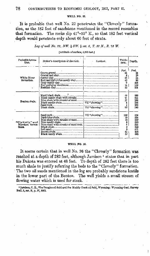
WELL NO. 22.
It is probable that well No. 22 penetrates the "Cloverly" forma tion, as the 182 feet of sandstone mentioned in the record resembles that formation. The rocks dip 41°-55° K, so that 182 feet vertical depth would penetrate only about 60 feet of strata.
Log of well No. 22, NW. J SW. i sec. 6, T. 32 N., R. 73 W.
[Altitude of surface, 5,370 feet.]
Probable forma tion.
White River
Driller's description of the rock.
Co arse gravel ........................
Blue shale with streaks of sand. .....
Black shale . . .........
Content. Thick ness.
Feet. 118
3542
91412
4031278
92
1821018
8533
8537
Depth.
Feet. 111954Qft
105119131
1809112382469 VI
342
524534552560565568571656693
WELL NO. 26.
It seems certain that in well No. 26 the "Cleverly" formation was reached at a depth of 282 feet, although Jamison 1 states that in part his Dakota was entered at 48 feet. To depth of 282 feet there is too much shale to justify referring the beds to the "Cloverly" formation. The two oil sands mentioned in the log are probably sandstone lentils hi the lower part of the Benton. The well yields a small stream of flowing water which is used for stock.
i Jamison, C. E., The Douglas oil field and the Muddy Creek oil field, Wyoming: Wyoming Geol. Survey 8011.3,801.6, p. 27,1912.
DOUGLAS OIL AND GAS FIELD, WYO. 79
Log of well No. 26, SW. i sec. 8, T. 32 N., R. 73 W.
[Altitude of surface, 5,400 feet.]
Probable forma tion.
White River for- . mation.
Ben ton shale.
"Cloverly" formation.
Driller's description of the rock.
Wash and brown gumbo ............
Oil sand..... .......................
Black gumbo .......................
Wash...............................
Wind cap rock. . .....................
Content.
Water at 80 feet. ............
Water at 254 feet. ...........
Thick ness.
Feet. 48
2 20
7 20 31
110 7
10 7
10 6 4
/ 2\ 18
Depth.
Feet. 48
50 70 77 97
128 238 245 255 262 272 278 282
284 302
WELL NO. 28.
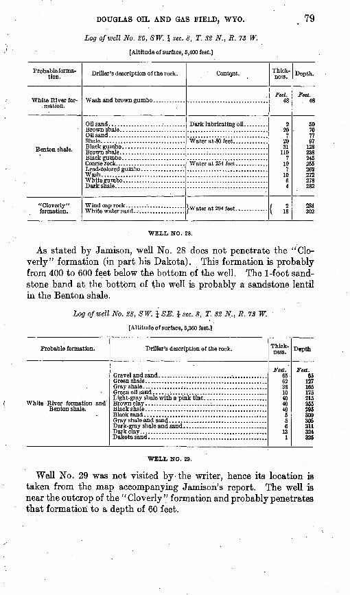
As stated by Jamison, well No. 28 does not penetrate the "Clo verly" formation (in part his Dakota). This formation is probably from 400 to 600 feet below the bottom of the well. The 1-foot sand stone band at the bottom of the well is probably a sandstone lentil in the Benton shale.
Log of well No. 28, SW. i SE. \ sec. 8, T. S2 N., R. 73 W.
[Altitude of surface, 5,360 feet.]
Probable formation.
White River formation andBenton shale.
Driller's description of the rock.
Gravel and sand .........................................Green shale... ..........................................Gray shale..............;...............................Green.oil sand...... ;..... ..............................Light-gray shale with a pink tint...... .................
Black shale.... .........................................Black sand....... ......................................Gray shale and sand....................................Dark-gray shale and sand.. .............................Dark clay. ............................ _ ...............Dakota sand.......................... _ ........... ....
Thick ness.
Feet. 6562381040dn40556
131
Depth
Feet. 65
127165175215255295300305311324325
WELL NO. 29.
Well No. 29 was not visited by-the writer, hence its location is taken from the map accompanying Jamison's report. The well is near the outcrop of the "Cloverly" formation and probably penetrates that formation to a depth of 60 feet.
80 CONTRIBUTIONS TO ECONOMIC GEOLOGY, 1912, PART H.
Log of well No. 29, SE. \ sec. 8, T. 32 N., R. 73 W.
Probable forma tion.
White River formation and Ben- ton shale.
"Cloverly" formation.
Driller's description of the rock.
Wash...............................
Sandstone..........................
Content.
Water at 55 feet.. ...........Good oil "showing" ........
the hole.
some gas.
gas.
Thick ness.
Feet. 253053
2
30
. 5155
135
5
60
Depth.
Feet. 2655
ins110
14A
145160165300
305
365
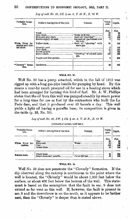
WELL NO. 30.
Well No. 30 has a pump attached, -which in the fall of 1912 was rigged up with a Jong gas-pipe handle for pumping by hand. By this means a near-by ranch procured oil for use in a heating stove which had been arranged for burning this kind of fuel. Mr. A. W. Phillips states that the oil from this well was pumped steadily by steam power for a long time for use as fuel by the contractors who built the La Prele'dam, and that it produced over 40 barrels a day. This well yields a light oil having a paraffin base; its composition is given in the table (p. 25, No. 30).
Log of well No. SO, SW. i SE. £ sec. 8, T. 32 N., R. 73 W.
[Altitude of surface, 5,340 feet.]
Probable forma tion.
White River for-
Driller's description of the rock.
Clay................................Blue rock ...........................Clay............:............... ; ...Green shale ..........................
Content.
Water......................
Oil at 325 feet. ..............
Thick ness.
Feet. 5030
10570
4528
Depth.
Feet. 5080
186255
300328
WELL NO. 33.
Well No. 33 does not penetrate the "Cloverly" formation. If the dip observed along the outcrop is continuous to the point where the well is located, the "Cloverly" would be about 1,000 feet below the surface, or about 400 feet below the bottom of the well. This state ment is based on the assumption that the fault in sec. 9 does not extend as far west as this well. If, however, the fault is present in sec. 8 and the downthrow is on the north, as it appears to be farther east, then the "Cloverly" is deeper than is stated above.
DOUGLAS OIL AND GAS FIELD, WYO. 81
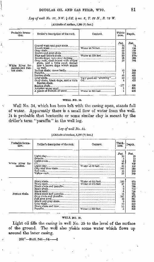
Log of well No. 33, NW. i 8E. J sec. 8, T. 32 N., R. 73 W.
[Altitude of surface, 5,280 (?) feet.]
Probable forma tion.
White River for mation and Ben- ton shale.
Driller's description of the rock.
Gray shale ..........................Brown and gray shale. ..............
shale, and a little sand; turned into a brown dope which stands up well.
Benton shale; caves badly ..........Paraflta................. ............Benton shale. .......................
Benton shale.
A pinch of Dakota oil sand. .........
Content.
Water at 74 feet.............
Water at 220 feet.. ..........
Oil..........................
Water at 601 feet ............
Thick ness.
Feet. 74506036502650
107
4210'
8
17711
Depth.
Feet. 74
124184220270296346
. 356363405
- 415423
600601602
WELL NO. 34.
Well No. 34, which has been left with the casing open, stands full of water. Apparently there is a small flow of water from the well. It is probable that bentonite or some similar clay is meant by the driller's term "paraffin" in the well log.
Log of well No. 34-
[Altitude of surface, 5,290 (?) feet.]
Probable forma tion.
White River for-
Benton shale.
Driller's description of the rock.
Light clay . . .........................Granite .............................
(?)..................................
Clay and blue shale. ............Red rock. ......................Yellow rock. ...................
Black shale ....................Black sand.. . .......................Black shale and paraffin. ............
Black and gray shale. ..........Gray shale ..........................Black shale and iron ................Paraffin. .........................
Content. Thick ness.
Feet. 105
456033
1421535
33027396
11141
199
1015
5
Depth.
Feet. 101560
1201W
295310345
6757fl9
705714720731872891900910925930
WELL NO. 35.
Light oil fills the casing in well No. 35 to the level of the surface of the ground. The well also yields some water which flows up around the inner casing.
365° Bull. 541 14 6
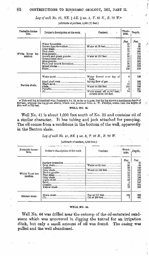
82 CONTKIBUTIONS TO ECONOMIC GEOLOGY, 1912, PART II.
Log of well No. 35, NE. J SE. \ sec. 8, T. 82 N., R. 73
[Altitude of surface, 5,300 (?) feet.]
Probable forma tion.
White River for-
Benton shale.
Driller's description of the rock.
Gray shale. .........................
Blue gumbo. ........................
Crystal formation ...................
Shale................................
Shale................................Paraffin.............................(?)......,...........................
Content.
Water at 36 feet.. ...........
Water at 217 feet............
hole.
Water at 550 feet ............
Water cased off at 667 feet;struck oil at 718 feet.
Thick ness.
Feet. 10704070225013102522
188
8
113
1045
74
Depth.
Feet. 1080
120190212262275285310332520
528
529542646651
725
o This well log is identical with Jamison's No. 13, so far as it goes, but his log shows a maximum depth of 810 feet, whereas the log given above, which was procured from A. W. Phillips, states that the depth of this well is 725 feet.
WELL NO. 41.
Well No. 41 is about 1,000 feet south of No. 35 and contains oil of a similar character. It has tubing and jack attached for pumping. The oil comes from a sandstone in the bottom of the well, apparently in the Benton shale.
Log of well No. 41, SE. J sec. 8, T. 32 N., R. 73 W.
[Altitude of surface, 5,320 feet.]
Probable forma tion. Driller's description of the rock.
Gray shale ..........................
Gray shale ..........................
Sand...............................
Yellow shale. . ......................
Black shale .........................(?)..................................
Content.
Gas at 312 feet. .............Oil at 399 feet. ..............
Thick ness.
Feet. 10805010 T;101550
52129
1042
Depth.
Feet. 1090
140150165175190240245266295
399401
WELL NO. 44.
Well No. 44 was drilled near the outcrop of the oil-saturated sand stone which was uncovered in digging the tunnel for an irrigation ditch, but only a small amount of oil was found. The casing was pulled and the well abandoned.
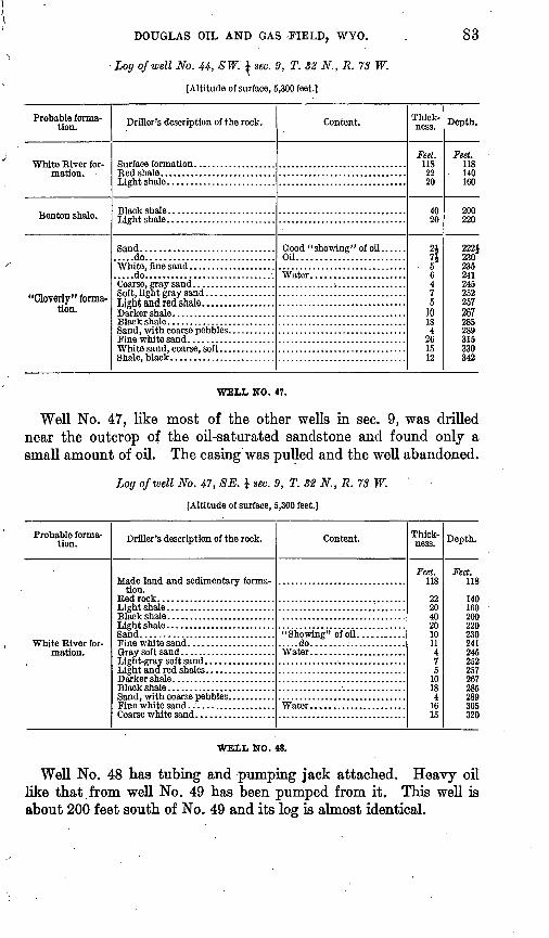
DOUGLAS OIL AND GAS -FIELD, WYO.
Log of well No. 44, SW. J sec. 9, T. 32 N., R. 73 W.
[Altitude of surface, 5,300 feet.]
83
Probable forma tion.
Benton shale.
"Cloverly" formation.
Driller's description of the rock.
.....do..............................
.....do..............................
Light and red shale.................
White sand, coarse, soft .............Shale, black. .......................
Content.
Oil.........................
Thick ness.
Feet. 1182220
4020
2171
. 56475
1018
261512
Depth.
Feet. 118140160
200220
222}230235241245252257267285289315330342
WELL NO. 47.
Well No. 47, like most of the other wells in sec. 9, was drilled near the outcrop of the oil-saturated sandstone and found only a small amount of oil. The casing was pulled and the well abandoned.
Log of well No. 47, SE. £ sec. 9, T. 82 N., R. 73 W.
[Altitude of surface, 5,300 feet.]
Probable forma tion. Driller's description of the rock.
Made land and sedimentary formation.
Black shale .........................
Darker shale ........................Black shale. ........................
Content.
Water......................
Water......................
Thick ness.
Feet. 118
222040201011475
10184
1615
Depth.
Feet. 118
140160200220230241245252257267285289305320
WELL NO. 48.
Well No. 48 has tubing and pumping jack attached. Heavy oil like that from well No. 49 has been pumped from it. This well is about 200 feet south of No. 49 and its log is almost identical.
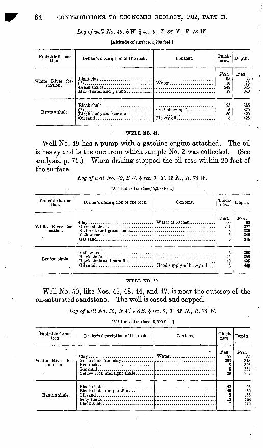
84 CONTRIBUTIONS TO ECONOMIC GEOLOGY, 1912, PART II.
Log of well No. 48, SW. J sec. 9, T. '82 N., R. 73 W.
[Altitude of surface, 5,290 feet.]
Probable forma tion.
White River formation.
Benton shale.
Driller's description of the rock.
m. .................................
n. .................................
Content.
Water......................
Heavy oil. ..................
Thick- ness.
Feet. 6510
24817
255
505
Depth.
Feet. 6575
323340
365370420425
WELL NO. 49.
Well No. 49 has a pump with a gasoline engine attached. The oil is heavy and is the one from which sample No. 2 was collected. (See analysis, p. 71.) When drilling stopped the oil rose within 20 feet of the surface.
Log of well No. 49, SW. $ sec. 9, T. 82 N., R. 73 W.
[Altitude of surface, 5,300 feet.]
Probable forma tion.
White River for-
Benton shale.
Driller's description of the rock.
Clay................................
Oil sand............................
Content.
Water at 60 feet.............
Thick ness.
Feet. 60
267855
545405
Depth.
Feet. 60
327335340345
3503954115
440
WELL NO. 50.
Well No. 50, like Nos. 49, 48, 44, and 47, is near the outcrop of the oil-saturated sandstone. The well is cased and capped.
Log of well No. 50, NW.' i SE. } sec. 9, T. 32 N., R. 73 W.
[Altitude of surface, 5,290 feet.]
Probable forma tion.
White River for-
Driller's description of the rock.
Clay................................
Oil sand............................
Content.
Water......................
Thick ness.
Feet. 55
26388
29
42455
137
Depth.
Feet. 55
318326334363
405450455468475
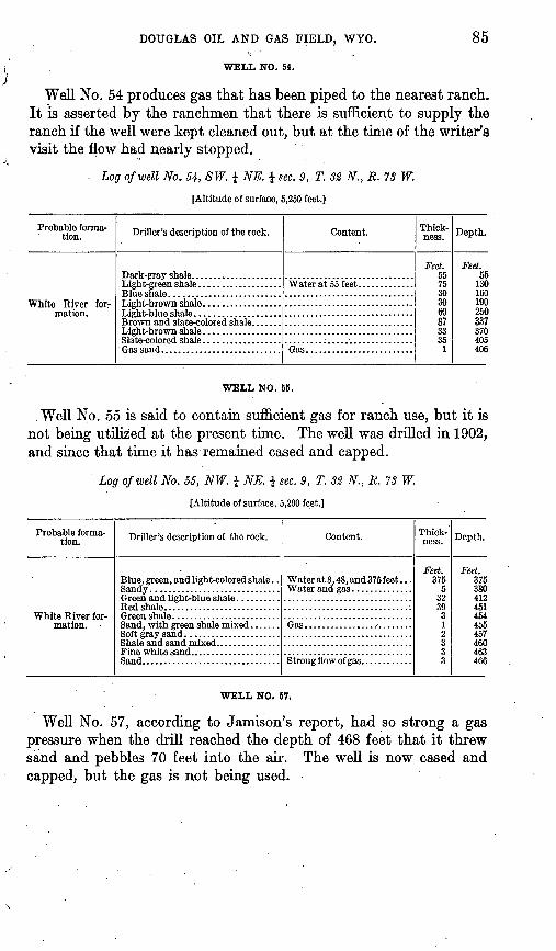
DOUGLAS OIL AND GAS FIELD, WYO. 85
WELL NO. 54.
Well No. 54 produces gas that has been piped to the nearest ranch. It is asserted by the ranchmen that there is sufficient to supply the ranch if the well were kept cleaned out, but at the time of the writer's visit the flow had nearly stopped.
Log of well No. 54, SW. i NE. i sec. 9, T.
[Altitude of surface, 5,250 feet.]
N., R. 73 W.
Probable forma tion.
White River for-
Driller's description of the rock.
' Gas sand.. . .........................
Content.
Gas.........................
Thick ness.
Feet. 5575303060873335
1
Depth.
Feet. 55
130160190250337370405406
WELL NO. 55.
. Well No. 55 is said to contain sufficient gas for ranch use, but it is not being utilized at the present time. The well was drilled in 1902, and since that time it has remained cased and capped.
Log of well No. 55, NW. i NE. \ sec. 9, T. 32 N., R. 73 W.
[Altitude of surface, 5,200 feet.]
Probable forma tion.
White River for-
Driller's description of the rock.
Blue, green, and light-colored shale . .
Content.
Water at 8. 48, and 375 feet . . .
Gas.........................
Thick ness.
Feet. 375
53239312333
Depth.
Feet. 375 3804124514544&5457460463466
WELL NO. 57.
Well No. 57, according to Jamison's report, had so strong a gas pressure when the drill reached the depth of 468 feet that it threw sand and pebbles 70 feet into the air. The well is now cased and capped, but the gas is not being used.
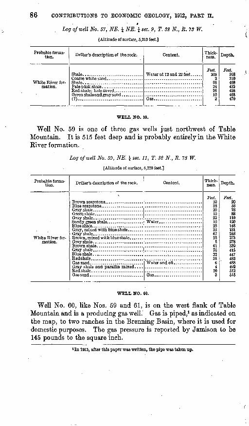
86 CONTRIBUTIONS TO ECONOMIC GEOLOGY, 1912, PART II.*
Log of well No. 57, NE. i NE. \ sec. 9, T. 32 N., R. 73 W.
{Altitude of surface, 5,210 feet.]
Probable forma tion.
White River formation.
Driller's description of the rock.-
Shale ...............................
Shale. . ..............:..............Pale pink shale. ....................
(?)..,...............................
Content.
Gas.........................
Thick ness.
Feet. 308
2932426102
Depth.
Feet. 308310408432438468470
WELL NO. 59.
Well No. 59 is one of three gas wells just northwest of Table Mountain. It is 515 feet deep and is probably entirely in the White River formation.
Log of well No. 59, NE'. J sec. 11, T. 32 N., R. 73 W.
[Altitude of surface, 5,220 feet.].
Probable forma tion. Driller's description of the rock.
Blue shale... .......................
Red shale ..........................
Content.
Water.......................
Gas.........................
Thick ness.
Feet. 20382010221028336725
5617600
3564
203
Depth.
Feet. 20587888
110120
. 14818124827327833941 1
447482488492512515
WELL NO. 60.
Well No. 60, like Nos. 59 and 61, is on the west flank of Table Mountain and is a producing gas well. Gas is piped,1 as indicated on the map, to two ranches in the Brenning Basin, where it is used for domestic purposes. The gas pressure is reported by Jamison to be 145 pounds to the square inch.
1 In 1013, after this paper was written, the pipe was taken up.
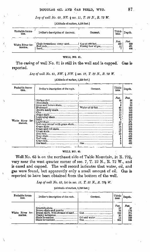
DOUGLAS OIL AND GAS FIELD, WYO. 87
Log of well No. 60, NE. J sec. 11, T. 32 N., R. 73 W.
[Altitude of surface, 5,230 feet.]
Probable forma tion. Driller's description of the rock.
Sand................................
Content. Thick ness.
Feet. 480
117
Depth.
Feet. 480491498
WELL NO. 61.
The casing of well No. 61 is still in the well and is capped. Gas is reported.
Log of well No. 61, NW. I NW. \ sec. 12, T. 32 N., R. 73 W.
[Altitude of surface, 5,220 feet.]
Probable forma tion.
White River for-
Drfller's description of the rock.
Brown sandy shale. ................Clay................................
Light-gray shale. ...................Sand................................Light shale. ........................
Green shale. ........................Bed rock ...........................Gray shale. .........................Red rock...........................Gray rock. ..........................Gas sand.. . .........................
Content.
Water at 60 feet. ............
Gas.........................
Thick ness.
Feet. nn46
6025154010
35887151567
205832
Depth.
Feet. 505460
120145160200210213271358373388455475480488491493
WELL NO. 63.
Well No. 63 is on the northeast side of Table Mountain, in R. 72$, very near the west quarter corner of sec. 7, T. 32 N., R. 72 W., and is cased and capped. The well record indicates that water, oil, and gas were found, but apparently only a small amount of oil. Gas is reported to have been obtained from the bottom of the well.
Log of well No. 63, lot in sec. 12, T, 32 N., R.
[Altitude of surface, 5,316 feet.]
W.
Probable forma tion.
White River formation.
Driller's description of the rock.
Greenish shale. .....................Brown shale and gumbo ............Bluish shale, with streaks of sand. . .Chalky formation. ..................Shale formation .....................Shale formations ....................
Content.
Gas.........................
6 il and water ...............
Thick ness.
Feet.Q778
1001015
365
Depth.
Feet. 97
175275285300665
88 CONTRIBUTIONS TO ECONOMIC GEOLOGY, 1912, PART II.
PRODUCTION.
The present production of oil in the Douglas field is small, but if the demand were sufficient the field could probably produce from the wells now open a hundred barrels a day for a short time. The gas supply is small, only three ranches using it in 1912. It seems probable, however, that the output could be increased so as to supply other ranches with light and heat, but the amount available would never be large unless new wells with greater flows of gas were found.
FUTURE DEVELOPMENT.
Although no one can say definitely that oil will or will not be found in a given area in advance of drilling, yet the writer is inclined to the opinion that future drilling in this field will find no great quantity of oil. It is said that drilling in 1913 is contemplated in the region north of Douglas. Here the highest known oil sand in this part of the State the Shannon sandstone lentil if present, should be reached at a depth of 4,000 to 5,000 feet. Drilling is also contemplated in the Labonte district, south of Douglas, but the writer is unfamiliar with this region.
The dips of the rocks near Glenrock suggest a favorable structure for the accumulation of oil, but this area has not been sufficiently studied to justify more than a mere mention at this time. The rocks at Glenrock dip toward the north, about 2£ miles southeast they dip toward the east, and about 3£ miles south of Glenrock they dip nearly south. These attitudes suggest a pitching anticline with an east-west axis about 1£ miles south of the town of Glenrock, but to reach the Shannon sandstone lentil here, if present, a thickness of about 2,700 feet of strata would have to be penetrated.
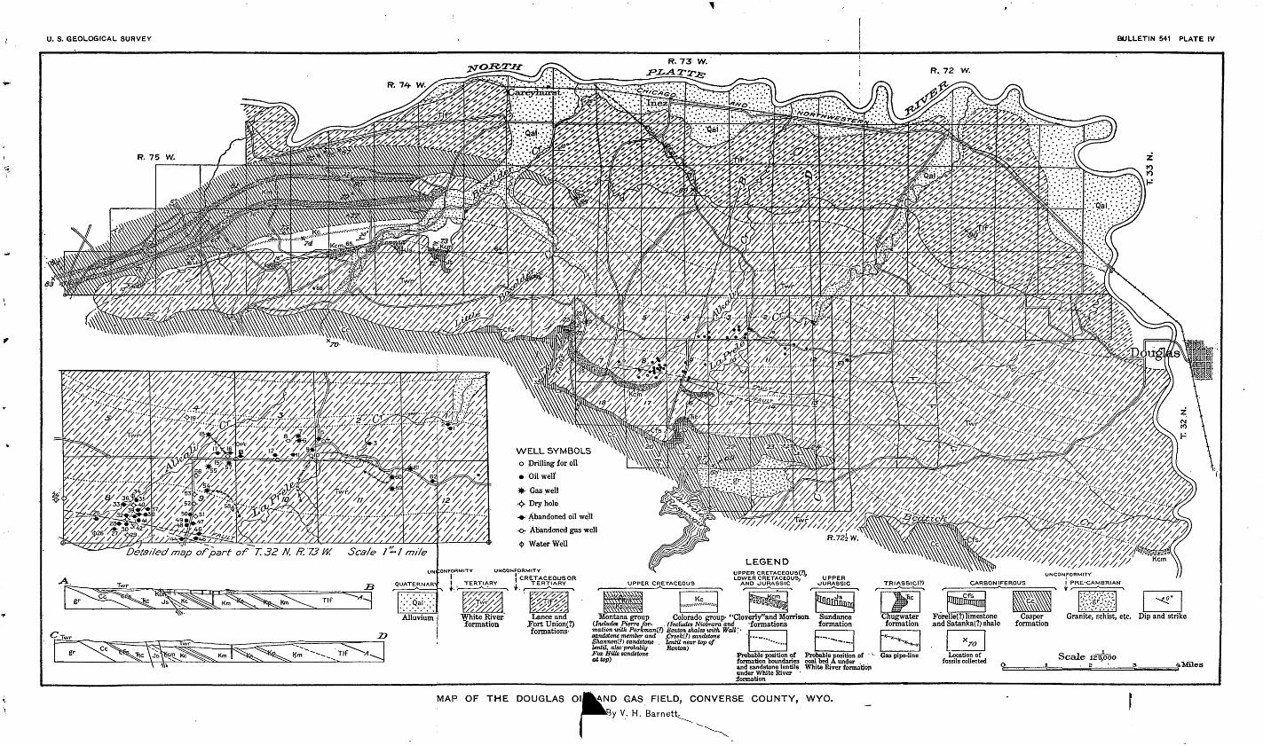
U. S. GEOLOGICAL SURVEY BULLETIN 541 PLATE IV
R. 73 W.R, 72 W.
R. 75 W.
WELL SYMBOLS o Drilling for oil
Oil wetf
Gas well
Dry hole
- Abandoned oil well
o- Abandoned gas well
<b Water WellSca/e /'=/ mileDetailed map of part of T.32 N. R. 73 W.
UNCONFORMITY
I TERTIARY
UPPER CRETACEOUSC?). LOWER CRETACEOUS.
AND JURASSICI CRETACEOUSOR ! TERTIARY T. /
Granite, schist, etc. Dip and strikeColorado group> "Cloverly"and Momson, SundanceLance and.Fort Union{?)formations'
(Includes Niobrara and
Location of fossils collected
Probable position of Probable position .of ' ' formation boundaries coal bed A under and sandstone lentils White River formation under White River formation
MAP OF THE DOUGLAS OlIJJ^NI
rAND GAS FIELD, CONVERSE COUNTY, WYO.
y V. H. Barnettt
THE SHOSHONE RIVER SECTION, WYOMING.
By D. F. HEWETT.
INTRODUCTION.
Shoshone River rises among the ridges of the Absaroka Range in northwestern Wyoming and, except for a local diversion around McCulloch Peak, flows in a course approximately N. 60° E. to a point near the Montana line, where it empties into Bighorn River. (See fig. 2, p. 49.) Its course is approximately normal to the axis of the Bighorn Basin. On the west side of the basin the front of the Absaroka Mountains coincides approximately with the eastern limit of lava flows which overlie the pfe-Eocene sedimentary rocks, but in the border belts on the east and west the river cuts through broad anticlinal folds, along the flanks of which the stratigraphic section is exposed in great detail. Thus on the west, along the east limb of the Rattlesnake-Cedar Mountain anticline, a complete section from the base of the Cambrian to the Eocene is visible, and though on the east, where Shoshone River cuts through the north end of Little Sheep Mountain, only the Cretaceous and Eocene formations are shown along the river, the complete Mesozoic section is brought to the surface near the center of the mountain.
With the view of using it as a guide in the study and mapping of a large area south of the river in which the geologic structure is favor able for the accumulation of oil and gas, the Mesozoic section along the river east of the Rattlesnake Mountain fold has been accurately measured and examined in greater detail than is customary in areal geologic work. Though the entire section from Cambrian to Eocene is exposed, the present examination has been confined to the Mesozoic and overlying Tertiary formations, for the reason that they probably contain all the sands which may carry oil and gas in the region under consideration. Furthermore, oil and gas have been found in two wells located on the axis of the narrow anticline shown on Plate V, and the sands from which they are derived outcrop prominently along the upper portion of the river. . -
The detailed examination of so continuous a stratigraphic section involving a great thickness of sedimentary rocks is not only rarely possible, but aside from the accuracy of measurement which it permits,
90 CONTRIBUTIONS TO ECONOMIC GEOLOGY, 1912, PART II.
it has the advantage of facilitating the more accurate delimitation of the formations. The section also shows in detail the sedimentary succession on the west side of the Bighorn Basin. The Mesozoic and Tertiary formations, exclusive of beds of Wasatch age, are approxi mately 15,000 feet thick along Shoshone River.
METHOD OF WORK.
In order to measure and study in detail the formations along the Shoshone Canyon, two operations were involved first, the location, by means of a plane-table survey on a scale of 2,000 feet to an inch, of numerous points on prominent as well as critical lithologic members, between which the stratigraphic thickness does not exceed 1,000 feet; second, the detailed measurement by tape or by clinometer and pacing, as the exposures permitted, of the various lithologic units, the points previously established being used as a basis of control. It is obvious that detail is more desirable in those portions of the section which contain thin, clearly separable formations of distinct lithologic character than where the formations are thick and merge gradually with bounding formations of different character. Thus greater detail has been sought in the lower marine sandstones and shales than in the higher beds of fluviatile origin. Lack of time also prevented the same amount of study of the higher beds that was given to those of the lower part of the section.
FOSSILS.
On several occasions the section along the Shoshone has been ex amined in more or less detail by members of the Geological Survey,1 and numerous collections of fossils have been made with the view of correlating the formations with those that are well known in south- central Montana and eastern Wyoming. In 1907 Fisher and Wood ruff 2 measured the Mesozoic part of the section, and with Stanton, Knowlton, and Willard collected plants and invertebrate fossils, from a number of horizons. It has been possible to identify most of these horizons, and with the permission of those who made the collections their lists of fossils are here presented with those made by the writer. Acknowledgment is also due to Mr. E. G. Woodruff"for suggestions in the field and for reference to unpublished notes in the office.
' Woodruff, E. G., Coal fields of the southwest side of the Bighorn Basin, Wyo.: U. S. Geol. Survey Bull. 341. p. 202,1909.
^Unpublished notes.
SHOSHONE EIVER SECTION, WYO.
GEOLOGY.
STRATIGRAPHY.
OUTLINE.
91
The following table shows the character and relations of the forma tions from the Sundance (Upper Jurassic) to the Wasatch (Eocene):
Summary of Jurassic, Cretaceous, and Tertiary formations along ShosJione River.
System.
: crtiary.
Cretaceous or Ter tiary.
Jurassic or Creta ceous.
Jurassic.
Series.
Eocene.
?
Upper Cretaceous.
Lower Cretaceous.
?
Upper Jurassic.
Formation.
Wasatch.
Fort Union.
Ilo.
Meeteetse.
Gebo.
Colorado.
"Cloverly."
' Morrison.
Sundance.
Character.
Buff and white sandstones, locally conglomeratic and feldspathic, alternating with greenish and red shales and clays.
White and buff massive sand stones with 'conglomerate zone at base. Upper portion more shaly. Contains flora and fresh water fauna.
Buff and yellow sandstones with minor sandy shale and clay. No coal beds; saurian bones and fresh-water invertebrate fossils.
Argillaceous sandstone and sandy shale with numerous beds of brown carbonaceous shale and lenticular coal near top. Mon tana flora.
Massive sandstone, buff near base and white near top. separated by thin beds of shale. One or more coal beds near base. A few plants and invertebrates of Mon tana types.
Upper member: Dark -green to mack shale, sandy near top; nu merous marine fossils.
Middle member: Buff sandstone locally conglomeratic, alternat ing with sandy shale and thin carbonaceous shale. One coal bed near top and several beds of bentonite.
Lower member: Gray to black shale with several sandstones and numerous beds of bentonite throughout. Few marine fossils and fish scales.
Two sandstones separated by shale.
Maroon, gray, and brown shales with several sandstones. Sau rian bones.
Glauconitic green and gray shales, calcareous sandstone, and gyp sum beds. Numerous marine and brackish-water fossils.
Thick ness (feet).
(?)
5,592
1,790
1,110
1,120
2,150
494
1,026
110
580
530
Total thickness, 14,502+ feet.
92 CONTRIBUTIONS TO ECONOMIC GEOLOGY, 1912, PART II.
Plate V presents a plan of the survey of Shoshone River covering a strip 9 miles long and a vertical cross section showing an interpre tation of the structure along a line approximately coinciding with the course of the river. It also shows, graphically, the stratigraphic section of the rocks from the Sundance formation (Upper Jurassic) to the Fort Union formation (Eocene) and an enlargement of the lower 2,700 feet of the section in order to show in greater detail the position and relations of the oil and gas bearing sands.
SUNDANCE FORMATION.
Beds containing Sundance (Upper Jurassic) fossils have been recognized at many localities in,the Bighorn Basin and in eastern Wyoming. They present similar lithologic features and are char acterized by abundant fossils, notably of the genera Gryphsea, Ostrea, and Pentacrinus. A section of the formation has been examined in detail by Fisher 1 along Trail Creek, 8 miles northwest of Cody and within 6 miles of the point of exposure along Shoshone River. Along Trail Creek a thickness of 322 feet was measured, but along the river, if the lower and.upper limits of marine Jurassic fossils are taken as the base and top, respectively, the thickness of the formation is 530 feet, the greatest which has been measured in Wyoming. The beds are well exposed along the south bank of the river and may be examined closely. There is no appreciable differ ence in dip or evidence of erosional unconformity between the Sundance formation and the underlying red sandstone of the Chug- water formation (Triassic?). There was, in fact, a gradual transi tion from conditions of Chugwater sedimentation to those of the marine Sundance formation.
The distinguishing features of the Sundance formation are the numerous alternations of fossiliferous marine shales and gypsum beds near the base, its evenly bedded condition throughout, and the gradual increase in content of glauconite and quartz sand toward the upper sandstone which limits it. In the following section the details of the lower part of the formation are those of the section made by Fisher and Woodruff.
Section of Sundance formation on Shoshone River.
Feet.Shale, gray, sandy, and sandstone, lower half shaly, upper half
firm and massive; fossil collection 4997...................... 42Sandstone, gray, massive, cross-bedded, with several poorly in
durated layers and a number of thin limestone beds composed of Ostrea fragments; fossil collections 4988, 4996................ 60
«Fisher, C. A., Geology and water resources of the Bighorn Basin, Wyo.: TJ. S. Geol. Survey Prof. Paper 53, p. 21,1906.
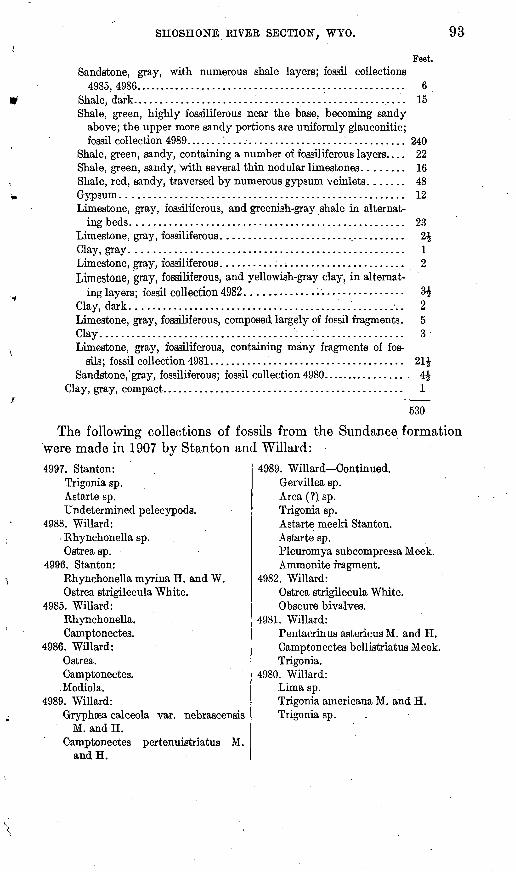
SHOSHONE RIVER SECTION, WYO.
Feet. Sandstone, gray, with numerous shale layers; fossil collections
4985,4986..................................................... 6Shale, dark. ................................................... 15Shale, green, highly fossiliferous near the base, becoming sandy
above; the upper more sandy portions are uniformly glauconitic;fossil collection 4989.... . .. 1 ...................... 1 ........... 240
Shale, green, sandy, containing a number of fossiliferous layers. ... 22Shale, green, sandy, with several thin nodular limestones. ....... 16Shale, red, sandy, traversed by numerous gypsum veinlets. ...... 48Gypsum. ..................................................... 12Limestone, gray, fossiliferous, and greenish-gray shale in alternat
ing beds. ................................................... 23Limestone, gray, fossiliferous. ................................... 2£Clay, gray. ................................................... 1Limestone, gray, fossiliferous. .........:........................ 2Limestone, gray, fossiliferous, and yellowish-gray clay, in alternat
ing layers; fossil collection 4982 .............................. 3$Clay, dark ................................................... 2Limestone, gray, fossiliferous, composed largely of fossil fragments. 5 Clay.......................................................... 3Limestone, gray, fossiliferous, containing many fragments of fos
sils; fossil collection 4981. .................................... 21£Sandstone, gray, fossiliferous ; fossil collection 4980 ................. 4$
Clay, gray, compact. ............................................. 1
530
The following collections of fossils from the Sundance formation were made in 1907 by Stanton and Willard:4997. Stanton:
Trigonia sp.Astarte sp.Undetermined pelecypods.
4988. Willard:Rhynchonella sp.Ostrea sp.
4996. Stanton:Rhynchonella myrina H. and W.Ostrea strigilecula White.
4985. Willard: Rhynchonella. Camptonectes.
4986. Willard: Ostrea.Camptonectes.
.Modiola. 4989. Willard:
Gryphsea calceola var. nebrascensisM. and H.
Camptonectes pertenuistriatus M. and H.
4989. Willard Continued.Gervillea sp.Area (?) sp.Trigonia sp.Astarte meeki Stanton.Astarte sp.Pleuromya subcompressa Meek.Ammonite fragment.
4982. Willard:Ostrea strigilecula White.Obscure bivalves.
4981. Willard:Pentacrinus astericus M. and H.Camptonectea bellistriatus Meek.Trigonia.
4980. Willard:Luna sp.Trigonia americana M. and H.Trigonia sp.
94 ' . CONTRIBUTIONS TO ECONOMIC GEOLOGY, 1912, PART H.
MORBISON FOEMATION.
The Morrison formation has been recognized at a number of locali ties throughout, the Bighorn Basin by its characteristics and relations and hi places by the presence in it of saurian bones. Measurements of its thickness have langed from 130 to 382 feet. 1 The formation is well exposed along the north bank of Shoshone River, where its thickness has been determined to be 580 feet. At the base it is not clearly separable from the underlying Sundance formation, but the division is made at the top of the uppermost outcropping sandstone which contains marine Jurassic fossils. As no fossils other than saurian bones from the middle portion have been found in either this formation or the overlying "Cleverly," the upper limit is taken to be the base of the sandstone overlying the uppermost maroon clay. In describing the character of the overlying "Cleverly" formation in the vicinity of the Bighorn Mountains Darton 2 states that the base is usually marked by a conglomeratic sandstone and considers that this member limits the underlying Morrison. On this criterion several beds of maroon clay are included in the "Cleverly" forma tion, though beds of similar character occur throughout the Morrison. In the absence of a conglomerate at this horizon on Shoshone River it seems reasonable to consider that the uppermost red clay marks the limit of Morrison sedimentation.
There is a striking resemblance between the middle portion of the formation along Shoshone River and that in the region north of Thermopolis described by Darton.3 Evidence of an unconformity between the Morrison and "Cleverly," noted by Fisher 3 in places has not been found on Shoshone River.
Besides the variegated color and alternations of several diverse types of material, a characteristic feature of the formation is the presence of gastroliths, or "stomach stones," which are found in intimate association with large saurian bones. In an area 20 feet in diameter on the cut bank where the beds are exposed on the north side of the river no less than 60 pounds of large bone fragments and 15 pounds of gastroliths were found. The gastroliths range from 2 to 5 inches in diameter and are faceted but highly polished. Most of them are chert, showing crinoid stems and Bryozoa, and one large pebble is hornstone, containing a few pyrite crystals, a rock not known to exist in place within 150 miles of this locality.
1 Fisher, C. A., op. cit., p. 25.2 Darton, N. H., Geology of the Bighorn Mountains: U. S. Geol. Survey Prof. Paper 51, p. 50,1906. * Fisher, C. A., op. cit., p. 26.
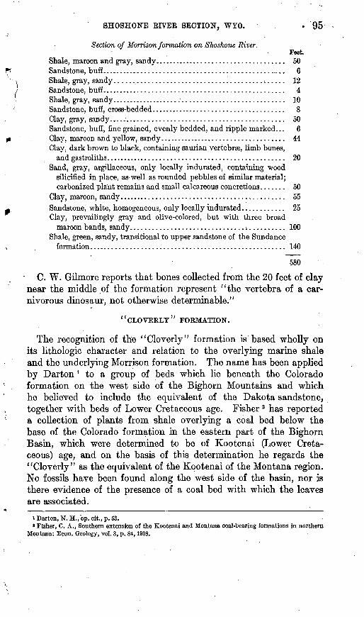
SHOSHONE RIVER SECTION, WYO. . '95
Section of Morrison formation on Shoshone River.Feet.
Shale, maroon and gray, sandy.................................... 50Sandstone, buff................................................... 6Shale, gray, sandy........................................ ̂ ..... 12Sandstone, buff.................................................. 4Shale, gray, sandy................................................ 10Sandstone, buff, cross-bedded..................................... 8Clay, gray, sandy................................................ 50Sandstone, buff, fine grained, evenly bedded, and ripple marked... 6 Clay, maroon and yellow, sandy................................... 44Clay, dark brown to black, containing saurian vertebrae, limb bones,
and gastroliths................................................. 20Sand, gray, argillaceous, only locally indurated, containing wood
silicified in place, as-well as rounded pebbles of similar material;carbonized plant remains and small calcareous concretions....... 50
Clay, maroon, sandy............................................. 55Sandstone, white, homogeneous, only locally indurated............ 25Clay, prevailingly gray and olive-colored, but with three broad
maroon bands, sandy.......................................... 100Shale, green, sandy, transitional to upper sandstone of the Sundance
formation..................................................... 140
580
C. W. Gilmore reports that bones collected from the 20 feet of clay near the middle of the formation represent "the vertebra of a car nivorous dinosaur, not otherwise determinable."
'' CLOVERLY'' FORMATION.
The recognition of the "Cloverly" formation is based wholly on its lithologic character and relation to the overlying marine shale and the underlying Morrison formation. The name has been applied by Darton* to a group of beds which lie beneath the Colorado formation on the west side of the Bighorn Mountains and which he believed to include the equivalent of the Dakota sandstone, together with beds of Lower Cretaceous age. Fisher 2 has reported a collection of plants from shale overlying a coal bed below the base of the Colorado formation in the eastern part of the Bighorn Basin, which were determined to be of Kootenai (Lower Creta ceous) age, and on the basis of this determination he regards the "Cloverly" as the equivalent of the Kootenai of the Montana region. No fossils have been found along the west side of the basin, nor is there evidence of the presence of a coal bed with which the leaves are associated.
i Darton, N. H., op. cit., p. 63.* Fisher, C. A., Southern extension of the Kootenai and Montana coal-bearing formations in northern
Montana: Econ. Geology, vol. 3, p. 84,1908.
96 CONTRIBUTIONS TO ECONOMIC GEOLOGY, 1912, PART H.
On account of the nearly vertical walls of the canyon of Shoshone River these beds, although well exposed, can not be examined in detail. .
The sandstones are fine grained and the grains are angular and , fairly uniform in size, ranging from 0.1 to 0.25 millimeter in diam- \ eter. They are firmly held by a cement composed largely of car- ! bonate of iron. No conglomerate beds such as have been recog nized elsewhere in the basin were found in the section.
Section of "Cloverly" formation on Shoshone River.Feet.
Sandstone, buff, indurated, characteristically thin bedded and rip ple marked. The .beds range from half an inch to 20 inches in thickness and are composed of angular and subangular grains of quartz, with traces of muscovite near the top................... 60
Shale, gray, sandy.............................................. 25Sandstone, buff, massive......................................... 25
110 COLORADO FORMATION.
GENERAL CHARACTER. .
The entire Colorado formation is exposed in exceptional detail along Shoshone River and is separable lithologically into three mem bers the lowest, 1,026 feet thick, composed largely of shale; the middle, 494 feet thick, predominantly shaly but containing a num ber of massive sandstones from 3 to 40 feet thick; and the upper most, 2,150 feet thick, principally shale. The lower two members contain but a few fossils, which do not serve to correlate them accu rately with portions of the formation observed in near-by regions. The lower part of the upper member is highly fossiliferous. Most of the sections presented herewith are those exposed on the north side of the river, though a portion of the formation near the base has been examined on the south side. There is no evidence of uncon- formable relations such as have been inferred by Washburne * on the east side of the basin.
The section is interesting as containing the oil sands which have been struck in the well of the Shoshone Oil Co., the log of which is given on page 65. The sandstone referred to by Washburne as the source of gas in wells on the east side of the basin is undoubtedly the equivalent of the 20-foot sandstone near the base of the lower shale member on Shoshone River, which has also yielded oil in the Shoshone Oil Co.'s well. There is a close resemblance between the section given by Washburne 1 and that on Shoshone River.
» Washburne, C. W., Gas fields of the Bighorn Basin, Wyo.: U. S. Geol. Survey Bull. 340, p. 350,1908.
SHOSHONE RIVEE SECTION, WYO. 97
LOWER MEMBER.
The most unusual feature of the lower member is the persistent occurrence of bentonite, a yellow unctuous clay, in beds from 1 inch to ,4 feet thick. Near the base of the member there are numerous
/
thin beds of bentonite, the 392-foot shale of the section below con- taming no less than 35 beds, whereas the upper portion contains fewer though much thicker beds. Bentonite is known to occur in many localities in Wyoming where the Colorado shale is well exposed,1 but the number of beds in the Shoshone Eiver section greatly exceeds 'chat reported elsewhere. It appears to be at least possible that more beds of bentonite than have been reported exist in the Colorado shale in other parts of Wyoming, but that the conditions of exposure do not permit their recognition. The shale of this member is gray to blue-black, dense, fine grained, and near the base carbonaceous.
Section of the lower member of the Colorado formation on Shoshone River.Feet.
1. Shale, sandy..............'............................'...... 322. Shale, blue-gray, with fish scales............................ 56
.3. Sandstone, buff............................................ 44. Bentonite................................................... 45. Shale, gray, with fish scales and vertebrae.................... 456. Bentonite.................................................. 47. Shale, gray, with fish scales................................. 1518. Sandstone, buff, thin bedded................................. 809. Shale, dark, dense.......................................... 50
10. Sandstone.................................................. 311. Shale, bluish black, containing several thin gray sandstones
and numerous beds of bentonite from 1 inch to 4 feet thick. 39212. Sandstone, buff, massive; the lower portion cross-bedded and
containing numerous crocodile teeth, several caudal ver tebrae of dinosaurs, and a turtle, also many pieces of carbon ized plant material; fossil collection 123.................... 20
13. Shale, dark brown to black, containing thin beds of bentonitenear the top............................................... 185
1,026
Fossil collection No. 123 contained "caudal vertebrae of dinosaur; teeth of crocodile/' according to C. W. Gilmore. 0. P. Hay reports that the turtle "represents an undescribed species probably belonging to the genus Gyremys. This genus is known from a single specimen, G. spectabilis Hay, believed to be from the Judith River formation of Montana."
MIDDLE MEMBER.
The middle member is extraordinarily well exposed and accessible. The shale in the member is gray, sandy, and only locally carbona ceous. The sandstones are gray and buff and well indurated, and sev-
»Fisher, C. A., The bentonite deposits of Wyoming: U. S. Geol. Survey Bull. 260, p. 569,1904. 365° Bull. 541 14 7
98 CONTRIBUTIONS TO ECONOMIC GEOLOGY, 1912, PART H.
eral of them contain persistent zones of chert pebbles, a feature which has been recognized elsewhere in the Bighorn Basin. Though the mid dle member contains several thick beds of bentonite, it lacks the great number of thin beds noted in the lower member. \
Section of the middle member of the Colorado formation on Shoshone River. s
Feet.1. Sandstone, buff, separated into three benches by thin brown
shale bands; upper and lower benches contain chert pebbles, the largest half an inch in diameter.......................... 24
2. Sandstone, buff to giay, shaly. ........................^........ 603. Shale, brown.........................."....................... 14. Bentonite.................................................... 85. Shale, brown...........................................:..... 56. Sandstone, buff.............................................. 67. Bentonite............................:....................... 68. Shale, brown,.with 4 inches of coal............................ 39. Sand, brown, shaly........................................... 8
10. Shale, brown, with two thin coal beds......................... 211. Shale, dark................................................... 1312. Sandstone, buff.............................................. 313. Shale, sandy.................................................. 3014. Sandstone, buff.............................................. 615. Shale, sandy.................................................. 5516. Sandstone, drab, separable into four massive benches by thin
shale layers; second bench from the top contains black chert pebbles three-fourths of an inch in diameter.................. 40
17. Shale, sandy. ................................................. 3218. Sandstone, buff, thin bedded................................... 1819. Shale, sandy.................................................. 2220. Sandstone, buff, thin bedded................................... 1221. Shale.....::.................................................. 1622. Sandstone, buff.............................................. 823. Shale......................................................... 1624. Sandstone, buff................................................ 4025. Shale......................................................... 2426. Sandstone, buff, thin bedded, containing nonpereistent zones of
. chert pebbles as much as 3 inches thick near the top and a highly persistent zone 6 inches thick near the middle; the peb bles range from three-fourths of an inch to 2 inches in diam eter; fragments of bone and bivalve shells are common........ 36
494UPPER MEMBER.
The uppermost sandstone of the middle member is overlain by a great thickness of shale which, though increasingly sandy near the upper limit, does not contain any lithologic units clearly separable from the shale. The thickness of this member along Shoshone River is 2,150 feet, the upper limit being the first massive sandstone of the overlying Gebo formation. The beds may be most satis factorily examined on the south side -of the river east of the anti cline on which the Shoshone Oil Co.'s well is situated.
SHOSHONE EIVER SECTION, WYO. 99
The lower portion of the member contains many concretions, most of which contain numerous fossils. These definitely establish the age of the beds as upper Colorado. 1
Though there are no separable lithologic units in this shale mem ber, close examination shows that several diverse types are present. The basal 200 feet is predominantly dark blue-gray to black in color, fine grained, and free from sand. This portion contains relatively few fossils. The next 300 feet is olive-gray to pale green, is locally sandy, and contains the concretions from which .most of the fossils are derived. Its color is due to a disseminated green mineral, which is probably glauconite. Above this zone the member contains an increasing proportion of quartz sand, and the 400 feet underlying the basal massive sandstone of the Gebo formation is essentially a succession of thin argillaceous sandstones. This portion is buff in color, evenly bedded, and locally ripple-marked. It has thus far only yielded a few gastropods too poorly preserved to permit identification.
The following collections of fossils from the upper member of the Colorado formation were made by Woodruff and Willard and by the writer:4960. Woodruff:
Inoceramus exogyroides M. and H.Inoceramua undabundus M. and H.Inoceramus acuteplicatus Stanton.Inoceramus sp.Legumen sp.Pholadomya papyracea M. and H.Baculites asper Morton (?)Baculites sp.Scaphites ventricosua M. and H.Ancyloceras (?) sp.Mortoniceras sp. related to M. sho-
shonense M. and H. 499L Willard:
Anomia sp.Avicula sp. cf. A. linguiformis E.
and S. .Inoceramus acuteplicatus Stanton.Inoceramus sp.Crassatellites n. sp.Corbula sp.Turritella n. sp.Baculites asper Morton?Baculites sp.Scaphites ventricosus M. and H.Mortoniceras sp.
5032. WiUard:Avicula sp.Inoceramus umbonatus M. and H.Inoceramus acuteplicatus Stanton.Crassatellites n. sp.Corbula sp.Dentalium sp.Turritella sp.Gyrodes conradi M. and H.Fusus (?) sp.Baculites asper Morton.Scaphites ventricosus M. and H.
7369. Hewett:Anomia sp.Avicula sp. cf. A. linguiformis E.
and S.Nemodon? sp.Veniella sp.Pholadomya papyracea M. and H.Corbula sp.Dentalium sp.Volutoderma sp.Cinulia sp.Baculites sp.Scaphites ventricosus M. and H.Mortoniceras shoshonense Meek.
i In the report by Fisher (U. S. Geol. Survey Prof. Paper 53) these beds, on the basis of .meager fossil collections, were regarded as being equivalent to the Pierre of eastern Wyoming and Montana. Their age appears now to be«stablished as Colorado.
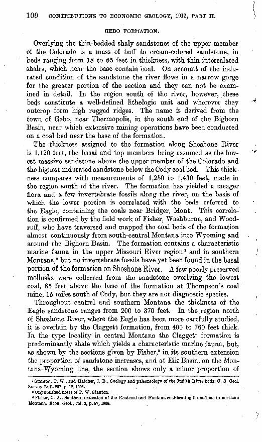
100 CONTRIBUTIONS TO ECONOMIC GEOLOGY, 1912, PART H.
GEBO FORMATION.
Overlying the thin-bedded shaly sandstones of the upper member of the Colorado is a mass of buff to cream-colored sandstone, in beds ranging from 18 to 65 feet in thickness, with thin intercalated shales, which near the base contain coal. On account of the indu rated condition of the sandstone the river flows in a narrow gorge for the greater portion of the section and they can not be exam ined in detail. In the region south of the river, however, these beds constitute a well-defined lithelogic unit and wherever they outcrop form high rugged ridges. The name is derived from the town of Gebo, near Thermopolis, in the south end of the Bighorn Basin, near which extensive mining operations have been conducted on a coal bed near the base of the formation.
The thickness assigned to the formation along Shoshone River is 1,120 feet, the basal and top members being assumed as the low- est massive sandstone above the upper member of the Colorado and the highest indurated sandstone below the Cody coal bed. This thick ness compares with measurements of 1,250 to 1,430 feet, made in the region south of the river. The formation has yielded a meager flora and a few invertebrate fossils along the river, on the basis of which the lower portion is correlated with the beds referred to the Eagle, containing the coals near Bridger, Mont. This Correla tion is confirmed by the field work of Fisher, Washburne, and Wood ruff, who have traversed and mapped the coal beds of the formation almost continuously from south-central Montana into Wyoming and around the Bighorn Basin. The formation contains a characteristic marine fauna in the upper Missouri River region 1 and in southern Montana,2 but no invertebrate fossils have yet been found in the basal portion of the formation on Shoshone River. A few poorly preserved mollusks were collected from the sandstone overlying the lowest coal, 85 feet above the base of the formation at Thompson's coal mine, 15 miles south of Cody, but they are not diagnostic species.
Throughout central and southern Montana the thickness of the Eagle sandstone ranges from 200 to 370 feet. In the .region north of Shoshone River, where the Eagle has been more carefully studied, it is overlain by the Claggett formation, from 400 to 760 feet thick. In the type locality in central Montana the Claggett formation is predominantly shale which yields a characteristic marine fauna, but, as shown by the sections given by Fisher,8 in its southern extension the proportion of sandstone increases, and at Elk Basin, on the Mon tana-Wyoming line, the section shows only a minor proportion of
1 Stanton, T. W., and Hatcher, J. B., Geology and paleontology of the Judith River beds: TJ. S GeoL Survey Bull. 257, p. 12,1905. .
2 Unpublished notes of T. W. Stanton.3 Fisher, C. A., Southern extension of the Kootenai and Montana coal-bearing formations in northern
Montana: Econ. Geol., vol. 3, p. 87,1908.
SHOSHONE RIVER SECTION, WYO. 101
shale. Though, the beds yield a characteristic fauna as far south as Bridger, Mont., 1 none of the fossils have thus far been found on Sho- shone River nor in the region south of it. The conclusion appears justifiable that the upper sandstones of the Gebo formation corre spond to the Claggett formation of Montana, and therefore that the Gebo formation, having a thickness of 1,120 feet on the river, is essen tially the equivalent of both the Eagle and Claggett formations.
Section ofGebo formation on Shoshone River,Feet.
Sandstone, buff, massive....................................... 18Shale, drab to brown; fossil collection-17, Knowlton (?) 2.......... 50Sandstone, buff, massive...................................... 20Sandstone, locally massive and indurated, with few beds of gray to
brown shale; fossil collection 4972, and 38, Woodruff.......... 720Sandstone, buff, massive....................................... 40Clay, gray to brown, homogeneous, sandy....................... 20Sandstone, buff, thin bedded................................... 55Shale, carbonaceous, with thin coal bed........................ 20Sandstone, thin, and shale..................................... 50Shale, dark, with two thin coal beds............................. 32Sandstone, buff, massive....................................... 28Shale, sandy. ................................................. 2Sandstone, massive, cavernous outcrop......................... 65
1,120
The following collections of fossils from the Gebo formation were made by Woodruff and Knowlton in 1907:4972. Woodruff:
Unio sp. Sphserium sp.Corbula subtrigonalis M. and H. Goniobasis invenusta M. and H. Viviparus sp. related to V. conradi M. and H.
Comment by T. W. Stanton: "Judith River rather than Claggett." 38. Woodruff:
Sequoia brevifolia. Protophyllum n. sp. Ficus (?) sp.Juglans (?) sp. £
Comment by F. H. Knowlton: "I do not know this flora. It is not like what has come heretofore from the Eagle, though it may be an Eagle flora., The Protophyllum is of the type of certain species found in the Dakota, while the Sequoia is ordinarily an upper Montana form."
17. Knowlton:Platanus (?) wardii Kn. Ficus sp.
Comment by F. H. Knowlton: " If the above species is correctly determined, the age of this should be Eagle, but it is insufficient to be very positive about."
1 Unpublished notes of T. W. Stanton.2 The source of this collection can not be indicated with assurance.
102 CONTBIBUTIONS TO ECONOMIC GEOLOGY, 1912, PAET II.
MEETEETSE FORMATION.
The name Meeteetse is applied to a group of beds 1,110 feet thick which overlie the Gebo formation and which, being poorly ex posed along the river, have been more thoroughly studied in the region south of it. From their lithologic character and relations in that region these beds have been recognized as a persistent formation, which is named from the town of Meeteetse, on Greybull Kiver, the largest town in the southwestern portion of the basin. No fossils have been found in the formation along the river, but in the region south of it no less than 19 species of plants have been found. This flora is distinctly that of the Montana group, six species occurring in the upper part of the Mesaverde formation at Point of Rocks, Wyo., and five in the Judith River formation on Willow Creek, Mont. Most of the collections have been designated "Judith River" by F. H. Ejaowlton, and the beds are regarded by him. as equivalent to the Ju dith River formation or Belly River beds of Canadian geologists. One collection containing five species of leaves, obtained 130 feet above the base of the formation, 15 miles south of the river, is reported by F. H. Knowlton to indicate "the approximate position of the Mesa verde." No vertebrate or invertebrate fossils have yet been found in the formation.
The conspicuous features of the formation are the presence of a number of beds of carbonaceous shale and coal and the general ab sence of induration of the beds. Along Shoshone River and also throughout the greater portion of the region south from the river to Owl Creek carbonaceous shale and coal beds are largely confined to the upper half of the formation, and though on the river there is but one bed of coal more than 14 inches thick that which has been mined by the Cody Coal Co. in the neighborhood of Meeteetse some sections contain as many as five beds. The beds are, however, highly lenticular and the coal is poor in quality compared to the coals in the underlying Gebo formation and the higher Fort Union forma tion. Somber colors prevail throughout the formation, the greater portion of the beds being gray to olive colored.
The material constituting the formation is characteristically poorly assorted; the sandstone contains much clay and the shale is sandy, features which partly account for the absence of induration. Mica is common throughout the formation, and some beds near the middle contain a large proportion of fresh biotite. Silicified wood is not common on the river, but is abundant in the lower 600 feet of the formation, where the beds are exposed in bad lands. Trunks of trees as much as 28 inches in diameter and 10 feet long, as well as roots silicified in place, have been found. The upper limit is the base of a bed of white, poorly indurated sandstone which is persistent throughout the west side of the Bighorn Basin.
SHOSHONE RIVER SECTION, WYO. 103
Section of Meeteetse formation on Shoshone River.Ft. in.
Shale, brown, carbonaceous.................................. 3Shale, gray................................................ 6Shale, carbonaceous..........^............................. 2Shale, gray................................................ 8Shale, carbonaceous.......................................... 3Sand, olive-colored, argillaceous, with zones of sandy clay.... 210Shale, gray, sandy, with thin beds of carbonaceous shale...... 60Shale, carbonaceous........................................ 3 6Sand, olive-colored, argillaceous.............................. 60
(Coal, 30 inches] Shale,linch |................................. 4 6 Coal, 23 incheej
Sandstone, buff and pale olive-gray, argillaceous............. 750
1,110
ILO FOEMATION.
The Ho formation presents poorer exposures along Shoshone River than any of the Upper Cretaceous formations. Its character is best displayed in the region south of the river, where several collections of invertebrate fossils have been made. Sandstone is the most abundant constituent, but the beds are so lacking in induration that except in small areas of bad lands where portions of the formation are shown there are few outcrops and it has not been possible to examine a complete section. The best exposures on the west side of the Big horn Basin are in the open valley northwest of Ho, a settlement 50 miles southeast of Cody, from which the name of the formation is derived. Here a thickness of 810 feet has been measured, compared to 850 feet 2 miles west of Meeteetse. As no fossil collections have been obtained on the river from the zone approximately 1,300 feet- thick between the beds in which fossils were found by Woodruff (4959) and Willard (365), the upper limit of the Ilo formation has not been established. There is some reason, however, for believing that the lowest conglomerate zone in the Fort Union formation is approxi mately the equivalent of a persistent zone 400 feet above the base of the Fort Union throughout the region between Greybull River and Owl Creek, where data bearing on the relations between the Ilo .and Fort Union are abundant. On Shoshone River, therefore, the top of the Ilo formation is provisionally assumed to be 400 feet below the lowest conglomerate of the Fort Union formation. The formation is regarded as approximately equivalent to the Lance formation in the eastern part of the State.
The Ilo formation consists of several groups of beds of massive yellow sandstone which range from 20 to 60 feet in thickness. Unin- durated clay and argillaceous sand alternate with the sandstone, and zones 200 to 600 feet from the base contain invertebrate and verte brate fossils which serve to establish the age of the formation. Thin
104 CONTRIBUTIONS TO ECONOMIC GEOLOGY, 1912, PART H.
beds of carbonaceous shale occur near the bottom, but are not per sistent, and coal is conspicuously absent. The materials are more perfectly assorted than those of the Meeteetse formation, but along Shoshone River there are few well-defined lithologic units capable of separation from the associated materials.
Section of Ilo formation on Shoshone River.
Sandstone with, zones of conglomerate of the Fort Union formation. Sandstones, buff and olive-colored, unconsolidated, with minor Feet-
zones of sandy clay; fossil collections 4976, 4990, 4959.......... 1,555Shale, carbonaceous........................................... 6Sandstone, olive-colored, argillaceous............................ 160Shale, carbonaceous........................................... 4Clay, gray, sandy.............................................. 25Sandstone, white, unindurated................................. 40
1,790
The following collections of fossils from the Ilo formation were made in 1907 by Woodruff and Willard:4976. Woodruff:
Sphserium sp.Campeloma multilineata M. and H.Physa sp.
Comment by T. W. Stanton: "Horizon probably 'Ceratops beds.'" 4990. Willard. 1,125 feet east of Cody coal mine;
Sphaerium sp. .Goniobasis tenuicarinata M. and H.Physa sp.Columna sp.Hydrobia (?) sp.
Comment by T. W. Stanton: "Horizon probably 'Ceratops beds.'" 4959. Woodruff. 900 feet stratigraphically above Cody coal mine:
Unio sp. related to U. priscus M. and H.Sphaerium sp.Goniobasis (?) sp.Viviparus sp.Campeloma multilineata M. and H. (?)
Comment by T. W. Stanton: "Horizon not closely fixed by these fossils, but it is believed to be about that of the 'Ceratops beds.'"
FOET UNION FOEMATION.
From the point where Sage Creek enters Shoshone River from the south to the bend where the river turns northward around McCulloch Peak, a distance of 12,000 feet, a group of beds are exposed which have thus far yielded only a Fort Union flora and fauna. On account of the great thickness of this formation, 5,400 feet, and the minor importance of the stratigraphy at this horizon, it has not been deemed advisable to measure the section in great detail. The point at which
SHOSHONE BIVEB SECTION, WYO. 105
these beds are overlain by those of Wasatch age lies east of the limit of this survey.
It is to be regretted that the valley of Sage Creek meets the river at a point near the base of this formation, for this fact, together with the poor exposures throughout the upper portion of the.Ilo formation, prevents detailed examination of the relations of the two formations.
In degree of consolidation and lithologic character the beds of the Fort Union stand in contrast to those of the underlying Ilo and Meeteetse formations. Though they include many zones of rela tively unconsolidated material, the beds of the lower portion of the Fort Union are compact and resistant and in the region south of Shoshone River form persistent high ridges. Beds of conglomerate occur at several horizons and are interesting as indicating the con ditions of sedimentation as well as the lithologic types present. The lowest group of conglomerates contains six zones from 5 to 20 feet thick in a stratigraphic distance of about 250 feet. Each of these zones is composed of smaller zones or beds of conglomerate, which range from 2 to 10 feet in thickness. The dip section is well exposed and shows the single beds to be relatively persistent in the direction of the dip northeast whereas in the strike section, which is not so well shown, the separate beds are not persistent, but lenticular and characteristically anastomosing. Though definite conclusions can scarcely be based on this single exposure, these features suggest that the pebbles were deposited by streams flowing from the west or southwest toward the east or northeast. The pebbles are mostly subangular to rounded. The largest pebbles are indurated fine sand stones about 5 inches in diameter. Most of the pebbles are gray to black chert, from half an inch to 2 inches in diameter. There are a few pebbles of red and gray quartzite; limestone pebbles are rare, and pebbles of vein quartz and igneous rocks are conspicuously absent. A few of the chert pebbles contain fossils which can be referred broadly to the Carboniferous, but from 'the same zone of conglomerates within 10 miles south of the river a collection of chert ' pebbles containing no less than 11 species has been made. The age of these fossils ranges from Pennsylyanian to probably Permian (Phosphoria fauna), and it is evident that rocks of this age that were being : eroded were the source of a part of the Fort Union sediments. It appears highly probable that the pebbles of silicified wood were derived from the Meeteetse formation. If this is true it is a factor in proving that local unconformities exist between the Fort Union formation and the underlying beds.
The higher conglomerate beds, such as occur in the 50-foot sand stone near the middle of the subjoined section, are thinner and con tain lithologic types not found lower in the formation. Quartzites are more abundant than chert, and there are fair proportions of
106 CONTRIBUTIONS TO ECONOMIC GEOLOGY, 1912, PART H.
quartz schist and pink granite pebbles not represented in the lower beds. At one place a well-rounded pebble of coal 3 inches long was found.
The presence of red clay in the upper part of the Fort-Union forma tion and the small amount of mica throughout the formation serve further to distinguish these beds from the Ilo and Meeteetse forma tions. There is no coal in the Shoshone River section of the Fort Union, but a bed is mined near Meeteetse at a horizon which cor responds closely with that of the lower conglomerate on the river.
Section of Fort Union formation on Shoshone River.Feet.
Sandstone, buff, massive................................ ̂ ...... 20Clay, gray, and argillaceous sand, with thin zones of carbonaceous
shale....................................................... 185Shales, maroon and.gray, sandy....................°............. 150Clay, red...................................................... 8Clay, gray..................................................... 6Clay, red...................................................... 6Clay, gray...................................................... 6Clay, red (mouth of creek from south)........................... 8Clay, gray. ......................................---.-.----- -. 8Sandstone, buff, massive....................................... 15Sand, drab, argillaceous.......'................................. 166Clay,red..............................:....................... 3Clay, gray..................................................... 1Clay, red...................................................... 2Sand, gray, argillaceous........................................ 40
- Sandstone, massive............................................. 8Sand, gray to olive-gray, with conglomeratic layers.............. 50Sand, argillaceous...................'........................... 30Sandstone, massive............................................. 40Sand, argillaceous.............................................. 30Sand, buff to.olive-gray, argillaceous; fossil collection 4994...... 558Clay, red..................................................... 3Clay, gray..................................................... 8Clay, red.....'.. ..,............................................. 3Sandstone, massive............................................. 24Shale, gray, sandy............................................ 8Sandstone, massive, conglomeratic............................. 16Sand, argillaceous, and unconsolidated clay, with thin carbona
ceous shale; fossil collections Woodruff 40, Knowlton 16....... 1, 760Shales, gray and olive-gray, sandy, and sand with carbonaceous
shale; fossil collection 4973.................................. 440Sand, argillaceous, and clay.................................... 680Sandstones, gray and buff, alternating with zones of unconsolidated
sand...;.............................................-...... 410Sandstones, gray and buff, containing numerous zones of conglom
erate in the lower 200 feet; fossil collection 366 Willard........ 500Sandstone, buff; fossil collection 365 Willard..................... 400Mouth of Sage Creek.
5,592
filvfcB stecTioir, WYO. 10*7
The following collections of fossils from the Fort Union formation were made by Willard, Woodruff, and Knowlton in 1907:366. Willard:
Populus sp. (?)Fragments of dicotyledons.
Comment by F. HI Knowlton: "Horizon probably Fort Union." 365. Willard:
Platanus raynoldsii Newb.Platanus haydenii Newb.Platanus nobilis (?) Newb.
Comment by F. H. Knowlton: "Horizon Fort Union." 4973. Woodruff:
Viviparua trochiformis M. and H.Goniobasis tenuicarinata M. and H.
Comment by T. W. Stanton: "Horizon Fort Union." 16. Knowlton:
Taxodium occidentale Newb.Populus sp. probably P. speciosa Ward.Populus arctica Heer of Lesq.Hicoria antiquorum (Newb.) Kn.Celastrinites ep. cf. C. grewiopsis Ward.Juglans, probably new.
Comment by F-. H. Knowlton: "Horizon Fort Union." 40. Woodruff:
Sequoia langsdorfii (Brgt.) Heer., VSapindus grandifolius Ward.Populus glandulifera? Heer.Carpites sp. (Palmocarpon?).Juglans sp.Platanus nobilis (?) Newb.
Comment-by F. H. Knowlton: "Horizon Fort Union." 4994. Woodruff:
Helix sp.Physa sp.Goniobasis tenuicarinata M. and H.Viviparus trochiformis M. and H. .
Comment by T. W. Stanton: "Horizon Fort Union."
CORRELATIONS OF THE FORMATIONS.
The Sundance formation has furnished a sufficient number of marine fossils to permit its correlation beyond any doubt with well- known sections throughout eastern and northern Wyoming and southern Montana.
Though the presence of saurian bones appears to establish the existence of the Morrison formation, it can not be stated with assur ance that a part of the thickness here assigned to it does not represent the Kootenai formation, nor that the beds assigned to the "Cleverly" in this section are not also a part of the same formation.
The great thickness of the Colorado formation, 3,670 feet, com pares with measurements of 2,775 feet in the Electric coal field,
108 CONTRIBUTIONS TO ECONOMIC GEOLOGY, 1912, PART-II.
Mont./ and 3,700 feet near Livingston, Mont.,2 where faunas similar to that on Shoshone River have been obtained. In comparing the Shoshone River section of the Colorado with those in eastern Wyo ming,3 it is noted that though there is a lithologic resemblance the eastern Wyoming sections contain a Niobrara fauna that is absent in the Bighorn Basin. In southwestern Wyoming the combined Colo rado and Montana sections are from 9,000 to 11,000 feet thick and are capable of division into three formations relatively distinct litho- logically, as well as faunally, much resembling the three members of the Colorado recognized on Shoshone River. The coal near the top of the middle member would therefore occupy a stratigraphic position similar to the beds of the Kemmerer coal group in the Frontier formation 4 in Uinta and Lincoln counties, Wyo. Only two of the marine fossils of the upper member on Shoshone River are present in the southwestern Wyoming section. The Pierre shale of Fisher's report on the Bighorn Basin 5 and of Barton's report on the Bighorn Mountains 6 is the upper shale member of the Colorado formation.
The most interesting feature of the Shoshone River section is the apparent absence of marine beds above the sandstone overlying the lowest coal of the Gebo formation. No fossils have been found at this horizon on Shoshone River, but a small collection was obtained from the roof of Thompson's coal mine, 15 miles south of Cody. For cor relating the formations above this horizon with those of near-by regions dependence must be placed on vertebrate and fresh-water invertebrate fossils and plant remains, and it is to be regretted that good collections have not been found near well-defined and persistent lithologic units, though small collections have been obtained. In the absence of more complete collections, it is at least possible that theColorado formation should include the lowest two sandstones of the Gebo formation.
The marine faunas of the Eagle and Claggett formations 7 of cen tral Montana have not been found south of the Montana-Wyoming line, though Claggett fossils have been found near Bridger, Mont. Commenting on collections of fossils made by himself and others along Shoshone River and northward into Montana, Stanton writes: 8
»Calvert, W. R., The Electric coal field, Park County, Mont.: U. S. Geol. Survey Bull. 471, p. 413,1912.2 Calvert, W. R., The Livingston and Trail Creek coalfields, Mont.: U. S. Geol. Survey Bull. 471, p. 387,
1912.» Wegemann, C. H., The Salt Creek oil field, Natrona County, Wyo.: U. S. Geol. Survey Bull. 452, p. 45,
1911.* Veatch, A. C., Geography and geology of a portion of southwestern Wyoming: U. S. Geol. Survey
Prof. Paper 56, p. 115,1907.6 Fisher, C. A., Geology and water resources of the Bighorn Basin, Wyo.:. U. S. Geol. Survey Prof. Paper
53, p. 30,1906. Barton, N. H., Geology of the Bighorn Mountains: U. S. Geol. Survey Prof. Paper 51, p. 58,190G.7 Stanton, T. W., and Hatcher, J. B., Geology and paleontology of the Judith River beds: U. S. Geol.
Survey Bull. 257, pp. 12,13,1905.8 Letter accompanying report on fossils to E. G. Woodruff, February, 1908.
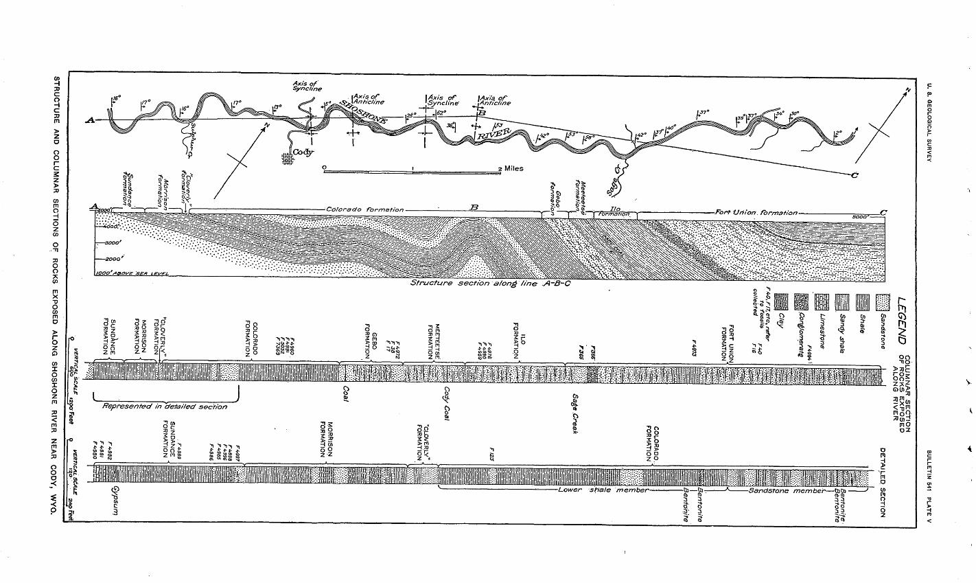
U.
S. G
EO
LO
GIC
AL
SU
RV
EY
BU
LL
ET
IN
541 P
LA
TE
V
LE
GE
ND
CO
LU
MN
AR
S
EC
TIO
NO
F R
OC
KS
E
XP
OS
ED
ALO
NG
R
IVE
R
Sa
nd
ston
e
Shale
Sandy shale
Lim
esto
ne
Cla
y
F.4
0,r/7
, etc
, refe
rto
fossils
colle
cte
d
FO
RT
U
NIO
N
FOR
MA
TION
P366
F365
IUO
FO
RM
AT
ION
FW
76
F
49
90
ME
ET
EE
TS
E
FO
RM
AT
ION
GE
BO
F
OR
MA
TIO
N
"CLOVER LV
!F
OR
MA
TIO
N
MO
RR
ISO
N
FO
RM
AT
ION
FO
RM
AT
ION
DE
TA
ILE
D.
SE
CT
ION
CO
LOR
AD
O.
FO
RM
AT
ION
.Creek
Co'dy C
oal
"CLO
VE
RLY
F
OR
MA
TIO
N
MO
RR
ISO
N
FO
RM
AT
ION
f 4
SS
6
F4
98
S
SU
ND
AN
CE
F
OR
MA
TIO
N
F4-9B
I
S^B
^ Bento
nite
Bento
hite
Be
nto
nite
B
ento
nite
'Sypsum
VE
RT
ICA
L S
CA
LE
9 epo
izpoFeet
VE
RT
ICA
L S
CA
LE
i^b .
zxtpreet
STRUCTURE AND COLUMNAR SECTIONS OF ROCKS EXPOSED ALONG SHOSHONE RIVER NEAR CODY, WYO.
SHOSHONE BIVER SECTION, WYO. 109
The Eagle, Claggett, and Bearpaw formations ought all to have marine faunas, but none such have been found in the Shoshone River section. Their absence indicates that possibly here and farther south in Bighorn Basin land conditions may have begun earlier than elsewhere and may have continued with little or no interruption to the end of the Cretaceous. Of course, it is recognized that there was more or less break in marine conditions during the deposition of the Eagle, even where that formation is mostly marine. This is indicated by the occurrence in it of land plants and verte brates and of coal beds.
Further study appears to confirm this interpretation. The sand stone formation overlying the Colorado shale 750 to 900 feet thick in the Livingston coal field * and 1,000 feet thick in the Electric coal field 2 is undoubtedly the equivalent of the Gebo formation.
In view of the fact that the recognition of the Meeteetse and Ilo formations is based largely on data collected in field work in ^he Oregon Basin, 'Meeteetse, and Ilo quadrangles, south of Shoshone River, it is deemed advisable to present the discussion of their re lations in the report on those areas.3
The incomplete section of the Fort Union formation, 5,592 feet thick, compares with a measurement of 8,500 feet by Woodruff in the Red Lodge coal field,4 though there is no indication of coal beds in the Shoshone River section similar to the coal beds which occur in the upper portion of the Red Lodge section. Coal beds are pres ent near the base of the Fort Union, however, near Meeteetse and Ilo, Wyo., a fact which, taken with other lithologic features, is proof of the great differences hi the conditions of deposition existing in adjacent regions at the same relative epoch.
STRUCTURE.
The structure of the northern portion of the Bighorn Basin has been described by Eldridge 5 and Fisher 6 and has been illustrated by cross sections and a structural contour map. Rattlesnake and Cedar mountains, lying 3 miles west of the limits of the present sur vey, are portions of a broad asymmetric anticline through which Shoshone River has cut a deep narrow gorge. The section presented on Plate V shows two minor anticlines on the east flank of this major structural feature. On the west side of Rattlesnake Mountain the Madison limestone dips 55° SW., whereas on the east at the same level this formation dips 16° NE. From this point eastward to the out-
1 Calvert, W. R., The Livingston and Trail Creek coal fields, Mont.: U. S. Geol. Survey Bull. 471, p. 387,1912.
2 Calvert, W. R., The Electric coal field, Park County, Mont.: U. S. Geol. Survey Bull. 471, p. 410,1912.8 Hewett, D. F., Geology and coal resources of the Oregon Basin and Meeteetse quadrangles, Wyo.: U. S.
Geol. Survey Bull. (in preparation).< Woodruff, E. G., The Red Lodge coalfield, Mont.: U. S. Geol. Survey Bull. 341, p. 94,1909.»Eldridge, G. H., A geological reconnaissance in northwest Wyoming: U. S. Geol. Survey Bull. 119,
72 pp., 1894.6 Fisher, C. A., Geology and water resources of the Bighorn Basin, Wyo.: U. S. Geol. Survey Prof.
Paper 53, p. 30,1906.
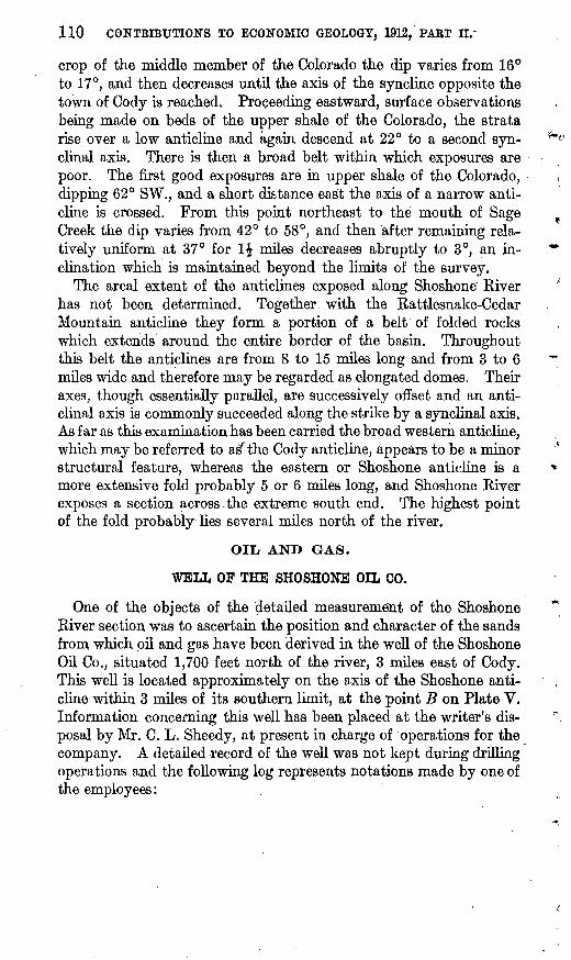
110 CONTBIBTJTIONS TO ECONOMIC GEOLOGY, 1912, PART H.-
crop of the middle member of the Colorado the dip varies from 16° to 17°, and then decreases until the axis of the syncline opposite the town of Cody is reached. Proceeding eastward, surface observations being made on beds of the upper shale of the Colorado, the strata rise over a low anticline and again descend at 22° to a second syn clinal axis. There is then a broad belt within which exposures are poor. The first good exposures are in upper shale of the Colorado, dipping 62° SW., and a short distance east the axis of a narrow anti cline is crossed. From this point northeast to the mouth of Sage Creek the dip varies from 42° to 58°, and then after remaining rela tively uniform at 37° for 1£ miles decreases abruptly to 3°, an in clination which is maintained beyond the limits of the survey.
The areal extent of the anticlines exposed along Shoshone' River has not been determined. Together with the Rattlesnake-Cedar Mountain anticline they form a portion of a belt of folded rocks which extends around the entire border of the basin. Throughout this belt the anticlines are from 8 to 15 miles long and from 3 to 6 miles wide and therefore may be regarded as elongated domes. Their axes, though essentially parallel, are successively offset and an anti clinal axis is commonly succeeded along the strike by a synclinal axis. As far as this examination has been carried the broad western anticline, which may be referred to as' the Cody anticline, appears to be a minor structural feature, whereas the eastern or Shoshone anticline is a more extensive fold probably 5 or 6 miles long, and Shoshone River exposes a section across.the extreme south end. The highest point of the fold probably lies several miles north of the river.
OIL AND GAS.
WELL OF THE SHOSHONE OIL CO.
One of the objects of the detailed measurement of the Shoshone River section was to ascertain the position and character of the sands from which oil and gas have been derived in the well of the Shoshone Oil Co., situated 1,700 feet north of the river, 3 miles east of Cody. This well is located approximately on the axis of the Shoshone anti cline within 3 miles of its southern limit, at the point B on Plate V. Information concerning this well has been placed at the writer's dis posal by Mr. C. L. Sheedy, at present in charge of operations for the company. A detailed record of the well was not kept during drilling operations and the following log represents notations made by one of the employees:
SHOSHONE BIVER SECTION, WYO. Ill
Log of Shoshone Oil Co.'s well No. 1.Feet.
Terrace bowlders............................................... 20Muddy sands.................................................. 10Shales, little water............................................. 90Mud, trace of oil............................................... 50Slate..................................................'...-.-. 50White sand, trace of oil......................................... 3Dark shaly sands.............................................. . 77Shaly sands and slate........................................... 60Slate...........................:............................ 225Dark sandstone, No. 1 oil sand, trace of gas....................... 10Light sandstone........;....................................... 5Slates with some thin sandstones................................ 260Dense sandy shales yielded a little oil........................... 5Slates......................................................... 163Sandstone, No. 2 oil sand; good gas flow at 1,262 feet............. 234
1,262
This well was dry except for the small flows encountered above 300 feet. Drilling began November, 1909, and with relatively little interruption continued to 1,000 feet. It started again March, 1911, and was carried to a depth of 1,285 feet by June, 1911. A standard rig was used. Much trouble was experienced from the caving of the shales and swelling of bentonite, and the well was finally cased with 10-inch casing to 260 feet, 8-inch from 260 to 410 feet, and 6J-inch from 410 to 1,028 feet. During the winter of 1911-12 this well was drilled to a depth of 1,700 feet, where a second gas sand was encoun tered, which corresponds closely with the 50-foot sandstone in the section of the Morrison formation on 'page 95. No attempt was ever made to pump from any of the oil sands. No record of produc tion has been kept; it probably did not exceed 200 barrels. All the oil produced was stored and sold locally for lubricating.
OIL SANDS.
By comparison of the log of the well with the stratigraphic section of the lower two members of the Colorado, the "Cleverly" and the Morrison formations, exposed along the river and presented herewith, it has been possible to ascertain Ihe beds which have yielded oil and gas. . The top of the well approximately coincides with the top of bed 16 of the section of the middle member of the Colorado on page 98. If this basis is assumed for correlation, the first traces of oil, from 120 to 170 feet, appear to have come from one or. more of beds 22, 23, and 24, but the exact sand can not be identified. The sand at 220 feet which yielded a trace of oil is probably a portion of the conglomeratic sandstone No. 26. The first sand which yielded more than a trace of oil, at 585 feet (see analysis No. 1 below), cor responds with bed 8 of the section of the lower member of the Colo-
112 CONTRIBUTIONS TO ECONOMIC GEOLOGY, 1912, PAET II.
rado on page 97; this bed, though reported to be but 15 feet thick in the well, is 80 feet thick on the river. The shale bed which yielded a little oil at 860 feet lies in the bentonite-bearing shale, but can not be identified. The sandstone at 1,028 feet, from which of the total yield of this well to date the greatest amount of oil was derived, cor responds closely to bed 12 of the section of the lower member of the Colorado. The analysis of oil from this sand is given under No. 2 in the table. This sandstone lies between thick beds of carbonaceous shale and is that in which saurian bones, crocodile teeth, and a turtle were found. It underlies the shale bearing numerous fish scales and vertebrae which is probably the equivalent of the Mowry shale member of eastern Wyoming. The sandstone at the bottom of the hole, 1,285 feet, which yielded a good flow of gas, is the upper sandstone of the "Cloverly" formation. The oil from two of the oil sands, at 585 and 1,028 feet, rose in the well and flowed when the sands were struck, but soon ceased, and the sands were later cased off in order to drill deeper.
To summarize, it is interesting to note that though oil has been derived from several sandstones in the lower portion of the Colorado formation, the sandstone which has yielded the greatest flow in this well is in or near the position of the Mowry shale member, depend ing on the limits assigned to it in this section. The sandstones of the lower portion of the Colorado formation yield oil in the Gar land,1 Spring Valley,2 Labarge,8 Lander,4 and Salt Creek 5 fields in Wyoming where structural and other conditions are favorable. In the first three of these fields the sandstones are in or near the position of the Mowry shale member. In the Shoshone anticline the oil has been found along the axis, and, though it can not be stated that pools do not occur at points on the flanks, it appears that structural con ditions have been predominant in determining the location of the oil.
Prior to the drilling of the well of the Shoshone Oil Co., another operator drilled a well to a depth of 850 feet near Shoshone River (No. 2 on PL V). The log of this well could not be obtained. It was cased but never capped, and oil, water, and gas now issue in small amounts from the mouth.
i Washburne, C. W., Gas fields of the Bighorn Basin, Wyo.: U. S. Qeol. Survey Bull. 340, p. 355,1908.* Veatch, A. C., Coal and oil in southern Uinta County, Wyo.: U. S. Geol. Survey Bull. 285, p. 349,1906.»Schultz, A. E., The Labarge oil field, central Uinta County, Wyo.: U. S. Geol. Survey Bull. 340, p. 369,
1908.«Woodruff, E. G., [The Lander oil field, Fremont County, Wyo.: U. S. Geol. Survey Bull. 452, p. 27,
1911.» Wegemann, C. H., The Salt Creek oil field, Natrona County, Wyo.: U. S. Geol. Survey Bull. 452,p. 71,
1911.
SHOSHONE ETVEB SECTION, WYO. 113
THE OIL.
Analyses of two samples of oil from the wells of the Shoshone Oil Co. are given below. These analyses were made in the laboratory of the United States Geological Survey, under the direction of David T. Day.
Analyses of samples of oil from wells of Shoshone Oil Co.
Color ..............................................
Total.......................................
Water.............................................
......... ..............°B..........................°c..
i
Dark green. 0.8454
35.60 190 37 0.8169
59.6 0.9278
96.6 7.6
Present.
2
Green. 0.8335
37.98 160 48 0-8009
52.4 0.8696
100.4 8 0
1. 585 feet; middle sandstone member of Colorado formation.2. 1,028 feet; lower shale member of Colorado formation.
Neither of these samples represents the oil as it came from the well. Sample 1 had been kept for some time in an open can and later in a bottle. Sample 2 was taken from an open tank. Neither of these oils is well adapted for lubricating in the raw state but would on distillation, as shown by the fraction distilling between 150° and -300° C., yield a good proportion of illuminating oil and a residue well adapted for lubrication. Sample 2 resembles the oil derived from the Wall Creek sandstone lentil of the Benton shale Gower Colo rado) in the Salt Creek field, 1 and the oil from a sandstone in the Mowry shale member of the Mancos shale (lower Colorado) at the Plunkett well in the Lander field.2 Oils of similar character, thought to have come from a sandstone in the Benton shale or "Cleverly" formation, have been found in wells in the Douglas oil field in central Wyoming (pp. 68-88). It is worthy of note that samples of oils from approximately the same geologic horizon in four fields in Wyoming should be of similar character.
1 Wegemann, C. H., The Salt Creek oil field. Wyo.: U. S. Geol. Survey Bull. 452, p. 80,1911.2 Woodruff, E. G., The Lander oil field, Wyo.: U. S. Geol. Survey Bull. 452, p. 29,1911.
365° Bull. 541 14 8